flower city planning, design and development …€¢ planning for the special study areas was put...
TRANSCRIPT

^s-v ReportUBRAMPTON Planning Design and
bramptoncD Flower City Development Committee Committee of the Council of
The Corporation of the City of Brampton
Date May 07 2012 PLANNING DESIGN ampDEVELOPMENT COMMITTEE
File City File P26S 049 DATE Ji^v^IL-^1^
Subject INFORMATION REPORT
City Initiated Official Plan amendment to re-designate the North Airport RoadIndustrial Special Study Area to permit commercial institutional employment and the potential for limited residential uses and to re-designate the MayfieldGoreway Drive Special Study Area to permit institutional and limited commercial uses Airport Road Corridor south of Mayfield Road and the southwest corner of Mayfield RoadGoreway Drive Ward 10
Contact David Waters Manager Land Use Policy
Overview
This report presents for statutory public meeting purposes a City-initiated Official Plan Amendment that proposes to re-designate the North Airport RoadIndustrial and MayfieldGoreway Drive Special Study Areas
bull The Vales North Secondary Plan designates the Airport Road Corridor between Mayfield Road and LaCoste Boulevard and the southwest quadrant of Mayfield Road and Goreway Drive as Special Study Areas to ensure that both areas develop in a manner that is complementary to and supportive of the adjacent upscale housing community
A consultant study undertaken for the City in 2006 recommended employment local serving offices and commercial uses for the Airport Road Corridor For the Mayfield RoadGoreway area the study recommended community-based uses such as a place of worship a private school a daycare centre or speciality retail
bull Planning for the Special Study Areas was put on hold by the City in March 2008 to await the results of the Citys Growth Plan Conformity Review regarding the long term need for employment lands across the City
A draft official plan amendment has been prepared for the two Special Study Areas based on the findings of the 2006 consultant study and public consultation
bull Staff will report back to a future Planning Design amp Development Committee meeting following the June 11 2012 public meeting with a final recommendation with respect to the draft Official Plan Amendment for the Vales North Special Study Areas
RECOMMENDATIONS ^^
1 THAT the report from David Waters Manager Planning Design and Development Department dated May 7 2012 to the Planning Design and Development Committee Meeting of re Information Report City initiated Official Plan Amendment to re-designate the North Airport RoadIndustrial Special Study Area to permit commercial institutional employment and the potential for limited residential uses and to re-designate the MayfieldGoreway Drive Special Study Area to permit institutional and limited commercial uses Airport Road Corridor south of Mayfield Road and the southwest corner of Mayfield Road and Goreway Drive Ward 10 (File P26S 049) be received
2 THAT staff be directed to report back to Planning Design and Development Committee with the results of the Public Meeting and a staff recommendation following the completion of the circulation of the draft Official Plan Amendment and
3 THAT the City Clerk be directed to forward a copy of this staff report and Council resolution to the Region of Peel Town of Caledon and the Toronto Region Conservation Authority for their information
BACKGROUND
Origin
The Vales North Secondary Plan (Area 49) is bounded by Mayfield Road to the north Countryside Drive to the south Goreway Drive to the east and the west branch of the West Humber River to the west Both the North Airport RoadIndustrial and MayfieldGoreway Drive Special Study Areas are located within Secondary Plan Area 49
A corridor flanking Airport Road south of Mayfield Road is designated Industrial with a Special Study overlay in the Official Plan A small area at the northwest corner of Mayfield Road and Goreway Drive is also designated Special Study Area with an underlying Residential designation
North Airport RoadIndustrial Special Study Area
As part of the implementation of the Vales North Secondary Plan a corridor fronting lands on both sides of Airport Road extending south from Mayfield Road to the edge of the valley associated with the West Humber River was designated IndustrialSpecial Study Area in the Citys Official Plan Policies with respect to this designation require that the City undertake a study to determine if the demand for prestige industrial or commercial use is strong enough to ensure that the area can be developed in a manner that is consistent with adjacent upscale housing community
gtgtl5-3 Existing land uses within the North Airport RoadIndustrial Special Study Area include a gas bar and convenience restaurant at the southwest corner of Airport Road and Mayfield Road St Marys Cemetery the Sikh Heritage Centre and a number of residential dwellings fronting on Mayfield Road and Airport Road A small industry (JB Aluminum Products) is located at the southeast comer of the Study Area
A site plan application was submitted to the City in September 2004 to redevelop the Sikh Heritage Centre into a new 4925 sq m (53000 sqft) community centre with related uses Processing of the site plan is ongoing as a number of technical issues will need to be addressed by the applicant before its approval
In February 2012 Punjabi Community Health Services a not-for-profit organization which provides a variety of health and community services received approval from the Committee of Adjustment to allow a Community Health Centre with associated offices accessory recreational activities and a commercial school (tutoring) at 11730 Airport Road The variance is permitted for a temporary period of three years subject to site plan approval obtaining a building permit filing an application to amend the Official Plan and Zoning By-Law as well as approval of access arrangements to Airport Road from the Region of Peel
The former Tullamore Village Blacksmith Shop located at 11850 Airport Road has been identified as a Category A heritage resource for which a heritage designation and adaptive reuse is recommended as part of the Citys Heritage Inventory Two rural residences on the east side of Airport Road have also been identified as built heritage features by the City and are recommended for heritage designation and retention In May 2005 Council directed heritage staff to designate all heritage cemeteriesburial grounds including St Marys Anglican cemetery (Tullamore) near Airport Road
View north along Airport Road view south along east side of Airport Road
bvs-^ The valley associated with the west branch of the West Humber River abuts the west side of the North Airport RoadIndustrial Special Study Area West of the valley are lands that fall within the Countryside Villages Secondary Plan which are designated for predominantly residential uses
On the east side the Study Area is adjacent to the Vales of Castlemore North executive housing community North of Mayfield Road in the Town of Caledon is the Tullamore IndustrialCommercial Secondary Plan which permits a mix of industrial and commercial uses in the Mayfield Road and Airport Road area This area recently saw the construction of a major warehouse distribution centre comprising 12 million square feet on the east side of Airport Road one kilometre north of Mayfield Road In addition a multiple industrial building located on the west side of Airport Road opposite the distribution centre was recently constructed
The Town of Caledon is in receipt of a private application to amend the lands at the northeast corner of Airport Road and Mayfield Road from Highway Commercial and General Industrial to Highway Commercial with Special Provisions and General Industrial with Special Provisions to permit a wide range of retail and service commercial uses (maximum 25000 sq m)
While no specific tenants are committed to the site at this time it is expected that the centre will be anchored by a Home and Automotive Supply Store Home Improvement Centre or potentially a warehouse membership club as well as a supermarket
This application has been circulated to the City of Brampton for comments and is currently under review by city staff
Mayfield RoadGoreway Drive Special Study Area
The Mayfield RoadGoreway Drive Special Study Area is located at the southwest corner of Goreway Drive and Mayfield Road It is relatively small in size about 67 acres and abuts the Salt Creek Valley on the south and west sides The Official Plan with respect to this Special Study Area require that a study be undertaken to determine if the demand for specific forms of residential institutional or commercial uses or a mix of these uses can be developed within this Study Area in a manner that is compatible with the adjacent executive housing community
View to the southeast from Mayfield Road
The Mayfield RoadGoreway Drive Special Study Area includes three existing residential properties The stone house located at the southwest corner of Goreway Drive and Mayfield Road is classified as a Class A heritage feature in the Citys Heritage Inventory
Previous Studies
Hemsons Vales North Special Study Area - Land Use Study (2006)
In January 2006 the City retained Hemson Consulting to complete a comprehensive land use study that included a market and planning assessment urban design guide lines and transportation recommendations for both Special Study Areas
Preliminary land use options for the North Airport RoadIndustrial Special Study Area focused on relatively small-scale industrial and institutional uses and local area serving commercial uses
The preliminary proposal for the Mayfield RoadGoreway Drive Special Study Area included institutional uses such as a place of worship day care facility or private school and limited specialty retail
In response to the concerns expressed by the area residents at an open house held in 2007 about industrial uses and given Hemsons identification of the area as not being suitable to accommodate large employment uses staff used the Citys Growth Plan Conformity review to assess the viability of North Airport RoadIndustrial Special Study Area for employment uses
Market Demand and Development Feasibility Study for Employment Lands (2010)
Cushman ampWakefield Ltd was retained by the City to investigate the market demand for employment lands within the City extending to the year 2031 The study provides an evaluation of fouremployment designated areas of the City including the North Airport RoadIndustrial Special Study Area
The report concluded that the Airport Road area will be challenged to attract traditional employment uses particularly because of the limited amount and physical configuration of the land Also the adjacent residential uses will constrain the potential range of industrial users that could be attracted to the area The report further concludes that the subject lands are unlikely to be a strong industrial area although local serving industrial multiples may represent an opportunity for small locally oriented enterprises
OP2006-043
The Growth Plan Conformity Recommendation Report submitted to Planning Design and Development Committee at the February2010 meeting
recommended policy directions for the Growth Plan Official Plan Amendment based on the Cushman and Wakefield Market Demand Study for Employment Lands The recommendations recognize that there is a potential for the North Airport RoadIndustrial Special Study Area to accommodate local serving industrial multiples and population serving employment activity Given the findings of the study OP2006-43 redesignated the Airport Road Special Study Area from Industrial to Business Corridor in Section 413 Special Study Area and included a policy that prohibited the development of a District Centre in this area OP2006-43 was endorsed by Council but is still under review by the Region of Peel
The revised policy for the Special Study Area will be addressed as part of the report dealing with the Regions modifications to OP2006-043 anticipated for Council review in early 2013
Conceptual Development Plan (east side of Airport Road)
Planning staff are in receipt of a conceptual development plan submitted by Candevcon Ltd on behalf of several of the owners on the east side of Airport Road The concept plan shows how all the properties south of Mayfield Road and east of Airport Road could be developed with a mix of retail offices and service employment uses The size of the proposed development is within the general range of a District Retail centre A Planning Justification Report Retail Market DemandAnalysisand Industrial Needs Assessment were submitted to the City to support the proposal These studies concluded that there is sufficient demand for commercial uses on the subject lands and only limited opportunities for industrial uses
The northern portion of the site is proposed for mainly commercial development with small scale retail buildings such as retailoffice restaurants and banks as well as two larger format retail users The southern portion of the site which is currently zoned Industrial would be primarily developed with service employment uses The proposed plan considers that the existing industrial building (JB Aluminum) will remain
Staff completed a preliminary review of Candevcons proposal and find that it represents an appropriate type of development for this area
Planning Area
The Vales North Secondary Plan (Area 49) is bounded by Mayfield Road to the north Countryside Drive to the south Goreway Drive to the east and the west branch of the West Humber River to the west Both the North Airport RoadIndustrial and MayfieldGoreway Drive Special Study Areas are located within Secondary Plan Area 49
bs-7 The North Airport RoadIndustrial Special Study Area is approximately 35 hectares (86 acres) located south of Mayfield Road and north of LaCoste Boulevard along both sides of Airport Road
The Mayfield RoadGoreway Drive Special Study Area is approximately 3 hectares (7 acres) located on the southwest corner of Mayfield Road and Goreway Drive
Proposal
This is a City of Brampton initiated Official Plan Amendment that proposes to re designate the North Airport RoadIndustrial Special Study Area to permit commercial institutional employment and the potential for limited residential uses and to re-designate the Mayfield RoadGoreway Drive Special Study Area to permit institutional and limited commercial uses
bull
J
The subject property has the following characteristics
NorthAirport RoadIndustrialSpecial Policy Area
bull is located along the Airport Road corridor south of Mayfield Road and mainly north of LaCoste Boulevard
bull has a site area of approximately 35 hectares (86 acres) and bull has a frontage of 344 metres (1128 feet) along Mayfield Road and
approximately 1 kilometre along Airport Road
Mayfield RoadGoreway Drive Special Policy Area
bull is located at the southwest corner of Mayfield Road and Goreway Drive bull has a site area of approximately 3 hectares (74 acres) bull has a frontage of 323 metres (1060 feet) along Mayfield Road and 147
metres (482 feet) along Goreway Drive
The surrounding land uses are described as follows
North Mayfield Road beyond which is the Town of Caledon
The Town of Caledon is in receipt of an Official Plan Amendment application to amend the lands at the northeast corner of Airport Road and Mayfield Road from Highway Commercial and General Industrial to Highway Commercial with Special Provisions and General Industrial with Special Provisions to permit a wide range of retail and service commercial uses (maximum 25000 sq m)
While no specific tenants have been identified at this time it is expected that the centre will be anchored by a Home and Automotive Supply Store Home Improvement Centre or potentially a warehouse membership club as well as a supermarket
South residential beyond which is Countryside Drive
East Goreway Drive with rural estate housing on the east side
West west branch of the West Humber River beyond which is the Countryside Villages Secondary Plan
CURRENT SITUATION
The City of Brampton is proposing to amend the Official Plan and the Vales of Castlemore North Secondary Plan (Area 49) to re-designate the North Airport RoadIndustrial Special Study Area to permit commercial institutional employmentand the potential for limited residential uses and to re-designate the Mayfield RoadGoreway Drive Special Study Area to permit institutional and limited commercial uses
8
Proposed Policy Framework
The following section summarizes the highlights of the City- initiated draft Official Plan Amendment
Based on study recommendation and extensive public consultation the draft Official Plan Amendment sets out the long-term planning vision for the subject lands It provides land use infrastructure and urban design policies to support the principles and objectives needed to ensure that both Special Study Areas can develop in a manner that is complementary and supportive of the adjacent upscale executive housing area
Staff will use this opportunity to update the existing land use Schedule SP49(a) that was prepared using AutoCAD some 12 years ago with an updated GIS-based version that reflects the actual development that has taken place since the secondary plan was approved in 2001
Key components of the amendment for the North Airport RoadIndustrial Special Study Area include (see Figure 1)
bull South of Mayfield Road and east of Airport Road - proposed Highway amp Service Commercial that would permit such uses as retailoffice restaurants and banks as well as two larger format retail users such as a food store or a home improvement outlet
bull East of Airport Road south end of the study area - proposed Service Employment that would permit such uses as wine making yogadancemartial arts studios gyms pool supplies custom workshop business and personal service shops and places of commercial recreation
bull Southwest corner of Mayfield Road and Airport Road - a range of convenience retail uses and local serving offices and permission for the existing highway commercial use (gas bar) to remain No additional highway commercial uses are proposed to be permitted
bull An Institutional designation for the lands on the west side of Airport Road to recognize the existing Sikh Heritage Centre and the existing Community Health Services organization immediately to the south This designation is proposed to permit the existing place of worship a day care or private school
bull Special Policy Area 1 - opportunity for these lands to be reviewed for residential uses in the future as part of the next Official Plan Review
Keycomponents of the amendment for the Mayfield RoadGoreway Drive Special Study Area include
bull an Institutional Special Policy Area designation at Mayfield Road and Goreway Drive which would include permissionsfor a place of worship day care facility or private school and limited specialty retailing
RESIDENTIAL
EXECUTIVE RESIDENTIAL
LOW DENSITY 1
LOW DENSITY 2
OPEN SPACE
WOODLOT
VALLEYLAND
NEIGHBOURHOOD PARK
STORM WATER MANAGEMENT FACILITY
M BRAMPTON bmmpionnl Flower City X
tgt5-D
INSTITUTIONAL COMMERCIAL
ELEMENTARY SCHOOL NEIGHBOURHOOD RETAIL
CEMETERY HIGHWAY amp SERVICE COMMERCIAL
INSTITUTIONAL SERVICE COMMERCIAL
INSTITUTIONAL - SPECIAL POLICY AREA SERVICE EMPLOYMENT
COMMERCIAL INSTITUTIONAL
TRANSPORTATION
bull^bullbullM COLLECTOR ROAD SPECIAL POLICY AREA 1
AREA SUBJECT TO THIS AMENDMENTmdash^mdash MINOR COLLECTOR ROAD
^-^ FULL MOVES ACCESS
Local roads shown are not pari of this schedule
FIGURE 1
VALES NORTH SECONDARY PLAN (AREA 49) PLANNING DESIGN amp DEVELOPMENT
100 200
Metres Dale 2012 05 14 FILE SPA49 graquo
OUTSTANDING ISSUESADDITIONAL COMMENTS
Comments from City divisionsdepartments and external commenting agencies are required in order to complete a comprehensive analysis of this application All comments received will be considered in the future planning recommendation report to the Planning Design and Development Committee
Redside Dace
Ministry of Natural Resources has stated that the Salt Creek tributary is now regulated recovery habitat for Redside Dace as ofJuly 1 2011 The implications of this designation for the Mayfield RoadGoreway Drive Special Study Area will be discussed as part of the Recommendation Report
Metrus Lands
The lands owned by Metrus are located on the west side of Airport Road south of the Punjabi Community Health Services office Staff recently received a submission from Metrus which requests the lands be redesignated for residential uses as part of the current review with permissions for commercialoffice and mixed use along Airport Road with single detached and townhouse dwellings on the balance of the lands
Staff is currently evaluating the Metrus proposal and will provide a full assessment as part of the Recommendation Report The Metrus lands are currently identified as Special Policy Area 1 along with the two acre parcel across from LaCoste Boulevard
Further details on the technical aspects of this City-initiated Official Plan Amendment can be found in the Information Summary contained in Appendix 5
CONCLUSION
This report presents the Citys draft Official Plan Amendment to re-designate the North Airport RoadIndustrial Special Study Area to permit commercial institutional employment and to provide the potential for limited residential uses to be studied as part of the next Official Plan review In addition this report presents the Citys proposal to re-designate the Mayfield RoadGoreway Drive Special Study Area to permit institutional and limited commercial uses
Staff will report back to a future Planning Design ampDevelopment Committee meeting presenting the results of the June 11 2011 public meeting and a final recommendation with respect to the draft Official Plan Amendment for the North Airport RoadIndustrial Special Study Area ampMayfield RoadGoreway Drive Special Study Area
10
1^5-1
Respectfully submitted
MkZbpgar MClFyRPP Acting-Director Planning Policy amp ommilsioner Planning Design and Growth Management Devfrlewrient
Authored by Pam Cooper Policy Planner
Attachments
Appendix 1- Official Plan Designation Appendix 2 - Secondary Plan Designations Appendix 3 - Current Zoning Designations Appendix 4 - Aerial Photo and Existing Land Use Appendix 5 - Information Summary Appendix 6 - Draft Official Plan Amendment
11
Original Signed ByOriginal Signed By
PVS-13
EXTRACT FROM SCHEDULE A (GENERAL LAND USE DESIGNATIONS) OF THE CITY OF BRAMPTON OFFICIAL PLAN
SUBJECT LANDS VALES vpoundvpound SPECIAL STUDY AREA bullbull OPEN SPACE CITY LIMIT ESTATE RESIDENTIAL RESIDENTIAL
INDUSTRIAL
APPENDIX 1ffl BRAMPTON poundf OFFICIAL PLAN DESIGNATIONSbrompionltQ Flower City VALES OF CASTLEMORE NORTH (AREA 49)
PUNNING DESIGN amp DEVELOPMENT
0 50 100
Drawn By TD Moires
Dalo2011 12 09
busraquou-t
m^ mmmrgt
COUNTRYSffiE DRIVE OP2006-016
EXTRACT FROM SPA 49 KNOWN AS THE VALES OF CASTLEMORE NORTH SECONDARY PLAN
LEGEND
RESIDENTIAL w-T-ra
Executive Residential
] Low Density 1
Low Density 2
INDUSTRIAL Industrial
Special Study Area
INSTITUTIONAL
TEJn ElementarySchool
Storm Water Management Facility
PlanFinn Settsilary
Special Study Area
TRANSPORTATION
Collector Road
Minor Collector Rond
COMMERCIAL
Commercial
MM Special Study Area
m Neighbourhood Retail
OPEN SPACE
Valleyland
Woodlot
frjtlNPlJj] Neighbourhood Park
TOWN OF CALEDON TULLAMORE SECONDARY PLAN
PRESTIGE INDUSTRIAL
GENERAL INDUSTRIAL
HIGHWAY COMMERCIAL
LIMITS OF SECONDARY PLAN AREA
APPENDIX 2 - SECONDARY PLAN DESIGNATIONSI BRAMPTON W VALES OF CASTLEMORE NORTH (AREA 49) km+ma FlowerCity amp LANDS TO THE NORTH OF MAYFIELD ROAD PLANNING DESIGN AND DEVELOPMENT
IN THE TOWN OF CALEDON
Dale 2012 05 05 Drawn By TD
THS-1S
SUBJECT_LANDS_VALES COMMERCIAL INSTITUTIONAL
ZONING BOUNDARY FLOODPLAIN OPEN SPACE
AGRICULTURAL INDUSTRIAL RESIDENTIAL
APPENDIX 3H BRAMPTON ZONING DESIGNATIONS
bromPion(o Flower City VALES OF CASTLEMORE NORTH (AREA 49)PLANNING DESIGN amp DEVELOPMENT
Drawn By TD Dale 2011 12 09
TgtlS-fo
AERIAL PHOTO DATE SPRING 2011
SCHOOL SUBJECT LAND RESIDENTIAL
a CEMETERY AGRICULTURAL OPEN SPACE
INSTITUTIONAL COMMERCIAL
APPENDIX 4gtfXM BRAMPTON AERIAL amp EXISTING LAND USEbramplonxo Fl0Wer City VALES OF CASTLEMORE NORTH (AREA 49)
PLANNING DESIGN amp DEVELOPMENT
0 SO 100
Drawn By TD Metres
Dale 2011 12 09
APPENDIX 5
Information Summary
Official Plan
The subject lands are designated as follows on Schedule A General Land Use Designations in the 2006 Official Plan
bull North Airport RoadIndustrial Special Study Area Industrial with a Special Study overlay in the Official Plan
bull MayfieldGoreway Drive Special Study Area Special Study Area with an underlying Residential designation
An amendment to the Official Plan is required to implement the proposed land use change and guiding policies
Secondary Plan
The subject lands are designated as follows in the Vales of Castlemore North Secondary Plan (Area 49)
bull North Airport RoadIndustrial Special Study Area Commercial Special Study Area and Industrial Special Study Area
bull MayfieldGoreway Drive Special Study Area Special Study Area
An amendment to the Secondary Plan is required to implement the proposal
Zoning By-Law
An amendment to the Zoning By-law is not required for this City-initiated Official Plan Amendment however an amendment to the Zoning By-law will be required for future applications to implement the uses proposed by the Official Plan Amendment
Servicing
Full municipal services are proposed for this development
Growth Management
Complete comments and recommendations with respect to Growth Management issues will be provided in the Recommendation Report
12
Environmental Issues
Ministry of Natural Resources has stated that the Salt Creek tributary is now regulated recovery habitat for Redside Dace as of July 1 2011 The implications if any of this designation for the Mayfield RoadGoreway Drive Special Study Area will be provided in the Recommendation Report
Complete comments and recommendations from the Citys Planning Design and Development Department and the Toronto and Region Conservation (TRC) with respect to the environmental features will be provided in the Recommendation Report
Documents in Support of the Application
In January 2006 the City retained Hemson Consulting to complete a comprehensive land use study that included a market and planning assessment urban design guide lines and transportation recommendations for both Special Study Areas
In 2009 A Planning Justification Report Retail MarketDemand Analysis and Industrial Needs Assessment were submitted to the City to support the proposal by the landowners on the east side of Airport Road
In 2010 Cushman amp Wakefield Ltd Prepared a Market Demand and Development Feasibility Study for Employment Lands which examined the North Airport RoadIndustrial Special Policy Area
Agency Comments Received
The Official Plan Amendment has been circulated to internal and external departments and agencies Complete comments that are received will be provided in the forthcoming Recommendation Report
Heritage Impact
The special study area that straddles Airport Road contains the following heritage resources
bull St Marys (Tullamore) Cemetery is a pioneer cemetery for which designation under the Ontario Heritage Act is pending
bull 11185 Airport Road (former Tullamore Village Blacksmith shop) is currently listed as a Category A heritage resource
bull 11903 Airport Road (farmhouse) is not currently listed or designated but exhibits potential heritage value
13
The special study area that borders Goreway Dr contains the following heritage resources
bull 6461 Mayfield Road (fieldstone farmhouse) is currently listed as a Category B heritage resource
Complete heritage comments will be provided in the Recommendation Report
Public Meeting Notification Area
Notice of the Public Meeting was given by prepaid first class mail to all persons assessed in respect of land to which the proposal applies and within 900 metres of the area in Brampton (120 metres in Caledon) to which the proposal applies as shown on the last revised assessment roll and by public notification in the Brampton Guardian
14
Tgt5-^P
APPENDIX 6
Draft Official Plan Amendment
4b liiformalionReport
Tgtpound -2-t
AMENDMENT NUMBER OP2006shy
To the Official Plan of the
City of Brampton Planning Area
10 Purpose
The purpose of this amendment is to replace the North Airport RoadIndustrial Special Study Area and Mayfield RoadGoreway Drive Special Study Area designations in the Official Plan and the Vales of Castlemore North Secondary Plan as shown on Schedule A to this amendment to permit the development of commercial institutional and service employment uses and to provide specific policies to guide the next stage of development approvals
20 Location
The lands subject to this amendment are located on both sides of Airport Road bounded to the north by Mayfield Road to the east by the Vales of Castlemore residential development and to the west by the West Humber River valleylands and are described as Part of Lots 16 and 17 Concession 6 EHS and Concession 7 ND and also the lands at the southwest corner of Mayfield Road and Goreway Drive described as Part of Lot 17 Concession 7 ND in the City of Brampton
30 Amendments and Policies Relative Thereto
31 The document known as the Official Plan of the City of Brampton Planning Area is hereby amended
(1) by changing on Schedule A GENERAL LAND USE DESIGNATIONS thereto the designation Special Study Area to BUSINESS CORRIDOR as shown on Schedule A to this amendment
(2) by deleting in Part 1 THE GENERAL PLAN Section 41311 North Airport RoadIndustrial Special Study Area and 41312 Mayfield RoadGoreway Drive Special Study Area in their entirety and
(3) by adding to the listof amendments pertaining to Secondary Plan Area Number 49 Vales of Castlemore North Secondary Plan as set out in Part II SECONDARY PLANS thereof Amendment Number OP2006-
32 The document known as the Vales of Castlemore North Secondary Plan being Chapter 49 of the document known as the 1993 Official Plan as amended of the City of Brampton Planning Area which remains in force is hereby further amended
(1) by deleting Schedule SP49(a) and replacing it with Schedule B to this amendment
(2) by deleting the paragraph under Section 30 Development Principles and replacing it with the following
The Vales North Secondary Plan proposes residential land uses throughout most of the Secondary Plan Area with an emphasis on upscale executive housing in the eastern and southeastern areas closest to Countryside Drive and Goreway Drive
The lands located at the intersection of Airport Road and Mayfield Road and extending south along the Airport Road Corridor are proposed to be developed for an appropriate mix of commercial employment and institutional uses to serve the area residents and businesses in addition to serving passing vehicular traffic
Two elementary schools a neighbourhood park and woodlot are proposed to be located in the centre of the community to act as a focal point for the community The upscale executive housing community envisioned through the designations and policies in this plan will be designed to take advantage of the natural features of the secondary plan area through thoughtful urban design A conventional housing component will also allow for the development of dwellings on smaller lots
(3) by replacing in Section 40 Development Policies thereof the heading CommercialIndustrial Special Study Area and Sections 427 428 and 429 with the following headings and policies
Service Commercial
427 Lands designated Service Commercial shall permit a range of commercial uses and be developed in accordance with the policies of Part I Section 428 and other relevant policies of the Official Plan Permitted uses may also include institutional uses such as a school daycare centre place of worship library and recreational facility
428 The existing permission for Highway Commercial Two (HC2) on the property at the southwest corner of Mayfield Road and Airport Road will continue to be recognized in the Secondary Plan Redevelopment of these lands will be subject to a superior standard of urban design with respect to the built form and streetscape in accordance with the policies of Section 410 Urban Form of the Official Plan
429 Lands designated Service Commercial shall develop in accordance with the following principles in order to contribute to a distinctive Gateway character
i) Buildings and landscaping shall be used to define the street edge Buildings are encouraged to have an active facade along the street line and vehicular parking areas shall be screened from public roads
ii) to generate an attractive and integrated urban environment superior site architectural landscape and safety design elements shall be used particularly including design features and characteristics that will enhance and complement the Upscale Executive Housing Community to the east
iii) a Gateway feature shall be established at the south-west corner of the Mayfield Road and Airport Road intersection in accordance with the Citys Gateway Beautification Program
iv) Outside storage of goods and materials shall not be permitted
v) Location of access points shall conform to the Region of Peel Access Control By-Law To achieve this common access and linked parking areas amongst land owners may be required and
^15-^4 established in accordance with the requirements of the City and the Region of Peel
vi) Appropriate siting of buildings and adequate landscaping shall be required to minimize any adverse impacts on adjacent properties
vii) All intersection and access points shall be defined with distinctive landscaping lighting and streetscape features that reflect the gateway character
viii) Auto-orientated development including drive-through restaurants shall not be permitted within the immediate vicinity of Gateway locations The location site planning and detailed design of drive-through facilities shall reinforce the City of Bramptons hierarchy of roadways and gateways as described in the Street Corridor Master Plan and the Gateways Beautification Program
ix) Service and loading areas shall be incorporated into building designs or effectively screened from view through appropriate fencing or landscaping
x) Where parking is provided in the front yard or abutting a major arterial road or highway landscaping shall be required to provide adequate screening and improve the visual amenity of the area while having regard for personal safety
xi) To ensure comprehensive and integrated development along the principal arterials the City shall require the submission of a tertiary plan to demonstrate how the adjacent lands can be comprehensively developed
CommercialInstitutional
4210 Land designated as CommercialInstitutional on Schedule 49(a) is located at the western boundary of the study area on Mayfield Road The purpose of this designation is to permit potential institutional users to have a high visibility location on Mayfield Road while allowing for access to the adjacent valleylands Depending on the type of institutional there may also be the potential for synergy with nearby retail and office developments
This designation shall permit a range of commercial uses and be developed in accordance with the policies of Part I Section 428 and other relevant policies of the Official Plan Permitted uses may also
TgtS-2S
include institutional uses such as a private school daycare centre place of worship library and recreational facility
Highway and Service Commercial
4211 Land designated as Highway and Service Commercial on Schedule SP49(a) is comprised of a 85 hectare (21 acre) parcel located at the southeast corner of Mayfield Road and Airport Road
This designation shall permit a range of Highway and Service Commercial uses and be developed in accordance with the policies of Part I Section 42 and other relevant policies of the Official Plan Permitted uses include retail establishments such as a home improvement store or an automotive retail store with associated garden centre a supermarket restaurant pharmacy office financial institution and one gas bar and related uses (not to be located at the intersection of Mayfield Road and Airport Road)
4212 The lands designated Highway and Service Commercial shall not permit motor vehicle sales repair service a body shop a car washing establishment or any other type of motor vehicle use except that one motor vehicle repair shop shall be permitted as part of the automotive retail store
4213 The lands designated Highway and Service Commercial shall be planned and developed as one integrated entity regardless of whether it is in more than one ownership or it is to be developed in phases In this regard a Tertiary Plan shall be prepared to the satisfaction of the City prior to the area being zoned to demonstrate how the designated area can be developed comprehensively
4214 Drive-through restaurants shall be developed in accordance with the policies of Part 1 Section 410 and other relevant policies of the Official Plan as well as the policies of the Development Design Guidelines
4215 The intersection of Mayfield Road and Airport Road has been identified as a Gateway on Schedule 2 Flower City Strategy Street Corridor Master Plan of the 2006 Official Plan Buildings at the corner of Mayfield Road and Airport Road shall be subject to a minimum height requirement of 2 storeys as well as upgraded streetscape design lighting planting signage and other urban design and landscaping amenities These performance standards will be specified in the implementing Zoning By-Law
4216 Development of lands designated Highway and Service Commercial shall occur on the basis of approved design guidelines for the area with the intent to establish cohesive and superior development Urban design guidelines shall be approved by the City prior to the issuance of site plan approval and shall include the following principles in order to contribute to a distinctive gateway character
i) The architectural treatment of development along Mayfield Road and Airport Road shall be of a higher order reflecting the high profile and gateway quality of these locations Buildings and landscaping shall be used to define the street edge Buildings are encouraged to have an active facade along the street line and vehicular parking areas shall be screened from public roads
ii) A Gateway feature shall be established at the south-east corner of the Mayfield Road and Airport Road intersection in accordance with the Citys Gateway Beautification program
iii) Outdoor storage shall be permitted only in conjunction with a garden centre sales establishment shall not be permitted abutting public roads and shall be screened from view through site design including location and landscaping
iv) Location of access points shall be in accordance with the Region of Peels Access Control By-Law To achieve this common access and servicing arrangements and linked parking areas amongst land owners may be required and established in accordance with the requirements of the City and the Region of Peel
v) To generate an attractive integrated and walkable urban environment and to minimize the impact of commercial development on the adjacent residential area development shall be of a high standard with superior architectural built form and landscaping that is complimentary and compatible wiith the executive residential community
vi) Appropriate buffering from the adjacent residential uses shall be provided as determined through development approvals and may include setbacks berming fencing and landscaped buffers
vii) To ensure comprehensive and integrated development the City shall require the submission of a tertiary plan and related background studies to demonstrate how the designated area can be comprehensively developed
viii) Site design and building layout shall incorporate an integrated pedestrian network
ix) The visual impact of drive-through facilities shall be minimized through appropriate siting and landscape screening and shall be directed away from adjacent residential areas or public roads
x) Service and loading areas shall be located away from residential areas to the greatest extent possible to minimize associated visual noise and air emissions impact and shall be incorporated into building design or effectively screened from view through appropriate fencing or landscaping
xi) All lighting on site shall be designed and oriented so as to minimize glare on adjacent properties and roadways
xii) All intersection and access points shall be defined with distinctive landscaping lighting and streetscape features that reflect the gateway character
xiii) Auto-orientated development including drive-through restaurants shall not be permitted within the immediate vicinity of the Gateway location The location site planning and detailed design of drive-through facilities shall reinforce the City of Bramptons hierarchy of roadways and gateways as described in the Street Corridor Master Plan and the Gateways Beautification Program
xiv) Motor vehicle salesleasing and motor vehicle repair detailing and body shops shall not be permitted A motor vehicle washing establishment shall only be permitted as an accessory use to a gas bar
xv) Building elevations along the residential interface shall provide moderate architectural articulation to ensure that residents do not face blank walls
Service Employment
4217 Lands designated Service Employment on Schedule SP49(a) are located on the east side of Airport Road north of the existing Neighbourhood Retail designation at LaCoste Boulevard and shall be developed for service based employment uses that are intended to serve area residents and businesses
in a built form that is compatible with the character of the adjacent residential community
4218 Lands designated Service Employment permit offices such as medicaldental as well as a business professional or administrative office and financial institution Commercial uses permitted include a personal service shop service shop art gallerystudio a printing or copy establishment health centre or fitness centre dry cleaning or laundry establishment commercial technical or recreationalschool place of worship or custom workshop
4219 The existing business at 11461 Airport Road (JB Aluminum) located within the Service Employment designation can continue to operate in accordance with existing zoning permissions Expansions to the existing operation that require a building permit are subject to mitigating any noise odour and visual impacts on the adjacent residential community to the satisfaction of the City
4220 The lands designated Service Employment shall be planned and developed as one integrated entity regardless of whether it is in more than one ownership or it is to be developed in phases In this regard a Tertiary Plan shall be prepared to the satisfaction of the City prior to the area being zoned to demonstrate how the designated area can be developed comprehensively
4221 Development of the lands designated Service Employment shall occur on the basis of approved design guidelines for the area with the intent to establish a cohesive superior development Urban design guidelines shall be approved by the City prior to the issuance of site plan approval and shall include the following principles in order to contribute to a distinctive gateway character
i) The architectural treatment of development along Airport Road shall be of a higher order reflecting the high profile and gateway quality of these locations Buildings and landscaping shall be used to define the street edge Buildings are encouraged to have an active facade along the street line and vehicular parking areas shall be screened from public roads
ii) Outdoor storage shall not be permitted
iii) Location of access points shall be in accordance with the Region of Peels Access Control By-Law To achieve this common access and servicing arrangements and linked parking areas amongst land owners may be required and established in accordance with the requirements of the City and the Region of Peel
TgtS-1
iv) To generate an attractive integrated and walkable urban environment and to minimize the impact of development on the adjacent residential area development shall be of a high standard with superior architectural built form and landscaping that is compatible with the executive residential character of the immediate area
v) Appropriate buffering from the adjacent residential uses shall be provided as determined through the development approval and may include measures such as setbacks berming fencing and landscape buffers
vi) To ensure comprehensive and integrated development the City shall require the submission of a development concept or tertiary plan and related background studies to demonstrate how the designated area can be comprehensively developed
vii) Site design and building layout shall incorporate pedestrian network
an integrated
viii) Auto-orientated development including drive-through restaurants shall not be permitted within the immediate vicinity of Gateway locations The location site planning and detailed design of drive-through facilities shall reinforce the City of Bramptons hierarchy of roadways and gateways as described in the Street Corridor Master Plan and the Gateways Beautification Program
ix) Service and loading areas shall be located away from residential properties to the greatest extent possible to minimize associated visual noise and air emissions impact and shall be incorporated into building design or effectively screened from viewthrough appropriate fencing or landscaping
x) All lighting on site shall be designed and oriented so as to minimize glare on adjacent properties and roadways
xi) Motor vehicle salesleasing and motor vehicle repair detailing body shops and motor vehicle washing establishments shall not be permitted
xii) Building elevations along the residential interfaceshall provide moderate architectural articulation to ensure that residents do not face blank walls
4222 The City will be undertaking a comprehensive review of the existing zoning permissions for the lands designated Service Employment to address compatibility with the adjacent residential community
Special Policy Area 1
4223 Land designated Special Policy Area 1 on Schedule SP49(a) is comprised of the lands located south of 11730 Airport Road on the west side of Airport Road Considering the isolated location of these lands next to the major valley system these lands have limited potential for traditional employment uses and as such should be considered for residential and related uses The potential for re-designation of Special Policy Area 1 for residential and related uses shall be reviewed as part of the Citys next five year Official Plan Review
(4) by replacing in Section 40 Development Policies thereof section 4318 Cemeteries and replacing it with the following new Subsection 4318 with the following policy
4318 The regulations set out in the Cemeteries Act shall also apply to St Marys Anglican Cemetery located on the west side of Airport Road south of Mayfield Road Council has given direction to designate this cemetery and as such it shall be preserved
(5) by adding to Section 40 Development Policies thereof the following policy as Section 445
The lands designated Institutional are intended to recognize the existing Sikh Heritage Centre located on the west side of Airport Road south of Mayfield Road and the property to the immediately south (11730 Airport Road) Institutional uses such as a private school or day care centre shall also be permitted
Site design and building layout shall incorporate an integrated pedestrian network
(6) by deleting in Section 40 Development Policies thereof the heading Special Study Area and Section 445 to 447 and replacing them with the following new subsections
10
Institutional - Special Policy Area
445 The southerly and westerly limit of the area designated Institutional shySpecial Policy Area is the edge of the adjacent valley system which has generally been established through the EIR and detailed site investigations undertaken by the City and Toronto Region Conservation
The final boundaries of the Valleyland shall be delineated through additional environmental studies and staking of natural areas as may be required as part of the development approval process The Valleyland shall be conveyed gratuituously to the City in a condition satisfactory to the municipality
446 Development adjacent to the Valleyland will contribute to the conservation and enhancement of natural features and ecological functions through the application of sustainable best management practices for stormwater drainage public infrastructure maintenance and management site design buffers and setbacks
447 The Salt Creek tributary is regulated recovery habitat for Redside Dace as of July 1 2011 and therefore the Ministry of Natural Resources and Toronto Region Conservation shall be consulted on development within this Special Policy Area
448 The lands designated Special PolicyArea shall be developed for a range of institutional and community based uses such as privatepublic education facilities libraries day care centres recreational facilities places of worship community clubs funeral home and specialty retailing Highway Commercial uses shall not be permitted
449 The lands designated Institutional - Special Policy Area shall be planned and developed as one integrated entity regardless of whether it is in more than one ownership or it is to be developed in phases In this regard a Tertiary Plan shall be prepared to the satisfaction of the City prior to zoning approval to demonstrate how the designated area can be comprehensively developed
4410 Development of the lands designated Institutional - Special Policy Area shall occur on the basis of an approved design brief for the area with the intent to establish a cohesive and superior development that is compatible with the upscale residential character of the immediate area Urban design guidelines shall be approved by the City prior to the issuance of site plan approval and shall include the following principles
11
i) Buildings shall be designed so as to minimize the impact upon adjacent residential uses through landscaping and residential design treatments of the buildings including roof top treatments that are compatible with the adjacent residential dwellings
ii) A Tertiary plan shall demonstrate how the farm house recommended for heritage designation can be preserved andor integrated into new development
iii) Buildings shall be developed in a manner that minimizes the impacts on the adjacent Salt Creek Valley and that creates minimal interference with the natural environmental features Accordingly the Zoning By-law will provide appropriate provisions for building setbacks
iv) Location of access points shall be in accordance with the Region of Peels Access Control By-Law To achieve this common access and servicing arrangements and linked parking areas amongst land owners may be required and established in accordance with the requirements of the City and the Region of Peel The number of driveway connections to this area shall be minimized to the greatest extent practical
v) Access entry drives shall be clearly marked with high quality signage landscaping and accent lighting
vi) The illumination of parking facilities shall be directed away from nearby residences to minimize intrusion and glare upon residential properties
vii) Pedestrian connections should be provided from development areas to any trail links to the Salt Creek valleylands
viii) Outside storage shall not be permitted
ix) Prior to zoning approval the applicant shall verify and receive confirmation from the Region of Peel that the existing servicing capacity will support the proposed uses Stormwater runoff is to be accommodated on site to the satisfaction of the City and the Toronto and Region Conservation Authority
12
015-32
(7) by adding to Section 60 Servicing and Design Considerations thereof the following new Section as Policy 623
623 A satisfactory comprehensive noise attenuation feasibility study in accordance with the relevant policies of the Official Plan shall be submitted as necessary prior to development so that adequate noise attenuation measures can be specified and guaranteed as a condition of development approval
The comprehensive noise attenuation feasibility study shall determine the appropriate building setback landscaped buffer and acoustic wall requirements that shall be provided between buildings on the east side of Airport Road and the existing residential area to the east to the satisfaction of the City of Brampton
(8) by replacing in Section 60 Servicing and Design Considerations thereof Section 672 with the following
672 Where a Residential land use designation interfaces with a Commercial or Service Employment land use designation on Schedule SP49(a) the City will require buffering and mitigation measures to be implemented in accordance with the Environmental Management polices and other relevant policies contained in Part I of the Official Plan
Approved as to Content
Henrik Zbogar MCIP RPP
Acting Director Planning Policy and Growth Management
13
bullfris^if
LANDS TO BE REDESIGNATED FROM SPECIAL STUDY AREA amp
INDUSTRIAL TO BUSINESS CORRIDOR
SPECIAL STUDY AREA OVERLAY
TO BE REMOVED
EXTRACT FROM SCHEDULE A (GENERAL LAND USE DESIGNATIONS OF THE DOCUMENT KNOWN AS THE 2006 CITY OF BRAMPTON OFFICIAL PLAN
RESIDENTIAL BUSINESS CORRIDOR SPECIAL STUDY AREA
ESTATE RESIDENTIAL INDUSTRIAL OPEN SPACE
SCHEDULE A TO OFFICIAL PLAN
hmtan Flower City AMENDMENT OP2006
U BRAMPTON PLANNING DESIGNamp DEVELOPMEW
Dale 2012 05 07 Drawn 8yCJK
File P26 S49 OPA A DRAFT
RESIDENTIAL
EXECUTIVE RESIDENTIAL
LOW DENSITY 1
LOW DENSITY 2
OPEN SPACE
WOODLOT
VALLEYLAND
NEIGHBOURHOOD PARK
STORM WATER MANAGEMENT
FACILITY
HI BRAMPTON v tafieui Flower City PLANNING DESIGN amp DEVELOPMENT
INSTITUTIONAL COMMERCIAL
ELEMENTARY SCHOOL NEIGHBOURHOOD RETAIL
CEMETERY HIGHWAY amp SERVICE COMMERCIAL
INSTITUTIONAL SERVICE COMMERCIAL
INSTITUTIONAL - SPECIAL POLICY AREA SERVICE EMPLOYMENT
COMMERCIAL INSTITUTIONAL
TRANSPORTATION
^^^ COLLECTOR ROAD ^f SPECIAL POLICY AREA 1
AREA SUBJECT TO THIS AMENDMENT ^mdash^mdash MINOR COLLECTOR ROAD LZZI ^-^ FULL MOVES ACCESS
Local roads shown aronotpari olthis schodute
SCHEDULE B TO OFFICIAL PLAN AMENDMENT OP2006
VALES NORTH SECONDARY PLAN (AREA 49) SCHEDULE SP49(a)
100 200
Metres DRAFTDate 2012 05 14 FILE SPA49gws

RESIDENTIAL
EXECUTIVE RESIDENTIAL
LOW DENSITY 1
LOW DENSITY 2
OPEN SPACE
WOODLOT
VALLEYLAND
NEIGHBOURHOOD PARK
STORM WATER MANAGEMENT FACILITY
M BRAMPTON bmmpionnl Flower City X
tgt5-D
INSTITUTIONAL COMMERCIAL
ELEMENTARY SCHOOL NEIGHBOURHOOD RETAIL
CEMETERY HIGHWAY amp SERVICE COMMERCIAL
INSTITUTIONAL SERVICE COMMERCIAL
INSTITUTIONAL - SPECIAL POLICY AREA SERVICE EMPLOYMENT
COMMERCIAL INSTITUTIONAL
TRANSPORTATION
bull^bullbullM COLLECTOR ROAD SPECIAL POLICY AREA 1
AREA SUBJECT TO THIS AMENDMENTmdash^mdash MINOR COLLECTOR ROAD
^-^ FULL MOVES ACCESS
Local roads shown are not pari of this schedule
FIGURE 1
VALES NORTH SECONDARY PLAN (AREA 49) PLANNING DESIGN amp DEVELOPMENT
100 200
Metres Dale 2012 05 14 FILE SPA49 graquo
OUTSTANDING ISSUESADDITIONAL COMMENTS
Comments from City divisionsdepartments and external commenting agencies are required in order to complete a comprehensive analysis of this application All comments received will be considered in the future planning recommendation report to the Planning Design and Development Committee
Redside Dace
Ministry of Natural Resources has stated that the Salt Creek tributary is now regulated recovery habitat for Redside Dace as ofJuly 1 2011 The implications of this designation for the Mayfield RoadGoreway Drive Special Study Area will be discussed as part of the Recommendation Report
Metrus Lands
The lands owned by Metrus are located on the west side of Airport Road south of the Punjabi Community Health Services office Staff recently received a submission from Metrus which requests the lands be redesignated for residential uses as part of the current review with permissions for commercialoffice and mixed use along Airport Road with single detached and townhouse dwellings on the balance of the lands
Staff is currently evaluating the Metrus proposal and will provide a full assessment as part of the Recommendation Report The Metrus lands are currently identified as Special Policy Area 1 along with the two acre parcel across from LaCoste Boulevard
Further details on the technical aspects of this City-initiated Official Plan Amendment can be found in the Information Summary contained in Appendix 5
CONCLUSION
This report presents the Citys draft Official Plan Amendment to re-designate the North Airport RoadIndustrial Special Study Area to permit commercial institutional employment and to provide the potential for limited residential uses to be studied as part of the next Official Plan review In addition this report presents the Citys proposal to re-designate the Mayfield RoadGoreway Drive Special Study Area to permit institutional and limited commercial uses
Staff will report back to a future Planning Design ampDevelopment Committee meeting presenting the results of the June 11 2011 public meeting and a final recommendation with respect to the draft Official Plan Amendment for the North Airport RoadIndustrial Special Study Area ampMayfield RoadGoreway Drive Special Study Area
10
1^5-1
Respectfully submitted
MkZbpgar MClFyRPP Acting-Director Planning Policy amp ommilsioner Planning Design and Growth Management Devfrlewrient
Authored by Pam Cooper Policy Planner
Attachments
Appendix 1- Official Plan Designation Appendix 2 - Secondary Plan Designations Appendix 3 - Current Zoning Designations Appendix 4 - Aerial Photo and Existing Land Use Appendix 5 - Information Summary Appendix 6 - Draft Official Plan Amendment
11
Original Signed ByOriginal Signed By
PVS-13
EXTRACT FROM SCHEDULE A (GENERAL LAND USE DESIGNATIONS) OF THE CITY OF BRAMPTON OFFICIAL PLAN
SUBJECT LANDS VALES vpoundvpound SPECIAL STUDY AREA bullbull OPEN SPACE CITY LIMIT ESTATE RESIDENTIAL RESIDENTIAL
INDUSTRIAL
APPENDIX 1ffl BRAMPTON poundf OFFICIAL PLAN DESIGNATIONSbrompionltQ Flower City VALES OF CASTLEMORE NORTH (AREA 49)
PUNNING DESIGN amp DEVELOPMENT
0 50 100
Drawn By TD Moires
Dalo2011 12 09
busraquou-t
m^ mmmrgt
COUNTRYSffiE DRIVE OP2006-016
EXTRACT FROM SPA 49 KNOWN AS THE VALES OF CASTLEMORE NORTH SECONDARY PLAN
LEGEND
RESIDENTIAL w-T-ra
Executive Residential
] Low Density 1
Low Density 2
INDUSTRIAL Industrial
Special Study Area
INSTITUTIONAL
TEJn ElementarySchool
Storm Water Management Facility
PlanFinn Settsilary
Special Study Area
TRANSPORTATION
Collector Road
Minor Collector Rond
COMMERCIAL
Commercial
MM Special Study Area
m Neighbourhood Retail
OPEN SPACE
Valleyland
Woodlot
frjtlNPlJj] Neighbourhood Park
TOWN OF CALEDON TULLAMORE SECONDARY PLAN
PRESTIGE INDUSTRIAL
GENERAL INDUSTRIAL
HIGHWAY COMMERCIAL
LIMITS OF SECONDARY PLAN AREA
APPENDIX 2 - SECONDARY PLAN DESIGNATIONSI BRAMPTON W VALES OF CASTLEMORE NORTH (AREA 49) km+ma FlowerCity amp LANDS TO THE NORTH OF MAYFIELD ROAD PLANNING DESIGN AND DEVELOPMENT
IN THE TOWN OF CALEDON
Dale 2012 05 05 Drawn By TD
THS-1S
SUBJECT_LANDS_VALES COMMERCIAL INSTITUTIONAL
ZONING BOUNDARY FLOODPLAIN OPEN SPACE
AGRICULTURAL INDUSTRIAL RESIDENTIAL
APPENDIX 3H BRAMPTON ZONING DESIGNATIONS
bromPion(o Flower City VALES OF CASTLEMORE NORTH (AREA 49)PLANNING DESIGN amp DEVELOPMENT
Drawn By TD Dale 2011 12 09
TgtlS-fo
AERIAL PHOTO DATE SPRING 2011
SCHOOL SUBJECT LAND RESIDENTIAL
a CEMETERY AGRICULTURAL OPEN SPACE
INSTITUTIONAL COMMERCIAL
APPENDIX 4gtfXM BRAMPTON AERIAL amp EXISTING LAND USEbramplonxo Fl0Wer City VALES OF CASTLEMORE NORTH (AREA 49)
PLANNING DESIGN amp DEVELOPMENT
0 SO 100
Drawn By TD Metres
Dale 2011 12 09
APPENDIX 5
Information Summary
Official Plan
The subject lands are designated as follows on Schedule A General Land Use Designations in the 2006 Official Plan
bull North Airport RoadIndustrial Special Study Area Industrial with a Special Study overlay in the Official Plan
bull MayfieldGoreway Drive Special Study Area Special Study Area with an underlying Residential designation
An amendment to the Official Plan is required to implement the proposed land use change and guiding policies
Secondary Plan
The subject lands are designated as follows in the Vales of Castlemore North Secondary Plan (Area 49)
bull North Airport RoadIndustrial Special Study Area Commercial Special Study Area and Industrial Special Study Area
bull MayfieldGoreway Drive Special Study Area Special Study Area
An amendment to the Secondary Plan is required to implement the proposal
Zoning By-Law
An amendment to the Zoning By-law is not required for this City-initiated Official Plan Amendment however an amendment to the Zoning By-law will be required for future applications to implement the uses proposed by the Official Plan Amendment
Servicing
Full municipal services are proposed for this development
Growth Management
Complete comments and recommendations with respect to Growth Management issues will be provided in the Recommendation Report
12
Environmental Issues
Ministry of Natural Resources has stated that the Salt Creek tributary is now regulated recovery habitat for Redside Dace as of July 1 2011 The implications if any of this designation for the Mayfield RoadGoreway Drive Special Study Area will be provided in the Recommendation Report
Complete comments and recommendations from the Citys Planning Design and Development Department and the Toronto and Region Conservation (TRC) with respect to the environmental features will be provided in the Recommendation Report
Documents in Support of the Application
In January 2006 the City retained Hemson Consulting to complete a comprehensive land use study that included a market and planning assessment urban design guide lines and transportation recommendations for both Special Study Areas
In 2009 A Planning Justification Report Retail MarketDemand Analysis and Industrial Needs Assessment were submitted to the City to support the proposal by the landowners on the east side of Airport Road
In 2010 Cushman amp Wakefield Ltd Prepared a Market Demand and Development Feasibility Study for Employment Lands which examined the North Airport RoadIndustrial Special Policy Area
Agency Comments Received
The Official Plan Amendment has been circulated to internal and external departments and agencies Complete comments that are received will be provided in the forthcoming Recommendation Report
Heritage Impact
The special study area that straddles Airport Road contains the following heritage resources
bull St Marys (Tullamore) Cemetery is a pioneer cemetery for which designation under the Ontario Heritage Act is pending
bull 11185 Airport Road (former Tullamore Village Blacksmith shop) is currently listed as a Category A heritage resource
bull 11903 Airport Road (farmhouse) is not currently listed or designated but exhibits potential heritage value
13
The special study area that borders Goreway Dr contains the following heritage resources
bull 6461 Mayfield Road (fieldstone farmhouse) is currently listed as a Category B heritage resource
Complete heritage comments will be provided in the Recommendation Report
Public Meeting Notification Area
Notice of the Public Meeting was given by prepaid first class mail to all persons assessed in respect of land to which the proposal applies and within 900 metres of the area in Brampton (120 metres in Caledon) to which the proposal applies as shown on the last revised assessment roll and by public notification in the Brampton Guardian
14
Tgt5-^P
APPENDIX 6
Draft Official Plan Amendment
4b liiformalionReport
Tgtpound -2-t
AMENDMENT NUMBER OP2006shy
To the Official Plan of the
City of Brampton Planning Area
10 Purpose
The purpose of this amendment is to replace the North Airport RoadIndustrial Special Study Area and Mayfield RoadGoreway Drive Special Study Area designations in the Official Plan and the Vales of Castlemore North Secondary Plan as shown on Schedule A to this amendment to permit the development of commercial institutional and service employment uses and to provide specific policies to guide the next stage of development approvals
20 Location
The lands subject to this amendment are located on both sides of Airport Road bounded to the north by Mayfield Road to the east by the Vales of Castlemore residential development and to the west by the West Humber River valleylands and are described as Part of Lots 16 and 17 Concession 6 EHS and Concession 7 ND and also the lands at the southwest corner of Mayfield Road and Goreway Drive described as Part of Lot 17 Concession 7 ND in the City of Brampton
30 Amendments and Policies Relative Thereto
31 The document known as the Official Plan of the City of Brampton Planning Area is hereby amended
(1) by changing on Schedule A GENERAL LAND USE DESIGNATIONS thereto the designation Special Study Area to BUSINESS CORRIDOR as shown on Schedule A to this amendment
(2) by deleting in Part 1 THE GENERAL PLAN Section 41311 North Airport RoadIndustrial Special Study Area and 41312 Mayfield RoadGoreway Drive Special Study Area in their entirety and
(3) by adding to the listof amendments pertaining to Secondary Plan Area Number 49 Vales of Castlemore North Secondary Plan as set out in Part II SECONDARY PLANS thereof Amendment Number OP2006-
32 The document known as the Vales of Castlemore North Secondary Plan being Chapter 49 of the document known as the 1993 Official Plan as amended of the City of Brampton Planning Area which remains in force is hereby further amended
(1) by deleting Schedule SP49(a) and replacing it with Schedule B to this amendment
(2) by deleting the paragraph under Section 30 Development Principles and replacing it with the following
The Vales North Secondary Plan proposes residential land uses throughout most of the Secondary Plan Area with an emphasis on upscale executive housing in the eastern and southeastern areas closest to Countryside Drive and Goreway Drive
The lands located at the intersection of Airport Road and Mayfield Road and extending south along the Airport Road Corridor are proposed to be developed for an appropriate mix of commercial employment and institutional uses to serve the area residents and businesses in addition to serving passing vehicular traffic
Two elementary schools a neighbourhood park and woodlot are proposed to be located in the centre of the community to act as a focal point for the community The upscale executive housing community envisioned through the designations and policies in this plan will be designed to take advantage of the natural features of the secondary plan area through thoughtful urban design A conventional housing component will also allow for the development of dwellings on smaller lots
(3) by replacing in Section 40 Development Policies thereof the heading CommercialIndustrial Special Study Area and Sections 427 428 and 429 with the following headings and policies
Service Commercial
427 Lands designated Service Commercial shall permit a range of commercial uses and be developed in accordance with the policies of Part I Section 428 and other relevant policies of the Official Plan Permitted uses may also include institutional uses such as a school daycare centre place of worship library and recreational facility
428 The existing permission for Highway Commercial Two (HC2) on the property at the southwest corner of Mayfield Road and Airport Road will continue to be recognized in the Secondary Plan Redevelopment of these lands will be subject to a superior standard of urban design with respect to the built form and streetscape in accordance with the policies of Section 410 Urban Form of the Official Plan
429 Lands designated Service Commercial shall develop in accordance with the following principles in order to contribute to a distinctive Gateway character
i) Buildings and landscaping shall be used to define the street edge Buildings are encouraged to have an active facade along the street line and vehicular parking areas shall be screened from public roads
ii) to generate an attractive and integrated urban environment superior site architectural landscape and safety design elements shall be used particularly including design features and characteristics that will enhance and complement the Upscale Executive Housing Community to the east
iii) a Gateway feature shall be established at the south-west corner of the Mayfield Road and Airport Road intersection in accordance with the Citys Gateway Beautification Program
iv) Outside storage of goods and materials shall not be permitted
v) Location of access points shall conform to the Region of Peel Access Control By-Law To achieve this common access and linked parking areas amongst land owners may be required and
^15-^4 established in accordance with the requirements of the City and the Region of Peel
vi) Appropriate siting of buildings and adequate landscaping shall be required to minimize any adverse impacts on adjacent properties
vii) All intersection and access points shall be defined with distinctive landscaping lighting and streetscape features that reflect the gateway character
viii) Auto-orientated development including drive-through restaurants shall not be permitted within the immediate vicinity of Gateway locations The location site planning and detailed design of drive-through facilities shall reinforce the City of Bramptons hierarchy of roadways and gateways as described in the Street Corridor Master Plan and the Gateways Beautification Program
ix) Service and loading areas shall be incorporated into building designs or effectively screened from view through appropriate fencing or landscaping
x) Where parking is provided in the front yard or abutting a major arterial road or highway landscaping shall be required to provide adequate screening and improve the visual amenity of the area while having regard for personal safety
xi) To ensure comprehensive and integrated development along the principal arterials the City shall require the submission of a tertiary plan to demonstrate how the adjacent lands can be comprehensively developed
CommercialInstitutional
4210 Land designated as CommercialInstitutional on Schedule 49(a) is located at the western boundary of the study area on Mayfield Road The purpose of this designation is to permit potential institutional users to have a high visibility location on Mayfield Road while allowing for access to the adjacent valleylands Depending on the type of institutional there may also be the potential for synergy with nearby retail and office developments
This designation shall permit a range of commercial uses and be developed in accordance with the policies of Part I Section 428 and other relevant policies of the Official Plan Permitted uses may also
TgtS-2S
include institutional uses such as a private school daycare centre place of worship library and recreational facility
Highway and Service Commercial
4211 Land designated as Highway and Service Commercial on Schedule SP49(a) is comprised of a 85 hectare (21 acre) parcel located at the southeast corner of Mayfield Road and Airport Road
This designation shall permit a range of Highway and Service Commercial uses and be developed in accordance with the policies of Part I Section 42 and other relevant policies of the Official Plan Permitted uses include retail establishments such as a home improvement store or an automotive retail store with associated garden centre a supermarket restaurant pharmacy office financial institution and one gas bar and related uses (not to be located at the intersection of Mayfield Road and Airport Road)
4212 The lands designated Highway and Service Commercial shall not permit motor vehicle sales repair service a body shop a car washing establishment or any other type of motor vehicle use except that one motor vehicle repair shop shall be permitted as part of the automotive retail store
4213 The lands designated Highway and Service Commercial shall be planned and developed as one integrated entity regardless of whether it is in more than one ownership or it is to be developed in phases In this regard a Tertiary Plan shall be prepared to the satisfaction of the City prior to the area being zoned to demonstrate how the designated area can be developed comprehensively
4214 Drive-through restaurants shall be developed in accordance with the policies of Part 1 Section 410 and other relevant policies of the Official Plan as well as the policies of the Development Design Guidelines
4215 The intersection of Mayfield Road and Airport Road has been identified as a Gateway on Schedule 2 Flower City Strategy Street Corridor Master Plan of the 2006 Official Plan Buildings at the corner of Mayfield Road and Airport Road shall be subject to a minimum height requirement of 2 storeys as well as upgraded streetscape design lighting planting signage and other urban design and landscaping amenities These performance standards will be specified in the implementing Zoning By-Law
4216 Development of lands designated Highway and Service Commercial shall occur on the basis of approved design guidelines for the area with the intent to establish cohesive and superior development Urban design guidelines shall be approved by the City prior to the issuance of site plan approval and shall include the following principles in order to contribute to a distinctive gateway character
i) The architectural treatment of development along Mayfield Road and Airport Road shall be of a higher order reflecting the high profile and gateway quality of these locations Buildings and landscaping shall be used to define the street edge Buildings are encouraged to have an active facade along the street line and vehicular parking areas shall be screened from public roads
ii) A Gateway feature shall be established at the south-east corner of the Mayfield Road and Airport Road intersection in accordance with the Citys Gateway Beautification program
iii) Outdoor storage shall be permitted only in conjunction with a garden centre sales establishment shall not be permitted abutting public roads and shall be screened from view through site design including location and landscaping
iv) Location of access points shall be in accordance with the Region of Peels Access Control By-Law To achieve this common access and servicing arrangements and linked parking areas amongst land owners may be required and established in accordance with the requirements of the City and the Region of Peel
v) To generate an attractive integrated and walkable urban environment and to minimize the impact of commercial development on the adjacent residential area development shall be of a high standard with superior architectural built form and landscaping that is complimentary and compatible wiith the executive residential community
vi) Appropriate buffering from the adjacent residential uses shall be provided as determined through development approvals and may include setbacks berming fencing and landscaped buffers
vii) To ensure comprehensive and integrated development the City shall require the submission of a tertiary plan and related background studies to demonstrate how the designated area can be comprehensively developed
viii) Site design and building layout shall incorporate an integrated pedestrian network
ix) The visual impact of drive-through facilities shall be minimized through appropriate siting and landscape screening and shall be directed away from adjacent residential areas or public roads
x) Service and loading areas shall be located away from residential areas to the greatest extent possible to minimize associated visual noise and air emissions impact and shall be incorporated into building design or effectively screened from view through appropriate fencing or landscaping
xi) All lighting on site shall be designed and oriented so as to minimize glare on adjacent properties and roadways
xii) All intersection and access points shall be defined with distinctive landscaping lighting and streetscape features that reflect the gateway character
xiii) Auto-orientated development including drive-through restaurants shall not be permitted within the immediate vicinity of the Gateway location The location site planning and detailed design of drive-through facilities shall reinforce the City of Bramptons hierarchy of roadways and gateways as described in the Street Corridor Master Plan and the Gateways Beautification Program
xiv) Motor vehicle salesleasing and motor vehicle repair detailing and body shops shall not be permitted A motor vehicle washing establishment shall only be permitted as an accessory use to a gas bar
xv) Building elevations along the residential interface shall provide moderate architectural articulation to ensure that residents do not face blank walls
Service Employment
4217 Lands designated Service Employment on Schedule SP49(a) are located on the east side of Airport Road north of the existing Neighbourhood Retail designation at LaCoste Boulevard and shall be developed for service based employment uses that are intended to serve area residents and businesses
in a built form that is compatible with the character of the adjacent residential community
4218 Lands designated Service Employment permit offices such as medicaldental as well as a business professional or administrative office and financial institution Commercial uses permitted include a personal service shop service shop art gallerystudio a printing or copy establishment health centre or fitness centre dry cleaning or laundry establishment commercial technical or recreationalschool place of worship or custom workshop
4219 The existing business at 11461 Airport Road (JB Aluminum) located within the Service Employment designation can continue to operate in accordance with existing zoning permissions Expansions to the existing operation that require a building permit are subject to mitigating any noise odour and visual impacts on the adjacent residential community to the satisfaction of the City
4220 The lands designated Service Employment shall be planned and developed as one integrated entity regardless of whether it is in more than one ownership or it is to be developed in phases In this regard a Tertiary Plan shall be prepared to the satisfaction of the City prior to the area being zoned to demonstrate how the designated area can be developed comprehensively
4221 Development of the lands designated Service Employment shall occur on the basis of approved design guidelines for the area with the intent to establish a cohesive superior development Urban design guidelines shall be approved by the City prior to the issuance of site plan approval and shall include the following principles in order to contribute to a distinctive gateway character
i) The architectural treatment of development along Airport Road shall be of a higher order reflecting the high profile and gateway quality of these locations Buildings and landscaping shall be used to define the street edge Buildings are encouraged to have an active facade along the street line and vehicular parking areas shall be screened from public roads
ii) Outdoor storage shall not be permitted
iii) Location of access points shall be in accordance with the Region of Peels Access Control By-Law To achieve this common access and servicing arrangements and linked parking areas amongst land owners may be required and established in accordance with the requirements of the City and the Region of Peel
TgtS-1
iv) To generate an attractive integrated and walkable urban environment and to minimize the impact of development on the adjacent residential area development shall be of a high standard with superior architectural built form and landscaping that is compatible with the executive residential character of the immediate area
v) Appropriate buffering from the adjacent residential uses shall be provided as determined through the development approval and may include measures such as setbacks berming fencing and landscape buffers
vi) To ensure comprehensive and integrated development the City shall require the submission of a development concept or tertiary plan and related background studies to demonstrate how the designated area can be comprehensively developed
vii) Site design and building layout shall incorporate pedestrian network
an integrated
viii) Auto-orientated development including drive-through restaurants shall not be permitted within the immediate vicinity of Gateway locations The location site planning and detailed design of drive-through facilities shall reinforce the City of Bramptons hierarchy of roadways and gateways as described in the Street Corridor Master Plan and the Gateways Beautification Program
ix) Service and loading areas shall be located away from residential properties to the greatest extent possible to minimize associated visual noise and air emissions impact and shall be incorporated into building design or effectively screened from viewthrough appropriate fencing or landscaping
x) All lighting on site shall be designed and oriented so as to minimize glare on adjacent properties and roadways
xi) Motor vehicle salesleasing and motor vehicle repair detailing body shops and motor vehicle washing establishments shall not be permitted
xii) Building elevations along the residential interfaceshall provide moderate architectural articulation to ensure that residents do not face blank walls
4222 The City will be undertaking a comprehensive review of the existing zoning permissions for the lands designated Service Employment to address compatibility with the adjacent residential community
Special Policy Area 1
4223 Land designated Special Policy Area 1 on Schedule SP49(a) is comprised of the lands located south of 11730 Airport Road on the west side of Airport Road Considering the isolated location of these lands next to the major valley system these lands have limited potential for traditional employment uses and as such should be considered for residential and related uses The potential for re-designation of Special Policy Area 1 for residential and related uses shall be reviewed as part of the Citys next five year Official Plan Review
(4) by replacing in Section 40 Development Policies thereof section 4318 Cemeteries and replacing it with the following new Subsection 4318 with the following policy
4318 The regulations set out in the Cemeteries Act shall also apply to St Marys Anglican Cemetery located on the west side of Airport Road south of Mayfield Road Council has given direction to designate this cemetery and as such it shall be preserved
(5) by adding to Section 40 Development Policies thereof the following policy as Section 445
The lands designated Institutional are intended to recognize the existing Sikh Heritage Centre located on the west side of Airport Road south of Mayfield Road and the property to the immediately south (11730 Airport Road) Institutional uses such as a private school or day care centre shall also be permitted
Site design and building layout shall incorporate an integrated pedestrian network
(6) by deleting in Section 40 Development Policies thereof the heading Special Study Area and Section 445 to 447 and replacing them with the following new subsections
10
Institutional - Special Policy Area
445 The southerly and westerly limit of the area designated Institutional shySpecial Policy Area is the edge of the adjacent valley system which has generally been established through the EIR and detailed site investigations undertaken by the City and Toronto Region Conservation
The final boundaries of the Valleyland shall be delineated through additional environmental studies and staking of natural areas as may be required as part of the development approval process The Valleyland shall be conveyed gratuituously to the City in a condition satisfactory to the municipality
446 Development adjacent to the Valleyland will contribute to the conservation and enhancement of natural features and ecological functions through the application of sustainable best management practices for stormwater drainage public infrastructure maintenance and management site design buffers and setbacks
447 The Salt Creek tributary is regulated recovery habitat for Redside Dace as of July 1 2011 and therefore the Ministry of Natural Resources and Toronto Region Conservation shall be consulted on development within this Special Policy Area
448 The lands designated Special PolicyArea shall be developed for a range of institutional and community based uses such as privatepublic education facilities libraries day care centres recreational facilities places of worship community clubs funeral home and specialty retailing Highway Commercial uses shall not be permitted
449 The lands designated Institutional - Special Policy Area shall be planned and developed as one integrated entity regardless of whether it is in more than one ownership or it is to be developed in phases In this regard a Tertiary Plan shall be prepared to the satisfaction of the City prior to zoning approval to demonstrate how the designated area can be comprehensively developed
4410 Development of the lands designated Institutional - Special Policy Area shall occur on the basis of an approved design brief for the area with the intent to establish a cohesive and superior development that is compatible with the upscale residential character of the immediate area Urban design guidelines shall be approved by the City prior to the issuance of site plan approval and shall include the following principles
11
i) Buildings shall be designed so as to minimize the impact upon adjacent residential uses through landscaping and residential design treatments of the buildings including roof top treatments that are compatible with the adjacent residential dwellings
ii) A Tertiary plan shall demonstrate how the farm house recommended for heritage designation can be preserved andor integrated into new development
iii) Buildings shall be developed in a manner that minimizes the impacts on the adjacent Salt Creek Valley and that creates minimal interference with the natural environmental features Accordingly the Zoning By-law will provide appropriate provisions for building setbacks
iv) Location of access points shall be in accordance with the Region of Peels Access Control By-Law To achieve this common access and servicing arrangements and linked parking areas amongst land owners may be required and established in accordance with the requirements of the City and the Region of Peel The number of driveway connections to this area shall be minimized to the greatest extent practical
v) Access entry drives shall be clearly marked with high quality signage landscaping and accent lighting
vi) The illumination of parking facilities shall be directed away from nearby residences to minimize intrusion and glare upon residential properties
vii) Pedestrian connections should be provided from development areas to any trail links to the Salt Creek valleylands
viii) Outside storage shall not be permitted
ix) Prior to zoning approval the applicant shall verify and receive confirmation from the Region of Peel that the existing servicing capacity will support the proposed uses Stormwater runoff is to be accommodated on site to the satisfaction of the City and the Toronto and Region Conservation Authority
12
015-32
(7) by adding to Section 60 Servicing and Design Considerations thereof the following new Section as Policy 623
623 A satisfactory comprehensive noise attenuation feasibility study in accordance with the relevant policies of the Official Plan shall be submitted as necessary prior to development so that adequate noise attenuation measures can be specified and guaranteed as a condition of development approval
The comprehensive noise attenuation feasibility study shall determine the appropriate building setback landscaped buffer and acoustic wall requirements that shall be provided between buildings on the east side of Airport Road and the existing residential area to the east to the satisfaction of the City of Brampton
(8) by replacing in Section 60 Servicing and Design Considerations thereof Section 672 with the following
672 Where a Residential land use designation interfaces with a Commercial or Service Employment land use designation on Schedule SP49(a) the City will require buffering and mitigation measures to be implemented in accordance with the Environmental Management polices and other relevant policies contained in Part I of the Official Plan
Approved as to Content
Henrik Zbogar MCIP RPP
Acting Director Planning Policy and Growth Management
13
bullfris^if
LANDS TO BE REDESIGNATED FROM SPECIAL STUDY AREA amp
INDUSTRIAL TO BUSINESS CORRIDOR
SPECIAL STUDY AREA OVERLAY
TO BE REMOVED
EXTRACT FROM SCHEDULE A (GENERAL LAND USE DESIGNATIONS OF THE DOCUMENT KNOWN AS THE 2006 CITY OF BRAMPTON OFFICIAL PLAN
RESIDENTIAL BUSINESS CORRIDOR SPECIAL STUDY AREA
ESTATE RESIDENTIAL INDUSTRIAL OPEN SPACE
SCHEDULE A TO OFFICIAL PLAN
hmtan Flower City AMENDMENT OP2006
U BRAMPTON PLANNING DESIGNamp DEVELOPMEW
Dale 2012 05 07 Drawn 8yCJK
File P26 S49 OPA A DRAFT
RESIDENTIAL
EXECUTIVE RESIDENTIAL
LOW DENSITY 1
LOW DENSITY 2
OPEN SPACE
WOODLOT
VALLEYLAND
NEIGHBOURHOOD PARK
STORM WATER MANAGEMENT
FACILITY
HI BRAMPTON v tafieui Flower City PLANNING DESIGN amp DEVELOPMENT
INSTITUTIONAL COMMERCIAL
ELEMENTARY SCHOOL NEIGHBOURHOOD RETAIL
CEMETERY HIGHWAY amp SERVICE COMMERCIAL
INSTITUTIONAL SERVICE COMMERCIAL
INSTITUTIONAL - SPECIAL POLICY AREA SERVICE EMPLOYMENT
COMMERCIAL INSTITUTIONAL
TRANSPORTATION
^^^ COLLECTOR ROAD ^f SPECIAL POLICY AREA 1
AREA SUBJECT TO THIS AMENDMENT ^mdash^mdash MINOR COLLECTOR ROAD LZZI ^-^ FULL MOVES ACCESS
Local roads shown aronotpari olthis schodute
SCHEDULE B TO OFFICIAL PLAN AMENDMENT OP2006
VALES NORTH SECONDARY PLAN (AREA 49) SCHEDULE SP49(a)
100 200
Metres DRAFTDate 2012 05 14 FILE SPA49gws
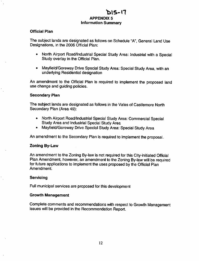
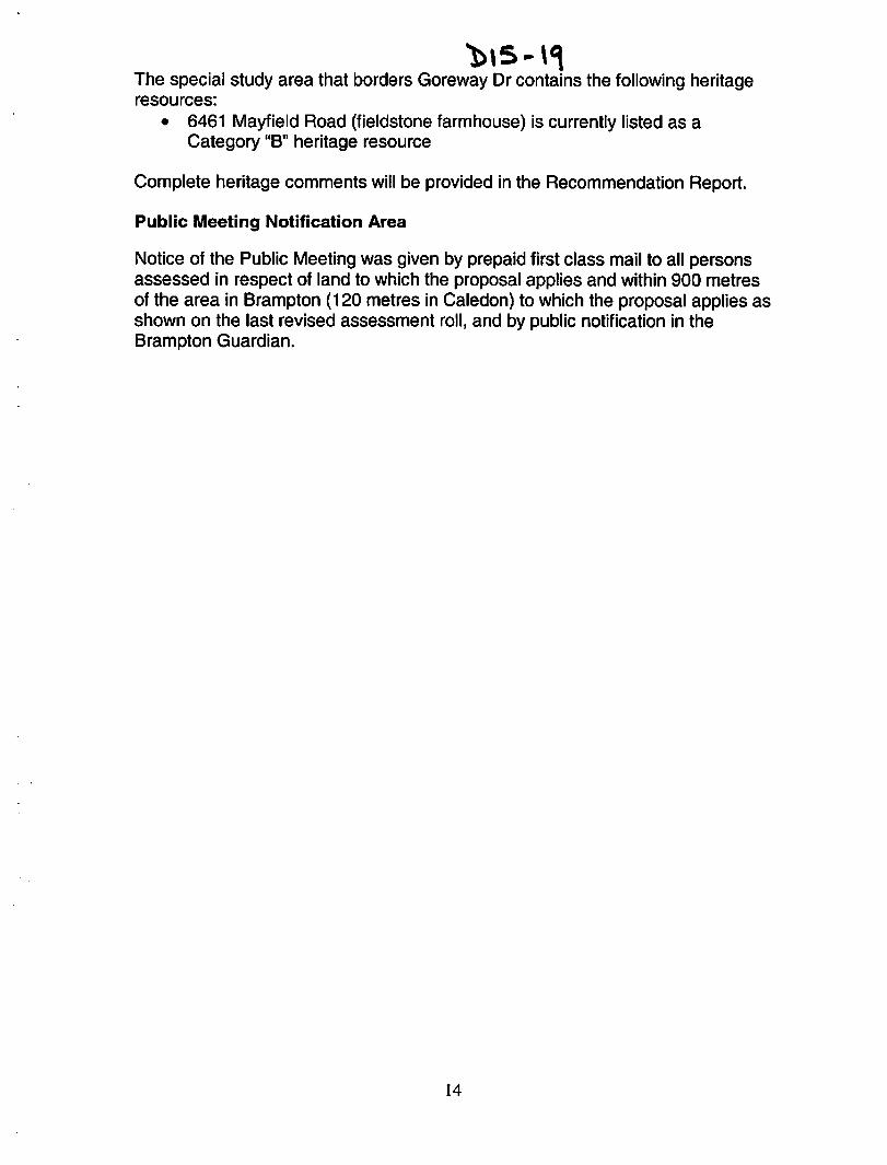
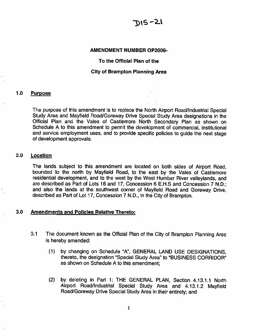
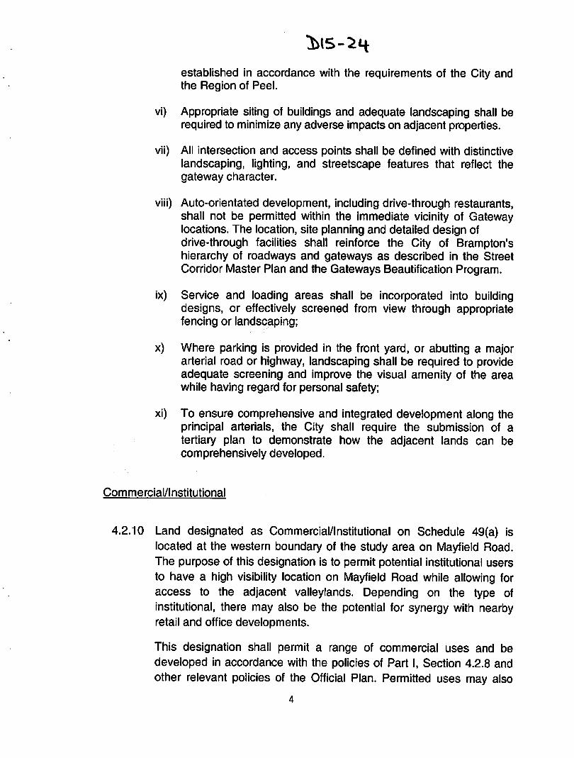
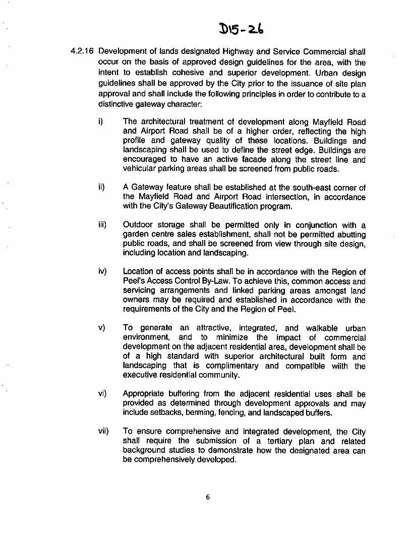