florida keys sombrero key to sand key - quick links · florida keys sombrero key to sand key . ......
TRANSCRIPT

BookletChart™ Florida Keys – Sombrero Key to Sand Key NOAA Chart 11442
A reduced-scale NOAA nautical chart for small boaters When possible, use the full-size NOAA chart for navigation.

2
Published by the National Oceanic and Atmospheric Administration
National Ocean Service Office of Coast Survey
www.NauticalCharts.NOAA.gov 888-990-NOAA
What are Nautical Charts?
Nautical charts are a fundamental tool of marine navigation. They show water depths, obstructions, buoys, other aids to navigation, and much more. The information is shown in a way that promotes safe and efficient navigation. Chart carriage is mandatory on the commercial ships that carry America’s commerce. They are also used on every Navy and Coast Guard ship, fishing and passenger vessels, and are widely carried by recreational boaters.
What is a BookletChart?
This BookletChart is made to help recreational boaters locate themselves on the water. It has been reduced in scale for convenience, but otherwise contains all the information of the full-scale nautical chart. The bar scales have also been reduced, and are accurate when used to measure distances in this BookletChart. See the Note at the bottom of page 5 for the reduction in scale applied to this chart.
Whenever possible, use the official, full scale NOAA nautical chart for navigation. Nautical chart sales agents are listed on the Internet at http://www.NauticalCharts.NOAA.gov.
This BookletChart does NOT fulfill chart carriage requirements for regulated commercial vessels under Titles 33 and 44 of the Code of Federal Regulations.
Notice to Mariners Correction Status
This BookletChart has been updated for chart corrections published in the U.S. Coast Guard Local Notice to Mariners, the National Geospatial Intelligence Agency Weekly Notice to Mariners, and, where applicable, the Canadian Coast Guard Notice to Mariners. Additional chart corrections have been made by NOAA in advance of their publication in a Notice to Mariners. The last Notices to Mariners applied to this chart are listed in the Note at the bottom of page 7. Coast Pilot excerpts are not being corrected.
For latest Coast Pilot excerpt visit the Office of Coast Survey website at http://www.nauticalcharts.noaa.gov/nsd/searchbychart.php?chart=11442
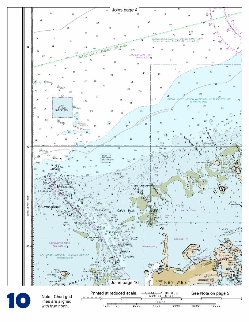
(Selected Excerpts from Coast Pilot) Great White Heron National Wildlife Refuge and National Key Deer Refuge extend through the northern part of the keys from near Vaca Key to Key West. Looe Key Management Area (Looe Key National Marine Sanctuary) has been established to protect and preserve the coral reef ecosystem and other natural resources of the waters surrounding Looe Key, 6 miles south-southeast of Summerland Key.
Kemp Channel, about 2 miles westward of Niles Channel, is between Summerland Key to the east and Cudjoe Key to the west. This channel is highly used by local boaters. A reported controlling depth of 3 feet was
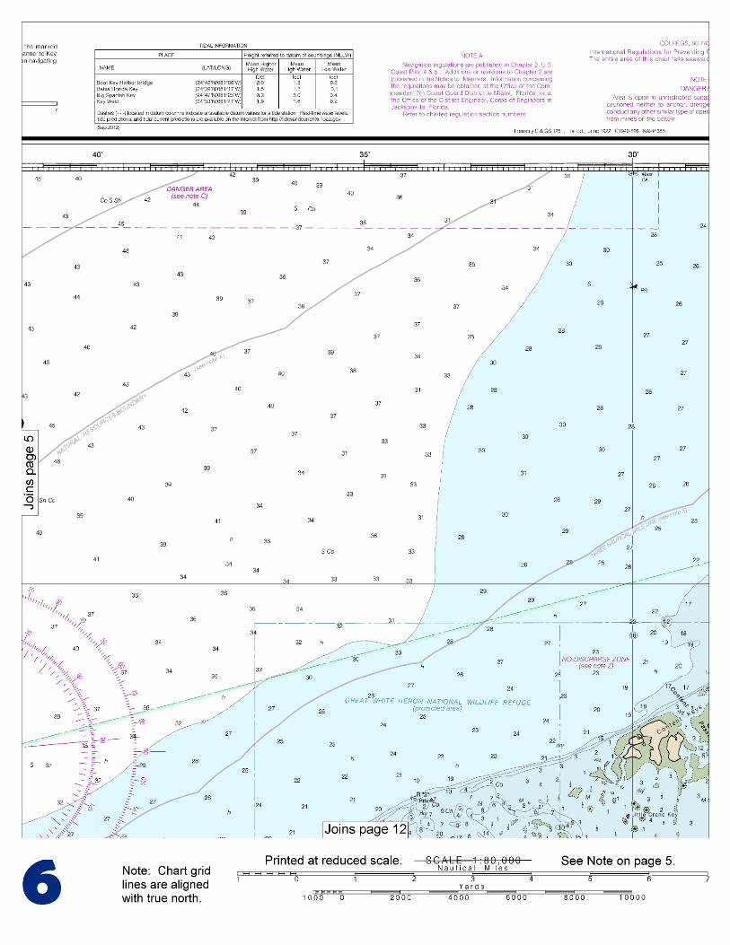
in the entrance, and 5 feet was in the channel. The channel is marked by daybeacons to the highway bridge. Strangers should seek local knowledge before transiting this area. The northern alternate route of the Intracoastal Waterway leads northwestward from Bahia Honda through Big Spanish Channel to Harbor Key Bank, thence along the north side of the Florida Keys to Northwest Channel, thence to Key West. The controlling depth for this route was 2 feet. Numerous submerged pilings are also in this channel. Local knowledge is advised. At Mile 1214.2A, the waterway passes through a crooked channel marked by daybeacons southwest of Big Spanish Key. Caution should be exercised in this shoal area. Northward of the key the color of the water is a good indication of the channel location. At Harbor Key Bank Light 45, Mile 1218.3A, the waterway enters the Gulf of Mexico, turns westward and follows a course of 246° for about 28 miles to the lighted bell buoy at the entrance to Northwest Channel, Mile 1251.1A. A course closer to the Florida Keys should not be attempted because the landmarks are difficult to identify and the bottom inside the 18-foot contour rises abruptly. The recommended routes to Key West are via Hawk Channel or through Big Spanish Channel; these routes have been described earlier. Moser Channel affords passage between the keys from the Gulf of Mexico to Hawk Channel for vessels of 7 to 8 feet in draft. The swing span of Seven Mile Bridge across Moser Channel has been removed; however, the bridge piers remain. The highway bridge south of the former swing span has a clearance of 65 feet. The tidal current at the Moser Channel bridge floods NNW with an average velocity of 1.4 knots and ebbs SSE with an average velocity of 1.8 knots. Wind effects modify considerably the current velocities and directions. Florida Bay, a triangular-shaped body of water between the Florida Keys and the S coast of the mainland, extends in a general E-W direction from Shell and Bogie Keys to Cape Sable. Depths are shallow and irregular; the bottom is mostly mud. From April to October the waters of the bay are clear and the shoals plainly discernible, but during the winter the water frequently turns milky and renders the shoals indistinguishable. In the E part of the bay are small keys and numerous mudflats which bare, or nearly bare, at low water. The W part of the bay has depths ranging from 7 to 13 feet, and the bottom is covered with loggerhead sponges and turtle grass. A protected area of the Everglades National Park is in the northern part of Florida Bay. For the protection of wildlife, all keys in the Florida Bay portion of Everglades National Park are closed to landing except those marked as designated camping areas. The killing, collecting, or molesting of animals, the collecting of plants, and waterskiing are prohibited by Federal Regulation. Manatees. Regulated speed zones for the protection of manatees are posted throughout the Everglades National Park.
U.S. Coast Guard Rescue Coordination Center 24 hour Regional Contact for Emergencies
RCC Miami Commander
7th CG District (305) 415-6800 Miami, FL

G
NOAA’s navigation managers serve as ambassadors to the maritime community. They help identify navigational challenges facing professional and recreational mariners, and provide NOAA resources and information for safe navigation. For additional information, please visit nauticalcharts.noaa.gov/service/navmanagers
To make suggestions or ask questions online, go to nauticalcharts.noaa.gov/inquiry. To report a chart discrepancy, please use ocsdata.ncd.noaa.gov/idrs/discrepancy.aspx.
Lateral System As Seen Entering From Seaward on navigable waters except Western Rivers
PORT SIDE
ODD NUMBERED AIDS
GREEN LIGHT ONLY
FLASHING (2)
PREFERRED CHANNEL
NO NUMBERS – MAY BE LETTERED
PREFERRED CHANNEL TO
STARBOARD
TOPMOST BAND GREEN
PREFERRED CHANNEL
NO NUMBERS – MAY BE LETTERED
PREFERRED CHANNEL
TO PORT
TOPMOST BAND RED
STARBOARD SIDE
EVEN NUMBERED AIDS
RED LIGHT ONLY
FLASHING (2)
FLASHING FLASHING
OCCULTING GREEN LIGHT ONLY RED LIGHT ONLY OCCULTING QUICK FLASHING QUICK FLASHING
ISO COMPOSITE GROUP FLASHING (2+1) COMPOSITE GROUP FLASHING (2+1) ISO
"1"
Fl G 6s
G "9"
Fl G 4s
GR "A"
Fl (2+1) G 6s
RG "B"
Fl (2+1) R 6s
"2"
Fl R 6s
8
R "8"
Fl R 4s
LIGHT
G
C "1"
LIGHTED BUOY
G
"5"
GR
"U"
GR
C "S"
RG
N "C"
RG
"G"
LIGHT
6
R
N "6"
LIGHTED BUOY
R
"2
"
CAN DAYBEACON
CAN NUN NUN
DAYBEACON
For more information on aids to navigation, including those on Western Rivers, please consult the latest USCG Light List for your area.
These volumes are available online at http://www.navcen.uscg.gov
Navigation Managers Area of Responsibility
Northeast
Lt. Meghan McGovern
Northwest and
Pacific Islands
Crescent Moegling
Great Lakes Region
Tom Loeper
Chesapeake and
Delaware Bay
Steve Soherr
California
Jeff Ferguson
[email protected] Mid-Atlantic
Lt. Ryan Wartick
Alaska
Lt. Timothy M. Smith
Western Gulf Coast
Alan Bunn
Central Gulf Coast
Tim Osborn
[email protected] South Florida
Puerto Rico
U.S. Virgin Islands
Michael Henderson
Southeast
Kyle Ward
2
2 C U 5
1


VHF Marine Radio channels for use on the waterways:Channel 6 – Inter-ship safety communications.Channel 9 – Communications between boats and ship-to-coast.Channel 13 – Navigation purposes at bridges, locks, and harbors.Channel 16 – Emergency, distress and safety calls to Coast Guard and others, and to initiate calls to other
vessels. Contact the other vessel, agree to another channel, and then switch.Channel 22A – Calls between the Coast Guard and the public. Severe weather warnings, hazards to navigation and safety warnings are broadcast here.Channels 68, 69, 71, 72 and 78A – Recreational boat channels.
Getting and Giving Help — Signal other boaters using visual distress signals (flares, orange flag, lights, arm signals); whistles; horns; and on your VHF radio. You are required by law to help boaters in trouble. Respond to distress signals, but do not endanger yourself.
EMERGENCY INFORMATION
Distress Call Procedures
• Make sure radio is on.• Select Channel 16.• Press/Hold the transmit button.• Clearly say: “MAYDAY, MAYDAY, MAYDAY.”• Also give: Vessel Name and/or Description;Position and/or Location; Nature of Emergency; Number of People on Board.• Release transmit button.• Wait for 10 seconds — If no responseRepeat MAYDAY call.
HAVE ALL PERSONS PUT ON LIFE JACKETS!
This Booklet chart has been designed for duplex printing (printed on front and back of one sheet). If a duplex option is not available on your printer, you may print each sheet and arrange them back-to-back to allow for the proper layout when viewing.
QR
Quick ReferencesNautical chart related products and information - http://www.nauticalcharts.noaa.gov
Interactive chart catalog - http://www.charts.noaa.gov/InteractiveCatalog/nrnc.shtmlReport a chart discrepancy - http://ocsdata.ncd.noaa.gov/idrs/discrepancy.aspx
Chart and chart related inquiries and comments - http://ocsdata.ncd.noaa.gov/idrs/inquiry.aspx?frompage=ContactUs
Chart updates (LNM and NM corrections) - http://www.nauticalcharts.noaa.gov/mcd/updates/LNM_NM.html
Coast Pilot online - http://www.nauticalcharts.noaa.gov/nsd/cpdownload.htm
Tides and Currents - http://tidesandcurrents.noaa.gov
Marine Forecasts - http://www.nws.noaa.gov/om/marine/home.htm
National Data Buoy Center - http://www.ndbc.noaa.gov/
NowCoast web portal for coastal conditions - http://www.nowcoast.noaa.gov/
National Weather Service - http://www.weather.gov/
National Hurrican Center - http://www.nhc.noaa.gov/
Pacific Tsunami Warning Center - http://ptwc.weather.gov/
Contact Us - http://www.nauticalcharts.noaa.gov/staff/contact.htm
NOAA’s Office of Coast Survey The Nation’s Chartmaker
For the latest news from Coast Survey, follow @NOAAcharts
NOAA Weather Radio All Hazards (NWR) is a nationwide network of radio stations broadcasting continuous weather information directly from the nearest National Weather Service office. NWR broadcasts official Weather Service warnings, watches, forecasts and other hazard information 24 hours a day, 7 days a week. http://www.nws.noaa.gov/nwr/