florida institute of technology
TRANSCRIPT
December 31, 2010

Page | 1
Table of Contents
Executive Summary........................................................................................................................... 5
Findings ................................................................................................................................... 7
Recommendations .................................................................................................................. 8
Introduction .......................................................................................................................... 12
Key Terms ............................................................................................................................... 14
Sea Level Rise: Causes and Projections .................................................................................... 16
Hazards of Sea Level Rise ........................................................................................................ 19
Ecosystems............................................................................................................................ 21
Tidal Wetlands ........................................................................................................................ 23
Low to Moderate Energy Shorelines ...................................................................................... 24
Submerged Aquatic Vegetation............................................................................................... 25
Barrier Islands ......................................................................................................................... 26
Coastal Bluffs .......................................................................................................................... 27
Marine Rocky Intertidal Areas ................................................................................................. 28
Freshwater Resources ............................................................................................................. 28
Ecosystems: Actions Needed to Adapt to Sea Level Rise .......................................................... 29
Public Works and Infrastructure ............................................................................................ 32
Communications ..................................................................................................................... 34
Energy..................................................................................................................................... 34
Shoreline Protective Structures ............................................................................................... 34
Solid Waste ............................................................................................................................. 36
Transportation ........................................................................................................................ 36
Drinking Water Supplies.......................................................................................................... 37
Wastewater Management Systems ......................................................................................... 38
Public Works and Infrastructure: Actions Needed to Adapt to Sea Level Rise .......................... 38
Page | 2
Communities ......................................................................................................................... 40
Public Health........................................................................................................................... 44
Loss of Shelter......................................................................................................................... 45
Disrupted Livelihoods and Loss of Economic Vitality................................................................ 45
Quality of Life and Community Cohesion................................................................................. 46
Climate Justice....................................................................................................................... 47
Communities: Actions Needed to Adapt to Sea Level Rise ....................................................... 48
Adaptation Champions.......................................................................................................... 52
Meeting the Challenge .......................................................................................................... 53
Recommendations of the Sea Level Rise Task Force .............................................................. 57
Appendix A: Members of the Task Force and Workgroups .................................................... 81
Appendix B: Public Outreach Summary ................................................................................. 88
Appendix C: Organizational Framework ................................................................................ 90
Appendix D: Summary of State Sea Level Rise (SLR) Policy Development �– Mid Atlantic andNortheast .............................................................................................................................. 92
Appendix E: Comments of the City of New York on the NYS Sea Level Rise Task Force Draft forPublic Comment .................................................................................................................... 95
Page | 3
Sea Level Rise Task Force Members
Pete Grannis, Former Commissioner, NYS Department of Environmental Conservation, Task Force Chair
Peter Iwanowicz, Acting Commissioner, NYS Department of Environmental Conservation, Task Force Chair
Fred Anders, Chief, Natural Resources Management, NYS Department of State (representing Ruth Noemí Colón,Acting Secretary of State)
John Gibb, Director, NYS Office of Emergency Management
Ivan Lafayette, Deputy Insurance Superintendent for Community Affairs, NYS Department of Insurance(representing James Wrynn, Superintendent, NYS Department of Insurance)
Jared Snyder, Assistant Commissioner for Air Resources, Climate Change and Energy, NYS Department ofEnvironmental Conservation (representing Pete Grannis, former Commissioner, and Peter Iwanowicz, ActingCommissioner, NYS Department of Environmental Conservation)
Richard Svenson, Director of the Division of Environmental Health Protection, NYS Department of Health(representing Richard F. Daines, M.D., Commissioner, NYS Department of Health)
Lloyd Wilson, Director's Office, Research and Special Projects , NYS Department of Health (representing Richard F.Daines, M.D., Commissioner, NYS Department of Health)
Lisa Weiss, Route 9A Urban Design Director (representing Stanley Gee, Acting Commissioner, NYS Department ofTransportation)
Fred Nuffer, NYS Office of Emergency Management, representing John Gibb, Director, NYS Office of EmergencyManagement
Adam Freed, Deputy Director, New York City Mayor�’s Office of Long Term Planning and Sustainability
Carrie Meek Gallagher, Commissioner of Environment and Energy, Suffolk County
Michael Gerrard, Andrew Sabin Professor of Professional Practice and Director, Columbia Law School Center forClimate Change Law
Gerceida Jones, Professor of Astronomy, New York University
Jack Mattice, Director, New York Sea Grant (retired)
Jerry Mulligan, Commissioner, Westchester County Department of Planning
Sarah Newkirk, Coastal Program Director, The Nature Conservancy
Brad Tito, Deputy Director of Environmental Coordination, Office of the Nassau County Executive
James Staudenraus, Vice President of Operations, George Henry Ltd.
John Walters III, Chief, Port Washington Fire Department

Page | 4
Acknowledgements
The New York State Sea Level Rise Task Force was created by an act of the New York State Legislature(Chapter 613 of the Laws of New York) in August 2007. New York State Department of EnvironmentalConservation (DEC) Commissioner Pete Grannis, Chair of the Task Force, assigned Special Counsel RobinSchlaff to establish and chair a steering committee. Kristin Marcell served as steering committee vicechair.
The steering committee, comprised of state agency staff and representatives of non governmentalorganizations (NGOs), spent an extraordinary amount of time researching, discussing and deliberatingissues addressed in the report. Members of the steering committee coordinated the work of five workgroups: Community Resilience, Ecosystems and Natural Resources, Infrastructure, Legal and PublicOutreach. Each work group included representatives from academia, businesses, NGOs, environmentaljustice and community groups, and federal, state and local agencies. This report is the result of theirefforts, and the Task Force gratefully acknowledges their contributions.
Projections of sea level rise affecting New York State were provided by the Columbia University Centerfor Climate Systems Research based on work undertaken for the New York City Panel on ClimateChange.
DEC Assistant Commissioner Jared Snyder provided leadership and guidance throughout development ofthis report. Alan Belensz, Director of the DEC Office of Climate Change, provided a critical review of anearly draft. Additional DEC staff contributors to writing, editing and production of this report includeAudrey Their, Elaine Bloom, Bernadette LaManna and Ellen Bidell. Kim Farrow and Mary Kadlecekmaintained the Sea Level Rise Task Force webpage. Mark Lowery provided editorial assistance andmanaged public outreach efforts.
The development of this report included a public review of the sea level rise projections, the Task Forceprocess and an early draft of the report and recommendations. Throughout the process, participation ofstakeholders and their thoughtful comments improved the quality of the report.
Page | 5
Executive Summary
New York State's extensive ocean coastline has places that we know, that we remember and that haveshaped us in some way. The state�’s coastline includes many notable locations�—Montauk Point, ConeyIsland, Robert Moses State Park, Battery Park and the Hudson River's shores from New York City to thefederal dam at Troy. More than 60 percent of New Yorkers live in homes on or near these waterfrontareas. Each shoreline area is unique and part of the essence of New York. But these places will change assea level rises, and the differences will become more obvious as the sea continues to rise to levels neverexperienced by humans. A result of the world�’s changing climate, a rising sea will alter more than just thecoastline. The entire state will feel the effects as residents and a significant amount of the landscape areaffected. These areas are diverse and interconnected and share New York�’s rich agriculture, commercial,economic and environmental history and resources.
The communities along New York State's coastline, including their structures, their residents, theirenvironment and the surrounding natural resources, are products of decisions made over the course ofmany years. These decisions shaped decades of investment, development and conservation. While theextent of the impacts to coastal communities from a rising sea are not fully known, even the mostconservative projections make clear that there will be dramatic changes in this century. Thus, howcoastal communities and our state address this collective challenge is important to today's decisionmakers. The responses needed to protect communities from the threat posed by sea level rise will taketime, and now that the challenges are better understood, government is obligated to protect its citizenswhile there is time to do so effectively. New York must focus on the smart use of limited resources toaddress the impacts associated with sea level rise.
THE SEA LEVEL RISE TASK FORCE
In 2007, the New York State Legislature created the Sea Level Rise Task Force and charged it withpreparing a report that addresses these issues, including recommendations for an action plan to protectcoastal communities and natural resources from rising sea levels. The New York State Department ofEnvironmental Conservation leads the Task Force, which has a diverse membership that includesrepresentatives of state and local government agencies, non governmental organizations and affectedcommunities. The legislature directed the Task Force to �“evaluate ways of protecting New York�’sremaining coastal ecosystems and natural habitats, and increasing coastal community resilience in theface of sea level rise, applying the best available science as to sea level rise and its anticipated impacts.�”The Task Force has studied and deliberated, with public participation, the complex issues involved withsea level rise in New York State; however, a thorough analysis of the costs and benefits associated withsea level rise and potential adaptation strategies was beyond the scope of this effort. The findings andrecommendations in this report are an important first step in increasing the resilience of our coastalcommunities but should be further analyzed to evaluate their site specific applicability and effect oneconomic development, greenhouse gas mitigation efforts, the environment and other factors.

Page | 6
While this report is the result of the considerable efforts of many dedicated individuals, it does notrepresent the unanimous consent of the Task Force. The City of New York, which was a member of theTask Force and has launched a comprehensive climate resilience effort as part of its long termsustainability plan, PlaNYC, does not support recommendations 2, 3, 4, 5 and 7. As detailed in commentssubmitted to the Task Force and available as an appendix to this report and athttp://www.dec.ny.gov/energy/69851.html, New York City believes that these recommendations �“arenot supported by thorough scientific, environmental, or cost benefit analysis [and] do not recognize thedifferences between undeveloped areas and densely populated cities�… since this analysis has not beendone, we do not fully understand the potential impacts of sea level rise and storm surge on coastalinfrastructure and communities�—much less many of the intended and unintended consequences of theproposed policy recommendations in the draft report.�” Similar concerns were expressed by others inpublic comments to the Task Force. The Task Force recognizes the divergence of opinion of its membersand looks forward to continuing to work with all affected stakeholders to respond to the real andsignificant challenges posed by sea level rise.
Findings1. Sea level rise and coastal flooding from storm surge are already affecting and will increasinglyaffect New York�’s entire ocean and estuarine coastline from Montauk Point to the Battery and upthe Hudson River to the federal dam at Troy.
2. The likelihood that powerful storms will hit New York State�’s coastline is very high, as is theassociated threat to human life and coastal infrastructure. This vulnerability will increase in areaand magnitude over time.
3. Natural shoreline features, such as wetlands, aquatic vegetation, dunes and barrier beaches,currently provide large scale services, such as flood protection, storm buffering, fisheries habitat,recreational facilities and water filtration, at almost no cost. These services would be prohibitivelyexpensive to replicate with human built systems. New York is losing tidal marshes at a rapid paceand with them the natural infrastructure that protects the shore from floods, wave attack anderosion.
4. Sea level rise will cause all shoreline ecosystems to become more frequently inundated. Lowlying locations will become permanently submerged. Habitats and the species associated withthem may migrate landward; this migration, however, will be impeded by the density ofdevelopment on much of the state�’s shoreline and the widespread hardening of that shoreline.
5. Current investment and land use planning practices by both New York State and localgovernments are encouraging development in areas at high risk of coastal flooding and erosion.
6. Over the long term, cumulative environmental and economic costs associated with structuralprotection measures, such as seawalls, dikes, and beach nourishment, may be more expensive andless effective than non structural measures, such as elevation of at risk structures and plannedrelocation away from the coastal shoreline, especially in less urbanized areas. Solutions for urbanareas, however, may require a mixed approach of structural and non structural solutions.
7. As water levels rise, sea walls, dikes and similar structures along the state�’s coastline may limitpublic access to beaches as the publicly accessible intertidal zone is eliminated.
8. Existing maps of New York State�’s coast that identify communities, habitats and infrastructure atgreatest risk of flooding and erosion are inaccurate, out of date, not detailed enough for planningand regulatory purposes and fail to incorporate historic and projected sea level rise.
9. There are low cost, high benefit actions that can be taken now to reduce vulnerability alongNew York State�’s coastline.
Page | 7
Recommendations1. Adopt official projections of sea level rise and ensure continued and coordinated adaptation efforts.
2. Require state agencies responsible for the management and regulation of resources, infrastructure,and populations at risk from sea level rise to factor the current and anticipated impacts into all relevantaspects of decision making.*
3. Classify areas where significant risk of coastal flooding due to storms has been identified andimplement risk reduction measures in those areas.*
4. Identify and classify areas of future impacts from coastal flooding from projected sea level rise andstorms to reduce risk in those areas.*
5. Reduce vulnerability in coastal areas at risk from sea level rise and storms. Support increased relianceon non structural measures and natural protective features to reduce impacts from coastal hazards,where applicable.*
6. Develop maps and other tools required to assist local decision makers in preparing for andresponding to sea level rise.
7. Amend New York State laws and change and adopt regulations and agency guidance documents toaddress sea level rise and prevent further loss of natural systems that reduce risk of coastal flooding.*
8. Provide financial support, guidance and tools for community based vulnerability assessments andensure a high level of community representation and participation in official vulnerability assessmentsand post storm recovery, redevelopment and adaptation planning processes.
9. Undertake a comprehensive assessment of the public health risks associated with sea level rise,coastal hazards and climate change including compromised indoor air quality, drinking water impacts,post traumatic stress and other mental health problems, increases in disease vectors, impaired accessto health care and loss of reliable access to food and medical supplies.
10. Raise public awareness of the adverse impacts of sea level rise and climate change and of thepotential adaptive strategies.
11. Develop mechanisms to fund adaptation to sea level rise and climate change.
12. Fund research, monitoring and demonstration projects to improve understanding of keyvulnerabilities of critical coastal ecosystems, infrastructure and communities from sea level rise.
13. Ensure continued and coordinated adaptation to sea level rise.
14. Seek federal funding, technical assistance and changes to federal programs to make them consistentwith, or accommodating to, state policies, programs and adaptation measures related to sea level rise.
* Recommendation does not have the unanimous support of the Task Force.
Page | 8

Page | 9
THE SEA IS RISING
Our climate is changing, causing the world�’s seas to rise. Since 1970, the Northeast has witnessedincreases in average temperatures of more than 1.5°F. These changes have resulted in warmer wintersand hotter summers and other changes in the form of fewer, but heavier, snows and heavier, moreintense rainfall and storms. The warming produced by global climate change causes the sea level to risebecause warmer water takes up more space, and higher temperatures are melting ice sheets around theglobe. New York Harbor has experienced an increase in sea level of more than 15 inches in the past 150years, with harbor tide gauges showing a rise of between 4 and 6 inches since 1960.
The Task Force looked to the best available science to estimate potential sea level rise. Not all regions ofthe marine coast will be affected in the same way, and this report focuses on estimates for two areas:the lower Hudson Valley and Long Island, including New York City, and the mid Hudson Valley andCapital Region. Sea level rise affecting the Lower Hudson Valley and Long Island is projected to be 2 to 5inches by the 2020s and 12 to 23 inches by the end of this century. However, rapid melt of land basedice could double these projections in the next few decades, with a potential rise of up to 55 inches bythe end of the century. Sea level rise in the mid Hudson Valley and Capital Region will be somewhat lessbut will follow similar trends. The combination of rising sea level, continuing climate change, and moredevelopment in high risk areas has raised the level of New York�’s vulnerability to coastal storms.Without meaningful action on a number of key fronts, this vulnerability will increase in area andmagnitude over time.
EVERY NEW YORK TIDAL COASTAL COMMUNITY WILL BE AFFECTED BY SEA LEVEL RISE
Sea level rise will have dramatic implications for New York�’s coastal communities and their naturalresources, affecting the entire ocean and estuarine coastline of the state. Every community along theHudson River from the Federal Dam at Troy to New York Harbor and along Long Island Sound and theAtlantic coastline will be affected.
Sea level rise will continue to increase the risk to developed areas, future development and coastalhabitats which are already highly vulnerable to flooding and storm damage. Many neighborhoods andtheir associated buildings, roads, and utilities will be directly affected, with the most vulnerablecommunities permanently inundated.
An area far broader than the immediate coastline will witness flooding and erosion associated withincreasingly powerful storms. The effects will be potentially more dramatic because of the broad extentof effects on the utilities and infrastructure systems upon which our modern society relies: sewage,stormwater, fuel storage, energy generation, communication, solid waste, and transportation, includingroad, rail, airports, and ports. The emergency services that provide relief and support during stormevents and flooding will be more overwhelmed in areas where the intensity of impacts increases.

Page | 10
Secondary impacts such as water borne pollution associated with flooding of contaminated landslocated throughout coastal communities may affect water quality and ecosystems, having long termimplications for New York�’s seafood industries. Public health will be further affected by vector bornediseases and impacts to water supplies caused by changes in rainfall, heat and saltwater intrusion.
New York�’s natural resources and ecosystems will be greatly affected by the human response to sealevel rise. Natural systems such as wetlands currently provide critical benefits, including floodprotection, to coastal communities on a large scale at almost no cost. These benefits would beexpensive to replicate with human engineered solutions. Responses that harden the coastline, such assea walls and bulkheads, prevent natural systems from migrating inland as water levels increase, leavingthem to drown in place. In addition, such solutions can limit public access to beaches. Thorough analysisof the environmental effects, long term effectiveness and costs of alternative management measuresrelative to coastline hardening will be required, particularly in less urbanized areas, and different typesof shorelines will require different types of protection.
While the recommendations contained in this report strongly favor and support first consideration ofnon structural strategies, the Task Force recognizes that responses must be flexible to account forunique local circumstances and may require multi faceted approaches. Further, the Task Forcerecognizes the need and appropriateness of structural shore protection solutions in highly developedareas or where water dependent infrastructure exists. New York City is home to approximately 43percent1 of New York State�’s population, with approximately 18 million2 people from the tri statemetropolitan area relying on New York City�’s extensive transportation, communication, and utilityinfrastructure. Much of this infrastructure is located in close proximity to the coast, without the benefitof natural systems, such as wetlands, to mitigate the effects of climate change. Responding to sea levelrise in this area will require analyses to develop a mix of both non structural and structural solutions.
THE TASK FORCE REPORT
The Task Force worked for more than two years to produce this report, which examines the complexitiesof sea level rise and its implications for New York in the twenty first century. This report includes 9findings and 14 specific recommendations for action. Many of the recommendations require additionalanalysis before implementation, and the proposed timelines for implementation of eachrecommendation reflect the necessary sequence of this work. The recommendations do not representthe unanimous consent of the Task Force. The City of New York, which was a member of the Task Forceand has launched a comprehensive climate resilience effort as part of its long term sustainability plan,PlaNYC, does not support recommendations 2, 3, 4, 5 and 7.
1 2009 US Census Bureau
2 Ibid.
Page | 11
The report�’s findings coalesce around the need for immediate action. Every day, New York's residents,governments and businesses make decisions that affect the future vulnerability of the state�’s coastline.The magnitude and scope of the challenge posed by sea level rise require that relevant and accurateinformation about climate risk, resilience and adaptation become part of these everyday decisions. Thevulnerabilities of coastal communities must be inventoried and assessed, and this information sharedwith residents of at risk communities. Appropriate responses must be formulated and implemented.Government policies and actions must be coordinated and prioritized to assist communities at greatestand most immediate risk in the most cost effective ways and in ways that recognize the importance ofour natural coastal resources and their role in New York�’s future. These efforts must be guided byaccurate science, up to date mapping and effective planning tools.
We hope that the Task Force�’s work will spark action. The public and its governments must be investedin meeting the challenge of sea level rise. The challenge is real, and sea level rise will progress regardlessof New York�’s response.
Introduction
The sea is rising, driven by changes in global climate, and New York State�’s low lying marine andestuarine coastal areas�–their people, businesses, infrastructure, and ecosystems�–are at risk. More than62 percent of New York's population lives in marine coastal counties, and these areas have tremendouseconomic value in terms of commerce and natural benefits such as habitat, water quality improvement,flood control, and storm protection. Sea level along New York's coast has been rising at the rate ofalmost one foot per century for at least 100 years,3 resulting in more severe storm impacts, shorelineerosion, and coastal flooding experienced by coastal communities today. The rate of rise is expected toincrease with global warming, perhaps doubling over the next century.4 Table 1 provides projections of
sea level rise in New York.
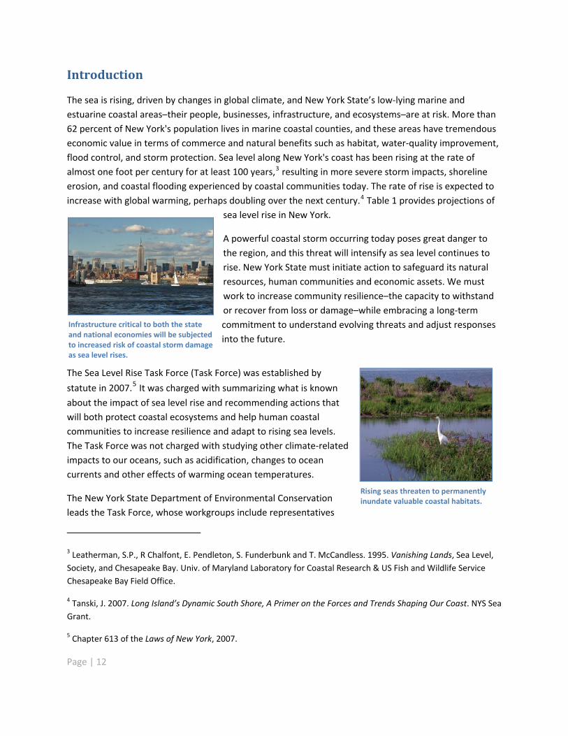
A powerful coastal storm occurring today poses great danger tothe region, and this threat will intensify as sea level continues torise. New York State must initiate action to safeguard its naturalresources, human communities and economic assets. We mustwork to increase community resilience�–the capacity to withstandor recover from loss or damage�–while embracing a long termcommitment to understand evolving threats and adjust responsesinto the future.
Infrastructure critical to both the stateand national economies will be subjectedto increased risk of coastal storm damageas sea level rises.
The Sea Level Rise Task Force (Task Force) was established by
statute in 2007.5 It was charged with summarizing what is known
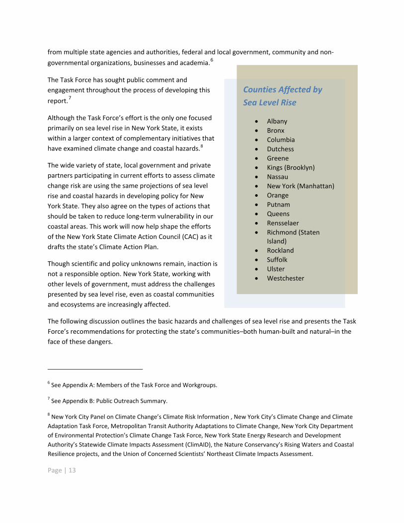
about the impact of sea level rise and recommending actions thatwill both protect coastal ecosystems and help human coastalcommunities to increase resilience and adapt to rising sea levels.The Task Force was not charged with studying other climate relatedimpacts to our oceans, such as acidification, changes to oceancurrents and other effects of warming ocean temperatures.
Rising seas threaten to permanentlyinundate valuable coastal habitats.The New York State Department of Environmental Conservation
leads the Task Force, whose workgroups include representatives
3 Leatherman, S.P., R Chalfont, E. Pendleton, S. Funderbunk and T. McCandless. 1995. Vanishing Lands, Sea Level,Society, and Chesapeake Bay. Univ. of Maryland Laboratory for Coastal Research & US Fish and Wildlife ServiceChesapeake Bay Field Office.
4 Tanski, J. 2007. Long Island�’s Dynamic South Shore, A Primer on the Forces and Trends Shaping Our Coast. NYS SeaGrant.
5 Chapter 613 of the Laws of New York, 2007.
Page | 12
from multiple state agencies and authorities, federal and local government, community and non
governmental organizations, businesses and academia.6
Counties Affected bySea Level Rise
Albany Bronx Columbia Dutchess Greene Kings (Brooklyn) Nassau New York (Manhattan) Orange Putnam Queens Rensselaer Richmond (Staten
Island) Rockland Suffolk Ulster Westchester
The Task Force has sought public comment andengagement throughout the process of developing this
report.7
Although the Task Force�’s effort is the only one focusedprimarily on sea level rise in New York State, it existswithin a larger context of complementary initiatives thathave examined climate change and coastal hazards.8
The wide variety of state, local government and privatepartners participating in current efforts to assess climatechange risk are using the same projections of sea levelrise and coastal hazards in developing policy for NewYork State. They also agree on the types of actions thatshould be taken to reduce long term vulnerability in ourcoastal areas. This work will now help shape the effortsof the New York State Climate Action Council (CAC) as itdrafts the state�’s Climate Action Plan.
Though scientific and policy unknowns remain, inaction isnot a responsible option. New York State, working withother levels of government, must address the challengespresented by sea level rise, even as coastal communitiesand ecosystems are increasingly affected.
The following discussion outlines the basic hazards and challenges of sea level rise and presents the TaskForce�’s recommendations for protecting the state�’s communities�–both human built and natural�–in theface of these dangers.
Page | 13
6 See Appendix A: Members of the Task Force and Workgroups.
7 See Appendix B: Public Outreach Summary.
8 New York City Panel on Climate Change�’s Climate Risk Information , New York City�’s Climate Change and ClimateAdaptation Task Force, Metropolitan Transit Authority Adaptations to Climate Change, New York City Departmentof Environmental Protection�’s Climate Change Task Force, New York State Energy Research and DevelopmentAuthority�’s Statewide Climate Impacts Assessment (ClimAID), the Nature Conservancy�’s Rising Waters and CoastalResilience projects, and the Union of Concerned Scientists�’ Northeast Climate Impacts Assessment.
Key Terms9
Beach nourishment: the addition of sand, often dredged from offshore, to an eroding shorelineto enlarge or create a beach area, offering temporary shore protection and recreationalopportunities. The NYS Coastal Erosion Hazard Act specifically defines beach nourishment as astructural measure.
Coast: In this report, this term refers to New York State�’s marine coastline only, not to the GreatLakes or other inland coastlines.
Coastal hazards: negative impacts associated with sea level rise, storm surge, wind drivenwaves and erosion
Coastal Risk Management Zone: areas to be classified as currently at significant risk of coastalflooding due to storms and areas projected to be at high risk of flooding from projected sea levelrise and strong storms
Ecosystem services: the benefits people obtain from ecosystems that communities would haveto replace artificially if the natural systems were lost. These benefits include, among others,flood control, water quality improvement, storm protection, food production, nursery grounds,wildlife habitat and carbon sequestration.
Natural protective features: natural features such as the nearshore area, wetlands, dunes,bluffs, barrier islands and aquatic vegetation, the alteration of which might reduce or destroythe protection afforded other lands against erosion or high water, or lower the reserves of sandor other natural materials available to replenish storm losses through natural processes10
Non structural protection or non structural measures: Non structural protective measuresaddress storms, flooding and erosion, and minimize current and future damage throughsustainable adaptation of development within the context of the natural environment. From theland use perspective, non structural measures include excluding development from unsafe,high risk locations through land use regulation, zoning, open space conservation, land trusts,easements or other land use measures that protect communities, development and naturalresources. Non structural measures also include building construction techniques that achieveresilience to environmental conditions, such as relocation, elevation, and flood proofing or othermeasures applied to development. Retrofits, tax incentives, post storm adaptation, transfer ofdevelopment rights, voluntary acquisition and temporary lease/occupancy agreements are
Page | 14
9 Adapted from Titus, J.G. 2009. US Global Climate Science Program Synthesis and Assessment Product 4.1.http://www.gcrio.org/orders/product_info.php?products_id=239
10 As defined in regulations corresponding to the Coastal Erosion Hazard Areas Act (6 NYCRR Part 505).
examples of non structural measures to reduce coastal storm and inundation impacts forexisting development.11
Shore protection: a range of management and engineering responses that focus on protectingland from inundation, erosion or storm induced flooding through traditional armoring (seawalls;bulkheads; or revetments made from concrete, rock, steel or timber and placed parallel to theshoreline); shoreline stabilization structures and facilities (groins, breakwaters, sills, vegetation,wetland or ground water drainage) designed to slow the erosion rate; beach and dunereconstruction, designed to replace sediment on the beach or dune; non structural measures(see above); or a combination of these approaches
Soft shore protection, shoreline softening or soft engineering:methods of shore protectionthat prevent or reduce shore erosion through the use of natural materials similar to thosealready found in a given location, such as using sand for beach or dune reconstruction or theplanting of native vegetation to retain soils along the shore; or through use of structuresdesigned to provide riparian habitat or to emulate natural shorelines for the purpose of addinghabitat value
Storm Surge: a dramatic elevation of the ocean surface that leads to rapid flooding
Hard shoreline protection, shoreline hardening, shoreline armoring or hard engineeringmethods : concrete, rock, sill, timber or other structures such as groins, jetties and breakwaters,designed to slow erosion; or bulkheads, dikes, revetments and seawalls, designed to manage theerosive effect of waves on property or landward infrastructure
Page | 15
11 New York State Coastal Policy 17. http://nyswaterfronts.com/downloads/Coastal_Policies/Generic44policies.pdf.
Page | 16
Sea Level Rise: Causes and Projections
Sea level rise is caused by a complex suite of factors. Climate change contributes to global sea level risein two ways: 1) higher seawater temperatures cause the volume of seawater to increase, a phenomenonknown as �“thermal expansion,�” and 2) melting ice caps, glaciers and ice sheets increase the total amountof seawater.
Local sea levels are affected by ocean currents, gravitational forces, prevailing winds, and rise and fall ofthe land mass. Within the coastal regions of New York State, the land mass is slowly sinking, with theexception of the Hudson estuary north of Kingston. This movement is a result of geological forces andimpacts of human activity and development. It affects local, or relative, rates of sea level rise. Theeffects of sea level rise are compounded by potential increases in extreme precipitation and stormsassociated with climate change.
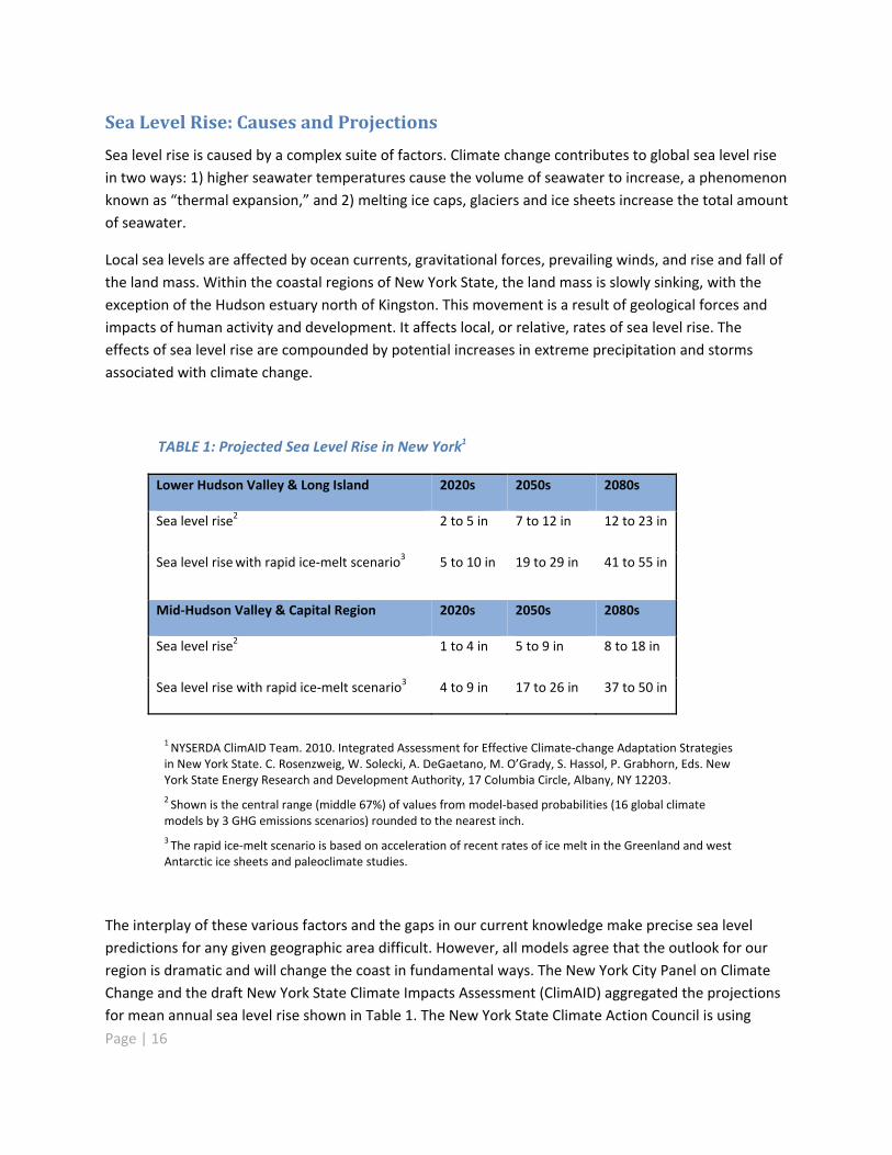
TABLE 1: Projected Sea Level Rise in New York1
Lower Hudson Valley & Long Island 2020s 2050s 2080s
Sea level rise2 2 to 5 in 7 to 12 in 12 to 23 in
Sea level risewith rapid ice melt scenario3 5 to 10 in 19 to 29 in 41 to 55 in
Mid Hudson Valley & Capital Region 2020s 2050s 2080s
Sea level rise2 1 to 4 in 5 to 9 in 8 to 18 in
Sea level rise with rapid ice melt scenario3 4 to 9 in 17 to 26 in 37 to 50 in
1NYSERDA ClimAID Team. 2010. Integrated Assessment for Effective Climate change Adaptation Strategiesin New York State. C. Rosenzweig, W. Solecki, A. DeGaetano, M. O�’Grady, S. Hassol, P. Grabhorn, Eds. NewYork State Energy Research and Development Authority, 17 Columbia Circle, Albany, NY 12203.2 Shown is the central range (middle 67%) of values from model based probabilities (16 global climatemodels by 3 GHG emissions scenarios) rounded to the nearest inch.3 The rapid ice melt scenario is based on acceleration of recent rates of ice melt in the Greenland and westAntarctic ice sheets and paleoclimate studies.
The interplay of these various factors and the gaps in our current knowledge make precise sea levelpredictions for any given geographic area difficult. However, all models agree that the outlook for ourregion is dramatic and will change the coast in fundamental ways. The New York City Panel on ClimateChange and the draft New York State Climate Impacts Assessment (ClimAID) aggregated the projectionsfor mean annual sea level rise shown in Table 1. The New York State Climate Action Council is using
these projections in developing its Climate Action Plan, and the Task Force has chosen to use this rangeof projections as the foundation for its risk assessments and recommendations.
These projections are supported by empirical datadocumenting recent sea level rise in New York State. Forexample, gauges at the New York City Battery indicate thatsea level in the 2000s is 4 to 6 inches higher than in theearly 1960s.12 The New York City Panel on Climate Changefound that as global temperatures have increased, theregional sea level has risen more rapidly in the past 100 to150 years than during the last 1,000 years.13
Beyond models and measurements, New Yorkers have theirown firsthand experience to confirm that the dangers offlooding and storm surges exacerbated by rising waters arereal and immediate.
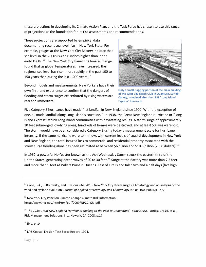
Only a small, sagging portion of the main buildingof the West Bay Beach Club in Quantuck, SuffolkCounty, remained after the 1938 "Long IslandExpress" hurricane.
Five Category 3 hurricanes have made first landfall in New England since 1900. With the exception ofone, all made landfall along Long Island's coastline.14 In 1938, the Great New England Hurricane or �“LongIsland Express�” struck Long Island communities with devastating results. A storm surge of approximately10 feet submerged low lying areas; hundreds of homes were destroyed, and at least 50 lives were lost.The storm would have been considered a Category 3 using today's measurement scale for hurricaneintensity. If the same hurricane were to hit now, with current levels of coastal development in New Yorkand New England, the total insured loss to commercial and residential property associated with thestorm surge flooding alone has been estimated at between $6 billion and $10.5 billion (2008 dollars).15
In 1962, a powerful Nor�’easter known as the Ash Wednesday Storm struck the eastern third of theUnited States, generating ocean waves of 20 to 30 feet.16 Surge at the Battery was more than 7.5 feetand more than 9 feet at Willets Point in Queens. East of Fire Island Inlet two and a half days (five high
12 Colle, B.A., K. Rojowsky, and F. Buonaiuto. 2010. New York City storm surges: Climatology and an analysis of thewind and cyclone evolution. Journal of Applied Meteorology and Climatology 49: 85 100. Pub ID# 3772.
13 New York City Panel on Climate Change Climate Risk Information.http://www.nyc.gov/html/om/pdf/2009/NPCC_CRI.pdf
14 The 1938 Great New England Hurricane: Looking to the Past to Understand Today�’s Risk, Patricia Grossi, et al.,Risk Management Solutions, Inc., Newark, CA, 2008, p.17
15 Ibid. p. 14
16 NYS Coastal Erosion Task Force Report, 1994.
Page | 17
Page | 18
tides) of high water carved through dunes and created a new inlet 1,200 feet wide at WesthamptonBeach. Parts of Coney Island were entirely inundated from ocean to bay.17
At Seagate, waves overtopped and severely damaged timber bulkheads. In Jamaica Bay, low lying areaswere completely flooded. The Rockaways experienced severe erosion and lost eight homes. Estimates ofdamage on Staten Island, Brooklyn�’s South Shore, the Rockaways, Long Beach Island, Long Island, FireIsland, Westchester and the Peconic shoreline totaled more than $220 million in today�’s dollars(adjusted for inflation).18
More recently, a Nor�’easter on December 11 and 12, 1992 caused a storm surge of nearly 7.75 feet atthe Battery, propelled by wind gusts of 80 to 90 mph. Tunnels and subways in lower Manhattan flooded,as did portions of the Manhattan Eastside FDR Drive, areas of Seagate, Broad Channel and many coastaltowns on Long Island.
New York has always been vulnerable to tropical storms, hurricanes and�—more commonly�—Nor�’easters. Without action to reduce community vulnerability, similar storms will, in the future,threaten many more lives, public infrastructure and private property in New York�’s coastal areas due toever increasing development and population growth in these areas. With elevated sea levels andassociated higher storm surges, the geographic extent of vulnerable areas and damage will increasedramatically.
In addition to the devastating impacts of these acute events, gradually encroaching seawater will havechronic, incremental effects on coastal ecosystem structure and functions and on human uses of thecoast. Some low lying areas in New York already experience flooding during spring high tides or due tothe inability to drain storm water in coastal floodplains.
17 NYS Coastal Erosion Task Force Report, 1994
18 $31 million in 1963 dollars adjusted for inflation using Bureau of Labor Statistics CPI calculator.http://data.bls.gov/cgi bin/cpicalc.pl
Page | 19
Hazards of Sea Level Rise
Sea level rise, by itself and in combination with other coastal hazards, such as intense storms and theeffects of climate change, will have many interacting consequences.
Rising Water Table
Higher groundwater levels may submerge infrastructure elements, interfering with their function andpreventing access. Failed septic systems can create public health problems and harm ecosystems. Salinegroundwater can corrode vulnerable infrastructure components. A higher water table also reduces theability of the soil to absorb runoff, increasing the likelihood of flooding.
Saltwater Intrusion
As seawater rises, it encroaches upon estuarine, brackish and freshwater environments, increasing theirsalinity and permanently altering ecosystems. Saltwater intrusion also threatens aquifers and otherfreshwater sources of public drinking water.
Inundation and Flooding
Permanent inundation refers to those areas that are completely underwater or are underwater for aportion of each day. Frequently flooded areas experience inundation regularly, in contrast to episodicallyflooded areas, which are at risk only from extreme weather events. Rising sea levels will expand theareas experiencing all types of inundation and flooding and push their boundaries further inland.Episodes of severe flooding will also become more frequent as the sea rises.19
Storm Surge
Storm surge is a dramatic elevation of the ocean surface that leads to rapid flooding. It is caused by thecombined effects of ocean water pushed landward during a storm, low pressure at the sea surface, andhigh tides. With higher baseline sea levels, the effects of storm surge will be felt further inland.Increased storm intensity will compound coastal erosion and damage from storm surge. Further, thefrequency of surge events of a given intensity is expected to increase with increased sea level.20
19 Goddard Institute for Space Studies, Institute on Climate and Planets. 2004. Climate Impacts in New York City:Sea Level Rise and Coastal Floods. http://icp.giss.nasa.gov/research/ppa/2002/impacts/results.html
20 Colle, B. A. and F. Buonaiuto. 2009. Climatology and Forecasting of New York City Storm Surges, in Against theDeluge: Storm Surge Barriers to Protect New York City, proceedings of the American Society of Civil Engineers,Infrastructure Group.
Page | 20
Coastal Erosion
Coastal erosion is a process whereby waves, storms, flooding, and human activities contribute to thewearing away of the beaches and bluffs along the coast. Human activities that contribute to erosioninclude excavation, prevention of natural sediment transport in dunes and beaches, and shore defensestructures that interfere with natural sediment transport. Erosion undermines and often destroyshomes, businesses, and public infrastructure built too close to the shoreline and can have long termeconomic and social consequences. Erosion may claim one out of four houses within 500 feet of the U.S.shoreline by mid century.21 It is anticipated that coastal erosion will be accelerated by rising sea levels.
Realistic projections of the effect of these phenomena in any given location over time are crucial inorder to properly plan to reduce risk. Development, human populations and ecosystems will interactwith sea level rise and related coastal hazards and with each other, according to local circumstances.The following discussion summarizes the major systems that will affect and be affected by sea level rise.
21 NOAA: http://coastalmanagement.noaa.gov/hazards.html#erosion
Ecosystems
Intact natural systems are essential to the health and functioning of the coast�’s ecological and humancommunities. They perform a wide variety of economically valuable functions22 including water qualityprotection, water supply, commercial and recreational fish production, flood mitigation, recreation,carbon storage and storm buffering. Theyprovide important habitat for plants andwildlife. Shoreline vistas, beaches and openspaces define coastal community characterand quality of life for residents and visitors.
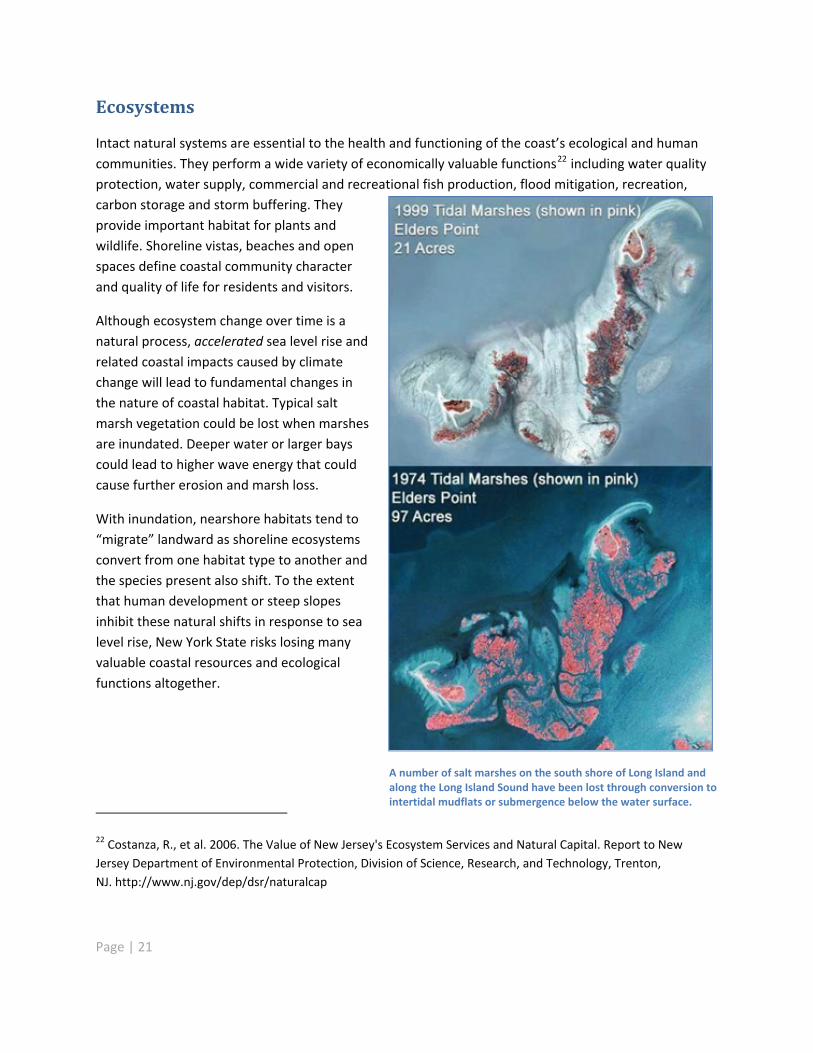
Although ecosystem change over time is anatural process, accelerated sea level rise andrelated coastal impacts caused by climatechange will lead to fundamental changes inthe nature of coastal habitat. Typical saltmarsh vegetation could be lost when marshesare inundated. Deeper water or larger bayscould lead to higher wave energy that couldcause further erosion and marsh loss.
With inundation, nearshore habitats tend to�“migrate�” landward as shoreline ecosystemsconvert from one habitat type to another andthe species present also shift. To the extentthat human development or steep slopesinhibit these natural shifts in response to sealevel rise, New York State risks losing manyvaluable coastal resources and ecologicalfunctions altogether.
A number of salt marshes on the south shore of Long Island andalong the Long Island Sound have been lost through conversion tointertidal mudflats or submergence below the water surface.
22 Costanza, R., et al. 2006. The Value of New Jersey's Ecosystem Services and Natural Capital. Report to NewJersey Department of Environmental Protection, Division of Science, Research, and Technology, Trenton,NJ. http://www.nj.gov/dep/dsr/naturalcap
Page | 21

Property damage caused by sea level rise and storm surges is likely to prompt greater public demand forshoreline armoring such as seawalls, bulkheads or shoreline stabilization structures such as groins.
These measures are intended to protect the land use behind them, but they also prevent the shorelineand its associated species from moving landward. They may also disrupt the sediment supply, resultingin erosion to adjacent or down drift areas and hindering the formation and adaptation of manyshoreline features, including the ability of beach, dune and barrier island systems to migrate landward. In addition, these structures will impair public access as water levels rise and will have other unintendedconsequences. For example, they can alter tidal and wave energy, causing damage to submergedaquatic vegetation, wetlands, parks and other waterfront amenities. Shoreline stabilization structuresplaced perpendicular to the shoreline trap sediment passing through the areas in which they are builtand protect the land behind them, but they may also cause erosion to areas downdrift of the structures.While they offer short term protection, traditional shoreline stabilization structures may not be the bestchoice to reduce the vulnerability of property and resources to coastal hazards and should only beconsidered after a thorough analysis of costs, benefits and environmental effects as part of acomprehensive shoreline management strategy.
The Task Force assessed seven major ecosystem types it deemed most threatened by sea level rise: tidalwetlands, low to moderate energy shorelines, submerged aquatic vegetation, barrier islands, coastalbluffs, marine rocky intertidal areas, and freshwater resources.
Coastal Natural Resources Provide Significant Human Benefits
A two year economic study commissioned by the New Jersey Department of EnvironmentalProtection in 2004 established values for some �“ecosystem services�” provided by coastalwetlands, beaches and estuaries in New Jersey. Ecosystem services are the benefits people obtainfrom ecosystems, such as flood control, water quality improvement, carbon storage, and stormprotection that communities would have to replace artificially if the natural systems were lost.The report estimated that the waste treatment services provided by coastal wetlands in NewJersey were valued at over $1 billion a year. It is important to note that this study focused solelyon the economic value provided to humans and probably underestimates the absolute value ofthese unique natural resources.
Source: Costanza, R., et al. 2006. The Value of New Jersey's Ecosystem Services and Natural Capital. Reportto New Jersey Department of Environmental Protection, Division of Science, Research, and Technology,Trenton, NJ. http://www.nj.gov/dep/dsr/naturalcap
Page | 22
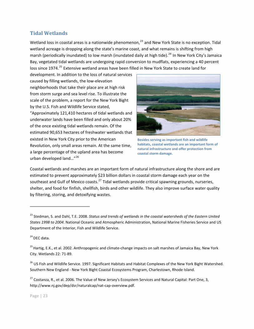
Tidal Wetlands
Wetland loss in coastal areas is a nationwide phenomenon,23 and New York State is no exception. Tidalwetland acreage is dropping along the state�’s marine coast, and what remains is shifting from highmarsh (periodically inundated) to low marsh (inundated daily at high tide).24 In New York City�’s JamaicaBay, vegetated tidal wetlands are undergoing rapid conversion to mudflats, experiencing a 40 percentloss since 1974.25 Extensive wetland areas have been filled in New York State to create land fordevelopment. In addition to the loss of natural servicescaused by filling wetlands, the low elevationneighborhoods that take their place are at high riskfrom storm surge and sea level rise. To illustrate thescale of the problem, a report for the New York Bightby the U.S. Fish and Wildlife Service stated,�“Approximately 121,410 hectares of tidal wetlands andunderwater lands have been filled and only about 20%of the once existing tidal wetlands remain. Of theestimated 90,653 hectares of freshwater wetlands that
existed in New York City prior to the AmericanRevolution, only small areas remain. At the same time,a large percentage of the upland area has becomeurban developed land�…�”26
Besides serving as important fish and wildlifehabitats, coastal wetlands are an important form ofnatural infrastructure and offer protection fromcoastal storm damage.
Coastal wetlands and marshes are an important form of natural infrastructure along the shore and areestimated to prevent approximately $23 billion dollars in coastal storm damage each year on thesoutheast and Gulf of Mexico coasts.27 Tidal wetlands provide critical spawning grounds, nurseries,shelter, and food for finfish, shellfish, birds and other wildlife. They also improve surface water qualityby filtering, storing, and detoxifying wastes.
23 Stedman, S. and Dahl, T.E. 2008. Status and trends of wetlands in the coastal watersheds of the Eastern UnitedStates 1998 to 2004. National Oceanic and Atmospheric Administration, National Marine Fisheries Service and USDepartment of the Interior, Fish and Wildlife Service.
24 DEC data.
25 Hartig, E.K., et al. 2002. Anthropogenic and climate change impacts on salt marshes of Jamaica Bay, New YorkCity. Wetlands 22: 71 89.
26 US Fish and Wildlife Service. 1997. Significant Habitats and Habitat Complexes of the New York Bight Watershed.Southern New England New York Bight Coastal Ecosystems Program, Charlestown, Rhode Island.
27 Costanza, R., et al. 2006. The Value of New Jersey's Ecosystem Services and Natural Capital: Part One, 3,http://www.nj.gov/dep/dsr/naturalcap/nat cap overview.pdf.
Page | 23

Although there are many factors involved in tidal wetland loss, sea level rise will exacerbate thephenomenon. Loss of marsh islands, which are particularly vulnerable to sea level rise, has beenidentified in areas from Peconic Bay to the north shore of Long Island and from the south shore of LongIsland to Jamaica Bay.
Physical disruption and increased inundation caused by storms undermine the integrity of marshstructure and processes. Recent studies suggest thatstorm surges superimposed on higher sea levels willincrease the frequency and extent of flooding in coastalregions and estuaries, thus increasing the risk of damageto vulnerable wetlands.28
At the lower end of projected sea level rise rates, the slowdeposition of water borne sediment will enable sometidal wetlands to migrate into adjacent upland areas,mitigating their loss. Such migration will not be possible inareas where shoreline protective structures,development, or natural impediments (open water orsteep slopes) prevent it, as is the case along much of NewYork State�’s heavily developed coastline. If the higherrates of projected sea level rise occur, migration will notbe possible in most areas. New York State�’s tidal wetlands, especially marsh islands, will be lost toinundation.29
As seas rise, natural migration of coastal features iscritical to their long term survival and is dependenton sediment transport processes. Where sedimenttransport is interrupted, natural features may becompromised. Credit: Jay Tanski
Low to Moderate Energy Shorelines
Low to moderate energy shorelines are small, non vegetated beaches and tidal flats along the marginsof protected areas such as estuaries and barrier island lagoons. Their narrow, steep upper beaches andrelatively flat low tide areas30 contain a mosaic of microenvironments.31 This intertidal habitat supportsresident species such as horseshoe crabs, killifish, crabs and shorebirds. Along with damage to these
28 Gornitz, V., S. Couch and E.K. Hartig. 2002. Impacts of sea level rise in the New York City metropolitan area.Global and Planetary Change, v. 32, p. 61 88 and Rosenzweig, C. 2009. Climate Risk Information: New York CityPanel on Climate Change. http://www.nyc.gov/html/om/pdf/2009/NPCC_CRI.pdf
29 Hartig, E.K., et al. 2002. Anthropogenic and climate change impacts on salt marshes of Jamaica Bay, New YorkCity.Wetlands 22: 71 89. and Fallon, D. and F. Mushacke. 1996. Tidal Wetlands Trends in Shinnecock Bay, NewYork 1974 to 1995. New York State Department of Environmental Conservation. 36pp. (unpublished).
30 Nordstrom, K.F. 1992. Estuarine Beaches. London: Elsevier Science Publishers.
31 The New York Sea Grant Institute. 1993. Estuarine Resources of the Fire Island National Seashore and Vicinity.Report NYSGI T 93 001. Stony Brook, New York.
Page | 24

populations, loss of this type of shoreline may lead to changes which affect human uses of these areas,including access to the upland area, fishing and boating access, and residential use.
It is difficult to predict how low to moderate energy shorelineswill respond to sea level rise. At the lower projections of sea levelrise, they might migrate at sites where there is adequatesediment, a relatively low slope, and no obstructions. Higher ratesof relative sea level rise or lack of adequate sediment supplywould drive the shoreline inland faster and could have othereffects that cannot yet be easily assessed. Sandy beaches mayincrease as marshes are lost.
Significant changes in water depths or embayment size couldaccelerate erosion. Where sediment supplies are limited,landward migration of beach dune systems may be limited.
Beach erosion could lead to loss ofrecreational areas.
Submerged Aquatic Vegetation
Submerged aquatic vegetation (SAV) is a group of floweringplants that have adapted to living fully submerged inlagoons, bays, estuaries and coastal marine waters. This typeof vegetation has a profound influence on coastal andestuarine environments. It regulates water flow, stabilizessediments, serves as a food source for marine life, andreplenishes dissolved oxygen in the surrounding waters. Itprovides critical habitat and nursery grounds for wadingbirds and waterfowl and for commercially, recreationally,and ecologically important fish and shellfish.
SAV beds are currently threatened by a host of factors.32 In1930, there were an estimated 200,000 acres of marine SAVbeds in New York State. This area has decreased by almost90 percent over time to 21,803 acres. According to the 2009New York State Seagrass Task Force Report, most of this lossis associated with water pollution, fishing and boating.33 But increasingly, sea level rise and climatedriven temperature change could become important stressors. The deeper waters caused by rising sea
Hardened shorelines, likely to increase as sealevel rises, will prevent the landwardmigration of existing seagrass beds anddecrease the availability of suitable nurseryhabitat for nearly every important finfish andshellfish in New York. Credit: Chris Pickerell
32 Orth, R.J., T.J.B. Carruthers, W. Dennison, C.M. Duarte, J.W. Fourqurean, K.L. Heck, A.R.Hughes, G.A. Kendrick,W.J. Kenworthy, S. Olyarnik, F.T. Short, M. Waycott and S. L. Williamsl. 2006. A global crisis for seagrassecosystems. Bioscience. 56:987 996.
33 New York State Seagrass Task Force Report, 2009.http://www.dec.ny.gov/docs/fish_marine_pdf/finalseagrassreport.pdf
Page | 25

levels could limit light penetration. Distribution of SAV is also dependent on water temperature. Whileglobal water temperatures will increase, it is not clear what effect sea level rise may have on tidalflushing through the inlets along the south shore which may affect temperature.
Hard shoreline protective structures would prevent the landward migration of existing beds into newlyinundated areas and may result in scour of soft bottom habitats. As sea levels rise, contaminants leakingfrom inundated septic systems or brownfield sites could cause further degradation, resulting inadditional damage to SAV beds and limiting the available nursery habitat for economically important fishand shellfish.34
Barrier Islands
Barrier islands are long, relatively narrow islands and spits running parallel to the coast, enclosing baysand lagoons.35 Composed primarily of sand, barrier islandsare constantly reshaped by wind, waves, and currents,especially during storms. They protect natural and humancommunities from ocean storms. Commercial and sport craftseek shelter behind these islands for safe passage betweenports. Sheltered by barrier islands, salt marshes providehabitat critical to the spawning and early life stages of manyfish species, supporting the multi million dollar commercialand sport fishing industries along our coasts. These islandssupport unique ecological communities, and many of thebays and estuaries enclosed by barrier islands on the northand south shores of Long Island are designated as SignificantCoastal Fish and Wildlife Habitat Areas by the New York StateDepartment of State.
The processes controlling barrier islands are not completelyunderstood, and there are significant local variations. Forexample, while all are highly dynamic and constantlychanging, some have not migrated significantly during thelast 750 to 1,300 years. The relationship between the rate of sea level rise and response of the barrierislands is not a simple one. During the next 30 to 50 years, at projected low to moderate rates of sealevel rise, the greatest impact to barrier islands will likely be from storms and disruption of sedimenttransport by human activity. Over time, barriers may not be able to maintain themselves if sea level rise
Increased erosion of barrier islands could resultin loss of important nesting, foraging andspawning sites. Credit: Jay Tanski
34 Op. cit.
35 The term barrier island, as used here, includes barrier spits and tombolos.
Page | 26
outpaces the ability of the system to supply sediment. At the highest rates of sea level rise, overwash(the process by which storm surges flow across barrier islands, depositing sediment and raising theirelevation) and breaching of new inlets would increase significantly, potentially changing the physical andenvironmental characteristics of the bays. The habitat affected by changes to barrier islands includeshorseshoe crab egg laying sites; shorebird foraging, nesting and resting sites; and fish spawning andnursery sites. Because the natural mechanisms that create barrier islands depend on the islands�’ abilityto change in response to storms and sea level rise, efforts to stabilize coastal barrier islands are contraryto the very processes that sustain them.
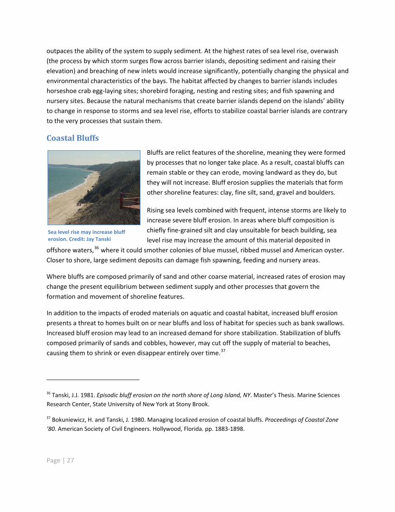
Coastal Bluffs
Bluffs are relict features of the shoreline, meaning they were formedby processes that no longer take place. As a result, coastal bluffs canremain stable or they can erode, moving landward as they do, butthey will not increase. Bluff erosion supplies the materials that formother shoreline features: clay, fine silt, sand, gravel and boulders.
Rising sea levels combined with frequent, intense storms are likely toincrease severe bluff erosion. In areas where bluff composition ischiefly fine grained silt and clay unsuitable for beach building, sealevel rise may increase the amount of this material deposited in
offshore waters,36 where it could smother colonies of blue mussel, ribbed mussel and American oyster.Closer to shore, large sediment deposits can damage fish spawning, feeding and nursery areas.
Sea level rise may increase blufferosion. Credit: Jay Tanski
Where bluffs are composed primarily of sand and other coarse material, increased rates of erosion maychange the present equilibrium between sediment supply and other processes that govern theformation and movement of shoreline features.
In addition to the impacts of eroded materials on aquatic and coastal habitat, increased bluff erosionpresents a threat to homes built on or near bluffs and loss of habitat for species such as bank swallows.Increased bluff erosion may lead to an increased demand for shore stabilization. Stabilization of bluffscomposed primarily of sands and cobbles, however, may cut off the supply of material to beaches,causing them to shrink or even disappear entirely over time.37
36 Tanski, J.J. 1981. Episodic bluff erosion on the north shore of Long Island, NY. Master�’s Thesis. Marine SciencesResearch Center, State University of New York at Stony Brook.
37 Bokuniewicz, H. and Tanski, J. 1980. Managing localized erosion of coastal bluffs. Proceedings of Coastal Zone�’80. American Society of Civil Engineers. Hollywood, Florida. pp. 1883 1898.
Page | 27
Marine Rocky Intertidal Areas
Rocky intertidal areas are dominated by bedrock, stones, or boulders, with little vegetation. They aregenerally high energy habitats, exposed to continuous erosion by wind driven waves or strong currents,and can be either natural formations or human made structures such as stone jetties and rockrevetments.
These zones have high biodiversity and high productivity,providing habitat, nursery grounds and food for marineand terrestrial organisms. Because of their exposedposition and the fact that their resident species aredependent on a tidal cycle of alternating wet and dryperiods, these areas are particularly vulnerable to sealevel rise and other phenomena related to climatechange. As the duration of tidal inundation increases,species will migrate landward. In areas that becomecompletely inundated or where landward migration isobstructed, intertidal species will be lost.
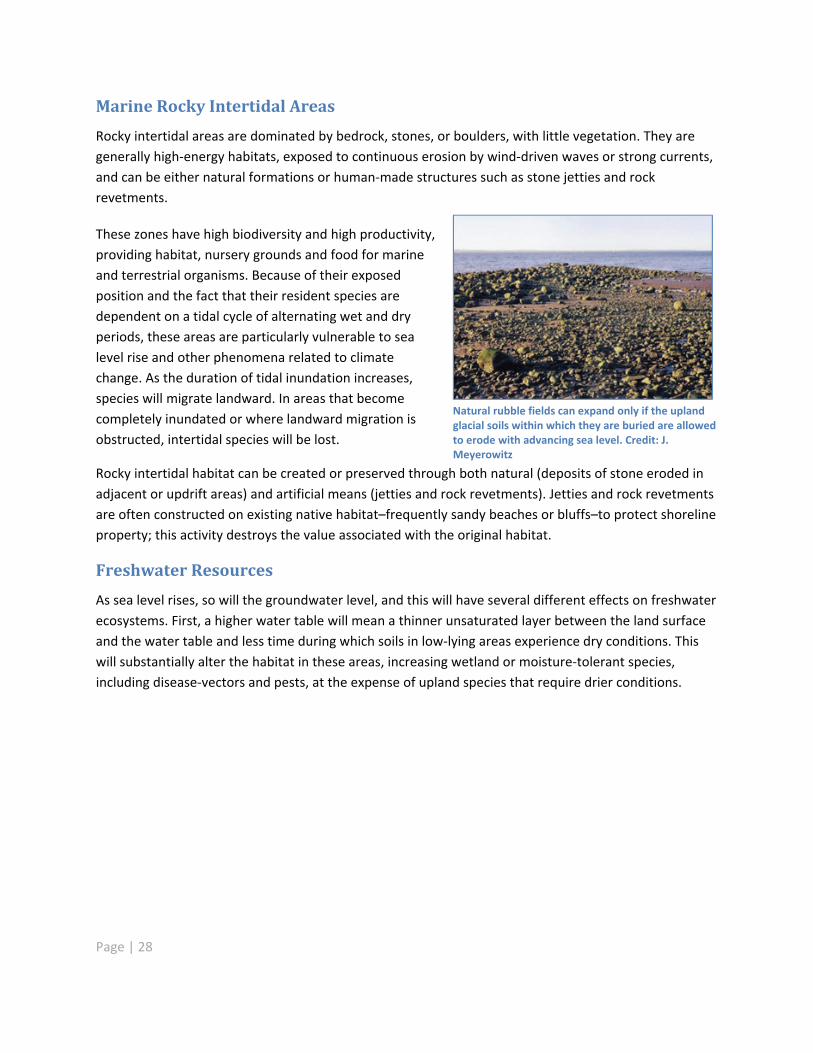
Natural rubble fields can expand only if the uplandglacial soils within which they are buried are allowedto erode with advancing sea level. Credit: J.Meyerowitz
Rocky intertidal habitat can be created or preserved through both natural (deposits of stone eroded inadjacent or updrift areas) and artificial means (jetties and rock revetments). Jetties and rock revetmentsare often constructed on existing native habitat�–frequently sandy beaches or bluffs�–to protect shorelineproperty; this activity destroys the value associated with the original habitat.
Freshwater Resources
As sea level rises, so will the groundwater level, and this will have several different effects on freshwaterecosystems. First, a higher water table will mean a thinner unsaturated layer between the land surfaceand the water table and less time during which soils in low lying areas experience dry conditions. Thiswill substantially alter the habitat in these areas, increasing wetland or moisture tolerant species,including disease vectors and pests, at the expense of upland species that require drier conditions.
Page | 28

Freshwater is underlain by denser saltwater in the shallow (water table) aquifer system of Long Island. 1. Conceptualizedposition of higher sea level. 2. Corresponding position of higher water table. 3. Resulting increase in hydraulic gradient andflow to streams. 4. Associated decrease in the depth to freshwater saltwater interface. As this interface moves higherdrinking water supplies may be affected. Credit: Ben Gutierrez, USGS
Second, as sea level rises, the point at which freshwater and saltwater meet will shift further upstreamin rivers and streams, and further inland and upward in coastal aquifers. Vegetation will likewise shiftfrom freshwater to brackish or salt tolerant species.
Anadromous fish (marine fish that spawn in freshwater) will be affected, as will other freshwater fishand fauna that currently use these areas for nesting, spawning and foraging. Freshwater habitat couldmigrate inland, though dams, bridges, shoreline development and other obstructions will impede suchmovement.
Ecosystems: Actions Needed to Adapt to Sea Level Rise
To maintain and expand the ecosystem services provided by New York�’s coastal systems, the stateshould pursue the following goals:
�• Minimize future habitat loss
�• Protect fresh drinking water resources
�• Provide coastal natural resources with adequate space to adapt to sea level rise�• Provide coastal natural resources with adequate space to adapt to sea level rise
�• Restore the natural mechanisms, such as sediment movement in coastal waters, which driveadaptation processes, including landward migration of habitat
�• Restore the natural mechanisms, such as sediment movement in coastal waters, which driveadaptation processes, including landward migration of habitat
Page | 29

It is essential to start with a current and accurate accounting of shoreline conditions throughout NewYork State (Recommendation 6) that shows how shorelines may change with rising sea levels. Such aninventory should include the location of areas of potential inundation as well as current locations ofstructural protection measures that could hinder the migration of natural systems responding to sealevel rise.
The collected information must serve as the basis for coastal natural resource management strategiesthat are coordinated on federal, state and local levels. Such strategies should emphasize ecosystembased management and ensure adequate funding to promote effective adaptation (Recommendations2, 11, 12, 13).
As the first line of defense againstextreme storms, features such asdunes, barrier islands and tidalwetlands take the brunt of waves andstorm surge, reducing the impact oncoastal communities andinfrastructure. To preserve coastalecosystem functions, natural featuresmust be allowed to respond naturallyor migrate inland as sea level rises.
Structural measures, such as seawallsand dikes, can be expensive to buildand maintain, and they often interruptsediment transport processes, result in biological impacts, and change erosion patterns. They createbarriers that prevent natural systems such as tidal wetlands from migrating inland to adapt to sea levelrise, simultaneously risking the reduction or elimination of foreshore areas currently accessible to thepublic under the Public Trust Doctrine.38 Additionally, there is no assurance that they will be adequateprotection from long term sea level rise.
New York State needs a regulatory framework that considers sea levelrise in proposals for development in areas where the migration ofdunes and other natural features may be restricted.
Conversely, solutions such as elevation and strategic relocation can reduce or eliminate the long termthreat of flooding with fewer impacts to natural systems and at potentially lower costs. In light of thesefactors, federal and state agencies have begun to incorporate such solutions into their long term coastalprotection planning and management.39
38 http://www.nyswaterfronts.com/waterfront_public_trust.asp
39 US Army Corps of Engineers: Environmental OperatingPrinciples: http://www.usace.army.mil/environment/Pages/eop.aspx
Page | 30

Page | 31
If feasible and protective, environmentally beneficial techniques sometimes referred to as �“softengineering�” or �“living shorelines,�” could be used where shoreline stabilization is required to maintainpublic infrastructure that cannot otherwise be secured by non structural measures. Properly designedand implemented, these approaches, which integrate structural shore elements such as breakwatersand sills with habitat sustaining elements such as marshes, beaches and reefs, can preserveenvironmentally beneficial qualities of riparian, intertidal and near shore zones, and minimize negativeeffects. While they are generally more environmentally benign than hard structures, such techniques donot completely eliminate the negative impacts of structures and they may not replace the habitatoriginally characteristic of the site. Such solutions, however, may be appropriate in areas where naturalsystems are largely absent, such as Manhattan.
New York State needs a regulatory framework that considers sea level rise in proposals for developmentand infrastructure in high risk coastal areas where the migration of dunes and other natural featuresmay be restricted (Recommendations 4, 5, 7). Such regulations should do the following:
Restrict hard structural shoreline protective measures and development in priority areas forwetland, dune, and beach migration
Prioritize and incentivize the use of non structural and soft shoreline protection measures toreduce risk
Provide larger buffers or setbacks between natural protective features and new development
Require local and regional planning efforts to establish areas for migration of natural protectivefeatures
There is also a need for additional studies, including establishment of long term monitoring systems thatwill improve our vulnerability analyses for natural areas at greatest risk of flooding (Recommendation12). These include the following:
Monitor and evaluate the cause of tidal wetland loss and changes at a landscape scale
Evaluate potential shifts in the upstream extent of the Hudson River salt front and inundation ofunderground drinking water supplies on Long Island
Map projected range shifts of key coastal species
Better understand how sea level rise, storms, erosion, and engineered shoreline modificationsaffect shoreline changes, water quality, wetlands and aquatic habitat
Public Works and Infrastructure
Public and private infrastructure dominates large sections of New York�’s coastline. This infrastructureincludes power plants, sewage and drinking water treatment plants and pump stations, landfills, wastetransfer stations, major road and rail transportation networks, air and sea ports, and a host of industrialfacilities. Underneath the streets of New York City, elaborate systems of public utilities that enable the
city to function are vulnerable to increased flooding from the intrusion
of surface water as well as from rising groundwater levels. Denselypopulated communities line our marine coasts, along with thehousing, businesses, recreational resources and institutions that servethem and help shape their character.
Nearly all this infrastructure was constructed before sea level rise wasrecognized as a significant problem. Today, sea level rise is recognizedas a phenomenon with potentially dramatic impacts on existing andnew infrastructure. Decisions regarding coastal infrastructure arecomplex in process (Table 2). Decision makers in both public andprivate sectors must ensure that relevant planning decisions reflectthis reality so that New York State�’s economy and communities arepoised to thrive well into the future.
If we do not begin proactive adaptation planning, sea level rise andrelated coastal hazards will significantly exacerbate current floodingproblems that much of New York State�’s coastal infrastructure already
faces and create new problems as well. The impacts of inundation and flooding are complex. It is notonly water that causes damage. Sea water contains salt, which corrodes equipment and undermines itsstrength. Floodwaters can release stored chemicals and petroleum, pick up contaminated soil andtransport lead based paint. Floodwaters can overwhelm combined storm and wastewater sewersystems and lead to release of untreated sewage. Many elements of existing infrastructure were notdesigned to withstand extended exposure to moisture. Much infrastructure will be susceptible toongoing structural and mold problems, such as those that became long term hindrances to recoveryafter Hurricane Katrina.
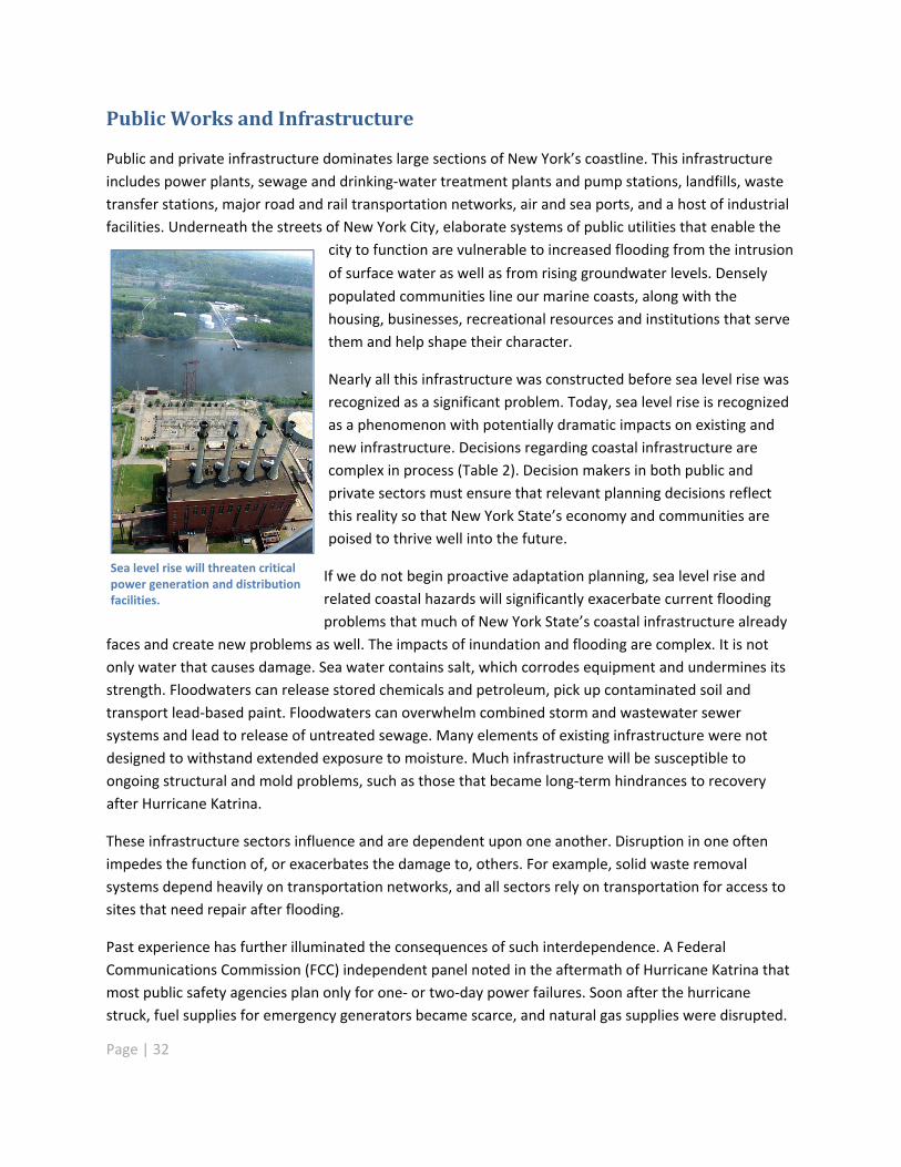
Sea level rise will threaten criticalpower generation and distributionfacilities.
These infrastructure sectors influence and are dependent upon one another. Disruption in one oftenimpedes the function of, or exacerbates the damage to, others. For example, solid waste removalsystems depend heavily on transportation networks, and all sectors rely on transportation for access tosites that need repair after flooding.
Past experience has further illuminated the consequences of such interdependence. A FederalCommunications Commission (FCC) independent panel noted in the aftermath of Hurricane Katrina thatmost public safety agencies plan only for one or two day power failures. Soon after the hurricanestruck, fuel supplies for emergency generators became scarce, and natural gas supplies were disrupted.
Page | 32

Page | 33
TABLE 2: Examples of Parties Responsible for Coastal Infrastructure Decisions
Examples ofInfrastructure
Planning &Development
Potential financing &Incentives
Approval or Permits Often Required
Telecommunicationscables
Private utility Usually private funding only Public Service CommissionState or local transportation departmentFederal Communications CommissionMunicipalities
Power plants Private utilityState Energy PlanNYSERDA (researchassistance)
Usually private funding only NYSDECNYSDOS (Coastal Zone Mgt)Public Service CommissionUS EPAFederal Energy Regulatory CommissionLocal planning commission
Electric and naturalgas deliveryinfrastructure
Private utility Usually private funding only Public Service CommissionState or local transportation deptFederal Communications CommissionMunicipalities
Residentialdevelopment
Private developer orlandownerLocal waterfront or zoningplan
Empire State Development Corp.Local economic developmentcorporationFederal flood insuranceDEC and DOS via BrownfieldCleanup ProgramEnvironmental FacilitiesCorporation
NYSDECNYSDOS (Coastal Zone Mgt)Army Corps of EngineersLocal planning commissionsCounty departments of health
Commercialdevelopment
Private developer orlandownerLocal waterfront or zoningplan
Empire State Development Corp.Local economic developmentcorporationDEC and DOS via BrownfieldCleanup Program
NYSDECNYSDOS (Coastal Zone Mgt)Army Corps of EngineersLocal planning commission
Waste transferstations
Municipality or privatecompanyLocal solid waste mgt planLocal waterfront or zoningplan
Environmental FacilitiesCorporation
NYSDECNYSDOS (Coastal Zone Mgt)Army Corps of EngineersLocal sanitation deptLocal planning commission
Shoreline protectionstructures
Private sectorMunicipal governmentsArmy Corps of Engineers
Private fundingMunicipal governmentsEmpire State Development Corp.Local economic developmentcorporations
NYSDECNYSDOS (Coastal Zone Mgt)Office of General Services (state land)Army Corps of EngineersUS Dept. of Interior (including Fish &Wildlife Service)Local planning commission
State roads NYSDOT GovernorFederal Dept. of Transportation(matching funds)
NYSDECNYSDOS (Coastal Zone Mgt)Army Corps of EngineersUS EPAUS Coast Guard (bridges)US Dept. of the Interior
Wastewater andsewer lines
MunicipalityCombined sewer overflowmanagement plans
Environmental FacilitiesCorporation(Potential for private financing infuture)
NYSDECNYSDOSLocal planning & zoning commissionsCounty departments of healthLocal building departments
Page | 34
Similarly, portable radio charging units and handheld satellite units became unusable when there was nopower to charge their rechargeable batteries. 40 If not addressed, these and other complex interactionswill hinder both recovery from major weather events associated with sea level rise and adaptation to itschronic effects.
The Task Force examined several infrastructure sectors and the ways in which they may becompromised by sea level rise and related coastal hazards.
Communications
Communication networks are vital to every aspect of daily life, but especially to police, fire and otheremergency services. Many of today�’s communications networks (wireline, wireless, Internet, voice overInternet protocol and cable) are interconnected and thus vulnerable to disruption. Flood inducedoutages to one centralized facility or primary cable path can result in total loss of service over an entirearea. �“Cascade effect�” outages can affect facilities beyond the immediately damaged area. Frequentinundation of communication delivery systems will accelerate deterioration of cable sheathing,telephone poles, and other components, making outages more likely and longer lasting. Outages willincrease as the areas affected by storm surges expand to places where infrastructure was not designedto withstand such events.
Energy
The risks to energy facilities parallel those facing communication infrastructures. Flooding of powerplants can result in total loss of service for a given area. Frequent inundation of electric and gastransmission and distribution systems can accelerate their deterioration, causing more frequent andlonger lasting outages with extended repair times. Flooding and a higher water table can impede accessfor repair and maintenance of underground gas and electric lines and equipment. Above and belowground storage tanks containing bulk liquids along the coast could be damaged in storms or corroded bysaltwater inundation. Leakage could contaminate ecosystems and drinking water and be costly to cleanup.
Shoreline Protective Structures
When water overtops bulkheads, seawalls and revetments�—structures intended to protect theshoreline against seawater and erosion�—buildings can be damaged or lost, especially if the presence ofprotective structures has encouraged development in high risk areas. As sea level continues to rise,efforts to prevent overtopping coastwide may ultimately be futile.
40 Federal Communications Commission Independent Panel. March 6, 2006. Reviewing Impact of Hurricane Katrinaon Communications Networks: Lessons Learned for Emergency Communications.
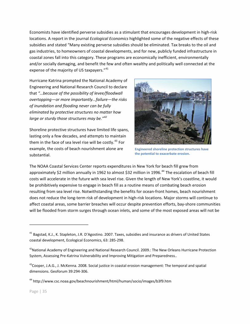
Economists have identified perverse subsidies as a stimulant that encourages development in high risklocations. A report in the journal Ecological Economics highlighted some of the negative effects of thesesubsidies and stated �“Many existing perverse subsidies should be eliminated. Tax breaks to the oil andgas industries, to homeowners of coastal developments, and for new, publicly funded infrastructure incoastal zones fall into this category. These programs are economically inefficient, environmentallyand/or socially damaging, and benefit the few and often wealthy and politically well connected at theexpense of the majority of US taxpayers.�”41
Hurricane Katrina prompted the National Academy ofEngineering and National Research Council to declarethat �“�…because of the possibility of levee/floodwallovertopping�—or more importantly...failure�—the risksof inundation and flooding never can be fullyeliminated by protective structures no matter howlarge or sturdy those structures may be.�”42
Shoreline protective structures have limited life spans,lasting only a few decades, and attempts to maintainthem in the face of sea level rise will be costly.43 Forexample, the costs of beach nourishment alone aresubstantial.
Engineered shoreline protection structures havethe potential to exacerbate erosion.
The NOAA Coastal Services Center reports expenditures in New York for beach fill grew fromapproximately $2 million annually in 1962 to almost $32 million in 1996.44 The escalation of beach fillcosts will accelerate in the future with sea level rise. Given the length of New York�’s coastline, it wouldbe prohibitively expensive to engage in beach fill as a routine means of combating beach erosionresulting from sea level rise. Notwithstanding the benefits for ocean front homes, beach nourishmentdoes not reduce the long term risk of development in high risk locations. Major storms will continue toaffect coastal areas, some barrier breaches will occur despite prevention efforts, bay shore communitieswill be flooded from storm surges through ocean inlets, and some of the most exposed areas will not be
41 Bagstad, K.J., K. Stapleton, J.R. D�’Agostino. 2007. Taxes, subsidies and insurance as drivers of United Statescoastal development, Ecological Economics, 63: 285 298.
42National Academy of Engineering and National Research Council. 2009.: The New Orleans Hurricane ProtectionSystem, Assessing Pre Katrina Vulnerability and Improving Mitigation and Preparedness..
43Cooper, J.A.G., J. McKenna. 2008. Social justice in coastal erosion management: The temporal and spatialdimensions. Geoforum 39:294 306.
44 http://www.csc.noaa.gov/beachnourishment/html/human/socio/images/b3f9.htm
Page | 35

secure, even with beach nourishment. If the protective measures are eventually undermined ordestroyed, the public investment would be lost. However, there will be some areas where shorelineprotective measures may be necessary due to the substantial existing investment and lack of feasible oreconomically viable alternatives, as for example in densely developed near shore areas of New YorkCity. In such cases, feasible soft engineering techniques should be evaluated in comparison with otherstructural and adaptation options to identify the combination of measures that will provide adequatesafety for human uses and optimal environmental quality.
Solid Waste
Flooding can cause structural damage to solid waste facilities and the transportation infrastructure thatallows movement of waste in and out of them. Post storm repair work on solid waste facilities andtransportation infrastructure, moreover, will conflict with the increased demand for debris removal thatoccurs after a storm, potentially overwhelming thesystem. Waste facilities inundated by water havesignificant potential to contaminate floodwaterswith petroleum and other noxious substances,causing odors and pathways for disease andaffecting nearby ecosystems, residents andbusinesses.
Transportation
Reliable, operational transportation networks areessential for maintaining normal business andresidential life. The need for these systems is nevermore critical than during emergency response andevacuation. Loss of road, air, ship and railtransportation from flooding has widespread repercussions, compounded by prolonged repair times dueto lack of service. Sections of commuter and freight railways along the Hudson are at special risk due totheir location just feet from the river, as are coastal airports.
Sea level rise threatens marine transfer stations and othercoastal waste management facilities. Such facilities are alsopotential sources of contamination if they are floodedduring storms.
Regular or profound flooding could threaten rail movement throughout the Hudson Valley, includingplans for high speed rail development. Foundations for rail lines could be undermined by erosion, andsignaling systems damaged by saltwater infiltration could lead to service disruptions. Rising water tableswill increase the risk of flooding and the need to pump standing water from underground or low lyingfacilities such as the New York City subway system. They could also weaken the substrate or subgradefor other transportation infrastructure. Public roadways can become permanently obstructed orrendered impassable, requiring relocation of critical thoroughfares.
Page | 36
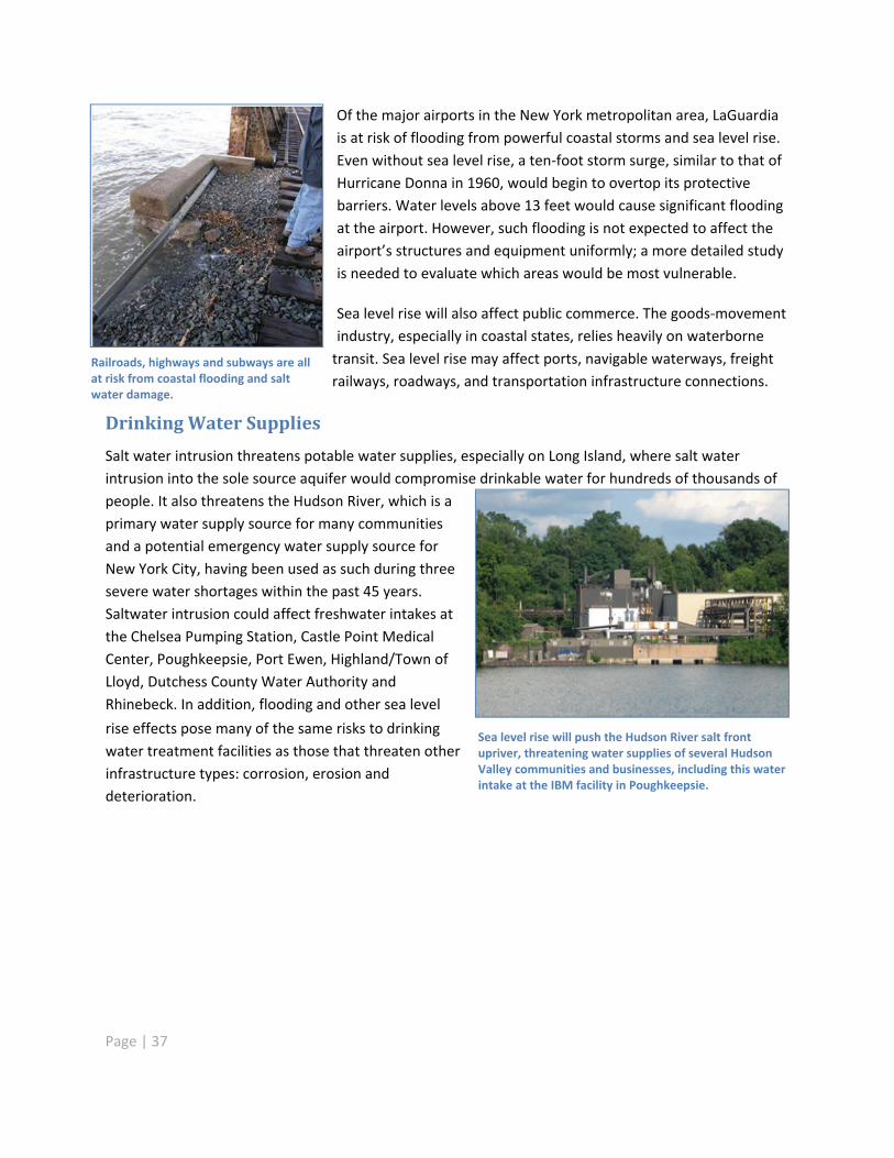
Of the major airports in the New York metropolitan area, LaGuardiais at risk of flooding from powerful coastal storms and sea level rise.Even without sea level rise, a ten foot storm surge, similar to that ofHurricane Donna in 1960, would begin to overtop its protectivebarriers. Water levels above 13 feet would cause significant floodingat the airport. However, such flooding is not expected to affect theairport�’s structures and equipment uniformly; a more detailed studyis needed to evaluate which areas would be most vulnerable.
Sea level rise will also affect public commerce. The goods movementindustry, especially in coastal states, relies heavily on waterbornetransit. Sea level rise may affect ports, navigable waterways, freightrailways, roadways, and transportation infrastructure connections.
Railroads, highways and subways are allat risk from coastal flooding and saltwater damage.
DrinkingWater Supplies
Salt water intrusion threatens potable water supplies, especially on Long Island, where salt waterintrusion into the sole source aquifer would compromise drinkable water for hundreds of thousands ofpeople. It also threatens the Hudson River, which is aprimary water supply source for many communitiesand a potential emergency water supply source forNew York City, having been used as such during threesevere water shortages within the past 45 years.Saltwater intrusion could affect freshwater intakes atthe Chelsea Pumping Station, Castle Point MedicalCenter, Poughkeepsie, Port Ewen, Highland/Town ofLloyd, Dutchess County Water Authority andRhinebeck. In addition, flooding and other sea level
rise effects pose many of the same risks to drinkingwater treatment facilities as those that threaten otherinfrastructure types: corrosion, erosion anddeterioration.
Sea level rise will push the Hudson River salt frontupriver, threatening water supplies of several HudsonValley communities and businesses, including this waterintake at the IBM facility in Poughkeepsie.
Page | 37
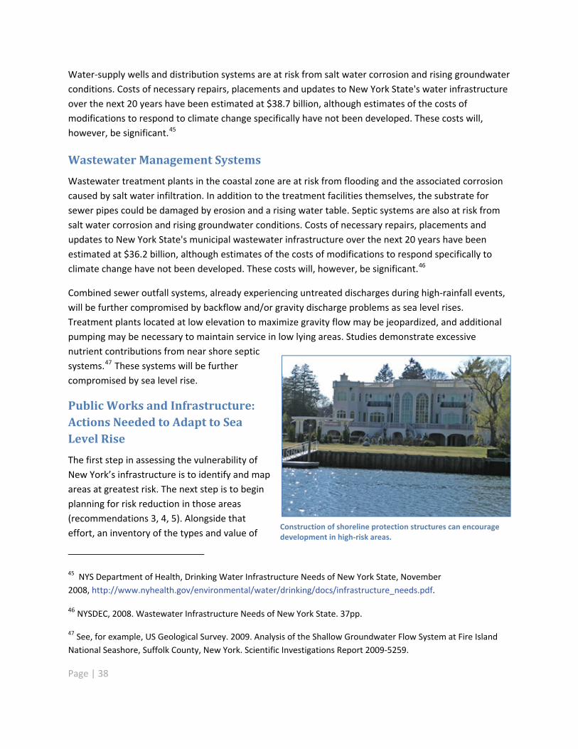
Water supply wells and distribution systems are at risk from salt water corrosion and rising groundwaterconditions. Costs of necessary repairs, placements and updates to New York State's water infrastructureover the next 20 years have been estimated at $38.7 billion, although estimates of the costs ofmodifications to respond to climate change specifically have not been developed. These costs will,however, be significant.45
Wastewater Management Systems
Wastewater treatment plants in the coastal zone are at risk from flooding and the associated corrosioncaused by salt water infiltration. In addition to the treatment facilities themselves, the substrate forsewer pipes could be damaged by erosion and a rising water table. Septic systems are also at risk fromsalt water corrosion and rising groundwater conditions. Costs of necessary repairs, placements andupdates to New York State's municipal wastewater infrastructure over the next 20 years have beenestimated at $36.2 billion, although estimates of the costs of modifications to respond specifically toclimate change have not been developed. These costs will, however, be significant.46
Combined sewer outfall systems, already experiencing untreated discharges during high rainfall events,will be further compromised by backflow and/or gravity discharge problems as sea level rises.Treatment plants located at low elevation to maximize gravity flow may be jeopardized, and additionalpumping may be necessary to maintain service in low lying areas. Studies demonstrate excessivenutrient contributions from near shore septicsystems.47 These systems will be furthercompromised by sea level rise.
Public Works and Infrastructure:Actions Needed to Adapt to SeaLevel Rise
The first step in assessing the vulnerability ofNew York�’s infrastructure is to identify and mapareas at greatest risk. The next step is to beginplanning for risk reduction in those areas(recommendations 3, 4, 5). Alongside thateffort, an inventory of the types and value of
Construction of shoreline protection structures can encouragedevelopment in high risk areas.
45 NYS Department of Health, Drinking Water Infrastructure Needs of New York State, November2008, http://www.nyhealth.gov/environmental/water/drinking/docs/infrastructure_needs.pdf.
46 NYSDEC, 2008. Wastewater Infrastructure Needs of New York State. 37pp.
47 See, for example, US Geological Survey. 2009. Analysis of the Shallow Groundwater Flow System at Fire IslandNational Seashore, Suffolk County, New York. Scientific Investigations Report 2009 5259.
Page | 38
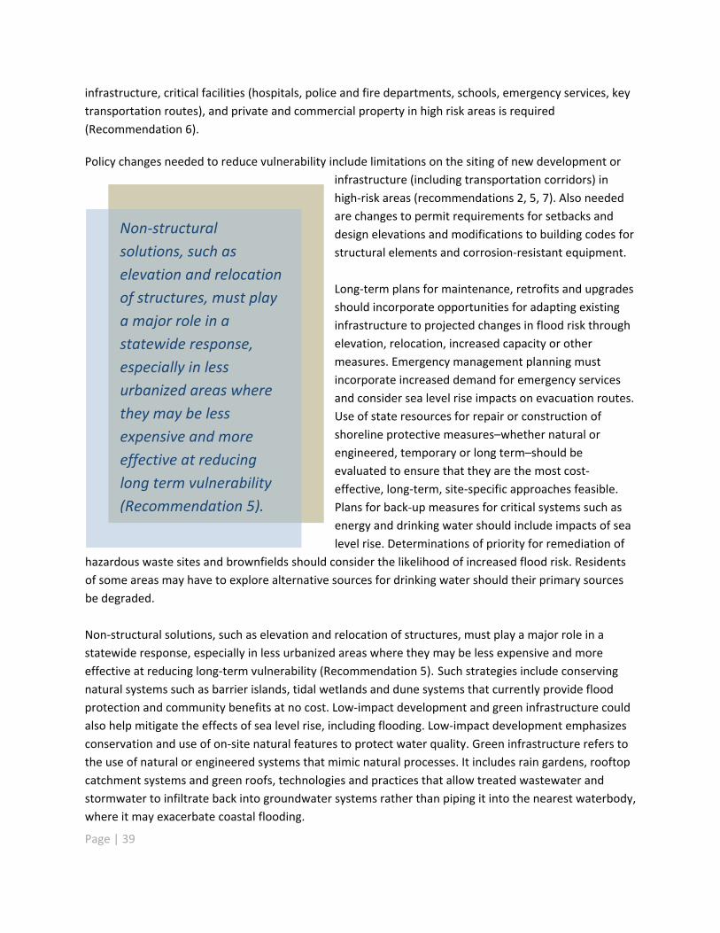
infrastructure, critical facilities (hospitals, police and fire departments, schools, emergency services, keytransportation routes), and private and commercial property in high risk areas is required(Recommendation 6).
Policy changes needed to reduce vulnerability include limitations on the siting of new development orinfrastructure (including transportation corridors) inhigh risk areas (recommendations 2, 5, 7). Also neededare changes to permit requirements for setbacks anddesign elevations and modifications to building codes forstructural elements and corrosion resistant equipment.
Page | 39
Long term plans for maintenance, retrofits and upgradesshould incorporate opportunities for adapting existinginfrastructure to projected changes in flood risk throughelevation, relocation, increased capacity or othermeasures. Emergency management planning mustincorporate increased demand for emergency servicesand consider sea level rise impacts on evacuation routes.Use of state resources for repair or construction ofshoreline protective measures�–whether natural orengineered, temporary or long term�–should beevaluated to ensure that they are the most costeffective, long term, site specific approaches feasible.Plans for back up measures for critical systems such asenergy and drinking water should include impacts of sealevel rise. Determinations of priority for remediation of
hazardous waste sites and brownfields should consider the likelihood of increased flood risk. Residentsof some areas may have to explore alternative sources for drinking water should their primary sourcesbe degraded.
Non structuralsolutions, such aselevation and relocationof structures, must playa major role in astatewide response,especially in lessurbanized areas wherethey may be lessexpensive and moreeffective at reducinglong term vulnerability(Recommendation 5).
Non structural solutions, such as elevation and relocation of structures, must play a major role in astatewide response, especially in less urbanized areas where they may be less expensive and moreeffective at reducing long term vulnerability (Recommendation 5). Such strategies include conservingnatural systems such as barrier islands, tidal wetlands and dune systems that currently provide floodprotection and community benefits at no cost. Low impact development and green infrastructure couldalso help mitigate the effects of sea level rise, including flooding. Low impact development emphasizesconservation and use of on site natural features to protect water quality. Green infrastructure refers tothe use of natural or engineered systems that mimic natural processes. It includes rain gardens, rooftopcatchment systems and green roofs, technologies and practices that allow treated wastewater andstormwater to infiltrate back into groundwater systems rather than piping it into the nearest waterbody,where it may exacerbate coastal flooding.

Page | 40
Due to their escalating capital and maintenance costs and the incentives they create for newdevelopment in high risk areas, reliance on structural protection measures alone, as well as fundingsuch measures, without examining alternative or complementary solutions, should be significantlyreduced over time. State and federal support for shore defense measures will likely be reduced andbecome uncertain in the future as sea level rise effects, distributed over an expanding geographic area,compete for funding with other budget priorities. Local governments and private interests compoundtheir risks by relying on these uncertain external subsidies for high risk development. A more efficient,market based approach to decisions on siting development or undertaking adaptive measures forexisting development will be needed to distribute finite resources. A close association betweendevelopment decisions and costs for emergency services, coastal hazard defenses and environmentalimpacts would facilitate more realistic analysis of the full costs associated with coastal infrastructureand development.
In areas where structural protection is warranted, such as some areas of New York City, the state shoulddevelop guidance to enhance the ecosystem value of structural protection measures (Recommendation8). At the same time, the state must coordinate with federal agencies like the Federal EmergencyManagement Agency (FEMA) and the U.S. Army Corps of Engineers to reduce incentives for newdevelopment and redevelopment in high risk areas (recommendations 5, 14).
Communities
Without sound planning for adaptation, sea level rise and associated coastal hazards will wreak damageon both individual and community scales. Because of all the amenities that life near the shore offers,people have long been drawn to settle in the areas most vulnerable to storm damage. The number ofpeople at risk from a Category 3 hurricane along New York State�’s coast, for example, has beenestimated at nearly 2 million and, for a Category 4 hurricane, more than 3 million.48 Residentialstructures in the 100 year floodplain of New York City and Nassau, Suffolk and Westchester countieshave a total estimated value of over $125 billion. While this figure includes riverine as well as coastalflood plains, it reflects the scale of flood exposure in the region.49
While coastal development has burgeoned, the many federal, state, and local decisions governing siting,design, construction and financing have not yet incorporated measures necessary to address the longterm effects of sea level rise and related coastal hazards. For example, Flood Insurance Rate Maps(FIRMS) issued by FEMA as part of the National Flood Insurance Program (NFIP) establish areas atcurrent risk from 100 year and 500 year floods and dictate rates of flood insurance for structures within
48 New York State Office of Emergency Management. New York State Standard Multi Hazard Mitigation Plan,Volume 1, Section 3, Table 3 29: Estimated Population Residing Within Hurricane Storm Surge Zones, p. 3 170.Report approved by FEMA 1/04/08. http://www.semo.state.ny.us/programs/planning/hazmitplan.cfm
49 Ibid. Table 3 18: Estimating Potential Flood Loss by County, p. 3 146.
Page | 41
those areas. However, FEMA flood maps in coastal counties in New York State, with the exception ofNassau and Suffolk counties, use outdated flood studies from the 1980s. Although FIRMS are designedsolely to serve as insurance rate maps, they are often used by state and local planners to approve ordisapprove structures, decisions that have inherent long term impacts. Because many FIRMS areoutdated and do not include areas where risk of flooding will increase due to sea level rise, this practicedramatically underestimates the actual long term cumulative impacts of individual developmentdecisions in high risk areas.
The structure of many current federal and state funded actions and programs protect or subsidize highrisk coastal development by shifting the cost of flood protection and storm recovery from propertyowners and local governments to state and federal taxpayers. Examples of these subsidies includefunding for structural shoreline protection (which includes artificial fill or 'beach nourishment'),insurance coverage through the National Flood Insurance Program, and federal and state post disasterrecovery funding and assistance that encourage replacing or rebuilding structures with a high level ofrisk exposure.50 These programs distort market forces and favor coastal development. One unintendedeffect of programs that support development in coastal floodplains will be increased risk of negativeimpacts from storm surge and inundation due to sea level rise.
According to New York University�’s Institute for Policy Integrity:
As a result of the National Flood Insurance Program�’s (NFIP) below market premium rates,building in floodplains appears more attractive to private developers ... In other words, the floodinsurance program encourages private development at a rate that is inefficient and unsupportedfrom a social perspective that more fully considers the ecological and financial risks. 51
Protecting development at high risk of coastal flooding thus far has come at great expense to thetaxpayers of New York State. In the last five years alone, the state spent more than $22.6 million inprojects to protect public infrastructure, and commercial and residential property from erosion andflooding in coastal areas. Costs are expected to continue to rise due to inflation and market forces. Thepredicted total cost for the construction of a planned project in Long Beach, Nassau County is estimatedat over $100 million, with a projected state and local cost of roughly $30 35 million. The implementationof the Fire Island Inlet to Montauk Point Storm Damage Reduction Project alternatives in Suffolk Countyhas the potential to cost New York State and local governments upwards of $700 million over several
50 Bagstad, K.J., K. Stapleton, J.R.D�’Agostino. 2007. Taxes, subsidies, and insurance as drivers of United Statescoastal development. Ecological Economics. 63:285 298.
51 Holladay, S. and J. Schwartz. 2010. Flooding the Market: The distributional costs of the NFIP. Institute for PolicyIntegrity at the New York University School of Law. Policy Brief No. 7.
Page | 42
decades, including a cost of $500 million for building retrofitting, and over $200 million for othersolutions such as beach fill, restoration alternatives and other approaches.52
Large scale, engineered fortifications may not be the best way to protect large cities and denselypopulated urban areas such as New York City from coastal storm impacts and inundation. Thedevastation following Hurricane Katrina resulted in an examination of structural protection measures,leading to findings that have broad national implications.
Among the significant findings of the National Academy of Engineering and the National ResearchCouncil:
�…the risks of inundation and flooding never can be fully eliminated by protective structures nomatter how large or sturdy those structures may be.53
The Council found that continued implementation of primarily structural defenses sends an unreliablemessage to the public�—that they are safe: "Hard structures, like levees, more often than not givecoastal residents a false sense of security."
Non structural solutions can reduce or eliminate the long term threat of flooding with fewer impacts tonatural systems and at potentially lower long term costs. These alternatives rely on planning strategiessuch as land acquisition, buffer zones, conservation of natural flood protection systems, buildingelevation, building codes and other local regulations.54, 55
The most notable research specifically evaluating the efficacy and efficiency of non structuralapproaches to risk reduction, such as land use planning in coastal areas, has been conducted at TexasA&M University under Dr. Samuel D. Brody. Research in multiple local communities examined therelationship between specific mitigation techniques and insured flood losses and demonstrated thatnone of the structural approaches significantly reduced insured residential property damage. Incontrast, almost half of the non structural strategies were found to be significantly related to reductionof losses from floods reported to the National Flood Insurance Program. Having a flood policy within alocal comprehensive or development management plan was found to have the strongest statistical
52 New York State Department of Environmental Conservation, Division of Water, Coastal Management Bureau.
53 National Academy of Engineering and National Research Council. 2009. The New Orleans Hurricane ProtectionSystem: Assessing Pre Katrina Vulnerability and Improving Mitigation and Preparedness. National Academies Press.
54 Jacob, J.S. & S. Showalter. 2007. The Resilient Coast: Policy Frameworks for Adapting the Built Environment toClimate Change and Growth in Coastal Areas of the US Gulf of Mexico. Sea Grant Texas.
55 It is important to note that non structural approaches do not include 'soft structural' techniques such as beachnourishment due to the narrow definition of �“structural�” under the Shoreowner�’s Protection Act (EnvironmentalConservation Law, Article 34) and corresponding regulations (6 NYCRR Part 505).
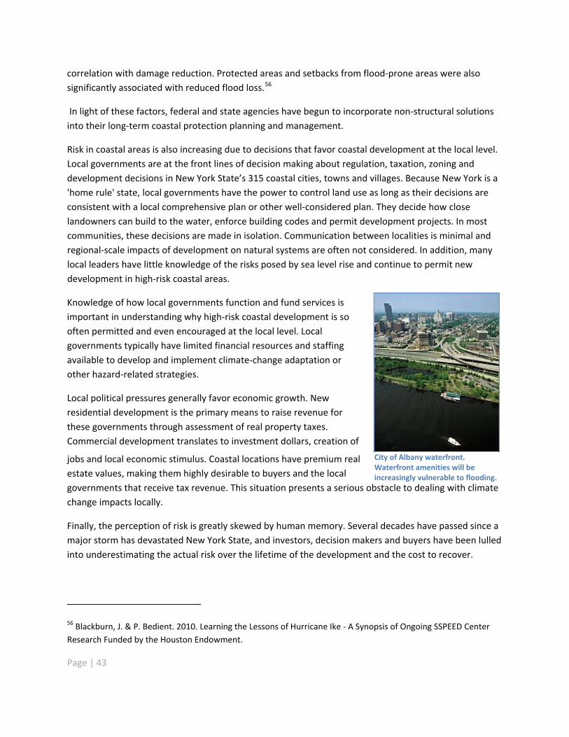
correlation with damage reduction. Protected areas and setbacks from flood prone areas were alsosignificantly associated with reduced flood loss.56
In light of these factors, federal and state agencies have begun to incorporate non structural solutionsinto their long term coastal protection planning and management.
Risk in coastal areas is also increasing due to decisions that favor coastal development at the local level.Local governments are at the front lines of decision making about regulation, taxation, zoning anddevelopment decisions in New York State�’s 315 coastal cities, towns and villages. Because New York is a'home rule' state, local governments have the power to control land use as long as their decisions areconsistent with a local comprehensive plan or other well considered plan. They decide how closelandowners can build to the water, enforce building codes and permit development projects. In mostcommunities, these decisions are made in isolation. Communication between localities is minimal andregional scale impacts of development on natural systems are often not considered. In addition, manylocal leaders have little knowledge of the risks posed by sea level rise and continue to permit newdevelopment in high risk coastal areas.
Knowledge of how local governments function and fund services isimportant in understanding why high risk coastal development is sooften permitted and even encouraged at the local level. Localgovernments typically have limited financial resources and staffingavailable to develop and implement climate change adaptation orother hazard related strategies.
Local political pressures generally favor economic growth. Newresidential development is the primary means to raise revenue forthese governments through assessment of real property taxes.Commercial development translates to investment dollars, creation of
jobs and local economic stimulus. Coastal locations have premium realestate values, making them highly desirable to buyers and the localgovernments that receive tax revenue. This situation presents a serious obstacle to dealing with climatechange impacts locally.
City of Albany waterfront.Waterfront amenities will beincreasingly vulnerable to flooding.
Finally, the perception of risk is greatly skewed by human memory. Several decades have passed since amajor storm has devastated New York State, and investors, decision makers and buyers have been lulledinto underestimating the actual risk over the lifetime of the development and the cost to recover.
56 Blackburn, J. & P. Bedient. 2010. Learning the Lessons of Hurricane Ike A Synopsis of Ongoing SSPEED CenterResearch Funded by the Houston Endowment.
Page | 43

Page | 44
The cumulative effect of the above factors is that the potential consequences of a large storm eventcontinue to increase. Indeed, the resilience of communities such as Long Beach and the north shore ofStaten Island is increasingly being tested as their protective natural systems and critical infrastructureare under threat or in decay.
Community resilience to threats related to sea level rise involves more than physically protectingproperty, buildings or structures from potential impacts. The concept encompasses a range of intangibleconsiderations that are critical to a particular community�’s capacity to withstand and recover from lossor damage.
The various considerations for community resilience, recovery and adaptation fall into four broadcategories:
Public health
Loss of shelter
Disrupted livelihoods and loss of economic vitality
Quality of life and community cohesion
Public Health
Storm surges and other flooding events can cause injury and death. They can also generate a host ofmore persistent environmental health hazards, including bacterial, fungal and chemical contaminationof drinking water sources, sewage and solid waste system disruption, hazardous materials releases, andincreased or displaced populations of insects, rodents and other disease vectors.
Typical land use planning and permitting processes and public health policies seldom explicitly addressthe public health implications of development in areas at high risk for flooding.57 During and afterfloods, the imperative to restore the status quo as quickly as possible can interfere with efforts toidentify and address less obvious problems, such as newly contaminated soil or housing.58 In fact, lack ofspecific information, data and analysis regarding post storm vulnerability to flood dispersedcontamination represents a significant public health concern for coastal communities. Recovery can befurther hampered by gaps in understanding of risk factors and treatments for post flood diseaseoutbreaks.
57 Levi, J., et al. 2009. Health problems heat up: Climate change and the public's health. Trust for America's Health.See also Morello, L. 2009. Adaptation: public health often moves behind the climate curve study. ClimateWire: ThePolitics and Business of Climate Change. http://www.eenews.net/climatewire/2009/10/27/
58 Gautam, K.P. and E.E. van der Hoek, E.E. 2003. Literature Study on Environmental Impact of Floods. Delft Clusterand the Netherlands Centre for River Research.
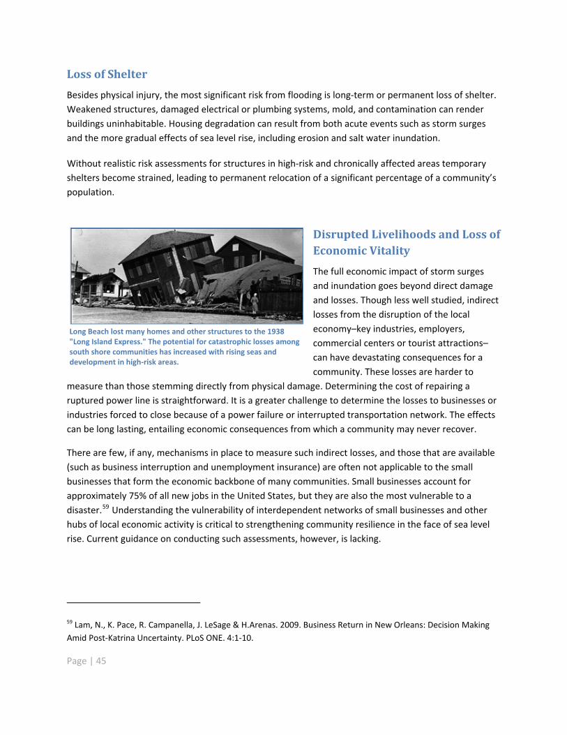
Loss of Shelter
Besides physical injury, the most significant risk from flooding is long term or permanent loss of shelter.Weakened structures, damaged electrical or plumbing systems, mold, and contamination can renderbuildings uninhabitable. Housing degradation can result from both acute events such as storm surgesand the more gradual effects of sea level rise, including erosion and salt water inundation.
Without realistic risk assessments for structures in high risk and chronically affected areas temporaryshelters become strained, leading to permanent relocation of a significant percentage of a community�’spopulation.
Disrupted Livelihoods and Loss ofEconomic Vitality
The full economic impact of storm surgesand inundation goes beyond direct damageand losses. Though less well studied, indirectlosses from the disruption of the localeconomy�–key industries, employers,commercial centers or tourist attractions�–can have devastating consequences for acommunity. These losses are harder to
measure than those stemming directly from physical damage. Determining the cost of repairing aruptured power line is straightforward. It is a greater challenge to determine the losses to businesses orindustries forced to close because of a power failure or interrupted transportation network. The effectscan be long lasting, entailing economic consequences from which a community may never recover.
Long Beach lost many homes and other structures to the 1938"Long Island Express." The potential for catastrophic losses amongsouth shore communities has increased with rising seas anddevelopment in high risk areas.
There are few, if any, mechanisms in place to measure such indirect losses, and those that are available(such as business interruption and unemployment insurance) are often not applicable to the smallbusinesses that form the economic backbone of many communities. Small businesses account forapproximately 75% of all new jobs in the United States, but they are also the most vulnerable to adisaster.59 Understanding the vulnerability of interdependent networks of small businesses and otherhubs of local economic activity is critical to strengthening community resilience in the face of sea levelrise. Current guidance on conducting such assessments, however, is lacking.
59 Lam, N., K. Pace, R. Campanella, J. LeSage & H.Arenas. 2009. Business Return in New Orleans: Decision MakingAmid Post Katrina Uncertainty. PLoS ONE. 4:1 10.
Page | 45
Page | 46
Quality of Life and Community Cohesion
Flood and storm damage can lead to transient or permanent loss of services and amenities�–hospitals;clinics; community, senior and day care centers; schools; and recreational open space. In many cases,communities, especially low income communities, have invested considerable time and energy tosecure these amenities, and their full value may not be reflected in typical vulnerability assessments.Such losses degrade the quality of life for shoreline communities.
To avoid irreplaceable loss from sea level rise and catastrophic storms, cultural and natural resourceassets, as well as infrastructure and development, must be adapted for coastal resilience. The importantsocio cultural, economic and natural assets of a community must be assessed for vulnerability andrelocated or otherwise adapted as environmental conditions change, so that the functions and way oflife that define a sense of community can continue. Losses of these services cannot be measured interms of simple monetary value.
Climate JusticeClimate justice is a relatively new area of research and analysis that focuses on the ethicaldimensions of climate change.1 The term also describes a social and political movement thatdemands that government policies and actions aimed at mitigating and adapting to climatechange address human rights and environmental justice.
Without proactive policies, climate change could be particularly damaging to the people leastable to respond to it. 2,3 In addition, if climate justice is not considered, government and privatesector actions to mitigate and adapt to shifting climate could create uneven financial burdensas well as social and cultural disruptions.
Because low income communities of color could be disproportionately affected,4 theirparticipation is critical to adaptation and community resilience planning efforts. Local residentshave on the ground and historical knowledge of local land uses and hazards that is vital toadaptation planning and developing effective response strategies to sea level rise impacts.Engaging members of the community in the planning process gives them a sense of ownershipof the final outcome. Participating in the process builds awareness and promotes action to limitrisks.
Two New York City based environmental justice organizations, UPROSE (Sunset Park, Brooklyn)and WE ACT (Harlem, Manhattan), have led the effort to include local communities in federal,state, and local government community resilience planning. Their work is centered on ensuringthat environmental justice communities are economically viable and have access to publichealth and safety protections, municipal services, and prompt and appropriate emergencyresponse.
1. Estrada Oyuela, R. A. 2002. Equity and Climate Change. in Ethics, Equity and International Negotiations on ClimateChange, P. R. Luiz and M. Mohan (eds.). Cheltenham, UK.
2. Patz, J. 2005. Impacts of Regional Climate Change on Human Health. Nature 384:310 317.
3. Morello Frosch, R., M. Pastor, J. Sadd, S.B. Shonkoff. 2009. The Climate Gap: Inequalities in How Climate ChangeHurts Americans & How to Close the Gap.
4. Medina Ramón, M., A. Zanobetti, D. Cavanagh, J. Schwartz. 2006. Extreme temperatures and mortality: assessingeffect modification by personal characteristics and specific cause of death in a multi city case only analysis. EnvironHealth Perspect, 114:1331 1336.
Page | 47
Page | 48
Communities: Actions Needed to Adapt to Sea Level Rise
New York State is at a crossroad. State government has the authority to participate in shore defenseprojects but lacks policy guidance in the application of this authority that would encourage propertyowners and communities to avoid high risk locations or to assume responsibility for site conditions. Sealevel rise, coastal erosion and storms are projected to expand risks and impacts beyond levels stategovernment can address. The state and local governments must revise past approaches to managingcoastal hazards or increasing impacts due to sea level rise will escalate until they becomeunmanageable. Our fundamental choices for responding to the increased risks to communities from sealevel rise and resultant flooding include the following:
Maintaining the status quo by allowing communities to respond to events as they occur, withstate assistance in emergencies
Continuing to support protective measures and absorb increasing costs, environmental impactsand expanding development risk until chronic effects, catastrophic events or economic realitiesforce management changes.
Setting new design standards for new development and for retrofitting existing development toachieve resilience in areas where occasional flooding may occur but that are otherwise deemedsafe and habitable and where such conditions are acceptable in the community
Reducing risk through planned adaptation including land use management, elevation andrelocation of at risk development and infrastructure over time
Prioritizing the conservation of natural systems like tidal wetlands, dunes, coastal barriers andnatural sediment transport so they continue to provide large scale beneficial services includingflood damage reduction, storm water management, water quality maintenance and otherimportant economic and environmental benefits
Ideally the state would support development of local or regional plans that emphasize long termreduction or elimination of risk, take into account the cumulative environmental impacts or benefits ofdecisions, and include the most cost effective mix of the above solutions tailored to the specific needs ofcommunities and geographic areas. It is essential that land use decisions, planning and funding ofadaptive or protective measures internalize the full cost of impacts and that costs be apportioned tobeneficiaries, so that realistic, market based evaluation is incorporated into management decisions.
Building the resilience of downstate communities to sea level rise and storm surge will requireimproving community level planning and decision making in a number of critical areas, including landuse, public health, and emergency response and post storm recovery. To effectively confront thesethreats, it will be necessary to build local capacity to conduct and sustain a range of planning,awareness raising, and implementation activities by providing technical assistance and guidance, clearlegal and regulatory frameworks, and financial resources.
Page | 49
Regional planning is critical to ensure sound decision making to reduce risk along the coast.Uncoordinated, ad hoc responses to coastal hazards will likely result in escalating costs for chronicdamages due to sea level rise and high costs for post storm recovery. Varying levels of protection amongcommunities due to differences in local resources will leave some communities at risk of casualties andsignificant loss of property. A failure to address regional ecosystems holistically will lead to burgeoningenvironmental impairments and social problems and the loss of critical natural systems and the servicesthey provide.
Local planning for sea level rise must identify vulnerable development, critical facilities, infrastructure,and natural resource assets at the site level, and should evaluate strategies to reduce risk over time. Thestate should provide grants, guidance, risk maps and other tools and technical assistance to empowerlocal decision makers to analyze their communities�’ circumstances through vulnerability assessmentsthat will lead them to develop appropriate strategies for reducing vulnerability (recommendations 2, 3,4, 6, and 11). A database of feasible adaptation responses for communities and habitats should becreated that allows each community to compare alternate strategies for achieving mutual, desired goalsand to select the strategy most appropriate for its own situation (Recommendation 8).
Guidance on these assessments must acknowledge the role of independent, community basedassessments conducted by local organizations. These assessments can produce more detailedinformation on the specific risks and vulnerabilities that threaten selected neighborhoods, communityamenities or vulnerable populations within a community (Recommendation 8).
Well designed and inclusive multi stakeholder planning processes can raise awareness, build capacity,generate community specific knowledge, and strengthen community cohesion and identity(recommendations 8, 10).
Particular effort and funding should be dedicated to ensuring that lower income communities andcommunities of color are adequately involved in planning efforts. The members of such communitiesoften have less discretionary time and resources to devote to participation, and without adequaterepresentation, their needs may be overlooked.
Guidance should address evaluating and updating emergency management strategies and plans. Inparticular, there is a critical need for more focused and sustained engagement by public healthprofessionals (Recommendation 9). Better data and analysis are needed to help communities assesstheir vulnerability to immediate mortality risks, risks of infectious and vector borne diseases, healthrelated costs of flooding and mental health problems, and the need for early warning systems.60
60 Ahern, M., et al. 2005. Global Health Impacts of Floods: Epidemiologic Evidence, Epidemiologic Reviews, JohnsHopkins Bloomberg School of Public Health.
Page | 50
Communities need guidance to develop and implement local regulations and zoning laws that willreduce new development in high risk areas and manage risks to existing infrastructure, property andpeople. Developing appropriate plans for recovery and redevelopment (Recommendation 5) followingpowerful storms can provide communities with an opportunity to proactively decrease theirvulnerability and identify areas that can provide restoration and migration opportunities for naturalresources.
In some cases, state regulation is needed to mandate risk reduction strategies where local governmentslack the resources or authority to pass or enforce local regulation to reduce risk or conserve naturalflood protection systems (recommendations 5, 7).
Internalizing the costs of emergency services, storm recovery and environmental impacts into coastaldevelopment would make investment in high risk areas much more realistic. Planning, zoning,subdivision, community development and property management should take such costs into account.All levels of government should require that infrastructure siting, design and construction explicitlyevaluate the potential impacts of storm surge and sea level rise, as well as the potential forinfrastructure to stimulate private development in unsafe locations. Real estate titles or otherconsumer oriented information should disclose projected risks to buyers. Flood insurance programs andstate building codes should strengthen siting and building standards in coastal areas (Recommendation7). Actions that foster consideration of environmental conditions and impacts associated with coastaldevelopment could dramatically reduce risk exposure over time by bringing a market based rationale tothe decision process. Loss of life, structure and infrastructure damage, environmental degradation,compromised communities and inability to recover from extreme weather events will increase ifexternal subsidies conceal the true costs of high risk development. All state policies and programsshould be carefully reviewed to evaluate whether they encourage at risk development and to suggestappropriate modifications (Recommendation 2).
At the present time, standardized reporting for periodic coastal hazard impacts is limited primarily toweather reports by the National Weather Service (NWS) and documentation supporting requests forFEMA Presidential Disaster Declarations. Records on local storm damage are largely anecdotal or fromnews media, and federal records of events are not readily accessible to state or local planning staff.These existing sources are insufficient to support local or regional planning or to document theeffectiveness of management measures. As a result, it is difficult for planners to compile backgroundinformation to support management actions or to modify existing plans or programs based onexperience. A standardized reporting system should be developed using forms that could be completedand filed by local planning, recovery or emergency management staff (Recommendation 8). It shouldprovide adequate detail to describe the locations and types of coastal hazard impacts and to give adescription of the source or cause of the impacts. Planners and managers could use this database toprepare measures to address coastal hazards over time according to their record of performance.
Page | 51
Federal, state and local agencies will need to coordinate to comprehensively address vulnerabilities inhigh risk coastal areas (Recommendation 13). Effective interagency coordination on climate changewould have an enormous benefit to regional and local governments dealing with a dizzying array ofuncoordinated agency funding and regulatory programs. Consolidation of policy and regulatorypriorities, funding programs, and technical assistance across agencies would conserve both state andlocal resources and potentially save tax dollars.
Adaptation ChampionsCommunity based organizations in New York State can provide strong and sustained local leadership onclimate change adaptation. The following are examples of �“adaptation champions�” from the three mainregions of the state affected by sea level rise. Their sustained efforts have stimulated local interest inadaptation, increased buy in for climate change adaptation projects and attracted external resources.
The Hudson Valley
To help people think about the local impacts of climate change�–and how the Hudson Valley might preparefor them�—the Rising Waters project brought together private and public stakeholders in the fields oftransportation, health care, utilities, emergency preparedness, planning and environmental advocacy. Theproject developed contrasting scenarios to explore the future consequences of climate change adaptationdecisions. Participants reached consensus on key findings and recommendations for adaptation, whichwere released in a May 2009 report. Several stakeholders are now engaged in developing a climate changespeakers�’ bureau in the Hudson Valley, promoting a sustainable shoreline initiative and conducting marshrestoration. Rising Waters was spearheaded by The Nature Conservancy�’s eastern New York chapter andpartners such as DEC�’s Hudson River Estuary Program and National Estuarine Research Reserve, CornellUniversity, the Cary Institute of Ecosystem Studies, and Sustainable Hudson Valley.
New York City
Parts of Sunset Park, a waterfront community in Brooklyn, are less than 10 feet above sea level, andflooding during major storms is a critical local concern. UPROSE (United Puerto Rican Organization ofSunset Park), a grassroots environmental justice organization, is developing a community specific climatechange adaptation plan that can be tailored and replicated by other vulnerable communities. The initiativeis part of PlaNYC, New York City�’s comprehensive sustainability plan to reduce the city�’s greenhouse gasemissions by 30% and adapt to climate change. UPROSE educates residents about the science of climatechange and simple changes they can make in their daily lives to reduce their carbon footprint. UPROSEworks with constituencies to identify resources that can help them implement adaptation strategies andbuild Sunset Park�’s resiliency.
Long Beach, Nassau County
The neighborhood of North Park is taking steps to ensure that the city of Long Beach on Long Island takesseriously the existing and potential effects of sea level rise and other coastal hazards. For decades,residents have endured severe flooding. The area�’s inadequate and aging shoreline infrastructure and itsproximity to Reynolds Channel makes North Park particularly vulnerable to impacts from sea level rise,storm surge and tidal influences. At high tide, even relatively mild storms have been known to create kneedeep water in some streets, at times forcing children to wade to their school buses or stranding seniors intheir homes. Citizen activists and the Long Beach Latino Civic Association have drawn attention to theseimpacts through repeated testimony before local authorities and consistent participation in municipal andstate level planning processes.
Page | 52

Page | 53
Meeting the Challenge
Despite data gaps, we now possess sufficient information, consensus and growing political will tosupport responsible actions to deal with sea level rise. New York State must now decide what theseactions will be.
Coastal communities are already experiencing damage from sea level rise and other coastal hazards and,even today, are at great risk from the impacts of a powerful storm. If a Category 3 hurricane similar tothe �“Long Island Express�” of 1938 hit New York�’s coast now, there would be severe and long termeconomic, ecological and public health consequences.
Holding back the rising sea on a large scale is not practical or even possible. The actions recommendedin this report are to guide communities�—people, with their accompanying infrastructure�—out of harm�’sway and to allow coastal ecosystems to migrate landward so that those ecosystems may continue toprovide natural protection against flooding and other coastal hazards.
There is a tremendous need for new and updated information to make decisions. High resolutionelevation maps are needed coastwide to outline areas of greatest vulnerability to coastal hazards.Storm surge models should be run with sea level rise projections. FEMA flood studies must be updatedto reflect current conditions. Shoreline inventories should be completed for infrastructure, criticalfacilities and existing structural shoreline defense measures. Tidal wetland and coastal erosion hazardarea maps have not been updated in decades even though, in the case of coastal erosion hazard areamaps, such updates are required by law. The implications of sea level rise for emergency managementsystems must be fully vetted. We also must continue to monitor coastal processes and improve ourunderstanding of how they will be affected by sea level rise.
Enacting cost effective adaptation policies in advance of rising seas and ecological shifts is the mostresponsible management path.61 However, efforts to fill data gaps should occur at the same time we areacting to preserve and protect coastal communities and ecosystems. The best available data must bebrought to bear at every stage through an adaptive management approach. Such an approach canreduce uncertainty in long term decisions over time by monitoring and evaluating the results ofresearch and policy actions and changing the course of action as needed.
Structural approaches to shore protection to manage vulnerability to coastal hazards have long been thenorm, but they do not recognize the natural and beneficial functions or mitigating capacities of thelandscape. The cumulative effects of many of these structures can compromise entire ecosystems. Inaddition, by appearing to reduce vulnerability, they can promote development in hazardous areas.
61 The precautionary principle of ecosystem management suggests that in the absence of all the answers, weshould not wait for the answers, but should take action to protect the ecosystem using the best available sciencewhile we improve our understanding.

Page | 54
The recommendations contained in this report strongly favor and support non structural strategies asthe first line of protection to be fully considered and applied in most circumstances, but adaptation tosea level rise along New York�’s coast will require a multitude of flexible, non exclusive, location specificapproaches: One size, or one measure, will not fit all. The existing risks to development andinfrastructure from coastal storms, escalating threats from sea level rise and differing capacity amongthe communities of the New York coastal area suggest that careful planning is necessary to fosteradaptation to a more resilient condition.
The historical reliance on armoring the shoreline will not always provide the desired protective shieldagainst coastal storms and has been shown to be flawed, as demonstrated in other regions, sometimeswith devastating consequences. Further, storm effects will be exacerbated by rising sea levels. TheNational Academy of Science recommends that such technological solutions be accompanied byredundant measures so that failures are not catastrophic. Over the long term, it is not likely to befeasible for the state to fund the continued construction and maintenance of armored approaches alongits entire shoreline, and non structural approaches must be considered. In addition to the risks and costsassociated with shore defense structures, the environmental effects of widespread shoreline armoringare unacceptable.
However, there are locations in the state, particularly in densely populated urban areas, where nonstructural strategies may not be practical or appropriate. Densely developed urban areas, such asManhattan, may require defensive measures not appropriate for less densely developed regions.Reliance on non structural responses alone will not be adequate. Existing vulnerable areas withsubstantial public infrastructure investment, water dependent facilities or critical facilities like powerplants represent viable assets if they can be protected relatively efficiently and/or if they can functioneffectively for an interim period while communities develop more resilient alternatives.
The selection of which measures to employ should include an assessment of the best possiblerelationship among risk exposure, resources available for implementation, feasible alternatives,environmental effects and safety, so that the limited resources available are allocated most efficiently tofoster sustainable communities. In order to accomplish the dual goals of increasing communityresilience while simultaneously protecting the remaining coastal ecosystems and natural habitats, theappropriate adaptive responses must be informed by a number of site and community specificconsiderations. Accordingly, the recommendations in this report endeavor to provide a comprehensiveset of measures that will foster community resilience while supporting a sustainable economy, andviable coastal ecosystems and natural habitats.
We can be certain that communities will continue to be exposed to natural hazards. Land developmentis what can, and should, be managed to lower vulnerability.
Page | 55
The preponderance of opinion in both the academic and practitioner communities is that keepingpeople out of harm's way through the "soft mitigation" practice of planning, particularly landuse planning, is far preferable to investments in either hard protective structures or investmentsin community reconstruction after the fact, necessary though these last two occasionally maybe.62
Sea level rise will affect almost every aspect of coastal life�–physical, social, economic, and ecological.The response to it must be similarly comprehensive. It must begin with the state�’s explicit adoption ofsea level rise projections and incorporation of adaptation strategies into all relevant regulatory, fundingand programming decisions.
A high priority is identifying and mapping the regions at greatest immediate and future risk from sealevel rise. This will raise awareness in communities about the risk so that they can act to reduce thevulnerability of high risk areas. With state assistance local and regional scale planning must be done toidentify the most appropriate strategies for each area of the coastline. Those involved in shapingdecisions at every level will need to strike a balance among the many competing claims on scarceshoreline resources and ensure that long term risks are factored into daily choices.
Community based organizations and independent assessments that originate at the community levelare important to understanding the socioeconomic factors, language barriers, social divisions and localtraditions that affect vulnerability to, and ability to recover from, damage from sea level rise and relatedcoastal hazards. Community based organizations are critical to effective communication with residents,for whom sea level rise and climate change effects may seem abstract or remote. They can mobilizepublic opinion in ways that a top down, regulatory approach cannot.
Any sea level rise adaptation strategy, including the recommendations in this report, represents onlyone stage in a planning process that must be continuously reviewed and revised to incorporate newdata, new experience and the changing needs of communities and natural ecosystems. The Task Force iscommitted to seeing that the insight gained through its work continues to inform future efforts.
62 Jacob, J.S. and S. Showalter. 2007. The Resilient Coast: Policy Frameworks for Adapting the Built Environment toClimate Change and Growth in Coastal Areas of the US Gulf of Mexico. Sea Grant Texas.

STORM SURGE BARRIERS ("floodgates" or "barrages") are artificial obstructions at the mouth of atidal watercourse with adjustable gates that are closed during large ocean dominated floodevents or surges and reopened after the floodwaters recede. The feasibility and sustainability ofstorm surge barriers in New York and their long term financial, social and ecological impacts mustbe assessed. The question of who pays and who gets the benefits�–and who does not�–is a potentsocial justice issue. While barriers may be a viable option for interim periods (decades), they mayactually increase long term catastrophic risks if prolonged sea level rise in combination with stormsurges eventually render them ineffective. It is important to note that barriers cannot be usedalone. They must be coupled with extensive systems of levees and pump facilities requiring largeamounts of space and costly maintenance. Planning, financing, operation and maintenance willrequire multi state agreements. If considered at all, they must be part of a broader comprehensiveand sustainable coastal management strategy that includes a long term exit strategy from highrisk areas.
Eastern Scheldt storm surge barrier, Netherlands. Credit: Raimond Spekking/Wikimedia Commons/CC NY SA 3.0 & GFDL
Page | 56
Page | 57
Recommendations of the Sea Level Rise Task Force
In 2007, the New York State Legislature created the Sea Level Rise Task Force and charged it withpreparing a report and recommendations for an action plan to protect coastal communities and naturalresources from rising sea levels. The New York State Department of Environmental Conservation leadsthe Task Force, which has a diverse membership that includes representatives of state and localgovernment agencies, non governmental organizations, and affected communities. The legislaturedirected the Task Force to �“evaluate ways of protecting New York�’s remaining coastal ecosystems andnatural habitats and increasing coastal community resilience in the face of sea level rise applying thebest available science on issues associated with sea level rise and its anticipated impacts.�” The TaskForce has studied and deliberated, with public participation, the complex issues involved with sea levelrise in New York State. This report, including findings and recommendations, is the result of theconsiderable efforts of many dedicated individuals; however, the recommendations do not representthe unanimous consent of the Task Force. As detailed in its public comments (Appendix E), the City ofNew York does not support recommendations 2, 3, 4, 5 and 7. The findings and recommendations in thisreport are important first steps toward increasing the resilience of New York�’s coastal communities withthe understanding that in many cases further analysis may be necessary to evaluate their site specificapplicability and effect on the State and local economies, economic development, greenhouse gasmitigation efforts, environment and other factors. The proposed timelines for implementation of eachrecommendation reflect the necessary sequence of this work.
1. Adopt official projections of sea level rise.
What: Formally adopt the projections of the Sea Level Rise Task Force for relative sea level rise in allmarine coastal areas of the state, including the Hudson River to the Federal Dam at Troy, for use by allstate agencies and authorities. These projections should serve as recommended standards for othergovernment, non government and private interests. Projections should be developed with the bestavailable science, extend for at least 100 years into the future, and be reviewed and updated on aregular basis.
How/Who: An act of the Legislature or, in the absence of legislative action, an executive order shouldrequire the state to adopt projections of sea level rise and call for their update on a regular basis. Theproposed New York State Climate Science Institute, or other such state scientific body, led by the StateDepartment of Environmental Conservation and State Department of State, and with the cooperation ofother relevant state agencies and local governments, should develop guidance for incorporation ofprojections into relevant policies and regulations. Local governments should also consider adoption ofthese projections for planning purposes.
When: Full implementation within two years.

Page | 58
2. Require state agencies responsible for the management and regulation ofresources and infrastructure subject to sea level rise and management of atrisk populations affected by sea level rise to factor the current and anticipatedimpacts of sea level rise into all relevant aspects of decision making.
What: Sea level rise poses a significant risk to the citizens, infrastructure, economy and naturalresources of the state. Official state projections of sea level rise, and associated impacts of sea level rise,should be factored into all relevant aspects of state agency decision making including long termplanning, programming, permitting, regulating and funding decisions, and the state should seek andprovide technical guidance consistent with anticipated changes. Agencies should consider storm and sealevel rise impacts over the lifespan of proposed projects or actions and the time horizon of anyassociated impacts to the proposed projects or actions in all state operational, permitting and/orfunding decisions. Relevant agencies should regularly update, modify, and refine guidance documentsand plans based on the most current information on sea level rise.
How/Who: An executive order should provide direction to all relevant state agencies to factor currentand anticipated impacts of sea level rise into all relevant aspects of decision making. Implementationinvolves changes to regulation and agency guidance. Relevant agencies include, but are not limited to,DOS, DEC, Office of Emergency Management (OEM), Environmental Facilities Corporation (EFC), EnergyResearch and Development Authority (NYSERDA), Office of Parks, Recreation, and Historic Preservation(OPRHP), Department of Health (DOH), Office of General Services (OGS), Office of Housing andCommunity Renewal (OHCR), Empire State Development (ESD), Department of Transportation (DOT),Metropolitan Transit Authority (MTA), Port Authority of New York and New Jersey (PANYNJ), New YorkPower Authority (NYPA), Long Island Power Authority (LIPA) and the Public Service Commission (PSC).
When: Full implementation within two to five years.
3. Classify areas where significant risk of coastal flooding due to storms hasbeen identified in order to implement risk reduction measures in those areas.
What: Define immediately the most vulnerable coastal areas and revise standards for development andredevelopment to reduce risk in these areas. Areas at high risk of coastal flooding have already beenidentified by the Federal Emergency Management Agency (FEMA). The state should define a new�“coastal risk management zone,�” comprised of, and consistent with, zones designated by FEMA toinclude coastal high hazard areas (V, V 1 30, or VE zones) and any areas defined by FEMA as "Areas ofModerate Wave Action" (i.e., areas within the A zone and subject to wave action of 1.5 to 3 feet) asareas currently most vulnerable to coastal hazards. These zones should provide the basis for additionalreview under state regulatory authority and guidance such as additional focus or analysis under State

Page | 59
Environmental Quality Review Act review to reduce vulnerability in coastal areas as outlined in thefollowing recommendations.
How/Who: A statute or an executive order should define the coastal risk management zone. DEC andDOS should provide guidance for agency implementation in cooperation with other federal, state andlocal agencies.
When: Full implementation within two to five years.
4. Identify and classify areas of future impacts from ocean coastal flooding dueto projected sea level rise and storms in order to reduce risk in those areas.
What: Develop maps that extend the area of the coastal risk management zone, acknowledgingdifferential levels of risk, to include areas potentially vulnerable to projected changes in sea level andhigh intensity storm events based on projections of sea level rise adopted by the state including thefollowing:
Areas at greatest risk from sea level rise
Areas at risk from storm surge with current sea levels
Areas at risk from storm surge with sea level rise
Since it is much more cost effective to prepare hydrologic modeling on a regional basis, as opposed tomunicipalities modeling their administrative areas individually, the state should support hydrologicmodeling for regions vulnerable to sea level rise. Such modeling should use the best availabletopography and bathymetry, and include the connectivity of adjacent channels and waterways toestimate the boundaries of inundation due to projected sea level rise and storm surge.
These maps should be used by permitting authorities, regulators and planners to manage the risk ofcoastal flooding from sea level rise. Methodology and criteria should also be developed andpromulgated to map areas that may be sites of dune, barrier beach and/or wetland migration inresponse to sea level rise with disclosure of sources of uncertainty. Digital base maps from the NationalFlood Insurance Program could be utilized as a basis for maps of projected flood plain inundation. Allmaps should be updated regularly as new projections for sea level rise are adopted by the state. Themost recently updated maps should serve as official maps.
How/Who: This recommendation should be implemented in a two step process.
1) DEC and DOS should develop maps for planning purposes in cooperation with federal andstate agencies, coastal counties and local governments. These maps should reflect projected sealevel rise and changes in coastal flooding through 2100. Maps of high risk areas and the
Page | 60
methodology for classification of risk should be made available to local governments and to thepublic via openly accessible online tools.
2) Official state maps should be developed to identify the coastal risk management zone anddepict coastal areas that are at increased risk for flooding. These maps should acknowledgedifferential levels of risk. This coastal risk management zone should provide the basis foradditional review under state regulatory authority and guidance such as additional focus oranalysis under State Environmental Quality Review Act review to reduce vulnerability in coastalareas as outlined in the following recommendations and for coastal and local planning asoutlined in the following recommendations.
When: Planning maps based on the best available current science should be produced as soon aspossible for counties for which high resolution elevation data are available and for other counties upondata availability. Priority for data acquisition should be given to counties of greatest vulnerability.Official maps should be developed upon adoption of projections of sea level rise and strong storms andidentification of areas of dune, barrier island and/or wetland migration. Full implementation within fiveto ten years.
5. Reduce vulnerability in coastal areas at risk from sea level rise and storms(coastal risk management zone) and support increased reliance on nonstructural measures and natural protective features to reduce impacts fromcoastal hazards, where appropriate.
What: The preference for new development and re development in the coastal risk management zoneshould be for projects or actions consistent with policies and programs that rely on natural protectivefeatures and non structural shoreline protection measures to minimize negative effects of coastalstorms, erosion and sea level rise. To reduce incentives that increase or perpetuate development inhigh risk locations and to create incentives for sustainable adaptation planning, state funding for coastaldefenses should be conditioned on: 1)preparation of effective adaptation plans, 2) the presence ofsignificant public investment or critical infrastructure that cannot be otherwise adapted, or 3) thepresence of state supported water dependent uses that require a location with some exposure tovulnerability in order to function. In particular, the state should encourage and support the following:
Regional and/or local planning efforts to reduce risk from sea level rise and coastal hazards
Projects or actions identified in plans to conserve natural protective features
Projects or actions to secure opportunities for habitat migration in response to sea level rise
Implementation of site appropriate structural and non structural measures to reduce risks fromcoastal hazards
Adaptive transition of infrastructure and development over time, in coordination with planning,capital expenditures and maintenance, and as storm and sea level rise impacts occur
Page | 61
Policies and programs resulting from such planning efforts should be consistent with the federallyapproved New York State Coastal Management Program Policies, pursuant to the Coastal ZoneManagement Act and other state policies and programs (e.g., Environmental Conservation Law articles25 and 34) and should accomplish the following:
Part I: Coastal Resilience Plansa) Public investment, programs and policies should be directed toward the development and
implementation of long term regional scale coastal resilience plans. These plans should identifynon structural alternatives to structural measures to reduce vulnerability in the coastal riskmanagement zone wherever use of non structural measures is feasible; identify areas wherestructural protection is needed to protect significant public investment, water dependent usesand/or critical infrastructure; and identify opportunities to further reduce vulnerability throughnon structural measures in the recovery and restoration process following high intensity coastalstorms.
b) Coastal resilience plans should meet the following criteria:
i. Use of New York State accepted sea level rise and storm surge projections
ii. Inclusion of vulnerability assessments that take into account developmental, economic,environmental quality and socio cultural functions and that use topographic and otherrelevant data necessary to support effective land use planning
iii. Identification of zones, areas or sites that are appropriate to elevate, relocate, protect,and/or "accommodate" (do nothing as water rises) infrastructure and/or coastaldevelopment in high risk coastal areas located either wholly or in part in the coastal riskmanagement zone
iv. Identification of long term policies or measures to reduce vulnerability, to be implementedfollowing high intensity storm events including, but not limited to, the following:
Landscape scale planning measures:
o Assessments of future impacts of sea level rise and coastal hazards in land useplanning and redevelopment decisions
o Projections of future land use patterns
o Restriction of new development and redevelopment in high risk areas, includingthe pathways of former breaches or washovers on barrier islands
o Plans for infrastructure risk mitigation and relocation, if warranted
o Identification and reduction of long term risks to public health
o Preservation and protection of natural processes and protective features,including processes that shape and form natural protective features
Page | 62
Site based measures:
o Rebuilding with construction techniques that reduce risk, utilize relocation andelevation, where appropriate, and minimize the negative effects of chronicflooding and high intensity storm events
o Development of measures to reduce risk to legal, non conforming uses
o Criteria to evaluate habitability of structures
o Acquisition or donation of substantially damaged or repetitive loss propertiesfrom willing owners
o Environmental restoration opportunities
Evaluation of actions:
o Evaluation of short term recovery actions to ensure they do not inhibit longterm adaptation
o Identification of implementation costs, benefits, sources of funding andresources to implement actions
o Consistency with local hazard mitigation plans
o Adoption of necessary local laws to make a plan enforceable by localgovernment
o Other long term recovery issues identified by the community
v. Transparency of planning processes and incorporation of citizen participation
vi. Designation of locations that will require continued funding for structural protectionmeasures because relocation, elevation or employment of non structural measures is notfeasible for facilities or infrastructure of critical public necessity and/or water dependentuses
vii. Plan approval by DOS and DEC to the extent required by existing law
c) Criteria for approval of coastal resilience plans should be developed in coordination with localgovernments.
d) Support, including guidance and funding, should be directed to, and increased for, regional,county and/or local planning offices in coastal areas to develop coastal resilience plans throughexisting planning support programs such as hazard mitigation plans and local waterfrontrevitalization plans, the Climate Smart Communities program, and small grants programs such asthe Hudson River Estuary grants program.
e) Communities located wholly or in part in the coastal risk management zone should beencouraged to implement county/regional or local coastal resilience plans as part of revisions ormodifications to their comprehensive plans, hazard mitigation plans and/or local waterfrontrevitalization plans and to achieve consistency with the state�’s coastal risk management zonepolicies.
Page | 63
Part II: Criteria for funding
a) In jurisdictions with approved coastal resilience plans, projects or actions seeking state fundingshould be consistent with such plans.
b) Projects or actions seeking state funding in jurisdictions within the coastal risk managementzone that do not have approved coastal resilience plans should meet the following conditions:
i. The existing standards and policies of the applicable Local Waterfront Revitalization Program(LWRP) or state Coastal Management Program (CMP), as appropriate, are maintained andthe project or action is consistent with local hazard mitigation plans. Where a LWRP, CRP orhazard mitigation plan is not finalized or has not been developed or adopted, care should betaken so that projects or actions do not compromise local ability to develop and implementsuch a plan.
ii. Proposed projects or actions should account for potential impacts due to projected sea levelrise, using state accepted projections during the functional lifetime of the proposed project,including impacts to shore protection measures, upland uses and adjacent areas and forpotential vulnerabilities following the useful lifespan of the project.
iii. Projects or actions should not compromise existing public access to the water as sea levelrises. Where public access is constrained by the design of a project, replacement access,including links to adjacent publicly accessible areas, should be provided. Projects or actionsshould be designed to increase public access wherever possible as consistent with the WRPor LWRP.
iv. Applicants�’ plans must include estimates for the construction and maintenance costs for thefunctional lifetimes of the proposed projects or actions.
v. A project or action commenced after the effective date of this policy should not serve as thebasis for the justification of a structural shore protection project.
vi. If the proposed project or action is a structural shoreline protection project it should besubject to the following additional conditions:
1. The applicant should demonstrate that protection appropriate to, and compatible with,both the character and purpose of the activity or development cannot be achieved throughone or a combination of non structural measures.
2. Redundant, non structural measures should be provided, to the extent feasible, so that inthe event of failure of the structural protective measures life and safety are not imperiledand essential services are maintained or quickly restorable.
Page | 64
3. The proposed project or action should not result in an unavoidable barrier to migration ofan existing tidal wetland habitat, submerged aquatic vegetation, dune or barrier islandsystem and should not cause adverse impacts to adjacent properties or ecological systems.If the project or action does result in an unavoidable barrier, the proponent of the project oraction should have the burden to demonstrate that the creation of such barrier or causationof adverse impacts is unavoidable because reasonable alternatives do not exist and that thebenefits of the proposed project or action outweigh its adverse impacts.
The proponent should further demonstrate that the proposed project or action shouldminimize the effect of such barrier or adverse impacts, and should provide for mitigation tooffset all unavoidable effects.
4. All maintenance costs will be the responsibility of the applicant, and the mechanism forfunding and implementing long term maintenance needs must be specified.
c) An open and transparent review process for proposals for projects or actions should bedeveloped.
i. Such review should be conducted with minimal procedural and administrative delay, andwhere feasible, be combined or consolidated with other review requirements to avoidunnecessary duplication of review.
ii. For de minimis projects and actions such review process should be streamlined and should takeinto consideration staffing and other constraints while insuring adequate and timely review.
d) All projects or actions are subject to approval by DEC and DOS.
How/Who: An executive order or legislation should provide direction to DEC, DOS, ESDC, DOT, OGS,OEM, and other agencies as appropriate. DOS should work with other agencies to ensure that policies ofthis recommendation are consistent with New York State coastal policies.
When: Full implementation within 10 15 years.
6. Develop maps and other tools to assist decision makers in preparing for,and responding to, sea level rise.
What: Ensure that decision makers have access to current and accurate planning data in the followingcategories:

Page | 65
a) Basic mapping data:
i. High resolution elevation data: Land elevation data are critical to mapping the projectedimpacts of sea level rise, related storm surge and flooding. The best available technologyshould be used to gather these data.
ii. Coastal erosion hazard areas (CEHA): Remapping is necessary for effective management ofNew York State�’s coastal erosion hazard areas to minimize investment in areas subject tocoastal storm damage, erosion and sea level rise impacts. The original maps should bereplaced with digital maps using geographic information systems (GIS) and current imagerywith accurate coastal erosion hazard areas delineated.
Subsequent periodic review and update of CEHA maps will be needed in order to maintainaccurate identification of erosion hazard areas and the use of this information to reducethe loss of property, investment and lives.
iii. Tidal and freshwater wetland boundaries: The state should maintain complete up to datemaps of tidal and freshwater wetlands. The existing tidal wetlands maps are nearly 40 yearsold and should be updated to include all existing tidal wetland areas. Guidance and criteria tomap areas of tidal wetland migration should be developed. The Tidal Wetland Act should bemodified to include consideration of the effects of sea level rise on tidal wetlands over timeand tidal wetlands should be re inventoried to include migration areas.
iv. Detailed shoreline inventories: The state should map the location and status of criticalhabitats, natural and human made shoreline protective features, infrastructure and criticalfacilities at risk.
v. FEMA floodplain maps: Accuracy and electronic access to these maps should be improved forlocal governments and the public to allow them to identify areas within the coastal riskmanagement zonemore readily.
vi. Socio economic and environmental data on relevant non climate stressors should be madeavailable for incorporation into vulnerability assessments.
b) The state should adopt, support and promote the use by the public and private sector of sourcesof decision support tools and information for planning (maps and data), such as the existingNature Conservancy model (www.coastalresilience.org), or similar models, including maps ofareas of future inundation from sea level rise and high intensity storms, changes in shorelineposition, and areas of potential habitat migration including wetlands, dunes and barrier islands.
How/Who: New York State agencies (e.g., DOS, DEC, Office of Cyber Security (OSC), DOT, OEM) with aninterest in, and/or responsibility for, data collection and dissemination should form a working group toidentify and implement funding strategies at the state and federal agency levels to ensure that
Page | 66
information collection and dissemination are coordinated with federal agencies, New York City andother local governments, and that information is updated on a regular basis.
When: A working group should determine funding strategies within one year. Priority for high resolutionelevation data acquisition should be given to unmapped counties of greatest vulnerability. Fullimplementation within five to ten years.
7. Amend NYS laws, and change and adopt regulations and agency guidancedocuments to address sea level rise and prevent further loss of naturalsystems that reduce risk of coastal flooding in the coastal risk managementzone.
What: Subject to further analyses during the respective legislative or regulatory processes to evaluatethe effect on the State and local economies, economic development, greenhouse gas mitigation efforts,environment and other factors, the Legislature and appropriate regulatory agencies may consider thefollowing statutory or regulatory changes to protect New York's remaining coastal ecosystems andnatural habitats and to increase coastal community resilience in the face of sea level rise.
SEQRA�—State Environmental Quality Review Act (ECL Article 8) and corresponding regulations (6NYCRR Part 617)
Potential statutory or regulatory change for consideration:
a) Add a definition of the phrase coastal risk management zone to 6 NYCRR 617.2.
b) Strengthen the environmental impact review process for certain actions if they are undertakenin a coastal risk management zone. Specifically,
i. add a new sub paragraph 12 in section 6 NYCRR 617.4(b) to read as follows:"any Unlisted Action occurring wholly or partially within the coastal risk managementzone�”
ii. Or in the alternative, amend the criteria for determining significance in 6 NYCRR § 617.7(c)to incorporate potential significant adverse impacts related to sea level rise into thedetermination process.
c) Add a section to the short and long environmental assessment forms, requiring an evaluation ofimpacts from or to the proposed project based on the risk of sea level rise and coastal hazards(e.g., rising groundwater, coastal flooding, saltwater intrusion or other impacts) and otherrelated effects of sea level rise.
d) Develop guidance for environmental review to require that decisions in the coastal riskmanagement zone consider potential coastal flooding and other effects of climate change forthe expected �“lifetime�” of the project, structure or facility.

Page | 67
New York State Uniform Fire Prevention and Building Code ActExecutive Law Article 18
Potential statutory or regulatory change for consideration:
Evaluate and revise existing building standards to address sea level rise and wind and water relatedimpacts associated with coastal storms and coastal flooding. These revisions should become mandatorywithin the coastal risk management zone over time, using an incremental implementation approach.
a) Restrict the use of systems, materials or practices within the coastal risk management zone thatmay pose a significant risk of water pollution when flooded if alternatives exist to these systems,materials or practices.
Proposed change in guidance or programming:
a) Provide guidance for local application of revised standards in areas designated for elevation,relocation, protection or accommodation.
Real Property LawArticle 14, sections 460 467
Potential statutory or regulatory change for consideration:
Add a new Article 15 to the Real Property Law that provides for notification and informed purchasingdecisions of owners, buyers and tenants in the coastal risk management zone. Specifically,
i. require that the maps created by the state to identify the coastal risk management zone befiled in the office of each of the county clerks of the State of New York, or at the New YorkCity Department of Finance in the case of New York, Kings, Queens, Richmond and Bronxcounties and with other municipal agencies responsible for the maintenance of propertyrecords or tax maps, and that the maps are made accessible to the public both online and inthe same manner as other property records and tax maps;
ii. require that until these new maps are prepared and publicized, the most recent FEMA floodinsurance rate maps be filed in the offices and agencies listed in the preceding paragraphand made accessible in the same manner, along with a description of how the FEMA mapswill serve to identify the coastal risk management zone until maps depicting projectedvulnerability from sea level rise can be developed;
iii. require that all real estate brokers and lending institutions involved in real propertytransactions affecting property wholly or partially situated within the coastal riskmanagement zone include language in any contract with an owner, buyer, or tenant thatidentifies the subject property as being located in the coastal risk management zone. Priorto the preparation and filing of the state's maps depicting the coastal risk management zonethese requirements should apply to any property identified as wholly or partially situated
Page | 68
within a �“coastal high hazard area�” (V, V 1 30, or VE zone) and those areas identified by theFEMA as "Areas of Moderate Wave Action."
a) Amend the NYS Property Disclosure Statement in section 462 (2) of the Real Property Law byincluding the following language:
"10. Is any or all of the property located in a FEMA designated coastal high hazard area,area of moderate wave action, or floodplain? YES NO UNKN NA (IF YES, EXPLAIN BELOW)"
Coastal Erosion Hazard Areas Act (CEHA)ECL Article 34 and corresponding regulations (6 NYCRR Part 505)
Note: There currently are no specific penalties provided for violations of ECL Article 34, which definesand regulates those areas of the state�’s coastline most prone to erosion hazards. DEC therefore relies onthe general civil penalty provisions of ECL §71 4003, which allows a maximum fine of only $500, plus$500 per day of continuing violation; this penalty has not been a sufficient deterrent to continuingviolations.
Potential statutory or regulatory change for consideration:
Amend ECL Article 71 by adding a new Title 34 that provides for appropriate penalties on the order of$10,000 to $25,000 per violation of ECL Article 34 as well as injunctive relief to allow DEC to compelremoval of unauthorized structures and/or restoration of unauthorized excavation within coastalerosion hazard areas.
a) Incorporate areas within coastal barrier breaches and washovers and their associated sandyshoals into the regulated natural protective features as provided in Article 34 of the state�’sEnvironmental Conservation Law, where excavation and permanent development areprohibited.
b) Strengthen the act to increase effectiveness of delegated local implementation of CEHA throughconsideration of the following:
i. New York State indemnification of properly administered local CEHA programs againsttakings claims (e.g., Pine Barrens §57 0123.6 and the Hudson Valley Greenway Compact§44 0119.7) to reduce the influence of potential litigation costs, including potential takingsclaims, on local program decision making
ii. DEC authority to reverse or veto local actions or decisions that are inconsistent with thepurposes and policies of Article 34
iii. Review and, as necessary, revision of the definition of "coastal erosion hazard area" or"erosion hazard area" in ECL §34 0103 and the corresponding provisions in ECL Article 34 toproperly account for sea level rise
Page | 69
Waterfront Revitalization of Coastal Areas and InlandWaterwaysNew York State Executive Law Article 42
Potential statutory or regulatory change for consideration:
a) The Legislature should add �“adaptation to sea level rise�” as an additional policy in Executive LawArticle 42 §912.
b) DOS should review and amend as appropriate state and regional Coastal Management Programpolicies, using the new sea level rise legislation to enforce the policy change, to ensure thatdiscretionary actions that would create new development and/or expand existing developmentare consistent with the new state standards and guidelines developed for the coastal riskmanagement zone as proposed in recommendations 2, 3, 4, and 5. Regulations for state agencyconsistency should be reviewed and modified to ensure state agency adherence to coastalpolicies.
Proposed changes in guidance or programming:
a) DOS should ensure that policies developed at the regional and local levels to protect naturalresources and development at risk from sea level rise are consistent with the purpose and intentof state Coastal Management Program policies.
b) DOS should provide guidance and criteria for municipal development of coastal resilience plans,in partnership with DEC.
c) The Significant Coastal Fish and Wildlife Habitat Program should consider sea level rise inupdates to impact assessments and narratives.
Local planning and zoning lawsVillage Law §7 722(2) (a); Town Law §272 a (2) (a); General City Law §28 a (3) (a)
Potential statutory or regulatory change for consideration:
a) These laws should be amended to require consideration of sea level rise impacts incomprehensive plans for coastal communities that are wholly or in part included in the coastalrisk management zone.
b) Communities should be encouraged to include buffer areas and/or other land use based coastalprotection strategies in their zoning of waterfront areas in comprehensive plans and/or localwaterfront revitalization plans to reduce risk to natural resources and ensure that all planningrelated to new construction and/or infrastructure is consistent with the new state standards andguidelines developed for the coastal risk management zone as proposed in recommendations 2,3, 4, and 5.
Page | 70
c) Following the development of appropriate guidance and funding mechanisms for localimplementation, encourage communities wholly or in part located in the coastal riskmanagement zone to meet designated criteria for implementation of coastal resilience plans,including post storm recovery and redevelopment planning that recognizes the long term risksof high intensity storm events, as part of revisions or modifications to their comprehensive plansand/or local waterfront revitalization plans (see revisions to Article 42 above).
Solid and Hazardous Waste LawECL Article 27
Potential statutory or regulatory change for consideration:
a) DEC regulations should be amended to consider the impacts of coastal hazards over the lifetimeof the project in the siting and design of solid waste facilities that are located within, or relyupon infrastructure located within, the coastal risk management zone.
b) Include considerations of sea level rise and its impact on groundwater levels and erosion indeterminations of threat significance under the NYS Inactive Hazardous Waste Disposal SiteProgram, determinations of eligibility under the brownfield programs, and remedial decisionsunder these and the state�’s other cleanup programs (e.g., oil spills and cleanup measuresundertaken as part of the implementation of the Environmental Quality Bond Act).
Proposed changes in guidance or programming:
a) Revise technical manuals, training and guidance documents to reflect changes in regulations.
b) Assess performance of hazard mitigation projects and identify opportunities to remediatedesign shortcomings due to past lack of consideration of the effects of sea level rise on longterm re suspension of contaminants.
Tidal Wetlands ActECL Article 25 and corresponding regulations (6 NYCRR Part 661)
Potential statutory or regulatory change for consideration:
a) Amend ECL §25 0102 by adding the phrase: �“It is declared to be the public policy of the state topreserve and protect tidal wetlands and to prevent their despoliation and destruction, giving dueconsideration to the occurrence of sea level rise that will result in wetlands loss and migration,and to the reasonable economic and social development of the state.�”
b) Amend ECL §25 0103 by adding definitions of sea level rise and coastal risk management zoneand include adopted projections of sea level rise.

Page | 71
c) Develop criteria to inventory and map tidal wetland migration areas resulting from sea level riseand incorporate such criteria into the mapping protocols for tidal wetlands. Update thisinventory every 10 years.
d) Revise the Tidal Wetlands Act to define and include tidal wetland migration areas.
e) DEC should amend the implementing regulations at Part 661 to correspond to the principlesarticulated above.
f) DEC should revise and narrow the criteria for variances in section 661.11 similar to the criteriaset forth in 505.13.
Proposed changes in guidance or programming:
a) DEC should establish guidance for permitting to ensure that decisions on tidal wetland permitstake into account the expected �“lifetime�” of the project, structure or facility.
b) DEC should provide guidance or, if necessary, make regulatory changes to ensure that theapproval of stabilization structures (e.g., bulkheads, seawalls) will not eventually result in theelimination of foreshore areas and the public trust embedded in those areas due to restrictionof landward movement of high water lines.
Freshwater Wetlands ActECL Article 24 and corresponding regulations (6 NYCRR Part 663)
Potential statutory or regulatory change for consideration:
a) DEC should revise Part 664 by designating those smaller wetlands that are in close proximity tothe tidally influenced coastline of the state as having "unusual local importance."
Shore Protection Authorization LawsUnconsolidated Laws Chapter 7�—Projects to Prevent Shore Erosion (§§1531 et seq.)
Potential statutory or regulatory change for consideration:
a) After the development of appropriate guidance and funding mechanisms, implement thefollowing:
Require that any municipality that enters into a cost share shore protection contract with NewYork State under this law meet the criteria for implementation of a coastal resilience plan inconformance with the criteria developed by DEC and DOS (see discussion of Executive LawArticle 42, above).
Page | 72
Long Island South Shore Estuary Reserve ActExecutive Law Article 46
Potential statutory or regulatory change for consideration:
a) Amend the act to require the South Shore Estuary Reserve Council to consider regionalimplementation of sea level rise adaptation following the guidance developed by DOS and DEC(see discussion of Executive Law Article 42, above), and to develop regional policies, consistentwith the state Coastal Management Program policies and the intentions of this Task Force, toguide adaptation by communities along the Long Island south shore.
How/Who: An executive order should direct agencies to amend or develop regulation and guidance asappropriate. The New York State Legislature should amend or enact new laws where necessary.
When: Full implementation of all regulatory recommendations within 10 15 years.
8. Provide financial support, guidance and tools for community basedvulnerability assessments and ensure a high level of communityrepresentation and participation in official vulnerability assessments andpost storm recovery, redevelopment and adaptation planning processes.
What: Support the development of community based efforts and strengthen and expand existing stateand local programs to develop vulnerability assessments, coastal resilience plans and adaptation plansbased on current and projected risks from coastal hazards such as sea level rise and storm surge andensure that community members are actively included in all planning processes. The state should createfinancial and technical support programs for community based organizations so that they can work inpartnership with state and municipal entities to develop and implement planning processes.Programs should include the following:
a) Guidance on the incorporation of the most current scientific information and data on increasingrisks associated with coastal hazards such as sea level rise and relevant stressors such asdemographic changes, economic downturns and poverty
b) Guidance on the process for developing vulnerability assessments, implementing coastalresilience plans, and incorporating them into broader climate change adaptation planningprocesses
c) Guidance to help communities identify and assess risks to local community assets includingcenters of economic activity, high profile community amenities and landmarks, and otherpotential effects that could undermine community cohesion, identity or character

Page | 73
d) Mechanisms such as grant programs, technical assistance programs, legal training and capacitybuilding to encourage and support vulnerability assessments, implementing coastal resilienceplans and post planning implementation activities available to both government planners andcommunity representatives
e) Guidance for local decision makers and community members on assessment of vulnerabilitiesand risks associated with the public health effects of sea level rise and storm surge
f) Development and dissemination of guidance and training on climate adaptation, use ofadaptation decision support tools and model laws through the state�’s Climate SmartCommunities and Local Waterfront Revitalization programs, including the benefits ofintermunicipal and/or regional partnerships to achieve adaptation goals
g) Development and dissemination of guidance on structural and non structural shorelinemanagement techniques, shoreline erosion control methods and green infrastructure as tools tomanage flood and erosion hazards and to maximize ecosystem benefit
h) Guidance to assist communities in development of post storm recovery and redevelopmentplans
i) Guidance on preparation and filing of storm damage reporting forms (Recommendation 6) toserve as a basis for community record keeping and for reference by planners at the community,county and state levels.
How/Who: DEC, DOS and other relevant state agencies should partner with the private andphilanthropic sector, community leaders and community based organizations.
When: Full implementation within two to five years.
9. Undertake a comprehensive assessment of the public health risksassociated with sea level rise, coastal hazards and climate change includingcompromised indoor air quality, effects on drinking water, post traumaticstress and other mental health problems, increases in disease vectors,impaired access to health care, and loss of reliable access to food and medicalsupplies.
What: Require the public health sector to lead an assessment of, and preparation for, significant short ,medium and long term public health risks from hazards associated with sea level rise in New York State.The information in the assessment should be used to inform the implementation of all therecommendations of the Task Force, in particular, in the creation of maps and guidance to supportdevelopment of coastal resilience plans (recommendation 5, 6, 8) and to inform state agency
Page | 74
incorporation of the current and anticipated impacts of sea level rise into all relevant aspects of decisionmaking.
How/Who: The Department of Health should be tasked to coordinate with other state agencies andstakeholders to complete this critical assessment. DOH should coordinate with appropriate agencies andstakeholders.
When: Full implementation within two to five years.
10. Raise public awareness of the adverse impacts of sea level rise and climatechange and the potential strategies to adapt.
What: Relevant New York State agencies should develop a coordinated message and programming in avariety of venues for a wide range of audiences to build an aware, informed and engaged public andensure that state and local decision makers and community leaders are aware of the vulnerabilitiesassociated with sea level rise in coastal areas. Support sustained efforts by local leaders such ascommunity based organizations, elected officials and educational institutions to engage with the publicthrough a variety of methods and ensure effective community focused efforts.Potential specific actions:
a) Provide sustained support and model tools for outreach efforts that incorporate opinion leadersfrom all sectors of the community, are tailored for specific audiences and include a particularfocus on vulnerable populations
b) Develop guidelines and protocols for making use of community based and non English mediaand other communication mechanisms
c) Channel resources to community based organizations to enable them to engage in sustainedawareness raising and community education activities around climate adaptation
d) Support the establishment of community based mechanisms to facilitate the flow ofinformation from individuals and neighborhoods experiencing impacts to planners andresponders, as well as from the science and response community to local decision makers
How/Who: DEC and DOS should lead this effort, partnering with New York Sea Grant, OEM, localgovernments, universities, NGOs and community based organizations.
When: Full implementation within two to five years.

Page | 75
11. Developmechanisms to fund adaptation to sea level rise and climatechange.
What: Conduct an assessment of viable funding mechanisms for the development of tools and researchto support the development and implementation of coastal resilience plans, coastal area mapping,restoration of natural protective features and critical habitats, green infrastructure and the acquisitionof lands in vulnerable areas. Significant financial resources are needed to meet the planning andadaptation needs at the state and local levels.
How/Who: Develop an agency working group to recommend and prioritize specific funding actions forthe Governor and Legislature. Potential approaches include the following:
a) Use revenues generated by real property and real estate transfer taxes for new constructionwith a sales price of $1 million or more in the coastal risk management zone. A similar strategyhas been implemented in New Jersey.
b) Use FEMA post disaster mitigation funds to carry out adaptation measures identified inapproved coastal resilience plans.
c) Create a new �“coastal users�’ tax�” for hotels, motels, guest lodging and vacation rental propertiesin the coastal risk management zone. A similar strategy has been implemented in Florida.
d) Use publicly owned properties acquired through real estate tax delinquency as relocation sitesfor exchange with willing flood vulnerable owners. A similar strategy has been employedsuccessfully in the Town of Brookhaven.
e) Earmark penalties from enforcement of the Shoreowner�’s Protection Act.
f) Pass an environmental bond act.
g) Increase or add permit fees for new construction in the coastal risk management zone.
h) Consider modifications to the evaluation criteria of the State Open Space Plan, ComprehensiveOutdoor Recreation Program, and Coastal and Estuarine Land Conservation Program to includeacquisition of coastal natural protective features.
i) Apply savings from the phase out of state funding for unsustainable shore protection measuresto implementation of nonstructural disaster resilient methods.
j) Prioritize resilient adaptation strategies in state, county and local hazard mitigation plans whenallocating state post disaster mitigation funds.
k) Explore and promote tax incentives for donations of conservation easements on vulnerableproperties, to encourage private preservation at low or no cost to public acquisition programs,

Page | 76
such as state income tax credits, uniform bargain sale policies for public acquisition programsand guidelines for local tax assessors on property tax abatement for eased properties.
l) Leverage state resources through partnerships with land trusts, philanthropic and federalgranting communities.
m) Allocate monies from state enforcement actions such as environmental benefit projects andprograms.
When: Implementation within two years.
12. Fund research, monitoring, and demonstration projects to improveunderstanding of key vulnerabilities to critical coastal ecosystems,infrastructure and communities from sea level rise.
What: State agencies should coordinate funding priorities for future research initiatives including thefollowing:
a) Improve information, definition and explanation of the areas at greatest risk of flooding due tosea level rise and the impacts of high intensity storms
i. Track trends in water levels and land subsidence that contribute to relative sea level risethrough a long term monitoring network of tidal gauges in the Hudson River estuary andLong Island Sound, and along the Atlantic coast
ii. Improve understanding of the effects of climate change on high intensity storm events
iii. Complete fine scale modeling in coastal New York State, including the Hudson River Estuary,to determine which shoreline areas are at greatest risk from sea level rise and storm surgeand how the salt front, a critical factor for drinking water supplies and aquatic life in theHudson River, will be affected by sea level rise
iv. Help communities monitor the location and scale of coastal hazard impacts including stormdamages and chronic effects of moderate to low intensity coastal inundation events;prepare an impact reporting system to support planning and adaptation
b) Track tidal wetland trends at a landscape scale and understand the key factors contributing totheir loss
i. Expand existing monitoring of trends in tidal wetland health to all tidal wetlands in themarine district and the Hudson River (to the Federal Dam at Troy) and add other criticalhabitats affected by sea level rise including pocket marshes, islands, fringe marshes andmarshes with varying tidal periods
Page | 77
ii. Unify tidal wetland monitoring and assessment programs in the marine district and the tidalHudson River (to the Federal Dam at Troy)
iii. Model the likely migration pathways of tidal wetlands and other coastal habitats in responseto sea level rise. Develop methodology and criteria to map areas that may be sites of tidalwetland migration in response to sea level rise
iv. Clarify the role of sea level rise in ongoing tidal wetlands loss and assess the relative effectsof other factors contributing to marsh loss such as eutrophication and conversion of tidalhabitats (e.g., high marsh to low marsh, vegetated to unvegetated)
v. Determine how productivity of marshes changes with sea level rise
c) Improve understanding of natural processes affecting land forms in coastal areas, including howsea level rise affects shoreline change
i. Develop coastal and estuarine sediment budgets, quantifying sources, sinks and pathways ofsediment transport and effects of fine sediment on wetlands and coarser sediment onbeaches, bluffs, barrier islands and other coastal habitats
ii. Assess ecosystem services in natural and engineered shorelines and identify best practicesfor enhancing ecosystem services in engineered shorelines
iii. Evaluate reinstituting or expanding the Atlantic Coast of New York beach monitoringprogram with a focus on providing useful information for incorporation into localgovernment and infrastructure planning for coastal resilience
iv. Collect reliable high resolution shoreline change data for estuarine shorelines and initiatecontinuing monitoring program to assess present and future conditions
v. Assess and quantify the physical and geological factors controlling movement of shorelines,including barrier islands and estuarine shoreline, and develop projections of future shorelinemigration and change
vi. Develop guidelines and design criteria for the use of innovative erosion managementmeasures that incorporate natural elements and focus on community resilience and naturalresource conservation
vii. Develop accurate high resolution data to quantify the interaction among bluff erosion,beach width, sediment supply and shoreline protection structures
viii. Examine legal issues surrounding ownership of emergent lands following strong storms
Page | 78
d) Improve understanding of how hazards associated with sea level rise affect water quality andaquatic habitats
i. Track basic water quality parameters, such as temperature, salinity, pH and dissolvedoxygen, to gain better understanding of habitat health factors
ii. Identify sentinel species for sea level rise impacts and their likely migration pathways if theirexisting habitats are diminished (e.g., horseshoe crabs)
iii. Determine factors that will facilitate the migration of submerged aquatic vegetation inlandand identify areas for future migrations
iv. Assess the impact of changes in quantity and quality of groundwater on submerged aquaticvegetation health
v. Map depth to groundwater in coastal areas to understand where high water tables arelocated and in coastal (saline) areas to understand the location and relationship betweenthe fresh and salt water tables and effects on drinking water supplies
e) Monitor coastline conditions, ocean temperatures, wetland area, real property losses due toflooding and erosion, and climate related public health effects to track trends related to climatechange and hazards associated with sea level rise
f) Policies that limit the beneficial use of dredged materials for habitat restoration should bereassessed to ensure they do not unnecessarily hinder wetland restoration along the coastline
How/Who: DEC and DOS should coordinate with relevant agencies and scientific bodies to develop andimplement research priorities in concert with federal, state and private research agencies andorganizations.
When: Full implementation within 10 20 years.
13. Ensure continued and coordinated adaptation to sea level rise.
What: Create a permanent mechanism to ensure the following:a) Interagency coordination
b) Review of projections of sea level rise and anticipated impacts on a regular basis following theIPCC schedule (roughly every 5 years)
c) Development of priorities for federal, state and local research, and policy and regulatoryinitiatives to respond to sea level rise
Page | 79
d) Management of progress in policy implementation, including the recommendations of the SeaLevel Rise Task Force
Individual state agencies or interagency teams should be responsible for developing priorities based ontheir respective expertise, and these agencies should work to implement agreed upon priorities andincorporate findings related to sea level rise into all state planning processes. The Office of ClimateChange, Office of Emergency Management and the DOS Coastal Program should coordinate themechanism and include adequate involvement from non governmental stakeholders.
How/Who: An executive order should direct the DEC Office of Climate Change, in coordination withDOS, to coordinate development of this effort with appropriate state agencies (see Recommendation 2).
When: Full implementation within two years.
14. Seek federal funding, technical assistance and changes to federal programsto make them consistent with, or accommodating, to state policies, programsand adaptation measures related to sea level rise.
What: Identify opportunities to leverage federal programs and resources to reduce coastal vulnerability.Review federal programs for compatibility with the recommendations of the Sea Level Rise Task Forceand seek modifications or assistance at the federal level to improve coordination of adaptationstrategies at all levels of government. The following actions would provide opportunities forimprovement:
a) Encourage federal agencies to adopt regional sea level rise projections and to include sea levelrise in all relevant decision making
b) Examine how current federal policies (e.g., FEMA planning, mitigation and disaster recoveryfunding; Army Corps of Engineers storm damage reduction projects), rules and regulations canbe modified to reduce the number of new structures and encourage relocation of existingstructures in high risk coastal floodplains
c) Evaluate whether changes to the current federal and state cost share formula for the coastalstorm damage risk reduction program (i.e., Shore Protection Program) could be used as apractical and effective disincentive to discourage new development and re development in thecoastal risk management zone
d) Evaluate whether current methodologies used in completing benefit/cost analyses for coastalprotection projects account for sea level rise and do not unfairly favor structural alternativesover non structural alternatives
Page | 80
e) Evaluate whether current rules, regulations and funding policies disadvantage communities thathave taken positive steps to limit new development and re development within high risk coastalfloodplains when those communities apply for federal grants or other monies
f) Examine the practicality of revising the current policies to support actions that allow a transitionto non structural measures (e.g., acquisition, relocation, elevation and strategic reconfigurationof infrastructure networks)
g) Develop tools and mechanisms to more thoroughly and fairly evaluate benefit/cost effects tonatural resource communities
h) Seek modifications to the National Flood Insurance Program so that rates better reflect actualrisk exposure, including sea level rise, such as the following:
i. Delineate a coastal zone that recognizes risks from storm surge and erosion due to sea levelrise
ii. Ensure that flood insurance rates reflect full risk exposure and include risks of sea level rise,particularly in repetitive loss areas
iii. Create federal incentives for the relocation of existing development out of floodplains anddisincentives for siting new structures in floodplains
iv. Consider adoption of the �“No Adverse Impact�” standards developed by the Association ofState Floodplain Managers
v. Strengthen incentives in FEMA�’s Community Rating System for the implementation ofresilient land use management strategies
vi. Create a program to track gain and loss of structures in high risk areas
vii. Evaluate a flood insurance surcharge that could be used to fund adaptation planning andimplementation
i) Coordinate state agency communication on climate change, sea level rise and adaptationmeasures with federal agencies to deliver consistent messages and formulate outreachprograms to deliver the messages to the public
j) Evaluate and understand the needs of the users of natural and social science data, research andanalysis so that the needs and interests of users are taken into account by federal, state andother generators of scientific information; facilitate communication among all entities
How/Who: The DOS and DEC should convene a working group of agencies to investigate andrecommend changes in federal laws, regulations and practices.
When:Working group convened within one year. Recommendations finalized in two to five years.
Page | 81
Appendix A: Members of the Task Force andWorkgroups
Members, Sea Level Rise Task ForcePete Grannis, Former Commissioner, NYS Department of Environmental Conservation, Task Force Chair
Peter Iwanowicz, Acting Commissioner, NYS Department of Environmental Conservation, Task Force Chair
Fred Anders, Chief, Natural Resources Management, NYS Department of State (representing Ruth Noemí Colón, ActingSecretary of State)
John Gibb, Director, NYS Office of Emergency Management
Ivan Lafayette, Deputy Insurance Superintendent for Community Affairs, NYS Department of Insurance (representing JamesWrynn, Superintendent, NYS Department of Insurance)
Jared Snyder, Assistant Commissioner for Air Resources, Climate Change and Energy, NYS Department of EnvironmentalConservation (representing Pete Grannis, former Commissioner, and Peter Iwanowicz, Acting Commissioner, NYSDepartment of Environmental Conservation)
Richard Svenson, Director of the Division of Environmental Health Protection, NYS Department of Health (representingRichard F. Daines, M.D., Commissioner, NYS Department of Health)
Lloyd Wilson, Director's Office, Research and Special Projects , NYS Department of Health (representing Richard F. Daines,M.D., Commissioner, NYS Department of Health)
Lisa Weiss, Route 9A Urban Design Director (representing Stanley Gee, Acting Commissioner, NYS Department ofTransportation)
Fred Nuffer, NYS Office of Emergency Management, representing John Gibb, Director, NYS Office of EmergencyManagement
Adam Freed, Deputy Director, New York City Mayor�’s Office of Long Term Planning and Sustainability
Carrie Meek Gallagher, Commissioner of Environment and Energy, Suffolk County
Michael Gerrard, Andrew Sabin Professor of Professional Practice and Director, Columbia Law School Center for ClimateChange Law
Gerceida Jones, Professor of Astronomy, New York University
Jack Mattice, Director, New York Sea Grant (retired)
Jerry Mulligan, Commissioner, Westchester County Department of Planning
Sarah Newkirk, Coastal Program Director, The Nature Conservancy
Brad Tito, Deputy Director of Environmental Coordination, Office of the Nassau County Executive
James Staudenraus, Vice President of Operations, George Henry Ltd
John Walters III, Chief, Port Washington Fire Department
Page | 82
Steering Committee
Robin Schlaff, ChairNYS Department of Environmental Conservation
Kristin Marcell, Vice ChairNYS Department of EnvironmentalConservation/Cornell University
Fred AndersNYS Department of State
Karen ChytaloNYS Department of Environmental Conservation
Udo DrescherNYS Department of Environmental Conservation
Arturo Garcia CostasNYS Department of Environmental Conservation
Mark LoweryNYS Department of Environmental Conservation
Suzanne MatteiNYS Department of Environmental Conservation
Michelle MooreNYS Department of Environmental Conservation
Sarah NewkirkThe Nature Conservancy
Fred NufferNYS Office of Emergency Management
Lisa WeissNYS Department of Transportation
Nate WoiwodeThe Nature Conservancy
Community Resilience Work GroupArturo Garcia Costas, ChairNYS Department of Environmental Conservation
Mary ArnoldPlanet NYC
Patricia BowieNYS Department of State
Vernon BrinkleyGroundwork Hudson Valley
Jackie BrooknerBrookner Studio
CeCe CarpioUPROSE
Mike CruzLong Beach Latino Civic Association
Matt de la HoussageSustainable Hudson Valley
Edgar FreudSierra Club, NYC Chapter
Chris GonzalezNos Quedamos
Yolanda GonzalezNos Quedamos
Sara GordonPeconic Land Trust
Blaise HancockSecure Home Group
Emilie HauserNYS Department of Environmental ConservationHudson River National Estuarine Research Reserve
Laura HofmannNewtown Creek Alliance
Christine HolowizcNewtown Creek Alliance
Anhthu HuangWE ACT for Environmental Justice
Will JobsNYS Department of Environmental ConservationHudson River National Estuarine Research Reserve
Page | 83
Community Resilience Work Group(continued)Crystal LakeResident of Long Beach
Al LopezArcadis Engineering
Ann Marie MitroffGroundwork Hudson Valley
Michelle MooreNYS Department of Environmental Conservation
Anthony MorenziNYS Department of Environmental Conservation
Fred NufferNYS Office of Emergency Management
Barry PendergrassNYS Department of State
Heather RamerizUPROSE
Paula SanchezNos Quedamos
Perry SheffieldMount Sinai School of Medicine
Jaime SteinSustainable South Bronx
Beryl ThurmanNorth Shore Waterfront Conservancy
Len TorresCity of Long Beach
Ellen WeissThe Nature Conservancy
Elizabeth YeampierreUPROSE
Ecosystems and Natural Resources WorkGroupKaren Chytalo, Co chairNYS Department of Environmental Conservation
Sarah Newkirk, Co chairThe Nature Conservancy
Laurie AllenNational Wildlife Federation
Fred AndersNYS Department of State
Alan BauderNYS Office of General Services
Betsy BlairNYS Department of Environmental Conservation
Michael BileckiNational Park Service
John CarstensNYS Office of General Services
Dr. Kirk CochranSUNY Stony Book
Robert DebonaMastic Beach Property Owners Association
Sarah DeonarineNYS Department of Environmental Conservation
Emily FogartyPeconic Estuary Program
Ellen HartigNew York City Parks Department
Dr. Gerceida JonesNew York University
Peter JonesNYS Department of Environmental Conservation
Gary LawtonNYS Office of Parks, Recreation and HistoricPreservation

Page | 84
Ecosystems and Natural Resources WorkGroup (continued)Dr. David MajorColumbia University
Steve PapaUS Fish and Wildlife Service
Camilo SalazarSuffolk County Department of Environment andEnergy
Chris SchubertUS Geological Survey
Carolyn SpilmanAudubon New York
Terra SturnNYS Department of State
Jay TanskiNYS Sea Grant
Nate WoiwodeThe Nature Conservancy
Byron YoungNYS Department of Environmental Conservation(retired)
Heather YoungNYS Department of Environmental Conservation
Steve ZahnNYS Department of Environmental Conservation
Infrastructure Work GroupSuzanne Mattei, Co chairNYS Department of Environmental Conservation
Lisa Weiss, Co chairNYS Department of Transportation
Sandi AllenNYS Environmental Facilities Corporation
Nancy AndersonSallan Foundation
Mary ArnoldPlanet NYC
Joel AuerbachJaybach Associates
Pete BassMetropolitan Transit Authority
Betsy BlairNYS Department of Environmental Conservation
Karen BlumerOpen Space Preservation Trust
Ken BreznerNYS Department of Environmental Conservation
Sankar Chakra BortyMetropolitan Transit Authority
Joan ByronPratt Planning and Architectural Collaborative
Larry ChertoffEnvironmental Market Analysis
Cecil Corbin MarkWE ACT for Environmental Justice
Stephen CouchUS Army Corps of Engineers
Miquela CraytorSustainable South Bronx
John CryanNYS Department of Environmental Conservation
Gina D'AgrosaWestchester County Department of Planning
Kathy DelloNYS Department of Environmental Conservation
Lena DeSantisPort Authority of New York and New Jersey
Bonnie DevineNYS Department of State
Page | 85
Infrastructure Work Group(continued)Katy DunlapHudson River Watershed Alliance
Frances DunwellNYS Department of Environmental Conservation
Robert ElburnNYS Department of Environmental Conservation
Robert ElliottNYS Department of State
Adam FreedNew York City Office of Long term Planning andSustainability
Arturo Garcia CostasNYS Department of Environmental Conservation
William GoetzCSX
Daniel GulizioSuffolk County Department of Planning
Klaus JacobColumbia University
Ed JohnsonStaten Island Institute of Arts & Sciences
MaryAnn JohnstonAffiliated Brookhaven Civic Organizations
Stephen JonesSuffolk County Water Authority
Edward KellyMaritime Association of the Port of New York/NewJersey
Kim KnowltonNatural Resources Defense Council
Aaron KochNew York City Office of Long term Planning andSustainability
Jim LaneSierra Club
Roland LewisMetropolitan Waterfront Alliance
Al LopezArcadis Engineering
Ricardo Lopez TorrijosNYS Department of Environmental Conservation
Kathryn MacriNYS Environmental Facilities Corporation
David MajorColumbia University
Paul MankiewiczThe Gaia Institute
Peter ManningConsolidated Edison
Debra MansNew York �–New Jersey Baykeeper
Kytt McManusColumbia University
Doug MelnickCity of Albany Department of Planning
Matthew MilleaNYS Environmental Facilities Corporation
Michelle MooreNYS Department of Environmental Conservation
Sriram Moorthy
Anthony MorenziNYS Department of Environmental Conservation
Richard MorseEcology & Environment, Inc.
Sarah NewkirkThe Nature Conservancy

Page | 86
Infrastructure Work Group(continued)Fred NufferNYS Office of Emergency Management
Michael O'HaraCity of Hudson
Doug PabstUS Environmental Protection Agency
Patricia PechkoUS Environmental Protection Agency
Barry PendergrassNYS Department of State
Larry PennyTown of East Hampton Department ofEnvironmental Protection
Rob PiraniRegional Plan Association
Randy PriceConsolidated Edison
Erin ReilleyNassau County
David ReuletNYS Public Service Commission
Michael RowleyNYS Public Service Commission
Dan RozellNYS Department of Environmental Conservation
Thomas RudolphNYS Department of Environmental Conservation
Arthur SandersonNYS Department of Transportation
Karl SchoeberlCentral Hudson Gas & Electric
Douglas SchroederMetro North Railroad
Regina SeetahalNYS Department of Environmental Conservation
Anna ServidoneNYS Department of Environmental Conservation
William SpitzNYS Department of Environmental Conservation
Mike StankiewiczNYS Department of Environmental Conservation
Kirke StansieMetropolitan Transit Authority
Amanda StevensNYS Energy Research and Development Authority
Alexander (Sandy) TaftNational Grid
Beryl ThermanNorth Shore Waterfront Conservancy
Brad TitoNassau County
Jessica UlbrichNYS Department of Transportation
Matt WallachCitizens Campaign for the Environment
Cortney WorrallMetropolitan Waterfront Alliance
Elizabeth YeampierreUPROSE
Chris ZeppiePort Authority of New York and New Jersey
Jeff ZupayRegional Plan Association
Joe YakelNYS Public Service Commission

Page | 87
Legal Work GroupUdo Drescher, ChairNYS Department of Environmental Conservation
Jessica BacherPace University
Tim EidleNYS Department of Environmental Conservation
Kari GathenNYS Department of State
Michael GerrardColumbia University
Robert J. GoldsteinUnited States Military Academy
Susan KathNew York City Law Department
Carol KrebsNYS Department of Environmental Conservation
Valerie MonastraVillage of Ossining
Gregory NolanNYS Office of the Attorney General
John NolonPace University
John ParkerNYS Department of Environmental Conservation
Robert QuinlanTown of Islip
Lawrence ShapiroRockefeller Fund
Rebecca TroutmanRiverkeeper
Jennifer UkeritisNYS Department of Environmental Conservation
Michael ZarinZarin & Steinmetz
Public Outreach Work GroupMark Lowery, Co chairNYS Department of Environmental Conservation
Michelle Moore, Co chairNYS Department of Environmental Conservation
Frank CastelliSuffolk County Department of Environment andEnergy
Susan SenecahNYS Department of State
Page | 88
Appendix B: Public Outreach Summary
The Public Outreach Work Group adopted and implemented an outreach plan with the goal ofsupporting the SLRTF�’s decision making process. The plan included six objectives:
Objective 1. Incorporate stakeholders into impact sector deliberations.
Objective 2. Provide public access to information on the SLRTF�’s activities and informational documents.
Objective 3. Provide opportunities for public participation in SLRTF meetings.
Objective 4. Provide opportunities for public input on specific issues.
Objective 5. Provide opportunities for public review of draft recommendations.
Objective 6. Provide opportunities for public review of draft final report.
Objective 1 Incorporate stakeholders into impact sector deliberations.
Agencies participating in the SLRTF assigned appropriate staff to the legal and sector impact workgroups. These staff, in turn, actively recruited experts and stakeholders from academia, businesses,other agencies and non governmental organizations. The broad spectrum of individuals, includingcommunity representatives, in the work groups provided insight, discussion and recommendations�” thatare reflected in the content of the Task Force report.
Objective 2 Provide public access to information on the SLRTF's activities and informationaldocuments.
To facilitate public participation in the development of recommendations, staff of DEC�’s Office ofClimate Change created and maintained an SLRTF website at www.dec.ny.gov/energy/45202.html. Thiswebsite included instructions for enrolling in the SLRTF listserve and provided an e mail address([email protected]) to which unsolicited comments and questions could be directed. The PublicOutreach Work Group assembled a list of potentially interested organizations and distributed directnotice of the opportunity to enroll in the e mail listserve and watch the website for information on theSLRTF's activities and opportunities to participate. Announcements of all public and Task Force meetingswere distributed to the listserve, and announcements and summaries of all public and Task Forcemeetings were posted on the website.
Objective 3 Provide opportunities for public participation in SLRTF meetings.
The SLRTF held six meetings at the Public Service Commission offices at 90 Church Street, New York City,and held one videoconference among members. All SLRTF meetings were open for observation by thepublic, and opportunities for observer comment were provided at each meeting.
Objective 4 Provide opportunities for public input on specific issues.

Page | 89
The SLRTF and its work groups invited several leading researchers to provide input on climate scienceand projections of sea level rise, held a focus group for municipal officials from communities along theHudson estuary to discuss findings and policy recommendations, and met with policy leaders from avariety of disciplines to discuss potential state responses to sea level rise.
Objective 5 Provide opportunities for public to comment on approach and suggest issues to beaddressed in SLRTF recommendations.
The Task Force held a series of five public meetings in late January 2009 to describe the approach it wasusing to generate its recommendations, to hear public comment on that approach and to allow thepublic to suggest issues to be addressed by the recommendations. Meetings were held in New York City,Poughkeepsie, Nassau County and Suffolk County. Public notice of the meetings included a DEC newsrelease, which generated several newspaper articles describing the Task Force and its objectives andannouncing the meetings. Approximately 150 individuals attended the five meetings.
Objective 6 Provide opportunities for public review of draft final report.
The Steering Committee produced a draft final report incorporating recommendations for future actionas recommended by the work groups and approved by the SLRTF. The draft final report was released forpublic review and comment in fall 2010. Release of the draft report was accomplished through thewebsite, listserve and news release and included notice of opportunities to comment. Written publiccomment was accepted during a 30 day public comment period following release of the draft report.The Task Force conducted a public information and comment videoconference and webinar during thepublic comment period. Videoconference locations included DEC offices in Albany, Westchester, NewYork City and Suffolk County. The webinar was also accessible via Internet connection.

Page | 90
Appendix C: Organizational Framework
Chapter 613 of the Laws of New York, 2007 established the New York State Sea Level Rise Task Force(SLRTF) and charged it with the creation of a report to the Legislature. The statute identified six exofficio Task Force members and ten members to be appointed by various elected officials. The statutedirected that the Task Force would be chaired by the commissioner of Department of EnvironmentalConservation.
Chapter 613 initially required the SLRTF to deliver its final report to the governor, the temporarypresident of the senate and the speaker of the assembly by December 31, 2009. The statute wassubsequently amended to extend the due date to January 1, 2011. The report must include anassessment of the anticipated impacts of sea level rise; recommendations to provide more protectivestandards for coastal development, wetlands protection, shoreline armoring and post storm recovery;recommendations of measures to protect and connect habitats to facilitate range shifts, protect andrestore critical habitats and ecosystem services, identify and monitor climate change effects on naturalbiota, and integrate climate change adaptation strategies into state environmental plans; andrecommendations on regulatory and/or statutory changes to respond to sea level rise.
The geographic scope of the SLRTF's recommendations included the coastlines of the counties of Suffolk,Nassau and Westchester, New York City, and the shoreline of the main stem of the Hudson River to theFederal Dam at Troy.
Commissioner of Environmental Conservation Alexander Grannis appointed Special Counsel RobinSchlaff to organize and chair a steering committee and Special Projects Coordinator Kristin Marcell asexecutive assistant and vice chair of the steering committee. Both Ms. Schlaff and Ms. Marcell workedwith staff of the Office of Climate Change to identify representatives of several state and local agenciesto serve on a steering committee. Individuals from academia and non governmental organizations wereadded to the steering committee as the process developed. Members of the steering committee wereresponsible for the work products that ultimately resulted in the SLRTF report. Ms. Schlaff served as theliaison of the Steering Committee to the SLRTF and was responsible for bringing matters that requiredaction to the SLRTF.
The SLRTF steering committee organized five work groups necessary to complete its charge:
�• Ecosystems and Natural Habitats
�• Infrastructure
�• Community Resilience
�• Legal
�• Public Outreach
Page | 91
Ms. Schlaff appointed chairs or co chairs of each work group. Chairs recruited individuals withappropriate expertise to serve as work group members and incorporated specific stakeholders asintegral members of the work groups. Group chairs coordinated the efforts of work group members andensured that required products were delivered in a timely fashion.
Work group chairs communicated regularly to share information and relevant research and to informeach other of potential overlapping issues.
Each sector work group produced a sector report for incorporation into the larger SLRTF report. Sectorreports summarized existing information on likely sea level rise effects to the sector, described thecurrent regulatory environment as it relates to the sector, identified ongoing programs as they relate tosea level rise impacts to the sector, and provided recommendations for filling gaps in necessaryinformation for impact assessment, regulatory changes and management actions.
The legal work group served as a resource to address legal questions as they arose during the work ofthe other work groups and developed recommendations for specific statutory and regulatory changes toimplement sector work group recommendations.
The public outreach work group developed and implemented a stakeholder involvement plan to supportthe SLRTF's decision making process.
It was recognized that the involved agencies and other organizations have numerous ongoing research,monitoring, planning and management efforts that the report and recommendations should consider.To facilitate identification of such programs, staff surveyed other agencies, academic institutions andorganizations to develop an understanding of relevant past and ongoing work. The sector work groupsdrew on this work to identify opportunities for integration of programs and needs for supplementalwork. The final report represents a synthesis of relevant past and ongoing research and monitoringactivities pertinent to the responsibilities of the SLRTF and a review of applicable current federal, stateand local laws and regulations.
Time and resources allocated for generation of the SLRTF report did not allow for development of acomprehensive vulnerability assessment and site specific, risk reduction strategies. Emphasis wasplaced on describing the potential risk of coastal inundation along New York's shorelines and the likelyaffected sectors, identifying research and monitoring needs, suggesting adaptation strategies, anddeveloping a roadmap for future work.

Page
|92
AppendixD:SummaryofStateSeaLevelRise(SLR)PolicyDevelopment�–MidAtlanticandNortheast
State
Autho
rity
Clim
atean
d/or
SLR
ActionPlan
SLRProjection
s;Derivation
Notes
NY
ExecutiveOrder,
2007
[Establishe
dSeaLevelRise
Task
Force]
SLRTask
Forcerepo
rtdu
eJanu
ary1,2011
Yes;region
alprojectio
nsbasedon
IPCC
mod
els,as
adop
tedby
theNew
York
City
Pane
lonClim
ateCh
ange
(NPC
C).For
moreinform
ation:
http://w
ww.nyc.gov/htm
l/om
/pdf/2009/
NPC
C_CR
I.pdf
Repo
rtwillinclud
erecommen
datio
nsto
specifically
addressSLR
impacts,vulnerabilitie
sandrecommen
datio
nsforadaptatio
n.Formoreinform
ation:
http://w
ww.dec.ny.gov/en
ergy/452
02.htm
l
MD
ExecutiveOrder
(2007)[Est.
Maryland
Commission
onClim
ateCh
ange]
Marylan
dClim
ateAction
Plan
,2008
Yes;region
alprojectio
nsbasedon
IPCC
mod
els.
Compreh
ensive
clim
ateplan
with
SLRsubcom
pone
nt,
�“Com
prehensive
Strategy
forR
educingMarylan
d�’sVu
lnerab
ility
toClim
ateCh
ange,Pha
se1:Sealevelrisean
dcoastalstorm
s,�”
that
includ
esan
assessmen
tofimpacts,vulnerabilitie
sand
recommen
datio
nsforadaptatio
n.Formoreinform
ation:
http://w
ww.m
de.state.m
d.us/assets/do
cumen
t/Air/Clim
ateC
hange/Ch
apter5.pdf
VA
ExecutiveOrder
(2007)
[Est.
Governo
r'sCo
mmission
onClim
ateCh
ange]
Governo
r'sCo
mmission
onClim
ateCh
ange,Final
Repo
rt,A
Clim
ateCh
ange
ActionPlan
,200
8
Yes;largelyused
Chesapeake
BayProgram
ScientificandTechnicalA
dvisory
Committee
(STA
C)repo
rt,�“Clim
ate
Chan
gean
dtheCh
esap
eake
Bay:Stateof
theScienceRe
view
and
Recommenda
tions.�”
TheActionPlan
focusesprim
arily
onen
ergy
andem
ission
sredu
ctionwith
less
discussion
ofSLR.
Formoreinform
ation:
http://w
ww.che
sape
ake.org/stac/Pub
s/clim
changerepo
rt.pdf
and
http://w
ww.deq
.state.va.us/export/sites/de
fault/info/docum
ents/clim
ate/CC
C_Final_Re
portFinal_12
1520
08.pdf
NJ
NJD
EP�’sCo
astal
Managem
ent
Office(NJC
MO)
NJCMOpo
licyto
work
with
pilotcom
mun
ities
onSLR
WhileNJh
asno
tofficially
adop
tedSLR
projectio
ns,N
JCMOisusing0.5,1.0,and
1.5m
increase
by2100
intheircurren
tcoastalhazards
workwith
pilot
commun
ities.
TheNJC
MO�’sSLRprojectio
nsareconsistent
with
DE�’sCo
astal
Program
andtheratesun
derconsiderationby
theMid
Atla
ntic
Region
alCo
uncilontheOcean
(MARC
O).Formoreinform
ation:
http://w
ww.state.nj.u
s/de
p/cm
p/czm_h
azards.htm
l
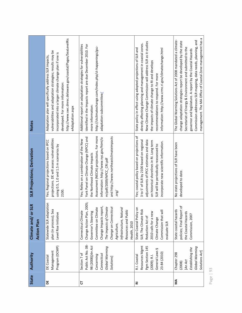
Page
|93
State
Autho
rity
Clim
atean
d/or
SLR
ActionPlan
SLRProjection
s;Derivation
Notes
DE
DECo
astal
Managem
ent
Program
(DCM
P)
Statew
ideSLRadaptatio
nplan
(inprocess);Sea
LevelRiseInitiative
Yes;Re
gion
alprojectio
nsbasedon
IPCC
projectio
ns.D
Ewillassessvulnerabilitie
susing0.5,1.0and1.5m
scen
ariosby
2100.
Adaptationplan
willspecifically
addressSLRim
pacts,
vulnerabilitie
sandadaptatio
nstrategies;resultsmay
beincorporated
into
alarger
clim
atechange
plan
ifon
eis
develope
d.Formoreinform
ation:
http://w
ww.swc.dn
rec.de
laware.gov/coastal/Pages/SeaLevelRis
eAdaptation.aspx
CTSection7of
PublicActNo.08
98(2008)[AnAct
Concerning
Conn
ecticut
Globa
lWarming
Solutio
ns]
Conn
ecticut
Clim
ate
Change
ActionPlan,2005;
Governo
r�’sSteering
Committee
onClim
ate
Change
Impactsrepo
rt,
TheIm
pactsof
Clim
ate
Chan
geon
Conn
ecticut
Agriculture,
Infrastructure,N
atural
Resourcesan
dPu
blic
Health
,2010
Yes;Re
lieson
acombinatio
nof
theNew
York
Pane
lonClim
ateCh
ange
(NPC
C)and
theNortheastClim
ateIm
pacts
Assessm
ent(NEC
IA)p
rojections.For
more
inform
ation:
http://w
ww.nyc.gov/htm
l/o
m/pdf/200
9/NPC
C_CR
I.pdf
andhttp://w
ww.northeastclim
ateimpacts
.org/
Add
ition
alrepo
rton
adaptatio
nstrategies
forvulnerabilitie
siden
tifiedintheIm
pactsrepo
rtaredu
eDecem
ber2010.For
moreinform
ation:
http://ctclim
atechange.com/ind
ex.php
/cthapp
enings/gsc
adaptatio
nsubcom
mittee/
RIR.I.Co
astal
ResourcesMgm
tPgm
Section145
(2009);R
.I.Gen
eralLaws§
2384
(2010)
StateCo
astalPolicyon
SLR;
TheClim
ateRisk
Redu
ctionActof
2010
calls
forane
wClim
ateCh
ange
Commission
that
will
evaluate
SLR
Yes;coastalpolicybasedon
projectio
nsof
3to
5�’of
SLRby
2100
basedon
region
aladjustmen
tsof
IPCC
estim
ates
anddata
onhistoricalshorelines
inRI.Lon
gterm
SLRwillbe
period
icallyreassessed
toincorporatene
wscientificinform
ation.
Statepo
licyineffectusingadop
tedprojectio
nsof
SLRand
directlyaffectingplanning
andmanagem
entincoastalzon
es.
New
Clim
ateCh
ange
Commission
willaddressSLRas
itstud
ies
theim
pactsof
clim
atechange
toRI
andde
velops
recommen
datio
nsto
respon
d.Formore
inform
ation:
http://w
ww.crm
c.ri.gov/clim
atechange.html
MA
Chapter298
(2008)
[AnAct
Establishing
the
Globa
lWarming
Solutio
nsAct]
Statecoastalhazards
policies;FinalRep
orto
ftheCo
astalH
azards
Commission
,2007
Nostateprojectio
nsof
SLRhave
been
develope
dto
date.
TheGlobalW
armingSolutio
nsActof
2008
mandatedaclim
ate
change
adaptatio
nstrategies
repo
rtbe
develope
dby
thestate
Secretariato
fEne
rgy&Environm
enta
ndsubm
itted
tothe
governor
andlegislature.Arepo
rtby
theCo
astalH
azards
Commission
addressesSLRmapping,datane
eds,planning,and
managem
ent.TheMAOfficeof
CoastalZon
emanagem
enth
asa

Page
|94
State
Autho
rity
Clim
atean
d/or
SLR
ActionPlan
SLRProjection
s;Derivation
Notes
MA
(con
t.)
�“Storm
SmartC
oasts�”
program
throughwhich
region
alcoordinatorsprovidetechnicalassistanceto
mun
icipalities.It
includ
esguidance
onSLR.
Formore
inform
ation:
http://w
ww.m
ass.gov/czm/storm
smart/inde
x.htm
NH
ExecutiveOrder,
2007
[Est.
Clim
ateCh
ange
PolicyTask
Force]
New
Ham
pshire
Clim
ate
ActionPlan
,200
9.Nostateprojectio
nsof
SLRhave
been
develope
dto
date;rep
ortreferen
cesIPCC
whe
reSLRismen
tione
d.
Focuson
broadactio
ns,not
SLR;
referenceto
improved
land
use;coastalprogram
specialprojectto
exam
ineadaptatio
nplanning.
ME
38M.R.S.A
§480
,Ch
.355
(2006)
Coastalsetback
that
accoun
tsfor2�’of
SLRin
thene
xt100years.
Nostateprojectio
nsof
SLRhave
been
develope
dto
date.
Aprojectm
ayno
tbepe
rmitted
if,with
in100years,itislikelyto
beseverelydamaged
byerosionto
theprop
erty
afterallowing
fora2�’rise
insealevelover1
00years.Be
achno
urishm
enta
nddu
nerestorationprojectsareexclud
edfrom
thisrequ
irem
ent.
Formoreinform
ation:
http://w
ww.m
aine
.gov/dep
/blwq/topic/du
nes/inde
x.htm
Page | 95
Appendix E: Comments of the City of New York on the NYS Sea Level RiseTask Force Draft for Public Comment

1
OFFICE OF THE MAYOR
Office of Long-Term Planning and Sustainability
253 Broadway, 10th Floor New York, New York 10007
www.nyc.gov/planyc2030
Memorandum To: Peter Iwanowicz
Acting Commissioner, New York State Department of Environmental Conservation From: Adam Freed
Deputy Director, New York City -Term Planning and Sustainability Date: December 14, 2010 Subject: Comments on NYS Sea Level Rise Task Force Report Draft for Public Comment As a member of the New York State Sea Level Rise Task Force (SLRTF) and Steering Committee, I appreciate the opportunity to provide comments on behalf of the City of New York on the draft report of the SLRTF, as released on November 9, 2010. The City commends the State for examining the challenges associated with sea level rise and climate change and is committed to working with the State and other local and statewide groups to address these critical issues. As articulated throughout this process; however, the City has a number of concerns about the recommendations in the draft report, many of which are not supported by thorough scientific, environmental, or cost-benefit analysis or do not recognize the differences between undeveloped areas and densely-populated cities. The City looks forward to working with the Task Force to address these concerns and develop recommendations that enhance the resilience of our state without imposing unnecessary burdens and obstacles. Through PlaNYC, greener, greater New York, the City has already begun to prepare for a changing climate and take actions to build climate resilience. In 2009, the City adopted official climate change projections that were developed by the New York City Panel on Climate Change, an expert panel of scientists, academics, economists, risk management experts and private sector practitioners appointed by the Mayor to advise the City on climate change. The City convened the NYC Climate Change Adaptation Task Force, which consists of 40 City, State, and Federal agencies and private companies that operate, regulate, or control critical infrastructure, to assess risks and develop strategies . Earlier this year, the City also acquired new high-resolution mapping and elevation data. This data will be used to better understand the risks the city faces from inland and coastal flooding and to update the Flood Insurance Rate Maps (FIRMs) in partnership with FEMA a critical first step that is needed to better understand the risks we currently face from coastal storms. The City has also begun to analyze potential changes to codes and land use
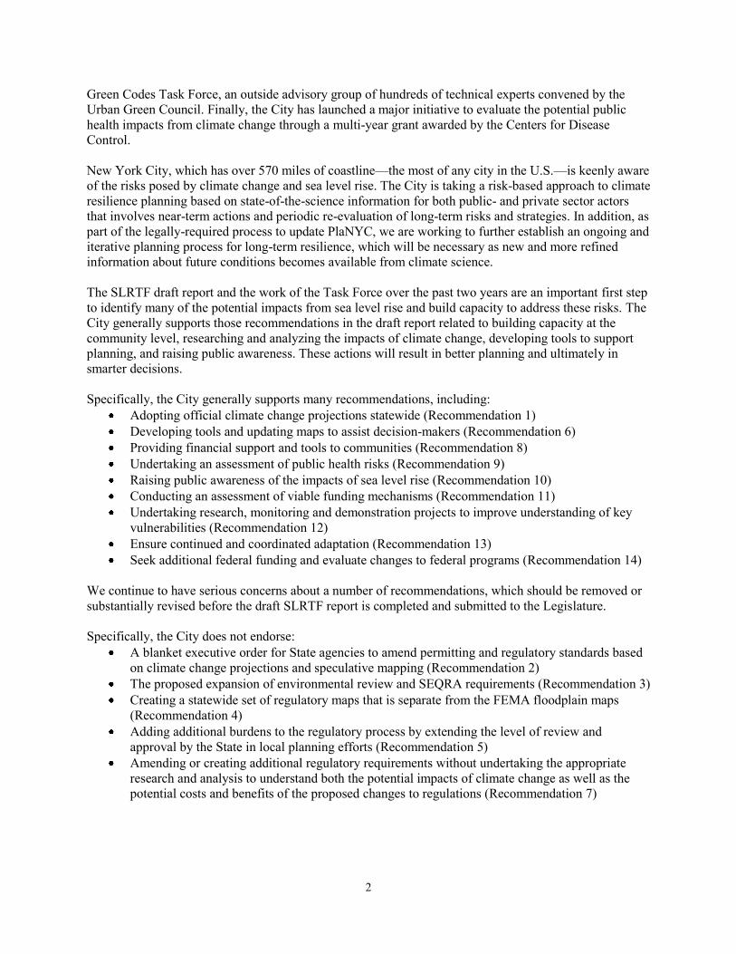
2
Green Codes Task Force, an outside advisory group of hundreds of technical experts convened by the Urban Green Council. Finally, the City has launched a major initiative to evaluate the potential public health impacts from climate change through a multi-year grant awarded by the Centers for Disease Control. New York City, which has over 570 miles of coastline the most of any city in the U.S. is keenly aware of the risks posed by climate change and sea level rise. The City is taking a risk-based approach to climate resilience planning based on state-of-the-science information for both public- and private sector actors that involves near-term actions and periodic re-evaluation of long-term risks and strategies. In addition, as part of the legally-required process to update PlaNYC, we are working to further establish an ongoing and iterative planning process for long-term resilience, which will be necessary as new and more refined information about future conditions becomes available from climate science. The SLRTF draft report and the work of the Task Force over the past two years are an important first step to identify many of the potential impacts from sea level rise and build capacity to address these risks. The City generally supports those recommendations in the draft report related to building capacity at the community level, researching and analyzing the impacts of climate change, developing tools to support planning, and raising public awareness. These actions will result in better planning and ultimately in smarter decisions. Specifically, the City generally supports many recommendations, including:
Adopting official climate change projections statewide (Recommendation 1) Developing tools and updating maps to assist decision-makers (Recommendation 6) Providing financial support and tools to communities (Recommendation 8) Undertaking an assessment of public health risks (Recommendation 9) Raising public awareness of the impacts of sea level rise (Recommendation 10) Conducting an assessment of viable funding mechanisms (Recommendation 11) Undertaking research, monitoring and demonstration projects to improve understanding of key
vulnerabilities (Recommendation 12) Ensure continued and coordinated adaptation (Recommendation 13) Seek additional federal funding and evaluate changes to federal programs (Recommendation 14)
We continue to have serious concerns about a number of recommendations, which should be removed or substantially revised before the draft SLRTF report is completed and submitted to the Legislature. Specifically, the City does not endorse:
A blanket executive order for State agencies to amend permitting and regulatory standards based on climate change projections and speculative mapping (Recommendation 2)
The proposed expansion of environmental review and SEQRA requirements (Recommendation 3) Creating a statewide set of regulatory maps that is separate from the FEMA floodplain maps
(Recommendation 4) Adding additional burdens to the regulatory process by extending the level of review and
approval by the State in local planning efforts (Recommendation 5) Amending or creating additional regulatory requirements without undertaking the appropriate
research and analysis to understand both the potential impacts of climate change as well as the potential costs and benefits of the proposed changes to regulations (Recommendation 7)
3
1. Many of the draft recommendations are not based on thorough analysis and require additional
research and analysis to determine specific regulatory responses to the long-term impacts of sea level rise
The draft report correctly identifies that many research, monitoring, and demonstration projects are needed to improve understanding of key vulnerabilities to critical coastal ecosystems, infrastructure, and communities from sea level rise. Recommendation 12 lists over twenty specific initiatives that are necessary to better understand the impacts of sea level rise. These are important areas to explore, and we look forward to working with the State on these efforts. However, since this analysis has not been done, we do not fully understand the potential impacts of sea level rise and storm surge on coastal infrastructure and communities much less many of the intended and unintended consequences of the proposed policy recommendations in the draft report. Therefore, we strongly believe it is premature to propose specific regulatory changes without conducting the necessary research and analysis. Many of the recommendations presented in the report outstrip the analysis performed by the Task Force. The benefits and costs of proposed regulatory changes, including an assessment of the relevant State manner, are not known at this time, and additional assessment must be done. Further, measures to increase resilience to climate change must consider a range of goals, including economic development, greenhouse gas mitigation, public access, ecological health, and more. Strategies should be evaluated based on consideration of a full range of costs and benefits, including their consequences for other parts of the state, resources available for other efforts, and their ability to produce co-benefits or advance other desirable ends. Building resilience to coastal storms and flooding anticipated in the future does not lend itself to quick solutions. Climate change poses real and significant risks to New Yorkers, but our response must be based on science and rational, risk-based planning that allows us to make more informed decisions about how to build resilience to sea level rise. In particular, we must better understand the impacts associated with the sea level rise levels projected for the 2050s and beyond since these are the most severe, yet also the most uncertain. 2. The draft report and recommendations do not sufficiently recognize the unique challenges
facing urban areas, particularly with regard to the potential for non-structural measures to adequately provide coastal protection into the future
Building resilience to coastal storms and flooding requires recognition of the characteristics of all of New York State The report does not appropriately recognize the unique characteristics of urban areas and the long-term need to protect New York City. The draft report has a strong bias toward non-structural measures that is not supported by any environmental, feasibility, or cost-benefit analyses that are based on conditions in New York. Many of the academic studies that are utilized throughout the draft report were conducted in non-urban areas, and it is not appropriate to extrapolate the conclusions from these areas onto New York City. The draft report also cites New Orleans on several occasions. In New Orleans, substantial portions of the city are located below sea level, and floodwaters do not naturally recede after a storm event, exacerbating the potential for damage and disruption, as illustrated by the experience of Hurricane Katrina. Unlike New Orleans, most portions of New York City stand several feet or more above sea level, and therefore face different challenges from New Orleans.
4
In the absence of an evaluation of the relative costs and benefits of alternative approaches to sea level rise in New York City, it is premature to dismiss structural measures. It is likely that New York City will need to utilize a host of structural and non-structural measures to protect its residents and critical infrastructure from sea level rise in the future. Absent rigorous analysis, flexibility must be given to localities to identify and implement the most appropriate climate resilience strategies that take into account a variety of considerations and concerns. As written, the draft recommendations could result in a policy of disinvestment in and promote relocation from existing urban areas. This would have dire economic and environmental consequences for the city and the state. There are over 215,000 people living within the FEMA 1 percent chance flood zone in New York City and more than 185,000 jobs present in this zone. In the 0.2 percent chance flood zone the population is more than 475,000, and there are over 290,000 jobs. These populations and jobs are of great significance to the city, state, and broader economy. Moreover, the city is built on a vast fixed infrastructure including transit and sewer systems that cannot be moved to higher ground. These assets are themselves a mitigation strategy for climate change: they enable New Yorkers to live in dense settlements in which our per-capita carbon emissions are already just one-third of the national average, and targeted for a further reduction of 30 percent by 2030 under PlaNYC. The capacity to support a large population in
natural resources elsewhere. 3. I f implemented, the proposed regulatory changes would create unnecessary additional
oversight for local land-use decisions and could add significant costs and time to projects in coastal areas, including those undertaken for public health and safety or to reduce flood risks
The City supports the use of climate change projections to create maps depicting sea level rise for planning purposes, but is concerned that basing regulatory policy and additional permitting requirements on these maps is problematic given the uncertainty and imprecision associated with current mapping and modeling technology. We do not support the concept of creating coastal risk management zones for regulatory purposes based on such predictive mapping, nor do we support the proposals outlined in Recommendation 7 that would change regulatory requirements within and based on these zones. We are further concerned that the recommendations to create these maps, as well as other recommendations such as amending wetlands regulations to cover lands that may transition to wetlands in the future, are based on assumptions that outstrip the predictive capacity of scientific evidence and methodologies. There are also legal implications that need to be explored related to making permitting decisions based on projected conditions. It would be also problematic if the State created regulatory maps that conflicted with the FEMA FIRMs. Instead, efforts should focus on coordinating with FEMA to regularly update their flood maps as opposed to creating an additional set of regulatory maps that could create conflicts, confusion, and additional regulatory burdens. If the State determines that there are areas of risk that are outside the FEMA A zones, property owners may be unable to get flood insurance in these zones, while they are able to get under the National Flood Insurance Program. The result could be to push development into, rather than out of, the most vulnerable areas. The proposal to require local climate resilience plans that require approval by both the Department of Environmental Conservation and the Department of State represents a major expansion of regulatory powers over local decision-making. Further, it is unclear how the State would manage, review, and approve the process proposed in Recommendation 5. If a municipality did not have an approved local coastal resilience plan in place, then it appears that ethat uses State funding would be subject to a review or require a permit. Yet the draft report and

5
recommendations do not indicate how this review will occur. This is especially important considering the current financial situation facing the State. Any delays in review or permitting would have an adverse
climate change planning process underway as part of its comprehensive long-term plan. This process has resulted in numerous projects that are reducing our exposure to climate change. Awaiting approval from two State agencies for a formal plan adds unnecessary time, costs, and unpredictability into an already complicated process. The proposed changes to SEQRA could also require additional costs and time for local projects. Making any unlisted action in a coastal area into a Type I action could have an adverse effect on property investment in the New York City and thus New York State economy. This recommendation suggests that the issuance of a discretionary permit e.g., for expansion of an existing bulkhead is more likely to require an EIS. This would ultimately impede adaptation in highly-urbanized areas. Adding such actions to the Type I list would accomplish little except adding cost and time to actions, including actions that are necessary for adaptation. Implementation of this recommendation could require the preparation of a future development scenario 50-100 years or more into the future, which is neither practical nor helpful. Adding additional burdens to the regulatory process (by adding new layers of review and analysis) could also prevent actual adaptation activities from occurring by increasing costs and directing investments (including flood mitigation strategies) away from coastal areas. In locations where retreat is not viable, increased stress on existing coastal infrastructure will require more frequent maintenance or upgrading. Predictable and timely regulatory approvals will therefore be a key part of a climate resilience strategy. As drafted, the SLRTF recommendations have the potential to add substantial costs and time to development projects and infrastructure investments. While codes and regulations will need to be updated to account for the impacts of climate change, implementing these measures without a thorough understanding of the cost and time implications or the scope of their reach is premature. The City looks forward to working with the State Department of Environmental Conservation and the members of the Sea Level Rise Task Force to address our concerns and develop final recommendations

New York State Sea Level Rise Task Force Report to the Legislature
Errata
January 10, 2011
Ordered by appearance in the text. Page 84 Insert additional members of the Infrastructure Work Group: Thomas Chandler Columbia University Andrew Garrett Columbia University Karen Levin Columbia University Page 86, column 2, paragraph 8, line 1 Change Therman to Thurman.