flora, fauna and net gain assessment of the big hill and davis
TRANSCRIPT

HEAD OFFICE: 292 Mt Alexander Road, Ascot Vale, VIC 3032 MELBOURNE: GEELONG: PO Box 8048, Newtown VIC 3220
1
FINAL REPORT:
Flora, Fauna and Net Gain Assessment of the Big Hill and
Davis sites, Temporary Waste Rock Stockpile area and future
Haulage Road for the proposed extension of the Stawell
Gold Mine, Stawell, Victoria.
PREPARED FOR:
Stawell Gold Mines Pty Ltd
January 2013
.
Ecology and Heritage Partners Pty Ltd
Flora, Fauna and Net Gain Assessments: Big Hill, Davis, TWRS, Additional areas and Haulage Rd, Stawell, Victoria
ii
Table of Contents
Abbreviations ............................................................................................... vii
Summary...................................................................................................... viii
1 Introduction ......................................................................................... 1
1.1 Background ....................................................................................... 1
1.2 Scope of Assessment ........................................................................ 1
1.3 Study Area ......................................................................................... 1
2 Methods ............................................................................................... 3
2.1 Nomenclature .................................................................................... 3
2.2 Desktop Assessment ......................................................................... 3
2.3 Flora Assessment .............................................................................. 3
2.4 Net Gain Assessment ........................................................................ 3
2.4.1 Habitat Hectare Assessment .................................................................................. 3
2.4.2 Tree Assessment .................................................................................................... 5
2.5 Fauna Assessment ............................................................................ 6
2.6 Best or Remaining 50% Habitat Assessment .................................... 6
2.7 Assessment Qualifications and Limitations ........................................ 7
3 Results ................................................................................................. 8
3.1 Literature Review ............................................................................... 8
3.1.1 Biosis Research Pty Ltd 1999. Flora and Fauna Assessment at the Stawell Gold Mines – Big Hill Development Project, Stawell, Victoria. .................................................. 8
3.2 Flora Species ..................................................................................... 8
3.3 Ecological Vegetation Classes .......................................................... 9
3.3.1 Box Ironbark Forest (EVC 61) ................................................................................. 9
3.4 Vegetation Condition ......................................................................... 9
3.4.1 Scattered Trees ..................................................................................................... 12
3.5 Significant Flora Species and Communities .................................... 12
3.5.1 National ................................................................................................................. 13
3.5.2 State ...................................................................................................................... 13
3.6 Communities .................................................................................... 13
3.7 Fauna Species ................................................................................. 14
3.7.1 Previous records................................................................................................... 14
3.8 Fauna Habitats ................................................................................ 14
3.8.1 Secondary Grassland ........................................................................................... 15
3.8.2 Woodland .............................................................................................................. 15
Flora, Fauna and Net Gain Assessments: Big Hill, Davis, TWRS, Additional areas and Haulage Rd, Stawell, Victoria
iii
3.8.3 Dams / Artificial Waterbodies ............................................................................... 16
3.8.4 Recreation Reserve and Arboretum of Planted trees .......................................... 16
3.8.5 Introduced grassland............................................................................................ 16
3.9 Significant Fauna ............................................................................. 17
3.9.1 National ................................................................................................................. 17
3.9.2 State ...................................................................................................................... 17
3.9.3 Regional and local ................................................................................................ 18
3.10 Sites of Biological Significance (BioSites) ........................................ 19
3.11 Ecological Significance of Study Area ............................................. 19
4 Implications of the Findings ............................................................. 20
4.1 Environment Protection and Biodiversity Conservation Act 1999 .... 20
4.2 Flora and Fauna Guarantee Act 1988 ............................................. 21
4.3 Planning and Environment Act 1987................................................ 23
4.4 Mineral Resources (Sustainable Development) Act 1990 ................ 24
4.5 Box-Ironbark Forests and Woodlands Investigation – Environment Conservation Council ..................................................................................... 26
4.6 Catchment and Land Protection Act 1994 ....................................... 26
4.7 Wildlife Act 1975 and Wildlife Regulations 2002 .............................. 27
4.8 The Native Vegetation Framework .................................................. 28
4.9 Northern Grampians Shire Council .................................................. 29
5 Net Gain Assessment ....................................................................... 31
5.1 Assessment of Best or Remaining 50% Habitat .............................. 31
5.1.1 Habitat assessment for threatened flora species ................................................ 32
5.1.2 Habitat assessment for threatened fauna species .............................................. 33
5.2 Habitat Hectare Assessment Calculations ....................................... 33
5.3 Tree Assessment ............................................................................. 41
5.3.1 Trees in habitat zones .......................................................................................... 41
5.3.2 Scattered tree assessment ................................................................................... 41
5.4 Summary of Habitat Hectare and Tree Assessment ........................ 41
5.5 Net Gain Implications ....................................................................... 42
5.5.1 Avoidance (First step) .......................................................................................... 42
5.5.2 Minimisation (Step two) ........................................................................................ 42
5.5.3 Offset Requirements ............................................................................................. 43
5.5.4 Summary of Net Gain Targets .............................................................................. 46
5.6 Potential Measures to Achieve Net Gain ......................................... 46
5.7 Potential Net Gain Strategies .......................................................... 47
5.7.1 Enhanced Management of Remnant Vegetation ................................................. 48

Flora, Fauna and Net Gain Assessments: Big Hill, Davis, TWRS, Additional areas and Haulage Rd, Stawell, Victoria
iv
5.7.2 Revegetation ......................................................................................................... 49
5.8 Finding an Appropriate Offset Site ................................................... 50
6 Potential Impacts............................................................................... 51
7 Mitigation Measures and Recommendations ................................. 52
References.................................................................................................... 53
Figures .......................................................................................................... 56
Appendices ................................................................................................... 61
Tables
Table 1. Threatening processes under the Flora and Fauna Guarantee Act 1988 applicable to the proposed mining operation. ................................................... 22
Table 2. Habitat assessment criteria for threatened species from the Native Vegetation – Guide for assessment of referred planning permit applications publication (DSE 2007). ................................................................................... 31
Table 3a. Best and remaining 50% habitat for rare or threatened flora species – Big Hill area ........................................................................................................... 32
Table 3b. Best and remaining 50% habitat for rare or threatened flora species – Davis Area ....................................................................................................... 32
Table 3c. Best and remaining 50% habitat for rare or threatened flora species in the Additional Areas, Temporary Waste Rock Stockpile area and Haulage Road. . 32
Table 4a. Habitat scores for remnant patches within the Big Hill area .................... 34
Table 4b. Habitat scores for remnant patches within the Davis area ....................... 35
Table 4b continued. Habitat scores for remnant patches within the Davis area ...... 36
Table 4b continued. Habitat scores for remnant patches within the Davis area ...... 37
Table 4c. Habitat scores for remnant patches within the Additional areas (Sections1-3) ..................................................................................................................... 38
Table 4d. Habitat scores for remnant patches within the Temporary Waste Rock Stockpile area .................................................................................................. 39
Table 4e. Habitat scores for remnant patches within the future Haulage Road alignment ......................................................................................................... 40
Table 5a. Net Gain targets for the Big Hill area (based on total removal)................ 44
Table 5b. Net Gain targets for the Davis area (based on total removal). ................. 44
Table 5c. Net Gain targets for the Additional areas – Sections 1-3 (based on total removal). ......................................................................................................... 45
Table 5d. Net Gain targets for the Temporary Waste Rock Stockpile area (based on total removal). .................................................................................................. 45
Table 5e. Net Gain targets for the study area (based on total removal). ................. 45
Table 6. Protect and recruit offset requirements for scattered trees ........................ 46

Flora, Fauna and Net Gain Assessments: Big Hill, Davis, TWRS, Additional areas and Haulage Rd, Stawell, Victoria
v
Table A1.1. Rare or Threatened categories for listed Victorian taxa. ...................... 62
Table A1.2. Defining Ecological Significance. ......................................................... 63
Table A1.3. Defining Site Significance. ................................................................... 65
Table A1.4. Defining Vegetation Condition. ............................................................ 67
Table A1.5. Defining Habitat Quality. ...................................................................... 67
Table A2.1. Flora recorded during the present survey ............................................ 69
Table A2.2. Significant flora recorded within 10 kilometres of the study area. .......... 73
Table A3.1. Fauna recorded during the present survey (2011 and 2012), and previously recorded within 10 kilometres of the study area. ............................. 77
Table A3.2. Significant fauna within 10 kilometres of the study area....................... 85
Flora, Fauna and Net Gain Assessments: Big Hill, Davis, TWRS, Additional areas and Haulage Rd, Stawell, Victoria
vi
Acknowledgments
We thank the following people for their contribution in the project.
David Coe (Stawell Gold Mines Pty Ltd) for site information and land access.
Department of Sustainability and Environment for access to the Flora Information System and Atlas of Victorian Wildlife.
Document Control
Project Name Flora, Fauna and Net Gain Assessment of Additional Areas associated with the Big Hill and Davis Sites for the proposed extension to the Stawell Gold Mine, Stawell, Victoria
Project numbers 3630, 4617 & 4692
Project manager(s) Bryan Roberts, Matt Hatton
Report author(s)
Bryan Roberts, Consultant Botanist Matt Hatton, Consultant Botanist Daniel Weller, Consultant Zoologist, Cristina Del Borello, Research Assistant
Report reviewer(s) Andrew Hill, Company Director – Principal Ecologist Stuart Cooney, Senior Zoologist
Other EHP Staff Report updates – Matt Hatton
Mapping Monique Elsley
File Name 4692_EHP_SGM_FFNG_BigHill_Davis_TWRS_22012013
Report Version Comments Comments Updated by:
Date Submitted
Draft David Coe BR, MH 11.01.2013
Final Report David Coe MH 22.01.2013
Copyright © Ecology and Heritage Partners Pty Ltd
This document is subject to copyright and may only be used for the purposes for which it was commissioned. The use or copying of this document in whole or part without the permission of Ecology and Heritage Partners Pty Ltd is an infringement of copyright.
Disclaimer
Although Ecology and Heritage Partners Pty Ltd have taken all the necessary steps to ensure that an accurate document has been prepared, the company accepts no liability for any damages or loss incurred as a result of reliance placed upon the report and its contents.
Flora, Fauna and Net Gain Assessments: Big Hill, Davis, TWRS, Additional areas and Haulage Rd, Stawell, Victoria
vii
ABBREVIATIONS AVW Atlas of Victorian Wildlife
CALP Act Catchment and Land Protection Act
DBH Diameter at Breast Height
DEC Department of Environment and Conservation NSW
DPCD Department of Planning and Community Development
DPI Department of Primary Industries
DSE Department of Sustainability and Environment
EES Environment Effects Statement
EPBC Act Environment Protection and Biodiversity Conservation Act
ERI Earth Resources Industry
EVC Ecological Vegetation Class
FIS Flora Information System
FFG Act Flora and Fauna Guarantee Act
LOT Large Old Tree
MEIWA Mining and Extractive Industry Work Approvals Process
MOT Medium Old Tree
MRSD Act Mineral Resources (Sustainable Development) Act
MoU Memorandum of Understanding
MTV Modified Treeless Vegetation
NES National Environmental Significance
NRE Department of Natural Resources & Environment
OMP Offset Management Plan
PDA Nomad Trimble Personal Digital Assistant
PPWCMA Port Phillip and Westernport Catchment Management Authority
PPRZ Public Park and Recreation Zone
SEWPAC Department of Sustainability, Environment, Water, Population and Communities
SUZ Special Use Zone
TRZ Tree Retention Zone
VBA Victorian Biodiversity Atlas
VLOT Very Large Old Tree
WCMA Wimmera Catchment Management Authority
WMO Wildfire Management Overlay

Flora, Fauna and Net Gain Assessments: Big Hill, Davis, TWRS, Additional areas and Haulage Rd, Stawell, Victoria
viii
SUMMARY
Introduction
Ecology and Heritage Partners Pty Ltd was commissioned by Stawell Gold Mines Pty Ltd to undertake flora, fauna and Net Gain assessments of the Big Hill and Davis areas, the Temporary Waste Rock Stockpile (TWRS) area, future haulage roadside and additional areas as part of the proposed extension of the Stawell Gold Mine, Stawell, Victoria. The aim of the assessment was to identify the type, quality and quantity of native vegetation and fauna habitat present within the study area.
Methods
Two flora and fauna assessments were undertaken on 9 and 10 January 2012 and a further assessment was conducted on 3 January 2013 to obtain information on terrestrial flora and fauna values within the study area. The study area was assessed on foot, with all observed flora and fauna species recorded, significant records mapped and the overall condition of vegetation and habitat noted.
A habitat hectare assessment was undertaken concurrently with the flora survey. Vegetation within the study area was assessed according to the habitat hectare methodology, which is described in the Vegetation Quality Assessment Manual.
Results
Flora
Big Hill
A total of 82 plant taxa (36 indigenous, 46 exotic) were recorded within the Big Hill study area. Flora species and soil types are representative of one Ecological Vegetation Class (EVC), Box-Ironbark Forest (EVC 61), which is listed as „depleted‟ within the Goldfields bioregion.
In general, vegetation south of Scenic Road in the Big Hill area is of fairly poor quality, with higher quality remnants restricted to the areas north/ above Scenic Road. Areas south of Scenic Road vary substantially and include an arboretum planted in the early 1950s to help cover the scars from previous mining practices. In addition to exotic trees, the arboretum includes a number of planted trees from around Australia, as well as some that are indigenous to the local area (e.g. Red Ironbark Eucalyptus tricarpa). Several unnatural ravines also occur within the study area both above and below Scenic Road and are most likely old mining shafts or excavations. Vegetation within these ravines is highly modified, especially the large ravine south of Scenic Road.
No threatened flora species or communities were recorded within the Big Hill study area and none are expected to occur within this section.

Flora, Fauna and Net Gain Assessments: Big Hill, Davis, TWRS, Additional areas and Haulage Rd, Stawell, Victoria
ix
Davis Area
A total of 92 plant taxa (57 indigenous, 35 exotic) were recorded within the Davis study area. Flora species and soil types are representative of the Ecological Vegetation Class (EVC), Box-Ironbark Forest (EVC 61), which is listed as „depleted‟ within the Goldfields bioregion.
The majority of the study area has an indigenous overstorey, with the condition of the vegetation highly variable, ranging from poor to high quality. Remnant vegetation is of poorer quality at the base of the hill, with vegetation quality gradually improving as the slope increases, with the highest quality vegetation on the northern aspects. Whilst retaining an intact overstorey and a small number of species reflective of the Box-Ironbark Forest EVC, poorer quality remnants were highly disturbed and contained a high cover of exotic species within the understorey, some of which are listed as noxious.
In total, thirteen patches Box-Ironbark Forest were recorded with the Davis area along with five scattered trees.
One state significant species, Small-leaf Goodenia Goodenia benthamiana was also recorded within the Davis area. This species is considered rare in Victoria. No other threatened species or communities were recorded within Davis section of the study area.
Additional areas – Sections 1-3
A total of 85 plant taxa (51 indigenous, 34 exotic) were recorded within the Additional study areas (Sections 1-3). Vegetation throughout these sections of the study area is highly modified, either through historical logging and mining, or current recreational uses and ranges from poor to good condition.
Section 1 comprises the triangular northern tip of the arboretum, planted in the early 1950‟s and currently used as public open space. Thirteen medium to large trees are scattered throughout an open-lawn reserve and all are exotic or non-indigenous natives. One Ecological Vegetation Class (EVC), Box-Ironbark Forest (EVC 61), was recorded within Sections 2 and 3 of this part of the study area. Indigenous trees are generally in good condition, though none are mature and canopy cover is low and few logs area present. Mid and understorey layers are generally intact and in moderate to good condition, though species diversity is relatively poor. With exception of several areas densely covered in Broom Genista spp. and Prickly Pear Opuntia stricta weed cover is generally low.
No scattered trees were recorded within the additional study areas. Threatened flora species or communities were also not recorded within these sections of the study area.
Flora, Fauna and Net Gain Assessments: Big Hill, Davis, TWRS, Additional areas and Haulage Rd, Stawell, Victoria
x
Temporary Waste Rock Stockpile (TWRS)
Approximately three quarters of the temporary Waste Rock Stockpile (TWRS) area is currently devoid of all vegetation and approximately one quarter has been replanted in distinct rows with a small selection of native understorey shrubs and trees, primarily Golden Wattle. The large bare area forms part of the disused Davis open cut mine and in its current state is suitable only to the growth of opportunistic weeds species such as Stinkwort.
No threatened flora species were identified in the TWRS section of the study area nor are any expected to occur as the area is highly modified and in an early stage of recovery.
Haulage Road
The future haulage road alignment consists of several thin patches of Box Ironbark on the roadside, which are in moderate condition. Yellow Gum is the dominant tree species, and the shrub layer is relatively dense in this area, with moderate species diversity, however, the distribution and abundance of understorey species is relatively low.
No threatened flora species were identified in the future haulage road section of the study area nor are any expected to occur as the area is highly modified and subject to the surrounding movements of heavy traffic.
Fauna
The entire study area currently supports five broad fauna habitat types: Secondary Grassland, Remnant woodland, dams/artificial waterbodies, an Arboretum of planted trees, and introduced grassland. Fauna habitat quality varies from high, for remnant woodland, to low, for introduced grassland.
Big Hill & Davis Areas
A total of 78 terrestrial fauna species comprising eight mammals (three introduced), 64 birds (four introduced), five reptiles, and one native frog species were recorded within the Big Hill and Davis sections of the study area (Appendix 3.1). One of these species, Brown Treecreeper Climacteris picumnus victoriae, is of state significance, while Bearded Dragon Pogona barbata, is of regional significance. No additional fauna species of national, state or regional significance were recorded within the Big Hill survey area.
Additional Areas – Sections 1-3
A total of 43 terrestrial fauna species comprising seven mammals (four native and three introduced), 34 birds (31 native and three introduced) and two reptiles were recorded during this assessment (Appendix 3.1). The majority of the recorded species

Flora, Fauna and Net Gain Assessments: Big Hill, Davis, TWRS, Additional areas and Haulage Rd, Stawell, Victoria
xi
are common and only one, Bearded Dragon Pogona barbata, is of regional significance. No additional fauna species of national, state or regional significance were recorded during the current survey.
Temporary Waste Rock Stockpile (TWRS)
A total of five fauna species were located within the TWRS and revegetation area. All species were commonly occurring birds that often take advantage of highly modified open spaces, such as Australian Magpie and Australian Raven. No threatened fauna species were located in this section of the study area and none are predicted to occur.
Haulage Road
At the time of survey, no fauna species were recorded within the future Haulage Road reserve. The proposed haulage road is directly adjacent to an existing dirt road that is extensively used by heavy machinery, which may explain the absence of fauna species in this section.
Relevant Legislation and Policy
No listed flora or fauna species listed under the Environment Protection and Biodiversity Conservation Act 1999 (EPBC Act) are considered likely to occur within the study area, as no suitable habitat is present. Therefore, an EPBC Act referral to the Commonwealth Environment Minister is not required.
Although several listed protected flora species were recorded within the study area (e.g. Asteraceae species and certain Acacias), a permit under the Flora and Fauna Guarantee Act 1988 (FFG Act) is not required for the removal of protected flora located on public land where a proposed mining project has been subject to an Environment Effects Statement (EES), and it is approved and a subsequent work plan is prepared in accordance with the Mineral Resources Development Act 1990.
A work plan under the Mineral Resources (Sustainable Development) Act 1990 (MRSD Act) will need to be prepared as the proposed development does not meet any of the exemptions under the Act. This work plan will need to comply with the requirements of the MRSD Act, and must include a detailed rehabilitation plan. Additionally, mining within the Box-Ironbark region must comply with the government approved recommendations as set out in the Environment Conservation Councils (ECCs) Box-Ironbark investigation.
Habitat Hectares
The study area contains a total of approximately 13.28 hectares (ha), or 5.49 habitat hectares (Hha) of remnant Box Ironbark Forest from the Goldfields bioregion. This total includes:
Flora, Fauna and Net Gain Assessments: Big Hill, Davis, TWRS, Additional areas and Haulage Rd, Stawell, Victoria
xii
Big Hill:
0.46 ha Medium conservation significance Box Ironbark Forest (BIF), OR 0.2 Habitat hectares (Hha) Medium BIF.
0.6 ha Low conservation significance BIF OR 0.17 Hha Low BIF
Davis:
1.98 ha High conservation significance Box Ironbark Forest (BIF), OR 1.14 Hha High BIF.
3.35 ha Medium conservation significance Box Ironbark Forest (BIF), OR 1.21 Hha Medium BIF
0.87 ha Low conservation significance BIF OR 0.24 Hha Low BIF
Plus 3 LOTs in patches and 5 scattered trees.
Additional Areas (minus TWRS and Section 5):
3.24 ha High conservation significance Box Ironbark Forest (BIF), OR 1.75 Hha High BIF
0.57 ha Medium conservation significance Box Ironbark Forest (BIF), OR 0.26 Hha Medium BIF
0.59 ha Low conservation significance BIF OR 0.11 Hha Low BIF
Haulage Road:
0.52 ha of Medium conservation significance BIF, OR 0.23 Hha of Medium BIF
Temporary Waste Rock Storage:
Revegetation area (HZ2): 1.1 ha of Low conservation significance BIF, OR 0.18 Hha Low BIF.
Five „Scattered Trees‟ were also identified within the study area.
Net Gain
As defined under Victoria’s Native Vegetation Management – A Framework for Action („the Framework‟), the principles of avoid and minimise need to be demonstrated prior to any vegetation being removed.
Net Gain targets associated with the final pit shell design for the additional survey areas include the following offsets to be generated from the Goldfields or in some instances an adjacent bioregion:

Flora, Fauna and Net Gain Assessments: Big Hill, Davis, TWRS, Additional areas and Haulage Rd, Stawell, Victoria
xiii
2.89 habitat hectares of High conservation significance Box-Ironbark Forest;
1.90 habitat hectares of Medium conservation significance Box-Ironbark Forest; and,
0.70 habitat hectares of Low conservation significance Box-Ironbark Forest.
Protect four LOTs and Recruit 20 new plants.
In addition, to meet offset obligations for the removal of five scattered indigenous trees within the study area, there is a requirement to Protect three LOTs and Recruit 30 plants, OR as a recruitment only option, Recruit 141 new plants.
Further Requirements
As remnant native vegetation and scattered indigenous trees are proposed to be removed as part of the final pit shell design, an Offset Management Plan will need to be developed to ensure the proposed action complies with „the Framework‟. Targeted flora surveys should be undertaken in higher quality remnants.

Flora, Fauna and Net Gain Assessments: Big Hill, Davis, TWRS, Additional areas and Haulage Rd, Stawell, Victoria
1
1 INTRODUCTION
1.1 Background
Ecology and Heritage Partners Pty Ltd was commissioned by Stawell Gold Mines Pty Ltd to undertake flora, fauna and Net Gain assessments of the Big Hill and Davis areas, the Temporary Waste Rock Stockpile (TWRS) area, future haulage roadside and several additional areas as part of the proposed extension of the Stawell Gold Mine, Stawell, Victoria (Figure 1). The aim of the assessment was to identify the type, quality and quantity of native vegetation and fauna habitat present within the study area.
1.2 Scope of Assessment
The objectives of the report are to:
Classify any flora and fauna species identified or considered likely to occur within the study area in accordance with Commonwealth and State legislation;
Provide information in relation to any implications of Commonwealth and State environmental legislation and Government policy (particularly Victoria‟s Native Vegetation – A Framework for Action (the Framework) (NRE 2002)) associated with the proposed development;
Determine any potential impacts on ecological values at a National and State level associated with the proposed development; and,
Provide advice on mitigation measures which may be undertaken to avoid potential adverse impacts on flora and fauna values.
1.3 Study Area
The entire study area is situated within the township of Stawell, approximately 240 kilometres west of the Melbourne CBD (Figure 1). For ease of interpretation and discussion, the study area has been broken into a number of discrete sections, which are referred to throughout the report to summarise findings and implications associated with different stages of the development.
According to the Department of Sustainability and Environment‟s (DSE) Biodiversity Interactive Map (DSE 2012), the entire study area occurs within the Goldfields Bioregion, close to the southern edge of the Victorian Riverina Bioregion. The Goldfields Bioregion extends from east of the Grampians, through central Victoria to south of Shepparton. The entire study area lies within the Northern Grampians Shire Council municipality and the Wimmera Catchment Management Authority.
Big Hill: The Big Hill section of the study area comprises the „Big Hill Parklands and Gardens Reserve‟ which is managed by Parks Victoria (Figure 2a). Within the study
Flora, Fauna and Net Gain Assessments: Big Hill, Davis, TWRS, Additional areas and Haulage Rd, Stawell, Victoria
2
area is the Apex Arboretum which was established in 1950 to help cover the effects of past mining practices. Big Hill is a prominent feature in the landscape, with the Pioneer Memorial and lookout point located at the top of Scenic Road. The majority of this section of the study area is located on the southern aspect of Big Hill. Much of this section is highly modified, in part because it contains the Apex Arboretum and a number of access tracks.
The Big Hill area occurs in a Public Park and Recreation Zone (PPRZ), with one small section in a Special Use Zone – Schedule 1 (SUZ1) which relates to the use and development of land for gold mining. A Wildfire Management Overlay (WMO) is also pertinent to the entire study area.
Davis Area: The Davis section of the study area is located within the current Stawell Gold Mine lease area (hereafter referred to as the Leased Area) and the adjoining Big Hill Parklands and Garden Reserve (hereafter referred to as the Parklands) to the north (Figure 2b). The majority of the study area is located on the southern aspect of Big Hill and is heavily vegetated, though some sections of the leased area are used for equipment depots and access/management tracks.
The Davis section of the study area is in a Public Park and Recreation Zone (PPRZ), with one small section in a Special Use Zone – Schedule 1 (SUZ1) which relates to the use and development of land for gold mining. A Wildfire Management Overlay (WMO) is also pertinent to the entire study area.
Additional Areas (Sections 1-3): The additional study areas include: Section One - a small triangular site on the north-west boundary of the lease area along Main Street (Figure 2c); Section Two - a rectangular, predominantly paddock area south-east of the largest water supply dam (Figure 2d); and Section Three - a roughly kidney shaped area immediately south-east of the Davis site, dissected by Reefs Road (Figure 2e).
Sections One and Three are covered by a Public Park and Recreation Zone (PPRZ) along with a Special Use Zone – Schedule 1 (SUZ1), which relates to the use and development of land for gold mining. Section Two is covered by a Public Use Zone – Service and Utility (PUZ1). A Wildfire Management Overlay (WMO) is pertinent to all sections.
Temporary Waste Rock Stockpile (TWRS) area: The Temporary Waste Rock Stockpile area is located north of Reefs Road and immediately south-east of the largest water supply dam (Figure 2f). The TWRS area is covered by a Public Use Zone – Service and Utility (PUZ1) and a Wildfire Management Overlay (WMO).
Haulage Road (Section 4): The existing Haulage Road and associated roadside vegetation dissects the current lease area and runs roughly parallel to Reefs Road to the north and Scenic Drive and Albion Road to the south (Figure 2e). This section of the study area is covered by a Public Use Zone – Service and Utility (PUZ1) and a Wildfire Management Overlay (WMO).

Flora, Fauna and Net Gain Assessments: Big Hill, Davis, TWRS, Additional areas and Haulage Rd, Stawell, Victoria
3
2 METHODS
2.1 Nomenclature
Common and scientific names of vascular plants follow the Flora Information System (FIS 2011), the Victorian Biodiversity Atlas (VBA 2011) and the Census of Vascular Plants of Victoria (Walsh and Stajsic 2007). Vegetation community names follow DSE‟s Ecological Vegetation Class (EVC) benchmarks (DSE 2013a) and Oates and Taranto (2001).
The names of terrestrial vertebrate fauna (mammals, birds, reptiles, amphibians) follow the VBA (2011) and the Atlas of Victorian Wildlife (AVW 2011).
2.2 Desktop Assessment
The following resources and databases were reviewed as part of the desktop assessment:
Biosis Research Pty Ltd 1999. Flora and Fauna Assessment at the Stawell Gold Mines – Big Hill Development Project, Stawell, Victoria.
Department of Sustainability, Environment, Water, Population and Communities (SEWPaC) Protected Matters Search Tool.
DSE Victorian Biodiversity Atlas (VBA).
DSE Flora Information System (FIS).
DSE Biodiversity Interactive Maps (DSE 2013b).
Planning Maps Online (DCPD 2013)
Planning Schemes Online (DSE 2013c).
2.3 Flora Assessment
Two flora assessments were undertaken on 9 and 10 January 2012 and a further assessment was conducted on 3 January 2013 to obtain information on the flora values within the study area and immediate surrounds. The entire study area was traversed on foot, and all vascular plants were recorded. The overall condition of vegetation was noted and transposed on to aerial photographs.
2.4 Net Gain Assessment
2.4.1 Habitat Hectare Assessment
A habitat hectare assessment was undertaken concurrently with the flora survey. All patches of remnant native vegetation were compared to historic and current EVC mapping and relevant EVC benchmarks (DSE 2012). The overall condition of
Flora, Fauna and Net Gain Assessments: Big Hill, Davis, TWRS, Additional areas and Haulage Rd, Stawell, Victoria
4
vegetation was noted and transposed on to aerial photographs and/or loaded onto a Nomad Trimble Personal Digital Assistant (PDA) with ArcPad 8.0 software.
Vegetation within the study area was assessed according to the habitat hectare methodology, which is described in the Vegetation Quality Assessment Manual (DSE 2004). A habitat hectare is a unit of measurement, which combines both quality (relative to an EVC Benchmark) and quantity (EVC type) for a habitat zone (DSE 2004).
Under the DSE guidelines, three categories of vegetation have been defined (DSE 2007a). The three categories are „remnant patches‟, „scattered trees‟ and „degraded treeless vegetation‟. Habitat hectare assessments were only undertaken in areas of vegetation considered to be remnant patches or scattered trees.
A remnant patch is defined as:
- An area of vegetation, with or without trees, where less than 75% of the total understorey plant cover is weeds or non-native plants (i.e. at least 25% understorey cover is indigenous); or,
- A group (i.e. three or more) of trees where the tree canopy cover is at least 20%.
Scattered Trees are defined as canopy trees within an area where at least 75% of the total understorey plant cover are non-native and the overall canopy cover for a group (i.e. three or more) of trees is less than 20%.
Degraded treeless vegetation is all other vegetation that does not meet the thresholds for a remnant patch or scattered trees (DSE 2007a).
DSE (2010) has further defined degraded treeless vegetation into two categories:
Minor Treeless Vegetation – Vegetation comprising less than 25% native understorey cover. No offset or habitat hectare assessment is required.
Modified Treeless Vegetation – Vegetation comprising greater than 25% native understorey cover, it does not support habitat for rare or threatened species, and the native species present are unlikely to have originally dominated the site. No offset or habitat hectare assessment is required.
Situations where Modified Treeless Vegetation may occur includes former grasslands that have had a history of cropping and are now extremely modified with cover consisting of a few opportunistic, primary colonising, native grass species, generally amongst exotic species, with little other indigenous diversity (DSE 2010)
The decision as to whether vegetation qualifies as Modified Treeless Vegetation is determined by DSE. If DSE consider that the vegetation is not Modified Treeless Vegetation or it is Modified Treeless Vegetation that provides habitat for rare or
Flora, Fauna and Net Gain Assessments: Big Hill, Davis, TWRS, Additional areas and Haulage Rd, Stawell, Victoria
5
threatened species, then assessments and offsets are required. No formal offsets are required for the proposed removal of Minor Treeless Vegetation or Modified Treeless Vegetation if there is no habitat for rare or threatened species. However, a planning permit is required for the removal of any native vegetation unless an exemption clause under 52.17-6 of the Victorian Planning Schemes applies.
Where losses are permitted, the definition of conservation significance and offset objectives is guided by the Framework (Appendices 3 and 4, Tables 5 and 6) and the Wimmera Native Vegetation Plan (WCMA 2008).
2.4.2 Tree Assessment
The Framework recognises that old trees are important environmental assets and these can be found in habitat zones, or as relicts of vegetation that formerly occupied the site (scattered trees). The Framework includes minimum protection/replacement ratios for trees that are to be removed as part of permitted clearing, based on the Diameter at Breast Height (DBH). Ratios apply to large old trees in „habitat zones‟ and to scattered old trees where the indigenous understorey cover is less than 25% of the total understorey cover. Small scattered trees (i.e. not old trees) are also considered to be environmental assets, and any permitted clearance would require offset ratios for the loss of these trees.
As such, all scattered indigenous trees (i.e. those not located within a remnant patch of vegetation) were mapped and the species, size class (compared with the relevant EVC benchmark) and the conservation significance of each tree was determined.
Trees within Habitat Zones
In relation to habitat zones that contain large old trees, the Framework states:
For each large old tree removed as part of permitted clearing a certain number of other large
old trees have to be protected and a certain number recruited (NRE 2002, p. 55).
Net Gain is the overall outcome where native vegetation and habitat gains are greater than the losses and where losses are avoided, where possible.
Scattered Trees
In relation to scattered old trees in parcels of land the Framework states:
For each medium or large old tree removed as part of permitted clearing an appropriate
number of new trees must be recruited. The number of new trees that must be recruited will be
specified in regional Native Vegetation Plans and may be graded according to conservation
significance… However where it better suits their circumstances, landholders may use the
‘protect other trees and ensure supplementary recruitment’ approach to meet this criteria (NRE
2002, p. 55).
Flora, Fauna and Net Gain Assessments: Big Hill, Davis, TWRS, Additional areas and Haulage Rd, Stawell, Victoria
6
The Draft Wimmera Native Vegetation Plan (WCMA 2008) currently contains offset ratios for losses of scattered trees, which are:
protect and recruit options for Very Large, Large and Medium Old Trees; or
recruit only options for Very Large, Large, Medium Old Trees.
However, these ratios only apply to large old trees scattered and isolated through the landscape at low densities and no formal offsets are outlined in the Wimmera Native Vegetation Plan for the removal of scattered Small Trees (WCMA 2008). As such, to be consistent with the „Net Gain‟ policy under the Victorian Native Vegetation Framework, replacement ratios for all scattered trees are sourced from the Framework and the Port Phillip and Western Port Native Vegetation Plan (NRE 2002; DSE 2007a; PPWCMA 2006). In addition, as all scattered trees belong to the Box-Ironbark Forest EVC, which has a conservation status of „depleted‟, scattered trees are assigned a conservation significance of „low‟.
2.5 Fauna Assessment
Two fauna assessments were undertaken on 9 and 10 January 2012 and a further assessment was conducted on 3 January 2013 to obtain information on terrestrial fauna values within the study area and immediate surrounds. The study area was visually assessed and active searching under and around ground debris for reptiles, frogs and small mammals was undertaken.
Binoculars were also used to scan the area for birds, and observers listened for calls and searched for other signs of fauna, such as nests and remains of dead animals. Habitat features, including ground cover composition and structure, and the potential to support threatened species was also noted. An inventory of all fauna species recorded during the survey, and a description of habitats and their overall quality was also documented.
2.6 Best or Remaining 50% Habitat Assessment
The conservation significance of each habitat zone has been determined by using the habitat score and bioregional conservation status of the EVC. However, the likelihood of occurrence of any significant species must also be considered to determine conservation significance (DSE 2007a).
In order to determine the „Best or Remaining 50% of habitat‟ for threatened species, those species considered likely to be present within the study area were assessed according to the steps outlined in the Guide for Assessment of Referred Planning Permit Applications (DSE 2007a). Only rare and threatened flora and fauna species given a likelihood rating of 1 or 2 in Appendices 2.2 and 3.2 are considered.

Flora, Fauna and Net Gain Assessments: Big Hill, Davis, TWRS, Additional areas and Haulage Rd, Stawell, Victoria
7
This measure was adopted as it is considered unreasonable to undertake an assessment for the „Best or Remaining 50% of habitat‟ for significant species which are highly unlikely to occur within a study area on a regular basis.
Flora species listed as „Poorly Known‟ and fauna species listed as „Near Threatened‟ or „Data Deficient‟ in Victoria (DSE 2005a, 2007a) are not included in the assessment for the Best or Remaining 50% of habitat. Table 3 presents the criteria for assessing the Best or Remaining 50% of habitat for threatened species (DSE 2007a).
2.7 Assessment Qualifications and Limitations
While the objective of the assessment was to document terrestrial flora and fauna species, an assessment of the interaction of species over a longer survey period was beyond the scope of this study. Other limitations for the current assessment which need to be considered include:
Flora surveys were conducted during the middle of summer which is not appropriate for the identification of some flowering plants. Further surveys at different times of the year, particularly spring, are likely to identify a small number of additional plant species, such as highly cryptic species or those subsisting as underground tubers in the summer months;
The relatively short duration of the survey meant that some migratory, transitory or uncommon fauna species are likely to have been missed. Therefore, it is possible that a small number of additional fauna species of local conservation significance may have been detected over a greater number of days.
Nevertheless, terrestrial flora and fauna data collected during the field surveys and historical information obtained from relevant sources (e.g. biological databases and relevant literature) are considered sufficient to meet the overall objectives of the assessment.

Flora, Fauna and Net Gain Assessments: Big Hill, Davis, TWRS, Additional areas and Haulage Rd, Stawell, Victoria
8
3 RESULTS
3.1 Literature Review
3.1.1 Biosis Research Pty Ltd 1999. Flora and Fauna Assessment at the Stawell Gold Mines – Big Hill Development Project, Stawell, Victoria.
In 1999 Biosis Research Pty Ltd undertook a flora and fauna assessment across a broad area within and around the current Stawell Gold Mine lease area as part of the Big Hill Development Project. Part of their assessment included the Davis site. A summary of the report is provided below: -
No threatened flora, fauna or communities were recorded; Much of the study area previously had most of its overstorey felled and whilst
scattered mature trees remain, regrowth is presumed to originate from the turn of the century;
A total of 195 flora species (153 indigenous, 42 exotic) were recorded across the broader area;
Five Ecological Vegetation Classes (EVCs) were recorded, including: Box Ironbark Forest (Western Goldfields), Heathy Woodland, Grassy Dry Forest, Yellow Gum Woodland and Valley Grassy Forest;
A total of 61 fauna species were recorded across the broader area including 12 mammal species (9 native); 40 bird species (37 native); 7 reptile species (all native); and 2 frog species (both native) recorded.
3.2 Flora Species
A total of 129 flora species (72 native and 129 exotic) were recorded across the entire study area (all sections) (Appendix 2.1). Planted trees and shrubs were not recorded unless they were seen to be naturally spreading on site. A brief breakdown of results for each section is given below.
Big Hill: A total of 82 flora species (36 indigenous, 46 exotic) were recorded within the Big Hill study area.
Davis Area: A total of 92 flora species (57 indigenous, 35 exotic) were recorded within the Davis study area, including the state significant species, Small-leaf Goodenia Goodenia benthamiana (Figure 2b).
Additional Areas (Sections 1-3): A total of 85 flora species (51 indigenous, 34 exotic) were recorded within the Additional study areas (Sections 1-3).

Flora, Fauna and Net Gain Assessments: Big Hill, Davis, TWRS, Additional areas and Haulage Rd, Stawell, Victoria
9
Temporary Waste Rock Stockpile (TWRS) area: The majority of this area currently devoid of vegetation, however, 20 flora species (10 natives and 10 exotics) were located in and around the revegetation zone.
Haulage Road (Section 4): A total of 48 flora species (25 native and 23 exotic) were identified in the future haulage road alignment.
3.3 Ecological Vegetation Classes
DSE modelled pre-1750 EVC mapping for the region shows that the entire study area and immediate surrounds would have predominantly contained one EVC; Box Ironbark Forest (EVC 61) (DSE 2013b). Extant (2005) EVC mapping shows the study area is still primarily covered by this EVC.
One EVC, Box-Ironbark Forest (EVC 61), was recorded within the study area during the field assessment (Figures 2a-f). The presence of this EVC was determined based on vegetation composition, soil types and location. Box Ironbark Forest (EVC 61) is listed as Depleted within the Goldfields bioregion.
3.3.1 Box Ironbark Forest (EVC 61)
Box-Ironbark Forest has an open overstorey to 20 metres tall and often includes one of the Ironbark species. The mid-storey forms a dense to open small tree or shrub layer over an open ground layer and can have a varied understorey ranging from a sparse, to well-developed suite of herbs and grasses (DSE 2013a). This EVC occurs in low rainfall areas on gently undulating rises, low hills and peneplains on infertile, often stony soils derived from a range of geologies (DSE 2013a).
3.4 Vegetation Condition
Vegetation throughout the entire study area is highly modified, either through historical logging and mining activities, or current recreational uses. As a result, vegetation condition throughout the study area ranges from poor to good condition. A brief outline of vegetation condition within each section of the study area is given below.
Big Hill: In general, vegetation south of Scenic Road in the Big Hill area is of fairly poor quality, with higher quality remnants restricted to the areas north of Scenic Road. Areas south of Scenic Road vary substantially and include an arboretum planted in the early 1950s to help cover the scars from previous mining practices. In addition to exotic trees, the arboretum includes a number of planted trees from around Australia, as well as some that are indigenous to the local area (e.g. Red Ironbark Eucalyptus tricarpa). Several unnatural ravines also occur within the study area both above and below Scenic Road and are most likely old mining shafts or excavations. Vegetation within these ravines is highly modified, especially the large ravine south of Scenic Road.

Flora, Fauna and Net Gain Assessments: Big Hill, Davis, TWRS, Additional areas and Haulage Rd, Stawell, Victoria
10
High quality habitat zones above Scenic Road contain a high cover of overstorey and shrub species such as Red Ironbark Eucalyptus tricarpa and Yellow Gum Eucalyptus leucoxylon subsp. leucoxylon, Hedge Wattle Acacia paradoxa, Golden Wattle Acacia pycnantha, Daphne Heath Brachyloma daphnoides and Grey Everlasting Ozothamnus obcordatus. Understorey species include Flame Heath Astroloma conostephioides, Black-anther Flax-lily Dianella admixta, Wattle Mat-rush Lomandra filiformis subsp. coriacea, Fuzzy New Holland Daisy Vittadinia cuneata var. cuneata, Silvertop Wallaby-grass Joycea pallida, and Supple Spear-grass Austrostipa mollis. It is likely that the diversity and cover of understorey species would be higher in spring when many short lived annuals are present. Higher quality areas generally contain stony soils, soil crusts and bryophytes, indicating soil disturbance has been limited since European settlement.
Lower quality remnants south of Scenic Road are highly modified with a low diversity and cover of native species present in the understorey. Compared to the top of the slope where Red Ironbark dominated the overstorey, Yellow Gum dominates at the base of the slope with occasional occurrences of Bundy Eucalyptus goniocalyx and Yellow Box Eucalyptus melliodora. Lower quality zones contained a moderate to high cover (>25%) of weed species, particularly the noxious Flax-leaf Broom Genista linifolia. Other common weed species included Sweet Pittosporum Pittosporum undulatum, Early Black-wattle Acacia decurrens, Sallow Wattle Acacia longifolia subsp. longifolia, Cocksfoot Dactylis glomerata and Panic Veldt-grass Ehrharta erecta var. erecta.
Lower quality habitat zones have previously been mapped by Biosis Research (1999) as highly disturbed Yellow Gum Woodland and highly disturbed Grassy Dry Forest. Yellow Gum woodland is no longer included in the current EVC classification and as such cannot be considered (DSE 2013a). Additionally, according to the current EVC Benchmark, Grassy Dry Forest is characterised by a ground layer dominated by a high diversity of drought-tolerant grasses and herbs which were not present at the time of assessment. As such, the vegetation in this area is considered to have closer affinities with the Box-Ironbark Forest EVC (EVC 61). This determination is supported by Muir et al. (1995) who also described this community as Box-Ironbark Woodland. Findings for the Davis area below also follow this reasoning.
Davis Area: The majority of the Davis area is covered by an indigenous overstorey, with the condition of the understorey vegetation highly variable, ranging in quality from poor to high. Additionally, a large proportion of the study area has been cleared for the now disused Davis open cut mine (Figure 2b). The majority of this open cut mine is now filled in and is currently used as a storage depot for the Stawell Gold Mine.
For the most part, remnant vegetation is of a poorer quality at the base of the slope. Vegetation quality gradually improves as the slope increases, with the highest quality vegetation on the northern aspects. To a certain degree, this can be attributed to the weed control measures that Stawell Gold Mine have been, and are currently,
Flora, Fauna and Net Gain Assessments: Big Hill, Davis, TWRS, Additional areas and Haulage Rd, Stawell, Victoria
11
undertaking. Whilst retaining an intact overstorey and some understorey species which are reflective of the Box-Ironbark EVC, poorer quality remnants were highly disturbed and contained a high cover of exotic species within the understorey, some of which are listed as noxious (Appendix 2.1). Species composition is essentially the same as the description given above for the Big Hill area.
Additional Areas (Sections 1-3): Vegetation condition throughout Sections 1-3 ranges from poor to good condition. Indigenous trees are generally in good condition, though none are mature and few reach the benchmark canopy height (16 metres for Box Ironbark Forest). Consequently no large old trees occur throughout the study area, canopy cover is low and few logs area present. Mid and understorey layers are generally intact and in moderate to good condition, though species diversity is relatively poor. With exception of several areas densely covered in Broom Genista spp. and Prickly Pear Opuntia stricta weed cover is generally low.
Section 1 comprises the triangular northern tip of the arboretum, planted in the early 1950‟s and currently used as public open space (Figure 2c). Thirteen medium to large trees are scattered throughout an open-lawn reserve and all are exotic, with exception of two Brisbane Box Tristania confertus, which area native to Queensland and not indigenous to the local area. Other introduced trees include California Redwood Sequoia sempervirens, several pines Pinus spp. and Desert Ash Fraxinus angustifolia subsp. angustifolia. The majority of the trees are large and healthy and despite being exotic and not qualifying as scattered trees under the Framework, should be retained for their habitat and recreational value if possible.
Section 2 consists almost entirely of open heavily modified grassland, with exception of a thin strip of Box Ironbark Forest regrowth (HZ1) along the southern boundary line, which forms the northern face of the now disused Davis open cut mine (Figure 2b). Regrowth in this strip is considered remnant as it is greater than 10-years-old and contains many Red Ironbark Eucalyptus tricarpa, which are indigenous to the local bioregion. Soils in this section are depauperate and unstable in many places, yet the extant trees are in relatively good condition. However, none of the trees reach canopy height as they are still immature. Several stunted shrub species are present, such as Hedge Wattle Acacia paradoxa, Golden Wattle Acacia pycnantha and Grey Parrot-pea Dillwynia cinerascens s.l., however, understorey diversity and cover is very low. Litter is relatively high in this area (40%) and several noxious weeds are present including, Bridal Creeper Asparagus asparagoides and Flax-leaf Broom Genista linifolia, yet weed cover is low (< 5%).
Section 3 consists of eight patches of remnant Box Ironbark Forest (HZ3-10). Seven of the eight patches are located within the current mine lease area, while a rectangular patch occurs immediately outside the southern fence line of the current mine area (Figure 2e). The patches range from moderate to good condition. Despite a period of hot and dry conditions at the time of survey, trees and shrubs are in good health, however, understorey species, including grasses, are largely dehisced and highly scattered. Soils are skeletal and dry with yet there is some moss cover. Yellow Gum

Flora, Fauna and Net Gain Assessments: Big Hill, Davis, TWRS, Additional areas and Haulage Rd, Stawell, Victoria
12
Eucalyptus leucoxylon subsp. leucoxylon is the dominant tree throughout all patches, though none of the trees meet the Large Old Tree (LOT) benchmark and few reach canopy height. The diversity of native shrubs is relatively high with moderate cover and most woody species show recruitment. Remains of many understorey herbaceous and grass species are present, including at least one species of Sun Orchid Thelymitra spp. Several dense outbreaks of Flax-leaf Broom are also apparent in this section, although recent herbicide treatment appears to be controlling further spread.
Temporary Waste Rock Stockpile area: Approximately three quarters of the temporary Waste Rock Stockpile (TWRS) area is currently devoid of all vegetation and approximately one quarter has been replanted in distinct rows with a small selection of native understorey shrubs and trees. The large bare area forms part of the disused Davis open cut mine and in its current state is suitable only to the growth of opportunistic weeds species. The revegetated area (HZ2) consists almost entirely of Golden Wattle planted in distinct rows. Additional scattered shrubs include Drooping Cassinia Cassinia arcuata, and Common Fringe-myrtle Calytrix tetragona. The diversity and cover of understorey species both native and non-native is poor, although Stinkwort Dittrichia graveolens is common throughout and outbreaks are regularly treated with herbicide (D. Coe Pers. comm.). Soils in this section are depauperate, skeletal and unstable in many places, yet the revegetation is in moderate condition.
Haulage Road - Section 4: This section consists of several thin patches of Box Ironbark (HZ11-14) in moderate condition on the existing roadside (Figure 2e). The adjacent road is unsealed and widely used at present, as it leads to the south-east exit point and runs through the central corridor of the lease area. Much of the vegetation is covered in a thick layer of dust due to the constant movement of heavy machinery and other vehicles. Yellow Gum is the dominant tree species, although none qualify as LOTs and none reach benchmark canopy height. The shrub layer is much denser in this area, with moderate species diversity, however, the distribution and abundance of understorey species is relatively low.
3.4.1 Scattered Trees
A total of five scattered trees were recorded within the Davis section of the study area only (Figure 2b). The total consists of three Large Old Trees (LOT) and two Small Trees (ST). Although these trees were closely associated with remnant patches, they were assessed as scattered trees as the understorey was highly modified with a high cover of exotic species.
3.5 Significant Flora Species and Communities
A consolidated list of significant flora, relevant conservation status, and likelihood of occurrence is provided below for the immediate study area and surrounds (Appendix 2.2). Previous records of significant flora are shown in Figure 3.

Flora, Fauna and Net Gain Assessments: Big Hill, Davis, TWRS, Additional areas and Haulage Rd, Stawell, Victoria
13
3.5.1 National
No nationally significant flora species were recorded within the entire study area. Eleven nationally listed flora species have previously been recorded within the local area (within 10 kilometres of the study area) (VBA 2011) (Figure 3; Appendix 2.2). An additional six species, not previously documented within the local area, also have habitat potentially occurring within the vicinity of the study area (SEWPaC 2012).
3.5.2 State
One state significant species was recorded during the current assessment: Small-leaf Goodenia Goodenia benthamiana. A species description and distribution is provided below.
A further 45 state significant flora species have previously been recorded in the local area (Figure 3; Appendix 2.2). The likelihood of occurrence of state listed threatened species within the study area is outlined in Appendix 2.2.
Small-leaf Goodenia Goodenia benthamiana
Conservation Status: Rare (DSE 2005)
Species Description
A sticky shrub to 40 centimetres tall with broad, stem clasping leaves along erect stems. Leaves are ovate to broadly elliptic, 1-3 centimetres long by 4-20 millimetres wide and are covered with glandular hairs with toothed margins. Flowers are yellow and approximately 15 millimetres wide with 5 petals. Each petal has a central thickened section which is surrounded by thin, wrinkled wings. This species flowers between September and February (FIS 2011, Walsh and Entwistle 1999).
Distribution
There are currently 74 records for this species across Victoria. This species is generally scattered across western Victoria in an area bounded by Bendigo in the east, Big Desert to the north, Mt Arapiles to the south (FIS 2011, Walsh and Entwisle 1999).
Occurrence within the Study Area
This species was only recorded from one location within the study area, along the artificial embankment which is adjacent to the storage yard (Figure 2b).
3.6 Communities
No ecological communities listed under the EPBC Act or the FFG Act were found to be present throughout the entire study area.

Flora, Fauna and Net Gain Assessments: Big Hill, Davis, TWRS, Additional areas and Haulage Rd, Stawell, Victoria
14
3.7 Fauna Species
A total of 77 terrestrial fauna species comprising nine mammals (five native and four introduced), 59 birds (55 native and four introduced), five reptiles and four frogs (all native) were recorded across the entire study area (Appendix 3.1). The majority of the observed species are common however, one state significant bird species Brown Treecreeper Climacteris picumnus victoriae and one regionally significant reptile species Bearded Dragon Pogona barbata, were identified within the study area. A brief breakdown of results for each section is given below.
Big Hill & Davis Area: A total of 78 terrestrial fauna species comprising eight mammals (three introduced), 64 birds (four introduced), five reptiles, and one native frog species were recorded within the Big Hill and Davis sections of the study area. Species included, Brown Treecreeper Climacteris picumnus victoriae, of state significance, and Bearded Dragon Pogona barbata, of regional significance.
Additional Areas (Sections 1-3): A total of 43 terrestrial fauna species comprising seven mammals (four native and three introduced), 34 birds (31 native and three introduced) and two reptiles were recorded. The majority of the recorded species are common and only one, Bearded Dragon Pogona barbata, is of regional significance.
Temporary Waste Rock Stockpile area: A total of five fauna species were located within the Temporary Waste Rock Stockpile area. All species were commonly occurring birds that often take advantage of highly modified open spaces, such as Australian Magpie and Australian Raven.
Haulage Road (Section 4): At the time of survey, no fauna species were recorded within the future Haulage Road reserve. The proposed haulage road is directly adjacent to an existing dirt road extensively used by heavy machinery. The road was in use on the day of survey, which may explain the absence of fauna species.
3.7.1 Previous records
A list of the fauna previously recorded within 10 kilometres of the study area is provided below (Appendix 3.1). There have been 199 fauna species documented; the majority of which are birds, with relatively low numbers of mammals, reptiles, frogs and fish (VBA 2011; AVW 2011). Several significant species have been recorded in proximity to the study area, however very few of these records are recent (Figure 4). This suggests the local area contains a broad range of fauna species, many of which are expected to use the study area either as residents, or visitors on a regular or irregular basis.
3.8 Fauna Habitats
The study area currently supports five broad fauna habitat types: 1) Secondary Grassland, 2) Remnant woodland, 3) Dams / artificial waterbodies, 4) Recreation

Flora, Fauna and Net Gain Assessments: Big Hill, Davis, TWRS, Additional areas and Haulage Rd, Stawell, Victoria
15
Reserve or Arboretum of planted trees, and 5) Introduced grassland. Fauna habitat quality varies from high, for remnant woodland, to low, for introduced grassland.
3.8.1 Secondary Grassland
Overall habitat value – This habitat type occurs in patches throughout the study area and is of generally low habitat value for fauna.
Description – Secondary grassland is characterised by the removal of woodland overstorey trees, where the remaining understorey behaves as a grassland patch.
Areas of this habitat type can be found along the southern boundary of the study area with several smaller patches located sporadically throughout the remainder of the site. Given the lack of connectivity to other grassland areas, the overall value of this habitat type within the study area is considered to be low.
Terrestrial fauna – Common native species may use this habitat, including birds such as Magpie-lark Grallina cyanoleuca. Raptors (Brown Falcon Falco berigora, Black-shouldered Kite Elanus axillaris) often search for prey items over grassland areas, and introduced species such as the House Sparrow Passer domesticus were also prevalent through this habitat during the assessment. Reptiles would also use this habitat type for foraging and dispersal purposes.
3.8.2 Woodland
Overall habitat value – This habitat is considered to be of moderate to high habitat value for fauna.
Description - This habitat type is found throughout the majority of the study area. It is characterised by a Yellow Gum overstorey that provides habitat for avifauna, mammal and reptile species, with some trees supporting hollows that would be of additional value to native bird and mammal species, including microbats.
Terrestrial fauna - Due to the generally degraded nature of surrounding habitats and proximity to residential areas, woodland remnants within the study area provide important habitat for native herpetofauna such as Bearded Dragon Pogona barbata and Bougainville's Skink Lerista bougainvillii. A range of woodland bird species such as Superb Fairy Wren Malurus cyaneus and Willie Wagtail Rhipidura leucophrys are present in these woodland areas. The woodlands are also likely to be important for threatened species such as Brown Treecreeper Climacteris picumnus victoriae, which is known from surrounding areas and was recorded in previous surveys within the greater mine lease area (Ecology and Heritage Partners 2012b). Larger patches are likely to support mammals such as Ring-tailed Possum Pseudocheirus peregrinus and Brush-tailed Possum Trichosurus vulpecula.
Woodland patches also provide foraging habitat for diurnal and nocturnal raptors (e.g. Brown Goshawk Accipiter fasciatus).

Flora, Fauna and Net Gain Assessments: Big Hill, Davis, TWRS, Additional areas and Haulage Rd, Stawell, Victoria
16
3.8.3 Dams / Artificial Waterbodies
Overall habitat value – This habitat is considered to be of low-moderate habitat value for native fauna species.
Description – A single dam / artificial waterbody is present in the eastern section of the study area. At the time of the assessment the wetland held water and supports a range of aquatic vegetation species.
Terrestrial fauna – Several native species are known to use this habitat, principally wetland dependant birds and frogs.
During the assessment Pacific Black Duck Anas superciliosa, Masked Lapwing Vanellus miles were observed in this wetland. Common frog species such as Spotted Marsh Frog Limnodynastes tasmaniensis and Common Froglet Crinia signifera were also heard calling in the wetland during the assessment. Other migratory and transient wetland dependant birds, such as Eastern Great Egret Ardea modesta may occasionally use wetland areas as a foraging resource.
3.8.4 Recreation Reserve and Arboretum of Planted trees
Overall habitat value – This habitat is considered to be of low to moderate habitat value for fauna.
Description – The small triangular section of arboretum relevant to this report contains a range of large exotic trees. Whilst the majority of these trees are gymnosperms (i.e. non-flowering) the trees nevertheless provide valuable habitat and food resources for a number of birds including Yellow-tailed Black-cockatoo Calyptorhynchus funereus.
Terrestrial fauna – Native birds and mammals are currently using these planted trees for refuge, roosting, nesting and foraging purposes. Large numbers of Long-billed Corella Cacatua tenuirostris and Yellow-tailed Black Cockatoo were observed feeding on pine cones within the greater arboretum area. Native mammal species would also use these trees for refuge and potential sap sites.
3.8.5 Introduced grassland
Overall habitat value – This habitat is considered to be of low habitat value for fauna.
Description – This habitat type occurs predominantly within Section 2 though also intermittently throughout the study area. Very few native flora species occur within the habitat, which predominantly contains introduced grasses and weeds, which are regularly grazed or slashed/mown.
Terrestrial fauna – Few native species are known to use this habitat, apart from common birds adapted to modified habitats such as Australian Magpie Gymnorhina
Flora, Fauna and Net Gain Assessments: Big Hill, Davis, TWRS, Additional areas and Haulage Rd, Stawell, Victoria
17
tibicen and Galah Eolophus roseicapilla, along with native raptor species which would search for prey items over these areas.
3.9 Significant Fauna
A consolidated list of the significant fauna species, their conservation status, and likelihood of occurrence is provided in Appendix 3.2. Previous records of significant fauna within the local area are shown in Figure 4.
3.9.1 National
No nationally significant fauna species were recorded during the present survey. However, 14 nationally significant fauna have previously been recorded from the local area (DSE 2011b) or, are predicted to occur (SEWPaC 2012) (Appendix 3.2.), including the following species:
Four mammals: Spot-tailed Quoll, Southern Brown Bandicoot, Heath Mouse and Brush-tailed Rock-wallaby;
Six birds: Australasian Bittern, Australian Painted Snipe Rostratula australis, Plains-wanderer, Swift Parrot Lathamus discolour, Regent Honeyeater and Malleefowl;
One frog: Growling Grass Frog;
One reptile: Striped Legless Lizard;
One fish: Murray Cod; and,
One invertebrate: Golden Sun Moth
Swift Parrot may visit the woodland areas within the study area, while Australian Painted Snipe may utilise dams / artificial waterbodies on rare occasions. However, these areas are unlikely to provide permanent and/or important habitat for these species.
Based on habitat type and conditions present, it is unlikely any other nationally significant species would occur within the study area (Appendix 3.2).
3.9.2 State
One state significant fauna species were recorded during the present survey, Brown Treecreeper, Climacteris picumnus victoriae. An additional 19 state significant fauna have previously been documented within 10 kilometres of the study site (VBA 2011b) and the likely use of the study area by these species is provided in Appendix 3.2. These species include:
Two mammals: Brush-tailed Phascogale and Squirrel Glider;
Flora, Fauna and Net Gain Assessments: Big Hill, Davis, TWRS, Additional areas and Haulage Rd, Stawell, Victoria
18
One wetland-associated bird: Hardhead;
Eight woodland associated birds: Painted Honeyeater, Hooded Robin, Diamond Firetail, Speckled Warbler, Bush-stone Curlew, Chestnut-rumped Heathwren, Grey-crowned Babbler and Brown Treecreeper;
Three diurnal raptors: Black Falcon, White-bellied Sea-Eagle and Grey Goshawk;
Two nocturnal raptors: Barking Owl and Powerful Owl;
Two reptiles: Lace Goanna and Samphire Skink; and,
One frog: Brown Toadlet.
Suitable habitat exists within the study area for Brown Treecreeper, Climacteris picumnus victoriae. Given previous records and the quality of habitat present within the study area, this species is likely to regularly visit and forage within the woodland patches. Similarly, the above-mentioned woodland-dependent birds (Hooded Robin, Diamond Firetail, Speckled Warbler) may visit the study site on occasion, however it is unlikely to provide permanent and/or important habitat for these species.
Black Falcon Falco sugniger may fly over, or forage, within the study area on rare occasions, however it is considered unlikely that this species would utilise the study area other than as a vagrant visitor.
There is no suitable habitat within the study area for any other species of state significance.
3.9.3 Regional and local
One regionally significant species, Bearded Dragon Pogona barbata, was recorded during the current assessment.
Eight regionally significant fauna have previously been recorded from the local area (VBA 2011) (Appendix 3.2). These species include:
Two mammals: Fat-tailed Dunnart and Eastern Pygmy-possum;
One diurnal raptor: Spotted Harrier;
One grassland-dependent bird: Brown Quail;
Two woodland-dependent birds: Black-chinned Honeyeater and Black-eared Cuckoo; and,
Two reptiles: Bearded Dragon and Woodland Blind Snake.

Flora, Fauna and Net Gain Assessments: Big Hill, Davis, TWRS, Additional areas and Haulage Rd, Stawell, Victoria
19
A dismembered Bearded Dragon was also found in the regrowth area of Section 2. This species is variable in colour with a large throat pouch, or „beard,‟ evident in mature adults. Bearded Dragons are semi-arboreal and can often be seen during the day basking on fence posts, fallen timber and the like (Cogger 1996). This species is classified as Data deficient (insufficiently or poorly known) by DSE (DSE 2007b).
Black-chinned Honeyeaters and Black-eared Cuckoos are likely to visit the study area on occasion to forage within the woodland patches and scattered remnant trees.
There is no suitable habitat within the study area for any of the remaining listed species of regional significance.
3.10 Sites of Biological Significance (BioSites)
A BioSite is a physical area of land or water containing biological assets with particular attributes, such as the presence of rare or threatened flora, fauna or habitat required for their survival and/or rare or threatened vegetation communities (DSE 2005b). BioSites are intended for use by DSE and other relevant government agencies as a strategic guide for future investment in biodiversity conservation.
No BioSites are recorded within the local area and as such no further consideration has been taken.
3.11 Ecological Significance of Study Area
Overall, considering flora, fauna, significant species and communities and habitats available within the study area, remnant vegetation is considered to be of at least regional conservation significance for the following reasons:
The occurrence of one EVC, Box-Ironbark Forest (EVC 61), which is listed as Depleted within the Goldfields bioregion;
Suitable habitat for several state significant flora species;
Presence of one resident regionally significant fauna species, Bearded Dragon; and,
Suitable foraging, dispersal and sheltering habitat for a range of native fauna species, including some state and regionally significant species.

Flora, Fauna and Net Gain Assessments: Big Hill, Davis, TWRS, Additional areas and Haulage Rd, Stawell, Victoria
20
4 IMPLICATIONS OF THE FINDINGS
This section identifies biodiversity policy and legislation relevant to the current assessment and principally addresses:
Commonwealth Environment Protection and Biodiversity Conservation Act 1999 (EPBC Act) (Commonwealth);
Flora and Fauna Guarantee Act 1988 (FFG Act) (Vic);
Planning and Environment Act 1987 (P&E Act) (Vic);
Mineral Resources (Sustainable Development) Act 1990;
Box-Ironbark Forests and Woodlands Investigation – Environment Conservation Council (Vic)
Catchment and Land Protection Act 1994 (CALP Act) (Vic);
Wildlife Act 1975 and Wildlife Regulations 2002; and,
Victoria’s Native Vegetation Management Framework (the Framework).
4.1 Environment Protection and Biodiversity Conservation Act 1999
The EPBC Act establishes a Commonwealth process for assessment of proposed actions that are likely to have a significant impact on matters of national environmental significance (NES), or on Commonwealth land. An action (i.e. project, development, undertaking, activity, or series of activities), requires approval from the Commonwealth Environment Minister if it is likely to have a significant impact on any matters of NES. Matters of NES include:
World Heritage properties
National heritage places
Ramsar wetlands of international significance
Threatened species and ecological communities
Migratory and marine species
Commonwealth marine area
Nuclear actions (including uranium mining)
The Great Barrier Reef Marine Park
Flora, Fauna and Net Gain Assessments: Big Hill, Davis, TWRS, Additional areas and Haulage Rd, Stawell, Victoria
21
Relevant Matters of National Environmental Significance
Ramsar wetlands of international significance
The EPBC Act Protected Matters Search Tool (SEWPaC 2011) identified one wetland of international significance (Lake Albacutya) as occurring in the same catchment as the study area. Lake Albacutya is approximately 156 kilometres north-west of the study area and will not be affected by the proposed development.
Listed flora and fauna species, and ecological communities
Flora – No EPBC Act listed flora species were recorded within the study area during the field assessment. Eleven EPBC Act listed flora species has previously been recorded within the local area (within 10 kilometres of the study area) (VBA 2010; Appendix 2.2; Figure 3). An additional six species, not previously documented within the local area, also have habitat as potentially occurring within the vicinity of the study area (SEWPaC 2011). No EPBC Act listed flora species are likely to occur within the study area as no suitable habitat is present.
Fauna – No EPBC Act-listed fauna species were recorded within the study area during the field assessment. Five EPBC Act-listed fauna species has previously been recorded in the local area (within 10 kilometres of the study area) (VBA 2011; Appendix 3.2; Figure 4). An additional nine species, not previously documented within the local area, also have habitat as potentially occurring within the vicinity of the study area (SEWPaC 2012). Swift Parrot may visit the study area on rare occasions only. No other EPBC Act-listed fauna species are likely to occur within the study area, as no suitable habitat is present.
Ecological Communities– No ecological communities listed under the EPBC Act occur within the study area.
Listed migratory and marine species
While migratory and marine listed species may occupy habitats within the study area on occasion, the study area supports no marine habitat, nor provides important habitat for an ecologically significant population of any migratory or marine species.
Implications
An EPBC Act referral to the Commonwealth Environment Minister is not required as there are no matters of NES that are likely to be significantly impacted by the proposed development.
4.2 Flora and Fauna Guarantee Act 1988
The primary legislation for the protection of flora and fauna in Victoria is the FFG Act. The Act builds on broader national and international policy in the conservation of biodiversity.
Flora, Fauna and Net Gain Assessments: Big Hill, Davis, TWRS, Additional areas and Haulage Rd, Stawell, Victoria
22
The broad objectives of the FFG Act are to; 1) ensure native flora and fauna survive, flourish and maintain in situ evolutionary potential, 2) manage threatening processes, 3) encourage the conserving of flora and fauna through cooperative community endeavours, and 4) establish a regulatory structure for the conservation of flora and fauna in Victoria.
The Act contains protection procedures such as the listing of threatened species and/or communities of flora and fauna, and the preparation of action statements to protect the long-term viability of these values.
Flora – Several flora species (including Hedge Wattle Acacia paradoxa, Fireweeds Senecio spp., Drooping Cassinia Cassinia arcuata and Common Everlasting Chrysocephalum apiculatum s.l.) listed as protected under the FFG Act were recorded during the field assessment. In addition Twenty-four FFG Act listed flora species have been previously recorded within a 10 kilometre radius of the study area (FIS 2011; Appendix 2.2). None of these additional flora species are considered likely to occur within the study area (Appendix 2.2).
Fauna – No fauna species listed under the FFG Act were recorded during the present assessment. A total of 15 species listed under the FFG Act have been recorded in the local area (VBA 2011b), with an additional nine identified as potentially occurring or having potential habitat within the study area (SEWPaC 2012). Given the type and quality of habitat present, the study area may support Diamond Firetail, Speckled Warbler and Hooded Robin.
Communities – No vegetation communities listed as protected under the FFG Act were recorded within the study area.
Threatening processes – A number of threatening processes listed under the FFG Act are applicable to the proposed mining operation (Table 1).
Table 1. Threatening processes under the Flora and Fauna Guarantee Act 1988 applicable to the
proposed mining operation.
Threatening process Mining action Avoidance and/or minimisation
Loss of hollow-bearing trees from Victorian forests and woodlands.
Removal of native vegetation supporting mature hollow-bearing trees.
Avoid and minimise disturbance to remnant native vegetation and scattered trees, particularly large hollow-bearing trees.
The invasion of native vegetation by environmental weeds.
Increase instances of weed invasion into areas supporting remnant native vegetation if control measures are not implemented.
Control environmental and noxious weeds in native vegetation.
Habitat fragmentation as a threatening process for fauna in Victoria
Removal of native vegetation throughout the study area as part of the mining development
Avoid and minimise the disturbance to remnant native vegetation

Flora, Fauna and Net Gain Assessments: Big Hill, Davis, TWRS, Additional areas and Haulage Rd, Stawell, Victoria
23
Implications
An FFG Act permit is generally required for the removal of protected species located on public land (i.e. within the Parklands), including any of the Asteraceae (Daisies), all orchids, ferns and Acacia species (excluding Acacia dealbata, Acacia decurrens, Acacia implexa, Acacia melanoxylon and Acacia paradoxa). An FFG Act permit is generally not required for removal of protected flora species on private land. Additionally under the FFG Act, the proponent is required to manage any threatening processes. However, where a proposed mining project has been subject to an Environment Effects Statement (EES), and it is approved and a subsequent work plan is prepared in accordance with the Mineral Resources Development Act 1990, a separate permit to 'take' Flora and Fauna Guarantee Act 1988 - listed species is not required.
There is potential or known habitat within the study area for three FFG Act-listed fauna species. Although these species are listed under the FFG Act, there are currently no requirements for proponent to apply for a permit under the FFG Act, where the proposed works will require the handling of a FFG Act-listed fauna species.
Where works are likely to require the salvage and translocation or general handling of FFG Act-listed terrestrial fauna species, DSE is the relevant referral authority, and management authorisation under the Wildlife Act 1975 will need to be granted prior to the commencement of any works (Section 4.7).
4.3 Planning and Environment Act 1987
All planning schemes contain native vegetation provisions at Clause 52.17. A planning permit is required under the Planning and Environment Act 1987 to remove, destroy or lop native vegetation on a site of more than 0.4 hectares, unless:
The application is exempt under the schedule to Clause 52.17.
A Native Vegetation Precinct Plan applies.
Planning schemes may contain other provisions in relation to the removal of native vegetation.
Changes to the planning provisions (DSE 2007a) have altered the criteria for when DSE is the mandatory referral authority. A permit must be referred to DSE if there is one or more of the following:
Scattered Trees (may include trees from patches of vegetation)
Greater than 15 trees with a diameter less than 40 centimetres at 1.3 metres above ground.
Greater than 5 trees with a diameter more than 40 centimetres at 1.3 metres above ground.

Flora, Fauna and Net Gain Assessments: Big Hill, Davis, TWRS, Additional areas and Haulage Rd, Stawell, Victoria
24
Areas of vegetation (may include trees)
Greater than 0.5 hectares of vegetation in an EVC with Bioregional Conservation Status of Endangered, Vulnerable or Rare.
Greater than 1 hectare of vegetation in an EVC with Bioregional Conservation Status of Depleted or Least Concern.
Other circumstances
On Crown land managed by the responsible authority.
Where a property vegetation plan applies to the site.
Implications
The clearing of native vegetation for Mining Industries is exempt from the requirement for a planning permit subject to an assessment as part of the work plan approval process (Mineral Resources (Sustainable Development) Act 1990). The removal of native vegetation for the Earth Resources Industry (ERI) is regulated through the Mining and Extractive Industry Work Approvals Process (DPI 2009). A Memorandum of Understanding (MoU) between DSE and DPI recognises that the Framework must be implemented into the work plan approval process.
4.4 Mineral Resources (Sustainable Development) Act 1990
Mineral exploration and mining in Victoria is regulated under the Mineral Resources (Sustainable Development) Act 1990 (MRSD Act) (DPI 2008). The purpose of this Act is to encourage an economically viable mining industry that operates in a way that is compatible with the environmental, social and economic objectives of the state.
One of the key objectives of this legislation is to establish a legal framework to ensure that mineral resources are developed in ways that minimise the impacts on the environment (DPI 2008). The MRSD Act requires that a licensee proposing to work under a mining licence must submit a work plan. A work plan is not required if the proposed development is:
On land that has an area of less than five hectares;
Has a depth less than five metres;
Does not require blasting; and,
Does not require clearing of native vegetation (DPI 2010).
If no exemptions apply, then Section 79 of the MRSD Act requires that the work plan include a „rehabilitation plan‟ for the progressive rehabilitation of land disturbed by the project. A rehabilitation plan must set out the following:
The concepts for the possible end use of the site;
Flora, Fauna and Net Gain Assessments: Big Hill, Davis, TWRS, Additional areas and Haulage Rd, Stawell, Victoria
25
The proposal for the progressive rehabilitation to a safe and stable landform of extraction areas including slope batters, road cuttings and dumps;
The proposals for landscaping to minimise the visual impact of the site;
Any proposals to protect and conserve native vegetation during the production phase of the operation; and,
Any proposals for the final rehabilitation and vegetation of the site including final security of the site, securing water dams and slimes dams and removal of plant and equipment.
If native vegetation is present on the site, the rehabilitation plan must also describe how native vegetation will be protected during the production phase of the project (DPI 2010) as well as:
Complying with the Commonwealth EPBC Act and the State FFG Act;
Following Victoria‟s Native Vegetation Framework (2002); and
Preparing an Offset Management Plan (OMP) if vegetation is removed.
The obligations of the Framework are applied through the specific mechanism of the relevant legislation (in this case, the MRSD Act) and in all cases the three step approach of first avoid, then minimise, then offset any clearing must be applied and documented (DPI 2009).
Implications
A work plan will need to be prepared as the proposed development does not meet any of the exemptions listed above. This work plan will need to comply with the requirements of the MRSD Act, and must include a detailed rehabilitation plan which includes:
Assessment of pre- and post-mining flora and fauna.
Provision of habitat corridors.
Weed management.
Monitoring of flora and fauna (including weeds).
In order for a Work Plan to be approved by the DPI, the department must be satisfied of “all necessary planning consents and approvals” including where “Native Vegetation Management Framework requires action” has been addressed (DPI 2009). If vegetation is to be cleared then the proponent will need to prepare an OMP, which is agreed between the proponent and DSE prior to clearing commencing. The proponent will need to include the relevant requirements of the OMP in their work plan and the DPI includes relevant conditions in the work plan and/or mining or exploration licence (DPI 2009).

Flora, Fauna and Net Gain Assessments: Big Hill, Davis, TWRS, Additional areas and Haulage Rd, Stawell, Victoria
26
4.5 Box-Ironbark Forests and Woodlands Investigation – Environment Conservation Council
Approximately 83% of the original Box-Ironbark vegetation in Victoria has now been cleared (ECC 2001). Not only have the forests and woodlands been mostly cleared, but what is left is highly modified from its original structure and is also very fragmented. These remaining forests and woodlands are mostly on public land and these areas are ecologically important for a rich diversity of flora and fauna, many of which are rare or threatened (ECC 2001). As such the Victorian Government gave the Environment Conservation Council (ECC) the task of proposing an appropriate system for the protection and management of Box-Ironbark forests and woodlands. The Government also required the ECC to consider the economic and social value of existing or proposed developments, land uses and resources.
In 2002 the Victorian Government accepted the recommendations outlined in the ECC report, with the General Principals outlined below:
Removal of native vegetation should be minimised;
As a planning principal, surface mining should not be precluded, but preference should be given to underground mining; and,
Prior to approval, proposals to clear vegetation on public land for mining should informally, but explicitly compare the expected benefit to the community with the value of the natural, cultural, historic and recreation values lost.
Implications
The recommendations within the ECCs Box-Ironbark report should augment, rather than replace, existing environmental protection measures. Mining within the Box-Ironbark region must comply with the government approved recommendations as set out in the ECC‟s Box-Ironbark investigation.
4.6 Catchment and Land Protection Act 1994
The CALP Act contains provisions relating to catchment planning, land management, noxious weeds and pest animals. This Act provides a legislative framework for the management of private and public land and sets out the responsibilities of land managers, stating that they must take all reasonable steps to:
Avoid causing or contributing to land degradation which causes or may cause damage to land of another land owner;
Protect water resources;
Conserve soil;

Flora, Fauna and Net Gain Assessments: Big Hill, Davis, TWRS, Additional areas and Haulage Rd, Stawell, Victoria
27
Eradicate regionally prohibited weeds;
Prevent the growth and spread of regionally controlled weeds; and,
Prevent the spread of, and as far as possible eradicate, established pest animals.
Essentially the Act establishes a framework for the integrated management and protection of catchments, and provides a framework for the integrated and coordinated management, which aims to ensure that the quality of the State‟s land and water resources and their associated plant and animal life are maintained and enhanced.
Implications
While not directly associated with the proposed works, any infestation of noxious weeds, which may become established during and/ or after the completion of works, should be appropriately controlled in areas of native vegetation to minimise their spread and overall impact on ecological values. In addition, increased levels of sediment should not enter any drainage lines during construction works (i.e. soil disturbance). Measures to ensure compliance with these provisions can be included in the work plan developed under the MRSD Act.
4.7 Wildlife Act 1975 and Wildlife Regulations 2002
Wildlife Act 1975
The Wildlife Act 1975 is the primary legislation in Victoria providing for protection and management of wildlife.
The Act requires people engaged in wildlife research (e.g. fauna surveys, salvage and translocation activities) to obtain a permit under the Act to ensure that these activities are undertaken in a manner consistent with the appropriate controls.
The Wildlife Act has the following objectives:
to establish procedures for the promotion of protection and conservation of wildlife, the prevention of species extinctions, and the sustainable use and access to wildlife; and,
to prohibit and regulate the conduct of those involved in wildlife related activities.
Wildlife Regulations 2002
The objectives of the Wildlife Regulations are:
to make further provision in relation to the licensing system established by section 22 of the Wildlife Act;
Flora, Fauna and Net Gain Assessments: Big Hill, Davis, TWRS, Additional areas and Haulage Rd, Stawell, Victoria
28
to prescribe fees, offences, royalties and various other matters for the purposes of the Wildlife Act; and,
to provide for exemptions from certain provisions of the Wildlife Act 1975.
Authorisation for habitat removal may be obtained under the Wildlife Act; through a licence granted under other relevant Victorian legislation, such as the Planning and Environment Act 1987.
Recommendation
If terrestrial fauna species (including birds, mammals, frogs and reptiles) require removal, salvage, temporary holding, or translocation, then an appropriate permit or Management Authorization under the Wildlife Act 1975 is required.
Any works requiring the removal, salvage, temporary holding, or translocation of national or state significant terrestrial fauna species from habitats within the project area would also require approval from DSEWPC and DSE respectively.
While a permit will be required for removal of habitat within the study area during the mine expansion works, this could be in the form of a work plan under the MRSD Act
Persons undertaking any inspection, removal or relocation of fauna species located in vegetation to be impacted as a result of disturbance within the study area must be authorised and hold a current permit under the Wildlife Act 1975.
4.8 The Native Vegetation Framework
The Framework states that the primary goal is to achieve:
‘A reversal, across the entire landscape, of the long-term decline in the extent and quality of native vegetation, leading to a Net Gain’ (NRE 2002).
When Net Gain is considered for potential impacts on native vegetation within all planning schemes, the Framework has defined a three-step approach for applying Net Gain to protection and clearance decisions. The three-step approach is:
1. To avoid adverse impacts, particularly through vegetation clearance.
2. If impacts cannot be avoided, to minimise impacts through appropriate consideration in planning processes and expert input to project design or management.
3. Identify appropriate offset options.
The three-step approach to Net Gain is the first consideration for all planning permit applications and planning scheme amendments, with emphasis placed on the first two steps of avoidance and minimisation. Only after these two steps have been taken

Flora, Fauna and Net Gain Assessments: Big Hill, Davis, TWRS, Additional areas and Haulage Rd, Stawell, Victoria
29
should offsets (actions undertaken to achieve commensurate gains) be considered (NRE 2002).
The „Framework‟ applies to all ERI activities that will cause the removal, destruction or lopping of native vegetation (DPI 2009). A discussion of this is provided in Section 6.
4.9 Northern Grampians Shire Council
Under the Northern Grampians Planning Scheme the majority of the study area is currently zoned Public Park and Recreation (PPRZ) and Special Use Zone – Schedule 1 (SUZ1) that relates to the use and development of land for gold mining. Small parts of the study area are also covered by a Public Use Zone – Service and Utility (PUZ1), and a Low Density Residential Zone (LDRZ). A Wildfire Management Overlay (WMO) covers the entire study area.
Public Park and Recreation (PPRZ) The purpose of the PPRZ is to:
To recognise areas for public recreation and open space; To protect and conserve areas of significance where appropriate; and To provide for commercial uses where appropriate.
Special Use Zone – Schedule 1 (SUZ1) The purpose of the Special Use Zone is to:
To implement the State Planning Policy Framework and the Local Planning Policy Framework, including the Municipal Strategic Statement and local planning policies.
To recognise or provide for the use and development of land for specific purposes as identified in a schedule in this zone.
Public Use Zone – Service and Utility (PUZ1) The purpose of the PUZ1 is to:
To implement the State Planning Policy Framework and the Local Planning Policy Framework, including the Municipal Strategic Statement and local planning policies.
To recognise public land use for public utility and community services and facilities.
To provide for associated uses that are consistent with the intent of the public land reservation or purpose.
Implications
An application for a permit must be accompanied by the written consent of the public land manager, in this case Parks Victoria, indicating that the public land manager generally or conditionally consents to either:
Flora, Fauna and Net Gain Assessments: Big Hill, Davis, TWRS, Additional areas and Haulage Rd, Stawell, Victoria
30
The application for permit being made; The application for permit being made and to the proposed use or
development.
Wildfire Management Overlay (WMO)
Under the WMO, the objectives are:
To implement the State Planning Policy Framework and the Local Planning Policy Framework, including the Municipal Strategic Statement and local planning policies;
To assist to strengthen community resilience to bushfire; To identify areas where the bushfire hazard requires specified bushfire
protection measures for subdivision and buildings and works to be implemented;
To ensure that the location, design and construction of development considers the need to implement bushfire protection measures; and,
To ensure development does not proceed unless the risk to life and property from bushfire can be reduced to an acceptable level.
Implications
A permit application must be accompanied by:
A locality and site description; and, A bushfire management statement.
The bushfire management statement must:
Contain a bushfire site assessment prepared to calculate defendable space and construction requirements in accordance with Standards 6.1, 7.1 and 8.1 of Clause 52.47 as appropriate.
Demonstrate the way in which an application meets the relevant objectives, standards, mandatory standards and decision guidelines set out in this clause, in a schedule to this overlay and in Clause 52.47.

Flora, Fauna and Net Gain Assessments: Big Hill, Davis, TWRS, Additional areas and Haulage Rd, Stawell, Victoria
31
5 NET GAIN ASSESSMENT
A Net Gain assessment has been prepared for the study area, and includes the results of the habitat hectare assessment and Net Gain implications. A fundamental premise of Net Gain is to achieve an „outcome for native vegetation and habitat where overall gains are greater than loss and individual losses are avoided where possible‟ (NRE 2002). Therefore, in line with the three-step approach as defined within the Framework, the principles of avoid and minimise are essential to initially assess any proposed removal of remnant vegetation. Any proposed removal of remnant native vegetation within the study area should be seen in the context of the on-going vegetation loss in the Goldfields bioregion.
5.1 Assessment of Best or Remaining 50% Habitat
Several rare and threatened flora and fauna species have previously been recorded within the vicinity of the study area, and remnant patches within the study area contain suitable habitat for several species. The habitat assessment was undertaken in accordance with the steps outlined in Guide for Assessment of Referred Planning Permit Applications (DSE 2007a), and is summarised below (Table 2).
Table 2. Habitat assessment criteria for threatened species from the Native Vegetation –
Guide for assessment of referred planning permit applications publication (DSE 2007).
Step Criteria Decision
A Is the species, or has the species, been recorded as resident on site? OR if the species is not „resident‟ has it been recorded regularly (e.g. annually) on-site?
Yes – go to B No – go to D
B Is it possible to discriminate between the importance of different populations of the species? For example, can numbers be reasonably estimated and is there available knowledge on what are typical population sizes?
Yes – go to C No – go to E
C Does the site contain a population that is above average size or importance for the bioregion?
Yes – Best 50% of habitat No – remaining 50% of habitat
D Does the habitat on site clearly meet one or more of the habitat requirements of the species? Is it reasonable to expect that the species is present or would make significant use of the site in the medium term (i.e. within the next 10 years)?
Yes to both – go to F No to either – no further consideration required for that species
E Has some form of habitat modelling been undertaken for the species in the bioregion?
Yes – use this information to determine Best 50% of habitat or Remaining 50% of habitat No – go to F
F Does the site represent above-average condition and landscape context for the relevant EVC or habitat type in the bioregion?
Yes – best 50% of habitat No – Remaining 50% of habitat

Flora, Fauna and Net Gain Assessments: Big Hill, Davis, TWRS, Additional areas and Haulage Rd, Stawell, Victoria
32
5.1.1 Habitat assessment for threatened flora species
The habitat assessment for significant flora species within each Section of the study area is summarised below (Table 3a-c).
Table 3a. Best and remaining 50% habitat for rare or threatened flora species – Big Hill area
Habitat Zone
Threatened species present or habitat
potentially present (as referenced)
Conservation status Steps (1)
Determination of Best 50% / Remaining 50% of
Habitat (2)
Conservation significance based
on threatened species rating (3)
HZ 4 Small-leaf Goodenia DSE 2005
(Rare)
A, D, F Remaining 50% Medium
Remaining Patches A, D No further consideration Not applicable
HZ 4 Rising Star Guinea-flower
DSE 2005 (Rare)
A, D, F Remaining 50% Medium
Remaining Patches A, D No further consideration Not applicable
Table 3b. Best and remaining 50% habitat for rare or threatened flora species – Davis Area
Habitat Zone
Threatened species present or habitat potentially present
(as referenced)* Conservation
status Steps (1)
Determination of Best 50% / Remaining 50% of
Habitat (2)
Conservation significance based on
threatened species rating (3)
HZ 3
Small-leaf Goodenia DSE 2005 (Rare)
A, B, C Best 50% High
HZ 1 & 4 A, D, F Remaining 50% Medium Remaining
Patches A, D No further consideration Not applicable
HZ 1, 3, 4 Rising Star Guinea-flower
DSE 2005 (Rare)
A, D, F Remaining 50% Medium Remaining
Patches A, D No further consideration Not applicable
HZ 1, 3, 4 Small Milkwort DSE 2005
(Vulnerable) A, D, F Remaining 50% High
Remaining Patches A, D No further consideration Not applicable
Table 3c. Best and remaining 50% habitat for rare or threatened flora species in the Additional
Areas, Temporary Waste Rock Stockpile area and Haulage Road.
Habitat Zone
Threatened species present or habitat
potentially present (as referenced)*
Conservation status Steps (1)
Determination of Best 50% / Remaining 50%
of Habitat (2)
Conservation significance based on
threatened species rating (3)
HZ 8, 9, 20, 21, 22
Small-leaf Goodenia DSE 2005 (Rare)
A, B, C Best 50% High
HZ 5 A, D, F Remaining 50% Medium
Remaining Patches A, D
No further consideration Not applicable
HZ 5, 8, 9, 20, 21, 22 Rising Star Guinea-
flower DSE 2005
(Rare) A, D, F Remaining 50% Medium
Remaining Patches A, D
No further consideration Not applicable
HZ 5, 8, 9, 21, 22 Small Milkwort DSE 2005
(Vulnerable) A, D, F Remaining 50% High
Remaining Patches A, D
No further consideration Not applicable
(1) From Table 2 in GARPPA (DSE 2007a) specify steps taken in habitat assessment to determine best 50% or remaining 50% of habitat. (2) Specify 'best' or 'remaining'. (3) Conservation significance of the habitat zone based on consideration of threatened species.
Flora, Fauna and Net Gain Assessments: Big Hill, Davis, TWRS, Additional areas and Haulage Rd, Stawell, Victoria
33
5.1.2 Habitat assessment for threatened fauna species
The Best or Remaining 50% habitat rating for rare and threatened fauna species is determined using the Habitat Assessment for Threatened Species table (DSE 2007a; Appendix 4.1). Only species with a likelihood of occurrence of two or less are included in the assessment (Appendix 3.2).
Based on these criteria, no threatened fauna species listed in appendix 3.2 have either Best or Remaining habitat within the study area.
5.2 Habitat Hectare Assessment Calculations
The study area contains approximately 13.28 hectares of remnant vegetation within one EVC, Box-Ironbark (EVC 61) and 22 different quality habitat zones (Table 4). The total area consists of the following amount for each zone.
Big Hill: 0.46 hectares (ha) of Medium conservation significance Box-Ironbark Forest and,
0.6 ha of Low conservation significance Box-Ironbark Forest.
Davis: 1.98 ha of High conservation significance Box Ironbark Forest,
3.35 ha of Medium conservation significance Box Ironbark Forest and,
0.87 ha of Low conservation significance Box Ironbark Forest.
Plus 3 LOTs in patches and 5 scattered trees
Additional Areas (Sections 1-3):
3.24 ha of High conservation significance Box Ironbark Forest,
0.57 ha of Medium conservation significance Box Ironbark Forest and,
0.59 ha of Low conservation significance Box Ironbark Forest.
Plus 5 scattered trees.
Haulage Road: 0.52 ha of Medium conservation significance Box Ironbark Forest.
TWRS: Revegetation area (HZ2): 1.1 ha of Low conservation significance Box Ironbark Forest.
Quality zones are considered to be of either High, Medium or Low conservation significance due to the status of the EVC (Depleted), the scoring and the threatened species rating and have been colour coded in the map series accordingly. Threatened species ratings are based on the Best or Remaining 50% habitat assessments, and significant flora and fauna species recorded or likely to be recorded within the study area (Section 5.1). Changes in significance due to the detection of additional populations of significant flora and fauna species may occur. The calculations of the habitat hectare assessment are presented below (Table 4a-e).
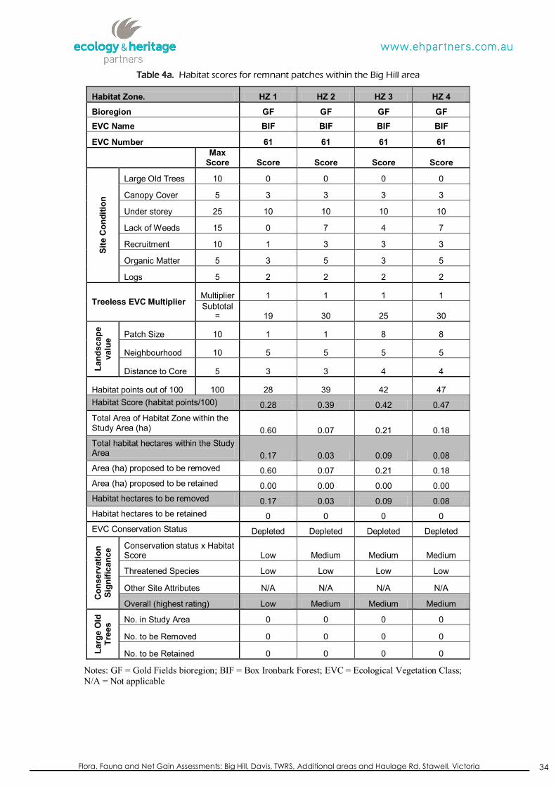
Flora, Fauna and Net Gain Assessments: Big Hill, Davis, TWRS, Additional areas and Haulage Rd, Stawell, Victoria
34
Table 4a. Habitat scores for remnant patches within the Big Hill area
Habitat Zone. HZ 1 HZ 2 HZ 3 HZ 4
Bioregion GF GF GF GF EVC Name BIF BIF BIF BIF
EVC Number 61 61 61 61
Max
Score Score Score Score Score
Site
Con
ditio
n
Large Old Trees 10 0 0 0 0
Canopy Cover 5 3 3 3 3
Under storey 25 10 10 10 10
Lack of Weeds 15 0 7 4 7
Recruitment 10 1 3 3 3
Organic Matter 5 3 5 3 5
Logs 5 2 2 2 2
Treeless EVC Multiplier Multiplier 1 1 1 1 Subtotal
= 19 30 25 30
Land
scap
e va
lue Patch Size 10 1 1 8 8
Neighbourhood 10 5 5 5 5
Distance to Core 5 3 3 4 4
Habitat points out of 100 100 28 39 42 47 Habitat Score (habitat points/100) 0.28 0.39 0.42 0.47 Total Area of Habitat Zone within the Study Area (ha) 0.60 0.07 0.21 0.18 Total habitat hectares within the Study Area 0.17 0.03 0.09 0.08 Area (ha) proposed to be removed 0.60 0.07 0.21 0.18 Area (ha) proposed to be retained 0.00 0.00 0.00 0.00 Habitat hectares to be removed 0.17 0.03 0.09 0.08 Habitat hectares to be retained 0 0 0 0 EVC Conservation Status Depleted Depleted Depleted Depleted
Con
serv
atio
n Si
gnifi
canc
e Conservation status x Habitat Score Low Medium Medium Medium
Threatened Species Low Low Low Low
Other Site Attributes N/A N/A N/A N/A
Overall (highest rating) Low Medium Medium Medium
Larg
e O
ld
Tree
s No. in Study Area 0 0 0 0
No. to be Removed 0 0 0 0
No. to be Retained 0 0 0 0
Notes: GF = Gold Fields bioregion; BIF = Box Ironbark Forest; EVC = Ecological Vegetation Class; N/A = Not applicable
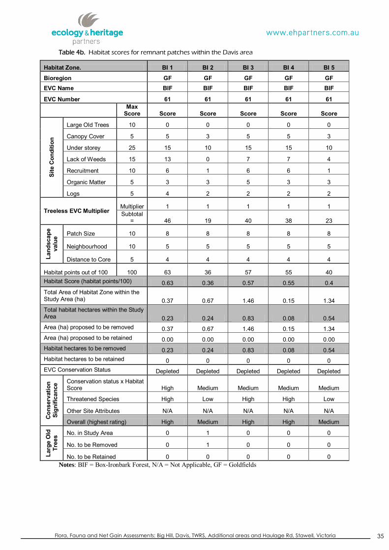
Flora, Fauna and Net Gain Assessments: Big Hill, Davis, TWRS, Additional areas and Haulage Rd, Stawell, Victoria
35
Table 4b. Habitat scores for remnant patches within the Davis area
Habitat Zone. BI 1 BI 2 BI 3 BI 4 BI 5
Bioregion GF GF GF GF GF EVC Name BIF BIF BIF BIF BIF
EVC Number 61 61 61 61 61
Max
Score Score Score Score Score Score
Site
Con
ditio
n
Large Old Trees 10 0 0 0 0 0
Canopy Cover 5 5 3 5 5 3
Under storey 25 15 10 15 15 10
Lack of Weeds 15 13 0 7 7 4
Recruitment 10 6 1 6 6 1
Organic Matter 5 3 3 5 3 3
Logs 5 4 2 2 2 2
Treeless EVC Multiplier Multiplier 1 1 1 1 1 Subtotal
= 46 19 40 38 23
Land
scap
e va
lue Patch Size 10 8 8 8 8 8
Neighbourhood 10 5 5 5 5 5
Distance to Core 5 4 4 4 4 4
Habitat points out of 100 100 63 36 57 55 40 Habitat Score (habitat points/100) 0.63 0.36 0.57 0.55 0.4 Total Area of Habitat Zone within the Study Area (ha) 0.37 0.67 1.46 0.15 1.34 Total habitat hectares within the Study Area 0.23 0.24 0.83 0.08 0.54 Area (ha) proposed to be removed 0.37 0.67 1.46 0.15 1.34 Area (ha) proposed to be retained 0.00 0.00 0.00 0.00 0.00 Habitat hectares to be removed 0.23 0.24 0.83 0.08 0.54 Habitat hectares to be retained 0 0 0 0 0 EVC Conservation Status Depleted Depleted Depleted Depleted Depleted
Con
serv
atio
n Si
gnifi
canc
e Conservation status x Habitat Score High Medium Medium Medium Medium
Threatened Species High Low High High Low
Other Site Attributes N/A N/A N/A N/A N/A
Overall (highest rating) High Medium High High Medium
Larg
e O
ld
Tree
s No. in Study Area 0 1 0 0 0
No. to be Removed 0 1 0 0 0
No. to be Retained 0 0 0 0 0 Notes: BIF = Box-Ironbark Forest, N/A = Not Applicable, GF = Goldfields

Flora, Fauna and Net Gain Assessments: Big Hill, Davis, TWRS, Additional areas and Haulage Rd, Stawell, Victoria
36
Table 4b continued. Habitat scores for remnant patches within the Davis area
Habitat Zone. BI 6 BI 7 BI 8 BI 9 BI 10
Bioregion GF GF GF GF GF EVC Name BIF BIF BIF BIF BIF
EVC Number 61 61 61 61 61
Max
Score Score Score Score Score Score
Site
Con
ditio
n
Large Old Trees 10 0 0 0 0 0
Canopy Cover 5 3 0 0 3 0
Under storey 25 5 5 5 5 15
Lack of Weeds 15 0 0 7 0 7
Recruitment 10 1 1 1 1 6
Organic Matter 5 3 3 3 2 5
Logs 5 0 0 0 0 2
Treeless EVC Multiplier Multiplier 1 1 1 1 1 Subtotal
= 12 9 16 11 35
Land
scap
e va
lue Patch Size 10 8 8 8 8 8
Neighbourhood 10 5 5 5 5 5
Distance to Core 5 4 4 4 4 4
Habitat points out of 100 100 29 26 33 28 52 Habitat Score (habitat points/100) 0.29 0.26 0.33 0.28 0.52 Total Area of Habitat Zone within the Study Area (ha) 0.56 0.31 0.62 0.47 0.01 Total habitat hectares within the Study Area 0.16 0.08 0.2 0.13 0.01 Area (ha) proposed to be removed 0.56 0.31 0.62 0.47 0.01 Area (ha) proposed to be retained 0.00 0.00 0.00 0.00 0.00 Habitat hectares to be removed 0.16 0.08 0.2 0.13 0.01 Habitat hectares to be retained 0 0 0 0 0 EVC Conservation Status Depleted Depleted Depleted Depleted Depleted
Con
serv
atio
n Si
gnifi
canc
e Conservation status x Habitat Score Low Low Medium Medium Medium
Threatened Species Low Low Low Low Low
Other Site Attributes N/A N/A N/A N/A N/A
Overall (highest rating) Low Low Medium Medium Medium
Larg
e O
ld
Tree
s No. in Study Area 1 0 0 1 0
No. to be Removed 1 0 0 1 0
No. to be Retained 0 0 0 0 0 Notes: BIF = Box-Ironbark Forest, N/A = Not Applicable, GF = Goldfields
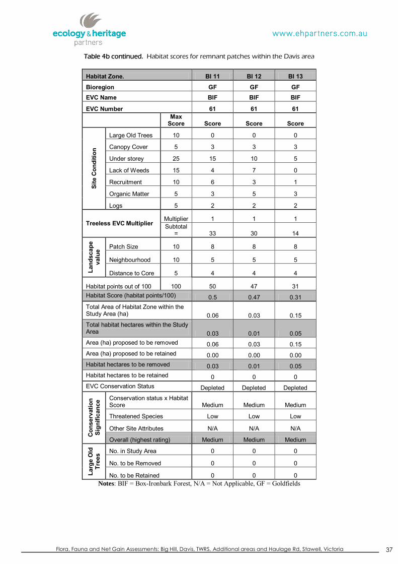
Flora, Fauna and Net Gain Assessments: Big Hill, Davis, TWRS, Additional areas and Haulage Rd, Stawell, Victoria
37
Table 4b continued. Habitat scores for remnant patches within the Davis area
Habitat Zone. BI 11 BI 12 BI 13
Bioregion GF GF GF EVC Name BIF BIF BIF
EVC Number 61 61 61
Max
Score Score Score Score
Site
Con
ditio
n
Large Old Trees 10 0 0 0
Canopy Cover 5 3 3 3
Under storey 25 15 10 5
Lack of Weeds 15 4 7 0
Recruitment 10 6 3 1
Organic Matter 5 3 5 3
Logs 5 2 2 2
Treeless EVC Multiplier Multiplier 1 1 1 Subtotal
= 33 30 14
Land
scap
e va
lue Patch Size 10 8 8 8
Neighbourhood 10 5 5 5
Distance to Core 5 4 4 4
Habitat points out of 100 100 50 47 31 Habitat Score (habitat points/100) 0.5 0.47 0.31 Total Area of Habitat Zone within the Study Area (ha) 0.06 0.03 0.15 Total habitat hectares within the Study Area 0.03 0.01 0.05 Area (ha) proposed to be removed 0.06 0.03 0.15 Area (ha) proposed to be retained 0.00 0.00 0.00 Habitat hectares to be removed 0.03 0.01 0.05 Habitat hectares to be retained 0 0 0 EVC Conservation Status Depleted Depleted Depleted
Con
serv
atio
n Si
gnifi
canc
e Conservation status x Habitat Score Medium Medium Medium
Threatened Species Low Low Low
Other Site Attributes N/A N/A N/A
Overall (highest rating) Medium Medium Medium
Larg
e O
ld
Tree
s No. in Study Area 0 0 0
No. to be Removed 0 0 0
No. to be Retained 0 0 0 Notes: BIF = Box-Ironbark Forest, N/A = Not Applicable, GF = Goldfields
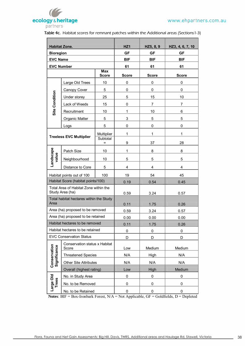
Flora, Fauna and Net Gain Assessments: Big Hill, Davis, TWRS, Additional areas and Haulage Rd, Stawell, Victoria
38
Table 4c. Habitat scores for remnant patches within the Additional areas (Sections1-3)
Habitat Zone. HZ1 HZ5, 8, 9 HZ3, 4, 6, 7, 10
Bioregion GF GF GF EVC Name BIF BIF BIF
EVC Number 61 61 61
Max
Score Score Score Score
Site
Con
ditio
n
Large Old Trees 10 0 0 0
Canopy Cover 5 0 0 0
Under storey 25 5 15 10
Lack of Weeds 15 0 7 7
Recruitment 10 1 10 6
Organic Matter 5 3 5 5
Logs 5 0 0 0
Treeless EVC Multiplier Multiplier 1 1 1 Subtotal
= 9 37 28
Land
scap
e va
lue Patch Size 10 1 8 8
Neighbourhood 10 5 5 5
Distance to Core 5 4 4 4
Habitat points out of 100 100 19 54 45 Habitat Score (habitat points/100) 0.19 0.54 0.45 Total Area of Habitat Zone within the Study Area (ha) 0.59 3.24 0.57 Total habitat hectares within the Study Area 0.11 1.75 0.26 Area (ha) proposed to be removed 0.59 3.24 0.57 Area (ha) proposed to be retained 0.00 0.00 0.00 Habitat hectares to be removed 0.11 1.75 0.26 Habitat hectares to be retained 0 0 0 EVC Conservation Status D D D
Con
serv
atio
n Si
gnifi
canc
e Conservation status x Habitat Score Low Medium Medium
Threatened Species N/A High N/A
Other Site Attributes N/A N/A N/A
Overall (highest rating) Low High Medium
Larg
e O
ld
Tree
s No. in Study Area 0 0 0
No. to be Removed 0 0 0
No. to be Retained 0 0 0 Notes: BIF = Box-Ironbark Forest, N/A = Not Applicable, GF = Goldfields, D = Depleted

Flora, Fauna and Net Gain Assessments: Big Hill, Davis, TWRS, Additional areas and Haulage Rd, Stawell, Victoria
39
Table 4d. Habitat scores for remnant patches within the Temporary Waste Rock Stockpile area
Habitat Zone. HZ2
Bioregion GF EVC Name BIF
EVC Number 61
Max
Score Score
Site
Con
ditio
n Large Old Trees 10 0
Canopy Cover 5 0
Under storey 25 5
Lack of Weeds 15 0
Recruitment 10 1
Organic Matter 5 0
Logs 5 0
Treeless EVC Multiplier Multiplier 1 Subtotal
= 6
Land
scap
e va
lue Patch Size 10 1
Neighbourhood 10 5
Distance to Core 5 4
Habitat points out of 100 100 16 Habitat Score (habitat points/100) 0.16 Total Area of Habitat Zone within the Study Area (ha) 1.10 Total habitat hectares within the Study Area 0.18 Area (ha) proposed to be removed 1.10 Area (ha) proposed to be retained 0.00 Habitat hectares to be removed 0.18 Habitat hectares to be retained 0 EVC Conservation Status D
Con
serv
atio
n Si
gnifi
canc
e Conservation status x Habitat Score Low
Threatened Species N/A
Other Site Attributes N/A
Overall (highest rating) Low
Larg
e O
ld
Tree
s No. in Study Area 0
No. to be Removed 0
No. to be Retained 0 Notes: BIF = Box-Ironbark Forest, N/A = Not Applicable, GF = Goldfields, D = Depleted

Flora, Fauna and Net Gain Assessments: Big Hill, Davis, TWRS, Additional areas and Haulage Rd, Stawell, Victoria
40
Table 4e. Habitat scores for remnant patches within the future Haulage Road alignment
Habitat Zone. HZ11, 12,
13, 14
Bioregion GF EVC Name BIF
EVC Number 61
Max
Score Score Si
te C
ondi
tion
Large Old Trees 10 0
Canopy Cover 5 0
Under storey 25 10
Lack of Weeds 15 7
Recruitment 10 6
Organic Matter 5 5
Logs 5 0
Treeless EVC Multiplier Multiplier 1 Subtotal
= 28
Land
scap
e va
lue Patch Size 10 8
Neighbourhood 10 5
Distance to Core 5 4
Habitat points out of 100 100 45 Habitat Score (habitat points/100) 0.45 Total Area of Habitat Zone within the Study Area (ha) 0.52 Total habitat hectares within the Study Area 0.23 Area (ha) proposed to be removed 0.52 Area (ha) proposed to be retained 0.00 Habitat hectares to be removed 0.23 Habitat hectares to be retained 0 EVC Conservation Status D
Con
serv
atio
n Si
gnifi
canc
e Conservation status x Habitat Score Medium
Threatened Species N/A
Other Site Attributes N/A
Overall (highest rating) Medium
Larg
e O
ld
Tree
s No. in Study Area 0
No. to be Removed 0
No. to be Retained 0 Notes: BIF = Box-Ironbark Forest, N/A = Not Applicable, GF = Goldfields, D = Depleted

Flora, Fauna and Net Gain Assessments: Big Hill, Davis, TWRS, Additional areas and Haulage Rd, Stawell, Victoria
41
5.3 Tree Assessment
5.3.1 Trees in habitat zones
Three Large Old Trees (LOTs) were recorded within Box-Ironbark habitat zones within the Davis section of the study area.
5.3.2 Scattered tree assessment
Scattered indigenous trees were classified as Very Large Old Trees (VLOTs), Large Old Trees (LOTs), Medium Old Trees (MOTs) or Small Trees according to the relevant EVC Benchmark (DSE 2013a; DSE 2007a). A total of five scattered indigenous trees were recorded within the Davis section of the study area. This total includes three LOTs and two STs (Figure 2b).
5.4 Summary of Habitat Hectare and Tree Assessment
The study area contains a total of 5.49 habitat hectares of remnant Box Ironbark Forest from the Goldfields bioregion. This total includes:
2.89 habitat hectares of High conservation significance Box-Ironbark Forest;
1.90 habitat hectares of Medium conservation significance Box-Ironbark Forest; and,
0.70 habitat hectares of Low conservation significance Box-Ironbark Forest.
Additionally, five „Scattered Trees‟ were also identified within the study area.
Habitat hectare (Hha) figures for each of the sections within the study area are also provided below.
Big Hill: 0.2 Hha of Medium conservation significance Box-Ironbark Forest and,
0.17 Hha of Low conservation significance Box-Ironbark Forest.
Davis: 1.14 Hha of High conservation significance Box Ironbark Forest,
1.21 Hha of Medium conservation significance Box Ironbark Forest and,
0.24 Hha ofLow conservation significance Box Ironbark Forest.
Plus 3 LOTs in patches and 5 scattered trees
Additional Areas (Sections 1-3):
1.75 Hha of High conservation significance Box Ironbark Forest,
0.26 Hha of Medium conservation significance Box Ironbark Forest and,
0.11 Hha Low conservation significance Box Ironbark Forest.

Flora, Fauna and Net Gain Assessments: Big Hill, Davis, TWRS, Additional areas and Haulage Rd, Stawell, Victoria
42
Haulage Road: 0.23 Hha of Medium conservation significance Box Ironbark Forest
TWRS: Revegetation area (HZ2): 0.18 Hha of Low conservation significance Box Ironbark Forest
5.5 Net Gain Implications
5.5.1 Avoidance (First step)
Avoidance may generally be interpreted as avoiding adverse vegetation impacts, such as the clearance of habitat zones and trees, and the vegetation being retained post construction (NRE 2002). Minimisation may generally be interpreted as reducing impacts on remnant vegetation (NRE 2002). Following detailed discussions and preliminary Net Gain investigations, the final pit shell design has refined the footprint of the operation to avoid and minimise some remnant native vegetation and scattered trees within the immediate vicinity of the study area, in accordance with the broad principals of the Framework. Avoidance and minimisation strategies include concentrating mining activities to areas that have already been cleared or are dominated by non-native species rather than in areas of high quality remnant vegetation.
5.5.2 Minimisation (Step two)
Minimisation may generally be interpreted as minimising impacts on scattered trees or habitat patches through appropriate consideration in planning processes and expert input to project design or management (NRE 2002).
In addition to the avoidance measures mentioned above, the proponent will also minimise impacts to remnant patches of vegetation and scattered indigenous trees through the implementation of the following actions:
Temporary fencing should be installed around retained areas of remnant vegetation to minimise disturbance (i.e. designated „no-go‟ areas) prior to construction;
Minimise the footprint of the mining activities so that vegetation is only removed when required.
Restricting construction activities to the actual area required for construction in areas of remnant vegetation;
Tree Retention Zones (TRZs) should be implemented to prevent indirect losses of native vegetation during construction activities (DSE 2010), and at a minimum standard of a TRZ should include:
a TRZ applies to a tree and is a specific area above and below the ground, with a radius 12 x the Diameter at Breast Height (DBH);
Flora, Fauna and Net Gain Assessments: Big Hill, Davis, TWRS, Additional areas and Haulage Rd, Stawell, Victoria
43
A TRZ of trees should be no less than 2 metres or greater than 15 metres;
Construction, construction related activities and encroachment (i.e. earthworks such as trenching that disturb the root zone) should be excluded from the TRZ;
Where encroachment exceeds 10% of the total area of the TRZ, the tree should be considered as lost and offset accordingly;
Subject to qualified arborist confirming that it is appropriate for the specific works, directional drilling may be used for works within the TRZ without being considered encroachment. The directional bore should be at least 600 millimetres deep. An arborist should also confirm that the radius of the bore will not significantly damage the tree causing it to be lost in the future; and,
Where the minimum standard for a TRZ has not been met an offset may be required (DSE 2010).
5.5.3 Offset Requirements
Once steps 1 and 2 have been considered and agreed upon by DSE and the Northern Grampians Shire Council, then offsets or Net Gain targets can be calculated for any permitted vegetation clearance.
„The Framework‟ sets out responses, including like for like criteria and Net Gain ratios, to proposals to clear and offset native vegetation, based on the conservation significance of the vegetation, which is determined by the habitat score and bioregional conservation status (NRE 2002). The Net Gain ratios from this table have been utilised to calculate the required offsets or Net Gain targets.
Habitat hectares
To meet the objectives of the Net Gain policy, offset criteria must be met, and at least:
1.5 times the habitat hectare loss for High conservation significance sites is required; and
1 times the habitat hectare loss for Medium and Low conservation significance sites is required.
The losses of quality and extent of native vegetation within each section of the study area are calculated below (Table 5a-e). Losses have been calculated based upon the final pit shell design for the mine extension area dated 03/01/2012 (David Coe, Environment and Community Advisor – Stawell Gold Mines).
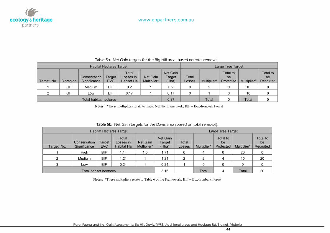
Flora, Fauna and Net Gain Assessments: Big Hill, Davis, TWRS, Additional areas and Haulage Rd, Stawell, Victoria
44
Table 5a. Net Gain targets for the Big Hill area (based on total removal).
Habitat Hectares Target Large Tree Target
Target No. Bioregion Conservation Significance
Target EVC
Total Losses in Habitat Ha
Net Gain Multiplier*
Net Gain Target (Hha)
Total Losses Multiplier*
Total to be
Protected Multiplier*
Total to be
Recruited
1 GF Medium BIF 0.2 1 0.2 0 2 0 10 0
2 GF Low BIF 0.17 1 0.17 0 1 0 10 0
Total habitat hectares 0.37 Total 0 Total 0
Notes: *These multipliers relate to Table 6 of the Framework; BIF = Box-Ironbark Forest
Table 5b. Net Gain targets for the Davis area (based on total removal).
Habitat Hectares Target Large Tree Target
Target No. Conservation Significance
Target EVC
Total Losses in Habitat Ha
Net Gain Multiplier*
Net Gain Target (Hha)
Total Losses Multiplier*
Total to be
Protected Multiplier*
Total to be
Recruited
1 High BIF 1.14 1.5 1.71 0 4 0 20 0
2 Medium BIF 1.21 1 1.21 2 2 4 10 20
3 Low BIF 0.24 1 0.24 1 0 0 0 0
Total habitat hectares 3.16 Total 4 Total 20
Notes: *These multipliers relate to Table 6 of the Framework; BIF = Box-Ironbark Forest

Flora, Fauna and Net Gain Assessments: Big Hill, Davis, TWRS, Additional areas and Haulage Rd, Stawell, Victoria
45
Table 5c. Net Gain targets for the Additional areas – Sections 1-3 (based on total removal).
Habitat Hectares Target Large Tree Target
Target No. Bioregion
Conservation Significance
Target EVC
Total Losses in Habitat Ha
Net Gain Multiplier*
Net Gain Target (Hha)
Total Losses Multiplier*
Total to be
Protected Multiplier*
Total to be
Recruited
1 GF High BIF 1.75 1.5 2.63 0 4 0 20 0
2 GF Medium BIF 0.26 1 0.26 0 2 0 10 0
3 GF Low BIF 0.11 1 0.11 0 1 0 10 0
Total habitat hectares 3.00 Total 0 Total 0
Notes: *These multipliers relate to Table 6 of the Framework; BIF = Box-Ironbark Forest
Table 5d. Net Gain targets for the Temporary Waste Rock Stockpile area (based on total removal).
Habitat Hectares Target Large Tree Target
Target No. Bioregion Conservation Significance
Target EVC
Total Losses in Habitat Ha
Net Gain Multiplier*
Net Gain Target (Hha)
Total Losses Multiplier*
Total to be
Protected Multiplier*
Total to be
Recruited
1 GF Low BIF 0.18 1 0.18 0 1 0 10 0
Total habitat hectares 0.18 Total 0 Total 0
Notes: *These multipliers relate to Table 6 of the Framework; BIF = Box-Ironbark Forest
Table 5e. Net Gain targets for the study area (based on total removal).
Habitat Hectares Target Large Tree Target
Target No. Bioregion Conservation Significance
Target EVC
Total Losses in Habitat Ha
Net Gain Multiplier*
Net Gain Target (Hha)
Total Losses Multiplier*
Total to be
Protected Multiplier*
Total to be
Recruited
1 GF Medium BIF 0.23 1 0.23 0 2 0 10 0
Total habitat hectares 0.23 Total 0 Total 0
Notes: *These multipliers relate to Table 6 of the Framework; BIF = Box-Ironbark Forest
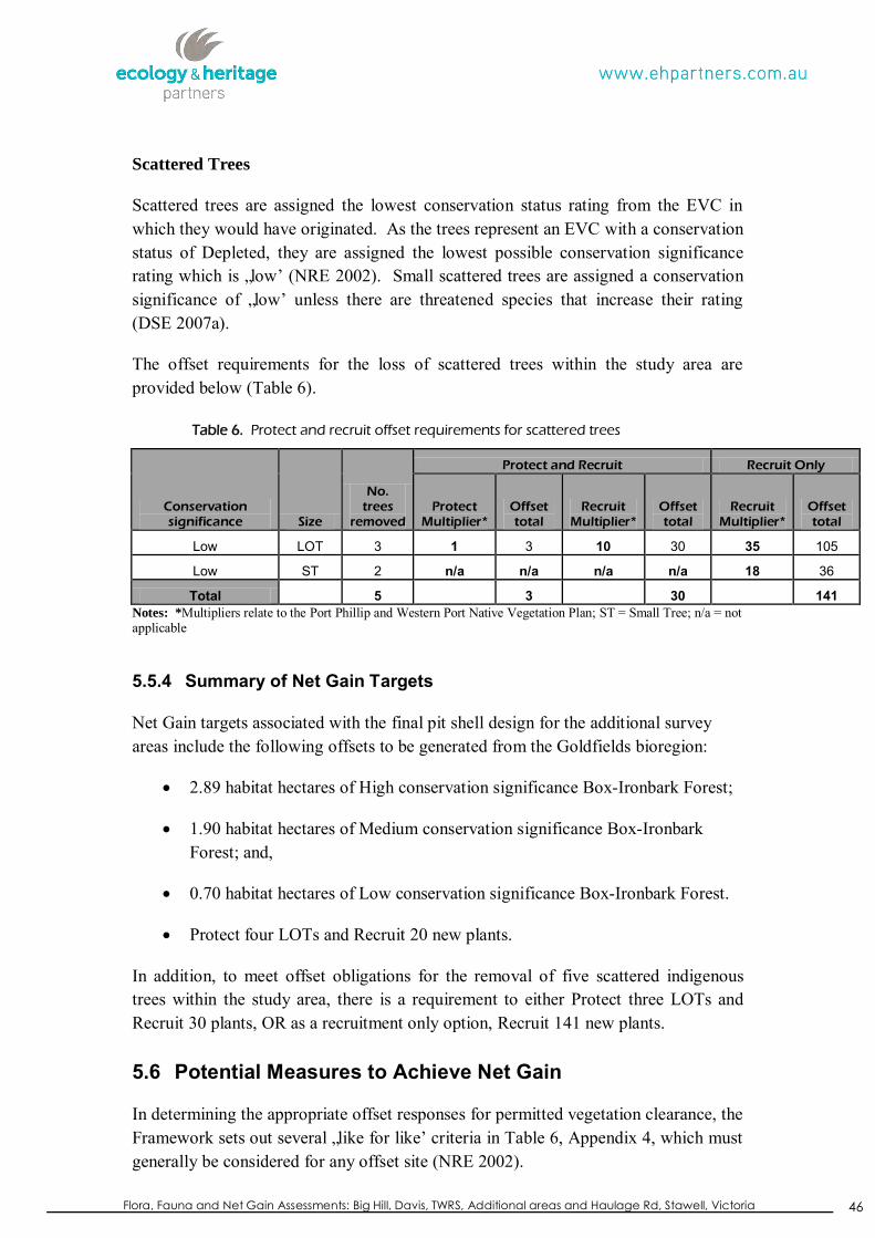
Flora, Fauna and Net Gain Assessments: Big Hill, Davis, TWRS, Additional areas and Haulage Rd, Stawell, Victoria
46
Scattered Trees
Scattered trees are assigned the lowest conservation status rating from the EVC in which they would have originated. As the trees represent an EVC with a conservation status of Depleted, they are assigned the lowest possible conservation significance rating which is „low‟ (NRE 2002). Small scattered trees are assigned a conservation significance of „low‟ unless there are threatened species that increase their rating (DSE 2007a).
The offset requirements for the loss of scattered trees within the study area are provided below (Table 6).
Table 6. Protect and recruit offset requirements for scattered trees
Conservation significance Size
No. trees
removed
Protect and Recruit Recruit Only
Protect Multiplier*
Offset total
Recruit Multiplier*
Offset total
Recruit Multiplier*
Offset total
Low LOT 3 1 3 10 30 35 105
Low ST 2 n/a n/a n/a n/a 18 36
Total 5 3 30 141 Notes: *Multipliers relate to the Port Phillip and Western Port Native Vegetation Plan; ST = Small Tree; n/a = not applicable
5.5.4 Summary of Net Gain Targets
Net Gain targets associated with the final pit shell design for the additional survey areas include the following offsets to be generated from the Goldfields bioregion:
2.89 habitat hectares of High conservation significance Box-Ironbark Forest;
1.90 habitat hectares of Medium conservation significance Box-Ironbark Forest; and,
0.70 habitat hectares of Low conservation significance Box-Ironbark Forest.
Protect four LOTs and Recruit 20 new plants.
In addition, to meet offset obligations for the removal of five scattered indigenous trees within the study area, there is a requirement to either Protect three LOTs and Recruit 30 plants, OR as a recruitment only option, Recruit 141 new plants.
5.6 Potential Measures to Achieve Net Gain
In determining the appropriate offset responses for permitted vegetation clearance, the Framework sets out several „like for like‟ criteria in Table 6, Appendix 4, which must generally be considered for any offset site (NRE 2002).

Flora, Fauna and Net Gain Assessments: Big Hill, Davis, TWRS, Additional areas and Haulage Rd, Stawell, Victoria
47
In order to locate an offset site for vegetation of „high‟ conservation significance, there is a requirement that the offset be:
The same vegetation/habitat type OR a Very High significance vegetation/habitat in the same bioregion;
Similar or more effective ecological function OR land protection function as impacted by the loss; and,
At least 75% of the quality of the vegetation being lost.
In order to locate an offset site for vegetation of „medium‟ conservation significance, there is a requirement that the offset be:
The same vegetation/habitat type OR a Very High significance vegetation/habitat in the same bioregion;
Similar or more effective ecological function OR land protection function as impacted by the loss; and,
At least 50% of the quality of the vegetation being lost.
In order to locate an offset site for vegetation of „low‟ conservation significance, there is a requirement that the offset be:
Any EVC in the Bioregion or a Very High or High conservation significance vegetation/habitat in an adjacent Bioregion; and,
Similar or more effective land protection function as impacted by the loss; and,
There are no minimum quality benchmarks when offsetting „low‟ conservation significance vegetation, with up to 100% of the offset (in habitat hectares) made up of revegetation works.
5.7 Potential Net Gain Strategies
Old tree offsets (of the appropriate size class) may consist of the protection of isolated trees in cleared areas and/or remnants, or revegetation works. DSE (2007a, p. 55) defines protection of a tree as „an area with twice the canopy diameter fenced and protected from adverse impacts: grazing, burning and soil disturbance not permitted, fallen timber retained, weeds controlled and intervention/management if necessary to ensure adequate natural regeneration or planting can occur‟. If any retained trees within the study area are treated as protected, they could be used to meet part of the Net Gain target.
Habitat hectare offsets may be in the form of (1) enhanced management of existing vegetation, and/or (2) revegetation (or natural recruitment). Generally it is more sensible to manage remnant vegetation as greater gains can be achieved, in both
Flora, Fauna and Net Gain Assessments: Big Hill, Davis, TWRS, Additional areas and Haulage Rd, Stawell, Victoria
48
ecological and economic terms (i.e. it costs less and greater ecological gains can be achieved). However, it should be noted that management requires a high level of skills, knowledge and resourcing for at least a 10-year period and the remnants are protected in perpetuity.
Temporary Loss of Native Vegetation
The loss of vegetation may be determined by DPI to be a „temporary loss‟ whereby the original or similar landform is reinstated via appropriate revegetation as per DSE‟s standards (DSE 2006). On a site where the loss of vegetation is deemed temporary (e.g. mining followed by rehabilitation), the revegetation within the reinstated area will be counted towards the Net Gain requirements for the offsets with a „Low‟ Conservation Significance applied (NRE 2002). As such, there is no cap on the proportion of revegetation which is included in the offset; however this only applies to areas which are reinstated following vegetation removal. Additionally, temporary loss provisions do not apply to Large or Medium Old Trees and as such are required to be offset as per Appendix 4, Table 6 of the Framework (NRE 2002) and the relevant Regional Native Vegetation Plans. It is currently unknown if any temporary losses are applicable to the project.
5.7.1 Enhanced Management of Remnant Vegetation
Gain scoring through management of existing remnant vegetation operates by allocating a certain score based on the vegetation management actions that maintain vegetation quality, or at a higher level, improve vegetation quality, and from increasing the security arrangement, and from recognition of past management. The guidelines and methodology for gain scoring are presented in DSE (2006) and can be used to determine the „gain‟ from activities such as, vegetation protection, maintenance and improvement activities, and increased security.
In order to calculate the potential gain available from managing native vegetation, estimates are made, which assist in determining the potential increase in habitat score of the vegetation being managed (i.e. the „gain‟ in habitat score). For example, the cover of weeds can be reduced and the understorey diversity increased, which could both contribute to a potential increase in habitat score. Generally an area of approximately 1 hectare of native vegetation is required to be ecologically managed to offset a loss of between 0.1 to 0.2 habitat hectares. Therefore in order to offset a loss of 1 habitat hectare, between 5 and 10 hectares would require ecological management.
Management commitments/arrangements to achieve Net Gain at any offset site can be broken up into two main strategies; 1) maintenance and 2) improvement. Some of these techniques include:
Security
Register the offsets with an on-title agreement.
Flora, Fauna and Net Gain Assessments: Big Hill, Davis, TWRS, Additional areas and Haulage Rd, Stawell, Victoria
49
Maintenance
Retention of all remnant trees (both living and/or dead specimens).
Removal of woody and herbaceous weeds.
Foregoing allowed uses such as grazing and slashing activities.
Exclude the removal of organic litter and logs.
Improvement
Control/eradication of environmental or noxious weeds including those that are a threat to existing remnant vegetation.
Fencing to restrict public/grazing access into areas of ecological value.
Control of introduced animals such as foxes, rabbits and feral cats.
Revegetation and/or supplement planting of locally indigenous tree, shrub and understorey species in appropriate areas (need to consider ecological function).
5.7.2 Revegetation
Where the management of vegetation is not practical, revegetation undertaken to a certain standard can also offset some habitat hectare losses (see below for amount). Recently published “Revegetation Planting Standards” (DSE 2006) outline the minimum standards for revegetation to qualify as a native vegetation gain.
These standards include a requirement to plant suitable local indigenous species that are appropriate to the bioregional EVC benchmark for the site. It also requires land managers to meet minimum site protection (i.e. fencing standards to exclude stock/humans), site preparation and plant stock standards, as well as agree to establish the plants according to a defined planting design and schedule; including follow up weed control (DSE 2006). It is recommended that a variety of life forms are used (i.e. groundcovers, shrubs, trees) with consideration of site conditions and use (DSE 2006). Target tree numbers are typically between 500 and 2,500 plants per hectare depending on the EVC (DSE 2006). Any offset through revegetation also requires management skills and long-term resourcing (at least a 10-year period).
For areas of very high, high, medium and low conservation significance, the proportion of revegetation included in the offset (in habitat hectares) is limited to 10%, 25%, 50% and 100% respectively. As a basic rule, revegetation of terrestrial vegetation to a minimum standard can attract seven habitat points per hectare for site condition improvement and five points per hectare for landscape context improvement. This is a total of 12 habitat score points for every hectare of revegetation committed to by the proponent and undertaken in a specified manner (i.e. 0.12 habitat hectares for every hectare of revegetation).

Flora, Fauna and Net Gain Assessments: Big Hill, Davis, TWRS, Additional areas and Haulage Rd, Stawell, Victoria
50
5.8 Finding an Appropriate Offset Site
Vegetation offsets must be achieved in accordance with a Vegetation Offset Management Plan over the stipulated 10-year offset period (and beyond). Several Net Gain offset strategies exist, including considering protecting indigenous vegetation (i.e. onsite-offset), undertaking appropriate revegetation works within the study area, and/or locating a third-party off-site offset (i.e. via the BushBroker register). It should be noted, that Net Gain offset targets may also be reduced by avoiding areas of remnant vegetation within the study area through appropriate redesign/planning.
Additional options to achieve Net Gain offsets include:
Acquiring and managing land elsewhere;
DSE‟s „BushBroker‟ program;
Negotiating a financial contribution towards an existing council-managed reserve; or,
Working with „Trust for Nature‟, a not-for-profit organisation, to identify and secure an offset.
Any proposed options to achieve Net Gain should be negotiated between Council and DSE. For any offset measures (for habitat hectares) an audit process and management plan are required in order to ensure that the Net Gain outcomes are achieved, and that the gains are on-going and of a secure nature (i.e. Section 173 agreements, Public Authority Management Agreement, vegetation covenants etc. negotiated between Council and relevant parties).

Flora, Fauna and Net Gain Assessments: Big Hill, Davis, TWRS, Additional areas and Haulage Rd, Stawell, Victoria
51
6 POTENTIAL IMPACTS
Any loss of ecological values should be viewed in the overall context of on-going loss, fragmentation, and deterioration in the quality of remnant vegetation throughout the greater Goldfields bioregion. The proposed development is likely to have a localised impact on indigenous flora and fauna species habitats.
Direct impacts of the proposed development are likely to include:
Removal and/or disturbance to areas of Box-Ironbark Forest;
Loss of scattered indigenous trees associated with the Box-Ironbark EVC;
Loss of habitat for one state significant fauna species (Brown Treecreeper) and one regionally significant fauna species (Bearded Dragon);
Decreases in population sizes of local flora and fauna species due to loss of habitat;
Loss of suitable foraging, dispersal and sheltering habitat for a range of native fauna species; and,
Increase habitat fragmentation through loss of remnant native vegetation, i.e. reduction in potential habitat corridors.
Indirect effects on adjacent areas are also possible if construction activities and drainage are not appropriately managed, and these include:
Potential for further spread of environmental weeds from on-site activities and subsequent degradation of native vegetation adjacent to the site; and,
Indirect impacts to adjoining native vegetation/habitat (e.g. potential short-term disturbance to fauna during construction activities and from increased human activity).

Flora, Fauna and Net Gain Assessments: Big Hill, Davis, TWRS, Additional areas and Haulage Rd, Stawell, Victoria
52
7 MITIGATION MEASURES AND RECOMMENDATIONS
The following measures should be undertaken to mitigate/ameliorate impacts to significant flora and fauna species and ecological communities associated with the proposed development:
The proposed development footprint should clearly demonstrate the first two principles of three-step approach of „the Framework‟. That is, to „avoid‟ and „minimise‟ impacts to remnant native vegetation, which reduces the requirement for vegetation removal;
Following the first two steps of „the Framework‟, mining activities should be concentrated in areas that have already been cleared or are of poorer quality than those areas of higher quality;
Targeted flora surveys should be undertaken in higher quality remnants if they are proposed to be disturbed;
Develop a Native Vegetation Offset Management Plan to ensure that the proposed any remnant vegetation removed adheres to the three step approach outlined in „the Framework‟;
Install temporary fencing to protect adjacent areas of native vegetation and to identify them as “no go” areas (i.e. use of signage to highlight the significance of areas immediately opposite the study area);
Inform contractors of the importance of remnant native vegetation that has been identified for retention;
Consideration should be taken to relocate habitat which is to be removed such as hollow logs and other large, dead or fallen debris for rehabilitation purposes;
Instead of felling, trees can be trimmed to provide access for vehicles or machinery;
If possible, trees approved for felling can be cut at a height approximately equal to the diameter of the tree to facilitate coppicing instead of uprooting (DPI 2008);
Use indigenous plants associated with the relevant Ecological Vegetation Class (Box-Ironbark) as part of any landscaping works to increase habitat for native fauna;
Any construction stockpiles or spoil should be placed away from areas of remnant vegetation, drainage lines and water bodies;
Monitoring or flora and fauna populations, especially significant species over a sufficient duration and during appropriate times of the year, both prior to and after mining; and,
Provision of bird and bat nest boxes in suitable areas.
Flora, Fauna and Net Gain Assessments: Big Hill, Davis, TWRS, Additional areas and Haulage Rd, Stawell, Victoria
53
REFERENCES AVW 2011. Atlas of Victorian Wildlife. Viridans Biological Databases maintained by
the Department of Sustainability and Environment, Victoria.
Biosis Research Pty Ltd 1999. Flora and Fauna Assessment at the Stawell Gold Mines – Big Hill Development Project, Stawell, Victoria. Unpublished report prepared for Resource Strategies Pty Ltd.
Christidis, L. & Boles, W.E 2008. Systematics and Taxonomy of Australian Birds. CSIRO Publishing, Collingwood, Victoria.
Cogger, H.G., Cameron, E.E., Sadlier, R.A. and Eggler, P 1993. The Action Plan for Australian Reptiles. Australian Nature conservation Agency, Canberra, ACT.
DEC 2005. Threatened species, population and ecological communities of NSW: Brown Treecreeper. Available at URL: http://www.threatenedspecies.environment.nsw.gov.au/tsprofile/profile.aspx?id=10171. Accessed 15 Feb 2012. Department of Environment and Conservation
DPCD 2013. www.dpcd.vic.gov.au. Department of Planning and Community Development, Victoria.
DPI 2008. Code of practice for mineral exploration – Standards, procedures and practical guidance under the Mineral Resources (Sustainable Development) Act 1990. Department of Primary Industries, Victoria.
DPI 2009. Native Vegetation management guide for the earth resources industries.
Department of Primary Industries, Victoria. DPI 2010. Extractive Industry Work Plan Guideline. Department of Primary
Industries, Victoria.
DSE 2004. Vegetation quality assessment manual: Guidelines for applying the habitat hectares scoring method. Biodiversity and Natural Resources Division, Department of Sustainability & Environment, Victoria.
DSE 2005a. Advisory List of Rare or Threatened Plants in Victoria - 2005. Department of Sustainability and Environment, East Melbourne, Victoria.
DSE 2005b. Information pamphlet: Biosites Update – Port Philip region. Department of Sustainability & Environment, Victoria, East Melbourne, Victoria.
DSE 2007a. Native Vegetation. Guide for assessment of referred planning permit applications, October 2006. Department of Sustainability and Environment, Victoria, East Melbourne, Victoria.
DSE 2007b. Advisory List of Threatened Vertebrate Fauna in Victoria. Department of Sustainability and Environment, Victoria.

Flora, Fauna and Net Gain Assessments: Big Hill, Davis, TWRS, Additional areas and Haulage Rd, Stawell, Victoria
54
DSE 2009. Advisory list of Threatened Invertebrate Fauna in Victoria – 2009. Department of Sustainability and Environment, Victoria.
DSE 2010. Native Vegetation – Technical Information Sheet August 2010. Department of Sustainability and Environment, Victoria.
DSE 2013a. EVC Benchmarks and descriptions. www.dse.vic.gov.au, Department of Sustainability and Environment, Victoria.
DSE 2013b. Interactive maps. www.dse.vic.gov.au, Department of Sustainability and Environment, Victoria.
Duncan, A., Baker, G.B. & Montgomery, N. 1999. The Action Plan for Australian Bats. Environment Australia, Canberra.
ECC 2001. Box-Ironbark Forests and Woodlands Investigation. Published report by the Environment Conservation Council.
Ecology and Heritage Partners Pty Ltd 2012a. Flora, Fauna and Net Gain Assessment at the Big Hill site for the proposed extension of the Stawell Gold Mine, Stawell, Victoria. Unpublished report on behalf of Stawell Gold Mines.
Ecology and Heritage Partners Pty Ltd 2012b. Flora, Fauna and Net Gain Assessment at the Davis site for the proposed extension of the Stawell Gold Mine, Stawell, Victoria. Unpublished report on behalf of Stawell Gold Mines.
FIS 2011. Flora Information System (Department of Sustainability and Environment), Viridans Pty Ltd. Bentleigh East, Victoria.
Garnett, S. & Crowley, G. 2000. The Action Plan for Australian Birds. Environment Australia, Canberra.
Higgins, P. J., Peter, J. M. and Steele, W. K. (Eds.) 2001. The Handbook of Australian, New Zealand and Antarctic Birds. Volume 5: Tyrant-flycatchers to Chats. Oxford University Press, Melbourne.
IUCN 2006. IUCN Red List of Threatened Animals. International Union for the Conservation of Nature & Natural Resources, Geneva.
Lee, A. K. 1995. Action Plan for Australian Rodents. Australian Nature Conservation Agency, Canberra.
Maxwell, S., Burbidge, A A. And Morris, K (Eds) 1996. The 1996 Action Plan for Australian Marsupials and Monotremes. Wildlife Australia for Australasian Marsupial and Monotreme Specialist Group and the IUCN Species Survival commission, Switzerland.
NRE 2002. Victoria's Native Vegetation Management: A Framework for Action. Department of Natural Resources & Environment, Victoria.
Oates & Taranto 2001. Vegetation Mapping of the Port Phillip and Westernport Region. Department of Sustainability & Environment, Victoria.

Flora, Fauna and Net Gain Assessments: Big Hill, Davis, TWRS, Additional areas and Haulage Rd, Stawell, Victoria
55
PPWCMA 2006. Port Phillip and Westernport Native Vegetation Plan. Port Phillip Catchment Management Authority.
Sands, D.P.A. and New, T.R. 2002. The Action Plan for Australian Butterflies, Environment Australia, Canberra.
SEWPaC 2012. Environment Protection and Biodiversity Conservation Act 1999. Protected Matters Search Tool (PMST). Accessed at URL: http://www.environment.gov.au/erin/ert/epbc/index.html. The Department of Sustainability, Environment, Water, Population and Communities, Canberra. Accessed 24 Jan 2012. Department of Environment and Conservation
Tyler, M.J. 1997. The Action Plan for Australian Frogs. Environment Australia, Canberra.
VBA. 2011. Data source: „VBA_FAUNA25‟ and „VBA_FLORA25‟,, August 2010. © The State of Victoria, Department of Sustainability and Environment.
Viridians 2012. http://www.viridans.com/RAREPL/mistletoe.htm. Viridians Biological Databases.
Walsh, N.G. and Entwisle T.J. (1999) (eds) Flora of Victoria Volume 4 Dicotyledons Cornaceae to Asteraceae, National Herbarium of Victoria. Inkata Press, Melbourne.
Walsh, N.G. & Stajsic, V. 2007. A Census of the Vascular Plants of Victoria 8th Edition. Royal Botanic Gardens, Melbourne.
WCMA 2008. Draft Wimmera Native Vegetation Plan. Wimmera Catchment Management Authority.