floodplain survey guide - montana...
TRANSCRIPT

FLOODPLAIN SURVEY GUIDERoger Austin PLS CFM

Biography
ROGER AUSTIN PLS/CFMPROFESSIONAL CONSULTANTS INC.3115 RUSSELL ST3115 RUSSELL ST.MISSOULA MT. 59804406‐721‐3632
Roger is a Licensed Surveyor in the states of Montana, Washington, North Dakota and California and is registered by ASFPM as a Certified Floodplain Manager. He has 35 years experience as a surveyor working with civil engineers, land surveyors, hydrologists, and general contractors. His range of experience includes data acquisition for flood studies, riparian characteristic analysis, Letters of Map Changes and as part of the FEMA Map Mod DFIRM team. He also has been doing boundary survey, GLO public domainpart of the FEMA Map Mod DFIRM team. He also has been doing boundary survey, GLO public domain breakdown, certificate of surveys, subdivisions and related utility plans. Field experience has included field supervisor/crew coordination, boundary surveys, construction stakeout, hydrographic, geodetic, environmental and topographic surveys. Roger has provided data acquisition and mapping for numerous wetland delineation, mitigation, floodplain and enhancement projects.

Data Acquisition for Hydraulic d lModeling
• Research available data. Utilize aerial photos for accessibility and stream sinuosity.
• Map in a published coordinate system. Use NGS monuments if available. At least two OPUS solutions if not.
• Determine where cross sections are needed. Use “Guidelines for Watercourse Surveys” and consult with hydrologist/engineer. y g / g
• Determine equipment to be used. I.E.: Total Station, Boats, GPS, bathometry equipment, sounding lines, safety gear, anchor ropes, camera.
• Don’t under staff the crew. On swift river boat cross sections use a minimum of 4 crew members.E t d ti ll b ti i t d BFE• Extend your cross sections well above anticipated BFE.
• Take pictures of both banks, upstream & downstream for modeler to determine bank roughness.
• Locate high water features. Debris in bushes, sand deposition on point bars etc.• Tie in stream gauges and replicate gauging cross section if possible This helps the modeler• Tie in stream gauges and replicate gauging cross section if possible. This helps the modeler
calibrate the model.

SWAN LAKE CROSS SECTIONSSWAN LAKE CROSS SECTIONS
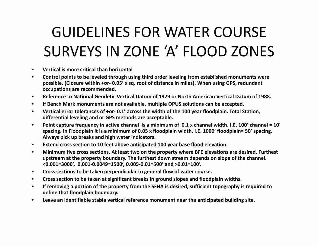
GUIDELINES FOR WATER COURSE ‘ ’SURVEYS IN ZONE ‘A’ FLOOD ZONES
• Vertical is more critical than horizontal• Control points to be leveled through using third order leveling from established monuments were• Control points to be leveled through using third order leveling from established monuments were
possible. (Closure within +or‐ 0.05’ x sq. root of distance in miles). When using GPS, redundant occupations are recommended.
• Reference to National Geodetic Vertical Datum of 1929 or North American Vertical Datum of 1988.• If Bench Mark monuments are not available, multiple OPUS solutions can be accepted.• Vertical error tolerances of +or‐ 0.1’ across the width of the 100 year floodplain. Total Station,
differential leveling and or GPS methods are acceptable. • Point capture frequency in active channel is a minimum of 0.1 x channel width. I.E. 100’ channel = 10’
spacing. In Floodplain it is a minimum of 0.05 x floodplain width. I.E. 1000’ floodplain= 50’ spacing. Always pick up breaks and high water indicators.Always pick up breaks and high water indicators.
• Extend cross section to 10 feet above anticipated 100 year base flood elevation.• Minimum five cross sections. At least two on the property where BFE elevations are desired. Furthest
upstream at the property boundary. The furthest down stream depends on slope of the channel. <0.001=3000’, 0.001‐0.0049=1500’, 0.005‐0.01=500’ and >0.01=100’.
i b k di l l fl f• Cross sections to be taken perpendicular to general flow of water course. • Cross section to be taken at significant breaks in ground slopes and floodplain widths. • If removing a portion of the property from the SFHA is desired, sufficient topography is required to
define that floodplain boundary.• Leave an identifiable stable vertical reference monument near the anticipated building siteLeave an identifiable stable vertical reference monument near the anticipated building site.

RESEACH SOURCES FOR EXISTING DATARESEACH SOURCES FOR EXISTING DATA
• NGS WEGSITE FOR BENCH MARKS: http://www.ngs.noaa.gov/cgi‐bin/datasheet.prl
• FIRMs: http://maps2.nris.mt.gov/mapper/MapWindow.asp?Profile=1629007&Cmd=Build+Reports
• TOPO QUADS: http://maps2.nris.mt.gov/scripts/esrimap.dll?name=LocMap&Cmd=Map
• AERIAL IMAGES: http://nris state mt us/nsdi/orthophotos/naip 2009 aspAERIAL IMAGES: http://nris.state.mt.us/nsdi/orthophotos/naip_2009.asp
• USGS WATER RESOURCES: http://water.usgs.gov/
• GUIDELINES FOR WATERCOURSE SURVEYS: http://dnrc mt gov/wrd/water op/floodplain/pdfs/guidlines wcsurveys pdfhttp://dnrc.mt.gov/wrd/water_op/floodplain/pdfs/guidlines_wcsurveys.pdf
• US ARMY CORPS OF ENGINEERS COORDINATE CONVERSION SITE: http://www.agc.army.mil/corpscon/index.html
• Montana Flood‐Frequency and Basin‐Characteristic Data:Montana Flood Frequency and Basin Characteristic Data: http://mt.water.usgs.gov/freq?site=12381400
• Guidelines and Specifications for Flood Hazard Mapping http://www.fema.gov/library/viewRecord.do?id=2206

USCGS MONUMENTS BASE YOUR SURVEY DATA ON A PUBLISHED VERTICAL AND HORIZONTAL DATUM. USE THE DATUM THAT THE EFFECTIVE STUDY IS ON


PHOTOS OF THE CROSS SECTION AREALOOKING AT EITHER SIDE OF CHANNEL

EXAMPLE STRUCTURE SURVEY