flood and landslide applications of near real-tim
TRANSCRIPT
Source of Acquisition NASA Goddard Space Hrght Center
Flood and Landslide Applications of Near Real-tim Satellite Rainfall Products
Uang Hong (1,2), Robert F. Adler ( 2 ) , Andrw Negri ( 2 ) , George J. Huffman (2, 3)
1 Coddard Earth and Science Technology CenterIUMBC *NASA Goddard Space Flight Center, Laboratory for Atmospheres
4 Science Systems and Applications, Inc
Prepared for Journal of Natural Hazards Special Issues: Use of Satellite Remote Sensing for Natural Hazards Analysis
Popular Summary:
Floods and associated landslides are one of the most widespread natural hazards on Earth, responsible for tens of thousands of deaths and billions of dollars in property damage every year. During 1993-2002, over 1000 of the more than 2,900 natural disasters reported were due to floods. These floods and associated landslides claimed over 90,000 lives, affected over 1.4 billion people and cost about $210 billion. The impact of these disasters is often felt most acutely in less developed regions. In many countries around the world, satellite-based precipitation estimation may be the best source of rainfall data due to lack of surface observing networks.
Satellite observations can be of essential value in improving our understanding of the occurrence of hazardous events and possibly in lessening their impact on local economies and in reducing injuries, if they can be used to create reliable warning systems in cost-effective ways. This article addressed these opportunities and challenges by describing a combination of satellite-based real-time precipitation estimation with land surface characteristics as input, with empirical and numerical models to map potential of landslides and floods. In this article, a framework to detect floods and landslides related to heavy rain events in near-real-time is proposed. Key components of the framework are: a fine resolution precipitation acquisition system; a comprehensive land surface database; a hydrological modeling component; and landslide and debris flow model components. A key precipitation input dataset for the integrated applications is the NASA TRMM-based multi-satellite precipitation estimates. This dataset provides near real-time precipitation at a spatial-temporal resolution of 3 hours and 0.25' x 0.25'.
By careful integration of remote sensing and in-situ observations, and assimilation of these observations into hydrological and landslideldebris flow models with surface topographic information, prediction of useful probabilistic maps of landslide and floods for emergency management in a timely manner is possible. Early results shows that the potential exists for successful application of satellite precipitation data in improving/developing global monitoring systems for floodllandslide disaster preparedness and management. The scientific and technological prototype can be first applied in a representative test-bed and then the information deliverables for the region can be tailored to the societal and economic needs of the represented affected countries.
Acknowledgement: This research is carried out with support from NASA's Applied Sciences program under Steven Ambrose of NASA Headquarters.

Flood and Landslide Applications of Near Real-time Satellite Rainfall
Products
Yang Hong (1,2), Robert F. Adler (2), Andrw Negri (2), George J. Huffman (2,3)
'~oddard Earth and Science Technology CenterIUMBC
2 NASA Goddard Space Flight Center, Laboratory for Atmospheres
4 Science Systems and Applications, Inc
Prepared for Journal of Natural Hazards Special Issues:
Use of Satellite Re~note Serzsiilg for Natural Hazards Analysis
*Corresponding Author: Dr. Yang Hong
Mailing: NASA Goddard Space Flight Center, Mail code 613.1, Greenbelt, MD 20771
Phone: 1-301-614-6232; Fax: 1-301-614-5492; Ernail:
Floods and associated landslides account for the largest number of natural disasters and affect
more people than any other type of natural disaster. With the availability of satellite rainfall
analyses at fine time and space resolution, it has also become possible to mitigate such
hazards on a near-global basis. In this article, a framework to detect floods and landslides
related to heavy rain events in near-real-time is proposed. Key components of the framework
are: a fine resolution precipitation acquisition system; a comprehensive land surface database;
a hydrological modeling component; and landslide and debris flow model components. A key
precipitation input dataset for the integrated applications is the NASA TRMM-based multi-
satellite precipitation estimates. This dataset provides near real-time precipitation at a spatial-
temporal resolution of 3 hours and 0.25' x 0.25'. In combination with global land surface
datasets it is now possible to expand regional hazard modeling components into a global
identificationlmonitoring system for floodllandslide disaster preparedness and mitigation.
Keywords: Satellite Remote Sensing, Precipitation, Flood, Landslide
1. Introduction
Floods and associated landslides are one of the most widespread natural hazards on Earth,
responsible for tens of thousands of deaths and billions of dollars in property damage every
year. During 1993-2002, over 1000 of the more than 2,900 natural disasters reported were
due to floods (World Disaster Report, 2003). These floods and associated landslides claimed
over 90,000 lives, affected over 1.4 billion people and cost about $210 billion (US Dollars in
2002). The impact of these disasters is often felt most acutely in less developed regions
(Hong et al., 2006a). In many countries around the world, satellite-based precipitation
estimation may be the best source of rainfall data due to lack of surface observing networks
(Adler et al., 2003; Hong et al., 2004). Naturally, this space-borne precipitation data is of
potential useful for monitoring such hazards over such data sparse areas. An example
monitoring display of the National Aeronautics and Space Administration (NASA) multi-
satellite rainfall product is shown in Figure 1. Tropical storm Xangsane, after forming just
east of the central Philippines, intensified into a typhoon and battered the central Philippines
with high winds and heavy rains on 27-28 of September 2006. At least 110 people were
reported killed with others missing as a result of flooding and mudslides brought on by the
storm. After passing through the Philippines and traversing the South China Sea, Xangsane
headed for the central coast of Vietnam where it made landfall on 1 October, causing
widespread damage and flooding. At least 59 people were reported to have died there as a
result. We believe that if people had been better informed and prepared, substantially fewer
would have died. This is particularly true in countries with modest weather services (Negri et
al., 2004a).
Satellite observations can be of value in improving the detection and warning of hazardous
events and poss~bly in decreasing the mortality rate.
Incorporation of a hydrological model and slope stability analysis into the near real-time
satellite rainfall monitoring system will improve the lead-time of disseminating disaster
warning at a cost-effective way (Mahdi, 2006). This article proposes a potential application
of satellite-based system to detect floods and landslides related to heavy rain events in near-
real-time. As shown in Figure 2, the framework is based on an approach that integrates more
than one of the traditional Earth science disciplines, and encourages complementary use of
models and data from multiple satellites and sensors (Negri et al., 2004b). The major
components of the framework are:
e A high time resolution real-time precipitation data acquisition system (gauge, radar,
infrared, microwave satellites)
e A comprehensive geospatial database including topography, soil, land cover, etc.
A hydrological modeling component for peak streamflow and flow duration
e Landslide and debris flow model components that incorporate geology and ambient
conditions
The Key precipitation dataset for the integrated applications is the NASA-based multi-
satellite precipitation estimation (near real-time precipitation at a spatial-temporal resolution
of 3 hours and 0.25' x 0.25'). This will be used in combination with the global coverage data
sets of land surface characteristics (e.g., elevation, vegetation) with the goal of expanding
local decision-support systems into a floodflandslide monitoring and forecasting system for
disaster preparedness and mitigation.
2. The new suite of satellite remote sensing datasets relevant to BoodAandslide hazards
2.1 Precipitation obsewntions @om space
A long history of development in the estimation of precipitation from space has culminated in
sophisticated satellite instrlrments and techniques to combine infomation from multiple
satelllies to produce long-term products useful for climate monitoring (Adler el: al., 2003). A
fine time resolution analysis, such as the Tropical Rainfall Measuring Mission (TRMM)
Multi-satellite Precipitation Analysis (?T\/IPA; Wuffman et al., 2006), can be used for this
study. The TMPA global rainfall map is produced by using TRMM to calibrate, or adjust, the
estimates from other satellite sensors, and then combining all the estimates into the TMPA
final analysis. The coverage of the TMPA depends on combined coverage input from
different sets of sensors. First, passive microwave data are collected by a variety of low-
Earth-orbiting satellites, including the TRMM Microwave Imager (TMI) on TRMM, Special
Sensor Microwave/Imager on Defense Meteorological Satellite Program (DMSP) satellites,
Advanced Microwave Scanning Radiometer for the Earth Observing System (AMSR-E) on
Aqua, and the Advanced Microwave Sounding Unit B (AMSU-B) on the National Oceanic
and Atmospheric Administration (NOAA) satellite series. The second major data source for
the TMPA is the window-channel (-10.7 micron) infrared (IR) data that are being collected
by the international constellation of geosynchronous-Earth-orbit satellites, which provide
excellent time-space coverage (half-hourly, 4x4-km-equivalent lat./long. grids). This product
is available from the Climate Prediction Center of the NOAANational Weather Service
(Janowiak et al, 2001). The IR brightness temperatures are corrected for zenith-angle viewing
effects and inter-satellite calibration differences between these geosynchronous satellites.
Finally, the research TMPA also makes use of three additional data sources: the TRMM
Combined Instrument (TCI) estimate, which employs data from both TMI and the TRMM
Precipitation Radar, as a source of calibration; the monthly rain gauge analysis developed by
the Global Precipitation Climatology Centre (GPCC); and the Climate Assessment and
Monitoring System monthly rain gauge analysis.
The TMPA 1s the standard product of TRMM, and is being computed for the entire
TRMM perlod (January 1998-present) as product 3B-42 of the TRMM Vers~on 6 processing
currently underway. A real-time version (without the gage-adjustment and TCI) of the
merged rainfa11 product was introduced since February 2002 and is available on the TRMM
web site (tmm.gsfc.nasa.gov). Figure 3 (top) shows an example of an instantaneous rain rate
map while Figure 3 (bottom) shows a seven-day accumulation map ending at the observed
time. Also available are regional blow-ups and 7-day movie loops so that the evolution of the
rain totals can be diagnosed.
2.2 Datcrsets of land Surface Characteristics
The basic digital elevation model (DEM) data sets considered in this system include NASA
Shuttle Radar Topography Mission (SRTM; htt~://www2.i~l.nasa.1zov/srtnl/) and U.S.
Geological Survey's GTOP030 ((http://edcdaac.us~s.~ov/gtop03O/gtopo30htm1). The DEM
data are used to derive topographic factors (slope, aspect, curvature, etc.) and hydrological
parameters (flow direction, flow path, etc.). The global land cover data from MODIS
(Moderate Resolution Imaging Spectroradiometer; http://niodis.gsfc.nasa.gov/) are used as a
surrogate for vegetation and land use types. The highest resolution of the MODIS land cover
classification map is 250-meter. The MODIS land cover product describes the geographic
distribution of the 17 IGBP land cover types based on an annual time series of observations.
Global soil property data sets are taken from Digital Soil of the World published in 2003 by
the Food and Agriculture Organization of the United Nations
(http://www.fao.or~/AG/anl/agll/dsmw.htm) and available in the International Satellite Land
Surface Climatology Project Initiative I1 (ISLSCP 11) Data Collection
(http://www.gewex.org/islscp.htrnl). The soil parameters used in this study are soil property
information (including clay mineralogy and soil depth) and 12 soil texture classes, following
the U.S. Department of Agriculture soif texture classification. Here we only list limited
infomation, please refer to their websites for more detailed infomation.

3. Prediction sf Floods and Landslse ~rsing Satellite Rain Prodrccts
3.1 Mapping Severe Flood Events
The most effective means to reduce the property damage and life loss caused by floods is the
use of warning systems. However, progress in global/regional flood monitoring and
forecasting has been constrained by the difficulty in estimating rainfall continuously at
catchment-scale to continental-scale, and even global-scale. Satellite-based precipitation
estimation is of potential useful in this regard. For example, from the flow of TRMM-based,
real-time precipitation information (Figure 3), simple flood-related maps can be produced
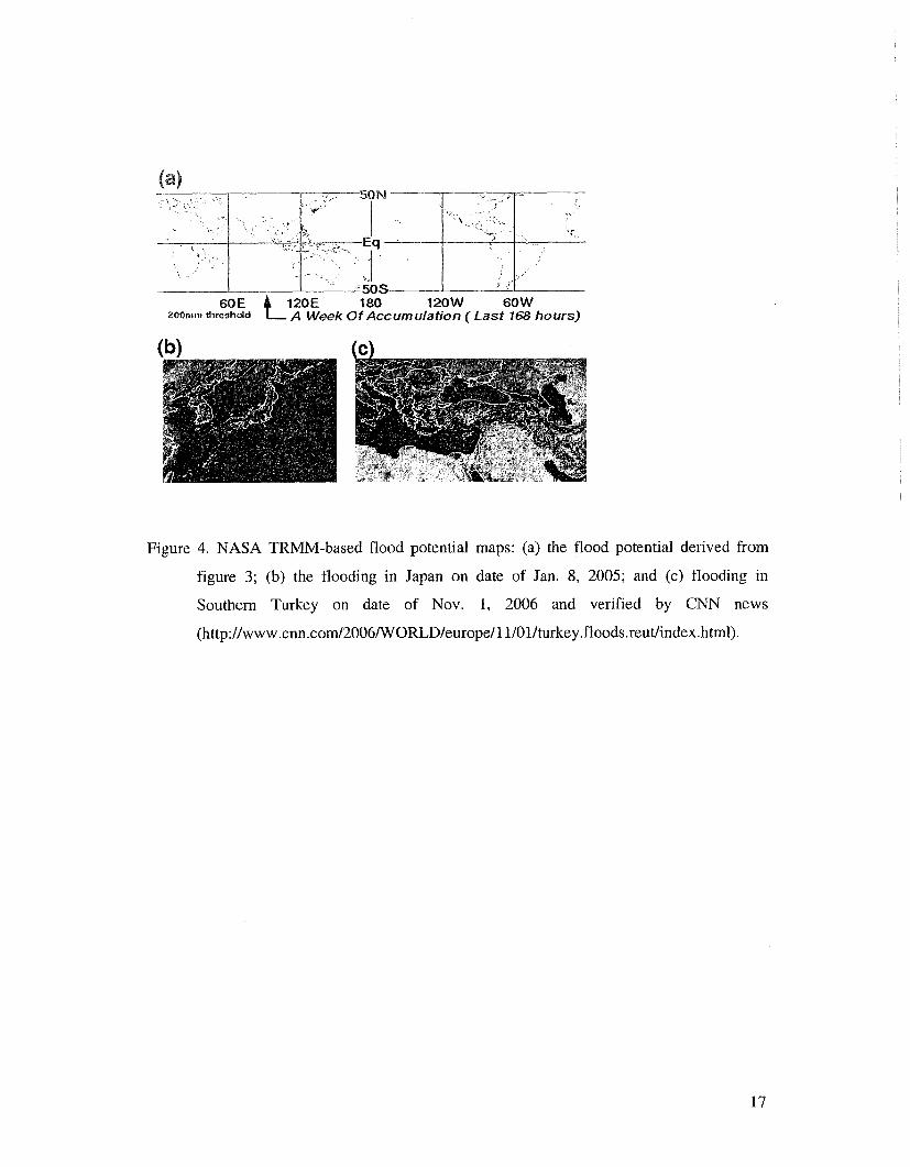
and displayed on webpage and updated every three hours. Fig. 4a shows an example of the
quasi-global "flood potential" maps that are produced in real-time (this example is from 8
Jan. 2005). Starting from global assessments such as Fig. 4a, users can zoom into regional
images (Figure 4b) to diagnose the heavy rainfalllpotential flood areas in much more detail.
See for example, the floods in southern Japan on this date, or more recently, the flood
potential map for southern Turkey on 1 Nov. 2006 (Fig. 4c). CNN later reported that the flash
flood caused by torrential rain killed at least 21 people across southeast Turkey
(http:llwww.cnn.com/20O6/WORLDle~so~elI 1/01/tt~rkey.floods.reut/index.ht11~l). The early
results demonstrate the potential of developing a satellite-based real-time flood detection
system.
Satellite observations acquired and processed in real time can now provide the precipitation
information needed to monitor severe flood events around the world by integrating satellite-
based rainfall data with hydrological models. As shown in Figure 2, we put forward practical
methods of mapping floods using a combination of data from TRMM-based precipitation and
high resolution topogaphy information and many other geospatiaf data sets, incIuding soil
properties and land cover infomation (Hong et ai., 2006b). These data sets are used in
conjunction wlth computationally efficient hydrological models to form the basis for the
flood predictions. There have been several practices in line with this direction:
(a) In Asia, U.S. Foreign Disaster Assistance has engaged USGS and NQAA as partners in its
Asia Flood Network activity, aimed at increasing the capacity of developing countries to
forecast and mitigate floods. A key partner is the Mekong River Commission, which has
a river-forecasting mandate on behalf of its member states: Cambodia, Laos, Thailand,
and Vietnam. In 2003, NASA TMPA were added to the suite of daily downloads. These
are ingested automatically into a geographic information system (GIs) system to calculate
mean rainfall totals for subbasins of the Mekong, an invaluable supplement to unevenly
distributed conventional gauge station data for operational river forecasting.
(b) A research group from Tennessee Technology University presented a relatively simple,
modular watershed modeling approach for estimating the expected error in flood
forecasting using input of satellite-based rainfall data and proposed its use to study many
of the approximately 263 international river basins (IRB) listed by UNESCO (Katiyar and
Hossain, 2006). This approach can be applied, therefore, even when conventional, real-
time rainfall information from upstream nations is not available to the lower riparian
nations due to a lack of in-situ rainfall measurement infrastructure or a lack of a treaty for
real-time sharing of rainfall data. This approach is considered appropriate, despite some
loss of detail and accuracy, in order to complete a global assessment of the large number
of flood-prone IRBs.
(c) USGS experience with satellite rainfall estimates (RFE) began with the use of rainfall
products as inputs to geospatial crop water balance modeling for agricultural drought
monitoring over Sub-Saharan Africa. Using CIS technology, rainfall grids were first
comb~ned with digital maps of basins, land cover, soils, and evapo&anspiration to
produce Basin Excess Ra~nfall Maps (http://edcint~.cr.usgs.gov/adds/), based on a
9.3) a~uaarn~~o apFlspu.t?[ yl!~ uollelnp pur? R~tsualu! IIujutel jo uopeuiquto~ jo suor$r?iauoD
ies~~rdura uo parla1 Rllr?3!difl svy Bu~pi~vuv[ ~a=IZp3 Reru Jeyl suo!jtpuo~ Ijvju!el jo uolt-enIeA3
'(0002 'uosla~~) JaleM ~U~VJI~IJUI 01 urny~nl[o:,
10 pas aql u! asuodsal amssald-alod aqj s~ sapyspuel ~ol~vqs jo uo!lnq!llsIp ll?ioduial ayl
uo loguo3 .~ap.~o-ls~y put. 'a3epns punoB aql jo adojs 3yqdsBodol aql s! Ilejufel Lq pala88y
SapyIspueI MoIIeqs jo uoylnq~lls!p ~epsds aql uo lonu03 laplo-lsly aql 'a.tojalay;L .sadols~l-yq
daap uo urnf~n1103 lo 110s pa~ep~~osuo:, Lpood aAloAul ley3 sapflspueI Molleqs ql!~ pawa3uo:,
ICpu.~pd ale aM 'Aprils syq~ ~od .(~smqlno la!3e18 lo 'ayenbyvea '~lquye~) s~o13ej 8uga82!11
3!ureuICp (q) pua (qa 'asn puel 'salsl Bu!laq~va~ 'IClolsg ~e3!8oloa8 's3yopal 'ICqdaBodol
8u!pnpu!) alnlIej 02 a1qylda3sns axjms pug[ aql aTaw q3ry~ saIqepeA ICro~e~edald (e)
:sa!.108ale3 OMI O~U! s1013ej asaqj padno18 (200~) -1~ $a !ea '(39002 '.IB la %OH) SaprIspueI
103 slo13ej a~yjasnm aql jo aBpa~~ouy saqnbal q~!q~ 'm33o Aeur sap!lspusI suo!l~puo:, leqM
lapun pue alaqM qloq jo 8u!puels~apun ue saqnbax plezeq apyspuel jo luaurssasse Injasn
sapyspuu7 pa~a88!nl-lluJu?ux 1~9023 ~UYSU~~~OS/~U~JO~~UOJ~ 2.g
'(17002 'IV $3 a3uvs.b.) la~!x
ododur!? aql .~o~!uow 03 zoo2 a3u!s IC~ua8e JalerM ue3!qwezopq aql Xq /C~!ep asn u! uaaq
sey pue 'w!qv rrraqlnog u! 2u!lo1!uour loj SDSn ICq /Cllvuo!le~ado pasn s! mSoa9 ay,Z,
.(pau-splezeq-~pes.~~~//:d~ly) anlm MOD IInjyueq ~e~~Bo~oqdrowoa8 e ql!~ a%.1eq3s!p
~uaun:, sa.~edwo:, ley3 plezeq poou jo dew pap03 .IOIO:, E jo srseq ayl ale saleurpsa MOD
palmq!le3un asaq;L .luawq~le3 q3aa 103 alqeIgAe s! IeAlalu! awg Xpep e uo qdel2olpLq
e 'sny~ '(100~ 'p la UB$.IV) spoqlaw 8upnol lauueq:, ql!~ uo!~eu!quro3 uy sanbruq~a~
3~801o~pRq pa~kn~ 8utsn 'y~o~~au lai\rl utsuq ay, qSnory, ~oy alulnurys 01 (I/YLTSO~~)
Iapoyq MOI~ ruuaas ~vyvdsoar;) aya pasn laqunj S~SJ-J '(6661 'u~pm~ pue uFplaA
:6661 '11" $3 y3sag) OEO~OLL;> '~asmvp ~:ydegodo~ 1vqol2 prto3as3sv-0~ ~SVWSDS~

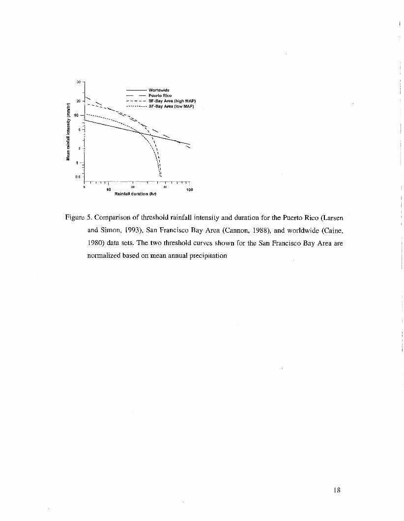
Cain, 1980). Such relationships have been investigated for both tropical and mid-latitude
regions. For example, Iandslide-~iggering rainfall thresholds have been reported for Puerto
Rico (Larsen and Simon, 1993), Hong Kong (Finlay et al, 1997), and central and southern
California (Cannon, 1988). These empirical relations between rainfall intensity and rainstorm
duration were regionally specific and often take the form of a power-law relation (Figure 5)
and were applied once an the rainfall thresholds were reached.
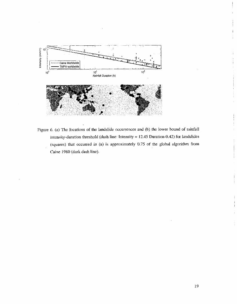
Figure 2 outlines an experimental prediction system for rainfall-triggered landslide
occurrence: (a) a global landslide susceptibility map was first derived using SRTM elevation,
slopes, land cover, soil texture, and soil types (Hong et al., 2006d); and (b) this map is then
overlain with the near real-time TRMM-based rnulti-satellite rainfall data to identify when
landslide-prone areas receive heavy rainfall. The empirical rainfall intensity-duration (I-D)
threshold is derived by examining rainfall characteristics which triggered landslides in a
variety of locations around world (Fig. 6). The rainfall intensity-duration (I-D) threshold
triggering landslides was approximated by inspection to the lower boundary of the scattered
data (74 squares) and the expressions are:
I = 12.45 D -0.42 for 3 hour<=D<=240 hours
In comparison, the satellite rainfall based threshold is approximately 0.75 of the algorithm
from Caine 1980 and it is possibly due to the coarser spatial scale of the TRMM rainfall data
against the gauge point measurement. Despite the variations, it is clear that the occurrences of
landslides require intense rainfall, sustained for at least a brief period of time. These results,
after regionalization, provide a possible basis to develop an early warning system for global
rainfall-triggered landslides.
4, Towards an Integrated Rainfail-t~ggered flo~d~liandslide Analysis

Unlike volcanoes and earthquakes, the flood and associated landslide hazards typically return
every year (Negri et al., 2004b). Satellite observations can be of essential value in improving
our understanding of the occurrence of hazardous events and possibly in lessening their
impact on local economies and in reducing injuries, if they can be used to create reliable
warning systems in cost-effective ways. This article addressed these opportunities and
challenges by describing a combination of satellite-based real-time precipitation estimation
with land surface characteristics as input, with empirical and numerical models to map
potential of landslides and floods. By careful integration of remote sensing and in-situ
observations, and assimilation of these observations into hydrological and landslide/debris
flow models with surface topographic information, prediction of useful probabilistic maps of
landslide and floods for emergency management in a timely manner is possible (Negri et al.,
2004b). Early results shows that the potential exists for successful application of satellite
precipitation data in improving/developing global monitoring systems for flood/landslide
disaster preparedness and management. The scientific and technological prototype can be
first applied in a representative test-bed and then the information deliverables for the region
can be tailored to the societal and economic needs of the represented affected countries.
Acknowledgement: This research is carried out with support from NASA's Applied
Sciences program under Steven Ambrose of NASA Headquarters.

Reference
Adler, R. F., Muffman, G J., Chang, A., Ferraro, R., Xie, P., Janowiak, J., Rudolf, B.,
Schneider, U., Curtis, S., Bolvin, D., Gruber, A., Susskind, J., Arkin, P., and Nelkin, E.,
2003: The version-2 Global Precipitation Climatology Project (GPCP) monthly
precipitation analysis (1979-Present), J. Hydrometeor., 4, 1 147-1 167.
Artan, G., J. Verdin, and K. Asante, 2001: A wide-area flood risk monitoring model. Fifth
International Workshop on Application of Remote Sensing in Hydrology, Montpellier,
France, October 2-5.
Asante, K. O., R. M. Dezanove, G. Artan, and J. Verdin, 2005: Developing a flood
forecasting system from remotely sensed data for the Limpopo Basin. Journal of Spatial
Hydrology, in review.
Caine, N., 1980: The rainfall intensity-duration control of shallow landslides and debris
flows: Geografiska Annaler, v. 62A, p. 23-27.
Cannon, S.H., 1988: Regional rainfall-threshold conditions for abundant debris-flow activity,
in Ellen, S.D., and Wieczorek, G.F., eds., Landslides, Floods, and Marine Effects of the
Storm of January 3-5, 1982, in the San Francisco Bay Region, California: U.S.
Geological Survey Professional Paper 1434, p. 35-42.
Dai, E.C., C.F. Lee, and Y.Y. Nagi, 2002: Landslide risk assessment and management: an
overview, Engineering Geol., 64, 65-87.
Finlay, P.J., R. Fell, and P.K. Maguire, 1997: The relationship between the probability of
landslide occurrence and rainfall: Canadian Geotechnical Journal, v. 34, p. 81 1-824.
Gesch, D.B., K. L. Verdin, and S. K. Greenlee, 1999: New land surface digital elevation
model covers the Earth. EOS, Transactions of the American Geophysical Union, 80
(6): 69-70.
Hong, Y., K.L. Hsu, X. Gao, and S. Sorooshian, 2004, Precipitation Estimation from
Remotely Sensed Imagery Using Artificial Neural Network - Cloud Classification
System, Journal of Applied Meteorology, Vol. 43, No. 12, pp. 1834-1 853
Hong, Y., R. Adler, and G. Huffman, 2006a: Evaluation of the NASA Multi-satellite
Precipitation Analysis Potential in Global Landslide Hazard Assessment, Geophysical
Research Letter (in press)
Hong, U., R. Adler, G. Huffman, and A. Negri, 2006b, A Conceptual Framework for Space-
bome Flood Detection/R/3onitoring System, EOS Trnnsactlon, AGU, May 23-24,
Baltimore, Maryland

6~~d'~3a3a~:enaua~.ssaupa~~da~d pug asuodsal ue!le$!ueuxny loj suo!leqdrny
ayj pur! sla$ses!p jo hl!lanas puv Lz~uanbay ayl uodn saZuey3 3gerny3 jo lmdur!
amnj ayl ssasse 01 Lpnls v 'a8uvq3 a1ewg3 103 ssaupa~vdaq.(s3a3xa) sayapos
1ua~sar3 pax pue sso~ pax 30 uoylelapad [euo!leu-ialuI '£002 'uodax slalses!a p1.10~
'21 -1 :g~z h8olo~pL~ jo Iewnof .surseq xaAp s, yllvg
ayl j0 uo!le3fj!p03 puv UOfleaUf1ap 103 malshs lv3r8olodol v :6661 'urp1aA pue .g 'u!pla~
'qt700~ '.uvy 'ep!.xol+~ '!u~vgq 'a3ualaju03 Ienuuv
h13yos h3olo~oalam ue3!1au1~ '~~~jpuq le s33ajj3 aue3!un~ 8u!lse3a10,.~- urnnuguo3
ap1[spuey-poold-auv3p1n~ aqL '~00~ "9 'a 'ayfpdn pug '-H -1 'uaplo~ '1'~ 'rBa~
1921 -6-98-SHV811; LT I '01 :IOa 'SV\IVEI 'Wnnu!luo3
ap!lspue7-poo~-auqun~ ayL '~POOZ 'ya-roz3a!~ .d -9 pue 'u!pm~ 'd 'f 'aylpdn .t> 'a 'Aalu!a'3~ 'V '1 'uasle~ '3 'p~ 'ucurjjnH .p .f) 'uosJanleH .g .f 'uaplof) 'H '[ 'IPJE~.~~ 'N 'V '!i8a~
(maddv 01) sp1ezeH IemlvN '8urpoo~ [euopda3xa uv jo sauoz
pivzey ayl jo uo!l3rpa~d ayl loj s3!1ne~phy ~'A~IJ puv s3ruy3a1oa8 Zuf.~led '9002 "J, '!pqel/~
'EZ-E~ 'd 'VSL *A 'KIIEUUTJ vysgeBoa9 :O~Q-J olland 'luauxuoqnua 1e3rdo.u-pturny
I! ur sapqspual mj ploysaql uo~~vmp-L~~sua~u~ [~ejure.~ v :£661 'UOUI!~ -Q PUB "3 .H 'uasley
pue[Lqq 'alow!lleg 'LZ-£2 Lel/y '09~ 'UO?I~VSUVAJ so3 'SUISB~ lanra
leuo!$vuraluI u! 8ugse3alod poo~d paseq-ma9 jo 8u.ydL$olo~ prdq ~oj y;romaureq
8uqapom payslaleM leInpom yooa-uado uv '9002 'U!ESSOH IBSIE~ PUB U~N 'IB~!JE;?I
'OT61-L68T 'd '9s
.A 'yxeasaa sa3mosaa .E~~EM :uo!laqyur urel Lq 8u!1a88!11 apgspuv7 :0002 "H '8 'uosla~I
(ssald ur) '~oa~atuo~pk~
T 'ale3~ au!d lv salvuI!]sg uopelfdr3ard losuag-paufquro3 '1ea~-!lln~ 'lvqo19
-!sen0 :s!sdlvu~ uo!lvl!d!3ald alr[[a)es-y[n~ flma~ aqL :9002 'jjlo~ '8.a 'lay3ols
.d.g '8~0~ -A 'uemmoa -d3g 'u~yla~ '1-3 '"9 '9 'u!r\lo~ 'L'c[ '1ajpv .,-J-X "f-9 'uvurjjn~
(paldamv)
splezvH IelnleN jo 1mnof 'Rlr~1q~da3sns sapgspuel MoIIeys 1vqo18 JO 8urddvur u!
elea 8ursuas alourax alglales jo asg :pg~oy: 'r&la~ .v pup 'ueuxjjn~ '9 Qa~pv '3 'A '%OH
(ssa~d uy) 8ulsuas ajozuatf yuv sa2uazxoag uo TUVAJ ZJ~ZJI
'uo;lswuoju~ 2uysua~ alourax alr11a3e~ 8uysn saprIspue7 pala;f2y-11sjuyea loj uralsles
2uylol!uom 1vqo1~ 1vluaw~madx~ uv :3900~ 'UEWJ;T~I_I '1.9 pue Qajpv 'djl'yj %ueh '2uo~
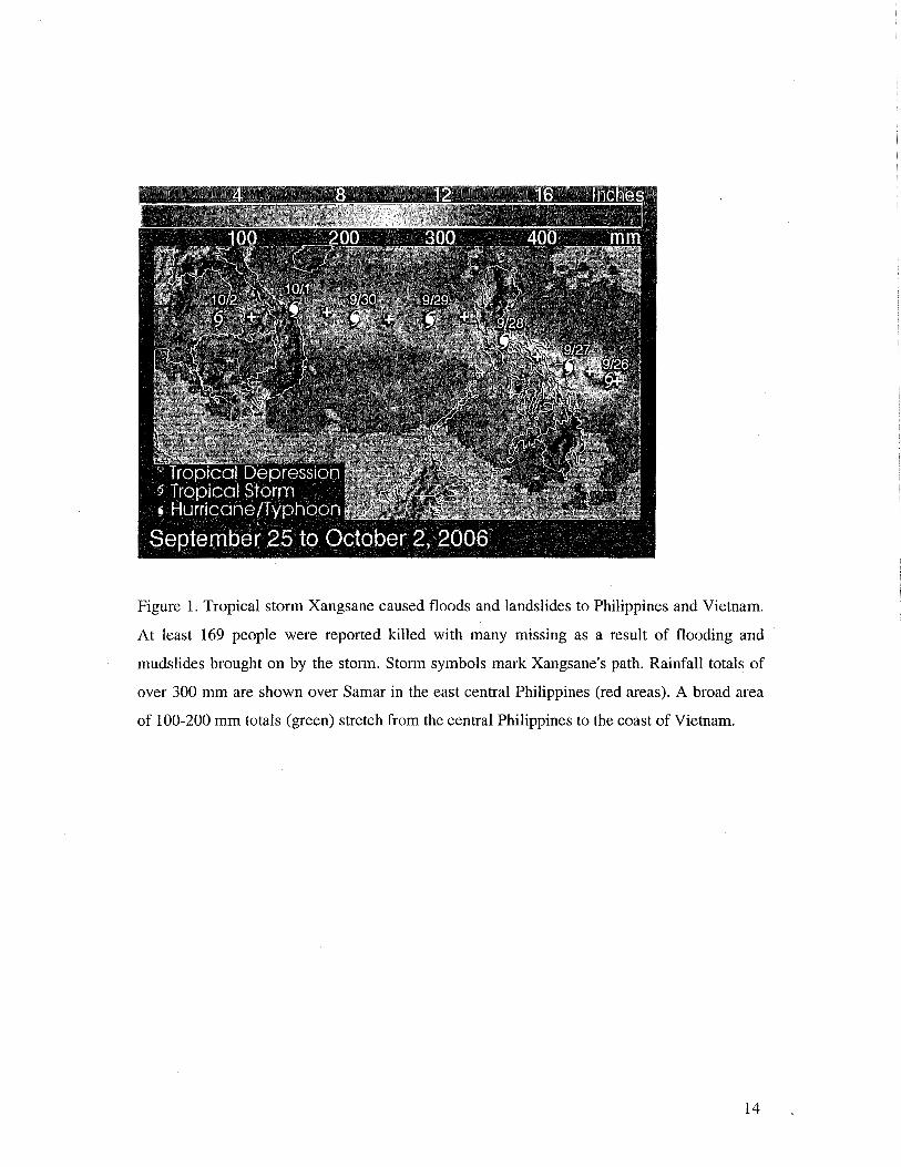
Figure 1. Tropical storm Xangsane caused floods and landslides to Philippines and Vietnam.
At least 169 people were reported killed with many missing as a result of flooding and
mudslides brought on by the storm. Storm symbols mark Xangsane's path. Rainfall totals of
over 300 mm are shown over Samar in the east central Philippines (red areas). A broad area
of 100-200 mm totals (green) stretch from the central Philippines to the coast of Vietnam.

Figure 2. The conceptual framework for monitoring rainfall-triggered flood/landslides at
global scale

Figure 3. Example of NASA TRMM MPA instantaneous rain rate map (top panel) and seven
day accumulation (bottom panel).
60, VZOE 180 120W 60W 200nitii threshold A Week Of Accumulation (Last 168 hours)
Figure 4. NASA TRMM-based flood potential maps: (a) the flood potential derived from
figure 3; (b) the flooding in Japan on date of Jan. 8, 2005; and (c) flooding in
Southern Turkey on date of Nov. 1, 2006 and verified by CNN news
(http://www.cnn.com/2006/WORLD/europe/1 l/0l/turkey.floods.reut~index.html).
5 20 5a 10 100
Rainfall duration (hr)
50 - -
-
20 -i
E
Figure 5. Comparison of threshold rainfall intensity and duration for the Puerto Rico (Larsen
Worldwide - Puerto Rlco -\ --- - - SF-Bay Area (high MAP) - - >- ---------- SF-Bay Area (low MAP)
-4.
and Simon, 1993), San Francisco Bay Area (Cannon, 1988), and worldwide (Caine,
1980) data sets. The two threshold curves shown for the San Francisco Bay Area are
s 5 -
-
@ 2 -
normalized based on mean annual precipitation
rn 3'
1 - - - -
0 5 - -
'\ ' : 1
',, I ;I \' ;,;
I
I r ~ t I I I 1 1 1 1 1 1
E - $ a, - - TMPA worldwide
10' Rainfall Duration (h)
Figure 6. (a) The locations of the landslide occurrences and (b) the lower bound of rainfall
intensity-duration threshold (dash line: Intensity = 12.45 Duration-0.42) for landslides
(squares) that occurred in (a) is approximately 0.75 of the global algorithm from
Caine 1980 (dark dash line).