fishing guide for clear lake
TRANSCRIPT
0 0.5 1 2 3 4
SODA BAY ROAD
PARK
DRI
VE
HIG
HLAN
D SP
RIN
GS
ROAD
MAI
N S
TREE
T
SODA BAY ROAD
POINT LAKEVIEW ROAD
LAKESHORE DRIVE
SULPHUR BANK
DRI
VE
SULPHUR BANK ROAD
MAIN STREET
20
20
20
53
53
29
281
29
LAKES
HORE
BLV
D
Kelseyville
Finley
Lakeport
Lucerne
Glenhaven
Nice
To Upper Lake and Ukiah
KonoTayee
RivieraHeights
ClearlakeRiviera
ClearlakeOaks
Clearlake
Lower Lake
RivieraWest
BUCKINGHAMCOUNTRY CLUB
LAKE COUNTY VISITOR INFORMATION
LAKE COUNTY CHAMBER OF
COMMERCE
SODA BAY ROAD
ANGELINA’S BAKERYASIAN DRAGON
CHEESE’S MAIN ST PIZZACHOPSTICKSPARK PLACE
THE PIT STOPT.J.’S DOWNTOWN GRILL
TNT ON THE LAKE
BOATHOUSE BAR & BBQHARBOR RESTAURANT & LOUNGEMARINA GRILLNICE FROSTIE
FOSTER’S FREEZESUBWAY THE ALPINE CAFE
HOWARD’S GROTTOKOUR THAIMAIN STREET BAR & GRILLSUNFLOWERTHE SPOTRICHMOND PARK
BAR & GRILL
THE TEE ROOM
29
29
175
2029
restaurantsRESTAURANTS ACCESSIBLE BY WATER
ARE LISTED ON THE FLIP SIDE, AND
SHOWN ON THIS MAP ALONG WITH THOSE
WITHIN EASY WALKING DISTANCE OF
THE LAKE. OTHER RESTAURANTS ARE
AVAILABLE IF YOU’RE WILLING TO
WALK A BIT FURTHER FROM THE LAKE.
FOR MORE COMPLETE LISTINGS,
SEE DESTINATIONS MAGAZINE,
AVAILABLE FROM THE LAKE COUNTY
CHAMBER OF COMMERCE IN LAKEPORT,
OR THE LAKE COUNTY VISITOR
INFORMATON CENTERS IN LUCERNE
AND CLEARLAKE.
VISTA CAFE
To Hopland
To Williamsand Sacramento
SOU
TH M
AIN
Cache Creek
Molesworth Creek
Schi
ndler
Cree
k
JagoBay
OakCove
Monitor Point
Pirates Cove
ParadiseCove
HoneymoonCove
GooseneckPoint
Borax Lake
IndianIsland
GarnerIslandThurston Lake Slater
Island
RedbankGorge
RattlesnakeIsland
Wheeler Point
Baylis Point
FraserPoint
AndersonIsland
WeekendIsland
WindflowerPoint
KonoctiBay
The Narrows
SodaBay
Quercus Point
Long TulePoint Reeves
Point
Rocky Point
TuleIsland
RodmanSlough
Willow Point
CorinthianBay
Rumsey Bay
BergerBay
HendersonPoint
BuckinghamPoint
Kono Tayee Point
Shag Rock
Dorn CoveHorseshoe
BendLittleBoraxLake
Lyons Creek
Manning Creek
McGough Slough Kelse
y Creek
Adobe Creek
Cole Creek
Clear Lake
Morr
ison Creek
To Lake Pillsbury and Blue Lakes
To HighlandSprings
Reservoir
To Indian ValleyReservoir
To Middletownand Napa
Alpine Park
Lucerne West
Nice
Com
mun
ity B
each
Eas
tNi
ce C
omm
unity
Bea
ch W
est
Keel
ing
Coun
ty P
ark
Rodm
an S
loug
h Co
unty
Par
k
Library Park
Lakeside County Park
Clear Lake State Park
C Street Extension
Davis Beach
Lucerne Clubhouse BeachLucerne Community Park
Clearlake Oaks Park
Silverado Beach
Pine DellBeach
Austin Park
Redbud Park &Thompson Harbor Marina
Anderson Marsh StateHistoric Park
Lake CountyFairgrounds
Clear Lake Dam
AMSHPNorth
RichmondPark
Konocti Vista Marina
Clear LakeVista Resort
Braito’sMarina
GlenhavenBeach Resort
PitstopMarina
Lucerne Harbor
✲
✲✲
✲
✲✲
✲
✲
✲
✲
✲
+G
+L
+K
+Q
+F
+E
+D
+C+B
+M
+N+O
+P
+H
+I
+J
✲✲✲
✲
✲✲
✲
✲
+A
-5-10
-15-20
-25
-25
-30
-35-30
-20
-25
-30-35
-40
-45
-50
-35
-40
-30 -30 -20 -10
-35
-25
-15
-10
-50
-40
-5
-10
-15
-20
-25
-30
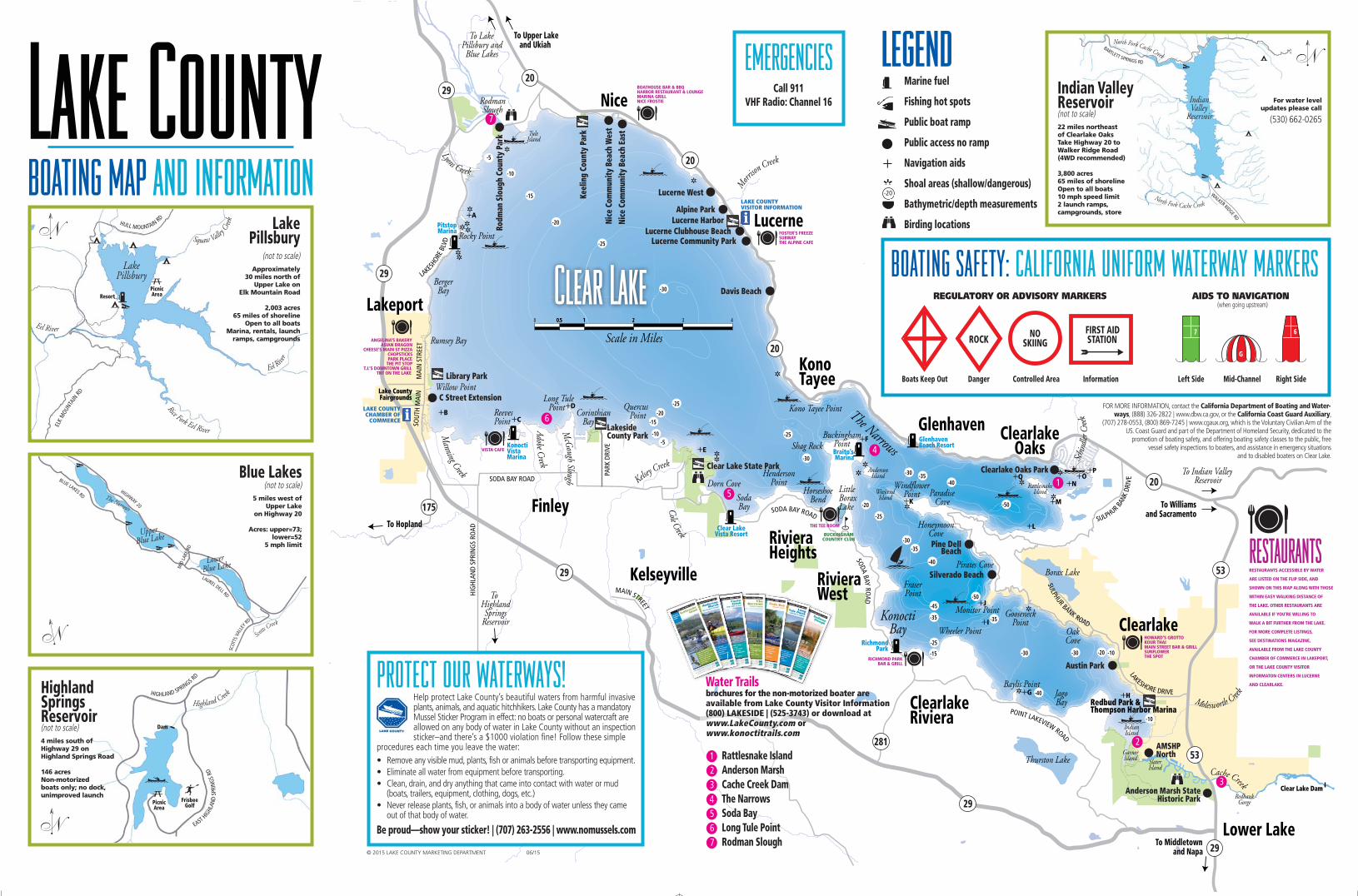
Marine fuel
Fishing hot spots
Public boat ramp
Public access no ramp
Navigation aids
Shoal areas (shallow/dangerous)
Bathymetric/depth measurements
Birding locations
legend BARTLETT SPRINGS RD
WALKER RIDGE RD
IndianValley
Reservoir
North Fork Cache Creek
North Fork Cache Creek
Indian ValleyReservoir(not to scale)22 miles northeast of Clearlake Oaks Take Highway 20 to Walker Ridge Road (4WD recommended)
3,800 acres65 miles of shorelineOpen to all boats 10 mph speed limit2 launch ramps, campgrounds, store
HIGHLAND SPRINGS R
D
EAST
HIGHL
AND
SPRI
NGS
RD
Highland Creek
Dam
PicnicArea
FrisbeeGolf
Highland Springs Reservoir(not to scale)4 miles south of Highway 29 on Highland Springs Road
146 acresNon-motorized boats only; no dock, unimproved launch
ELK
MOU
NTAI
N RD
HULL MOUNTAIN RD
LakePillsbury
Squaw Valley C
reek
Eel Rive
r
Rice Fork Eel River
Eel River
PicnicAreaResort
Lake Pillsbury
(not to scale)Approximately
30 miles north of Upper Lake on
Elk Mountain Road
2,003 acres65 miles of shoreline
Open to all boats Marina, rentals, launch
ramps, campgrounds
Scotts C
reek
LAUREL DELL RD
SCOT
TS V
ALLE
Y RD
BLUE LAKES RD
HIGHWAY 20
MID
LAKE
RD
UpperBlue Lake
LowerBlue Lake
The Narrows
Blue Lakes(not to scale)
5 miles west of Upper Lake
on Highway 20
Acres: upper=73;lower=52
5 mph limit
BOATING MAP AND INFORMATION
EMERGENCIESCall 911
VHF Radio: Channel 16
BOATING SAFETY: CALIFORNIA UNIFORM WATERWAY MARKERS
FOR MORE INFORMATION, contact the California Department of Boating and Water-ways, (888) 326-2822 | www.dbw.ca.gov, or the California Coast Guard Auxiliary,
(707) 278-0553, (800) 869-7245 | www.cgaux.org, which is the Voluntary Civilian Arm of theUS. Coast Guard and part of the Department of Homeland Security, dedicated to the
promotion of boating safety, and offering boating safety classes to the public, free vessel safety inspections to boaters, and assistance in emergency situations
and to disabled boaters on Clear Lake.
Boats Keep Out Danger
ROCK NOSKIING
FIRST AIDSTATION
Controlled Area
REGULATORY OR ADVISORY MARKERS AIDS TO NAVIGATION (when going upstream)
Information Left Side Right SideMid-Channel
© 2015 LAKE COUNTY MARKETING DEPARTMENT 06/15
PROTECT OUR WATERWAYS! Help protect Lake County’s beautiful waters from harmful invasiveplants, animals, and aquatic hitchhikers. Lake County has a mandatoryMussel Sticker Program in effect: no boats or personal watercraft are allowed on any body of water in Lake County without an inspectionsticker–and there’s a $1000 violation fine! Follow these simple
procedures each time you leave the water:• Remove any visible mud, plants, fish or animals before transporting equipment.• Eliminate all water from equipment before transporting.• Clean, drain, and dry anything that came into contact with water or mud
(boats, trailers, equipment, clothing, dogs, etc.)• Never release plants, fish, or animals into a body of water unless they came
out of that body of water.
Be proud—show your sticker! | (707) 263-2556 | www.nomussels.com
Water Trails brochures for the non-motorized boater areavailable from Lake County Visitor Information (800) LAKESIDE | (525-3743) or download at www.LakeCounty.com orwww.konoctitrails.com
l1 Rattlesnake Island l2 Anderson Marshl3 Cache Creek Daml4 The Narrowsl5 Soda Bayl6 Long Tule Pointl7 Rodman Slough
l1
l2
l3
l4
l5
l6
l7
-20
For water level updates please call
(530) 662-0265
BoatMap_tearoff_2015_Layout 1 6/8/15 4:36 PM Page 1
Whether they come for the fish or the splash, Clear Lake is a haven forboating enthusiasts. The largest natural freshwater lake in California, ClearLake’s shores are lined with boat launches—most are free to the public. Frompaddle to pontoon boats, wakeboards to wave runners, rentals are availableat many businesses around Clear Lake. One of the most popular places forlaunching a boat is Clear Lake State Park, which features a marina, swimbeach, fishing pier, lake side camping, hiking trails, and a visitor center.
The lake is brimming with many species of fish, including catfish, carp,crappie, and bluegill, and most notably, bass. In fact, two-thirds of the fishcaught are largemouth bass. Major national bass tournament tours make a stop here; the average tournament-winning weight can be more than 5 pounds, a weight un matched by any other lake in the nation. Clear Lakehas earned a reputation for being home to “monster bass,” and those in the know refer to Clear Lake as the “Bass Capital of the West.” Evenorganizations like U.S. Bass, Cal Bass, and Western Bass agree that ClearLake is the “number one bass lake in the nation.”
Clear Lake isn’t the only body of water in the area. Northwest of Clear Lake,fishing opportunities abound in the cold, clear waters of Blue Lakes, whichhas rainbow trout, catfish, bluegill, and black bass; no boat may exceed 5mph,making the lakes perfect for kayaks, canoes, paddleboats, or a quiet day offishing or swimming. Lake Pillsbury, nestled in the middle of the MendocinoNational Forest due north of Clear Lake and surrounded by mountains, hasblack bass, pumpkinseed sunfish, and rainbow trout; all types of boats and lakeactivities are welcome. Remote and peaceful Indian Valley Reservoir to the northeast, where boats are required to stay below 10 mph, has rainbowtrout, black bass, catfish, kokanee, and crappie. Southwest of Clear Lake, theNorth Fork of Cache Creek has rainbow trout. Due south, HighlandSprings Reservoir has catfish, black bass, crappie, and bluegill, and any boatwithout a gas-powered motor is welcome; visitors also can hike, play disc golfor horseshoes, or enjoy a picnic in the area’s oak woodland and brushy terrain.
Several businesses around Lake County offer fishing licenses and supplies, including a variety of bait and tackle. Professional fishing guidesoffer instruction year-round, as well as gear, sightseeing and hunting tours,nature photography opportunities, and more.
For more information, request a copy of Destinations magazine from theLake County Chamber of Commerce or Visitor Information Center.
on the lakes boating & fishing
boat-up explore the shorelineLake County is a whole newworld when seen from the water.Early visitors to the county traveledfrom one end of the county tothe other entirely by boat. Today’svisitors still enjoy a host of activitiesfrom the water. Here’s a brieflist of things to do and places togo that you can reach by boat.
For events or more information:
Lake County Visitor Information Center(800) 525-3743www.lakecounty.com
Lake County Chamber of Commerce263-5092; www.lakecochamber.com
Lake County Parks & Recreation262-1618; www.konoctitrails.com
FISHING
Adam’s Whoop Bass GuideService................................ 391-5685 www.whoopbass.biz
Bass Fishin’ with Richard ........................... 272-8410 www.bassfishinclearlake.com
Bassin’ with Bob............349-4460 www.fishclearlake.com
Bob Thein’s Fishing GuideService ............. 994-4886; 350-1493 www.fishclearlakebass.com
Ross England’s Clear Lake Guide Service..... 349-1427www.clearlakeguideservice.com
Taylored Guide Service ............................... 349-6797www.clearlakefishingguide.com
GOLF
Buckingham Golf & Country Club9-hole golf course, 18 different tees. Seasonal restaurant, clubhouse.2855 Eastlake Drive Kelseyville .............................. 279-11400
NOTE: All telephone numbers are area code(707) unless otherwise listed.
MARINE FUEL
Braito’s Buckingham Marina1555 Eastlake DriveKelseyville ............................... 279-4868
Clear Lake Vista Resort 6190 Soda Bay RoadKelseyville ............................... 289-4017www.konocti-vista-casino.com
Konocti Vista Casino Resort Marina and RV Park2755 Mission Rancheria RoadLakeport ................................. 262-1900www.konocti-vista-casino.com
Lake Pillsbury Resort andMarina 2756 Kapranos RoadPotter Valley ........................... 743-9935www.lprandm.com
Pit Stop 3740 Lakeshore Boulevard Lakeport ................................. 262-0931
Richmond Park Bar & Grill 9435 Konocti Bay RoadKelseyville ............................... 277-7535
NIGHTLIFE & GAMING
Konocti Vista Casino Resort, Marina & RV ParkGaming, dining, lodging, marina, concerts.2755 Mission Rancheria Road Kelseyville ................................ 262-1900www.konocti-vista-casino.com
PARKS & BEACHES
Alpine Park5985 East Highway 20Lucerne .................................... 262-1618
Anderson Marsh State Historic Park8825 Highway 53Lower Lake .............................. 995-2658
Austin Park14077 Lakeshore DriveClearlake .................................. 994-8201
Clearlake Oaks Beach12684 Island DriveClearlake Oaks ........................ 262-1618
Clear Lake State Park Hiking trails, birding, camping. Swimming beach. Visitor center.5300 Soda Bay RoadKelseyville ................................ 279-2267
Redbud Park/Thompson Harbor14655 Lakeshore DriveClearlake ................................ 994-8201
Highland Springs Recreation Area3600 E. Highland Springs RoadKelseyville ................................ 263-2341
Keeling Park1000 Lakeshore BoulevardNice.......................................... 262-1618
Indian Valley Dam & Reservoir4439 Access Road Clearlake Oaks................ (530) 662-0265 Fishing info .................... (530) 662-0607
Lake Pillsbury Resort & Marina 2756 Kapronos RoadLake Pillsbury ............................743-9935
Lakeside County Park 1985 Park Drive Lakeport .................................. 262-1618
Library Park 222 Park Street Lakeport .................................. 263-5615
Lucerne Park and Harbor6319 East Highway 20Lucerne .................................... 262-1618
Rodman Slough Nice-Lucerne CutoffNice.......................................... 262-1618
RESTAURANTS
The Spot 14625 Lakeshore Drive Clearlake .................................. 900-8671
Richmond Park Bar & Grill 9435 Konocti Bay Road Kesleyville ................................ 277-7240
TNT Bar & Grill 2559 Lakeshore Boulevard Lakeport .................................. 263-4868
Park Place 50 Third Street Lakeport .................................. 263-0444
The Pit Stop 3740 Lakeshore Boulevard Lakeport .................................. 262-0931
The Boathouse Bar & Restaurant 2685 Lakeshore BoulevardNice.......................................... 274-1100
The Harbor Restaurant & Lounge4561 East HIghway 20 Nice.......................................... 274-1637
SUMMER CONCERTSFree outdoor summer concerts every Fri-day night, mid-June to mid-August, at theGazebo at Library Park. Different genresweekly; local and regional musicians travelto the shores of Clear Lake to entertain residents and summer visitors. Library Park,222 Park Street, Lakeport........ 263-6113
WATERCRAFTRENTALS
Disney’s Water Sports401 South Main StreetLakeport................................... 263-0969www.disneyswatersports.com
Indian Beach Resort9945 East Highway 20 Clearlake Oaks ......................... 998-3760www.theindianbeachresort.com
Lake Pillsbury Resort and Marina2756 Kapranos Road Lake Pillsbury............................ 743-9935www.lprandm.com
Le Trianon Resort5845 West Highway 20 Blue Lakes................................ 275-2262www.letrianon.com
The Lodge at Blue Lakes5135 West Highway 20Blue Lakes .............................. 275-2181www.TheLodgeAtBlueLakes.com
Mendo-Lake SUP (Stand Up Paddleboards) ................................................ 245-7171facebook.com/MENDOLAKESUP
The Narrows Lodge Resort5690 Blue Lakes RoadBlue Lakes................................ 275-2718www.thenarrowsresort.com
Pine Acres Resort5328 Blue Lakes RoadBlue Lakes .............................. 275-2811www.bluelakepineacres.com
Shady Acres (launch site)7805 Cache Creek Way Clearlake ................................ 994-2236shadyacres.com
NOTE: All information is subject to changewithout notice. The County of Lake is not responsible for correctness in listingsor changes of status. Please e-mail corrections to [email protected].
LAU
RA
LA
MA
R/M
AX
DE
SIG
N S
TU
DIO
boating safety rulesThe following are the rules for boating, and for all vesselstowing (and all persons being towed on) aquaplanes, waterskis, surfboards, wakeboards, innertubes, or any similartowed device on any of the waters of California.
• PFD (personal floatation devices/lifevest) requirements: One for each person on board. Children under 12, PFDs must be worn at all times. Anyperson being towed behind a vessel must wear a Coast Guard-approvedlife jacket. Exceptions include: parades, tournaments, and those personsinvolved in barefoot, jump, or trick water skiing.
• Observe posted SPEED/NO WAKE zones.
• Keep RIGHT when meeting another boat head-on.
• Observe other boaters and Aids to Navigation (buoys, lights; see reverse).
• Must have Coast Guard Fire Extinguisher and Distress Signal on board(flag, horn, waving arms, etc.).
• All motor boat (15hp+) and PWC (personal watercraft: waverunner, jetski, etc.) operator age limit is 16 and older; age 12–15 may operate if supervised by an adult.
• In addition to the operator of the boat, there must be an observer on boardwho is at least 12 years of age and in a position to see the water skier at all times and relay information about the skier to the boat operator.
• Whenever the skier, ski rope or any of the ski equipment is down in thewater, a 12" x 12" orange or red flag must be displayed so that it isclearly visible to surrounding boaters.
• Towing a person on water skis between the hours of sunset and sunrise isprohibited.
• No water skiing within 200 feet of a swimming beach or platform or anyarea posted or marked as closed to water skiing.
• No person shall endanger the life, limb, or property of any other person.Operating a boat in a reckless or negligent manner, without due regardfor other traffic and other circumstances is prohibited. Law prohibits operation with blood alcohol level of .08%.
Emergencies: Call 911; VHF Radio: Channel 16
LAU
RA
LA
MA
R
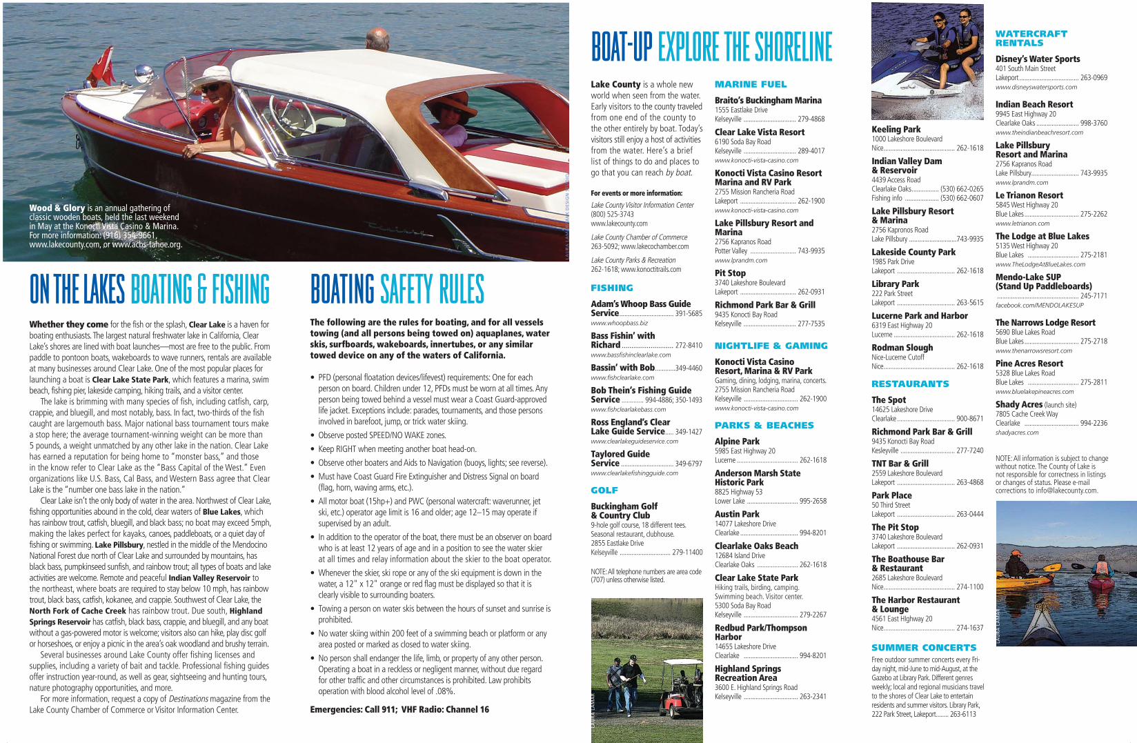
Wood & Glory is an annual gathering of classic wooden boats, held the last weekend in May at the Konocti Vista Casino & Marina.For more information: (916) 354-9661,www.lakecounty.com, or www.acbs-tahoe.org.
LAU
RA
LA
MA
R
BoatMap_tearoff_2015_Layout 1 6/8/15 4:36 PM Page 2