fish access to low order tributaries on the trinity river ... · pdf filefish access to low...
TRANSCRIPT

Fish access to low order tributaries on the Trinity River
Abstract
Members of the Trinity Adaptive Management Work Group (TAMWG) hypothesized that lower than natural flow releases from Lewiston dam inhibit adult steelhead from accessing tributaries during the critical spawning period. This project assessed adult steelhead passage into low order (0-4) Trinity River Tributaries during January of 2016. The study was conducted while tributary flows were between 100 and 150% of median for this time of year as indicated by gaged tributaries, namely Rush, Grass Valley, and Indian Creeks. US Fish and Wildlife fisheries biologist assessed fish passage on a scale from 1-5 based on professional judgement with 1 being no barrier and 5 being impassible. The tributaries were photographed and a long profile consisting of at least 3 points were obtained. Results of the study indicate that 7 of 8 observed 2nd order and smaller tributaries were impassible. Half of the 10confluences at 3rd order tributaries were passible (≤ 3). Confluences of the 4th order Reading and Browns creek offered no barrier to fish passage and Dutch Creek was difficult for fish to pass at the time of observation. Smaller tributaries that were inaccessible near the confluence frequently had fish barriers located upstream of the confluence suggesting that these streams are unlikely to support large populations of steelhead regardless of confluence conditions. The validity of this study is limited to flows observed. Higher flows in either the mainstem or tributaries will increase accessibility to tributaries by adult steelhead. Mainstem flow rate of 2000 cfs would ensure that confluence conditions of the surveyed tributaries would pose no barrier to fish passage.
Introduction
The Trinity River Restoration Program (TRRP) is charged with restoring river ecology and anadromous fish populations impacted by operation of the Trinity and Lewiston Dams. Operation of the Trinity and Lewiston Dams under the Record of Decision (ROD) (USBR 2000) includes a winter base flow, spring high flow to mimic natural snowmelt runoff, and summer base flow. The 300 cfs winter baseflow released from Lewiston is less than occurred during pre-dam hydrology and less than would be expected for a regional stream with similar annual runoff volume as prescribed under the ROD hydrology. TAMWG at the December 10th meeting voiced a concern that low flow releases to the Trinity River inhibit adult steelhead from migrating into tributaries during the critical spawning period. Essentially low mainstem stage, related to flow, produces tributary flow depths in the vicinity of the confluence that is too shallow to allow fish passage.
The study objective is to determine if barriers to fish passage exist in the vicinity of tributary confluences. The secondary objective is to determine the mainstem flow rate that would facilitate fish passage into tributaries. This study is intended as a pilot to address fish passage into tributaries as requested by the TAMWG.

Methods
A team of 2-3 Program scientists conducted field surveys of tributaries to the Trinity River between Lewiston Dam and the North Fork Trinity River near Helena. Tributaries in this study are zeroth to fourth order streams as determine using USGS quadrangle maps. The crew obtained photographs of tributary confluence with the mainstem river and took additional pictures of fish barriers and equipment set up. The crew obtained long profiles of tributary elevation and flow depth starting in the mainstem to a point in the tributary where flow depths were unaffected by confluence conditions. Long profiles consist of 3 locations or more with one location in the mainstem, one at the shallowest location in the deepest flow path, and another where flow conditions were unaffected by confluence conditions. Elevations were obtained in local coordinates using a Sokkia C31 auto level and distances between measurements were measured with a 200’ survey tape. The accessibility of tributaries is dependent on flow conditions of the tributary and the mainstem. It is assumed that flow rates on ungagged tributaries are closely related to the flow on larger gaged tributaries and tributary flow rate is estimated using area weighted method. Flow rates in ungagged tributaries are estimated using the average area weighted floe rates from Rush, Grass Valley, and Indian Creeks. Flow rates on gaged tributaries are reported in Table 1. Mainstem flow rates associated with the tributary observation date are estimated using streamflow gages located upstream and downstream of the tributary (Table1). Mainstem water surface elevation is estimated using SRH-2D model output. The flow required to produce confluence conditions that pose no barrier to fish passage is estimated by differencing SRH-2D water surface elevations to achieve the stage increase required to back water the shallowest location along the deepest flow path.
Results

Table 1. Summary description of tributaries to the Trinity River located between Lewiston Dam and the North Fork Trinity River. Gaged tributary and mainstem flows are reported for the dates of observation.
Deadwood Creek PIC102-0541-0544
Deadwood Creek is a third order tributary located at the new Lewiston Bridge in Lewiston Ca depicted in Figure 1. The long profile of Deadwood Creek is shown in Figure 2, the zero station is located at the bridge pier where tributary stages were unaffected by confluence conditions. Deadwood was easily passible by adult steelhead on the survey date. The minimum flow depth along the deepest flow path was 0.55 ft.
0= Not observed; 1= No barrier; 2= Easily passible; 3= passible; 4= Difficult to pass; 5=Not passible Drainage areaTributary Stream order Fish Passage conditions mi2 Mainstem TributaryDeadwood Creek 3 1 8.9 307 38Hoadley Gulch 3 5 3.9 345 17Alder Gulch 3 3 2 362 9Rush Creek >4 0 22.7 371 146Grass Valley Creek >4 1 36.9 517 84Trinity House Gulch 3 5 2.8 601 11Tom Lang Gulch 3 4 3.4 612 13Ditch above China Gulch 1 5 0.1 625 0China Gulch 2 5 0.4 626 2McIntyre Gulch 2 5 0.7 610 3Indian Creek >4 0 33.2 613 117Weaver Creek >4 0 49.1 730 194Reading Creek 4 1 30.4 924 120Dutton Creek 3 5 4.7 470 4Browns Creek 4 1 74.1 474 58Maxwell Creek 3 5 5 531 4Dutch Creek 4 4 9.5 535 7Soldier Creek 3 2 7.1 481 6Deep Gulch 2 4 0.5 487 0Mill Creek 2 0 2.3 487 2Oregan Gulch 3 2 7.4 489 6McKinney Gulch (@ Gompa) 2 5 1.1 620 1Canyon Creek >4 0 64 621 52JC Campground 2 5 1.1 673 1Conner Creek 3 2 4.9 674 4Wheel Gulch 0 5 0.6 678 0Unnamed Gulch on Left upstream of Pear Tree 1 5 0.7 679 1Unnamed Gulch on Left upstream of Bagdad 2 4 1.4 679 1
Flow (cfs)

Figure 1. Deadwood a third order tributary located at the new Lewiston Bridge in Lewiston Ca.
Figure 2. Profile and water surface elevation measurements of Deadwood Creek.

Hoadly Gulch PIC102-0572-0577
Hoadly Gulch is a 3rd order tributary that enters the Trinity from the left just downstream from the old Lewiston Bridge. The river needs to rise approximately 10’ to provide access to this tributary due to a small waterfall near the confluence (Figure 3). Measurements were not obtained on this tributary because the precipitous confluence of the stream is believed to be a fish barrier at virtually all flows, and the stream gradient was deemed too steep to be surveyed safely.
Figure 3. Hoadly Gulch located downstream of the old Lewiston Bridge in Lewiston California.
Alder Gulch PIC102-0578-0580

Alder Gulch is a 3rd order tributary that enters the mainstem on river left across from the Cemetery side channel entrance. The confluence of this tributary consists of a short plunge into the mainstem which would cause some difficulty to migrating fish (Figure 4 & 5). However this confluence is passible as a result of the pool below the plunge (Figure 6). Increasing mainstem stage by approximately 1.75 ft at the observed tributary flow conditions would ensure that this confluence presents no barrier to fish passage. This increase in depth would require a mainstem discharge of about 2000 cfs. The property owner at the confluence informed the field crew that while no adult fish have been observed in the stream, fingering size fish have been observed. The identity of the observed fingerling fish is unknown.
Figure 4. The confluence of Alder Gulch with the mainstem Trinity River.

Figure 5. The confluence of Alder Gulch with the mainstem Trinity River.
Figure 6. Profile and water surface elevation measurements of Alder Gulch.
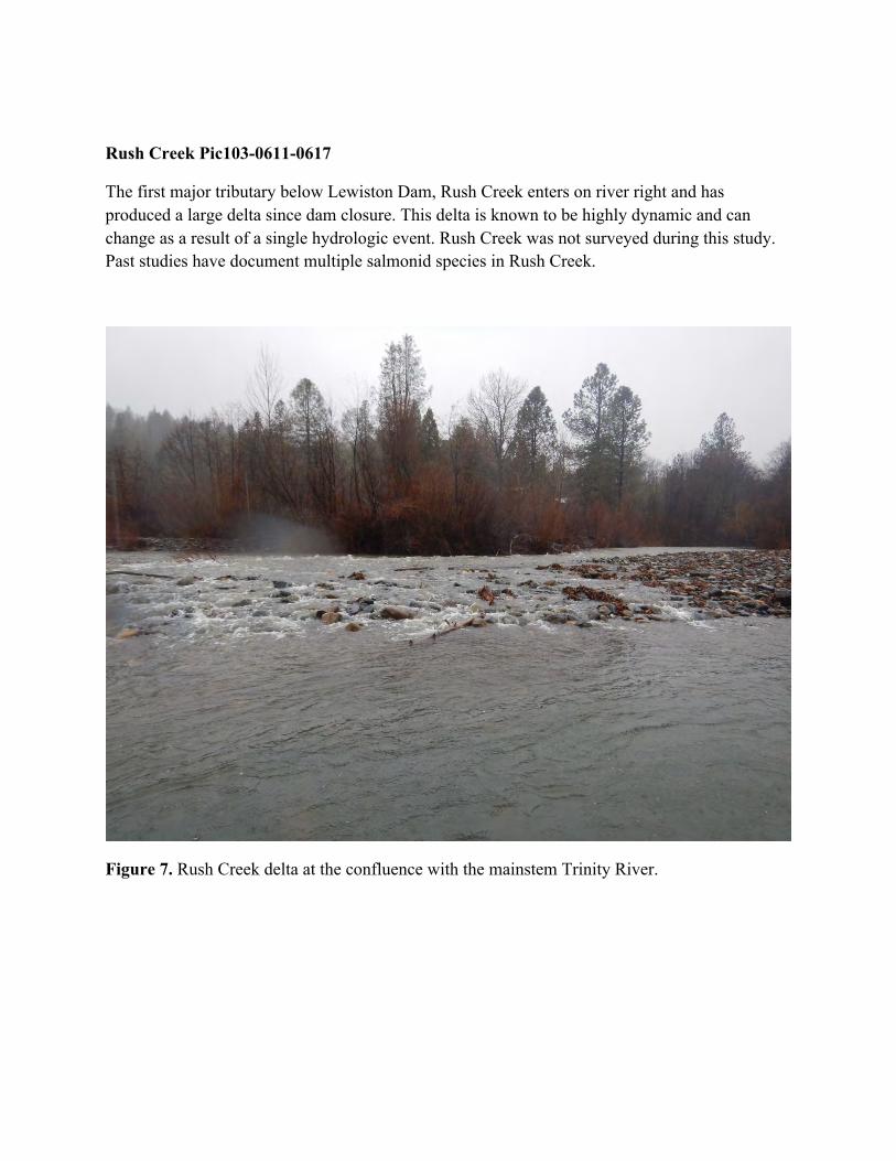
Rush Creek Pic103-0611-0617
The first major tributary below Lewiston Dam, Rush Creek enters on river right and has produced a large delta since dam closure. This delta is known to be highly dynamic and can change as a result of a single hydrologic event. Rush Creek was not surveyed during this study. Past studies have document multiple salmonid species in Rush Creek.
Figure 7. Rush Creek delta at the confluence with the mainstem Trinity River.
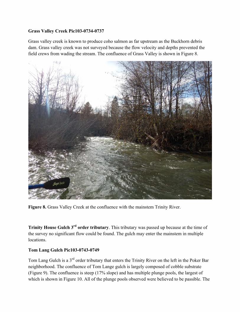
Grass Valley Creek Pic103-0734-0737
Grass valley creek is known to produce coho salmon as far upstream as the Buckhorn debris dam. Grass valley creek was not surveyed because the flow velocity and depths prevented the field crews from wading the stream. The confluence of Grass Valley is shown in Figure 8.
Figure 8. Grass Valley Creek at the confluence with the mainstem Trinity River.
Trinity House Gulch 3rd order tributary. This tributary was passed up because at the time of the survey no significant flow could be found. The gulch may enter the mainstem in multiple locations.
Tom Lang Gulch Pic103-0743-0749
Tom Lang Gulch is a 3rd order tributary that enters the Trinity River on the left in the Poker Bar neighborhood. The confluence of Tom Lange gulch is largely composed of cobble substrate (Figure 9). The confluence is steep (17% slope) and has multiple plunge pools, the largest of which is shown in Figure 10. All of the plunge pools observed were believed to be passible. The

long profile and flow depth of Tom Lang confluence is shown in Figure 11. The confluence was deemed difficult for fish to pass in large part due to a debris dam near station 40 of the survey. A mainstem flow rate of about 1250 cfs is required for the confluence to pose no barrier to fish passage. That discharge produces a stage approximately 1.1 ft higher than was present on the survey date. The long term stability of the debris jam is uncertain and it may wash out during subsequent high flow events and permit fish passage up this tributary.
Figure 9. Tom Lang Gulch at the confluence with the mainstem Trinity River.

Figure 10. Plunge pool on Tom Lang Gulch with fish technician shown for scale. This plunge pool is believed to be passible by fish due to the pool at the bottom.
Figure 11. Tom Lang Gulch long profile and stream depth.

Ditch above China Gulch on the right Pic103-0762-0763
The confluence of a small (1st order) tributary locate on river left upstream of China Gulch is shown in Figure 12. This tributary was impassible to fish and was not surveyed.
Figure 12. Ditch above China House Gulch at the confluence with the mainstem Trinity River.
China House Gulch pic103-0764-0766 No passage
China gulch is a small second order tributary located on river right downstream of society pool. China gulch confluence is shown in Figure 13. Due to the heavy vegetation and small stream size this tributary was impassible to fish and was not surveyed.

Figure 13. China House Gulch at the confluence with the mainstem Trinity River.
McIntyre Gulch
McIntyre Gulch is a second order tributary that enters the Trinity downstream of Biggers Bridge off Steel Bridge road. The confluence is located in a beautiful section of river with many flow bifurcations (Figure 14).

Figure 14. McIntyre Gulch at the confluence with the mainstem Trinity River with survey level in the foreground. The long profile and flow depth is shown in Figure 15. The shallowest portion of the deepest flow path is 0.15 ft. McIntyre Gulch is not passible to steel head due to the long shallow confluence. If the mainstem stage where to be increased by 0.5 ft McIntyre confluence would be no barrier to fish passage. Mainstem flow of 1100 cfs would increase the stage at this location about 0.5 ft and allow fish passage.

Figure 15. Long profile and depth of McIntyre Gulch.
Indian Creek
Indian Creek enters the Trinity River on the left (Figure 16). Indian Creek was not surveyed as flow rate prohibited the field crew from standing in the thalweg to obtain measurements. Indian Creek confluence provided no barrier to fish passage.

Figure 16. Indian Creek confluence with the Trinity River.

Weaver Creek
Figure 17. Weaver Creek confluence with the Trinity River.
Reading Creek
No pictures were taken of Reading Creek. However the stream appeared to be easily passible to fish.
Chop Tree to Even’s Bar 1-12-2016
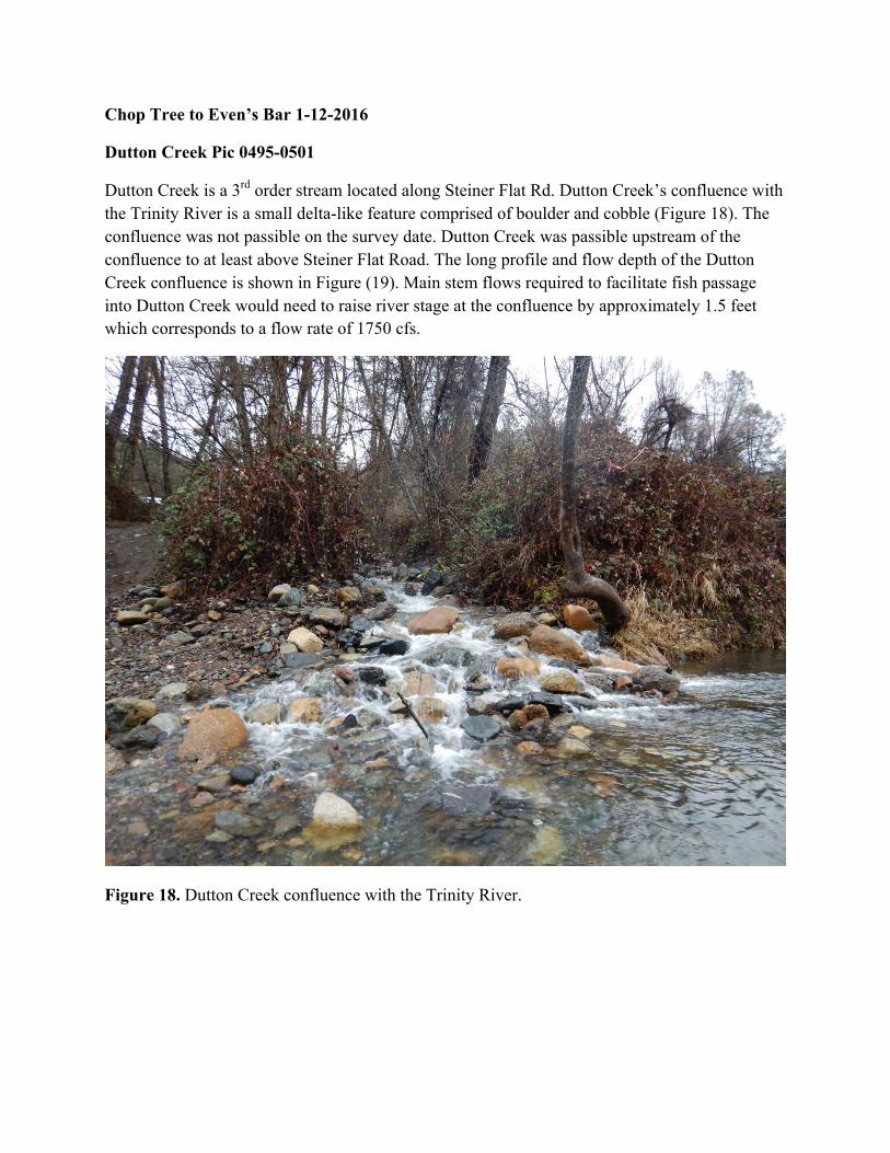
Dutton Creek Pic 0495-0501
Dutton Creek is a 3rd order stream located along Steiner Flat Rd. Dutton Creek’s confluence with the Trinity River is a small delta-like feature comprised of boulder and cobble (Figure 18). The confluence was not passible on the survey date. Dutton Creek was passible upstream of the confluence to at least above Steiner Flat Road. The long profile and flow depth of the Dutton Creek confluence is shown in Figure (19). Main stem flows required to facilitate fish passage into Dutton Creek would need to raise river stage at the confluence by approximately 1.5 feet which corresponds to a flow rate of 1750 cfs.
Figure 18. Dutton Creek confluence with the Trinity River.

Figure 19. Dutton Creek long profile and depth.
Browns Creek Pic0514-0518
Browns Creek is a fourth order tributary that enters the Trinity on river left in the canyon reach at the end of B-Bar-K road. Browns Creek confluence is shown in Figure 20. The long profile and flow depth is shown in Figure 21. The relatively deep (1.5 ft) tributary confluence provides no barrier to fish passage. Steel head spawning has been observed in Browns Creek along B-Bar-K road by program biologists.

Figure 20. Browns Creek confluence with the Trinity River.
Figure 21. Browns Creek long profile and depth.
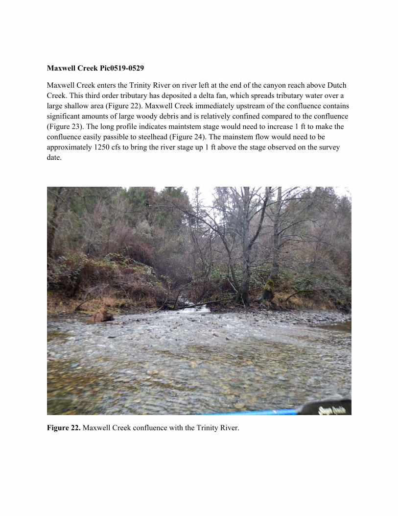
Maxwell Creek Pic0519-0529
Maxwell Creek enters the Trinity River on river left at the end of the canyon reach above Dutch Creek. This third order tributary has deposited a delta fan, which spreads tributary water over a large shallow area (Figure 22). Maxwell Creek immediately upstream of the confluence contains significant amounts of large woody debris and is relatively confined compared to the confluence (Figure 23). The long profile indicates maintstem stage would need to increase 1 ft to make the confluence easily passible to steelhead (Figure 24). The mainstem flow would need to be approximately 1250 cfs to bring the river stage up 1 ft above the stage observed on the survey date.
Figure 22. Maxwell Creek confluence with the Trinity River.

Figure 23. Maxwell Creek just above the confluence with the Trinity River.
Figure 24. Maxwell Creek long profile and depth.

Dutch Creek Pic0530-0533
The Dutch Creek confluence with the Trinity River is on river right just upstream of Evans Bar. A small delta was present in the mainstem river on the survey date (Figure 25). The deepest flow path is in the right side of Figure 25. The shallowest spot in the deepest channel on the fan was 6”0.5 ft deep and was missed in the survey of the long profile. Dutch Creek confluence was considered difficult for fish to pass, but not impossible. The long profile indicates that mainstem stage needs to increase by approximately 1 ft to make the Dutch Creek easily accessible. Based on SRH-2D modelling, a mainstem flow rate of 1100 cfs would be sufficient to remove any barrier to fish passage.
Figure 25. Dutch Creek confluence with the Trinity River.

Figure 26. Dutch Creek long profile and depth.
The river reach from Evan’s Bar to Bagdad was floated on January 11, 2016 when flows at the USGS Junction City Gage (USGS#11526250) were between 620-640 cfs and the flows at the gage above the North Fork (USGS#11526400) where between 770-800 cfs. The tributaries were flowing as a result of resent precipitation but where relatively clear and on the descending limb of the hydrograph.
Soldier Creek Pic0371-0375
Soldier Creek is located on river left downstream of Evans Bar. When Soldier Creek is first viewed from a distance, the confluence appears difficult for fish to negotiate with white rushing waters (Figure 27). However minimum flow depth on the deepest flow path was measured at 0.75ft and determined to be easily passible for adult steelhead (Figure 28). The long profile and flow depth of Soldier Creek is shown in Figure 29.

Figure 27. Soldier Creek confluence with the Trinity River.

Figure 28. Soldier Creek confluence with the Trinity River. The deepest flow path is left of the wood and rock divide.
Figure 29. Soldier Creek long profile and depth.

Deep Gulch Below Ed’s Hole Pic0376-0381
Deep Gulch is located on river left downstream of Ed’s Hole hole. When Deep Gulch is first viewed from a distance, the confluence appears impossible for fish to negotiate with white rushing waters (Figure 30). The section of stream just upstream of the confluence has a high gradient (31%) and low flow depth (0.25 ft) (Figure 31). Deep Gulch above the survey data continues as a steep stream consisting of short (1-2’) water falls (Figure 32). The entrance conditions at Deep Gulch would be difficult to pass for migrating steelhead. It seemed reasonable that if fish made it beyond the confluence that natural migration barriers exist upstream which preclude this tributary from utilization by steelhead.
Figure 30. Deep Gulch confluence with the Trinity River.
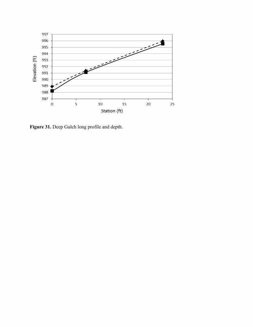
Figure 31. Deep Gulch long profile and depth.
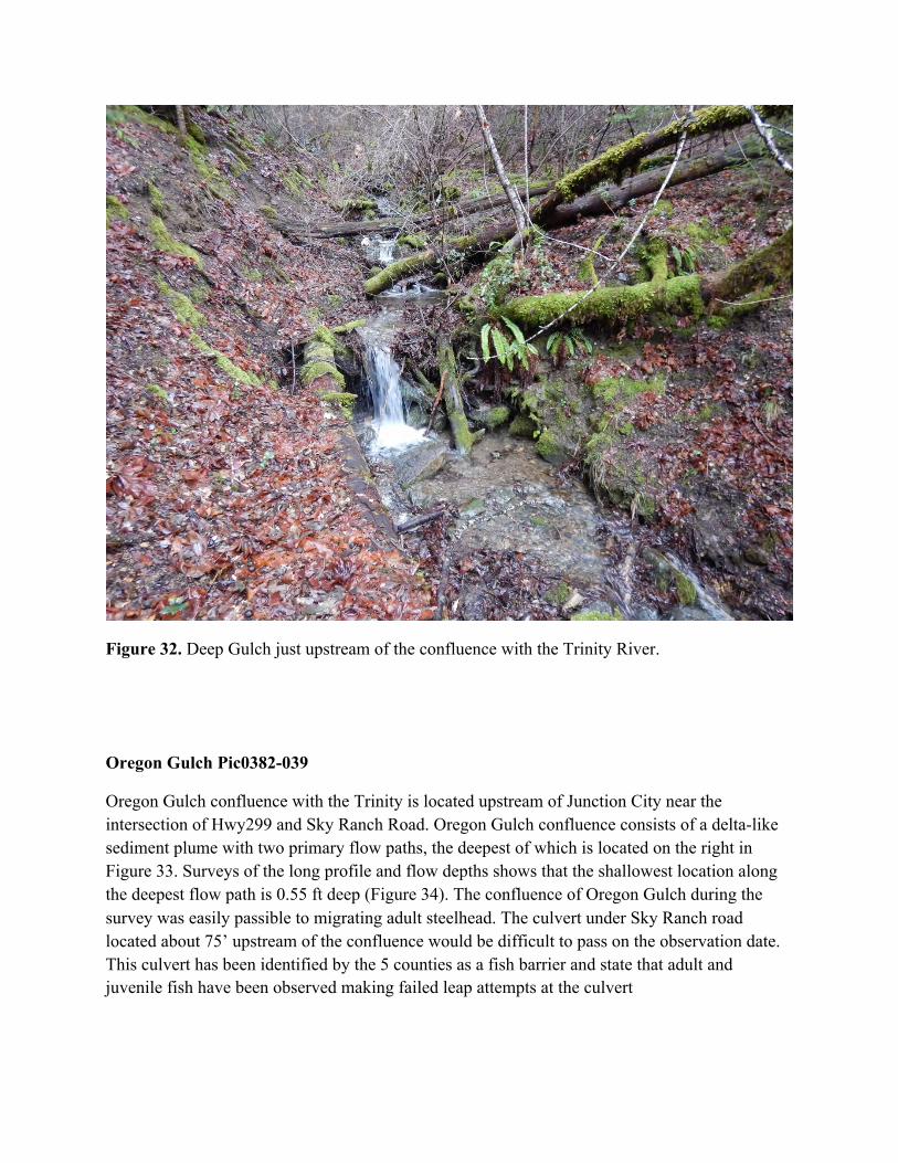
Figure 32. Deep Gulch just upstream of the confluence with the Trinity River.
Oregon Gulch Pic0382-039
Oregon Gulch confluence with the Trinity is located upstream of Junction City near the intersection of Hwy299 and Sky Ranch Road. Oregon Gulch confluence consists of a delta-like sediment plume with two primary flow paths, the deepest of which is located on the right in Figure 33. Surveys of the long profile and flow depths shows that the shallowest location along the deepest flow path is 0.55 ft deep (Figure 34). The confluence of Oregon Gulch during the survey was easily passible to migrating adult steelhead. The culvert under Sky Ranch road located about 75’ upstream of the confluence would be difficult to pass on the observation date. This culvert has been identified by the 5 counties as a fish barrier and state that adult and juvenile fish have been observed making failed leap attempts at the culvert

Figure 33. Oregon Gulch at the confluence with the Trinity River.
Figure 34. Oregon Gulch long profile and depth.

McKinney Gulch (aka Gonpa Creek) river left downstream of Dutch Creek bridge not passible Pic0398-401
McKinney Gulch, located on river left downstream of the Dutch Creek Bridge, was observed on January 1st 2016 (Figure 35). McKinney Gulch was not surveyed due to presence of thick vegetation and time constraints. The stream was determined to be impassible due to a combination of shallow flow depths, dense vegetation, and large woody debris which would inhibit migration.
Figure 35. McKinney Gulch at the confluence with the Trinity River.
Across from Junction City Camp Pic0409
The gulch on river left across from the Junction City campground is shown in Figure 36. The stream consisted of shallow water flowing over bedrock and was determined to be impassible.

Figure 36. JC Campground Gulch at the confluence with the Trinity River.
Conner Creek No Photo available
Conner Creek confluence with the Trinity River is on the left downstream of the Junction City Campground. The deepest flow path on Conner Creek reached a minimum depth of 0.45 ft (Figure 37). The flow depth of 0.45 ft would be easily passible for any steelhead attempting to traverse the confluence.

Figure 37. Conner Creek long profile and flow depth.
Trib on Left above Pear tree Pic0430-0431
A first order tributary located on river left above the Pear Tree screw trap was observed on January 11, 2016. This tributary was not surveyed, as the stream appeared to shallow to facilitate adult steelhead (Figure 38). The confluence of the stream was not passible on the date observed.

Figure 38. Unnamed tributary above Pear Tree on river left.
Trib on Left above Bagdad Pic0432-0435
An unnamed tributary located on river left upstream of the Bagdad boat launch was observed on January 11, 2016. The stream would have been difficult to pass for migrating steelhead on the survey date. Barriers to fish passage were observed upstream of the confluence; one is shown in Figure 34. While plunges like the one shown in Figure 39 appeared to be impassable at the flows observed the fisheries biologist were of the opinion that this barrier would be passible at higher flows. The long profile and depth is shown in Figure 40 and has a minimum flow depth of 0.5’ in the deepest flow path.

Figure 39. Fish barrier just upstream of the confluence on an unnamed tributary above Bagdad boat launch.
Figure 40. Long profile and flow depth of unnamed tributary on river left above Bagdad boat ramp.
Conclusions
Tributary confluences on the Trinity River located between Lewiston Dam the North Fork Trinity River were surveyed during January of 2016. This study determined the mainstem flow rate that would be required so that tributary confluences provide no barrier to fish passage. Most tributaries of third order or less were difficult for fish to pass or impassible. Forth order or larger stream confluences, with the exception of Dutch Creek, posed no barrier to fish passage. Of the 3rd order and larger streams, Hoadley Gulch requires the largest mainstem flow rate to produce confluence conditions that pose no barrier to fish passage. A mainstem flow rate of 2000 cfs would be needed to ensure that confluence conditions of the surveyed 3rd order and larger tributaries pose no barrier to fish passage.
References
US Department of the Interior, 2000. Record of Decision, Trinity River Mainstem Fishery Restoration Environmental Impact Statement/Environmental Impact Report.