fish 2017 - new · pdf fileopportunity for residents and non-residents to fish without a...
TRANSCRIPT

Fish2018A part of our heritage
Upsalquitch River, Forks Pool

Invasive speciesOur waters are being threat-ened by invasive plants and animals. Once established, invasive species are usu-ally impossible to control or eradicate. They disrupt natural ecosystems and are one of the leading causes of native species becoming threatened or endangered.
Be alert!Eurasian water-milfoil (Myriophyllum spicatum) has recently been discovered in the Saint John River system. This submersed aquatic plant creates dense mats that interfere with recreational activity. It out-competes native plants which negatively impacts our fish and wildlife. This invasive plant can spread when fragments cling to boats, motors and trailers and are moved to new areas. Please do not pass through mats of vegetation and always follow the guidelines above when moving from one waterbody to another. (Note: Some water-milfoils are native to New Brunswick.)
How to identify the intruder:• Feather-like leaves arranged in whorls of 3 to 6 around the
stem (4 leaves most common)• Whorls are openly spaced (1 cm or more) on long spaghetti-
like stems• Average 12 to 24 leaflet pairs per leaf• Tip of the plant will be reddish in colour and small reddish
flowers appear above the water surface in mid-summer
Largemouth bass have been caught in the St. Croix River (Grand Falls flowage) and Saint John River (Meduxnekeag and Mactaquac Arm). Anglers who catch a largemouth bass are encouraged to keep it and contact the nearest ERD Office. The presence of largemouth have a negative impact on existing fish species and their fisheries.
Identification tips
Largemouth bass Smallmouth bass
1 Mouth terminates behind the eye
Mouth terminates inline with or slightly ahead of the eye
2Separation between spiny and soft rays on dorsal fin
No separation between spiny and soft rays on dorsal fin
3 Dark horizontal bar Dark vertical patches
PROTECT OUR WATERSWHAT TO DOEvery time you move from one body of water to another, aquatic invasive species may travel with you. You can help! Please do the following:• Inspect and remove all visible
aquatic plants, animals and mud from canoes, kayaks, jet skis, boats, motors, trailers, etc.
• Drain all the water from your boat, including the live well, bilge, and motor.
• Wash watercraft with high-pressure or hot water or dry for 5 days.
• Check, clean, and dry all personal gear, including waders, fishing lines and lures.
• Dispose of unused bait responsibly.• Never release plants, fish or other
animals into a body of water unless they came out of that water!
LARGEMOUTH BASS
SMALLMOUTH BASS
3 – 6 leaves per whorl (usually 4)
12 – 21 leaflet pairs per leaf
Phot
o cou
rtesy
of Dr
. Meg
hann
Bruc
e
1
Fish 2018 A part of our heritage
Province of New Brunswick PO Box 6000, Fredericton NB E3B 5H1
11551 | 2018.03
www.gnb.ca
ISBN 978-1-4605-1702-4 (print) ISBN 978-1-4605-1703-1 (online)
ISSN 1914-6191 (print) ISSN 2371-8781 (online)
IMPORTANT: This is not a legal document. This book provides a brief summary of major angling regulations and licence information for the 2018 season. Regulations are subject to change at any time. This book does not cover all the laws contained in federal and provincial acts and regulations. For additional information regarding season dates, bag limits, possession limits, size limits or gear restrictions, contact your local Department of Fisheries and Oceans.
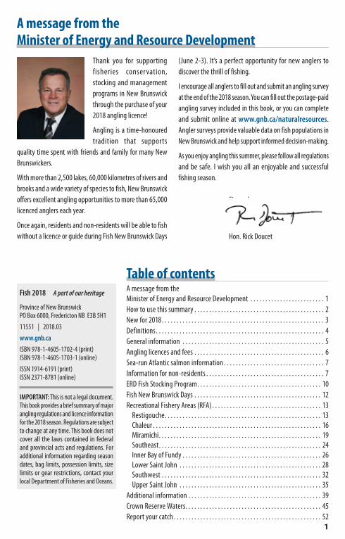
A message from the Minister of Energy and Resource Development
Thank you for supporting fisheries conservation, stocking and management programs in New Brunswick through the purchase of your 2018 angling licence!
Angling is a time-honoured tradition that supports
quality time spent with friends and family for many New Brunswickers.
With more than 2,500 lakes, 60,000 kilometres of rivers and brooks and a wide variety of species to fish, New Brunswick offers excellent angling opportunities to more than 65,000 licenced anglers each year.
Once again, residents and non-residents will be able to fish without a licence or guide during Fish New Brunswick Days
(June 2-3). It’s a perfect opportunity for new anglers to discover the thrill of fishing.
I encourage all anglers to fill out and submit an angling survey at the end of the 2018 season. You can fill out the postage-paid angling survey included in this book, or you can complete and submit online at www.gnb.ca/naturalresources. Angler surveys provide valuable data on fish populations in New Brunswick and help support informed decision-making.
As you enjoy angling this summer, please follow all regulations and be safe. I wish you all an enjoyable and successful fishing season.
Sincerely,
Hon. Rick Doucet
Table of contentsA message from the Minister of Energy and Resource Development . . . . . . . . . . . . . . . . . . . . . . . . . 1How to use this summary . . . . . . . . . . . . . . . . . . . . . . . . . . . . . . . . . . . . . . . . . . . . 2New for 2018 . . . . . . . . . . . . . . . . . . . . . . . . . . . . . . . . . . . . . . . . . . . . . . . . . . . . . . . 3Definitions . . . . . . . . . . . . . . . . . . . . . . . . . . . . . . . . . . . . . . . . . . . . . . . . . . . . . . . . . 4General information . . . . . . . . . . . . . . . . . . . . . . . . . . . . . . . . . . . . . . . . . . . . . . . . 5Angling licences and fees . . . . . . . . . . . . . . . . . . . . . . . . . . . . . . . . . . . . . . . . . . . . 6Sea-run Atlantic salmon information . . . . . . . . . . . . . . . . . . . . . . . . . . . . . . . . . . 7Information for non-residents . . . . . . . . . . . . . . . . . . . . . . . . . . . . . . . . . . . . . . . . 7ERD Fish Stocking Program . . . . . . . . . . . . . . . . . . . . . . . . . . . . . . . . . . . . . . . . . . 10Fish New Brunswick Days . . . . . . . . . . . . . . . . . . . . . . . . . . . . . . . . . . . . . . . . . . . 12Recreational Fishery Areas (RFA) . . . . . . . . . . . . . . . . . . . . . . . . . . . . . . . . . . . . . 13
Restigouche . . . . . . . . . . . . . . . . . . . . . . . . . . . . . . . . . . . . . . . . . . . . . . . . . . . . . 13Chaleur . . . . . . . . . . . . . . . . . . . . . . . . . . . . . . . . . . . . . . . . . . . . . . . . . . . . . . . . . 16Miramichi . . . . . . . . . . . . . . . . . . . . . . . . . . . . . . . . . . . . . . . . . . . . . . . . . . . . . . . 19Southeast . . . . . . . . . . . . . . . . . . . . . . . . . . . . . . . . . . . . . . . . . . . . . . . . . . . . . . . 24Inner Bay of Fundy . . . . . . . . . . . . . . . . . . . . . . . . . . . . . . . . . . . . . . . . . . . . . . . 26Lower Saint John . . . . . . . . . . . . . . . . . . . . . . . . . . . . . . . . . . . . . . . . . . . . . . . . 28Southwest . . . . . . . . . . . . . . . . . . . . . . . . . . . . . . . . . . . . . . . . . . . . . . . . . . . . . . 32Upper Saint John . . . . . . . . . . . . . . . . . . . . . . . . . . . . . . . . . . . . . . . . . . . . . . . . 35
Additional information . . . . . . . . . . . . . . . . . . . . . . . . . . . . . . . . . . . . . . . . . . . . . 39Crown Reserve Waters . . . . . . . . . . . . . . . . . . . . . . . . . . . . . . . . . . . . . . . . . . . . . . 45Report your catch . . . . . . . . . . . . . . . . . . . . . . . . . . . . . . . . . . . . . . . . . . . . . . . . . . 52

2
How to use this summary1. Where: See the map below and turn to the page of the Recreational Fishery Area (RFA) where you will be fishing.2. What species: Decide which species you want to fish.3. Look under the species name: For season, bag limit, size limit and exceptions.4. Look under Exceptions and special regulations: Check to see if the water you want to fish is closed or has special gear
or harvest restrictions.
Recreational Fishery Areas (RFAs)
1. Restigouche — page 132. Chaleur — page 163. Miramichi — page 194. Southeast — page 245. Inner Bay of Fundy — page 266. Lower Saint John — page 287. Southwest — page 328. Upper Saint John — page 35

3
New for 2018• Sea-Run Atlantic Salmon—Atthetimethisbookwaspublished,themandatoryhookandreleaserequirementforsea-runAtlanticsalmonwasineffectonallwatersofNewBrunswick.PleaseconsulttheDepartmentofFisheriesandOceans’webpagefordetailsaboutsea-runAtlanticsalmonregulationsathttp://www.glf.dfo-mpo.gc.ca/Gulf/FAM/Recreational-Fisheries(orsearchbykeywords‘’DFOGulfRegionrecreationalfisheries’’).YoucanalsocallthenearestDFOconservationandprotectionoffice(seecontactlistbelow).
• Non-sport fish on boundary waters with Maine:Thesmeltdailybaglimitisnow60(reducedfrom200)andthewhitefishlimitisnow3(reducedfrom8).
• Striped bass—Atthetimethisbookwasprinted,informationonmanagementmeasuresandseasonsforStripedbassintheRestigouche,Chaleur,MiramichiandSoutheastRFAswasnotavailable.PleaseconsulttheDepartmentofFisheriesandOceans’websitefordetailsaboutStripedbassregulationsathttp://www.glf.dfo-mpo.gc.ca/Gulf/FAM/Recreational-Fisheries(orsearchbykeywords‘’DFOGulfRegionrecreationalfisheries’’).YoucanalsocallthenearestDFOconservationandprotectionoffice(seecontactlistbelow).
DFO Conservation and Protection Detachments
Detachment Telephone number Detachment Telephone numberBaieSte-Anne 506-228-4263 Quispamsis 506-849-1416,ext.221Beresford 506-542-7485 Renous 506-622-5992Campobello 506-752-2935 Richibucto 506-523-4606Caraquet 506-727-3038 Shediac 506-533-5033Charlo 506-684-2202 Shippagan 506-336-6474Fredericton 506-452-3018,ext.221 SouthEsk 506-773-3268
GrandManan 506-662-3151 St.George 506-755-5000GrandFalls 506-473-3993 Tracadie 506-395-7706Neguac 506-776-3307
4
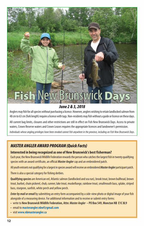
DefinitionsAngling: Fishing with a line to which up to three hooks are attached, held in the hand or attached to a rod.
Artificial Fly: A single hook, a double hook or two single hooks dressed with materials likely to attract fish, with no weight, spinning device or natural bait attached.
Boundary Waters: Waters forming the boundary between the State of Maine and/or the Province of Quebec and the Province of New Brunswick.
Bag Limits: The possession limit for a particular species is the same as the daily bag limit.
Fly Fishing: To cast upon the water and retrieve in the usual and ordinary manner an unbaited, unweighted artificial fly attached to a line to which no weight has been added. Trolling with artificial flies is permitted.
Fly Fishing Only Waters (Scheduled): Waters where fly fishing is the only method of angling permitted.
Guide Required Waters: Waters deemed to be angled mainly for Atlantic Salmon. Non-Residents require a guide while angling for any species on these waters after the designated date.
Hook: A single, double or treble hook, with or without barbs, on one shank or shaft.
Jigging: Manipulating a hook(s) to foul-hook a fish in any part of its body instead of its mouth.• Foul-hooked fish are those fish hooked accidentally in any
part of the body except the mouth, which must be released unharmed immediately.
Length Measurements:• Fork length (FL) is measured from the tip of the nose to the
fork of the tail— used when measuring Atlantic salmon or landlocked salmon.
• Total length (TL) is measured from the tip of the nose to the end of the tail (tips of the tail squeezed together)— used when measuring all other fish.
Live Release: Capture and immediate release of live fish.
Main Restigouche River: The main stem of the Restigouche River, from the junction with the Little Restigouche River and Kedgwick River, downstream to the J.C. Van Horne Bridge.
Main Southwest Miramichi River: The main stem of the Southwest Miramichi River, from the forks at Juniper, downstream to the junction with the Northwest Miramichi River.
Non-Sport Fish Seasons: Legal access to non-sport fish species in inland waters is governed by the season for sport fish. If all sport fish seasons on a particular water are closed, then the non-sport fish season is also closed.
Resident:a) A person who has resided in the province for a period of
six months immediately prior to making an application for a licence.
b) A person who has resided in the province for a period of two weeks immediately prior to making an application for a licence, where that person was required to take up residence in the province as a result of being transferred to the province by their employer.
c) A person who is taking educational training of a three-month minimum duration and has been residing in the province for a two-week period immediately prior to making an application for a licence.
d) A person who resided in the province for a period of six months immediately prior to taking educational training outside the province.
e) A person who has resided in the province for the purpose of employment for an aggregate period of six months within the last 12 months.
f) A person who was born in the province and who owns real property in the province.
g) a person who was born in the Province and who is a member of the Canadian Forces or the Royal Canadian Mounted Police.
h) a person who has his or her principal place of residence in the Province and is the holder of a valid New Brunswick driver’s licence or a valid photo identification card issued by the Minister of Public Safety and referred to in the regulations under the Financial Administration Act.
Set Line: A fishing line that is not attached to a rod, held in the hand or closely attended.
Sport Fish: Sea-run Atlantic salmon, landlocked salmon, brook trout, brown trout, lake trout, rainbow trout, arctic char, and smallmouth bass.
Trolling: Angling with a hook(s) and line that is drawn through the water by a watercraft propelled by mechanical or manual means.

5
General informationActivities not allowed while angling(Applies to the open water season on inland waters)• Sport fish may not be caught by means other than angling.• No person shall angle with more than one fishing line to
which more than three hooks are attached.• No person shall use a set-line for fishing in inland waters.• No person shall angle for sport fish in waters during the
period beginning two hours after sunset and ending two hours before sunrise (see exception, page 14).
• No person shall fish with the aid of an artificial light or light from a fire.
• No person shall use or possess live fish (including crayfish) as bait in inland waters.
– Exception: On international boundary waters (between Maine and New Brunswick), live fish may be used as bait provided they are obtained from the water being fished and are not on the prohibited list.*
– On international boundary waters (between Maine and New Brunswick), tidal waters and all inland waters, dead fish can be used as bait as long as they are not on the prohibited list.** Prohibited species: bass, bullhead, sunfish, yellow
perch, white perch, other spiny fin-rayed fish, pickerel, muskellunge, goldfish or other carp.
• Fishing with bait or lures is not permitted on Crown Reserve Waters. Artificial flies must be used while fishing these waters.
• Fishing and/or assisting another angler to fish from a bridge is not permitted.
• Fishing is not permitted within 22.8 m (25 yards) downstream from the lower entrance to any fish-way, canal, obstacle or leap.
• Fishing is not permitted within a 100 m radius of any facility operated by or on behalf of the Department of Fisheries and Oceans or the Province for the purposes of counting, passage or rearing of fish.
• Gaffs cannot be used to land sport fish.• Jigging devices or spears are not permitted within 15 m
of inland waters.• Snares or bows and arrows are not permitted in inland
waters or within 15 m of inland waters unless the person is lawfully hunting or trapping.
• Fishing by jigging, or assisting in landing fish that have been caught by jigging in inland waters is not permitted.
Angling ethics and courtesyEthical anglers are those who appreciate New Brunswick’s natural culture and its history. They protect our natural resources. They fish in a responsible manner. They respect the rights of others and they handle their catch in a humane manner.
Respect our fish as a valuable resource:• Do not kill fish that you do not intend to use.• Learn proper handling techniques to ensure released
fish survive.• If you have decided to keep a fish, kill it quickly.• Treat fish in a humane manner, whether they are retained,
released or used as bait.• Ensure quality angling for future generations. Limit your
catch, rather than catching your limit.
Respect the environment and our aquatic habitat:• Do not litter. If you brought it in, take it out. Leave the area
cleaner than you found it.
Respect other users and their property:• Fishing should be an enjoyable experience for all. Don’t
spoil it for others.• Cooperate with all resource users, including other anglers,
swimmers and boaters.• Respect private property and private water.

6
Angling licences and feesLicences are available at www.gnb.ca/naturalresources, from authorized vendors, and all Service New Brunswick centres. Contact your local Energy and Resource Development (ERD) office or our website to find the location nearest you (see page 39). Fish & Wildlife tags are available from all authorized vendor and ERD/SNB locations.
Type Class Period Salmon tags Cost *
Resid
ent Atlantic salmon
(Includes all other fish)
Retention (with tags)
7 (under 65 years of age) Season 4 $36.40
8 (10 - 15 years of age / 65 or over) Season 4 $20.00
Live release (salmon only)
16 (under 65 years of age) Season 0 $36.40
17 (10 - 15 years of age / 65 or over) Season 0 $20.00
All fish except Atlantic salmon
9 Season 0 $23.00
10 (65 years of age or over) Season 0 $15.00
Non-
resid
ent
Atlantic salmon (Includes all other fish)
Retention (with tags)
1 Season 4 $173.00
2 7-day ** 2 $100.00
3 3-day ** 1 $53.00
Live release (salmon only)
13 Season 0 $173.00
14 7-day ** 0 $100.00
15 3-day ** 0 $53.00
All fish except Atlantic salmon
4 Season 0 $64.00
5 7-day ** 0 $41.00
6 3-day ** 0 $30.00
* Licence cost includes fish stocking fee, conservation fees collected for the New Brunswick Wildlife Trust Fund and tax is not included.
** Valid only for consecutive calendar days. For example: June 30, July 1 and July 2.
One day angling adventures may be available to resident and non-resident anglers from specific operators and outfitters. For more information, see www.tourismnewbrunswick.ca
Federal law stipulates that any landlocked salmon from 48 cm to 63 cm fork length requires an Atlantic salmon tag if it is retained. For this reason, an Atlantic salmon retention licence, with valid tag(s) is required for an angler to retain landlocked salmon in this size range. Anglers wishing to retain landlocked salmon in the 48 – 63 cm length range must purchase a Licence Class 1, 2, 3, 7 or 8.

7
Licence requirements• Angling licences must be properly signed and carried at
all times while fishing.• Angling licences are not required in tidal waters, except
if landlocked salmon are retained. New Brunswick tidal water boundaries are described at www.gnb.ca/naturalresources
• Anglers can only purchase one Class 1, 7, or 8 licence per season.
• Anglers 16 years of age and older require a provincial licence while angling in inland waters.
• An angling licence does not authorize the holder to purchase, sell or barter sport fish.
Anglers under the age of 16• Anglers, who are under 16 and do not have an Atlantic
salmon licence, may fish for Atlantic salmon only when accompanied by an angler with a valid salmon licence. The licence holder must include the child’s Atlantic salmon catch in his/her daily catch limit.
• Resident anglers 10 - 15 years old must buy a salmon licence if they want their own catch limit.
• Anglers under the age of 16 who do not wish to fish for Atlantic salmon do not require an angling licence. These anglers have their own daily bag limit.
• Regular angling licences do not entitle anglers to fish on Crown Reserve Waters.
– For information on youth anglers on Crown Reserve waters, see page 45.
Sea-run Atlantic salmon information• See individual Recreational Fishery Area (RFA) for detailed
Atlantic salmon information.• All sea-run Atlantic salmon and grilse must be live released.• Only artificial flies are permitted on fly fishing only waters.• Once anglers have reached their daily live release limit, they
must stop fishing for sea-run Atlantic salmon.
In-season pool closures in the Miramichi River systemThere is an overall concern for the status of Atlantic salmon under stressful conditions associated with exceptional climatic events. To reduce the impact of fishing on Atlantic salmon, a protocol to close certain salmon holding pools in the Miramichi River during stressful warm water conditions has been developed using science-based advice.
For more information on these conservation measures, please refer to DFO Gulf Region’s Recreational Fisheries webpage: www.glf.dfo-mpo.gc.ca/Gulf/FAM/Recreational-Fisheries
Information for non-residents• Non-resident anglers require a licensed guide when fishing
for sea-run Atlantic salmon, or when angling for any species on Guide Required Waters after the designated date.
• Non-residents may fish without a guide on Fish New Brunswick Days but require an appropriate licence if a landlocked salmon (from 48 cm to 63 cm) is retained.
• Professional guides (Guide I) are permitted to angle and hook a salmon on behalf of his or her licensed client. The client is considered to have hooked the salmon, which counts towards their live release limit.
• Professional guides (Guide I) may accompany as a guide: three licensed persons while wading or fishing from shore for Atlantic salmon or while angling in Guide Required Waters; or one licensed person while angling from a boat for Atlantic salmon in Guide Required Waters.
• Professional guides (Guide I) and their clients cannot fish at the same time.
• Non-residents may purchase any number or combination of Class 2 or Class 3 licences as long as the total number of tags does not exceed four per year.

8
Guide required watersNon-resident anglers must be accompanied by a licensed New Brunswick guide when fishing these waters after the specified dates.
RiverGuide required
beginning Guide required stretchRestigouche RFAKedgwick May 15 Entire river
Little Main Restigouche May 15 Entire river (Note: a portion of this river is restricted to residents only - see page 13)
Northwest Upsalquitch May 15 Mouth upstream to the closed watersPatapedia May 15 Entire river
Restigouche May 1 From line drawn from Copeland Brook (NB) to Ruisseau du Moulin (Quebec) upstream to Little Main Restigouche
Southeast Upsalquitch May 15 Entire riverUpsalquitch May 15 Entire riverChaleur RFABig Tracadie Apr 15 Murchie Bridge to St. Sauveur roadJacquet July 1 Route 11 bridge to Lower McNair BrookNepisiguit Apr 15 The Consolidated Bathurst Pumping Station Dam to Nepisiguit FallsTetagouche Apr 15 From and including Minnie’s Pool upstream to Tetagouche FallsMiramichi RFABartholomew June 1 Mouth upstream to forks of North & South branchesBartibog Apr 15 Egans Quarry upstream to Green Brook Big Sevogle Apr 15 Entire river including North & South branchesCains Apr 15 Mouth upstream to North Cains River
Dungarvon Apr 15 Mouth upstream to western limit of timber block 222 (N 46°45.68’, W 066° 34.67’)
Little Southwest Miramichi Apr 15 Upstream of the Oxbow on the north boundary line of the Red Bank
Indian Reserve No. 7Lower North Branch Little Southwest Miramichi Apr 15 Entire river
Main Southwest Miramichi Apr 15
A line drawn from grid reference 87948796 to 87048802 (the Old Squaw Rock above the mouth of the Renous River) upstream to junction of North and South Branches
North Branch Renous Apr 15 Mouth upstream to North Renous Lake North Branch Southwest Miramichi Apr 15 Forks upstream to Beadle Brook
Northwest Miramichi Apr 15 From and including Scott’s Rapid Pool upstream to the forksRenous Apr 15 Entire river upstream of the Route 8 bridgeSouth Branch Southwest Miramichi Apr 15 Forks upstream to Flemming Gibson Dam at Juniper
South Branch Renous Apr 15 Mouth upstream to forks with Little Renous River Tabusintac Apr 15 Head of Tide Island upstream to Route 8 bridgeTaxis July 1 Mouth upstream to Highway 625 crossing Tomogonops June 15 Mouth upstream to South Branch

9
Salmon angling courtesy• Start upstream of others: Begin fishing upstream of
anglers that are already fishing a pool or run.• Don’t crowd other anglers: Leave some space between
you and the angler downstream so you don’t affect their ability to cast and fish through the pool.
• Fish through the pool: Anglers should move downstream at a reasonable pace while fishing a pool or run to allow upstream or waiting anglers an opportunity to fish the water (applies for shore and boat anglers alike).
• Slow your boat: Reduce the wake from your boat by slowing down and taking a wide berth when passing anglers fishing from shore or in another boat.
• Don’t anchor too close to wading anglers: When arriving to fish a pool from a boat, allow anglers who are fishing from shore with enough room to cast.
• Always yield to an angler who has a fish on the line: The angler below and above should reel in line and be prepared to give the angler fighting the fish room to play and land his/her catch.
• Give others a chance after you have landed a fish: An angler who lands a salmon or grilse should rotate to the beginning if they wish to continue fishing a pool or run. An angler who loses a fish may return to his/her place in line.
Tips on releasing fish• Consider using artificial lures and barbless hooks.• Retrieve your catch quickly. Use appropriate size tackle to
quickly land the fish or break off large fish.• Release the fish immediately by gently placing it in
calm water.• Keep your fingers out of the gills and eyes.
• Avoid squeezing the fish. Use both hands to evenly support the fish’s weight.
• Keep the fish in the water as much as possible.• Cut the line and leave deeply embedded or swallowed
hooks in the fish.• A fish that can be legally kept should not be released if
it is bleeding heavily. Its chance of surviving is very low.

10
ERD Fish Stocking ProgramEnergy and Resource Development’s Fish Stocking Program aims to enhance recreational angling opportunities for brook trout and landlocked salmon. These species are stocked annually, when possible, to a number of lakes throughout the province. Stocking is carried out in the spring or fall, with fall stocked fish (f) generally ranging in size from 10 cm - 15 cm (4” - 6”) and spring stocked fish (s) from 15 cm - 25 cm (6” - 10”). The table below provides details about the waters stocked in 2017. For more information, or a list of previous years’ stockings, please visit our website: http://www2.gnb.ca/content/gnb/en/departments/erd/natural_resources/content/fish.html
NOTE: Stocking amounts of brook trout were below target due to unforeseen circumstances at the growers’ facilities.
Brook Trout Stocking 2017County Lake/pond, number stocked (season stocked)
Gloucester Bass River 6750 (f) Pabineau 6960 (f)
Landlocked Salmon Stocking 2017County Lake/ Pond, Amount stocked (season stocked)
CharlotteChamcook 720 (s)Digdeguash 1010 (s)
Gibson 50 (s) Little Chamcook 100 (s)
Utopia 3400 (s)Wheaton 220 (s)
Madawaska Baker 420* (f)Queens Grand 20930 (s) Grand 110* (f)
York Magaguadavic 6010 (s) Oromocto 5010 (s)
* adult
Protect our watersIt is illegal to transfer fish or to stock waters without authorization!What is the problem?Introduced species:• prey on resident fish species• compete for food and space• disrupt natural ecosystems• introduce diseases and parasites to native fish.
What can you do?• Do not stock or move fish. It is illegal to transfer or stock
any fish without federal authorization.• Be aware of bait regulations. It is illegal to use live fish as
bait in most New Brunswick waters. Where use of live bait is legal, use bait from the body of water you are fishing.
• Never release aquarium or pond fish into natural waters.
To report illegal fish stocking activity, please call 1-800-222-8477 or go online to www.crimenb.ca
ERD fish stocking program assessmentBefore being stocked, a fin is clipped on each fish so it can be distinguished from wild fish. If you catch a brook trout or landlocked salmon with a fin clip please add a note on your angler survey (see insert) indicating which fin was clipped along with the length, date and location (waterbody) of your catch.
This information is important in helping us evaluate the Fish Stocking Program. PLEASE REPORT YOUR CATCH!
ADIPOSE FIN (AD)
VENTRAL FINS

11
Wild Atlantic Salmon need your help.REPORT POACHINGRight now, Atlantic salmon need full protection and anglers can be part of the solution.
• Report to both ERD and DFO any information on either large salmon or grilse being killed.
• If activity is in progress, faster reporting by cell phone is important.
Phone ERD• Doaktown 506-365-2001• Miramichi 506-627-4050• Fredericton 506-453-2345• Bathurst 506-547-2080• Campbellton 506-789-2336
Note: In business hours, the above numbers are manned — for other times, if poaching is in progress, press “1” to connect to the Mobile Communications Centre *
Phone DFO1-800-565-1633 and listen for prompts taking you to conservation and protection.
Detachment numbers are available athttp://asf.ca/dfo-enforcement.html
* Be sure to ask a conservation/fishery officer to phone you back.
Gather some evidence to support your report.
• Note details of activity — exact date, time and location.
• Take photos and note car licence plate number if possible.
The more salmon and grilse that get to the spawning beds, the better chance we will have healthy runs and an
improved New Brunswick economy in the future.
This is your resource…don’t let poachers take what is yours!
12
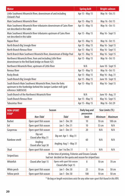
MASTER ANGLER AWARD PROGRAM (Quick Facts)Interested in being recognized as one of New Brunswick’s best fisherman?Each year, the New Brunswick Wildlife Federation rewards the person who catches the largest fish in twenty qualifying species with an award certificate, an official Master Angler cap and an embroidered patch.
All youth entrants not qualifying for a largest in species award will receive an embroidered Master Angler participant patch.
There is also a special category for fishing derbies.
Qualifying species are American eel, Atlantic salmon (landlocked and sea run), brook trout, brown bullhead, brown trout, burbot, chain pickerel, chub, cunner, lake trout, muskellunge, rainbow trout, smallmouth bass, splake, striped bass, sturgeon, sunfish, white perch and yellow perch.
Enter by mail or email by submitting an entry form accompanied by a side-view photo or digital image of your fish alongside of a measuring device. For additional information and to receive or submit entry forms:• write to New Brunswick Wildlife Federation, Attn: Master Angler – PO Box 549, Moncton NB E1C 8L9• email to [email protected]• visit www.nbmasterangler.ca
Fish New Brunswick DaysJune 2 & 3, 2018
Anglers may fish for all species without purchasing a licence. However, anglers wishing to retain landlocked salmon from 48 cm to 63 cm (fork length) require a licence with tags. Non-residents may fish without a guide or licence on these days.
All current bag limits, closures and other restrictions are still in effect on Fish New Brunswick Days. Access to private waters, Crown Reserve waters and Crown Leases requires the appropriate licences and landowner’s permission.
Individuals whose angling privileges have been revoked cannot fish anywhere in the province, including on Fish New Brunswick Days.

13
RestigoucheRecreational Fishery Area
Boundary description: All lakes, rivers, and streams of the Restigouche River and tributaries upstream of the J.C. Van Horne Bridge at Campbellton.
Attention anglers:• Refer to “Exceptions and special regulations” listed
below for water specific regulations.• The angling season in the Restigouche RFA closes Sept 15
on all inland waters not open to Atlantic salmon angling or noted otherwise in the exceptions below.
• Crown Reserve Waters are not open to fishing before or after the Crown Reserve season dates. (See exceptions below)
• The Restigouche River main stem is primarily private or leased waters. Permission from the owner/lessee is required to angle on these waters.
• The Little Main Restigouche River from the junction of the Kedgwick River upstream to, but not including, the pool at the mouth of Jardine Brook is restricted to Resident anglers only.
TROUT
Season
Daily bag and
possession limit
Minimum Size Limits (TL)
Brook trout
Arctic char, brown trout,
rainbow trout Lake troutRivers, brooks and streams May 1 - Sept 15
5* 10 cm 15 cm 45 cmLakes, ponds and reservoirs May 15 - Sept 15
* No more than 2 lake trout
ATLANTIC SALMONSeason
Daily bag limit
Daily hook and release limit
Spring keltRefer to the table below
TBD * 10 **Bright salmon TBD * 4 **
* To be determined: Contact DFO for more information (see 3)
** Anglers must stop fishing for Atlantic salmon when the daily hook and release limit is met. Artificial flies are required when angling for Atlantic salmon.
Atlantic salmon seasons — Includes all tributaries unless otherwise notedWater Spring kelt Bright salmonGounamitz River N/A June 1 - Sept 30Kedgwick River N/A June 1 - Sept 30Little Main Restigouche River, upstream to Cedar Brook May 1 - 31 June 1 - Sept 30Main Restigouche boundary waters Apr 15 - May 31 June 1 - Sept 30Main Restigouche non-boundary waters May 1 - 31 June 1 - Sept 30North Kedgwick River N/A June 1 - Sept 30Northwest Upsalquitch River N/A June 1 - Sept 30Patapedia River N/A June 1 - Sept 30Southeast Upsalquitch River N/A June 1 - Sept 30Upsalquitch River N/A June 1 - Sept 30

14
NON-SPORT FISH*
Season Daily bag and possession
limit
Size Limits (TL)
Non-Tidal Tidal Minimum Maximum
Burbot Open sport fish season Jan 1 - Dec 30 10 10 cm 100 cmEel Open sport fish season Jan 1 - Dec 31 10 53 cm N/AGaspereau Open sport fish season Jan 1 - Dec 31 20 N/A N/A
Rainbow smeltDip net: Closed after May 31 Dip net: Apr 1 - May 31
60 N/A N/AAngling: Closed after Sept 30 Angling: Aug 1 - May 31
Shad Open sport fish season Jan 1 - Dec 31 5 N/A N/A
Striped bass At the time of printing, Fisheries and Oceans Canada had not decided on the quota and season for striped bass
Whitefish Closed after Sept 15 Opens with sport fish seasonClosed after Sept 15
8 10 cm 70 cm
White perch Open sport fish season Jan 1 - Dec 30 25 10 cm 50 cmYellow perch Open sport fish season Jan 1 - Dec 30 100 10 cm 50 cm
* No bag or length restrictions exist for any other non-sport fish found in this RFA.
Exceptions and special regulations — excludes all tributaries unless noted otherwiseNote: All fly fishing waters are restricted to angling with an artificial fly only.
Waterbody Stretch Exception
All tidal waters limits of inland tidal waters
No fishing for striped bass from 2 hours after sunset to 2 hours before sunrise
Non-offset barbless circle hook is mandatory when fishing for striped bass with bait from May 1 to Sept 30
Gounamitz Riverentire waterbody Brook trout minimum
size limit (TL): 25 cm
upstream to the junction of the North and West Branches Fly fishing only beginning July 1
Jardine Brook, Restigouche County
from its junction with the Little Main Restigouche upstream to the Restigouche-Victoria county boundary line
Fly fishing only beginning July 1
Jardine Brook, Victoria County
from the Restigouche-Victoria county boundary line upstream to the CN railway bridge
Fly fishing only beginning Aug 1
Kedgwick River including North and South Branches Fly fishing only beginning May 1
Little Main Restigouche River
from its junction with the Main Restigouche River (a line drawn from grid reference 613248 5279890 to grid reference 613337 5279856) upstream to Cedar Brook
Fly fishing only beginning May 15
Northwest Upsalquitch River
downstream of Nine Mile Brook (grid reference 664850 5275150) Fly fishing only beginning May 1
upstream of Nine Mile Brook (grid reference 664850 5275150) Closed to anglingPatapedia River (Crown Reserve waters) entire waterbody Fly fishing only
beginning June 1
Restigouche drainage upstream from the junction of the Kedgwick River and the Little Main Restigouche, including all tributaries
Trout daily bag limit beginning Sept 1: 0
Restigouche River from the Kedgwick River downstream to the Patapedia River Fly fishing only beginning May 15

15
Waterbody Stretch Exception
Restigouche River (continued)
from the Patapedia River downstream to the Matapedia CN Railway bridge
Fly fishing only beginning April 15
5 trout daily bag limit in effect until Sept 30
from the Matapedia CN Railway bridge downstream to a line between Copeland Brook (NB) and Ruisseau du Moulin (QC)
Fly fishing only beginning May 15
from the Matapedia CN Railway bridge downstream to the J.C. Van Horne Bridge
5 trout daily bag limit in effect from April 15
until Oct 31upstream of a line drawn between Copeland Brook (NB) and Ruisseau du Moulin (QC) Smelt season closed
Devil’s Half Acre, Three Sisters, and Red Bank Crown Reserve stretches
Open to angling without a
Crown Reserve licence before June 1
South Branch Kedgwick River entire waterbody Trout minimum size
limit (TL): 25 cm
Southeast Upsalquitch River
upstream to the first unnamed pool (grid reference 680703 5279878) above Boar’s Head pool
Fly fishing only beginning May 1
from and including the first unnamed pool (grid reference 680703 5279878) above Boar’s Head pool upstream to Simpson’s Field Falls
Closed to angling
Upsalquitch River entire waterbody Fly fishing only beginning May 1
DFO Atlantic salmon and striped bass tagging programs
Fisheries and Oceans (DFO) with many partners regularly tag fish in experiments to determine fish behaviour, movements, growth and fishing catch rates. The recovery of tagged fish and the success of these tagging campaigns rely on the collaboration of recreational anglers and the fishing industry.
Atlantic salmon: If you catch an Atlantic salmon with a DFO tag, please remove the tag and send it, along with the date and location of capture, to the address on the back of the tag:
Science Branch, Department of Fisheries and Oceans: PO 5030, Moncton NB E1C 9B6
You can also send the information and a photo of the tag by email to [email protected]
Be sure to include your name, address and phone number/email for contact purposes and to receive information on your fish. Anglers who return tags will have their names entered in the North Atlantic Salmon Conservation Organization (NASCO) tag return incentive draw. Each year, a grand prize of US$2,500 is awarded as well as a US$1,500 prize for the North American area.
Striped bass: If you catch a Striped Bass with a DFO tag, please remove the tag and send it, along with the date and location of capture, to the address on the back of the tag:
Science Branch, Department of Fisheries and Oceans: PO 5030, Moncton NB E1C 9B6
You can also send the information and a photo of the tag by email to [email protected]
Be sure to include your name, address and phone number/email for contact purposes.

16
ChaleurRecreational Fishery Area
Boundary description: All lakes, rivers, and streams draining into the Bay of Chaleur seaward of the J.C. Van Horne Bridge at Campbellton and all waters draining into the Gulf of St. Lawrence north of Tabusintac Bay.
Attention anglers:• Refer to “Exceptions and special regulations” listed
below for water specific regulations.• Crown Reserve Waters are not open to fishing before or
after the Crown Reserve season dates.• The angling season in the Chaleur RFA closes Sept 15 on
all inland waters not open to Atlantic salmon angling,
landlocked salmon angling or noted otherwise in the exceptions below.
• Landlocked salmon angling is closed in all waters other than those listed in the “Landlocked Salmon” table below.
TROUT
SeasonDaily bag and
possession limit
Minimum Size Limits (TL)
Brook trout
Arctic char, brown trout,
rainbow troutRivers, brooks and streams May 1 - Sept 15
5 10 cm 15 cmLakes, ponds and reservoirs May 15 - Sept 15
LANDLOCKED SALMON*Season
Daily bag and possession limit
Size Limits (FL)Minimum Maximum
Middle Tetagouche LakeMay 15 - Sept 30 2* 35 cm 63 cm
Upper Tetagouche Lake
* Any landlocked salmon from 48 cm to 63 cm FL requires an Atlantic salmon tag if it is retained.
ATLANTIC SALMONSeason
Daily bag limit
Daily hook and release limit
Spring keltRefer to the table below
TBD * 10 **Bright salmon TBD * 4 **
* To be determined: Contact DFO for more information (see page 3)
** Anglers must stop fishing for Atlantic salmon when the daily hook and release limit is met. Artificial flies are required when angling for Atlantic salmon.
Atlantic salmon seasons — Includes all tributaries unless otherwise notedWater Spring kelt Bright salmonBass River Apr 15 - May 15 May 16 - Oct 22Benjamin River Apr 15 - May 15 May 16 - Oct 22Caraquet River Apr 15 - May 15 May 16 - Oct 15Charlo River Apr 15 - May 15 May 16 - Oct 22Eel River Apr 15 - May 15 May 16 - Oct 22Jacquet River, upstream of Halfway Pool N/A June 1 - Oct 15Jacquet River, from and including Halfway Pool downstream to mouth Apr 15 - May 15 May 16 - Oct 22Little River Apr 15 - May 15 May 16 - Oct 15

17
Water Spring kelt Bright salmonLittle Tracadie River Apr 15 - May 15 May 16 - Oct 15Middle River Apr 15 - May 15 May 16 - Oct 22Millstream River Apr 15 - May 15 May 16 - Oct 22Nepisiguit River, from Nepisiguit Falls downstream to mouth N/A June 1 - Oct 22Nigadoo River Apr 15 - May 15 May 16 - Oct 22Pokemouche River Apr 15 - May 15 May 16 - Oct 15South Caraquet River Apr 15 - May 15 May 16 - Oct 29Tetagouche River Apr 15 - May 15 May 16 - Oct 22Big Tracadie River, downstream of Lord & Foy Brook Apr 15 - May 15 May 16 - Oct 29Big Tracadie River, upstream of Lord & Foy Brook N/A June 1 - Oct 15
NON-SPORT FISH*
Season Daily bag and possession
limit
Size Limits (TL)
Non-Tidal Tidal Minimum Maximum
Burbot Open sport fish season Jan 1 - Dec 30 10 10 cm 100 cmEel Open sport fish season Jan 1 - Dec 31 10 53 cm N/AGaspereau Open sport fish season Jan 1 - Dec 31 20 N/A N/A
Rainbow smelt
Dip net: Closed after May 31
Dip net: Apr 1 - May 31
60 N/A N/AAngling:
Closed after Sept 30Angling: Aug 1 - May 31
Shad Open sport fish season Jan 1 - Dec 31 5 N/A N/A
Striped bass At the time of printing, Fisheries and Oceans Canada had not decided on the quota and season for striped bass
Whitefish Closed after Sept 15 Opens with sport fish seasonClosed after Sept 15
8 10 cm 70 cm
White perch Open sport fish season Jan 1 - Dec 30 25 10 cm 50 cmYellow perch Open sport fish season Jan 1 - Dec 30 100 10 cm 50 cm
* No bag or length restrictions exist for any other non-sport fish found in this RFA.

18
Exceptions and special regulations — excludes all tributaries unless noted otherwiseNote: All fly fishing waters are restricted to angling with an artificial fly only.
Waterbody Stretch Exception
All Tidal waters Limits of inland tidal waters
No fishing for striped bass from 2 hours after sunset to 2 hours before sunrise
Non-offset barbless circle hook is mandatory when fishing for striped bass with bait from May 1 to Sept 30
Big Tracadie River upstream of a line drawn from 47°27’46.2”N 64°56’01.9”W to 47°27’25.5”N 64°55’23.7”W
Fly fishing only before May 1 and
after Sept 15
Comeau River upstream of a line drawn from 47°28’30.2”N 64°55’42.2”W to 47°28’26.5”N 64°55’50.5”W
Fly fishing only before May 1 and
after Sept 15
Jacquet River from the Route 134 (old Route 11) bridge upstream to the head of Kettle Hole Pool
Fly fishing only beginning July 1
Leech River upstream of a line drawn from 47°27’46.2”N 64°56’01.9”W to 47°27’25.5”N 64°55’23.7”W
Fly fishing only before May 1 and
after Sept 15
Little Tracadie River upstream of the Route 11 Bridge (47°31’41.3”N 64°56’02.7”W to 47°31’52.5”N 64°56’00.3”W)
Fly fishing only before May 1 and
after Sept 15
Nepisiguit River
from its junction with the Big South Nepisiguit downstream to, but not including, White Birch Pool Closed to angling
from, but not including, Elbow Pool downstream to Indian Falls Brook Closed to angling
from Nepisiguit Falls downstream to the Route 11 bridge at Bathurst
Fly fishing only beginning June 1
from the head of Pabineau Falls pool downstream 45 m Closed to angling
within 100 m of the Nepisiguit counting fence Closed to angling
Nepisiguit (Bathurst) Lake
entire waterbody Trout daily bag limit: 0
Nepisiguit Lakes thoroughfares connecting the chain of four lakes Closed prior to May 15
All brooks flowing into Nepisiguit Lakes, Northumberland County Closed to angling
Nigadoo Riverupstream from Route 134 bridge to a line drawn from 47°44’38.59”N 65°53’24.22”W to 47°44’38.55”N 65°53’23.16”W, including Haché Pool
Fly fishing only beginning July 15
Pokemouche River upstream of Route 113 BridgeFly fishing only
before May 1 and after Sept 15
Portage River upstream of a line drawn from 47°27’46.2”N 64°56’01.9”W to 47°27’25.5”N 64°55’23.7”W
Fly fishing only before May 1 and
after Sept 15
Southwest Caraquet River from the Route 11 bridge upstream to Innishannon Brook Fly fishing only
beginning July 15

19
MiramichiRecreational Fishery Area
Boundary description: All lakes, rivers, and streams draining into Tabusintac Bay and all waters draining into Miramichi Bay north of Point Escuminac.
Attention anglers:• Refer to “Exceptions and special regulations” listed
below for water specific regulations.• Crown Reserve Waters are not open to fishing before or after
the Crown Reserve season dates. (See exceptions below).• The angling season in the Miramichi RFA closes Sept 15
on all inland waters not open to Atlantic salmon angling,
landlocked salmon angling or noted otherwise in the exceptions below.
• Some stretches on the Miramichi River are private or leased waters. Permission from the owner/lessee is required to angle on these waters.
TROUT
SeasonDaily bag and
possession limit
Minimum Size Limits (TL)
Brook trout
Arctic char, brown trout,
rainbow troutRivers, brooks and streams May 1 - Sept 15 5* of which only
2 over 30 cm 10 cm 15 cmLakes, ponds and reservoirs May 15 - Sept 15
* No more than 2 lake trout
ATLANTIC SALMONSeason
Daily bag limit
Daily hook and release limit
Spring keltRefer to the table below
TBD * 10 **Bright salmon TBD * 4 **
* To be determined: Contact DFO for more information (see page 3)
** Anglers must stop fishing for Atlantic salmon when the daily hook and release limit is met. Artificial flies are required when angling for Atlantic salmon.
Atlantic salmon seasons — Includes all tributaries unless otherwise notedWater Spring kelt Bright salmon
Bartholomew River Apr 15 - May 15 May 16 - Oct 15Bartibog River Apr 15 - May 15 May 16 - Oct 29Bay du Vin River Apr 15 - May 15 May 16 - Oct 15Big Sevogle River Apr 15 - May 15 May 16 - Oct 15Black River Apr 15 - May 15 May 16 - Oct 15Burnt Church River Apr 15 - May 15 May 16 - Oct 29Cains River Apr 15 - May 15 May 16 - Oct 15Clearwater Brook, downstream of the Northeast Branch Apr 15 - May 15 May 16 - Sept 30Clearwater Brook, upstream of the Northeast Branch Apr 15 - May 15 May 16 - Sept 15Dungarvon River, downstream of the Furlong Bridge Apr 15 - May 15 May 16 - Oct 15Dungarvon River, upstream of the Furlong Bridge Apr 15 - May 15 May 16 - Sept 15Little Southwest Miramichi River, upstream of Cleland’s Pool Apr 15 - May 15 May 16 - Sept 15
20
Water Spring kelt Bright salmon
Little Southwest Miramichi River, downstream of and including Cleland’s Pool
Apr 15 - May 15 May 16 - Oct.15
Main Southwest Miramichi River Apr 15 - May 15 May 16 - Oct 15Main Southwest Miramichi River tributaries downstream of Cains River not described in this table
Apr 15 - May 15 May 16 - Oct 15
Main Southwest Miramichi River tributaries upstream of Cains River not described in this table
Apr 15 - May 15 May 16 - Sept 15
Napan River Apr 15 - May 15 May 16 - Oct 15North Branch Big Sevogle River Apr 15 - May 15 May 16 - Sept 15North Branch Renous River Apr 15 - May 15 May 16 - Sept 15North Branch Main Southwest Miramichi River, downstream of Bridge Pool Apr 15 - May 15 May 16 - Sept 15Northwest Miramichi River, from and including Little River downstream to the Red Bank bridge on Route 425
Apr 15 - May 15 May 16 - Oct 15
Northwest Miramichi River, upstream of Little River N/A June 10 - Sept 15Renous River Apr 15 - May 15 May 16 - Oct 15Rocky Brook Apr 15 - May 15 May 16 - Aug. 31South Branch Big Sevogle River Apr 15 - May 15 June 10 - Sept 15South Branch Main Southwest Miramichi River, from the forks upstream to the footbridge behind the Juniper Lumber mill (grid reference 36805650)
Apr 15 - May 15 May 16 - Sept 15
South Branch of the Northwest Miramichi River N/A June 10 - Aug. 31South Branch Renous River Apr 15 - May 15 May 16 - Sept 15Tabusintac River Apr 15 - May 15 May 16 - Oct 29
NON-SPORT FISH*
Season Daily bag and possession
limit
Size Limits (TL)
Non-Tidal Tidal Minimum MaximumBurbot Open sport fish season Jan 1 - Dec 30 10 10 cm 100 cmEel Open sport fish season Jan 1 - Dec 31 10 53 cm N/AGaspereau Open sport fish season Jan 1 - Dec 31 20 N/A N/A
Rainbow smelt
Dip net: Closed after May 31 Dip net: Apr 1 - May 31
60 N/A N/AAngling:
Closed after Sept 30 Angling: Aug 1 - May 31
Shad Open sport fish season Jan 1 to Dec 31 5 N/A N/A
Striped bass At the time of printing, Fisheries and Oceans Canada had not decided on the quota and season for striped bass
Whitefish Closed after Sept 15 Opens with sport fish seasonClosed after Sept 15
8 10 cm 70 cm
White perch Open sport fish season Jan 1 - Dec 30 25 10 cm 50 cmYellow perch Open sport fish season Jan 1 - Dec 30 100 10 cm 50 cm
* No bag or length restrictions exist for any other non-sport fish found in this RFA.

21
Exceptions and special regulations — excludes all tributaries unless noted otherwiseNote: All fly fishing waters are restricted to angling with an artificial fly only.
Waterbody Stretch Exception
All Tidal waters limits of inland tidal waters No fishing for striped bass from 2 hours after sunset to 2 hours before sunrise
Bartholomew River
entire waterbody Trout daily bag limit beginning July 1: 0
from its confluence with the Main Southwest Miramichi River upstream to the Route 8 bridge
Fly fishing only: flies must be barbless
prior to May 16
from the Route 8 bridge upstream to Ledbetters BrookFly fishing only before May 16
and after May 31
Bartibog River from the Route 11 bridge upstream to the junction with the South Branch and Middle Branch
Fly fishing only before May 1
and after Sept 15: flies must be barbless
prior to May 16
Beadle Brook from the mouth upstream to the junction of the North and South Branches Fly fishing only
Big Sevogle River entire waterbody
Fly fishing only before May 16
and after May 31: flies must be barbless
prior to May 16
Burnthill Brook entire waterbody Fly fishing only
Cains River
downstream of Beaver BrookFly fishing only:
flies must be barbless prior to May 16
from the mouth of Lower Otter Brook downstream to the river ford located approximately 750 m above the Hopewell Lodge
Open to angling without a
Crown Reserve licence after Sept 15
above the Route 123 bridge, including the North Branch, upstream to the junction of Beaver Brook Trout daily bag limit: 0
Clearwater Brook entire waterbody Fly fishing only
Dungarvon River
from 100 m below the ERD salmon protection barrier upstream to its source, including all tributaries Closed to angling
from 100 m below the ERD salmon protection barrier downstream to the Renous River
Fly fishing only before May 16
and after May 31: flies must be barbless
prior to May 16
Fifteen Mile Brook entire waterbody Fly fishing only
First and Second Lakes Northesk Parish, Northumberland County Closed to angling

22
Waterbody Stretch Exception
Little Bartibog River all waters from 25 m downstream to 25 m upstream of the Russellville bridge Closed to angling
Little Southwest Miramichi River
entire waterbodyFly fishing only:
flies must be barbless prior to May 16
from Big Rock Pool upstream, including the East and West Branches, not including tributaries
Trout daily bag limit beginning July 1: 0
Lower North Branch of the Little Southwest Miramichi River
entire waterbody Fly fishing only
including tributaries but excluding lakes Trout daily bag limit: 0
from and including Rocky Rapids Pool upstream to its source, including all tributaries
Closed before July 1 and after Sept 15
Main Southwest Miramichi River
upstream from a line drawn at the mouth of Doyles Brook from grid reference 751539 5194066 to grid reference 751553 5193718, Northumberland County, to the junction of the North Branch Southwest Miramichi River and South Branch Southwest Miramichi River, Carleton County
Fly fishing only: flies must be barbless
prior to May 16
from a point 300 m upstream from the Quarryville bridge, to a point 300 m downstream from said bridge, including Indiantown Brook from its junction upstream to Route 108
Closed to angling after June 30
from a square drawn 100 m upstream, downstream and off shore from the mouth of Wilson Brook, as well as the waters of Wilson Brook upstream 100 m from its junction with the Main Southwest Miramichi River (an area known locally as the Bear Den)
Closed to angling after June 30
Miramichi River
from Centennial Bridge upstream to Doyle’s Brook on the Southwest Miramichi River and to the Red Bank/Sunny Corner Bridge on the Northwest Miramichi River
Anglers are restricted to the following gear types: 1) unbaited single barbless hook; 2) unbaited lure or spinner with a single barbless hook; 3) single barbless artificial fly; 4) baited or unbaited non-offset circle hook; 5) baited or unbaited lure or spinner with a non-offset
circle hook
McKiel Brook entire waterbody Fly fishing only
North Branch Renous River entire waterbody
Fly fishing only before May 16 and
after May 31: flies must be barbless
prior to May 16
North Branch Big Sevogle River entire waterbody
Fly fishing only before May 16 and
after May 31
North Branch Southwest Miramichi River
including all tributaries Fly fishing only
upstream from the Bridge Pool to its source Closed after June 30

23
Waterbody Stretch Exception
Northwest Miramichi River
from a point 200 m above the South Branch of the Northwest Miramichi River upstream to its source, including all tributaries Closed to angling
from a point 200 m above the South Branch of the Northwest Miramichi River, downstream to the Red Bank/Sunny Corner highway bridge
Fly fishing only: flies must be barbless
prior to May 16
from 100 m upstream to 100 m downstream from the mouth of Sutherland Brook, as well as the waters of Sutherland Brook downstream of the Route 420 bridge
Closed after June 30
within 100 m of the Route 430 bridge, locally known as Miners Bridge Closed to angling
North Pole Stream
entire waterbody Fly fishing only
upstream from the junction of Lizard Brook Closed to angling
downstream from the junction of Lizard Brook Closed before July 1 and after Sept 15
Renous River
upstream of the Route 8 bridge
Fly fishing only before May 16
and after May 31: flies must be barbless
prior to May 16
downstream of the Route 8 bridgeFly fishing only:
flies must be barbless prior to May 16
Rocky Brook entire waterbody Fly fishing only
South Branch Southwest Miramichi River
downstream of the Route 107 bridge at ForestonFly fishing only:
flies must be barbless prior to May 16
South Branch Renous River downstream of Route 108
Fly fishing only before May 16
and after May 31
South Branch Big Sevogle River entire waterbody
Fly fishing only before May 16
and after May 31
Stewart Brook downstream from a point 90 m above the Miramichi Salmonid Enhancement Centre water supply dam Closed to angling
Tabusintac River
upstream from the Route 11 bridge to Stilson Brook (a line drawn from grid reference 339874 5244550 to 339870 5244733)
Fly fishing only after Sept 15
upstream from Stilson Brook to Becks Brook (a line drawn from grid reference 339874 5244550 to 339870 5244733 upstream to a line drawn from grid reference 336040 5245334 to 336026 5245205)
Fly fishing only before May 16 and after
Sept 15: flies must be barbless prior to May 16
upstream from Becks Brook to it source, including tributaries (upstream of a line drawn from grid reference 336040 5245334 to 336026 5245205)
Fly fishing only before May 16 and after May 31: flies must be barbless prior to May 16
West Brook downstream of the CN railway crossing Fly fishing only

24
SoutheastRecreational Fishery Area
Boundary description: All lakes, rivers, and streams draining into the Gulf of St. Lawrence and Northumberland Strait south of Point Escuminac to the New Brunswick/ Nova Scotia border.
Attention anglers:• Refer to “Exceptions and special regulations” listed
below for water specific regulations.• The angling season in the Southeast RFA closes Sept 15
on all inland waters.• There is no open season for Atlantic salmon.
TROUT
SeasonDaily bag and
possession limit
Minimum Size Limits (TL)
Brook troutBrown trout,
rainbow trout
Rivers, brooks and streams Apr 15 - Sept 155 10 cm 15 cm
Lakes, ponds and reservoirs May 1 - Sept 15
NON-SPORT FISH*
Season Daily bag and possession
limit
Size Limits (TL)
Non-Tidal Tidal Minimum Maximum
Burbot Open sport fish season Jan 1 - Dec 30 10 10 cm 100 cm
Eel Open sport fish season Jan 1 - Dec 31 10 53 cm N/A
Gaspereau Open sport fish season Jan 1 - Dec 31 20 N/A N/A
Rainbow smelt
Dip net: Closed after May 31
Dip net: Apr 1 - May 31
60 N/A N/AAngling:
Closed after Sept 30Angling: Aug 1 - May 31
Shad Open sport fish season Jan 1 - Dec 31 5 N/A N/A
Striped bass At the time of printing, Fisheries and Oceans Canada had not decided on the quota and season for striped bass
Whitefish Closed after Sept 15 Opens with sport fish seasonClosed after Sept 15
8 10 cm 70 cm
White perch Open sport fish season Jan 1 - Dec 30 25 10 cm 50 cm
Yellow perch Open sport fish season Jan 1 - Dec 30 100 10 cm 50 cm
* No bag or length restrictions exist for any other non-sport fish found in this RFA.

25
Exceptions and special regulations — excludes all tributaries unless noted otherwiseNote: All fly fishing waters are restricted to angling with an artificial fly only.
Waterbody Stretch Exception
All Tidal waters limits of inland tidal waters
No fishing for striped bass from 2 hours after sunset to 2 hours before sunrise
Non-offset barbless circle hook is mandatory when fishing for striped bass with bait from May 1 to Sept 30
Bouctouche River from the highway bridge at Coates Mills upstream to the St. Paul Crossroads bridge
Fly fishing only beginning July 15
Hudson Brook including all tributaries (Richibucto watershed) Trout bag limit after June 14: 0
Northwest Branch Cocagne River including all tributaries Trout bag limit
after June 14: 0South Branch Bouctouche River including all tributaries Trout bag limit
after June 14: 0South Branch St. Nicholas River
from the lower most road bridge (grid reference 53505525) upstream to its source, including all tributaries
Trout bag limit after June 14: 0
Trout Brook including all tributaries (Kouchibouguacis watershed) Trout bag limit after June 14: 0
Weisner Brook including all tributaries (Shediac watershed) Trout bag limit after June 14: 0

26
Inner Bay of FundyRecreational Fishery Area
Boundary description: All lakes, rivers, and streams draining into the Bay of Fundy eastward of the Saint John harbor bridge to the provincial border between New Brunswick and Nova Scotia.
Attention anglers:• Refer to “Exceptions and special regulations” listed
below for water specific regulations.• The angling season in the Inner Bay of Fundy RFA closes
Sept 15 on all inland waters not open to landlocked salmon angling.
• There is no open season for Atlantic salmon.• Landlocked salmon angling is closed in all waters other
than those listed in the “Landlocked Salmon” table below.
TROUT
SeasonDaily bag and
possession limit
Minimum Size Limits (TL)
Brook trout
Arctic char, brown trout,
rainbow troutRivers, brooks and streams Apr 15 - Sept 15
5* 10 cm 15 cmLakes, ponds and reservoirs May 1 - Sept 15
* No more than two lake trout and/or two brown trout
LANDLOCKED SALMON*Season
Daily bag and possession limit
Size Limits (FL)Minimum Maximum
Ratcliff Brook Apr 15 - Sept 30 2
35 cm 63 cmLoch Lomond Reservoir; Second Lake May 1 - Sept 30 2a
Robertson Lake; Third Lake ; Taylor Lake; McBrien Lake; Otter Lake May 1 - Sept 30 2
* Any landlocked salmon from 48 cm to 63 cm FL requires an Atlantic salmon tag if it is retained.a Any combination of landlocked salmon or brown trout
SMALLMOUTH BASS (General) Season
Daily bag and possession limit
Size Limits (TL)Minimum Maximum
Rivers, brooks and streams Apr 15 - Sept 155 10 cm 60 cm
Lakes, ponds and reservoirs May 1 - Sept 15
NON-SPORT FISH*
Season Daily bag and possession
limit
Size Limits (TL)
Non-Tidal Tidal Minimum Maximum
Burbot Open sport fish season Jan 1 - Dec 30 10 10 cm 100 cmChain pickerel Open sport fish season Jan 1 - Dec 30 10 10 cm 100 cmEel Open sport fish season Jan 1 - Dec 31 10 35 cm N/AGaspereau Open sport fish season Jan 1 - Dec 31 20 N/A N/A
Rainbow smelt
Dip net: Closed after May 31 Dip net: Apr 1 - May 31
60 N/A N/AAngling:
Closed after Sept 30 Angling: Aug 1 - May 31

27
NON-SPORT FISH*
Season Daily bag and possession
limit
Size Limits (TL)
Non-Tidal Tidal Minimum Maximum
Shad Open sport fish season Jan 1 to Dec 31 5 N/A N/AStriped bass Closed Jan 1 to Dec 29 1 68 cm 150 cmSturgeon May only be angled by artificial fly or baited barbless hook with a single point
Closed June 1 - 30 Closed June 1 - 30 unlimited 130 cm N/AWhitefish Closed after Sept 15 Opens with sport fish season
Closed after Sept 158 10 cm 70 cm
White perch Open sport fish season Jan 1 - Dec 30 25 10 cm 50 cmYellow perch Open sport fish season Jan 1 - Dec 30 100 10 cm 50 cm
* No bag or length restrictions exist for any other non-sport fish found in this RFA.
Exceptions and special regulations — excludes all tributaries unless noted otherwiseNote: All fly fishing waters are restricted to angling with an artificial fly only.
Waterbody Stretch Exception
Big Salmon River from Cranberry Brook upstream to Crow Brook Fly fishing only beginning June 15
Black River Saint John County, from a point 100 m upstream from the public wharf (in the estuary) to Ritchie River
Fly fishing only beginning July 15
Loch Lomond Reservoir entire waterbody
Combined bag limit for landlocked salmon and
brown trout: 2Brown trout minimum
size limit (TL): 35cm
Second Lake entire waterbody
Combined bag limit for landlocked salmon and
brown trout: 2Brown trout minimum
size limit (TL): 35cm
Shepody River and its tributaries upstream from the flood gate at Harvey Bank, except McFadden Lake, Fenton and Alcorn ponds
Trout season closed prior to May 15
Daily bag limit for trout: 5 only one of which can be greater than
30 cm (TL)
Upper Salmon River upstream from the abutment above the mill dam in Alma Fly fishing only beginning July 15

28
Lower Saint JohnRecreational Fishery Area
Boundary description: All lakes, rivers, and streams of the Saint John River drainage and tributaries downstream from the Covered Bridge at Hartland to the Saint John Harbour Bridge.
Attention anglers:• Refer to “Exceptions and special regulations” listed
below for water specific regulations.• The angling season in the Lower Saint John RFA closes
Sept 15 on all inland waters except: 1) smallmouth bass
managed waters, 2) waters open to landlocked salmon angling.
• There is no open season for Atlantic salmon.• Landlocked salmon angling is closed in all waters other
than those listed in the “Landlocked Salmon” table below.
TROUT
Season
Daily bag and
possession limit
Minimum Size Limits (TL)
Brook troutBrown trout,
rainbow trout Lake troutRivers, brooks and streams Apr 15 - Sept 15
5* 10 cm 15 cm 45 cmLakes, ponds and reservoirs May 1 - Sept 15
* No more than two lake trout and/or two brown trout
LANDLOCKED SALMON*Season
Daily bag and possession limit
Size Limits (FL)Minimum Maximum
Newcastle Creek Apr 15 - Sept 302 35 cm < 63 cmGrand, Oromocto, Second Eel and
Yoho lakesMay 1 - Sept 30
* Any landlocked salmon from 48 cm to 63 cm FL requires an Atlantic salmon tag if it is retained.
SMALLMOUTH BASS* (General) Season
Daily bag and possession limit
Size Limits (TL)Minimum Maximum
Rivers, brooks and streams Apr 15 - Sept 155 10 cm 60 cm
Lakes, ponds and reservoirs May 1 - Sept 15Exceptions:Hammond River, from McGonagle Brook downstream to the bridge in French Village
Apr 15 - Oct 15 5 10 cm 60 cm
Kennebecasis River, from the bridge at Goshen downstream to the bridge on Bloomfield Station RoadKeswick River, from the CN railway bridge at Barton downstream to Route 105Nashwaak River, from the East Branch Nashwaak River downstream to the Durham Bridge
* See exceptions for smallmouth bass managed waters below.

29
SMALLMOUTH BASS (Managed Waters)
Season
Daily bag and
possession limit
Size Limits (TL)
Minimum MaximumLakes:•Cassidy Lake•Darlings Lake•Davidson Lake•First Eel Lake•Lake George•Ludgate Lake
•Oromocto Lake•Second Eel Lake•Spruce Lake•Waltons Lake•Yoho Lake
May 1 - June 30 0
30 cm 60 cmJuly 1 - Sept 15 2
Sept 16 - Oct 15 0
Non-tidal portions of the following rivers, brooks and streams:•Eel River, downstream of First Eel Lake•Hammond River, downstream of the bridge in
French Village (closed before May 1)•Kennebecasis River, downstream of the
Bloomfield Station bridge•Keswick River, downstream of Route 105•Meduxnekeag River, downstream of the railway
bridge (1.3 km upstream of Route 2)•Nashwaak River, downstream of the Durham
Bridge•Nackawic Stream, downstream of Route 595•Nashwaaksis Stream, downstream of Sunset Drive•Nerepis River, downstream of the Brittain Road
bridge•Oromocto River, including the North Branch and
South Branch Oromocto River downstream of Route 101•Pokiok Stream, downstream of Route 2•Saint John River, from the covered bridge in
Hartland to the power line crossing 360 m downstream•Shogomoc Stream, downstream of Route 2
Apr 15 - June 30 0
30 cm 60 cm
July 1 - Sept 15 2
Sept 16 - Oct 15 0
Tidal portions of the following:
Saint John River and all tributaries downstream of the Mactaquac Dam
Apr 15 - June 30 030 cm 60 cmJuly 1 - Sept 15 2
Sept 16 - Nov 30 0Exceptions:Meduxnekeag River, upstream of the railway bridge (1.3 km upstream of Route 2) to the North Branch Meduxnekeag River
Apr 15 - June 30 030 cm 60 cm
July 1 - Sept 15 2
Mactaquac Lake, including Mactaquac Arm, Longs Creek Arm and Kellys Creek Basin
May 1 - June 30 030 cm 60 cmJuly 1 - Sept 15 2
Sept 16 - Nov 30 0Saint John River, from the power lines crossing the river 360 m below the covered bridge in Hartland downstream to the Route 585 highway bridge in Grafton, excluding tributaries
Apr 15 - June 30 0
30 cm 60 cmJuly 1 - Sept 15 2
Sept 16 - Nov 30 0

30
NON-SPORT FISH*
Season Daily bag and possession
limit
Size Limits (TL)
Non-Tidal Tidal Minimum Maximum
Burbot Open sport fish season Jan 1 - Dec 30 10 10 cm 100 cmChain pickerel Open sport fish season Jan 1 - Dec 30 10 10 cm 100 cmEel Open sport fish season Jan 1 - Dec 31 10 35 cm N/AGaspereau Open sport fish season Jan 1 - Dec 31 20 N/A N/AMuskellunge Open sport fish season Jan 1 - Dec 30 5 10 cm 170 cm
Rainbow smelt
Dip net: Closed after May 31 Dip net: Apr 1 - May 31
60 N/A N/AAngling:
Closed after Sept 30 Angling: Aug 1 - May 31
Shad Open sport fish season Jan 1 - Dec 31 5 N/A N/AStriped bass Closed after Oct 15 Jan 1 - Dec 29 1 68 cm 150 cm
SturgeonMay only be angled by artificial fly or baited barbless hook with a single point
Closed June 1 - June 30 Closed June 1 - June 30 unlimited 130 cm N/AWhitefish Closed after Sept 15 Opens with sport fish season
Closed after Sept 158 10 cm 70 cm
White perch Open sport fish season Jan 1 - Dec 30 25 10 cm 50 cmYellow perch Open sport fish season Jan 1 - Dec 30 100 10 cm 50 cm
* No bag or length restrictions exist for any other non-sport fish found in this RFA.
Exceptions and special regulations — excludes all tributaries unless noted otherwiseNote: All fly fishing waters are restricted to angling with an artificial fly only.
Waterbody Stretch Exception
Hammond River
from the CN Railway Bridge at Nauwigewauk upstream to McGonagle Brook
Fly fishing only beginning July 15
from CN Railway Bridge at Nauwigewauk upstream to the bridge in French Village Closed prior to May 1
Kennebecasis River
from the bridge on the Bloomfield Station road upstream to the bridge at Goshen
Fly fishing only beginning July 1
from the road bridge at McCully Station (grid reference 11737051) upstream to Ketchums Brook
Trout daily bag limit: 0Artificial lures
and flies only from Apr 15 - June 30Fly fishing only July 1 - Sept 15
Keswick River from the Route 105 bridge upstream to the CN railway bridge at Barton
Fly fishing only beginning July 1
Meduxnekeag River not including North and South branches
Trout daily bag limit: 5 (may include only 1 brook trout over
25 cm and 1 brown trout over 35 cm)

31
Waterbody Stretch Exception
Meduxnekeag River (continued)
from the old bridge abutments located 160 m upstream of the bridge crossing in Belleville to the junction of the North and South Branches
Unbaited lures and flies only
North and South BranchesFly fishing only
Trout daily bag limit: 0
Nashwaak River
Big Basin Pool (grid reference 4962899) Closed to angling after June 15
within 15 m of the junction of Youngs Brook (McKenzie Brook) near the Route 107 bridge at Nashwaak Bridge
Closed to angling after June 15
from a point 150 m downstream of Porters Brook to a point 30 m upstream of Porters Brook
Closed to angling after June 15
upstream from the highway bridge at Penniac to the East Branch Nashwaak River
Fly fishing only beginning July 1
Palmer Brookfrom the Hammond River upstream to the Stock Farm Road Trout daily bag limit: 0
from the Hammond River upstream 200 m Closed to angling after June 30
Saint John River
from the highway bridge at Grafton upstream to the railway bridge at Upper Woodstock
Closed to angling after June 30
from the Mactaquac dam downstream to a line drawn across the river from the mouth of Springhill Brook (Hartt Island Campground) to the western Fredericton city limit on the north side of the river (near Clements Drive and Carlisle Road)
Closed to angling
Our turtle populations are in declineIF YOU REALIZE YOU HAVE HOOKED A TURTLE WHILE ANGLING:1. Reel it in slowly and gently to prevent the hook from digging in deeper.2. Never cut your line. A hook left embedded in a turtle could lead to its death. 3. Use a net or hold the back end of the turtle’s shell to lift it out of the water. (Don’t
lift by the line.)4. Be cautious. Turtles may bite to protect themselves, especially when feeling pain
from being hooked. Be extra careful with snapping turtles, they can swing their heads back and have a powerful bite.
5. Identify how the hook is embedded. If it can be removed easily, then do so and release the turtle.
6. If the hook is difficult to remove, caught in the mouth, or swallowed, medical care is required. Call the Atlantic Wildlife Institute at (506) 364-1902 – they will provide medical care at no charge and have volunteers to assist with transport.
For more infomation, visit: http://cbrowne0.wixsite.com/cbrowne/angler-survey or email Dr. Constance Browne, NBM Research Associate: [email protected]

32
SouthwestRecreational Fishery Area
Boundary description: All lakes, rivers, and streams draining into the Bay of Fundy westward from the Saint John Harbour Bridge to the international border between the Province of New Brunswick and the State of Maine.
Attention anglers:• Refer to “Exceptions and special regulations” listed
below for water specific regulations.• The angling season in the Southwest RFA closes Sept 15
on all inland waters except: 1) smallmouth bass managed waters, 2) waters open to landlocked salmon angling, 3)
waters with extended seasons as identified in “exceptions and special regulations”.
• There is no open season for Atlantic salmon.• Landlocked salmon angling is closed in all waters other
than those listed in the “Landlocked Salmon” table below.
TROUT SeasonDaily
bag and possession
limit
Minimum Size Limits (TL)
Non-boundary waters
Boundary waters between NB and Maine
Brook trout
Brown trout,
rainbow trout
Lake trout
Rivers, brooks and streams Apr 15 - Sept 15Apr 15 - Sept 30 5* † 15 cm 45 cm
Lakes, ponds and reservoirs May 1 - Sept 15
* No more than two lake trout and/or two brown trout† Minimum size limit for brook trout (TL): 10 cm on non-boundary waters
and 15 cm on boundary waters between NB and Maine
LANDLOCKED SALMON*
Season
Daily bag and possession
limit
Size Limits (FL)
Minimum MaximumNon boundary waters•Lake Anthony Brook •Palfrey Stream Apr 15 - Sept 30
2* 35 cm 63 cm
•Lake Anthony •Big Indian Lake•Chamcook Lake•Clear Lake•Cranberry Lake•Crystal Lake•Deer Lake•Digdeguash Lake•Eagle Lake•East Branch Reservoir•East Long Lake•Gibson Lake•Harvey Lake•La Coote Lake•Little Chamcook Lake•Little John Lake•Little Magaguadavic Lake •Loch Alva Reservoir•Magaguadavic Lake
•Moose Lake (Musquash drainage)•Ogden Lake•Queens Lake•Robin Hood Lake•Rocky Lake
(Lepreau drainage)•Round Lake•Shadow Lake•Sherwood Lake•Skiff Lake•Sparks Lake•Spectacle Lake•St. Patricks Lake•Trout Lake•Lake Utopia•West Long Lake•Wheaton Lake
May 1 - Sept 30

33
LANDLOCKED SALMON*
Season
Daily bag and possession
limit
Size Limits (FL)
Minimum MaximumBoundary waters between New Brunswick and Maine•East Grand Lake•Grand Falls Flowage•North Lake•Palfrey Lake
•Spednic Lake•St. Croix River•Woodland Flowage
Apr 15 - Sept 30 2* 35 cm 63 cm
* Any landlocked salmon from 48 cm to 63 cm FL requires an Atlantic salmon tag if it is retained.
SMALLMOUTH BASS* (General) Season
Daily bag and possession limit
Size Limits (TL)Minimum Maximum
Boundary waters between NB and MaineRivers, brooks and streams
Apr 15 - Sept 30 2* 25 cm N/ALakes, ponds and reservoirsNon-boundary watersRivers, brooks and streams Apr 15 - Sept 15
5* 10 cm 60 cmLakes, ponds and reservoirs May 1 - Sept 15
* See exceptions for smallmouth bass managed waters below.
SMALLMOUTH BASS* (Managed Waters)
Season
Daily bag and possession
limit
Size Limits (TL)
Minimum MaximumLakes:•Bolton Lake•Craig Lake•Digdeguash Lake•East Branch Reservoir•East Brook Lake•Foster Lake•Harvey Lake•Little Magaguadavic Lake•Magaguadavic Lake •McDougall Lake
•Mill Lake•Modsley Lake•Moores Mills Lake•Potters Lake•Second Harvey Lake•Skiff Lake•Trout Lake•Lake Utopia•Wauklahegan Lake•Wheaton Lake
May 1 - June 30 0
30 cm 60 cmJuly 1 - Sept 15 2
Sept 16 - Oct 15 0
ExceptionsDiggity Stream Apr 15 - Oct 15 0 N/A N/AFirst Lake May 1 - Oct 15 0 N/A N/AGrand Falls Flowage Apr 15 - Sept 30 0 N/A N/A
Magaguadavic River, downstream of Second Falls, including the Canal
Apr 15 - June 30 030 cm 60 cmJuly 1 - Sept 15 2
Sept 16 - Oct 15 0Palfrey Lake May 1 - Oct 15 0 N/A N/ASpednic Lake Apr 15 - Sept 30 0 N/A N/A
St. Croix River, from Grand Falls to the Milltown BridgeApr 15 - Sept 30 2
25 cm N/AOct 1 - Oct 31 0

34
NON-SPORT FISH*
Season Daily bag and possession
limit
Size Limits (TL)
Non-Tidal Tidal Minimum Maximum
Burbot Open sport fish season Jan 1 - Dec 30 10 10 cm 100 cmChain pickerel Open sport fish season Jan 1 - Dec 30 10 10 cm 100 cmEel Open sport fish season Jan 1 - Dec 31 10 35 cm N/AGaspereau Open sport fish season Jan 1 - Dec 31 20 N/A N/A
Rainbow smelt
Dip net: Closed after May 31
Dip net: Apr 1 - May 31
60 N/A N/AAngling:
Closed after Sept 30Angling: Aug 1 - May 31
Shad Open sport fish season Jan 1 - Dec 31 5 N/A N/AStriped bass Closed Jan 1 - Dec 29 1 68 cm 150 cm
SturgeonMay only be angled by artificial fly or baited barbless hook with a single point
Closed June 1 - June 30 Closed June 1 – June 30 unlimited 130 cm N/AWhitefish Closed after Sept 15 Opens with sport fish season
Closed after Sept 158 10 cm 70 cm
White perch Open sport fish season Jan 1 - Dec 30 25 10 cm 50 cmYellow perch Open sport fish season Jan 1 - Dec 30 100 10 cm 50 cmBoundary waters between NB and MaineRainbow smelt Open sport fish season 60 N/A N/AWhitefish Open sport fish season 3 N/A N/AWhite perch Open sport fish season 25 10 cm N/A
* No bag or length restrictions exist for any other non-sport fish found in this RFA.
Exceptions and special regulations — excludes all tributaries unless noted otherwiseNote: All fly fishing waters are restricted to angling with an artificial fly only.
Waterbody Stretch Exception
East Grand Laketributaries to East Grand lake Closed to smelt fishing
entire waterbody Lake trout daily bag limit: 1
East Musquash Reservoir entire waterbody Brown trout minimum
length limit (TL): 35 cm
Grand Manan all waters Trout angling season is from Apr 15 - Sept 15
Lake Utopia including tributaries Closed to smelt fishing
Skiff Lake including tributaries Closed to smelt fishing
St. Croix River
from the old Union Mills Bridge remnants upstream to the power house dam at Milltown
Fly fishing only beginning Apr 15
from Grand Falls downstream to the Milltown BridgeUnbaited lures and artificial flies only
Oct 1 - 31

35
Upper Saint JohnRecreational Fishery Area
Boundary description: All lakes, rivers, and streams of the Saint John River drainage, upstream from the Covered Bridge at Hartland.
Attention anglers:• Refer to “Exceptions and special regulations” listed
below for water specific regulations.• The angling season in the Upper Saint John RFA closes
Sept 15 on all inland waters except: 1) smallmouth bass managed waters, 2) waters open to landlocked salmon angling, 3) waters with extended seasons as identified in “exceptions and special regulations”.
• There is no open season for Atlantic salmon or striped bass.• Landlocked salmon angling is closed in all waters other
than those listed in the “Landlocked Salmon” table below.• Anglers fishing Quebec portions of boundary waters require
a Quebec licence and need to follow Quebec’s regulations.
TROUTNon-boundary waters
Boundary waters between NB and Maine Minimum Size Limits (TL)
Season
Daily bag and
possession limit Season
Daily bag and
possession limit
Brook trout
Brown trout,
rainbow trout
Lake trout
Rivers, brooks and streams May 1 - Sept 15 10*Apr 15 - Sept 30 5* † 15 cm 45 cm
Lakes, ponds and reservoirs May 15 - Sept 15 5*
* No more than two lake trout† Minimum size limit (TL) for brook trout: 10 cm on non-boundary waters
and 15 cm on boundary waters between NB and Maine
LANDLOCKED SALMON*Season
Daily bag and possession limit
Size Limits (TL)Minimum Maximum
Inland waters•First Lake (Green River)•Long Lake (Victoria
County)•Second Lake (Green
River)
•Serpentine Lake•Sisson Branch Reservoir•Third Lake (Green River)•Trousers Lake•Unique Lake
May 15 - Sept 30 2* 35 cm 63 cm
Exceptions:Baker Lake May 15 - Sept 15 2* 35 cm 63 cmGreen River May 15 - Sept 30 2* 50 cm 63 cmNictau Lake May 15 - Sept 30 1* 35 cm 63 cmBoundary waters•Glasier Lake•Saint John River•St. Francis River, including ponds
Apr 15 - Sept 30 2* 35 cm 63 cm
* Any landlocked salmon from 48 cm to 63 cm FL requires an Atlantic salmon tag if it is retained.
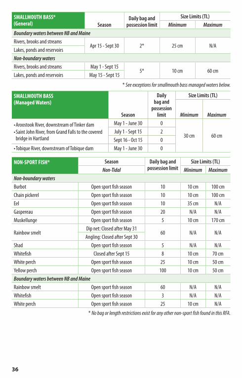
36
SMALLMOUTH BASS* (General) Season
Daily bag and possession limit
Size Limits (TL)Minimum Maximum
Boundary waters between NB and MaineRivers, brooks and streams
Apr 15 - Sept 30 2* 25 cm N/ALakes, ponds and reservoirsNon-boundary watersRivers, brooks and streams May 1 - Sept 15
5* 10 cm 60 cmLakes, ponds and reservoirs May 15 - Sept 15
* See exceptions for smallmouth bass managed waters below.
SMALLMOUTH BASS (Managed Waters)
Season
Daily bag and
possession limit
Size Limits (TL)
Minimum Maximum
•Aroostook River, downstream of Tinker dam•Saint John River, from Grand Falls to the covered
bridge in Hartland
May 1 - June 30 0
30 cm 60 cmJuly 1 - Sept 15 2Sept 16 - Oct 15 0
•Tobique River, downstream of Tobique dam May 1 - June 30 0
NON-SPORT FISH* Season Daily bag and possession limit
Size Limits (TL)Non-Tidal Minimum Maximum
Non-boundary watersBurbot Open sport fish season 10 10 cm 100 cmChain pickerel Open sport fish season 10 10 cm 100 cmEel Open sport fish season 10 35 cm N/AGaspereau Open sport fish season 20 N/A N/AMuskellunge Open sport fish season 5 10 cm 170 cm
Rainbow smeltDip net: Closed after May 31
60 N/A N/AAngling: Closed after Sept 30
Shad Open sport fish season 5 N/A N/AWhitefish Closed after Sept 15 8 10 cm 70 cmWhite perch Open sport fish season 25 10 cm 50 cmYellow perch Open sport fish season 100 10 cm 50 cmBoundary waters between NB and MaineRainbow smelt Open sport fish season 60 N/A N/AWhitefish Open sport fish season 3 N/A N/AWhite perch Open sport fish season 25 10 cm N/A
* No bag or length restrictions exist for any other non-sport fish found in this RFA.

37
Exceptions and special regulations — excludes all tributaries unless noted otherwiseWaterbody Stretch Exception
Aroostook River from the railway bridge upstream to the Maine-NB border Fly fishing only beginning July 1
Becaguimec Stream from its mouth upstream to Route 105 bridge Closed to angling after June 30
Big Presque Isle Stream from its mouth upstream to Route 103 bridge Closed to angling
after June 30
First Lake (Green River) entire waterbody Trout bag limit after Aug 31: 0
Little Tobique Riverfrom Sisson Branch upstream to Nictau Lake Fly fishing only
beginning July 1
from Sisson Branch downstream to the Tobique River Closed to angling after June 30
Mamozekel River entire waterbody Fly fishing only beginning July 1
Monquart Stream upstream to Route 105 bridge Closed to angling after June 30
Muniac Streamfrom its confluence with the Saint John River upstream to a line drawn across the river: 46°37’16.15”N 67°41’58.22”W to 46°37’15.22”N 67°41’56.50”W
Closed to angling after June 30
Nictau Lake entire waterbody
Landlocked salmon bag limit: 1
Brook trout minimum length limit (TL): 25cm
Brook trout daily bag limit: 2
Nictau Lake tributaries all brooks flowing into Nictau Lake Closed to angling
Right Hand Branch Tobique River (Campbell River)
entire waterbody Fly fishing only beginning July 1
from Mamozekel River upstream to the mouth of Tom Pole Brook Closed after May 31
Roulston Lake entire waterbody
Open angling season for trout:
June 15 - Aug 31Brook trout
daily bag limit: 2
Saint John River
from the Grand Falls dam downstream to Brooks Bridge at Limestone
Fly fishing only beginning July 1
from the Beechwood Dam to a point 800 m downstream Closed to angling
from a point 800 m downstream of the Beechwood dam to the covered bridge at Hartland
Fly fishing only beginning July 1
from 50 m downstream of the Upper Guisiguit Brook to 50 m upstream of the Upper Guisiguit Brook
Closed to angling after June 30
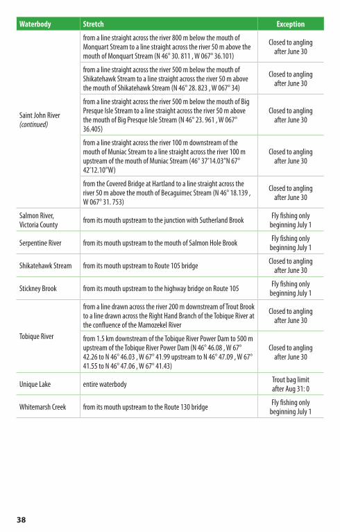
38
Waterbody Stretch Exception
Saint John River (continued)
from a line straight across the river 800 m below the mouth of Monquart Stream to a line straight across the river 50 m above the mouth of Monquart Stream (N 46° 30. 811 , W 067° 36.101)
Closed to angling after June 30
from a line straight across the river 500 m below the mouth of Shikatehawk Stream to a line straight across the river 50 m above the mouth of Shikatehawk Stream (N 46° 28. 823 , W 067° 34)
Closed to angling after June 30
from a line straight across the river 500 m below the mouth of Big Presque Isle Stream to a line straight across the river 50 m above the mouth of Big Presque Isle Stream (N 46° 23. 961 , W 067° 36.405)
Closed to angling after June 30
from a line straight across the river 100 m downstream of the mouth of Muniac Stream to a line straight across the river 100 m upstream of the mouth of Muniac Stream (46° 37’14.03”N 67° 42’12.10”W)
Closed to angling after June 30
from the Covered Bridge at Hartland to a line straight across the river 50 m above the mouth of Becaguimec Stream (N 46° 18.139 , W 067° 31. 753)
Closed to angling after June 30
Salmon River, Victoria County from its mouth upstream to the junction with Sutherland Brook Fly fishing only
beginning July 1
Serpentine River from its mouth upstream to the mouth of Salmon Hole Brook Fly fishing only beginning July 1
Shikatehawk Stream from its mouth upstream to Route 105 bridge Closed to angling after June 30
Stickney Brook from its mouth upstream to the highway bridge on Route 105 Fly fishing only beginning July 1
Tobique River
from a line drawn across the river 200 m downstream of Trout Brook to a line drawn across the Right Hand Branch of the Tobique River at the confluence of the Mamozekel River
Closed to angling after June 30
from 1.5 km downstream of the Tobique River Power Dam to 500 m upstream of the Tobique River Power Dam (N 46° 46.08 , W 67° 42.26 to N 46° 46.03 , W 67° 41.99 upstream to N 46° 47.09 , W 67° 41.55 to N 46° 47.06 , W 67° 41.43)
Closed to angling after June 30
Unique Lake entire waterbody Trout bag limit after Aug 31: 0
Whitemarsh Creek from its mouth upstream to the Route 130 bridge Fly fishing only beginning July 1

39
Additional informationQuestions about regulations?Contact Energy and Resource Development at 506-453-3826 or your nearest district office:
Bathurst 506-547-2080 Edmundston 506-735-2040 Richibucto 506-523-7600
Campbellton 506-789-2336 Florenceville 506-392-5105 St. George 506-755-4040
Canterbury 506-279-6005 Fredericton 506-453-2345 Saint-Quentin 506-235-6040
Chipman 506-339-7019 Hampton 506-832-6055 Sussex 506-432-2008
Dieppe 506-856-2344 Miramichi 506-627-4050 Tracadie-Sheila 506-394-3636
Doaktown 506-365-2001 Plaster Rock 506-356-6030 Welsford 506-486-6000
Marine species and shellfishQuestions?Angling for marine species and recreational harvesting of shellfish are regulated by the federal Department of Fisheries and Oceans. For information on seasons, zones, bag limits, closures and other regulations, contact DFO at:
– Maritimes Region (RFAs 5, 6, 7, 8): 902-426-2473 – Gulf Region (RFAs 1, 2, 3, 4): 506-851-7797 or 506-851-7798
Mercury contamination of freshwater fishEating fish caught in New Brunswick’s lakes or rivers could increase the level of mercury in your body. The following guidelines apply to the consumption of brook trout, lake trout, landlocked salmon, smallmouth bass, perch, fresh water cusk (burbot), pickerel, striped bass and catfish; but exclude Atlantic salmon:1. Women of child-bearing age and children under eight
years of age should limit consumption of brook trout measuring less than 29 cm (12 inches) to one meal per month. Avoid consumption of all other species, including brook trout measuring 29 cm or more. Pregnant women should avoid consumption of all freshwater fish noted in this advisory.
2. For children eight years of age and older, male adults and women past childbearing age, there is no restriction on consuming brook trout under 29 cm. Consumption of brook trout measuring 29 cm and more should be limited to one meal per week. Consumption of all other New Brunswick freshwater fish listed above should be limited to one meal every two weeks.
An occasional meal which exceeds the guidelines should have no adverse health effects. This advisory applies only to wild fish caught in the province’s lakes and rivers. Fish from commercial trout ponds and aquaculture operations are considered safe to eat.
For information on freshwater species: Public Health Services - NB Department of Health 506-457-4800
For information on commercial fish: Canadian Food Inspection Agency (New Brunswick) 506-452-4963

40
It’s the law!If you catch a salmon parr or smolt, gently remove the hook and release it back in the water. Study these pictures and note the differences between young Atlantic salmon and brook trout.
Set Young Salmon Free
Salmon parr•Blackspotsonbackandsides•Forkedtail•Nomarkingsonfinsortail
Salmon smolt•Silveryfish•Onlyashadowofverticalsidebars•Blackspotsonuppersidesandcheeks•Darkforkedtail
Brook trout•Lightcolouredspotsonitssides•Redspotswithlightcolourededge•Marbledpattern(darkirregularlines)onupperbodyandback
•Dorsalfinhasdarkbarsandpatches•Lowerfinshaveawhiteedge•Tailissquareorveryslightlyconcave
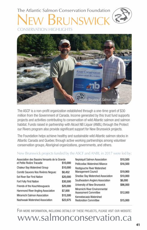
41
The ASCF is a non-profit organization established through a one-time grant of $30 million from the Government of Canada. Income generated by this trust fund supports projects and activities contributing to conservation of wild Atlantic salmon and salmon habitat. Funds raised in partnership with Alcool NB Liquor (ANBL) through the Protect our Rivers program also provide significant support for New Brunswick projects.
The Foundation helps achieve healthy and sustainable wild Atlantic salmon stocks in Atlantic Canada and Quebec through active working partnerships among volunteer conservation groups, Aboriginal organizations, governments, and others.
Association des Bassins Versants de la Grande et Petite Rivière Tracadie $10,000
Chaleur Bay Watershed Group $10,000
Comité Sauvons Nos Rivières Neguac $8,452
Eel River Bar First Nation $20,000
Fort Folly First Nation $30,500
Friends of the Kouchibouguacis $20,000
Hammond River Angling Association $7,000
Miramichi Salmon Association $15,500
Nashwaak Watershed Association $22,675
Nepisiquit Salmon Association $10,500Petitcodiac Watershed Alliance $16,500Restigouche River Watershed Management Council $19,900Shediac Bay Watershed Association $10,000Southeastern Anglers Association $6,000University of New Brunswick $96,000Miramichi River Environmental Assessment Committee $12,000Kennebecasis Watershed Restoration Committee $15,000
NEW BRUNSWICK
Photo: Nepisiquit Salmon Association
www.salmonconservation.caFOR MORE INFORMATION, INCLUDING DETAILS OF THESE PROJECTS, PLEASE VISIT OUR WEBSITE:
New Brunswick projects funded by the ASCF and ANBL in 2017 were led by:
CONSERVATION HIGHLIGHTS

42
New Brunswick Salmon Council Inc. (a regional council of the Atlantic Salmon Federation) and its local affiliates encourage everyone to practise conservation in all your 2018 angling activities. Here are a few suggestions on how you can individually contribute to the health and vitality of New Brunswick’s prized wild Atlantic salmon stocks:• Carefully read and be aware of all regulations that apply to the waters you will be angling.• Remember to pinch your barbs— the hook is much easier to remove, causing less injury to the
fish and allowing quicker live release.• Land your fish swiftly. (A good rule of thumb is 1-minute per pound for Atlantic salmon.)
• Gently handle your catch. If necessary, for a short time period before releasing it, keep the fish in the water facing upstream so that a flow of water passes over its gills.
• Report signs of poaching activities (1-800-222-TIPS) or environmental concerns such as pollution including bank erosion, unnaturally silty water and sedimentation in streams or excessive stream bank vegetation removal. For environmental concerns call 506-453-2690 or 1-800-565-1633 (after hours or emergencies)
• Finally, to help NB rivers meet conservation targets, and to help with international negotiations aimed at conserving and increasing the stocks returning to our rivers, we encourage the live release of all salmon and grilse.
Get involved… Be part of the solution! Join one of our many affiliates shown below or start your own group on “your” river. We can help!
www.nbsalmoncouncil.comNBSC Executive Contact Telephone EmailPresident (Director-At-Large) Peter Cronin 506-444-9012 [email protected] President (Director-At-Large) John Pugh 506-450-0831 [email protected] (Director-At-Large) James Marriner 506-387-7733 [email protected] George Findlay 506-392-5947 [email protected] President Debbie Norton 506-622-8834 [email protected] Directors-At-Large
Danny Bird 506-284-2173 [email protected] LeBlanc 506-866-4345 [email protected] Spencer 506-470-1132 [email protected]
Affiliate OrganizationsAtlantic Salmon for Northern Maine James Barresi 207-768-0699 [email protected] de chasse et pêche de Saint-Leonard George Findlay 506-392-5947 [email protected] Fly Tying Club Ronald Godin 506-381-1300 [email protected] Folly Habitat Recovery Tim Robinson 506-379-3401 [email protected] Fish and Game Association Dave Sawler 506-260-0488 [email protected] River Angling Association Andy Miller 506-333-8270 [email protected] Nation Conservation Council Patricia Saulis 506-472-8803 [email protected] River Association Stephen Wilson 506-325-1100 [email protected] Headwaters Salmon Federation Kevin Shaw 506-246-5375 [email protected] Salmon Association Mark Hambrook 506-622-4000 [email protected] Fish and Game Association Ron Cybulski 506-854-9804 [email protected] or [email protected] Watershed Association Bill Gammon 506-459-8560 [email protected] Professional Guides and Outfitters Association Dale Norton 506-622-8834 [email protected] Salmon Association Wayne Clowater 506-544-0024 [email protected] Brunswick Wildlife Federation James Sinclair 506-389-2605 [email protected] Salmon Protection Association Debbie Norton 506-622-8834 [email protected] Watershed Association Robin Hanson 506-357-8888 [email protected] Sportsman’s Club Milton Goggin 506-756-2594 [email protected] Camp Owners Association Arnold Boer 506-455-4951 [email protected] River Watershed Management Council David LeBlanc 506-759-7300 [email protected] Salmon Club F. Robert Hewett 418-865-2942 [email protected] Rod and Gun Club Kevin Davidson 506-387-7136 [email protected]. John River Basin Salmon Recovery Inc. John Bagnall 506-457-1042 [email protected] Fish and Game Association Jim Cormier 506-432-4788 [email protected] Salmon Protective Association Robert O’Donnell 506-356-7251 [email protected]

43
QUICK FACTSWHAT? A collaboration of local law enforcement agencies and Crime Stoppers for the protection of iBoF salmon.
WHO? Parks Canada, Fisheries and Oceans Canada, Environment and Climate Change Canada, NB Department of Justice and Public Safety, RCMP and New Brunswick Crime Stoppers.
WHERE? New Brunswick’s inner Bay of Fundy region.
WHY? To protect large numbers of adult salmon released to inner Bay of Fundy rivers and to build connections and capacity amongst local law enforcement agencies.
WHEN? Adult salmon are released in October to spawn and typically return to the Bay of Fundy in late November.
For more information, contact NB Crime Stoppers: [email protected] Fundy Salmon Recovery: [email protected] www.fundysalmonrecovery.com
Law Enforcement CollaborationProtection of inner Bay of Fundy Atlantic salmonParks Canada and its partners along New Brunswick’s Fundy coast region have invested in salmon recovery for over a decade. While these ‘life support’ activities have prevented the extinction of the inner Bay of Fundy (iBoF) salmon, a self-sustaining salmon population has yet to be restored.
Now, Parks Canada, Cooke Aquaculture, Fisheries and Oceans Canada, Fort Folly First Nation, the Atlantic Canada Fish Farmers Association, the University of New
Brunswick and the Province of New Brunswick have joined forces to create Fundy Salmon Recovery. Together they are raising hundreds of wild adult iBoF salmon on the world’s first wild salmon marine conservation farm and releasing them back to their native rivers to spawn.
As rivers cross jurisdictional boundaries and the value of salmon as a recreational fishery is high, collaboration amongst law enforcement agencies is the best strategy for their protection. Through education, monitoring and enforcement, this collaboration will help ensure the protection of salmon during a critical period of their life cycle, while also building capacity amongst local law enforcement agencies for ongoing and future collaboration. You can help! If you see or suspect salmon-related crimes, call Crime Stoppers: 1-800-222-TIPS (8477)
Photo: Inner Bay of Fundy Atlantic Salmon Law Enforcement Collaboration

44
New Brunswick Wildlife Trust FundList of Projects Approved in 2017
Tel: 506.453.6655PO Box 30030 Fax: 506.462.5054Fredericton, NB e-mail: [email protected] E3B 0H8 Web Site: www.nbwtf.ca
Restigouche River Watershed Management Council Inc.Atlantic Salmon Survey 2017 – Restigouche River System...................................................................$10,000.
Nepisiguit Salmon AssociationNepisiguit Salmon Association Salmon Enhancement Project .....................................................................$7,000.
Partenariat pour la gestion intégrée du bassin versant de labaie de Caraquet Inc.Fish Habitat Improvement in the Caraquet River and its Tributaries ..............................................................$10,000.
Comité de Gestion Environnementale de la RivièrePokemoucheFish Habitat Restoration in Fidèle’s Brook – Phase IV ...$7,000.
Association des bassins versants de la Grande et Petite rivièreTracadieEcological Enhancement of the Fish Habitat in Clearwater Brook.......................................................$6,000.
Comité Sauvons nos Rivières Neguac Inc.Ecological Restoration of Degraded Aquatic Habitats in Godin Brook and McKnight Brook ...............................$8,000.
Miramichi Salmon Association Inc.Smolt Predation Study on the Northwest Miramichi River 2017...............................................................$5,500.
Miramichi Salmon AssociationJuvenile Atlantic Salmon Assessment on the Miramichi River 2017..............................................$14,000.
Miramichi Watershed Management CommitteeMiramichi Lake Smallmouth Bass Containment 2017.....................................................................$15,000.
Miramichi Watershed Management CommitteeStriped Bass Creel Survey on the Miramichi 2017 ........$7,990.
Northumberland Salmon Protection AssociationAdult Salmon and Striped Bass Assessment on the Northwest Miramichi River 2017...............................$12,000.
Les Amis de la Kouchibouguacis Inc.Kouchibouguacis River Aquatic Habitat 2017.............$12,000.
Les Amis de la Kouchibouguacis Inc.Atlantic Salmon (education, egg incubation, restoration and monitoring) ........................................$9,490.
Southeastern Anglers AssociationMill Creek Bank Stabilization and Fish Habitat Improvement ............................................................$9,000.
Shediac Bay Watershed AssociationFish Habitat Restoration, Evaluation and Education of theEnhancement of Salmonids Populations in the Shediac Bay Watershed .........................................................$6,000.
Vision H20 (Groupe du bassin versant de la région de Cap-Pelé)Evaluation of the Tedish River as Habitats of Salmonids ................................................................$8,000.
Kurt Samways UNB, Canadian River InstituteRestoring Inner Bay of Fundy Atlantic Salmon through Conservation Rearing: Migration-Related Evaluation of Reproductive Success ................................................$8,400.
Fort Folly Habitat Recovery ProgramMonitoring & Assessment of Endangered Inner Bay of Fundy Atlantic Ssalmon on the Big Salmon River........$10,000.
Kennebecasis Watershed Restoration CommitteeRemoving Fish Passage Barriers in the Kennebecasis ..........................................................$7,000.
Kennebecasis Watershed Restoration CommitteeUpper Kennebecasis Riparian Enhancement Project ......$6,000.
Hammond River Angling AssociationJuvenile Salmon Population Assessment .....................$8,000.
Hammond River Angling AssociationHammond River Atlantic Salmon Smolt Assessment ..............................................................$5,000.
Atlantic Canada Fish Farmers AssociationFundy Salmon Recovery 2017 .................................$15,000.
Atlantic Salmon FederationOuter Bay of Fundy Atlantic Salmon Monitoring Program...................................................................$4,475.
Oromocto River Watershed Association Inc.2017 Recreational Fishery Assessment .....................$12,000.
Nashwaak Watershed Association Inc.Monitoring the Health of the Nashwaak Watershed ................................................................$7,000.
Nashwaak Watershed Association Inc.Assessing and Restoring Fish Passage in the Nashwaak Watershed................................................$6,000.
NB Sport Fishing AssociationNackawic Access Ramp.............................................$6,400.
Miramichi Headwaters Salmon Federation Inc.Satellite Rearing Facility Operation & Public Education 2017......................................................$12,575.
Michelle Gray UNB, Faculty of Forestry and EnvironmentalManagementInvestigation of Prevalence and Impact of an Ectoparasite on Brook Trout in the Quisibis Watershed ..............................................................$12,000.
Restigouche River Watershed Management Council Inc.Fall Spawning Survey of Adult Salmon in the Restigouche River 2017.............................................$4,000.
Antoin O’Sullivan, University of New BrunswickFishing with environmental DNA: establishing spatial and temporal distributions of Striped Bass and searching for Smallmouth Bass in the Miramichi catchment, New Brunswick ........................................$7,500.
The Southeastern Anglers Association Inc.Striped Bass Acoustic Tagging in the Bouctouche and Cocagne Watershed ..........................................$10,000.
Vision H2O; Groupe du bassin versant du Village de Cap-Peléet de la Communauté rurale Beaubassin-estRaising Awareness on Protecting the Aboujagane River and its Tributaries as Habitats for the Atlantic Salmon ....................................................................$9,000.
Michael Duffy, University of New BrunswickInvestigating Pathology and Treatment of Ectoparasites Infecting Outer Bay of Fundy Atlantic Salmon ..................................................................$12,000.
Matthew Litvak, Mount Allison UniversityDevelopment of Best Practices for Angling of Shortnose Sturgeon .................................................$21,500.
Kennebecasis Watershed Restoration CommitteeClosing Restoration Gaps...........................................$7,500.
Hammond River Angling AssociationPopulation estimate of a unique, non-migratory Striped Bass contingent in the Saint John River, New Brunswick .......................................................$15,000.
Allen Curry, University of New BrunswickLeft Out in the Cold: The Overlooked and UnderstudiedOverwintering Ecology of Striped Bass in Canada .........$3,000.
Allen Curry, University of New BrunswickAbundance and movements of Brown Trout in the Saint John River......................................................$11,600.
NB WildlifeTrust Fund

45
General information• The following persons may apply for or obtain a Crown
Reserve angling licence: – persons whose principal place of residence is New Brunswick, and
– current members of the Royal Canadian Mounted Police or Canadian Forces who were born in New Brunswick but who are stationed outside of the province.
• Crown Reserve anglers require an Outdoors Card number to apply for or book Crown Reserve angling opportunities. If you do not already have your Outdoors Card, you can obtain one by registering online at www.gnb.ca/naturalresources, a participating vendor, or SNB centre.
• There are three types of Crown Reserve Waters:1. Regular Crown Reserve2. Daily Crown Reserve3. Live Release Crown Reserve
• Crown Reserve Waters are not open to fishing before or after the Crown Reserve season dates. (see Restigouche and Miramichi RFAs for exceptions)
• Crown Reserve Licences do not guarantee exclusive stretch use.
• All Atlantic salmon hooked on Crown Reserve waters must be live released. The bag limit for Atlantic salmon (grilse or mature fish) is zero (0).
• Anglers may live release up to a maximum of four (4) Atlantic salmon per calendar day. Once four Atlantic salmon have been live released the angler must cease angling for that day.
• On Crown Reserve waters a “fishing day” is the 24-hour period extending from 2:00 pm on the first day until 2:00 pm on the second day. (Exception: Patapedia and Lower Patapedia stretches are based on a full calendar day. See pages 49 and 50 for details.)
• Licence fees are per angler per day, taxes not included.• All Crown Reserve Waters are fly fishing only. Barbed flies
are legal on Regular and Daily Crown Reserves. Barbless flies are required on Live Release Crown Reserves. Trolling with artificial flies is permitted on all Crown Reserves.
Accommodations• Camps are available to Crown Reserve anglers on 24 of
40 Crown Reserve stretches. Their use, where available, is included with the purchase of a Crown Reserve angling licence. (Note: An exception is the Patapedia Crown Reserve where accommodations are booked on a fee basis through the Corporation de Gestion des Rivières Matapédia et Patapédia located in Matapédia Quebec; phone: 1-418-865-2080)
• Purchase of a Crown Reserve angling licence does not guarantee exclusive use of its camp. For example, Crown Reserve bookings made under Step C within 48 hours of the angling date may be done by multiple angling parties. Also, on the Jardine Brook and Lower Kedgwick Daily Crown Reserve stretches, a camp can be booked by more than one angling party. Crown Reserve anglers should check with the appropriate designated ERD office when making a Crown Reserve booking that might involve the sharing of camp facilities so that, if necessary, they can choose to make alternate accommodation arrangements.
• Camp descriptions are provided in the “Stretch Description” documents available from the ERD web site and included with Crown Reserve licence information packages. Crown Reserve camps include basic amenities such as a stove, table, chairs, etc. Crown Reserve anglers are responsible for all other incidentals such as firewood, food, and drinking water.
• Crown Reserve stretches without a camp may feature camping facilities such as a tenting area, picnic table, etc. Refer to the Stretch Description documents for further information.
C ROW N R E S E RV E WAT E R S

46
C ROW N R E S E RV E WAT E R S
Youth on Crown Reserve WatersYouth under the age of 16 may participate in Crown Reserve angling without being required to hold a licence or be a Crown Reserve party member.
If a youth is angling on Crown Reserve Waters and is not a party member:• He/she must be accompanied* by a licensed Crown Reserve
angler.• The licensed Crown Reserve angler and the youth may not
angle at the same time.• The young person’s catch must be included in the live release
limit of the licensed Crown Reserve angler.• The adult licensed Crown Reserve angler is legally respon-
sible to ensure that the youth complies with all regulations.
If a youth under the age of 16 is a party member:• The youth must possess the appropriate Crown Reserve
Licence for the stretch being angled.• On Atlantic salmon Crown Reserve stretches:
– If the youth is 10 - 15 years of age and possesses a Class 8 or 17 salmon angling licence, they may angle alone and they have their own live release limit;
– If the youth does not possess the appropriate salmon angling licence required on the stretch being angled, they must be accompanied* by a licensed Crown Reserve angler and their catch must be included with that other party member’s live release limit. This also includes all youth under the age of 10 who are not eligible to purchase a salmon angling licence.
• On Brook Trout Crown Reserve Stretches: – Youth under 16 years of age do not require a Class 7, 8, 9, 10, 16, or 17 angling licence, but do require a Crown Reserve Licence.
* Accompanied is defined as within visual and/or auditory contact of each other without the aid of artificial devices except medically-prescribed eyeglasses or hearing aids.
Crown Reserve Creel SurveysParty chiefs are encouraged to submit creel census data related to their Crown Reserve angling trip(s). Your information is important in the management of this recreational fishery and helps improve the quality of a Crown Reserve angling experience for all anglers.
Creel data and stretch comments can be submitted online via a link provided in the Crown Reserve licence package e-mail. A paper form option is also available; however anglers are encouraged to submit their information online if possible. Further information on the Crown Reserve Creel census process is available at www.gnb.ca/naturalresources.
Regular Crown ReserveTwenty of these salmon angling waters are located in the Miramichi and Restigouche river systems (see page 49). Fishing rights are awarded annually by computer draw. The season extends from June 10 - Sept 15. These waters are closed before and after the Regular Crown Reserve season with the exception of three Restigouche River stretches (Red Bank, Three Sisters, and Devil’s Half Acre) which are open from Apr 15 - June 1 for all angling. All stretches except Patapedia are valid for a 48-hour period, beginning at 2:00 pm on the first day and ending at 2:00 pm on the third day. The Patapedia stretch is valid for three consecutive calendar days.
Application and payment proceduresApplicants may apply online at www.gnb.ca/naturalresources, at the Fish and Wildlife Branch in Fredericton, or at any ERD District office. An application fee of $7.00 per angler must be paid at the time of the application.• Applicants are restricted to one application to the Regular
Crown Reserve draw per year.• Once the draw is held, the successful applicants will be
notified in writing or by e-mail of the payment deadline.• Payment must be made online at www.gnb.ca/
naturalresources or at the Fish and Wildlife Branch in Fredericton. No payments will be accepted at ERD District offices or after the deadline. Total cost per angler is $46.00 per day for angling dates from June 10 to Aug 31 and $31.00 per day per angler for angling dates from Sept 1 - 15.

47
C ROW N R E S E RV E WAT E R S
• In addition to a Regular Crown Reserve Angling Licence, each angler must have a Class 7, 8, 16 or 17 salmon angling licence. For exception, see “Youth on Crown Reserve”, page 46.
• Further information will be provided in successful applicants’ licence packages.
Unclaimed stretches• Angling opportunities that are unclaimed during the
Regular Crown Reserve draw will be reoffered to anglers on a first-come first-served booking basis.
• Unclaimed stretch listings are available online at www.gnb.ca/naturalresources or by contacting any ERD district office.
• Crown Reserve anglers are encouraged to book stretches unclaimed in the Regular Crown Reserve draw online at www.gnb.ca/naturalresources. Persons without Internet access will be able to book unclaimed stretches by contacting one of the following designated ERD district offices:1. Miramichi River stretches
ERD Miramichi: 506-627-40502. Restigouche River stretches
ERD Campbellton: 506-789-23363. North Branch Kedgwick stretch
ERD Saint-Quentin: 506-235-6040• There is no fee to book unclaimed Regular Crown Reserve
stretches.• Booking periods for unclaimed Regular Crown Reserve
stretch dates include:1. Unsuccessful applicant booking period:
– Begins the second Monday of May and lasts two consecutive weeks. In 2018, bookings by unsuccessful draw applicants will be accepted online and at designated ERD offices beginning 8:30 am, Monday, May 14.
– Only anglers who were unsuccessful in the Regular Crown Reserve draw may book a stretch date during this period.
– Ineligible persons include successful Regular Crown Reserve applicants regardless of whether they actually paid for their stretch or not, unsuccessful applicants who substituted into an angling party that was successful in the draw, and any person who did not apply to the draw.
– A limit of one stretch date per angler applies. – Bookings do not have to be based on the original
party membership. A four person party, for example, could book a stretch date during this period as two separate two-person parties.
– Party size must correspond to the size limit for that stretch.
– Immediate licence payment at the time of booking is required.
2. Open booking period: – Begins the first Monday of June and lasts until the
end of the Regular Crown Reserve angling season. In 2018, bookings for this period will be accepted online and at designated ERD district offices beginning 8:30 am, Monday, June 4.
– Any angler whose principal place of residence is New Brunswick may book stretch dates during this period regardless of whether they participated in the Regular Crown Reserve draw or not.
– There are no limits as to the number of available stretches that may be booked.
– Party size must correspond to the size limit for that stretch.
– Immediate licence payment at the time of booking is required.
3. Bookings within 48 hours of an angling date: – Any stretch that has not been booked within 48 hours
of its angling date can be booked by individuals or parties. The number of persons who book the stretch may be less than the stretch limit.
– Bookings within 48 hours of angling dates that occur on a Saturday, Sunday, or Monday will begin at 8:30 am on the previous Thursday.

48
C ROW N R E S E RV E WAT E R S
Daily Crown ReserveThese fifteen salmon and trout fishing waters provide excellent angling on a day-by-day basis (see page 50). The season extends from June 1 - Sept 15. These waters are closed before and after the Daily Crown Reserve season. Exception: Restigouche River Daily Crown Reserve (Grog Island) is open from Apr 15 - June 1 for all angling.
Application and payment proceduresStep A: Random draw• Apply online at www.gnb.ca/naturalresources or by
calling the appropriate ERD district office between 8:30 am and 11:00 am on the draw date.
• Draws are held on weekdays 7 days in advance of the angling date. If the angling date is a Saturday or Sunday, the draw is held on the Monday of the week immediately preceding the angling date, or on Tuesday in the event that Monday is a holiday.
• An application fee of $7.00 per angler must be paid at the time of the application unless the angler has previously applied to a Crown Reserve draw during the current year.
• Successful applicants will be contacted by phone or e-mail after the draw is conducted at 11:00 am. Immediate payment is required.
Step B: Party booking• If no applications are received by 11:00 am on the draw
date, unclaimed stretches may be booked on a first-come first-served basis by proper party size, up to 48 hours before the angling date.
• To book, visit www.gnb.ca/naturalresources or call the appropriate designated office beginning at 1:30 pm on the stretch draw date.
• There is no fee to book unclaimed stretches under Step B.Step C: Individual or party booking• Within 48 hours of the fishing date bookings are accepted
from individuals or parties. The total number of anglers is not permitted to exceed the stretch limit and licence fees apply only to the number of persons who actually take the stretch.
• There is no application fee to book unclaimed stretches under Step C.
• To book, visit www.gnb.ca/naturalresources or call the appropriate ERD office after 8:30 am beginning two business days immediately prior to the angling date.
General information on Daily Crown Reserves• In addition to a Daily Crown Reserve licence, anglers on
Daily Crown Reserves must have a valid Class 7, 8, 16 or 17 salmon angling licence for salmon stretches, or a valid Class 9 or 10 licence for trout stretches. For exception, see “Youth on Crown Reserve”, page 46.
• Licences are not transferable.• Anglers are limited to two days per month for any specific
stretch of Daily Crown Reserve Water obtained through Step A Random Draw and those periods shall not be consecutive over month’s end. Vacant water booked under Steps B and C does not count towards this limit.
• Anglers must purchase the full period of vacant water. Partial purchase is not allowed.
• When the successful party is notified, payment must be made immediately by credit card, Interac, cash, cheque or money order (by phone or in person). There are no exceptions.
• The cost per angler per day on Daily Crown Reserve salmon stretches is $46.00 for angling dates from June 1 - Aug 31 and $31.00 per day per angler for angling dates between Sept 1 - 15. (Exception: the Lower Patapedia stretch is $20.00 for angling dates from June 3 - Aug 31.)
• The cost per angler per day on Daily Crown Reserve brook trout stretches is $20.00 for angling dates from June 3 - Aug 31 and $13.00 for angling dates from Sept 1 - 15.
• At the time of payment, all party members’ Outdoors Card numbers or their information must be provided for the issuance of the licences (name, address, date of birth, telephone number and identification).

49
C ROW N R E S E RV E WAT E R S
Live Release Crown ReserveOnly fly fishing with single barbless or pinched hooks is permitted. There are five of these reserves in the Miramichi drainage (see page 50). The season extends from June 1 - Sept 15. Waters are closed before and after the Live Release Crown Reserve season.
Application and payment procedures:• Same procedures as Steps A, B and C for Daily Crown Reserve.• An application fee of $7.00 per angler must be paid at the
time of the application unless the angler has previously applied to a Crown Reserve draw during the current year.
• Anglers are limited to two days per month for each stretch of Live Release Crown Reserve Water obtained through Step A Random Draw and those periods shall not be consecutive over month’s end. Stretches booked under Steps B and C do not count towards this limit.
• The cost per angler per day on Live Release Crown Reserve stretches is $33.00 for angling dates from June 1 - Aug 31 and $22.00 for angling dates from Sept 1 - 15. (Exception: the Upper and Lower Cains stretches are $20.00 for angling dates from June 1 to Aug 31 and $13.00 for angling dates from Sept 1 - 15.)
• In addition to a Live Release Crown Reserve Licence, each angler must have a valid Class 7, 8, 16 or 17 salmon angling licence. For exception, see “Youth on Crown Reserve”, page 46.
• If angling on the Cains River, each angler must have a valid Class 7, 8, 9, 10, 16 or 17 licence in addition to a Live Release Crown Reserve Licence. For exception, see “Youth on Crown Reserve”, page 46.
• Palisades and Sinclair stretch licences are issued for two consecutive fishing days.
Regular Crown Reserve WatersCost per angler per day is $46.00 for angling dates from June 10 - Aug 31 and $31.00 per day per angler for angling dates from Sept 1 - 15.
Restigouche drainageRiver Stretch Party size Camp AccessKedgwick North Branch Kedgwick 2 Yes Canoe or wadingPatapedia Patapediaa 2 Yesb CanoeRestigouche Devil’s Half Acre 4 Yes CanoeRestigouche Red Bank 4 Yes CanoeRestigouche Three Sisters 4 Yes CanoeUpsalquitch Crooked Rapids 2 or 4 No CanoeUpsalquitch Upsalquitch Forks Pool 2 Yes CanoeNW Upsalquitch Craven Gulch 2 No CanoeNW Upsalquitch Northwest Upsalquitch 2 or 4 No CanoeSE Upsalquitch Southeast Upsalquitch 2 Yes Canoe or wading
a Patapedia licences are valid for three consecutive calendar days. The last available stretch start date is Aug 29.b Accommodations for the Patapedia stretch are available from the Corporation de Gestion des Rivières Matapédia et
Patapédia, Matapedia, Quebec (Tel: 1-418-865-2080).
Bag limit: The bag limit for Atlantic salmon (grilse or mature fish) on the Restigouche Regular Crown Reserve is 0. Live release only.
Live release limit: A maximum of 4 Atlantic salmon may be live released per day.

50
C ROW N R E S E RV E WAT E R SMiramichi drainage
River Stretch Party size Camp AccessLSW Miramichi Charlies Rock 4 Yes Wading
Lr North Branch, LSW Miramichi Adams Poola 4 Yes Wading
NW Miramichi Crawford 4 Yes Wading
NW Miramichi Depot 4 Yes Wading
NW Miramichi Elbow 4 Yes Wading
NW Miramichi Stoney Brook 4 Yes Wading
NW Miramichi Sullivan 2 Yes Wading
North Sevogle Groundhog Landing 4 Yes Wading
North Sevogle Squirrel Falls 4 Yes Wading
North Sevogle Narrows 4 Yes Wading
a Anglers must release all brook trout caught on the Adams Pool stretch on the Lower North Branch Little Southwest Miramichi River.
Bag limit: The bag limit for Atlantic salmon (grilse or mature fish) on the Miramichi Regular Crown Reserve is 0. Live release only.
Live release limit: A maximum of 4 Atlantic salmon may be live released per day.
Daily Crown Reserve WatersAtlantic salmonCost per angler per day is $46.00 for angling dates from June 1 - Aug 31 and $31.00 per day per angler for angling dates from Sept 1 - 15. (Exception: the Lower Patapedia stretch is $20.00 for angling dates from June 3 - Aug 31.)
Stretch Water Season Party size Camp ERD office TelephoneBerry Brook Upsalquitch June 1 - Sept 15 2 or 4 No Campbellton 506-789-2336Cruickshank North Branch Sevogle June 10 - Sept 15 2 Yes Miramichi 506-627-4050Grog Island Restigouche June 1 - Sept 15 2 No Campbellton 506-789-2336Jardine Brook Little Main Restigouche June 1 - Sept 15 2 or 4 Yes Saint-Quentin 506-235-6040Kedgwick Forks Kedgwick June 1 - Sept 15 2 Yes Saint-Quentin 506-235-6040Lower Kedgwick Kedgwick June 1 - Sept 15 2, 4 or 6a Yes Saint-Quentin 506-235-6040Lower Patapedia Patapedia June 3 - Aug 31b 2 Yesc Campbellton 506-789-2336
a Lower Kedgwick stretch accommodates six anglers until July 10 inclusive; four anglers beginning on July 11.b Lower Patapedia licences valid for two consecutive calendar days.
Start dates are June 3, 7, 11, 15, 19, 23, 27; July 1, 5, 9, 13, 17, 21, 25, 29; Aug 2, 6, 10, 14, 18, 22, 26, 30.c Accommodations for the Lower Patapedia stretch are available from the Corporation de Gestion des Rivières Matapédia
et Patapédia, Matapédia, Quebec (Tel: 1-418-865-2080).
Bag limit: The bag limit for Atlantic salmon (grilse or mature fish) on Daily Crown Reserve waters is 0. Live release only.
Live release limit: A maximum of 4 Atlantic salmon may be live released per day.

51
C ROW N R E S E RV E WAT E R SBrook troutCost per angler per day is $20.00 for angling dates from June 3 - Aug 31 and $13.00 for angling dates from Sept 1 - 15.
Stretch Season Party size CampdTrip bag limit
per person ERD office TelephoneCalifornia Lakea June 1 - Aug 31 2 or 4 No 5 Bathurst 506-547-2080Caribou Lake June 1 - Sept 15 2 No 5 Bathurst 506-547-2080Goodwin Lakeb June 1 - Sept 15 2 No 2 Miramichi 506-627-4050Island Lake June 1 - Sept 15 2 No 2 Doaktown 506-365-2001Kenny Lake June 1 - Sept 15 2 No 2 Miramichi 506-627-4050Nepisiguit River July 15 - Aug 15 2 No 2 Bathurst 506-547-2080Peaked Mountain Lakesc June 1 - Sept 15 2 or 4 No 2 Doaktown 506-365-2001Valentine Lake June 1 - Sept 15 2 No 2 Doaktown 506-365-2001
a Artificial lures and bait prohibited to be in an anglers possession while angling on California Lake.b Access to Goodwin Lake requires a canoe portage.c Access to the Peaked Mountain Lakes requires 4x4 truck and a canoe portage.d Daily Crown Reserve brook stretches generally feature camping facilities rather than actual accommodations.
Live Release Crown Reserve WatersCost per angler per day is $33.00 for angling dates from June 1 - Aug 31 and $22.00 for angling dates from Sept 1 - 15. (Exception: Upper and Lower Cains stretches are $20.00 for angling dates from June 1 - Aug 31 and $13.00 for angling dates from Sept 1 - 15.)
Stretch River Season Party size Camp ERD office Telephone
Cains Lower Cains June 1 - Sept 15 2 or 4 No Doaktown 506-365-2001
Cains Upper Cains June 1 - Sept 15 2 or 4 No Doaktown 506-365-2001
Lr North Branch LSW Miramichi June 1 - Sept 15 4 No Miramichi 506-627-4050
Palisades North Pole Stream July 1 - Sept 15 4 Yes Doaktown 506-365-2001
Sinclair North Pole Stream July 1 - Sept 15 4 Yes Doaktown 506-365-2001
Bag limit: The bag limit for all fish species on Live Release waters is 0. Live release only.
Live release limit: A maximum of 4 Atlantic salmon may be live released per day.

52
REPORTYOURCATCH
PLEASE TAKE A MINUTE TO COMPLETE AND SUBMIT THIS POSTAGE-PAID ANGLER SURVEY CARD AT THE END OF THE 2018 SEASON, OR COMPLETE IT ONLINE
http://dnr-mrn.gnb.ca/AnglingRecord/?lang=e
Notes
Help managers make informed decisions and help sustain quality fishing in New Brunswick.
Weneedyourfishinginformation!