firm profile - haydenconsultants.com · • 4 leica viva gs14 gps receivers • 2 leica cs15 data...
TRANSCRIPT
Hayden Statement of Qualifications 1
FIRM PROFILEAt Hayden Consultants, Inc., we design today for tomorrow’s communities, creating an ever-increasing legacy of infrastructure improvements that will enhance quality of life for generations to come. Hayden Consultants is a Dal-las-based engineering partner serving public agencies and private industry, specializing in civil and transportation engineering design services for projects in North Texas, statewide and in the surrounding states.
Founded in 2000, Hayden Consultants has earned a reputation as the go-to firm for design of complex street recon-struction, highways and tollways, water resources, rail and transit facilities, and Low Impact Development (LID) and sustainable design practices. Our clients come back to us again and again to take advantage of our problem-solving expertise in transportation, water and wastewater design, subsurface utility engineering (SUE) and utility coordina-tion, survey, site development, and construction engineering and inspection.
Our experienced staff of 39 includes a Registered Professional Land Surveyor, three CADD specialists, three survey crews and additional support personnel. Our staff also includes 8 licensed professional engineers, 3 Certified Flood-plain Managers, 2 Registered Accessibility Specialists and 2 Envision™ Sustainability Professionals.
Historically Underutilized Business – State of Texas and the Texas Department of TransportationSmall Business Enterprise – North Central Texas Regional Certification AgencyWoman-Owned Business Enterprise – North Central Texas Regional Certification Agency, SouthCentral Texas Region-al Certification Agency and by the City of Austin Small & Minority Business Resources DepartmentDisadvantaged Business Enterprise – North Central Texas Regional Certification AgencyWoman Owned Small Business – National Women Business Owners CorporationEconomically Disadvantaged Woman Owned Small Business – National Women Business Owners Corporation
Certifications
Women’s Transportation Seminar, Employer of the Year, 2013ACEC Texas Engineering Excellence Award, 2012 Gold Medal Award for Riverfront Boulevard Bioswale StudyAggie 100™, 100 fastest growing Aggie-owned or Aggie-led businesses in the world – 2006, 2007, 2010, 2011, 2016Dallas 100™, 100 fastest growing privately held companies in the Dallas area - 2010, 2016
Awards
IH 35E Phase 1 & 2

FIRM PROFILE
Hayden Statement of Qualifications2
Roadways and Highways• Schematic & PS&E development• Complete streets design• Freeway ramp & direct connector design• Arterial widening & new location arterials• Residential street reconstruction• Bicycle & pedestrian facilities• Alignment studies• Culvert design & layout sheets
Utilities• Water & wastewater pipeline design• Utility coordination• Record drawing & franchise utility research• Facilitate utility coordination meetings• Coordination with architects, bridge & roadway
designers• Subsurface Utility Engineering (SUE)• Develop utility conflict matrices/exhibits
Drainage• Master drainage & watershed plans• Hydraulics & hydrologic modeling• Bioswale & biofiltration system design• Low Impact Design (LID)• Storm sewer systems• Bridge/culvert/channel hydraulics• Detention design• Regional & sub-regional detention
• FEMA LOMAs, CLOMRs & LOMRs• NPDES storm water facilities• Coordination with FEMA and Corps of Engineers
Land Surveying• Boundary determinations• Topographic surveys• Right-of-way determinations and parcel maps• Static control networks• Aerial panel layout• High-definition laser scanning
Site Development• Paving plans & parking layouts• Accessibility review to TDLR standards• Grading & drainage plans• Flood plain modeling• Traffic impact analysis• Construction management
Construction Engineering & Inspection Services (CEI)• Construction inspection• Field office coordination• Review of requests for information• Primavera scheduling• Contractor coordination• Change order negotiation• Noncompliance reports• Submittal review
Services
Addison, Arlington, Carrollton, Dallas, Highland Village, Irving, Fort Worth, McKinney, Mesquite, Plano, Richardson, Dallas Area Rapid Transit, Dallas County, Dallas Independent School District, North Central Texas Council of Governments, Texas Department of Transportation, Trinity River Authority, Trinity Metro (Formerly the Fort Worth Transportation Authority), Dallas Park and Recreation and Dallas County Community College District
Clients We’ve Worked With
DWU W/WW Main Replacement
Hayden Statement of Qualifications 3
FIRM PROFILE
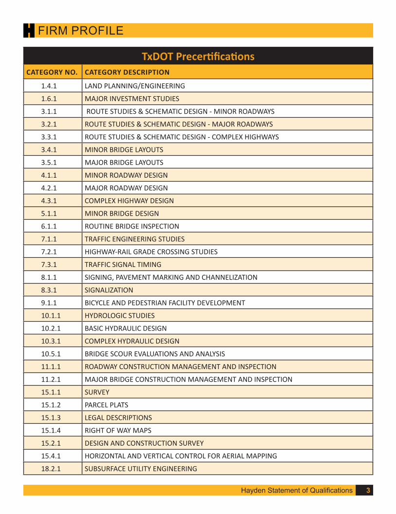
TxDOT PrecertificationsCATEGORY NO. CATEGORY DESCRIPTION
1.4.1 LAND PLANNING/ENGINEERING
1.6.1 MAJOR INVESTMENT STUDIES
3.1.1 ROUTE STUDIES & SCHEMATIC DESIGN - MINOR ROADWAYS
3.2.1 ROUTE STUDIES & SCHEMATIC DESIGN - MAJOR ROADWAYS
3.3.1 ROUTE STUDIES & SCHEMATIC DESIGN - COMPLEX HIGHWAYS
3.4.1 MINOR BRIDGE LAYOUTS
3.5.1 MAJOR BRIDGE LAYOUTS
4.1.1 MINOR ROADWAY DESIGN
4.2.1 MAJOR ROADWAY DESIGN
4.3.1 COMPLEX HIGHWAY DESIGN
5.1.1 MINOR BRIDGE DESIGN
6.1.1 ROUTINE BRIDGE INSPECTION
7.1.1 TRAFFIC ENGINEERING STUDIES
7.2.1 HIGHWAY-RAIL GRADE CROSSING STUDIES
7.3.1 TRAFFIC SIGNAL TIMING
8.1.1 SIGNING, PAVEMENT MARKING AND CHANNELIZATION
8.3.1 SIGNALIZATION
9.1.1 BICYCLE AND PEDESTRIAN FACILITY DEVELOPMENT
10.1.1 HYDROLOGIC STUDIES
10.2.1 BASIC HYDRAULIC DESIGN
10.3.1 COMPLEX HYDRAULIC DESIGN
10.5.1 BRIDGE SCOUR EVALUATIONS AND ANALYSIS
11.1.1 ROADWAY CONSTRUCTION MANAGEMENT AND INSPECTION
11.2.1 MAJOR BRIDGE CONSTRUCTION MANAGEMENT AND INSPECTION
15.1.1 SURVEY
15.1.2 PARCEL PLATS
15.1.3 LEGAL DESCRIPTIONS
15.1.4 RIGHT OF WAY MAPS
15.2.1 DESIGN AND CONSTRUCTION SURVEY
15.4.1 HORIZONTAL AND VERTICAL CONTROL FOR AERIAL MAPPING
18.2.1 SUBSURFACE UTILITY ENGINEERING

Hayden Statement of Qualifications4
FIRM PROFILE
Surveying Services
Subsurface Utility Engineering (SUE)In fully developed urban areas and constantly changing utility relocations, an accurate base map of the existing underground conditions is critical to a successful design and construction project. Hayden has developed an effective working relationship with franchise utility companies in the DFW area based on our extensive utility coordination efforts with municipal clients. We have SUE and UC experts on staff with more than 40 years combined industry experience in over 20 municipalities and 25 TxDOT Districts. Hayden uses the utility quality levels defined in the ASCE 38-02: “Standard Guidelines for the Collection and Depiction of Existing Subsurface Utility Data,” and they are as fol-lows: Quality Level D (Records Research); Quality Level C (Visible Surface Features); Quality Level B (Designating); and Quality Level A (Locating). Hayden owns all equipment necessary to provide complete SUE services, and we have an experience field coordinator capable of managing multiple crews and schedules.
• One (1) Vactron HTV573 PTO S/N TBD – Vacuum Excava-tion Equipment
• One (1) CS Unitech Diamond Core Drill – 3-SPEED, High-Torque – Holes up to 14” Diameter
• One (1) Radiodetection RD1500 GRP with Large Wheel Set and Mains Lead
• Two (2) Radiodetection RD8100 MARKER BALL FINDER
• Two (2) Receiver, RD8100• Two (2) Metrotech 810 Classic• Two (2) Receiver, VM-810• Two (2) Clamp, Inductive, 4”• Two (2) Transmitter, 10-watt• Two (2) Clamp, Inductive, 5”• Two (2) Easy Locator Metal Detector, Traffic
Safety Equipment
Hayden’s surveying services range from typical boundary and topographic surveys to detailed high definition laser scanning topography. All surveying is supervised by a Registered Professional Land Surveyor (RPLS) registered with the Texas Board of Professional Surveying and will conform to all standards set forth by that agency. Our project experiences range from municipal streets and facilities to educational facilities and parks.
Important factors when providing professional land sur-veying services include providing a rapid response to all requests and providing the capability and flexibility to meet varying levels of effort and schedules. To that end, all proj-ects begin with a kick-off meeting where the project man-ager details the scope and schedule of the project to all task leads, field coordinators, crew chiefs and office personnel. Communicating the expectations of the project to all key staff optimizes each individual’s contribution on the project.
Hayden’s survey crews are fully equipped to provide accu-rate, thorough, and complete collections of survey data. Crews utilize the latest GPS equipment, with digital elec-tronic total stations, interfaced with an electronic data collector. We have extensive experience utilizing various Virtual Reference Systems and our team structure enables us to deliver the most accurate and timely results for your
project. By utilizing our effective management, coordi-nation, and surveying capabilities the Hayden Team will provide accurate data delivery with the most advanced technology, ensuring your project is a success.
• 2 Leica TS 12 Robotic Total Stations• 2 Leica MS50 Robotic Total Station/Scanner• 4 Leica Viva GS14 GPS Receivers• 2 Leica CS15 Data Collectors• 2 Leica Captivate CS20 Collector• 1 Leica Sprinter digital level

Hayden Statement of Qualifications 5
PROJECT EXPERIENCE
TEX Rail is a 27-mile commuter rail project being developed by the Fort Worth Trans-portation Authority (The T) in Tarrant County separated into three segments. Segment 2 is 4.2 miles of commuter rail from the T& P Station in Downtown Fort Worth, extend-ing across the West Fork of the Trinity River to Tower 60/DART Cotton Belt. Segment 3 is 20.4 miles of commuter rail from Tower 60/DART Cotton Belt in Fort Worth to Grape-vine/DFW Junction. Segment 4 is 2.6 miles of commuter rail from the DFW Junction to DFW International Airport Terminal B.
Hayden staff is responsible for performing all tasks associated with SUE QL D records research, SUE QL C topographic survey, existing utility base mapping, utility coordina-tion, utility studies, and utility design for water, wastewater, and storm drain crossings. Additionally, Hayden is identifying and providing design review of more than 480 fran-chise utility relocations. There are approximately 110 franchise relocations in Segment 2, approximately 300 franchise relocations in Segment 3, and approximately 70 fran-chise relocations in Segment 4.
Hayden survey staff provided locations for all visible utilities along the entire 27-mile route. Survey information was collected by using a combination of RTK surveying, con-ventional robotic survey and Terrestrial LiDAR. Hayden crews were all safety trained and badged for operating in track areas and coordinated with railroad entities for scheduling of flaggers and D/FW airport personnel to alert them as to when the crews were on site.
Accomplishments (Survey)Our crews collaborated with multiple TexRail final design field service crews (survey, SUE, Geotech) by coordinating the use of flaggers to reduce time and cost. Resources were adjusted to provide maximum responsiveness and services were delivered with-out any safety incidences.
Scope: Utility Coordination, SUE, Utility Design, & Survey
Construction Cost: $800 million
Project Status: Under Construction
Client: Parsons/TranSystems (for Trinity Metro)
Client Contact: Will Dooley, PE
Role of Key Personnel: Daphne King, PE – Project Manager/Utility Coordination
Adam Cross, PE – Segment 4 Utility Design
Brian Wright, RPLS – Survey Manager
Tre Hayes – SUE Manager*
TEX Rail – Tarrant County, Texas
* work performed with previous employer

Hayden Statement of Qualifications6
PROJECT EXPERIENCE
City of Fort Worth retained Hayden to provide field verification of the installation of 1700+ LF of new 36” sewer pipeline and tunnel. The new pipeline was 36” fiberglass pipe in-stalled in 50” inside diameter lag and beam tunnel. The tunnel depths were between 19-36 feet deep. Hayden’s team produced a project-specific health and safety plan that included the requirements for confined space certification, personal protection equipment, ventila-tion and lighting, and other safety measures required for all parties involved.
Hayden was requested to verify the grade and alignment of the newly constructed tunnel and provide data points in comparison to the design plans. The field crew used a Leica Multistation 50 to scan up to 150 feet into the tunnel from open access shafts. For shots beyond the scanning area, the field crews entered the tunnel to record ground shots and tunnel measurements every 50 feet. The field horizontal alignment and vertical profile was overlaid on the original sewer line plan-profile design. The data points were also graphically represented in cross sections from the scans providing verification the shape of the constructed tunnel.
Scope of Services• Project-specific Health and Safety Plan• Confined Space Certification• Field Verification of 1706 LF of 50” Tunnel for 36” sanitary sewer main• Ground shots every 50 feet• Scans using Leica Multistation 50 • Exhibits showing actual horizontal alignment and vertical profile overlaying the
original design plans• Exhibits showing 10 cross sections of tunnel spaced every 100 to 200 feet along
the verified length.
Scope: Survey & Field Verification
Completed: 2016
Client: City of Fort Worth
Client Contact: Walter Norwood, PE
Role of Key Personnel: Brian Wright, RPLS – Survey Manager
Rachel Kulhavy, PE, CFM – Safety Manager
Fort Worth Tunnel Survey – Fort Worth, Texas
Hayden Statement of Qualifications 7
PROJECT EXPERIENCE
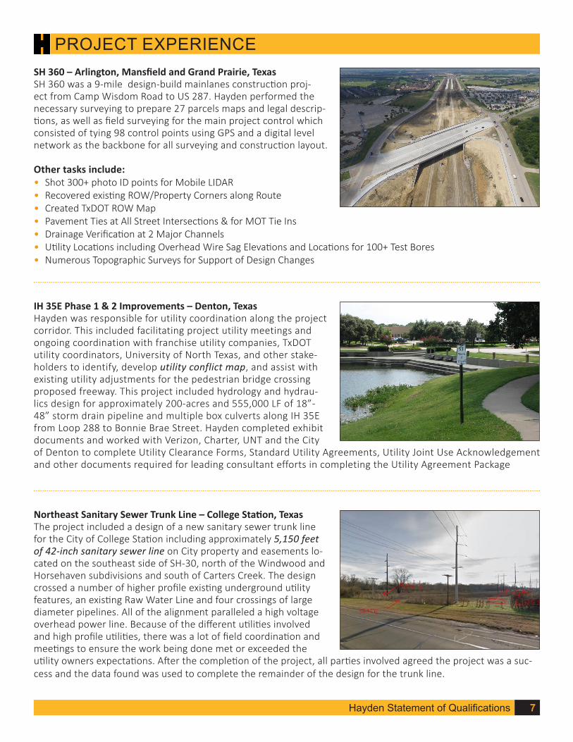
Northeast Sanitary Sewer Trunk Line – College Station, TexasThe project included a design of a new sanitary sewer trunk line for the City of College Station including approximately 5,150 feet of 42-inch sanitary sewer line on City property and easements lo-cated on the southeast side of SH-30, north of the Windwood and Horsehaven subdivisions and south of Carters Creek. The design crossed a number of higher profile existing underground utility features, an existing Raw Water Line and four crossings of large diameter pipelines. All of the alignment paralleled a high voltage overhead power line. Because of the different utilities involved and high profile utilities, there was a lot of field coordination and meetings to ensure the work being done met or exceeded the utility owners expectations. After the completion of the project, all parties involved agreed the project was a suc-cess and the data found was used to complete the remainder of the design for the trunk line.
IH 35E Phase 1 & 2 Improvements – Denton, TexasHayden was responsible for utility coordination along the project corridor. This included facilitating project utility meetings and ongoing coordination with franchise utility companies, TxDOT utility coordinators, University of North Texas, and other stake-holders to identify, develop utility conflict map, and assist with existing utility adjustments for the pedestrian bridge crossing proposed freeway. This project included hydrology and hydrau-lics design for approximately 200-acres and 555,000 LF of 18”-48” storm drain pipeline and multiple box culverts along IH 35E from Loop 288 to Bonnie Brae Street. Hayden completed exhibit documents and worked with Verizon, Charter, UNT and the City of Denton to complete Utility Clearance Forms, Standard Utility Agreements, Utility Joint Use Acknowledgement and other documents required for leading consultant efforts in completing the Utility Agreement Package
SH 360 – Arlington, Mansfield and Grand Prairie, TexasSH 360 was a 9-mile design-build mainlanes construction proj-ect from Camp Wisdom Road to US 287. Hayden performed the necessary surveying to prepare 27 parcels maps and legal descrip-tions, as well as field surveying for the main project control which consisted of tying 98 control points using GPS and a digital level network as the backbone for all surveying and construction layout.
Other tasks include:• Shot 300+ photo ID points for Mobile LIDAR• Recovered existing ROW/Property Corners along Route• Created TxDOT ROW Map• Pavement Ties at All Street Intersections & for MOT Tie Ins• Drainage Verification at 2 Major Channels• Utility Locations including Overhead Wire Sag Elevations and Locations for 100+ Test Bores• Numerous Topographic Surveys for Support of Design Changes

Hayden Statement of Qualifications8
PROJECT EXPERIENCE
Indian Creek Force Main No. 2 (HDR for NTMWD) – Plano, TexasAs a result of extreme development in the sewershed served by Indian Creek Lift Station No.1 which includes Plano’s Legacy West Development North Texas Municipal Water District (NT-MWD) is constructing a new Indian Creek Lift Station No. 2 and Indian Creek Force Main No. 2 to transfer flows to the Preston Lift Station. This improvement project will construct 25,000 LF of new 24” force main. Hayden is providing SUE QL-B for more than 50,000 LF of utilities and more than 32 OL-A testholes.
Hawthorne Meadows Phase 1 & 2, Glenwyck Subdivision, Twin Mills Subdivision – Fort Worth, TexasEach of the four projects are similar in the needs identified by the client. Those needs were to provide extremely quick turn around on information for special permitting for large residential develop-ments in Fort Worth. This information was used to provide direct design modifications and ensure compliance and safety for the projects. Each of the projects also were following very tight budget constraints for the developer to maximize their profits on each lot developed, so unique approaches to complete the potholing were implemented. All of the projects also included coordination with pipeline and high profile utility owners. Each of these projects were fast tracked from the first phone to discuss the project, to preparing a scope/fee/schedule proposal, placing proper one calls and submitting permits, and completing the work in the field. Some of the unique approaches to complete the work in a quicker timeframe for less costs included providing input on the pothole locations to reduce the needs for traffic control costs, moving the location of the pothole to a lower elevation along the utility alignment to reduce the field time required for the excavation, and providing real time photos and updates for the client to continue moving forward.
7-11 at SH 287 and FM 156 – Fort Worth, TexasThis project had complex coordination with the utility owner to provide accurate depth coverage requirements for the proposed development being proposed above it. The access to the site required special planning to ensure the heavy equipment would be in safe locations while operating and the high-profile utility owner was ensured proper non-damage excavation techniques. To complete the project to the client’s satisfaction, the require-ment to meet the escalated project schedule was a must have. We were able to exceed the project requirements and provide the data above the client’s expectations.
Hayden Statement of Qualifications 9
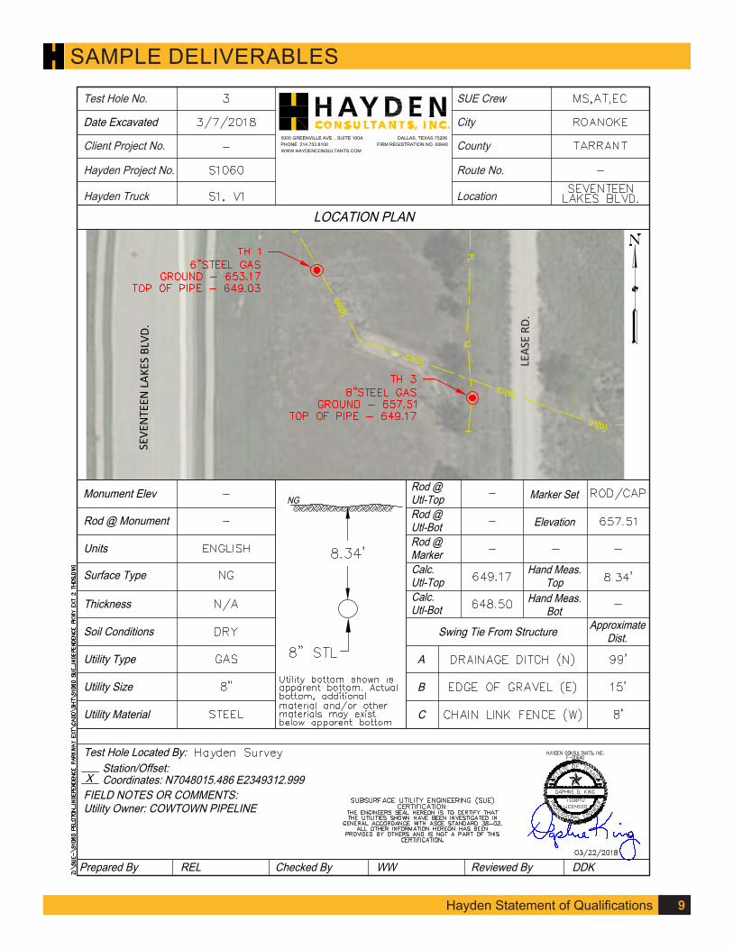
SAMPLE DELIVERABLES
Date Excavated
Client Project No.
Hayden Project No.
Hayden Truck
SUE Crew
City
County
Route No.
Location
Test Hole No.
5005 GREENVILLE AVE. , SUITE 100A DALLAS, TEXAS 75206PHONE 214.753.8100 FIRM REGISTRATION NO. 00640WWW.HAYDENCONSULTANTS.COM
LOCATION PLAN
C
B
A
Swing Tie From Structure ApproximateDist.
Rod @Utl-TopRod @Utl-Bot
Calc.Utl-Top
Hand Meas.Top
Hand Meas.Bot
Calc.Utl-Bot
Rod @Marker
Elevation
Marker SetNG
Test Hole Located By:Station/Offset:Coordinates: N7048015.486 E2349312.999
FIELD NOTES OR COMMENTS:Utility Owner: COWTOWN PIPELINE
Rod @ Monument
Units
Surface Type
Thickness
Monument Elev
Soil Conditions
Utility Type
Utility Size
Utility Material
X
Prepared By Checked ByREL WW Reviewed By DDK
SEVE
NTE
EN L
AKES
BLV
D.
LEAS
E RD
.

10 Hayden Statement of Qualifications
SAMPLE DELIVERABLES

11Hayden Statement of Qualifications Hayden Statement of Qualifications
SAMPLE DELIVERABLES
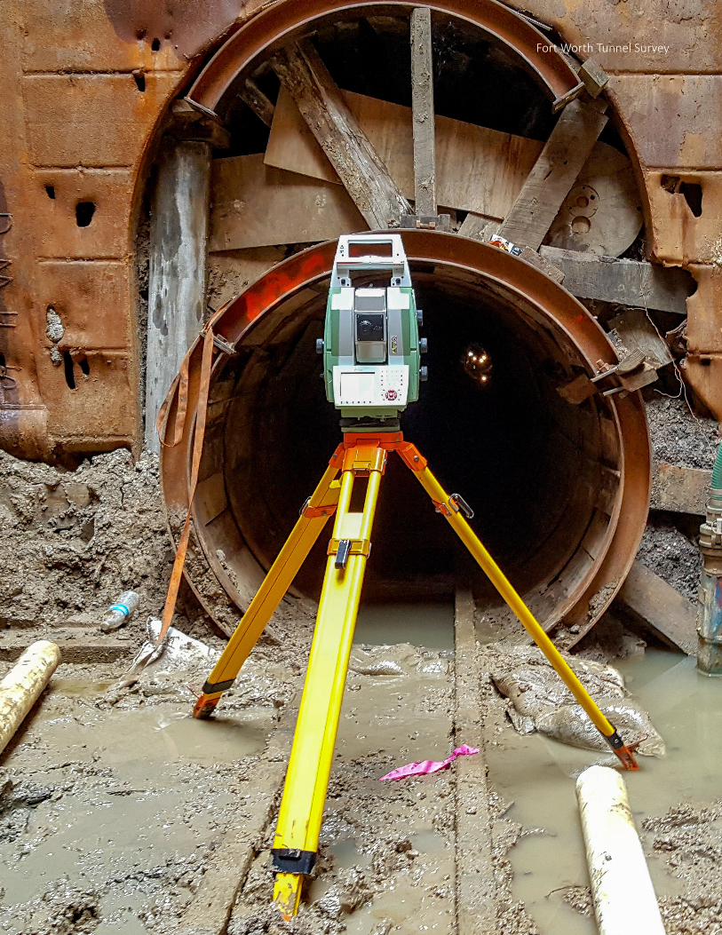
Fort Worth Tunnel Survey

Hayden Statement of Qualifications 13
RESUMES
Brian Wright, RPLS (HCI)Survey
YEARS OF EXPERIENCE: 39
REGISTRATION/CERTIFICATION: Professional Land Surveyor, Texas #4560
TxDOT Precertifications: 15.1.1, 15.1.2, 15.1.3, 15.1.4, 15.2.1, 15.4.1
SPECIALIZED TRAINING: OSHA 10 & 30 Trained, Erail Certified Confined Space, Monthly Safety Meetings, Job Specific Safety Kickoff Meetings, TSPS Boundary Law Experience, Easement Law, TSPS Liability & Malpractice
Mr. Wright has extensive experience in design and construction survey, including management, computer operations, boundary determinations and site layout for local, state and federal roadway and airport projects. Mr. Wright has served as project manager, performing topographic surveys, including high-definition laser scanning and GPS, right-of-way determinations, and preparing topography and right-of-way/parcel maps. He has a strong working knowledge of programs such as AutoCAD, Civil 3D, MicroStation, Softdesk (DCA), Land Development Desktop, Geopak, Trimble Geomatic Office, Trimble Total Control, Pathfinder Office, and Javad Pinnacle. He also has significant experience with performing RTK GPS and Static GPS control surveys.
Mr. Wright personally developed and programmed software for translation of data-collected field work directly to Auto-CAD or MicroStation, and has developed office and field standards to maximize efficiency of field and office production.
Relevant Project ExperienceSH 360, TxDOT – Mansfield and Arlington, TexasThe scope of the SH 360 project included the drainage design for the construction of the mainlanes of SH 360 from Camp Wisdom Road to US 287. Hayden performed the necessary surveying to prepare 27 parcels maps and legal descriptions for the purpose of Acquisition and/or Denial of Access, as well as field surveying for the main project control which consisted of tying 98 control points using GPS and a digital level network as the backbone for all surveying and construction layout. As Survey-or-in-Charge, Mr. Wright was responsible for: performing field surveying to locate 350+ photo identifiable points for use as LIDAR control; pavement ties at all street intersections and for MOT tie ins; drainage verification at 2 major channels including valley sections for these and numerous smaller areas along the entire route; utility locations including overhead wire sag elevations; and locations for 100+ test bores.
FM 85, TxDOT – Ellis County, TexasThis 8.5-mile rural highway safety improvement project stretched from the intersection of IH 45 to the inter-section of FM 1182. As Surveyor-in-Charge, Mr. Wright oversaw the survey crews that set control for the length of the project utilizing the TxDOT VRS system and sur-
veyed the entire roadway in 50 foot sections from ROW to ROW. The topography survey included all driveways, mailboxes and visible utilities. Eight bridge class culverts and 28 minor culverts were detailed in the survey. The bridge class culverts included valley sections being taken for a total of 400 feet upstream and downstream from each culvert. Proper safety procedures were followed using signage and flagmen as needed.
Off-System Bridge Replacements, TxDOT – Abilene, Fort Worth, Bryan, Beaumont, Tyler, TexasAs Surveyor-in-Charge, Mr. Wright is responsible for the roadway topography, creek sections, tree ties for more than 15 off-system bridges. The project included bridge layouts, SW3P, traffic control plans to close the road-way, hydrologic and hydraulic design, roadway design and final PS&E.
US 67, TxDOT – San Angelo, TexasAs Surveyor-in-Charge, Mr. Wright was responsible for this roadway project that included a topographic survey of 0.4 miles of US 67 (6 lanes with an at grade turn lane) and 0.35 miles of secondary roadway. The survey includ-ed all roadway, visible utilities and drainage structures and was performed using a combination of GPS, Robotic
Hayden Statement of Qualifications14
RESUMESTotal Station and Terrestrial LIDAR (laser scanner). The laser scanner was used to improve field crew safety in US 67 due to the high volume of traffic.
Fort Worth Tunnel Survey – Fort Worth, TexasThe City of Fort Worth retained Hayden to provide field verification of the installation of 1700+ LF of new 36” sewer pipeline and tunnel. The new pipeline was 36” fiberglass pipe installed in 50” inside diameter lag and beam tunnel. Tunnel depths were between 19-36 ft deep. Hayden produced a project-specific health and safety plan that includ-ed the requirements for confined space certification, personal protection equipment, ventilation and lighting, and other safety measures required for all parties involved. Hayden was requested to verify the grade and alignment of the newly constructed tunnel and provide data points in comparison to the design plans. The field crew used a Leica Multistation 50 to scan up to 150 ft into the tunnel from open access shafts. For shots beyond the scanning area, the field crews entered the tunnel to record ground shots and tunnel measurements every 50 ft. The field horizontal alignment and vertical profile was overlaid on the original sewer line plan-profile design. The data points were also graphically represented in cross sections from the scans providing verification the shape of the constructed tunnel. Mr. Wright served as Survey Manager.
Riverfront/Continental Boulevard Replacement – Dallas, TexasThis project replaces the current roadway (Riverfront from UPRR to Continental; Continental from IH35E to Trinity River). As Survey Manager, Mr. Wright provided topographic survey for the just completed Woodall Rogers Project at Riverfront and Continental from southbound IH 35 E to McKinney Street. Mr. Wright also delineated and visually identified right of way takes for negotiations with private land owners.
2014 Irving Water & Wastewater Main Improvements – Irving, TexasHayden is providing design, analysis, survey, and plan production for the replacement and rehabilitation of pipeline in five residential sites and one industrial site with heavily wooded creek area which includes 8,900 LF of 6”-10” water main and 11,700 LF of 6”-15” wastewater pipeline. Mr. Wright’s responsibilities include boundary, topographic and tree surveys; and ROW research for railroads and streets.
Canada Drive – Dallas, TexasMr. Wright is the Survey Manager for this full roadway reconstruction project on Canada Drive from Westmoreland to Hampton that includes on-street bicycle lanes as well as pedestrian amenities for the entire project length. The project includes 5200 LF of paving and drainage design, 800 LF of water/wastewater design, and a full bridge re-placement and is being designed using the NCTCOG iSWM manual as amended by Dallas, and it is considered a Low Impact Development (LID) project.It includes sustainable elements such as drivable grass parking lanes, rain gardens, and an enhanced median swale.
TexRail – Tarrant County, TexasTEX Rail is an $800 million, 27-mile commuter rail project being developed by the Fort Worth Transportation Author-ity (The T) in Tarrant County separated into three segments. Segment 2 is 4.2 miles of commuter rail from the T& P Station in Downtown Fort Worth, extending across the West Fork of the Trinity River to Tower 60/DART Cotton Belt. Segment 3 is 20.4 miles of commuter rail from Tower 60/DART Cotton Belt in Fort Worth to Grapevine/DFW Junction. Segment 4 is 2.6 miles of commuter rail from the DFW Junction to DFW International Airport Terminal B.
As Survey Manager, Mr. Wright supervised the Hayden survey staff, who provided locations for all visible utilities along the entire 27 mile route. Survey information was collected by using a combination of RTK surveying, conven-tional robotic survey and Terrestrial LiDAR. Hayden crews were all safety trained and badged for operating in track areas and coordinated with railroad entities for scheduling of flaggers and D/FW airport personnel to alert them as to when the crews were on site.

Hayden Statement of Qualifications 15
RESUMES
Daphne King, PE (HCI)Principal & Utility Coordination
YEARS OF EXPERIENCE: 15
EDUCATION: University of Missouri - Kansas City, B.S. Civil Engineering, 2002
REGISTRATION/CERTIFICATION: Professional Engineer, Texas #103610
TxDOT Precertifications: 4.1.1, 8.1.1, 10.2.1, 18.2.1
Ms. King is a professional civil engineer with experience as a design engineer and project manager for public and private infrastructure and maintenance projects. Her experience includes preparing the design and construction plans for trenchless wastewater lines, traditional wastewater and water lines, roadway horizontal and vertical alignments, cross sections, construction phasing, traffic control, grading, erosion control, striping and signage, utility mapping and SUE coordination, hydrology and hydraulics. She is responsible for coordinating design projects with clients, surveyors, and sub-consultants. She is also efficient in providing design review, project oversight, cost estimating, personnel and material need identification, bid proposal preparation, project planning, scheduling, and tracking. Ms. King is skilled in the use of Microstation, Geopak, Microsoft Excel, the TMUTCD, TxDOT Roadway Design Criteria, and various munici-palities design standards.
Relevant Project ExperienceTEX Rail, Fort Worth Transportation Authority – Tarrant County, Texas TEX Rail is a 27-mile commuter rail project being de-veloped by the Fort Worth Transportation Authority (The T) in Tarrant County to DFW International Airport. The commuter rail system will operate in Fort Worth’s Central Business District, Haltom City, Watauga, North Richland Hills, Hurst, Colleyville, Southlake, Grapevine, and DFW International Airport. Hayden is responsi-ble for facilitating discussions and coordination with franchise utility companies, municipalities, and vari-ous regulatory agencies. This coordination is ongoing with the entities identified above and additional major stakeholders, such as TxDOT, TRWD, TRA, DART, BNSF, UPRR, FWWR, Oncor, Chesapeake, Explorer Pipeline, Atmos, AT&T, and Sprint.
Ms. King is responsible for performing all tasks associ-ated with SUE QL D records research, SUE QL C topo-graphic survey, existing utility base mapping, utility coordination, utility studies, and utility design for water, wastewater, and storm drain crossings. She is also responsible for identifying and providing design review of more than 480 franchise utility relocations. There are approximately 110 franchise relocations in Segment 2, 300 in Segment 3, and 70 in Segment 4.
2015 Utility Engineering & Utility Coordination, TxDOT – Various locations in North TexasMs. King is the Hayden Task Lead currently responsible for providing all Subsurface Utility Engineering (SUE) tasks associated with SUE QL D records research and utility base mapping, SUE QL C above ground utility survey, utility coordination and utility studies on a task order contract basis. • IH 45 from North of Business 287 to FM 739 – Navar-
ro County, Texas: Hayden provided SUE QL D records research and utility mapping for approximately 65,000 LF of utilities along this 10.6 mile project
• US 287 from IH 45 to CR 2040 and on FM 637 from US 287 (North) to US 287 (South) – Navarro County, Texas: Hayden is responsible for providing SUE QL D records research for approximately 201,000 LF of utili-ties along this 14.0 mile project
• US 377 from Parish Lane to FM 114 (Byron Nelson Boulevard) – Denton, County: Hayden is responsible for providing SUE QL D records research for approximately 35,000 LF of utilities along this 1.5 mile project
• US 77 South of Waxahachie to US 77 North of Waxa-hachie – Ellis County, Texas: Hayden is responsible for providing SUE QL D records research for approximately 46,000 LF of utilities along 8 intersections

Hayden Statement of Qualifications16
RESUMES• SH 205 from SH 78 to Rusk Street and on North Alamo
Road from East Rusk Street to Live Oak Street – Collin and Rockwall Counties, Texas: Hayden provided SUE QL D records research for approximately 326,000 LF of utilities along this 7.0 mile project
• HWY16 from CR 481 to HWY 69 (Main Street) in Lin-dale – Smith County, Texas: Hayden is responsible for providing SUE QL D records research for approximately 145,000 LF of utilities along this 4.6 mile project
Clearfork Main Street Reconstruction – Fort Worth, TexasThis project consists of paving and drainage design for about 1,300 LF of pavement on Clearfork Main Street, in addition to a northbound left turn lane at Hulen Street. Ms. King was responsible for determining the required length of MBGF based on current City of Fort Worth and TXDOT roadway design criteria, estimating quantities and establishing an engineer’s estimate of probable cost, in addition to identifying applicable design details and developing a T411 rail modification detail.
IH 35E Phase 1 & 2 Improvements, TxDOT – Denton, TexasMs. King was responsible for utility coordination along the project corridor. This included facilitating project utility meetings and ongoing coordination with franchise utility companies, TxDOT utility coordinators, University of North Texas, and other stakeholders to identify, develop utility conflict map, and assist with existing utility adjustments for the pedestrian bridge crossing proposed freeway. This proj-ect included hydrology and hydraulics design for approx-imately 200-acres and 555,000 LF of 18”-48” storm drain pipeline and multiple box culverts along IH 35E from Loop 288 to Bonnie Brae Street.
US 377 Schematic Design – Denton County, TexasMs. King is responsible for 15 miles of utility coordina-tion along US 377 from FM 1830 to SH 170. This $190 million 15 mile urban principal arterial schematic design and PS&E project will widen the existing two-lane rural section to a four-lane urban section, including turn lanes. Impacted stakeholders include 21 franchise utility companies, UPRR, Argyle High School, industrial/com-mercial businesses, residential properties, and various municipality business districts. Ms. King provides utility engineering coordination, has developed and continues to maintain the master utility conflict list and provides
project oversight of existing utility mapping. Utility conflicts are being identified in the project utility con-flict matrix for coordination with franchise utility pro-viders such as Tri-County Electric Cooperative, NuStar Pipeline, Denton Municipal Electric, Verizon, Atmos, CoServ, Sprint, AT&T, TWC, TW Telecom, and others. All deliverables will be provided to TxDOT Dallas District SUE guidelines and adhere to ASCE C-I 38-02, Standard Guideline for the Collection and Depiction of Existing Subsurface Utility Data.
Trinity Parkway, NTTA – Dallas, TexasAs the Design Engineer, Ms. King was responsible for util-ity coordination of the new Trinity Parkway from SH 183 to Hampton Road in addition to the design for the recon-struction of the SH 183 frontage road driveway plan and profiles. She assisted with the development of roadway and drainage design criteria, developed and maintained the master utility conflict list and provided project over-sight of existing utility mapping and SUE coordination. Ms. King determined SUE locations to ensure bridge and roadway design conflicts were identified in the project utility conflict list and coordinated with franchise utility providers TXU/Oncor (Distribution and Transmission), AT&T, Atmos, Sprint, MCI/Verizon, TW Telecom, Time Warner Cable, XO/Nextlink and AboveNet.
Dallas Water Utilities Water/Wastewater Main Replacement 2013 – Dallas, TexasAs Design Engineer for Utility Coordination, and Traffic Control for this $38 million project, Ms. King is responsi-ble for utility coordination, existing utility mapping and traffic control plans and the design of 20,213 LF of 8”-16” water main, and 26,030 LF of 8”-21” wastewater main replacements in 32 urban locations. She provided project oversight and design coordination for multiple subcon-sultants and level B SUE oversight for each location and reviewed the accuracy and completeness of level A SUE provided by others. Franchise utility coordination is ongoing with Atmos Energy, Oncor, AT&T, Level 3, Verizon Business, TW Telecom, Time Warner Cable, and XO Com-munications to develop comprehensive existing utility maps. The traffic control plans are being developed for specified locations, which includes ongoing coordina-tion with the client’s traffic engineer utilizing the latest MUTCD Standards and TxDOT to ensure traffic control plans identify proper signage for safe vehicle maneuvers through high-density urban areas.

Hayden Statement of Qualifications 17
RESUMES
Tre Hayes (HCI)SUE – Subsurface Utility Engineering
YEARS OF EXPERIENCE: 20
SPECIALIZED TRAINING:
Sensor & Software Ground Penetrating Radar Course
Mala Ground Penetrating Radar Course
Staking University 1 week Advanced Utility Theory Course
Mr. Hayes has more than 20 years of SUE experience as a Project Manager. His responsiblities included the collection of mapping, locating & designating underground utilities utilizing sub-surface geophysical methods, surface optical technologies, and non-destructive vacuum excavation methods for the purpose of roadway and infrastructure de-signs, construction management, survey utility mapping, private locating, and record documentation. His experience includes utilizing multiple Vacuum Excavation Trucks such as the Sewer Equipment’s Ram Vac HX-12 & 6, Vac Master, Tellus, Ditch Witch Trailer units and Utilivac Mobile units. He has worked with Bluebeam, managing a team with Base Camp 3 and has implemented a GIS mapping system to track everything from vehicle maintenance, test holes, desig-nating, pole inventories, manhole inventories and equipment inventories.
Relevant Project ExperienceCity of Irving On-Call SUE Services – Irving, TexasThis contract includes field potholing services, surveying, traffic control, and professional engineering SUE services.• Provide designating and/or test holes at various loca-
tions provided by the city• Tom Braniff Dr – provide QL-B on approx. 500 ft of
roadway for locating an existing gas pipeline• Tipton Rd – provide QL-B designating of all utilities for
approximately 500’ of Tipton Rd and 5 QL-A testholes for a roadway repair project
• Northgate Dr – provide QL-B designating of all utilities for approximately 1500’ in an area identified by the city and 4 QL-A testholes
FM 123 (TxDOT) – Denton and Collin County, Texas* As SUE Project Manager, Mr. Hayes performed SUE ser-vices related to the reconstruction and capacity improve-ment for FM-123 from SH-121 to SH-380 in Denton/Collin County for TxDOT’s Dallas District. Project included Level B SUE services for 95,040 LF of utilities and Level A SUE for approximately 200 test holes.
SH-820/Eastchase (TxDOT) – Fort Worth, Texas*As SUE Project Manager, Mr. Hayes performed SUE services related to the reconstruction and capacity improvement for SH 820 & SH-10 Tarrant County for TxDOT’s Fort Worth District. Project included Level B SUE services for 52,880 LF of utilities. Level A SUE for approximately 120 test holes.
Grand Parkway (TxDOT) – Houston, Texas*As SUE Project Manager, Mr. Hayes performed Level B SUE services for Segment I-2, from I-10(E) (the East Freeway) near Mont Belvieu to SH 146 in Baytown. This was the sec-ond leg of SH 99 constructed. The SH 99 (Grand Parkway) Segment H, I-2 project lies northeast of Houston within Chambers, Harris, Liberty and Montgomery counties
US 281 (TxDOT) – Premont, Texas*SUE Supervisor for the design of a new 2.0 MGD capac-ity, triplex lift station. Work included the abandonment of approximately 5,200 LF of 15” sanitary sewer; the phased abandonment and demolition of the existing 70-year old, 1.0 MGD duplex lift station; relocation of the ex-isting electrical service and emergency generator; design of approximately 3,900 LF of new 15- to 30” diameter gravity sanitary sewer, 650 LF of new 8” diameter force main, a 16-foot diameter wet well, pump controls, con-trol building, access road and other site improvements.
TEX Rail – Tarrant County, Texas*As SUE Project Manager, Mr. Hayes performed SUE services for TEX Rail, a 27-mile commuter rail line. Project included 150 Level A Test holes and over 500 soil borings cleared.
*project completed with previous employer