final structure plan - · pdf filefigure 5.9: landscape thematic treatment 83 figure 5 ......
TRANSCRIPT

Strathdale Commercial Precinct Structure Plan
City of Greater Bendigo
Prepared by: Renaissance Planning Pty Ltd
Prepared for: City of Greater Bendigo
Date: Adopted June 2010

Renaissance Planning Pty Ltd2
RENAISSANCE Planning Pty Ltd Suite 307/91 Murphy Street Richmond Victoria 3121
ABN 91 796 676 210 ACN 094 933 972
Tel: (03) 9428 1116
Fax: (03) 9428 9077
[email protected] www.renaissanceplanning.com.au
strategic planners | urban designers | economists | landscape architects
©Copyright, Renaissance Planning Pty Ltd, June 2009
This work is copyright. Apart from any use as permitted under Copyright Act 1963, no part may be reproduced without written permission of Renaissance Planning Pty Ltd
Disclaimer: Neither Renaissance Planning Pty Ltd nor any member of employee of Renaissance Planning Pty Ltd takes responsibility in any way whatsoever to any person or organisation (other than that for which this report has been prepared) in
respect of the information set out in this report, including any errors or omissions herein. Renaissance Planning is not liable for errors in plans, specifi cations,
documentation or other advice not prepared or designed by Renaissance Planning.

Strathdale Commercial Precinct Structure Plan Report 3
EXECUTIVE SUMMARY 5
1 INTRODUCTION1.1 Study Area 112 CONTEXT2.1 Policy 152.2 Location/Role 202.3 Demography 252.4 Social, Community and Retailing Needs 302.5 Setting and Physical Structure 332.6 Integrated Access Considerations 363 VISION AND COMMUNITY VALUES3.1 Community Values 433.2 Vision Statement 443.3 Key Planning Issues 454 STRATEGIC DIRECTIONS4.1 What is a Structure Plan? 494.2 What are strategic directions? 494.3 Village Heart 504.4 Open Space and Pedestrian Network 534.5 Connection to Bendigo CBD 574.6 Diversity of Housing 574.7 Permeability 584.8 Sustainability in Design 584.9 Legibility 594.10 Living Community 594.11 Renew the pedestrian scale 605 STRUCTURE PLAN5.1 Purpose 635.2 Component Planning areas 635.3 Village Core 665.4 Boulevard 735.5 Strath-Haven 765.6 Lakeside 815.7 Strath Hill 845.8 Lowndes 855.9 Central Victorian Innovation Park 895.10 Village Life 916 IMPLEMENTATION FRAMEWORKVillage Core 95Boulevard 95Strath-Haven 96Lakeside 96
CONTENTS
Strath Hill 97Lowndes 97Central Victorian Innovation Park 97Village Life 98

Renaissance Planning Pty Ltd4
CONTENTS (Cont.)
FIGURESFigure 1.1: Study Area 12Figure 2.1: Strathdale Catchment Area 17Figure 2.2: Bendigo Village Centres: Developed Floorspace 18Figure 2.3: Bendigo Village Centres: Developed and Approved Floorspace 19Figure 2.4: Bendigo Activity Centres: Proportion of all trips by car 21Figure 2.5: Strathdale Catchment Area 24Figure 2.6: Strathdale Main Trade Area and Greater Bendigo Age Structures 27Figure 2.7: Relative Concentrations of Key Demographic Measures 28Figure 2.8: Location of Car Parks 39Figure 4.1: Pedestrian Space and Opportunities Plan 52Figure 4.2: Strathdale Core Circulation Plan 55Figure 4.3: Strathdale Central Area Pedestrian Space Plan 56Figure 5.1: Precinct and Component Areas 64Figure 5.2: Strathdale Commercial Precinct Structure Plan 65Figure 5.3: Strath Village/Kennington Village Square 71Figure 5.4: Cnr Condon/Edwards Street Sketch Plan Indicative Building 72Figure 5.4: Cnr Condon Edwards Street, Visible Transparent Building 72Figure 5.6: Central Area Design Concept 78Figure 5.7: Strath-Haven Indicative Concepts 79Figure 5.8: Set of Figures - Proposed Pedestrian Link Strath Village to Kennington Reservoir via Strath-Haven 80Figure 5.9: Landscape Thematic Treatment 83Figure 5.10: Strath Hill Sketch Elevations 87Figure 5.11: Strath Hill Draft Development Concept 88
PHOTOSPhoto 2.1: Strath Hill Centre 23Photo 2.2: Strath Village Shopping Centre 32Photo 2.3: View east along Condon Street 35Photo 2.4: View north along Crook Street 35Photo 2.5: View across Crook Street to Strath Haven aged care facilities 35Photo 2.6: View across Crook Street south west to Condon Street 35Photo 5.1: Strath Village Shopping Centre 70Photo 5.2: View of Kennington Reservoir 70Photo 5.3: Edwards Road and Lowndes Street looking east 86Photo 5.4: Edwards Road and Lowndes Street looking north 86Photo 5.5: Edwards Road and Lowndes Street looking south 86Photo 5.6: Edwards Road and Lowndes Street looking west 86

Strathdale Commercial Precinct Structure Plan Report 5
EXECUTIVE SUMMARYVisionThe vision for the Strathdale Commercial Precinct will be an attractive, pedestrian focussed and safe
place that is vibrant and friendly meeting a diversity of local and district needs. All that we do in the
Strathdale Commercial Precinct will be:
• socially inclusive and family friendly;
• safe and sustainable;
• building a village feel; and
• customer and user focussed.
Commercial Precinct OverviewThe Strathdale Commercial Precinct is a designated village centre serving the eastern and south-eastern suburbs of Greater Bendigo. It is located approximately three kilometres south-east of the Bendigo Central Business District (CBD) in the suburb of Strathdale.
Village centres are supermarket-based activity centres and intended to serve the city’s residential and ex-urban districts, and to provide a diversity of retailing, commercial, professional leisure and community services, together with opportunities for new forms of residential accommodation.
The Strathdale Commercial Precinct is an active and successful village centre. It serves a district population of approximately 27,500 people (2009) that is projected to grow to 32,000 people by 2021. Most of the precincts projected retail and offi ce fl oorspace requirements for the next decade and beyond are being met by the Aldi development and the approved Kennington Village development.
The precinct is focussed at the intersection of Condon Street and Edwards Road and has evolved as a series of freestanding building masses, separated from the road network and each other by extensive car parking and unco-ordinated landscaping. Moreover, there are no pedestrian focal places and spaces in the precinct, and gathering spaces for shoppers and visitors are confi ned to the internal arcades of the Strath Village shopping centre, the edge spaces of the Strath Hill centre or areas within the McDonalds restaurant.
Two of the key issues that the Structure Plan addressed arose directly from the assessment of its current physical setting. This indicated that the current isolated forms and the lack of quality pedestrian space and amenity are signifi cant defi ciencies in the Strathdale Commercial Precinct. The need for attractive and amenable spaces as meeting places for the community was identifi ed in the stakeholder and community visioning process. These needs were central requirements of the Structure Plan which was directed to achieve a village heart for the local community interconnected by a network of attractive pedestrian focussed spaces. The Structure Plan also focussed on the need to provide a framework for the long term transformation of the precinct as an urban

Renaissance Planning Pty Ltd6
street-based form.The Structure Plan is guided by a set of strategic directions that should be considered to be its basic building blocks. These have established the underlying principles and rationale of the Plan. The key directions that contribute to the Structure Plan encompass:• creating a strong recognisable heart for the Precinct,• creation of a hierarchy of pedestrian and open space linkages,• facilitating strong public transport connections to the Bendigo CBD,• providing for a diversity of housing,• ensuring ‘permeability’ in the local area: a diverse network of access routes and options,• ensuring sustainability within design,• providing ‘legibility’ or defi ning pathways and directions to facilitate wayfi nding,• enhancing a living and diverse community,• renewing the pedestrian scale.
Precinct and Component AreasFor the purposes of the Structure Plan and Strathdale Commercial Precinct was divided into a number of component areas. The key concepts developed by the Structure Plan for each of these precincts are as follows:
Village Core
• creation of a village core area encompassing a town square linking the Strath Village shopping centre and the proposed Kennington Village shopping centre;
• a framework for a street-based urban form that will commenced with offi ce tenancies and a restaurant to front Marnie Road and Condon Street and a potential restaurant development proposed to be located at the Condon Street / Edwards Road intersection;
• creation of a slow speed zone along Condon Street in the vicinity of the Strathdale Commercial Precinct and to extend from Reservoir Road to Leigh Street;
• a direct Marnie Road / Crook Street road link and the rationalisation of traffi c signalisation between Reservoir Road and Edwards Road with new traffi c signals at Marnie Road - Crook Street and removal of existing signals at their current mid-block location.
Boulevard
• boulevarding of Condon Street through thematic edge and central plantation landscaping and the distinctive clustering of signature trees at Edwards Road / Condon Street. The City of Greater Bendigo will continue to work with VicRoads to identify appropriate measures to increase pedestrian safety in Condon Street.
Strath-Haven
• improved pedestrian access along the edges of Condon Street and across Condon Street connecting the

Strathdale Commercial Precinct Structure Plan Report 7
proposed open space at Kennington Village to Strath-Haven;• potential for a pedestrian access route across the south-east corner of the Strath-Haven site connected
to a crosswalk at Crook Street. The route would form a new pedestrian axis connecting the village core are to Kennington Reservoir and the open space areas and residential areas beyond;
• potential for a shared open space that could be developed at the south-eastern corner of the Strath-Haven site and accommodate activities such as a coffee shop, community resource centre/library and a plant nursery/garden;
• guidelines for the potential redevelopment of Strath-Haven that recognises its ongoing signifi cant retirement living and residential aged care accommodation role and the potential to create an attractive interface with community activities and space.
Lakeside
• concept for improved pedestrian access around the southern section of Kennington Reservoir.
Strath Hill
• concept for improved pedestrian space at the Strath Hill centre.
Lowndes
• policy recommendation to investigate planning issues and the feasibility for development of a medium density residential precinct north of Lowndes Street.
Central Victorian Innovation Park
• policy recommendation for a residential edge along Edwards Road to front the envisaged Central Victorian Innovation Park.
Village Life
• policy recommendation to maintain the amenity and scale of development at the Village Life precinct.
Implementation Framework (Summary)An implementation framework has been prepared to guide the planning and statutory management of key projects required for the Structure Plan. Major themes in each precinct for each precinct are as follows:
Village Core• development of concepts and masterplan for a village square between Strath Village and
Kennington Village;• development of masterplan for Strath Village.
Boulevard• development plan for Condon Street.

Renaissance Planning Pty Ltd8
Strath-Haven• development of masterplan for Strath-Haven.
Lakeside• development of a management plan for Kennington Reservoir.
Strath Hill• development of principles for Strath Hill shopping strip.
Lowndes• development of principles for long term land use and development.
Central Victorian Innovation Park• development of principles for land use and development.

1Introduction

Renaissance Planning Pty Ltd10

Strathdale Commercial Precinct Structure Plan Report 11
1.1 Study Area
The Strathdale Commercial Precinct is a designated village centre serving the eastern and south-eastern suburbs of Greater Bendigo. It is focussed on Condon Street at the intersection of Edwards Road and comprises:
• Strath Village shopping centre, a freestanding supermarket based neighbourhood centre;
• Strath Hill centre, a retail and business services freestanding development;
• Aldi supermarket located adjacent to the Strath Hill centre;
• the approved Kennington Village shopping centre to be located at the site currently occupied by the Victory Christian School. The Kennington Village shopping centre will be physically linked to the Strath Village shopping centre and will have restaurants and other activities facing Marnie Road and Condon Street;
• two signifi cant aged care facilities, Strath-Haven located adjacent to the Edwards Road/Condon Street intersection and Village Life located approximately 200 metres west of the intersection;
• the John Bomford Medical Health Centre, administered by Bendigo Health located at the site of the former Shire of Strathfi eldsaye offi ces at the intersection of Crook Street and Condon Street;
• Reservoir Hotel, a local pub and bistro located at Condon Street opposite Reservoir Road, approximately 450 metres east of the Condon Street/Edwards Road intersection;
• a site reserved for a proposed technology park to be developed by Latrobe University. The site is located to the south of the Strath Village shopping centre;
• a bulky goods store located at Edwards Road and Lowndes Street, approximately 200 metres of the Condon Street/Edward Street intersection;
• extensive park areas to the north and south of the Strathdale Commercial Precinct (Brennan Park in the south west and parklands adjoining the Kennington Reservoir in the north east).
1 INTRODUCTIONIn
trodu
ction
1

Renaissance Planning Pty Ltd12
FIGURE 1.1: Study Area
The Strathdale Commercial Precinct study area was extended beyond a core area within approximately 400 metres of the Condon Street/Edwards Road intersection (refer Figure 1.1) to include Kennington Primary School, some 800 - 900 metres north of the Condon Street/Edwards Road intersection.
ILL
W
D
V
W
O
RI
E
LILS STR
EET
E
A
HO
UL
HA
N S
TR
EE
T
EI
H
VN
UE
LG
AE
A
I
N
TR
E
LL
SO
S
ET
OSL
N
OU
RT
R
Y
C
AL
KEW
OO
D DRIV
E
BERT
D
VE
TIM
OP
RIA
NA
N
E
M
HO
VE
U
CO
NDO
N S
TRE
TE
HA
LEY TCE
R
CN
ON
STR
EET
OD
BON
V
OLT DRI E
AN
ED
MR
I R
OA
L
ND
ES S
REET
OW
T
RES
R
OI
RO
AD
E
V
R
KENNINGTON
RESERVOIR
BRENNAN PARK
STRATH-HAVEN
BARGAINS
GALORE
STRATH HILL
VILLAGE LIFE
ALDI
STRATH VILLAGE
PROPOSED
KENNINGTON VILLAGE
STRATHDALE COMMERCIAL PRECINCT
STUDY AREA
KENNINGTON
PRIMARY SCHOOL

2Context

Renaissance Planning Pty Ltd14
Strathdale Commercial Precinct Structure Plan Report 15
2 CONTEXT
2.1 Policy
The City of Greater Bendigo Commercial Land Strategy (Ratio Consultants 2004) provided a framework for the planning and management of activity centres and precincts in the municipality for the planning period 2004 - 2021. “Council supports the strategy, which identifi es that the existing retail and commercial
hierarchy in Bendigo is to be protected by encouraging growth that supports the respective
roles of each centre. Council seeks to maintain and strengthen this hierarchy and promote new
development that is consistent with structure plans and development plans” (refer Greater Bendigo Planning Scheme, Clause 21.07 - 1).
The Bendigo activity centre hierarchy is comprised (in descending order) as follows:
• Bendigo Central Business District (CBD) which includes Bendigo Marketplace. This is the highest order retail and commercial centre for Bendigo and its regional catchment area and is the primary focus for:
- core retailing goods and services; - commercial business and professional services; - the arts, entertainment and recreation; - legal services, social welfare and justice; - health services; - education services; - tourism and hospitality services; - city and regional public transport.
In addition the CBD also provides residential living opportunities for a local population, together with special accommodation facilities. The CBD is the most signifi cant employment precinct in north western and central Victoria.
Con
text
2

Renaissance Planning Pty Ltd16
• Kangaroo Flat south regional centre is based on the Centro Lansell shopping centre and extends north to encompass the Bunnings Store, Rocklea bulky goods development and south to encompass the Kangaroo Flat market and the Harvey Norman store. The centre has a sub regional role and draws extensive trade from areas to the south and south west of Greater Bendigo.
• Village centres are supermarket based neighbourhood centres. These centres are intended to provide weekly and daily shopping needs and services for local precincts and districts. They are also intended to provide for a range of local professional, medical and community services; and to serve as the essential retail, commercial and community focii of Bendigo’s district communities. The village centres include:
- Golden Square precinct; - Eaglehawk; - Kangaroo Flat village centre; - Strathdale Commercial Precinct; - Strathfi eldsaye; - Epsom village; - Maiden Gully and Marong are proposed future village centres.
Each of the village centres has different catchments and supporting populations and these tend to be in the range of 15,000 - 30,000 people. The Strathdale Commercial Precinct has a primary and secondary catchment area that encompasses the south-east suburbs of Bendigo with a current estimated resident population of approximately 27,560 people (2009) and a projected estimated resident population of approximately 32,000 people by 2021.

Strathdale Commercial Precinct Structure Plan Report 17
FIGURE 2.1: Strathdale Commercial Precinct Catchment
arym Ci ar tchmP ent
y
62%
91.4%
0 1 2
Kilometres
m0
04
SStrathdale30%
Kennington16%
Flora Hill4%
Strathfieldsaye North7.2%
Strathfieldsaye South12%
Kennington3.7%
Strathdale3.1%
Flora Hill3.4%
Kennington12%
Source: RACV VicRoads Country Street Directory of Victoria
Renaissance Planning Pty Ltd18
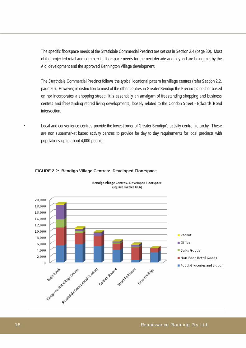
The specifi c fl oorspace needs of the Strathdale Commercial Precinct are set out in Section 2.4 (page 30). Most of the projected retail and commercial fl oorspace needs for the next decade and beyond are being met by the Aldi development and the approved Kennington Village development.
The Strathdale Commercial Precinct follows the typical locational pattern for village centres (refer Section 2.2, page 20). However, in distinction to most of the other centres in Greater Bendigo the Precinct is neither based on nor incorporates a shopping street; it is essentially an amalgam of freestanding shopping and business centres and freestanding retired living developments, loosely related to the Condon Street - Edwards Road intersection.
• Local and convenience centres provide the lowest order of Greater Bendigo’s activity centre hierarchy. These are non supermarket based activity centres to provide for day to day requirements for local precincts with populations up to about 4,000 people.
FIGURE 2.2: Bendigo Village Centres: Developed Floorspace

Strathdale Commercial Precinct Structure Plan Report 19
In summary the village centres are a critical tier in Greater Bendigo’s activity centre hierarchy. They are supermarket based centres and intended to serve the city’s residential and ex-urban districts, and to provide a diversity of retailing, commercial, professional, leisure and community services together with opportunities for new forms of residential accommodation. There are signifi cant fl oorspace needs for village centres for the period 2009-2021 as indicated by a recent study. As such they are intended to be developed as the social focii for the city’s suburban areas.
The Strathdale Commercial Precinct is an active and successful village centre. It serves a district population of approximately 27,500 people (2009) that is projected to grow to 32,000 people by 2021. Most of the precinct’s projected retail and offi ce fl oorspace requirements for the next decade and beyond are being met by the Aldi development and the approved Kennington Village development. These developments will result in the Strathdale Commercial Precinct overtaking the Kangaroo Flat Village Centre in terms of overall retail commercial fl oorspace
Con
text
FIGURE 2.3 Bendigo Village Centres: Developed and Approved Floorspace

Renaissance Planning Pty Ltd20
2.2 Location and Role
The Strathdale Commercial Precinct is located at Condon Street, an arterial road and principal access route from central Bendigo to Strathfi eldsaye, and Edwards Road, an important connector road linking a number of Bendigo’s middle eastern suburbs. The precinct has evolved as a set of freestanding elements set back from both main roads (refer Section 2.3, page 25). .The retail and service role of the Strathdale Commercial Precinct is established by its major attractors. At present Strath Village is the principal shopping centre in the precinct. It functions as a large neighbourhood centre and its retail catchment is set by the full line IGA supermarket which is the principal retail attractor. The retail catchments of the Strathdale Commercial Precinct are shown in Figure 2.1 (page 17), based on in-centre surveys undertaken at the precinct in April 2008. The catchments may be described as follows:
• a primary catchment area which is contained within approximately two kilometres of the Condon Street/Edwards Road interesection. The primary catchment is the area from which most of the daily trips to the centre are generated. It encompasses the suburbs of Kennington, Strathdale and Flora Hill and has an estimated resident population of approximately 16,200 people;
• the secondary catchment area is the catchment from which the majority of weekly and less frequent shopping trips are generated to the precinct. It extends approximately fi ve - six kilometres north and south of the precinct and about nine kilometres south east to Strathfi eldsaye and beyond. The secondary catchment encompasses the south eastern suburbs of Bendigo with an estimated resident population of approximately 27,500 people (2009) projected to grow to approximately 32,000 people by 2021;
• within the primary catchment a walking catchment was assessed from the in-centre survey. It was found to extend approximately one to one and a half kilometres from the Strathdale Commercial Precinct (refer Figure 2.1, page 17). The walking catchment encompasses the study area selected for the Precinct Structure Plan. The fi ndings of an extensive active walkable catchment to the Strathdale Commercial Precinct provided the impetus to ensure safe pedestrian access across the precinct and the main roads and to the residential precincts in order to maximise effective pedestrian access for the residential community,

Strathdale Commercial Precinct Structure Plan Report 21
In-centre surveys were carried out at Kangaroo Flat South Regional Centre, Kangaroo Flat Village Centre, the Bendigo CBD and Eaglehawk by Ratio Consultants in 2003. Further in-centre surveys were carried out by Renaissance Planning in the Strathdale Commercial Precinct in April 2009. These surveys provided important information on patterns of visitation and use of the precinct, together with an indication of needs and preferences. The modal distribution of trips to the precinct indicates that trips are overwhelmingly car based with more than 82 per cent journeying to the precinct by car either as drivers or passengers. A further 14 per cent walked, and the balance (approximately 4 per cent) journeyed to the centre by bus or taxi (approximately 2.5 per cent) or cycled or came by motor cycle (approximately 1.5 per cent). As can be seen in Figure 2.4 below, the Strathdale Commercial Precinct is a heavily car based centre, not just in terms of overall percentage of trips taken to the centre, but also when compared to other village centres in Bendigo, including Kangaroo Flat and Eaglehawk.
Con
text
FIGURE 2.4 Bendigo Activity Centres: Proportion of all trips by car (2003-2009)
Source: In Centre Surveys, Ratio Consultants, 2003, Renaissance Planning, 2009

Renaissance Planning Pty Ltd22
In summary the Strathdale Commercial Precinct is well placed to serve as a designated village centre for Bendigo’s south-eastern suburbs. Its primary catchment area encompasses the local suburbs of Kennington, Strathdale and Flora Hill and the secondary catchment area extends to inner Bendigo in the west and Strathfi eldsaye in the east. The precinct functions as a large neighbourhood centre and this role will be augmented with the Aldi store and the development of Kennington Village. There is a signifi cant interfl ow of visitors between Strath Village shopping centre and the Strath Hill centre and to other parts of the precinct including the bulky goods store at Lowndes Street and the John Bomford Medical Centre.
The surveys also indicated that notwithstanding the separate pattern of developments there was a signifi cant interfl ow of visitors between different parts of the precinct. It was found that:
• approximately 66 per cent of visitors to Strath Village also visited Strath Hill on the day of the survey; the principal attraction being the Bendigo Bank at Strath Hill;
• approximately 40 per cent of visitors to Strath Village also visited other areas in the precinct including the bulky goods store at Lowndes Street, the John Bomford medical centre and the Reservoir Hotel;
• approximately 42 per cent of visitors to Strath Hill also visited Strath Village on the day of survey, the principal attractions being the IGA supermarket, the banks, newsagency and pharmacy.
Strath Village functions as a neighbourhood shopping centre with most visitors frequenting several stores and services on a single trip. More than 90 per cent of patrons visited at least two shops or services and more than 57 per cent visited four or more establishments. The Strath Hill centre operates more as a convenience strip and approximately 80 per cent of patrons visited two establishments or less. The principal stores and services visited at Strath Village included the IGA supermarket, the newsagency, post offi ce, pharmacy, the banks and the McDonalds restaurant.

Strathdale Commercial Precinct Structure Plan Report 23
PHOTO 2.1: Strath Hill Centre: View looking north west at the Condon Street/Edwards Road intersection
Con
text

Renaissance Planning Pty Ltd24
0 2 4
kilometres
Strathfieldsaye
Strathdale
Kennington
Flora Hill
Spring Gully
Quarry HillJunortoun
Mandurang
East Bendigo
Bendigo
Golden Square
White Hills
Epsom
North Bendigo
Long Gully
West Bendigo
Kangaroo Flat
Golden Gully
McIvor Highway
Bendigo Redesdale Road
Con
td Son tree
Midlan
d Highw
ay
C
halder Hig
way
Cae
Hld
r
igahw y
B Men odig ary Rbo hroug oad
Lo
odd
w
n
g
Val el y Hi hay
Ascot
FIGURE 2.5: Strathdale Catchment Area
Primary catchment
Secondary catchment
Primary walking catchment Origins of visitors who walked to centreOrigins of visitors who journeyed to centre by motor vehicle or public transport

Strathdale Commercial Precinct Structure Plan Report 25
2.3 Demography
As indicated in Section 2.1 (page 15) the main trade area (MTA) of the Strathdale Commercial Precinct (refer Figure 2.5) is the principal catchment area for the activity centre and accounts for in excess of 90 per cent of trade drawn to the centre. A detailed demographic analysis was undertaken of the suburbs that make up the core of this area. These are:• Flora Hill;• Kennington;• Strathdale;• Strathfi eldsaye.
A summary of the key measures used in the demographic assessment is shown in Figure 2.6 below. This shows an assessment of selected demographic measures in each of the suburbs that comprise the core of Strathdale’s MTA. The assessment is based on location quotient analysis. This measures the relative concentration of a social or economic factor for a local area in comparison to a wider regional base. For example:• in the 2006 Census of Housing and Population it was found that some 18.9 per cent of the population in the
suburb of Flora Hill was aged 20-24 years;• by comparison the Census indicated that 6.9 per cent of the population in the City of Greater Bendigo was
aged 20-24 years;• the location quotient (LQ) measure for persons aged 20-24 years in Flora Hill at the 2006 Census is as
follows: LQ (Flora Hill) = % of persons aged 20-24 years in Flora Hill % of persons aged 20-24 years in Greater Bendigo = 18.90 6.90 = 2.74
The analysis shows that the proportion of persons aged 20-24 in Flora Hill was almost three times the average representation of this age group in Greater Bendigo. Thus, at the 2006 Census the location quotient analysis shows Flora Hill to have a high concentration of persons in this age group relative to Greater Bendigo.
Con
text

Renaissance Planning Pty Ltd26
The location quotient measure is a simple and powerful measure of relative concentration and very informative in terms of developing and understanding of the key demographic, social and economic characteristics of a local area in comparison to a wider regional base. It will be appreciated that where the LQ value equals 1.0 then there is no variation between a local area and the wider region. As the key to Figure 2.6 (page 27) indicates LQ values in the range of 0.95 to 1.05 there is no statistically signifi cant variation from the mean. The various indicators of degrees of over or under representation and associated LQ values are shown in the key to Figure 2.6.
Figure 2.7 (page 28) shows how each of the selected demographic measures was represented in each of the areas under study at the 2006 Census of Housing and Population. For example, it can be seen that the reference area as a whole has marginally or signifi cantly higher family and household incomes compared to the City of Greater Bendigo as a whole (11 per cent higher median family incomes and 18 per cent higher median household incomes, with higher variations in Strathdale and Strathfi eldsaye).
The analysis shows patterns that refl ect an inner-outer dichotomy across Greater Bendigo. For example, average household size and the relatively high concentration of family households are refl ected in Strathfi eldsaye, a growing outer urban area. The inner areas of Flora Hill and Kennington were marginally under-represented in these measures. Similarly the proportion of persons aged under 14 years is signifi cantly over-represented in Strathfi eldsaye, and under-represented in the inner suburbs of Flora Hill and Kennington with no signifi cant variation in the suburb of Strathdale.
Strathdale and Kennington have relatively high concentrations of older people and Strathfi eldsaye has a signifi cant under-representation of older citizens. The pattern of lone persons households also refl ects an inner-outer variation across the reference area, with relatively high concentrations of lone person households in the inner suburbs of Flora Hill and Kennington. There is a marginal under-representation of lone person households in Strathdale and a signifi cant under-representation in the suburb of Strathfi eldsaye.
Finally a measure was selected that refl ected the attendance at tertiary institutions among persons aged 15-24 years. It was found that the inner suburbs of Flora Hill and Kennington have relatively high concentrations of tertiary students. The proportion of students at Strathdale shows no signifi cant variation from the City of Greater Bendigo and there is a signifi cant under-representation of tertiary students at Strathfi eldsaye.

Strathdale Commercial Precinct Structure Plan Report 27
An analysis of the Strathdale local area from the 2006 Census of Population and Housing is highlighted in the fi gures below. Figure 2.6 highlights age structure data from the 2006 ABS Census for those areas that make up the Main Trade Reference Area compared to Greater Bendigo as a whole. A score of over 1.05 highlights an over representation of particular age structure data whilst a score of less than 0.95 highlights an under representation.
FIGURE 2.6: Strathdale Main Trade Area and Greater Bendigo Age Structures
0 to 4 5 to 14 15 to 19 20 to 24 25 to 34 35 to 44 45 to 54 55 to 64 65+
Flora Hill 0.81 0.69 1.63 2.73 1.22 0.72 0.66 0.65 0.92
Kennington 0.66 0.84 1.02 1.33 0.91 0.89 0.93 0.85 1.48
Strathdale 0.87 1.00 0.99 0.93 0.77 0.92 1.09 1.20 1.12
Strathfieldsaye 1.53 1.46 0.94 0.59 1.25 1.24 0.95 0.75 0.38
Total Main Trade Reference Area 0.91 0.96 1.13 1.37 0.99 0.92 0.93 0.90 1.06
>1.30 Highly over represented1.16 - 1.30 Significantly over represented1.06 - 1.15 Marginally over represented0.95 - 1.05 No significant variance0.94 - 0.85 Marginally under represented0.84 - 0.70 Significantly under represented
<0.70 Highly under represented
Area
Location Quotient Values: Greater Bendigo as Base
Age Structure - All Persons
Con
text
It can be seen that in comparison with Greater Bendigo as a whole:• the resident population of the Main Trade Reference Area as a whole is slightly younger than Greater Bendigo
with a marginal under representation in ages 35 – 64. This is further exemplifi ed by the marginal over representation of 15 – 19 years olds in the area and the high over representation of 20 to 24 year olds.
• The age composition of Strathdale shows that it is an ageing suburb with those in the 20 to 34 age group range either marginally or signifi cantly under represented with those in the over 45 age group categories either marginally or signifi cantly over represented.
• Kennington is dominated by both the young (students attending the La Trobe University campus in Flora Hill

Renaissance Planning Pty Ltd28
in the 20 to 24 age group) and the elderly (those living in aged care facilities, the over 65 age group). It doesn’t appear to be a popular location for family’s with those in the 0 to 14 and 25 to 64 age groups either marginally or signifi cantly under represented.
• Flora Hill is dominated by the La Trobe University campus and this is refl ected in the age group structures for the suburb. There is a huge over representation of those in the 15 to 24 age group and signifi cant under representations in the young (5 to 14) and middle aged (35 – 54).
• Strathfi eldsaye represents a quintessential young family suburb. There is signifi cant over representation of those in the 25 to 44 age groups and of those in the 0 to 14 age groups (most likely the children of those signifi cantly over represented middle aged people). There is a signifi cant under representation of adolescents and young adults who are fi nishing or have fi nished secondary schooling and of older people, particularly the elderly (over 65 years of age).
Figure 2.7 highlights location quotient ratios of household and income data from the 2006 Census for the Strathdale area compared to Greater Bendigo as a whole. A score of greater than 1.05 represents an over representation of particular household and income data in Strathdale compared to Greater Bendigo.
Average household size
Median family income
($/weekly)
Median household
income ($/weekly)
Median housing loan
repayment ($/monthly)
Median rent ($/weekly)
Median individual
income ($/weekly)
% of Family Households
% of Lone Person
Households
% Persons Under 14
Years
% Persons Over 64 Years
Tertiary Institution Attending
Aged 15 to 24Flora Hill 0.92 0.98 0.93 1.00 1.09 0.70 0.94 1.18 0.76 0.97 2.87
Kennington 0.92 1.08 1.02 1.04 1.09 1.08 0.90 1.28 0.81 1.53 1.40
Strathdale 1.00 1.12 1.22 1.09 1.13 1.11 1.04 0.89 0.96 1.12 1.05
Strathfieldsaye 1.28 1.28 1.54 1.29 1.44 0.84 1.23 0.34 1.40 0.16 0.77
Total Main Trade Reference Area 1.03 1.11 1.18 1.10 1.19 1.10 1.00 1.01 0.96 1.04 1.79
>1.30 Highly over represented1.16 - 1.30 Significantly over represented1.06 - 1.15 Marginally over represented0.95 - 1.05 No significant variance0.94 - 0.85 Marginally under represented0.84 - 0.70 Significantly under represented
<0.70 Highly under represented
Location Quotient Values: Greater Bendigo as Base
Area
FIGURE 2.7: Relative Concentrations of Key Demographic Measures

Strathdale Commercial Precinct Structure Plan Report 29
As Figure 2.7 highlights:• income levels observed in the Census were consistently higher in the Strathdale area compared to
Greater Bendigo and for household incomes the differential was signifi cant. Household median weekly incomes were 22 per cent higher in Strathdale compared to Greater Bendigo;
• there was a higher preponderance of family households in the Strathdale area compared to Greater Bendigo and lower representation of both lone person households and group households.;
• demographic projections indicate that the population will age over the next decade and beyond with signifi cant increases in the population aged 65 years and over. The proportion of single person households is projected to marginally increase over the period to 2021.
In summary the demographic assessment shows variations across the reference area for a number of measures that appear to refl ect a wider inner-outer variation in the wider urban area. Notwithstanding this pattern the area as a whole is generally of a higher income level than represented in the wider City of Greater Bendigo. The MTA of the Strathdale Commercial Precinct thus encompasses a broad diversity of demographic areas and the provisioning of services and activities at the activity centre will need to address the broad demographic mix in the wider catchment in order to maximise its appeal in the wider region.
Con
text

Renaissance Planning Pty Ltd30
• Family – demand for increased family support services by 2011.
• Older years – demand is very strong in the catchment for aged services. Projected long-term growth is forecast in the coming years. The current approach is to provide an holistic approach to planning for ageing within the community and provide a positive approach to ageing. This approach is refl ected in the City’s Health and Well Being Strategy.
• Child disability and family support service operate from the Strathdale Children’s Centre. There are no identifi ed
adult disability support services in the local district.
• General community – particular community services or facilities that would be desirable at the Kennington Village retail development would include a generic meeting space for people of all ages, consulting rooms for visiting medical practitioners or community health services providing immunisation services, diabetes testing and other services and information, access opportunities for library and outreach services where possible and appropriate.
2.4 Social, Community and Retailing Needs
The recent social assessment commissioned by the City (undertaken by Dr Kate Kerkin) identifi ed the social needs of the local communities surrounding the future Kennington Village development. The study found that there were a range of needs in the local area. These encompassed:
• Early childhood years – the study identifi ed potential to utilise a number of buildings within the catchment for community groups including play groups and parents’ groups.
• Education and training – possible need for an additional primary school beyond 2021. No need for a further secondary school.
• Young people – no non-recreational facilities targeting young people in the precinct. Opportunities to enhance youth services for young people by improving walking and cycle links and increasing public transport options to link suburban areas with the CBD, community services and entertainment options.

Strathdale Commercial Precinct Structure Plan Report 31
• Medical – there is one general clinic in the Strathdale Commercial Precinct. The Strathdale Children’s Centre provides sessional children’s specialities. There is also a chiropractic centre. However further specialist medical services would be benefi cial.
The major needs and gaps in the area surrounding the Strathdale Commercial Precinct are considered to be youth and family services. There is a lack of non-sporting youth facilities and a general youth resource centre. Moreover, there is a lack of youth support services, youth non-sporting activities and adult disability services.
The in-centre survey at the Strathdale Commercial Precinct provided information on needs of visitors to the Precinct. Survey respondents indicated the need for an additional supermarket, fresh food stores, clothing specialty stores and a discount department store. Positive perceptions of the Centre were based on its location and convenience and parking accessibility. Negative perceptions related to the appearance and amenity of the Strath Village shopping centre and the view that the principal shopping centre (Strath Village) appeared “old and tired”.
The retail and commercial fl oorspace requirements for the Strathdale Commercial Precinct were assessed in the recent studies: the Kennington Village Strategic and Economic Assessment study (prepared for the City of Greater Bendigo, Collie Pty Ltd, August 2008 and the Commercial Land Strategy Review (for the City of Greater Bendigo, Renaissance Planning Pty Ltd, November 2009.
These studies have indicated that:
• there is a signifi cant demand for retail and commercial fl oorspace at the Strathdale Commercial Precinct;
• the recently completed Aldi supermarket and the approved Kennington Village Shopping Centre development will provide two additional supermarkets to the Precinct, a number of specialty stores, cafes and offi ces. The two developments will add 8,340 square metres gross leasable area (GLA) of retail goods and services fl oorspaces and 700 square metres GLA of offi ce fl oorspace.
Analysis undertaken for the study indicates that there is a further potential for some 2,000 square meters of retail goods and services at the Strathdale Commercial Precinct by 2026 (principally in cafes, hospitality services and retail services) and a further 700 square metres GLA of offi ce fl oorspace. In addition there are other requirements for community meeting facilities and specialist medical consulting rooms.
Con
text
Renaissance Planning Pty Ltd32
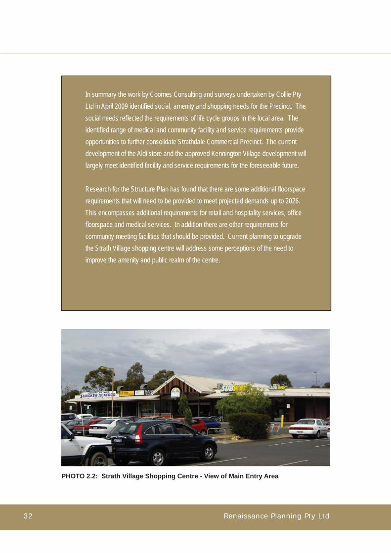
In summary the work by Coomes Consulting and surveys undertaken by Collie Pty Ltd in April 2009 identifi ed social, amenity and shopping needs for the Precinct. The social needs refl ected the requirements of life cycle groups in the local area. The identifi ed range of medical and community facility and service requirements provide opportunities to further consolidate Strathdale Commercial Precinct. The current development of the Aldi store and the approved Kennington Village development will largely meet identifi ed facility and service requirements for the foreseeable future.
Research for the Structure Plan has found that there are some additional fl oorspace requirements that will need to be provided to meet projected demands up to 2026. This encompasses additional requirements for retail and hospitality services, offi ce fl oorspace and medical services. In addition there are other requirements for community meeting facilities that should be provided. Current planning to upgrade the Strath Village shopping centre will address some perceptions of the need to improve the amenity and public realm of the centre.
PHOTO 2.2: Strath Village Shopping Centre - View of Main Entry Area

Strathdale Commercial Precinct Structure Plan Report 33
2.5 Setting and Physical Structure
The Strathdale Commercial Precinct has evolved as a crossroads neighbourhood centre and focal area in a suburban environment. Condon Street is the principal access route from central Bendigo to Strathfi eldsaye and Edwards Road is an important connector road providing cross suburban access to Flora Hill and Kennington. Thus the crossroads on which the Strathdale Commercial Precinct has developed provide extensive district and suburban access for the centre.
The Strathdale Commercial Precinct is a product of the suburbanisation of Bendigo and the growth of the south eastern suburbs from the 1960s onwards. The principal activities of the Precinct are accommodated in freestanding structures, essentially surrounded by car parking (refer Figure 2.8, page 39):
• The Strathdale Commercial Precinct and indeed the wider local area is dominated by the road network. It provides the scale and setting for the Strathdale Commercial Precinct and is the principal common element in the suburban environment.
• The development of Strath Village, Strath-Haven and Strath Hill (and the bulky goods store north of Lowndes Street) present the Precinct as a series of large scale freestanding buildings widely separated from the road network and each other, by large car parking areas and uncoordinated open space.
• Strath Village shopping centre is almost entirely an internalised shopping centre with a limited number of tenancies having an external face, and the main building block is well separated from either Edwards Road or Condon Street.
• Similarly Strath-Haven presents as a freestanding building mass with no connection to any street frontage.
• The Strath Hill centre is a freestanding strip running parallel to Edwards Road and separate from it.
• The Aldi supermarket, on the site of the former indoor sports centre also presents as a freestanding supermarket located at the rear of the Strath Hill centre.
Con
text

Renaissance Planning Pty Ltd34
• The approved Kennington Village shopping centre development is planned to be developed as a “freestanding wing” to be linked to the Strath Village shopping centre. Offi ce and restaurant tenancies will address the street face at Marnie Road and parts of Condon Street.
• There are extensive open space areas throughout the Study Area. The predominant public space is formed around Kennington Reservoir between Crook Street and Reservoir Road and provides an important green corridor. Brennan Park in the south west of the study area is an important recreational and open space resource.
• The suburban environment is comprised of standard density detached dwellings and the dissection of the area by the arterial road and connector roads has resulted in an environment that is beyond the pedestrian scale and is dominated by the motor vehicle.
• The land form is undulating with high points at the north and south of the Study Area.
In summary the Precinct has evolved as a series of freestanding building masses separated from the road network and each other by extensive car parking and uncoordinated landscaping. Moreover there are no pedestrian focal places and spaces in the Precinct, and gathering spaces for shoppers and visitors are confi ned to internal arcades of the Strath Village shopping centre, the edge spaces of the Strath Hill centre or areas within the McDonalds restaurant.
Two of the key issues facing the Structure Plan arise directly from the current isolated forms and lack of quality pedestrian space and amenity in the Strathdale Commercial Precinct. The Structure Plan is (inter alia) directed to achieve a village heart for the local community defi ned by a network of attractive pedestrian focusssed spaces. It is also focussed to provide a framework for the long term transformation of the Precinct to an urban street based form.
The Strathdale Commercial Precinct is set within a standard density suburban environment predominantly comprised of detached single level dwellings. The in-centre surveys showed that about 14 per cent of shoppers and other visitors walk to the Precinct and distances of one kilometre and more are not uncommon. The public realm of the suburban environment is dominated by the road network, which present wide expanses of asphalt and verges well beyond the pedestrian scale.

Strathdale Commercial Precinct Structure Plan Report 35
PHOTO 2.3:View east along Condon Street
at the Edwards Road intersection
PHOTO 2.4:View north along Crook Street
PHOTO 2.5:View across Crook Street to Strath Haven
aged care facilities
PHOTO 2.6:View across Crook Street
south west to Condon Street
Con
text

Renaissance Planning Pty Ltd36
2.6 Integrated Access Considerations
Considerations of integrated access provided an important part of the understanding of the Precinct’s context and planning issues.
Pedestrian and Cycle Access
Research undertaken for the study indicates there are extensive pedestrian movements throughout the Study Area. In particular, Kennington Primary School, South East College and Latrobe University are signifi cant generators of pedestrian trips. The Strathdale Commercial Precinct is itself a major generator of pedestrian trips, and the three nodes, together with Kennington Reservoir and surrounding parkland and Brennan Park provide an important network of pedestrian attractions and open space.
The most signifi cant missing links in the pedestrian network are the limited safe pedestrian crossings at Condon Street which traverses the heart of the Precinct. Thus the improvement of safe pedestrian access accross Condon Street will have a signifi cant systemic benefi t across the entire study area.
Similarly there is extensive provision for both on-road and off-road cycle access throughout the Study Area. The key missing links are on-road cycle links along Edwards Road south of Lowndes Street, Lowndes Street south of Edwards Road, Crook Street and provision for safe access across Condon Street. These links will signifi cantly improve safe bicycle access across the wider local area.
Public Transport Access
Bus services traverse Condon Street to inner Bendigo and the CBD, with an important connecting loop via Edwards Road to Latrobe University and the South East Secondary College. The current and projected growth of Strathfi eldsaye is likely to generate demands for more frequent services to this district via Condon Street.
Vehicular Access
Sub-regional access to the Precinct is provided by the arterial road network (Condon Street and Reservoir Road). District and inter-suburban access is provided by the connector road network (Edwards Road supported by Lowndes Street, Crook Street and Marnie Road).

Strathdale Commercial Precinct Structure Plan Report 37
Key traffi c management and vehicular access issues include:
• the need to improve pedestrian safety and facilitate safe pedestrian access across Condon Street, particularly in the vicinity of the Strathdale Commercial Precinct;
• the need to achieve traffi c calming along Condon Street in the vicinity of the Strathdale Commercial Precinct;
• the need to improve traffi c access across the Study Area. At present there is no connection between Marnie Road and Crook Street at Condon Street. Access to Marnie Road from Edwards Road or Crook Street, north of Condon Street can only be achieved via the Condon Street Edwards Road intersection. Thus the effect of this disconnection is to make local access diffi cult and circuitous;
• the need to facilitate co-ordinated access from Condon Street to the two roadside restaurants that will exist once the Kennington Village development has been implemented (that is the existing McDonalds Restaurant and a proposed restaurant to be developed to the east of the McDonalds facility);
• the need to co-ordinate vehicular access to Condon Street at Reservoir Road and Crook Street and Marnie Road.
Road Network Capacity
The analysis by Traffi x indicates that the most signifi cant traffi c fl ows are carried by Condon Street in the vicinity of the Strathdale Commercial Precinct (in the range of 14,000 - 16,000 vehicles per day measured as two-day data traffi c volumes) and Edwards Road (approximately 7,500 vehicles per day north of Innovation Court and south of Condon Street). The analysis found that there is suffi cient capacity at this intersection to cater for projected traffi c fl ows and that there is existing capacity within the existing road network to cater for foreseeable traffi c growth.
Car Parking
The car parking assessments by Traffi x found that:• the principal car park at Strath Hill (Area 7, refer Figure 5.1, page 64) is currently close to capacity and
accordingly any measures provided as part of a Strathdale Commercial Precinct Structure Plan should not reduce the parking provision in that car park;
• the adjacent car park (Area 10, refer Figure 5.1, page 64) is poorly utilised and measures could be
Con
text

Renaissance Planning Pty Ltd38
considered to increase the connectivity between this car park and Area 7 to share the parking demands and available resources;
• parking area 5 (Strath Village, western car park facing Edwards Road) is highly utilised and congested due to vehicles entering and exiting at both ends. Consideration may be given to making this area operate one way, to reduce congestion and improve vehicle circulation;
• overall Strath Village car parking is underutilised (61 per cent at the peak time). The car parking supply could be reduced from 508 car spaces to 344 car spaces and peak occupancy would be at 90 per cent. Accordingly, the car parking assessment indicates that some existing car spaces can be removed in order to implement other objectives of the Strathdale Commercial Precinct Structure Plan, such as improvements to pedestrian amenity and potential for additional street-based developments; and that this can occur without prejudice to the operation of the car parking system at Strath Village, subject to a fi nal assessment of car spaces that may be lost for these purposes.
In summary the Strathdale Commercial Precinct and surrounding educational, recreation and park areas are signifi cant generators of pedestrian activity. An on and off road bicycle network also contributes to connectivity in the precinct, which is primarily accessed via the arterial (Condon Street and Reservoir Road) and sub-arterial road network. These access routes serve vehicles and the public transport network and connect the precinct with sub-regional and district and inter-suburban communities.
Key access considerations for the network involve ensuring pedestrian safety, linking the existing network, developing further public transport infrastructure and further co-ordination and facilitation of key traffi c issues for the benefi t of pedestrians in the area. The analysis found that there was suffi cient capacity for future traffi c growth and the precinct had a signifi cant component of carparking, some of which was underutilised.

Strathdale Commercial Precinct Structure Plan Report 39
Con
text
FIGURE 2.8: Location of Car Parks surveyed (Collie Pty Ltd and Traffi x Group), April 2009
12
11
10
78
9
4
3
2
5
1 6
1 Strath Village - northern car park2 Strath Village - eastern car park/service area3 McDonalds car park4 Strath Village - main northern car park5 Strath Village - main western car park6 Edwards Road south7 Strath Hill8 Service Station9 Strath Hill west - mixed use precinct10 Strath Hill north - mixed use precinct11 Feel Good Fitness car park12 Bargains Galore car park

Renaissance Planning Pty Ltd40
3Vision and Community Values

Renaissance Planning Pty Ltd42

Strathdale Commercial Precinct Structure Plan Report 43
3 VISION AND COMMUNITY VALUES 3
Vision
and
Com
mu
nity V
alues
3.1 Community Values
A community workshop was conducted with residents and stakeholders during the consultation phase of the project. The development of a vision to guide the Strathdale Commercial Precinct was derived from an identifi cation of key themes that were deemed to be of signifi cance to the community. These encompassed:
• Pedestrian Safety, Traffi c Management and Access
“This key issue concerns the separation of people from the traffi c and providing access for
all. Current access and safety for the elderly, mobility devices and prams was identifi ed
as a problem. The speed and volume of traffi c coupled with a lack of crossings on the
surrounding roads was seen as challenging for the elderly and children. The fragmentation of
shopping caused by the roadways and traffi c was seen as a negative and suggestions were
made about a physical linkage across the highway through either an underpass or overpass.
Another suggestion was the creation of a central island, with tree plantings on the highway so
people could make a two stage crossing..”
• Community Spaces, Identity and Sustainable Design
“There was a desire to make the Strathdale Commercial Precinct user friendly and a place
for people to enjoy. Suggestions included: more shade and seating, playground space
for children, green open spaces, coffee shops and alfresco dining. The future plan for the
Strathdale Commercial Precinct was seen as an opportunity to integrate the shopping centres
and create a village identity and character. There was some discussion about the name of
the area in relation to identity building. Future development should incorporate sustainable
design elements like recycled water use and sustainable energy.”

Renaissance Planning Pty Ltd44
• Community Services, Facilities and Viability
“There was common ground about the need for the commercial precinct to be viable and
diverse. Providing a range of community services and facilities, in addition to retail, like
banking, medical clinics, meeting rooms, entertainment and other professions will give
people more reasons to regularly visit the precinct.”
3.2 Vision Statement
A Vision Statement was prepared based on the Community Workshop and an evaluation of community directions by the planning team.
“The Strathdale Commercial Precinct will be an attractive pedestrian focussed and safe place that is vibrant and friendly meeting a diversity of local and district needs.
All that we do in the Strathdale Commercial Precinct will be:• socially inclusive and family friendly• safe and sustainable• building a village feel• customer and user focused”

Strathdale Commercial Precinct Structure Plan Report 45
3.3 Key Planning Issues
The study identifi ed a number of signifi cant planning issues that the Structure Plan needed to address. These encompassed:
• a range of facility and service needs for particular life cycle groups and support services for disabled citizens. A particular need for meeting rooms and medical facilities, particularly specialist medical facilities was identifi ed (refer Section 2.4);
• the approved Kennington Village shopping centre and the Aldi supermarket will address current and projected needs for the foreseeable future of the local area of Strathdale, Kennington and the wider district. The signifi cant population serviced generates needs for a range of commercial and professional services and these will need to be met within the Precinct;
• traffi c and pedestrian safety - the village was founded and has grown as a crossroads settlement with isolated clusters of freestanding developments. As these have grown, pedestrian access requirements have increased throughout the activity centre and across the roads that service it;
• need to directly address the issue of safe quality pedestrian access throughout the core area (refer Figure 5, Page 28) and create a stronger pedestrian focus from the precinct outwards to the residential area;
• the core area and suburban surrounds need a unifying sense of place and linkage;
• need to ensure that a diversity of activities are fostered in the Strathdale Commercial Precinct and that it reaches potential as a true village centre;
• wider signifi cance of education, retirement and health facilities;
• great potential to link the Kennington Reservoir and parklands to the core of the village centre.
Vision
and
Com
mu
nity V
alues

Renaissance Planning Pty Ltd46

4StrategicDirections

Renaissance Planning Pty Ltd48
Strathdale Commercial Precinct Structure Plan Report 49
4 STRATEGIC DIRECTIONS 4
Strateg
ic Direction
s
4.1 What is a Structure Plan?
A Structure Plan is a preferred organisation of land use, transport, landscape, pedestrian space and built form to realise a community vision for a defi ned area or precinct. The Structure Plan for the Strathdale Commercial Precinct is focussed to achieve a high quality village centre focussed around the community vision and which refl ects Council policy, maximises community benefi t and is sustainable.
The vision for the Precinct is that it will become an attractive pedestrian focussed and safe place that
is vibrant and friendly meeting a diversity of local and district needs.
4.2 What are Strategic Directions?
The strategic directions are the fundamental building blocks of the Structure Plan. They represent the underlying principles and rationale of the Structure Plan.
Each of the directions represents a fundamental consideration and underpinning to build the Structure Plan. The key directions that contribute to the Structure Plan encompass:
• creating a strong recognisable village heart for the Precinct,
• creation of a hierarchy of pedestrian and bicycle pathways, together with open space linkages where practicable;
• facilitating strong public transport connections to the Bendigo CBD,
• providing for a diversity of housing,
• ensuring ‘permeability’ in the local area: a diverse network of access routes and options,
• ensuring sustainability within design,
• providing ‘legibility’ or defi ning pathways and directions to facilitate wayfi nding,

Renaissance Planning Pty Ltd50
• enhancing a living and diverse community,
• renewing the pedestrian scale.
4.3 Village Heart
The Structure Plan seeks to create a sense of place and village heart for the Strathdale Commercial Precinct through:
• transformation of Condon Street in the vicinity of the Strathdale Commercial Precinct to a boulevard with a central avenue of trees and enhanced roadside landscaping;
• extension of built form, pedestrian pathways and landscaping to the Condon Street frontage where opportunities present (long term transformation from suburban dominated forms to a coherent urban heart);
• encouragement and facilitation of complementary activities (including cafes, restaurants and other services) that enliven indoor and outdoor public spaces;
• encouragement and facilitation of a diversity of retailing activities and environments to provide new points of interest and attraction;
• encouragement and facilitation of a range of professional and community services to provide a broad balance of activities for the Strathdale Commercial Precinct;
• creation of a high quality pedestrian pathway system that links directly to the internal arcade of Strath Village and the envisaged verandah system of Kennington Village;
• facilitation of a recognised domain of quality pedestrian access and gathering places (refer Figure 4.3, page 56);
• within this context, facilitation of pedestrian linkages across Condon Street and Crook Street to Kennington Reservoir;
• undergrounding of powerlines when major roadworks are being planned and implemented.

Strathdale Commercial Precinct Structure Plan Report 51
Strateg
ic Direction
s
In summary the Structure Plan seeks to unify several key elements to create a coherent core area in the Strathdale Commercial Precinct. These are:
• Strath Village shopping centre;• Kennington Village shopping centre;• Strath Hill;• Strath-Haven;• Kennington Reservoir and adjoining public space (referred to as the Lakeside
planning area in the Structure Plan):• Condon Street boulevard.
The overriding urban design principle is to connect and establish these opportunities within the precinct. Once the principal internal and external pedestrian routes were identifi ed the framework was established to co-ordinate pedestrian and vehicle hierarchies. Intrinsic to this evaluation was the development of the following:
• three dimensional design and development principles;
• public space and landscape principles;
• amenity and safety guidelines.

Renaissance Planning Pty Ltd52
FIGURE 4.1: Pedestrian Space and Opportunities Plan
Condon Street
Edwa
rds S
treet
Marnie Road
Reservo
ir Road
Lowndes Street
Strath Village
Strath-Haven
Strath Hill
High
Moderate
Low
Area of highest potentialpedestrian improvements
Desirable slow traffi c zone
Potential Pedestrian Access Levels

Strathdale Commercial Precinct Structure Plan Report 53
Strateg
ic Direction
s
4.4 Open Space and Pedestrian Network
The Structure Plan seeks to create a high quality village precinct that is closely linked to the local area and wider district. There are three key components:
• an intensive central area pedestrian network system;
• open space and pedestrian - cycle networks;
• an extensive street-based pedestrian pathway system and on road cycle network.
Central Area Pedestrian Space Plan
The design framework underlying the Structure Plan was derived from the central area pedestrian space plan (refer Figure 4.3, page 56). The plan provides a consistent and integrated pedestrian network that brings the principal elements of the core area together. In particular, the plan:
• identifi es potential locations for external plazas and squares addressed by active frontages and squares;
• an opportunity to provide a north facing terrace or square at the interface of the Strath Village and Kennington Village shopping centres;
• linkages to the envisaged north facing verandah at Kennington Village and the internal arcade system of Strath Village;
• safe pedestrian crossings at Condon Street (at Edwards Street, mid block connections to Strath Haven and at Marnie Road / Crook Street);
• a pedestrian access to link the Kennington Reservoir and perimeter pathway directly to the core pedestrian network;
• undergrounding of powerlines when major roadworks are being planned and implemented.

Renaissance Planning Pty Ltd54
Major Open Space Linkages
The Structure Plan envisages new direct pedestrian linkages between the core area and existing pedestrian and cycle networks that encompass Kennington Reservoir and its extensive parklands.
Connections to the District Pedestrian and Cycleway Networks
The Structure Plan seeks to integrate the extensive existing suburban pathway and cycling network with the open space system and particularly with the Strathdale Commercial Precinct. In this context improvement of connections and pedestrian networks and the provision of pedestrian - focussed spaces creates a destination focussed Strathdale Commercial Precinct and facilitates safe pedestrian access across the principal arterial route, Condon Street. Improvements at the central area achieve wider systemic benefi ts to the district.
In summary the Structure Plan seeks to provide a strong pedestrian focussed core area with high quality linkages to Kennington Reservoir and its extensive parkland areas and facilitation of improved access and linkages to the local area and wider district. Within this template it is important to activate a real and genuine sense of belonging. This celebrates the scale and traditions of Strathdale and Kennington by repositioning the reservoir and open space area immediate to the east of Strath-Haven, (areas outlined in the framework and structure plans) as integral to the future growth of the village and environs. This consolidation then utilises these natural assets to achieve the following key benefi ts:
• repositions the centre at the junction of the parkland and recreation network;
• adjusts and redirects the scale of Condon Street as a boulevard, to celebrate and reposition the locale and surrounds;
• consolidates adjacent streetscapes;
• establishes safe pedestrian crossings and walking paths quarantined from the road edge;
• establishes clear sight lines across Condon Street to the reservoir;
• thematically ties the pedestrian cycle system and open space system together with consistent paving and planting.

Strathdale Commercial Precinct Structure Plan Report 55
Key Issues
1 Main road networks at the heart of the Village Precinct;
2 Highest pedestrian crossing requirement at the busiest intersection;
3 Enveloping dominance of at-grade car parks;
4 Elaborate nature of core pedestrian access.
The consultative design process for the Strathdale Commercial Precinct identifi ed the lack of pedestrian safety and the need for attractive focal places at the heart of the Precinct. These needs established the impetus to provide a village heart and to unify the pedestrian and open space system. The Structure Plan provides a design approach for Condon Street that transforms it from an arterial through route that divides the Precinct to a unifying boulevard and safe pedestrian zone that, together with changes in built form and design will bring the Precinct together.
Strateg
ic Direction
s
FIGURE 4.2: Strathdale Core Circulation Plan
Car Park AreasArterial RoadSub-Arterial RoadConnector RoadsMinor RoadsMajor PedestrianConfl ict AreasPedestrian Access

Renaissance Planning Pty Ltd56
FIGURE 4.3: Strathdale Central Area Pedestrian Space Plan
LEGEND
Key Activity AreasPedestrian Linkages

Strathdale Commercial Precinct Structure Plan Report 57
Strateg
ic Direction
s
4.5 Connection to Bendigo CBD
Critical to reconnecting with the Central Business District (CBD) is establishing a median strip to Condon Street and reconfi guring the bus stop to this axis. Providing safe and convenient public transport access to the CBD creates a sense of proximity and accessibility; however it remains important to differentiate from the scale and type of urban design interventions that are apparent in the CBD creating an individualistic and specialised local character for the Strathdale Commercial Precinct.
4.6 Diversity of Housing
The establishment of diverse housing stock with emphasis on higher density may follow as a consequence of reconfi guration of the key shopping nodes in the precinct. Allowable space for higher density housing is marginal and consideration may be given in time to accessibility options within the precinct. Therefore it will be necessary to:
• investigate long-term housing options within the precinct;
• investigate bicycle and pedestrian pathway linkages to the CBD;
• develop a diversity of housing types, including higher density housing opportunities at Strath-Haven for Strath-Haven residents only;
• consider opportunities for residential student accommodation along Edwards Road in the masterplanning of the proposed Innovation Park;
• investigate opportunities for medium density housing in the Lowndes Precinct as part of the consideration for the long term use and zone of the precinct.

Renaissance Planning Pty Ltd58
4.7 Permeability
Permeability, sustainability within design, and legibility are intrinsic values ingrained in the structure planning process.
As discussed in previous sections but with specifi c reference to the values listed above, it will be important to incorporate these principles in the Structure Plan:
• articulate pedestrian and vehicle hierarchy with clear and identifi able sight lines across the precinct;
• articulate with median and street confi guration Condon Street as the principal boulevard;
• register signifi cance of Condon Street as the central core with a new bus stop, interchange and high profi le pedestrian crossing adjacent to McDonalds;
• reconfigure footpaths and crossing points at road junctions to achieve visual and material consistency;
• apply water sensitive urban design principles to all new plantings and hard stand areas;
• standardise lighting and detail design elements (bollards, railings, edges etc);
• consistency of materials and articulation of surface and landscape narrative to identify specifi c integrated areas, the reservoir, boardwalk, Strath-Haven frontage and shopping centre car parks;
• celebrate identity of the Strathdale Commercial Precinct by commissioning architectural or sculptural form to re-activated urban space adjacent to Strath-Haven.
4.8 Sustainability in Design
Key to the urban design process is the recognition that increased native and exotic tree cover will provide much needed shade in summer and protection in winter. The proposed urban design initiatives seek to utilise existing successful species and introduce them as a standard throughout the precinct. Particular attention is being placed upon pedestrian access along Condon Street (at the Edwards Road and Marnie Road intersection) and the infi ll potential for new and proposed shopping areas. The absence of serious planting initiatives and human scale vegetation contributes to the sense of alienation and space. The predominant theme within this design exercise is to recognise simple vegetation patterns as a vital ingredient in consolidation and composition of elements within the precinct.

Strathdale Commercial Precinct Structure Plan Report 59
Strateg
ic Direction
s
An important requirement for planning and urban design is the need to ensure ecologically sustainable development. The Structure Plan recognises the importance of providing sustainable principles in built form, land use and development, water, waste and energy in any future development.
4.9 Legibility
Pivotal to this is the re-working of Condon Street to change its personality from a rigid arterial thoroughfare to a treed boulevard. To soften and lighten the impact of a bleak open space and create a transition between the built and natural elements. To reduce the scale of separation in the public realm to establish a closer synergy between people, commercial enterprises and the natural landscape. The urban design framework sought to establish these principles and outlined trends for future development. The design approach is to make the connections and develop and exchange between high use and underutilised assets.
4.10 Living Community
An important direction in the Structure Plan is the need to provide a framework for the Strathdale Commercial Precinct as the heart of a living community for a diversity of local and district groups. In particular, the Structure Plan:
• provides a range of internal and external spaces at the retail commercial core (Strath Village - Kennington Village) to provide diverse opportunities for people to meet and socialise;
• identifi es opportunities for Strath-Haven to more actively interface with the community;
• precinct includes opportunities for shared open space and improved connections to the retail commercial core, Kennington Reservoir and the wider open space system;
• provides a framework for a possible residential / mixed use edge for the proposed Central Victorian Innovation
Park at the Edwards Road interface. This could be used to provide for student housing and other needs and ensure a wider diversity of housing and accommodation types within the Strathdale Commercial Precinct;
• provides a defi ned high quality urban space at the core of the Strathdale Commercial Precinct through the transformation of Condon Street to a boulevard and the provision of high quality safe pedestrian linkages to the extensive open space and parklands which adjoin the Precinct;
• access opportunities for library and outreach services where possible and appropriate.

Renaissance Planning Pty Ltd60
4.11 Renew the Pedestrian Scale
The living community and renewing the pedestrian scale in the Strathdale Commercial Precinct are vital themes in the review of the pedestrian scale in the precinct.
• establish principal pedestrian and traffi c scale hierarchy;
• ensure pedestrian safety and comfort;
• investigate additional street plantings for Edwards Road south of Condon Street;
• establish clear and high quality pedestrian walking access throughout the Strath Village and Kennington Village shopping centres and across Condon Street;
• establish opportunities for community to engage both on a commercial and environmental level with balance achieved between the reservoir and the shopping centres;
• investigate opportunities to provide improved pedestrian linkages from the Village Core and Strath Haven precincts to the Lakeside precinct and potentials to connect to the existing pedestrian pathway system.

5Structure Plan

Renaissance Planning Pty Ltd62

Strathdale Commercial Precinct Structure Plan Report 63
5 STRUCTURE PLAN 5S
tructu
re Plan
5.1 Purpose
The purpose of the Structure Plan is to provide a clear planning and design framework for the management and development of the Strathdale Commercial Precinct that is directed to achieve a high quality people-focussed village centre which is sustainable and refl ects the community vision and Council policy.
5.2 Component Planning Areas
For the purposes of the Structure Plan and policy development the Strathdale Commercial Precinct was divided into a number of component areas (refer Figure 5.1, page 64). These are:
• Village Core,• Boulevard,• Strath-Haven,• Lakeside,• Strath Hill,• Lowndes,• Central Victorian Innovation Park,• Village Life.

Renaissance Planning Pty Ltd64
Condon Street
Reservoir R
oadEdw
ards
Roa
d
Mar
nie
Road
Lowndes Street
Strath Village
Strath Hill
La Trobe University
KenningtonReservoir
Strath-Haven
1
7
4
3
658
2
Not to Scale
Kennington Village
BrennanPark LEGEND
1 Village Core2 Boulevard3 Strath-Haven4 Lakeside5 Strath Hill6 Lowndes7 Central Victorian Innovation Park8 Village Park
Figure 5.1: Precinct and Component Areas
LEGEND1 Village Core2 Boulevard3 Strath-Haven4 Lakeside5 Strath Hill6 Lowndes7 Central Victorian Innovation Park8 Village Life

Strathdale Commercial Precinct Structure Plan Report 65
Figure 5.2: Strathdale Commercial Precinct Structure Plan
Lowndes Street
Condon Street
Marnie Road
Reservo
ir Road
BrennanPark
KenningtonReservoir
La TrobeUniversity
LEGEND
Edw
ards
Roa
d
St Aidens Road
Arterial Roads
Sub Arterial Roads
Collector Roads
Selected Tree Planting
Retail/Commercial Activity
Community Facilities
Community Space
Technology Precinct
Business 4
Residential
Precinct Boundary
Existing and Proposed Bicycle Routes
Public Parks and Reserves
Investigation Areas for Safe Pedestrian Access
Bus Routes
Pedestrian Linkages
Education Activities
Retirement Living
0 250
metres
VLSH2
SH1
LDs
VC
CVIP
LS
CVIP
VL Village Life
Strath Hill
Strath-Haven
Lowndes
Lakeside
Boulevard
Village Core
Central Victorian Innovation Park
SH2SH1
LDs
VC
CVIPLS
B
B

Renaissance Planning Pty Ltd66
5.3 Village Core
Signifi cance
The Village Core comprises the existing Strath Village and the approved Kennington Village shopping centres. It is the current and likely future retail and commercial hub of the Strathdale Commercial Precinct and presents the greatest opportunities to create a sense of place and an environment for social interaction, that could be facilitated through a network of internal and external spaces.
Strath Village developed as a freestanding centre, well separated from Condon Street and Edwards Road by extensive car parking areas. The approved Kennington Village shopping centre has its major components also set well back from Condon Street and Marnie Road;
• the approved Kennington Village plan provides a direct axial link between the two centres. This will ensure a high level of interaction between the two centres and effectively they will function as a single shopping precinct;
• the approval for Kennington Village also provides for commercial development to face Condon Street and Marnie Road;
• in addition there is a requirement for open space at Condon Street to be fl anked by a restaurant and other activities and linked via a walkway to the Kennington Village core area.
These components will ensure the functional integration of Strath Village and Kennington Village and will mark the beginning of a process to reform a disparate suburban freestanding pattern of development towards an urban street based pattern.
Surveys and research for the Structure Plan showed a high level of pedestrian interaction between the Village Core precinct and the adjacent Strath Hill and Strath-Haven precincts. The Structure Plan recognises that this level of interaction is likely to increase as a result of the new Aldi supermarket and the possible long term redevelopment and consolidation of the Strath-Haven facilities. In this context there is a critical need to improve safe pedestrian access at the Edwards Road/Condon Street intersection and along Edwards Road north to the Kennington Primary School. Importantly the Structure Plan recognises this need, and provides a north south pedestrian spine along Edwards Road providing amenable and safe pedestrian access from LaTrobe University north to the Village Core precinct with safe access to the Strath-Haven and Strath Village precincts and extended linkages north to the Kennington Primary School.

Strathdale Commercial Precinct Structure Plan Report 67
Stru
cture P
lan
The challenge of the Structure Plan is to facilitate the development of new quality public spaces and a safe attractive environment to achieve the vision of a people-focussed central place at the heart of the Strathdale Commercial Precinct.
Objectives
• Identify opportunities for a town square/s to be externally focussed at the interface between Strath Village and Kennington Village;
• provide opportunities and facilitate complementary activities for public spaces and spaces;
• provide a network for improved pedestrian access within the village core area;
• ensure the pedestrian network system is integrated and connected to other areas in the Strathdale Commercial Precinct and to the adjacent residential areas by a series of internal and external spaces and places;
• provide a framework for the transformation of development in the village core to a street-based form;
• protect the amenity of residential areas;
• ensure that service areas are screened from both residential areas and primary shopping and pedestrian areas;
• encourage a broader diversity of complementary activities including commercial, professional and community services.
Concepts
The Structure Plan proposes a town square to be developed at the interface of Strath Village and Kennington Village. Key elements of the concept could comprise:
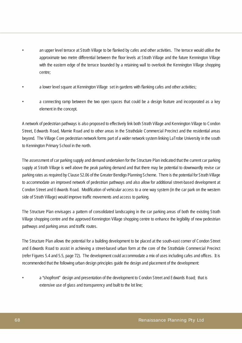
Renaissance Planning Pty Ltd68
• an upper level terrace at Strath Village to be fl anked by cafes and other activities. The terrace would utilise the approximate two metre differential between the fl oor levels at Strath Village and the future Kennington Village with the eastern edge of the terrace bounded by a retaining wall to overlook the Kennington Village shopping centre;
• a lower level square at Kennington Village set in gardens with fl anking cafes and other activities;
• a connecting ramp between the two open spaces that could be a design feature and incorporated as a key element in the concept.
A network of pedestrian pathways is also proposed to effectively link both Strath Village and Kennington Village to Condon Street, Edwards Road, Marnie Road and to other areas in the Strathdale Commercial Precinct and the residential areas beyond. The Village Core pedestrian network forms part of a wider network system linking LaTrobe University in the south to Kennington Primary School in the north.
The assessment of car parking supply and demand undertaken for the Structure Plan indicated that the current car parking supply at Strath Village is well above the peak parking demand and that there may be potential to downwardly revise car parking rates as required by Clause 52.06 of the Greater Bendigo Planning Scheme. There is the potential for Strath Village to accommodate an improved network of pedestrian pathways and also allow for additional street-based development at Condon Street and Edwards Road. Modifi cation of vehicular access to a one way system (in the car park on the western side of Strath Village) would improve traffi c movements and access to parking.
The Structure Plan envisages a pattern of consolidated landscaping in the car parking areas of both the existing Strath Village shopping centre and the approved Kennington Village shopping centre to enhance the legibility of new pedestrian pathways and parking areas and traffi c routes.
The Structure Plan allows the potential for a building development to be placed at the south-east corner of Condon Street and Edwards Road to assist in achieving a street-based urban form at the core of the Strathdale Commercial Precinct (refer Figures 5.4 and 5.5, page 72). The development could accommodate a mix of uses including cafes and offi ces. It is recommended that the following urban design principles guide the design and placement of the development:
• a “shopfront” design and presentation of the development to Condon Street and Edwards Road; that is extensive use of glass and transparency and built to the lot line;

Strathdale Commercial Precinct Structure Plan Report 69
Stru
cture P
lan
• sympathetic design of any upper level activities to the shopfront ground elevation;
• incorporation of signage and lighting to optimise the strategic position of the development as a gateway symbol for the precinct;
• provision of outdoor dining areas to the south and east of the development facing the Strath Village centre;
• linked pedestrian access to the main entry areas of the Strath Village centre.
The approved Kennington Village plan provides for service areas at the rear of the development to be extensively screened from the bordering residential properties. The existing service area for the Strath Village shopping centre is located on its eastern side. The Structure Plan envisages that the service area would be confi ned to the south eastern section of the Strath Village shopping centre.
Implementation
It is recommended that the City of Greater Bendigo undertake discussions with representatives of the Body Corporate of the Strath Village shopping centre and the owner of the approved Kennington Village shopping centre to ascertain the extent to which a town square concept could be developed at the interface of the Strath Village and Kennington Village shopping centres.
In this context it is recommended that Council consider allowing a downward revision of car parking requirements for Strath Village shopping centre to facilitate the development of a town square/terrace and adjoining development as generally indicated in Figure 5.2, page 71.
It is also recommended that the City of Greater Bendigo seeks agreement with the owners of the Strath Village and Kennington Village shopping centres to modify the required pedestrian connection between the two centres to be facilitated by an external ramp connecting the proposed town square elements.
It is recommended that the City encourage the owners of the Strath Village shopping centre to prepare a Masterplan for the long term upgrading and development of the Strath Village shopping centre that could consider modifi cations to car parking supply and layout and the provision of additional street-based development and maintain car parking supply in accordance with future demand rates.

Renaissance Planning Pty Ltd70
PHOTO 5.1: Strath Village Shopping Centre: View of Main Entry and Edwards Road frontage
PHOTO 5.2: View of Kennington Reservoir and shared pathway looking north

Strathdale Commercial Precinct Structure Plan Report 71
Figure 5.3: Strath Village/Kennington Village Square
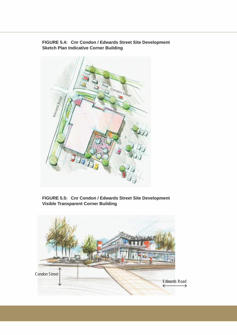
FIGURE 5.4: Cnr Condon / Edwards Street Site DevelopmentSketch Plan Indicative Corner Building
FIGURE 5.5: Cnr Condon / Edwards Street Site DevelopmentVisible Transparent Corner Building
Condon StreetEdwards Road

Strathdale Commercial Precinct Structure Plan Report 73
5.4 Boulevard
Signifi cance
Condon Street is an arterial road and a principal access route from central Bendigo to Strathfi eldsaye. The Structure Plan envisages that an important section of Condon Street in its passage through the Strathdale Commercial Precinct should be planned and managed as a boulevard. A separate planning area extending along Condon Street reserve between Reservoir Road and Leigh Avenue has been identifi ed for this purpose.
Condon Street is the principal access route and the central common space linking the northern and southern sections of the Strathdale Commercial Precinct. It was also identifi ed in research undertaken for the Structure Plan as a constraint for safe pedestrian access.
Thus from the standpoint of the Structure Plan the identifi ed section of Condon Street is the most signifi cant road space in the study area. Planning and management of Condon Street in its passage through the Strathdale Commercial Precinct has the potential to be transformed from a key division and barrier in the Precinct to a unifying and focal element through landscaping, traffi c management, public transport and improved pedestrian improved pedestrian access.
Objectives
• Investigate the potential and practicality for the development of Condon Street as a unifying element in the Strathdale Commercial Precinct, encompassing traffi c safety, pedestrian safety and access and landscape amenity;
• identify opportunities for the transformation of Condon Street to a tree-lined boulevard with a central plantation;
• provide a pedestrian pathway system along the edges of the boulevard and ensure safe pedestrian access across Condon Street at key intersections (Edwards Road, Marnie Road and Reservoir Road);
• facilitate improved cycle access to ensure the linkiing of existing on-road and off-road cycleways;
• investigate opportunities for improved public transport access and stops in the Strathdale Commercial Precinct;
Stru
cture P
lan
Renaissance Planning Pty Ltd74
• provide for safe vehicular and pedestrian access from Marnie Road to Condon Street and the rationalisation of traffi c signals between Edwards Road and Reservoir Road;
• provide a raised pedestrian crossing on Crook Street.
Concepts
The planning and design concepts envisaged by the Structure Plan to transform Condon Street to a boulevard and central linking space for pedestrian, public transport and cycle access are:
• A landscape concept for Condon Street for edge and central plantation treatment (refer Figure 5.9, page 83);
• distinctive clustering of signature trees at the Edwards Road – Condon Street intersection as place markers for the Precinct;
• a signalised intersection at Marnie Road and Condon Street incorporating a pedestrian phase and rationalisation of traffi c signalisation between Reservoir Road and Edwards Road with the removal of existing signals at their current mid-block location;
• an extensive pedestrian pathway edge and provision for safe pedestrian access across Condon Street in addition to Edwards Road (existing);
• designation of Condon Street between Reservoir Road and Leigh Avenue as a slow-speed zone;
• provision for a queuing lane and turning movements for vehicular entry into Strath Village (including McDonalds) and Kennington Village;

Strathdale Commercial Precinct Structure Plan Report 75
Implementation
The following actions are recommended to facilitate the transformation of Condon Street to a low speed boulevard:
• Review and assessment of the proposed traffi c signalisation changes for Condon Street between Reservoir Road and Edwards Road by Vic Roads in conjunction with the City of Greater Bendigo;
• agreed resolution of a Development Plan for Condon Street to be co-ordinated by Vic Roads and City of Greater Bendigo in consultation with other stakeholders, to encompass development implementation and funding.
The Development Plan is required to address:
• boulevarding of the road including enhanced edge planting and a central plantation;
• pedestrian pathway development along both edges of the boulevard and additional pedestrian crossings at Marnie Road – Crook Street;
• augmentation of street and intersection lighting as required;
• provision of co-ordinated vehicular access and egress to the Strath Village and Kennington Village shopping centres including the McDonalds restaurant and other cafes to be developed.
Stru
cture P
lan

Renaissance Planning Pty Ltd76
5.5 Strath-Haven
Signifi cance
The Strath-Haven planning area is an island site bounded by Edwards Road and Lowndes, Crook and Condon Street. The site is signifi cant in two respects:
• it accommodates one of the most important retirement and aged care facilities in Greater Bendigo. Strath-Haven is a 94 bed residential aged care facility managed by Uniting Aged Care Victoria and Tasmania (UACVT). It has been providing services to older residents since 1979. The facilities are set in gardens and provide a range of social, recreational and pastoral activities for residents;
• the site is centrally located in the Strathdale Commercial Precinct opposite the Village Core area and adjacent to the Strath Hill and Lakeside areas (refer Figure 5.6, page 78). It is within close proximity to a range of shopping facilities and services and the extensive recreational areas that encompass the Kennington Reservoir.
There is currently a masterplanning process in place being conducted by the UACVT. A detailed assessment of current and future resident needs is being undertaken as part of this process.
Objectives
• Recognise the ongoing signifi cant retirement living and residential aged care facilities and services provided by Strath-Haven;
• ensure high quality and safe pedestrian access from Strath-Haven across Crook Street to the Lakeside precinct; across Edwards Road to the Strath Hill precinct (at the Edwards Road/Condon Street intersection) and across Condon Street to the Village Core precinct (at the Edwards Road and Marnie Road intersection);
• investigate opportunities for shared open space and activities to more effectively link Strath-Haven with the wider community;
• provide for improved public transport access;• provide a planning framework to facilitate additional development and accommodation opportunities at the Strath-
Haven site;• provide an urban design framework to guide master planning and the physical development of the Strath-Haven
facilities, to provide: - articulation of building forms to provide interest and variation for buildings and activities to be provided on
the site; - opportunities for gradation of building heights with generally lower and mid scale buildings at the Condon

Strathdale Commercial Precinct Structure Plan Report 77
Street frontage and higher buildings on the southern side of Lowndes Street. - opportunities for a landmark/gateway building element at Condon and Edwards Street; - opportunities to articulate building layout and create internal courts and gardens; - opportunities to provide outward facing buildings to better integrate the development with
the surrounding precinct; - potentials to create an active interface to address a possible shared open space in the
south eastern area of the subject site (refer Figure 5.7, page 79); - provision of safe pedestrian access across Crook Street to facilitate improved pedestrian
connections to Kennington Reservoir and parklands; - opportunities to facilitate upgrading of pedestrian linkages along Edwards Road; - landscaping along the street edges of Strath-Haven consistent with the landscape
thematic treatment plan (refer Figure 5.9, page 83).
Concepts
Preliminary concepts have been prepared for discussion purposes to indicate how the planning objectives could be met. They provide (refer Figure set 5.8, page 80):
• a network of safe pedestrian access crossing points at signalised intersections (the existing intersection at Edwards Road and Condon Street and the proposed new signalised intersection at Marnie Road and Condon Street). It is proposed that the safe pedestrian crossing at Crook Street could be developed to incorporate a raised pedestrian crossing;
• improved pedestrian access along the street edges of the site and particularly along Condon Street and Edwards Road;
• potential for a shared open space that could be developed at the south eastern corner of the Strath-Haven site and accommodate activities such as a coffee shop, community resource centre/library and a plant nursery/garden;
• potential locations for consolidated/new building development.
Implementation
The following actions are recommended to implement the objectives of the Structure Plan:
• facilitation of an ongoing dialogue with the Strath-Haven community and stakeholders to progress a common vision for the long-term development of Strath-Haven;
Stru
cture P
lan
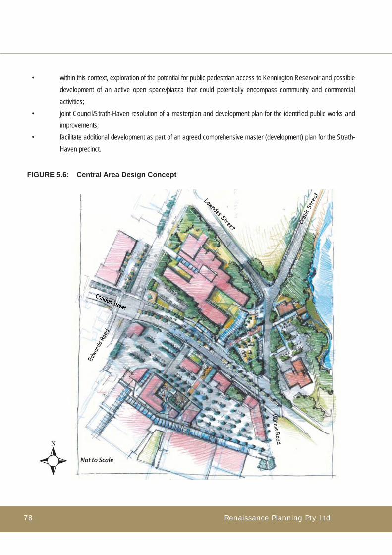
Renaissance Planning Pty Ltd78
• within this context, exploration of the potential for public pedestrian access to Kennington Reservoir and possible development of an active open space/piazza that could potentially encompass community and commercial activities;
• joint Council/Strath-Haven resolution of a masterplan and development plan for the identifi ed public works and improvements;
• facilitate additional development as part of an agreed comprehensive master (development) plan for the Strath-Haven precinct.
FIGURE 5.6: Central Area Design Concept
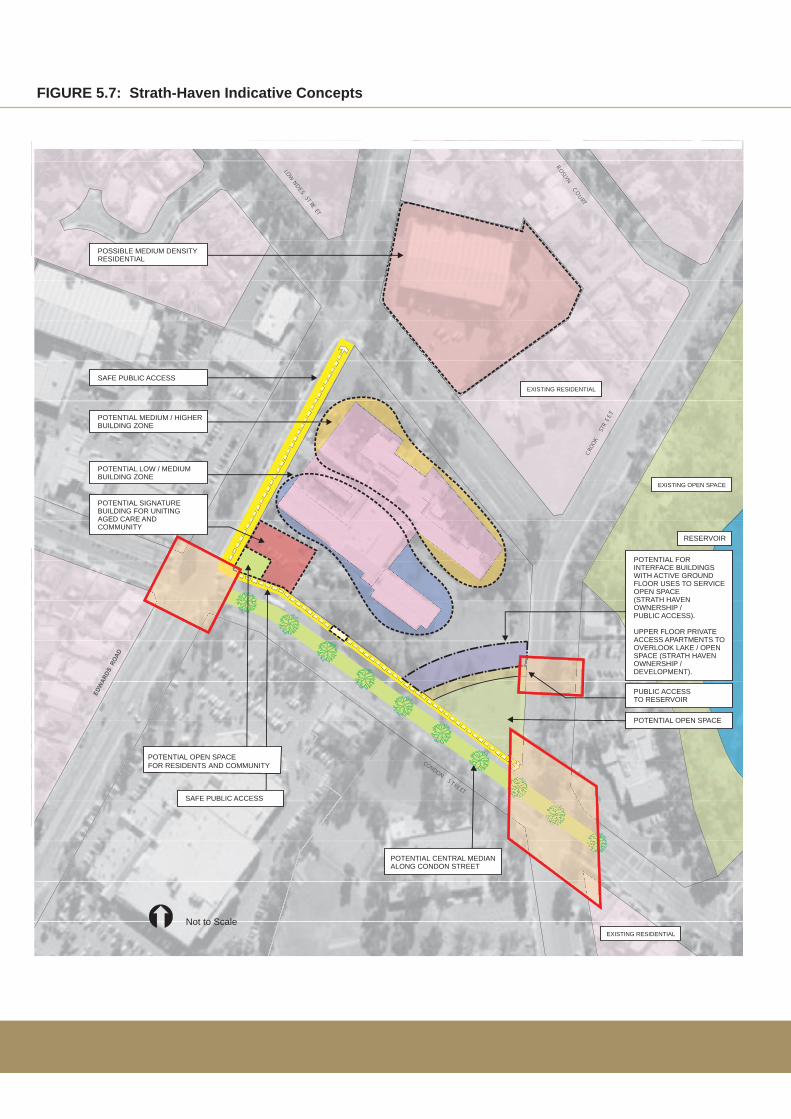
R OSLYNO
URT
C
CONDONTR
ES
ET
LOWN
ET
E
DS
SR
ET
CRO
OKST
RE E T
SAFE PUBLIC ACCESS
POTENTIAL SIGNATUREBUILDING FOR UNITING AGED CARE ANDCOMMUNITY
POTENTIAL CENTRAL MEDIAN ALONG CONDON STREET
SAFE PUBLIC ACCESS
EXISTING OPEN SPACE
EXISTING RESIDENTIAL
EXISTING RESIDENTIAL
RESERVOIR
POTENTIAL MEDIUM / HIGHERBUILDING ZONE
POSSIBLE MEDIUM DENSITYRESIDENTIAL
POTENTIAL OPEN SPACE FOR RESIDENTS AND COMMUNITY
POTENTIAL FOR INTERFACE BUILDINGS WITH ACTIVE GROUND FLOOR USES TO SERVICEOPEN SPACE(STRATH HAVENOWNERSHIP / PUBLIC ACCESS).
UPPER FLOOR PRIVATEACCESS APARTMENTS TOOVERLOOK LAKE / OPEN SPACE (STRATH HAVENOWNERSHIP / DEVELOPMENT).
POTENTIAL OPEN SPACE
PUBLIC ACCESSTO RESERVOIR
POTENTIAL LOW / MEDIUM BUILDING ZONE
Not to Scale
FIGURE 5.7: Strath-Haven Indicative Concepts

Renaissance Planning Pty Ltd80
FIGURE SET 5.8: Proposed Pedestrian Link from Strath Village to Kennington Reservoir via Strath-Haven
Perspective view from Kennington Reservoir looking south-west to Strath Village. The sketch shows a possible concept for a redevelopment of Strath-Haven.
Perspective sketches of the proposed pedestrian link. The sketches show a new community focussed area on the south-west edge of the Strath-Haven site
Perspective view from Condon Street looking south-west to Strath Village. The sketch shows the principal pedestrian walk with other potential activities including an open space area and activities facing the walk. The existing Strath-
Haven buildings are shown in this sketch.

Strathdale Commercial Precinct Structure Plan Report 81
Stru
cture P
lan
5.6 Lakeside
Signifi cance
The Lakeside planning area encompasses the southern section of Kennington Reservoir and adjacent public space and activities. It extends between Crook Street and Reservoir Road south to Condon Street.
Kennington Reservoir and adjacent parklands are an important recreational resource for the local and wider community. There is approximately 1.4 kilometres of sealed walking track around the Reservoir and there are extensive amenities and facilities for picnics. The reservoir contains important native fl ora and fauna and the environmental values need to be protected.
The area is part of an important recreational resource and green corridor of local and district signifi cance. It affords continuous pedestrian and cycle access north to Kennington Primary School. Activities in the area provide important community roles for mental health (John Bomford Medical Centre) and pre-school education (Kindergarten facilities).
The proximity of the Reservoir and associated public space to the Village Core offers signifi cant potentials to achieve high quality pedestrian linkages to the heart of the Strathdale Commercial Precinct, and to provide a destination space and activities at the lake with improved pedestrian and cycle connections to adjacent residential areas.
Objectives
• to provide attractive, safe and amenable pedestrian access from the Village Core to Kennington Reservoir;
• to provide a framework to fully utilise the existing shared pathway access around Kennington Reservoir and to provide for improved connections across Crook Street to the Strath-Haven precinct to the Kennington Primary School and to adjacent residential areas;
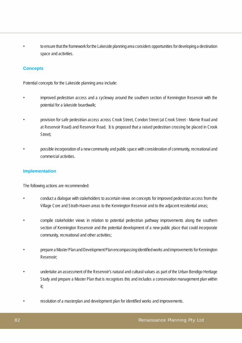
Renaissance Planning Pty Ltd82
• to ensure that the framework for the Lakeside planning area considers opportunities for developing a destination space and activities.
Concepts
Potential concepts for the Lakeside planning area include:
• improved pedestrian access and a cycleway around the southern section of Kennington Reservoir with the potential for a lakeside boardwalk;
• provision for safe pedestrian access across Crook Street, Condon Street (at Crook Street - Marnie Road and at Reservoir Road) and Reservoir Road. It is proposed that a raised pedestrian crossing be placed in Crook Street;
• possible incorporation of a new community and public space with consideration of community, recreational and commercial activities.
Implementation
The following actions are recommended:
• conduct a dialogue with stakeholders to ascertain views on concepts for improved pedestrian access from the Village Core and Strath-Haven areas to the Kennington Reservoir and to the adjacent residential areas;
• compile stakeholder views in relation to potential pedestrian pathway improvements along the southern section of Kennington Reservoir and the potential development of a new public place that could incorporate community, recreational and other activities;
• prepare a Master Plan and Development Plan encompassing identifi ed works and improvements for Kennington Reservoir;
• undertake an assessment of the Reservoir’s natural and cultural values as part of the Urban Bendigo Heritage Study and prepare a Master Plan that is recognises this and includes a conservation management plan within it;
• resolution of a masterplan and development plan for identifi ed works and improvements.

Strathdale Commercial Precinct Structure Plan Report 83
KENNINGTONRESERVOIR
BRENNAN PARK
Not to Scale
KEY INTERSECTION - CONSISTENT TREE THEMECENTRAL MEDIAN PLANTING - DECIDUOUS / EXOTICAUGMENTED MAJOR ROAD STREETSCAPE PLANTING - NATIVEEXISTING NATIVE VEGETATION, OPEN SPACE ENVELOPESCONSOLIDATION OF PLANT SPECIESPRECINCT STUDY AREA
Condon Street
Lakewood Drive
Roslyn Court
Harley Tce
Willo
w Driv
e
Condon Street
Ellis Street
Lowndes Street
Timberto
p Driv
e
Mahon Ave
nue
Reservo
ir Road
Edw
ards
Roa
d
Leig
h Av
enue
Cro
ok S
treet
Marnie Road
FIGURE 5.9: Landscape Thematic Treatment

Renaissance Planning Pty Ltd84
5.7 Strath Hill
Signifi cance
The Strath Hill planning area is located to the west of Edwards Road and extends north of Condon Street to Lowndes Road. It contains a diverse range of retail shops and services. The area forms an important part of the retail and business services provided by the Strathdale Commercial Precinct.
The Structure Plan envisages that Strath Hill will continue to function as a diversifi ed business precinct. Its earlier pattern of disconnected development provides an important need to improve pedestrian linkages within the precinct. In addition, there are signifi cant levels of pedestrian interaction between the Strath Hill precinct and the adjoining Strath-Haven and Village Core precincts. As indicated in Section 5.3 (page 66), with the development of the Aldi supermarket it is likely that pedestrian interaction will increase between the two precincts and with the future consolidation of the Strath-Haven precinct increased interaction with this precinct is also likely.
Thus the improvement of pedestrian amenity within the precinct and facilitation of safe pedestrian access between the precincts are important considerations in the long term planning and management of the Strathdale Commercial Precinct. Objectives
• improve safe pedestrian access between Strath Hill and the Village Core planning areas;
• identify opportunities to improve pedestrian space, amenity and connectivity throughout the planning area, and to improve vehicular circulation and connectivity.
Concepts
A planning concept to improve pedestrian space and amenity has been prepared for the principal shopping strip at Strath Hill. The concept is based on the repositioning of the car park at Strath Hill effectively pushing the car park east towards Edwards Road with reduced landscaped roadside strip. This could provide additional space at the frontage of the Strath Hill shopping strip. The additional space could be used for a widened pedestrian pavement and areas for seating and landscaping. There would be no loss in car parking.
Strathdale Commercial Precinct Structure Plan Report 85
Implementation
The following actions are recommended for the Strath Hill planning area:
• dialogue with stakeholders to ascertain views on a concept to improve pedestrian space and amenity at Strath Hill;
• resolution of a masterplan and development plan for the identifi ed works and improvements.
Stru
cture P
lan
5.8 Lowndes
Signifi cance
The Lowndes planning area is situated on the northern side of Lowndes Street and extends between Edwards Road and Crook Street. The western part of the site is zoned B4 under the Greater Bendigo Planning Scheme and accommodates a large format store, a lighting store and doctors surgery. The eastern part of the site is zoned R1 and has a single historic residence. This building which lies at the corner of Crook and Lowndes Street has been included in the Urban Bendigo Heritage Study.
The Structure Plan seeks to consolidate retailing and commercial functions in the Village Core and Strath Hill precincts. The current large format commercial functions in the Lowndes precinct are separated from the Village Core by the Strath-Haven precinct, a major retirement facility which is undergoing master planning for long term consolidation.
The Structure Plan recognises this situation and the objectives to concentrate retailing and commercial activities in the Village Core and Strath Hill precincts. Therefore, the position taken in the Structure Plan is that the most effective structuring of land use in the Lowndes precinct in the longer term should encompass residential activities north of Lowndes Street, and within this context, medium density development should be investigated.
Objectives
Provide a framework for investigation of the urban design planning merits and feasibility for medium density residential use in the planning area with provision for improved pedestrian access to Kennington Reservoir and the Strath Hill and Village Core areas.

Renaissance Planning Pty Ltd86
Implementation
The following actions are recommended:
• dialogue with stakeholders to ascertain views on the preferred policy position of the Structure Plan for medium density residential use in the Lowndes planning area;
• investigate the feasibility and appropriate zoning to facilitate increased residential development and transition uses;
• statutory amendments as required.
PHOTO 5.3: Edwards Road and Lowndes Street looking east
PHOTO 5.5: Edwards Road and Lowndes Street looking south
PHOTO 5.6: Edwards Road and Lowndes Street looking west
PHOTO 5.4: Edwards Road and Lowndes Street looking north

Strathdale Commercial Precinct Structure Plan Report 87
FIGURE 5.10: Strath Hill Sketch Elevations
Living our potential
Not to Scale
BUILDING EDGE
BUILDING
EDGE
EDGE OF SHOP
VERANDAH
CAR PARKING CAR PARKING
VEHICLE
ACCESS
MEDIANFOOTPATH
MEDIAN
3000 5000
6000 1000
12005000 6000
EDWARDS ROAD
EDWARDS ROAD
EXISTING CONDITIONS
PROPOSED CONDITIONS
ACTIVE STREET
FRONTAGE
CAR PARKING ONE WAY VEHICLE
ACCESS
CAR PARKING
STREET
FRONTAGE
PARALLEL PARKING
STREET FRONTAGE
6000 6000 3500
5000 5000
Stru
cture P
lan

Renaissance Planning Pty Ltd88
FIGURE 5.11: Strath Hill Draft Development Concept
Edwards Road
Condon Street

Strathdale Commercial Precinct Structure Plan Report 89
5.9 Central Victorian Innovation Park
Signifi cance
The Central Victorian Innovation Park planning area adjoins the Strath Village shopping centre and extends south along Edwards Road. The land is zoned B1Z and is owned by La Trobe University and is intended to be developed as a technology and innovation park.
The signifi cance of the planning area lies in its location placed between the Village Core, La Trobe University and adjoining residential areas. It is important to ensure that the future planning and development of the precinct as a technology park facilitates the extension of safe high quality pedestrian links south along Edwards Road, and provides local service facilities for employees and visitors.
Objectives
• To ensure that the planning and development of a technology and innovation park makes provision for and facilitates attractive, high amenity pedestrian linkages south from Strath Village to La Trobe University;
• To ensure that the technology park provides an entry and information point and makes provision for local and convenience services for future employees and visitors;
• To ensure that building development at the technology park is of a scale commensurate with its location and adjacent uses
Concept
An indicative concept for the Central Victorian Innovation Park planning area could comprise the following:
• mixed use development including residential apartments/student accommodation facing Edwards Road with emphasis placed on quality pedestrian access and environment;
Stru
cture P
lan

Renaissance Planning Pty Ltd90
• an entry node at the intersection of Innovation Court and Edwards Road that could provide an information point, convenience store and cafe for employees and visitors;
• provision of an envelope for future development to ensure that the scale of building development was commensurate with the general location of the site, particularly at its residential interfaces;
• application of the boulevard planting theme identifi ed for Edwards Road in the Structure Plan;
• distinctive urban design and landscape treatment for Innovation Court.
Implementation
The following actions are recommended:
• dialogue with stakeholders to ascertain views on the conceptual framework for the Technology Park planning area to implement the ojbectives of the Structure Plan;
• resolution of an agreed masterplan for the Technology Park to implement the objectives of the Structure Plan;
• preparation of a development plan for identifi ed public works.

Strathdale Commercial Precinct Structure Plan Report 91
Stru
cture P
lan
5.10 Village Life
Signifi cance
The Village Life planning area is the site of an important independent retired living facility for older residents. The facilities comprise a total of 100 units and two community-dining rooms.
It is unlikely that extensive redevelopment will occur at the site although refurbishments may be undertaken to improve and extend the community rooms. The units provide rental accommodation and cater for a largely inactive population. The average age of residents is currently approximately 87 years. The signifi cant identifi ed requirement that would assist the mobility of residents is improved taxi and mini bus access and services.
Objectives
• To recognise the important role and signifi cance of Village Life in its service to the community and its place in the Strathdale Commercial Precinct;
• To ensure that the amenity of the Village Life planning area is maintained to ensure a tranquil and safe environment at the facilities.
Implementation
The following actions are recommended:
• dialogue with stakeholders to ascertain views on the recommended policy position for the Village Life planning area;
• resolution of a preferred policy position in relation to the Village Life planning area.


6ImplementationFramework

Renaissance Planning Pty Ltd94

Strathdale Commercial Precinct Structure Plan Report 95
6 IMPLEMENTATION FRAMEWORK 6
Planning Area
Project Recommended Actions Lead Agency Priority
Village Square • Dialogue with Stakeholders• Principles for town square• Potential roles of Council/Stakeholders• Drafting of potential concept options• Exhibition and review by Council, stakeholders and
community• Preferred Masterplan• Development Plan• Apportionment of development costs and responsibilities• Permits and approvals• Tender and construction
City of Greater Bendigo in co-ordination with the Body Corporate of Strath Village and the owners of Kennington Village
High
Master Plan for Strath Village
• Agreement on principles for Masterplan• Draft master plan• Exhibition and review by Council, stakeholders and
community• Resolution of Masterplan• Approvals process
Strath Village Body Corporate in liaison with City of Greater Bendigo
Medium
Boulevard development
• Draft Development Plan for Condon Street• Exhibition and review with stakeholders• Adoption of Development Plan• Apportionment of development costs• Approvals process• Tender and construction
Vic Roads in liaison with City of Greater Bendigo
High
Villa
ge C
ore
Boule
vard

Renaissance Planning Pty Ltd96
Planning Area
Project Recommended Actions Lead Agency Priority
Strath-Haven Masterplan
• Dialogue with stakeholders• Presentation and dialogue with Council• Agreement on site development principles• Draft Masterplan• Exhibition and review with stakeholders• Approvals process• Tender and construction
Uniting Care Victoria and Tasmania (UACVT) in liaison with City of Greater Bendigo
High
Strath-Haven • Workshop with stakeholders• Agreement on development principles• Draft Masterplan• Exhibition and review with stakeholders• Resolution of Development Plan• Apportionment of development costs and responsibilities• Approvals process• Tender and construction
UACVT in partnership with Council
High
Kennington Reservoir Masterplan
• Workshop with stakeholders• Agreement on development principles• Draft Masterplan• Exhibition and review with stakeholders• Review and adoption of Masterplan• Approvals process• Tender and construction
City of Greater Bendigo
Medium
Stra
th-Ha
ven
Lake
side

Strathdale Commercial Precinct Structure Plan Report 97
Planning Area
Project Recommended Actions Lead Agency Priority
Strath Hill Improvement Plan
• Dialogue with stakeholders• Principles for Strath Hill Improvement Plan• Drafting of potential concept options• Exhibition• Review and adoption of preferred Masterplan• Development Plan• Apportionment of development costs• Permits and approvals• Tender and construction
City of Greater Bendigo in co-ordination with Strath Hill property owners and tenants
Medium
Policy Development Framework
• Dialogue with stakeholders• Principles for long term land use and development• Drafting of potential concept options• Exhibition• Review and adoption of preferred development framework
by Council
City of Greater Bendigo in co-ordination with Lowndes property owners
Medium/Low
Development Framework Plan
• Dialogue with stakeholders• Principles for land use and development• Drafting of potential concept options• Exhibition• Review and adoption of preferred development framework
by Council
City of Greater Bendigo in co-ordination with La Trobe University
Medium/Low
Stra
th Hi
llLo
wnde
sCe
ntral
Victo
rian
Innov
ation
Par
k

Renaissance Planning Pty Ltd98
Planning Area
Project Recommended Actions Lead Agency Priority
Policy Development Framework
• Dialogue with stakeholders• Principles for long term land use and management• Drafting of policy statement• Exhibition • Review and adoption of policy statement by Council
Council in co-ordination with the owners and managers of Village Life
Medium/Low
Villa
ge Li
fe
