final restoration plan and environmental assessment for the old gulf … · 2015-08-06 · final ....
TRANSCRIPT
FINAL
RESTORATION PLAN AND ENVIRONMENTAL ASSESSMENT FOR THE OLD GULF OIL REFINERY,
PORT ARTHUR, JEFFERSON COUNTY, TEXAS
September 10, 2004
Prepared by: National Oceanic and Atmospheric Administration
Texas Commission on Environmental Quality Texas Parks and Wildlife Department
Texas General Land Office and
The United States Fish and Wildlife Service on behalf of the
U.S. Department of the Interior

Table of Contents
1.0 INTRODUCTION .................................................................................................................................... 1-1 1.1 Authority ................................................................................................................................................ 1-2 1.2 NEPA Compliance ................................................................................................................................ 1-2 1.3 Public Participation................................................................................................................................ 1-3 1.4 Administrative Record ........................................................................................................................... 1-3
2.0 PURPOSE AND NEED FOR RESTORATION ....................................................................................... 2-1 2.1 Overview of the Site .............................................................................................................................. 2-1
2.1.1 Human Use Characteristics .............................................................................................................2-2 2.1.2 Surface Water Characteristics .........................................................................................................2-2 2.1.3 Habitat Characteristics .....................................................................................................................2-3
2.2 Summary of Response Actions............................................................................................................. 2-4 2.3 Assessment of Resource Injuries and Compensation Requirements .................................................. 2-6
2.3.1 Injury Determination and Quantification ...........................................................................................2-6 2.3.2 Injury Assessment Strategy .............................................................................................................2-6 2.3.3 Preliminary Restoration Strategy .....................................................................................................2-8 2.3.4 Restoration Scaling Strategy............................................................................................................2-8
3.0 THE AFFECTED ENVIRONMENT ......................................................................................................... 3-1 3.1 The Physical Environment..................................................................................................................... 3-1 3.2 The Biological Environment................................................................................................................... 3-2 3.3 The Cultural and Human Environment .................................................................................................. 3-3
4.0 INJURY AND SERVICE LOSS EVALUATION ...................................................................................... 4-1 4.1 Pathways of Contamination to Trust Resources ................................................................................... 4-1 4.2 Contaminants of Concern (COCs) ........................................................................................................ 4-1
4.2.1 Organic Contaminants .....................................................................................................................4-1 4.2.1.1 Polynuclear Aromatic Hydrocarbons (PAHs) ...................................................................................4-1 4.2.2 Metals...............................................................................................................................................4-2 4.2.2.1 Chromium.........................................................................................................................................4-2 4.2.2.2 Copper .............................................................................................................................................4-3 4.2.2.3 Lead .................................................................................................................................................4-3 4.2.2.4 Nickel ...............................................................................................................................................4-3 4.2.2.5 Zinc ..................................................................................................................................................4-4
4.3 Injury Assessment & Findings............................................................................................................... 4-4 4.3.1 Habitat Equivalency Analysis Background.......................................................................................4-6 4.3.2 Habitat Equivalency Analysis Debit Model.......................................................................................4-7
5.0 THE RESTORATION PLANNING PROCESS ....................................................................................... 5-1 5.1 Restoration Objective............................................................................................................................ 5-1 5.2 Restoration Selection Criteria................................................................................................................ 5-2
Old Gulf Oil Refinery i September 10, 2004 Final Restoration Plan/Environmental Assessment
5.3 Emergency Restoration Credit - J.D. Murphree WMA .......................................................................... 5-4 5.4 Tier-1 Screening of Restoration Alternatives......................................................................................... 5-5 5.5 Tier-2 Screening of Restoration Alternatives......................................................................................... 5-8 5.6 Scaling the Preferred Restoration Projects ......................................................................................... 5-11
5.6.1 Habitat Equivalency Analysis Credit Model....................................................................................5-11 5.7 Summary of Settlement....................................................................................................................... 5-14 5.8 Geographic Proximity of Projects ........................................................................................................ 5-14
6.0 RESTORATION ALTERNATIVES COMPARISON................................................................................ 6-1 6.1 Preferred Restoration Alternative part 1: Marsh Creation via beneficial use of dredged sediment and
creation of Coastal Wet Prairie habitat at Old River South Unit of the Lower Neches Wildlife Management Area (the “Old River South Marsh/Wet Prairie Project”)................................................. 6-1 6.1.1 Evaluation of Alternative ..................................................................................................................6-4 6.1.2 Ecological and Socio-Economic Impacts .........................................................................................6-5
6.2 Preferred Restoration Alternative part 2: Construction of Water Control Structures and levees for enhanced wildlife management of the J.D. Murphree Wildlife Management Area (“J.D. Murphree Water Control Structure Project”)..................................................................................................................... 6-7 6.2.1 Existing Conditions...........................................................................................................................6-7 6.2.2 Evaluation of Alternative ..................................................................................................................6-9 6.2.3 Ecological and Socio-Economic Impacts .......................................................................................6-10
6.3 Marsh Enhancement via Hydraulic Restoration of Keith-Clam Lake Complex Using Constructed Water Control Structure (Non-Selected Alternative) ...................................................................................... 6-11 6.3.1 Evaluation of Alternative ................................................................................................................6-12 6.3.2 Ecological and Socio-Economic Impacts .......................................................................................6-13
6.4 Marsh Enhancement via Restoration of Freshwater Flow between Salt Bayou and Star Lake Using Constructed Inverted Siphon System (Non-Selected Alternative)....................................................... 6-13 6.4.1 Evaluation of Alternative ................................................................................................................6-14 6.4.2 Ecological and Socio-Economic Impacts .......................................................................................6-15
6.5 No Action (Non-Selected Alternative).................................................................................................. 6-15 6.5.1 Evaluation of No Action Alternative................................................................................................6-15
7.0 NEPA, ENDANGERED SPECIES ACT, & ESSENTIAL FISH HABITAT: ANALYSIS AND PRELIMINARY FINDING OF NO SIGNIFICANT IMPACT..................................................................... 7-1 7.1 Likely Impacts of the Preferred Alternatives (Old River South Marsh/Wet Prairie Creation and J.D.
Murphree Water Control Structure Construction).................................................................................. 7-2 7.1.1 Nature of Likely Impacts...................................................................................................................7-2 7.1.2 Effects on public health and safety ..................................................................................................7-3 7.1.3 Unique characteristics of the geographic area.................................................................................7-3 7.1.4 Controversial aspects of the project or its effects ............................................................................7-3 7.1.5 Uncertain effects or unknown risks ..................................................................................................7-3 7.1.6 Precedential effects of implementing the project .............................................................................7-4 7.1.7 Possible, significant cumulative impacts ..........................................................................................7-4
Old Gulf Oil Refinery ii September 10, 2004 Final Restoration Plan/Environmental Assessment
7.1.8 Effects on National Historic Sites or nationally significant cultural, scientific or historic resources..7-4 7.1.9 Effects on endangered or threatened species .................................................................................7-5 7.1.10 Violation of environmental protection laws.......................................................................................7-5
7.2 Conclusion & Preliminary Finding of No Significant Impact on the Quality of the Human Environment 7-5 7.3 Endangered and Threatened Species................................................................................................... 7-6 7.4 Essential Fish Habitat ........................................................................................................................... 7-7
7.4.1 Effect on Essential Fish Habitat .......................................................................................................7-9 7.4.2 Effects on the Managed Species, and Associated Species by Life History Stage...........................7-9 7.4.3 The Federal Agency’s Views Regarding The Effects Of The Action On EFH................................7-11 7.4.4 Conclusion of Effects on EFH ........................................................................................................7-11
8.0 COMPLIANCE WITH OTHER KEY STATUTES, REGULATIONS AND POLICIES ............................. 8-1 8.1 Clean Water Act (CWA), 33 U.S.C. § 1251 et seq. ............................................................................... 8-1 8.2 Rivers and Harbors Act, 33 U.S.C. § 401 et seq. .................................................................................. 8-1 8.3 Coastal Zone Management Act (CZMA), 16 U.S.C. § 1451 et seq., 15 C.F.R. Part 923 ...................... 8-1 8.4 Fish and Wildlife Conservation Act, 16 U.S.C. § 2901 et seq. .............................................................. 8-2 8.5 Fish and Wildlife Coordination Act (FWCA), 16 U.S.C. § 661 et seq. ................................................... 8-2 8.6 Marine Mammal Protection Act, 16 U.S.C. § 1361 et seq. .................................................................... 8-2 8.7 Migratory Bird Conservation Act, 16 U.S.C. § 715 et seq. .................................................................... 8-2 8.8 National Historic Preservation Act, 16 U.S.C. § 470 et seq. ................................................................. 8-2 8.9 Information Quality Guidelines issued pursuant to Public Law 106-554 ............................................... 8-2 8.10 Executive Order 12898 (59 Fed. Reg. 7629) - Environmental Justice .................................................. 8-3 8.11 Executive Order Number 11514 (35 Fed. Reg. 4247) - Protection and Enhancement of Environmental
Quality ................................................................................................................................................... 8-3 8.12 Executive Order Number 11990 (42 Fed. Reg. 26,961) - Protection of Wetlands ................................ 8-3 8.13 Executive Order Number 12962 (60 Fed. Reg. 30,769) - Recreational Fisheries................................. 8-3
9.0 LITERATURE CITED ............................................................................................................................. 9-1
10.0 LIST OF PERSONS/AGENCIES CONSULTED................................................................................... 10-1
11.0 LIST OF PREPARERS......................................................................................................................... 11-1
Old Gulf Oil Refinery iii September 10, 2004 Final Restoration Plan/Environmental Assessment

Table of Figures Figure 2.1 The Old Gulf Oil Refinery (now Premcor), Jefferson County, Port Arthur, Texas .............................. 2-1 Figure 2.2 Example of complete corrective measures construction, North Separator Area, Old Gulf Oil Refinery
Site, Jefferson County, Texas. .................................................................................................................. 2-5 Figure 5.1 Restoration project locations in the lower Neches River/Sabine Lake System.................................. 5-9 Figure 6.1 TPWD Lower Neches River WMA - Wetland & Circulation Enhancements for Old River South
Marsh/Wet Prairie Project.......................................................................................................................... 6-2 Figure 6.2 J.D. Murphree Water Control Enhancements: Water Control Structure Rehabilitation and
Construction, Jefferson Co., TX ................................................................................................................ 6-8
Table of Tables Table 4.1- Chemical characteristics and probabilities of significant toxicity in amphipod survival tests.
(MacDonald et al, 1998) ............................................................................................................................ 4-5 Table 4.2 Acres injured (exceeding the lower injury threshold) for each assessment area. ............................... 4-6 Table 4.3 HEA debit model input parameters for offsite habitats. ....................................................................... 4-8 Table 4.4 HEA debit model input parameters to account for injury to birds and biota in on-site areas (waste pits
and upland areas). .................................................................................................................................... 4-9 Table 5.1 HEA input parameters for J.D. Murphree WMA emergency restoration action ................................... 5-5 Table 5.2 Summary of Trustees’ Tier-1 Screening of Restoration Alternatives .................................................. 5-7 Table 5.3 Summary - Trustees’ Evaluation of Restoration Alternatives ............................................................ 5-11 Table 5.4 DSAY Credit that will be produced by the wet prairie portion of the preferred alternatives............... 5-13 Table 5.5 DSAY Credit that will be produced by the Old River South portion of the preferred alternatives ...... 5-13 Table 5.6 DSAY Credit that will be produced by the J.D. Murphree WMA water control structures portion of the
preferred alternatives .............................................................................................................................. 5-13 Table 7.1 Federal and State Endangered or Threatened Species in Coastal Texas .......................................... 7-8
Old Gulf Oil Refinery iv September 10, 2004 Final Restoration Plan/Environmental Assessment
1 INTRODUCTION
This Restoration Plan and Environmental Assessment (RP/EA) has been developed by the Texas General Land Office (GLO), the Texas Commission on Environmental Quality (TCEQ) (formerly known as the Texas Natural Resource Conservation Commission), the Texas Parks and Wildlife Department (TPWD), the National Oceanic and Atmospheric Administration (NOAA) of the U. S. Department of Commerce, and the United States Fish and Wildlife Service (USFWS) on behalf of the U.S. Department of the Interior (DOI), (collectively, "the Trustees") to address natural resources, including ecological services, injured, lost or destroyed due to releases of hazardous substances in areas at or adjacent to the Old Gulf Oil Refinery (Site) in Jefferson County, Texas. The RP/EA identifies the restoration action(s) that the Trustees will implement as part of a natural resource settlement that the Trustees jointly recovered for natural resource damages associated with natural resource injuries in areas at or adjacent to the Old Gulf Oil Refinery Site. The natural resource damages settlement is the result of a cooperative natural resource damage assessment between Chevron USA Inc. (Chevron) and the Trustees. During this cooperative process, the Trustees and Chevron reached a settlement agreement concerning natural resource injuries at or adjacent to the Site in an effort to avoid costly litigation and mutual desire to find an acceptable resolution to the Trustees’ natural resource damage claims. In this restoration plan, the Trustees’ natural resource damages claim is to be compensated by Chevron constructing 83 acres of coastal wetland, 30 acres of coastal wet prairie, and water control structures overseen by the Trustees pursuant to a Consent Decree (hereafter, “Consent Decree”). Under applicable laws and the terms of the Consent Decree, the damages to be recovered by the Trustees may only be used to plan, implement and oversee a restoration plan providing for the creation or enhancement of estuarine wetlands in the Neches River basin as a means of restoring natural resources and services comparable to those injured or lost. In this case, the damages associated with natural resource injuries in areas at or adjacent to the Site will be compensated in terms of habitat and ecological services constructed or improved under Trustee supervision. The Gulf Oil Company built and began operating a refinery at this site around 1902 to refine Spindletop crude oil. In 1984, Chevron acquired Gulf Oil Corporation. Premcor Refining Group, Inc. (Premcor) purchased the refinery in 1995 from Chevron, and today it refines 250,000 barrels per day of crude oil. The Premcor Port Arthur Refinery Site (the “Old Gulf Oil Refinery Site”), encompassing approximately 4,000 acres, is located in an industrial area
Old Gulf Oil Refinery 1-1 September 10, 2004 Final Restoration Plan/Environmental Assessment
at 1801 South Gulfway Drive in Port Arthur, Jefferson County, Texas. The Joint Outfall Canal (JOC) bisects the Site and flows into the Gulf Intracoastal Waterway (ICWW) approximately 2.3 kilometers downstream from the refinery. The width of the JOC at the Site ranges from approximately 80 to 115 meters. The center depth of the JOC is generally greater than 10 feet and deepens toward the ICWW confluence. Canal sediments consist of fine-grained silty to sandy clays.
1.1 AUTHORITY
This RP/EA was prepared jointly by the Trustees pursuant to their respective authority and responsibilities as natural resource trustees under the Comprehensive Environmental Response, Compensation and Liability Act (CERCLA), 42 U.S.C. § 9601, et seq.; the Federal Water Pollution Control Act, 33 U.S.C. § 1251, et seq. (also known as the Clean Water Act or CWA), and other applicable federal or state laws, including Subpart G of the National Oil and Hazardous Substances Contingency Plan (NCP), at 40 C.F.R. §§ 300.600 through 300.615, and DOI’s CERCLA natural resource damage assessment regulations at 43 C.F.R. Part 11 (NRDA regulations) which provide guidance for this restoration planning process under CERCLA.
1.2 NEPA COMPLIANCE
Actions undertaken by the Trustees to restore natural resources or services under CERCLA and other federal laws are subject to the National Environmental Policy Act (NEPA), 42 U.S.C. § 4321 et seq., and the regulations guiding its implementation at 40 C.F.R. Parts 1500 through 1517. NEPA and its implementing regulations outline the responsibilities of federal agencies under NEPA, including for preparing environmental documentation. In general, federal agencies contemplating implementation of a major federal action must produce an environmental impact statement (EIS) if the action is expected to have significant impacts on the quality of the human environment. When it is uncertain whether a contemplated action is likely to have significant impacts, federal agencies prepare an environmental assessment (EA) to evaluate the need for an EIS. If the EA demonstrates that the proposed action will not significantly impact the quality of the human environment, the agency issues a Finding of No Significant Impact (FONSI), which satisfies the requirements of NEPA, and no EIS is required. For a proposed restoration plan, if a FONIS determination is made, the Trustees may then issue a final restoration plan describing the selected restoration action(s). In accordance with NEPA and its implementing regulations, this RP/EA summarizes the current environmental setting, describes the purpose and need for restoration actions,
Old Gulf Oil Refinery 1-2 September 10, 2004 Final Restoration Plan/Environmental Assessment
identifies alternative actions, assesses their applicability and potential impact on the quality of the physical, biological and cultural environment, and summarizes the actions taken to facilitate opportunities for public participation in the decision-making process. This information was used to make a threshold determination as to whether preparation of an EIS was required prior to selection of the final restoration actions. Based on the EA integrated into this RP/EA, the federal Trustees – NOAA as the lead agency and USFWS as a cooperating agency – determined that the selected restoration actions do not meet the threshold requiring an EIS.
1.3 PUBLIC PARTICIPATION
Public review of the RP/EA is an integral component of the restoration planning process. Through the public review process, the Trustees seek public comment on the analyses used to define and quantify natural resource injuries and service losses and the methods being proposed to restore injured natural resources or replace lost resource services. A draft version of this RP/EA was provided to the public with current information about the nature and extent of the natural resource injuries identified and restoration alternatives evaluated. The draft version of this RP/EA was available to the public for a 30-day comment period which began May 21, 2004, and closed June 21, 2004. The notice of availability of the Draft RP/EA was published in 29 Tex. Reg. 5128 (May 21, 2004). The Trustees received no public comments on the Draft RP/EA. Public review of the Draft RP/EA is consistent with all state and federal law and regulations that apply to the natural resource damage assessment process, including the DOI regulations, NEPA, and the regulations implementing NEPA at 40 C.F.R. § 1500, et seq.
1.4 ADMINISTRATIVE RECORD
The Trustees have maintained records documenting the information considered and actions taken by the Trustees during this restoration planning process, and these records collectively comprise the Trustees’ administrative record (AR) supporting this RP/EA. Information and documents are included in this AR as received or completed. These records are available for review by interested members of the public. Interested persons can access or view these records at the offices of: Richard Seiler Texas Commission on Environmental Quality Remediation Division
Old Gulf Oil Refinery 1-3 September 10, 2004 Final Restoration Plan/Environmental Assessment

Building D, Room 246 12100 Park 35 Circle Austin, TX Phone: 512-239-2523 Fax: 512-239-4814 Email: [email protected] Arrangements must be made in advance to review or to obtain copies of these records by contacting the person listed above. Access to and copying of these records are subject to all applicable laws and policies including, but not limited to, laws and policies relating to copying fees and the reproduction or use of any material that is copyrighted.
Old Gulf Oil Refinery 1-4 September 10, 2004 Final Restoration Plan/Environmental Assessment
2 PURPOSE AND NEED FOR RESTORATION
This section generally describes the Site, summarizes the response actions which were undertaken, summarizes the Trustees’ assessment of natural resource injuries in areas at or adjacent to the Site and compensation requirements related to this assessment and provides more detailed information on the physical, biological and cultural environments in the area affected by releases of hazardous substances from the Site.
2.1 OVERVIEW OF THE SITE
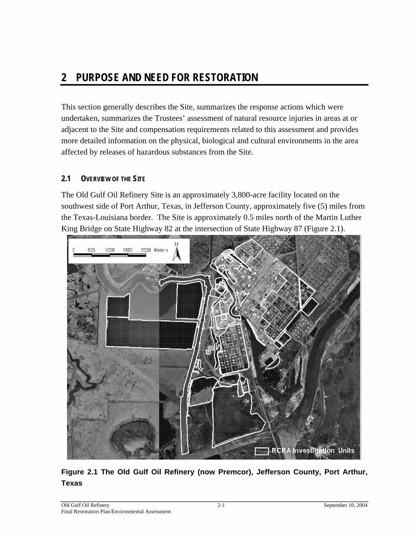
The Old Gulf Oil Refinery Site is an approximately 3,800-acre facility located on the southwest side of Port Arthur, Texas, in Jefferson County, approximately five (5) miles from the Texas-Louisiana border. The Site is approximately 0.5 miles north of the Martin Luther King Bridge on State Highway 82 at the intersection of State Highway 87 (Figure 2.1).
Figure 2.1 The Old Gulf Oil Refinery (now Premcor), Jefferson County, Port Arthur, Texas
Old Gulf Oil Refinery 2-1 September 10, 2004 Final Restoration Plan/Environmental Assessment
Gulf Oil Corporation (Gulf) began construction of the Site in 1901 and remained owner and operator until Gulf merged with Chevron U.S.A. Inc. (Chevron) in 1985. In 1995, Chevron sold the Site to Clark Refining and Marketing, Inc. (Clark). Clark has since changed its name to The Premcor Refining Group, Inc. (Premcor), and the Site remains an active refinery currently operated by Premcor. Chevron Chemical (now Chevron Phillips Chemical Company, LP) leased back a portion of the property where it currently operates a chemical manufacturing facility. Operations at the Site have included crude oil refining, lubricant oil and chemical manufacturing, and product distribution. Products produced at the Site historically include gasoline, kerosene, jet fuel, fuel oils, naphtha, and petrochemicals.
2.1.1 Human Use Characteristics
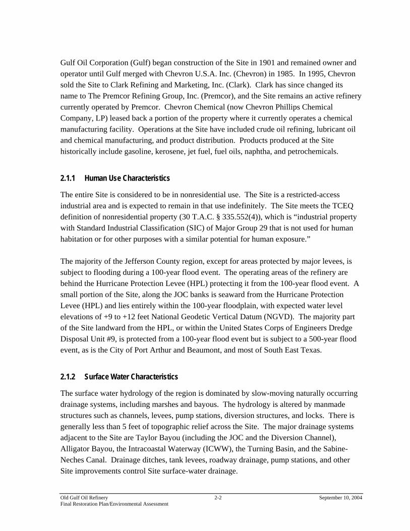
The entire Site is considered to be in nonresidential use. The Site is a restricted-access industrial area and is expected to remain in that use indefinitely. The Site meets the TCEQ definition of nonresidential property (30 T.A.C. § 335.552(4)), which is “industrial property with Standard Industrial Classification (SIC) of Major Group 29 that is not used for human habitation or for other purposes with a similar potential for human exposure.” The majority of the Jefferson County region, except for areas protected by major levees, is subject to flooding during a 100-year flood event. The operating areas of the refinery are behind the Hurricane Protection Levee (HPL) protecting it from the 100-year flood event. A small portion of the Site, along the JOC banks is seaward from the Hurricane Protection Levee (HPL) and lies entirely within the 100-year floodplain, with expected water level elevations of +9 to +12 feet National Geodetic Vertical Datum (NGVD). The majority part of the Site landward from the HPL, or within the United States Corps of Engineers Dredge Disposal Unit #9, is protected from a 100-year flood event but is subject to a 500-year flood event, as is the City of Port Arthur and Beaumont, and most of South East Texas.
2.1.2 Surface Water Characteristics
The surface water hydrology of the region is dominated by slow-moving naturally occurring drainage systems, including marshes and bayous. The hydrology is altered by manmade structures such as channels, levees, pump stations, diversion structures, and locks. There is generally less than 5 feet of topographic relief across the Site. The major drainage systems adjacent to the Site are Taylor Bayou (including the JOC and the Diversion Channel), Alligator Bayou, the Intracoastal Waterway (ICWW), the Turning Basin, and the Sabine-Neches Canal. Drainage ditches, tank levees, roadway drainage, pump stations, and other Site improvements control Site surface-water drainage.
Old Gulf Oil Refinery 2-2 September 10, 2004 Final Restoration Plan/Environmental Assessment

Premcor managed Site drainage by collecting, treating, and discharging stormwater to adjacent surface waters through its National Pollutant Discharge Elimination System (NPDES)-permitted outfall (No. 001). Ponds and other water-retaining systems are present, and standing water accumulates temporarily in some areas of the Site. As needed, water in impoundments is pumped out and treated at the Site’s wastewater treatment plant before being discharged to the Oxidation Pond Discharge Area, part of the wastewater treatment system. Stormwater and treated process water combine in the Oxidation Pond and are discharged into the JOC through Premcor’s NPDES outfall. The JOC flows into the ICWW approximately 2.3 km from the site. The ICWW, in turn, flows into lower Sabine Lake, a 416-km2 estuary, approximately 13 km downstream from the Site. The JOC, ICWW, Sabine Lake and associated wetlands are tidally influenced, both wind driven and lunar.
2.1.3 Habitat Characteristics
The Site is an operating refinery with areas of open water process units, storm water conduits, landfills, and confined dredge disposal units. The Site’s 17-mile perimeter is bordered partially by roadways, waterways, industrial properties, wetlands and wildlife management areas. Alligator Bayou borders the Site on the northeast, and the Site is bordered on the northwest by Upper Taylor Bayou and along the south by the Intracoastal Waterway (ICWW) and the Sabine-Neches Canal (Figure 2.1) (waterways constructed to provide access for barging industrial products). The JOC (the main storm water drainage ditch for Jefferson County) divides the operational areas (behind the HPL) and the large water process units and joins the ICWW near the Site’s southern border. A residential area is located immediately northeast of the Site, and light and heavy industrial areas exist mainly to the northeast and east of the Site. The Motiva Refinery and Huntsman Corporation chemical facility are located upstream along Alligator Bayou, which flows into the Joint Outfall Canal. Other industrial and commercial facilities surrounding the Site include several shipping and receiving facilities located to the south; Equistar Chemicals (formerly Quantum Chemical Company), a chemical manufacturing facility located on the JOC north of the Oxidation Ponds; Great Lakes Carbon, a coke facility on the Turning Basin; Bethlehem Steel, an iron scrap reuse facility on Pleasure Island; and the Port of Port Arthur southeast of the Site, along the ICWW. The JOC, ICWW, Sabine Lake and associated wetlands constitute a tidal system that is an important nursery area for estuarine trust resource species. Species known to occupy the habitats provided by the ICWW, Sabine Lake and associated wetlands include, but are not limited to, spotted sea trout, sand trout, Atlantic croaker, red drum, black drum, southern
Old Gulf Oil Refinery 2-3 September 10, 2004 Final Restoration Plan/Environmental Assessment

flounder, sheepshead, blue crab, white shrimp and brown shrimp. Additionally, benthic resources such as copepods, polychaetes, molluscs and amphipods occupy vegetated and open water areas.
2.2 SUMMARY OF RESPONSE ACTIONS
Polynuclear aromatic hydrocarbons (PAHs), lead, zinc, nickel, chromium, and copper were identified as exceeding designated criteria in the surface water and sediments in the JOC, in on-site lacustrine habitats, in the North Marsh, in other on-site water bodies, and in adjacent wetlands at or near the Site and are therefore the contaminants of concern (COCs) for this Site. The Trustees then determined the total acreage impacted by the contaminants exceeding these criteria. TCEQ in the 1997 Agreed Order (Docket No. 970404IHWE; SWR No. 30004) identified numerous Solid Waste Management Units (SWMUs). The Agreed Order consists of twelve Ordering Provisions and five Attachments that stipulate how and when the investigations are to be completed. Attachment 3 of the Agreed Order lists the units to be investigated. Chevron began remediation efforts and voluntarily began to implement source control, in-situ stabilization and capping of identified wastes, excavation, etc., to address potential site- related human health and ecological risks. Prior to the Agreed Order, Chevron had implemented remedial actions at the Site. Chevron is expected to have completed all on-site corrective action (remedial) construction activities by August 2005. The final remedy also included consolidating waste; performing grading and capping within the Site’s waste areas; installing controls to manage and treat storm water run-off from inactive and completed areas; and making adjustments to dike elevations and slopes necessary to construct caps, monitor to prevent areas of excessive settlement and protect against future erosion, e.g. Figure 2.2 As planned and when implemented, the remedy selected to address the contamination at the Site is expected to protect natural resources in the vicinity of the Site from further or future injury.
Old Gulf Oil Refinery 2-4 September 10, 2004 Final Restoration Plan/Environmental Assessment

Figure 2.2 Example of complete corrective measures construction, North Separator Area, Old Gulf Oil Refinery Site, Jefferson County, Texas
Old Gulf Oil Refinery 2-5 September 10, 2004 Final Restoration Plan/Environmental Assessment

2.3 ASSESSMENT OF RESOURCE INJURIES AND COMPENSATION REQUIREMENTS
This section begins with an overview that describes the Trustees’ assessment strategy, including the approaches used to determine potential injuries to specific resources affected by hazardous substance releases from the Site. The remainder of the section describes the approach used to estimate the ecological service losses and presents the results of these assessments. The term ecological services means the “physical and biological functions performed by the resource including the human uses of those functions. These services are the result of the physical, chemical, or biological quality of the resource.” (43 C.F.R. § 11.14(nn)).
2.3.1 Injury Determination and Quantification
The Trustees’ assessment of natural resource injuries focused on identifying the injury or losses of natural resources which were likely or known to have resulted from contamination at or adjacent to the Site, including injuries due to the remedies undertaken. PAHs and volatile organic compounds (VOCs) were the primary COCs for natural resource damage assessment purposes. These hazardous substances were also found in sediments of the marsh adjacent to the Site. Using data and other information developed as part of the remedial investigation process, as well as information on these contaminants in the existing scientific literature, the Trustees assessed impacts to natural resources. The Trustees found that resources or resource services were lost due to the release of hazardous substances in certain areas at or adjacent to the Site, were injured due to the migration of hazardous substances into the North Marsh, were harmed by exposure to surface waters contaminated by releases at or adjacent to the Site, and were injured or lost as a result of the excavation and capping undertaken as part of the remedy. The Trustees then used this information to conservatively (in favor of the natural resources) estimate the total potential loss of wetland acre-years represented by the natural resource injuries associated with the Site.
2.3.2 Injury Assessment Strategy
The goal of this assessment is to determine the nature and extent of injuries to natural resources and to quantify the resulting resource and service losses, thus providing a technical basis for evaluating the need for, type of, and scale of restoration actions. As described above in Section 1.1, this assessment process is guided by the NRDA regulations under
Old Gulf Oil Refinery 2-6 September 10, 2004 Final Restoration Plan/Environmental Assessment
CERCLA. 43 C.F.R. Part 11. For the Old Gulf Oil Refinery Site, the Trustees pursued an assessment approach in conjunction with the RCRA Facility Investigation (RFI) and in cooperation with Chevron. This integration is advantageous because much of the data needed for the RFI process are useful in evaluating injuries. The integrated approach permits data sharing, resulting in time and/or cost savings. Moreover, this approach recognizes that RFI-related remediation decisions and the Trustees’ damage assessment decisions are interdependent. Remedial decisions can affect the amount and type of compensatory restoration necessary to make the ecosystem whole. Using an integrated approach rather than beginning a damage assessment after remediation is complete promotes efficiency in the overall process. In addition, the cooperative NRDA approach avoids costly litigation and expedites the restoration of the environment. The injury assessment process occurs in two stages: 1) injury evaluation and 2) resource and service loss quantification. To evaluate potential injury to resources, the Trustees reviewed existing information, including remedial investigation data, ecological risk assessments, and scientific literature. Based on information from all of these sources and with an understanding of the function of the terrestrial and aquatic ecosystems at and near the Site, the Trustees evaluated injury to natural resources. The Trustees considered several factors when making this evaluation, including, but not limited to:
• the specific natural resource and ecological services of concern;
• evidence indicating exposure, pathway and injury;
• the mechanism by which injury occurred;
• the type, degree, spatial and temporal extent of injury; and
• types of restoration actions that are appropriate and feasible. For each resource category (either a group of organisms or a habitat type) that was potentially affected, the Trustees identified a pathway linking the injury to releases at or adjacent to the Site, determined whether an injury is likely to or has occurred, and identified the nature of the injury. To undertake this effort, an understanding of the important contaminants is necessary. The evaluation of the COCs and their pathways to ecological receptors is described in the next two sections. Following the identification of the contaminants, it is possible to evaluate those resources that have been adversely affected by releases from the Site. As a result of the cooperative NRDA approach, the Trustees used the data provided by Chevron to create a spatial representation of the locations of the contaminated areas by plotting the data on aerial photographs using software combining database and GIS packages
Old Gulf Oil Refinery 2-7 September 10, 2004 Final Restoration Plan/Environmental Assessment
(MS Access/ArcView 3.2). Once the concentrations of contaminants in each habitat were plotted and the amount of affected acreage was determined for each habitat type, the Trustees used peer-reviewed scientific literature and best professional judgment to develop estimates of the percentage of injury to each habitat. The Trustees focused the injury assessment from the entire facility (including off-site areas) to specific areas within SWMUs and/or adjacent areas. The Trustees used the year 1981 to begin the calculation of time-based injury duration. The Trustees also made conservative estimations of the duration of the monitored natural recovery period for the individual areas based on contaminant concentration and planned remediation. If no remediation is planned for a given area, for calculation purposes, it will remain injured in perpetuity. If some remediation was or is planned, then estimated years of partial or full recovery were used as inputs.
2.3.3 Preliminary Restoration Strategy
This assessment was designed for injury assessment and restoration planning to occur simultaneously, utilizing a restoration-based approach. Under a restoration-based approach, the focus of the assessment is on quantifying the injuries and/or losses in natural resources and ecological services in ways that facilitate the identification of restoration projects that will compensate the public with the same level, type and quality of resources and ecological services that were lost. This restoration-based assessment approach is consistent with the CERCLA NRDA regulations, which allow restoration planning to be included as part of the Assessment Plan Phase where available data are sufficient to support their concurrent development. 43 C.F.R. § 11.31.
2.3.4 Restoration Scaling Strategy
Habitat Equivalency Analysis (HEA), scientific literature and knowledge of Texas estuaries were used to determine how much credit could be realized from a restoration project, such as enhancing a degraded environment or preserving an existing environment. Various inputs are considered, such as the level of ecological services currently provided at the proposed location, the threat of destruction of the habitat by human encroachment and the potential for inundation. The analysis calculation shows how many discount service acre years (DSAYs) can be credited for a given restoration project. The DSAYs are then converted to the amount of acreage that, if constructed at the Site, would be necessary for compensation for a specific type of habitat. If the project entails the preservation of existing habitat rather than new habitat construction, the amount of acreage necessary for compensation usually increases.
Old Gulf Oil Refinery 2-8 September 10, 2004 Final Restoration Plan/Environmental Assessment
3 THE AFFECTED ENVIRONMENT
This section describes the environment in the project area that forms the basis for evaluation of the potential environmental impacts of the selected restoration actions. Resource areas described in this section correspond to the range of resource areas addressed in Section 5, “Restoration Alternatives Comparison.” Resource areas addressed include wildlife, fish and invertebrates, essential fish habitat, threatened and endangered species, farmland and urban development, recreation resources, water and sediment quality, air quality, cultural resources, hazardous and toxic waste, and environmental justice. This subsection provides additional information on the physical, biological and cultural environments in the area affected by releases of hazardous substances from the Old Gulf Oil Refinery Site and in which restoration action(s) contemplated in this RP/EA will occur.
3.1 THE PHYSICAL ENVIRONMENT
Sabine Lake is Texas' easternmost estuary, covering some 90,000 acres. It is largely co-owned and regulated by Texas and Louisiana. The estuary lies in a river valley formed during the last glacial period. The lake receives its primary freshwater influx from the Sabine River and the Neches River. Bayous entering Sabine Lake include Lighthouse, Fourge, Greens, Madame Johnson, Johnsons, Willow, and Black. With the Sabine River, the lake forms the boundary between Louisiana and Texas. The Sabine Lake ecosystem has five times more marshland than the Galveston Bay complex. Except for a few miles near its head, the Neches River serves as a boundary stream, forming the county lines between Van Zandt and Smith, Smith and Henderson, Henderson and Cherokee, Cherokee and Anderson, Cherokee and Houston, Houston and Angelina, Angelina and Trinity, Angelina and Polk, Angelina and Tyler, Tyler and Jasper, Jasper and Hardin, Hardin and Jefferson, and Jefferson and Orange counties. The Sabine River starts in Hunt County and forms the boundary lines between Rains and Van Zandt, Van Zandt and Wood, Wood and Smith, and Smith and Upshur counties. After crossing most of Gregg County, the river forms portions of the county lines between Gregg and Harrison, Harrison and Rusk, and Harrison and Panola counties before it bends more sharply across Panola County. At the thirty-second parallel in the southeastern corner of
Old Gulf Oil Refinery 3-1 September 10, 2004 Final Restoration Plan/Environmental Assessment
Panola County the Sabine becomes the state boundary between Texas and Louisiana, and thus the eastern boundary of Shelby, Sabine, Newton, Jefferson, and Jefferson counties. The Sabine River flows for 555 miles. Its total drainage basin area is 9,756 square miles, of which 7,426 is in Texas and the remainder in Louisiana. Average annual precipitation is between thirty-seven inches at its source and fifty inches at its mouth. It discharges the largest volume of water at its mouth of all Texas rivers. Average runoff within 97 percent of the Sabine River basin during the 1941-67 period was about 640 acre-feet per square mile. The Neches River has a drainage area estimated at 10,011 square miles. Abundant rainfall in the basin results in a flow of some 6,000,000 acre-feet per year. Major tributaries include the Angelina River, which drains one-third of the basin area, Bayou La Nana, Ayish Bayou, Pine Island Bayou, Village Creek, Kickapoo Creek, and Flat Creek.
3.2 THE BIOLOGICAL ENVIRONMENT
The wetlands of the Sabine Lake/Neches River Estuary contribute nutrients to and enhance productivity of Sabine Lake as well as serve as important nursery and adult habitat for a variety of oligohaline and marine fish and invertebrate species. Sabine Lake is a low-salinity, estuarine embayment of the Gulf of Mexico and is characterized by shallow, productive waters. The Neches River in the vicinity of the Site is tidally influenced and is part of the Sabine Lake/Neches River Estuary. Phytoplankton, zooplankton, and aquatic invertebrates living in these habitats provide food web support for a diversity of fish and bird species. Marine species utilizing the marsh include, but are not limited to, spotted seatrout (Cynoscion nebulosus), sand seatrout (Cynoscion arenarius), Atlantic croaker (Micropogonius undulatus), red drum (Scienops ocellatus), black drum (Pogonius cromis), sheepshead (Argosargus probatocephalus), blue crab (Callinectes sapidus), white shrimp (Litopenaeus setiferus), brown shrimp (Farfantepenaeus aztecus), and southern flounder (Paralichthys lethostigma). The waters of the Sabine Lake/Neches River Estuary support species important for commercial and recreational usage and provide habitat for the following organisms: white shrimp and brown shrimp, blue crab, eastern oyster (Crassostrea virginica), spotted seatrout, sand seatrout, Atlantic croaker, red drum, black drum, southern kingfish (Menticirrhus americanus), Gulf kingfish (Menticirrhus littoralis), sheepshead, southern flounder, striped mullet (Mugil cephalus), sea catfish (Galeichthys felis), Gulf menhaden (Brevoortia patronus), and gafftopsail catfish (Bagre marinus). In addition, numerous other estuarine and marine resources are found in Sabine Lake/Neches River Estuary including bay anchovy
Old Gulf Oil Refinery 3-2 September 10, 2004 Final Restoration Plan/Environmental Assessment

(Anchoa mitchilli), silver perch (Bairdiella chrysoura), bull shark (Carcharhinus leucas), sheepshead minnow (Cyprinodon variegatus), gizzard shad (Dorosoma cepedianum), Gulf killifish (Fundulus grandis), code goby (Gobiosoma robustum), pinfish (Lagodon rhomboides), spot (Leiostomus xanthurus), silversides (Menidia spp.), Gulf flounder (Paralichthys albigutta), bluefish (Pomatomus saltatrix), Spanish mackerel (Scomberomorus maculatus), bay squid (Lolliguncula brevis), hard clam (Mercenaria mercenaria), grass shrimp (Palaemonetes pugio), and common rangia (Rangia cuneata). The sediments within the estuary support benthic organisms, including annelid worms, small crustaceans (amphipods, isopods, copepods, juvenile decapods), molluscs, and other small bottom-dwellers in salt marshes and unvegetated subtidal sediments. Among these benthic organisms are herbivores (eating algae or other live plant material), detritivores (feeding on decaying organic matter in surface sediments or sediment-bound nutrients and organic substances that are not generally available to epiphytic or pelagic organisms), carnivores (preying on other benthic organisms), and omnivores (a combination). These organisms provide the nutritional base for developing stages of many finfish and shellfish and, thus, affect all trophic levels in the Sabine Lake/Neches River Estuary. The Sabine Lake/Neches River Estuary is home to a variety of plant species that are typical of species found in estuarine wetlands including cordgrasses (Spartina alterniflora and S. patens), saltwort (Batis maritima), glasswort (Salicornia virginica), seashore saltgrass (Distichlis spicata), saltmarsh bulrush (Scirpus maritimus), sea oxeye (Borrichia frutescens), and marsh elder (Iva frutescens).
3.3 THE CULTURAL AND HUMAN ENVIRONMENT
The Texas coast enjoys a rich history, dating back thousands of years. Early inhabitants of the region included the Eyeish and Atacapa Indians. The Spanish began populating Texas in the early 1700s and German immigration to some parts of the Texas coast was prevalent during the 1800s, although the Neches River area was not among the earliest areas affected by these migrations. The Neches River/Sabine Lake area cultural environment was influenced by immigration of Anglo-American settlers from neighboring Louisiana. During the Civil War, Sabine Pass, at the south of Sabine Lake, was a major center for the shipment and trade of cotton in exchange for vital supplies, arms, and medicine for the Confederate Army. Union ships actively sought to blockade harbors and disrupt shipments along the Gulf Coast. In a small but notable victory, Confederate forces repelled an attempted 1863 invasion of Texas by Union naval gunboats convoying Union soldiers at Sabine Pass near Port Arthur. Sabine Pass Battleground State Historical Park, a 57.6-acre
Old Gulf Oil Refinery 3-3 September 10, 2004 Final Restoration Plan/Environmental Assessment

park located in Jefferson County to the south, encompasses lands and resources that were part of this historic period. In addition to being part of Texas’ cultural history, the Sabine Lake/Neches River Estuary supports both recreational and commercial fishing. Recreational fishing occurs throughout the estuary, including in the salt marshes in the vicinity of the Site. Species fished in the estuary include blue crab, red drum, black drum, spotted sea trout, southern flounder, Atlantic croaker, striped mullet, and sea catfish. Sabine Lake is also a popular area for recreational fishing, with red and black drum, sea trout, sheepshead, and flounder being the most commonly harvested species. The Sabine Lake/Neches River Estuary supports several important commercial fisheries. Large numbers of blue crab are harvested in the lake, as well as in the surrounding salt marshes and throughout the rest of the estuary. White shrimp and brown shrimp are economically important species found in the Sabine Lake system. Commercial harvest of finfish also occurs at low levels. These human activities are dependent upon the condition of the coastal and marine habitats.
Old Gulf Oil Refinery 3-4 September 10, 2004 Final Restoration Plan/Environmental Assessment

4 INJURY AND SERVICE LOSS EVALUATION
4.1 PATHWAYS OF CONTAMINATION TO TRUST RESOURCES
A pathway is defined as the route or medium (for example, water or soil) through which hazardous substances are transported from the source of contamination to the natural resource of concern (43 C.F.R. § 11.14). The Trustees concluded that the transport pathways to habitats of concern were open pits and surface impoundments containing refinery wastes and sludges, on-site water bodies and the JOC. Waste disposal practices at the Site resulted in the presence of contamination in areas utilized by wildlife and other ecological receptors of interest. Results of the RFI and laboratory analyses indicated that soils and sediments were contaminated with crude oil refinery constituents. On-site water bodies and large surface impoundments containing refinery wastes served as an attractive nuisance to terrestrial and migratory avian receptors.
4.2 CONTAMINANTS OF CONCERN (COCS)
One of the early steps of the damage assessment was to identify which crude oil refinery constituents should be included on the list of contaminants of concern. The Trustees participated in this evaluation during the remedial investigation process by determining which contaminants released in the assessment areas at or adjacent to the Site could pose a risk to ecological receptors. The Trustees determined that the contaminants threatening trust natural resources at and adjacent to the Site were PAHs and select metals, i.e., chromium, copper, lead, nickel and zinc. These hazardous substances were found in the surface soils, surface waters, sediments, groundwater, adjacent wetlands and intertidal habitat at or near the Site, and/or the JOC.
4.2.1 Organic Contaminants
4.2.1.1 Polynuclear Aromatic Hydrocarbons (PAHs) PAHs are organic contaminants that tend to sorb to particulates and sediments. PAHs can bioaccumulate but do not tend to biomagnify because PAHs are rapidly metabolized (Eisler, 1987). PAHs are not very soluble in water and have a strong affinity for particles in aquatic systems, particularly fine particles with high organic content. Fine particles containing PAHs
Old Gulf Oil Refinery 4-1 September 10, 2004 Final Restoration Plan/Environmental Assessment

are easily transported downstream with prevailing water currents. The PAHs with high solubilities (such as naphthalene) may remain dissolved in surface water, while those with lower solubilities are likely to form associations with colloidal material or suspended particulates. Hence, PAHs are commonly associated with suspended particulates in aquatic systems. While PAHs associated with suspended particulates may be photochemically degraded, biodegraded, transported to other areas, and incorporated into aquatic biota, deposition and consolidation with bedded sediments probably represents one of the most important environmental fate processes for this class of compounds. Hence, sediments represent the major environmental sink for these compounds. Water-borne PAHs can be acutely lethal to invertebrates, fish, and amphibians; long-term exposure to sub-lethal levels can impair survival, growth and reproduction. Similarly, exposure to sediment-associated PAHs can adversely affect the survival, growth, and reproduction of benthic invertebrates. Fish investigations have shown that exposure to PAH contamination can induce mortality and a variety of internal and external abnormalities. Sediments heavily contaminated with industrial waste PAHs have directly caused increased body burdens and increased frequency of liver neoplasia in fishes (Eisler, 1987)
4.2.2 Metals
Lead, zinc, nickel, chromium and copper are all elemental metals found naturally in the earth’s crust, usually at low levels. These metals can be found in industrial wastes. 4.2.2.1 Chromium Chromium (Cr) may be released into the environment from a number of municipal and industrial sources. Trivalent chromium (Cr(III)) and hexavalent Chromium (Cr(VI)) are the two principal forms of Cr in the environment. The fate of Cr in aquatic systems varies depending on the form of the metal that is released and the environmental conditions in the receiving water system. Generally, Cr(III) forms associations with sediment, while Cr(VI) remains in the water column. Both forms of Cr are toxic to aquatic organisms, with Cr(VI) being the more toxic of the two. Dissolved Cr is highly toxic to aquatic plants and invertebrates, with short- and long-term exposures causing adverse effects on survival, growth, and reproduction. Fish are generally less sensitive to the effects of Cr than are invertebrates. Exposure to elevated levels of sediment-associated Cr causes acute and chronic toxicity to sediment-dwelling organisms. Dietary exposure to Cr can also adversely affect survival, growth, and reproduction in avian and mammalian wildlife species.
Old Gulf Oil Refinery 4-2 September 10, 2004 Final Restoration Plan/Environmental Assessment
4.2.2.2 Copper Copper (Cu) may be released into the environment from a variety of agricultural, municipal, and industrial sources. In aquatic systems, Cu tends to become associated with dissolved materials or suspended particles, including both organic and inorganic substances. Over time, these forms of Cu tend to become associated with biological tissues and bottom sediment. Copper, particularly the dissolved form, is highly toxic to aquatic organisms, causing effects on the survival, growth, and reproduction of fish, invertebrates, and plants. Exposure to elevated levels of sediment-associated Cu causes acute (i.e., short-term) and chronic (i.e., long-term) toxicity to sediment-dwelling organisms. While avian and mammalian wildlife species tend to be less sensitive to the effects of Cu than are aquatic organisms, dietary exposure to elevated levels of Cu can cause organ damage, reduced growth, and mortality. 4.2.2.3 Lead Although lead (Pb) may be released into the environment from natural sources, most of the Pb that occurs in aquatic systems has been released due to human activities. Depending on the form of Pb that is discharged, Pb can remain dissolved in the water column or become associated with sediments upon release to aquatic systems. Lead has been shown to be neither essential nor beneficial to living organisms. While dissolved Pb is not highly acutely toxic to aquatic organisms, longer-term exposure to relatively low levels of this substance can adversely affect the survival, growth, and reproduction of fish, invertebrates, and, to a lesser extent, aquatic plants. Exposure to elevated levels of sediment-associated Pb causes acute and chronic toxicity to sediment-dwelling organisms. In birds and mammals, dietary exposure to elevated levels of Pb can cause damage to the nervous system and major organs, reduced growth, impaired reproduction, and death. 4.2.2.4 Nickel Nickel (Ni) is released into the environment from natural sources and human activities, with the burning of fossil fuels and the processing of Ni-bearing ores being the most important sources. Unlike many other metals, Ni is considered to be highly mobile in aquatic ecosystems, repeatedly cycling between the water column, bottom sediments, and biological tissues. While there is little information available with which to assess the effects of sediment-associated Ni, exposure to dissolved Ni is known to adversely affect the survival, growth, and reproduction of amphibians, fish, invertebrates, and aquatic plants. In birds and
Old Gulf Oil Refinery 4-3 September 10, 2004 Final Restoration Plan/Environmental Assessment
mammals, dietary exposure to elevated levels of Ni can result in reduced growth and survival. 4.2.2.5 Zinc Zinc (Zn) is released into the environment as a result of various human activities, including electroplating, smelting and ore processing, mining, municipal wastewater treatment, combustion of fossil fuels and solid wastes, and disposal of Zn-containing materials. In aquatic systems, Zn can be found in several forms, including the toxic ionic form, dissolved forms (i.e., salts), and various inorganic and organic complexes. While Zn can form associations with particulate matter and be deposited on bottom sediments, sediment-associated Zn can also be remobilized in response to changes in physical-chemical conditions in the water body. The acute toxicity of dissolved Zn is strongly dependent on water hardness; however, chronic toxicity is not. Long-term exposure to dissolved Zn has been shown to adversely affect the survival, growth, and reproduction of fish, invertebrates, and aquatic plants. Exposure to sediment-bound Zn may cause reduced survival and behavioral alterations in sediment-dwelling organisms. In birds and mammals, dietary exposure to elevated levels of Zn can cause impaired survival, growth, and health.
4.3 INJURY ASSESSMENT & FINDINGS
Assessment of the present condition of the injured resources and evaluation of the reduction in ecological services from the injured resources provided the measure of injuries to natural resources and loss of services as a result of releases of hazardous substances from the Old Gulf Oil Refinery Site. This quantification includes accounting for the time required for the injured resources to recover through natural or enhanced means to their pre-release condition. The Trustee’s assessment included site visits, the review of inspection reports and photographs by TCEQ personnel, and data provided by Chevron. A Reasonably Conservative Injury Evaluation (RCIE) approach was used to assess injuries to benthic and terrestrial organisms resulting from releases to areas at or adjacent to the Site. The RCIE approach uses data from site investigations, literature values and a Habitat Equivalency Analysis, or HEA, to estimate natural resource injuries. After evaluating the entire refinery site and adjacent areas the Trustees focused on specific Areas of Concern (AOCs). The AOCs were either specific natural resource types (e.g. open water) or industrial areas that were utilized by transient natural resource species (e.g. birds) as if the areas were natural habitat, e.g. attractive nuisance areas. The AOCs (and associated
Old Gulf Oil Refinery 4-4 September 10, 2004 Final Restoration Plan/Environmental Assessment

habitats) that underwent assessment include the JOC, oil/waste pits, the North Marsh, the Intertidal Marsh, dredged material disposal areas, on-site water bodies, and upland habitat. PAH compounds, lead, zinc, nickel, cadmium, and copper were identified as exceeding relevant criteria and guidelines (TRRP ERA Guidance, 2001) in the surface water and/or sediments in the JOC, in on-site lacustrine habitats, in the North Marsh, in the Intertidal Marsh, and in other on-site water bodies and are therefore the COCs for this injury assessment. The Trustees then determined the total acreage impacted by the COCs exceeding these criteria. For the purposes of injury assessment of the tidally-influenced sediments affected by the Site, the Trustees reviewed the available data that had been collected during the remedial investigations. The Trustees compared mean quotients of PAH and metal concentrations from individual sample locations to scientifically-recognized screening values: the mean quotients of Effects Range Low (ERL) and Effects Range Medium (ERM) values developed by NOAA. The ERL and ERM values are numerical guidelines that are highly predictive of adverse effects to sediment-dwelling organisms due to ingestion and bioaccumulation. Adverse biological effects are possible at contaminant concentrations ranging between the ERL and the ERM (MacDonald, et al 1998). Above the ERM, adverse effects are highly probable. The Trustees’ assessment further assumed that these contaminants are available to sediment-ingesting organisms. Table 4.1 shows the probability of toxicity to the chemical characteristics of the sediment. Data has shown that with increases in the numbers of both individual ERMs exceeded and in mean ERM quotients, the probability of observing toxicity to sediment-dwelling organisms generally increases. Table 4.1 Chemical characteristics and probabilities of significant toxicity inamphipod survival tests. (MacDonald et al, 1998)
Chemical Characteristics Probability (%) of toxicity
in amphipod survival tests mean ERM quotients > 1.5 74% mean ERM quotients 0.51 - 1.5 46% mean ERM quotients 0.11-0.5 30% mean ERM quotients < 0.1 12%
Old Gulf Oil Refinery 4-5 September 10, 2004 Final Restoration Plan/Environmental Assessment

The Trustees determined injury to the freshwater habitats associated with the Site using the freshwater Probable Effects Levels (PEL, analogous to ERM) (MacDonald, et al, 2000). To determine injury to upland habitats, the Trustees used photographs from inspections located in the TCEQ files and RFI data. The Trustees also considered evidence on injuries to birds and mammals when exposed to open oil pits, as documented contemporaneously in USFWS memoranda. Using this information, the Trustees estimated natural resource injuries to the upland habitats at the Site. Table 4.2 shows the amount of acreage considered injured by the Trustees for each area. The Trustees concluded that the sediment, benthos, motile biota, and terrestrial receptors in those areas shown in Table 4.4 that were impacted by the hazardous constituent releases were actually or potentially injured. Table 4.2 Acres injured (exceeding the lower injury threshold) for each assessment area
Area Acres injured
Joint Outfall Canal 199.9 acres of unconsolidated bottom habitat Lacustrine Habitat 91.4 acres of lacustrine habitat North Marsh 15.2 acres of palustrine emergent habitat Dredged Material Cells 24.4 acres of estuarine transitional habitat Oil/Waste Pits 918.6 total acres Intertidal Marsh 13.5 acres of intertidal marsh habitat
Upland Habitat 13.1 acres of upland grassland habitat
4.3.1 Habitat Equivalency Analysis Background
Habitat Equivalency Analysis, or HEA, (NOAA, 2000) is a calculation tool used to determine the amount of compensation (in the form of acreage) needed to replace an injured habitat. The scale, or size, of a restoration project should be such that it provides enough ecological service gains to offset the total of the losses.
Old Gulf Oil Refinery 4-6 September 10, 2004 Final Restoration Plan/Environmental Assessment
Losses are quantified as lost resource habitat area and ecological services. Restoration projects are scaled to provide comparable habitat resources and ecological services (equivalency) between the lost and restored habitat resources and ecological services. In general, the HEA is a technique that balances “debits” (injured habitat or other resource service losses) that have occurred as a result of releases of hazardous substances against compensatory “credits” (habitat restoration projects) and uses a discount factor to account for the difference in time that the restoration services are delivered. Because the losses occur in different time periods, the relevant losses are not directly comparable. To make the losses that occur in different time periods comparable, a discount factor is applied to the losses to determine “discounted service-acre-years” or DSAYs.
4.3.2 Habitat Equivalency Analysis Debit Model
Inputs to the HEA for this injury assessment were based on sediment chemistry analytical results and conservative assumptions1. A number of generic, conservative assumptions were associated with all of the areas that were assessed: 1) the HEA is an appropriate analytical tool, 2) the discount rate is 3%, 3) the base year (the year from which a discount is applied) is the year 2000, 4) the onset of injury was calculated beginning in 1981, 5) no full recovery of the injured resources, and 6) restoration was to be initiated in the year 2004. Other specific values used in the HEA debit model are shown in Table 4.3 and Table 4.4.
1The term” conservative assumption” indicates that the value of the parameter in question
would tend to favor the natural resource and the public’s interests in injured natural resources when used in the analysis. The assumed value therefore leads to an upper-end estimate of how much injury occurred or how much restoration is required. Often these assumptions are used in initial analyses to guide the Trustees in determining the appropriate level of effort to apply in obtaining more refined estimates. Sometimes, as is the case for most of the assumptions used in this injury assessment, the cost of developing refined estimates for parameters would exceed the potential reduction in the cost of restoration. In these instances, the use of conservative assumptions in the final analysis, rather than developing more precise point estimates, results in an overall cost savings to the potentially responsible parties (PRPs) while still protecting the public’s interest in obtaining sufficient restoration for the injuries.
Old Gulf Oil Refinery 4-7 September 10, 2004 Final Restoration Plan/Environmental Assessment

Table 4.3 HEA debit model input parameters for offsite habitats
Input Parameter
Joint Outfall Canal
Palustrine Emergent
Habitat (North Marsh)
Intertidal
Marsh Habitat
Dredged Material
Disposal Areas
Lacustrine Habitat
Habitat Type unconsolidated bottom habitat
Freshwater wetlands
estuarine wetlands
estuarine wetlands
freshwater wetlands
Acres injured 199.9 15.2 13.5 24.4 91.4
Habitat Conversion Factor 0.25 0.7 0.25 0.15 0.1
Time injury begins 1981 1981 1981 1981 1981
Level of Ecological Services at time of injury
6% - 70% 50% 50% 70% 90%
Initial Level of Injury 30% - 94% 50% 50% 30% 10%
Year of Full Recovery No recovery No recovery No recovery 2006 No recovery
Level of Services at Maximum Recovery
70% 50% 50% 100% 90 %
Level of Injury at Maximum Recovery
30% 50% 50% 0% 10%
Total Raw DSAYs 5420.67 456.51 405.45 227.06 549.01
Total EqDSAYs 1355.168 319.557 101.3625 34.059 54.901
Total Equivalent DSAYs Lost Offsite 1865
Old Gulf Oil Refinery 4-8 September 10, 2004 Final Restoration Plan/Environmental Assessment

Table 4.4 HEA debit model input parameters to account for injury to birds and biota in on-site areas (waste pits and upland areas)
Input Parameter
Section 7 (Sludge pit)
Historical Pits
Palustrine Emergent Pits
Other Pits Other Landfill Areas
Habitat Type Estuarine wetlands
estuarine wetlands
estuarine wetlands
estuarine wetlands
upland
Marsh Equivalency Factor 0.20 0.20 0.20 0.20 0.10
Acres Injured 162.7 87.3 114.3 554.3 13.10
Levels of Ecological Services at Time of Injury
75% 75% 87% 75% 85%
Initial Level of Injury 25% 25% 13% 25% 15%
Years Until Recovery 5 years 2001 No recovery No recovery 2002
Level of Ecological Services at Maximum Recovery
100% 100% 87% 75% 85%
Level of Injury at Maximum Recovery
0% 0% 13% 25% 15%
Total DSAYs 2443.2 597.04 892.54 8323.81 53.75
Total EqDSAYs 488.6 119.4 178.5 1664.8 5.4
Total Equivalent DSAYs Lost onsite (birds & wildlife only) 2456.8
There were two main components to the debit calculation: injuries to benthic resources in off- facility habitats (JOC), lacustrine areas, north marsh, dredged material cells, intertidal marsh, grasslands) (Table 4.3) and injuries to birds and wildlife only in on-facility areas (water treatment lagoons and waste impoundments). A factor for relative habitat productivity must be applied so that different habitat types can be compared. Comparing DSAYs of different habitat types is like comparing apple and oranges. The Trustees decided that the habitat productivity of each area would be compared to the habitat productivity of a natural estuarine wetland and developed an estuarine wetland conversion factor (marsh equivalency factor or MEF). Multiplying the “raw” DSAYs by the MEF converts the losses to comparable units, i.e., EqDSAYs.
Old Gulf Oil Refinery 4-9 September 10, 2004 Final Restoration Plan/Environmental Assessment
5 THE RESTORATION PLANNING PROCESS
5.1 RESTORATION OBJECTIVE
The overall objective of the restoration planning process is to identify restoration alternatives that are appropriate to restore, rehabilitate, replace or acquire natural resources and their services equivalent to natural resources injured or lost as a result of releases of hazardous substances. The restoration planning process may involve two components: primary restoration and compensatory restoration. Primary restoration actions are actions designed to assist or accelerate the return of resources and services to their pre-injury or baseline levels. In contrast, compensatory restoration actions are actions taken to compensate for interim losses of natural resources and services, pending return of the resources and their services to baseline levels. In this instance, remedial actions undertaken at the Site (e.g. wastes consolidation and capping of the terrestrial areas) are expected to protect natural resources in the vicinity of the Site from further or future harm and allow natural resources to return to pre-injury or baseline conditions within a reasonable period of time. Under these circumstances, it was unnecessary for the Trustees to consider or plan for primary restoration actions. Accordingly, this RP/EA only addresses the need for compensatory restoration action. The objective of restoration under this RP/EA is provided by the underlying assessment and specified in the proposed Consent Decree: the creation of at least 83 acres of estuarine marsh habitat, 30 acres of coastal wet prairie, and 1332 acres of wetland enhancement. All of the selected restoration actions would be in the Sabine/Neches River basin and are to compensate for the natural resource injuries and service losses attributed to hazardous substance releases at the Old Gulf Oil Refinery Site. In accordance with NRDA regulations, the Trustees identified and evaluated a reasonable range of project alternatives that could be used to create and enhance estuarine marsh habitat in the Neches River basin. These projects were identified from the results of other recent marsh project searches in the same watershed, including those identified in an inventory of coastal projects in Texas developed for and submitted to the Texas Coastal Coordination
Old Gulf Oil Refinery 5-1 September 10, 2004 Final Restoration Plan/Environmental Assessment

Council in June 20002. The Trustees reviewed available information on these projects and consulted with individuals with knowledge of specific projects or of the benefits and feasibility of the alternatives, based on project design. In identifying and evaluating these alternatives, the Trustees also sought to ensure the restoration action selected would be capable of providing multiple benefits or services to ensure the action(s) undertaken provide the greatest overall benefit to the public. The restoration project alternatives so identified were considered carefully by the Trustees based on the criteria outlined below. Each project alternative, the results of that evaluation and the restoration action(s) that the Trustees have selected on the basis of that evaluation are identified in Section 6.0 of this RP/EA.
5.2 RESTORATION SELECTION CRITERIA
In accordance with the NRDA regulations, the following criteria were used to evaluate restoration project alternatives and identify the project(s) selected for implementation under this plan:
The extent to which each alternative is expected to meet the Trustees’ restoration goals and objectives: The primary goal of any compensatory restoration project is to provide a level and quality of resources and services comparable to those lost. In this plan, that goal is met through the stated restoration objective: to provide for the creation of sufficient habitat acreage in the Neches River basin to compensate for the natural resource injuries and service losses attributed to hazardous substance releases to areas at and adjacent to Site. The Trustees considered the potential relative productivity of restored habitat and whether the habitat is being created or enhanced. Future management of the restoration site is also a consideration because management issues can influence the extent to which a restoration action meets its objective.
The cost to carry out the alternative: The benefits of a project relative to its cost are a major factor in evaluating restoration alternatives. Additionally, the Trustees considered the total cost of the project and the availability of matching funds. Factors that can affect and increase the costs of implementing the restoration alternatives may include project timing, access to the restoration site (for example with heavy equipment), acquisition of state or federal permits, and acquisition of the land needed to complete a project and the potential liability from project construction. Although a monitoring program does increase the cost of an alternative, the presence of an adequate monitoring component is considered a positive attribute because documenting project performance is important.
2 This inventory of projects (GLO Contract No 99-123R) was developed with public input, including comments obtained at a public meeting in the Beaumont/Port Arthur area held on May 24, 2000.
Old Gulf Oil Refinery 5-2 September 10, 2004 Final Restoration Plan/Environmental Assessment
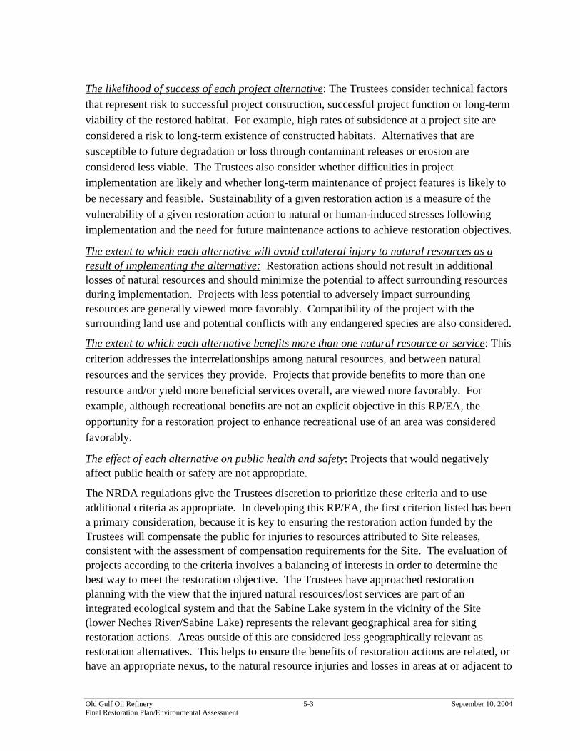
The likelihood of success of each project alternative: The Trustees consider technical factors that represent risk to successful project construction, successful project function or long-term viability of the restored habitat. For example, high rates of subsidence at a project site are considered a risk to long-term existence of constructed habitats. Alternatives that are susceptible to future degradation or loss through contaminant releases or erosion are considered less viable. The Trustees also consider whether difficulties in project implementation are likely and whether long-term maintenance of project features is likely to be necessary and feasible. Sustainability of a given restoration action is a measure of the vulnerability of a given restoration action to natural or human-induced stresses following implementation and the need for future maintenance actions to achieve restoration objectives.
The extent to which each alternative will avoid collateral injury to natural resources as a result of implementing the alternative: Restoration actions should not result in additional losses of natural resources and should minimize the potential to affect surrounding resources during implementation. Projects with less potential to adversely impact surrounding resources are generally viewed more favorably. Compatibility of the project with the surrounding land use and potential conflicts with any endangered species are also considered.
The extent to which each alternative benefits more than one natural resource or service: This criterion addresses the interrelationships among natural resources, and between natural resources and the services they provide. Projects that provide benefits to more than one resource and/or yield more beneficial services overall, are viewed more favorably. For example, although recreational benefits are not an explicit objective in this RP/EA, the opportunity for a restoration project to enhance recreational use of an area was considered favorably.
The effect of each alternative on public health and safety: Projects that would negatively affect public health or safety are not appropriate.
The NRDA regulations give the Trustees discretion to prioritize these criteria and to use additional criteria as appropriate. In developing this RP/EA, the first criterion listed has been a primary consideration, because it is key to ensuring the restoration action funded by the Trustees will compensate the public for injuries to resources attributed to Site releases, consistent with the assessment of compensation requirements for the Site. The evaluation of projects according to the criteria involves a balancing of interests in order to determine the best way to meet the restoration objective. The Trustees have approached restoration planning with the view that the injured natural resources/lost services are part of an integrated ecological system and that the Sabine Lake system in the vicinity of the Site (lower Neches River/Sabine Lake) represents the relevant geographical area for siting restoration actions. Areas outside of this are considered less geographically relevant as restoration alternatives. This helps to ensure the benefits of restoration actions are related, or have an appropriate nexus, to the natural resource injuries and losses in areas at or adjacent to
Old Gulf Oil Refinery 5-3 September 10, 2004 Final Restoration Plan/Environmental Assessment
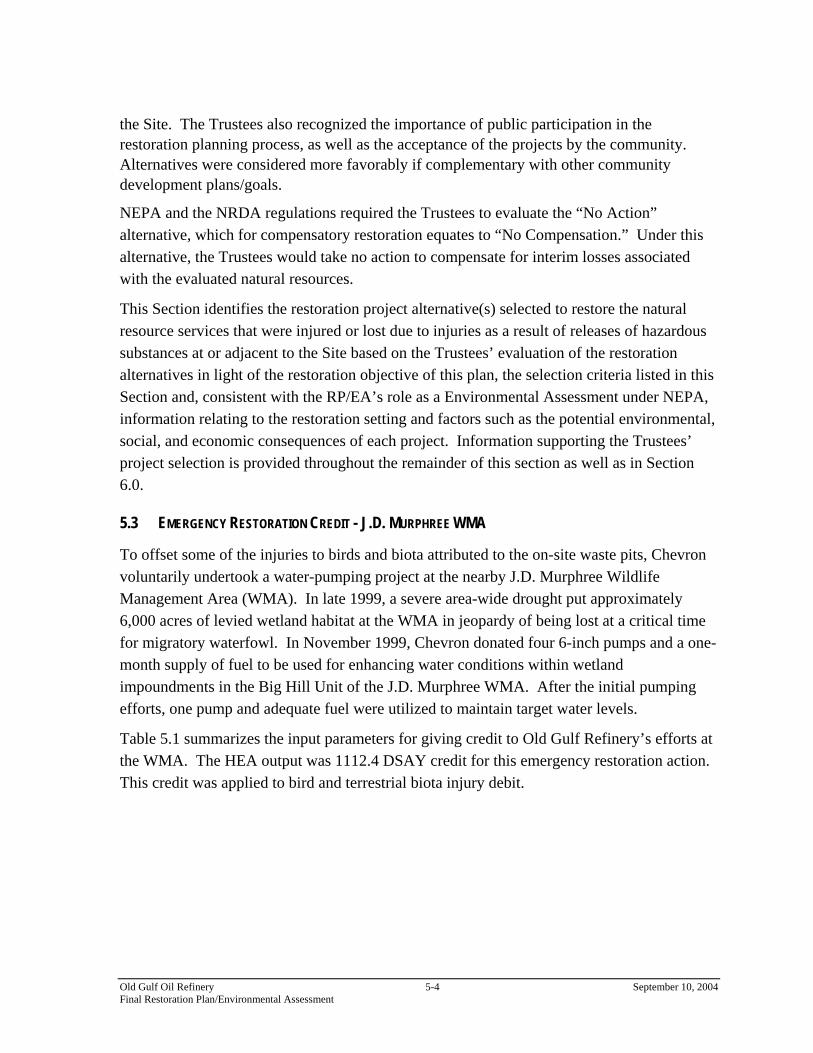
the Site. The Trustees also recognized the importance of public participation in the restoration planning process, as well as the acceptance of the projects by the community. Alternatives were considered more favorably if complementary with other community development plans/goals.
NEPA and the NRDA regulations required the Trustees to evaluate the “No Action” alternative, which for compensatory restoration equates to “No Compensation.” Under this alternative, the Trustees would take no action to compensate for interim losses associated with the evaluated natural resources.
This Section identifies the restoration project alternative(s) selected to restore the natural resource services that were injured or lost due to injuries as a result of releases of hazardous substances at or adjacent to the Site based on the Trustees’ evaluation of the restoration alternatives in light of the restoration objective of this plan, the selection criteria listed in this Section and, consistent with the RP/EA’s role as a Environmental Assessment under NEPA, information relating to the restoration setting and factors such as the potential environmental, social, and economic consequences of each project. Information supporting the Trustees’ project selection is provided throughout the remainder of this section as well as in Section 6.0.
5.3 EMERGENCY RESTORATION CREDIT - J.D. MURPHREE WMA
To offset some of the injuries to birds and biota attributed to the on-site waste pits, Chevron voluntarily undertook a water-pumping project at the nearby J.D. Murphree Wildlife Management Area (WMA). In late 1999, a severe area-wide drought put approximately 6,000 acres of levied wetland habitat at the WMA in jeopardy of being lost at a critical time for migratory waterfowl. In November 1999, Chevron donated four 6-inch pumps and a one-month supply of fuel to be used for enhancing water conditions within wetland impoundments in the Big Hill Unit of the J.D. Murphree WMA. After the initial pumping efforts, one pump and adequate fuel were utilized to maintain target water levels.
Table 5.1 summarizes the input parameters for giving credit to Old Gulf Refinery’s efforts at the WMA. The HEA output was 1112.4 DSAY credit for this emergency restoration action. This credit was applied to bird and terrestrial biota injury debit.
Old Gulf Oil Refinery 5-4 September 10, 2004 Final Restoration Plan/Environmental Assessment

Table 5.1 HEA input parameters for J.D. Murphree WMA emergency restoration action
Replacement Habitat Type
2700 acres of freshwater wetland (ecological services provided to birds and biota)
Initial level of ecological services
60%
Year creation/replacement project starts
1999
Year ecological services start increasing
1999
Year in which maximum ecological service level is reached
2000
Maximum ecological service level
100%
Shape of recovery function
linear
Expected length of service increase
1 year
Credit DSAYs
1,112.4
Marsh equivalency factor
0.20
Total Equivalent DSAYs Gained
222.5
5.4 TIER–1 SCREENING OF RESTORATION ALTERNATIVES
The Trustees first developed a list of potential alternatives for consideration to compensate for losses at or adjacent to the Site. The Trustees then narrowed the list by considering the following screening factors:
• Preference for restoration projects that could be implemented in the short term.
Old Gulf Oil Refinery 5-5 September 10, 2004 Final Restoration Plan/Environmental Assessment

• Preference for restoration projects with a strong nexus to the injured resources. • Preference for restoration projects with a high degree of habitat enhancement. • Preference for restoration projects that do limit disruption to existing resources.
As a result of the above screening factors, the Trustees further evaluated the following eleven restoration alternatives in a Tier-1 screening as potential restoration projects for the Site:
• Marsh creation via beneficial use of stockpiled dredge material at the Gulf States Utilities Canal at the Old River South Unit of the Lower Neches Wildlife Management Area (WMA). Creation of coastal wet prairie, via grading and planting of a former dredge material placement area.
• Construction of water control structures and levee systems to enhance wildlife management of wet prairie impoundments at the J.D. Murphree WMA.
• Marsh creation via beneficial use of lower Neches River dredge material in the Old Rose Hill Oil Field.
• Marsh enhancement via restoration of freshwater flow between Salt Bayou and Star Lake using a constructed inverted siphon system.
• Marsh enhancement via hydraulic restoration of Keith-Clam Lake Complex using constructed water control structures.
• Marsh creation via beneficial use of lower Neches River dredge material at Nelda Stark Unit of the Lower Neches WMA (“Bessie Heights Dredge Material Project”).
• Marsh Creation via terracing in the Nelda Stark Unit of the Lower Neches WMA (“Bessie Heights Terracing Project”).
• Marsh Creation via terracing in Old River Unit of Lower Neches WMA. • Accelerated transition of freshwater wetlands to estuarine wetlands at Salt Bayou. • Restoration of ricefield to freshwater wetlands and bottomland hardwood forest near
upper Taylor Bayou. • No Action.
As a result of the Tier-1 screening, see Table 5.2, six projects were dropped from consideration. The Bessie Heights and the Rose Hill Marsh Creation Projects were dropped because dredged material from maintenance work in the lower Neches River is not available for use for several years; thus, the projects would be excessively delayed. The two terracing projects were eliminated from further consideration because other projects evaluated provided a much higher degree of habitat enhancement than terracing, for example, marsh creation at the Old River South Unit. The
Old Gulf Oil Refinery 5-6 September 10, 2004 Final Restoration Plan/Environmental Assessment

Salt Bayou accelerated habitat transitioning project was not chosen because this project would destroy freshwater wetlands to create estuarine wetlands. Finally, the Taylor Bayou restoration of agricultural fields (rice) to freshwater wetland and bottomland hardwood forests was not selected because this restoration project did not have strong nexus with the injured resources. Table 5.2 Summary of Trustees’ Tier-1 Screening of Restoration Alternatives
Restoration Alternative
Implementable in short term
Strong nexus between injured habitats
Amount of habitat function enhancement
Avoids injury to existing resources
Retain for detailed analysis
March Creation & Wet Prairie Creation, Old River South
+ + ++ 0 Y
Construction of Water Control Structures, J.D. Murphree WMA
+ ++ ++ 0 Y
Marsh Enhancement/Salt Bayou-Star Lake Inverted Siphon
0 0 + - Y
Water Control Structure, Keith-Clam Lake
+ + ++ 0 Y
Marsh Creation, Rose Hill
--
Drop
+ ++ 0 N
Marsh Creation,
Bessie Heights Dredge Project
--
Drop
+ ++ 0 N
Marsh Creation,
Bessie Heights
Terracing Project
+ + 0
Drop
0 0
Old Gulf Oil Refinery 5-7 September 10, 2004 Final Restoration Plan/Environmental Assessment
Restoration Alternative
Implementable in short term
Strong nexus between injured habitats
Amount of habitat function enhancement
Avoids injury to existing resources
Retain for detailed analysis
Marsh Creation via Terracing, Old River North Unit
+ + 0
Drop
0 N
Accelerated Transition FW to estuarine marsh, Salt Bayou
+ + - --
Drop
N
Rice Field Freshwater marsh/Bottomland Hardwood Forest Restoration - Upper Taylor Bayou
0 --
Drop
+ - N
No action* + 0 0 0 Y*
5.5 TIER -2 SCREENING OF RESTORATION ALTERNATIVES
The Trustees considered the following restoration alternatives in developing this RP/EA (preferred alternatives in bold): (Figure 5.1 and Table 5.3)
• Marsh creation and wet prairie creation at Old River South Unit;
• Construction of water control structures and levee systems to enhance wildlife management of wet prairie impoundments on the J.D. Murphree WMA (also known as the Jefferson County Wetlands/Waterflow Enhancement Project);
• Marsh enhancement via hydraulic restoration of Keith-Clam Lake Complex using constructed water control structure;
• Marsh enhancement via restoration of freshwater flow between Salt Bayou and Star Lake using constructed inverted siphon system; and
• No action.
Old Gulf Oil Refinery 5-8 September 10, 2004 Final Restoration Plan/Environmental Assessment
Figure 5.1 Restoration project locations in the lower Neches River/Sabine Lake System
The highest priority criteria for evaluation of alternatives are those based upon a restoration project’s ability to provide appropriate compensation, its likelihood of success, and its benefits to resources. In evaluating each alternative based on these criteria, the Trustees identified two preferred project locations. The Trustees evaluation of the various projects and the ranking of each project are presented in Table 5.3. Information supporting the Trustees' selection of restoration alternatives is provided throughout the remainder of this Section. As described above, the goal of this process is the identification and implementation of expeditious and cost-effective restoration actions. To meet that objective, the benefits of restoration actions must have an appropriate nexus to the natural resources and resource service injuries and losses at the Site. To ensure the proper nexus, the Trustees must
Old Gulf Oil Refinery 5-9 September 10, 2004 Final Restoration Plan/Environmental Assessment

determine that the preferred restoration alternative has an ecological and a geographical relationship to injured resources and lost services. The Trustees selected a suite of projects to be constructed to create sufficient habitat to, in aggregate, compensate the public for the losses outlined in Section 4.0. The suite consists of the following: a) Marsh construction and enhancement in the Old River South Unit of the lower Neches WMA, adjacent to Sabine Lake near Port Arthur, Jefferson County, Texas. Construction of estuarine marsh consisting of a minimum of 60-70% vegetation and 30-40% open water (the “Marsh Complex”) via the beneficial re-use of dredged material. The dredge material to be reused will originate from the construction of the GSU canal and is presently stored in a dredged material management area adjacent the WMA. This material will be used to create a field of pimple mounds and terraces. Construction of a low water plug in the lower end of Ferry Road Canal and the addition of eight culverts under Ferry Road will ensure adequate surface water circulation and exchange. The Marsh Complex will be built via reuse of dredged material from a borrow area and terracing of existing sediments in existing open water areas.
b) Construction of coastal wet prairie (the “Coastal Wet Prairie”). After the soil from the dredged material management area is removed to construct the pimple mounds and terraces, it will be graded into a landscape of swales, and mounds and ponds and planted with wet prairie plants native to southeastern Texas.
c) Construction of Water Control Structures and levees necessary to restore and enhance the soil moisture in impoundments 8, 9, and 10 for enhanced wildlife management of the J.D. Murphree Wildlife Management Area located near the City of Port Arthur, Jefferson County, Texas. The water levels within these wetlands are managed by the TPWD. The project consists of constructing a water control structure and a low terrace with an adjacent ditch and plugging an existing ditch in the project area.
Each of these projects is discussed in further detail below.
Old Gulf Oil Refinery 5-10 September 10, 2004 Final Restoration Plan/Environmental Assessment

Table 5.3 Summary - Trustees’ Evaluation of Restoration Alternatives
Restoration Alternative
Restoration Objective (incl. future
management)
Success (incl. technical
feasibility)
Cost of
Restoration
Minimize Resource
Injury
Resource Benefits
on Public Safety
Marsh Creation & Wet Prairie Creation, Old River South
++ + 0 ++ ++ 0
Construction of Water Control Structures, J.D. Murphree WMA
+ ++ + ++ + 0
Water Control Structure, Keith-Clam Lake
0 + - + + 0
Inverted Siphon, Star Lake
0 + - + + 0
No Action - + + - - 0
Consistency with Likelihood of Avoid - Maximize Effect
5.6 SCALING THE PREFERRED RESTORATION PROJECTS
5.6.1 Habitat Equivalency Analysis Credit Model
The Trustees evaluated the suite of preferred habitat restoration projects listed (above) using scientific literature and knowledge of Texas estuaries to determine the amount of credit that each would generate by their construction. The DSAYs are then divided by the restoration credit per acre of construction value to determine the actual acreage required for compensation.
Using these assumptions, the Trustees used HEA calculations to determine the number of DSAYs given by each portion of the project. Table 5.4, Table 5.4 and Table 5.6 (correct Table 5.4 to Table 5.5) show the results. In total 4321 EqDSAYs were lost (all habitats combined). When the credit for the emergency restoration action (Section 4.3, 223 EqDSAYs) is considered, a total of 4099 a total of EqDSAYs remains to be compensated by the preferred alternative. The preferred
Old Gulf Oil Refinery 5-11 September 10, 2004 Final Restoration Plan/Environmental Assessment

alternatives will provide 4191 EqDSAYs credit. Thus, the HEA conducted by the trustees indicates that the preferred restoration options when constructed will provide sufficient compensatory credit.
Old Gulf Oil Refinery 5-12 September 10, 2004 Final Restoration Plan/Environmental Assessment

Table 5.4 DSAY Credit that will be produced by the wet prairie portion of the preferred alternatives
acres DSAYs conversion factor
Habitat Equivalent DSAYs
Old River South wet prairie construction
30 518.5 0.60 311.09
Old River South enhancement of wet prairie
195 224.23 0.60 134.54
Total wet prairie benefits 445.63
Table 5.5 DSAY Credit that will be produced by the Old River South portion of the preferred alternatives
acreage
DSAYs
Old River South wetlands construction
83
1273.61
Old River South enhancement of wetlands and mudflats
236.5
543.90
Old River South enhancement of wetlands east of Ferry Landing Road
300
689.93
Total emergent wetland benefits
2507.44
Table 5.6 DSAY Credit that will be produced by the J.D. Murphree WMA water control structures portion of the preferred alternatives
acres DSAYs conversion factor
Habitat Equivalent DSAYs
Total wetland impoundment benefits
600
6188.3
0.2
1237.66
Total wet prairie benefits 1237.66
Old Gulf Oil Refinery 5-13 September 10, 2004 Final Restoration Plan/Environmental Assessment

5.7 SUMMARY OF SETTLEMENT
The settlement of natural resource damage claims will be proposed in a consent decree resolving United States of America and the State of Texas v. Chevron U.S.A. Inc. (the “Consent Decree”) and is expected to contain an implementation plan which includes restoration project design parameters and conceptual design (“Implementation Plan”). This RP/EA selected a combination of three wetlands restoration projects to be performed in southeast Texas as preferred alternative(s) as part of a settlement of natural resource liability. The settlement of these natural resource damage claims will be embodied within the Consent Decree. The proposed Implementation Plan will contain monitoring protocols, certification criteria, and corrective action requirements and limits for the Jefferson County Wetlands (“JC Wetlands”) restoration project and the Old River South (“ORS”) restoration project. The monitoring program will identify when the ORS and JC Wetlands Restoration Projects have met success criteria. These selected restoration actions are located on State of Texas wildlife management areas (WMAs), managed by the Texas Parks and Wildlife Department (TPWD), a signatory to the proposed Consent Decree. The settlement is expected to provide funds that will be used to enable Trustee participation in, oversight and monitoring, of the selected projects to create or enhance estuarine wetlands in the Neches River basin, the estuary or watershed encompassing the Site, in order to compensate for the natural resource damages claim attributed to the Site. Funds will also be paid to the Trustees to reimburse past assessment costs.
5.8 GEOGRAPHIC PROXIMITY OF PROJECTS
All of the restoration alternatives are within the general Port Arthur area and would have geographic proximity to the Site. Of the projects warranting further consideration by the Trustees, the Old River South and J.D. Murphree projects are located closest to the Site. The J.D. Murphree project is located approximately 5 miles from the Site. The Old River South project is located approximately 10 miles northeast of the former refinery site. The Salt Bayou project is located approximately 15 miles southwest of the Site. The Keith-Clam Lake project is located approximately 15 miles southwest of the Site.
Old Gulf Oil Refinery 5-14 September 10, 2004 Final Restoration Plan/Environmental Assessment

6 RESTORATION ALTERNATIVES COMPARISON
6.1 PREFERRED RESTORATION ALTERNATIVE PART 1: MARSH CREATION VIA BENEFICIAL USE OF DREDGED
SEDIMENT AND CREATION OF COASTAL WET PRAIRIE HABITAT AT OLD RIVER SOUTH UNIT OF THE
LOWER NECHES WILDLIFE MANAGEMENT AREA (THE “OLD RIVER SOUTH MARSH/WET PRAIRIE
PROJECT”)
The project site is located south of Highway 73 between the Rainbow Bridge and Bridge City, Texas in Orange County. The project site is within the Old River South Unit of the southern section of Lower Neches River Wildlife Management Area (Lower Neches WMA). The Lower Neches WMA is owned and operated by TPWD. As selected, approximately 845 acres of coastal wetlands would be enhanced through the construction of vegetated marsh habitat and the addition of water control structures. Of the 845-acre site, approximately 83 acres of existing open water and degraded emergent marsh would be constructed through the beneficial reuse of dredge material previously placed in an adjacent dredge material placement area (DMPA) located on the Old River Unit. In addition, the ground elevation of 30 acres within the DMPA would be returned to a level that will support coastal wet prairie. By modifying the hydrology within the Old River South Unit through installation of plugs and culverts, the coastal wetland system within the entire 845-acre site would be enhanced. The wetland enhancement and construction efforts would be designed to increase marsh habitat functions and increase habitat diversity at the site. The goals of the project would be to: Restore wetland habitat by re-establishing bottom elevations necessary for the growth of emergent plant communities in open water,
Reduce export of bottom sediments and biomass by decreasing surface water velocities across the site through the installation of a water control structure along Ferry Road,
Increase the rate of sediment accretion by reducing surface flow velocities,
Increase wildlife utilization of the area by increasing the available habitat,
Increase utilization by aquatic organisms and freshwater biota by increasing the habitat quality,
Decrease the rate of loss of emergent marsh habitat, and
Maximize water circulation while still maintaining reduced overall surface water velocities by placing culverts underneath Ferry Road.
Old Gulf Oil Refinery 6-1 September 10, 2004 Final Restoration Plan/Environmental Assessment
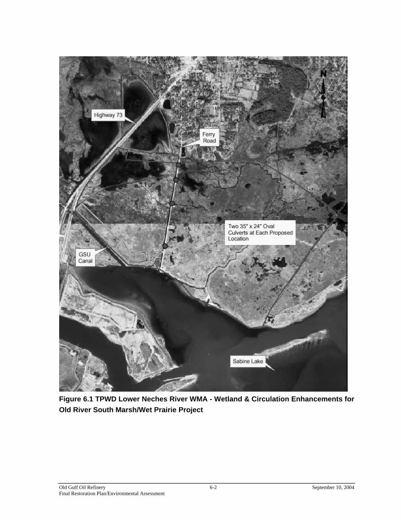
Figure 6.1 TPWD Lower Neches River WMA - Wetland & Circulation Enhancements for Old River South Marsh/Wet Prairie Project
Old Gulf Oil Refinery 6-2 September 10, 2004 Final Restoration Plan/Environmental Assessment

Existing Habitat. The marsh creation site contains approximately 158 acres of shallow open water, 237 acres of intertidal marsh and mudflats, 195 acres of wet coastal prairie, and 27 acres of uplands. The site also contains a 30-acre soil storage area (the DMPA) and a 34-acre mitigation site (Figure 6.1). Historically, the open water area of the site contained a continuous freshwater marsh with minimal water. Saltwater intrusion and erosion of surface sediments caused destruction of marsh acreage with conversion to open water. Geological subsidence contributed to the lowering of bottom elevations such that the area of interest could no longer support growth of emergent vegetation. The open water areas currently provide low quality habitat for benthic and epi-benthic communities. The open water areas also provide low quality habitat for estuarine finfish, invertebrates, wading birds, and shore birds. These areas appear to be too deep for utilization of mudflats and consumption of benthos by birds. The open water areas do not provide valuable habitat to aquatic organisms due to the potential for heat stress and turbidity. The site currently provides limited permitted opportunities through TPWD for non-consumptive (e.g. bird watching, photography and boating) and consumptive (e.g. hunting, fishing, and crabbing) recreational activities, and has significantly restricted public access via Hwy 73. Proposed Action. There are three components to this restoration alternative: 1) restoration and construction of intertidal emergent wetlands, 2) restoration of coastal wet prairie, and 3) construction of water control structures to modify site hydrology and to enhance the entire 685 acre coastal wetland system. Wetland construction within open water areas will be accomplished through the beneficial reuse of dredge material found in either the DMPA located on the site or from the use of a portion of the alternative borrow area. Prior to the use of material from the DMPA and alternative site, the upper layer of vegetation, roots and some soil would be scraped off and stockpiled for on-site disposal by TPWD. The material found in the DMPA and alternative borrow site will be slurried and pumped to the open water areas to construct intertidal islands appropriate for colonization of emergent vegetation. The DMPA and alternative borrow areas, which are currently characterized as poor quality upper marsh and uplands, would be returned to their historical condition as coastal wet prairie by reestablishing the original elevations by removal of the fill material. This action would restore historic sheet flow patterns and allow re-growth of wet coastal prairie
Old Gulf Oil Refinery 6-3 September 10, 2004 Final Restoration Plan/Environmental Assessment
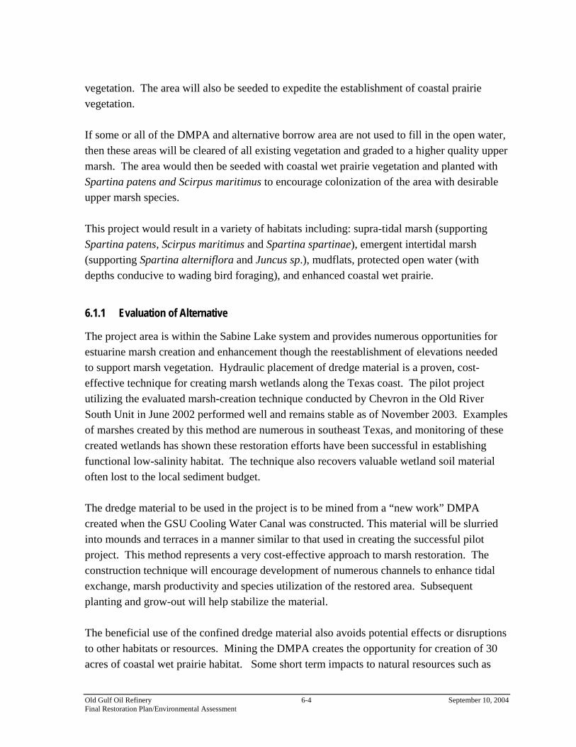
vegetation. The area will also be seeded to expedite the establishment of coastal prairie vegetation. If some or all of the DMPA and alternative borrow area are not used to fill in the open water, then these areas will be cleared of all existing vegetation and graded to a higher quality upper marsh. The area would then be seeded with coastal wet prairie vegetation and planted with Spartina patens and Scirpus maritimus to encourage colonization of the area with desirable upper marsh species. This project would result in a variety of habitats including: supra-tidal marsh (supporting Spartina patens, Scirpus maritimus and Spartina spartinae), emergent intertidal marsh (supporting Spartina alterniflora and Juncus sp.), mudflats, protected open water (with depths conducive to wading bird foraging), and enhanced coastal wet prairie.
6.1.1 Evaluation of Alternative
The project area is within the Sabine Lake system and provides numerous opportunities for estuarine marsh creation and enhancement though the reestablishment of elevations needed to support marsh vegetation. Hydraulic placement of dredge material is a proven, cost- effective technique for creating marsh wetlands along the Texas coast. The pilot project utilizing the evaluated marsh-creation technique conducted by Chevron in the Old River South Unit in June 2002 performed well and remains stable as of November 2003. Examples of marshes created by this method are numerous in southeast Texas, and monitoring of these created wetlands has shown these restoration efforts have been successful in establishing functional low-salinity habitat. The technique also recovers valuable wetland soil material often lost to the local sediment budget. The dredge material to be used in the project is to be mined from a “new work” DMPA created when the GSU Cooling Water Canal was constructed. This material will be slurried into mounds and terraces in a manner similar to that used in creating the successful pilot project. This method represents a very cost-effective approach to marsh restoration. The construction technique will encourage development of numerous channels to enhance tidal exchange, marsh productivity and species utilization of the restored area. Subsequent planting and grow-out will help stabilize the material. The beneficial use of the confined dredge material also avoids potential effects or disruptions to other habitats or resources. Mining the DMPA creates the opportunity for creation of 30 acres of coastal wet prairie habitat. Some short term impacts to natural resources such as
Old Gulf Oil Refinery 6-4 September 10, 2004 Final Restoration Plan/Environmental Assessment

temporary turbidity or other localized effects on surface water quality may occur, but these effects are generally minimized and of a short-term nature. Marsh restoration can be implemented without additional land acquisition costs because the restoration site is owned by TPWD. Siting restoration within the Wildlife Management Area will result in a larger area of protected, heterogeneous habitat than would be possible at other locations. Further, as a designated WMA, the area is already dedicated and managed by TPWD for the long-term preservation and conservation of natural resources, including estuarine habitats, a management framework that is fully consistent with the Trustees’ restoration goal. Under these conditions, the created marsh will be self-sustaining, require limited or no active intervention following construction and initial plantings to achieve functional success and will provide an uninterrupted flow of services into the future. The nature of the project and the setting for construction would present no human health or safety issues beyond those met by standard procedures for safe construction. TPWD supports this restoration effort and no public opposition to this project has been apparent during scoping by the Trustees.
6.1.2 Ecological and Socio-Economic Impacts
Modifying hydrologic patterns would enhance the entire 845-acre wetland system of the Old River South WMA. These modifications will improve sheet flow across the site and decrease the rate of tidal exchange while maintaining circulation. A plug will be constructed on the man-made canal that is adjacent to and parallel with Ferry Road. Eight (8) culverts will be installed under Ferry Road to re-establish historic water flow between the site and adjacent marshes on the eastern side of Ferry Road. There will be no net increase in water elevation in the restoration area and no net decrease in drainage from the restoration area. These hard structure modifications will significantly enhance adjacent intertidal wetlands. This restoration is expected to accomplish the following:
• increase habitat diversity,
• increase and enhance utilization of the area by fish and wildlife,
• help stop the loss of emergent marsh habitat in the vicinity of the restoration site,
• re-establish bottom conditions necessary for the growth of emergent plant communities,
• decrease the rate of water flow across the site,
Old Gulf Oil Refinery 6-5 September 10, 2004 Final Restoration Plan/Environmental Assessment

• decrease the rate of sediment loss, and
• increase the rate of sediment accretion. The habitat types that will be created include the following:
• supra-tidal marsh (supporting Gulf cordgrass (Spartina spartinae) and saltmeadow cordgrass (S. patens)),
• emergent intertidal marsh along edges,
• intertidal mudflats, and
• isolated pockets of deeper water. The following resources are expected to utilize the newly created marsh habitat:
• redfish,
• speckled trout
• killifish,
• other finfish,
• shrimp,
• crabs,
• avian species (e.g., migratory, wading and shore birds), and
• other wildlife (e.g. mink and muskrat). Increasing the habitat value of this area would be expected to enhance the carrying capacity and biological productivity of the system and to result in increased numbers of fish and shellfish available for harvest. These ecological effects will indirectly benefit humans by contributing to opportunities for recreation and enjoyment of the project area and the Lower Neches WMA through activities such as boating, bird watching, hunting and fishing. Implementation of the project will involve the temporary use of equipment or activities that will increase noise and the level of human activity in the project area for a short period of time. No other negative socio-economic effects are expected due to this project.
Old Gulf Oil Refinery 6-6 September 10, 2004 Final Restoration Plan/Environmental Assessment

6.2 PREFERRED RESTORATION ALTERNATIVE PART 2: CONSTRUCTION OF WATER CONTROL STRUCTURES
AND LEVEES FOR ENHANCED WILDLIFE MANAGEMENT OF THE J.D. MURPHREE WILDLIFE MANAGEMENT
AREA (“J.D. MURPHREE WATER CONTROL STRUCTURE PROJECT”)
This project would include construction of an earthen plug, and earthen berm and two (2) water control features (Figure 6.2) in the J.D. Murphree State Wildlife Management Area (WMA) near Port Arthur, Texas. This project is also known as the Jefferson County Wetlands/Waterflow Enhancement Project. The J.D. Murphree WMA is owned by TPWD and is located approximately 5 miles southwest of the city of Port Arthur. Modifications to hydrology within the J.D. Murphree WMA will result in the enhancement of approximately 600 acres of coastal marsh. The proposed project area includes two (2) leveed wetland management compartments that were constructed on the Big Hill Unit of the J.D. Murphree WMA between 1960 and 1963. These wetland compartments (numbers 8 & 9) are located east of Blind Bayou and north of the ICWW. Differences in elevations in the two wetland compartments preclude the flow of freshwater into the entire area and limit the marsh habitat. In addition, saltwater intrudes into the predominantly freshwater marsh as a result of the ICWW. The project will enhance the abundance and quality of emergent marsh, supra-tidal marsh, and wet coastal prairie over the unit by improving water management capabilities. In addition, the levees would enhance TPWD ability to regulate saltwater influx into the units. The goals of the project are to:
• Restore and improve the control of freshwater that flows between compartments 8 and 9,
• Allow the hydrology within the compartments to be managed independently, and
• Improve management of undesirable vegetation.
6.2.1 Existing Conditions.
The proposed project site is predominantly a freshwater marsh with controlled saltwater influence. The hydrology of these wetland units is currently managed by a system of water control structures and gravity flow. The management scheme mimics historical seasonal hydraulic conditions on the Texas Chenier Plain. A large portion of compartment 9 was impacted by soil deposited on the north shore of the ICWW during construction in the early 1930s. The existing water control facility limits optimization of water levels as a legitimate management tool for these two compartments.
Old Gulf Oil Refinery 6-7 September 10, 2004 Final Restoration Plan/Environmental Assessment
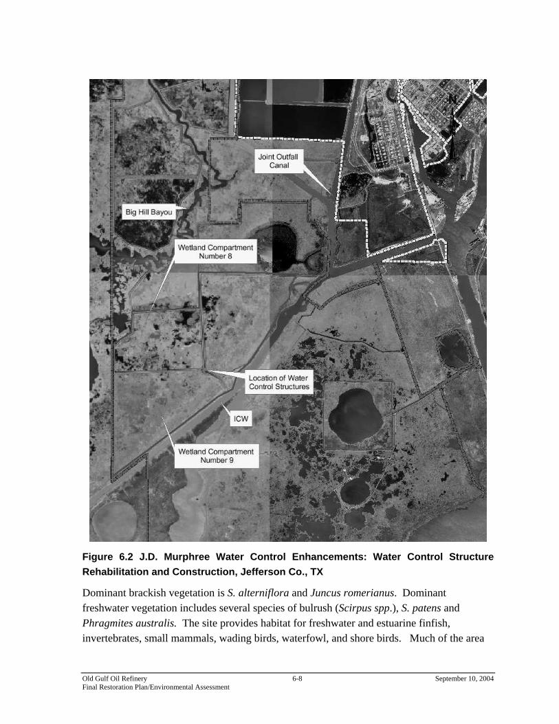
Figure 6.2 J.D. Murphree Water Control Enhancements: Water Control Structure Rehabilitation and Construction, Jefferson Co., TX
Dominant brackish vegetation is S. alterniflora and Juncus romerianus. Dominant freshwater vegetation includes several species of bulrush (Scirpus spp.), S. patens and Phragmites australis. The site provides habitat for freshwater and estuarine finfish, invertebrates, small mammals, wading birds, waterfowl, and shore birds. Much of the area
Old Gulf Oil Refinery 6-8 September 10, 2004 Final Restoration Plan/Environmental Assessment
is being invaded by water hyacinth, hydrilla, and Salvinia minima. The site currently provides opportunities for non-consumptive (e.g. bird watching, photography and boating) and limited consumptive (e.g. hunting, fishing, and crabbing) recreational activities. Proposed Actions. The restoration project involves replacing two water control structures located between compartments 8 and 9 and installing a new water control structure on the north ditch in the northeast corner of compartment 9, and constructing a 300-feet long, low-elevation earthen berm along the northeastern boundary of compartment 9 west of the Magnolia Cut. A constructed berm would direct water from the existing water control structure in compartment 9 to this new water control structure. This would allow compartment 9 to be managed independently of compartment 8. The new water control structures will be used by TPWD staff to manage water circulation and flow dynamics more efficiently and restore historic seasonal hydrology. Improved water level control capabilities and the potential to increase salinity in this compartment would reduce the amount of chemical herbicide needed to control noxious exotic freshwater vegetation. Replacing these structures would restore and improve water management capabilities in the compartment and enhance approximately 600 acres of emergent marsh, supra-tidal marsh, and wet coastal prairie.
6.2.2 Evaluation of Alternative
Better control of water conditions in the J.D. Murphree WMA is needed to reverse declines in wetland quality. Water control structures are essential tools in this process. An adequate number of functional structures are needed to allow for water management which will use salinity-stress to control invasive, low productivity plants. Additionally, the system will function as low salinity habitat and will help restore the historic vegetative community. This restoration project alternative would permit hydraulic modifications to achieve creation or enhancement of oligohaline marsh services. The J.D. Murphree WMA’s location adjacent to the operating refinery is advantageous in that it provides a large amount of high quality wetland habitat that tends to attract waterfowl and other biota away from the facility’s wastewater treatment lagoons. Marsh restoration can be implemented without additional land acquisition costs because the restoration site is owned by TPWD. Siting in the WMA allows the project to be included in a larger, contiguous area of undeveloped and protected habitat. This strategy increases the
Old Gulf Oil Refinery 6-9 September 10, 2004 Final Restoration Plan/Environmental Assessment

likelihood of restoration success, yields greater benefits to fish and wildlife, enhances the public values associated with this conservation area, and is generally preferable to implementing restoration in smaller, isolated or non-contiguous areas. Siting restoration within the WMA will result in a larger area of protected, heterogeneous habitat than would be possible at other locations. Further, as a designated WMA, the area is already dedicated and managed by TPWD for the long-term preservation and conservation of natural resources, including estuarine habitats, a management framework that is fully consistent with the Trustees’ restoration goal. Under these conditions, the created marsh will be self-sustaining, require limited or no active intervention following construction and initial plantings to achieve functional success and will provide an uninterrupted flow of services into the future. The nature of the project and the setting for construction would present no human health or safety issues beyond those met by standard procedures for safe construction. TPWD supports this restoration effort, and no public opposition to this project has been apparent during scoping by the Trustees. Construction of the water control structures described here is technically feasible, and its role in effective water management for marsh preservation and enhancement is generally recognized. To preserve the integrity and function of the structure over time, periodic maintenance or repair would likely be required. This is a project disadvantage where other, more self-sustaining options are available. Construction of a single structure will influence and improve salinity conditions and result in a corresponding increase or enhancement of marsh functions over a sizable area. The potential increase in or enhancement of marsh services may be equal to or greater than the service equivalent to be gained by restoration under this plan but the area and degree of improvement attributable to management actions involving water control structures are more difficult to predict. In this instance, there is more certainty as to whether this project would achieve the goal of this plan. Here, the utility of construction of a single structure is more certain because management measures are being implemented independent of this natural resource damages claim to effectively meet the management goal.
6.2.3 Ecological and Socio-Economic Impacts
Construction of water control structures would allow more intensive management of stressed wetlands by the TPWD and enhance oligohaline habitats in its area of influence. Implementation of this project would be expected to improve the ecology of the wetlands in this area. It would be expected to greatly increase and/or improve the ecological services of the area of influence that benefit a wide variety of fish and wildlife, including those of recreational and commercial importance.
Old Gulf Oil Refinery 6-10 September 10, 2004 Final Restoration Plan/Environmental Assessment
Owing to the project site’s distance from highways and recreational waterways, these benefits would occur in areas without ready public access. While the area is utilized by a limited number of alligator and waterfowl hunters, the primary benefits to humans would accrue more directly from the ecological service flows as they extend, albeit in a reduced manner, to areas allowing the public better access or opportunities to take advantage of the resources. Increases in organism availability should result in enhancement of the public’s benefits, e.g., more fish should mean more fish caught by fishers. Construction may disturb or displace resources within the footprint and immediate vicinity of the project area, but these impacts would be minimal, largely temporary and result in no long term effects other than the positive effects associated with the intended future use of the structure. No negative socio-economic effects would be expected due to this project.
6.3 MARSH ENHANCEMENT VIA HYDRAULIC RESTORATION OF KEITH-CLAM LAKE COMPLEX USING
CONSTRUCTED WATER CONTROL STRUCTURE (NON-SELECTED ALTERNATIVE)
This project alternative involves construction of a single water control structure in the McFaddin WMA along the ICWW and adjacent to the Keith-Clam Lake Complex marsh to aid in the control of salinity fluxes from the Sabine-Neches and ICWW in order to improve the Keith-Clam Lake Complex marsh complex through salinity management. The Keith-Clam Lake Complex is within the Sabine Lake system within 15 miles of the Old Gulf Oil Refinery Site (see Figure 5.1). It is located south of the ICWW, adjacent to the McFaddin WMA marsh complex managed by the USFWS. It is currently characterized by tidally-influenced brackish marsh, with little net water outflow. The system historically received freshwater from the Salt Bayou watershed and functioned as part of the upper estuary within the Sabine Lake estuarine ecosystem. Construction of the ICWW in 1930 prevented the flow of freshwater from Salt Bayou into the Keith-Clam Lake Complex. The only freshwater that enters the Keith-Clam Lake Complex now is from local rainfall. To compound the situation, the ICWW also serves as a conduit for saltwater. Saltwater intrusion into the marsh areas north of the ICWW has caused serious degradation and interference with the ecological function of these areas. The USFWS manages the adjacent McFaddin WMA marsh complex to preserve and protect low salinity wetlands. This is achieved through the use of water control structures and levees established to allow water managers to mimic the system’s historic hydrology. Four water control structures were used in the past. Two of these were located on the ICWW and served
Old Gulf Oil Refinery 6-11 September 10, 2004 Final Restoration Plan/Environmental Assessment

as freshwater outlets and brackish water inlets. Erosion along the ICWW has caused the loss of these two structures. Two water control structures remain on Star Lake to manage freshwater outflow into Clam Lake and then into Keith Lake. Currently, these structures are used only as freshwater outlets. The overall goal of water management of the area is to restore or maintain the historic hydrologic conditions across the upper part of the estuarine system. These goals are presently hampered by a lack of freshwater and the poor condition or loss of the water control structures that are key tools in management of salinity conditions. The inability to meet these goals has adversely impacted the vegetation structure of the marsh complex and impaired its function and value as estuarine wetlands.
6.3.1 Evaluation of Alternative
The Keith-Clam Lake Complex’s location adjacent to the McFaddin WMA is beneficial as it would provide a larger area of protected, heterogeneous habitat. The area of marsh that would benefit from this alternative is privately owned. Provisions for the future protection and management of this area would need to be established in order for the public benefits of restoration under this alternative to be realized. A management plan would have to be developed which provides guidance for the full complex in order to prevent further degradation and improve the marshes of the Keith-Clam Lake Complex and McFaddin WMA. This additional requirement would be expected to add significantly to the time and cost to ensure restoration objectives would be met if this project were used. Construction of the water control structure contemplated here is technically feasible, and its role in effective water management for marsh preservation and enhancement is generally recognized. To preserve the integrity and function of the structure over time, periodic maintenance or repair would likely be required. This is a project disadvantage where other, more self-sustaining options are available. Construction of a single structure probably cannot influence the entire 31,000-acre system but likely would influence and improve salinity conditions and result in a corresponding increase or enhancement of marsh functions over a sizable area. The potential increase in or enhancement of marsh services may be equal to or greater than the service equivalent to be gained by restoration under this plan, but the area and degree of improvement attributable to management actions involving a single structure are more difficult to predict. In this instance, there is less certainty as to whether this project would achieve the goal of this plan. The utility of construction of a single structure would also be less where other measures are still needed to effectively meet the management goal.
Old Gulf Oil Refinery 6-12 September 10, 2004 Final Restoration Plan/Environmental Assessment

6.3.2 Ecological and Socio-Economic Impacts
Construction of an appropriately sized and placed water control structure would allow more intensive management of stressed wetlands by the USFWS and enhance low salinity habitats in its area of influence. Implementation of this project would be expected to improve the ecology of the wetlands in this area. It would be expected to greatly increase and/or improve the ecological services of the area of influence as nursery habitat for estuarine resources and to benefit a wide variety of fish and wildlife, including those of recreational and commercial importance. Salinity could be maintained within ranges appropriate for estuarine dependent decapods (shrimp and crabs) via timely operation of the structure; and, if appropriately designed, the structure could allow migration of decapods and fish between the system and the greater estuary. Owing to the marsh complex’s distance from highways and recreational waterways, these benefits would occur in areas without ready public access. Benefits to the public would accrue more directly from the ecological service flows as they extend, albeit in a reduced manner, to areas allowing the public better access or opportunities to take advantage of the resources. Increases in organism availability should result in enhancement of the public benefits, e.g., more fish should mean more fish caught by fishers. Construction may disturb or displace resources within the footprint and immediate vicinity of the project area, but these impacts would be minimal, largely temporary and result in no long term effects other than the positive effects associated with the intended future use of the structure. No negative socio-economic effects would be expected due to this project.
6.4 MARSH ENHANCEMENT VIA RESTORATION OF FRESHWATER FLOW BETWEEN SALT BAYOU AND STAR
LAKE USING CONSTRUCTED INVERTED SIPHON SYSTEM (NON-SELECTED ALTERNATIVE)
This project alternative involves construction of a system of inverted siphons under the ICWW to re-establish freshwater flow from the Spindletop watershed to the Star Lake marsh complex south of the ICWW (see Figure 5.1). The inverted siphon system would provide a source of freshwater to be diverted from Salt Bayou into the Star Lake marsh complex in the McFaddin WMA. Frequent inundation of the Star Lake marsh complex by seawater during high tides or storms has introduced high salinities into the marsh complex and resulted in both vegetation shifts and losses. In addition, a documented drought spanning the last ten years has reduced the freshwater available to the Star Lake marshes. The degradation of this system has become
Old Gulf Oil Refinery 6-13 September 10, 2004 Final Restoration Plan/Environmental Assessment
more serious in the last few years due to the long-term drought and periodic tropical storms in the area. The Star Lake marsh complex is another component of the larger area, needing better water management to restore or maintain the historic hydrologic conditions across the upper part of the estuarine system. These goals are presently hampered by a lack of freshwater and the poor condition or loss of the water control structures that are key tools in management of salinity conditions (i.e., target water elevations and salinities). The inability to meet these goals has adversely impacted the vegetation structure of the marsh complex and impaired its function and value as wetlands. For the Star Lake marsh complex, recent extended drought periods have severely compromised the ability to achieve target elevations and salinities with existing management tools. This has adversely affected the overall ecological health of the Star Lake marshes.
6.4.1 Evaluation of Alternative
The resource improvements and benefits of this project would generally occur within the McFaddin WMA. As such, this alternative would contribute to improvement of a larger area of protected, heterogeneous habitat, which is an advantage in wetlands restoration. To be effective at preventing further degradation and improving the marshes within the McFaddin WMA, use of the inverted siphon system would need to be recognized and integrated in a broader plan developed to provide management guidance for the larger marsh complex. This additional requirement under this project alternative would be expected to add significantly to the time and cost to ensure restoration objectives would be met if this project were used. A portion of the project site is privately owned; and, in this case, the ability to implement this project and realize its benefits to the McFaddin marshes into the future is less certain. Legal protections or measures to ensure this flow of services into the future would have to be established and the relationship between private property owners and another federal agency (government landowner for Big Hill Strategic Petroleum Reserve) has seen a divergence of private and public interests in recent years. The construction of this siphon system alone probably cannot influence the entire 31,000-acre system. Nonetheless, it likely could influence and improve salinity conditions and result in a corresponding increase or enhancement of marsh functions over a sizable area. The marsh service increases or enhancements under this alternative might be equal to or greater than the service equivalent required to achieve the objective of this restoration plan but the area of influence and degree of improvement attributable to the siphon system alone are more
Old Gulf Oil Refinery 6-14 September 10, 2004 Final Restoration Plan/Environmental Assessment
difficult to predict. The likelihood of restoration success under this plan would, likewise, be more difficult to access than other options. Similarly, its utility as a standalone measure would also be less where other activities are also needed to effectively meet the overall management goal for the system. The project appears to be technically feasible, but costs associated with constructing the siphons and levees would likely to be higher than for other restoration alternatives considered in this RP/EA. Future maintenance and repairs may also be needed.
6.4.2 Ecological and Socio-Economic Impacts
Construction of an appropriately sized and placed inverted siphon system under the ICWW would allow more intensive management of wetlands by the USFWS. Together with appropriate management, this alternative would enhance low salinity habitats in its area of influence, thereby providing improved habitat for low salinity dependent species and, if salinity is maintained within the ranges appropriate for estuarine dependent decapods (shrimp and crabs), potentially increase recruitment of species such as brown and white shrimp and blue crabs. Implementation of this project would be expected to improve services from the area for a wide variety of fish and wildlife. Public access to the area would have limited improvement by this project due to the distance from highways and recreational waterways. The benefits to the public would be from ecological benefits extending, albeit in a reduced manner, into areas where the public has more ready access to resources and can take advantage, recreationally or commercially, of any increased numbers of fish and shellfish. Construction of this system might also disturb or displace resources within the footprint and immediate vicinity of the project area, but these impacts would be minimal, largely temporary and result in no long term effects other than the positive effects associated with the intended future use of the siphons. No negative socio-economic effects would be expected due to this project.
6.5 NO ACTION (NON-SELECTED ALTERNATIVE)
Under this alternative, the Trustees would take no action to create or restore estuarine marsh services to compensate for the resource losses attributed to the Site.
6.5.1 Evaluation of No Action Alternative
The Trustees determined that natural resources or ecological resource services were lost due to injuries caused by releases of hazardous from the Site. As a result of these impacts, the Trustees identified habitats with reduced or lost ecological services due to the hazardous substances released at the Site. While the remedial activities addressed the actions needed to
Old Gulf Oil Refinery 6-15 September 10, 2004 Final Restoration Plan/Environmental Assessment

allow injured resources to recover, the remedial activities did not compensate the public for ecological resources service losses. Such compensation serves to make the public whole for the full harm done to natural resources injured by hazardous substances releases at the Site. In the instant case, the Trustees know of restoration projects that are able to restore injured natural resources and ecological service losses at the Site. Under CERCLA, the Trustees sought compensation for these interim losses on behalf of the public through actions that restore, replace, or provide services equivalent to those lost. Under the “no action” alternative, restoration actions needed to make the environment and the public whole for its losses would not occur. This is inconsistent with the goals of natural resource damage provisions under CERCLA, and the compensation objective of this restoration plan. Thus, the Trustees have determined that the “no action” alternative (i.e., no compensatory restoration) must be rejected on that basis.
Old Gulf Oil Refinery 6-16 September 10, 2004 Final Restoration Plan/Environmental Assessment
7 NEPA, ENDANGERED SPECIES ACT, & ESSENTIAL FISH HABITAT: ANALYSIS AND PRELIMINARY FINDING OF NO SIGNIFICANT IMPACT
Pursuant to the National Environmental Policy Act (NEPA), 42 U.S.C. § 4371, et seq., and the implementing regulations at 40 C.F.R. Parts 1500 - 1517 (the NEPA regulations), federal agencies contemplating implementation of a major federal action must produce an environmental impact statement (EIS) if the action is expected to have significant impacts on the quality of the human environment. NEPA defines the human environment comprehensively to include the “natural and physical environment and the relationship of people with that environment.” 40 C.F.R. § 1508.14. All reasonably foreseeable direct and indirect effects of implementing a project, including beneficial effects, must be evaluated. 40 C.F.R. § 1508.8. Federal agencies may conduct an environmental assessment (EA) to evaluate the need for an EIS. If the EA demonstrates that the proposed action will not significantly impact the quality of the human environment, the agency issues a Finding of No Significant Impact (FONSI), which satisfies the requirements of NEPA, and no EIS is required. Section 1508.27 of the NEPA regulations describes the minimum criteria that federal agencies should consider in evaluating the potential significance of proposed actions. The regulations explain that significance embodies considerations of both context and intensity. In the case of site-specific actions such as those proposed in this EA/RP, the appropriate context for considering significance of action is local, as opposed to national or worldwide. With respect to intensity of the impacts of the proposed restoration action, the NEPA regulations suggest consideration of ten factors:
• likely impacts of the proposed project, • likely effects of the project on public health and safety, • unique characteristics of the geographic area in which the project is to be
implemented, • controversial aspects of the project or its likely effects, • degree to which possible effects of implementing the project are highly uncertain
or involve unknown risks, • precedential effect of the project on future actions that may significantly affect
the human environment,
Old Gulf Oil Refinery 7-1 September 10, 2004 Final Restoration Plan/Environmental Assessment

• possible significance of cumulative impacts from implementing this and other similar projects,
• effects of the project on National Historic Places, or likely impacts to significant cultural, scientific or historic resources,
• degree to which the project may adversely affect endangered or threatened species or their critical habitat, and
• likely violations of environmental protection laws. 40 C.F.R. § 1508.27. These factors, along with the federal Trustees’ conclusions concerning the likely significance of impacts of the selected restoration action, are discussed in detail below.
7.1 LIKELY IMPACTS OF THE PREFERRED ALTERNATIVES (OLD RIVER SOUTH MARSH/WET PRAIRIE
CREATION AND J.D. MURPHREE WATER CONTROL STRUCTURE CONSTRUCTION)
7.1.1 Nature of Likely Impacts
The selected restoration actions for injuries to natural resources at the Site consist of coastal marsh habitat restoration. Marsh enhancement would generally benefit marshland ecosystem within the upper Texas coast. Marsh/wet prairie construction at Old River South and water control structure installation at J.D. Murphree WMA would provide increased nursery, foraging, and cover habitat for critical species that inhabit the area. Increased habitat support for birds and other wildlife species would also benefit recreational uses of the area. Marsh/wet prairie creation in the Old River South area would result in some impacts to existing habitats, such as open water and unvegetated, subtidal sediments. Heavy industrialization and development as well as subsidence and erosion have resulted in a loss of many square miles of wetland habitat each year. Marsh/wet prairie restoration provides most of the same services as unvegetated sub-tidal sediments, but marsh/wet prairie is a much more productive habitat and would provide additional services. The existing open water habitat would be transformed into an emergent wetland habitat. The created marshes and wet prairie would include approximately 40% unvegetated open water bottoms. The replacement of open water by vegetated wetland results in a net benefit to the natural environment. Wetlands provide a source of organic carbon, which supplies needed energy to support the estuarine food web. Marsh and wet prairie creation in the Old River South area would also benefit the currently degraded upper marsh and upland habitats of the DMPA. Conversion of these habitats to
Old Gulf Oil Refinery 7-2 September 10, 2004 Final Restoration Plan/Environmental Assessment

emergent wetland habitat would result in an increase in productivity and a net benefit to the environment. Wetland enhancement as selected in the J.D. Murphree WMA would result in a net improvement to about 600 acres of existing wetland habitat. Currently the TPWD is using chemical herbicide to control undesirable freshwater wetland vegetation. Through the influx of salt water made available through the proposed water control structures, the use of these chemicals may be reduced. In addition, the diversity of the wetland vegetation would increase resulting in a richer habitat to support wildlife.
7.1.2 Effects on public health and safety
The Trustees do not expect marsh/wet prairie creation activities or construction of water control structures to have any impacts on public health and safety. The marsh/wet prairie that would result from implementation of the restoration project would not present any unique physical hazards to humans. No pollution or toxic discharges would be associated with marsh/wet prairie creation or water control structure installation.
7.1.3 Unique characteristics of the geographic area
Open water, unvegetated subtidal benthic sediments, and degraded emergent marsh occur at the project sites. These habitats are not unique in the upper Texas coast near Port Arthur. Degraded marsh and open water are displacing highly functional wetland habitat resulting in a net loss of habitat productivity. Therefore, no unique or rare habitat would be destroyed due to restoration of wetlands to those areas that previously supported wetlands.
7.1.4 Controversial aspects of the project or its effects
The Trustees do not expect any controversy to arise in connection with wetland creation with respect to either project approach. Wetland creation has been implemented, both by making beneficial use of U.S. Army Corps of Engineers (USACE) dredge material and the terracing method, by these and other Trustees in Texas and Louisiana, with no adverse reaction from the public. Current governmental policy supports creating wetlands along the Gulf Coast of Texas.
7.1.5 Uncertain effects or unknown risks
The Trustees do not believe there are uncertain effects or unknown risks to the environment associated with implementing the selected restoration actions. The Trustees would conduct a
Old Gulf Oil Refinery 7-3 September 10, 2004 Final Restoration Plan/Environmental Assessment
thorough site survey and engineering analysis to address any significant uncertainties before implementing the restoration actions.
7.1.6 Precedential effects of implementing the project
The Trustees have pursued wetland restoration projects to compensate for other natural resource damages claims in Texas. Wetland restoration projects are regularly implemented along the Texas coast to protect against erosion, address sediment losses, and to preserve or restore coastal habitats, and such projects have used both beneficial use of dredge material and the terracing method. The selected restoration actions, therefore, set no precedents for future actions of a type that would significantly affect the quality of the human environment.
7.1.7 Possible, significant cumulative impacts
Project effects will be cumulative in the sense that the creation of marsh and wet prairie will provide resource services into the future. The Trustees, however, know of no impacts to the environment to which the selected restoration actions would contribute that, cumulatively, would constitute a significant impact on the quality of the human environment. All selected projects would only restore a habitat type – low salinity marsh – that originally existed and naturally occurred in the area. Further, the actions selected in this RP/EA are intended to restore habitat services to offset the natural resource loss of equivalent habitat services resulting from releases of hazardous substances at or adjacent to the Site. The restoration of these services is designed to make the public whole, i.e. compensation for injuries to natural resources. The selected restoration actions also are not part of any systematic or comprehensive program or plan to address the conditions along the Texas coast or in the Old River South area.
7.1.8 Effects on National Historic Sites or nationally significant cultural, scientific or historic resources
The Trustees are aware of no previously recorded archeological sites located in the area of the selected projects. Further, as a fairly remote aquatic environment, the topographical setting of the area has a low potential for resources of cultural or historic significance. The Trustees believe the selected restoration actions will not affect any designated National Historic Site or any nationally significant cultural, scientific, or historic resources.
Old Gulf Oil Refinery 7-4 September 10, 2004 Final Restoration Plan/Environmental Assessment

7.1.9 Effects on endangered or threatened species
The Trustees know of no direct or indirect impacts of the selected restoration actions on threatened or endangered species, or their designated critical habitats. The general locale where the restoration actions would be sited is not critical habitat for any listed species.
7.1.10 Violation of environmental protection laws
The selected restoration actions do not require nor do the Trustees anticipate any violation of federal, state or local laws, designed to protect the environment incident to or as a consequence of the implementation of either of the selected actions. The restoration actions selected can be implemented in compliance with all applicable environmental laws.
7.2 CONCLUSION & PRELIMINARY FINDING OF NO SIGNIFICANT IMPACT ON THE QUALITY OF THE HUMAN
ENVIRONMENT
Under 40 C.F.R. §§ 1501.5 and 1501.6 for the purposes of this NEPA analysis, NOAA is the lead agency and USFWS is a cooperating agency. Based on the analysis in this Section and the other information and analyses included throughout the RP/EA as part of the environmental review process for the proposed restoration actions, the federal Trustees conclude that neither the Old River South Marsh/Wet Prairie Project and Construction of Water Control Structures and levees for enhanced wildlife management of the J.D. Murphree Wildlife Management Area (“Proposed Restoration Alternatives”) will not, if implemented, result in any significant impacts on the quality of the human environment. The selected restoration projects would provide habitat which would be beneficial to the biological environment found within the proposed project areas. The selected restoration projects will not impact the cultural and human environment except for providing for increased opportunities for recreation and commercial fishing by improving estuary habitats for fish dependent and other aquatic organism dependent upon estuarine environments. Significant impacts were not revealed through the public review and comment process. As a result of the federal Trustees’ analyses and public review and comment, no environmental impact statement will be prepared for the selected restoration actions. A Finding of No Significant Impact (FONSI), based upon this Environmental Assessment, will fulfill and conclude all requirements for compliance with NEPA for both NOAA and DOI.
Old Gulf Oil Refinery 7-5 September 10, 2004 Final Restoration Plan/Environmental Assessment
7.3 ENDANGERED AND THREATENED SPECIES
The Endangered Species Act of 1973 instructs federal agencies to carry out programs for the conservation of endangered and threatened species and to conserve the ecosystems upon which these species depend. Numerous endangered and threatened species are seasonal or occasional visitors to the Sabine Lake/Neches River Estuary coastal ecosystem. Endangered and threatened species known to occur in the Texas Gulf Coast Prairies and Marshes Ecoregion or adjacent marine waters are listed in Table 7.1 (Texas Parks and Wildlife Department 1997). Fifteen of these species - including the brown pelican (Pelecanus occidentalis), reddish egret (Egretta rufescens), white-faced ibis (Plegadus chihi), wood stork (Mycteria americana), whooping crane (Grus americana), bald eagle (Haliaeetus leucocephalus), Arctic peregrine falcon (Falco peregrinus tundrius), piping plover (Charadrius melodus), Eskimo curlew (Numenius borealis), green sea turtle (Chelonia mydas), Kemp's ridley sea turtle (Lepidochelys kempi), loggerhead sea turtle (Caretta caretta), Texas tortoise (Gopherus berlandieri), scarlet snake (Cemophora coccinea), and South Texas siren (Siren sp.) - have been documented in or are believed to utilize the estuary. Most species would be present in the estuary incident to migration through the area. None of these species were considered to be exposed or at risk of injury due to hazardous substance releases at the Site. The estuary’s habitats provide general support for any threatened and endangered species migrating through or utilizing these communities. Because the selected projects will provide beneficial habitats, no adverse impacts are expected on any endangered or listed species found within the project areas. The ESA directs all federal agencies to conserve endangered and threatened species and their habitats to the extent their authority allows. Protection of wildlife and preservation of habitat are central objectives in this effort. Under the ESA, the Department of Commerce (through NOAA) and the Department of the Interior (through USFWS) publish lists of endangered and threatened species. Section 7 of the Act requires federal agencies to consult with these departments to minimize the effects of federal actions on these listed species. The restoration actions described in this RP/EA are not expected to adversely impact any threatened or endangered species. The actions would create or enhance habitats beneficial to supporting ecosystems for any such species. Informal consultation procedures were initiated with the USFWS and with the National Marine Fisheries Service (NOAA Fisheries) in order to ensure the restoration action are implemented in accordance with applicable provisions of the ESA.
Old Gulf Oil Refinery 7-6 September 10, 2004 Final Restoration Plan/Environmental Assessment
7.4 ESSENTIAL FISH HABITAT
Congress enacted amendments to the Magnuson-Stevens Fishery Conservation and Management Act (Public Law 94-265) in 1996 that established procedures for identifying Essential Fish Habitat (EFH) and required interagency coordination to further the conservation of Federally-managed fisheries. Rules published by the NOAA Fisheries (50 C.F.R. §§ 600.805 - 600.930) specify that any Federal agency that authorizes, funds or undertakes, or proposes to authorize, fund, or undertake an activity which could adversely affect EFH is subject to the consultation provisions of the above-mentioned act and identifies consultation requirements. This section was prepared to meet these requirements. The Gulf of Mexico Fishery Management Council has identified the proposed project area as Essential Fish Habitat (EFH) for post-larval, juvenile, sub-adult and adult red drum (Sciaenops ocellatus), white shrimp (Litopenaeus setiferus) and brown shrimp (Farfantepenaeus aztecus). Adult brown shrimp are common in the area from March though July and rare from August through February. Juvenile brown shrimp are abundant from March through October and common from November to February. Adult white shrimp are abundant from August through February and common from March through July, whereas juveniles are highly abundant year round. Adult red drum are rare in the project site year-round, though juveniles are always common (NMFS 2002)
Old Gulf Oil Refinery 7-7 September 10, 2004 Final Restoration Plan/Environmental Assessment

Table 7.1 Federal and State Endangered or Threatened Species in Coastal Texas
Common Name Scientific Name Status
Mammals West Indian manatee Trichechus manatus FE, SE White-nosed coati Nasua narica ST Birds Brown pelican Pelecanus occidentalis FE, SE Reddish egret Egretta rufescens ST White-faced ibis Plegadus chihi ST Wood stork Mycteria americana ST Whooping crane Grus americana FE, SE Swallow-tailed kite Elanoides forficatus ST Bald eagle Haliaeetus leucocephalus FT, ST White-tailed hawk Buteo albicaudatus ST Peregrine falcon Falco peregrinus FE, SE Arctic peregrine falcon Falco peregrinus tundrius FE, ST Attwater's greater prairie-chicken Tympanuchus cupido attwateri FE, LE Piping plover Charadrius melodus FT, LT Eskimo curlew Numenius borealis FE, SE Sooty tern Sterna fuscata ST Botteri's sparrow Aimophila botteri ST Reptiles Green sea turtle Chelonia mydas FT, LT Kemp's ridley sea turtle Lepidochelys kempi FE, SE Loggerhead sea turtle Caretta caretta FT, ST Alligator snapping turtle Macroclemy temminckii ST Texas tortoise Gopherus berlandieri ST Scarlet snake Cemophora coccinea ST Indigo snake Drymarchon corais ST Northern cat-eyed snake Leptodeira septentrionalis ST Smooth green snake Liochlorophis vernalis ST Timber (canebrake) rattlesnake Crotalus horridus ST Amphibians Black-spotted newt Notophthalmus meridionalis ST South Texas siren (large form) Siren sp. ST Houston toad Bufo houstonensis FE, SE Fish Blue sucker Cycleptis elongatus ST
River goby Awaous tajasica ST
Plants Black lace cactus Echinocereus reichenbachii FE, SE
South Texas ambrosia Ambrosia cheiranthifolia FE, SE
Slender rush-pea Hoffmannseggia tenella FE, SE
Old Gulf Oil Refinery 7-8 September 10, 2004 Final Restoration Plan/Environmental Assessment
7.4.1 Effect on Essential Fish Habitat
Approximately 71 acres of open water will be impacted by the organized placement of material into the marsh. Recovery of some benthos will probably be relatively fast, but the assemblage in the sediments at the bottom may never be the same. There will be an initial loss of estuarine water column and estuarine mud bottoms. While they are being filled, the area within them will not be available for aquatic organism use. It will take some time before the marsh is established; however, the estuarine nature of the new marsh, once established, will provide habitat for numerous species, which utilize estuaries during different life stages. The designed features, which will allow circulation of waters through the marsh, make this a potentially exceptionally productive estuarine area. While there will be impacts to the benthos, some of which will be irreversible, there will be an overall gain in the ecology of the lower Neches/Sabine Lake system from the creation of the restoration features. This project is expected to provide habitats, which are likely to increase fisheries populations within the project area.
7.4.2 Effects on the Managed Species, and Associated Species by Life History Stage.
Red Drum: In the Gulf of Mexico red drum occur in a variety of habitats, ranging from depths of about 40 meters offshore to very shallow estuarine waters. They commonly occur in virtually all of the Gulf’s estuaries where they are found over a variety of substrates including sand, mud and oyster reefs. Red drum can tolerate salinities ranging from freshwater to highly saline, but optimum salinities for the various life stages have not been determined. Types of habitat occupied depend upon the life stage of the fish. Spawning occurs in deeper waters near the mouths of bays and inlets, and on the Gulf side of the barrier islands. Eggs hatch mainly in the Gulf, and larvae are transported into the estuary where the fish mature before moving back to the Gulf. Adult red drum utilize estuaries but tend to spend more time offshore as they age. Estuarine wetlands are especially important to the larval, juvenile and sub-adult red drum. Juvenile red drum are commonly found in the project site year-round and will be affected by the increase in turbidity, which can kill eggs and larvae and foul gills; however, most will avoid the project area during construction. Adult red drum are rare in the project site and should not be affected by any project activities. Given the overall increase in estuarine marshes provided by the selected projects, no mitigation is required. White Shrimp: White shrimp are offshore and estuarine dwellers and are pelagic or demersal, depending on life stage. The eggs are demersal and larval stages are planktonic;
Old Gulf Oil Refinery 7-9 September 10, 2004 Final Restoration Plan/Environmental Assessment

both occur in nearshore marine waters. Post-larvae migrate through passes mainly from May-November with peaks in June and September. Migration is in the upper two meters of the water column at night and at mid depths during the day. Post-larval white shrimp become benthic upon reaching the nursery areas of estuaries, where they seek shallow water with muddy-sand bottoms high in organic detritus or abundant marsh, and develop into juveniles. Juveniles are common to highly abundant in all Gulf estuaries in Texas. Post-larvae and juveniles inhabit mostly mud or peat bottoms with large quantities of decaying organic matter or vegetative cover. As juvenile white shrimp approach adulthood, they move from the estuaries to coastal areas where they mature and spawn. Migration from estuaries occurs in late August and September and appears to be related to size and environmental conditions (e.g., sharp temperature drops in fall and winter). Adult white shrimp are demersal and generally inhabit nearshore Gulf waters to depths less than 30 meters on bottoms of soft mud or silt. (Gulf of Mexico Fishery Management Council, 1998). Juvenile and adult white shrimp are found year-round in the project site and will be affected by the increase in turbidity, which can kill eggs and larvae, clog filter-feeding appendages, and interrupt primary productivity. Most white shrimp should be able to avoid the project area, though some may be buried upon initial sediment deposition. These effects will be offset by the overall increase in estuarine marshes provided by the selected projects, and, ultimately, all life stages of the white shrimp will benefit. Therefore, no mitigation is required. Brown Shrimp: Brown shrimp eggs are demersal and occur offshore. The larvae occur offshore and begin to migrate to estuaries as post-larvae. In estuaries, brown shrimp post-larvae and juveniles are associated with shallow, vegetated habitats but are also found over fine sand and non-vegetated mud bottoms. Juveniles and sub-adults of brown shrimp occur from secondary estuarine channels out to the continental shelf but prefer shallow estuarine areas, particularly the soft, muddy areas associated with plant-water interfaces. Adult brown shrimp occur in neritic Gulf waters (i.e., marine waters extending from mean low tide to the edge of the continental shelf) and are associated with silt, muddy sand, and sandy substrates. (Gulf of Mexico Fishery Management Council, 1998). Juvenile brown shrimp are found year-round in the project site and adults are found from March through July. Turbidity will affect those present, possibly killing eggs and larvae, clogging filter-feeding appendages, and interrupting primary productivity. Most brown shrimp should be able to avoid the project area, though some may be buried upon initial sediment deposition. These effects will be offset by the overall increase in estuarine marshes
Old Gulf Oil Refinery 7-10 September 10, 2004 Final Restoration Plan/Environmental Assessment
provided by the selected projects, and, ultimately, all life stages of the brown shrimp, will benefit. Therefore, no mitigation is required.
7.4.3 The Federal Agency’s Views Regarding The Effects Of The Action On EFH
It is the opinion of the federal Trustees that the project as proposed will not have a significant adverse effect upon EFH. While there will be some loss of bottom area, the beneficial use plans will have an overall effect of benefiting the managed species and should provide an overall increase in marsh habitats.
7.4.4 Conclusion of Effects on EFH
Though initial, significant impacts on EFH are expected due to loss of estuarine water column and mud bottoms, there will be a net benefit to the ecology of the Old River South Marsh system from the creation of the restoration features. Because these projects are expected to provide habitats, which are likely to increase fisheries populations within the project area, no mitigation is necessary. The Trustees have initially determined that the selected restoration actions will have no adverse effect on any EFH designated or pending designation under the Act. NOAA Fisheries were consulted regarding this determination.
Old Gulf Oil Refinery 7-11 September 10, 2004 Final Restoration Plan/Environmental Assessment
8 COMPLIANCE WITH OTHER KEY STATUTES, REGULATIONS AND POLICIES
8.1 CLEAN WATER ACT (CWA), 33 U.S.C. § 1251 ET SEQ.
The CWA is the principal law governing pollution control and water quality of the nation’s waterways. Section 404 of the law authorizes a permit program for the beneficial uses of dredged or fill material. USACE administers the program. In general, restoration projects, which move significant amounts of material into or out of waters or wetlands, for example, hydrologic restoration of marshes, require 404 permits. A CWA 404 permit will be obtained, if required, in order to implement any restoration action selected in this RP/EA.
8.2 RIVERS AND HARBORS ACT, 33 U.S.C. § 401 ET SEQ.
The Rivers and Harbors Act regulates development and use of the nation’s navigable waterways. Section 10 of the Act prohibits unauthorized obstruction or alteration of navigable waters and vests the Corps with authority to regulate discharges of fill and other materials into such waters. Restoration actions that must comply with the substantive requirements of Section 404 must also comply with the substantive requirements of Section 10. Any such permit would be obtained, as required, in order to implement any restoration action selected in this RP/EA.
8.3 COASTAL ZONE MANAGEMENT ACT (CZMA), 16 U.S.C. § 1451 ET SEQ., 15 C.F.R. PART 923
The goal of the CZMA is to encourage states to preserve, protect, develop, and, where possible, restore and enhance the nation’s coastal resources. Under Section 1456 of the CZMA, restoration actions undertaken or authorized by federal agencies within a state’s coastal zone are required to comply, to the maximum extent practicable, with the enforceable policies of a state’s federally approved Coastal Zone Management Program. NOAA and the USFWS found the restoration actions identified in this RP/EA to be consistent with the Texas Coastal Zone Management Program, and a determination of consistency was received from the appropriate state agencies after their review of the Draft RP/EA.
Old Gulf Oil Refinery 8-1 September 10, 2004 Final Restoration Plan/Environmental Assessment
8.4 FISH AND WILDLIFE CONSERVATION ACT, 16 U.S.C. § 2901 ET SEQ.
The restoration actions described herein will encourage the conservation of non-game fish and wildlife.
8.5 FISH AND WILDLIFE COORDINATION ACT (FWCA), 16 U.S.C. § 661 ET SEQ.
The FWCA requires that federal agencies consult with USFWS, NOAA Fisheries, and state wildlife agencies regarding activities that affect, control, or modify waters of any stream or bodies of water, in order to minimize the adverse impacts of such actions on fish and wildlife resources and habitat utilizing these aquatic environments. Coordination is taking place by and between NOAA Fisheries, the USFWS and TPWD, the appropriate state wildlife agency. This coordination is also incorporated into compliance processes used to address the requirements of other applicable statutes, such as Section 404 of the CWA. The restoration actions described herein will have a positive effect on fish and wildlife resources.
8.6 MARINE MAMMAL PROTECTION ACT, 16 U.S.C. § 1361 ET SEQ.
The Marine Mammal Protection Act provides for the long-term management of and research programs for marine mammals. It places a moratorium on the taking and importing of marine mammals and marine mammal products, with limited exceptions. The Department of Commerce is responsible for whales, porpoise, seals, and sea lions. The Department of the Interior is responsible for all other marine mammals. The restoration actions described in this RP/EA will not result in any adverse effect to marine mammals.
8.7 MIGRATORY BIRD CONSERVATION ACT, 16 U.S.C. § 715 ET SEQ.
The selected restoration action will have no adverse effect on migratory birds that are likely to benefit from the establishment of new marsh habitat.
8.8 NATIONAL HISTORIC PRESERVATION ACT, 16 U.S.C. § 470 ET SEQ.
The Trustees know of no known cultural or historic resources within or in the vicinity of the selected restoration sites.
8.9 INFORMATION QUALITY GUIDELINES ISSUED PURSUANT TO PUBLIC LAW 106-554
Information disseminated by federal agencies to the public after October 1, 2002, is subject to information quality guidelines developed by each agency pursuant to Section 515 of
Old Gulf Oil Refinery 8-2 September 10, 2004 Final Restoration Plan/Environmental Assessment

Public Law 106-554 that are intended to ensure and maximize the quality of such information (i.e., the objectivity, utility and integrity of such information). The RP/EA, upon release as a draft, was identified as an information product covered by information quality guidelines established by NOAA and DOI for this purpose. The information contained herein complies with applicable guidelines.
8.10 EXECUTIVE ORDER 12898 (59 FED. REG. 7629) - ENVIRONMENTAL JUSTICE
This Executive Order requires each federal agency to identify and address, as appropriate, disproportionately high and adverse human health or environmental effects of its programs, policies, and activities on minority and low-income populations. EPA and the Council on Environmental Quality (CEQ) have emphasized the importance of incorporating environmental justice review in the analyses conducted by federal agencies under NEPA and of developing mitigation measures that avoid disproportionate environmental effects on minority and low-income populations. The Trustees have concluded that there are no low- income or ethnic minority communities that would be adversely affected by the restoration projects identified herein.
8.11 EXECUTIVE ORDER NUMBER 11514 (35 FED. REG. 4247) - PROTECTION AND ENHANCEMENT OF
ENVIRONMENTAL QUALITY
An Environmental Assessment is integrated within this RP/EA. Environmental analyses and coordination have taken place as required by NEPA.
8.12 EXECUTIVE ORDER NUMBER 11990 (42 FED. REG. 26,961) - PROTECTION OF WETLANDS
The selected restoration actions will not result in adverse effects on wetlands or the services they provide, but rather will provide for the enhancement and protection of wetlands and wetland services.
8.13 EXECUTIVE ORDER NUMBER 12962 (60 FED. REG. 30,769) - RECREATIONAL FISHERIES
The selected restoration actions will not result in adverse effects on recreational fisheries but will help ensure the enhancement and protection of such fisheries.
Old Gulf Oil Refinery 8-3 September 10, 2004 Final Restoration Plan/Environmental Assessment

9 LITERATURE CITED
Texas Natural Resource Conservation Commission. December 2001. Guidance for Conducting Ecological Risk Assessments at Remediation Sites in Texas. RG-263 (revised). 296pp Long, E.R., D.D. MacDonald, S.L. Smith and F.D. Calder. 1995. Incidence of adverse biological effects within ranges of chemical concentrations in Marine estuarine sediments. Environmental Management 19:81-97 NOAA. 1999. Discounting and the treatment of uncertainty in natural resource damage assessment. Technical Paper 99-1. National Oceanic and Atmospheric Administration, Damage Assessment and Restoration Program. Website www.darp.noaa.gov/publicat.htm Long, E.R., Field, L.J., and MacDonald, D.D. Predicting toxicity in marine sediments with numerical sediment quality guidelines, Environmental Toxicology and Chemistry, 17, 4, 1998 Lee, BG, JS Lee, SN Luoma, HJ Choi and CH Koh, 2000, Influence of Acid Volatile Sulfide and Metal Concentrations on Metal Bioavailability to Marine Invertebrates in Contaminated Sediments. Environ. Sci. Technol. 34:4517-4523 MacDonald, D.D., C.G. Ingersoll, and T.A. Berger. 2000. Development and Evaluation of Consensus-Based Sediment Quality Guidelines for Freshwater Ecosystems. Archives of Environmental Contamination and Toxicology 39: 20-31. NOAA. 2000. Habitat Equivalency Analysis: An Overview, Damage Assessment and Restoration Program, National Oceanic and Atmospheric Administration, Department of Commerce, 23 pp. http://www.darp.noaa.gov/pdf/heaoverv.pdf
Old Gulf Oil Refinery 9-1 September 10, 2004 Final Restoration Plan/Environmental Assessment
10 LIST OF PERSONS/AGENCIES CONSULTED
National Oceanic and Atmospheric Administration Robert A. Taylor Gail Siani Rusty Swafford Texas Commission on Environmental Quality C. Sweeney Texas Parks and Wildlife Department Woody Woodrow M. Wezsutek Jim Sutherland Texas General Land Office Eddie Fisher Fish and Wildlife Service, United States Department of the Interior John Huffman
Old Gulf Oil Refinery 10-1 September 10, 2004 Final Restoration Plan/Environmental Assessment

11 LIST OF PREPARERS
National Oceanic and Atmospheric Administration Ron Gouguet Jason Forman Texas Commission on Environmental Quality Richard Seiler Texas Parks and Wildlife Department Don Pitts Raenell Silcox Andy Tirpak Texas General Land Office William Grimes Dennis Rocha Fish and Wildlife Service, United States Department of the Interior Ken Rice
Old Gulf Oil Refinery 11-1 September 10, 2004 Final Restoration Plan/Environmental Assessment