final report east 12 street bikeway feasibility study 12th street bikeway feasibility study prepared...
TRANSCRIPT

Final Report
East 12th Street Bikeway Feasibility Study
Prepared for: City of Oakland
Public Works Agency
Submitted by:
180 Grand Avenue, Suite 250 Oakland, CA 94612 Phone: (510) 839-1742; Fax: (510) 839-0871 www.dowlinginc.com Contact: Alice Chen x101 November 19, 2008


Table of Contents
Introduction .................................................................................................... 1
Background ..................................................................................................... 1
Setting ............................................................................................................. 2
Data Collection ................................................................................................ 5
Traffic Volumes......................................................................................................... 5
Lane Configuration ................................................................................................... 6
On-street Parking ..................................................................................................... 7
Bicycle and Pedestrian Volumes............................................................................... 7
Collision Data............................................................................................................ 8
Intersection Operations ......................................................................................... 10
Proposed Bike Lanes...................................................................................... 11
Proposed Project .................................................................................................... 11
Intersection Operations ......................................................................................... 12
Cumulative Conditions................................................................................... 16
Summary of Recommendations..................................................................... 21
Appendices .................................................................................................... 25

List of Tables
Table 1 – Average Daily Traffic Volumes on East 12th Street.................................................... 5 Table 2 – Width Measurements at Study Intersections............................................................ 6 Table 3 – Bicycle and Pedestrian Counts at East 12th Street Intersections.............................. 8 Table 4 – Additional Bicycle Counts .......................................................................................... 8 Table 5 – Highest Number of Reported Collisions .................................................................... 9 Table 6 – Existing Intersection Level of Service Summary..................................................... 10 Table 7 – Existing with Project Intersection Level of Service Summary ................................ 12 Table 8 – Existing Intersection Level of Service with Recommendations .............................. 13 Table 9 – Future (2025) Intersection Level of Service Summary........................................... 17 Table 10 – Future Intersection Level of Service with Recommendations .............................. 18

Introduction
The City of Oakland Community and Economic Development Agency is considering the feasibility of bike lanes on East 12th Street from 2nd Avenue to Fruitvale Avenue and has retained Dowling Associates to lead this study. This report summarizes the data collection efforts, presents the findings of the feasibility analysis, and provides specific recommendations for implementing the bike lanes along this corridor.
Background
This study was prepared to assess the feasibility of providing Class II bike lanes on East 12th Street from 2nd Avenue to Fruitvale Avenue. For a Class II bike lane, Caltrans Design Standards require a five-foot width for each direction of travel, which would require reconfiguration of East 12th Street to accommodate the bike lanes.
The Alameda Countywide Bicycle Plan shows this section of East 12th Street as segment BC of the cross county “Oakland I-880” corridor (#25). The recent update of the Oakland Bicycle Master Plan identifies several bicycle facilities that link with East 12th Street providing access to the Estuary and the City of Alameda to the south and to the Oakland hills to the north. Existing and proposed bicycle facilities that cross East 12th Street include:
• 4th/5th Avenues Class III Bike Route: Proposed from Embarcadero to East 18th Street.
• 16th Avenue Class III Bike Route: Existing/proposed from Embarcadero to Foothill Boulevard
• Fruitvale Avenue Class II/III Bike Lane/Route: Existing/proposed from Alameda Avenue to Foothill Boulevard.
• 38th Avenue Class III Bike Lane: Proposed from East 12th Street to MacArthur Boulevard.
The East 12th Street Bikeway would connect with the proposed Class II bike lanes on East 12th/12th Street to downtown Oakland and the proposed Class III bike route that continues from Fruitvale Avenue to 38th Avenue.
East 12th Street Bikeway Feasibility Study 1 Dowling Associates, Inc.
Setting Setting
Photo 2 – East 12th Street at 7th Avenue
Photo 1 – East 12th Street at 4th Avenue
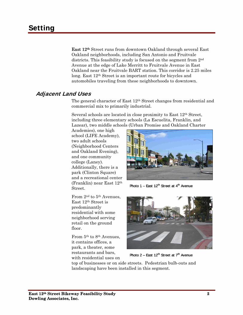
East 12thEast 12th Street runs from downtown Oakland through several East Oakland neighborhoods, including San Antonio and Fruitvale districts. This feasibility study is focused on the segment from 2nd Avenue at the edge of Lake Merritt to Fruitvale Avenue in East Oakland near the Fruitvale BART station. This corridor is 2.25 miles long. East 12th Street is an important route for bicycles and automobiles traveling from these neighborhoods to downtown.
East 12th Street Bikeway Feasibility Study 2
Adjacent Land Uses The general character of East 12th Street changes from residential and commercial mix to primarily industrial.
East 12th Street at 4th Avenue Photo 1 –
Several schools are located in close proximity to East 12th Street, including three elementary schools (La Escuelita, Franklin, and Lazear), two middle schools (Urban Promise and Oakland Charter Academies), one high school (LIFE Academy), two adult schools (Neighborhood Centers and Oakland Evening), and one community college (Laney). Additionally, there is a park (Clinton Square) and a recreational center (Franklin) near East 12th Street.
From 2nd to 5th Avenues, East 12th Street is predominantly residential with some neighborhood serving retail on the ground
East 12th Street at 7th Avenue
Dowling Associates, Inc.
Photo 2 –
floor.
From 5th to 8th Avenues, it contains officepark, a theater, some restaurants and bars, with residential uses ontop of businesses or on side streets. Pedestrian bulb-outs and landscaping have been inst
s, a
alled in this segment.
East 12th Street Bikeway Feasibility Study 2 Dowling Associates, Inc.

From 8th to 14th Avenues, the street includes light industrial businesses, smaller warehouses, markets, some offices and residences, and automotive shops.
Photo 3 – East 12th Street at 10th Avenue
From 14th to 16th Avenues westbound, the uses are mostly commercial fronting East 12th Street, with a fast-food restaurant, a sit-down restaurant, office, and light industrial uses. Residences are located on the side streets. There are no land uses on East 12th Street eastbound between 14th and 20th Avenues.
Photo 4 – East 12th Street at 14th Avenue (WB)
From 16th to 23rd Avenues, the street transitions to a more industrial orientation and includes warehouses (retail and industrial), light industrial businesses, and automotive shops. Activities associated with these businesses result in trucks parked along this section of East 12th Street. BART’s elevated train tracks enter East 12th Street’s median near 19th Avenue.
Photo 5 – East 12th Street at Miller Avenue (EB)
Photo 6 – East 12th Street between 26th and 29th Avenues (WB)
From 23rd to 26th Avenues, several automotive shops, coin operated laundry facilities, discount retail warehouses, and fast-food restaurants have frontages along East 12th Street. Residences are
East 12th Street Bikeway Feasibility Study 3 Dowling Associates, Inc.

generally located on the side streets.
Photo 7 – East 12th Street at 31st Avenue (WB)
From 26th to 29th Avenues, there is a middle school and a self-storage facility.
From 29th to Fruitvale Avenues, there are industrial warehouses, some empty lots or abandoned buildings, and some residences on both East 12th Street and on the side streets.
Photo 8 – East 12th Street at Fruitvale (EB)
At Fruitvale Avenue, the neighborhood transitions again as it proceeds east towards the BART station. Restaurants, other retail, and civic services become the predominant land uses.
Future Conditions Several on-going and proposed projects along the corridor may potentially change the character of East 12th Street. In addition to the recently completed streetscape improvements from 5th Avenue to 8th Avenue, a streetscape study is underway for 14th Avenue, which includes the two intersections with East 12th Street. The Fruitvale Alive study identified several improvements along the Fruitvale Avenue corridor, particularly at the intersection with East 12th Street. The reconstruction and reconfiguration of the 12th Street Dam project lies directly west of the project towards downtown Oakland.
The future development of the Fruitvale Transit Village Phase II and the Fruitvale Gateway would also potentially affect travel patterns along East 12th Street. The recently approved Oak-to-Ninth development along the estuary may affect the traffic on the cross streets, such as 5th Avenue and 22nd Avenue.
East 12th Street Bikeway Feasibility Study 4 Dowling Associates, Inc.

Data Collection
Traffic Volumes
Average Daily Traffic Twenty-four hour vehicle traffic counts were conducted at four locations along East 12th Street on Wednesday, October 11, 2006. The weather that day was clear and warm. Morning traffic peaks occurred in the westbound direction (towards downtown Oakland) between 8:00 and 9:00 AM, and evening traffic peaks occurred in the eastbound direction between 4:00 and 6:00 PM. The average daily traffic (ADT) is summarized in Table 1.
Table 1 – Average Daily Traffic Volumes on East 12th Street
AM PM
Location ADT Time Volume Time Volume
Between 5th and 8th Aves 12,301 8:00-9:00 1,181 5:00-6:00 1,296
Between 19th and 22nd Aves 21,921 8:00-9:00 1,892 4:30-5:30 2,334
Between 23rd and 29th Aves 16,482 7:45-8:45 1,551 4:30-5:30 1,881
Between 29th and Fruitvale Aves 15,138 7:45-8:45 1,483 4:30-5:30 1,714 Source: Counts conducted by Wiltec on October 11, 2006.
Peak Hour Intersection Volumes Peak hour intersection counts were collected for the ten signalized intersections along the corridor. Since recent counts were available for four (4) intersections, peak hour turning movement counts were conducted on October 11, 2006 at the six (6) remaining intersections during the AM and PM peak periods. The AM and PM peak hour volumes for all signalized intersections along the corridor are provide in the technical appendix.
East 12th Street Bikeway Feasibility Study 5 Dowling Associates, Inc.
Lane Configuration
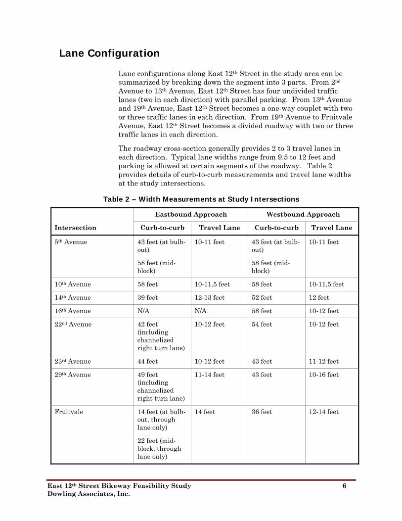
Lane configurations along East 12th Street in the study area can be summarized by breaking down the segment into 3 parts. From 2nd Avenue to 13th Avenue, East 12th Street has four undivided traffic lanes (two in each direction) with parallel parking. From 13th Avenue and 19th Avenue, East 12th Street becomes a one-way couplet with two or three traffic lanes in each direction. From 19th Avenue to Fruitvale Avenue, East 12th Street becomes a divided roadway with two or three traffic lanes in each direction.
The roadway cross-section generally provides 2 to 3 travel lanes in each direction. Typical lane widths range from 9.5 to 12 feet and parking is allowed at certain segments of the roadway. Table 2 provides details of curb-to-curb measurements and travel lane widths at the study intersections.
Table 2 – Width Measurements at Study Intersections
Eastbound Approach Westbound Approach
Intersection Curb-to-curb Travel Lane Curb-to-curb Travel Lane
5th Avenue 43 feet (at bulb-out)
10-11 feet 43 feet (at bulb-out)
10-11 feet
58 feet (mid-block)
58 feet (mid-block)
10th Avenue 58 feet 10-11.5 feet 58 feet 10-11.5 feet
14th Avenue 39 feet 12-13 feet 52 feet 12 feet
16th Avenue N/A N/A 58 feet 10-12 feet
22nd Avenue 42 feet (including channelized right turn lane)
10-12 feet 54 feet 10-12 feet
23rd Avenue 44 feet 10-12 feet 43 feet 11-12 feet
29th Avenue 49 feet (including channelized right turn lane)
11-14 feet 43 feet 10-16 feet
Fruitvale 14 feet (at bulb-out, through lane only)
14 feet 36 feet 12-14 feet
22 feet (mid-block, through lane only)
East 12th Street Bikeway Feasibility Study 6 Dowling Associates, Inc.
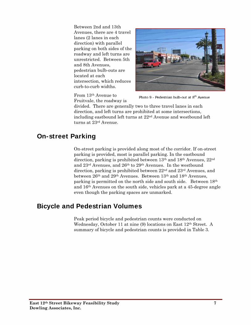
Between 2nd and 13th Avenues, there are 4 travel lanes (2 lanes in each direction) with parallel parking on both sides of the roadway and left turns are unrestricted. Between 5th and 8th Avenues, pedestrian bulb-outs are located at each intersection, which reduces curb-to-curb widths.
From 13th Avenue to Fruitvale, the roadway is divided. There are generally two to three travel lanes in each direction, and left turns are prohibited at some intersections, including eastbound left turns at 22nd Avenue and westbound left turns at 23rd Avenue.
Photo 9 - Pedestrian bulb-out at 8th Avenue
On-street Parking
On-street parking is provided along most of the corridor. If on-street parking is provided, most is parallel parking. In the eastbound direction, parking is prohibited between 13th and 18th Avenues, 22nd and 23rd Avenues, and 26th to 29th Avenues. In the westbound direction, parking is prohibited between 22nd and 23rd Avenues, and between 26th and 29th Avenues. Between 13th and 18th Avenues, parking is permitted on the north side and south side. Between 18th and 16th Avenues on the south side, vehicles park at a 45-degree angle even though the parking spaces are unmarked.
Bicycle and Pedestrian Volumes
Peak period bicycle and pedestrian counts were conducted on Wednesday, October 11 at nine (9) locations on East 12th Street. A summary of bicycle and pedestrian counts is provided in Table 3.
East 12th Street Bikeway Feasibility Study 7 Dowling Associates, Inc.

Table 3 – Bicycle and Pedestrian Counts at East 12th Street Intersections
AM Peak Period PM Peak Period (7:00 to 9:00) (4:00 to 6:00)
Intersection Pedestrians Bicyclists Pedestrians Bicyclists
East 12th Street at 5th Avenue 127 16 83 11
East 12th Street at10th Avenue 16 9 18 5
East 12th Street at14th Avenue (north) 17 11 8 9
East 12th Street at14th Avenue (south) 4 5 3 1
East 12th Street at16th Avenue 31 10 36 49
22nd Avenue 12 8 17 10
23rd Avenue 15 13 23 13
29th Avenue 164 20 93 24
Fruitvale Avenue 195 49 279 18 Source: Data collected by Wiltec, October 2006.
In addition to counts at the intersections, bicycles mounted on bus racks, bicyclists riding on the wrong side of the roadway, and bicyclists riding on the sidewalk were counted separately at 5th Avenue, 29th Avenue, and Fruitvale Avenue. A summary of bicycles mounted on buses, bicyclists on sidewalk, and wrong-way riding bicyclists is provided in Table 4.
Table 4 – Additional Bicycle Counts
Bikes Mounted on Bus Racks
Bicyclist on Sidewalk
Wrong-way Riding
Intersection AM PM AM PM AM PM
5th Avenue 2 3 3 17 1 20
29th Avenue 14 15 1 9 5 10
Fruitvale Avenue 1 22 1 0 0 4 Source: Data collected by Wiltec, October 2006.
Collision Data
Collision data for East 12th Street from the Statewide Integrated Traffic Reporting System (SWITRS) was provided by the City for the period of April 1, 2002 to March 31, 2006.1 During this four-year period, a total of 242 collisions were reported along East 12th Street
1 Data provided was missing collisions from January 1, 2005 to March 31, 2005.
East 12th Street Bikeway Feasibility Study 8 Dowling Associates, Inc.

from 2nd Avenue to Fruitvale Avenue. Total reported collisions averaged about 60 collisions per year. Of these reported collisions, only one collision involved a bicycle (at Fruitvale Avenue) and 11 involved pedestrians. The primary collision factors most often cited were improper turning (46), auto right-of-way violation (42), traffic signals and signs (41, and unsafe speed (37). Most of the collisions (63%) occurred between the 9:00 am and 6:00 pm during daylight hours.
The ten intersections with the highest numbers of collisions are listed in Table 5. The location with the highest number of collisions is the intersection of East 12th Street and 22nd Avenue with 30 reported collisions. With 22nd Avenue providing access across I-880 and then over to Alameda, the intersection is designed to facilitate those movements to and from 22nd Avenue south of East 12th Street. The intersection of 14th Avenue was the second highest with 16 reported collisions.
Based on the available average daily traffic (ADT) volumes for East 12th Street, a collision rate per 1,000 ADT was calculated. When the exposure is considered, the collision rate at 22nd Avenue continues to be the highest at 1.37 collisions per 1000 ADT, but the intersection of East 12th Street and 2nd Avenue is a close second with 1.33 collisions per 1000 ADT.
Table 5 – Highest Number of Reported Collisions
Intersection of East 12th Street
Reported Collisions
Average Daily Traffic
Collision Rate (per 1,000 ADT)
22nd Avenue 30 21,920 1.37
14th Avenue 20 22,000 0.91
2nd Avenue 16 12,000 1.33
29th Avenue 14 16,500 0.85
23rd Avenue 13 16,500 0.79
5th Avenue 11 12,300 0.89
8th Avenue 10 12,300 0.81
7th Avenue 8 12,300 0.65
25th Avenue 8 16,500 0.48
4th Avenue 7 12,000 0.58 Source: SWITRS 4/1/2002 to 3/31/2006 (missing data from January 1, 2005 to March 31, 2005).
East 12th Street Bikeway Feasibility Study 9 Dowling Associates, Inc.
Intersection Operations
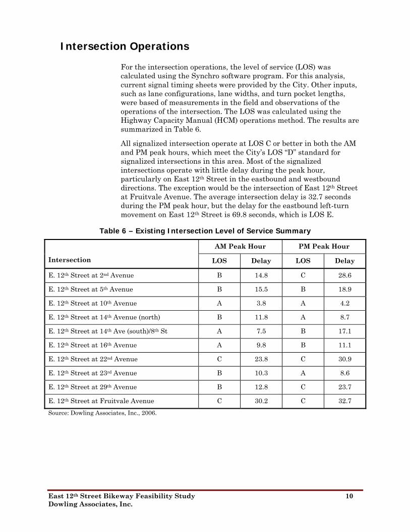
For the intersection operations, the level of service (LOS) was calculated using the Synchro software program. For this analysis, current signal timing sheets were provided by the City. Other inputs, such as lane configurations, lane widths, and turn pocket lengths, were based of measurements in the field and observations of the operations of the intersection. The LOS was calculated using the Highway Capacity Manual (HCM) operations method. The results are summarized in Table 6.
All signalized intersection operate at LOS C or better in both the AM and PM peak hours, which meet the City’s LOS “D” standard for signalized intersections in this area. Most of the signalized intersections operate with little delay during the peak hour, particularly on East 12th Street in the eastbound and westbound directions. The exception would be the intersection of East 12th Street at Fruitvale Avenue. The average intersection delay is 32.7 seconds during the PM peak hour, but the delay for the eastbound left-turn movement on East 12th Street is 69.8 seconds, which is LOS E.
Table 6 – Existing Intersection Level of Service Summary
AM Peak Hour PM Peak Hour
Intersection LOS Delay LOS Delay
E. 12th Street at 2nd Avenue B 14.8 C 28.6
E. 12th Street at 5th Avenue B 15.5 B 18.9
E. 12th Street at 10th Avenue A 3.8 A 4.2
E. 12th Street at 14th Avenue (north) B 11.8 A 8.7
E. 12th Street at 14th Ave (south)/8th St A 7.5 B 17.1
E. 12th Street at 16th Avenue A 9.8 B 11.1
E. 12th Street at 22nd Avenue C 23.8 C 30.9
E. 12th Street at 23rd Avenue B 10.3 A 8.6
E. 12th Street at 29th Avenue B 12.8 C 23.7
E. 12th Street at Fruitvale Avenue C 30.2 C 32.7 Source: Dowling Associates, Inc., 2006.
East 12th Street Bikeway Feasibility Study 10 Dowling Associates, Inc.

Proposed Bike Lanes
The proposed project is the installation of Class II bike lanes on both sides of East 12th Street roadway between 2nd Avenue and Fruitvale Avenue. To accommodate bike lanes in each direction, curb-to-curb cross-sections were compared to the following minimum and preferred cross-sections for bike lanes to determine if vehicle travel lanes will need to be removed to accommodate the bike lane:
▪ Preferred widths: 11-foot travel lanes, 8-foot parallel parking lanes, 18.5-foot 45-degree angle parking lanes, and 6-foot bike lane in each travel direction.
▪ Minimum widths: 11-foot outside travel lanes, 10-foot inside travel lanes, 7-foot parallel parking lanes, 18.5-foot 45-degree angle parking lanes, and 5-foot bike lane in each travel direction.
Proposed Project
Between 2nd Avenue and 13th Avenue, the roadway is currently four lanes (two lanes westbound and two lanes eastbound) with parallel parking on both sides. The bike lanes would reduce this roadway to three travel lanes (one westbound lane and one eastbound lane with a median two-way left turn lane) and maintain the parallel parking on both sides. This configuration would be similar to the T3 Cross Section described in the Bicycle Master Plan Update.
Between 13th Avenue and 19th Avenue, the one-way couplet would be wide enough to provide two travel lanes with parallel parking on both sides, where parking currently exists on the eastbound roadway. A minimum of 40 feet would be required, as identified for W2 Cross Section described in the Bicycle Master Plan Update.
From 19th Avenue to Fruitvale, where the roadway is divided by the wide median containing the BART overhead structure, the bike lane would require a minimum of 33 feet in each direction to provide two travel lanes – one 10’ and one 11’ adjacent to the bike lane - with a minimum 7’ parking lane.
East 12th Street Bikeway Feasibility Study 11 Dowling Associates, Inc.

Intersection Operations
With the addition of bike lanes on East 12th Street, the intersection analysis was conducted assuming that one travel lane would be removed to accommodate the bike lane, unless sufficient curb-to-curb was available to maintain existing intersection geometries with the bike lane. The effects on the traffic operations at these key intersections along the corridor are summarized in Table 7.
Table 7 – Existing with Project Intersection Level of Service Summary
Existing With Bike Lanes Time
Period Intersection LOS Delay LOS Delay
AM B 14.8 B 15.9 E. 12th Street at 2nd Avenue
PM C 28.6 C 33.3
AM B 15.5 C 20.5 E. 12th Street at 5th Avenue
PM B 18.9 B 24.2
AM A 3.8 A 8.6 E. 12th Street at 10th Avenue
PM A 4.2 A 7.5
AM B 11.8 B 11.3 E. 12th Street at 14th Avenue (north)
PM A 8.7 A 8.4
AM A 7.5 A 9.0 E. 12th Street at 14th Ave (south) and 8th St
PM B 17.1 C 26.5
AM A 9.8 B 11.8 E. 12th Street at 16th Avenue
PM B 11.1 B 11.7
AM C 23.8 C 24.1 E. 12th Street at 22nd Avenue
PM C 30.9 E 59.6
AM B 10.3 B 10.5 E. 12th Street at 23rd Avenue
PM A 8.6 A 9.0
AM B 12.8 B 13.0 E. 12th Street at 29th Avenue
PM C 23.7 C 25.3
AM C 30.2 C 30.4 E. 12th Street at Fruitvale Avenue
PM C 32.7 C 34.2
Source: Dowling Associates, Inc., 2008.
East 12th Street Bikeway Feasibility Study 12 Dowling Associates, Inc.

With the bike lanes on East 12th Street, most of the signalized intersections would continue to operate at LOS D or better, which meets the City standard, except as noted below. A summary of Existing LOS results with recommendations are shown in Error! Reference source not found..
Table 8 – Existing Intersection Level of Service with Recommendations
Existing With Bike Lanes
With Recommendation Time
Period Intersection LOS Delay LOS Delay LOS Delay
AM B 14.8 B 15.9 B 17.9 AE. 12th Street at 2nd Avenue PM C 28.6 C 33.3 D 42.9
AM B 15.5 C 20.5 B 14.5 E. 12th Street at 5th Avenue PM B 18.9 B 24.2 B 18.6
AM A 3.8 A 8.6 A 5.9 E. 12th Street at 10th Avenue PM A 4.2 A 7.5 A 7.2
AM B 11.8 B 11.3 B 11 E. 12th Street at 14th Avenue (north) PM A 8.7 A 8.4 A 8.4
AM A 7.5 A 9 B 10.7 E. 12th Street at 14th Ave (south) and 8th St PM B 17.1 C 26.5 C 20.9
AM C 30.9 A 6.1 E. 12th Street at E. 8th St merge PM B 14.9 F 109.5
AM A 9.8 B 11.8 B 11.8 E. 12th Street at 16th Avenue PM B 11.1 B 11.7 B 11.7
AM C 23.8 C 24.1 C 23.8 E. 12th Street at 22nd Avenue PM C 30.9 C 30 E 59.6
AM B 10.3 B 10.5 B 10.5 E. 12th Street at 23rd Avenue PM A 8.6 A 9 A 9
AM B 12.8 B 13 B 13 E. 12th Street at 29th Avenue PM C 23.7 C 25.3 C 25.3
AM C 30.2 C 30.4 C 30.4 E. 12th Street at Fruitvale Avenue PM C 32.7 C 34.2 C 34.2
Source: Dowling Associates, Inc., 2008.
East 12th Street Bikeway Feasibility Study 13 Dowling Associates, Inc.
East 12th Street at 22nd Avenue The intersection of East 12th Street at 22nd Avenue would operate below the City standard at LOS E during the PM peak hour. With the bike lane, the eastbound approach, which is the critical movement at 22nd Avenue, would experience excessive delays due to the loss of one eastbound through lane.
Recommendation:
Because of the limited right-of-way and intensive land uses of this section of the corridor, roadway widening is not possible to accommodate bicycle lanes while maintaining existing travel and parking lanes. Excessive delays can be reduced by removing the bike lane and replacing it with “Sharrows” (pavement markings indicating a travel lane for shared use by bicyclists and motorists) in the eastbound direction from 21st Avenue to 22nd Avenue in order to maintain existing travel lanes. Maintaining travel lanes at preferred widths would return the intersection operations to LOS C in the PM peak-hour.
East 12th Street at 14th Avenue (south) and East 8th Street In addition, the LOS for the intersection of East 12th Street at 14th Avenue (south) and 8th Street assumes the existing channelized free-right turn from 8th Street would remain. However, to address potential conflicts with bicyclists at the merge on East 12th Street, the additional analysis considered options to control the high speed free right-turn from 8th Street. If the free right-turns are controlled at the existing signal at this location, LOS F conditions would result due to the delays to the northbound right turns combined with the delays for the southbound left turn movement.
Recommendation:
At the East 8th Street merge onto East 12th Street, a bicycle refuge and actuated traffic signal are recommended at the existing island to control eastbound vehicle movement that currently enters freely onto East 12th Street from East 8th Street. (See Appendices for discussion of Caltrans signal warrants.) Because of the limited widths, challenging geometrics, and high vehicle volumes and speeds, the bike lane will be suspended from the bicycle refuge island until the three-to-two travel lane merge, which is a total distance of 545 feet. As such, the signal phase for bicyclists will provide 30 seconds of all-red time in order to provide enough time for bicyclists to get into the resumed bike lane before vehicles from East 8th Street will be given a green phase.
Assuming twenty-five bicycle calls per hour, the new traffic signal to control the free right-turns from East 8th Street to East 12th Street would cause excessive delay to eastbound through vehicles entering East 12th Street from East 8th Street during the PM peak hour. The
East 12th Street Bikeway Feasibility Study 14 Dowling Associates, Inc.

delay is primarily due to the 30 seconds of all red signal time bicyclists would need to get from the refuge island to where the bike lane restarts 545 feet east. Additionally, there is a risk that excessive delays, all red time, and long cycle lengths would lead to non-compliance problems by both bicyclists and vehicles. The existing travel lanes can be maintained with bike lanes from 14th Avenue to the 16th Avenue ramp. In order to maintain existing travel lanes and provide bike lanes from the 16th Avenue ramp to the three-lane to two-lane merge, the roadway will need to be widened for a length of 245 feet by a width of 4 feet. Making these changes to the roadway, the traffic signal cycle length can be shortened due to the bike lane being located in close proximity to the bicycle refuge island and would result in LOS B in the PM peak-hour.
East 12th Street Bikeway Feasibility Study 15 Dowling Associates, Inc.
Cumulative Conditions
To assess the cumulative conditions with and without the proposed bike lanes, forecasts of future turning movement volumes were developed based on the latest Oakland Cumulative Growth Scenario and available forecasts from previous studies, including the 12th Street Reconstruction project, the Oak-to-Ninth EIR, and other on-going studies for developments along the corridor, which include the preliminary analyses for the Fruitvale Transit Village Phase II and the Fruitvale Gateway developments.
For locations where cumulative forecasts were not available from previous studies, the model growth between 2005 and 2025 was used to estimate the future link volumes, which were then proportioned based on the existing turning movement volumes and compared to the forecasts for adjacent intersections and adjusted for consistency. However, it should be noted that these cumulative forecasts assumed the existing lane configurations on East 12th Street.
With the lane reductions as part of the proposed bike lanes, the current forecasts may overstate future growth along East 12th Street. These forecasts do not account for modal, temporal or spatial changes due to the bike lanes. With an improved bicycle facility, some trips may shift from auto to bicycle. Some traffic may shift to earlier or later time periods to avoid congestion or from East 12th Street to parallel routes, such as 8th Street, International Boulevard, 15th Street, and Foothill Boulevard due to the reduce capacity on East 12th Street with the implementation of the bike lanes. Without further detailed analysis, the vehicular traffic volume assumptions under cumulative conditions are considered as a worst-case condition.
The future intersection LOS analysis assumed existing signal timings and maintenance of the existing left-turn pockets along East 12th Street. As summarized in Table 9, several intersections would operate below the City standard. The following five intersections would operate at LOS E or F without the bike lanes:
• East 12th Street at 5th Avenue
• East 12th Street at 14th Avenue (South) - East 8th Street
• East 12th Street at 22nd Avenue
• East 12th Street at 29th Avenue
• East 12th Street at Fruitvale Avenue
East 12th Street Bikeway Feasibility Study 16 Dowling Associates, Inc.

Table 9 – Future (2025) Intersection Level of Service Summary
Future With Bike Lanes Time
Period Intersection LOS Delay LOS Delay
AM D 46.0 D 46.0 E. 12th Street at 2nd Avenue
PM C 34.9 C 28.2
AM C 29.3 F 104.3 E. 12th Street at 5th Avenue
PM E 69.2 F 202.5
AM A 6.2 F 102.4 E. 12th Street at 10th Avenue
PM A 4.1 E 77.4
AM B 17.6 B 19.7 E. 12th Street at 14th Avenue (north)
PM B 12.4 B 13.8
AM C 23.0 C 27.9 E. 12th Street at 14th Ave (south) and 8th St
PM E 76.5 F 103.8
AM B 12.5 C 22.6 E. 12th Street at 16th Avenue
PM C 27.1 C 29.0
AM C 27.7 C 28.9 E. 12th Street at 22nd Avenue
PM E 66.1 F 121.0
AM B 15.3 B 15.9 E. 12th Street at 23rd Avenue
PM B 13.9 B 14.9
AM B 18.0 B 19.1 E. 12th Street at 29th Avenue
PM F 131.2 F 136.5
AM D 39.3 D 39.6 E. 12th Street at Fruitvale Avenue
PM E 67.2 E 76.4
Source: Dowling Associates, Inc., 2006.
With the addition of bike lanes on East 12th Street, operations at study intersections would deteriorate significantly at 5th Avenue during the AM peak hour and 10th Avenue during the AM and PM peak hours. The bike lane would further degrade substandard conditions at 5th Avenue during the AM peak hour and 14th Avenue (South)-East 8th Street, 22nd Avenue, 29th Avenue, and Fruitvale Avenue during the PM peak hour. A summary of 2025 LOS results with recommendations is shown in Table 10.
East 12th Street Bikeway Feasibility Study 17 Dowling Associates, Inc.
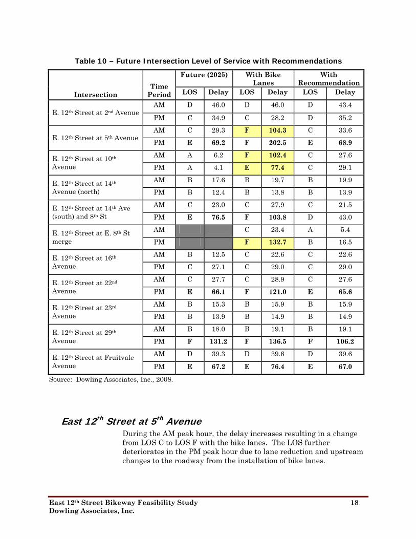
Table 10 – Future Intersection Level of Service with Recommendations
Future (2025) With Bike Lanes
With Recommendation Time
Period LOS Delay LOS Delay LOS Delay Intersection AM D 46.0 D 46.0 D 43.4
E. 12th Street at 2nd Avenue PM C 34.9 C 28.2 D 35.2
AM C 29.3 F 104.3 C 33.6 E. 12th Street at 5th Avenue PM E 69.2 F 202.5 E 68.9
AM A 6.2 F 102.4 C 27.6 E. 12th Street at 10th Avenue PM A 4.1 E 77.4 C 29.1
AM B 17.6 B 19.7 B 19.9 E. 12th Street at 14th Avenue (north) PM B 12.4 B 13.8 B 13.9
AM C 23.0 C 27.9 C 21.5 E. 12th Street at 14th Ave (south) and 8th St PM E 76.5 F 103.8 D 43.0
AM C 23.4 A 5.4 E. 12th Street at E. 8th St merge PM B 16.5 F 132.7
AM B 12.5 C 22.6 C 22.6 E. 12th Street at 16th Avenue PM C 27.1 C 29.0 C 29.0
AM C 27.7 C 28.9 C 27.6 E. 12th Street at 22nd Avenue PM E 66.1 F 121.0 E 65.6
AM B 15.3 B 15.9 B 15.9 E. 12th Street at 23rd Avenue PM B 13.9 B 14.9 B 14.9
AM B 18.0 B 19.1 B 19.1 E. 12th Street at 29th Avenue PM F 131.2 F 136.5 F 106.2
AM D 39.3 D 39.6 D 39.6 E. 12th Street at Fruitvale Avenue PM E 67.2 E 76.4 E 67.0
Source: Dowling Associates, Inc., 2008.
East 12th Street at 5th Avenue During the AM peak hour, the delay increases resulting in a change from LOS C to LOS F with the bike lanes. The LOS further deteriorates in the PM peak hour due to lane reduction and upstream changes to the roadway from the installation of bike lanes.
East 12th Street Bikeway Feasibility Study 18 Dowling Associates, Inc.

Recommendation:
Maintain the existing bulb-outs and two travel lanes in each direction at 5th Avenue. “Sharrows” would be installed on the outside travel lanes. With this recommendation, the intersection delay would be similar to that experienced under No Project conditions. The difference in delay can be attributed to the recommended changes to the signal at 10th Avenue.
East 12th Street at 10th Avenue The intersection of East 12th Street and 10th Avenue drops to LOS F during the AM peak hour and LOS E during the PM peak hour with the bike lane due to the reduced capacity on East 12th Street.
Recommendation:
Bike lanes would need to be removed in order to provide for greater through-lane capacity for eastbound and westbound vehicles. However, because of low northbound and southbound vehicle volumes and low pedestrian volumes, bike lanes could be maintained at this intersection if a semi-actuated traffic signal were installed to prioritize eastbound and westbound traffic movements. Installing an actuated, uncoordinated signal at this intersection, with minimum pedestrian crossing times, would result in LOS C with 27.6 seconds of delay during the AM peak hour and 29.1 seconds of delay during the PM peak hour.
East 12th Street at 14th Avenue (south) – East 8th Street At 14th Avenue (South) – East 8th Street in the PM peak-hour, deterioration of LOS results primarily from separating the free right-turns from East 8th Street to a new signal where East 8th Street merges with East 12th Street. With this shift, the intersection average delay increases. The excessive delays experienced by the northbound through movements are no longer averaged with the high volumes of free northbound right turns, which experience minimal delays.
Recommendation:
Curb-to-curb widths of 44 feet along this roadway allow for the restriping eastbound East 8th Street from 12th Avenue to 14th Avenue to increase vehicle travel lanes from the existing three lanes to four lanes, which will result in three lanes feeding onto northbound 14th Avenue and one lane feeding onto eastbound East 12th Street. Doing so would reduce the delays at 14th Avenue (south) and result in LOS D in the PM peak-hour.
Assuming twenty-five bicycle calls per hour, the new traffic signal at the East 8th Street – East 12th Street merge does not operate at acceptable LOS in the PM peak hour. The same recommendation discussed under Existing conditions would reduce the delays. There is
East 12th Street Bikeway Feasibility Study 19 Dowling Associates, Inc.

enough width to maintain existing travel lanes with bike lanes from 14th Avenue to the 16th Avenue ramp. In order to maintain existing travel lanes and provide bike lanes from the 16th Avenue ramp to the three-lane to two-lane merge, the roadway will need to be widened for a length of 245 feet by a width of 4 feet. Making these changes to the roadway, the traffic signal cycle length can be shortened due to the bike lane being located in close proximity to the bicycle refuge island and would result in LOS B in the PM peak-hour.
East 12th Street at 22nd Avenue At 22nd Avenue, the reduction in travel lanes with bike lanes in the eastbound direction would result in excessive delays during the PM peak hour. Specifically, the eastbound through traffic and the westbound left turns would operate at LOS F with the bike lanes. Modifications to the traffic signal phasing and cycle length could not mitigate this intersection to an acceptable level of service due to the heavy westbound left turn volumes. The other option explored of parking removal to accommodate the bike lane would create design and safety issues, as bicyclists would be shifted to the far right for a few hundred feet only to be forced to transition to the left of the dedicated right-turn lane as they approach the intersection.
Recommendation:
At 22nd Avenue, the recommendation is to remove the bike lane and replace it with Sharrows in the eastbound direction from 21st Avenue to 22nd Avenue in order to maintain existing travel lanes. Maintaining travel lanes at preferred widths would return the intersection operations to LOS E in the PM peak-hour.
East 12th Street at 29th Avenue The intersection delay increases slightly at 29th Avenue in the PM peak hour due to lane width reductions from 12-foot to 11-foot lanes on the eastbound approach with the bike lanes.
Recommendation:
Optimizing signal splits at 29th Avenue decreases delay to better than it was under No Project conditions, although it still operates at LOS F in the PM peak-hour. The existing signal cycle length would be maintained.
East 12th Street at Fruitvale Avenue The intersection delay increases slightly at Fruitvale Avenue in the PM peak hour due to lane width reduction from a 14-foot to 11-foot lane for the eastbound through traffic with the bike lanes.
East 12th Street Bikeway Feasibility Study 20 Dowling Associates, Inc.

Recommendation:
Optimizing signal splits at Fruitvale Avenue returns the project to a similar delay experienced under No Project conditions, although it still operates at LOS E in the PM peak-hour, primarily due to northbound left, eastbound through and eastbound left operational issues. The existing signal cycle length would be maintained.
Summary of Recommendations
Based on the analysis of intersection operations under Existing and 2025 conditions, the following general lane configurations are recommended for the proposed bikeways on East 12th Street with specific modifications at intersections to improve safety and operations with the bike lane as well as address substandard intersection operations. Existing parking lanes are maintained unless otherwise specified.
2nd Avenue to 5th Avenue Maintain existing travel lanes using minimum widths. Install
Sharrows in both directions on the outer travel lanes.
East 12th Street at 5th Avenue
• Maintain existing lane configurations with minimum lane widths on East 12th Street.
5th Avenue to 13th Avenue East of 5th Avenue, transition from 2 travel lanes in each direction
to 1 travel lane in each direction and one two-way left turn median using minimum widths to provide for installation of the bike lane. Continue this configuration to 13th Avenue.
East 12th Street at 10th Avenue
• Reduce existing travel lanes from two to one in each direction with dedicated left-turn pockets to install bike lanes on East 12th Street.
• Replace existing pre-timed traffic signal with an actuated, uncoordinated signal with minimum crossing times for pedestrians and pedestrian countdown signals.
East 12th Street Bikeway Feasibility Study 21 Dowling Associates, Inc.
13th Avenue to 21st Avenue From 13th Avenue to 16th Avenue ramp eastbound, transition at
13th Avenue and maintain three lanes eastbound using preferred widths with bike lane and existing “no parking” lane.
East 12th Street at 14th Avenue (south) and 8th Street
• Use preferred widths to install bike lane and maintain existing lane configurations on East 12th Street.
• Increase the number of northbound through lanes from East 8th Street onto 14th Avenue from 2 to 3 lanes from re-striping East 8th Street between 12th and 14th Avenues using preferred lane widths. On East 8th Street, this would result in three lanes for vehicles heading through to 14th Avenue and one for vehicles merging onto East 12th Street.
• At the East 8th Street – East 12th Street merge, there are currently raised bars located for 300 feet east of the merge to prevent vehicles from East 8th Street from weaving into traffic coming from East 12th Street and onto the 16th Avenue ramp. However, these raised bars also trap bicyclists coming eastbound on East 12th Street between two lanes of fast-moving traffic. As a result, it is proposed to install an actuated uncoordinated bicycle signal and create a bicycle refuge at the existing island at the East 8th Street – East 12th Street merge eastbound.
From 16th Avenue ramp to 21th Avenue eastbound, widen roadway by 4 feet for a length of 245 feet and begin merge from three lanes to two lanes after the 16th Avenue ramp to accommodate bike lane using preferred widths. Bike lane after the merge can fit within the given roadway widths using preferred widths. A handful of parking spaces at the 19th Avenue intersection may need to be removed. However, there are no land uses in close proximity to these parking spaces.
From 21st Avenue to 16th Avenue westbound, reduce travel lanes from three to two lanes and install bike lane using preferred widths.
East 12th Street at 16th Avenue (westbound only)
• Reduce number of travel lanes from three to two and use preferred widths to install bike lanes on East 12th Street.
From 16th Avenue to 13th Avenue westbound, maintain existing travel lanes and parking configuration using minimum widths up to 14th Avenue. Preferred widths can be used for the transition from two to one lane approaching 13th Avenue. A handful of parking
East 12th Street Bikeway Feasibility Study 22 Dowling Associates, Inc.

spaces may need to be removed on the north side to accommodate the merge and bike lanes.
East 12th Street at 14th Avenue (north)
• Use minimum widths and maintain existing lane configurations to install bike lanes on East 12th Street.
21st Avenue to 29th Avenue From 21st Avenue to 22nd Avenue eastbound, maintain existing
travel lanes using preferred widths and install Sharrows on the outside lane, suspending the bike lane.
From 22nd Avenue to 29th Avenue eastbound, reduce travel lanes from three to two lanes using preferred widths and install bike lanes.
From 23rd Avenue to 21st Avenue westbound, maintain existing travel lanes and install bike lanes using minimum widths.
East 12th Street at 22nd Avenue
• In the eastbound direction, maintain existing travel lanes using preferred widths and suspend bike lane
• In the westbound direction, maintain existing travel lanes using minimum widths to install bike lane.
East 12th Street at 23rd Avenue
• In the eastbound direction, reduce number of travel lanes using preferred widths to install bike lane.
• In the westbound direction, maintain existing travel lanes using minimum widths to install bike lane.
From 29th Avenue to 23rdAvenue westbound, generally maintain existing travel lanes (with a reduction from 3 to 2 travel lanes west of 29th Avenue for the length needed to get the bike lane past the raised island for southbound right turning vehicles) and install bike lanes using preferred widths.
29th Avenue to Fruitvale Avenue From 29th Avenue to 30th Avenue eastbound, maintain existing
travel lanes and install bike lanes using preferred widths.
From 30th Avenue to the Fruitvale Avenue split eastbound, reduce travel lanes from three to two lanes and install bike lanes using
East 12th Street Bikeway Feasibility Study 23 Dowling Associates, Inc.
preferred widths. Bike lanes are to be continued to Fruitvale Avenue next to the eastbound through lane.
From Fruitvale Avenue to 29th Avenue westbound, maintain existing travel lanes and install bike lanes using preferred widths.
East 12th Street at 29th Avenue
• Maintain existing lane configurations using preferred widths to install bike lanes in both directions on East 12th Street.
East 12th Street at Fruitvale Avenue
• Maintain existing lane configurations in the eastbound through direction using preferred widths. End bike lane in the eastbound direction approaching the bulb-out or modify the bulb-out to allow a continuous bike lane.
• Begin westbound bike lanes west of Fruitvale Avenue.
East 12th Street Bikeway Feasibility Study 24 Dowling Associates, Inc.

Appendices
Caltrans Bicycle Signal Warrants A bicycle signal is proposed at the East 8th Street – East 12th Street merge in order to facilitate bicycle movements across the existing uncontrolled movement by vehicles onto East 12th Street from East 8th Street (essentially, these movements are a free right turn at the 14th Avenue intersection). Raised bars located for 300 feet east of the merge prevent vehicles from East 8th Street from weaving across East 12th Street onto the 16th Avenue ramp, but also trap bicyclists coming eastbound on East 12th Street between two lanes of fast-moving traffic. For this reason, a bicycle refuge and actuated bicycle signal is proposed at the East 8th Street – East 12th Street merge.
Bicycle signals are used to direct bicyclists to take specific actions and may be used to address an identified safety or operational problem involving bicyclists. In order to install a bicycle signal on a facility under the State of California’s jurisdiction, the bicycle signal must meet the following criteria according to the California Manual on Uniform Traffic Control Devices (MUTCD):
1. Bicycle signal must be used in combination with an existing traffic signal
2. Volumes: Bicycle intersection volumes must be greater than 50 and bicycle volumes times vehicle volumes at the intersection must be greater than 50,000 in the same peak-hour.
3. Collision: When 2 or more bicycle/vehicle collisions of types susceptible to correction by a bicycle signal have occurred over a 12-month period and the responsible public works official determines that a bicycle signal will reduce the number of collisions.
4. Geometric: (a) Where a separate bicycle/multi use path intersects a roadway. (b) At other locations to facilitate a bicycle movement that is not permitted for a motor vehicle. 2
For this Proposed Project, Criterion 1 is met as the vehicle movements are originating from the signalized intersection of 14th Avenue and the bicycle signal would be installed to control the existing free right movements. Criterion 2 is not met under existing conditions, primarily because conditions in the eastbound direction at this intersection discourage bicyclists (there are 5 bicyclists in the AM and
2 MUTCD 2003 California Supplement (September 26, 2006), Sections 4C.102(CA) and 4D.104(CA), http://www.dot.ca.gov/hq/traffops/signtech/mutcdsupp/pdf/camutcd/CAMUTCD-Part4.pdf
East 12th Street Bikeway Feasibility Study 25 Dowling Associates, Inc.
1 bicyclist in the PM peak-hours). However, it is assumed that 50 bicyclists per hour are reasonable in the peak-hours once bike lanes are installed and improvements are implemented at this intersection. If 50 bicyclists are anticipated, the bicycle volumes multiplied by vehicle volumes will be far greater than 50,000 under both peak-hours under Existing and 2025 conditions. Criterion 3 is not met, as there has been only one bicycle-involved collision reported over a five-year period and it wasn’t at this intersection. However, as stated before, the configuration at this intersection actively discourages bicyclists. Criterion 4 is met for condition (b).
In the interest of safety and promoting bicycle use along East 12th Street, it is assumed that the City of Oakland will consider installing a bicycle signal at the East 8th Street – East 12th Street merge.
East 12th Street Bikeway Feasibility Study 26 Dowling Associates, Inc.

Level of Service Calculations Intersection levels of service were calculated using the 2000 Highway Capacity Manual methodologies, which were implemented by Synchro© software, version 7, build 763. The detailed calculations for each intersection follow and are ordered:
• Existing AM Peak-Hour – No Project
• Existing PM Peak-Hour – No Project
• Existing AM Peak-Hour with Bike Lanes
• Existing PM Peak-Hour with Bike Lanes
• Cumulative 2025 AM Peak-Hour – No Project
• Cumulative 2025 PM Peak-Hour – No Project
• Cumulative 2025 AM Peak-Hour with Bike Lanes
• Cumulative 2025 PM Peak-Hour with Bike Lanes
• Existing AM Peak-Hour with Bike Lanes - Mitigated
• Existing PM Peak-Hour with Bike Lanes - Mitigated
• Cumulative 2025 AM Peak-Hour with Bike Lanes - Mitigated
• Cumulative 2025 PM Peak-Hour with Bike Lanes - Mitigated
East 12th Street Bikeway Feasibility Study 27 Dowling Associates, Inc.