final phase i environmental site … phase i environmental site assessment report for 2327-2379...
TRANSCRIPT

FINAL
PHASE I ENVIRONMENTAL SITE ASSESSMENT
REPORT FOR
2327-2379 SKYLAND TERRACE, SE
WASHINGTON, DC 20020
Prepared by:
888 17th
St NW #850
Washington, DC 20006
October 13, 2014

TABLE OF CONTENTS
EXECUTIVE SUMMARY ............................................................................................................ 1
1.0 INTRODUCTION AND SCOPE OF INVESTIGATION ................................................. 3
2.0 METHODOLOGY ............................................................................................................. 3
2.1. Site Visit and Area Reconnaissance ............................................................................................ 3 2.2. Historical Evaluation and Regulatory File .................................................................................. 3 2.3. Hydrogeological Evaluation ........................................................................................................ 4
3.0 RESULTS ........................................................................................................................... 5
3.1. Site Inspection ............................................................................................................................. 5 3.2. Area Reconnaissance ................................................................................................................... 6 3.3. Historic Evaluation and Regulatory File Review ........................................................................ 6
4.0 CONCLUSIONS............................................................................................................... 12
4.1. On-Site Conditions .................................................................................................................... 12 4.2. Off Site Conditions .................................................................................................................... 12
5.0 SIGNATURE PAGE ........................................................................................................ 13
LIST OF APPENDICES
Appendix A – Site Location Map
Appendix B – Site Photographs
Appendix C – Site Diagram
Appendix D – Regulatory Review Report
Appendix E – Sanborn Fire Insurance Maps
Appendix F – Historic Aerial Photographs
Appendix G – Topographic Maps
Appendix H – Telephone Directories

LIST OF ACRONYMS
AST aboveground storage tank
ASTM American Society for Testing Materials
CERCLIS Comprehensive Environmental Response, Compensation, and Liability
Information System
CESQG Conditionally exempt small quantity generators
CIU Currently In Use
CORRACTS Corrective Action Activity
DC HIST UST District of Columbia Historical Underground Storage Tanks
DC LUST District of Columbia leaking underground storage tank
DC RGA LUST District of Columbia Recovered Government Archive Leaking
Underground Storage Tank
DC UST District of Columbia Underground Storage Tank
DC District of Columbia
DCRA (District of Columbia) Department of Consumer and Regulatory Affairs
DDS Digital Data Series
DHCD (District of Columbia) Department of Housing and Community
Development
DOD Department of Defense
EDR MGP Environmental Data Resources Manufactured Gas Plant
EDR Environmental Data Resources
ESA Environmental Site Assessment
HIST Historical
HRHR High Risk Historical Records
HSWA Hazardous and Solid Waste Amendments
LUST Leaking Underground Storage Tank
NFA No Further Action
NPL National Priority List
PEER PEER Consultants, P.C.
POU Permanently Out of Use
RCRA CORRACTS Resource Conservation and Recovery – Corrective Action Activity
RCRA Resource Conservation and Recovery Act
RCRA-CESQGs Resource Conservation and Recovery Act – Conditionally Exempt Small

Quantity Generators
RCRA NonGen Resource Conservation and Recovery Act Non-Generators
REC Recognized Environmental Condition
RGA Recovered Government Archive
ROD Record of Decision
SCS Soil Conservation Service
SF Square Feet
SWLF Solid Waste Disposal Facilities
US ENG United States Engineering Control
USDA United States Department of Agriculture
USEPA United States Environmental Protection Agency
USGS United States Geologic Survey
USGS United States Geological Survey
UST underground storage tank
VEC Vapor Encroachment Condition
VES Vapor Encroachment Screening

ES-1
EXECUTIVE SUMMARY
PEER Consultants, P.C. (PEER), performed a Phase I Environmental Site Assessment (ESA) for
a site at 2327-2339 Skyland Terrace, SE, Washington, DC (the Site). The purpose of this
assessment was to identify recognized environmental conditions at the Site. These conditions
could indicate the presence or likely presence of hazardous substances or petroleum products in,
on, or at the Site. The assessment was performed in accordance with the requirements of the
American Society of Testing and Materials (ASTM) Standard Practice E1527-13.
The Site is vacant, partially covered with low-cut grass and partially covered with thick brush
and trees. It is currently owned by District of Columbia Department of Housing and Community
Development (DHCD). The Site consists of seven lots and with a total area of 19,932 square
feet, is centered at the coordinates of 38.860 North and 76.973 West and is approximately
166 feet above mean sea level. According to the District of Columbia Office of Tax and
Revenue, the lots which constitute the site are identified as follows:
(1) 2327 Skyland Terrace (2) 2329 Skyland Terrace
Owner District of Columbia District of Columbia
Square Suffix Lot # 5740-0341 5740-0342
Land Area 3,873 SF 2,785 SF
Land Use Code 191 – Vacant 191 – Vacant
(3) 2331 Skyland Terrace (4) 2333 Skyland Terrace
Owner District of Columbia District of Columbia
Square Suffix Lot # 5740-0343 5740-0344
Land Area 2,716 SF 2,481 SF
Land Use Code 191 – Vacant 191 – Vacant
(5) 2335 Skyland Terrace (6) 2337 Skyland Terrace
Owner District of Columbia District of Columbia
Square Suffix Lot # 5740-0345 5740-0346
Land Area 2,423 SF 2,423 SF
Land Use Code 191 – Vacant 191 – Vacant
(7) 2339 Skyland Terrace
Owner District of Columbia
Square Suffix Lot # 5740-0347
Land Area 3,231 SF
Land Use Code 191 – Vacant
A site visit was performed by PEER staff on September 17, 2014. Direct access to the Site was
available. Observations of the current site conditions were noted and documented with
photographs. A historical records/database review was provided by Environmental Data
Resources Inc. (EDR). The database review lists sites with environmental concerns found within
a specified radius of the subject parcel. This assessment revealed the following conditions:
On-Site Conditions
Based on historical data, the Site has been undeveloped land. Until 1983, the Site was within a
forested area. In 1983, it appears that clearing of the site and the immediate vicinity began for
construction of Skyland Terrace and the homes to the east and to the west of the site. By 1998,
construction of the homes around the loop of Skyland Terrace, 23rd
Street, Skyland Place and
24th
Street were complete. Site observations found the Site to be covered with low-cut grass on
portion closest to Skyland Terrace and thick brush and trees toward the northerly property line.

ES-2
The site slopes towards northeast from the point where vegetation starts. Illegal dumping was
observed in the wooded area. There were no visual signs of on-site above ground storage tanks
(ASTs) or underground storage tanks (USTs), or use of any hazardous materials or waste. The
Site was not listed on any of the environmental databases searched.
Off Site Conditions
A review of the environmental databases for surrounding sites found no RECs within a 0.5 to 1.0
mile radius of the Site. A review of the environmental databases for surrounding sites located
within 0.5 miles of the subject property found the following:
One (1) Resource Conservation and Recovery Act-conditionally exempt small
quantity generators (RCRA-CESQG);
Fifteen (15) District of Columbia (DC) leaking underground storage tank
(DC LUST) sites;
Two (2) DC underground storage tank (DC UST) sites;
Fourteen (14) US Brownfield sites;
Four (4) District of Columbia Historical Underground Storage Tanks (DC HIST
UST) sites;
One (1) U.S. Historic Cleaners sites; and
Eight (8) Vapor Encroachment sites.
However, due to their status or location with respect to the Site (down gradient topographically
and/or hydrologically), they have been determined to be de mininis conditions for the subject
Site. Based on this information, the assessment revealed no evidence of potential recognized
environmental conditions in connection with the subject Site.

2327-2339 Skyland Ter., SE, Washington, DC
Phase I Environmental Site Assessment Page 3
1.0 INTRODUCTION AND SCOPE OF INVESTIGATION
This report describes the result of a Phase I Environmental Site Assessment (ESA) that was
conducted by PEER Consultants, P.C. (PEER) on a site at 2327-2337 Skyland Terrace, SE,
Washington, DC (Site). Figure 1 (Appendix A) shows the location of the Site.
The purpose of this ESA was to determine:
The presence or likely presence of any hazardous substances or petroleum
products in, on or at a property: (1) due to any release to the environment; (2)
under conditions indicative of a release to the environment; or (3) under
conditions that pose a material threat of a future release to the environment.1
2.0 METHODOLOGY
The ESA was performed in accordance with procedures specified in the American Society of
Testing and Materials (ASTM) Standards on Environmental Site Assessments for Commercial
Real Estate (ASTM E1527). The procedures specified were supplemented by the requirements
of the contract document wherever required. The methodology used for the analysis included
site visits, visual inspections, and review of records from U.S. Environmental Protection Agency
(USEPA) and the District of Columbia Department of Consumer and Regulatory Affairs
(DCRA) databases. Detailed descriptions of the methodologies are presented in the following
paragraphs.
2.1. Site Visit and Area Reconnaissance
A site visit was conducted to determine visual evidence of previous and existing contamination
at the site. The area reconnaissance was conducted to determine the potential for contamination
from off-site sources based on observations of activities in the immediate vicinity of the subject
site. The site visit did not include a comprehensive investigation for hazardous building
materials such as asbestos, lead-based paint, and mercury. Direct access to the site was
available.
2.2. Historical Evaluation and Regulatory File
Historical data on the Site was searched to determine previous uses of the Site. Data obtained
from aerial photographs, Sanborn maps, Haines directories, Polk city directories, and
U.S. Geological Survey (USGS) topographic maps was searched for evidence of previous
contamination at the site based on the historic uses and activities at the properties and the
physical setting of the sites. Enforcement, regulatory and other relevant data from several
sources were searched to check for evidence of contamination, enforcement and cleanup
activities at the properties.
The data was searched based on radius limits prescribed in ASTM E1527 to identify facilities
that reported contamination; that are undergoing remediation measures; and that exhibit potential
for contamination. For example, the National Priorities List (NPL) data that contains sites for
priority cleanup was searched for sites within a mile of the properties being evaluated. The
1 Source: ASTM E1527.

2327-2339 Skyland Ter., SE, Washington, DC
Phase I Environmental Site Assessment Page 4
following is a partial list of the databases searched, the dates of the data updates, the search
radius and a brief description of the database contents. Several additional databases that were
not required by ASTM E1527 were also searched.
The minimum radial search areas required review distances are as follows:
To One (1) Mile:
National Priorities List (NPL)
Resource Conservation and Recovery Act – Corrective Action Activity (RCRA
CORRACTS) facilities
Department of Defense (DOD)
Record of Decision List (ROD)
Environmental Data Resources, Inc. Propriety Manufactured Gas Plant
(EDR MGP) Database
To One-Half (0.5) of a Mile:
Comprehensive Environmental Response, Compensation, and Liability
Information System (CERCLIS)
U.S. Engineering Control List ENG (US ENG)
District of Columbia Leaking Underground Storage tank (DC LUST)
District of Columbia Brownfield sites (DC Brownfields)
Solid Waste Disposal Facilities, Active and Inactive (SWLF)
District of Columbia Recovered Government Archive Leaking Underground
Storage Tank (DC RGA LUST)
To One-Quarter (0.25) of a Mile:
District of Columbia Underground Storage Tanks (DC USTs) list
District of Columbia Historical Underground Storage Tanks (DC HIST USTs) list
Resource Conservation and Recovery Act – Conditionally Exempt Small Quantity
Generators (RCRA-CESQGs)
Resource Conservation and Recovery Act Non-Generators – (RCRA NonGen) list
Environmental Data Resources, Inc. United States Historical Auto Station (EDR
U.S. Hist Auto Station) list
Environmental Data Resources, Inc. United States Historical Cleaners list (EDR
U.S. Hist Cleaners) list
Vapor Encroachment Conditions (VEC)
2.3. Hydrogeological Evaluation
The hydrogeological evaluation consisted of reviewing USGS topographic maps; data obtained
from the U.S. Soil Conservation Service (SCS); and groundwater, hydrologic, and
hydrogeological data. This data included federal, local and regional water agency records to
assess groundwater flow direction and location of nearby drinking water wells.
The Site’s elevation is 166 feet above mean sea level. The general topographic gradient is to the
general north (N) and the Site is not within a 100-year flood-plain. No jurisdictional wetlands
were identified at the subject Site or within a ½-mile radius of the subject Site. Direction of

2327-2339 Skyland Ter., SE, Washington, DC
Phase I Environmental Site Assessment Page 5
groundwater flow in the area of the Site is reported to be to the northwest (NW), discharging into
the Anacostia and Potomac rivers. General soil type for the site and the surrounding vicinity is
described as BELTSVILLE and the soil surface texture is silt loam, according to the U.S.
Department of Agriculture’s (USDA) SCS. Overall geology for the Site as defined by P.G.
Schruben, R.E. Arndt and W.J. Bawiec, Geology of the Conterminous U.S. at 1:2,500,000 Scale
– a digital representation of the 1974 P.B. King and H.M. Beikman Map, USGS Digital Data
Series DDS – 11 (1994) is as follow:
Era: Mesozoic Series: Lower Cretaceous
System: Cretaceous Code: IK
The Local and Regional Water Agency records indicate that there are no wells registered at the
Site and the nearest wells are more than 0.25 miles to the east, north northeast and west
southwest.
3.0 RESULTS
3.1. Site Inspection
A site visit was performed by PEER on September 17, 2014. PEER staff visually observed and
documented on site activities. In addition, observations of adjacent properties were made to
identify high-risk neighbors and potential contamination migration concerns were made. The
site visit included the following observation techniques:
A walk around the periphery of the subject property
A view of the subject property from all accessible public thoroughfares
A walk through of the property
Site observations were documented with photographs, which are included in Appendix B. Site
features were documented on a diagram which is included in Appendix C.
3.1.1. Site Observations
The Site was found to be vacant at the time of the site visit. It is located in a residential area of
the Anacostia neighborhood in the District of Columbia (DC) and consists of seven lots with a
total area of 19,932 square feet. According to the District of Columbia Office of Tax and
Revenue, the lots which constitute the site are identified as follows:
(8) 2327 Skyland Terrace (9) 2329 Skyland Terrace
Owner District of Columbia District of Columbia
Square Suffix Lot # 5740-0341 5740-0342
Land Area 3,873 SF 2,785 SF
Land Use Code 191 – Vacant 191 – Vacant
(10) 2331 Skyland Terrace (11) 2333 Skyland Terrace
Owner District of Columbia District of Columbia
Square Suffix Lot # 5740-0343 5740-0344
Land Area 2,716 SF 2,481 SF
Land Use Code 191 – Vacant 191 – Vacant

2327-2339 Skyland Ter., SE, Washington, DC
Phase I Environmental Site Assessment Page 6
(12) 2335 Skyland Terrace (13) 2337 Skyland Terrace
Owner District of Columbia District of Columbia
Square Suffix Lot # 5740-0345 5740-0346
Land Area 2,423 SF 2,423 SF
Land Use Code 191 – Vacant 191 – Vacant
(14) 2339 Skyland Terrace
Owner District of Columbia
Square Suffix Lot # 5740-0347
Land Area 3,231 SF
Land Use Code 191 – Vacant
During the site visit, half of the lot was covered with mowed grass and other half was covered in
thick vegetation. There were no visual signs of on-site above ground storage tanks (ASTs) or
underground storage tanks (USTs), use of hazardous materials or waste or other use which would
be of potential environmental concern.
3.2. Area Reconnaissance
Current land use in the vicinity of the Site is residential. Immediately adjacent to the site to the
east, west and south are single family residences. To the north is a forested area. Within ½ mile
south-southeast from the site is Washington Nursing Facility and to the north-northeast is the
Good Hope Clinic Children’s Hospital. No recognized environmental concerns were observed in
the vicinity of the Site.
3.3. Historic Evaluation and Regulatory File Review
A review of the regulatory status of the Site and properties in the vicinity of the Site was
conducted as it pertains to regulated activities involving the use of hazardous chemicals; the
generation of hazardous waste; the treatment, storage, or disposal of hazardous waste; or the
release of regulated substances. Following is a summary of the information. A copy of the
regulatory review report is included in Appendix D.
3.3.1. Property Ownership/Occupants
According to the District of Columbia Office of Tax and Revenue the subject property is
currently owned by the District of Columbia, Washington DC. A review of telephone directories
from 1922 to 2013 was conducted to determine potential uses and ownership of the Site. No
telephone listings were found for the Site. Telephone listings for adjoining properties were
residential listings.
3.3.2. Sanborn Fire Insurance Maps
Sanborn fire insurance maps covering the Site were found dating from 1989 through 1998. The
1989 through 1998 Sanborn Map indicates that the Site was vacant during that period. In the
vicinity of the Site, all of the Sanborn Maps indicate that the neighborhood has and remains
primarily a residential community. The townhomes to the east of the Site along Skyland Terrace
were constructed sometime between 1990 and 1992. The townhomes to the west of the Site
along 23rd
Street were constructed after 1995. Copies of the Sanborn maps can be found in
Appendix E.
2327-2339 Skyland Ter., SE, Washington, DC
Phase I Environmental Site Assessment Page 7
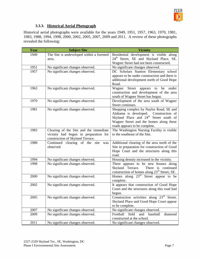
3.3.3. Historical Aerial Photograph
Historical aerial photographs were available for the years 1949, 1951, 1957, 1963, 1970, 1981,
1983, 1988, 1994, 1998, 2000, 2002, 2005, 2007, 2009 and 2011. A review of these photographs
revealed the following:
Year Subject Site Vicinity
1949 The Site is undeveloped within a forested
area.
Residential development is visible along
24th Street, SE and Skyland Place, SE.
Wagner Street had not been constructed.
1951 No significant changes observed. No significant changes observed.
1957 No significant changes observed. DC Scholars Stanton Elementary school
appears to be under construction and there is
additional development north of Good Hope
Road.
1963 No significant changes observed. Wagner Street appears to be under
construction and development of the area
south of Wagner Street has begun.
1970 No significant changes observed. Development of the area south of Wagner
Street continues.
1981 No significant changes observed. Shopping complex by Naylor Road, SE and
Alabama is developed. Construction of
Skyland Place and 24th Street south of
Wagner Street and the homes along these
roads appears to be complete.
1983 Clearing of the Site and the immediate
vicinity had begun in preparation for
construction of Skyland Terrace.
The Washington Nursing Facility is visible
to the southeast of the Site.
1988 Continued clearing of the site was
observed.
Additional clearing of the area north of the
Site in preparation for construction of Good
Hope Court and the structures along this
road.
1994 No significant changes observed. Housing density increased in the vicinity.
1998 No significant changes observed. There appears to be new houses along
Skyland Terrace. There is continued
construction of homes along 23rd
Street, SE.
2000 No significant changes observed. Homes along 23rd
Street appear to be
complete.
2002 No significant changes observed. It appears that construction of Good Hope
Court and the structures along this road had
begun.
2005 No significant changes observed. Construction activities along 23rd
Street,
Skyland Place and Good Hope Court appear
to be complete.
2007 No significant changes observed. No significant changes observed.
2009 No significant changes observed. Football field and baseball diamond
constructed at the school.
2011 No significant changes observed. No significant changes observed.

2327-2339 Skyland Ter., SE, Washington, DC
Phase I Environmental Site Assessment Page 8
Copies of the historical aerial photographs can be found in Appendix F.
3.3.4. Regulatory File Review
A review of the environmental databases for the Site found the following:
The Site was not listed in any of the regulatory databases.
No environmental liens or any specialized knowledge or experience that would provide
important information about previous ownerships or uses of the property that may be
material to identifying recognized environmental conditions.
A review of the environmental databases for surrounding sites found no NPL, RCRA
CORRACTS, DOD, ROD or MGP sites at a distance of 0.5 to 1.0 mile radius of the Site.
A review of the environmental databases for surrounding sites located within 0.5 miles of the
subject property found the following:
One (1) Resource Conservation and Recovery Act-conditionally exempt small
quantity generators (RCRA-CESQG);
Fifteen (15) District of Columbia (DC) leaking underground storage tank
(DC LUST) sites;
Two (2) DC underground storage tank (DC UST) sites;
Fourteen (14) US Brownfield sites;
Four (4) District of Columbia Historical Underground Storage Tanks (DC HIST
UST) sites;
One (1) U.S. Historic Cleaners sites; and
Eight (8) Vapor Encroachment sites.
Federal RCRA Generators List
RCRA-CESQG: RCRA information of USEPA’s comprehensive information system, providing
access to data supporting the RCRA of 1976 and the Hazardous and Solid Waste Amendments
(HSWA) of 1984. The database includes selective information on sites which generate,
transport, store, treat and/or dispose of hazardous waste as defined by the RCRA Act.
Conditionally exempt small quantity generators (CESQGs) generate less than 100 kg of
hazardous waste, or less than 1 kg of acutely hazardous waste per month.
A review of the RCRA-CESQG list, as provided by EDR, and dated 03/11/2014 has revealed
that there is one (1) RCRA-CESQG site within approximately 0.25 miles of the target property.
RCRA – CESQG LIST – EQUAL/LOWER ELEVATION
SITE NAME ADDRESS DIR/DIST
FROM SITE SUBSTANCE/PRODUCT STATUS
Children’s National
Medical CE
2501 Good Hope
Road, SE
E 1/8 – ¼
(0.235 mi.)
Various Substances No Violations
Found
DC Leaking Underground Storage Tank List (DC LUST)
The DCRA maintain a database of leaking underground storage tank incident reports.

2327-2339 Skyland Ter., SE, Washington, DC
Phase I Environmental Site Assessment Page 9
A review of the DC LUST list, as provided by EDR, and dated 07/01/2014 has revealed that
there are fifteen (15) DC LUST sites within approximately 0.5 miles of the target property.
LUST SITES – HIGHER/OR EQUAL ELEVATION
SITE NAME ADDRESS DIR/DIST FROM SITE SUBSTANCE/
PRODUCT STATUS
Skyland Apartments,
Area #1
2307 Skyland Place,
SE
E 1/8 – 1/4 (0.199 mi.) Heating Oil Closed
Good Hope Overlooking
Apts.
2635 Naylor Road,
SE
ENE 1/8 – 1/4 (0.246 mi.) Heating Oil Closed
Mobil 2704 Good Hope Rd.,
SE
E 1/4 - 1/2 (0.267 mi.) Gasoline
Soil/GW
NFA
Exxon 2713 Good Hope, SE E 1/4 - 1/2 (0.286 mi.) Gasoline
Soil
Closed
Amoco 2801 Alabama Ave.,
SE
E 1/4 - 1/2 (0.363 mi.) Gasoline
Soil/GW
NFA
Sears Roebuck and
Company
2845 Alabama Ave.,
SE
E 1/4 - 1/2 (0.372 mi.) Heating
Oil/Gasoline/Soil
Closed
Avon Theater 2834 Alabama
Avenue, SE
E 1/4 - 1/2 (0.382 mi.) Heating Oil
Soil
Closed
Naylor Place Apartments 2765 Naylor Rd., SE SE 1/4 - 1/2 (0.383 mi.) Heating Oil
Soil
Administrative
Closure
DC Metro Police, 7th
Dist. 2455 Alabama
Avenue, SE
SSE 1/4-1/2 (0.455 mi.) Gasoline
Soil/GW
Open
Muscle, Inc. 2829 Gainesville
Street
SE 1/4 – 1/2 (0.478 mi.) Heating Oil/Soil Closed
Naylor Garden Coop,
Housing AS
2711 29th
Street, SE ESE 1/4 – 1/2 (0.495 mi.) Heating Oil/Soil Closed
LUST SITES – LOWER ELEVATION
SITE NAME ADDRESS DIR/DIST FROM SITE SUBSTANCE/
PRODUCT STATUS
Chas. E. Smith – Marbury
Plaza
2300 Good Hope
Road, SE
N 1/4 – 1/2 (0.298 mi.) Heating Oil/Soil
GW
Closed
DC Public Library 1800 Good Hope
Road, SE
NW 1/4 – 1/2 (0.444 mi.) Heating Oil
Soil
Closed
William C. Smith Corp. 1813 23rd
Street, SE N 1/4 – 1/2 (0.452 mi.) Heating Oil
Soil
Closed
Hunter Gardens 2316 16 Street, SE WNW 1/4 – 1/2 (0.499 mi.) Heating Oil
Soil
Closed
DC Registered Underground Storage Tanks (DC UST)
The Underground Storage Tank database contains registered USTs. USTs are regulated under
Subtitle I of the RCRA. The data comes from the DCRA’s UST Database List. A review of the
DC UST list, as provided by EDR, and dated 07/01/2014 has revealed that there are two (2) DC
UST sites within approximately 0.25 miles of the target property. These UST sites are outlined
below:

2327-2339 Skyland Ter., SE, Washington, DC
Phase I Environmental Site Assessment Page 10
UST SITES – HIGHER/OR EQUAL ELEVATION
SITE NAME ADDRESS DIR/DIST FROM SITE SUBSTANCE/
PRODUCT STATUS
Apartment Building – DC Fire
Prevention Branch
2348 Skyland Pl., SE E 1/8- 1/4 (0.146 mi.) Heating Oil CIU
Apartment Building – Altamont
Manor Condo Assoc
2400 Good Hope Rd.,
SE
NNE 1/8 – 1/4 (0.170 mi.) Heating Oil POU
DC Brownfields:
A review of the DC Brownfields list, as provided by EDR, and dated 03/19/2014 has revealed
that there are fourteen (14) DC Brownfields sites within approximately 0.5 miles of the target
property.
DC BROWNFIELDS SITES – HIGHER/OR EQUAL ELEVATION
SITE NAME ADDRESS DIR/DIST FROM SITE SUBSTANCE
/PRODUCT STATUS
Not Reported 2650 Naylor Road, SE NE 1/4 - 1/2 (0.253 mi.) Phase II Pending Underdevelopment
Not Reported 2648 Naylor Road, SE NE 1/4 - 1/2 (0.253 mi.) Phase II Pending Underdevelopment
Not Reported 2646 Naylor Road, SE NE 1/4 - 1/2 (0.253 mi.) Phase II Pending Underdevelopment
Not Reported 2626 Naylor Road, SE NE 1/4 - 1/2 (0.260 mi.) Phase II Pending Underdevelopment
Mobil 2704 Good Hope Rd., SE E 1/4 - 1/2 (0.267 mi.) Phase II Pending Underdevelopment
Not Reported 2712 Good Hope Road, SE E 1/4 - 1/2 (0.269 mi.) Phase II Pending Underdevelopment
Not Reported 2808-2810 Alabama Avenue E 1/4 - 1/2 (0.370 mi.) Phase II Pending Underdevelopment
Not Reported 2800-2834 Alabama Avenue E 1/4 - 1/2 (0.370 mi.) Phase II Pending Underdevelopment
Not Reported 2812 Alabama Avenue, SE E 1/4 - 1/2 (0.370 mi.) Phase II Pending Underdevelopment
Not Reported 2838 Alabama Avenue, SE E 1/4 - 1/2 (0.384 mi.) Phase II Pending Underdevelopment
Not Reported 2840 Alabama Avenue, SE E 1/4 - 1/2 (0.385 mi.) Phase II Pending Underdevelopment
Not Reported 2842 Alabama Avenue, SE E 1/4 - 1/2 (0.386 mi.) Phase II Pending Underdevelopment
Not Reported 2844 Alabama Avenue, SE E 1/4 - 1/2 (0.388 mi.) Phase II Pending Underdevelopment
Not Reported 2846 Alabama Avenue, SE E 1/4 - 1/2 (0.389 mi.) Phase II Pending Underdevelopment
DC Historic Underground Storage Tanks
A review of the DC HIST UST list, as provided by EDR, and dated 12/31/1999 has revealed that
there are four (4) DC HIST UST sites with approximately 0.25 miles of the target property.
DC HIST UST SITES – HIGHER/OR EQUAL ELEVATION
SITE NAME ADDRESS DIR/DIST FROM SITE SUBSTANCE/
PRODUCT STATUS
Apartment Building – DC
Fire Prevention Branch
2348 Skyland Pl., SE E 1/- 1/4 (0.146 mi.) Heating Oil CIU
Unknown 2324 24th
St., SE ENE 1/8 – 1/4 (0.147 mi.) Heating Oil Not Reported
Good Hope Overlook
Apartments
2635 Naylor Rd., SE ENE 1/8 – 1/4 (0.246 mi.) Heating Oil CIU

2327-2339 Skyland Ter., SE, Washington, DC
Phase I Environmental Site Assessment Page 11
DC HIST UST SITES – LOWER ELEVATION
SITE NAME ADDRESS DIR/DIST FROM SITE SUBSTANCE/
PRODUCT STATUS
Unknown 2310 Good Hope Rd., SE NNW 1/8 – 1/4 (0.240 mi.) Not Reported CIU
US Historical Cleaners
EDR conducted a search of selected national collections of business directories and collected
listings of potential dry cleaner sites that were available. The review was limited to those
categories of sources that might include dry cleaning establishments. The categories reviewed
included, but were not limited to dry cleaners, cleaners, laundry, laundromat, cleaning/laundry,
wash and dry, etc. This database falls within a category of information classified as "High Risk
Historical Records", or HRHR. EDR’s HRHR effort presents unique and sometimes proprietary
data about past sites and operations that typically create environmental concerns, but may not
show up in current government records searches.
A review of the EDR U.S. Hist Cleaners list, as provided by EDR, has revealed that there is one
(1) EDR US Hist Cleaners sites within approximately 0.25 miles of the target property.
HISTORIC CLEANERS LIST – HIGHER/OR EQUAL ELEVATION
SITE NAME ADDRESS DIR/DIST FROM SITE SERVICE/
PRODUCT
YEAR
REPORTED
Skyland Laundromat 2443 Good Hope Rd., SE ENE 1/8 – 1/4 (0.204 mi.) Self-serve laundry 1954 & 1960
Vapor Encroachment
The purpose of a Vapor Encroachment Screen (VES) is to determine the potential for a vapor
encroachment condition in the subsurface of a target property caused by the release of vapors
from contaminated soil or groundwater either on or near the target property. The VES is
conducted in accordance with ASTM Standard Practice for Assessment of Vapor Encroachment
into Structures on Property Involved in Real Estate Transactions (E 2600-10).
The results of the VES found no physical evidence of vapor encroachment conditions at the Site.
A review of the Vapor Encroachment Screen revealed there are eight (8) properties with Vapor
Encroachment Conditions within approximately 0.25 miles of the Site. The sites with Vapor
Encroachment Conditions are outlined below:
VAPOR ENCROACHMENT SITES
SITE NAME ADDRESS DIR/DIST FROM SITE
Skyland Laundromat 2443 Good Hope Road, SE ENE 1/10 - 1/3 (0.204 mi.)
Good Hope Overlooking Apts. 2635 Naylor Road, SE ENE 1/10 - 1/3 (0.246 mi.)
Unmapped Sites
A list of unmapped sites is included in the report. These are sites listed on any of the databases
reviewed which has an incomplete address or could not be mapped for any other reason. A

2327-2339 Skyland Ter., SE, Washington, DC
Phase I Environmental Site Assessment Page 12
review of the list did not identify any sites which would indicate a potential environmental
concern to the subject Site.
3.3.5. Previous Environment Investigation
Reports from previous environmental investigations were not provided.
4.0 CONCLUSIONS
A Phase I Environmental Site Assessment was performed by PEER in conformance with the
requirements of ASTM Practice E 1527 for a Site located at 2352 - 2360 High Street, SE,
Washington, DC 20020. This assessment revealed the following conditions:
4.1. On-Site Conditions
Based on historical data, the Site has been undeveloped land. Until 1983, the Site was within a
forested area. In 1983, it appears that clearing of the site and the immediate vicinity began for
construction of Skyland Terrace and the homes to the east and to the west of the site. By 1998,
construction of the homes around the loop of Skyland Terrace, 23rd
Street, Skyland Place and
24th
Street were complete. Site observations found the Site to be covered with low-cut grass on
portion closest to Skyland Terrace and thick brush and trees toward the northerly property line.
The site slopes towards northeast from the point where vegetation starts. Illegal dumping was
observed in the wooded area. There were no visual signs of on-site ASTs or USTs, or use of any
hazardous materials or waste. The Site was not listed on any of the environmental databases
searched.
4.2. Off-Site Conditions
A review of the environmental databases for surrounding sites found no RECs within a 0.5 to 1.0
mile radius of the Site. A review of the environmental databases for surrounding sites located
within 0.5 miles of the subject property found the following:
One (1) Resource Conservation and Recovery Act-conditionally exempt small
quantity generators (RCRA-CESQG);
Fifteen (15) District of Columbia (DC) leaking underground storage tank
(DC LUST) sites;
Two (2) DC underground storage tank (DC UST) sites;
Fourteen (14) US Brownfield sites;
Four (4) District of Columbia Historical Underground Storage Tanks (DC HIST
UST) sites;
One (1) U.S. Historic Cleaners sites; and
Eight (8) Vapor Encroachment sites.
However, due to their status or location with respect to the Site (down gradient topographically
and/or hydrologically), they have been determined to be de mininis conditions for the subject
Site. Based on this information, the assessment revealed no evidence of potential recognized
environmental conditions in connection with the subject Site.

2327-2339 Skyland Ter., SE, Washington, DC
Phase I Environmental Site Assessment Page 13
5.0 SIGNATURE PAGE
Bipin Pokharel, MS
Site Inspector/Report Writer/Environmental Scientist
10/13/2014
Date
Pamela A. Lemme, P.E.
Project Manager
10/13/2014
Date
Lori A. Melroy, P.E.
QA/QC Reviewer
10/13/2014
Date

2327-2339 Skyland Ter., SE, Washington, D.C
Phase I Environmental Site Assessment
Appendix A
Site Location Map

2327-2339 Skyland Ter., SE, Washington, D.C
Phase I Environmental Site Assessment
Appendix B
Site Photographs

2327-2339 Skyland Ter., SE, Washington, D.C
Phase I Environmental Site Assessment
Appendix C
Site Diagram

2327-2339 Skyland Ter., SE, Washington, D.C
Phase I Environmental Site Assessment
Appendix D
Regulatory Review Report

2327-2339 Skyland Ter., SE, Washington, D.C
Phase I Environmental Site Assessment
Appendix E
Sanborn Fire Insurance Maps

2327-2339 Skyland Ter., SE, Washington, D.C
Phase I Environmental Site Assessment
Appendix F
Historic Aerial Photographs

2327-2339 Skyland Ter., SE, Washington, D.C
Phase I Environmental Site Assessment
Appendix G
Topographic Maps

2327-2339 Skyland Ter., SE, Washington, D.C
Phase I Environmental Site Assessment
Appendix H
Telephone Directories