final performance report - wildlifedepartment.com · the poteau river, impounded near wister in...
TRANSCRIPT

W 2800.7 F293 T-54-R 7/10-6/12 c.l
FINAL PERFORMANCE REPORT
^S^$$^«£
FEDERAL AID GRANT NO. F10AF00135 (T-54-R-1)
SURVEY AND STATUS OF MUSSELS AND MUSSEL HABITAT IN THE POTEAU RIVER IN SOUTHEASTERN OKLAHOMA
OKLAHOMA DEPARTMENT OF WILDLIFE CONSERVATION
July 1, 2010 through June 30, 2012

Final Performance Report
State: Oklahoma Grant Number: F10AF00135 (T-54-R-1)
Grant Program: State Wildlife Grant
Grant Name: Survey and Status of Mussels and Mussel Habitat in the Poteau River in Southeastern Oklahoma
Grant Period: 1 July, 2010 - 30 June, 2012
I. Abstract:
Many projects and activities in the State of Oklahoma require additional information regarding resulting negative effects on fish and wildlife resources including species of greatest conservation need. Other activities have caused injury to such species and warrant investigation into the cause of the injury or have been established as superfund sites and/or undergoing the Natural Resource Damage Assessment and Restoration (NRDAR) process. The Oklahoma Department of Wildlife Conservation (ODWC) has the authority under state and federal statues to make recommendations concerning these impacts on the environment; proceed with investigations that could affect threatened and endangered species, species of special concern, and species of greatest conservation need; and proceed with NRDAR activities. Over the past several years, the ODWC has made recommendations and provided comments based on research and careful consideration of each project. The ODWC has also participated in a plethora of activities involving working groups, trustee councils, tri-state partnerships and general investigations. Although most of the projects with which we are concerned involve recent activities or acute events, some activities have resulted in long term, possibly irreversible environmental damages. Through our response, both reactive and proactive opportunities exist for representing fish and wildlife conservation concerns. Either action is necessary to avoid or minimize the need for extensive mitigation, recovery, remediation and restoration efforts.
II. Need:
Freshwater mussels are one of the most threatened faunas globally (Strayer et al. 2004). The Ouachita Region of Oklahoma, including the Ouachita Uplands and Gulf Coastal Plain, contains five small rivers identified by the Oklahoma Comprehensive Wildlife Conservation Strategy that are a Very High Priority Conservation Landscape with 19 freshwater mussels species identified as Species in Greatest Conservation Need (OCWCS: ODWC 2005 p. 209). These rivers are the Poteau River, the Kiamichi River, and the Little River with its major tributaries, the Mountain Fork River and the

Glover River. These rivers contain a high proportion of species identified in the OCWCS as Species in Greatest Conservation Need (OCWCS pp. 211-212), particularly freshwater mussels.
The Poteau River, impounded near Wister in 1949, is a tributary to the Arkansas River. It has a shoreline of approximately 115 miles, 7,333 acres with a capacity of 62,360 acre-ft. The Poteau River is one of the three major tributaries of the Arkansas River originating in the Ouachita uplands. The Poteau is a 4th order river that is approximately 228m long, drains 4840 km2 and is impounded by Wister Lake 116m upstream from the mouth. Above Wister the river is high gradient as it flows through the Ouachita Mountains. Below Wister the river makes an abrupt transition to low-gradient turbid conditions as it flows across the Arkansas River floodplain (Matthews et al. 2005). The Poteau has been harvested for mussels, both historically and continually until 2007. More recently, from 1912 - 1923 a semi-quarterly survey was conducted of a site near the city of Poteau, which is now directly above Wister Lake (Isley, 1924). In 1976 a survey was completed on a tributary to the Poteau (White, 1977), and in 1994 a survey by Harris was also conducted on 23 sites in the upper Poteau River primarily in Arkansas. Most recently, Vaughn conducted a survey in 2003 of the Poteau identified as suitable mussel habitat above Wister Lake in Arkansas and below Wister from the dam to just past Poteau (Vaughn, 2004). The Poteau River contains over 30 species of mussels (Vaughn 2004) of which there are 11 species identified as species of Greatest Conservation Need including 5 Tier I species: Ouachita kidneyshell (Ptychobranchus occidentalis), Ouachita Creekshell (Villosa arkansasensis), Butterfly (Ellipsaria lineolata), Southern Hickorynut (Obovaria jacksonia, and Purple Lilliput (Toxolasma lividum); 2 Tier II species: Louisiana fatmucket (Lampsilis hydiana), and Plain pocketbook (Lampsilis cardium); and 4 Tier III species: Threeridge Mussel (Amblema plicata), Washboard (Megalonaias nervosa), Bluefer (Potamilus purpuratus), and Wartyback Mussel (Quadrula nodulata) (OCWCS pp. 211-212).
Harvesting of commercial species has been shown to lead to declines in biodiversity of non-commercial species (Anthony and Downing, 2001). In recent years the Poteau has been heavily harvested primarily for Megalonaias nervosa (washboard mussels) and Amblema plicata (threeridge mussels) for use in the cultured pearl industry. Commercial harvest may have contributed to declines in mussel species richness in the lower Poteau and decreased richness at downstream sites is due in part to more localized disturbance from mussel harvesting, which primarily occurs at downstream sites (Vaughn, 2004). Additionally, because large commercially-valuable species such as Megalonaias nervosa stabilize the streambed and perform ecosystem processes that provide habitat for and may facilitate other species (Vaughn and Hakenkamp, 2001; Spooner, 2002), their removal may jeopardize the success of noncommercial mussel species. In the Poteau River, like smaller rivers, mussel harvest occurs during the summer when water levels are low. Under these conditions it is easy for even inexperienced pickers to 'clean out' large mussel beds by simply wading and picking up all visible mussels (Anthony and Downing, 2001). Mussels that are found undesirable are simply thrown back regardless of whether they are returned to appropriate habitat and placed properly back into the substrate (Vaughn, 2004).

Furthermore, mussels which are collected remain at such low densities that successful reproduction is unlikely (Downing etai, 1993).
In 1999 and 2000, 306,004 and 108,871 pounds of mussels were taken from Oklahoma rivers. Although by-river statistics are not available, most harvesting is believed to have been M. nervosa taken from the Poteau River. In 1999 over 150,000 pounds of M. nervosa were harvested from the Poteau and nearby Clear and Muddy Boggy Rivers. Concerns over this increase in harvest prompted the Oklahoma Department of Wildlife Conservation to create a mussel sanctuary in July of 2000 in the lower Poteau River. Oklahoma regulations state that in Oklahoma waters, Megalonaias nervosa and Ambelema plicata must have a minimum shell height of 4 inches or greater to be legally harvested. The assumption is that this rule will allow mussel to grow to sexual maturity and spawn at least once prior to being harvested. This 4-inch size limit for M. nervosa is based on data on reproductive habits of populations of the species occurring within the Upper Mississippi River and Kentucky Reservoir where species can begin reproducing at age eight (which corresponds to the 4-inch size limit). However, we have no data on reproduction from Oklahoma populations of M. nervosa and do not know if they follow this pattern. Examination of size distribution data of both M nervosa and A. plicata indicate that recruitment is very low in Poteau River populations (Vaughn, 2004). Additionally, the majority of M. nervosa sampled by Vaughn (2004) exceeded the size limit and is therefore not protected by these regulations and smaller individuals occurred at only one site.
The primary uses for Wister Lake are flood control, water supply, low flow regulation and conservation. Since the time of its construction, normal pool has been raised several times and flooded existing wetlands in the western reaches of Wister Lake. This has greatly impaired the littoral and riparian zones and their ability to properly filter sediment and protect shoreline. Water quality issues have become an increasing problem in Wister as land use practices change and sediment accumulation increases. Federal, state and municipal stakeholders have been working towards solutions to improve the overall water quality within the lake.
The most recent proposal is to extend a sluice tube in the lake and "siphon" water out the sluice gate into the tail race. This will interrupt the stratification of the lake and discharge anoxic water through the sluice gate. The anticipated results of this action is to improve the dissolved oxygen concentration and reduce algae blooms within the lake, which would improve fish habitat and improve water quality before entering municipal treatment plants. To date the draft Environmental Assessment conducted by the USACE has addressed little about the overall operation of the "siphon" and contains few test models. The lack of information has been commented on by multiple organizations and more information will not be available until publication of the final draft. No impact study is scheduled or anticipated for this action.
Since continued mussel harvest and alterations to the water quality in the Poteau River below Wister Reservoir have the potential to negatively affect downstream water quality, habitat, and diversity of mussel and fish populations in state designated mussel

sanctuaries research is needed to collect updated distribution and status data of these sensitive species.
III. Objectives:
1. To conduct an intensive one-year survey of the freshwater mussel species in the Poteau River.
2. To systematically survey fish assemblages to determine health of the Poteau river and presence of larval mussel hosts.
3. To determine the baseline concentration of dissolved oxygen, pH, temperature, and conductivity both in Wister Reservoir and in the Poteau River below Wister Dam.
4. To determine the concentration of ammonia, organic nitrogen, nitrite, nitrate, orthophosphate, and total phosphorus in water samples from Wister Lake and the Poteau River.
5. To determine the sediment concentrations of total organic carbon and total metals including mercury, arsenic.
IV. Methods:
Mussel surveys were conducted in sites determined to be suitable mussel habitat, from the upstream border with Wister Lake Dam to the downstream crossing of Highway 112 (approximately 27 km) and timed snorkeling and scuba searches based on Vaughn (1998) and USFWS (2005) (Figure 1). Once located, mussels were carefully removed from the substrate and enumerated. All individuals collected were identified to species using keys by Oesch (1995) and Mather (2005). Mussels were carefully returned to the river by placing them anterior end down into the substrate. Basic water chemistry data (temperature, dissolved oxygen, pH, conductivity, alkalinity and hardness) were collected at each sampling site. A fish survey was also completed at mussel sampling sites. A variety of gears, including boat and backpack electrofishing and seines, were utilized depending on the water depth. All sampling locations and their corresponding fish and mussel community data were georeferenced with global positioning system (GPS) receivers.
To assess water quality parameters, a YSI 6920v2 sonde was placed in the reservoir above the dam and another sonde placed in the Poteau River below the dam in the Poteau River on 26, October 2010. Sondes were set up to log dissolved oxygen (%, mg/L), pH, temperature (° C), and conductivity (uS/cm) data at 30-minute increments. Data was downloaded and calibrated monthly. During the March retrieval, it was discovered that the sonde in the lake had become unattached from the retention cable. It was determined the lock had not been properly secured to the sonde, resulting in the sonde sinking to the bottom of the lake. A replacement sonde was deployed to continue data collection. The original sonde was retrieved on June 27, 2011 with no loss of data. Monitoring concluded in the river October 25, 2011 and in the lake October 26, 2011.

Finally, sediment chemistry was be collected using a stainless steel Ekman dredge sampler ( 6 x 6 x 6 inches), targeting no more than the approximate top 10 cm of sediment. Five samples were collected in Wister Lake and two samples will be collected from the Poteau. At each sampling station, the sampler will be deployed, gently extracted from the sediment, and slowly and carefully raised through the water column to minimize sample disruption during retrieval. Once the sampler was retrieved from the water and secured on the deck of the boat (in a stainless steel tray), the screen doors will be opened and any excess water that is retained on the sediment surface will be siphoned off. Any grab samples that were not intact following retrieval (i.e., low volume, partially washed out, incomplete closure of sampler) were discarded. The top-layer sediment sample was obtained by removing approximately 300 mL of sediment from one side of the sampler, taking care to remove only about the top 10 cm of material. This material will be transferred into a stainless steel sample collection container using a stainless steel spoon. This material was homogenized and used to fill a 4 oz. glass jar and stored at 4°C until analysis.
V. Results and Discussion:
During August of 2010, a survey of mussels was conducted in the Poteau River from Wister Dam downstream to Hwy 59. Individual mussels were released immediately prior to identification. Additionally, relic shells were collected from each site for future examination. For each of the 6 identified sites (figure 1), mussels and fish were surveyed. As a result of sampling, 16 species of mussels (table 3) and 25 species of fish (table 4) were identified.
Mussels were identified at each of the survey sites although mussel abundance varied greatly ranging from a 13 species at site 6 to a single species at site 4. Catch per unit effort (mussels per survey minute) was .347 (table 5). For the majority of the site, SCUBA gear had to be used to locate mussels. There visibility was so poor that all SCUBA sun/eys were done strictly by feel likely contributing to the low CPUE. Of the 17 total species collected in our study, 4 species are considered species of greatest conservation need (OCWCS, 2005). We identified one Tier II species the wartyback mussel (Quadrula nodulata) at sites 5 and 6; and three Tier II species: bluefer (Potamilus pupuratus) at site 3, three ridge (Amblema plicata) at sites 1 and 5, and the washboard (Megalonaias nervosa) at all 6 sites. The species collected in this study reflect a similar mussel community as has been previously known to occur within this stretch of the Poteau River. We collected 15 of the 23 species identified by Vaughn and Spooner (2004) and 11 of the 18 species identified by Isley (1925).
Fish were identified and enumerated for each survey location and released on site and listed in table 4 with the red shiner {Notropis lutrensis), longear sunfish (Lepomis megalotis), and bluegill sunfish {Lepomis macrochirus) being the most abundant species with an overall CPUE of 2.41 (table 5). It should be noted that although the red shiner was species with the greatest total abundance, all but 1 individual of this species was collected at only 1 site, site 5. The largemouth bass and

spotted bass largely represent the piscivorus feeding guild within this section of the Poteau River. Channel catfish were also present in small numbers at all but 1 site. The harlequin darter (Etheostoma histrio), identified as a Tier III species (ODWC, 2005), was the only fish species collected that was identified as a species of greatest conservation need.
Fish were included in this study for two reasons. First, we were interested in a baseline assessment of the health of this section of the Poteau River prior a water quality improvement project on at Wister Lake. Second, fish play a critical role in the life cycle of mussel species when the glochidia parasitize fish briefly before the glochidia metamorphose. Additionally, fish serve as a dispersal mechanism for mussel. Mussels vary in their specificity to glochidial hosts. Some mussels are species specific and others being capable of parasitizing multiple common species. We collected host fish species for all of the mussel species collected that were identified as species of greatest conservation need. Table 6 lists the mussels and their known hosts.
At each mussel survey location, basic water quality parameters (dissolved oxygen, pH, conductivity, salinity, temperature) were collected using handheld probes. Additionally, starting on 26, October 2010, ODWC staff worked with Water Monitoring Solutions (Consultant) in placing two YSI 6920v2 sondes in the study area, (Figure 2). One sonde was suspended from a marked buoy within Wister reservoir. The second sonde was placed in the Poteau River, suspended within a PVC pipe fixed to the shoreline approximately 1.8 miles below Wister Dam. The sondes record data at 30 minute intervals. Since their deployment, the units have been monitored on a monthly basis. Data was downloaded from the units, calibrations and calibration logs maintained, and regular maintenance has been conducted as needed/required. During the 28, March 2011 scheduled maintenance, it was discovered that the sonde recording data in the reservoir was no longer attached to its cable. Further investigation led us to believe that the lock that secured the unit to the cable had not been properly secured or the lock had malfunctioned in the environment. On 25, April 2011, another YSI 6920v2 was deployed to continue collecting data until the missing sonde could be found. After several attempts spanning three months, the missing sonde was retrieved on 27, June 2011. It was found 30 feet northeast of the buoy anchor. The sonde housing protected the sonde from any damage and fouling. ODWC staff provided the sonde to the consultant for data extraction. It was determined the batteries running the equipment were still active and the unit continued to record data the entire time of its absence. Post calibration and data review showed that the data was valid; therefore, there was no lapse in data during the time it was detached.
Dissolved oxygen began a steady decline toward the end of February. River data show that anoxic water was discharged downstream during June releases. However, during June, readings were affected by fouling of the D.O. probe. Readings are questionable mid-late July. Dissolved oxygen concentrations dropped in the lake and river below 4.00 mg/L in late June. Concentrations then fluctuated between 0.00 mg/L and 4.00 mg/L until August, rising above 6.00 mg/L in September and making 8.00 mg/L by the end of October. In addition, flashy readings point to possible negative

effects related to algae blooms from July through the end of the study in both river and lake.
Initial review of the data showed pH values as low as 2.93 in February and as high as 8.21 in March at the river station. Initial reservoir data also showed fluctuations in pH values, but with large spikes. Most noticeable is the downward trend of pH values as spring progressed into summer. When comparing pH values to release data it is evident that small releases have a negative impact on river pH as opposed to large releases. Recorded pH values for in the lake and the river were between 7 and 8 until December 29, 2010 when a small release resulted in river pH values to drop to 2.93. Similar occurrences continued with subsequent releases. After initial releases, values would quickly rebound to near lake levels. The highest river pH value occurred on March 28, 11 measuring 8.21. Lake pH values drifted below 7 by the end of April remaining between 7 and 6 until the end of July. August forward lake values were between 6.5 and 7.5.
River conductivity values spiked to a year high of 1489 us/cm on March 2, 2011. Spikes were observed during all releases throughout the year. Lake values remained relatively constant around 100 us/cm. ODWC staff collected sediment samples from 7 locations (Figure 2) within Wister Lake and the Poteau River. Samples were taken to the Oklahoma Department of Environmental Quality diagnostic lab in Oklahoma City, (Table 2). Sediments were analyzed for arsenic, mercury, total nitrogen, nitrate-nitrites, and phosphorus. Sediment samples at sites 1, 4, and 5 exceeded the 9.8 mg/kg benchmark identified in the EPA Region III BTAG Freshwater Sediment Screening Benchmarks (2004). Although this level is not acutely toxic, exceedance of this level pose a chronic risk to species exposed to benthic sediments. The source of this arsenic is unknown but could be from poultry operations with in the watershed or from groundwater inflows.
It is important to note that the Wister area experienced a drought and extreme summer temperatures in 2011. The combination of shallow bathymetry, orientation, nutrient loading and erosion results in heating of the reservoir to extreme temperatures during the summer and re-suspension of nutrients/sediments that drive algal blooms that negatively influence oxygen levels and pH. When releases were compared to water quality parameters, it was noted that the lake de-stratifies during extended releases and stratifies relatively quickly when releases cease. During smaller releases, the river does not sufficiently aerate to improve water quality, specifically as it pertains to low pH values in the river. Further evaluation of pH, dissolved oxygen and various releases is recommended.

VI. References:
Anthony J.L. & J.A. Downing. (2001). Exploitation trajectory of a decliniing fauna:a century of freshwater mussel fisheries in North America. Can J. Fish Aquatic. ScL, 58:2071-2090.
Barbour, M.T., J. Gerritsen, B.D. Snyder, and J.B. Stribling. (1999). Rapid Bioassessment Protocols for Use in Streams and Wadeable Rivers: Periphyton, Benthic Macroinvertebrates and Fish, Second Edition. EPA 841-B-99-002. Environmental Protection Agency, Office of Water, Washington, D.C.
Downing J.A., Y. Rochon, M. Perusse & H. Harvey. (1993). Spatial aggregation, body size, and reproductive success in the freshwater mussel Elliptio complanta. J. N. Am. Benthol. Soc, 12:148-156.
Region III BTAG Marine Screening Benchmarks. (2004). http://www.epa.gov/reg3hwmd/risk/eco/btag/sbv/marine/screenbench.htm
Isley F.B. (1924). The freshwater mussel fauna of eastern Oklahoma. Proc. Oklahoma Acad. Sci., 4:43-118.
Galbraith H.S., Spooner D.E. & Vaughn C.C. (2008). Status of rare and endangered freshwater mussels in southeastern Oklahoma rivers. Southwestern Naturalist, 53, 45-50.
Mather, CM. (2005). The freshwater mussels of Oklahoma. Report to the Oklahoma Department of Wildlife Conservation. 266 pgs. Oklahoma City, OK. USA
Matthews W.J., Vaughn C.C, Gido K.B. & Marsh-Matthews E. (2005). Southern plains rivers. In: Rivers of North America (eds. Benke A & Cushing CE). Academic Press.
Oesch, R. D. (1995). Missouri Naiades A guide to the mussels of Missouri. Missouri Department of Conservation, Jefferson City, MO. USA
Oklahoma Department of Wildlife Conservation. (2005). Oklahoma Comprehensive Wildlife Plan. URL http://www.wildlifedepartment.com/CWCS.htm.
Spooner D.E. (2002). A field experiment examining the effect of freshwater mussels (Unionidae) on sediment ecosystem function. M.S. Thesis, University of Oklahoma.
Strayer D.L., Downing J.A., Haag W.R., King T.L., Layzer J.B., Newton T.J. & Nichols S. (2004). Changing perspectives on pearly mussels, North America's most imperiled animals. BioScience, 54, 429-439.

Vaughn C.C. (2005). Freshwater mussel populations in southeastern Oklahoma: population trends and ecosystem services. In: Proceedings of Oklahoma Water 2005. Oklahoma Water Resources Institute. Stillwater, OK, 12 pp.
Vaughn C.C. & Spooner D.E. (2004). Status of the mussel fauna of the Poteau River and implications for commercial harvest. American Midland Naturalist, 152, 336-346.
Vaughn C.C. & C.C. Hakenkamp. (2001). The functional role of burrowing bivalves in freshwater ecosystems. Freshw. Biol., 46:1431-1446.
Vaughn, C.C. (1998). Determination of the status and habitat preference of the Neosho Mucket inOklahoma. Final report submitted to Oklahoma Department of Wildlife Conservation, February 25, 1998.
White D.S. (1977). Changes in the freshwater mussel populations of the Poteau River System, Le Flore County, Oklahoma. Proc. Oklahoma Acad. Sci., 57:103-105.
Wychoff D.G. (1976). Faunal materials from four early Caddoan traditional sites, Arkansas Basin, eastern Oklahoma. Univeristy of Oklahoma Depaermtne of Archaeology, Norman.

Tables:
Table 1: Activity Log for Sonde Monitoring
Date 10-26-10
10-26-10
11-22-10
12-20-10
01-21-11
2-28-11
3-28-11
3-28-11
4-1-11
4-5-11
4-25-11
4-25-11
5-23-11
5-23-11
6-27-11
6-27-11
6-27-11
6-28-11
7-25-11
7-25-11
Location
Reservoir
River
Reservoir, River
Reservoir, River
Reservoir, River
Reservoir, River
Reservoir
River
Reservoir
Reservoir
Reservoir
River
Reservoir
River
Higgins office
River
Reservoir
Reservoir
Reservoir
River
Activity
Deployed YSI 6920 V2 sonde measuring dissolved oxygen, pH, temperature and conductivity in Wister Reservoir outside of Quarry Island cove. The sonde is suspended from a buoy approximately two to three feet above the bottom of the reservoir. Deployed YSI 6920 V2 sonde measuring dissolved oxygen, pH, temperature and conductivity in the Poteau River approximately 1.8 miles below Wister Dam. An attempt to deploy the sonde from the railroad bridge at this location failed, so it was deployed from the bank using PVC pipe, cable, t-posts and existing trees. Sonde data downloaded, sondes calibrated
Sonde data downloaded, sondes calibrated
Sonde data downloaded, sondes calibrated, DO wipers changed, installed new batteries Sonde data downloaded, sondes calibrated, DO wipers changed
Sonde was missing. It was determined that the padlock was not likely secure and the sonde had become detached from the cable. Sonde data downloaded, sonde calibrated, DO wiper changed, time advanced one hour for daylight savings time. An attempt to retrieve lost sonde via free diving failed.
An attempt to locate lost sonde via SCUBA equipment failed.
Consultant installed another sonde (also a YSI 6920 V2) until lost sonde could be found. The suspension cable was lengthened to maintain depth. Sonde data downloaded, sonde calibrated, DO wiper changed. It was observed that the probe guard had leaves and debris at the bottom of the guard, although none appeared to be on the probes themselves. Sonde data downloaded, sonde calibrated, DO wiper changed.
Sonde data downloaded, sonde calibrated, DO wiper changed. New batteries installed; adjusted time by three minutes forward Constructed equipment to locate lost sonde
Sonde data downloaded, sondes calibrated. Probe guard was full of debris, DO data not valid after 5-31-11. Sensors were cleaned and replaced DO wiper pad. Cleaned and raised sonde tube (It had moved down and was close to the bottom of channel, filling tube of debris). Sonde data downloaded, sonde calibrated, DO wiper changed
An attempt to retrieve lost sonde via SCUBA equipment was successful in locating sonde 30ft northeast of the buoy anchor. Suspension cable was replaced with a 6ft cable. Recovered sonde was re-deployed after cleaning, calibration. DO wiper and batteries changed. Sonde data downloaded, sonde calibrated, DO wiper changed. Pipe was raised on the t-post in the river.

Table 2: Sediment Analysis (values in mg/kg)
Sample
1
2
3
4
5
6
7
Arsenic
12
4.9
2
11.6
10.2
9.3
8.1
Mercury
<.025
<.026
<.027
<.028
<.029
<.030
<.031
Nitrogen, Total
942
531
283
864
685
673
683
Notrogen, Kjeldahl
942
531
283
864
685
673
683
Nitrate-Nitrite
<1
<1
<1
<1
<1
<1
<1
Phosphorus
308
178
92
313
357
219
208

Table 3: Summary of Mussels Found in the Poteau River By Site
Species
Obliquaria reflexa
Corbicula fluminea
Potamilus purpuratus
Truncilla truncata
Pyganodon grandis
Pluerobema sintoxia
Quadrula quadrula
Lampsilis siliquoidea
Quadrula pustulosa
Tritogonia verrucosa
Amblema plicata
Fusconaia flava
Quadrula nodulata
Megalonaias nervosa
Lasmigona complanata
Lampsilis teres
Common Name
Threehorn Wartyback
Asian Clam
Bluefer
Deer Toe
Floater
Round Pigtoe
Maple Leaf
Fat Mucket
Pimpleback
Pistolgrip
Three Ridge
Wabash Pigtoe
Wartyback
Washboard
White Healsplitter
Yellow Sandshell
Sitel
3
11
8
5
3
Site 2
2
8
1
1
1
9
20
8
Site 3
6
1
1
2
10
8
4
Site 4
3
Site 5
13
2
2
4
10
1
5
12
1
50
13
Site 6
79
1
1
7
25
21
22
1
7
3
13
8
1

Table 4: Summary of Fish Species Found in the Poteau River By Site
Species
Fundulus notatus
Ictalurus furcatus
Lepomis macrochirus
Ictalurus punctatus
Percina copelandi
Cyprinus carpio
Aplodinotus grunniens
Pylodictis olivaris
Lepisosteus oculatus
Lepisosteus platostomus
Etheostoma blenniodes
Lepomis cyanellus
Etheostoma histrio
Micropterus salmoides
Percina caprodes
Lepomis megalotis
Lepomis humilis
Cyprinella lutrensis
Noturus exilis
Ictiobus bubalus
Micropterus punctulatus
Campostoma anomalum
Marone chrysops
Proximis annularis
Gambusiia affinis
Common Name
Blackstripe Topminnow
Blue Catfish
Bluegill
Channel Catfish
Channel Darter
Common Carp
Freshwater Drum
Flathead Catfish
Spotted Gar
Shortnose Gar
Greenside Darter
Green Sunfish
Harlequin Darter
Largemouth Bass
Logperch
Longear Sunfish
Orangespot Sunfish
Red Shiner
Slender Madtom
Smallmouth buffalo
Spotted Bass
Central Stoneroller
White Bass
White Crappie
Western Mosquitofish
Site
1
18
4
3
2
3
7
3
2
5
1
7
3
2
1
3
3
1
5
1
1
2
1
1
1
2
4
5
3
1
2
3
2
1
2
2
5
1
9
1
1
1
7
1
1
1
1
36
1
70
10
8
8
6
2
9
1
2
1
1
5
1
3
2
4

Table 5: Summary of Statistics for fish and Mussel Collections
Summary of Collections
Taxonomic Group
Mussels
Fish
Total abundance
350
184
Richness
16
25
CPUE
2.413793103
0.347621252
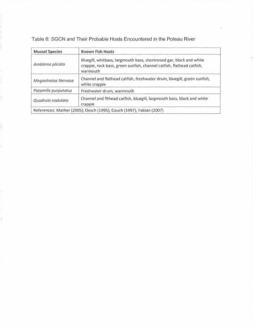
Table 6: SGCN and Their Probable Hosts Encountered in the Poteau River
Mussel Species
Amblema plicata
Megaolnaias Nervosa
Potamilis purputatus
Quadrula nodulata
Known Fish Hosts
Bluegill, whitbass, largmouth bass, shortnosed gar, black and white crappie, rock bass, green sunfish, channel catfish, flathead catfish, warmouth
Channel and flathead catfish, freshwater drum, bluegill, green sunfish, white crappie
Freshwater drum, warmouth
Channel and flthead catfish, bluegill, largmouth bass, black and white crappie
References: Mather (2005); Oesch (1995); Couch (1997); Fabian (2007)

Figures:
Figure 1: Locations of Mussel Sample Sites

Figure 2: Locations of Sediment Samples From Wister Lake

Cost: Total: $89,969.67 Federal Share: $55,900.00
Significant Deviations: None
Prepared by: William Ray, Oklahoma Department of Wildlife Conservation
Date: 21 September 2012
Approved b y : _ _ ^ ^ ^ X M ^ n Fisheries Division Administration Oklahoma Department of Wildlife Conservation
71 ^ ~ 4 I K John/Stafford, Federal Aid Coordinator Oklahoma Department of Wildlife Conservation