final part of the description of ayutthaya with remarks … · defence, policing, infrastructure,...
TRANSCRIPT

Final Part of the Description of Ayutthaya with Remarks on Defence, Policing, Infrastructure, and Sacred Sites
Chris Baker1
The Description of Ayutthaya is a verbal description of the old capital, probably compiled from the memories of survivors after its destruction in 1767. I have published translations of two extracts from the document in JSS99 (2011) and JSS101 (2013). This article has a translation of the remaining portions. These deal with three subjects: the infrastructure of gates, roads, bridges, and ferries; security arrangements including customs and guard posts, checkpoints, jails, and a watch tower; and a listing of major royal and religious places inside and outside the city. This brief introduction draws attention to some implications of these sections of the text.
Gates and defence
After the first sack of the city by the Burmese in 1568-9, the walls and moats were improved. In 1586, these defences held against another siege by the Burmese armies. For the next 173 years, until 1759, no army threatened Ayutthaya.
The sheer number of gates betrays the city’s sense of security in this era. There are twenty-three gates listed in the section of the document translated here, plus another six in the northern wall of the palace, which also forms part of the city wall. In addition, there were over sixty “tunnel gates,” apertures big enough for people or pack animals to pass.
All illustrations of the city show that the water gates were large and flamboyant. The most reliable representation is a sketch made in his notebook by Kaempfer while mapping the city in 1690 (Figure 1). The gate soars higher than the wall, which was six metres from ground level to the tip of the ramparts, making the gate possibly around ten metres tall. The design has the inward-sloping pillars and flared crosspiece still seen on the Great Swing (sao chingcha) outside Bangkok’s Wat Suthat. Other illustrations, such as on the Vingboons map (Figure 2), which have been redrawn by European draftsmen, who had never seen the original but worked from sketches made in situ, lack the distinctive design but confirm the shape and size. On Kaempfer’s sketched map of the city, there are at least twenty gates in this design.
1 With thanks to Winai Pongsripian, Barend Terwiel, Patrick Dumon, Thavatchai Tangsirivanich, and Pasuk Phongpaichit. All photographs are by Patrick Dumon.
Journal of the Siam Society, Vol. 102, 2014

180 Chris Baker
Such gates were designed to impress, not to keep enemies out. In case of a siege they had to be barricaded. Phraya Boranratchathanin, who carried out the earliest excavations in Ayutthaya around the turn of the 20th century, reported as follows:
When there was a war and an enemy laid siege to the capital, two rows of logs were inserted and filled with earth to close the canal between the walls on each side. Thirty years ago, some senior people told me that when they were young they had seen people dig out many logs of redwood and sal wood around four spans square and six cubits long from canals inside the line of the wall.2
A very large part of the population lived off the island. European maps dating from the early to mid-17th century onwards mostly show off-island settlements to the south and east. But that is because those were the areas that the European observers knew best. The twenty or so “public” ferries listed in the Description are ranged rather evenly around the island,3 suggesting that the population spread rather evenly in all directions. The large number of ferries and gates shows that the convenience of getting in and out of the walled city outweighed considerations of defence.2 APA, 55-6, n. 33.3 A slightly higher number on the west may be because the “government house” was located on the western side of the Palace from the Narai reign onwards.
Figure 1 (top left). Wall, watergate, and tunnel gate from Kaempfer’s notebook (Terwiel, Kaempfer Werke 4, 202)
Figure 2 (centre left). Vingboons map: two watergates on the south side of the island (probably Thesami Gate and Chinese Gate).
Figure 3 (below left). Vingboons map: two tunnel gates to the east of Pomphet.
Figure 4 (below). Only remains of a tunnel gate, near the southeast corner of the island, beside Wat Rattanachai
Journal of the Siam Society, Vol. 102, 2014
181Final Part of the Description of Ayutthaya
Policing
While external defence seems to have been a low priority, the arrangements for internal policing were elaborate and suggest concern over crime and revolt.
There was a guard-cum-customs post on the waterway approaches in all four directions. Each was relatively heavily manned by two officers and twenty men, with “post horses and fast boats for reporting incidents to the city.” These posts were charged to “carry out inspections for goods forbidden by law, unusual weapons, and suspicious people entering and leaving.”
The only bridge into the city, across the causeway at the northeast corner, was guarded by officers of the Ministry of the Capital. Apart from royal officials, others needed a written permit to use this bridge. Possibly this stricture was imposed to control the amount of traffic, but also had a guard function.
There were probably guards at the ferry landings. The Description mentions a sala trawen, or guard post, only by the ferry landing close to the palace, but other landings were probably guarded too. The Palace Law has three clauses dividing the city into zones under different units of the guard. These clauses come very early in the law, preceded only by clauses about the regalia of royal family members and about arrangements for royal audience. This early position in the law suggests the importance of this topic.
The first of these clauses specifies seven zones:
Authority: from Ten Cowries Landing to the White Elephant Gate, from Ten Cowries Landing to the residence of the king’s-guard archers, authority of Phitak Thiwa and Raksa Ratri; from the White Elephant Gate to the jetty, authority of the major guard; from the jetty of the water olive,1 authority of Muen Thepthawan; from the conduit past the Gate of Dispelling Misfortune to Chikun Peak Market, authority of Ja Pram; from the head of the parade ground to the Gate Showing Ram, authority of Bamrue Phakdi; from the head of the parade ground to the polo ground, authority of sword officers of the left; from the polo ground to the casting foundry, authority of sword officers of the right.2
Phitak Thiwa, Raksa Ratri, and Bamrue Phakdi were all titles of officials in the Ministry of the Palace; the major guard was a unit in Kalahom, including the two sword officers (khun dap). The zones are difficult to identify because several of the locations are unknown, but they seem to form a circle around the Grand Palace, extending perhaps half a kilometre.
1 There should be a “to” phrase here, probably lost in copying. This text has many such errors. The “water olive” (มะกอกน้ำ�, makok nam, Elaeocarpus hygrophilus) appears elsewhere in the Palace Law and seems to refer to an area in or outside the northwest corner of the Grand Palace.2 Clause 14 of the Palace Law, Kotmai tra sam duang, I, 74-5.
Journal of the Siam Society, Vol. 102, 2014

182 Chris Baker
The second clause appears to divide the whole island into four segments extending out from the drum tower at the crossroads close to the centre of the island. The officials are all from the patrol department of the Ministry of the Capital.
From the drum tower to Jao Sai and Peak Market, district of Khun Thoraniban; from the drum tower to the Gate of Victory and Jao Sai, district of Khun Thoraban; from the drum tower to Coconut Quarter and Chi Landing to the end of Bang Ian, district of Khun Lokaban; from the drum tower to Bang Ian on to the palace residence, district of Khun Noraban.3
The third clause4 divides the perimeter of the palace into four segments, roughly equivalent to the four sides. In each segment, a different unit of the palace guard has the ไอยก�รอ�ยัด, aiyakan ayat, meaning the authority.
There were checkpoints or roadblocks along the major roads. These checkpoints were rows of stakes driven into the ground to force passers-by to walk through an S-bend. Guards were present, and the checkpoints could be closed after
curfew at night.5 The Description lists two sets. The first set of eight is ranged around the palace (and possibly overseen by the guards in the third clause of the Palace Law cited above). The other set of sixteen cannot all be located, but seem to be along the main roads that lead to and from the palace. On the Vingboons map, three of these roadblocks can be clearly seen along the Maharathaya road leading southwards from the palace (Figure 5 shows one of these). As this map was redrawn in Europe using sketches made on the spot, the representation of the roadblock may not be accurate, but the
locations seem to match the list in the Description.To complete the apparatus of policing, there were eight jails. The main
jail was just south of the Grand Palace on the spot now occupied by the Khum Khun Phaen. In a well-known discourse on the Ayutthaya laws, MR Seni Pramoj argued that jail was very little used as a form of punishment, only as temporary
3 Clause 16, Kotmai tra sam duang, I, 76.4 Clause 17, Kotmai tra sam duang, I, 76-7.5 APA, 102, n. 133. Phraya Boran quotes a song in which a lovelorn youth hoping to visit his lover is stopped by a closed checkpoint.
Figure 5. Vingboons map: checkpoint on Maharathaya road in front of Wat Phraram. The wall and gate at the top of the picture are on the south side of the Grand Palace.
Journal of the Siam Society, Vol. 102, 2014

183Final Part of the Description of Ayutthaya
detention.6 This was not correct. The Description states that these jails are used “to hold criminals, robbers, villains, and bandits.” Several ministries had their own jail used for punishing offences that did not figure in the laws collected in the Three Seals code. Besides, many laws in the code specify that a convict be “sent to” this ministry or that, usually the Ministry of the Capital. This meant being sent to that ministry’s jail. These sentences never specify the length of imprisonment. Probably it was arbitrary, ended only by buying or begging a release.
Infrastructure
Late Ayutthaya had a considerable stock of infrastructure, including roads, bridges, walls, watchtowers, checkpoints, jails, and the causeway. Phraya Boran counted many brick bridges, and the remains of several have survived until today. Phraya Boran also reported, “In the city, there were many roads, wide and narrow, set on raised embankments like the railway, raised three cubits where the land is high and four cubits of more where it is low. The roads are two or three fathoms wide, paved with brick in the middle.”7
How was the construction and maintenance of this infrastructure financed? The Description gives us two hints.
First, jail inmates were used for labour on public works, and maybe their wives and children too. However, the inmates of four of these jails were dedicated to shipbuilding, especially constructing docks and junks for the tribute trade to Beijing—an indication of the importance of this trade in late Ayutthaya.
6 Seni, Pathakatha, 8.7 APA, 99-100, n. 132. See Figire 8.
Figure 6. The drum tower on Kaempfer’s original sketch (above left); on a later fair copy of this map (above right; it does not figure on the published version of the map); and on the Vingboons map (right), where it seems to be positioned almost on the western edge of the city, but that is because the southwestern portion of the island is completely missing from the map; the tower is correctly placed on the west of the road leading south from the Grand Palace.
Journal of the Siam Society, Vol. 102, 2014

184 Chris Baker
Second, the infrastructure was financed from levies on trade. The Description mentions the drum tower, which stood near the centre of the city. Rising sixty metres high, it was a major landmark, featuring in European maps of the city (Figure 6). Its drums were used to signal the approach of enemies, warn of fires, and summon people to public meetings. The Description relates that the staff of the drum tower kept cats to guard against mice gnawing the drums, and fed the cats by levying a tax on the nearby market. Possibly, other infrastructure was financed in this way. The use of jail convicts on public works was underwritten by a similar tax. Government did not provide convicts with food. Mostly families had to provide meals, but in addition the jailers took convicts into the markets on a regular basis so they could beg or steal food and other necessities.
Major sacred sites
The last part of the Description is a list of “the major, presiding things of the capital that celebrate the standing of the city of Ayutthaya.” The list includes: fourteen palace buildings, including some at Lopburi, Bang Pa-in, and Nakhon Luang; five relic stupas (phra mahathat); five other great stupas (jedi); eight Buddha images at wat in the city; and seven sacred locations outside the city.
The list of stupas and relic stupas has one surprise: Wat Somonkot, now known as Wat Samanakottharam, off the island about one kilometre to the east, on the west bank of Khlong Ayodhya. The ruins include a large bell-shaped stupa that probably dates to early Ayutthaya or even before. The site now attracts little attention but, perhaps in late Ayutthaya and early Bangkok, it was revered as a very ancient site.
Of the eight listed Buddha images, four are from Wat Phra Si Sanphet inside the palace, two are in wat adjacent to the palace (Mongkhon Bophit, Thammikarat), and one is the massive image at Wat Jao Phananchoeng. The eighth is another surprise and a mystery: “Phra Phuttha Borom Trailokanat Satsadayan, seated in meditation, six cubits across the lap, cast in brass, in Wat Khok”.
As โคก khok means “mound” and wat were often sited on elevated ground, there are several wat with khok as part of their name. Although the image measuring “six cubits across the lap” is not as large as those at Wat Jao Phananchoeng (ten cubits) or Mongkhon Bophit (sixteen cubits), it is still sizeable, but none can be identified in a wat with khok in the name. One possibility is Wat Khok on the east bank of the Bangkok (Chaophraya) River, immediately south of Wat Jao Phananchoeng. The wat appears on early maps (“54. Wat Kuuk” on the Valentyn map), but its history is obscure, except for the fact that it is probably the Wat Khok that was renovated by King Thaisa and where a massive anchor was cast.8 However, today there is almost nothing left on the site other than a mound. Another possibility is Wat Khok Phraya,
8 Cushman, Royal Chronicles, 404, 406.
Journal of the Siam Society, Vol. 102, 2014
185Final Part of the Description of Ayutthaya
off the island to the north behind Wat na Phramen. This location was used several times as the site for executing royalty. However, the ruins suggest the wihan was rather small for such a large image.
Another site, Wat Khok Saeng (โคกแสง), is mentioned in the royal chronicles as the residence of one of the royal kin during the dynastic disputes in 1735, but the site cannot be identified today.9 A recent publication of the Fine Arts Department speculated that this might be the site more usually known as Wat Chumsaeng, since the location just east of the palace as well as the size and antiquity attested by the remains would be fitting as a royal residence.10 There was also a Wat Khok Khamin to the south of the island where there remains a plinth for a large image, but little else is left at the site and there is no record in the chronicles.11
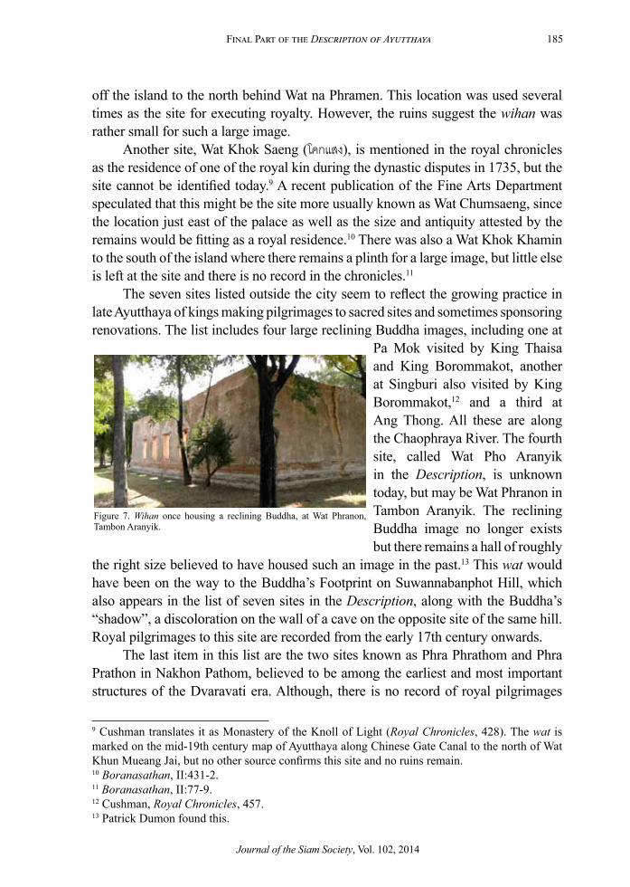
The seven sites listed outside the city seem to reflect the growing practice in late Ayutthaya of kings making pilgrimages to sacred sites and sometimes sponsoring renovations. The list includes four large reclining Buddha images, including one at
Pa Mok visited by King Thaisa and King Borommakot, another at Singburi also visited by King Borommakot,12 and a third at Ang Thong. All these are along the Chaophraya River. The fourth site, called Wat Pho Aranyik in the Description, is unknown today, but may be Wat Phranon in Tambon Aranyik. The reclining Buddha image no longer exists but there remains a hall of roughly
the right size believed to have housed such an image in the past.13 This wat would have been on the way to the Buddha’s Footprint on Suwannabanphot Hill, which also appears in the list of seven sites in the Description, along with the Buddha’s “shadow”, a discoloration on the wall of a cave on the opposite site of the same hill. Royal pilgrimages to this site are recorded from the early 17th century onwards.
The last item in this list are the two sites known as Phra Phrathom and Phra Prathon in Nakhon Pathom, believed to be among the earliest and most important structures of the Dvaravati era. Although, there is no record of royal pilgrimages
9 Cushman translates it as Monastery of the Knoll of Light (Royal Chronicles, 428). The wat is marked on the mid-19th century map of Ayutthaya along Chinese Gate Canal to the north of Wat Khun Mueang Jai, but no other source confirms this site and no ruins remain.10 Boranasathan, II:431-2.11 Boranasathan, II:77-9.12 Cushman, Royal Chronicles, 457.13 Patrick Dumon found this.
Figure 7. Wihan once housing a reclining Buddha, at Wat Phranon, Tambon Aranyik.
Journal of the Siam Society, Vol. 102, 2014

186 Chris Baker
d1
d2
d5
d4
d1
x5
x12
x6 x7 x8 x9 x10
x11
x13
x14
x16
x22
x21
x18
x19
x17
x25
x26
x28
x27
x29
x30
x23
x1
x2
x3
x4
x24
x15
x20
j22
j23
j24
j17 j18 j19 j20
j21
j13
j14
j4
j3
j12
j1j2
j16
j15
Ric
ehus
k C
lP
ot V
illag
e C
l
Ban
Bat C
l
Lotus Pond Cl
Phla Lai Cl
Paddy Gate Cl
Pak Sa Cl
Chinese Gate Cl
Nai Kai Cl
Mah
acha
i Gra
nary
Cl
Wat
Pra
du C
l
Pak
Khao
san
Cl
Khan
om T
an C
l
Suan Phlu Cl
Thetsami Gate Cl
Chakrai Noi Cl
Chakrai Yai Cl
Fang
Cl
Mah
anak
Cl
Pak Tho
Ho
Rat
tana
chai
Cl
Ironwood Cl
Wat
Cha
i
Wat
tana
ram
Cl
Cham Dyke Cl
Nak
honb
an C
l
drum
tow
er
Gra
nd P
alac
e
Can
als,
Roa
ds, B
ridge
s, F
errie
s, G
ates
, C
heck
poin
ts, a
nd J
ails
in L
ate
Ayut
thay
a
The
river
s an
d w
alls
in th
is m
ap fo
llow
Sum
etJu
msa
i. Th
e ca
nals
are
mai
nly
base
d on
Ka
empf
er’s
map
ske
tche
d w
hile
wal
king
ar
ound
the
city
in 1
690.
As
only
a fe
w ro
ads
wer
e m
arke
d on
ear
ly m
aps,
and
as
alm
ost
all r
oads
and
road
nam
es h
ave
disa
ppea
red,
he
re th
ey a
re m
ainl
y de
rived
from
the
Des
crip
tion.
Wat
Tra
Rd
Coco
nut Q
r Rd
Char
coal
Qr R
d
Chikun Rd
Maharathaya Banana Leaf Qr Rd
Four
Way
s Rd
Nak
Brid
ge R
d
Lao
Rd
Fire
Rd
Jao
Phro
m M
arke
t Rd
Dru
m Q
r Rd
Lead Qr Rd
Rong
Ma
Rd
Thre
e H
orse
s Rd
Jao
Jan
Gat
e Rd
Eart
h G
ate
Rd
Na
Rong
Mai
Rd
Nai
Gai
Rd
Net
Vill
age
Rd
Whi
tecl
ay Q
r Rd
Chin
ese
Stre
et
Mattress Qr Rd
Gre
at K
haek
Vill
age
Rd
b1
b2
b3
b4
b5
b6
b7b8
b9
b10
b11
b12
b13a
b13b
b14
b15
b16
b17
b18
b19
b20
b21
b22
caus
eway
g1g2
g3
g4
g5
g6g7
g8
g9
g10
g11g1
2
g13
g14
g15
g16
g17
g18
g19
g21
g22
g23
g20
f1
f2
f3f4
f5
f6
f7f8f9
f10
f11
Journal of the Siam Society, Vol. 102, 2014

187Final Part of the Description of Ayutthaya
to these places in late Ayutthaya, their appearance in this list suggests that their importance was appreciated and such pilgrimages may have taken place.
Translation
The Description of Ayutthaya exists in three versions, each slightly different. The history of the document is described in “Note on the Testimonies and the Description of Ayutthaya” in JSS99 (2011). The subheadings do not appear in the original texts, but were inserted when the texts were printed. The bracketed numbers like (b7) are inserted for keying to the map. Text [in square brackets] appears only in KLHW/KWPS (see bibliography for abbreviations). Text {in curly brackets} appears only in APA. Differences between KLHW and KWPS are described in the notes. Notes marked (B) are based on those by Phraya Boranratchathanin in APA, and those marked (W) on those by Winai Pongsripian in Phanna phumisathan. The beginning of the document is rather different between APA and KLHW/KWPS so the two versions are presented separately.
{Here14 will be told of the city of Si Ayutthaya. The San lake (well)15 came from the past. It has the shape (like) of a junk (ship), surrounded by water [as a moat]. The city’s long sides are on the north and south [meaning the prow of the junk is at the edge of the lake]. The bow of the junk, a short side16 [excellent], is to the east. Another short side (the stern of the junk) [the stern of the ship] is to the west [ส�ทร]. There is a wall (made) of brick and stone around the outskirts of the city [set on the bank of the river of the city of Si Ayutthaya]. The ramparts at the highest are three fathoms17 (from ground level), with a raised earthwork18 [with passageways19] six cubits20 high and ten cubits wide. In front are gates, large and small, and forts. The fortification all round the city of Si Ayutthaya is one hundred sen long and fifty sen wide.21 The description follows documents in the palace library which state as follows.}
[Here will be told of the geography of Krungthep Mahanakhon Bowon 14 Phraya Boranratchathanin explains that, in this paragraph in the original document, some words [here in square brackets] are circled for deletion, and others (here in round brackets) are written between the lines for insertion.15 ท่�นส�บสัน, with ซ่�ง inserted. Probably this part of the document was damaged. 16 KLHW/KWPS use “cross” and “long” to describe the short (N-S) and long (E-W) sides of the city. APA uses ขื่อ, khuea, and แป, pae, terms for the lengthwise and crosswise beams in house construction.17 ว�, wa, equivalent to around 2 metres.18 ช�นเชิงเทิน, chan choeng thoen. A raised earthwork for patrolling inside the walls.19 ช่องเนินบรรพต, chong noen banphot, literally passageways between hills.20 ศอก, sok, the length from elbow to finger tips, usually calculated as 50 to 60 centimetres, so 4 to 4.8 metres.21 เส็น, sen, 20 fathoms or 40 metres, so 4 kilometres by 2 kilometres.
Journal of the Siam Society, Vol. 102, 2014

188 Chris Baker
Thawarawathi Si Ayutthaya Thani.22 The holy city is situated on Sano Marsh Island23 in the country of Siam. There are rivers encircling the island, which has a shape like a junk. The name of the city appears as Krungthep Mahanakhon Bowon Thawarawadi Si Ayutthaya Mahadilokphop Nopharatana Ratchathani Buriram Udomphrarachaniwet Mahasathan.24 The King of Siam rules over the royal wealth in the capital as the great ruler in the country of Siam with extensive dominion—on the north up to the Lao territory, on the south to the Malay Khaek25 territory, on the east to the territory of the Khmer city, on the west to the Mon territory. Tributary states of the white-bellied Lao, black-bellied Lao, Khmer, and Malay Khaek are forever coming to offer gold and silver flowers without fail. His miraculous royal power and might are excellent and perfect. He protects the phrai, slaves, and subjects with the Ten Royal Virtues.26 He nourishes the Buddhist religion, Brahman teachers, and the ordinary people so they are incomparably cool and content. Traders of various countries, who know that Ayutthaya is happy and abundant with goods, hasten to come, present tribute, and beg to depend on the royal bo-tree shelter.27 Commerce in the city is great, beyond estimation. The city is immense, perfect, a jewelled royal abode, a haven of auspiciousness for the people of Siam, who are prosperous throughout the capital.
The28 island is shaped like a junk. The long sides are on the north and south. The short side at the head of the junk shape is to the east, and that at the stern is to the west. There are walls built around the city, some of brick, some of laterite, and some of red stone. The wall from ground level to the top of the parapet is three fathoms.29 22 Phra Poramanuchit Chinorot wrote that at the foundation of the city, U Thong, King Ramathibodi I, gave this name which combined: the prior name of the place, Thepnakhon; Thawarawathi (Dvaravati), in remembrance of the prior era; and Si Ayutthaya, a Thai distortion of Ayodhya, the capital of Rama in the Indian epic, Ramayana. (W)23 เก�ะหนองโสน, ko nong sano, perhaps the marsh of the sano tree, Sesbania javanica, a plant in the pea family that can live in watery ground. Possibly this refers to one of the many foundation stories of Ayutthaya, told in two slightly differing versions by Van Vliet, where U Thong comes upon a stinking marsh and gets rid of its resident dragon (Van Vliet’s Siam, 104–5, 200–1).24 Meaning: Krungthep Thawarawadi Si Ayutthaya the magnificent, great city which is a city of angels, is a great royal seat happy with the nine jewels of excellence, is a great capital abundant with royal palaces. A similar but shorter version of the name appears in the Phrakat phraratchaphrarot (royal announcement) about the foundation of the city in the Three Seals Law (see Kotmai tra sam duang, I: 1). (W)25 แขกมล�ย,ู khaek malayu.26 ทศพิธร�ชธรรม, thotsaphit ratchatham, a code of conduct for kings, based on Buddhist principles. The ten virtues are: munificence, moral living, generosity, justice, compassion, absence of bad ambition, suppression of anger, non-oppressiveness, and upholding the thamma or Buddhist teachings. According to the legend, a royal minister who had become an ascetic found a thammasat, law code, inscribed on a hillside which enjoined the king to follow these ten virtues and to practice the Buddhist precepts (Ishii, State, Sangha and Society, 44–45).27 A conventional phrase comparing the king’s authority to the shelter provided by a bo tree.28 In KLHW/KWPS this paragraph appears later, at the start of the section on city gates.29 ว�, wa, 2 metres.
Journal of the Siam Society, Vol. 102, 2014

189Final Part of the Description of Ayutthaya
Inside there is a raised earthwork eight cubits high with passageways. There are forts, camps, a moat and gates, big and small, around the city. The long side is over one hundred sen and the short side over fifty sen. Here it is described according to documents in the palace which state as follows.]
[Customs posts]
[Ayutthaya has] {There are} guard [and customs]30 posts on lookout for [various] incidents [, sited around the city] in all four directions [on the principal waterways for] entering the city: [to the east the post is located at] Khao Mao Village;31 to the south at Bang Tanaosi Village;32 to the west at Pak Khu Village;33 and to the north at Bang Luang34 Village. [The four are collectively called the royal custom posts of the four directions. Each has two officers, a captain of the guard and chief of customs,35 and twenty royal phrai, rotated every fifteen days. They carry out inspections for goods forbidden by law, unusual weapons, and suspicious people entering and leaving. They must challenge and question according to the circumstances. At each of the four locations, there are post horses and fast boats for reporting incidents to the city.]
[Ferries around the city]36
[Ayutthaya is surrounded by]{On the surrounding} waterways [outside the walls. There] is a causeway37 [across the river from the bank on the northeast side to the outskirts of the city at the Janbowon palace] beside Mahachai Fort [near the Front Palace granary. The causeway is] three fathoms wide [with a channel at the centre for the passage of boats, large and small. On both sides, the causeway is paved with planks. There are steps one cubit apart for descending the slope down to the bank on both sides. In the middle, planks are laid like an elephant bridge.38 This causeway, which is the only way] for [monks, Brahmans, teachers, all sorts of]
30 ด่�นขนอน, dan khanon, meaning a guard post and customs post respectively.31 Six kilometres due east of the city along Ban Bat Canal. It was sited here “because this was the junction of the Lopburi and Pasak Rivers in the past” (APA, 89, note 85).32 6 kilometres south down the Bangkok (now Chaophraya) River beside Wat Phrot Sat, now called Ban Khanon Luang, referred to by European visitors as the Tabanque.33 3 kilometres northwest of the city along what is now the Chaophraya River.34 Usually called Bang Lang, 6 kilometres north of the city along the old course of the Lopburi River, now Khlong Khuat.35 ขุนด่�น หมื่นขนอน, khun dan muen khanon.36 Many of the ferry landings are marked on a map believed to have been drawn (from memory, obviously) in the reign of King Rama III. See a copy of the map at www.ayutthaya-history.com/Temples_Ruins_IAM_1850.html.37 ทำ�นบรอ, thamnop ro; thamnop is a weir and ro is a row of stakes planted in the river to slow the current. 38 An “elephant bridge” means a bridge made of stone or similar durable materials, strong enough to bear the weight of an elephant.
Journal of the Siam Society, Vol. 102, 2014

190 Chris Baker
people, [as well as] elephants, horses[, and carts] to pass [in and out of the city, is known as] the Head Weir (hua ro) {and ferries for monks and Brahmans to cross}. [At the slope down to the bridge-causeway, there are officers of the Ministry of the Capital standing guard at a sala beside the causeway, strictly not allowing any elephants, horses, carts, buffaloes, or cattle to pass except for officers of the king, unless an official order has informed them in advance.
This causeway was made in CS 918 (CE 1556–57), Year of the Snake, eighth of the decade,39 in the reign of King Jakkaphat Rachathirat, the sixteenth monarch of Ayutthaya. At that time, the King of Hongsawadi40 brought an army to besiege and attack the city, and the Mon drove in stakes of sugar palm trunks to make a weir, filled it in with earth, and made a bamboo bridge across the river into the city. Subsequently, this was not destroyed but kept for the convenience of having a large bridge to cross the river into the city. When that old Mon causeway rotted and collapsed, the Thai repaired it and gradually converted it into a great bridge.41]
On the east cross-side [of Ayutthaya, there are five landings where people can hire ferries to cross in and out of the city], starting from the Head Weir guard post:
(b1) [from the Elephant Landing at the Front Palace to the Dutch Landing;]42 (b2) a ferry at Wat Saphan Kluea [crossing to the city at the Eight Guards
Landing at the end of the Front Palace;(b3) from the city] across to Wat Nang Chi;(b4) [from the city] across to Wat Phichai;(b5) [from the city] to Wat Ko Kaeo; 43
39 ปีมะโรงอัฐศก, pi marong attha sok, meaning the Year of the Snake, which has a final digit of 7 in the Chula Sakkarat calendar. This is a form of counting using the intersection of a 12-base system, the animal years, and a 10-base system, the universal decimal system, to create a 60-year cycle. The year should be 1568–69.40 Bayinnaung of Pegu. The Ayutthaya chronicles state that the Pegu forces built three causeways, all in the northeast corner (Cushman, Royal Chronicles, 65–66, 73–74).41 This account is doubtful. At the time of the Burmese attack in 1569, the eastern moat ran along what is now Nai Kai Canal. Soon after, the western defences were improved by digging a channel to bring in the flow of the Lopburi River, and move the eastern moat out to its current site. According to Phraya Boran, the weir was constructed at this time in order to divert some of the flow of the Lopburi River around the north side of the city. Possibly, it was built on some remains from the Burmese attack, but this account omits what seems to have been the weir’s primary purpose (APA, 44–6, note 2; Boranratchathanin, “Tamnan krung kao,” 77–8, 127–8).42 The “Dutch Landing” is mysterious. There is no Dutch settlement in this part of the city. Perhaps the name recalls an event. APA does not have this ferry at all. In KLHW/KWPS it appears in the wrong order, after b2.43 On the south side of the mouth of Khaosan Canal, opposite the wharf in front of Wat Suwan; the ordination hall has almost totally collapsed into the river (B). The “Wat Suwan” in Phraya Boran’s account may be another name for Wat Jin, which appears on his map but has now disappeared, and the site is occupied by Wat Rattanachai.
Journal of the Siam Society, Vol. 102, 2014

191Final Part of the Description of Ayutthaya
—five ferries [for hire by people entering or leaving the city] on the eastern side {and the causeway}.
On the south side [of Ayutthaya there are six landings with ferries for hire to enter and leave the city:
(b6) from the tunnel gate44 at the head of the Iron Workshop45 Market in the city] across to [the front of] Wat Jao Phanangchoeng;
(b7) from Shell Landing46 across to [Wat] Pa Jak;(b8) [from Phraya Ratchawangsan Landing] across to Wat Khun Phrom; (b9) from Dan Chi [Landing] across to Wat Surin[tharam]; (b10) from Chakrai Noi [Landing] in the city across to Wat Tha {Rap} [Ram];47
(b11) from Victory Palace [Landing] in the city across to Wat Nak at the mouth of Lakhonchai Canal;48
—a total of six ferries on the long southern side.
On the western cross-side of Ayutthaya [there are four landings with ferries]: (b12) from Ban Chi [Landing in the city] across to Wat Chaiyaram {(Chai
Wathanaram)};49
(b13) from the Rear Palace [Landing in the city] across to Wat [Long] {Lod}chong;50
(b14) [from Dan Lom Landing in the city] across to Wat Kasat;(b15) [from Chaophraya Phonlathep’s House Landing in the city] across to
Wat Thamma; —a total of four ferries on the short western side.
On the long northern side [of the city of Ayutthaya, there are seven ferry landings]:
44 ประตูช่องกุต, pratu chong kut, an aperture in the wall large enough for someone to walk through. The only surviving example at the southwest corner beside Wat Jin opposite Wat Phananchoeng is 4 cubits and 1 fist wide, and over 5 cubits tall. (B) The dimensions work out as roughly 2.1 x 2.5 metres. See Figures 3, 4.45 โรงเหล็ก, rong lek.46 ท่�หอย, tha hoi, sometimes called ท่�มู่บ้�นจีน, tha muban jin, Chinese Village Landing.47 ท�ร�บ, tha rap, “flat landing,” is correct.48 KLHW has only “Wat Nak Lakhonchai,” while APA/KWPS has extra words which seem correct. Wat Nak was on the upper [western] side of the mouth of Khun Lakhonchai Canal, also known as Takhian (Ironwood) Canal. (B)49 The phrase “in the city” appears only in KWPS and may be wrong. “Wat Chai Wathanaram” appears (in brackets) only in APA and may also be wrong. Ban Chi was off the island, south of Wat Chai Wathanaram, while Wat Chaiyaram was opposite, on the city side, and later known as Wat Pho Phueak.50 ลอดช่อง, lodchong, the name of a sweet, is correct. Probably this entry muddles two ferries. The ferry from Wat Lodchong probably went to a landing just south of the mouth of Ricehusk (klaep) Canal, while the ferry from the Rear Palace probably went to a landing at Wat Rachaphli.
Journal of the Siam Society, Vol. 102, 2014

192 Chris Baker
(b16) from Sattakop Gate [Landing in the city] across to Wat Khun Yuan;(b17) [from Horse Bathing Landing51 in the city] across to Wat Tin [Tha];52
(b18) a regular night-and-day ferry for officials [from the Royal Palace Nobles Landing in the city] across to the Patrol Post Landing53 beside Lotus Pond Canal;
(b19) from the [Royal Palace54 Elephant Landing, that is] Ten Cowries Landing,55 in the city across to Wat [Si] Pho {Canal};
(b20) from {beside Wat} Sand Landing in the city across to Wat Rong Khong [beside the house of Chaophraya Jakri; at this landing there is a pair of salas for travellers to take rest and for distributing alms];
(b21) from Wat Song [on Front Palace Elephant Stable Road in the city] across to Wat Pa Khonthi [on Potters’ Village Road];
(b22) a regular [night-and-day] ferry for officials from [the Front Palace Nobles Landing] beside Mahachai Fort in front of Jan[bowon] Palace [in the city] across to Wat {Mae} Nang Pluem and Herd Landing;56
—[a total of seven ferries] on the long northern side including] five normal ferries and two official ferries.
The river around all four sides of the city has [one large bridge at] the causeway, two landings for official ferries, and twenty ferries for hire making a total of twenty-three [ways for people to enter and leave the city].
[City gates]
[184] [As described in the documents from the palace, they say that the city of] Ayutthaya starting from the east by Mahachai Fort at the end of the causeway and turning [to the right]:57
(g1) a great gate called the Elephant Landing Gate of Janbowon Palace, that is, the Front Palace;
{two tunnel gates;}
51 ท�ม้�อ�บน้ำ�, tha ma ap nam.52 Usually called Wat Choeng Tha. This became the landing for officials crossing to the palace when the palace was remodelled in the Phetracha reign. Before that, ferry b19 had this role. (B)53 ศ�ล�ตระเวน, sala trawen. This is the central of three guard posts to watch the river by the palace; an upper one mentioned in the Palace Law, was probably on the opposite bank between Kalahom Landing and Ten Cowries Landing; and the lower one was near Salapun, perhaps beside Wat Salapun. (B, APA, 92-3, n. 99)54 KLHW has วัด wat here but KWPS has วัง palace.55 A colloquial name coined because the fare each way was 5 cowries. In fact, this name seems to have applied to the ferry at Royal Palace Nobles Landing (see b18). More likely the city-side landing for this ferry was not here but at Kalahom Landing, further east, directly opposite Wat Si Pho.56 โขลง, khlong, term for a herd of elephants. KWPS has โขลน, khlon, female guards in the inner palace.57 I.e., clockwise from the northeast corner.
Journal of the Siam Society, Vol. 102, 2014

193Final Part of the Description of Ayutthaya
(g2) a great gate called the Water Cloister58 Gate for the regular landing of the Janbowon Palace [, that is the cloister gate of the Front Palace];
three tunnel gates;(f1) Wat Fang Fort;59
one tunnel gate;(g3) a great gate at a canal called the Tower of the Jewels of Victory Gate;three tunnel gates;(g4) a great gate called Jao Jan Gate where it is forbidden to take out corpses; two tunnel gates;(f2) a fort opposite Crystal Island;one tunnel gate;the southeast corner of the city [of Ayutthaya], known by people as Hua
Sarapha,60 close to where junks cast anchor. This is the end of the eastern side.
The long south side of Ayutthaya from the corner at Hua Sarapha:one tunnel gate;(f3) a [large] fort;one tunnel gate;(f4) a large fort built of laterite, [secure and strong, three fathoms and two
cubits high,] two cubits higher than the palace wall, with a walkway three fathoms wide [around the fort, and a crystal wall around the walkway]; there is one tunnel gate to the left of the fort, and one to the right, both leading out onto a platform around the fort; [this platform has a crystal wall around;] there are eight guns placed at apertures; [and on the storey below there is a cannon mounted on a carriage in all sixteen apertures; this great fort called] Diamond Fort61 is sited on the river opposite Kaja Village market.
(g5) the gate at a canal called Nai Kai;five tunnel gates;(f5) Ok Kai Fort;two tunnel gates;(g6) a great gate at a canal called Chinese Gate;two tunnel gates;(g7) a great watergate called Thesami Gate;62 the area of Dan Chi Landing with two tunnel gates;
58 ฉนวน, chanuan, a shielded passageway for royalty.59 All version give ฟ�ง, fang, but this fort is usually named ขว�ง, khwang.60 This name may come from สรรพ, meaning “together;” or from samphao, junk; or, as Prince Damrong suggested, from samphakorn, customs (W). Or perhaps from the cries of ส�ระพ�, sarapha (shouted to coordinate a group effort, similar to “Heave Ho!”) of crews maneuvering ships to anchor.61 ป้อมเพชร, Pomphet.62 Variously given as เทสม,ี thesami (KLHW), เข�สม,ี khao sami (APA), เทพหม,ี thepmi (KLHW).
Journal of the Siam Society, Vol. 102, 2014

194 Chris Baker
(f6) a fort opposite the entrance to Cham Dyke Canal;one tunnel gate in the area of Chi Landing;(g8) a large watergate called Chakrai Noi Gate;63
two tunnel gates;(g9) a great watergate called Victory Gate;64
three tunnel gates;(g10) a great watergate called Chakrai Yai Gate;two tunnel gates;(f7) a fort opposite the mouth of Lakhonchai Canal;65
one tunnel gate;the end of the long south side.66
[On the western cross-side of the city of Ayutthaya, from the corner at the Victory Palace67 and Chi Village:
three tunnel gates;(g11) a great gate called Ricehusk Canal68 Gate;two tunnel gates;(g12) a great gate called Rear Palace Landing Gate;two tunnel gates;(g13) a great gate called Mahachai Granary Canal Gate;three tunnel gates;(g14) a great gate called Fang Canal Gate;(f8) a fort at the sharp corner of the river called Sattakop Fort;69 end of the short western side.
The long northern side of the city of Ayutthaya, from Sattakop Fort:one tunnel gate;(g15) a great gate called Sattakop Gate out to the fresh fish market;one tunnel gate; (f9) a great fort newly built called Supharat Fort;
63 In all versions, Victory Gate and Chakrai Noi Gate are listed in the wrong order, here corrected according to Phraya Boran (APA, 49, notes 17 and 18).64 Phraya Boran doubted this was a watergate (APA, 105–6, n.143), and omitted the canal from his map. Other maps suggest there may have been a short canal into an open square just inside the wall. As this was the gate for ceremonial entry (e.g., for embassies), this square would have been for disembarking from boats.65 Called ป้อมวังชัย, pom wang chai, Victory Palace Fort.66 APA is missing a large section here, restarting in mid-sentence before g22.67 The residence of Phra Thianracha before he became King Jakkaphat in 1548 and converted the site into a wat. (B)68 Known colloquially as Monk Landing Canal. (B)69 ท้�ยกบ, thai kop, rear of the frog, in the chronicles (B; see Cushman, Royal Chronicles, 483).
Journal of the Siam Society, Vol. 102, 2014

195Final Part of the Description of Ayutthaya
one tunnel gate;(g16) a great gate called Goose Gate;one tunnel gate;(g17) a great gate called Mu Taluang Gate,70 for corpses of children and
grandchildren of the royal family to embark by boat in procession to cremations at the pyre of Wat Chai Wattanaram;
one tunnel gate;(g18) a great watergate at the corner of the Grand Palace called Pak Tho Gate;(g19) moving across from the western corner of the palace wall to the eastern
corner there is a great gate called Boundary Landing Gate;one tunnel gate;(g20) a great gate called Laundry Landing Gate;three tunnel gates;(g21) a great gate called Ten Cowries Landing Gate where elephants come
down to bathe; beside the landing outside the city walls by the river there are stables for certified71 elephants with four stalls, each with one bull elephant;
beyond is one tunnel gate; by the walls going out to the plain, the Mahathera Mai Sae72 tunnel gate; at this
spot, water is diverted to flow under] the main road, along the Pak Sa ditch, [through earthenware pipes buried] under Nak Bridge Road [, and through buried pipes] to join the Khao Sami Gate Canal;
beyond are two tunnel gates;(g22) a great gate called Kalahom Landing Gate;two tunnel gates;(g23) a great gate at a canal called Paddy Gate;one tunnel gate;(f10) a fort [called Jampaphon Fort];73
two tunnel gates;(f11) a great fort called Mahachai Fort, at the corner of the city [wall on the north];the end of the long northern side.
Along the wall round the city of Ayutthaya there are {twelve} [twenty-two]74 forts, large and small, twenty-three great gates [with red-painted peaks], and sixty-one tunnel gates.75
70 หมูทะลวง, perhaps “pierced pig.”71 ระหว่�ง, probably ระว�ง, rawang, register, meaning elephants trained and certified as royal mounts. (W)72 มห�เถรไม้แซ, “great-elder wood war-boat,” possibly the name of a senior monk.73 ป้อมจำ�ป�พล; Phraya Boran’s map does not show this fort but depicts an unnamed defensive structure at the mouth of Khao Pluak Canal, which still stands.74 Only eleven are mentioned. This counting probably includes forts that are part of the palace, described elsewhere in the text (see Baker “The Grand Palace”).75 In the listing there are 63 in KLHW and APA, and 61 in KWPS.
Journal of the Siam Society, Vol. 102, 2014

196 Chris Baker
[Inside the city walls]
In[side the walls of] the city of Ayutthaya there is a main road [called Maharathaya76 in the centre of the city], {five}[six] fathoms wide, [paved smooth with laterite,] for big events such as {royal kathin and royal ordination} processions; military parades, and sasanan royal bathing rites,77 with various royal horses and elephants[; land kathin processions, sometimes with horses and elephants, sometimes with palanquins, including the regular annual royal kathin processions with triple robes lasting seven days, then followed by the royal presentation of kathin robes at the royal wat both by land and by boat. This main road is used for the royal ordination procession, and royal funeral procession, and other funerals. Processions start from the Victory Gate in the south of the city].78
There are checkpoints79 [to safeguard the city as follows] from the head of Tra Palace Road:
(j1) at the head of Tra Palace Road;(j2) at the end of Tra Palace Road at Ten Cowries Landing Gate;(j3) at the head of Lead Quarter Road;(j4) at the corner of Drum Quarter Road;(j5) at the head of Salver Quarter80 Road at Prathiap Landing;(j6) at the end of Salver Quarter Road;(j7) at the head of Silver Bowl Road;(j8) at the end of Medicine Quarter Road;(j9) at the head of Pink Quarter Road;(j10) at the head of both Wood Quarter Road and Iron Quarter Road;(j11) at the head of Mattress Quarter Road;
76 A large road from the front of the palace southwards, making a dog-leg right-to-left at the southeast corner, then proceeding south to the Victory Gate on the river. The French missive was brought to the palace along this route in 1685. (B) On many European maps, such as that of Bellin, this is called the Barcalon (phrakhlang) Street. Kaempfer (Description, 26-8) visited the Phrakhlang’s house, and on his sketch map of the city there is a large house drawn on the west side of the road which may represent this house. This map is reproduced in Engelbert Kaempfer, Werke I/1: Heutiges Japan (München: Iudicium, 2001), 507-8.77 KLHW สระสน�น; APA สระขน�น; KWPS สะฃน�น; from สระ, sa and สน�น, sanan, two Sanskrit-derived words for bathing. Probably this means the various phisek ceremonies in the annual cycle of royal ceremonies (Kotmai tra sam duang, I: 139-52).78 APA is missing most of this paragraph, having only a fragment, probably from a damaged manuscript, ปตูไชย ชักจะเข้ใสศภพระร�ช�ขณะอธิก�ร, perhaps: Victory Gate, draw crocodile, carrying corpse of a senior monk.79 ค่�ยผนบบ้�นหล่อ, khai phanop ban lo; khai means camp; phanop comes from a Khmer word for device; ban lo is distorted from chalo, a Khmer-derived word meaning slow down. This was a guarded barrier across the road, forcing people to walk an S-bend. In KLHW, this sentence appears before the prior paragraph. See Figure 5.80 APA has เตียบ tiap, KLHW เกรียบ kriap.
Journal of the Siam Society, Vol. 102, 2014

197Final Part of the Description of Ayutthaya
Figures 8. Remains of old paved road between the Grand Palace and Wat Thammikarat
Journal of the Siam Society, Vol. 102, 2014

198 Chris Baker
Figure 9 (top left). Monkey (wanon) Bridge (x13).Figure 10 (top right). The sign claims these are remains of Chikun Bridge (x9), but more likely they are Wat Chat-than Bridge (x15).Figure 11 (centre). Chinese Market Bridge (x11)Figure 12 (below). Reconstructed and now called Sing Bridge, but probably on the site of Whiteclay Village Bridge (x17)
Journal of the Siam Society, Vol. 102, 2014
199Final Part of the Description of Ayutthaya
(j12) {at the head}[in the middle] of Green Cloth Road;(j13) at the head of Four Ways Road;(j14) at the end of Four Ways Road;(j15) at the head of Banana Leaf Quarter Road by the residence of Chaophraya
Phrakhlang;81
(j16) at the end of Banana Leaf Quarter Road at the {Elephant}[Granary] Victory Gate Landing.
Checkpoints around the royal palace:(j17) at the head of Rong Ma Chairoek82 [Road] at Jakkara Mahima Gate;(j18) at the corner of Wat Thammikarat by the wall bordering the parade ground
in front of Jakkrawat;83
(j19) at the head of Jao Phrom Market Road;(j20) at the {fort by the} Registration Hall84 [beside the tattooing hall];(j21) at the central fort by Wat Si Chiang;(j22) at the corner of the fort turning towards Wat Rakhang;85
(j23) at the corner of the fort where there is an entry to the end86 of the Crystal Pond [in the palace];
(j24) at the corner of Pak Tho Fort where Earth Gate Road turns to terminate at the cloister by the regular landing;87
—a total of eight checkpoints around the palace, and at sixteen places along main roads [inside the city walls], making [a grand total of] twenty-four.
[Bridges in the city]
Within the walls of the city [of Ayutthaya], there are [fifteen] brick bridges and [fifteen] wooden bridges across [major] canals [, making a total of thirty on the main roads alone].
(x1) a wooden bridge across the Tower of the Jewels of Victory88 Canal;
81 APA จวนคลัง, juan khlang, a shorter form with the same meaning.82 โรงม้�ไชยฤกษ,์ chairoek horse stables, where chairoek means “excellent time.”83 Meaning the Jakkrawat Phichaiyon audience hall.84 ส�ล�ส�รบัญช,ี sala sarabanchi, overseeing the registration of people for corvée duty; at the southeast corner of the Grand Palace.85 Also known as Wat Worapho (excellent bo tree) since the reign of King Boromakot, probably as one of the bo trees brought from Sri Lanka was planted there. (B)86 KLHW has the wat of Crystal Pond, clearly a mistake.87 Meaning at the northwest corner of the palace, suggesting that Earth Road turns and runs eastward outside the palace walls as far as Wasukri Landing, where the cloister or covered way that runs across the palace emerges onto the river.88 หอรัตนชัย, ho rattanachai. A fort is mentioned in this position and with the same name in the chronicles in the mid-16th century and the tower is mentioned at the start of King Narai’s reign (Cushman, Royal Chronicles, 60, 236), but nothing seems to be known about the tower. Probably it was a watchtower, named to celebrate a victory, long disappeared, and remembered in the name
Journal of the Siam Society, Vol. 102, 2014

200 Chris Baker
(x2) a brick bridge across the Nai Kai Gate Canal to turn to the Tower of the Jewels of Victory;
(x3) a wooden bridge called Si Saek Bridge;(x4) a large bridge called Hua Jaka Bridge;(x5) a brick bridge at Nai Kai Gate called Nai Kai Bridge;
along Paddy Gate Canal all the way to Chinese Gate:(x6) a laterite bridge called Elephant Bridge89 [across the canal];(x7) a brick bridge called Charcoal Quarter [Road] Bridge;(x8) a wooden bridge called Wat Lat Bridge;(x9) a brick bridge called Chikun Bridge;90
(x10) a wooden bridge called Wat Khun Mueang Jai Bridge;(x11) a brick bridge called Chinese Market Bridge;(x12) a brick bridge called Firework Village91 Bridge across a small canal cut
from Nai Kai Canal out to Chinese Gate;
the Thetsami Gate Canal comes in to Pak Samut ditch; water from [canals in] the city centre is diverted to flow out [along]{beside} Nak Bridge [Canal] to join with Thet Gate Canal;
(x13) a brick bridge called Monkey92 Bridge from Great Khaek Village [Road] across to Net Village Road;
(x14) on the small canal cut from the large Chinese Gate Canal through to Thet Bridge Canal a brick bridge called [Grass]{Medicine}93 Bridge from [Great] Khaek Village Road to the resthouse94 on [Grass]{Medicine} Quarter [Road];
(x15) a brick bridge [called Wat Chat-than95 Bridge leading] from the {the road in} front of Wat Am Mae96 [at the end of Great Khaek Village Jaosen] on to the main road at [the front of] Wat Chat-than;
of the canal and gate.89 The laterite was taken to Bangkok to build an artificial mountain at Wat Saket (the Golden Mount) in the Third Reign. (B)90 On Chikun Road today there are remains labelled as Chikun Bridge (Figure 10), but these are too far south and probably were the Wat Chat-than bridge (x15).91 บ้�นดอกไมเพลิง, ban dok mai phloeng.92 ว�นร, wanon, a Sanskrit-derived word. This bridge has been partially restored, behind the Ayutthaya Historical Centre. See Figure 9.93 KLHW/KWPS have หญ้�, ya, grass but APA has ย�, ya, medicine.94 ศ�ล�อ�ไศร, KLHW: อ�ศรัย, perhaps อ�ศัย, asai, hence the “resthouse.”95 KWPS ฉัตรทันต KLHW ฉัททันตร ์APA ฉัดทัน, from Pali Chaddantha, the name of a lake in Himaphan; a lineage of elephants with silvery white skin and red mouths and feet; and a Jataka, where the Bodhisatta is born as king of the Chaddanta elephants and saws off his own tusks for a vengeful queen.96 Possibly this was not a wat but a mosque, as the name is difficult to interpret as Thai, but may have been distorted from “Ahmed.” On Kaempfer’s sketch map, there is a symbol surmounted by a crescent, possibly representing this building.
Journal of the Siam Society, Vol. 102, 2014

201Final Part of the Description of Ayutthaya
on Victory Gate Canal97 up to where it meets Four Ways Road at the corner of Wat Pa Nai:
(x16) a wooden bridge [called Wat Jakkarawat Bridge across the canal] beside the Royal Goods Storehouse98 [far from Banana Leaf Quarter,] across into Wat Borom Jakkarawat;99
(x17) a brick bridge [called Whiteclay Village Bridge across the canal] in front of Wat Borom Phuttharam100 to Whiteclay Quarter [Road] and Wat Phra Ngam Road;101
(x18) a wooden bridge [called Silversmith Village Bridge] across Silversmith Village {Road}[Canal] to Wat Pa Nai;
(x19) where Victory Gate Canal turns to the east, a wooden bridge [called Brahman Temple Village Bridge] across the canal from Green Cloth Quarter to Brahmin Village in front of Wat Pa Nai [and near the Brahmin Temple];
(x20) a wooden bridge called Nak Bridge at the head of Mattress Quarter Road across to the road in front of Wat Sak;102
on a small canal, which leads {west}[east]103 from Victory Gate Canal through to Chakrai Yai Canal:
(x21) a wooden bridge [called Snake Bridge] across to Banana Leaf Quarter Road;(x22) a wooden bridge [called Potters Village Bridge] at Chakrai Noi104 across
to Wat Thong Road in Pot Village;
on Pak Tho Gate Canal which leads out through Chakrai Yai Gate:(x23) a wooden bridge called Khun Lok Bridge;(x24) a {wooden} bridge [called Lady Swan Bridge] at Wat Khwit105 Road
across [the canal] to Wat Kuti Salak;106
97 The text seems to confuse Victory Gate and Chakrai Noi Canals (see note on gate g8 above). Bridges x16 to x20 seem to be along Chakrai Noi Canal.98 พระคลังสินค้�, prakhlang sinkha, for storing trade goods.99 KWPS omits a passage here, calling this bridge the Whiteclay Village Bridge, and omitting the details of x17. Maps by Sumet Jumsai and the Fine Arts Department locate Wat Borom Jakkarawat immediately north of Wat Borom Phuttharam, but there is no evidence and no remains. If these bridges are in fact along Chakrai Noi Canal, then this wat should be east of the canal, possibly the site now known as Wat Singharam.100 Built by King Phetracha on the site of his former residence between Victory Gate and the Chakrai Noi Canal, and known colloquially as the Wat of Glazed Tiles. (B)101 This is probably the bridge across Wat Chakrai Noi restored (i.e., reconstructed) by the Fine Arts Department and now known as Sing Bridge (Figure 12).102 Probably Wat Pa Sak.103 KWPS has west (which is correct). 104 Same in both APA and KLHW, but clearly should be Chakrai Yai. Pot Village (ป่�หมอ, pa mo) Canal links Victory Gate Canal and Chakrai Yai Canal. Phraya Boran’s map shows Wat Thong and Wat Pa Mo as two adjacent wat, but other maps show them as one called Wat Thong Pa Mo.105 Wat Khwit has disappeared, but may have been close to Wat Thong in Pot Village.106 This is probably a wat at the junction of Chakrai Yai and Ricehusk canals, labelled as Wat Salak
Journal of the Siam Society, Vol. 102, 2014

202 Chris Baker
(x25) a brick bridge called Lamhei Bridge on Four Ways Road across [the canal] to Lao Road;
(x26) a brick107 bridge called Chain108 Bridge at Mahaphokharat {Gate} across to Na Rong Mai Road [where nobles enter for audience at Song Buen Audience Hall];
from Pak Tho Canal a small canal branches into the Crystal Pond and Inner Treasury;
(x27) a wooden bridge [called Krailat Bridge] at the road in front of Wat Rakhang [crosses the small canal] into the Grape Garden [inside the palace];
(x28) a brick bridge called [the Phra Uthayan Bridge or sometimes] the Grape Garden Bridge on the road behind Wat Rakhang across [the small canal which branches] into Thai Sa;
from the Pak Tho Canal a small canal branches west out through the great Mahachai Granary Gate at Wat Suan Luang Sopsawan;
(x29) a brick bridge called Crystal Bridge beside the Thang Hua Phai Canal;
(x30) [a bridge called Gold Bridge across the mouth of the Pak Tho Canal into the palace grounds at the twin salas by Khuha Chonglom Gate109 across to the main road in front of the Almsgiving Sala at the centre of the quarter;110 people are forbidden to use this bridge except when there are royal rites and processions; the bridge is closed with elephant-ear gates at both ends;]
—fifteen brick bridges and {fourteen}[fifteen] wooden bridges making a total of {twenty-nine}[thirty] bridges [across canals on main roads] in the capital [, all with names].
[Jails, drum tower]
There are eight jails to hold criminals, robbers, villains, and bandits. In front of each jail, there are cells to house the wives and children of the criminals. Those jailed for petty offences are chained together by the neck in groups of ten, and taken to do government work all over the city. Those jailed for serious offences are chained together by the neck in groups of twenty or thirty, and taken out [on holy days—the fifth, eighth, eleventh, and fifteenth—ten111 times per month] to beg alms of food
or Wat Kao on old maps.107 Brick appears in APA and KWPS, not KLHW.108 ส�ยโซ,่ sai so.109 This gate does not appear in the list of gates in the Description, but several gates seem to have had both official and colloquial names.110 ศ�ล�ฉ้อท�นกล�งย่�น, sala cho than klang yan.111 Perhaps a mistake for four (สิบ สี่).
Journal of the Siam Society, Vol. 102, 2014
203Final Part of the Description of Ayutthaya
in the markets, with the criminals’ wives and children {attached to the back of the group}[put in two-level chains with ropes around the waist and taken out to work].
At Four Ways Road there is a drum tower, thirty fathoms high in three stories with an arched roof painted red.112 The top storey is used to keep watch for an army [approaching, when they beat a drum] called Phra Maharuek.113 At the middle storey is a drum called Phra Maharangap-phloeng114 to beat in case of fire. If there is fire on the opposite bank of the river outside the city, the drum is beaten three times; if there is a fire at the foot of the walls or in the city, the drum is beaten [continuously] until the fire is extinguished. On the first storey, there is a large drum beaten to mark midday, and to summon people to meetings when the sun weakens at dusk according to the custom of [Ayutthaya] city {from the past}[. The first-storey drum is] called Phra Thiwaratri.115 Officials of the Ministry of the City take care [of these three drums]. The keepers [must] raise cats to guard against mice gnawing the drums. Morning and evening, city officials collect fees of five cowries per shop in the market in front of the jail between the checkpoint and the drum tower for buying grilled fish to feed the cats. [In front of the hap-phoei gate116 there is a patrol unit with overseers in charge to guard against incidents in both the city and the jail.]
There are jails for holding criminals to build junks and various war ships and to dig dry docks outside the [city] walls for the junks which take royal missives [and tribute117 to Beijing every year]. One jail in the Attap Quarter (d2) is for those building junks, another at Victory Palace (d3) for those making war ships [, another at Banana Leaf Quarter (d4) for those making docks for junks, and another at the end of Banana Leaf Quarter (d5) for those sawing timber planks. These four jails are for various uses in the city].
[Royal residences outside the city]118
There are five palaces outside the city.
112 On the northwest of the crossroads. “Dug and found base of old pillars, as large as those used in cremation pavilions in the city centre, only three remaining, and the remains of a brick wall around” (B, APA, 100, n. 132).113 พระมห�ฤกษ,์ “great time,” especially in the sense of a moment in astrological reckoning; title of a piece of music played at opening ceremonies; probably distorted from มโหระทึก mahorathuek, the ancient bronze drums of mainland Southeast Asia, sometimes called Dong Son drums.114 “Great Fire Queller.”115 “Day-night.”116 หับเพย, derived from Khmer words meaning “open-shut”; the main gate of the principal jail (d1).117 จิ้มก้อง, jim kong, technical term for tribute to China, based on Chinese words meaning “give a present.”118 This section is only in KLHW/KWPS. APA has only a fragment of the description of the elephant enclosure, as follows: Wang Jan has a throne hall with four wings but no peak. Phra Maha Uparat, the Front Palace, resides close to the Grand Palace, 50 sen to the east. There is an open palace outside the city to the northeast for the king to view the capture of wild elephants and elephant herds leading in wild elephants, hence called the elephant enclosure (phaniat).
Journal of the Siam Society, Vol. 102, 2014

204 Chris Baker
The Khochaprawet119 Mahaprasat has a single mondop spire, four-level roofs, wings extending from the main building in two directions like the Jakkrawat Phachaiyon on the wall of the capital.120 This Khochaprawet palace is open, with no walls, on two storeys. It is sited on a mound at the elephant enclosure for the king to watch the capture of wild elephants and elephant herds leading in wild elephants. There is a crow’s wing fence of posts behind this palace, and two large brick salas for royal victuallers to provide victuals. This palace is outside the city in the northeast.
The Aisuriyathipat Mahaprasat121 has a single mondop spire, four-level roofs, walls on four sides, an entrance porch122 extending as a wing from the main building on the east, a crystal wall five cubits high all around, a large pond the length of the palace, a private garden for the royal pleasure, many buildings large and small for royalty to stay, and a wall around the palace area. The Bang Pa-in Island123 has been a residence and retreat for several reigns. Sometimes in the eleventh or twelfth month the king travels to float a lantern at this island.124
The Phranakhon Luang Prasat125 has a single prang tower, and several mondop peaks in rows in the palace grounds. It is for day and overnight stays when the king travels to pay respect at the Buddha’s Footprint. Also, sometimes in the dry season the king visits there for the gun-firing rite.126 Sometimes in the tenth month the king travels there to offer khao yakhu127 to the chapter of monks and abbot of the wat, and to conduct the royal ceremony of mathupayat,128 mixing celestial rice in the Nakhon Luang palace. In the tenth month, the king travels by water because people plant paddy on the road. In the fourth month, the king travels by land because the land is perfect with no obstacle to the king’s progress.
119 “Entry of Elephants.” This is a pavilion at the elephant enclosure 1 kilometre north up the Lopburi River on the west bank. The enclosure was moved from the northeast corner of the island to this location in the Chakkraphat reign when the line of the eastern wall was moved. This building was burnt down in 1767 and restored in the Bangkok Third Reign. (B) 120 In fact on an inner wall of the Grand Palace. See Baker, “The Grand Palace,” 100-1.121 The Holy Residence of the Divine Royal Seat, built by King Prasat Thong at Bang Pa-in early in his reign (r. 1629–36; see Cushman, Royal Chronicles, 217), and restored by King Rama V in keeping with the description here.122 มุขเด่น probably an error for มุขเด่จ, mukdet.123 12 kilometres south of the city down the river towards Bangkok.124 This timing matches loi kratong. The term translated here as lantern is ประทีป, prathip.125 Built by King Prasat Thong in 1631, on a design copied from Angkor, to serve as an overnight stop on journeys to the Buddha’s Footprint in Saraburi. Known now as Nakhon Luang, around 12 kilometres northeast from the city along the Pasak River.126 พิธียิงบืน, phithi ying buen, part of a rite of chanting the Atthanathiyasut on festival days to drive away spirits.127 เข�ย�ค,ู a drink made by boiling rice and sugar.128 ม�ธุป�ย�ศ, rice pudding. In stories of the life of the Buddha, Suchada gave him this dish when he broke his fast, and again straight after he attained enlightenment. In the royal ceremony of ภัทรบท, phatrabot in the tenth month, young rice was prepared and presented to Brahmans, probably as part of the annual cycle of fertility rites (Woraphon, Sathaban kasat nai kot monthianban, 111).
Journal of the Siam Society, Vol. 102, 2014

205Final Part of the Description of Ayutthaya
In Lopburi, there is a large and splendid palace similar to that in the capital. This Lopburi palace has two audience halls and many other buildings large and small without peaks. The two are: Sutthaisawan Mahaprasat129 and Dusit Sawan Thanya Mahaprasat.130 Both have a single mondop spire, four-level roofs, and walls on all four sides. There are many lodges, large and small, a surrounding wall, a treasury hall, and brick buildings with markets and shops where everything is available. This was the residence for King Narai in the hot season and cool season for six months regularly until the end of his reign, and afterwards was visited by the king occasionally.
[Front Palace]131
[211] The old Front Palace, was sited in a cramped space near the royal palace. Later, this Janchaloem Palace was given to become the residence of the Maha Uparat132 while the Front Palace King went to reside in Janbowon Palace, fifty sen133 away from the Royal Palace. Janbowon Palace is sited in the east of the city of Ayutthaya below the causeway. Inside there is an audience hall with four wings but no peak. There are many other buildings, large and small, in front and behind, with swan-tail finials and multi-level roofs, but none has a peak. There are many lodges, large and small, for the inside and front. There are several treasuries, a full complement of attendants, an arsenal for guns, big and small, an arsenal for other weapons, stables for elephants and horses, stores for carriages, halls for various craftsmen, and a court sala for deciding lawsuits for all departments. There is a big sala, known as the official sala of the front palace, for nobles waiting to attend audience. There are duty salas for Mahatthai, Kalahom, Port Department, Palace Department, Land Department, City Department, all six used for judging cases under each of the six departments in the Front Palace. There is also a Registration Hall in the Front Palace, two jails under the prison governor for holding criminals, an elephant landing, water cloister landing, patrol salas at the corners, and boathouses for royal barges and for various procession boats at Wat Thong Pu134 and Wat Prasat.
129 A residence set among gardens and fountains, where King Narai died in 1688.130 The best preserved audience hall of this era.131 This section is only in KLHW/KWPS. APA has only: Wang Jan has a throne hall with four wings but no peak. Phra Maha Uparat, the Front Palace, resides close to the Grand Palace, 50 sen to the east.132 An office that appears during the reign of King Prasat Thong, described by Van Vliet as “first mandarin and stadholder of the king” and “head of all the nobility,” apparently a sort of standing regent, able to deputize for the king during absences (Van Vliet’s Siam, 145, 278). This move happened during the Thammaracha reign (1569–90). The location of this former palace is unknown.133 Equivalent to 2 kilometres.134 Given as ทองปุ but rightly ตองปุ, tongpu, possibly a Mon name. The wat was repaired by Prince Naresuan to be a residence for a Mon monk who returned with him from fighting with Pegu in 1584.
Journal of the Siam Society, Vol. 102, 2014

206 Chris Baker
There is no gunpowder store, no tattooing hall,135 no mint. Inside the Janbowon Palace is one wat called Wat Khun Saen, complete with ordination hall, preaching hall, teaching hall, relic stupa, and other stupas, but no monks because it is inside a palace.
[The major, presiding things of the capital]136
The major, presiding things in the capital that celebrate the standing of the city of Ayutthaya are:
Three audience halls with prang towers and eleven with mondop spires making a total of fourteen, which have been the palaces of every king from the past.
The three palaces with prang towers are:Mangkhlaphisek Mahaprasat,137 which formerly had five prang towers, and
later was rebuilt and renamed Wihan Somdet after a fire;Phaithun Mahaprasat138 with a single prang tower; these two are in the royal palace;Phra Nakhon Luang with a single prang tower, a royal residence for staying
outside the capital to the east on the way to the Buddha’s Footprint.
The eleven palaces with mondop spires are:Sanphet Mahaprasat139 with a nine-fold spire;Benjarat Mahaprasat140 with a five-fold spire;Suriyamarin Mahaprasat with a five-fold spire;Jakrawat Phaichayon141 with a single spire;Banyong Rattanat Mahaprasat142 with a single spire;Phaichaiyon Mahaprasat with a single spire;Aisawan Mahaprasat with a single spire;Khotchaprawet Mahaprasat with a single spire, outside the capital at the
elephant enclosure;Aisawan Thipphat Mahaprasat143 with a single spire, a royal residence on Bang
135 โรงศัก, rong sak, place where men are tattooed for corvée.136 This section is only in KLHW. APA has a much shorter list, as follows: The principal places of the capital city of Ayutthaya are: three audience halls; the relic stupas of Wat Phraram, Wat na Phrathat, and Wat Ratbuna; the stupas of Wat Suan Luang Sopsawan and Wat Khun Mueang Jai; the Buddha images of Wat Phra Si Sanphet and Wat Mongkhon Bophit; and outside the capital, the stupa of Wat Chaophya Thai, 2 sen 6 fathoms high; Wat Phukhaothong, 2 sen 5 fathoms high; the presiding image at Wat Jao Phananchoeng of Phra Jao Sam Botianchang covered with a lustrous jewel peak; the stupa of Wat Chaophya Thai Pa Kaeo Tok, this village is outside the capital.137 Built by King Ramathibodi I. (W)138 According to the later and lengthier chronicles, built by King Ramathibodi I. (W)139 Built by King Trailokanath in 1448. (W)140 Built by King Trailokanath. (W)141 Built by King Prasat Thong in 1631. (W)142 Built by King Phetracha according to the chronicles, but actually at the start of the Narai reign. 143 Built by King Prasat Thong in 1632. (W)
Journal of the Siam Society, Vol. 102, 2014

207Final Part of the Description of Ayutthaya
Pa-in Island outside the capital to the south;Sutthaisawan Mahaprasat144 with a single spire;Dusitsawan Thanya Mahaprasat with a single spire.The latter two are royal residences outside the capital in the palace at the city
of Lopburi.Nine in the city and five outside for a total of fourteen residences for all kings.
The five relic stupas, which are major places in Ayutthaya, are at:Wat Phraram;Wat Mahathat;Wat Ratchaburana;Wat Somonkot;145
Wat Phutthaisawan.
The five great stupas, which are major places in Ayutthaya, are at:Wat Suan Luang Sopsawan;146
Wat Khun Mueang Jai;147
Wat Chaophraya Thai;148
Wat Phukhaothong, one sen five fathoms tall;Wat Yai Chaimongkhon, one sen five fathoms tall.
The eight great and powerful Buddha images, which are major places of the city, are:
Phra Phuttha Si Sanphetdayan, in standing pose, eight fathoms tall, completely covered in gold, in the great preaching hall of Wat Phra Si Sanphet;149
Phra Phuttha Sihing, seated in meditation, four cubits across the lap, cast from nak and pure gold, in the great preaching hall with a prang tower in Wat Phra Si Sanphet;150
Phra Phuttha Borom Traiphopphanat, seated in meditation, one cubit one span across the lap, cast completely from gold, in royal attire,151 in the great preaching hall
144 Built by King Narai in 1662. (W)145 วัดสมรโกฎ, now called Wat Samanakottharam, off the island about 1 kilometre to the east, on Khlong Ayodhya, with ruins of a large bell-shaped stupa that probably dates to early Ayutthaya or even before. 146 To the west of the city, beside the moat, close to the Jedi Suriyothai. The remains were levelled to create an army camp.147 A large wat on the island to the southeast of the palace. Little is known about the wat as it makes almost no appearance in the historical record. However, the architecture suggests the original stupa may pre-date the foundation of Ayutthaya, and archaeological finds, including images and pottery, confirm its early date and importance. See: www.icomosthai.org/m_news/santi/watKhun_.pdf148 This is the old name of Wat Yai Chaimongkhon, which also appears in the list.149 Now in the east wihan of Wat Pho in Bangkok and known as Phra Phuttha Lokanat Satsadayan.150 Now in the National Museum.151 ทรงเครื่องต้น, song khrueang ton, with a crown, chest ornament, and other royal decorations.
Journal of the Siam Society, Vol. 102, 2014

208 Chris Baker
of Wat Phra Si Sanphet;Phra Phuttha Sayam Phuwayanmoli, seated in meditation, sixteen cubits
across the lap, cast in brass, in the great preaching hall with a mondop spire of Wat Sumongkhon Bophit;152
Phra Phuttha Borom Trailokanat Satsadayan, seated in meditation, six cubits across the lap, cast in brass, in Wat Khok;153
Phra Phuttha Jao Phra Nang Choeng, seated in meditation, ten cubits across the lap, in the preaching hall of Wat Phra Nangchoeng;
Phra Phuttha Khanthanrat, seated in meditation, one cubit across the lap, cast in bronze, brought by water from the south, in the preaching hall of Wat Thammikarat, with great Buddhist potency including the ability to summon rain;
Phra Phuttha Janthondaeng in the preaching hall of Wat Phra Si Sanphet.A total of eight images.
[outside the city]The reclining Buddha at Wat Pa Mok,154 one sen five fathoms long.The reclining Buddha at Wat Phranon Jaksri,155 sixteen fathoms long.The reclining Buddha at Wat Khun In Phramun,156 seventeen fathoms long.The reclining Buddha at Wat Pho Aranyik,157 fifteen fathoms long.Phra Prathom and Phra Prathon, major relic stupas in Nakhon Chaisi.Buddha’s Footprint on Suwannabanphot Hill.Phra Pathawi, a shadow of the Buddha,158 in a small rock shelter in the forest
in Saraburi district.These things have been the glory of the capital of Ayutthaya from ancient times.
152 In situ, restored in the 1920s.153 See the discussion of Wat Khok in the introduction above.154 At Wat Pa Mok Worawihan,12 kilometres northwest of the city on the Chaophraya River. The length of the reclining Buddha is 22.5 metres, roughly half the length given here.155 About 2 kilometres west of the Chaophraya River just south of Singburi town; believed to be a very old image, restored by King Boromakot in the 1750s.156 4 kilometres west of the Chaophraya River, just to the north of Ang Thong town.157 There is no wat of this name today, and Winai reported this site as unidentified. In the Aranyik area, around 20 kilometres northeast of Ayutthaya, there is a Wat Phra Non on the left bank of the Pasak River. According to the abbot, the ruined wihan once housed a reclining Buddha that was destroyed in 1767. The wihan is around 15–17 metres long. Most likely this is the site mentioned here. Patrick Dumon made this discovery. See Figure 7.158 พุทธฉ�ย, phutthachai, an image of the Buddha on a rock face, believed (like Buddha footprints) to be a trace of the Buddha’s journey to the region. King Sua visited the site in 1709, and fell mortally ill on the return journey (Phraratchaphongsawadan krung si Ayutthaya chabab mo Bratle, 385; Cushman misunderstood the passage and thought the object was a Buddha image, see Royal Chronicles, 396, line 4). This location, now known as Wat Phraphutthachai, 5 kilometres southeast of Saraburi town on the opposite side of the hill with the famous Buddha’s Footprint, had become a popular place of pilgrimage in the mid-19th century, and was visited by Henri Mouhot, who reported that it was particularly revered by the Lao (Mouhot, Travels, 75–83).
Journal of the Siam Society, Vol. 102, 2014

209Final Part of the Description of Ayutthaya
References
APA Boranaratchathanin, Phraya. Athibai phaen thi phranakhon Si Ayutthaya [Description of Ayutthaya]. Bangkok: Ton chabap, 2007 [1929]. A facsimile of the 1929 edition of the short version of the Description, including extensive commentary by Phraya Boranratchathanin and a preface by Prince Damrong, with the addition of a facsimile of Phumisathan krung Si Ayutthaya [Geography of Ayutthaya], extra material from the same original document, added in 1939.
KCKK Khamhaikan chao krung kao [Testimony of the inhabitants of the old capital]. Bangkok: Chotmaihet, 2001 [1925].
KLHW Khamhaikan khun luang ha wat [Testimony of the king who entered a wat]. Bangkok: Sukhothai Thammathirat University, 2004.
KWPS Khamhaikan khun luang wat pradu songtham: ekkasan jak ho luang [Testimony of the king at Wat Pradu Songtham: documents from the palace]. Edited by Winai Pongsripian. Bangkok: Committee to Edit and Print Thai Historical Documents, Office of the Cabinet, 1991.
Baker, Chris. 2011a. “Markets and Production in the City of Ayutthaya before 1767: Translation and Analysis of part of the Description of Ayutthaya.” Journal of the Siam Society, 99, pp. 38-71.
____. 2011b. “Note on the Testimonies and the Description of Ayutthaya.” Journal of the Siam Society, 99, pp. 72-80.
____. 2013. “The Grand Palace in the Description of Ayutthaya: Translation and Commentary.” Journal of the Siam Society, 101, pp. 69-112.
Boranratchathanin, Phraya. 2010 [1908]. “Tamnan krung kao” [History of the old city]. In Krung kao lao rueang [Relating about the old city], edited by Wansiri Dechakhup and Pridi Phitphumwithi. Bangkok: Sinlapa Watthanatham.
Boranasathan nai jangwat phranakhon Si Ayutthaya [Monuments in Ayutthaya Province]. 2 vols. Bangkok: Fine Arts Department and James H. W. Thompson Foundation.
Cushman, Richard D. 2000. The Royal Chronicles of Ayutthaya. A synoptic trans-lation by Richard D. Cushman. Edited by David K. Wyatt. Bangkok: Siam Society.
Ishii, Yoneo. 1986. Sangha, State and Society: Thai Buddhism in History. Translated by Peter Hawkes. Monographs of the Center of Southeast Asian Studies, Kyoto
Journal of the Siam Society, Vol. 102, 2014

210 Chris Baker
University, 16. Honolulu: University of Hawaii Press, 1986.Kotmai tra sam duang [Three Seals Law]. 1994. 5 vols. Bangkok: Khurusapha.Mouhot, Henri. 2000 [1863]. Travels in Siam, Cambodia, Laos, and Annam.
Bangkok: White Lotus.Phraratchaphongsawadan krung si Ayutthaya chabab mo bratle [Bradley edition of
the Royal Chronicles of Ayutthaya]. 2006 [1864]. Bangkok: Kosit. Seni Pramoj, MR. Pathakatha rueang kotmai samai Si Ayutthaya [A lecture on law
in the Ayutthaya era], delivered 8 April 1957. Bangkok: Committee for the Ayutthaya Memorial, 1957.
Terwiel, Barend J. ed. Kaempfer Werke IV: Engelbert Kaempfer in Siam. München: Iudicium Verlag, 2003.
Van Vliet’s Siam, ed. Chris Baker et al. 2005. Chiang Mai: Silkworm Books.Winai Pongsripian. 2005. “Kot monthianban chabap chaloemprakiat” [Palace Law,
royal anniversary version], in Kot monthianban chabap chaloemprakiat. 2 vols. Bangkok: Thailand Research Fund.
Winai Pongsripian, ed. 2007. Phanna phumisathan phrakhon si ayutthaya: ekkasan jak ho luang [Geographical description of Ayutthaya: Documents from the palace library]. Bangkok: Usakane.
Woraphon Phuphongphun. 2012. Sathaban kasat nai kot monthianban [Kingship in the Palace Law]. Nakhon Pathom: Silpakorn University.
Journal of the Siam Society, Vol. 102, 2014