final institutional control … institutional control implementation and a ssurance plan vasquez...
TRANSCRIPT

FINAL INSTITUTIONAL CONTROL IMPLEMENTATION AND ASSURANCE PLAN VASQUEZ BOULEVARD/INTERSTATE 70 OPERABLE UNIT 1 – RESIDENTIAL SOILS DENVER, COLORADO CERCLIS ID: CO0002259588 Prepared for:
U.S. Army Corps of Engineers, Omaha District Omaha, Nebraska Rapid Response Program Offutt AFB, NE 68113
Environmental Protection Agency Region 8 1595 Wynkoop Street Denver, CO 80202 USACE Contract No. W9128F-12-D-0003 Task Order No. 0002 Prepared by:
CB&I Federal Services LLC 6380 S. Fiddlers Green Circle, Suite 300 Greenwood Village, Colorado 80111 November 2016
VASQUEZ BOULEVARD/INTERSTATE 70 OPERABLE UNIT 1 - RESIDENTIAL SOILS
DENVER, COLORADO
Institutional Control Implementation and Assurance Plan
CERCLIS ID: C00002259588
USACE Contract No. W9128F-12-D-0003 Task Order No. 0002
Reviewed by f(~J.---L r<sw~ Date: October 31 , 2016
Kathleen Romalia, PE, PMP CB&! Project Manage~ /
Approved by~~ Date: November 9, 2016
Mark Meacham USACE Omaha District, Program Manager
emedial Project Manager
Vasquez Boulevard/Interstate 70 Superfund Site i Institutional Control Implementation and Assessment Plan Operable Unit 1
Table of Contents
Page List of Tables .................................................................................................................................................. ii List of Figures ................................................................................................................................................. ii List of Plates ................................................................................................................................................... ii List of Abbreviations and Acronyms............................................................................................................... iii 1.0 Introduction ....................................................................................................................................... 1 2.0 Site Details ....................................................................................................................................... 2
2.1 Site Description ................................................................................................................... 2 3.0 Operable Unit 1 ................................................................................................................................ 2
3.1 Characteristics and History .................................................................................................. 2 3.1.1 Soil Sampling.......................................................................................................... 4 3.1.2 Soil Removal .......................................................................................................... 4 3.1.3 Informational Institutional Controls ......................................................................... 5
3.2 Response Action Summary ................................................................................................. 6 3.3 Contaminant of Concern ...................................................................................................... 6 3.4 Current Site Information ...................................................................................................... 6
3.4.1 Parcel Ownership/Occupancy Information.............................................................. 6 3.4.2 Property Interest and Resource Ownership ............................................................ 6 3.4.3 Current and Reasonably Anticipated Future Site Land Use ................................... 6 3.4.4 Stakeholders .......................................................................................................... 6
3.5 Site Mapping........................................................................................................................ 7 4.0 Institutional Control Instruments ....................................................................................................... 7
4.1 Key Components ................................................................................................................. 7 4.1.1 Institutional Control Objectives ............................................................................... 7 4.1.2 Instrument Duration ................................................................................................ 7
4.2 Instrument Categories ......................................................................................................... 7 5.0 Institutional Control Maintenance ..................................................................................................... 7 6.0 Institutional Control Enforcement ...................................................................................................... 8 7.0 Institutional Control Modification and Termination ............................................................................ 8 8.0 References ....................................................................................................................................... 9
Table of Contents (Continued)
Vasquez Boulevard/Interstate 70 Superfund Site ii Institutional Control Implementation and Assessment Plan Operable Unit 1
List of Tables ___________________________________________________
Table 1 Properties with Filed Notices of Environmental Conditions List of Figures __________________________________________________
Figure 1 VB/I-70 Superfund Site Boundary Map List of Plates____________________________________________________
Plate 1 VB/I-70 OU1 Properties with Filed Notices of Environmental Conditions

Vasquez Boulevard/Interstate 70 Superfund Site iii Institutional Control Implementation and Assessment Plan Operable Unit 1
List of Abbreviations and Acronyms ________________________________
bgs below ground surface CB&I CB&I Federal Services LLC CDPHE Colorado Department of Public Health and Environment CERCLA Comprehensive Environmental Response, Compensation, and Liability Act EPA U.S. Environmental Protection Agency ESD Explanation of Significant Differences IC Institutional Control ICIAP Institutional Control Implementation and Assurance Plan NPL EPA Superfund National Priorities List NTCRA Non-Time Critical Removal Action O&M Operation and Maintenance OU Operable Unit ppm parts per million RI Remedial Investigation ROD Record of Decision Site VB/I-70 Superfund Site TCRA Time Critical Removal Action USACE U. S. Army Corps of Engineers VB/I-70 Vasquez Boulevard and Interstate 70

List of Abbreviations and Acronyms (Continued)
Vasquez Boulevard/Interstate 70 Superfund Site iv Institutional Control Implementation and Assessment Plan Operable Unit 1
(This page intentionally left blank.)
Vasquez Boulevard/Interstate 70 Superfund Site 1 Institutional Control Implementation and Assessment Plan Operable Unit 1
1.0 Introduction
This Institutional Control Implementation and Assurance Plan (ICIAP) was prepared by CB&I Federal Services LLC (CB&I) for the U.S. Army Corps of Engineers (USACE) and the U.S. Environmental Protection Agency (EPA) Region 8 addressing the Vasquez Boulevard and I-70 (VB/I-70) Superfund Site (Site) (ID: CO0002259588) in Denver, Colorado. The Site has been divided into three separate operable units (OUs). This ICIAP addresses OU1, which is the residential yards within the Site with levels of arsenic and/or lead in soil that present an unacceptable risk to human health. Investigation and response actions at OU1 were performed by EPA under the Superfund law. Remediation of OU1, including selection of Institutional Controls (ICs), was performed independent of OU2 and OU3.
Specifically, this ICIAP covers the following informational ICs, which were added to the OU1 remedy via the 2014 Explanation of Significant Differences (ESD) (EPA, 2014a) and were implemented in 2014 and 2015:
• Notice of Environmental Conditions/Notice of Potential Environmental Conditions filed in the property title records to notify present, prospective, and future owners of the potential for elevated arsenic or lead in the property soil.
• Annual informational letters mailed to each owner of record, as well as each property address (should there be a tenant), to ensure that both would be aware of the potential for soil contamination and to provide information on how to minimize the potential for exposure to potentially contaminated soil.
These informational ICs are required at the individual OU1 properties where EPA was not granted access to sample and/or remove soil.
As these informational ICs are already implemented, this ICIAP focuses on required maintenance activities, including identification of the response organizations. This ICIAP also includes information regarding potential modification or termination of the ICs. This ICIAP was designed to help ensure that the ICs continue to operate as intended. The ICIAP acts as the Operation and Maintenance (O&M) Plan for OU1 due to the nature and status of the remedy. This plan outlines O&M procedures. Colorado Department of Public Health and Environment (CDPHE) is the lead agency for O&M at OU1.
Vasquez Boulevard/Interstate 70 Superfund Site 2 Institutional Control Implementation and Assessment Plan Operable Unit 1
2.0 Site Details
2.1 Site Description The VB/I-70 Site is comprised of approximately 4.5 square miles, located in the north-central section of the city and county of Denver, Colorado. There are three OUs within the VB/I-70 Site. OU2 and OU3 are the former sites of the Omaha & Grant Smelter and the Argo Smelter sites respectively. The structures associated with these smelters have been demolished and the areas have been redeveloped with commercial businesses.
OU1 is defined as residential yards within the Site with levels of lead or arsenic in soil that present an unacceptable risk to human health. OU1 includes the Denver neighborhoods of Cole, Clayton, Swansea, and Elyria, as well as the southwest portion of the Globeville neighborhood and a northern section of the Curtis Park neighborhood (Figure 1). There are approximately 4,000 residential properties, 10 schools, and 7 parks located within the OU1 boundary. Most residences are single family dwellings; however, some multi-family homes and apartment buildings are also present. A number of commercial and industrial properties are within the boundaries of OU1 as well.
3.0 Operable Unit 1
3.1 Characteristics and History Historically, the VB/I-70 Site location was a major smelting center for the Rocky Mountain West. The Omaha & Grant Smelter, the Argo Smelter, and the ASARCO Globe Smelter all previously operated in the area refining gold, silver, cadmium, copper, lead, and zinc (CB&I, 2015).
The smelter sites came to the attention of EPA as a result of studies directed by the CDPHE at the ASARCO Globe Smelter – a separate site from VB/I-70. These studies indicated elevated concentrations of arsenic and/or lead were present in the soils of some residential properties in the Swansea and Elyria area due to historical smelter operations. Subsequent investigations indicated that arsenic contamination might also be present as a result of application of lawn care products.
In March of 1998, following a request for assistance from the CDPHE, EPA began investigating the nature and extent of metals contamination at the OU1 Site with an extensive soil sampling effort. Soils were sampled in the residential yards, schools, and playgrounds in Swansea, Elyria, and the northern half of the Cole and Clayton neighborhoods. Based on the results of this sampling effort and meetings with community members, EPA defined a study area that included all of the Swansea, Elyria, Cole, Clayton, and portions of Globeville neighborhoods. Based on

Vasquez Boulevard/Interstate 70 Superfund Site 3 Institutional Control Implementation and Assessment Plan Operable Unit 1
results from the sampled properties, EPA determined that the residential properties located within this study area contained concentrations of arsenic and/or lead at levels that could present unacceptable health risks to residents with long term exposures. Consequently, on July 22, 1999, EPA added the VB/I-70 Site to the EPA Superfund National Priorities List (NPL).
Following the addition of the VB/I-70 Site to the NPL, the EPA began a large residential-soil remedial investigation (RI) in August of 1999. Over 3,000 of the approximately 4,000 properties at the Site were sampled, resulting in an estimated 850 residential properties with concentrations of lead and/or arsenic high enough to require remediation.
To protect young children from adverse health effects related to short-term (sub-chronic) exposure, EPA conducted Time Critical Removal Action (TCRA) efforts (soil removal and backfill with clean soil) for 18 OU1 properties in 1998 and 30 properties in 2000. The action level for the TCRAs was average arsenic soil concentration greater than 450 parts per million (ppm) and/or lead soil concentration greater than 2,000 ppm. These action levels were established by an Action Memorandum issued in September 1998 for the effort.
EPA also conducted a Non-Time Critical Removal Action (NTCRA) at OU1 (soil removal and backfill with clean soil) to address the properties that present the highest risk of adverse health effects to children and adult residents. The NTCRA was conducted in 2003 at 133 properties with arsenic soil concentrations greater than the action level of 240 ppm and/or lead soil concentrations greater than the action level of 540 ppm. These action levels were established by an Action Memorandum issued in March 2003 for the effort. The properties not addressed by the NTCRA were included in the list of properties to be addressed by the subsequent remedial action.
The EPA released a Proposed Plan outlining its preferred clean-up option for the remaining OU1 properties in May 2002. Extensive public comments were received requesting EPA lower the soil concentration clean-up levels from 240 ppm to 70 ppm for arsenic and from 540 ppm to 400 ppm for lead to match the cleanup levels adopted for the Globe Site. The adjusted cleanup levels were within the range of preliminary remediation goals identified in the Feasibility Study (MFG, 2001) based on results of the Baseline Risk Assessment (EPA, 2001). A new clean-up alternative that included the lower clean-up levels was published in May 2003. A Record of Decision (ROD) detailing EPA’s final clean-up decision for OU1 was then issued on September 25, 2003 (EPA, 2003). The selected cleanup remedy for OU1 consisted of the following three components:
1) Soil sampling 2) Soil removal 3) Informational institutional controls
Vasquez Boulevard/Interstate 70 Superfund Site 4 Institutional Control Implementation and Assessment Plan Operable Unit 1
3.1.1 Soil Sampling Prior to the ROD, approximately 75 percent of the residential properties within the VB/I-70 Site boundary had been sampled for arsenic and lead. Because the spatial pattern of arsenic and lead contamination is variable throughout the Site, it was not possible to assess if a specific property required a soil removal without data from that property. Therefore, a program of on-going soil sampling was included in the remedy for residential properties that had not been adequately tested.
The soil sampling program began with the identification of properties that required sampling. Once access had been obtained from the property owner to conduct the sampling, soil samples were collected from the property and analyzed for arsenic and lead. The results were provided to the property owner and evaluated to determine if a soil removal was needed.
3.1.2 Soil Removal Soil removals occurred at properties that had arsenic and/or lead soil concentrations greater than the following action levels, as specified in the OU1 ROD:
• Highest arsenic concentration from the three composite soil samples taken from the property was greater than 70 ppm.
• Average lead concentration from the three composite soil samples taken from the property was greater than 400 ppm.
The soil removal activities included excavation of all accessible soils to a depth of 12 inches,1 backfilling the excavation with clean soil, off-site disposal of the excavated soil, restoration of remediation yard features, and landscaping in accordance with the homeowner agreed upon restoration plan. Exterior lead-based paint assessments were conducted for all properties that received soil removal due to elevated lead concentrations. Exterior lead-based paint abatement was completed for all properties that the peeling of lead-based paint on the property was sufficient to cause potential recontamination of the soil above the remedial action level.
EPA performed soil removals in 2003 through 2008, addressing approximately 800 properties. In 2008, the soil removal component of the remedy was considered complete. However, at that time, approximately 190 properties were unaddressed because the owners had not granted access to EPA to sample the property or to complete the soil removal if the EPA soil sampling results were above the remedial action levels (EPA, 2008). It was not cost effective for EPA to keep open the option for sampling and cleanup for these unaddressed properties into the indefinite future. Therefore, EPA, with support from CDPHE, decided to implement a process of notices of environmental conditions with annual informational letters at each of the unaddressed properties 1 The soil removal depth was determined during the Remedial Investigation/Feasibility Study. The results of these studies found that lead and arsenic concentrations in soil reduced with depth, and at 6 inches in depth, lead and arsenic concentrations in soil were below levels of health concern. Therefore, removal of 12 inches of soils from residential properties was determined to be sufficient to remove the site contaminants.
Vasquez Boulevard/Interstate 70 Superfund Site 5 Institutional Control Implementation and Assessment Plan Operable Unit 1
to address the risk/potential risk from arsenic and/or lead in soil. Notices of environmental conditions and annual informational letters were added to the OU1 remedy as informational ICs via an ESD, which was signed on September 30, 2014 (EPA, 2014).
In 2012, EPA decided that before implementing notices of environmental conditions on the unaddressed properties, it would offer the owners one more opportunity to have their properties sampled and/or remediated. Almost 50 percent of the properties had changed ownership between 2006 and 2012 (without a process in place to notify the new property of the contamination/possible contamination on the property) and EPA did not feel it was appropriate to implement notices of environmental conditions without offering these property owners the opportunity to have their property addressed. An additional 99 properties were sampled in 2012 through 2015 and an additional 26 properties were remediated in 2013 through 2015 (EPA, 2013).
Despite EPA’s efforts, 45 properties remained unsampled and 10 properties remained unremediated (soil sampling data exceeded the remedy action levels) because the property owners failed to respond to or denied EPA’s request for access; these properties have potential/known contamination unacceptable to human health.
3.1.3 Informational Institutional Controls A community health program was specified in the OU1 ROD as part of the remedy. Although not styled as such in the ROD, EPA considers the community health program to be an informational IC. The community health program was available in 2004 through 2008, when the soil sampling and removal components of the remedy were initially considered complete (EPA, 2008).
The community health program was developed in consultation with an advisory stakeholders group for the VB/I-70 Site, and implemented by the City and County of Denver. The community health program consisted of two activities: providing biomonitoring services for children and conducting community outreach. Participation in one or both of the program activities was strictly voluntary, and there was no charge to eligible residents and property owners for any of the services offered by the community health program.
With the completion of the community health program, EPA added notices of environmental conditions with annual informational letters to the OU1 remedy in 2014 via the ESD; these informational ICs were added to address the remaining unsampled/unremediated properties.
For the residential properties where EPA has not sampled, a Notice of Potential Environmental Conditions was filed with the City and County of Denver Clerk and Recorders Office in the title records. For properties where soil removal was not conducted even though it is required based on EPA’s soil sampling results for lead and/or arsenic, a Notice of Environmental Conditions was filed with the City and County of Denver Clerk and Recorders Office in the title records. EPA

Vasquez Boulevard/Interstate 70 Superfund Site 6 Institutional Control Implementation and Assessment Plan Operable Unit 1
filed these notices in 2014 and 2015 for the 55 remaining unaddressed properties to notify present, prospective, and future owners of the potential for elevated levels of lead or arsenic in the property soil. EPA provided a copy of the filed notice to each property owner of record. Table 1 lists the property address where the notices have been filed, as well as the notice filing date and identification.
The annual informational letters are to be sent to each owner of record, as well as each property address, for the unaddressed properties. The annual informational letters provide specific informational that EPA has on the property and how to minimize the potential for exposure to potentially contaminated soil. Drafting and mailing of the annual informational letters started in 2015.
3.2 Response Action Summary A brief summary of the response action at OU1 is provided in Section 3.1 as part of the characteristics and history description. Further details regarding the OU1 remedial action are provided in the Remedial Action Report (CB&I, 2016).
3.3 Contaminant of Concern The chemicals of concern at OU1 are arsenic and lead in the shallow soil (less than 6 inches below ground surface [bgs]).
3.4 Current Site Information 3.4.1 Parcel Ownership/Occupancy Information All the properties included in OU1 are privately owned residencies. Table 1 summarizes the property addresses where the notices of environmental conditions and annual informational letters are required and have been implemented.
3.4.2 Property Interest and Resource Ownership There are currently no additional property interests at OU1 that may impact the ICs.
3.4.3 Current and Reasonably Anticipated Future Site Land Use OU1 is currently residential in nature. The VB/I-70 Site covers an area of approximately 4.5 square miles which includes schools, parks, and retail businesses and over 4000 residences. The VB/I-70 Site is developed with very little vacant land available. In discussions with the City and County of Denver, there are no reasonably foreseeable changes in the future land use of the VB/I-70 Site.
3.4.4 Stakeholders There are currently no additional stakeholders other than EPA, CDPHE, and the residents in OU1.

Vasquez Boulevard/Interstate 70 Superfund Site 7 Institutional Control Implementation and Assessment Plan Operable Unit 1
3.5 Site Mapping Mapping of OU1 site boundary and features are shown in Figure 1. Plate 1 shows the locations of the remaining unaddressed OU1 properties; these properties have the notice of environmental conditions and annual information letters implemented.
4.0 Institutional Control Instruments
4.1 Key Components 4.1.1 Institutional Control Objectives The objectives of the informational ICs for OU1 are as follows:
Reduce or control human exposure to potentially contaminated soil on these properties by providing information regarding the potentially contaminated soils to current and future property owners or tenants.
4.1.2 Instrument Duration The individual notices of environmental conditions with annual information letters are anticipated to be in-place perpetually at the properties because the arsenic and/or lead concentrations potentially present an unacceptable risk to human health.
4.2 Instrument Categories ICs are typically divided into four distinct categories: proprietary controls, government controls, enforcement documents, and informational devices. The notices of environmental conditions and annual informational letters for OU1 are informational ICs. No use restrictions are associated with these informational devices.
5.0 Institutional Control Maintenance
The following maintenance activities are required for the notices of environmental conditions and annual information letters:
• Monitoring of the ICs
• Review of property records for the properties that have either a recorded Notice of Potential Environmental Conditions or a recorded Notice of Environmental Conditions
• Preparation and mailing of the annual informational letters

Vasquez Boulevard/Interstate 70 Superfund Site 8 Institutional Control Implementation and Assessment Plan Operable Unit 1
CDPHE is responsible for completing these required maintenance activities. CDPHE completed the 2016 annual mailing letters in September. EPA had previously completed the annual mailing letters in June, 2015.
EPA is responsible for conducting five-year reviews.
6.0 Institutional Control Enforcement
The notices of environmental conditions and annual informational letters at OU1 are informational ICs and do not have an enforceable component.
7.0 Institutional Control Modification and Termination
If an event occurs that could lead to a modification, this plan should be reviewed and revised accordingly to ensure the ICs at the properties continue to provide adequate protection. EPA is responsible for determining the need for and completing the modification of this document. An evaluation of the ICs protectiveness will also be completed as part of the recurring Comprehensive Environmental Response, Compensation, and Liability Act (CERCLA) five-year reviews to be conducted for the VB/I-70 Site. Five Year Reviews are required because the arsenic and/or lead concentration present/potentially present at the OU1 unaddressed properties do not allow for unlimited use/unrestricted exposure (EPA 2009, 2014b). EPA will conduct the next five year review in 2019.
Termination of ICs may occur if:
• For properties where the sampling results exceed the remedial action level for arsenic and/or lead: the soil removal component of the remedy is implemented, which involves excavating all accessible soil to a depth of 12 inches and properly disposing of the excavated soil off-site.
• For unsampled properties: the soil sampling component of the remedy is completed and the results do not exceed the action levels for arsenic and lead.
CDPHE is responsible for determining, in consultation with EPA, the need for IC termination at an individual property and for filing a Withdrawal Notice to remove the Notice of Potential Environmental Conditions/Notice of Environmental Conditions. CDPHE is also responsible for removing such a property from the list for the annual informational letters.
Vasquez Boulevard/Interstate 70 Superfund Site 9 Institutional Control Implementation and Assessment Plan Operable Unit 1
8.0 References
CB&I Federal Services LLC (CB&I). 2015. Final Sampling and Construction Site Report Addendum. Report amended by CB&I for USACE, Omaha District, Contract No. W9128F-12-D-0003. November. CB&I. 2016. Draft Remedial Action Report, Operable Unit 1, Vasquez Boulevard/Interstate 70 Superfund Site, Denver, Colorado. Prepared for USACE, Omaha District, Contract No. W9128F-12-D-0003. September. Environmental Protection Agency (EPA). 2001. Baseline Human Health Risk Assessment, Vasquez Boulevard and 1-70 Superfund Site, Denver, CO. August. EPA. 2003. Record of Decision, Vasquez Boulevard/Interstate 70 Superfund Site, Operable Unit 1 Residential Soils. September. EPA. 2008. Remedial Action Report, Vasquez Boulevard/I-70 Superfund Site, CERCLIS ID CO0002259588, Operable Unit 01- Residential Soils. September. EPA. 2009. First Five-Year Review, Vasquez Boulevard/I-70 Superfund Site, City and County of Denver, Colorado. September. EPA. 2013. Remedial Design Work Plan for Soil Sampling and Remediation Program, Operable Unit 1, Vasquez Boulevard/Interstate 70 Superfund Site, Denver, Colorado. Originally prepared by MFG, Inc. and Tetra Tech EM Inc. Edited by Shaw Environmental & Infrastructure, Inc. July. EPA. 2014 a. Explanation of Significant Differences, Operable Unit 1, Vasquez Boulevard/Interstate 70, City and County of Denver, Colorado. September. EPA. 2014 b. Second Five-Year Review, Vasquez Boulevard/I-70 Superfund Site, City and County of Denver, Colorado, CERCLIS ID CO0002259588. September. MFG Inc. (MFG). 2001. Feasibility Study Report for Operable Unit 1, Vasquez Boulevard/Interstate 70 Superfund Site, Denver, Colorado. October.

TABLES
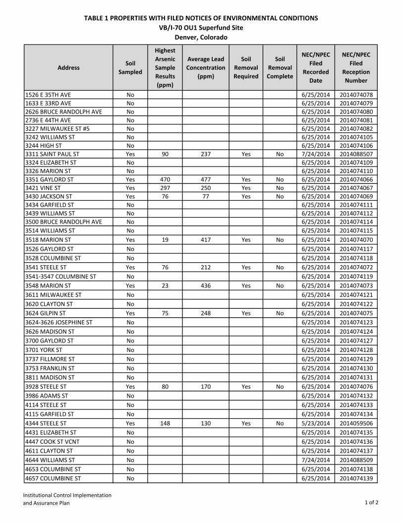
TABLE 1 PROPERTIES WITH FILED NOTICES OF ENVIRONMENTAL CONDITIONSVB/I-70 OU1 Superfund Site
Denver, Colorado
Institutional Control Implementation and Assurance Plan 1 of 2
AddressSoil
Sampled
Highest Arsenic Sample Results (ppm)
Average Lead Concentration
(ppm)
Soil Removal Required
Soil Removal Complete
NEC/NPEC Filed
Recorded Date
NEC/NPEC Filed
Reception Number
1526 E 35TH AVE No 6/25/2014 20140740781633 E 33RD AVE No 6/25/2014 20140740792626 BRUCE RANDOLPH AVE No 6/25/2014 20140740802736 E 44TH AVE No 6/25/2014 20140740813227 MILWAUKEE ST #5 No 6/25/2014 20140740823242 WILLIAMS ST No 6/25/2014 20140741053244 HIGH ST No 6/25/2014 20140741063311 SAINT PAUL ST Yes 90 237 Yes No 7/24/2014 20140885073324 ELIZABETH ST No 6/25/2014 20140741093326 MARION ST No 6/25/2014 20140741103351 GAYLORD ST Yes 470 477 Yes No 6/25/2014 20140740663421 VINE ST Yes 297 250 Yes No 6/25/2014 20140740673430 JACKSON ST Yes 76 77 Yes No 6/25/2014 20140740693434 GARFIELD ST No 6/25/2014 20140741113439 WILLIAMS ST No 6/25/2014 20140741123500 BRUCE RANDOLPH AVE No 6/25/2014 20140741143514 WILLIAMS ST No 6/25/2014 20140741153518 MARION ST Yes 19 417 Yes No 6/25/2014 20140740703526 GAYLORD ST No 6/25/2014 20140741173528 COLUMBINE ST No 6/25/2014 20140741183541 STEELE ST Yes 76 212 Yes No 6/25/2014 20140740723541-3547 COLUMBINE ST No 6/25/2014 20140741193548 MARION ST Yes 23 436 Yes No 6/25/2014 20140740733611 MILWAUKEE ST No 6/25/2014 20140741213620 CLAYTON ST No 6/25/2014 20140741223624 GILPIN ST Yes 75 248 Yes No 6/25/2014 20140740753624-3626 JOSEPHINE ST No 6/25/2014 20140741233626 MADISON ST No 6/25/2014 20140741243700 GAYLORD ST No 6/25/2014 20140741273701 YORK ST No 6/25/2014 20140741283737 FILLMORE ST No 6/25/2014 20140741293753 FRANKLIN ST No 6/25/2014 20140741303811 MADISON ST No 6/25/2014 20140741313928 STEELE ST Yes 80 170 Yes No 6/25/2014 20140740763986 ADAMS ST No 6/25/2014 20140741324114 STEELE ST No 6/25/2014 20140741334115 GARFIELD ST No 6/25/2014 20140741344344 STEELE ST Yes 148 130 Yes No 5/23/2014 20140595064431 ELIZABETH ST No 6/25/2014 20140741354447 COOK ST VCNT No 6/25/2014 20140741364611 CLAYTON ST No 6/25/2014 20140741374644 WILLIAMS ST No 7/24/2014 20140885094653 COLUMBINE ST No 6/25/2014 20140741384657 COLUMBINE ST No 6/25/2014 2014074139
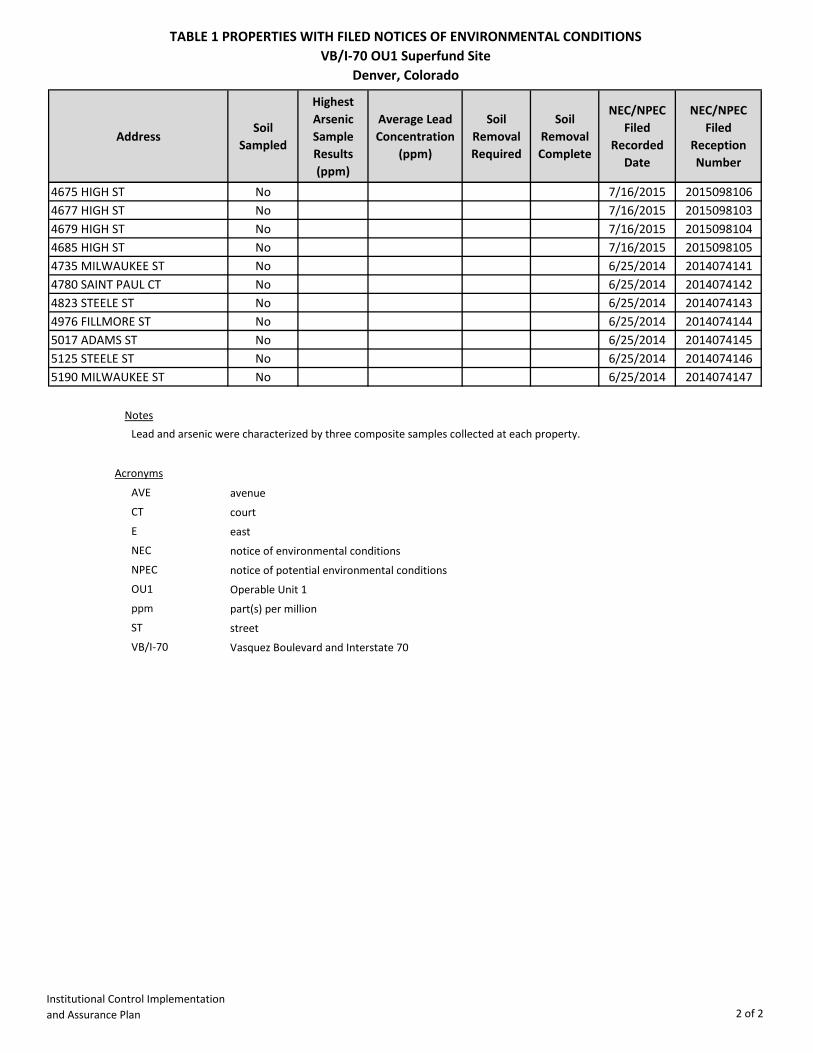
TABLE 1 PROPERTIES WITH FILED NOTICES OF ENVIRONMENTAL CONDITIONSVB/I-70 OU1 Superfund Site
Denver, Colorado
Institutional Control Implementation and Assurance Plan 2 of 2
AddressSoil
Sampled
Highest Arsenic Sample Results (ppm)
Average Lead Concentration
(ppm)
Soil Removal Required
Soil Removal Complete
NEC/NPEC Filed
Recorded Date
NEC/NPEC Filed
Reception Number
4675 HIGH ST No 7/16/2015 20150981064677 HIGH ST No 7/16/2015 20150981034679 HIGH ST No 7/16/2015 20150981044685 HIGH ST No 7/16/2015 20150981054735 MILWAUKEE ST No 6/25/2014 20140741414780 SAINT PAUL CT No 6/25/2014 20140741424823 STEELE ST No 6/25/2014 20140741434976 FILLMORE ST No 6/25/2014 20140741445017 ADAMS ST No 6/25/2014 20140741455125 STEELE ST No 6/25/2014 20140741465190 MILWAUKEE ST No 6/25/2014 2014074147
Notes
Acronyms
AVE avenueCT courtE eastNEC notice of environmental conditionsNPEC notice of potential environmental conditionsOU1 Operable Unit 1ppm part(s) per millionST streetVB/I-70 Vasquez Boulevard and Interstate 70
Lead and arsenic were characterized by three composite samples collected at each property.

FIGURES

South Platte River
70
25
70
25
Color
ado B
lvdCo
lorad
o Blvd
Martin Luther King Blvd
33rd St
35th St
E 52nd Ave
E 49th Ave
Race Ct
Vasquez
Blvd
W 48th Ave
Operable Unit 1
Operable Unit 1
Operable Unit 2
Operable Unit 3
Operable Unit 3
Area Enlarged
Colorado
0 1,000 2,000 Feet
0 250 500 MetersMap Date: January 14, 2011Map Projection: UTM, Meters, 13 North, NAD83Data Sources: Boundaries - U.S. EPA Region 8 (2011); Imagery - USDA NAIP 1-meter aerial photo (2009).*Boundaries are based on the nature and extent of contamination and are subject to change.
NPLBoundary
Operable UnitBoundary
Figure 1: Vasquez Blvd. and I-70 Superfund Site Boundary Map
Denver County, Colorado

PLATES

4677-4679 HIGH ST
3227 MILWAUKEE ST #5
3928 STEELE ST
4344 STEELE ST
3430 JACKSON ST
3421 VINE ST
3541 STEELE ST
3624 GILPIN ST
3351 GAYLORD ST
3311 SAINT PAUL ST
3518 MARION ST
3548 MARION ST
3700 GAYLORD ST
3701 YORK ST
4115 GARFIELD ST
3611 MILWAUKEE ST
3737 FILLMORE ST
4447 COOK ST
3986 ADAMS ST
5017 ADAMS ST
5125 STEELE ST
4114 STEELE ST
4611 CLAYTON ST
3434 GARFIELD ST
4685 HIGH ST
3624 JOSEPHINE ST
3541-3547 COLUMBINE ST
5190 MILWAUKEE ST
4976 FILLMORE ST
4735 MILWAUKEE ST
3244 HIGH ST
4780 SAINT PAUL CT
3528 COLUMBINE ST
3811 MADISON ST
3326 MARION ST
3620 CLAYTON ST
3626 MADISON ST
3324 ELIZABETH ST
3526 GAYLORD ST
3439 WILLIAMS ST
3753 FRANKLIN ST
4823 STEELE ST
4675 HIGH ST
3500 BRUCE RANDOLPH AVE
3514 WILLIAMS ST
2736 E 44TH AVE
4657 COLUMBINE ST
3242 WILLIAMS ST
4644 WILLIAMS ST
1633 E 33RD AVE2626 BRUCE RANDOLPH AVE
4431 ELIZABETH ST
1526 E 35TH AVE
4653 COLUMBINE ST
Sources: Esri, HERE, DeLorme, Intermap, increment P Corp., GEBCO, USGS, FAO, NPS, NRCAN, GeoBase, IGN, Kadaster NL, Ordnance Survey, Esri Japan, METI, Esri China (Hong Kong), swisstopo, MapmyIndia, © OpenStreetMapcontributors, and the GIS User Community
VASQUEZ BLVD AND I-70 OU1 PROPERTIES WITH FILED NOTICES OF
ENVIRONMENTAL CONDITIONS1
PLATE
PROJECTION : GCS NORTH AMERICAN DATUM, NAD 83SCALE 1 : 4,200 ONE INCH = 350 FEET
¯0 350 700175
Feet
LEGEND
NO FURTHER ACTION
NOTICE OF POTENTIALENVIRONMENTAL CONDITIONSFILED - SAMPLING OUTSTANDINGNOTICE OF ENVIRONMENTAL CONDITIONS FILED - SOIL REMOVAL OUTSTANDING
COUNTY LINE
DATA SOURCES:
IMAGERY - ESRI: WORLD TOPO MAPPARCELS - CITY AND COUNTY OF DENVER (2003)PARCEL STATUS - U.S. EPA REGION 8 (2015)
By: TFB G:\I70_Vasquez\GIS_Documents\Project_Maps\ICIAP\I70_001_Plate1_ICIAP_20160919.mxd 6/9/2009 8:35:57 AM
STATUS DATE: JULY 16, 2015