final feasibility study report casmalia … · 2016-02-19 · era ecological risk assessment fs...
TRANSCRIPT

APPENDIX C – ADJUSTMENT OF REMEDIAL FOOTPRINT FS AREAS 2 AND 3
FINAL FEASIBILITY STUDY REPORT CASMALIA RESOURCES SUPERFUND SITE
CASMALIA, CALIFORNIA
PREPARED BY: ARCADIS


Casmalia Resources Superfund Site Final Feasibility Study Report Appendix C
TABLE OF CONTENTS
Appendix C-1 Adjustment of Remedial Footprint for FS Area 2 Appendix C-2 Residual Risk Analysis for FS Area 3
C‐i

APPENDIX C-1
ADJUSTMENT OF REMEDIAL FOOTPRINT FOR FS AREA 2


Casmalia Site Remediation
MemorandumAdjustment of the Remedial
Footprint for the West Canyon Spray Area and the RCRA Canyon
Prepared for:
USEPA, Region 975 Hawthorne Street
San Francisco, CA 94105

Casmalia Resources Superfund Site Adjusted Remedial Footprint Memo
TABLE OF CONTENTS
1.0 Introduction 1-12.0 Summary of Methodology 2-1
2.1 Identification of Locations for Adjustment of Remedial Footprint 2-12.2 Estimation of Adjusted Remedial Footprint Area 2-22.3 Estimated Residual Risks Based on Adjusted Remedial Footprint 2-2
3.0 Summary and Conclusions 3-14.0 References 4-1
i

Casmalia Resources Superfund Site Adjusted Remedial Footprint Memo
LIST OF TABLES
Table # Description1 Locations Identified for Adjustment of Remedial Footprint in the WCSA and RCRA
Canyon2 Summary of Residual Exposure Point Concentrations and Residual Risks for the
WCSA and RCRA Canyon3 Residual Risk Estimates for Terrestrial Wildlife at WCSA 4 Residual Risk Estimates for Terrestrial Wildlife at RCRA Canyon
ii
Casmalia Resources Superfund Site Adjusted Remedial Footprint Memo
LIST OF FIGURES
Figure # Description1 Adjusted Remedial Footprint for WCSA and RCRA Canyon
iii

Casmalia Resources Superfund Site Adjusted Remedial Footprint Memo
LIST OF ATTACHMENTS
ATTACHMENT 1 Selected Figures and Tables from the Remedial Investigation and Feasibility Study
iv
Casmalia Resources Superfund Site Adjusted Remedial Footprint Memo
LIST OF ACRONYMS AND ABBREVIATIONS
bgs below ground surfaceCOI chemical of interestCSC Casmalia Steering CommitteeERA ecological risk assessmentFS Feasibility StudyHQ hazard quotientLOAEL lowest-observed adverse effects levelNOAEL no-observed adverse effects levelRBC risk-based concentrationRCRA Resource Conservation Recovery ActRI Remedial InvestigationTRV toxicity reference valueUSEPA U.S. Environmental Protection AgencyWCSA West Canyon Spray Area
v

Casmalia Resources Superfund Site Adjusted Remedial Footprint Memo
1.0 Introduction
This Memorandum (Memo) was prepared by ARCADIS for the Casmalia Steering Committee (CSC) for the Casmalia Resources Superfund Site (the site), located in Casmalia, California. The purpose of this Memo is to provide a rationale for adjusting the remedial footprint proposed for the West Canyon Spray Area (WCSA) and the Resource Conservation Recovery Act (RCRA) Canyon for use in the Feasibility Study report (FS; CSC, 2011a).
To address United States Environmental Protection Agency’s (USEPA) comment (Comment No. 40 in a letter from USEPA dated May 17, 2011) on the FS report (CSC, 2011a) and specifically related to the ecological risks driven by barium, CSC re-evaluated the risks to ecological receptors exposed to soils in the WCSA and the RCRA Canyon at the site. Historical activities indicate that drilling mud containing barium sulfate was spread in these areas. Barium sulfate, which is about four times denser than water, is typically used by oil and gas industries as a weighing agent during drilling. Additionally, high-density barium sulfate is insoluble and therefore, provides stability for the drilling mud (Halliburton et al., 2007).
Barium toxicity to ecological receptors (wildlife) is due to free barium ions which can be absorbed into lungs and intestines. Barium sulfate, being insoluble, does not cause significant toxicity, as free barium ions are not released. However, soluble forms of barium (such as barium hydroxide) dissociate in water and release free barium anions, which can readily be absorbed by lungs and intestines and cause adverse toxic effects (Halliburton et al., 2007).
In 1993, USEPA exempted barium sulfate from the reporting requirements under Section 313 of the Emergency Planning and Community Right-to-Know Act of 1986 (USEPA, 1993). USEPA stated that:
“Human and animal data show that barium sulfate is essentially non-toxic to humans or other mammalian species. This is attributable to the very low solubility of the compound in water. Barium sulfate is not expected to be absorbed through the skin and is expected to be only minimally absorbed through the lung and gastrointestinal tract. . . . Barium sulfate cannot reasonably be anticipated to cause acute or chronic toxicity in humans or adverse effects in the environment.”
The toxicity values used in the ecological risk assessment (ERA) as part of the Remedial Investigation (RI) for the site (CSC, 2010) were all based on soluble forms of barium. The barium toxicity reference values (TRVs) for mammals and birds were based on toxic effects of barium chloride and barium hydroxide, respectively, both highly soluble. Similarly, for plants and soil invertebrates, soluble forms of barium were used to develop screening levels. Menzie et al. (2008) compare the solubility and toxicity of barium sulfate to the soluble forms of barium used to develop screening levels in the USEPA Ecological Soil Screening Levels (EcoSSL) guidance (USEPA, 2005). Barium sulfate is considered nontoxic to invertebrates, plants, and wildlife (Menzie et al., 2008). Kuperman et al (2006) conducted range-finding tests for barium with four barium compounds to determine which was most suitable to produce a toxicity benchmark. Of the four compounds, only barium sulfate was insoluble and it did not affect adult survival of the three soil invertebrate species tested at concentrations as high as 10,000 milligrams per kilogram (mg/kg).
1-1

Casmalia Resources Superfund Site Adjusted Remedial Footprint Memo
Based on USEPA’s exemption of barium sulfate and the knowledge of historical activities at the WCSA and the RCRA Canyon, the calculated ecological risk from exposure to barium reported in the RI (CSC, 2011b) was overestimated. Considering that barium at the WCSA and the RCRA Canyon is barium sulfate and, therefore, not toxic to ecological receptors, barium can be excluded as a risk-driving constituent or chemical of interest (COI).
The remedial footprint (Figure 1) proposed for the WCSA and the RCRA Canyon in the FS (CSC, 2011a) was based on four COIs: barium, chromium, copper, and zinc. For this Memo, the proposed remedial footprint was adjusted to exclude barium as one of the COIs. Additionally, the residual risks (i.e., risk based on exposure to soil outside of the remedial footprint) were calculated to assess whether remaining COIs in exposed soils would pose adverse effects to ecological receptor populations. The approach and methods used to adjust the remedial footprint at the WCSA and the RCRA Canyon are summarized in the following sections.
1-2

Casmalia Resources Superfund Site Adjusted Remedial Footprint Memo
2.0 Summary of Methodology
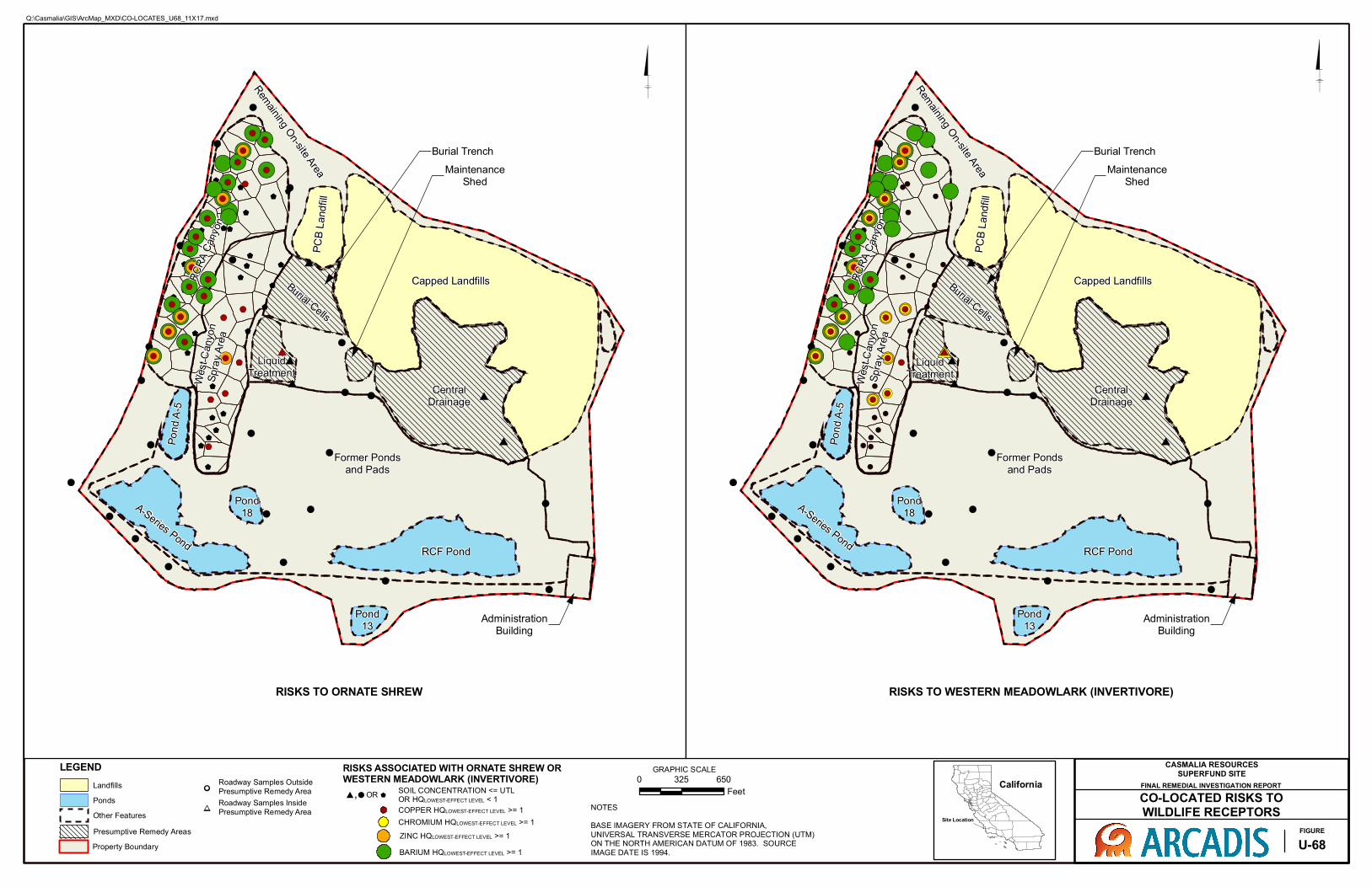
The collocated risk figures (Figures U-67 and U-68) from the ERA (Appendix U) presented in the Final RI report (CSC, 2011b) were used for this evaluation. These figures are provided in Attachment 1 of this Draft Memo. The collocated risk figures present the locations where the hazard quotient (HQ) for each COI is greater than 1 for plants (based on plant screening levels), soil invertebrates (based on soil invertebrate screening levels), ornate shrew (protective of all mammals; based on the lowest-adverse effects level [LOAEL] or high TRVs), and the invertivorous western meadowlark (protective of all birds; based on the LOAEL/high TRVs). These figures also identify locations were soil concentrations are at or below backgrounddeveloped for the site.
2.1 Identification of Locations for Adjustment of Remedial Footprint
A step-wise approach was used to adjust the proposed remedial footprint for the WCSA and the RCRA Canyon based on excluding barium as a COI.
First, sample locations were identified within the proposed remedial footprint (Figure 1) for the WCSA and the RCRA Canyon with HQs greater than 1 based on barium alone. In the WCSA, no such locations were identified. In the RCRA Canyon, locations RISBRC-01, RISSRC-03,and RISBRC-08 indicate only a barium HQ greater than 1 for one or more receptors.
Second, sample locations were identified within the proposed remedial footprint (Figure 1) forthe WCSA and the RCRA Canyon with low HQs (i.e., HQ greater than 1 but less than 3) for plants and soil invertebrates for COIs other than barium. In the WCSA, no such locations were identified. In the RCRA Canyon, locations RISBRC-02, RISBRC-03, RISBRC-18, and RISSRC-12 indicate zinc HQs are greater than 1 for plants and/or soil invertebrates. HQs for plants and soil invertebrates based on the maximum detected concentrations of zinc in soil at these locations are presented in Table 1. These HQs were estimated based on the ecological risk-based concentrations (RBCs) presented in Table 8-3 of the FS (CSC, 2011a), also included in Attachment 1. Zinc HQs for plants and soil invertebrates ranged from 0.8 to 2.8 at these locations.
Third, locations were identified within the proposed remedial footprint (Figure 1) for the WCSA and the RCRA Canyon with low HQs (i.e., HQ greater than 1 but less than 3) for mammals and birds for COIs other than barium. In the WCSA, no such locations were identified. In the RCRA Canyon, locations RISBRC-12, RISSRC-15, RISSRC-12, RISSRC-02, and RISSRC-14 indicate copper HQs are greater than 1 for mammals. Also, location RISBRC-03 indicates a copper HQ equal to 1 for birds (see Figure U-68 in Attachment 1). HQs based on the maximum detected concentrations of copper in soil at these locations are presented in Table 1. These HQs were estimated based on the ecological RBCs presented in Table 8-3 of the FS (CSC, 2011a), also included in Attachment 1. Copper HQs for mammals ranged from 1.3 to 1.7 at these locations.
Fourth, locations with soil concentrations at or below background that were included in the proposed remedial footprint (Figure 1) for the WCSA and the RCRA Canyon were evaluated for this adjustment. One such location, RISBRC-13 was identified in the RCRA Canyon.
2-1

Casmalia Resources Superfund Site Adjusted Remedial Footprint Memo
Finally, location RISSSA-09 was not originally included in the proposed remedial footprint (Figure 1) for the WCSA. HQs for chromium at this location are greater than 1 for most of the ecological receptors except for mammals. HQs for ecological receptors based on the maximum detected concentrations of chromium in soil at this location are presented in Table 1.
Sample locations within the proposed remedial footprint in the WCSA include RISBSA-04, RISBSA-05, RISSSA-02, RISSSA-05, RISSSA-06, and RISSSA-09 through RISSSA-11 (Figure 1). Data associated with these samples were simply excluded from the residual risk dataset for the WCSA (see Section 2.3 below).
Sample locations within the proposed remedial footprint in the RCRA Canyon include RISBRC-05, RISBRC-06, RISBRC-11, RISBRC-14, RISBRC-19 through RISBRC-23, RISSRC-01, and RISSRC-04 through RISSRC-11 (Figure 1). Data associated with these samples were simply excluded from the residual risk dataset for the RCRA Canyon (see Section 2.3 below).
2.2 Estimation of Adjusted Remedial Footprint Area
For the purpose of this Memo, the Thiessen polygons constructed for the ERA (CSC, 2010) were used here to estimate the boundaries of the proposed remedial footprint and the adjusted remedial footprint based on the locations identified in Section 2.1.
The approximate area for the proposed remedial footprint in the WCSA is 5.2 acres. The polygon for location RISSSA-09 is approximately 0.3 acre. Including RISSSA-09 within the proposed remedial footprint will increase the total remedial footprint for the WCSA to approximately 5.5 acres.
The approximate area for the proposed remedial footprint in the RCRA Canyon is 15 acres. The polygons representing the locations identified in Section 2.1 (and Table 1) is approximately 6.6 acres. Excluding the locations/polygons from the proposed remedial footprint will decrease the total remedial footprint for the RCRA Canyon to approximately 8.4 acres.
Please note, the boundaries for the remedial areas in the WCSA and RCRA Canyon will likely be adjusted to follow topographical contours and to address other Remedial Action Objectives of the FS when defining the final areas for remediation. The final boundaries will be presented and discussed in the Revised FS but will not be less than the areas defined by this Memo.
2.3 Estimated Residual Risks Based on Adjusted Remedial Footprint
Residual risks were estimated for ecological receptors potentially exposed to COIs other than barium in soil outside the boundary of the adjusted remedial footprint in the WCSA and the RCRA Canyon. Residual exposure point concentrations (EPCs) and residual risks were estimated following the approach used in the ERA presented in the RI (CSC, 2011b).
First, the locations identified to be within the proposed remedial footprint (Section 2.1) were simply excluded from the soil datasets for surface soil (0 to 2 feet below ground surface [bgs]) and shallow soil (0 to 6 feet bgs) in the WCSA and RCRA Canyon and then non-spatial residual EPCs were calculated based on the soil data outside of the proposed remedial footprint for chromium, copper, and zinc using USEPA’s ProUCL Version 4.00.02 (USEPA, 2007).
2-2
Casmalia Resources Superfund Site Adjusted Remedial Footprint Memo
Residual risks to plants and soil invertebrates were estimated by comparing the residual EPCs to the soil screening levels for plants and soil invertebrates, respectively, and are summarized in Table 2. The same screening values used in the ERA (Table U-15 of the ERA) were also used for these comparisons. Residual HQs for copper and zinc are equal to or less than 1 for plants and soil invertebrates in the WCSA and in the RCRA Canyon (Table 2). Residual HQs for chromium in the WCSA and in the RCRA Canyon are greater than 1; however, the residual EPCs are less than background (Table 2).
Residual risks to mammals and birds were estimated using the residual EPCs, the exposure parameters for terrestrial wildlife (from Table U-11 of the ERA [CSC, 2011b]), bioaccumulation factors (from Tables U-13a through U-13c of the ERA [CSC, 2011b]), and LOAEL TRVs (from Table U-18 of the ERA [CSC, 2011b]). The area use factor was assumed to be 1. Residual LOAEL/high TRV and no-observed adverse effects levels (NOAEL/low TRV) based HQs for the ornate shrew and the invertivorous western meadowlark are summarized in Table 2. Residual LOAEL/high TRV and NOAEL/low TRV based HQs for all the terrestrial receptors including the ornate shrew (invertivorous mammal), California vole (herbivorous mammal), striped skunk (carnivorous mammal), western meadowlark (invertivorous bird and herbivorous bird), and American kestrel (carnivorous bird) are presented in Table 3.
For the ornate shrew, as summarized in Table 2, residual LOAEL/high TRV and NOAEL/low TRV-based HQs for chromium and copper are equal to or less than 1 in the WCSA and the RCRA Canyon. The LOAEL/high TRV-based HQs for zinc are less than 1 in both the areas but the NOAEL/low TRV-based HQs are greater than 1. However, the residual EPCs for zinc are less than background.
For the invertivorous western meadowlark, as summarized in Table 2, residual LOAEL/high TRV and NOAEL/low TRV-based HQs for chromium are less than 1 in the WCSA and the RCRA Canyon. The LOAEL/high TRV-based HQs for chromium and zinc are less than 1 in both the areas but the NOAEL/low TRV-based HQs are greater than 1. However, the residual EPCs for chromium and zinc are less than background.
2-3


Casmalia Resources Superfund Site Adjusted Remedial Footprint Memo
3.0 Summary and Conclusions
The remedial footprint for proposed for the WCSA and the RCRA Canyon was re-evaluated to address USEPA’s comment (Comment No. 40 in a letter from USEPA dated May 17, 2011) on the FS report (CSC, 2011a). Based on the toxicity information available for barium sulfate, the form of barium likely to be present in these areas, barium was not considered toxic to ecological receptors and, therefore, was excluded as a COI in soil in the WCSA and the RCRA Canyon. Locations were identified where barium alone was a COI and other COIs at concentrations slightly above the ecological RBCs, and the proposed remedial footprint in the WCSA and the RCRA Canyon were adjusted accordingly. Additionally, residual risks were estimated for ecological receptors that could potentially be exposed to soils outside the boundary of the adjusted remedial areas in the WCSA and the RCRA Canyon to assess if risks would be acceptable.
The WCSA adjusted remedial footprint was increased from the proposed 5.2 acres by approximately 0.3 acre, making it a total of approximately 5.5 acres. The RCRA Canyon adjusted remedial footprint was reduced from the proposed 15 acres by approximately 6.6acres, making it a total of approximately 8.4 acres.
The residual HQs calculated for the WCSA and the RCRA Canyon indicate that post-remedial risks to plant, soil invertebrate, mammal, and bird populations will be acceptable.
In conclusion, excluding barium from the list of COIs and adjusting the proposed remedial footprint is expected to result in acceptable post-remedial risks to ecological receptor populations at the WCSA and the RCRA Canyon.
3-1


Casmalia Resources Superfund Site Adjusted Remedial Footprint Memo
4.0 References
CSC. 2011a. Draft Feasibility Study. Casmalia Resources Superfund Site. Casmalia Steering Committee. February.
CSC. 2011b. Final Draft Remedial Investigation Report. Casmalia Resources Superfund Site. Casmalia Steering Committee. April.
Halliburton, J.M., McHugh, T.E., and Higgins, E.A. 2007. Barium Sulfate: A Protocol for Determining Higher Site-Specific Barium Cleanup Levels. Society of Petroleum Engineers. March.
Kuperman, R.G., Checkai, R.T., Simini, M., Phillips, C.T., Speicher, J.A., Barclift, D.J. 2006. Toxicity benchmarks for antimony, barium, and beryllium determined using reproduction endpoints for Folsomia candida, Eisenia fetida and Enchytraeus crypticus. Environmental Toxicology and Chemistry 25:754-762.
Menzie, C.A., Southworth, B., Stephenson, G. and Feisthauer, N. 2008. The importance of understanding the chemical form of a metal in the environment: The case of barium sulfate (barite). Human and Ecological Risk Assessment 14:974-991.
USEPA. 1993. Barium Sulfate; Toxic Chemical Release Reporting Community Right-to-Know. 40 CFR Part 372, Federal Register. 58, No. 111, 32622-32628. United States Environmental Protection Agency. June 10.
USEPA. 2005. Ecological Soil Screening Levels for Barium. United States Environmental Protection Agency. Office of Soild Waste and Emergency Response. February.
USEPA. 2007. ProUCL Version 4.00 Technical Guide. United States Environmental Protection Agency. EPA/600/R-07/041. April
USEPA. 2011. Comments on the Draft Feasibility Study, Casmalia Resources Superfund Site. United States Environmental Protection Agency. Letter dated May 11, 2011.
4-1

TABLES


Table 1Locations Identified for Adjustment of the Remedial Footprint in the WCSA and RCRA Canyon
Hazard Quotients Based on Ecological RBCs
Area Locationa
Include/Exludefrom Proposed
Remedial Footprint COI
Backgound UTL for COIs other than Bariumb
(mg/kg)
MaximumDetected
Concentration for COIs other than Bariumb (mg/kg)
Receptors with HQ > 1 for COIs other
than Bariumb Plant Soil Invertebrate Mammal BirdWCSA RISSSA-09 Include Cr 47 330 Plant + Birds 330 825 Not a RD 4.5
RCRA Canyon RISBRC-01 Exclude Ba -- -- -- -- -- -- --RCRA Canyon RISBRC-08 Exclude Ba -- -- -- -- -- -- --RCRA Canyon RISSRC-03 Exclude Ba -- -- -- -- -- -- --RCRA Canyon RISBRC-02 Exclude Ba + Zn 104 110 Plants + Inverts 2.2 1.1 0.3 0.6
Ba + Zn 104 140 Plants + Inverts 2.8 1.4 0.4 0.7Ba + Cu 19 26 Birds + Mammals 0.4 0.3 1.7 1.0
RCRA Canyon RISBRC-12 Exclude Ba + Cu 19 20 Mammal 0.3 0.3 1.3 0.8RCRA Canyon RISBRC-18 Exclude Ba + Zn 104 120 Plants + Inverts 2.4 1.2 0.3 0.6RCRA Canyon RISSRC-02 Exclude Ba + Cu 19 20 Mammal 0.3 0.3 1.3 0.8
Ba + Zn 104 77 Plants 1.5 0.8 0.2 0.4Ba + Cu 19 21 Mammal 0.3 0.3 1.4 0.8
RCRA Canyon RISSRC-14 Exclude Ba + Cu 19 21 Mammal 0.3 0.3 1.4 0.8RCRA Canyon RISSRC-15 Exclude Ba + Cu 19 21 Mammal 0.3 0.3 1.4 0.8RCRA Canyon RISBRC-13 Exclude none (bkg) -- -- -- -- -- --
Notes:a Location identified for inclusion/exclusion from the Remedial Footprint proposed in the Feasibility Study report (CSC, 2011).b Barium excluded as a risk driver/COI. See Draft Memorandum for details.c Hazard quotients > 1 are in bold and shaded in grey.
Ecological RBCs (mg/kg) from Feasibility Study report (Table 8-3 [CSC, 2011]).
Surface RBC Subsurface
(based on birds)(based on small
mammals)Zinc 192 353 50 100Copper 25.5 14.9 70 80Chromium 73.9 Not a RD 1 0.4
Abbreviations:COI = chemical of interest (Ba = barium, Cu = copper, Cr = chromium, Zn = zinc)mg/kg = milligrams per kilogramNot a RD = not a risk driver RBC = risk-based concentrationWCSA = West Canyon Spray Area
References:CSC. 2011. Feasibility Study, Casmalia Resources Superfund Site. Casmalia Steering Committee. February.
COIPlant Screening
LevelInvertebrate
Screening Level
RCRA Canyon RISBRC-03 Exclude
RCRA Canyon RISSRC-12 Exclude
Page 1 of 1

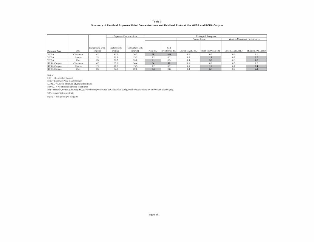
Table 2Summary of Residual Exposure Point Concentrations and Residual Risks at the WCSA and RCRA Canyon
Exposure Concentrations Ecological ReceptorsOrnate Shrew Western Meadolark (Invertivore)
Exposure Area COIBackground UTL
(mg/kg)Surface EPC
(mg/kg)Subsurface EPC
(mg/kg) Plant HQSoil
Invertebrate HQ Low (LOAEL) HQ High (NOAEL) HQ Low (LOAEL) HQ High (NOAEL) HQWCSA Chromium 47 40.0 36.2 36 100 0.2 0.7 0.6 0.6WCSA Copper 19 16.9 15.2 0.2 0.2 0.7 1.1 0.7 2.0WCSA Zinc 104 52.7 53.8 1.1 0.5 0.1 3.9 0.3 2.8RCRA Canyon Chromium 47 35.0 34.4 34 88 0.2 0.6 0.5 0.5RCRA Canyon Copper 19 17.6 15.5 0.2 0.2 0.7 1.2 0.7 2.1RCRA Canyon Zinc 104 84.9 69.8 1.4 0.8 0.1 6.3 0.4 4.4
Notes:COI = Chemical of InterestEPC = Exposure Point ConcentrationLOAEL = Lowest observed adverse effect levelNOAEL = No observed adverse effect levelHQ = Hazard Quotient (unitless); HQ>1 based on exposure area EPCs less than background concentrations are in bold and shaded grey.UTL = upper tolerance limitmg/kg = milligrams per kilogram
Page 1 of 1

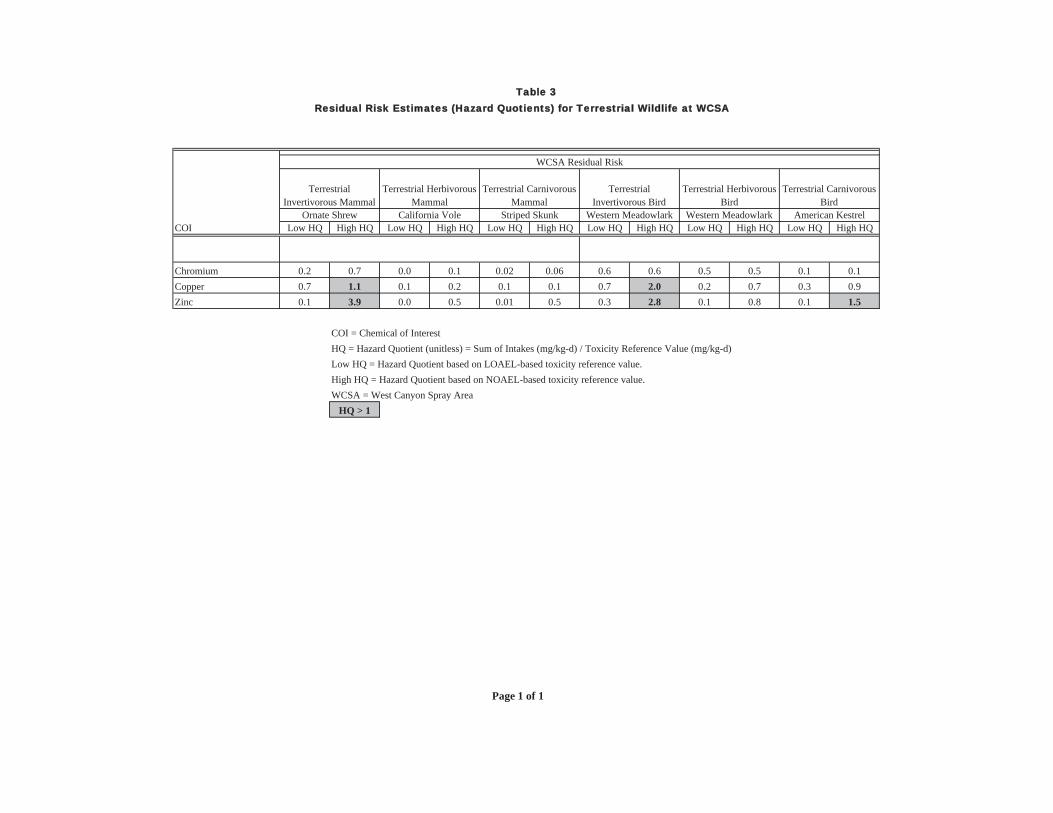
Table 3 Residual Risk Estimates (Hazard Quotients) for Terrestrial Wildlife at WCSA
COI Low HQ High HQ Low HQ High HQ Low HQ High HQ Low HQ High HQ Low HQ High HQ Low HQ High HQ
Chromium 0.2 0.7 0.0 0.1 0.02 0.06 0.6 0.6 0.5 0.5 0.1 0.1Copper 0.7 1.1 0.1 0.2 0.1 0.1 0.7 2.0 0.2 0.7 0.3 0.9Zinc 0.1 3.9 0.0 0.5 0.01 0.5 0.3 2.8 0.1 0.8 0.1 1.5
COI = Chemical of InterestHQ = Hazard Quotient (unitless) = Sum of Intakes (mg/kg-d) / Toxicity Reference Value (mg/kg-d)Low HQ = Hazard Quotient based on LOAEL-based toxicity reference value.High HQ = Hazard Quotient based on NOAEL-based toxicity reference value.WCSA = West Canyon Spray Area
HQ > 1
Western Meadowlark Western Meadowlark American Kestrel
WCSA Residual Risk
Terrestrial Herbivorous Bird
Terrestrial Carnivorous Bird
TerrestrialInvertivorous Mammal
Ornate Shrew California Vole Striped Skunk
Terrestrial Herbivorous Mammal
Terrestrial Carnivorous Mammal
TerrestrialInvertivorous Bird
Page 1 of 1

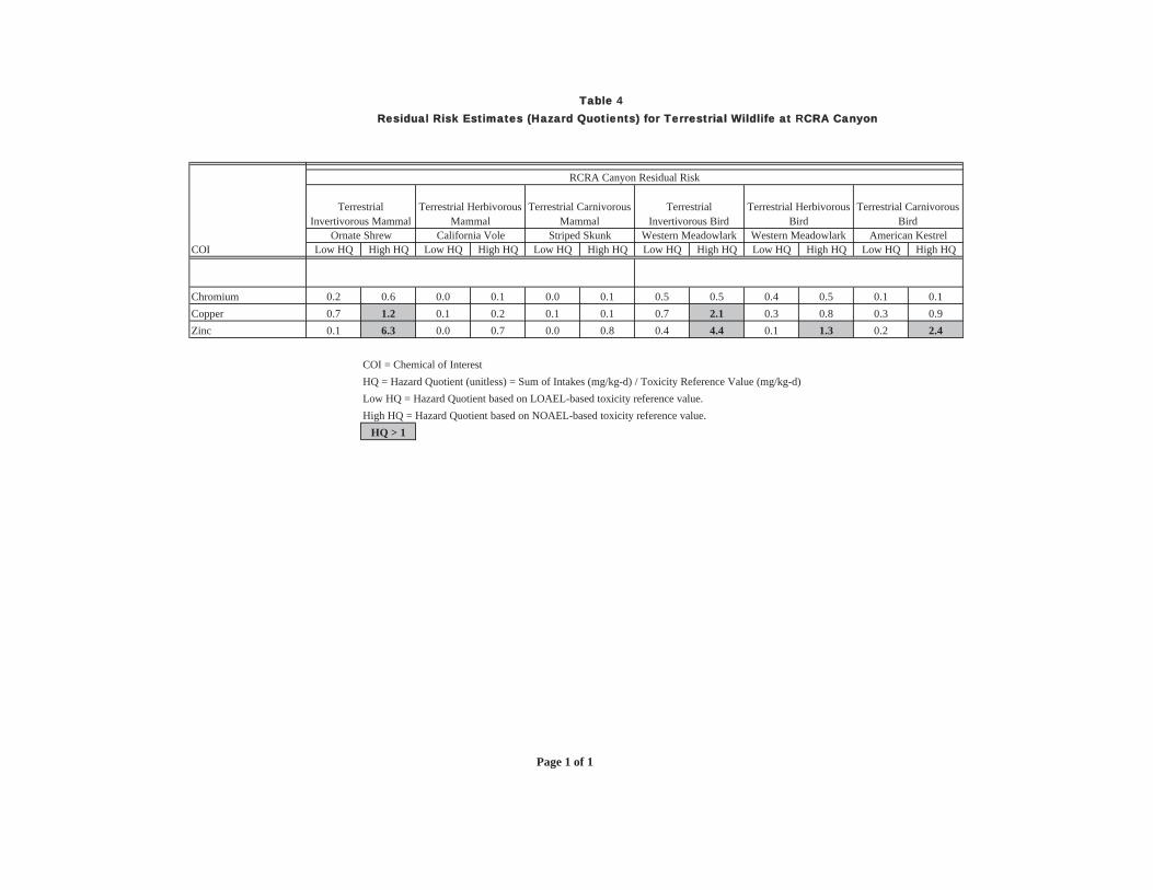
Table 4 Residual Risk Estimates (Hazard Quotients) for Terrestrial Wildlife at RCRA Canyon
COI
ChromiumCopperZinc
Low HQ High HQ Low HQ High HQ Low HQ High HQ Low HQ High HQ Low HQ High HQ Low HQ High HQ
0.2 0.6 0.0 0.1 0.0 0.1 0.5 0.5 0.4 0.5 0.1 0.10.7 1.2 0.1 0.2 0.1 0.1 0.7 2.1 0.3 0.8 0.3 0.90.1 6.3 0.0 0.7 0.0 0.8 0.4 4.4 0.1 1.3 0.2 2.4
COI = Chemical of InterestHQ = Hazard Quotient (unitless) = Sum of Intakes (mg/kg-d) / Toxicity Reference Value (mg/kg-d)Low HQ = Hazard Quotient based on LOAEL-based toxicity reference value.High HQ = Hazard Quotient based on NOAEL-based toxicity reference value.
HQ > 1
RCRA Canyon Residual Risk
California Vole Striped Skunk Western Meadowlark Western Meadowlark American Kestrel
TerrestrialInvertivorous Bird
Ornate Shrew
Terrestrial Herbivorous Bird
Terrestrial Carnivorous Bird
TerrestrialInvertivorous Mammal
Terrestrial Herbivorous Mammal
Terrestrial Carnivorous Mammal
Page 1 of 1


FIGURE


LiquidTreatment
Former Pondsand Pads
Remaining On-site Area
Capped LandfillsRCRA
Cany
on
CentralDrainage
West
Cany
onSp
ray Ar
ea
A-Series Pond
Burial Cells
PCB L
andfi
ll
Pond
A-5
Pond18
RISSSA-12
RISSSA-11
RISSSA-10
RISSSA-09RISSSA-08
RISSSA-07
RISSSA-04
RISSSA-03
RISSSA-02
RISSSA-01
RISSRC-18
RISSRC-16
RISSRC-15
RISSRC-14 RISSRC-13
RISSRC-12
RISSRC-11RISSRC-10
RISSRC-09
RISSRC-08
RISSRC-07
RISSRC-06
RISSRC-05
RISSRC-04
RISSRC-02RISSRC-01
RISBSA-05
RISBSA-04
RISBSA-03
RISBSA-01
RISBRC-23
RISBRC-22
RISBRC-20
RISBRC-19
RISBRC-18
RISBRC-17
RISBRC-16
RISBRC-15RISBRC-14
RISBRC-13
RISBRC-12
RISBRC-10
RISBRC-09
RISBRC-08
RISBRC-07
RISBRC-06
RISBRC-05
RISBRC-03
RISBRC-01
RISSSA-06
RISSSA-05
RISSRC-03
RISBSA-02
RISBRC-21
RISBRC-11
RISBRC-04
RISBRC-02
LAKEWOOD DB: MLM TM: MPProject (B00 01224.00001)
GRAPHIC SCALE
FIGURE
1
ADJUSTED REMEDIAL FOOTPRINTFOR WSCA AND RCRA CANYONSite Location
California
NOTESBASE IMAGERY FROM STATE OF CALIFORNIA, UNIVERSAL TRANSVERSE MERCATOR PROJECTION (UTM) ON THE NORTH AMERICAN DATUM OF 1983. SOURCE IMAGE DATE IS 1994.
CASMALIA RESOURCESSUPERFUND SITE
Q:\Casmalia\GIS\ArcMap_MXD\Remedial_Footprint_070611.mxd
0 175 350Feet
LEGENDLandfillsPondsOther Features
Property BoundaryPresumptive Remedy Areas Thiessen Polygons of Sample Locations
Adjusted Remedial FootprintPrevious Remedial Footprint


ATTACHMENT 1
SELECTED FIGURES AND TABLES FROM THE REMEDIAL INVESTIGATION AND FEASIBILITY STUDY


$
$
$
$
$
$
$
$
$
$ $
$
$
$
$$
$
$
$
$
$
$
$
$
$
$
$
$
$
$
$
$
$
$
$
$$$$
$
$
$
$
$
$$$
$
$
$
$
$
$
$$
$$
$
$
$
$$
$
$$
$
$
$
$
$
$$
$
$
$
$
$
$
$
$
$
$
$
$
$
$
$
$
$
$
$
$
$
$
$
$$
$
$
$
$
$
$
$
$
$
$
$
$
$
$
$
$
$
$
$
$
$
$
$$
$
$
$
$
$
$
$
$$
$
$$
$
$
$
$
$
$
$
$
$
$
$
$
$
$
$
!
!
!
!
!
!
!
#*
!
#*
#*
!
!
!
!
!
! #*
!
!
!
!
!
!
!
!
!
#*
!(!(
!(
!(
!(
!(
!(!(
!(
!(!(
!(
!(
!(
!(
!(
!(
!( !(!(
!(
!(
!(
!(!(!(
!(
!(
!(
!(!(
!(!(
!(!(
!(
!(
!(
!(
!(
!(
!(
!(
!(
!(
!(
!(
!(
!(
!(
!(
!(
!(
!(
!(!(
!(!(
!(!(
!(
!(
!(
!(
!(
!(
!(
!(
!(!(
!(!(
!(#*
!(
!(
!(
!( !(!(
!(!(
!(
MaintenanceShed
Burial Trench
LiquidTreatment
Former Pondsand Pads
Former Pondsand Pads
Remaining On-site Area
Capped LandfillsRCRA
Cany
on
CentralDrainage
RCF Pond
West
Cany
onSp
ray Ar
ea
A-Series Pond
Burial CellsPC
B Lan
dfill
Pond
A-5
Pond18
Pond13 Administration
Building
$
$
$
$$
$
$$
$
$
$
$
$
$$
$
$
$
$
$
$
$
$
$
$
$
$
$
$
$$
$
$
$
$
$
$
$
$$
$
$$
$
$
$
$
$
$
$
$
$
$
$
$
$
$
$
!(
!(
!(
!(
!(
!(
!(
#*
!(
#*
#*
!(
!(
!(
!(
!(
!( #*
!(
!(
!(
!(
!(
!(
!(
!(
!(
#*
!(!(
!(
!(
!(
!(
!(!(
!(
!(!(
!(
!(
!(
!(
!(
!( !(
!(
!(
!(
!(!(!(
!(
!(!(
!(
!(
!(
!(
!(
!(
!(
!(
!(
!(
!(
!(
!(
!(
!(
!(!(
!(
!(!(
!(!(
!(
!(
!(
!(
!(
!(
!(
!(
!(
!(!(
!(!(
!( #*
!(!(
!(!(
!(#*
MaintenanceShed
Burial Trench
LiquidTreatment
Former Pondsand Pads
Remaining On-site Area
Capped LandfillsRCRA
Cany
on
CentralDrainage
RCF Pond
West
Cany
onSp
ray Ar
ea
A-Series Pond
Burial Cells
PCB L
andfi
ll
Pond
A-5
Pond18
Pond13 Administration
Building
Site Location
California
FIGURE
U-67
CO-LOCATED RISKS TOECOLOGICAL COMMUNITIES
CASMALIA RESOURCESSUPERFUND SITE
FINAL REMEDIAL INVESTIGATION REPORTGRAPHIC SCALE
NOTESBASE IMAGERY FROM STATE OF CALIFORNIA, UNIVERSAL TRANSVERSE MERCATOR PROJECTION (UTM) ON THE NORTH AMERICAN DATUM OF 1983. SOURCE IMAGE DATE IS 1994.
LEGEND RISKS ASSOCIATED WITH SOIL INVERTEBRATESOR TERRESTRIAL PLANTS
SOIL CONCENTRATION <= UTLOR HQLOWEST-EFFECT LEVEL < 1COPPER HQLOWEST-EFFECT LEVEL >= 1CHROMIUM HQLOWEST-EFFECT LEVEL >= 1
BARIUM HQLOWEST-EFFECT LEVEL >= 1
0 325 650Feet
RISKS TO SOIL INVERTEBRATES RISKS TO TERRESTRIAL PLANTS
Q:\Casmalia\GIS\ArcMap_MXD\CO-LOCATES_U67_11X17.mxd
LandfillsPondsOther Features
Property BoundaryPresumptive Remedy Areas ZINC HQLOWEST-EFFECT LEVEL >= 1
$
Roadway Samples OutsidePresumptive Remedy Area!!
Roadway Samples InsidePresumptive Remedy Area##
! OR#,

Site Location
California
FIGURE
U-68
CO-LOCATED RISKS TOWILDLIFE RECEPTORS
GRAPHIC SCALE
NOTESBASE IMAGERY FROM STATE OF CALIFORNIA, UNIVERSAL TRANSVERSE MERCATOR PROJECTION (UTM) ON THE NORTH AMERICAN DATUM OF 1983. SOURCE IMAGE DATE IS 1994.
RISKS ASSOCIATED WITH ORNATE SHREW ORWESTERN MEADOWLARK (INVERTIVORE)
Q:\Casmalia\GIS\ArcMap_MXD\CO-LOCATES_U68_11X17.mxd
$
$
$
$$
$
$$
$
$
$
$
$
$$
$
$
$
$
$
$
$
$
$
$
$
$
$
$
$$
$
$
$
$
$
$
$
$$
$
$$
$
$
$
$
$
$
$
$
$
$
$
$
$
$
$
!(
!(
!(
!(
!(
!(
!(
#*
!(
#*
#*
!(
!(
!(
!(
!(
!( #*
!(
!(
!(
!(
!(
!(
!(
!(
!(
#*
!(!(
!(
!(
!(
!(
!(!(
!(
!(
!(
!(
!(
!( !(
!(
!(
!(
!(!(!(
!(!(
!(
!(
!(
!(
!(
!(
!(
!(
!(
!(
!(
!(!(
!(
!(
!(
!(
!(!(
!(
!(
!(
!(
!(
!(
!(
!(
!(
!(
!(
!(
!(!(
!(#*
MaintenanceShed
Burial Trench
LiquidTreatment
Former Pondsand Pads
Remaining On-site Area
Capped LandfillsRCRA
Cany
on
CentralDrainage
RCF Pond
West
Cany
onSp
ray Ar
ea
A-Series Pond
Burial CellsPC
B Lan
dfill
Pond
A-5
Pond18
Pond13 Administration
Building
!(
!(
!(
!(!(
!(
!(!(
!(
!(
!(
!(
!(
!(
!(
!(
!(
!(
!(
!(
!(
!(
!(
!(
!(
!(
!(
!(
!(
!(!(
!(
!(
!(
!(
!(
!(
!(
!(!(
!(
!(!(
!(
!(
!(
!(
!(
!(
!(
!(
!(
!(
!(
!(
!(
!(
!(
!(
!(
!(
!(
!(
!(
!(
!(
!(
!(
!(
!(
!(
!(
!(
!(
!(
!(
!(
!(
!(
!(
!(
!(
!(
!(
!(
!(
!(
!(
#*
!(
#*
#*
!(
!(
!(
!(
!(
!( #*
!(
!(
!(
!(
!(
!(
!(
!(
!(
#*
!(!(
!(
!(
!(
!(
!(
!(
!(!(
!(
!(
!(
!(
!(
!( !(
!(
!(
!(
!(!(!(
!(
!(
!(
!(
!(
!(
!(
!(
!(
!(
!(
!(!(
!(
!(
!(
!(
!(
!(
!(
!(
!(!(
!(!(
!( #*
!(
!(
!(
!(
!(
!(
!(
!(
!(
!(
!(
!(
!(
!(
!(
!(
!(!(
!(#*
MaintenanceShed
Burial Trench
LiquidTreatment
Former Pondsand Pads
Remaining On-site Area
Capped LandfillsRCRA
Cany
on
CentralDrainage
RCF Pond
West
Cany
onSp
ray Ar
ea
A-Series Pond
Burial Cells
PCB L
andfi
ll
Pond
A-5
Pond18
Pond13 Administration
Building
RISKS TO ORNATE SHREW RISKS TO WESTERN MEADOWLARK (INVERTIVORE)
0 325 650Feet
LEGENDSOIL CONCENTRATION <= UTLOR HQLOWEST-EFFECT LEVEL < 1COPPER HQLOWEST-EFFECT LEVEL >= 1CHROMIUM HQLOWEST-EFFECT LEVEL >= 1
BARIUM HQLOWEST-EFFECT LEVEL >= 1
LandfillsPondsOther Features
Property BoundaryPresumptive Remedy Areas ZINC HQLOWEST-EFFECT LEVEL >= 1
$
Roadway Samples OutsidePresumptive Remedy Area!!
Roadway Samples InsidePresumptive Remedy Area##
! OR#,
CASMALIA RESOURCESSUPERFUND SITE
FINAL REMEDIAL INVESTIGATION REPORT


Table 8-6Risk-Driving Chemicals and Risk-Based Concentrations in Soil
Casmalia Resources Superfund Site Feasibility Study
Surface Soil Subsurface SoilInorganicsBarium 900 2448 1.90E+05Chromium 73.9 NA 6.80E+04Copper 25.5 14.9 3.80E+04Zinc 191.5 353 2.90E+05
OrganicsDDT, total 0.0259 0.0275 63Dioxin, Tot. Mam TEQ 6.00E-06 6.00E-06 1.80E-04PCB, sum congener 0.12 0.11 NAMCPP 347 246 770TCE 0.01 NA 50PCE 194 194 110
Notes:1. Derivation of the RBC values are described in Sections 7 and 8 and Appendices�T and U of the RI document.
Eco-RBCmg/kg HH RBC
mg/kgRisk-Driving Chemicals

APPENDIX C-2
RESIDUAL RISK ANALYSIS FOR FS AREA 3


Table C-2 Residual Risk Analysis - Former Ponds and Pads Casmalia Feasibility Study
Scenario Scenario Summary CPEC Surface EPC Soil Invertebrates
Hazard Quotient Surface RBSL1
1 Location 3 remediated Barium 318 0.96 330 2 Location 4 remediated Barium 611 1.85 3303 Location 5 remediated Barium 228 0.69 330 4 Locations 3 and 4 remediated Barium 224 0.68 330 5 Locations 3, 4, and 5 remediated Barium 163 0.49 330
Notes: 1
Equivalent to soil invertebrate toxicity value from Tier 1 Ecological Risk Assessment
CPEC = Constituent of Potential Ecological Concern EPC = Exposure point concentration RBSL = Risk-based screening level
