final environmental impact report - kern county, ca notice of preparation/initial study ... final...
TRANSCRIPT

Final Environmental Impact
Report
SCH# 2009091127
Volume VII Chapter 7
PACIFIC WIND ENERGY PROJECT enXco Development Corporation
Zone Change Case No. 4, Map 216
Zone Change Case No. 11, Map 233 Conditional Use Permit No. 3, Map 216 Conditional Use Permit No. 7, Map 233
Kern County Planning and Community Development Department
Bakersfield, California
August 2010

Final
Environmental Impact Report
SCH# 2009091127
Volume I Chapter 7
PACIFIC WIND ENERGY PROJECT enXco Development Corporation
Zone Change Case No. 4, Map 216
Zone Change Case No. 11, Map 233 Conditional Use Permit No. 3, Map 216 Conditional Use Permit No. 7, Map 233
Kern County Planning and Community Development Department 2700 M Street, Suite 100
Bakersfield, CA 93301-2370 (661) 862-8600
Technical Assistance by:
Aspen Environmental Group 30423 Canwood Street, Suite 215
Agoura Hills, CA 91301 (818) 597-3407
August 2010

PLANNING AND COMMUNITY DEVELOPMENT DEPARTMENT Lorelei H. Oviatt, AICP, Director 2700 "M" STREET, SUITE 100 BAKERSFIELD, CA 93301-2323 Phone: (661) 862-8600 FAX: (661) 862-8601 TTY Relay 1-800-735-2929 E-Mail: [email protected] Web Address: www.co.kern.ca.us/planning
DEVELOPMENT SERVICES AGENCY Ted James, AICP, DSA DIRECTOR Planning and Community Development Engineering, Surveying and Permit Services Roads Department
August 27, 2010 File: Adoption of Pacific Wind Energy Project ZCC # 4, Map 216; ZCC # 11, Map 233; CUP # 3, Map 216; CUP # 7, Map 233 TO COMMENTING AGENCIES AND INTERESTED PERSONS Re: DRAFT ENVIRONMENTAL IMPACT REPORT: Pacific Wind Energy Project by enXco
Development Corporation (SCH# 2009091127) - Response to Comments Ladies and Gentlemen: Enclosed is a document entitled Volume VII - Chapter 7 - Response to Comments, for the above-referenced project. Section 15088 of the California Environmental Quality Act (CEQA) Guidelines requires the Lead Agency to evaluate comments on environmental issues received from persons who reviewed the Draft Environmental Impact Report (EIR) and prepare a written response addressing each comment. This document is Chapter Seven (7) of the Final EIR. A public hearing has been scheduled with the Kern County Planning Commission to consider this request on September 9, 2010, at 7:00 p.m. or soon thereafter, at the Chambers of the Board of Supervisors, First Floor, Kern County Administrative Center, 1115 Truxtun Avenue, Bakersfield, California. Thank you for your participation in the environmental process for this project. If you have any questions regarding this letter or the Response to Comments, please contact Michael D. Hollier, Planner II at (661) 862-8787. Very truly yours, LORELEI OVIATT, AICP, DIRECTOR Planning and Community Development Department By: Michael Hollier, Planner II Plan Development Section COMMENTING AGENCIES AND INTERESTED PERSONS: California Department of Conservation - Division of Oil, Gas and Geothermal Resources; California Department of Fish and Game; Governor’s Office of Planning and Research; California Regional Water Quality Control Board – Lahontan Region; Kern County Engineering, Surveying and Permit Services; Kern County Department of Airports; The Kern Audubon Society; Tuan Hua; Iberdrola USA; Pacific Gas and Electric.
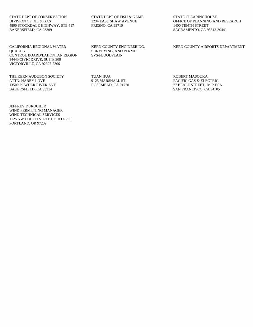
STATE DEPT OF CONSERVATION DIVISION OF OIL & GAS 4800 STOCKDALE HIGHWAY, STE 417 BAKERSFIELD, CA 93309
STATE DEPT OF FISH & GAME 1234 EAST SHAW AVENUE FRESNO, CA 93710
STATE CLEARINGHOUSE OFFICE OF PLANNING AND RESEARCH 1400 TENTH STREET SACRAMENTO, CA 95812-3044"
CALIFORNIA REGIONAL WATER QUALITY CONTROL BOARD/LAHONTAN REGION 14440 CIVIC DRIVE, SUITE 200 VICTORVILLE, CA 92392-2306
KERN COUNTY ENGINEERING, SURVEYING, AND PERMIT SVS/FLOODPLAIN
KERN COUNTY AIRPORTS DEPARTMENT
THE KERN AUDUBON SOCIETY ATTN: HARRY LOVE 13500 POWDER RIVER AVE. BAKERSFIELD, CA 93314
TUAN HUA 9125 MARSHALL ST. ROSEMEAD, CA 91770
ROBERT MASOUKA PACIFIC GAS & ELECTRIC 77 BEALE STREET, MC: B9A SAN FRANCISCO, CA 94105
JEFFREY DUROCHER WIND PERMITTING MANAGER WIND TECHNICAL SERVICES 1125 NW COUCH STREET, SUITE 700 PORTLAND, OR 97209

County of Kern
TABLE OF CONTENTS Chapter 7
Pacific Wind Energy Project i August 2010 Final Environmental Impact Report
Page
Chapter 7 Response to Comments 7.1 Introduction ................................................................................. 7-1 7.2 Revisions to the Project Draft EIR ...................................................... 7-5 Page 1-15 .................................................................................... 7-5 Page 1-29 .................................................................................... 7-5 Page 1-32 .................................................................................... 7-6 Page 1-34 .................................................................................... 7-7 Page 1-38 .................................................................................... 7-9 Page 4.4-83 ................................................................................ 7-10 Page 4.4-84 ................................................................................ 7-10 Page 4.4-86 ................................................................................ 7-10 Page 4.4-88 ................................................................................ 7-11 Page 4.4-92 ................................................................................ 7-13 Page 4.8-1 .................................................................................. 7-14 Page 4.8-29 ................................................................................ 7-14 Page 4.8-31 ................................................................................ 7-14 Page 4.9-11 ................................................................................ 7-14 Page 4.9-12 ................................................................................ 7-15 Page 4.9-24 ................................................................................ 7-15 Page 4.9-26 ................................................................................ 7-15 Page 4.9-28 ................................................................................ 7-16 7.3 Errata to the Project Draft EIR ......................................................... 7-17 Page 1-19 ................................................................................... 7-17 Page 4.9-26 ................................................................................ 7-19 Page 4.9-28 ................................................................................ 7-19 Page 4.10-4 ................................................................................ 7-20 Page 4.10-26 ............................................................................... 7-20 7.4 Response to Comments .................................................................. 7-22 State Agencies Comment Letter 1. California Department of Conservation (DOGGR) ..... 7-23 Comment Letter 2. California Department of Fish and Game................. 7-28 Comment Letter 3. California State Clearinghouse ............................. 7-56 Regional Agencies Comment Letter 4. Lahontan RWQCB ............................................ 7-67 Local Agencies Comment Letter 5. Kern County Engineering, Surveying and Permit Services ............................................... 7-79 Comment Letter 6. Kern County Department of Airports ..................... 7-81

Table of Contents (continued) County of Kern Page
August 2010 ii Pacific Wind Energy Project Final Environmental Impact Report
Interested Parties Comment Letter 7. The Kern Audubon Society ................................. 7-83 Comment Letter 8. Tuan Hua ....................................................... 7-91 Exhibit A. Range 1 and Range 2 Keyholes Exhibit B. Review of Avian Studies in the Tehachapi Wind Resource Area
Kern County, California Exhibit C. Pacific Wind Energy Project California Department of Fish and
Game Mohave Ground Squirrel Guideline Survey Report Exhibit D. Pacific Wind Energy Project U.S. Fish and Wildlife Service
Desert Tortoise Protocol Surveys Exhibit E. Golden Eagle Aerial Surveys May 20-31, 2010

County of Kern Chapter 7. Response to Comments
Pacific Wind Energy Project 7‐1 August 2010 Final Environmental Impact Report
7.1 Introduction
Purpose As defined by Section 15050 of the California Environmental Quality Act (CEQA) Guidelines, the Kern County Planning and Community Development Department is serving as “Lead Agency” for the preparation of the Environmental Impact Report (EIR) for the Pacific Wind Energy Project (proposed project). The Final EIR presents the environmental information and analyses that have been prepared for the proposed project, including comments received addressing the adequacy of the Draft EIR, and responses to those comments. In addition to the responses to comments, clarifications, corrections, or minor revisions have been made to the Draft EIR. The Final EIR—which includes the responses to comments, the Draft EIR, along with the Mitigation Monitoring Program—will be used by the Planning Commission and Board of Supervisors in the decision-making process for the proposed project.
Environmental Review Process A Notice of Preparation/Initial Study (SCH No. 2009091127) was circulated for a 30-day public review period beginning on September 30, 2009, and ending on October 30, 2009. A scoping meeting was noticed and held on October 23, 2009. No verbal or written comments were received at the scoping meeting. Seven comment letters were received and used in the preparation of the Draft EIR. The Draft EIR for the proposed project was circulated for a 45-day public review period beginning on June 17, 2010, and ending on August 2, 2010. Eight written comment letters were received on the Draft EIR.
Section 15088 of the CEQA Guidelines requires that the lead agency evaluate comments on environmental issues received from persons and agencies that reviewed the Draft EIR and prepare a written response addressing each of the comments received. The response to comments is contained in this document— Volume VII, Chapter 7 of the Draft EIR. Volumes I, II, III, IV, V, VI, and VII together constitute the Final EIR. A list of agencies, organizations, and interested parties who have commented on the Draft EIR is provided below in Table 7-1. A copy of each numbered comment letter and a lettered response to each comment are provided in Section 7.4, “Response to Comments,” of this chapter. Table 7-1 Public Comments Received on the Draft EIR
Letter No. Commenter Commenter Type
1 California Department of Conservation Division of Oil, Gas, and Geothermal Resources
State
2 California Department of Fish and Game State 3 State Clearing House State 4 Lahontan RWQCB Regional 5 Kern County Engineering, Surveying and Permit Services Local 6 Kern County Department of Airports Local 7 The Kern Audubon Society Interested party 8 Tuan Hua Interested party

Chapter 7. Response to Comments County of Kern
August 2010 7‐2 Pacific Wind Energy Project Final Environmental Impact Report
Applicant Changes to the Proposed Project On April 23, 2009, enXco and Northrop Grumman Systems Corporation entered into a private settlement agreement (Private Agreement) to address Northrop Grumman Systems Corporation's concerns regarding the compatibility of proposed wind turbine generators (WTGs) associated with enXco projects with Northrop Grumman Systems Corporation's private contractor aviation-related testing at the Tejon Test Facility. Provisions of the Private Agreement govern the siting of WTGs within portions of the proposed project boundary.
Per the provisions of the Private Agreement, enXco revised the proposed project to withdraw zone change requests that include the Wind Energy (WE) District on parcels identified as being located within the Range 1 Keyhole as shown on Figures 7-1 and 7-2.
The revised project, as depicted on Figures 7-1 and 7-2, is a reduction in power output from the originally proposed project (from up to 250 MW to up to 151 MW). Consequently, the revised project is also a reduction in the number of proposed WTGs from up to 250 WTGs to up to 151 WTGs. Since the project revision involves a reduction in the number of WTGs within the same proposed project boundaries, no new significant information has been added to the project that would require additional environmental analysis.
The project revision falls within the scope of the original project analysis included in the Draft EIR and does not result in an increase in any impacts. No new significant environmental impact would result from the project change or from a new mitigation measure proposed to be implemented. Therefore, no revisions have been made to the analysis presented within the Draft EIR and recirculation of the Draft EIR is not required pursuant to CEQA Guideline 15088.5 (Recirculation of an EIR Prior to Certification).
Furthermore, to be consistent with the settlement agreement, enXco has requested the inclusion of the following mitigation measure (MM 4.10-4) into the Final Environmental Impact Report (EIR) (Please see Section 7.3 Errata to the Project Draft EIR). Kern County has already imposed similar mitigation on the nearby PdV/Manzana project, which was also the subject of the Private Agreement. As discussed above, the impacts on Northrop Grumman Systems Corporation equipment are considered beyond the scope of CEQA because radar clutter does not create any significant adverse impact on the physical environment. However, in the interest of completeness and full disclosure Mitigation Measure 4.10-4 as presented below in Section 7.2 has been added to the Land Use section of the Final EIR.

Los Angeles Aqueduct
10 N 15 W
10 N 14 W
9 N 14 W
9 N 15 W
1
8
6
9
25
7
4 3
7
6
29 28
24
25
34
27 26
3533 36
11
32
19
14
23
2322
26
22
27
15
24
25
12
16
29
21
30
19
28
13
10
30
17
21
18
20
30
18
19
31
1 5
8
1813
30
14
31
15
20
16
29
32
25
24
13
20
12
17
29
17
3136353431 32 33
20
36 32
1713 18
ROSAMOND
170T
H ST
REET
WES
T
ROSAMOND
December 2008
Figure 7-1Project Areas
Proposed for RezoningI0 2,500 5,000
Feet
LA AqueductRange 1Range 2
! Pacific Crest TrailSite BoundaryProposed Wind Energy Combining District Zone Change
Pacific Wind Energy ProjectFinal Environmental Impact Report
County of Kern Chapter 7 Response to Comments
August 20107-3

!(
!(
!(
!(
!(
!(
!(
!(
!(!(
!(
!(
!(
!(
!(
!(
!(
!(
!(
!(
!(
!(
!(
!(
!(
!(
!(
!(
!(
!(
!(
!(
!(
!(
!(
!(
!(
!(
!(
!(
!(
!(
!(
!(
!(
!(
!(
!(
!(
!(
!(
!(
!(
!(
!(
!(!(
!(
Los Angele
s Aqueduct
Pacific Crest Trail
170T
H S
TRE
ET W
EST
ROSAMOND
December 2008
Figure 7-2Project Site PlanI
0 2,000 4,000Feet
LEGEND!( Wind Turbines
Roads and Underground TransmissionOverhead - 230 kV Route 1Overhead - 230 kV Route 2Existing SCE Transmission Lines and TRTP Approved RouteFranchise RouteManzana (formerly PdV) and Pacific Wind Secondary Route - Route 4Site BoundaryO&M FacilitySubstationSubstation, Temporary Laydown Construction, O&M FacilityTemporary Laydown ConstructionRange 1Range 2
August 2010
Chapter 7 Response to Comments County of Kern
Pacific Wind Energy ProjectFinal Environmental Impact Report7-4
Conceptual Wind Turbines

County of Kern Chapter 7. Response to Comments
Pacific Wind Energy Project 7‐5 August 2010 Final Environmental Impact Report
7.2 Revisions to the Project Draft EIR
The following revisions are made to the text of the Pacific Wind Energy Project Draft EIR. Amended text is identified by page number. Clarifications to the Draft EIR text are shown with underlining and text removed from the Draft EIR is shown with strikethrough.
Page 1‐15
Table 1-1. Summary of Less-than-significant and Significant but Mitigable Impacts and Mitigation for theProposed Project
Impact Mitigation Measure(s) Hazards and Hazardous Materials Impact 4.8-1: Create a Significant Hazard to the Public or the Environment Through the Routine Transport, Use, or Disposal of Hazardous Materials
MM 4.8-5 The project proponent shall coordinate with the Department of Oil, Gas and Geothermal Resources to ensure inspection and leakage testing of the abandoned onsite wells are preformed prior to construction. The wells shall be recorded on all future maps related to the proposed project. A 10-foot no-build radius shall be established around the abandoned wells, and no structure shall be built over or within 10 feet of any abandoned oil or gas well. Should any additional abandoned or unrecorded wells be uncovered or damaged during excavation or grading, the project proponent shall immediately contact the Department of Oil, Gas and Geothermal Resources.
Page 1‐29
Table 1-2. Summary of Significant and Unavoidable Impacts and Mitigation for the Proposed Project
Biological Resources Impact 4.4-1: Substantial Adverse Effects to Special-status Species
MM 4.4-6 The project proponent shall submit written documentation to the Kern County Planning and Community Development Department showing that a biological firm, approved by United States Fish and Wildlife Service and California Department of Fish and Game, has been retained as an on-call service provider to recover and relocate ground-dwelling special-status species as encountered during construction. Any capture and relocation activities would require the appropriate scientific collecting permits issued by California Department of Fish and Game. The recovery and relocation of any ground-dwelling special-status species will not include any species listed under the federal Endangered Species Act (FESA) or California Endangered Species Act (CESA). Any capture and movement of species listed under federal Endangered Species Act or California Endangered Species Act would only be permitted under the context of the appropriate take permit authorizations as issued by United States Fish and Wildlife Service and California Department of Fish and Game, respectively.
MM 4.4-8 If an injured or dead special-status species is encountered during construction, the project proponent shall stop work within the immediate vicinity. The project proponent shall notify the Kern County Planning and Community Development

Chapter 7. Response to Comments County of Kern
August 2010 7‐6 Pacific Wind Energy Project Final Environmental Impact Report
Table 1-2. Summary of Significant and Unavoidable Impacts and Mitigation for the Proposed Project Department, the on-call biologist, and the appropriate resources agency (e.g., United States Fish and Wildlife Service or California Department of Fish and Game) before construction is allowed to proceed. If an injured or dead federally or State listed species is encountered, all project work shall stop immediately until the appropriate resources agency (e.g., United States Fish and Wildlife Service or California Department of Fish and Game) is consulted. The resource agency will then determine the appropriate course of action in consultation with the project applicant and the need for an Incidental Take Permit.
Page 1‐32
Table 1-2. Summary of Significant and Unavoidable Impacts and Mitigation for the Proposed Project
Biological Resources Impact 4.4-1: Substantial Adverse Effects to Special-status Species
MM 4.4-17 The project proponent or its representatives shall perform Post-Construction Avian and Bat Mortality Monitoring in the first and third years 1, 3, and 5 following the initial operation of the project to demonstrate the level of incidental injury and mortality to populations of avian or bat species in the vicinity of the project site. Post-Construction Avian and Bat Mortality Monitoring shall include a Mortality Analysis, which shall be conducted as follows:
a. The project proponent shall provide to the Kern County Planning and Community Development Department and the California Department of Fish and Game the results of mortality studiesy for avian and bat species when completedon an annual basis. A qualified wildlife biologist shall conduct mortality monitoring using a statistically significant sample size of operational turbines within the wind energy development project.
b. The Mortality Analysis shall note species number, location, and distance from the turbine for each recovered bird or bat, availability of bird and bat prey species, and apparent cause of avian or bat mortality. The project proponent shall provide all results to the Wildlife Response and Reporting System database within 90 days of completion of the annual study.
c. The mortality monitoring shall follow standardized guidelines outlined by the California Energy Commission, and shall include carcass scavenging and searcher efficiency trials.
d. The results of the Mortality Analysis shall be provided to the Kern County Planning Department and regional entities involved in the conservation of resident and migratory avian and bat species, including United States Fish and Wildlife Service, California Department of Fish and Game, and the Audubon Society. At a minimum, the Mortality Analysis shall consider three factors:
i. Number of annual avian and bat mortalities per turbine,
ii. Disproportionate representation of a particular species, and

County of Kern Chapter 7. Response to Comments
Pacific Wind Energy Project 7‐7 August 2010 Final Environmental Impact Report
Table 1-2. Summary of Significant and Unavoidable Impacts and Mitigation for the Proposed Project iii. Comparison to existing data on wind farm
mortality.
Page 1‐34
Table 1-2. Summary of Significant and Unavoidable Impacts and Mitigation for the Proposed Project
Biological Resources Impact 4.4-1: Substantial Adverse Effects to Special-status Species
MM 4.4-21 A qualified biologist shall conduct focused clearance surveys for desert tortoise within 24 hours prior to construction activities at each site. Clearance surveys are required in any area (including appropriate buffers) that supports suitable desert tortoise habitat and that would be subject to disturbance as a result of implementation and operation of the proposed project, unless otherwise authorized by the United States Fish and Wildlife Service. Clearance surveys shall follow the United States Fish and Wildlife Service’s desert tortoise survey protocol. The authorized biologist shall determine whether tortoises are present at the site, and whether tortoises may occur in adjacent areas and immigrate into the impact area. If tortoises or intact burrows are found in the impact area or if the authorized biologist determines that a tortoise may enter the construction site, the project proponent shall halt work within 500 feet of the tortoise or burrow and construction activities may not resume within this 500 foot buffer without concurrence from the United States Fish and Wildlife Service and California Department of Fish and Game. Upon discovery of a tortoise or active tortoise burrow, a desert tortoise mitigation and monitoring plan shall be developed and implemented that includes the following measures in consultation with the United States Fish and Wildlife Service and California Department of Fish and Game:
a. The project proponent shall retain a qualified biologist with demonstrated expertise with desert tortoise to monitor all construction activities and assist in the implementation of the monitoring program. This person will be approved by the United States Fish and Wildlife Service prior to the onset of ground-disturbing activities. This biologist will be referred to as the authorized biologist hereafter. The authorized biologist will be present during all construction activities immediately adjacent to or within habitat that supports desert tortoise.
b. Prior to the onset of construction activities, the project proponent shall provide all personnel who will be present on work areas within or adjacent to the project area the following information:
i. A detailed description of the desert tortoise including color photographs;
ii. The protection the desert tortoise receives under the federal and State Endangered Species Acts and possible legal action that may be incurred for violation of the Acts;

Chapter 7. Response to Comments County of Kern
August 2010 7‐8 Pacific Wind Energy Project Final Environmental Impact Report
Table 1-2. Summary of Significant and Unavoidable Impacts and Mitigation for the Proposed Project iii. The protective measures being implemented to
conserve the desert tortoise and other species during construction activities associated with the project;
iv. A point of contact if desert tortoises are observed.
c. All trash that may attract predators of desert tortoises will be removed from work sites or completely secured at the end of each work day.
d. Where construction can occur in habitat where desert tortoise are widely distributed, work areas will be fenced in a manner that prevents equipment and vehicles from straying from the designated work area into adjacent habitat. The authorized biologist will assist in determining the boundaries of the area to be fenced in consultation with the United States Fish and Wildlife Service/California Department of Fish and Game/Kern County. All workers will be advised that equipment and vehicles must remain within the fenced work areas. Installation of the fencing and any necessary surveys will be directed and/or conducted by the authorized biologist in concurrence with the United States Fish and Wildlife Service/California Department of Fish and Game/Kern County.
e. If desert tortoises are found within an area that has been fenced to exclude the species, activities will cease and the authorized biologist will contact California Department of Fish and Game and United States Fish and Wildlife Service for further direction.
f. If desert tortoises are found in a construction area where fencing was deemed unnecessary, work will cease until the animal(s) leave on their own. The authorized biologist in consultation with United States Fish and Wildlife Service/California Department of Fish and Game/Kern County will then determine whether additional surveys or fencing are needed. Work may resume while this determination is being made, if deemed appropriate by the authorized biologist. The authorized biologist will have the authority to stop all activities until appropriate corrective measures have been completed.
g. A raven management plan shall be developed for the project site in consultation with the United States Fish and Wildlife Service and California Department of Fish and Game. This plan shall include at a minimum:
i. Identification of all raven nests within the project area during construction;
ii. Weekly inspection under all nests in the project area for evidence of desert tortoise predation (scutes, shells, etc.), and, if evidence of predation is noted, submit a report to California Department of Fish and Game, United States Fish and Wildlife Service, and the Kern County Planning and Community Development Department within 5

County of Kern Chapter 7. Response to Comments
Pacific Wind Energy Project 7‐9 August 2010 Final Environmental Impact Report
Table 1-2. Summary of Significant and Unavoidable Impacts and Mitigation for the Proposed Project calendar days; and,
iii. Provisions for the management of trash that could attract common ravens during the construction and operation phases of the project.
Should U.S. Fish and Wildlife determine it is necessary for that the proposed project to participate in the identified plan to address impacts to biological resources, the project proponent shall be subject to the provisions of the comprehensive raven management plan.
Page 1‐38
Table 1-2. Summary of Significant and Unavoidable Impacts and Mitigation for the Proposed Project
Biological Resources Impact 4.4-1: Substantial Adverse Effects to Special-status Species
MM 4.4-27 The project proponent shall submit written documentation to the Kern County Planning and Community Development Department showing implementation of pre-construction surveys for the Mohave ground squirrel within all suitable habitat prior to initial ground disturbing activities. The name and phone number of the biological monitor shall be provided to a California Department of Fish and Game regional representative at least 14 days before the initiation of ground-disturbing activities. If the biological monitor observes a Mohave ground squirrel on the construction site, work shall be halted and redirected to areas not supporting this species. A written report shall be sent to California Department of Fish and Game within five calendar days of the sighting. The report will include the date, time of the finding or incident (if known), and location of the animal. If a dead Mohave ground squirrel is encountered, all work should stop and the remains shall be collected, frozen as soon as possible, and California Department of Fish and Game shall be contacted immediately to determine the appropriate course of action. to determine where the remains will be sent.
MM 4.4-28 The project proponent shall submit written documentation to the Kern County Planning and Community Development Department showing implementation of pre-construction surveys for desert kit fox and American badger within suitable habitat. If present, occupied kit fox and/or badger dens shall be flagged and ground-disturbing activities avoided within 50 feet of the occupied den avoided. Maternity dens shall be avoided during pup-rearing season (February 15 through July 1) and a minimum 200-foot buffer established. Maternity dens shall be flagged for avoidance, identified on construction maps, and a biological monitor shall be present during construction.
If avoidance of a non-maternity den is not feasible, kit foxes and badgers shall be passively relocated by slowly excavating the burrow (either by hand or mechanized equipment under

Chapter 7. Response to Comments County of Kern
August 2010 7‐10 Pacific Wind Energy Project Final Environmental Impact Report
Table 1-2. Summary of Significant and Unavoidable Impacts and Mitigation for the Proposed Project the direct supervision of the biologist, removing no more that 4 inches at a time) before or after the rearing season (February 15 through July 1). Any relocation of kit foxes and/or badgers shall occur only after consultation with the California Department of Fish and Game and the Kern County monitor. A written report documenting the kit fox and/or badger removal shall be provided to the California Department of Fish and Game and the Kern County Planning and Community Development Department within 30 days of relocation.
If an occupied desert kit fox den is encountered, all work in the area shall stop until the California Department of Fish and Game is consulted for the appropriate course of action.
Page 4.4‐83
MM 4.4-6 The project proponent shall submit written documentation to the Kern County Planning and Community Development Department showing that a biological firm, approved by United States Fish and Wildlife Service and California Department of Fish and Game, has been retained as an on-call service provider to recover and relocate ground-dwelling special-status species as encountered during construction. Any capture and relocation activities would require the appropriate scientific collecting permits issued by California Department of Fish and Game. The recovery and relocation of any ground-dwelling special-status species will not include any species listed under the federal Endangered Species Act (FESA) or California Endangered Species Act (CESA). Any capture and movement of species listed under federal Endangered Species Act or California Endangered Species Act would only be permitted under the context of the appropriate take permit authorizations as issued by United States Fish and Wildlife Service and California Department of Fish and Game, respectively.
Page 4.4‐84
MM 4.4-8 If an injured or dead special-status species is encountered during construction, the project proponent shall stop work within the immediate vicinity. The project proponent shall notify the Kern County Planning and Community Development Department, the on-call biologist, and the appropriate resources agency (e.g., United States Fish and Wildlife Service or California Department of Fish and Game) before construction is allowed to proceed. If an injured or dead federally or State listed species is encountered, all project work shall stop immediately until the appropriate resources agency (e.g., United States Fish and Wildlife Service or California Department of Fish and Game) is consulted. The resource agency will then determine the appropriate course of action in consultation with the project applicant and the need for an Incidental Take Permit.
Page 4.4‐86
MM 4.4-17 The project proponent or its representatives shall perform Post-Construction Avian and Bat Mortality Monitoring in the first and third years 1, 3, and 5 following the initial operation of the project to demonstrate the level of incidental injury and mortality to populations of avian or bat species in the vicinity of the project site. Post-Construction

County of Kern Chapter 7. Response to Comments
Pacific Wind Energy Project 7‐11 August 2010 Final Environmental Impact Report
Avian and Bat Mortality Monitoring shall include a Mortality Analysis, which shall be conducted as follows:
h. The project proponent shall provide to the Kern County Planning and Community Development Department and the California Department of Fish and Game the results of a mortality studiesy for avian and bat species when completedon an annual basis. A qualified wildlife biologist shall conduct mortality monitoring using a statistically significant sample size of operational turbines within the wind energy development project.
i. The Mortality Analysis shall note species number, location, and distance from the turbine for each recovered bird or bat, availability of bird and bat prey species, and apparent cause of avian or bat mortality. The project proponent shall provide all results to the Wildlife Response and Reporting System database within 90 days of completion of the annual study.
j. The mortality monitoring shall follow standardized guidelines outlined by the California Energy Commission, and shall include carcass scavenging and searcher efficiency trials.
k. The results of the Mortality Analysis shall be provided to the Kern County Planning Department and regional entities involved in the conservation of resident and migratory avian and bat species, including United States Fish and Wildlife Service, California Department of Fish and Game, and the Audubon Society. At a minimum, the Mortality Analysis shall consider three factors:
i. Number of annual avian and bat mortalities per turbine,
ii. Disproportionate representation of a particular species, and
iii. Comparison to existing data on wind farm mortality.
Page 4.4‐88
MM 4.4-21 A qualified biologist shall conduct focused clearance surveys for desert tortoise within 24 hours prior to construction activities at each site. Clearance surveys are required in any area (including appropriate buffers) that supports suitable desert tortoise habitat and that would be subject to disturbance as a result of implementation and operation of the proposed project, unless otherwise authorized by the United States Fish and Wildlife Service. Clearance surveys shall follow the United States Fish and Wildlife Service’s desert tortoise survey protocol. The authorized biologist shall determine whether tortoises are present at the site, and whether tortoises may occur in adjacent areas and immigrate into the impact area. If tortoises or intact burrows are found in the impact area or if the authorized biologist determines that a tortoise may enter the construction site, the project proponent shall halt work within 500 feet of the tortoise or burrow and construction activities may not resume within this 500 foot buffer without concurrence from the United States Fish and Wildlife Service and California Department of Fish and Game. Upon discovery of a tortoise or active tortoise burrow, a desert tortoise mitigation and monitoring plan shall be developed and implemented that includes the following measures in consultation with the United States Fish and Wildlife Service and California Department of Fish and Game:
a. The project proponent shall retain a qualified biologist with demonstrated expertise with desert tortoise to monitor all construction activities and assist in the implementation of the monitoring program. This person will be approved by the United States Fish and Wildlife Service prior to the onset

Chapter 7. Response to Comments County of Kern
August 2010 7‐12 Pacific Wind Energy Project Final Environmental Impact Report
of ground-disturbing activities. This biologist will be referred to as the authorized biologist hereafter. The authorized biologist will be present during all construction activities immediately adjacent to or within habitat that supports desert tortoise.
b. Prior to the onset of construction activities, the project proponent shall provide all personnel who will be present on work areas within or adjacent to the project area the following information:
i. A detailed description of the desert tortoise including color photographs;
ii. The protection the desert tortoise receives under the federal and State Endangered Species Acts and possible legal action that may be incurred for violation of the Acts;
iii. The protective measures being implemented to conserve the desert tortoise and other species during construction activities associated with the project;
iv. A point of contact if desert tortoises are observed.
c. All trash that may attract predators of desert tortoises will be removed from work sites or completely secured at the end of each work day.
d. Where construction can occur in habitat where desert tortoise are widely distributed, work areas will be fenced in a manner that prevents equipment and vehicles from straying from the designated work area into adjacent habitat. The authorized biologist will assist in determining the boundaries of the area to be fenced in consultation with the United States Fish and Wildlife Service/California Department of Fish and Game/Kern County. All workers will be advised that equipment and vehicles must remain within the fenced work areas. Installation of the fencing and any necessary surveys will be directed and/or conducted by the authorized biologist in concurrence with the United States Fish and Wildlife Service/California Department of Fish and Game/Kern County.
e. If desert tortoises are found within an area that has been fenced to exclude the species, activities will cease and the authorized biologist will contact California Department of Fish and Game and United States Fish and Wildlife Service for further direction.
f. If desert tortoises are found in a construction area where fencing was deemed unnecessary, work will cease until the animal(s) leave on their own. The authorized biologist in consultation with United States Fish and Wildlife Service/California Department of Fish and Game/Kern County will then determine whether additional surveys or fencing are needed. Work may resume while this determination is being made, if deemed appropriate by the authorized biologist.
The authorized biologist will have the authority to stop all activities until appropriate corrective measures have been completed.
g. A raven management plan shall be developed for the project site in consultation with the United States Fish and Wildlife Service and California Department of Fish and Game. This plan shall include at a minimum:
i. Identification of all raven nests within the project area during construction;

County of Kern Chapter 7. Response to Comments
Pacific Wind Energy Project 7‐13 August 2010 Final Environmental Impact Report
ii. Weekly inspection under all nests in the project area for evidence of desert tortoise predation (scutes, shells, etc.), and, if evidence of predation is noted, submit a report to California Department of Fish and Game, United States Fish and Wildlife Service, and the Kern County Planning and Community Development Department within 5 calendar days; and,
iii. Provisions for the management of trash that could attract common ravens during the construction and operation phases of the project.
Should U.S. Fish and Wildlife determine it is necessary for that the proposed project to participate in the identified plan to address impacts to biological resources, the project proponent shall be subject to the provisions of the comprehensive raven management plan.
Page 4.4‐92
MM 4.4-27 The project proponent shall submit written documentation to the Kern County Planning and Community Development Department showing implementation of pre-construction surveys for the Mohave ground squirrel within all suitable habitat prior to initial ground disturbing activities. The name and phone number of the biological monitor shall be provided to a California Department of Fish and Game regional representative at least 14 days before the initiation of ground-disturbing activities. If the biological monitor observes a Mohave ground squirrel on the construction site, work shall be halted and redirected to areas not supporting this species. A written report shall be sent to California Department of Fish and Game within five calendar days of the sighting. The report will include the date, time of the finding or incident (if known), and location of the animal. If a dead Mohave ground squirrel is encountered, all work should stop and the remains shall be collected, frozen as soon as possible, and California Department of Fish and Game shall be contacted immediately to determine the appropriate course of action. to determine where the remains will be sent.
MM 4.4-28 The project proponent shall submit written documentation to the Kern County Planning and Community Development Department showing implementation of pre-construction surveys for desert kit fox and American badger within suitable habitat. If present, occupied kit fox and/or badger dens shall be flagged and ground-disturbing activities avoided within 50 feet of the occupied den avoided. Maternity dens shall be avoided during pup-rearing season (February 15 through July 1) and a minimum 200-foot buffer established. Maternity dens shall be flagged for avoidance, identified on construction maps, and a biological monitor shall be present during construction.
If avoidance of a non-maternity den is not feasible, kit foxes and badgers shall be passively relocated by slowly excavating the burrow (either by hand or mechanized equipment under the direct supervision of the biologist, removing no more that 4 inches at a time) before or after the rearing season (February 15 through July 1). Any relocation of kit foxes and/or badgers shall occur only after consultation with the California Department of Fish and Game and the Kern County monitor. A written report documenting the kit fox and/or badger removal shall be provided to the California Department of Fish and Game and the Kern County Planning and Community Development Department within 30 days of relocation.

Chapter 7. Response to Comments County of Kern
August 2010 7‐14 Pacific Wind Energy Project Final Environmental Impact Report
If an occupied desert kit fox den is encountered, all work in the area shall stop until the California Department of Fish and Game is consulted for the appropriate course of action.
Page 4.8‐1 Current and historic uses of the proposed project site include atmospheric monitoring, high voltage transmission tower lines, off-road recreational vehicle activities, hunting, hiking, and camping. The site is crossed by the Pacific Crest Trail, three existing Southern California Edison (SCE) electrical transmission lines, the Los Angeles Aqueducts, and several intermittent drainages. In addition, there is are presently one two plugged and abandoned oil or gas wells within the project boundaries (DOGGR, 2010). Sparse residential housing exists at the proposed project site. A total of seven residential structures are located within the proposed project site. Twenty residential structures are located within a one-mile vicinity of the proposed project site.
Page 4.8‐29 Implementation of Mitigation Measure 4.8-1 would reduce the significance of this potential impact by requiring the HMBP to contain procedures for handling and disposing of unanticipated hazardous materials encountered during construction. Mitigation Measure 4.8-4 would further reduce potential impacts by requiring the construction contractor to stop work if suspected contamination is identified, cordon off areas of suspected contamination, take appropriate health and safety measures, have a trained individual conduct sampling and testing or suspected material, and, if contamination is found to be greater than regulatory limits, notifying the Kern County Environmental Health Services Department and documenting all actions. Finally, Mitigation Measure 4.8-5 would ensure that the abandoned well areas are inspected for leakage, and that a 10-foot no-build zone is established around it them.
Page 4.8‐31 MM 4.8-5 The project proponent shall coordinate with the Department of Oil, Gas and Geothermal
Resources to ensure inspection and leakage testing of the abandoned onsite wells are preformed prior to construction. The wells shall be recorded on all future maps related to the proposed project. A 10-foot no-build radius shall be established around the abandoned wells, and no structure shall be built over or within 10 feet of any abandoned oil or gas well. Should any additional abandoned or unrecorded wells be uncovered or damaged during excavation or grading, the project proponent shall immediately contact the Department of Oil, Gas and Geothermal Resources.
Page 4.9‐11 The SWRCB regulates water quality through the Porter-Cologne Water Quality Act of 1969, which contains a complete framework for the regulation of waste discharges to both surface waters and groundwater of the State. On the regional level, the proposed project falls under the jurisdiction of the Lahontan RWQCB, which is responsible for the implementation of State and federal water quality protection statutes, regulations and guidelines. The Lahontan

County of Kern Chapter 7. Response to Comments
Pacific Wind Energy Project 7‐15 August 2010 Final Environmental Impact Report
Region has developed a Water Quality Control Plan (Basin Plan) to show how the quality of the surface and ground waters in the Central Coast Lahontan Region should be managed to provide the highest water quality reasonably possible. The Basin Plan lists the various beneficial uses of water within the region, describes the water quality which must be maintained to allow those uses, describes the programs, projects, and other actions which are necessary to achieve the standards established in this plan, and summarizes plans and policies to protect water quality. Beneficial uses associated with Cottonwood Creek and the ephemeral drainages in the Proposed Project area include municipal and domestic supply (MUN), agricultural supply (AGR), groundwater recharge (GWR), water contact recreation (REC-1), non-contact water recreation (REC-2), warm freshwater habitat (WARM), and wildlife habitat (WILD). The proposed project would be expected to not disrupt current or designated beneficial uses of surface waters.
Page 4.9‐12 California Water Code §13260 requires that any person discharging waste, or proposing to discharge waste, within any region that could affect the quality of the waters of the State, other than into a community sewer system, must submit a report of waste discharge to the applicable RWQCB. All surface waters are considered waters of the State, which include but are not limited to drainages, streams, washes, ponds, pools, or wetlands, and may be permanent or intermittent. Any actions related to the proposed Project that would be applicable to California Water Code §13260 would be reported to the Central Coast RWQCB.
Page 4.9‐24 As mentioned in Section 4.9.3 (Regulatory Setting), all surface waters are considered waters of the State, which include but are not limited to drainages, streams, washes, ponds, pools, or wetlands, and may be permanent or intermittent. As described throughout the impact analysis presented above, the Proposed Project could potentially affect multiple different surface water features, including Cottonwood Creek and its tributaries, as well as multiple unnamed ephemeral waterways. Implementation of Mitigation Measure (MM) 4.9-1, listed below, MM 4.4-30, presented in Section 4.4, MMs 4.7-9 through 4.7-12, presented in Section 4.7 (Geology and Soils), and MMs 4.8-1 and 4.8-3, presented in Section 4.8 (Hazards and Hazardous Materials), would minimize or avoid the potential for proposed project activities to result in the violation of any water quality standards or waste discharge requirements. These mitigation measures would also avoid resulting in changes to stream channel function that could adversely affect designated beneficial uses to surface waters in the area, and ensure compliance with the Lahontan Region Water Quality Control Plan (Basin Plan).
Page 4.9‐26 Clearing, grading, and excavation activities required for proposed project construction could result in changes to drainage patterns across the project site. The project site is crossed by Cottonwood Creek and numerous ephemeral drainages. Prior to commencement of construction activities, the applicant would be required to submit a grading permit to the

Chapter 7. Response to Comments County of Kern
August 2010 7‐16 Pacific Wind Energy Project Final Environmental Impact Report
County for approval. Any alteration of the bed or banks of Cottonwood Creek (or any other drainage deemed by the CDFG to be jurisdictional water), including through access road improvement and/or construction, would not be permitted to commence prior to development and implementation of a Streambed Alteration Agreement with the CDFG. Section 4.4 (Biological Resources) includes Table 4.4-2 (Drainage Characteristics and Associated Impacts), which provides a quantification of impacts to drainage and riparian areas, including: width of stream from top of streambed, width of riparian habitat, and CDFG jurisdiction area.
Encroachment of a turbine tower or other project-related permanent infrastructure into a stream channel or floodplain, including FEMA-designated Flood Hazard Areas, could result in flooding of or erosion damage to the encroaching structure, diversion of flows and increased flood risk for adjacent property, or increased erosion on adjacent property. This impact is likely to occur only where turbine towers or other permanent project features are constructed in or closely adjacent to a stream channel. With the exception of very wide and undefined ephemeral desert washes, it is not expected that infrastructure associated with the proposed project would be placed in an existing stream channel or flood hazard area. Access and/or spur roads on the proposed project site would cross multiple ephemeral streams. As required by MM 4.9-2, described above under Impact 4.9-1, the precise locations of all stream crossings would be identified in the project road plan, which would include road design specifications. To the extent practical, sheetflow would be allowed to cross over the access roads, thereby maintaining unconfined flow downstream of access roads.
Page 4.9‐28 Although the amount of surface runoff within the project area would not change, the pattern and concentration of this runoff could be altered by grading activities associated with the project. As described under Section 4.9.2 (Environmental Setting), there are multiple ephemeral drainages across the proposed project site, and the generally flat topography of the proposed project site can lead to unconfined overland flow during storm events. As discussed above under Impact 4.9-3, implementation of the proposed project would not permanently alter the course of any drainages, or substantially alter drainage patterns on or off the project site. With the exception of very wide and undefined ephemeral desert washes, it is not expected that infrastructure associated with the proposed project would be placed in an existing stream channel or flood hazard area. Access and/or spur roads on the proposed project site would cross multiple ephemeral streams. As required by MM 4.9-2, described above under Impact 4.9-1, the precise locations of all stream crossings would be identified in the project road plan and to the extent practical, sheetflow would be allowed to cross over the access roads, thereby maintaining unconfined flow downstream of access roads. Any activities which occur within FEMA-designated Flood Hazard Areas would comply with the requirements and construction design specifications of the Kern County Floodplain Management Ordinance. Grading would be required for access roads throughout the project site, and leveling would be required for each turbine installation site, substation site, and O&M building site. These activities could result in changes to drainage patterns across the project site if the improved access roads and/or leveled areas are not properly designed. However, the potential for development of the proposed project to alter the existing drainage patterns would be minimized through compliance with design-specifications and BMPs

County of Kern Chapter 7. Response to Comments
Pacific Wind Energy Project 7‐17 August 2010 Final Environmental Impact Report
required by the Kern County Grading Code and Floodplain Management Ordinance. Any increase in surface water runoff resulting from permanent project features would be minor and location-specific, and would not influence surface runoff in a manner which would result in flooding on-site or off-site.
7.3 Errata to the Project Draft EIR The following errata are provided for the text of the Pacific Wind Energy Project Draft EIR. Amended text is identified by page number. Clarifications to the Draft EIR text are shown with underlining and text removed from the Draft EIR is shown with strikethrough.
Page 1‐19
Table 1-1. Summary of Less-than-significant and Significant but Mitigable Impacts and Mitigation for theProposed Project
Impact Mitigation Measure(s) Land Use and Planning Impact 4.10-1: Conflict with Any Applicable Land Use Plan, Policy, or Regulation of an Agency With Jurisdiction Over the Project Adopted for the Purpose of Avoiding or Mitigating an Environmental Effect
MM 4.10-1 Prior to the issuance of grading or building permits, the project proponent shall submit a final project design to the authorized officer of Edwards Air Force Base. Said final project design, shall be in the form of a detailed plan as required by Section 19.64.130 (Detailed Plot Plan Required- Contents) of the Kern County Zoning Ordinance and shall include final specifications on the height and location of the wind turbine generators to be installed as well as the anticipated schedule of each construction phase.
MM 4.10-2 Prior to issuance of building permits, the project proponent shall notify the licensee(s) of nearby land mobile stations regarding the project and provide them with contact information and a proposed turbine layout. If owner of the nearby land mobile station notifies the County that any turbine will result in interference to its Radio Frequency facility, the project proponent shall relocate wind turbine generators to avoid interference.
MM 4.10-3 Prior to the issuance of the project building permit, the project proponent shall notify the National Telecommunications and Information Administration and the Joint Program Office regarding the project and provide them with a proposed wind turbine generator layout. If the National Telecommunications and Information Administration or the Joint Program Office notifies the County that any unlisted Radio Frequency facilities will experience interference, the project proponent shall consult with the affected facility operator and Kern County to relocate wind turbine generators to avoid such interference. In addition to the notification provided above, the project proponent shall perform a physical inspection of the project site to determine whether there are any other unlisted or undocumented non-broadcast transmitters within the area or within a half-mile of project boundaries. If such facilities are located where interference is likely to occur, the project proponent shall make reasonable attempts to contact the facility operators and to

Chapter 7. Response to Comments County of Kern
August 2010 7‐18 Pacific Wind Energy Project Final Environmental Impact Report
Table 1-1. Summary of Less-than-significant and Significant but Mitigable Impacts and Mitigation for theProposed Project
Impact Mitigation Measure(s) relocate wind turbine generators to avoid interference.
MM 4.10-4 This mitigation measure is included at the request of the applicant. This mitigation measure relates to restrictions imposed on the applicant in a private settlement agreement entered into by and among Northrop Grumman Systems Corporation ("NGSC"), the applicant and other entities in April 2009 (the "Private Agreement").
Any and all grading, excavation, construction activities, or any other improvements relating in any way to the project, including without limitation the grading and excavation for, and the construction or installation of, (a) wind turbines or components thereof (including without limitation towers, nacelles, hubs and blades) and (b) other structural improvements (including paved roads and other paved surfaces) or components thereof shall be prohibited within the Range 1 keyhole area identified in Exhibit "A" attached hereto (the "Range 1 Keyhole"), except as otherwise expressly agreed in the Private Agreement or unless otherwise agreed to in writing by the developer and NGSC, each acting in its sole discretion.
Prior to September 27, 2010 (the "Construction Date") any and all grading, excavation or construction activities relating in any way to the project, including without limitation the grading and excavation for, and the construction or installation of, (a) wind turbines or components thereof (including without limitation towers, nacelles, hubs and blades) and (b) other structural improvements (including paved roads and other paved surfaces) or components thereof ("Range 2 Construction Activities") shall be prohibited within the Range 2 keyhole area identified in Exhibit "A" attached hereto ("Range 2 Keyhole"), except as otherwise expressly provided in the Private Agreement.
Except as otherwise expressly permitted in the Private Agreement, following the Construction Date, but prior to September 30, 2011 (the "Target Date"), Range 2 Construction Activities that involve the construction or installation of structural improvements (other than the construction or installation of wind turbines or components thereof) shall be permitted within the Range 2 Keyhole prior to the Target Date if (i) such structural improvements or components thereof are not within the radar line of sight of Range 2 or (ii) if and to the extent they are within such radar line of sight, they are no higher than three (3) feet above ground level or no higher than eight (8) feet above ground level if and to the extent that such structural improvements or components thereof are shielded from the radar test signal by an earthen berm or radar fence (except that the construction of overhead transmission line are permitted with no height restriction) that is constructed by the applicant or developer at its sole expense and complies in all respects with all applicable requirements set forth in the Private Agreement.

County of Kern Chapter 7. Response to Comments
Pacific Wind Energy Project 7‐19 August 2010 Final Environmental Impact Report
Page 4.9‐26 Encroachment of a turbine tower or other project-related permanent infrastructure into a stream channel or floodplain, including FEMA-designated Flood Hazard Areas, could result in flooding of or erosion damage to the encroaching structure, diversion of flows and increased flood risk for adjacent property, or increased erosion on adjacent property. This impact is likely to occur only where turbine towers or other permanent project features are constructed in or closely adjacent to a stream channel. With the exception of very wide and undefined ephemeral desert washes, it is not expected that infrastructure associated with the proposed project would be placed in an existing stream channel or flood hazard area. Access and/or spur roads on the proposed project site would cross multiple ephemeral streams. As required by MM 4.9-2 MM 4.9-1, described above under Impact 4.9-1, the precise locations of all stream crossings would be identified in the project road plan.
Page 4.9‐28 Although the amount of surface runoff within the project area would not change, the pattern and concentration of this runoff could be altered by grading activities associated with the project. As described under Section 4.9.2 (Environmental Setting), there are multiple ephemeral drainages across the proposed project site, and the generally flat topography of the proposed project site can lead to unconfined overland flow during storm events. As discussed above under Impact 4.9-3, implementation of the proposed project would not permanently alter the course of any drainages, or substantially alter drainage patterns on or off the project site. With the exception of very wide and undefined ephemeral desert washes, it is not expected that infrastructure associated with the proposed project would be placed in an existing stream channel or flood hazard area. Access and/or spur roads on the proposed project site would cross multiple ephemeral streams. As required by MM 4.9-2 MM 4.9-1, described above under Impact 4.9-1, the precise locations of all stream crossings would be identified in the project road plan. Any activities which occur within FEMA-designated Flood Hazard Areas would comply with the requirements and construction design specifications of the Kern County Floodplain Management Ordinance. Grading would be required for access roads throughout the project site, and leveling would be required for each turbine installation site, substation site, and O&M building site. These activities could result in changes to drainage patterns across the project site if the improved access roads and/or leveled areas are not properly designed. However, the potential for development of the proposed project to alter the existing drainage patterns would be minimized through compliance with design-specifications and BMPs required by the Kern County Grading Code and Floodplain Management Ordinance. Any increase in surface water runoff resulting from permanent project features would be minor and location-specific, and would not influence surface runoff in a manner which would result in flooding on-site or off-site.

Chapter 7. Response to Comments County of Kern
August 2010 7‐20 Pacific Wind Energy Project Final Environmental Impact Report
Page 4.10‐4
Northrop Grumman Systems Corporation
The Northrop Grumman Systems Corporation operates the Tejon Test Facility, located approximately 1.7 miles northwest of the proposed project site. On April 23, 2009, enXco and Northrop Grumman Systems Corporation entered into a private settlement agreement (Private Agreement) to address Northrop Grumman Systems Corporation's concerns regarding the compatibility of proposed WTGs associated with enXco projects with Northrop Grumman Systems Corporation's private contractor aviation-related testing at the Tejon Test Facility. Provisions of the Private Agreement govern the siting of WTGs within portions of the proposed project boundary.
Page 4.10‐26
Northrop Grumman Systems Corporation
In accordance with the provisions of the Private Agreement entered into to address Northrop Grumman Systems Corporation's concerns regarding the compatibility of proposed WTGs associated with enXco projects with Northrop Grumman Systems Corporation's private contractor aviation-related testing at the Tejon Test Facility, enXco revised the proposed project to withdraw zone change requests that include the WE District on parcels identified as being located within the Range 1 Keyhole as shown on the following map (Figure 7-1).
The revised project, as depicted on Figure 7-1, is a reduction in power output from the originally proposed project (from up to 250 MW to up to 151 MW). Consequently, the revised project is also a reduction in the number of proposed WTGs from up to 250 WTGs to up to 151 WTGs. Furthermore, to be consistent with the settlement agreement, enXco has requested the inclusion of Mitigation Measure 4.10-4 presented below. Kern County has already imposed similar mitigation on the nearby Manzana Wind Project (formerly known as the PdV Wind Energy Project), which was also the subject of the Private Agreement. The impacts on Northrop Grumman Systems Corporation equipment are considered beyond the scope of CEQA because radar clutter does not create any significant adverse impact on the physical environment. However, in the interest of completeness and full disclosure, Mitigation Measure 4.10-4 is presented below.
Mitigation Measures
MM 4.10-4 This mitigation measure is included at the request of the applicant. This mitigation measure relates to restrictions imposed on the applicant in a private settlement agreement entered into by and among Northrop Grumman Systems Corporation ("NGSC"), the applicant and other entities in April 2009 (the "Private Agreement"). Any and all grading, excavation, construction activities, or any other improvements relating in any way to the project, including without limitation the grading and excavation for, and the construction or installation of, (a) wind turbines or components thereof (including

County of Kern Chapter 7. Response to Comments
Pacific Wind Energy Project 7‐21 August 2010 Final Environmental Impact Report
without limitation towers, nacelles, hubs and blades) and (b) other structural improvements (including paved roads and other paved surfaces) or components thereof shall be prohibited within the Range 1 keyhole area identified in Exhibit "A" attached hereto (the "Range 1 Keyhole"), except as otherwise expressly agreed in the Private Agreement or unless otherwise agreed to in writing by the developer and NGSC, each acting in its sole discretion. Prior to September 27, 2010 (the "Construction Date") any and all grading, excavation or construction activities relating in any way to the project, including without limitation the grading and excavation for, and the construction or installation of, (a) wind turbines or components thereof (including without limitation towers, nacelles, hubs and blades) and (b) other structural improvements (including paved roads and other paved surfaces) or components thereof ("Range 2 Construction Activities") shall be prohibited within the Range 2 keyhole area identified in Exhibit "A" attached hereto ("Range 2 Keyhole"), except as otherwise expressly provided in the Private Agreement. Except as otherwise expressly permitted in the Private Agreement, following the Construction Date, but prior to September 30, 2011 (the "Target Date"), Range 2 Construction Activities that involve the construction or installation of structural improvements (other than the construction or installation of wind turbines or components thereof) shall be permitted within the Range 2 Keyhole prior to the Target Date if (i) such structural improvements or components thereof are not within the radar line of sight of Range 2 or (ii) if and to the extent they are within such radar line of sight, they are no higher than three (3) feet above ground level or no higher than eight (8) feet above ground level if and to the extent that such structural improvements or components thereof are shielded from the radar test signal by an earthen berm or radar fence (except that the construction of overhead transmission line are permitted with no height restriction) that is constructed by the applicant or developer at its sole expense and complies in all respects with all applicable requirements set forth in the Private Agreement.

Chapter 7. Response to Comments County of Kern
August 2010 7‐22 Pacific Wind Energy Project Final Environmental Impact Report
7.4 Response to Comments
Introduction The comment letters received on the Draft EIR are addressed in their entirety in this section. Each comment contained in the letter has been assigned a reference code. The responses to reference code comments follow each letter. Each comment letter has been given its own number.

County of Kern Chapter 7 Response to Comments
Pacific Wind Energy Project 7‐23 August 2010 Final Environmental Impact Report
Comment Set 1: California Department of Conservation Division of Oil, Gas, and Geothermal Resources
1‐A

Chapter 7 Response to Comments County of Kern
August 2010 7‐24 Pacific Wind Energy Project Final Environmental Impact Report
1‐A, cont.

County of Kern Chapter 7 Response to Comments
Pacific Wind Energy Project 7‐25 August 2010 Final Environmental Impact Report

Chapter 7 Response to Comments County of Kern
August 2010 7‐26 Pacific Wind Energy Project Final Environmental Impact Report

County of Kern Chapter 7 Response to Comments
Pacific Wind Energy Project 7‐27 August 2010 Final Environmental Impact Report
Response to Comment Set 1: California Department of Conservation Division of Oil, Gas, and Geothermal Resources
1-A Thank you for your comment. The commenter notes that although the project site is outside the administrative boundaries of any oil or gas field, there are two plugged and abandoned wells within the project boundaries.
In response to the submitted comment, the Lead Agency notes that page 4.8-29 of the Environmental Impact Report (EIR) specifically identifies that there are two plugged and abandoned oil or gas wells within the project boundaries. Mitigation Measure 4.8-1 on page 4.8-27 of the Final EIR requires the project proponent prepare and submit to the Kern County Environmental Health Services Department for review and approval a Hazardous Materials and Business Plan. Implementation of this mitigation measure will ensure any and all hazardous materials identified on site are properly handled and disposed of if necessary. Additionally, Mitigation Measure (MM) 4.8-5 on paged 4.8-31 of the Final EIR requires a 10-foot no-build radius be established around the abandoned wells and further requires the project proponent to coordinate with the Department of Oil, Gas and Geothermal Resources prior to construction activities to ensure inspection and leakage testing of the onsite wells has occurred. With that being said, MM 4.8-5 has been clarified as follows to include both of the plugged and abandoned oil wells located within the project site.
MM 4.8-5 The project proponent shall coordinate with the Department of Oil, Gas and Geothermal Resources to ensure inspection and leakage testing of the abandoned onsite wells are preformed prior to construction. The wells shall be recorded on all future maps related to the proposed project. A 10-foot no-build radius shall be established around the abandoned wells, and no structure shall be built over or within 10 feet of any abandoned oil or gas well. Should any additional abandoned or unrecorded wells be uncovered or damaged during excavation or grading, the project proponent shall immediately contact the Department of Oil, Gas and Geothermal Resources.

Chapter 7 Response to Comments County of Kern
August 2010 7‐28 Pacific Wind Energy Project Final Environmental Impact Report
Comment Set 2: California Department of Fish and Game
2‐B
2‐C
2‐D
2‐A

County of Kern Chapter 7 Response to Comments
Pacific Wind Energy Project 7‐29 August 2010 Final Environmental Impact Report
2‐I
2‐E
2‐G
2‐H
2‐F
2‐J

Chapter 7 Response to Comments County of Kern
August 2010 7‐30 Pacific Wind Energy Project Final Environmental Impact Report
2‐J, cont.
2‐M
2‐K
2‐L

County of Kern Chapter 7 Response to Comments
Pacific Wind Energy Project 7‐31 August 2010 Final Environmental Impact Report
2‐O
2‐N
2‐M, cont.

Chapter 7 Response to Comments County of Kern
August 2010 7‐32 Pacific Wind Energy Project Final Environmental Impact Report
2‐T
2‐O, cont.
2‐P
2‐R
2‐Q
2‐S

County of Kern Chapter 7 Response to Comments
Pacific Wind Energy Project 7‐33 August 2010 Final Environmental Impact Report
2‐U
2‐V
2‐W
2‐X
2‐Y

Chapter 7 Response to Comments County of Kern
August 2010 7‐34 Pacific Wind Energy Project Final Environmental Impact Report
2‐D2
2‐Z
2‐A2
2‐B2
2‐C2
2‐E2

County of Kern Chapter 7 Response to Comments
Pacific Wind Energy Project 7‐35 August 2010 Final Environmental Impact Report
2‐I2
2‐E2, cont.
2‐F2
2‐H2
2‐J2
2‐G2

Chapter 7 Response to Comments County of Kern
August 2010 7‐36 Pacific Wind Energy Project Final Environmental Impact Report
2‐J2, cont.
2‐K2

County of Kern Chapter 7 Response to Comments
Pacific Wind Energy Project 7‐37 August 2010 Final Environmental Impact Report
Response to Comment Set 2: California Department of Fish and Game
2-A Thank you for your comment. The commenter has correctly identified the proposed project as described in the Environmental Impact Report (EIR) which analyzed impacts from an up-to-250-megawatt (MW) project. The Lead Agency would like to note, that since distribution and circulation of the Draft EIR, the project applicant has revised the proposed project. At this time, implementation of the project would reduce the total possible number of wind turbine generators from 250 to 151. Please see page 7-2 of the Response to Comments for further discussion regarding the revised project.
2-B The commenter notes that the Environmental Impact Report (EIR) indicates that project-related impacts to a number of species, including those listed under the California Endangered Species Act (CESA) would be significant and unavoidable the commenter further notes that some of the mitigation measures are not effective in reducing project related impacts and should be modified.
Thank you for your comment. The Lead Agency notes that Section 4.4 of the EIR has identified 31 feasible mitigation measures (MM) (consisting of MM 4.4-1 through MM 4.4-30 and MM 4.9-1) to avoid, reduce, and compensate for the significant effects of the proposed project. Based on comments received from California Department of Fish and Game (CDFG), some of these mitigation measures have been modified (see Chapter 7) and additional mitigation measures, such as the preparation of a raven management plan, have since been included in the EIR.
2-C The commenter notes that an Incidental Take Permit may be warranted if project related impacts to listed species cannot be reduced to less than significant levels or take as defined by Section 86 of the Fish and Game Code cannot be avoided. The comment is noted for the Record and will be provided to the Planning Commission and Board of Supervisors.
The Environmental Impact Report (EIR) identifies the potential for significant and unavoidable impacts to a variety of avian species that are known to occur in the region. However, the results of the directed surveys and, where appropriate, protocol surveys, indicate that there is a very low risk of “take” of any federally or State listed avian species. Section 4.4 of the EIR and the Biological Resources Technical Report (BRTR) (presented in Appendix E of the EIR) have documented the results of directed surveys for all federally- and State-listed avian species and State Fully Protected species that have the potential to occur within the proposed project area. Two species, golden eagle (Aquila chrysaetos; State Fully Protected) and Swainson’s hawk (Buteo swainsonii; State-listed as Threatened), were identified in the proposed project area during surveys. Section 4.4 of the EIR has identified a series of mitigation measures to avoid, reduce, and compensate for the significant effects of the proposed project. These include specific mitigation measures associated with collisions and electrocution risks, such as minimized lighting on wind turbine generators (WTGs) and appurtenant structures (Mitigation Measures (MM) 4.4-15 and 4.4-16); post-construction avian and bat mortality monitoring, including a Mortality Analysis (MM 4.4-17); supplemental mitigation if results of the analysis indicate significant effects (MM 4.4-18); and, designing transmission facilities to be raptor-safe in accordance with the Suggested Practices for Raptor Protection on Power Lines: The State of the Art in 2006 and Mitigating Bird Collisions with Power Lines: The State of the Art in 1994 (MM 4.4-20).

Chapter 7 Response to Comments County of Kern
August 2010 7‐38 Pacific Wind Energy Project Final Environmental Impact Report
2-D The commenter notes its Trustee Agency Authority under the California Environmental Quality Act. In response, the Lead Agency notes that the regulatory authority of the CDFG is acknowledged on page 2-11 of the Environmental Impact Report (EIR) and in the Biological Resources Technical Report (BRTR) (which is presented in Appendix E of the EIR).
2-E The commenter notes its regulatory authority under the California Endangered Species Act (CESA). In response, the Lead Agency notes that the regulatory authority of the California Department of Fish and Game (CDFG) under the CESA is noted in both Section 4.4 of the Environmental Impact Report (EIR) on page 4.4-50 and the Biological Resources Technical Report (which is presented in Appendix E of the EIR).
2-F The commenter notes that California Department of Fish and Game (CDFG) has regulatory authority with regard to activities occurring in streams and/or lakes that could adversely affect any fish or wildlife resources and recommend that the stream disturbance be described and mitigated for as part of the environmental review process.
In response to the submitted comments, the Lead Agency notes that a delineation of areas subject to the jurisdiction of the CDFG under Section 1600 of the Fish and Game Code was completed. This information was included as an appendix to the Biological Resources Technical Report (BRTR) and summarized in both the Environmental Impact Report (EIR) and the BRTR (which is presented in Appendix E of the EIR). Sections 4.4.2 (on page 4.4-3) and 4.9.3 (page 4.9-11), and 4.9.4 (page 4.9-26) of the EIR state that a streambed alteration notification shall be submitted to the CDFG prior to any construction activities for final determination of jurisdiction for each drainage crossing potentially impacted by the proposed project. Additionally, this section of the EIR state that any alteration of the bed or banks of Cottonwood Creek (or any other drainage deemed by CDFG to be jurisdictional waters), including through access road improvement and/or construction, would not be permitted to commence prior to development and implementation of a Streambed Alteration Agreement (SAA) issued by CDFG, per state regulation. Furthermore, Mitigation Measure 4.4-30 on page 4.4-93 of the Final EIR indicates that the project proponent shall submit to the Kern County Planning and Community Development Department all required water quality permits, including a SAA from CDFG, if appropriate, prior to engaging in soil-disturbing construction activities, entering flowing or ponded water, and construction-related crossing of flowing or ponded water.
2-G The commenter notes its regulatory authority over actions which may result in the disturbance or destruction of active nest sites or the unauthorized take of birds. In response, the Lead Agency notes that the regulatory authority of the California Department of Fish and Game (CDFG) with respect to nesting birds is noted in both Section 4.4 of Environmental Impact Report (EIR) (on page 4.4-85) and the Biological Resources Technical Report (which is presented in Appendix E of the EIR).
2-H The commenter notes its regulatory authority over fully protected species. In response, the Lead Agency notes that the regulatory authority of the California Department of Fish and Game with respect to the protection of “Fully Protected” species pursuant to the State Fish and Game Code is noted in both Section 4.4 (multiple pages) of the Environmental Impact Report (EIR) and the Biological Resources Technical Report (which is presented in Appendix E of the EIR).
2-I The commenter states that the baseline bird use surveys do not provided enough information to adequately assess the project’s potential impacts to birds.

County of Kern Chapter 7 Response to Comments
Pacific Wind Energy Project 7‐39 August 2010 Final Environmental Impact Report
Avian surveys conducted in support of the proposed project were consistent with the voluntary guidelines presented in “California Guidelines for Reducing Impacts to Birds and Bats from Wind Energy Development” (California Energy Commission and California Department of Fish and Game, 2007). These consisted of five distinct protocols to survey birds within the proposed project area, including bird use counts (BUCs), area search counts, early morning flight counts, diurnal raptor counts, and reconnaissance bird counts. The five survey protocols covered an area of approximately 9,387 acres. The survey methods employed are consistent across all four seasons sampled (winter, spring, summer, and autumn), although migration counts were not conducted outside the primary periods of migration (summer and winter). Surveys conducted for the proposed project include area search counts and early morning flight counts and were intended to maximize the detection of avian diurnal migrants. Additionally, BUCs were also conducted at a higher frequency to ensure a sufficient record of the range and relative numbers of avian species that typically utilize habitat in or near the proposed project area. The Biological Resources Technical Report for the proposed project provides a more comprehensive discussion on the specific methods used in each of the survey protocols. It also provides a detailed discussion on the characterization of avian species presence and use in the proposed project area. These protocols were employed to establish an avian use baseline that is adequate to allow the County to make a determination of the significance of impacts under the California Environmental Quality Act.
2-J The commenter notes that the Environmental Impact Report did not include the use of radar surveys for avian use of the area. Your comment is noted for the record and will be provided to the Planning Commission and Board of Supervisors.
The Lead Agency notes that radar surveys are just one of several methods suggested by the California Energy Commission (CEC) and California Department of Fish and Game (CDFG) Guidelines. This method, however, was determined to be unnecessary by the Lead Agency based on the results of field investigations that were conducted on the adjacent Manzana Wind Energy Project site (formerly known as the PdV Wind Energy Project), located immediately north of the proposed project area. As reported in the Biological Resources Technical Report, Nexrad data was collected for the Manzana site, but the study did not provide any data that differed significantly from that derived from the other survey methods that were employed and replicated for the proposed project. Additionally, radar surveys were determined to be inappropriate due to the relatively low level of bird use and lack of topographic features on the project site that would concentrate migrants, each of which was confirmed by the results of diurnal surveys. As identified in Section 4.4.2 of the Environmental Impact Report (EIR), Cottonwood Creek is the only topographic feature that would potentially concentrate migrants in the proposed project area and this area was covered extensively by diurnal survey protocols, which maximized detection of avian migrants with other survey methods. The diurnal survey results clearly established that the proposed project area exhibits low levels of use for avian migrants. High-elevation migration does not present conflicts with wind turbine generators (WTGs). The approximate heights of the bird flights that were documented during surveys are included in the EIR. Collisions occur in the rotor swept area, which is visible without radar.
The use of radar surveys is an optional feature according to CEC and CDFG Guidelines. As discussed above, radar records from the adjacent Manzana Wind Energy Project site (formerly known as the PdV Wind Energy Project) indicated that nocturnal migration by birds and bats

Chapter 7 Response to Comments County of Kern
August 2010 7‐40 Pacific Wind Energy Project Final Environmental Impact Report
occurred at low levels. Additionally, a study of spring nocturnal migration conducted in 2006 at a proposed wind farm site in the project vicinity demonstrated that nocturnal migrant passage rates were among the lowest of any wind resource area studied. These results are consistent with other studies completed for wind energy projects in the Tehachapi Wind Resource Area (TWRA) that concluded that the region poses a low risk to migrant birds (Anderson et al., 2004). The nearest demonstrated avian migrant stopover sites, which are identified in Section 4.4.2 of the EIR and include the Piute Ponds on Edwards Air Force Base and Betterbredt Spring Wildlife Sanctuary , are located approximately 15-35 miles away from the proposed project area. Prior to the protocol avian surveys conducted for the proposed project, the proposed project area was considered to exhibit low-use for diurnal migrants. This consideration was based on existing data from other projects in the nearby area and was later confirmed by surveys for the proposed project. Therefore, it is the Lead Agency’s determinations that radar surveys were not required.
2-K The commenter states that the Draft Environmental Impact Report conclusion that 100 percent of the proposed project study area was surveyed for avian use is incorrect as reconnaissance level bird surveys were used in determining the survey coverage area.
The Lead Agency disagrees with that assessment. The surveys that were conducted for the proposed project were performed in a manner that achieved 100 percent coverage of the proposed project area. The protocol survey methods were consistent with California Energy Commission (CEC) and California Department of Fish and Game (CDFG) Guidelines (2007) and were sufficient to characterize resident and migrant avian use, pursuant to California Environmental Quality Act. Five different types of protocol surveys were conducted over the duration of a year to characterize baseline conditions for avian species. These included bird use counts, area search counts, early morning flight counts, diurnal raptor counts, and reconnaissance bird counts. Nearly 700 worker hours were expended in the completion of directed avian surveys. Three replicates of bird use counts were conducted in each of four seasons. There were four replicates of area search and 22 replicates of the early morning flight counts in autumn. Diurnal raptor counts were conducted in each of the four seasons. Directed surveys were augmented by compilation of avian data during more than 2,000 additional worker hours of surveys for other biological resources.
These survey methods yielded the identification of 107 avian species within the proposed project area. Based on similar survey methods, this can be compared to more than 175 species reported at Butterbredt Springs, or approximately 60 percent of the species diversity. Although the entire proposed project area is composed of 9,387 acres, less than five percent of the proposed project area would be subjected to affects related to the development of proposed project components resulting in up to 250 megawatts (MW). Additionally, given the reduction of the proposed project as discussed in correspondence to the Lead Agency, dated July 2, 2010, implementation of the project would include the development of up to 151 MW through the development of up to 151 wind turbine generators. The revised project would result in temporary impacts to approximately 116 acres and permanent impact to approximately 189 acres, or roughly 2 percent of the proposed project area.
The proposed project area is characterized by open habitats. Subsequently, it is highly unlikely that any noteworthy diurnal avian migration events would have been overlooked during the extensive amount of time dedicated to avian survey efforts. The early morning flight counts are

County of Kern Chapter 7 Response to Comments
Pacific Wind Energy Project 7‐41 August 2010 Final Environmental Impact Report
designed to detect diurnal landbird migrants from dawn to at least two hours after dawn, when many migrants are still actively moving. This method is intended to maximize the probability of detection of species diversity as well as to quantify the number of individuals occurring at the most favored sites for migration, which in the proposed project area is represented by Cottonwood Creek Canyon. One area search count and one bird use count (BUC) point, among several others, were placed near this spring to maximize the number of species and individuals, including migrants, recorded utilizing the area. Reconnaissance counts were performed on 83 days throughout the period of investigation and were used to supplement other survey methods.
2-L The commenter states that although the number of bird count points per square mile equals the recommended density in the 2007 California Guidelines for Reducing Impacts to Birds and bats from Wind Energy Development the points do not provide complete coverage of the project area as recommended.
As recognized in the comment, the number of bird use count (BUC) points that was chosen was adequate pursuant to California Energy Commission (CEC) and California Department of Fish and Game (CDFG) Guidelines (2007). BUC locations covered the five major habitat types occurring in the proposed project area and were more concentrated in habitats (e.g. Joshua tree woodland) that would be expected to support greater numbers of individuals and a greater diversity of avian species. Reconnaissance surveys were used to sample areas not covered by the BUC counts in order to avoid overlooking any potential areas of high avian activity and to increase detection of any potentially occurring special-status avian species.
Approximately 258 acres (roughly 3 percent) of the proposed project area is composed of an extensive road system. All areas of the proposed project area are within 0.25 mile of a dirt road. The avian sampling locations were strategically placed to cover all habitats that are present within the proposed project area and transition zones between these habitats. The placement of BUC points also took into consideration that comparable studies had been completed for the Manzana (Kern County) and Tylerhorse (U.S. Bureau of Land Management) wind energy project sites located adjacent and to the north of the proposed project area, respectively. Ease of access to point count locations does not compromise the quality of the collected data. The quality and accuracy of the data is supported by a review of the substantial number of avian species recorded and the substantial number of individuals recorded during surveys conducted over all four seasons. These efforts included diurnal raptor transects and intensive and extensive reconnaissance sampling of the Mojavean juniper woodland and scrub habitat in the proposed project area.
2-M The commenter states that the sampling efforts implemented for the proposed project during baseline bat surveys were inadequate to determine baseline bat use in the project area. The commenter also suggests that the Environmental Impact Report (EIR) lacks a complete discussion regarding the level of bat migration through the project area and vicinity. Finally, the commenter states that the EIR fails to address the abandoned mines to the northeast of the project area which could support large numbers of emerging bats during foraging events.
The Lead Agency disagrees with the assessment that sampling efforts were inadequate. California Energy Commission (CEC) and California Department of Fish and Game (CDFG) Guidelines (2007) indicate that, if year-round bat surveys are not feasible, then at least the spring and autumn migration periods should be sampled. The level of survey efforts that were conducted for bats was consistent with CEC and CDFG Guidelines (2007) and is adequate to

Chapter 7 Response to Comments County of Kern
August 2010 7‐42 Pacific Wind Energy Project Final Environmental Impact Report
form a baseline for determining significance of impacts pursuant to CEQA. As stated in Section 4.4.2 of the EIR, the survey periods covered three seasons (spring, summer and autumn) in one year, which is considered sufficient to document the number of bat species and level of bat activity in the proposed project area.
With respect to bat migration through the project area, it is the Lead Agency’s determination bat migration studies were not warranted since the area does not support any substantial migratory corridors for bats. As identified in Section 4.4.4 of the EIR, large concentrations of bats were not documented in the proposed project area during bat surveys. Additionally, Section 4.4.2 of the EIR addresses the presence of abandoned mines in the vicinity of the project area, although the proposed project area lacks habitat features (i.e., nearby roosts, adequate water bodies, etc.) that would be expected to potentially concentrate foraging bats, one reason for the suggestion in the CEC and CDFG Guidelines (2007) that bat acoustic monitoring be conducted over the course of a year, including winter. Winter monitoring, when bats are expected to be least active, was not conducted as it is unlikely that these efforts would have resulted in a substantial increase in the number of individual bats or bat species.
Surveys conducted over the three seasons that were sampled resulted in low levels of bat activity in the proposed project area. These surveys were consistent with CEC and CDFG Guidelines and the sampling durations and periods were sufficient in determining the level of bat activity. The low level of bat activity that was recorded indicates that usage of the area for migration and/or foraging events from bats emerging from abandoned nearby mines northeast of the proposed project area was low. Crepuscular observations of small numbers of bats were multidirectional, indicating no concerted bat movements during any season.
Two permanent sampling locations were established within Mojavean juniper woodland and scrub and Mojave mixed woody scrub habitats at anemometer tower locations. The purpose of these locations was to identify bat species and to document general bat activity levels. Roosting surveys, which consisted of driving around the proposed project area, were conducted to identify features that may provide suitable roosting habitat, such as crevices, caves, and trees.
Similar results were obtained during recent (summer 2010) bat surveys conducted northeast of the proposed project area. Due to a prior wet winter, water was still present and flowing in a temporary stream during these survey efforts. The results recorded a greater level of bat activity than that recorded at the proposed project area; however, the same assemblage of species was identified. Furthermore, limited bat sampling at Cottonwood Creek, conducted during the same period. During these efforts, Cottonwood Creek exhibited an intermittent flow in several areas. However, significant bat activity was not documented, which is consistent with the low levels of activity recorded earlier during three seasons of bat sampling at the proposed project area.
Finally, mortality studies performed over two years at the Oak Creek Energy System's (OCES) wind farm and for six months at the Alite Project wind farm site resulted in no recorded bat mortalities (a review of fatality studies at both sites attached to the Final EIR as Exhibit B). These sites are located within the Tehachapi Wind Resource Area.
2-N The commenter states that there is not enough information provided in the Environmental Impact Report (EIR) to conclude that Mohave ground squirrel (MGS) is absent from the site. The commenter also suggests that there was no consultation between the project proponent and the California Department of Fish and Game (CDFG) prior to MGS trapping surveys conducted

County of Kern Chapter 7 Response to Comments
Pacific Wind Energy Project 7‐43 August 2010 Final Environmental Impact Report
for the proposed project. Finally, the commenter recommends that an Incidental Take Permit for MGS may be warranted if project related impacts cannot be reduced to less than significant levels or take as defined by the Fish and Game Code cannot be avoided. These recommendations have been noted for the Record and will be provided to the Planning Commission and Board of Supervisors.
As provided in Table 4.4.4 of the EIR, MGS was determined to have a low potential to occur in the proposed project area. This determination was based on negative MGS protocol survey results conducted for the proposed project and nearby projects, historical range data, and the presence of suitable habitat in the proposed project area. As such, the probability of MGS on site is low.
According to the project proponent, in 2008, the project applicant forwarded information on the scope and effort of MGS protocol surveys that would be conducted for the proposed project to Mr. Gustafson (now retired) of CDFG. However, the applicant received neither a verbal nor written response to this communication. Protocol surveys were performed for MGS at the proposed project area in spring 2008 and again in spring 2010. Coordination of the 2008 surveys was undertaken with CDFG. Results of the 2010 surveys are reported in a supplemental report prepared by Sapphos in August 2010, which is attached to the Final EIR as Exhibit C).
Although the proposed project area consists of just over 8,300 acres, the currently proposed up-to-151 megawatt (MW) capacity project would result in temporary impacts to approximately 116 acres of land and permanent impacts to approximately 189 acres. The CDFG has not published MGS sampling protocols for project areas of this size. The proposed project area is outside the historical range for MGS that is recognized by the U.S. Bureau of Land Management (BLM). The proposed project area is, however, located within the historical range as mapped by CDFG. Two individuals were reported at the Alta-Oak Creek Mojave Project site in 2006, but subsequent surveys in that area yielded negative results. Because the proposed project area is located within the CDFG historical range for MGS and suitable habitat for this species occurs onsite, it was determined that there is a low potential for MGS to occur. Although there is a low potential for MGS to occur, this species was not detected during any protocol survey efforts conducted for the proposed project. Furthermore, there is no evidence that operation of a wind farm would be incompatible with the conservation of MGS due to the very low level of vehicular trips required to support operations.
As part of the proposed project, the applicant would implement mitigation measures specifically directed at avoiding impacts to MGS, including Mitigation Measure 4.4-27, which requires the implementation of pre-construction MGS surveys, biological monitoring, and the immediate cessation and avoidance of any project activities in areas where this species is positively identified.
2-O The commenter states that the Draft Environmental Impact Report (EIR) does not document that desert tortoise sign was found within the proposed project site during surveys conducted for another project in 2005, that potential desert tortoise habitat was under-surveyed within the project boundary in 2010, and that the last complete survey of potential habitat within the project boundary was conducted two years ago, which is older than the one-year shelf life of surveys. In response to the comment, the Lead Agency notes that the location of the desert tortoise burrow identified in March 2005, and referenced in the comment, occurred within the zone of influence (ZOI) at the 1,200-foot transect line for the proposed project area. The

Chapter 7 Response to Comments County of Kern
August 2010 7‐44 Pacific Wind Energy Project Final Environmental Impact Report
burrow exhibited no signs of recent use according to William Vanderweg, a reputable desert tortoise expert. As described on pages 4.4-6 through 4.4-8 of the Draft EIR, protocol-level desert tortoise surveys were conducted by Sapphos Environmental, Inc. (Sapphos) between May 11 and May 21, 2010. These surveys were consistent with the most current United States Fish and Wildlife Service (USFWS) 2010 protocols and were conducted over 2,309 acres, which included sufficient coverage of all project impact areas (i.e., wind turbine generator pad sites, access roads, and yard locations) and an associated 100-foot buffer around all project impact areas. No desert tortoise individuals or diagnostic sign indicative of desert tortoise presence were identified in the proposed project area during 2010 surveys (see Exhibit D of the Final EIR).
While no desert tortoise or diagnostic sign indicative of desert tortoise presence (e.g., track, scat, active or inactive burrows, scutes, courtship rings, pallets, drinking depressions, live tortoise, and tortoise carcasses or parts thereof) was observed on the project site during surveys of desert tortoise conducted during spring 2010, it is recognized that additional surveys conducted during 2008 and 2009 for other projects in areas within the general geographic region resulted in the observation of 24 burrows and 4 scats. These observations occurred between roughly 6 and 10 miles northeast of the proposed project area. Additionally, two live desert tortoise individuals were recently reported approximately 9 miles to the northeast, as reported in a supplemental report prepared by Sapphos in August 2010, which is attached to the Final EIR as Exhibit D.
While the results from these past surveys indicate that desert tortoise is likely to occur in areas near and adjacent to the project area, it is concluded that desert tortoise are unlikely to occur within the project study area due to negative survey results from the multiple years of protocol-level surveys, lack of observations within the project area from Center for Biological Diversity records, and results of other survey efforts conducted from 2005–2009 for other renewable energy projects, which failed to detect tortoises in the margins of areas directly adjacent to the project study area. Based on this information, it is likely that the proposed project area is located near the extreme westernmost extension of the range of the species, and no evidence was observed to suggest that desert tortoise inhabit the areas of suitable habitat within previously surveyed and unsurveyed portions of the proposed project area.
Even though no sign of desert tortoise presence on the project site was observed during protocol level surveys, Mitigation Measure (MM) 4.4-21 requires the project proponent to conduct focused clearance surveys for desert tortoise 24 hours prior to construction activities in any area that supports suitable desert tortoise habitat. The clearance surveys shall follow USFWS's desert tortoise survey protocol. If a desert tortoise or an intact burrow is found in the potential impact area, then MM 4.4-21 requires the cessation of construction activities and consultation with USFWS and the California Department of Fish and Game (CDFG) to develop a desert tortoise mitigation and monitoring plan that will include, but not be limited to the following: the retention of a qualified biologist with expertise in desert tortoise monitoring; worker education to reduce potential impacts; removal of trash; installation of desert tortoise fencing; further consultation with CDFG; and the option to cease all construction activities until appropriate corrective measure have been completed. Therefore, it is the determination of the Lead Agency that the potential impacts to desert tortoise have been addressed and the proposed mitigation is feasible.

County of Kern Chapter 7 Response to Comments
Pacific Wind Energy Project 7‐45 August 2010 Final Environmental Impact Report
2-P The commenter states that the Draft Environmental Impact Report (EIR) does not address the potential for tortoise impacts as a result of increased raven predation. In response to the comment, page 4.4-68 does identify the predation of desert tortoise by ravens as a potential impact to this species. The EIR discloses that predation of juvenile tortoises by ravens may increase, raven populations may increase due to access to human-subsidized food sources, and additional nest and perch sites would be provided as a result of implementation of the proposed project, as such, Mitigation Measure 4.4-21has been clarified to include the preparation of a raven management plan.
2-Q The commenter states that raven predation on desert tortoise would degrade tortoise habitat on the project site, and that the Draft Environmental Impact Report (EIR) does not recognize this impact nor propose mitigation. Subsequently, the applicant has agreed to prepare and implement a raven management plan to avoid exacerbating cumulative impacts to desert tortoise related to raven predation. The raven management plan has been included in the Final EIR as a component of mitigation measure 4.4-21, which is directed at specifically minimizing and avoiding impacts to desert tortoise, should they occur. The revised text of this measure, on page 4.4-88 of the EIR, is shown below.
MM 4.4-21 A qualified biologist shall conduct focused clearance surveys for desert tortoise within 24 hours prior to construction activities at each site. Clearance surveys are required in any area (including appropriate buffers) that supports suitable desert tortoise habitat and that would be subject to disturbance as a result of implementation and operation of the proposed project, unless otherwise authorized by the United States Fish and Wildlife Service. Clearance surveys shall follow the United States Fish and Wildlife Service’s desert tortoise survey protocol. The authorized biologist shall determine whether tortoises are present at the site, and whether tortoises may occur in adjacent areas and immigrate into the impact area. If tortoises or intact burrows are found in the impact area or if the authorized biologist determines that a tortoise may enter the construction site, the project proponent shall halt work within 500 feet of the tortoise or burrow and construction activities may not resume within this 500 foot buffer without concurrence from the United States Fish and Wildlife Service and California Department of Fish and Game. Upon discovery of a tortoise or active tortoise burrow, a desert tortoise mitigation and monitoring plan shall be developed and implemented that includes the following measures in consultation with the United States Fish and Wildlife Service and California Department of Fish and Game:
a. The project proponent shall retain a qualified biologist with demonstrated expertise with desert tortoise to monitor all construction activities and assist in the implementation of the monitoring program. This person will be approved by the United States Fish and Wildlife Service prior to the onset of ground-disturbing activities. This biologist will be referred to as the authorized biologist hereafter. The authorized biologist will be present during all construction activities immediately adjacent to or within habitat that supports desert tortoise.
b. Prior to the onset of construction activities, the project proponent shall provide all personnel who will be present on work areas within or adjacent to the project area the following information:

Chapter 7 Response to Comments County of Kern
August 2010 7‐46 Pacific Wind Energy Project Final Environmental Impact Report
i. A detailed description of the desert tortoise including color photographs;
ii. The protection the desert tortoise receives under the federal and State Endangered Species Acts and possible legal action that may be incurred for violation of the Acts;
iii. The protective measures being implemented to conserve the desert tortoise and other species during construction activities associated with the project;
iv. A point of contact if desert tortoises are observed.
c. All trash that may attract predators of desert tortoises will be removed from work sites or completely secured at the end of each work day.
d. Where construction can occur in habitat where desert tortoise are widely distributed, work areas will be fenced in a manner that prevents equipment and vehicles from straying from the designated work area into adjacent habitat. The authorized biologist will assist in determining the boundaries of the area to be fenced in consultation with the United States Fish and Wildlife Service/California Department of Fish and Game/Kern County. All workers will be advised that equipment and vehicles must remain within the fenced work areas. Installation of the fencing and any necessary surveys will be directed and/or conducted by the authorized biologist in concurrence with the United States Fish and Wildlife Service/California Department of Fish and Game/Kern County.
e. If desert tortoises are found within an area that has been fenced to exclude the species, activities will cease and the authorized biologist will contact California Department of Fish and Game and United States Fish and Wildlife Service for further direction.
f. If desert tortoises are found in a construction area where fencing was deemed unnecessary, work will cease until the animal(s) leave on their own. The authorized biologist in consultation with United States Fish and Wildlife Service/California Department of Fish and Game/Kern County will then determine whether additional surveys or fencing are needed. Work may resume while this determination is being made, if deemed appropriate by the authorized biologist.
The authorized biologist will have the authority to stop all activities until appropriate corrective measures have been completed.
g. A raven management plan shall be developed for the project site in consultation with the United States Fish and Wildlife Service and California Department of Fish and Game. This plan shall include at a minimum:
i. Identification of all raven nests within the project area during construction;
ii. Weekly inspection under all nests in the project area for evidence of desert tortoise predation (scutes, shells, etc.), and, if evidence of predation is noted, submit a report to California Department of Fish and Game, United States Fish and Wildlife Service, and the Kern County Planning and Community Development Department within 5 calendar days; and,

County of Kern Chapter 7 Response to Comments
Pacific Wind Energy Project 7‐47 August 2010 Final Environmental Impact Report
iii. Provisions for the management of trash that could attract common ravens during the construction and operation phases of the project.
Should U.S. Fish and Wildlife determine it is necessary for that the proposed project to participate in the identified plan to address impacts to biological resources, the project proponent shall be subject to the provisions of the comprehensive raven management plan.
2-R The commenter states that burrowing owls are highly susceptible to fatalities within wind farms and that California Department of Fish and Game (CDFG) recommends off-site compensation measures for impacts to burrowing owls. In response to the comment, the minimum rotor-swept distance from ground level of the proposed wind turbine generators (WTGs) for the proposed project would be 135 feet, which would substantially avoid potential burrowing owl mortality from collisions with the WTGs. Small numbers of burrowing owls, including two probable breeding pairs, were identified in the proposed project area during surveys. Consequently, Mitigation Measure 4.4-24 requires the project proponent to perform a preconstruction survey, consistent with CDFG and protocol, for this species, consisting of four site visits, which shall be completed no more than 30 days prior to the start of construction within suitable habitat and adjacent buffer areas. Additionally, the measure requires the project proponent to perform post-construction monitoring of these areas. The project applicant shall also maintain an area of no disturbance within 50 meters of occupied burrows during the non-breeding season (September 1 to January 31) or within 75 meters during the breeding season (February 1 to August 31). Occupied burrows will not be disturbed during the nesting season and a 250-foot buffer from any development activities will be maintained during the nesting season. Off-site mitigation is also included under mitigation measure 4.4-25(g) on pages 4.4-90 and 4.4-91 of the Draft Environmental Impact Report.
2-S Thank you for the comment stating that the California Department of Fish and Game (CDFG) agrees, in part, with Mitigation Measure (MM) 4.4-25, which sets forth off-site mitigation requirements for burrowing owl. MM 4.4-25 requires the applicant work with CDFG in developing an acceptable habitat acquisition plan to offset the proposed project’s impacts to burrowing owl to less than significant levels.
2-T The commenter states that wind turbines present a threat to Swainson’s hawks, and that the Draft Environmental Impact Report (EIR’s) disclosure of impacts to this species as being “significant and unavoidable” ought to be supplemented with mitigation requiring the applicant to obtain an Incidental Take Permit for this species, which would reduce this impact to less than significant levels. As documented in the EIR on page 4.4-39 and 4.4-70 and Biological Resources Technical Report (which is included as Appendix E of the EIR), one Swainson’s hawk was observed during directed avian surveys and this species has the potential to occur in the proposed project area during spring and fall migration and during foraging events. However, the proposed project area does not support suitable nesting habitat for this species.
The proposed project has been designed to avoid and reduce impacts associated with avian collisions to the maximum extent practicable. Additionally, no Swainson’s hawks were observed in the TWRA from 1996-1998, nor were any mortalities of this species reported in the Tehachapi Wind Resource Area (TWRA) as a result of collisions with wind turbine generators (WTGs) (Anderson et al., 2004). There have been no reported losses of Swainson’s hawk in Kern County from collisions with WTGs. Therefore, the risk of take is considered to be low;

Chapter 7 Response to Comments County of Kern
August 2010 7‐48 Pacific Wind Energy Project Final Environmental Impact Report
consequently, a take permit from the California Department of Fish and Game (CDFG) for Swainson’s hawk would be required if impacts to nesting Swainson’s hawks cannot be avoided.
The EIR includes a wide range of mitigation measures to avoid and minimize the potential for take of Swainson’s hawk. These include:
• Mitigation Measure (MM) 4.4-4, habitat restoration/compensation (pages 4.4-81 through 4-4-83);
• MM 4.4-15, post-construction breeding monitoring, including a nesting analysis (page 4.4-86);
• MM 4.4-24, preconstruction Swainson’s hawk surveys (page 4.4-90); and,
• MM 4.4-25, provisions for the removal of nest trees (pages 4.4-90 and 4.4-91).
Several mitigation measures would also be implemented to reduce impacts associated with collisions and electrocution risks, including:
• MM 4.4-16 and MM4.4-17, minimized lighting on WTGs and appurtenant structures (pages 4.4-86 and 4.4-87);
• MM 4.4-18, post-construction avian and bat mortality monitoring, including the preparation of a mortality analysis (pages 4.4-87 and 4.4-88);
• MM 4.4-19, supplemental mitigation if results of the analysis indicate significant effects (page 4.4-88); and,
• MM 4.4-20, requirement for transmission facilities designed to be raptor-safe in accordance with the 2006 Avian Power Line Interaction Committee guidelines (page 4.4-88).
2-U The commenter states that mitigation measures proposed in the Draft Environmental Impact Report would reduce impacts to Swainson’s hawk during construction but not operation. In response to the comment, Mitigation Measure (MM) 4.4-16 through MM 4.4-21 on pages 4.4-86 through 4.4-90 would minimize the potential for take during the operational phase of the proposed project through the appropriate siting and design of wind turbine generators and appurtenant structures and post-construction monitoring and compensation measures.
2-V The commenter states that the Draft Environmental Impact Report (EIR) proposes a programmatic take permit from the USFWS for golden eagle could be necessary, but that this does not address the California Department of Fish and Game's (CDFG) concern for the species as the species is fully protected under the California Fish and Game Code, and CDFG cannot issue a take permit for this species. The commenter furthermore states that the Draft EIR does not propose adequate mitigation to address impacts to this species. In response to the comment, subsequent to the preparation of the Draft EIR and in consultation with U.S. Fish and Wildlife Service (USFWS), the applicant conducted aerial surveys documenting potential golden eagle nests within ten miles of the proposed project area, as reported in a supplemental report prepared by Sapphos in August 2010, which is attached to the Final EIR as Exhibit E. Two adult golden eagles and one large young were observed at an active cliff nest approximately six miles northwest of the project site on May 25, 2010. No other golden eagle nests were observed during the surveys on and within ten miles of the project site. Given the known nesting

County of Kern Chapter 7 Response to Comments
Pacific Wind Energy Project 7‐49 August 2010 Final Environmental Impact Report
location, it is correctly characterized in the EIR as an uncommon visitor in the proposed project area, which is supported by the low number of observations in the proposed project area over several years of directed surveys. Mitigation measure 4.4-22, presented on page 4.4-90 of the EIR requires the project proponent to provide documentation to the CDFG, USFWS, and Kern County to ensure compliance with the Bald and Golden Eagle Protection Act.
2-W The commenter states that the Draft Environmental Impact Report (EIR) did not state the proposed locations of turbines in relation to willow flycatcher habitat, so it is difficult to adequately determine the project’s impact to this species, and that an Incidental Take Permit could be necessary if project impacts would result in take of this species. In response to the comment, the Lead Agency notes that as presented on page 4.4-41 of the EIR the proposed project area does not provide suitable breeding habitat for willow flycatcher. Cottonwood Creek Canyon provides limited suitable habitat for migratory individuals of this species. Southwestern willow flycatcher was not detected during migration surveys conducted for the proposed project. As stated in the Draft EIR in Table 4.4-4 on page 4.4-42, it is recognized that this species could occur onsite during migration, particularly in spring, but it would be considered a rare migrant in the proposed project area. Nonetheless, the proposed project is designed to avoid placement of wind turbine generators within or near the rim of Cottonwood Creek Canyon. Therefore, an Incidental Take Permit would be required if impacts to willow flycatcher habitat cannot be avoided.
2-X The commenter recommends that the Environmental Impact Report (EIR) include a measure to comply with regulations prohibiting take of desert kit fox. In response to the comment, desert kit fox was not observed at the proposed project site as a result of field surveys, as described on page 4.4-78 of the Draft EIR. The applicant will be required to apply for a take permit of the project if desert kit fox is identified in the proposed project area as a result of preconstruction sweep surveys. It is anticipated that operation of a wind energy facility would be compatible with regional conservation of desert kit fox as it would not represent a significant increase in vehicular activity beyond what is currently experienced on the property.
2-Y The commenter states that Mitigation Measure (MM) 4.4-6 should be revised to refer to species not listed under the California Endangered Species Act (CESA). MM 4.4-6 on page 4.4-83 has been revised as requested, and is shown below.
MM 4.4-6 The project proponent shall submit written documentation to the Kern County Planning and Community Development Department showing that a biological firm, approved by United States Fish and Wildlife Service and California Department of Fish and Game, has been retained as an on-call service provider to recover and relocate ground-dwelling special-status species as encountered during construction. Any capture and relocation activities would require the appropriate scientific collecting permits issued by California Department of Fish and Game. The recovery and relocation of any ground-dwelling special-status species will not include any species listed under the federal Endangered Species Act (FESA) or California Endangered Species Act (CESA). Any capture and movement of species listed under federal Endangered Species Act or California Endangered Species Act would only be permitted under the context of the appropriate take permit authorizations as issued by United States Fish and Wildlife Service and California Department of Fish and Game, respectively.

Chapter 7 Response to Comments County of Kern
August 2010 7‐50 Pacific Wind Energy Project Final Environmental Impact Report
2-Z The commenter states that Mitigation Measure (MM) 4.4-8 should be revised to specify species not listed under California Endangered Species Act and that work should stop until California Department of Fish and Game is consulted. MM 4.4-8 on page 4.4-84 has been revised as requested, and is shown below.
MM 4.4-8 If an injured or dead special-status species is encountered during construction, the project proponent shall stop work within the immediate vicinity. The project proponent shall notify the Kern County Planning and Community Development Department, the on-call biologist, and the appropriate resources agency (e.g., United States Fish and Wildlife Service or California Department of Fish and Game) before construction is allowed to proceed. If an injured or dead federally or State listed species is encountered, all project work shall stop immediately until the appropriate resources agency (e.g., United States Fish and Wildlife Service or California Department of Fish and Game) is consulted. The resource agency will then determine the appropriate course of action in consultation with the project applicant and the need for an Incidental Take Permit.
2-A2 The commenter states that part Mitigation Measures (MM) 4.4-6 and 4.4-8 should be amended in accordance with part “c” of MM 4.4-9. Part “c” of mitigation measure 4.4-9 has been used to amend mitigation measures 4.4-6 and 4.4-8, on pages 4.4-83 and 4.4-84, accordingly. Changes to MM 4.4-6 are shown below, and changes to MM 4.4-8 are shown above in Response to Comment 2-Z.
MM 4.4-6 The project proponent shall submit written documentation to the Kern County Planning and Community Development Department showing that a biological firm, approved by United States Fish and Wildlife Service and California Department of Fish and Game, has been retained as an on-call service provider to recover and relocate ground-dwelling special-status species as encountered during construction. Any capture and relocation activities would require the appropriate scientific collecting permits issued by California Department of Fish and Game. The recovery and relocation of any ground-dwelling special-status species will not include any species listed under the federal Endangered Species Act (FESA) or California Endangered Species Act (CESA). Any capture and movement of species listed under federal Endangered Species Act or California Endangered Species Act would only be permitted under the context of the appropriate take permit authorizations as issued by United States Fish and Wildlife Service and California Department of Fish and Game, respectively.
2-B2 The commenter suggests that it would be impossible to determine long-term decline in regional bird use of any project-focused surveys as a result of surveys done pursuant to Mitigation Measure (MM) 4.4-14. In response to the comment, MM 4.4-14 is not designed to provide a metric of long-term decline, but rather a metric of the project’s more immediate impact on breeding populations, if any. The three years of post-construction breeding monitoring over a five-year period is consistent with the suggested timeframes for such monitoring pursuant to California Energy Commission and California Department of Fish and Game Guidelines.
2-C2 Please see response 2-B2, above.
2-D2 The commenter recommends that avian and bat mortality surveys be required in Mitigation Measure (MM) 4.4-17 for a minimum of five consecutive years from the start of project operation. MM 4.4-17 on page 4.4-86 has been modified accordingly and is shown below.

County of Kern Chapter 7 Response to Comments
Pacific Wind Energy Project 7‐51 August 2010 Final Environmental Impact Report
MM 4.4-17 The project proponent or its representatives shall perform Post-Construction Avian and Bat Mortality Monitoring in the first and third years 1, 3, and 5 following the initial operation of the project to demonstrate the level of incidental injury and mortality to populations of avian or bat species in the vicinity of the project site. Post-Construction Avian and Bat Mortality Monitoring shall include a Mortality Analysis, which shall be conducted as follows: a. The project proponent shall provide to the Kern County Planning and
Community Development Department and the California Department of Fish and Game the results of a mortality studyies for avian and bat species when completedon an annual basis. A qualified wildlife biologist shall conduct mortality monitoring using a statistically significant sample size of operational turbines within the wind energy development project.
b. The Mortality Analysis shall note species number, location, and distance from the turbine for each recovered bird or bat, availability of bird and bat prey species, and apparent cause of avian or bat mortality. The project proponent shall provide all results to the Wildlife Response and Reporting System database within 90 days of completion of the annual study.
c. The mortality monitoring shall follow standardized guidelines outlined by the California Energy Commission, and shall include carcass scavenging and searcher efficiency trials.
d. The results of the Mortality Analysis shall be provided to the Kern County Planning Department and regional entities involved in the conservation of resident and migratory avian and bat species, including United States Fish and Wildlife Service, California Department of Fish and Game, and the Audubon Society. At a minimum, the Mortality Analysis shall consider three factors:
i. Number of annual avian and bat mortalities per turbine,
ii. Disproportionate representation of a particular species, and
iii. Comparison to existing data on wind farm mortality.
2-E2 The commenter states that California Department of Fish and Game (CDFG) recommends raptor mortality surveys for the life of the project for California Endangered Species Act-listed and fully protected raptor species, and that any mortality of Swainson’s hawk resulting from project operation would be considered “take” and would require an Incidental Take Permit, and that CDFG cannot authorize take of golden eagle. Please see response 2-D2, above.
2-F2 The commenter states that the implementation of additional surveys should the project have unanticipated significant impacts (in reference to Mitigation Measure (MM) 4.4-18f) is not an effective mitigation measure and does not reduce impacts resulting from the project, nor do MM 4.4-18h or 4.4-18i reduce impacts and that removal of turbines is warranted if significant impacts to avian and bat species should occur. In response to the comment, the proposed project was sited at a location with relatively low values for biological resources when compared to other habitats with long-term conservation status in Kern County. Therefore, the project is expected to have relatively low levels of mortality to birds and bats. Nonetheless, monitoring has been required to validate the accuracy of those projections and adaptive management measures articulated in the unanticipated event that mortality levels exceed levels anticipated by the Environmental Impact Report analysis. The commenter has not proven why off-site

Chapter 7 Response to Comments County of Kern
August 2010 7‐52 Pacific Wind Energy Project Final Environmental Impact Report
measures to enhance habitat would be ineffective mitigation. Elimination of wind turbine generators or seasonal shutdowns are extraordinary measures that have not been warranted by the low levels of avian and bat mortality in the Tehachapi Wind Resource Area and are not anticipated to be warranted. Post-construction monitoring is required to validate these conclusions.
2-G2 Please see response 2-F2, above.
2-H2 The commenter requests modification of Mitigation Measure (MM) 4.4-21 include clearance surveys regardless of any other agency authorization to the contrary. MM 4.4-21, on page 4.4-88, has been revised as requested, and is shown below. The U.S. Fish and Wildlife Service (USFWS) has conducted a range-wide Environmental Assessment to look at the establishment of a comprehensive raven management plan to be managed by USFWS. At this time, USFWS is calculating that it will take an estimated annual fee of $100 to $200 per acre of impacted land to implement the plan.
MM 4.4-21 A qualified biologist shall conduct focused clearance surveys for desert tortoise within 24 hours prior to construction activities at each site. Clearance surveys are required in any area (including appropriate buffers) that supports suitable desert tortoise habitat and that would be subject to disturbance as a result of implementation and operation of the proposed project, unless otherwise authorized by the United States Fish and Wildlife Service. Clearance surveys shall follow the United States Fish and Wildlife Service’s desert tortoise survey protocol. The authorized biologist shall determine whether tortoises are present at the site, and whether tortoises may occur in adjacent areas and immigrate into the impact area. If tortoises or intact burrows are found in the impact area or if the authorized biologist determines that a tortoise may enter the construction site, the project proponent shall halt work within 500 feet of the tortoise or burrow and construction activities may not resume within this 500 foot buffer without concurrence from the United States Fish and Wildlife Service and California Department of Fish and Game. Upon discovery of a tortoise or active tortoise burrow, a desert tortoise mitigation and monitoring plan shall be developed and implemented that includes the following measures in consultation with the United States Fish and Wildlife Service and California Department of Fish and Game:
a. The project proponent shall retain a qualified biologist with demonstrated expertise with desert tortoise to monitor all construction activities and assist in the implementation of the monitoring program. This person will be approved by the United States Fish and Wildlife Service prior to the onset of ground-disturbing activities. This biologist will be referred to as the authorized biologist hereafter. The authorized biologist will be present during all construction activities immediately adjacent to or within habitat that supports desert tortoise.
b. Prior to the onset of construction activities, the project proponent shall provide all personnel who will be present on work areas within or adjacent to the project area the following information:
i. A detailed description of the desert tortoise including color photographs;

County of Kern Chapter 7 Response to Comments
Pacific Wind Energy Project 7‐53 August 2010 Final Environmental Impact Report
ii. The protection the desert tortoise receives under the federal and State Endangered Species Acts and possible legal action that may be incurred for violation of the Acts;
iii. The protective measures being implemented to conserve the desert tortoise and other species during construction activities associated with the project;
iv. A point of contact if desert tortoises are observed. c. All trash that may attract predators of desert tortoises will be removed from
work sites or completely secured at the end of each work day.
d. Where construction can occur in habitat where desert tortoise are widely distributed, work areas will be fenced in a manner that prevents equipment and vehicles from straying from the designated work area into adjacent habitat. The authorized biologist will assist in determining the boundaries of the area to be fenced in consultation with the United States Fish and Wildlife Service/California Department of Fish and Game/Kern County. All workers will be advised that equipment and vehicles must remain within the fenced work areas. Installation of the fencing and any necessary surveys will be directed and/or conducted by the authorized biologist in concurrence with the United States Fish and Wildlife Service/California Department of Fish and Game/Kern County.
e. If desert tortoises are found within an area that has been fenced to exclude the species, activities will cease and the authorized biologist will contact California Department of Fish and Game and United States Fish and Wildlife Service for further direction.
f. If desert tortoises are found in a construction area where fencing was deemed unnecessary, work will cease until the animal(s) leave on their own. The authorized biologist in consultation with United States Fish and Wildlife Service/California Department of Fish and Game/Kern County will then determine whether additional surveys or fencing are needed. Work may resume while this determination is being made, if deemed appropriate by the authorized biologist.
The authorized biologist will have the authority to stop all activities until appropriate corrective measures have been completed.
g. A raven management plan shall be developed for the project site in consultation with the United States Fish and Wildlife Service and California Department of Fish and Game. This plan shall include at a minimum:
i. Identification of all raven nests within the project area during construction;
ii. Weekly inspection under all nests in the project area for evidence of desert tortoise predation (scutes, shells, etc.), and, if evidence of predation is noted, submit a report to California Department of Fish and Game, United States Fish and Wildlife Service, and the Kern County Planning and Community Development Department within 5 calendar days; and,
iii. Provisions for the management of trash that could attract common ravens during the construction and operation phases of the project.

Chapter 7 Response to Comments County of Kern
August 2010 7‐54 Pacific Wind Energy Project Final Environmental Impact Report
Should U.S. Fish and Wildlife determine it is necessary for that the proposed project to participate in the identified plan to address impacts to biological resources, the project proponent shall be subject to the provisions of the comprehensive raven management plan.
2-I2 Thank you for your comment. The commenter questions the effectiveness of measures required by Mitigation Measure 4.4-26 presented on Page 4.4-91 of the Draft Environmental Impact Report (EIR), such as the use of bird flight diverters on guy wires and immediate removal of livestock carcasses from an 8,300-acre site. In response to this comment, the Lead Agency notes that use of unguyed wires, or bird flight diverters on guy wires, and contributions into the Condor Recovery Fund are considered feasible mitigation to reduce impacts to condors that have been imposed on other similar wind energy projects recently approved in Kern County. The Lead Agency also notes that the commenter does not provide suggestions for alternative feasible mitigation measures.
Regarding carcass removal and management of 8,300 acres of grazing land, the Lead Agency disagrees with the commenter’s assessment that 8,300 acres of the project site will or are currently being utilized for grazing. Since circulation of the Draft EIR, the project applicant has revised the project size and scope. The revised project, as depicted on Figure 7-1 and Figure 7-2, is a reduction in power output from the originally proposed project (from up to 250 megawatts (MW) to up to 151 MW). Consequently, the revised project is also a reduction in the number of proposed wind turbine generators (WTGs) from up to 250 WTGs to up to 151 WTGs. As currently proposed, implementation of the project will result in a zone change of approximately 3,698 acres to include the WE (Wind Energy) Combining Zone District. Additionally, there is no evidence in the record to indicate that mass grazing is currently occurring on-site. At this time, 27 acres of land within the revised project boundary conduct grazing operations and are subject to the provisions of a Williamson Act Land Use Contract that specifies grazing as a specific use. Further, Mitigation Measure 4.4-26 on page 4.4-91 of the Final EIR includes a requirement that the project proponent will work with the property owners to phase out any potential grazing on the project site over the next 10 years. It is the Lead Agency’s determination that implementation of the revised project along with incorporation of identified mitigation measures are feasible and will effectively limit the potential for future grazing operations on the project site.
2-J2 Thank you for your comment. The commenter requests that Mitigation Measure (MM) 4.4-27 as presented on page 4.4-92 of the Draft Environmental Impact Report (EIR), be revised to require that all work be stopped and the California Department of Fish and Game (CDFG) be contacted immediately if a dead Mohave ground squirrel is found during construction. In response to this comment, the Lead Agency notes that MM 4.4-27 has been revised as requested and is presented below and on page 4.4-92 of the Final EIR.
MM 4.4-27 The project proponent shall submit written documentation to the Kern County Planning and Community Development Department showing implementation of pre-construction surveys for the Mohave ground squirrel within all suitable habitat prior to initial ground disturbing activities. The name and phone number of the biological monitor shall be provided to a California Department of Fish and Game regional representative at least 14 days before the initiation of ground-disturbing activities. If the biological monitor observes a Mohave

County of Kern Chapter 7 Response to Comments
Pacific Wind Energy Project 7‐55 August 2010 Final Environmental Impact Report
ground squirrel on the construction site, work shall be halted and redirected to areas not supporting this species. A written report shall be sent to California Department of Fish and Game within five calendar days of the sighting. The report will include the date, time of the finding or incident (if known), and location of the animal. If a dead Mohave ground squirrel is encountered, all work should stop and the remains shall be collected, frozen as soon as possible, and California Department of Fish and Game shall be contacted immediately to determine the appropriate course of action. to determine where the remains will be sent.
2-K2 Thank you for your comment. The commenter notes its disagreement with the use of passive relocation as proposed in Mitigation Measure (MM) 4.4-28 presented on page 4.4-92 of the Draft Environmental Impact Report (EIR). Furthermore the commenter suggests that if any kit fox are documented on-site, California Department of Fish and Game (CDFG) should be consulted to determine how to proceed and to avoid species take. In response to this comment, the Lead Agency notes that MM 4.4-28 has been revised as requested and is presented below and on page 4.4-92 of the Final EIR.
MM 4.4-28 The project proponent shall submit written documentation to the Kern County Planning and Community Development Department showing implementation of pre-construction surveys for desert kit fox and American badger within suitable habitat. If present, occupied kit fox and/or badger dens shall be flagged and ground-disturbing activities avoided within 50 feet of the occupied den avoided. Maternity dens shall be avoided during pup-rearing season (February 15 through July 1) and a minimum 200-foot buffer established. Maternity dens shall be flagged for avoidance, identified on construction maps, and a biological monitor shall be present during construction.
If avoidance of a non-maternity den is not feasible, kit foxes and badgers shall be passively relocated by slowly excavating the burrow (either by hand or mechanized equipment under the direct supervision of the biologist, removing no more that 4 inches at a time) before or after the rearing season (February 15 through July 1). Any relocation of kit foxes and/or badgers shall occur only after consultation with the California Department of Fish and Game and the Kern County monitor. A written report documenting the kit fox and/or badger removal shall be provided to the California Department of Fish and Game and the Kern County Planning and Community Development Department within 30 days of relocation.
If an occupied desert kit fox den is encountered, all work in the area shall stop until the California Department of Fish and Game is consulted for the appropriate course of action.

Chapter 7 Response to Comments County of Kern
August 2010 7‐56 Pacific Wind Energy Project Final Environmental Impact Report
Comment Set 3: State Clearing House
3‐A

County of Kern Chapter 7 Response to Comments
Pacific Wind Energy Project 7‐57 August 2010 Final Environmental Impact Report

Chapter 7 Response to Comments County of Kern
August 2010 7‐58 Pacific Wind Energy Project Final Environmental Impact Report
3‐B

County of Kern Chapter 7 Response to Comments
Pacific Wind Energy Project 7‐59 August 2010 Final Environmental Impact Report

Chapter 7 Response to Comments County of Kern
August 2010 7‐60 Pacific Wind Energy Project Final Environmental Impact Report

County of Kern Chapter 7 Response to Comments
Pacific Wind Energy Project 7‐61 August 2010 Final Environmental Impact Report

Chapter 7 Response to Comments County of Kern
August 2010 7‐62 Pacific Wind Energy Project Final Environmental Impact Report

County of Kern Chapter 7 Response to Comments
Pacific Wind Energy Project 7‐63 August 2010 Final Environmental Impact Report

Chapter 7 Response to Comments County of Kern
August 2010 7‐64 Pacific Wind Energy Project Final Environmental Impact Report

County of Kern Chapter 7 Response to Comments
Pacific Wind Energy Project 7‐65 August 2010 Final Environmental Impact Report

Chapter 7 Response to Comments County of Kern
August 2010 7‐66 Pacific Wind Energy Project Final Environmental Impact Report
Response to Comment Set 3: State Clearing House
3-A Thank you for your comment. The commenter provided a list of agencies that reviewed the Draft Environmental Impact Report (EIR) as well as copies of the letters it received from agencies who commented on the EIR. In response to the submitted comment, the Lead Agency notes that the comment letters and detailed responses to each comment are presented within Section 7.4 of the Final EIR.
3-B Thank you for your comment. The commenter provided a copy of a letter from the Lahontan Regional Water Quality Control Board (LRWQCB) that includes several comments on the Draft Environmental Impact Report. In response to the submitted comment, the Lead Agency notes that the letter from the LRWQCB and responses to comments contained within the letter are presented below on Page 7-67 in Response to Comment Set 4.

County of Kern Chapter 7 Response to Comments
Pacific Wind Energy Project 7‐67 August 2010 Final Environmental Impact Report
Comment Set 4: Lahontan Regional Water Quality Control Board

Chapter 7 Response to Comments County of Kern
August 2010 7‐68 Pacific Wind Energy Project Final Environmental Impact Report

County of Kern Chapter 7 Response to Comments
Pacific Wind Energy Project 7‐69 August 2010 Final Environmental Impact Report

Chapter 7 Response to Comments County of Kern
August 2010 7‐70 Pacific Wind Energy Project Final Environmental Impact Report
4‐D
4‐A
4‐B
4‐C

County of Kern Chapter 7 Response to Comments
Pacific Wind Energy Project 7‐71 August 2010 Final Environmental Impact Report
4‐G
4‐D, cont.
4‐E
4‐F
4‐H

Chapter 7 Response to Comments County of Kern
August 2010 7‐72 Pacific Wind Energy Project Final Environmental Impact Report
4‐H, cont.
4‐I

County of Kern Chapter 7 Response to Comments
Pacific Wind Energy Project 7‐73 August 2010 Final Environmental Impact Report
Response to Comment Set 4: Lahontan Regional Water Quality Control Board
4-A Thank you for your comment. The commenter notes that project components including access roads and turbine pads are located within a “hierarchy” of surface water features including blue-line streams, surface drainages, washes, and swales with less well-defined bed and bank features, and that the impact analysis should specifically address all of the aforementioned surface water features, not just blue-line streams which are identified on United States Geologic Survey (USGS) topographic maps. In addition, the commenter further notes that all surface waters are considered “waters of the State,” including but not limited to perennial or intermittent drainages, streams, washes, ponds, pools, and wetlands, and that the impact analysis should specifically address waters of the State.
In response to the comment, the Lead Agency notes that Section 4.9 (Hydrology and Water Quality) of the Draft Environmental Impact Report (EIR) addressed potential impacts to all surface waters within the proposed project area, including consideration of drainages, streams, washes, ponds, pools, and wetlands, with a full analysis of jurisdictional delineations included as an appendix to the Draft EIR Biological Resources Technical Report (BRTR), Appendix E, Volume II, Part 2 of 2. Surface water features on the project site are described on pages 4.9-1 and 4.9-2 of the Draft EIR, with discussion provided for all surface water features in the proposed project area. The hydrology and water quality environmental setting presented in the Section 4.9.2 of the Draft EIR on pages 4.9-1 through 4.9-8 is not limited to USGS-designated blue-line streams, as suggested by the commenter. The impact analysis presented in Section 4.9.4 of the Draft EIR also describes all surface water features that could potentially be affected by the project. For instance, on page 4.9-25, the discussion under Impact 4.9-3 states, “The project site is crossed by Cottonwood Creek and numerous ephemeral drainages…with the exception of very wide and undefined ephemeral desert washes, it is not expected that infrastructure associated with the proposed project would be placed in an existing stream channel or flood hazard area.” As required by Mitigation Measure (MM) 4.9-1, which is presented on page 4.9-25 of the Draft EIR, the location of all stream crossings, including ephemeral desert washes and other ephemeral drainages, would be identified in the proposed project’s road plan, prior to construction.
The referenced analysis and mitigation requirements responds to the commenter’s notes regarding the need to assess surface water features other than blue line streams by clarifying that the hydrology and water quality analysis presented in the Draft EIR sufficiently addresses all surface water features.
Regarding the commenter’s notes that all surface waters are considered “waters of the State,” pages 4.9-12 and 4.9-23 of the Final EIR show revisions to the Draft EIR which clarify that all surface waters are considered waters of the State, which include but are not limited to drainages, streams, washes, ponds, pools, or wetlands, and may be permanent or intermittent. Waters of the State, or jurisdictional waters, are also addressed in Section 4.4 (Biological Resources) of the Draft EIR. As mentioned above, a full analysis of jurisdictional delineations is included in the Draft EIR as Appendix E, Volume II, Part 2 of 2 to the BRTR. Section 4.6 (Federal and State Waters), presented on page 4 of this addendum, identifies 36 linear miles of surface waters on the proposed project site, made up of the following: 20 ephemeral drainages (including Cottonwood Creek), 2 tributaries of Cottonwood Creek, and 17 independent unnamed drainages. The Biological Resources analysis presented in Section

Chapter 7 Response to Comments County of Kern
August 2010 7‐74 Pacific Wind Energy Project Final Environmental Impact Report
4.4 of the Draft EIR also describes that in arid regions such as the proposed project area, many small ephemeral drainages that are not represented as blue-line features are still considered by the California Department of Fish and Game (CDFG) to qualify for jurisdiction as waters of the State. A description of all CDFG jurisdictional areas relevant to the proposed project is provided on pages 4-4-2 and 4-4-3 of the Draft EIR. The Draft EIR sufficiently assesses waters of the State in Sections 4.9 (Hydrology and Water Quality) and Section 4.4 (Biological Resources).
4-B Thank you for your comment. The commenter notes that the Draft Environmental Impact Report (EIR) does not provide specific information regarding potential impacts to surface waters, particularly impacts to in-channel and riparian areas of surface waters, and that such impacts should be quantified, including a discussion of the purpose of the project, need for disturbance, and alternatives to avoid and/or minimize disturbance, or mitigation for impacts to surface waters.
In response to the comment, the Lead Agency notes that the response to Comment 4-A provided above clarifies that the Draft EIR sufficiently addresses surface waters. In addition, Section 4.4 (Biological Resources) of the Draft EIR addresses potential impacts of the proposed project to riparian habitat. Page 4-4-27 of the Draft EIR includes Table 4.4-2 (Drainage Characteristics and Associated Impacts), which provides quantification of impacts to drainage and riparian areas, including: width of stream from top of streambed, width of riparian habitat, and California Department of Fish and Game jurisdiction area. Page 4.9-26 of the Final EIR has been revised to include a cross-reference to Section 4.4, which specifies impacts to riparian areas. Mitigation Measure 4.4-4, presented on page 4.4-81 of the Draft EIR, requires a Habitat Restoration and Revegetation Plan that includes specific measures to compensate for impacts to riparian areas. In addition, Impact 4.4-2, introduced on page 4.4-80 of the Draft EIR, specifically addresses potential impacts to riparian areas, including in-channel and riparian areas of Cottonwood Creek and other surface waters.
The need for disturbance under the proposed project, or unavoidable impacts that would occur as a result of the project, are described in the issue area sections of Chapter 4 of the Draft EIR, and summarized in Section 5.2 (Significant Environmental Effects that Cannot be Avoided) on page 5-1 of the Draft EIR.
The referenced analysis responds to the commenter’s notes regarding impacts to surface waters and riparian areas by clarifying that the Draft EIR includes sufficient analysis of these areas.
4-C Thank you for your comment. The commenter notes that if impacts to surface waters are unavoidable, it is requested that the project be designed to maintain existing hydrologic features and patterns to the extent feasible, and that all unavoidable impacts to surface waters should be mitigated to avoid net loss of function and value.
In response to the comment, the Lead Agency notes that the analysis provided in Section 4.9 (Hydrology and Water Quality) of the Draft Environmental Impact Report (EIR) determined that proposed project would not result in any significant and unavoidable impacts related to Hydrology and Water Quality. Mitigation measures that are identified throughout Chapter 4 of the Draft EIR to minimize and/or avoid potential impacts to surface waters and associated loss in function and value include the following: Mitigation Measure (MM) 4.9-1, presented

County of Kern Chapter 7 Response to Comments
Pacific Wind Energy Project 7‐75 August 2010 Final Environmental Impact Report
on page 4.9-25 of the Draft EIR, which requires the project proponent to develop and implement a road plan that minimizes disturbance to surface waters; MM 4.4-30, presented on page 4.4-93 of the Draft EIR, which requires the project proponent to demonstrate compliance with all required water quality permits; MMs 4.6-5 and 4.6-6, presented on page 4-6-18 and 4.6-19, respectively, which require Best Management Practices to avoid erosion and sedimentation impacts; and MM 4.8-1, presented on page 4.8-27, which requires all hazardous materials to be properly stored, handled by trained individuals, and disposed of in accordance with applicable laws and regulations.
The referenced analysis responds to the commenter’s notes regarding unavoidable impacts to surface waters by clarifying the mitigation measures required in the Draft EIR would maintain existing hydrologic features and patterns to the extent feasible and implement measures to avoid net loss of function and value.
4-D Thank you for your comment. The commenter notes that in order to ensure that stream crossings are designed appropriately, a professional engineer, registered with the State of California, should perform hydrologic analyses which should be considered in the project’s design, in order to avoid project-induced hydrologic changes that exacerbate flooding, erosion, scouring, sedimentation, and loss of downstream flows. The commenter also notes that the Hydrology Study prepared for the proposed project by Pinnacle Engineering was not signed or stamped by the engineer.
In response to the comment, the Lead Agency notes that the Draft Environmental Impact Report (EIR) includes Mitigation Measure (MM) 4.9-1, identified on page 4.9-25 of the Draft EIR, requires that the applicant submit a road plan to the County prior to construction of the proposed project; this plan must include Best Management Practices (BMPs) to minimize or avoid impacts and “…clearly identify all planned road construction and improvements to existing roads, all drainage crossings, and all sensitive habitat within 100 feet of road improvements.” Section 4.9 of the Draft EIR also describes that the proposed project would be in compliance with all applicable laws and regulations, including as relevant to flooding, erosion, scouring, sedimentation, and loss of downstream flows. As described in Section 4.9.3 (Local Regulations) of the Draft EIR, Section 19.64.140.K of the County’s Zoning Ordinance requires that a registered civil engineer or other professional prepare and submit for approval (to the County) a plan for the mitigation of potential impacts prior to the issuance of any grading permit. This plan had the requirement to design stream crossings and culverts such that post-construction hydrologic conditions match pre-construction conditions.
In response to the commenter’s note regarding the Pinnacle Engineering study, the County has a copy of the project’s December 2009 Hydrology Study that is stamped and signed by the engineer.
The referenced analysis responds to the commenter’s notes regarding appropriate design of stream crossings by clarifying that the Hydrology Study is stamped and signed by a registered engineer, and that final engineering of the project will include appropriate design of any necessary stream crossings.
4-E Thank you for your comment. The commenter notes that the proposed project’s Hydrology Study should be updated to adequately design individual stream crossings for all surface waters affected by the project. In response to the comment, the Lead Agency notes that

Chapter 7 Response to Comments County of Kern
August 2010 7‐76 Pacific Wind Energy Project Final Environmental Impact Report
Mitigation Measure (MM) 4.9-1, presented on page 4.9-25 of the Draft Environmental Impact Report, requires the precise locations of all stream crossings to be identified in a road plan for the proposed project. Prior to construction of the proposed project, the applicant will submit a Notification of a Streambed Alteration Agreement to California Department of Fish and Game (CDFG) to the extent that those streambed crossings impact waters of the State subject to CDFG’s jurisdiction. These actions would occur prior to the issuance of a grading permit by the County, in accordance with MM 4.9-1.
The referenced analysis and mitigation responds to the commenter’s notes regarding stream crossings by clarifying that all stream crossings will be appropriately and individually designed prior to project construction.
4-F Thank you for your comment. The commenter notes that road-side ditches to collect sheetflow upstream of access road alignments would divert stormwater runoff in such a way that flows would be concentrated, resulting in aggradation and headcutting upstream of the crossing, as well as channel incision, increased sediment transport, and eventual widening downstream of the crossing. The commenter requests that in order to avoid these potential impacts, sheetflow should be allowed to cross over access roads to the extent practicable, thereby maintaining unconfined flow downstream of access roads.
In response to the comment, the Lead Agency notes that Chapter 3 (Project Description) of the Draft Environmental Impact Report (EIR) describes that the project applicant shall design the road system, to the extent practicable, so that stormwater runoff is allowed to cross over the access roads. Section 4.9 (Hydrology and Water Quality) of the Draft EIR describes sheetflow as “overland flow”, and specifies on page 4.9-27 that the potential for development of the proposed project to alter the existing drainage patterns of the project site would be minimized through compliance with design specifications and Best Management Practices required by the Kern County Grading Code and Floodplain Management Ordinance, and that any increase in surface water runoff (including as noted by the commenter) would be minor and location-specific, and would not influence surface runoff in a manner which would result in flooding on-site or off-site. All road improvements that would occur under the proposed project would be approved by the County in the form of a grading permit. Page 4.9-26 of the Final EIR has been revised to clarify that to the extent practical, sheetflow would be allowed to cross over the access roads, thereby maintaining unconfined flow downstream of access roads.
The referenced analysis and revision responds to the commenter’s notes regarding stream crossings by specifying that road improvements under the proposed project would be designed to maintain unconfined sheetflow downstream of access roads to the maximum extent practicable.
4-G Thank you for your comment. The commenter notes that the realignment, channelization, lining, and/or infilling of surface waters as a result of project implementation would impair the beneficial uses of surface waters by reducing available riparian habitat, thereby eliminating the natural buffer system to filter runoff and enhance water quality. In response to the comment, the description provided above in the Response to Comment 4-B describes that Sections 4.4 (Biological Resources) and 4.9 (Hydrology and Water Quality) of the Draft Environmental Impact Report (EIR) analyze the project’s potential to affect riparian areas of Cottonwood Creek, its tributaries, and other ephemeral drainages. The analysis of hydrology

County of Kern Chapter 7 Response to Comments
Pacific Wind Energy Project 7‐77 August 2010 Final Environmental Impact Report
and water quality impacts presented in Section 4.9 of the Draft EIR does not describe any realignment, channelization, lining, and/or filling of Cottonwood Creek or other surface waters; however, Mitigation Measure (MM) 4.9-1, identified on Page 4-9-25 of the Draft EIR, requires that any road improvement activities are identified prior to the issuance of a grading permit by the County, and that Best Management Practices (BMPs) are developed and implemented to minimize and/or avoid surface water impacts associated with road improvements. In addition, the applicant would be required to obtain and comply with the National Pollutant Discharge Elimination System (NPDES) General Permit, which requires the applicant to develop and implement a Stormwater Pollution Prevention Plan (SWPPP). In accordance with the Clean Water Act and as described on Page 4-9-12 of the Draft EIR, the SWPPP must contain the following: a visual monitoring program; a chemical monitoring program for “non-visible” pollutants to be implemented if there is a failure of BMPs; and a sediment monitoring plan if the site discharges directly to a water body listed on the 303(d) list for sediment. Additionally, under MM 4.4-30, identified on Page 4.4-93 of the Draft EIR, the applicant would be required to demonstrate compliance with all required water quality permits (including implementation of a SWPPP) prior to commencement of any construction activities.
The referenced analysis responds to the commenter’s notes regarding water quality impacts associated with realignment, channelization, lining, and/or infilling of surface waters at the project site by clarifying that implementation of mitigation measures identified in the Draft EIR and compliance with existing laws and regulations would avoid and/or minimize potential water quality impacts from project-related earth disturbance.
4-H Thank you for your comment. The commenter notes that Cottonwood Creek and ephemeral drainages on the proposed project site are identified in the Basin Plan and have associated beneficial uses that could be affected by implementation of the proposed project. In response to the comment, the Lead Agency notes that Mitigation Measure (MM) 4.4-30, as identified on Page 4.4-93 in Section 4.4 (Biological Resources) of the Draft Environmental Impact Report (EIR), requires the project applicant to demonstrate compliance with all required water quality permits prior to commencement of any construction activities, including as related to compliance with designated beneficial uses of waters in the proposed project area. In addition, Page 4.9-11 of the Final EIR has been revised to identify designated beneficial uses in the project area, as follows: beneficial uses associated with Cottonwood Creek and the ephemeral drainages include municipal and domestic supply (MUN), agricultural supply (AGR), groundwater recharge (GWR), water contact recreation (REC-1), non-contact water recreation (REC-2), warm freshwater habitat (WARM), and wildlife habitat (WILD). Compliance with MM 4.4-30 (mentioned above) would ensure that potential impacts of the proposed project would not adversely affect beneficial uses of waters in the project area.
The referenced analysis and revisions respond to the commenter’s notes regarding designated beneficial uses of surface waters in the project area by describing that project mitigation would ensure that designated beneficial uses would not be adversely affected.
4-I Thank you for your comment. The commenter notes that developments such as the proposed project can result in nonpoint-source pollution through discharge of materials such as hydrocarbons, volatile organic compounds, and metals, and that such a discharge associated with the project would be in violation with the Basin Plan, which prohibits “the discharge,

Chapter 7 Response to Comments County of Kern
August 2010 7‐78 Pacific Wind Energy Project Final Environmental Impact Report
bypass, or diversion of raw or partially treated sewage, sludge, grease, or oils to surface waters.” The commenter also notes that the Final Environmental Impact Report (EIR) should include evaluation of water quality impacts and stormwater mitigation controls which were not included in the Draft EIR. In response to the comment, the Lead Agency notes that Section 4.9 (Hydrology and Water Quality) of the Draft EIR thoroughly addresses potential water quality impacts of the proposed project under Impact 4.9-5 (Create or contribute runoff water which would exceed stormwater drainage system capacity or provide a substantial additional source of polluted runoff), presented on Page 4.9-28 of the Draft EIR and Impact 4.9-6 (Otherwise substantially degrade water quality), presented on Page 4.9-29 of the Draft EIR. The conclusion provided under Impact 4.9-5 has been revised (Page 4.9-28 of the Final EIR) to clarify that mitigation measures included under the proposed project would ensure compliance with the Lahontan Region Water Quality Control Plan (Basin Plan). In addition, as described under Impact 4.9-2 (Substantially deplete groundwater supplies or interfere with groundwater recharge such that there would be a net deficit in aquifer volume or a lowering of the local groundwater table level), presented on Page 4.9-25 of the Draft EIR, the proposed project’s O&M Facilities would utilize a septic system for sewage treatment, and “…the septic system and leach field would be constructed to comply with applicable requirements of the Kern County Environmental Health Department.” Also as described in the Draft EIR, the proposed project includes mitigation measures to avoid and/or minimize the potential for pollutants to enter Cottonwood Creek or other surface waters. Implementation of Mitigation Measure (MM) 4.9-1 (Page 4.9-25), MM 4.4-30 (Page 4.4-93), MM 4.6-5 (Page 4.6-18), and MM 4.6-6 (Page 4.6-19) would address potential water quality impacts from erosion and sedimentation, while implementation of MMs 4.8-1 and 4.8-3 (Page 4.8-26) would address potential water quality impacts from the release of hazardous materials. All impacts would be mitigated to less-than-significant levels.
The referenced analysis and revisions respond to the commenter’s notes regarding water quality concerns by identifying mitigation measures introduced in the Draft EIR that would be implemented with the proposed project and would avoid and/or minimize potential water quality impacts, including as related to the Basin Plan.

County of Kern Chapter 7 Response to Comments
Pacific Wind Energy Project 7‐79 August 2010 Final Environmental Impact Report
Comment Set 5: Kern County Engineering, Surveying and Permit Services
5‐A

Chapter 7 Response to Comments County of Kern
August 2010 7‐80 Pacific Wind Energy Project Final Environmental Impact Report
Response to Comment Set 5: Kern County Engineering, Surveying and Permit Services
5-A Thank you for your comment. The commenter notes that runoff of storm water from the site will be increased due to the increase in impervious surface generated by the proposed development and that the property is subject to flooding from the Antelope Valley Alluvial Fan. Furthermore, the commenter recommends through a Condition of Approval that the Applicant provide a plan for the disposal of drainage waters originating on site and from adjacent road right-of-ways, subject to approval of its Department, per Kern County development standards; and notes that associated flood hazard requirements will need to be incorporated into project design.
In response to the submitted comment, the Lead Agency notes that with regard to the potential for increased stormwater runoff due to the increase in impervious surface generated by the proposed project, the proposed project would comply with the goals, policies, and implementation measures of the Kern County General Plan and Willow Springs Specific Plan, as well as Kern County Grading Code and Floodplain Management Ordinance requirements. In addition, a Storm Water Pollution Prevention Plan would be prepared in compliance with the National Pollutant Discharge Elimination System General Permit, and would include Best Management Practices to avoid construction-related erosion and sedimentation on- or off-site. Compliance with these requirements would reduce the potential for increased stormwater runoff due to the increase in impervious surface generated by the proposed project.
With regard to the proposed project site being subject to flooding from the Antelope Valley Alluvial Fan, the Lead Agency notes that a drainage study prepared for the proposed project site (and included as Appendix I to the Draft Environmental Impact Report (EIR)) discloses the potential for flooding in association with the Antelope Valley Alluvial Fan. This study discusses that the conceptual project has been designed to avoid and reduce the potential for erosion in association with flooding.
With regard to the recommended conditions of approval, the Lead Agency notes that the following mitigation measures (MM) have been included in the EIR to minimize or avoid the potential for proposed project activities to result in the violation of any water quality standards or Waste Discharge Requirements: MM 4.4-30 (Biological Resources) on page 4.4-93 of the Final EIR; MM 4.6-1 and 4.6-6 (Geology and Soils) on pages 4.6-13 and 4.6-19 of the Final EIR; and MM 4.9-1 (Hydrology and Water Quality) on page 4.9-25 of the Final EIR.
The Lead Agency notes that with regard to the incorporation of associated flood hazard requirements, the proposed project would comply with the goals, policies, and implementation measures of the Kern County General Plan, Willow Springs Specific Plan, and Kern County Grading Code and Floodplain Management Ordinance requirements.

County of Kern Chapter 7 Response to Comments
Pacific Wind Energy Project 7‐81 August 2010 Final Environmental Impact Report
Comment Set 6: Kern County Department of Airports
6‐A

Chapter 7 Response to Comments County of Kern
August 2010 7‐82 Pacific Wind Energy Project Final Environmental Impact Report
Response to Comment Set 6: Kern County Department of Airports
6-A Thank you for your comment. The commenter acknowledges that the Environmental Impact Report (EIR) accurately reflects that there are no apparent conflicts to aviation standards as they relate to airport operations.
The Lead Agency concurs with the commenter. Analysis and discussion of the potential impacts of the proposed project on public airports can be found on page 4.8-32 of the Hazards and Hazardous Materials section of the Final EIR.

County of Kern Chapter 7 Response to Comments
Pacific Wind Energy Project 7‐83 August 2010 Final Environmental Impact Report
Comment Set 7: The Kern Audubon Society
7‐A
7‐B

Chapter 7 Response to Comments County of Kern
August 2010 7‐84 Pacific Wind Energy Project Final Environmental Impact Report
7‐I
7‐B, cont.
7‐D
7‐E
7‐J
7‐C
7‐F
7‐G
7‐H

County of Kern Chapter 7 Response to Comments
Pacific Wind Energy Project 7‐85 August 2010 Final Environmental Impact Report
7‐J, cont.
7‐K
7‐L

Chapter 7 Response to Comments County of Kern
August 2010 7‐86 Pacific Wind Energy Project Final Environmental Impact Report
Response to Comment Set 5: The Kern Audubon Society
7-A Thank you for your comment. The commenter states an elevation contour map (including topography, WTG pads and ridgelines) needs to be included in order to aid the visualization of the project’s location and scope. In response to the comment, the Lead Agency notes the requested maps of contours, streambeds, roads, and other project features are provided on Figures 4.5-1, 4.6-1, 5.1.3-1 through 5.1.3-9, and 5.1.4-1 of the Biological Resources Technical Report, which is presented as Appendix E of the Environmental Impact Report (EIR).
7-B Thank you for your comment. The commenter states that maps need to be placed within the text of the Draft Environmental Impact Report (EIR) for each related topic. In response to the comment, the Lead Agency notes that maps have been placed within the text of the Draft EIR for every section, with the exception of the Visual Resources section. The figures for this section were included at the end of the text section to present an easier visual presentation. While maps can be generated several times to match related topics, it would be superfluous to duplicate several versions of a particular map throughout the document. Additionally, duplicate versions of various maps would present a much larger document in size than is necessary. Nevertheless, your suggestion will be taken into consideration for the production of future documents.
7-C Thank you for your comment. The commenter states there should be a map identifying current established wind farms, which would include the boundaries of each farm, the wind turbine generators locations, and the date (year) of each farm’s inception in order to facilitate the analysis of bird/bat ‘kills’ at a particular farm. In response to the comment, the Lead Agency notes the analysis presented in the Environmental Impact Report (EIR) addressed impacts of the proposed project. Additionally, as discussed on page 4.4-62 of the EIR, the results of site-specific and regional avian studies conducted to date support the conclusion that this proposed project region likely poses a low risk to birds compared to other wind-energy facilities in the U.S., nevertheless, potential impacts related to avian and bat mortality as a result of the proposed project were determined to be significant and unavoidable under the threshold evaluated and no additional documentation or graphical representation is required. Furthermore, with regard to facilitating analysis at particular wind farms, data from the Alite Project wind farm and the Oak Creek Energy Systems (OCES) wind farm post-construction mortality studies, which were included in the Alta-Oak Creek Mojave EIR (Western EcoSystems Technology, Inc., 2003), are the most recent avian mortality data from any wind farm in the Tehachapi Wind Resource Area (TWRA). Both studies at two sites located adjacent to or near the Alta-Oak Creek Mojave project site demonstrate low levels of avian and bat mortality. A review of fatality studies at both sites is attached to the Final EIR as Exhibit B.
The Biological Resources Technical Report (BRTR) contains a compilation of other known available data related to bird mortality in the Tehachapi Mountains, which also shows low levels of avian mortality. Additionally, the United States Fish and Wildlife Service (USFWS) actively monitors the California condor in the vicinity of the proposed project area and that there is no recorded collisions with WTGs. As such, the data presented in the EIR and the BRTR related to avian and bat mortality from wind farms provides sufficient information to

County of Kern Chapter 7 Response to Comments
Pacific Wind Energy Project 7‐87 August 2010 Final Environmental Impact Report
characterize impacts of the proposed project pursuant to the California Environmental Quality Act.
7-D Thank you for your comment. The commenter states the location of the wind turbine generator (WTG) pads and roads should be found on all project maps, which would allow the reader to evaluate biological and botanical statements in light of the actual project as completed. In response to the comment, the Lead Agency notes that several maps included in the Draft EIR serve to present the project area as a whole in relation to environmental features in the project region. It is not necessary to include the location of WTG pads and roads on all maps unless the features presented on the maps are located within or near these project elements. Maps included in the Draft Environmental Impact Report (EIR) show the locations of WTG pads and roads when required. Additionally, consistent with the requirements of the California Environmental Quality Act, maps used to characterize baseline conditions do not include the conceptual site plan because they are intended to convey the pre-project condition of the resources; approximately 10 percent of the data would be obscured if temporary and permanent impact areas were overlain on top of the baseline data.
7-E Thank you for your comment. The commenter states records and data from other wind farms in the area need to be provided in tabular form. Data should include the size of each turbine (height and kilowatt); number of recorded bird/bat kills per tower per year; the type of bird; and the removal, replacement or upgrading of wind turbine generators (WTGs). In response to the comment, the Lead Agency notes that according to the County’s knowledge, there are no Tehachapi-area wind farms that have encountered a “high degree of bird kills.” The Biological Resources Technical Report (BRTR) summarizes the available literature regarding low rates of bird mortality in the Tehachapi Wind Resource Area in comparison to other wind resource areas (WRAs) in California and elsewhere. The findings of the BRTR are consistent with the findings of the Alite Project post-construction mortality study (summarized in Exhibit B of the Final EIR), the most recent available post-construction avian mortality study from any wind farm in the Tehachapi area (Western EcoSystems, Inc., no date). The Alite Project study reports low levels of avian and bat mortality for a 3.0 MW (megawatt) wind energy project located in the eastern Tehachapi Mountains.
Section 4.4 of the Environmental Impact Report contains Mitigation Measures 4.4-1 through 4.4-30 which are designed to reduce impacts to biological resources and included mitigation designed to avoid bird mortality. Additional measures included in the project description include a prohibition on the use of person wires. Guyed structures are considered a significant risk for bird collisions, in some cases posing a higher risk than the WTG themselves.
7-F Thank you for your comment. The commenter states records and data should be presented regarding remediation activities related to Tehachapi area wind farms that have a high degree of kills. The effectiveness of the steps to reduce bird kill should also be provided in text and chart forms. In response to the comment, the Lead Agency notes that the Biological Resources Technical Report indicates that the proposed project area supports relatively low regional values for biological resources, with low levels of riparian vegetation, and no significant water features (the only permanent water feature is one spring). Low levels of riparian vegetation occur in Cottonwood Creek Canyon. Special attention was devoted to this area to document any diurnal avian migration during spring and autumn, including use of early morning flight counts and the project has been designed to avoid placement of wind turbine generators (WTGs) along the rim

Chapter 7 Response to Comments County of Kern
August 2010 7‐88 Pacific Wind Energy Project Final Environmental Impact Report
of Cottonwood Creek Canyon. All five avian survey protocols that were employed documented only low avian migration use of the proposed project area, including Cottonwood Creek. Nonetheless, all proposed WTGs will be located away from the rim of Cottonwood Creek Canyon and, thus, away from the only marginal riparian corridor located within the proposed project area. The analysis presented in Section 4.4 of the Environmental Impact Report (EIR) beginning on page 4.4-58 evaluated impacts related to avian and bat mortality due to collisions with proposed project WTGs and determined that impacts would be significant and unavoidable. The following mitigation measures (MM) have been recommended in Section 4.4. of the EIR to reduce and/or avoid impacts associated with avian and bat collisions to the extent feasible MM 4.4-14 (on page 4.4-85), 4.4-15 (on page 4.4-86), 4.4-16 (on page 4.4-86), 4.4-17 (on page 4.4-86), 4.4-18 (on page 4.4-87), and 4.4-19 (on page 4.4-88).
7-G Thank you for your comment. The commenter states the Draft Environmental Impact Report (EIR) needs to refer to industry-wide techniques/standards used to reduce or prevent bird kill. Such as, Best Management Practices used by the California Department of Fish and Game (CDFG) and other regulatory agencies. In response to the comment, the Lead Agency notes that Best Management Practices (BMPs) for avoiding bird collisions include comprehensive preconstruction surveys to ensure that selected sites are not significant migratory pathways, the construction and maintenance of unguyed meteorological towers, observations and implementation of buffers from active nesting sites and from riparian areas, post-construction mortality to verify expected low mortality rates, and cooperation with the agencies to fund research on the best means to avoid avian impacts. As discussed in the Biological Resources Technical Report (BRTR), the California Department of Fish and Game (CDFG) collaborated with the California Energy Commission (CEC) in the development of voluntary guidelines to evaluate and manage the effects of wind energy development on birds and bats. These guidelines include preliminary screening of proposed wind energy project sites; pre-permitting study design and methods; assessing direct, indirect, and cumulative impacts to birds and bats in accordance with State and federal laws; developing avoidance and minimization measures; establishing appropriate compensatory mitigation; and post construction operations, monitoring, analysis, and reporting methods. The Methods section of the BRTR explains how the surveys for the proposed project were conducted in accordance with the CEC and CDFG guidelines. Measures provided in the EIR further implement the recommendations provided in the CEC and CDFG Guidelines. These Guidelines, while voluntary, represent BMPs for the industry and, where appropriate, were followed in the development of the proposed project siting and EIR.
7-H Thank you for your comment. The commenter states buffer zones should be identified where there would not be wind turbine generators (WTG) construction, as recommended in the California Energy Commission guidelines. Such zones should correspond to migratory flyways and riparian vegetation corridors. In response to the comment, the Biological Resources Technical Report indicates that the proposed project area supports relatively low regional values for biological resources, with low levels of riparian vegetation, and no significant water features (the only permanent water feature is one spring). Low levels of riparian vegetation occur in Cottonwood Creek Canyon. The project has been designed to avoid placement of WTGs along the rim of Cottonwood Creek Canyon, and thus, away from the only marginal riparian corridor located within the proposed project area.

County of Kern Chapter 7 Response to Comments
Pacific Wind Energy Project 7‐89 August 2010 Final Environmental Impact Report
7-I Thank you for your comment. The commenter states there needs to be supportive maps and text that show the project will not unnecessarily fragment habitat. In response to the comment, the Lead Agency notes that the proposed project would not result in the fragmentation of habitat on-site or on adjacent sites. The project would utilize less than 5 percent of the land surface area with new permanent disturbance. The Environmental Impact Report and Biological Resources Technical Report provide maps of vegetation types onsite. These vegetation types establish habitat zones. The small disturbance footprint that would result from implementing the proposed project would not fragment these habitat zones. The site has also been determined not to be a significant migratory pathway for birds or bats. Therefore, the proposed project would not result in the fragmentation of an established flyway or stopover area during migration seasons.
7-J Thank you for your comment. The commenter states that particular wind turbine generators (WTGs) that result in high levels of avian mortalities due to collisions should be closed immediately pending a full assessment of the causes of such mortalities. In response to the comment, the Lead Agency recognizes the importance of identifying offending WTGs, should they occur. Mitigation Measure (MM) 4.4-14 presented on page 4.4-85 of the Environmental Impact Report requires 1, 3, and 5 year post-construction mortality studies to determine the level of avian mortality associated with operation of the proposed project. Furthermore, MM 4.4-14 provides that supplemental measures shall be implemented if the results of mortality studies indicate a level of incidental injury and mortality to nesting birds beyond projected levels.
7-K Thank you for your comment. The commenter states that in addition to the one year and three year evaluations of operations by a field biologist, the operator should be required to incorporate any new bird avoidance practices and equipment that is developed. In addition, the commenter states that since the inception of wind farms in the Altamont and Tehachapi areas, the improvement of equipment and practices has dramatically reduced bird kills. In response to the comment, the Lead Agency notes that the County notes that the number of avian kills in the Altamont Pass Wind Resource Area (WRA) far exceeds mortality rates in the Tehachapi WRA. Seasonal shutdowns have been imposed in the Altamont Pass WRA to address those significant avian impacts but are not warranted in the Tehachapi WRA. The County has made provisions for the implementation of adaptive management measures to offset significant impacts from injury to or mortality of avian species from collisions with wind turbine generators (WTGs) that are in excess of those predicted in the impact analysis, in the event that evidence from post-construction monitoring shows unexpected and biologically significant levels of bird mortality.
In terms of new equipment, the WTGs proposed for the Pacific Wind Energy Project are today’s state-of-the-art turbines, with tubular (non-lattice) WTGs, lower rotation speeds for the blades, and more spacing between the WTGs. All these features have been shown to reduce bird mortality when compared to the smaller, older WTGs, which have dominated the landscape in the Altamont Pass WRA. Some of the recent reductions in mortality rates at the Altamont Pass WRA have been attributed to the replacement of the older WTGs with the new modern WTGs (“repowering”).
Section 15126.4 of the California Environmental Quality Act Guidelines requires that the lead agency, in specifying mitigation measures, ensure that such measures are consistent with all applicable constitutional requirements and that they be able to demonstrate that there is a nexus

Chapter 7 Response to Comments County of Kern
August 2010 7‐90 Pacific Wind Energy Project Final Environmental Impact Report
between the mitigation measure and a legitimate government interest and that such measures be roughly proportional to the impacts of the project. Such determinations could not be made for unspecified technology for which the cost and benefits are not currently known. The County is required to make Findings of Fact based on the anticipated level of impact analyzed using the best available data at the time when the Environmental Impact Report was prepared and an assessment of feasible mitigation measures and alternatives that are currently available to avoid, reduce, or compensate for the anticipated impacts of the project.
7-L Thank you for your comments. The commenter states the Draft Environmental Impact Report (EIR) cannot be faithfully and fully reviewed by the public until the information requested in their comments are incorporated. In response to the comment, the Lead Agency states that whether the proposed comments are incorporated or not, an additional 45-day comment period is not warranted or required. The California Environmental Quality Act Guideline 15088.5 states that new information added to an EIR is not “significant” unless the EIR is changed in a way that deprives the public of a meaningful opportunity to comment upon a substantial adverse environmental effect of the project or a feasible way to mitigate or avoid such an effect.... The incorporation of the changes described above would not change the significance of bird impacts. However, approved changes will be included in the Final EIR and will be made available to the public for review prior to a decision on the project.

County of Kern Chapter 7 Response to Comments
Pacific Wind Energy Project 7‐91 August 2010 Final Environmental Impact Report
Comment Set 8: Tuan Hua
8‐A

Chapter 7 Response to Comments County of Kern
August 2010 7‐92 Pacific Wind Energy Project Final Environmental Impact Report
8‐A, cont.
8‐B
8‐C
8‐D

County of Kern Chapter 7 Response to Comments
Pacific Wind Energy Project 7‐93 August 2010 Final Environmental Impact Report
Response to Comment Set 8: Tuan Hua
8-A Thank you for your comment. The commenter notes plans to build a home within five to ten years on owned property (T9N, R15W) located adjacent to the proposed project site. The commenter additionally notes concerns with the proposed project’s impact on aesthetics, including long and flickering shadows on the commenter’s property and impacts to night time viewing of the sky. Additionally, the creation of a new source of noise pollution is noted.
In response to this comment, the Lead Agency notes that the Draft Environmental Impact Report (EIR) was prepared in accordance with the California Environmental Quality Act (CEQA). Section 15125 of the CEQA Guidelines requires EIRs to include a description of the physical environmental conditions in the vicinity of the Proposed Action that exists at the time of the Notice of Preparation (NOP). Kern County issued the NOP in September 2009, therefore, potential impacts of the proposed project, including those related to aesthetics and noise, were analyzed according to the conditions of the proposed project site and its surroundings that existed in September 2009.
The Lead Agency also notes that, as described above on page 7-2 of the Final EIR, since circulation of the Draft EIR, the proposed project has been modified such that most of the parcels within T9N, R15W would not be developed with wind turbine generators (WTGs) at this time, therefore it is unlikely that WTGs would be constructed on land adjacent to the commenter’s parcel. The revised site plan is presented in Figure 7-1 of the Final EIR.
With regard to aesthetics, the Lead Agency notes that as described in Section 4.1 (Aesthetics) of the Draft EIR under Impact 4.1-3 beginning on page 4.1-13, impacts related to aesthetics, views, and visual resources were determined to be significant and unavoidable and would require a Statement of Overriding Considerations to be adopted by the Board of Supervisors if they decide to approve the project. Your comments will be included in the Final EIR which will be considered by the decision makers as part of their deliberations to approve or disapprove the proposed project.
With regard to shadow flicker, the results of shadow flicker analysis (presented on pages 4.1-24 through 4.1-27) for existing structures indicated that shadow flicker has the potential to occur at 11 of the 19 existing structures within and around the proposed project site. The analysis shows that the total annual shadow flicker from project WTGs at the 11 affected structures would range from approximately 3.4 hours to 252 hours per year, up to 37 minutes per day. However, the actual time per day would vary widely at the locations that would experience shadow flicker; some days there would be no shadow flicker and some days there would be more than 37 minutes of shadow flicker. Shadow flicker effects of proposed project WTGs may be considered a nuisance depending on the intensity of the effect which would be directly dependent on the distance and orientation of a subject property (or a structure’s windows) to the WTGs causing the effect as well as the brightness of the sun. However, given the relatively short duration of exposure (no more than 37 minutes per day) and the fact that this value is likely that actual shadow flicker effects would be less than those modeled, this effect is considered to be adverse, but less than significant. Additionally, design of future residential structures that would be constructed after the proposed WTGs are present onsite would likely be able to incorporate design features to minimize the effects of shadow flicker on the structure.

Chapter 7 Response to Comments County of Kern
August 2010 7‐94 Pacific Wind Energy Project Final Environmental Impact Report
With regard to degradation of night time views and intrusive night time lighting, the Lead Agency notes that implementation of mitigation measure 4.1-7 on page 4.1-27 of the Final EIR, would be expected to prevent security lighting on the operation and maintenance building(s), substation(s), and on-site security fencing from causing significant levels of sky glow or light trespass, by requiring that all outdoor and exterior lighting be the minimum required to meet safety and security standards and that all light fixtures be hooded and/or shielded to eliminate any potential for glare effects, to prevent light from spilling off the site or up into the nighttime sky, and to minimize the potential for light trespass. In addition, the fixtures would have sensors and switches to permit the lighting to be turned off when it is not required.
With regard to noise impacts, the Lead Agency notes that as discussed on pages 4.12-21 and 4.12-26 of the Draft EIR, the proposed project would comply with the goals, policies, and implementation measures of the Kern County General Plan and the Willow Springs Specific Plan. Additionally, implementation of Mitigation Measures 4.12-1 through 4.12-10 on pages 4.12-18, 4.12-19 and 4.12-24 would reduce noise impacts of the proposed project with regard to temporary and permanent increases in ambient noise levels in the vicinity of the proposed project.
8-B Thank you for your comment. The commenter notes that the proposed project would not induce significant employment or population growth in the area; however, the commenter does not want the proposed project.
The Lead Agency concurs with the commenter that the proposed project would not induce substantial growth. As discussed in Section 4.13.4, Impacts and Mitigation Measures of the Population and Housing section of the Environmental Impact Report (EIR), the proposed project is not expected to induce or contribute to significant population growth. As discussed in Section 3.3 of the EIR, most of the objectives of the proposed project are related to producing electricity from a renewable resource and reducing or displacing emissions of such gases as carbon dioxide, sulfur dioxide, and nitrogen oxide. An additional objective of the proposed project is to provide green jobs within Kern County and the State of California.
With regard to the commenter’s objection to the proposed project, the Lead Agency notes the objection and it will be shared with the decision-makers who are reviewing the project.
8-C Thank you for your comment. The commenter notes that at the end of the proposed project life, it would not be possible to restore the visual characteristics of the proposed project site to its preconstruction state and that the tower pads would be covered up with sand and dirt and not removed.
In response to this comment, the Lead Agency notes, as discussed in Section 3.9 on page 3.-27 of the Environmental Impact Report, if the proposed project is decommissioned, all facilities which make up the proposed project would be dismantled and removed in accordance with all applicable Kern County, State and federal laws; however, underground distribution cables, foundations and structures would most likely be abandoned in place. The foundations for wind turbine generators would be dismantled approximately two feet below grade before being abandoned in place. Therefore, visual characteristics of the proposed project site would be restored in accordance with applicable regulations.

County of Kern Chapter 7 Response to Comments
Pacific Wind Energy Project 7‐95 August 2010 Final Environmental Impact Report
8-D Thank you for your comment. The commenter notes approval for Alternative A: No Project and that the site would be available for other future developments that are consistent with the Kern County General Plan and the Willow Springs Specific Plan.
In response to this comment, the Lead Agency notes, as discussed throughout the Environmental Impact Report, with implementation of mitigation measures and the proposed zoning overlay, development of the proposed project would be consistent with the Kern County General Plan and the Willow Springs Specific Plan. Your comments will be shared with the decision-makers who are reviewing the project.