final cleanup action plan former dupont works site
TRANSCRIPT

FINAL Cleanup Action Plan
Former DuPont
Works Site DuPont, WA
Prepared For:
Washington State Department of Ecology
Prepared By:
West Shore Corporation, NW
PIONEER Technologies Corporation
July 2003


Cleanup Action Plan Former DuPont Works Site, DuPont, WA
July 2003 Page ii
TABLE OF CONTENTS
SECTION 1 – INTRODUCTION .................................................................................................................................... 1-1 1.1 DECLARATION ......................................................................................................................................... 1-1 1.2 APPLICABILITY ........................................................................................................................................ 1-1 1.3 ADMINISTRATIVE RECORD ...................................................................................................................... 1-1 1.4 PREVIOUS WORK..................................................................................................................................... 1-1
SECTION 2 – SITE BACKGROUND.............................................................................................................................. 2-1 2.1 PROPERTY HISTORY ................................................................................................................................ 2-1 2.2 SITE INVESTIGATIONS.............................................................................................................................. 2-1 2.3 INTERIM REMEDIAL ACTIONS.................................................................................................................. 2-1 2.4 RI/RA/FS ................................................................................................................................................ 2-2
2.4.1 RI................................................................................................................................................... 2-2 2.4.2 RA................................................................................................................................................. 2-2 2.4.3 FS .................................................................................................................................................. 2-2
2.5 PHYSICAL SITE CHARACTERISTICS .......................................................................................................... 2-2 2.5.1 Topography ................................................................................................................................... 2-2 2.5.2 Geology......................................................................................................................................... 2-2 2.5.3 Hydrogeology................................................................................................................................ 2-3
2.6 FUTURE LAND USE.................................................................................................................................. 2-3 SECTION 3 – NATURE AND EXTENT OF CONTAMINATION ....................................................................................... 3-1
3.1 SOIL QUALITY.......................................................................................................................................... 3-1 3.1.1 Current Conditions ........................................................................................................................ 3-1 3.1.2 Lateral and Vertical Extent ........................................................................................................... 3-1
3.2 GROUNDWATER QUALITY ....................................................................................................................... 3-1 3.2.1 DNT Data for Site Groundwater ................................................................................................... 3-1 3.2.2 DNT Data for Groundwater Discharging via Seeps to Puget Sound............................................. 3-1 3.2.3 Other Chemicals............................................................................................................................ 3-1
3.3 SURFACE WATER QUALITY ..................................................................................................................... 3-2 3.4 FRESHWATER SEDIMENT ......................................................................................................................... 3-2
SECTION 4 – SOIL INDICATOR CHEMICALS AND CLEANUP STANDARDS ................................................................ 4-1 4.1 RISKS TO HUMAN HEALTH AND THE ENVIRONMENT ............................................................................... 4-1 4.2 SELECTION OF SOIL INDICATOR CHEMICALS ........................................................................................... 4-1 4.3 OVERVIEW OF CLEANUP, SCREENING, AND REMEDIATION LEVELS......................................................... 4-2 4.4 SITE CLEANUP, SCREENING, AND REMEDIATION LEVELS ........................................................................ 4-2
4.4.1 Soil Cleanup Levels ...................................................................................................................... 4-2 4.4.2 Ecological Soil Screening Concentration for Lead ....................................................................... 4-2 4.4.3 Soil Remediation Levels ............................................................................................................... 4-2 4.4.4 Groundwater Cleanup Level for DNT........................................................................................... 4-3 4.4.5 Summary of Cleanup and Remediation Levels ............................................................................. 4-3
4.5 POINT OF COMPLIANCE ........................................................................................................................... 4-3 4.5.1 Soil Points of Compliance............................................................................................................. 4-3 4.5.2 Groundwater Point of Compliance................................................................................................ 4-3
SECTION 5 – SELECTION OF A CLEANUP ACTION .................................................................................................... 5-1 5.1 REMEDIAL ACTION OBJECTIVES.............................................................................................................. 5-1 5.2 APPLICABLE, RELEVANT AND APPROPRIATE REQUIREMENTS ................................................................. 5-1 5.3 SOIL CLEANUP ACTION ALTERNATIVE EVALUATION CRITERIA .............................................................. 5-3
5.3.1 Effectiveness ................................................................................................................................. 5-3 5.3.2 Implementability ........................................................................................................................... 5-3 5.3.3 Cost ............................................................................................................................................... 5-3
5.4 GROUNDWATER CLEANUP ACTION ALTERNATIVES EVALUATION .......................................................... 5-3

Cleanup Action Plan Former DuPont Works Site, DuPont, WA
July 2003 Page iii
5.5 REMEDIAL ALTERNATIVES EVALUATED AT THE SITE FOR SOIL .............................................................. 5-3 5.6 EVALUATION OF THE RETAINED CLEANUP ACTION ALTERNATIVES ....................................................... 5-4
5.6.1 Protective of Human Health and the Environment........................................................................ 5-4 5.6.2 Compliance with Cleanup Standards ............................................................................................ 5-4 5.6.3 Compliance with Applicable State and Federal Laws................................................................... 5-4 5.6.4 Provision for Compliance Monitoring .......................................................................................... 5-5 5.6.5 Use of Permanent Solutions to the Maximum Extent Practicable................................................. 5-5 5.6.6 Provision of a Reasonable Restoration Time Frame ..................................................................... 5-5
5.7 PREFERRED ALTERNATIVE FOR LARGE SCALE APPLICATIONS ................................................................ 5-5 5.8 PREFERRED ALTERNATIVE FOR SMALL SCALE APPLICATIONS ................................................................ 5-5 5.9 PREFERRED ALTERNATIVE FOR GROUNDWATER ..................................................................................... 5-5
SECTION 6 – PROPOSED CLEANUP ACTION DECISION ............................................................................................ 6-1 6.1 PROPOSED CLEANUP ACTION - LARGE SCALE APPLICATIONS .................................................................. 6-1
6.1.1 Remediation Units CM-1 through CM-8 and GC-1 through GC-9............................................... 6-1 6.1.2 Remediation Unit CM-09.............................................................................................................. 6-1 6.1.3 Remediation Units OS-01, OS-2 NOC, OS-03 SOC and OS-04 .................................................. 6-1
6.2 DESCRIPTION OF PROPOSED CLEANUP ACTION - LARGE SCALE APPLICATIONS ...................................... 6-1 6.2.1 Excavation..................................................................................................................................... 6-1 6.2.2 Soil Excavation Methods .............................................................................................................. 6-2 6.2.3 Cap Construction........................................................................................................................... 6-2 6.2.4 Haul/Stockpile............................................................................................................................... 6-2 6.2.5 Verification Sampling and Analysis.............................................................................................. 6-2
6.3 PROPOSED CLEANUP ACTION – SMALL-SCALE APPLICATIONS ............................................................... 6-3 6.3.1 Miscellaneous Small Remediation Units: MSU-1, 2, 5, 6, 9, 11, 12, and 18-28........................... 6-3 6.3.2 Miscellaneous Small Remediation Units: MSU-122-132 ............................................................. 6-3 6.3.3 Miscellaneous Small Remediation Units: MSU-4, 8, 7, 10, 14-16, 76 and 87.............................. 6-3 6.3.4 Miscellaneous Small Remediation Units: MSU-3, 13, 29-68, 70-75, 77-86, 88-94, and 96-106.. 6-3 6.3.5 Miscellaneous Small Remediation Units: MSU-133-138 ............................................................. 6-4 6.3.6 Miscellaneous Small Remediation Units: MSU-69 and 108-120.................................................. 6-4 6.3.7 Miscellaneous Small Remediation Units: NGRR-10 .................................................................... 6-4 6.3.8 Miscellaneous Small Remediation Units: NGRR-01-09, 11-16, and 19-46.................................. 6-4 6.3.9 Miscellaneous Small Remediation Units: “Hot Spots” ................................................................. 6-5 6.3.10 Miscellaneous Small Remediation Units: MSUs-1-4, 8-16, 18, 20, 25-32, and 36....................... 6-5
6.4 DESCRIPTION OF PROPOSED CLEANUP ACTION - SMALL SCALE APPLICATIONS ...................................... 6-5 6.4.1 Off-Site Disposal at a Landfill ...................................................................................................... 6-5 6.4.2 Cap/Cover ..................................................................................................................................... 6-5 6.4.3 On-Site Deposition with Cap/Cover.............................................................................................. 6-6 6.4.4 Limited Use Alternatives .............................................................................................................. 6-6 6.4.4.1 Capping ......................................................................................................................................... 6-6 6.4.4.2 No Action...................................................................................................................................... 6-6
6.5 PROPOSED CLEANUP ACTION – GROUNDWATER ..................................................................................... 6-6 6.6 PERFORMANCE STANDARDS .................................................................................................................... 6-6
6.6.1 Cap Construction........................................................................................................................... 6-6 6.6.2 Soil Compliance Sampling............................................................................................................ 6-6 6.6.3 Groundwater Monitoring............................................................................................................... 6-7 6.6.4 Debris Evaluation.......................................................................................................................... 6-7
6.7 INSTITUTIONAL CONTROLS...................................................................................................................... 6-7 6.8 EXPECTATIONS FOR CLEANUP ACTIONS .................................................................................................. 6-8 6.9 CLEANUP ACTION SCHEDULE .................................................................................................................. 6-8 6.10 FIVE YEAR REVIEW ................................................................................................................................. 6-8
SECTION 7 – REFERENCES CITED............................................................................................................................. 7-1

Cleanup Action Plan Former DuPont Works Site, DuPont, WA
July 2003 Page iv
LIST OF TABLES
TABLE 4-1 – SOIL AND GROUNDWATER CLEANUP, SCREENING, AND REMEDIATION LEVELS FOR EACH LAND USE ............................................................................................................................... 4-4
LIST OF FIGURES
FIGURE 1-1 – SITE VICINITY AND LAYOUT ............................................................................................................ 1-2 FIGURE 2-1 – FUTURE LAND USE AT THE SITE....................................................................................................... 2-4 FIGURE 6-1 – LARGE SCALE REMEDIATION UNITS ................................................................................................ 6-9 FIGURE 6-2 – MISCELLANEOUS SMALL REMEDIATION UNITS.............................................................................. 6-10 FIGURE 6-3 – MISCELLANEOUS NARROW GAUGE RAILROAD REMEDIATION UNITS ............................................ 6-11 FIGURE 6-4 – MISCELLANEOUS DEBRIS AND STOCKPILE REMEDIATION UNITS ................................................... 6-12 FIGURE 6-5 – CLEANUP ACTION SCHEDULE ........................................................................................................ 6-13


Cleanup Action Plan Former DuPont Works Site, DuPont, WA
July 2003 Page v
TABLE OF ACRONYMS AND ABBREVIATIONS
Acronym Definition TNT 2,4,6-Trinitrotoluene BGS Below Ground Surface cPAH Carcinogenic polycyclic aromatic hydrocarbon CAP Cleanup Action Plan CL Cleanup Level COPCs Chemicals of potential concern DBD-OD sequence Olympia Beds/Possession Drift/Whidbey Formation/Double Bluff Drift sequence DNT Dinitrotoluene (includes 2,4-dinitrotoluene and 2,6-dinitrotolune) DuPont E.I. duPont de Nemours and Company, Inc. FS Feasibility Study IEUBK Integrated Exposure Uptake Biokinetic Model for Lead ISR Interim Source Removal msl Mean sea level MSUs Miscellaneous Small Remediation Units MTCA Model Toxics Control Act NGRR Narrow Gauge Railroad RME Reasonable Maximum Exposure RAO Remedial Action Objectives RI Remedial Investigation RL Remediation Level RU Remediation Units RCW Revised Code of Washington RA Risk Assessment Site The Former DuPont Works Site TPH Total petroleum hydrocarbons UST Underground Storage Tank WAC Washington Administrative Code Ecology Washington State Department of Ecology Weyerhaeuser Weyerhaeuser Company


Cleanup Action Plan Former DuPont Works Site, DuPont, WA
July 2003 Page 1-1
Section 1 – INTRODUCTION
This report presents the Washington State Department of Ecology’s (Ecology) proposed cleanup action for the Former DuPont Works Site (Site), located in southwestern Pierce County, within the City of DuPont, Washington (Figure 1-1). This Cleanup Action Plan (CAP) is required as part of the site cleanup process under the Model Toxics Control Act (MTCA), Chapter 70.105D Revised Code of Washington (RCW), implemented by Ecology. The cleanup action decision is based on the Remedial Investigation (RI), Risk Assessment (RA) and Feasibility Study (FS) completed by the Weyerhaeuser Company (Weyerhaeuser) and E.I. duPont de Nemours and Company, Inc. (DuPont) and other relevant documents in the administrative record. This CAP includes the following:
• A summary of the history of operations, ownership, and disposal activities at the Site (Section 2).
• A summary of the efforts completed to date as Interim Source Removal (ISR) Actions (Section 2).
• A summary of the nature and extent of contamination as presented in the RI (Section 3).
• Cleanup and/or remediation levels for the Site, as presented in the RA, that are protective of human health and the environment (Section 4).
• Determination of the need for additional remedial actions (Section 5).
• Decision of which remedial alternatives, as presented in the FS, will be required for each cleanup unit (Section 6).
1.1 DECLARATION
Ecology has selected the remedies described in Section 6 because they will be protective of human health and the environment. Furthermore, the selected remedies are consistent with the preference of the State of Washington as stated in RCW 70.105D.030(1)(b) for permanent solutions. In addition, the chosen remedies were selected in accordance with the requirements identified in MTCA (Washington Administrative Code (WAC) 173-340-360 – Selection of Cleanup Actions).
1.2 APPLICABILITY
Cleanup and remediation levels specified in this CAP are applicable only to the Site. They were developed as a part of an overall remediation process under Ecology oversight, and, comply with MTCA.
1.3 ADMINISTRATIVE RECORD
The documents used to make the decisions discussed in this CAP are on file in the administrative record for the Site. Major documents are listed in the reference section. The entire administrative record for the Site is available for public review by appointment at Ecology’s Southwest Regional Office, located at 300 Desmond Drive, Lacey, WA 98504-7775. Please call (360) 407-6365 to set up an appointment.
1.4 PREVIOUS WORK
This CAP presents a brief description and history of the Site. Results from applicable Site studies and reports are summarized to provide background information pertinent to the CAP. These studies and reports include:
• URS and PIONEER Technologies Corporation. 2003. Remedial Investigation, Former DuPont Works Site, DuPont Washington.
• PIONEER Technologies Corporation. 2003. Human Health and Ecological Risk Assessment for the Former DuPont Works Site, DuPont, Washington.
• West Shore Corporation NW. 2003. Feasibility Study for the Former DuPont Works Site, DuPont, Washington.

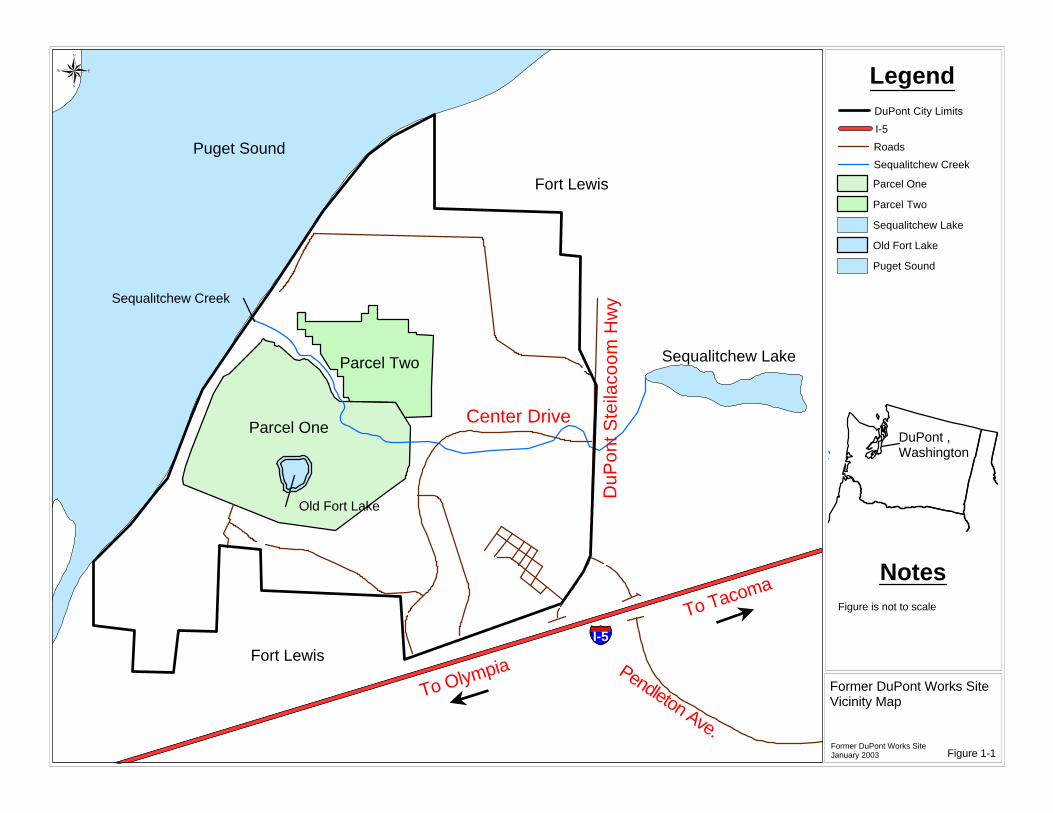
Parcel OneCenter Drive
DuP
ont S
teila
coom
Hw
y
Fort Lewis
Fort Lewis
Sequalitchew Lake
Pendleton Ave.
To Olympia
To Tacoma
§̈¦I-5
Parcel Two
Old Fort Lake
Sequalitchew Creek
Puget Sound
Legend
Former DuPont Works SiteVicinity Map
Former DuPont Works SiteJanuary 2003
®
PacificOcean
NotesFigure is not to scale
Figure 1-1
DuPont ,Washington
l
l
DuPont City Limits
I-5
Roads
Sequalitchew Creek
Parcel One
Parcel Two
Sequalitchew Lake
Old Fort Lake
Puget Sound


Cleanup Action Plan Former DuPont Works Site, DuPont, WA
July 2003 Page 2-1
Section 2 – SITE BACKGROUND
This Section summarizes the Site history, including the chronological history of the investigations, and ISR activities that have taken place at the Site, and describes the physical characteristics of the Site.
2.1 PROPERTY HISTORY
The Site property was originally used by Native Americans. In the 1830s, Europeans settled in the area and built Fort Nisqually, which was located in the northern portion of the Site. DuPont acquired the property in 1906 and constructed an explosives plant and the historical Village of DuPont as a company town for plant workers. DuPont continued to manufacture explosives at the Site until the mid 1970s, when it sold the property and adjacent areas to Weyerhaeuser. Weyerhaeuser still owns the Site. Activities at the Site during its operation and decommissioning resulted in the accumulation of residual chemicals in soils Site-wide and in groundwater.
2.2 SITE INVESTIGATIONS
Actions taken at the Site subsequent to the manufacturing shutdown in 1976 include the following:
• In 1985, Weyerhaeuser initiated studies to determine whether hazardous substances were present.
• In 1986, a Phase I Site Survey and Review was conducted to identify areas on Site that may be of environmental concern.
• In 1986, soil contamination was first documented and reported to Ecology.
• In 1987, a Phase II Site Characterization study was performed, which characterized the type, concentration, and distribution of constituents at 38 areas on the Site.
• In 1989, a Baseline Human Health Risk Assessment was performed using results of the Phase II survey.
• In 1991, Weyerhaeuser and DuPont signed a Consent Decree (No. 91 2 01703 1) with Ecology. This required the Companies to complete an RI, RA, and FS for the Site. The Site was divided into two main areas: Parcel 1 (approximately 636 acres); and Parcel 2 (approximately 205 acres).
• In 1994 and 1995, Draft RI, RA, and FS reports were submitted to Ecology.
• In 1996, based on the result of interim source removal actions, Ecology approved a Cleanup Action Plan (CAP) for Parcel 2 that provided for no further remediation activities except for the institutional controls to maintain the industrial use of Parcel 2.
• In 1997, Parcel 2 was deleted from the Consent Decree, and the deed restriction requiring institutional controls to maintain the industrial use was recorded in the Pierce County Auditor’s Office.
Between 1990 and 2001, while studies and negotiations were ongoing, Weyerhaeuser and DuPont undertook interim source removal actions to clean up soil and/or debris at the Site, in accordance with MTCA and the Consent Decree.
2.3 INTERIM REMEDIAL ACTIONS
Interim source removals have been conducted at the Site between 1990 and 2001 to remove soil and/or debris from specific areas. These ISR activities were undertaken in specific areas referred to as RI areas, which were defined according to historical manufacturing and production operations at the Site. During the ISR activities soil at many of the pre-RI and RI sample locations was removed and therefore data collected previously from those locations are no longer representative of current Site conditions. Removal activities were summarized in a series of ISR memoranda (and in the RI) and have included:
• RI Areas 5 and 6 drum, soil, and debris removal.
• RI Area 8 pipeline, tank, and soil removal.

Cleanup Action Plan Former DuPont Works Site, DuPont, WA
July 2003 Page 2-2
• Sympathetic detonations (RI Area 18).
• Dinitrotoluene-impacted soil removal (RI Areas 10, 18, 25, and 31).
• Lead and miscellaneous debris removal (RI Areas 18/1/2/3/4, 19C, 24, 30, 31, 35, and 36, and Maintenance Buildings).
• Mercury-impacted soil removal (RI Area 39).
• Underground storage tank (UST) removals (RI Areas 20A and 20B, 38, and 39).
• Site-wide lead and arsenic hot spot removal including RI Area LR-68.
• Lead and arsenic impacted soil removal [Foundation and Narrow Gauge Railroad (NGRR)].
• Lead and arsenic impacted soil removal (Sand and Topsoil Laydown Areas).
2.4 RI/RA/FS
In 2002, revised drafts of the RI, RA and FS were submitted to Ecology. These documents present the basis for the decisions selected for the Site and presented in this Report. A brief description of the contents of each of these reports is presented below.
2.4.1 RI
The purpose of the RI was to collect, develop, and evaluate sufficient information regarding the Site to enable completion of the RA and FS. The RI characterized the nature and extent of contamination in the context of past activities at the Site. The RI also presented the analytical data which represents current conditions at the Site (i.e. post-ISR) grouped by RI area.
2.4.2 RA
In contrast to the RI, the RA evaluated Site conditions in relation to future land uses at the Site. The RA identified default soil cleanup concentrations and presented the methods used to derive Site-specific soil concentrations that are protective of human health and ecological receptors based on future land use. These cleanup levels (CLs) and remediation levels (RLs) were compared to Site chemical concentrations in order to identify which areas required additional evaluation in the FS.
2.4.3 FS
The FS evaluated over 50 different remedial technologies or groupings of technologies to identify the alternatives with the highest potential to meet the remedial action objectives (RAOs). The FS divided the Site into Remediation Units (RUs) based upon land use type, or unique physical characteristics, and developed a preferred alternative for each RU. The FS provides the information necessary for Ecology to evaluate and select the remedial alternative appropriate for the Site.
2.5 PHYSICAL SITE CHARACTERISTICS
2.5.1 Topography
The Site is situated on a glacial outwash plain that slopes gently to the west, toward Puget Sound. The significant features of relief across the Site are numerous glacial kettles (depressions), the east-west trending valley of Sequalitchew Creek, a small kettle lake in the southern portion of the Former Production Area (Old Fort Lake), and the steep bluff bordering Burlington Northern Railroad property. The elevation across the Site generally ranges from 200 to 225 feet above mean sea level (msl), except within the kettles, which are at an elevation of approximately 150 feet msl. Before ISR activities began, the Site was generally forested with intermittent clearings associated with the former production activities.
2.5.2 Geology
The four major stratigraphic units beneath the Site include Steilacoom Gravels, Vashon Till, the Olympia Beds/Possession Drift/Whidbey Formation/Double Bluff Drift sequence (DBD-OB) (formerly known as the Kitsap Formation) (Borden and Troost. 2001) and the Salmon Springs Glaciation (formerly known as the Salmon Springs Formation). Each of these units is described below.

Cleanup Action Plan Former DuPont Works Site, DuPont, WA
July 2003 Page 2-3
Steilacoom Gravels comprise the surficial soils of the Site and extend to a depth of 300 feet. The Steilacoom Gravels consist of brown and gray stratified sands and gravels, with cobbles and occasional zones of siltier sand. The Steilacoom Gravels were deposited during retreat of the final (Vashon) glaciation in high-energy meltwater channels, which originated in a proglacial lake located in the present-day Puyallup River valley to the east. The Vashon Till consists of a high density, high silt content till that makes it a weak aquitard upon which perched water has been observed. The Vashon Till is underlain by the Vashon Advance Outwash, which was deposited by glacial rivers or streams during advance of the Vashon glaciation. The Advance Outwash becomes finer-grained with depth, typical of advance outwash deposition. The DBD-OB sequence is a fine-grained, interglacial deposit approximately 70 to 100 feet thick, and very heterogeneous regionally. The DBD-OB sequence is present below the Site but does not extend west of a line about 2,500 feet inland from Puget Sound. The Salmon Springs Glaciation was deposited in the glacial period preceding the DBD-OB sequence interglacial. Regional information indicates that the formation is 70 to 120 feet thick and contains zones of organic silt and till. The Sea Level Aquifer is a regionally extensive aquifer that occurs within the Salmon Springs Glaciation.
2.5.3 Hydrogeology
Two aquifers are present beneath the Site—the shallow Water Table Aquifer (20 to 105 feet below ground surface (BGS)) and the deeper Sea Level Aquifer (160 to 215 feet BGS). Across most of the Site, the relatively impermeable beds within the DBD-OB sequence (Aquitard) restricts vertical flow of groundwater and separates the Water Table Aquifer from the deeper Sea Level Aquifer. However, the Aquitard is absent west of the “Cutoff”, which is located 500 to 2,500 feet east of Puget Sound, and roughly parallel to the shoreline. The “Cutoff” is the western extent of the Water Table Aquifer and is where the Sea Level Aquifer becomes unconfined (west of the “Cutoff”). Groundwater in the Water Table Aquifer flows toward the west-northwest, with local discharge via springs to upper Sequalitchew Creek. At the “Cutoff”, groundwater from the Water Table Aquifer mixes with groundwater in the Sea Level Aquifer. Groundwater in the Sea Level Aquifer flows toward the west-northwest and discharges west of the “Cutoff” as seeps to Puget Sound.
2.6 FUTURE LAND USE
Based on a restrictive covenant, and in accordance with the Final Environmental Impact Statement, future use of the Site will include commercial, golf course, historical, industrial, and open space uses. Commercial use will include development of offices and retail businesses, and will comprise approximately 334 acres of the Site. Most of the soil in commercial areas will be covered by buildings, parking lots, and roads. The remaining soil will be either professionally landscaped or covered with sidewalks. A golf course will cover approximately 187 acres of the Site. Historical areas on the Site include the 1833 Hudson’s Bay Fort, the Shell Midden Site, the 404 Burial Site, and the Methodist Mission site (the location of the monument is presented in Figure 2-1, but the size and actual location are unknown). In total, the 1833 Fort, Shell Midden, and the 404 site comprise approximately 4 acres of the Site. Weyerhaeuser, Weyerhaeuser Real Estate Company, City of DuPont, The Nisqually Point Defense Fund, Committee for the Preservation of the Nisqually Mission Historical Site, The Nisqually Delta Association and the DuPont Historical Society have a Memorandum of Agreement (MOA, 2000) that develops a framework for the establishment of a National Historic District along the banks of Sequalitchew Creek. This MOA is outside the scope of this cleanup project and will come into effect after the cleanup is completed. Industrial use may include activities ranging from mining gravel to development of light industrial facilities. The area proposed for industrial use is north of Sequalitchew Creek and comprises approximately 36 acres of the Site. Open space use, which will occur in four areas of the Site, will encompass a total area of approximately 73 acres. The location of each of these future use areas is presented in Figure 2-1.


Legend®
0 375 750 1,125 1,500187.5Feet
Industrial
Historical
Golf Course
Old Fort Lake
Open Space
Parcel One
Commercial
Old Fort Lake
Future Land Use at the Site
Former DuPont Works SiteMay 2003 Figure 2-1
NotesHistorical location in the Industrial area is the Methodist Mission Marker.Actual location of the mission is unknown.

Cleanup Action Plan Former DuPont Works Site, DuPont, WA
July 2003 Page 3-1
Section 3 – NATURE AND EXTENT OF CONTAMINATION
This Section summarizes the nature and extent of contamination for each medium at the Site including soil, groundwater, surface water, and freshwater sediment. The potential risks associated with affected soils as well as the future land use for the Site are also presented.
3.1 SOIL QUALITY
3.1.1 Current Conditions
Site soil contamination occurs as two distinct categories; lead and arsenic impacted soils, and isolated small occurrences of total petroleum hydrocarbons (TPH), mercury, di and trinitrotoluenes (DNT/TNT), and/or benzo(a)pyrene impacted soils. This second group, referred to as Miscellaneous Small Remediation Units or MSUs throughout this Report, represents less than 1% of the total volume of contaminated soils.
3.1.2 Lateral and Vertical Extent
Lead and Arsenic Impacted Soils Lead contamination was detected Site-wide. Arsenic contamination was generally detected within 25 feet of the former NGRR track beds but can occur in other discrete areas of the Site. The vertical extent of those chemicals was generally confined to a depth of less than 1 foot BGS in all areas except where acid was discharged, drywell locations, some production-related foundations, and disposal areas. The vertical extent was generally limited to a depth of less than 10 feet BGS in these areas.
Miscellaneous Small Units The lateral extent of MSU soils was generally limited to production building foundations and waste disposal areas. The vertical extent of chemicals was generally confined to a depth of less than 1 foot BGS in all areas except where acid was discharged, drywell locations, some production-related foundations, and disposal areas. The vertical extent was generally limited to a depth of less than 10 feet in these areas. Debris painted with lead-based paint occur in soils throughout the Site. The majority of these occurrences is limited to production foundations and waste disposal areas but can occur in other discrete areas of the Site.
3.2 GROUNDWATER QUALITY
3.2.1 DNT Data for Site Groundwater
DNT is the only chemical that is of potential concern in groundwater. All other chemicals are either below levels of concern, were not detected, or are below background concentrations. Data from 34 rounds of combined pre-RI and RI groundwater sampling at 30 well locations indicate that low DNT concentrations have been consistently detected in 6 of 30 Site groundwater monitoring locations.
3.2.2 DNT Data for Groundwater Discharging via Seeps to Puget Sound
Site groundwater is discharging to the intertidal area of Puget Sound. The seep groundwater discharge is naturally saline due to saltwater intrusion, which disqualifies these seeps as drinking water sources in accordance with MTCA (the locations are also submerged at high tide). Two visible and accessible locations, Seep 1 and Seep 2, were sampled and total DNT has ranged from nondetect to 0.27 µg/L in the 25 samples collected from SEEP 1. DNT was not detected in SEEP 2. All detected DNT concentrations at SEEP 1 are at least 33 times lower than the surface water protective concentration of 9.1 µg/L.
3.2.3 Other Chemicals
In 1988, nitrate was detected in three Site monitoring wells. Because one of the monitoring wells is located along the eastern (upgradient) edge of the Site, off-Site sources of nitrate (such as animal pasturing) are possible. All three wells have had relatively low nitrate concentrations since 1988. Total cPAH concentrations in groundwater have all been low. With the exception of naturally occurring aluminum concentrations (also detected in background groundwater samples), all other dissolved metals were detected at low concentrations.

Cleanup Action Plan Former DuPont Works Site, DuPont, WA
July 2003 Page 3-2
3.3 SURFACE WATER QUALITY
Three surface water bodies—Puget Sound, Sequalitchew Creek, and Old Fort Lake—occur within or adjacent to the Site. Puget Sound is a large saltwater body west of the Consent Decree area. Puget Sound directly or indirectly receives all groundwater and surface water discharge from the Site. Sequalitchew Creek is a perennial stream that originates in Sequalitchew Lake east of the Site and discharges into Puget Sound. In the dry season, the upper and lower reaches of the creek within the Site are dry. Old Fort Lake is a small glacial kettle lake that has no inlet or outlet. The lake is fed by groundwater from the Water Table Aquifer, and the lake level is an expression of the Water Table Aquifer. Of the wide range of chemicals sampled for in Site surface water, only dissolved lead and dissolved copper were detected at elevated concentrations in one or more samples collected from Old Fort Lake and Sequalitchew Creek. Dissolved copper was the only chemical with confirmed elevated detections. Dissolved lead was detected infrequently at marginally elevated concentrations in both Old Fort Lake and Sequalitchew Creek. None of the lead detections were confirmed in preceding or subsequent sampling rounds. In addition, the concentrations of dissolved copper and lead detected in on-Site surface water are within the range of background concentrations detected in an area background (upstream) sampling location in Sequalitchew Creek (SW-4). Concentrations of dissolved copper and lead detected in on-Site surface water are within the range of background concentrations detected in other regional rivers and streams in Pierce County. Based on these data, Ecology provided verbal agreement that No Further Action was required for surface water at the Site (pending the submittal of a summary of the data), indicating that chemicals detected in Site surface water do not require cleanup or any further action (Ecology 1996).
3.4 FRESHWATER SEDIMENT
Of the wide range of chemicals for which freshwater sediment samples were analyzed, no chemicals were detected at elevated concentrations. Lead was detected in Old Fort Lake sediments but at relatively low concentrations. Detected concentrations of metals were comparable to available background sediment data for the Puget Sound region. Based on these data, Ecology provided verbal agreement that No Further Action was required for freshwater sediment at the Site (pending the submittal of a summary of the data), indicating that chemicals detected in Site freshwater sediment do not require cleanup or any further action (Ecology 1996).

Cleanup Action Plan Former DuPont Works Site, DuPont, WA
July 2003 Page 4-1
Section 4 – SOIL INDICATOR CHEMICALS AND CLEANUP STANDARDS
This Section identifies the indicator chemicals and summarizes the Site-specific cleanup and remediation levels. MTCA requires the establishment of cleanup standards for individual sites. Cleanup standards consist of cleanup or remediation levels and points of compliance. Cleanup and remediation levels (CLs and RLs, respectively) determine the concentration at which a chemical does not pose a threat to human health or the environment. Material that exceeds a CL or RL is addressed through a remedy that prevents exposure to the material. Points of compliance represent the locations on the Site where CLs or RLs must be met.
4.1 RISKS TO HUMAN HEALTH AND THE ENVIRONMENT
Risks to human health and the environment are associated with potential exposure to residual chemicals in soil and debris present at the Site. Residual chemicals are those chemicals that remain in the soil, after the explosives manufacturing facility was decommissioned and after ISRs. Future users of the Site may be exposed via incidental soil ingestion. Ecological receptors may be exposed via ingestion of soil, plants, or soil biota from the areas where there are residual chemicals in soil.
4.2 SELECTION OF SOIL INDICATOR CHEMICALS
MTCA defines the criteria used to determine whether a chemical should be retained as an indicator chemical for the Site. When defining CLs or RLs at a site contaminated with several hazardous chemicals, Ecology may eliminate from consideration those contaminants that contribute a small percentage of the overall risk to human health and the environment. WAC 173-340-703(2) provides that a chemical may be eliminated from further consideration based on:
• The frequency of detection. If a compound is detected in 5% or less of samples analyzed, it may be appropriate to eliminate it;
• The concentration of the chemical. Chemicals with concentrations marginally above their cleanup standards may not be important in consideration of overall hazard and risk;
• The toxicity of the chemical. It may be suitable to delete chemicals of low toxicity;
• Environmental fate. Chemicals that readily degrade in the environment may not be of importance to overall hazard or risk. Conversely, those with highly-toxic degradation products should be included in an analysis of overall hazard and risk;
• The natural background levels of the chemical. MTCA regulates risks due to chemicals found at contaminated waste sites. The risks caused by chemicals at background concentrations are not addressed by MTCA;
• The mobility and potential for exposure to the chemical. Chemicals may be eliminated if the values for these factors are low.
A preliminary list of indicator chemicals was identified for the Site by eliminating from consideration those chemicals that were not detected in any sample. Following this screening step, there were 38 detected chemicals in surface soil and 52 detected chemicals in subsurface soil. A second screening step was performed in which the maximum detected concentration for each chemical was compared to the most conservative (i.e., the lowest) soil CLs and screening concentrations presented in MTCA for human and ecological receptors. Following this screening step, there were 18 indicator chemicals identified for surface soil, 20 indicator chemicals identified for subsurface soil, and 3 COPCs identified for subsurface soil greater than 15 feet BGS at the Site. The RA evaluated all of the indicator chemicals to determine which chemicals posed unacceptable risks. The RA (see PIONEER 2003) identified the following chemicals as being of concern:
• Lead – Site wide.
• Arsenic – Site wide.
Cleanup Action Plan Former DuPont Works Site, DuPont, WA
July 2003 Page 4-2
• TPH (Bunker C and non-Bunker C) – Four locations on-Site.
• Mercury – Five locations on-Site.
• TNT – Five locations on-Site.
• Benzo(a)pyrene – One location on-Site.
• Aldrin – One location on-Site.
The CLs or RLs that were developed in the RA for each of these chemicals is presented in the following sections.
4.3 OVERVIEW OF CLEANUP, SCREENING, AND REMEDIATION LEVELS
CLs, screening levels, and RLs were used to assess potential impacts to human health and the environment at the Site. CLs specified in MTCA are concentrations that are protective of humans for specific exposure scenarios (i.e., industrial land use and unrestricted future land use) (WAC 173-340-200). To supplement these MTCA table values, Ecology has approved Site-specific CLs for a select group of chemicals (including a Site-specific CL for arsenic in soil based on the area background concentration). In addition, Ecology performed an evaluation of the Site and identified a screening concentration for lead to evaluate the potential for terrestrial ecological impacts. RLs are Site-specific levels based on protection of human health that are developed using exposure assumptions and other media-specific factors that reflect future Site conditions. RLs are calculated using human health risk assessment procedures and Site-specific information, as specified in WAC 173-340-708. In order to apply RLs institutional controls (such as deed restrictions) or engineering controls (such as a cap) are implemented for properties with residual contamination to ensure that the exposure conditions assumed in the derivation of these levels are maintained at the Site in the future.
4.4 SITE CLEANUP, SCREENING, AND REMEDIATION LEVELS
The RI documents the presence of contamination in soil and groundwater at the Site. CLs or RLs that have been developed for each of these media are presented below and summarized in Table 4-1.
4.4.1 Soil Cleanup Levels
CLs for soil are published by Ecology, and are default values that can be used at any site. These default CLs were applied to the industrial area located north of Sequalitchew Creek. These levels assume adult workers would be exposed to hazardous chemicals through incidental soil ingestion, and were calculated in accordance with WAC 173-340-745. Another CL used at the Site was 2,000 mg/kg for TPH (non-bunker C), which was obtained from the MTCA Method A Table, in WAC 173-340-900. In addition, Site-specific CLs for mercury, TPH (bunker C), total DNT, and TNT were approved for use at the Site by Ecology. An area background soil concentration was determined and used to develop a CL for arsenic per WAC 173-340-709. As part of the RI investigation, soil samples were collected outside of the Consent Decree boundary to define the “Site Area Background” level of arsenic. As stipulated in WAC 173-340-709, twenty soil samples were collected to statistically establish area background levels. Based on the results of these samples, the Site area background concentration for arsenic is 32 mg/kg. This value represents the 90th percentile value of the distribution of the background samples.
4.4.2 Ecological Soil Screening Concentration for Lead
Ecology has performed an evaluation of the Site and determined that lead is the indicator chemical for potential terrestrial ecological impacts. As part of this evaluation, Ecology determined that based on Site-specific information the potential species groups of concern included ground-feeding birds and herbivorous small mammals. The resulting soil lead screening level identified by Ecology is intended to be protective of wildlife, including birds and small mammals.
4.4.3 Soil Remediation Levels
The equations used to calculate RLs for all chemicals except lead were obtained from WAC 173-340-740. Soil RLs were calculated using these equations, considering the potential reasonable maximum exposure (RME) for humans under each future land use. For lead, EPA and Ecology have chosen to evaluate the potential adverse health effects
Cleanup Action Plan Former DuPont Works Site, DuPont, WA
July 2003 Page 4-3
using a physiologically-based model. The model currently used by EPA for establishing lead RLs in non-residential areas is the Adult Lead Model (EPA, 1996). Using this model, Site-specific RLs were developed for golf course worker, commercial worker, and industrial worker scenarios. A hybrid approach using both the Adult Lead Model and the child Integrated Exposure Uptake Biokinetic Model for Lead (IEUBK), was used to derive a RL for open space areas.
4.4.4 Groundwater Cleanup Level for DNT
The groundwater CL for DNT was calculated in accordance with MTCA Method B, WAC 173-340-720. This default value was calculated based on the assumption that someone is living at the Site and their drinking water is obtained from groundwater.
4.4.5 Summary of Cleanup and Remediation Levels
Table 4-1 presents the soil cleanup, screening, and remediation levels for each land use and applicable media. These values were used in the RA and FS to evaluate the effectiveness of remedial actions for each chemical and RU.
4.5 POINT OF COMPLIANCE
The MTCA Cleanup Regulation defines the point of compliance as the point or points where CLs or RLs shall be attained (WAC 173-340-200). Once CLs or RLs are met at the point of compliance, the Site is no longer considered a threat to human health or the environment.
4.5.1 Soil Points of Compliance
For soil CLs and RLs the point of compliance is established in soils throughout the Site. The actual points of compliance will be located on the Site-wide grid nodes that are 75 feet apart. In instances where there are MSUs located 0 to 1 foot BGS, the point of compliance will be a 50 x 50 foot area that will be centered on or around each MSU area. The point of compliance for MSUs at a depth greater than 1 foot BGS will be 15 x 15 foot boxes and samples will be collected from each sidewall and the bottom of the excavation.
4.5.2 Groundwater Point of Compliance
For groundwater, each well is a point of compliance.


Cleanup Action Plan Former DuPont Works Site, DuPont, WA
July 2003 Page 4-4
Table 4-1 – Soil and Groundwater Cleanup, Screening, and Remediation Levels for each Land Use
Chemical
Commercial and
Golf Course Cleanup
and Remediation
Levels (mg/kg)
Golf Course Cap
Remediation Levels
(mg/kg)
Historical and Open Space Cleanup and Remediation
Levels (mg/kg)
Industrial Cleanup and Remediation
Levels (mg/kg)
Groundwater Screening
Concentration (ug/L)
Explosives 2,4,6-Trinitrotoluene 1.75(1.2) 1.75(1,2) 1.75(1) 1.75(1) NA
DNT 3.0(3) 3.0(3) 3.0(3) 3.0(3) 0.13
Petroleum Hydrocarbons TPH (418.1) (Bunker C) 7,600(4) 7,600(4) 7,600(4) 7,600(4) NA
TPH (418.1) (heavy oil, non-Bunker C)
2,000(5) 2,000(5) 2,000(5) 2,000(5) NA
Inorganics Arsenic 60(6,7) 530(6,7) 32(8) 90(9) NA Lead 118(10) 4,100(6) 118(10) 1,000(11) NA Mercury 24(6) 24(6) 24(6) 24(6) NA PAHs Benzo(a)Pyrene 12.6(7) 109(7) 0.71(7) 18(10) NA Pesticides/PCBs Aldrin 5(6) 47(6) 0.3(6) 7.7(9) NA Notes: (1) Soil concentration protective of groundwater approved by Ecology. (2) Value is a cleanup level. (3) Soil concentration for DNT (2,4-DNT plus 2,6-DNT) protective of human health and groundwater approved by Ecology. (4) Ecology agreement for TPH that originated as Bunker C fuel. One Area has TPH that did not originate from Bunker C fuel. Those TPH data
were compared to the MTCA Table A value of 2,000 mg/kg for heavy oils. (5) MTCA Method A value for heavy oil. (6) Based on Site-specific exposure factors approved by Ecology. (7) Value is a remediation level.
(8) Based on Site-specific background concentration approved by Ecology. (9) Calculated using MTCA Method C parameters. (10) Ecological screening concentration. (11) MTCA default value used for Parcel 2.

Cleanup Action Plan Former DuPont Works Site, DuPont, WA
July 2003 Page 5-1
Section 5 – SELECTION OF A CLEANUP ACTION
5.1 REMEDIAL ACTION OBJECTIVES
Remedial Action Objectives (RAOs) are statements describing the actions necessary to protect human health and the environment through eliminating, reducing, or otherwise controlling risks posed through each exposure pathway and migration route. They are developed considering the appropriate CLs or RLs for each indicator chemical, the characteristics of the contaminated medium, the characteristics of the chemicals present, the migration and exposure pathways, the potential receptor points and other relevant regulations. Soil and groundwater are the contaminated media of concern at the Site. People may be exposed to contaminated soil via ingestion while ecological receptors may be exposed via ingestion of soil, plants, and soil biota. Due to existing deed restrictions eliminating residential development, the most likely potentially exposed populations would be on-Site workers and older children who will have access to open space areas. Given these potentially exposed populations and exposure pathways, the RAOs for the Site center around the prevention or minimization of exposure of humans and ecological receptors to impacted soils, but include:
• Achieving CLs or RLs that will be protective of human health and the environment; and
• Compliance with chemical-, location-, and action-specific Applicable or Relevant, and Appropriate Requirements (ARARs).
5.2 APPLICABLE, RELEVANT AND APPROPRIATE REQUIREMENTS
MTCA requires that all cleanup actions comply with applicable state and federal law, and further states that the term ‘applicable state and federal laws’ shall include legally applicable requirements and those requirements that the department determines are ‘relevant and appropriate requirements’ (WAC 173-340-710(1)). This section discusses applicable state and federal law, relevant and appropriate requirements, and local permitting requirements, which were considered in the FS and were of primary importance in selecting cleanup requirements in this CAP. If other requirements are identified at a later date, they will be applied to the cleanup actions at that time. MTCA provides an exemption from the procedural requirements of several state laws, and from any laws authorizing local government permits or approvals for remedial actions (RCW 70.105D.090). Substantive requirements must be met. The substantive requirements currently known are incorporated into this CAP. If further additional substantive requirements are identified, the necessary steps to incorporate them will be taken. The procedural requirements of the following state laws are exempted:
• Chapter 70.94 RCW, Washington Clean Air Act;
• Chapter 70.95 RCW, Solid Waste Management, Reduction, and Recycling;
• Chapter 70.105 RCW, Hazardous Waste Management;
• Chapter 75.20 RCW, Construction Projects in State Waters;
• Chapter 90.48 RCW, Water Pollution Control; and
• Chapter 90.58 RCW, Shoreline Management Act of 1971.
WAC 173-340-710(4) sets forth the criteria that Ecology evaluates when determining whether certain requirements are relevant and appropriate for a cleanup. Those criteria are as follows:
(a) Whether the purpose for which the statute or regulations under which the requirement was created is similar to the purpose of the cleanup action;
(b) Whether the media regulated or affected by the requirement is similar to the media contaminated or
affected at the site;

Cleanup Action Plan Former DuPont Works Site, DuPont, WA
July 2003 Page 5-2
(c) Whether the hazardous chemical regulated by the requirement is similar to the hazardous chemical found at
the site; (d) Whether the entities or interests affected, or protected, by the requirement are similar to the entities or
interests affected by the site; (e) Whether the actions, or activities, regulated by the requirement are similar to the cleanup action
contemplated at the site; (f) Whether any variance, waiver, or exemption to the requirements are available for the circumstances of the
site; (g) Whether the type of place regulated is similar to the site; (h) Whether the type and size of structure or site regulated is similar to the type and size of structure, or site,
affected by the release or contemplated by the cleanup action; and (i) Whether any consideration of use or potential use of affected resources in the requirement is similar to the
use, or potential use, of the resources affected by the site, or contemplated cleanup action. The following lists present the state and federal laws that contain the ARARs that apply to the cleanup action for the Former DuPont Works Site.
Potential CLs and Chemical-Specific ARARs
• The Model Toxics Control Act Chapter 173-340 WAC.
Potential Location-Specific Requirements
• Washington State Shoreline Management Act (Chapter 90.58 RCW; Chapters 173-18, 173-22, and 173-27 WAC).
• Pierce County Shoreline Management Use Regulation (Title 20).
• Pierce County Development Regulations—Critical Areas (Title 18E).
• Washington State Hydraulic Projects Approval (Chapters 75.20.100 Through 75.20.160 RCW; Chapter 220-110 WAC).
• The Fish and Wildlife Coordination Act.
• Endangered Species Act (16 USC 1531 et seq.; 50 CFR Parts 17, 225, and 402).
• Native American Graves Protection and Repatriation Act (25 USC 3001 Through 3013; 43 CFR Part 10) and Washington's Indian Graves and Records Law (Chapter 27.44 RCW).
• Archaeological Resources Protection Act (16 USC 470aa et seq.; 43 CFR Part 7).
Potential Action-Specific Requirements
• Washington Dangerous Waste Regulations (Chapter 173-303 WAC).
• Solid Waste Management Act (Chapter 70.95 RCW; Chapter 173-304 and 173-351 WAC).
• Water Quality Standards for Surface Waters of the State of Washington (Chapters 90.48 and 90.54 RCW; Chapter 173-201A WAC).
• Federal, State, and Local Air Quality Protection Programs.
• Department of Transportation Hazardous Materials Regulations (40 CFR Parts 171 Through 180).
• Occupational Safety and Health Act (29 CFR 1910).

Cleanup Action Plan Former DuPont Works Site, DuPont, WA
July 2003 Page 5-3
• Washington State Water Well Construction Act (Chapter 18.104 RCW; Chapter 173-160 WAC).
5.3 SOIL CLEANUP ACTION ALTERNATIVE EVALUATION CRITERIA
Cleanup alternatives designed to meet RAOs were evaluated as part of the FS for the Site. The following criteria were used to screen technologies and processes to determine if the alternatives selected represent those that are permanent to the maximum extent practicable as defined by WAC 173-340-360 (3)(b).
5.3.1 Effectiveness
Effectiveness involves those criteria that evaluate the state of development of the technology, the ability to protect human health and the environment, and identifies potential negative impacts associated with the technology. Under this heading are the following MTCA criteria:
• Protectiveness: This evaluation considers the degree of protection each technology provides to human health and the environment, the extent to which reductions in risk, toxicity, and/or mobility are expected to be achieved, the time required to reduce risk and obtain cleanup standards, the off-Site and on-Site risks resulting from the implementation of the alternative, and the degree of improvement of the overall environmental quality.
• Permanence: This evaluation considers the degree to which the alternative permanently reduces the toxicity, mobilization or volume of the contaminants. This evaluation considers the materials treated, quantity of material treated, degree of toxicity, mobility, and volume reduction, degree to which the treatment is irreversible, and residuals type and quantity.
• Long Term Effectiveness: This evaluation considers the effectiveness of the process during the time when contaminant concentrations remain on-Site that are greater than CLs or RLs, the magnitude of risk with the alternative in place, and the adequacy and reliability of any Site controls.
• Management of Short Term Risks: This evaluation considers the effectiveness of the process in dealing with the potential impacts to human health and the environment during the implementation phase.
• Consideration of Public Concerns: This evaluation considers community concerns associated with the alternative, and how those concerns will be addressed.
5.3.2 Implementability
Implementability involves the technical and administrative feasibility of constructing, operating, and maintaining a particular remediation technology. Technical implementability has already been used in the preliminary screening. At this stage, the emphasis is placed on the institutional aspects of implementability, such as the ability to obtain the necessary permits, the availability of treatment, storage, and disposal services, and the availability of necessary equipment and skilled workers to implement the technology.
5.3.3 Cost
The cost for remediation work includes such items as installation and operation of process equipment, excavation, and disposal fees. The cost analysis is made on the basis of engineering judgment, and each process is evaluated as to whether costs are high, medium, or low relative to other process options in the same technology category.
5.4 GROUNDWATER CLEANUP ACTION ALTERNATIVES EVALUATION
Dinitrotoluene (DNT) has been detected in groundwater below the Site at concentrations above drinking water standards but consistently below the MTCA Method B value. Two alternatives where evaluated in the FS for the remediation of groundwater. They were Active Groundwater Treatment and Natural Restoration.
5.5 REMEDIAL ALTERNATIVES EVALUATED AT THE SITE FOR SOIL
The FS evaluated over 50 different technologies or combinations of technologies using the criteria presented in Secton 5.3 and recommended the following four remedial alternatives for detailed analysis. These alternatives where judged to be appropriate for large-scale applications (ranging from greater than 2 acres in size to total Site remediation) only.

Cleanup Action Plan Former DuPont Works Site, DuPont, WA
July 2003 Page 5-4
• No Action;
• On-Site Deposition with Cap (i.e., highly durable, impermeable, engineered material) and Cover (i.e., clean soil layer that may include gravel layer);
• Off-Site Disposal at a Landfill; and
• Wet Screening with On-Site Deposition with Cap and Cover and Disposal of the Residual Soils at a Landfill.
The FS determined that there were five alternatives that should be further evaluated for small-scale applications (less than 2 acres in size or 5,000 cubic yards in volume). In addition to the No Action alternative, which may have limited applications and small isolated occurrences of chemicals that were not either used or generated as part of the manufacturing activities of decommissioning of the buildings at the Site, the four primary remedial alternatives (to be used on a small-scale basis) considered in the detailed analysis were as follows:
• Cap;
• Cover;
• Cap/Cover; and
• Off-Site Disposal at a Landfill.
The FS performed a detailed analysis of these remedial alternatives and recommended on-Site Deposition with Cap and Cover as the preferred alternative for large-scale applications and a combination of the above alternatives for small scale applications:
5.6 EVALUATION OF THE RETAINED CLEANUP ACTION ALTERNATIVES
The retained alternatives were evaluated using the following six criteria:
• Protection of Human Health and the Environment;
• Compliance with Cleanup Standards;
• Compliance with Applicable State and Federal Laws;
• Provision for Compliance Monitoring;
• Use of Permanent Solutions to the Maximum Extent Practicable; and
• Provision of a Reasonable Restoration Time Frame
The results of the evaluation for each criterion is presented below.
5.6.1 Protective of Human Health and the Environment
All alternatives, except No Action, protect human health and the environment. Ingestion of contaminated soil by on-Site workers and ingestion of soil, plants, or soil biota by ecological receptors are the primary pathways of concern. By removing the contaminated soils from the Site or covering them with a cap/cover system, these pathways are either eliminated or controlled. Institutional controls will prevent disruption to the cap/cover and thereby prevent exposure to contaminated soils. No Action does not meet cleanup standards and, thus, does not meet this threshold criterion.
5.6.2 Compliance with Cleanup Standards
All preferred alternatives, except No Action, achieve cleanup standards through either off-Site disposal or on-Site containment actions. No action does not meet cleanup standards and, thus, does not meet this threshold criterion.
5.6.3 Compliance with Applicable State and Federal Laws
All the retained alternatives comply with applicable state and federal laws as identified above, except No Action.

Cleanup Action Plan Former DuPont Works Site, DuPont, WA
July 2003 Page 5-5
5.6.4 Provision for Compliance Monitoring
All alternatives could address these requirements by providing a program for compliance monitoring. A compliance monitoring plan, for groundwater, has been operational for the Site since 1989, will be updated as needed, and will be continued until CLs are met.
5.6.5 Use of Permanent Solutions to the Maximum Extent Practicable
To determine whether a cleanup action uses permanent solutions to the maximum extent practicable, the disproportionate cost analysis specified in the regulation was used (WAC 173-340-360(3)(e)). The analysis compared the costs and benefits of the cleanup action alternatives and requires the consideration of several factors. Costs are disproportionate to the benefits if the incremental costs of the alternative over that of a lower cost alternative exceed the incremental degree of benefits achieved by the alternative over that of the lower cost alternative. Based on the analysis and information completed in the FS, it has been determined that preferred alternative (On-Site Deposition with a Cap/Cover) in comparison to the other alternatives for large scale applications uses permanent solutions to the maximum extent practicable.
5.6.6 Provision of a Reasonable Restoration Time Frame
WAC 173-340-360(4) describes the specific requirements and procedures for determining whether a cleanup action provides for a reasonable restoration time frame, as required under subsection (2)(b)(ii). The factors that are used to determine whether a cleanup action provides a reasonable restoration time frame are set forth in WAC 173-340-360(4)(b). On-Site Deposition with a Cap/Cover has the shortest time frame of those retained for final analysis in the FS.
5.7 PREFERRED ALTERNATIVE FOR LARGE SCALE APPLICATIONS
Based on the above analysis, On-Site Deposition with Cap/Cover is the preferred alternative, followed by Wet Screening with On-Site Deposition, with Cap and Cover, and Disposal of the Residual Soils at a Landfill. Off-Site Disposal at a Landfill is the high cost alternative. No action has a low cost but does not meet cleanup standards and, thus, cannot be used except, possibly, in special circumstances, e.g., areas of ecological sensitivity.
5.8 PREFERRED ALTERNATIVE FOR SMALL SCALE APPLICATIONS
Like the FS, this CAP did not consider cost in the evaluation of alternatives for small scale applications. As such, Cap/Cover and Excavation, and Off-Site Disposal at a Landfill were selected as two of the three proposed preferred alternatives. On-Site Deposition with Cap/Cover was added as the third preferred alternative after further consideration. Capping could have limited application and No Action could be considered in areas of ecological sensitivity and in areas of small isolated occurrences of chemicals that were not either used or generated as part of the manufacturing activities of decommissioning of the buildings at the Site.
5.9 PREFERRED ALTERNATIVE FOR GROUNDWATER
Natural Restoration was selected as the preferred altervative for groundwater remediation. Active Groundwater Treatment was not selected since its cost would be substantial and disproportionate to the degree of risk reduction achieved.


Cleanup Action Plan Former DuPont Works Site, DuPont, WA
July 2003 Page 6-1
Section 6 – PROPOSED CLEANUP ACTION DECISION
The proposed cleanup action for the Site for the different RUs is presented below. The different RUs are identified in Figure 6-1.
6.1 PROPOSED CLEANUP ACTION - LARGE SCALE APPLICATIONS
6.1.1 Remediation Units CM-1 through CM-8 and GC-1 through GC-9
Decision: Based on the analysis summarized in Section 5, the preferred alternative (On-Site Deposition with Cap/Cover) has been selected as the proposed cleanup action for these RUs.
Justification: The preferred alternative meets each of the threshold requirements and uses permanent solutions
to the maximum extent practicable. The incremental costs of the other retained alternatives are disproportionate to their incremental benefits. The cost of the preferred alternative is less than the other alternatives and provides a similar level of protection for human health and the environment. The cap/cover system will reduce potential exposure routes and limit the migration of contaminants. The preferred alternative provides a reasonable restoration time frame and addresses public concerns.
6.1.2 Remediation Unit CM-09
Decision: Based upon the information presented in the RA, the No Action alternative has been selected as the proposed cleanup action for this RU.
Justification: Based upon the information presented in the RA, CM-09 will be in compliance with MTCA three-
fold statistical criteria once isolated “hot spot” locations (MSU-29 and MSU-30) have been remediated. See Figure 6-2 for the location of these MSUs.
6.1.3 Remediation Units OS-01, OS-02 NOC, OS-03 SOC and OS-04
Decision: Based upon the information presented in the RA, the No Action alternative has been selected as the proposed cleanup action for these RUs. The location of the four open space RUs are presented in Figure 6-1.
Justification: Based upon the information presented in the RA, OS-01, OS-02 NOC, and OS-03 SOC will be in
compliance with MTCA three-fold statistical criteria once isolated MSU locations (MSU-98 through 106) have been remediated. See Figure 6-2 for the location of these MSUs.
The OS-4 RU is the open space surrounding Old Fort Lake. There are no lead exceedances, but there
are four locations that have arsenic concentrations marginally above the area background concentration of 32 mg/kg.
No Action is proposed for these RUs due to the special ecological sensitivity of the area. These RUs represent environmentally sensitive areas that contain a surface water body and steep slopes. As such, excavation in these areas would likely cause slope stability and sedimentation problems which could result in undue harm to these water bodies. Ecology has completed visual inspections of these RUs and has found diverse and abundant plant and wildlife communities. These factors have led to the determination that the greatest net environmental benefit would result from no remediation in these areas. No Action would cause less long-term harm to the local ecology in these RUs than any of the active remediation alternatives. This determination is supported by the public’s strong desire to protect these sensitive areas.
6.2 DESCRIPTION OF PROPOSED CLEANUP ACTION - LARGE SCALE APPLICATIONS
6.2.1 Excavation
RUs that were not incompliance with the 3-fold criteria will be excavated to a depth of 1 foot.

Cleanup Action Plan Former DuPont Works Site, DuPont, WA
July 2003 Page 6-2
6.2.2 Soil Excavation Methods
Excavation of soils not in compliance with Site-specific RLs for lead and arsenic would occur by one of the following methods. All excavation work done within the first three feet of the current ground surface will be monitored by trained archeologists to determine if cultural or archeological artifacts are present. If any artifacts are found they will be treated in the manner described in the Cultural Resource Protection Plan.
Scraping The majority of the shallow soils (up to 1.0 foot deep) will be excavated using self-loading pan scrapers. This method would be used on those areas within Parcel 1 that are not historical or open space RUs. Some selected excavation could occur within the golf course areas. The general scraping process would be:
• Phase I - The upper six inches of soil would be removed, using a self-loading pan scraper.
• Phase II - The remaining six inches of soil would be graded into a windrow and picked up by the pan scraper. GPS will be used to confirm the initial depth, followed by a complete survey to confirm the depth excavated.
Other Excavation In those areas not accessible to the pan scrapers (because of topography or other reasons), an excavator will be used to selectively excavate the soil in six to eight inch lifts until the desired depth of 1 foot is met. The excavated soil will be loaded into off-road haul trucks and transported to the PAs for placement. Direct pushing of soils into the PA is possible from areas adjacent to PAs GPS will be used to confirm the initial depth, followed by a complete survey to confirm the depth excavated. All of the material excavated would be placed in the PAs within the golf course areas and rough-graded.
6.2.3 Cap Construction
A golf course will be constructed on the Site and will serve as engineered cover (cap) for contaminated soils and, if necessary, debris. The majority of this material will be moved from the commercial land use areas in Parcel 1 and consolidated in roughly 90 acres of the approximately 180-acre golf course footprint. These 90 acres would constitute the PAs. Only soils and debris that contain contaminant concentrations equal to or less than the golf course RLs would be placed in the PAs. Each PA would be capped with 18 inches of clean soil by one of the two methods listed below. This cap would be placed on any areas with in-situ contaminant concentrations (if not excavated) less than the golf course RL but greater than the Site-specific commercial RL.
Method One Six inches of clean soil will be placed over 12 inches of pit run gravel. In this process, the gravel would act as an exposure barrier to ecological receptors. The six inches of clean soil would act as an additional exposure barrier to individuals most likely to be exposed—the golf course worker, who, on occasion, may find it necessary to install drainage ditches or repair irrigation pipes.
Method Two Eighteen inches of “pit run” soil will be placed over a geotextile. In this case, the 18 inches of soil would act as the human exposure barrier and the geotextile will act as the ecological exposure barrier.
6.2.4 Haul/Stockpile
Excavated soil will be transported directly to future golf course placement areas (PAs) for deposition or transported to a central area and stockpiled in preparation for treatment or disposal.
6.2.5 Verification Sampling and Analysis
Verification soil samples will be collected from excavated areas and analyzed. Analytical results will be evaluated to determine compliance. If soil remaining in the excavation does not meet Site RLs or, if applicable, CLs, additional excavation and verification sampling and analysis will be performed.

Cleanup Action Plan Former DuPont Works Site, DuPont, WA
July 2003 Page 6-3
6.3 PROPOSED CLEANUP ACTION – SMALL-SCALE APPLICATIONS
6.3.1 Miscellaneous Small Remediation Units: MSU-1, 2, 5, 6, 9, 11, 12, and 18-28
Decision: Based upon the information presented in the RA and FS, the Excavation and Off-Site Disposal at a Landfill alternative has been selected as the proposed cleanup action for these RUs. See Figure 6-2 for the location of these MSUs.
Justification: These MSUs contain isolated occurrences of a single contaminant in soil and represent a small in-
place volume. This alternative meets each of the threshold requirements. Furthermore, since it would be costly to perform secondary treatment on soils, the preferred alternative uses permanent solutions to the maximum extent practicable. The incremental costs of the other retained alternatives are disproportionate to their incremental benefits. Due to the small volume of soil involved, this alternative provides a reasonable restoration time frame and addresses public concerns.
6.3.2 Miscellaneous Small Remediation Units: MSU-122-132
Decision: Based upon the information presented in the RA and FS, the Excavation and Off-Site Disposal at a Landfill alternative has been selected as the proposed cleanup action for these RUs. See Figure 6-2 for the location of these MSUs.
Justification: These MSUs contain isolated occurrences of chemicals that were not either used or generated as
part of the manufacturing activities or decommissioning of the buildings at the Site. No action would be appropriate for small occurrences of cadmium since this contaminant has not been detected in groundwater, occurs in very low concentrations, has an average/mean concentration that is below the CL, has a low number of exceedances (less than 5%) of the CL in comparison to the number of detections and/or samples collected, and have no known source associated with activities at the Site.
6.3.3 Miscellaneous Small Remediation Units: MSU-4, 8, 7, 10, 14-16, 76 and 87
Decision: Based upon the information presented in the RA and FS, the Excavation and Off-Site Disposal at a Landfill alternative has been selected as the proposed cleanup action for these RUs. See Figure 6-2 for the location of these MSUs.
Justification: These MSUs contain occurrences of a similar mixture of contaminants (e.g., TPH mixture,
nitroaromatic explosive compound mixture, etc.) in soil and represent a small in-place volume. This alternative meets each of the threshold requirements. Furthermore, since it would be costly to perform secondary treatment on soils, the preferred alternative uses permanent solutions to the maximum extent practicable. The incremental costs of the other retained alternatives are disproportionate to their incremental benefits. Due to the small volume of soil involved, this alternative provides a reasonable restoration time frame and addresses public concerns.
6.3.4 Miscellaneous Small Remediation Units: MSU-3, 13, 29-68, 70-75, 77-86, 88-94, and 96-106
Decision: Based on the analysis summarized above, the preferred alternative (On-Site Deposition and Cap/Cover) has been selected as the proposed cleanup action for these RUs. See Figure 6-2 for the location of these MSUs.
Justification: These MSUs represent locations in open space as well as locations outside PAs greater than 1 foot
below ground surface where there are arsenic and/or lead exceedances. On-Site Deposition with Cap/Cover (including excavation) meets each of the threshold requirements. Furthermore, the preferred alternative uses permanent solutions to the maximum extent practicable. The incremental costs of the other retained alternatives are disproportionate to their incremental benefits. The cost of the preferred alternative is less than the other alternatives and provides a similar level of protection for human health and the environment. The cap/cover system will

Cleanup Action Plan Former DuPont Works Site, DuPont, WA
July 2003 Page 6-4
reduce potential exposure routes and limit the migration of contaminants. The preferred alternative provides a reasonable restoration time frame and addresses public concerns.
6.3.5 Miscellaneous Small Remediation Units: MSU-133-138
Decision: Based upon the information presented in the RA and FS, the Cap/Cover alternative has been selected as the proposed cleanup action for these RUs. See Figure 6-2 for the location of this MSU.
Justification: This is the historical location known as the Fort Nisqually Cemetary (PI404). It is an area of
special cultural significance. The application of a cap/cover is appropriate in this MSU where an exposure barrier is desired. This technology is appropriate for in-situ soils in these areas if the performance standards listed in Section 6.4 are met. Cap/Cover will be required over this entire MSU.
6.3.6 Miscellaneous Small Remediation Units: MSU-69 and 108-120
Decision: Based upon the information presented in the RA and FS, both the Cap/Cover and On-Site Deposition with Cap/Cover (including excavation) alternatives have been selected as the proposed cleanup action for these RUs. See Figure 6-2 for the location of these MSUs.
Justification: These are areas of special cultural significance known as the 1883 Fort Nisqually and the South
Midden Site. Since archeological excavation is possible in these areas, a cap/cover will not be appropriate unless areas of the MSU can be isolated from further work and an exposure barrier is desired. No known contaminant concentrations in these areas exceed the remediation levels established for placement under the proposed golf course. As such, at a minimum, the following two alternatives will be applied at each sample location within these MSUs that exceeds the Site-specific RLs: • Cap/Cover for 10 feet in each direction or the edge of the MSU, whichever is nearest the
sample location. Cap/Cover is only possible in those areas of the MSU where institutional controls are in place to eliminate the potential for future excavation; or
• Excavation and On-Site Deposition with Cap/Cover for 25 feet in each direction or the edge of the MSU, whichever is nearest the sample location.
6.3.7 Miscellaneous Small Remediation Units: NGRR-10
Decision: Based upon the information presented in the RA and FS, the Cap/Cover alternative has been selected as the proposed cleanup action for this MSU. See Figure 6-3 for the location of this MSU.
Justification: This MSU is located within Sequalitchew Creek Canyon, an environmentally sensitive area.
Asphalt capping (with a gravel sub-base) would create an effective exposure barrier within the track bed. This cap would be necessary across the entire track bed ranging from where the track bed encounters the natural slope of the canyon in both the uphill and downhill directions. The limited use of this technology would meet cleanup standards, be protective long-term (with active maintenance) and is cost effective.
6.3.8 Miscellaneous Small Remediation Units: NGRR-01-09, 11-16, and 19-46
Decision: Based on the analysis summarized above, the preferred alternative (On-Site Deposition and Cap/Cover) has been selected as the proposed cleanup action for these RUs. See Figure 6-3 for the location of these MSUs.
Justification: These MSUs represent sections of former NGRR track bed that are still in place. These areas were
not remediated as part of previous ISRs because the Forest Practices Act Permit had not been granted at that time. On-Site Deposition with Cap/Cover (including excavation) meets each of the threshold requirements. Furthermore, the preferred alternative uses permanent solutions to the maximum extent practicable. The incremental costs of the other retained alternatives are disproportionate to their incremental benefits. The cost of the preferred alternative is less than the other alternatives and provides a similar level of protection for human health and the environment.

Cleanup Action Plan Former DuPont Works Site, DuPont, WA
July 2003 Page 6-5
The cap/cover system will reduce potential exposure routes and limit the migration of contaminants. The preferred alternative provides a reasonable restoration time frame and addresses public concerns.
6.3.9 Miscellaneous Small Remediation Units: “Hot Spots”
Decision: These RUs are represented by soils with contaminant concentrations greater than golf course RLs that are discovered during the implementation of any cleanup action. Excavation and Off-Site Disposal at a Landfill alternative has been selected as the proposed cleanup action for these RUs.
Justification: Off-Site Disposal at a Landfill is required for any soils with contaminant concentrations greater
than golf course RLs. This alternative meets each of the threshold requirements. Furthermore, since it would be costly to perform secondary treatment on soils, the preferred alternative uses permanent solutions to the maximum extent practicable. The incremental costs of the other retained alternatives are disproportionate to their incremental benefits. Due to the small volume of soil involved, this alternative provides a reasonable restoration time frame and addresses public concerns.
6.3.10 Miscellaneous Small Remediation Units: MSUs-1-4, 8-16, 18, 20, 25-32, and 36
Decision: These RUs are occurrences of in-place debris and stockpiled material. The regulatory status of this debris is unknown. As such, the Excavation and Off-Site Disposal at a Landfill alternative has been selected as the proposed cleanup action unless the debris passes the analytical testing process (for debris) listed in Section 6.4. If the debris passes the performance criteria it can either be placed in the golf course PAs or, if below regulatory limits, treated as solid waste. See Figure 6-4 for the location of these MSUs.
Justification: Off-Site disposal is required for any debris with contaminant concentrations greater than golf
course RLs. This alternative meets each of the threshold requirements. Furthermore, since it would be costly to perform secondary treatment on debris, the preferred alternative uses permanent solutions to the maximum extent practicable. The incremental costs of the other retained alternatives are disproportionate to their incremental benefits. Due to the small volume of debris involved, this alternative provides a reasonable restoration time frame and addresses public concerns.
6.4 DESCRIPTION OF PROPOSED CLEANUP ACTION - SMALL SCALE APPLICATIONS
6.4.1 Off-Site Disposal at a Landfill
Under this alternative soils above Site-specific CLs for non-lead and non-arsenic contaminated soils would be excavated, loaded into 30-ton trucks and hauled to and disposed of at an off-Site landfill. Additional excavation would be required if either conformational or RI testing showed that they contained contaminant concentrations greater than CLs or RLs. The excavated soils would be stockpiled, sampled, and transported to an approved off-Site disposal facility.
6.4.2 Cap/Cover
This alternative involves the installation of an engineered cap/cover 18 inches in thickness using one of the two methods listed below. This cap would be placed on any golf course land use areas with in-situ contaminant concentrations less than the golf course remediation level but greater than the Site-specific commercial remediation level.
• Method One: Six inches of clean soil would be placed over 12 inches of pit run gravel. In this process, the gravel would act as an exposure barrier to ecological receptors. The six inches of clean soil would act as an additional exposure barrier to humans.
• Method Two: Eighteen inches of “pit run” soil would be placed over a geotextile. In this case, the 18 inches of soil would act as the human health exposure barrier and the geotextile will act as the ecological exposure barrier.

Cleanup Action Plan Former DuPont Works Site, DuPont, WA
July 2003 Page 6-6
6.4.3 On-Site Deposition with Cap/Cover
In general, this alternative would involve the mass excavation of the existing soils containing contaminant concentrations above the CL but below the RL for a particular area, followed by the transfer, consolidation and capping of the excavated soils beneath the planned golf course. The cap would be constructed by one of the methods described in section 6.4.2.
6.4.4 Limited Use Alternatives
6.4.4.1 Capping
This alternative would involve the construction of an impermeable cap over existing soils containing contaminant concentrations above the CL but below the RL for a particular area. An example would be the use of an asphalt cap. In this case, the asphalt and sub-base would act as the human health and the ecological exposure barrier. No excavation of underlying soils would occur.
6.4.4.2 No Action
• No remediation activities would occur under this alternative.
6.5 PROPOSED CLEANUP ACTION – GROUNDWATER
Natural Restoration was selected as the preferred alternative for groundwater remediation. Active Groundwater Treatment was not selected since its cost would be substantial and disproportionate to the degree of risk reduction achieved.
6.6 PERFORMANCE STANDARDS
6.6.1 Cap Construction
The engineered cap/cover will be designed and constructed so that it acts as a protective barrier to direct contact with humans or animals. At a minimum the cap/cover will include: Ecological Barrier: This will consist of a minimum of 12 inches of pit run gravel. This decision is based upon the determination of Ecology’s Ecological Risk Specialist that there is low likelihood that soil biota will travel through this depth of gravel to get to underlying soils and on-Site observations which show that Steilacoom gravels do not support biological growth or activity. In lieu of gravels a geotextile that meets the same performance standards can be used. Human Health Barrier: This barrier will consist of the soil necessary to make the cap/cover a minimum of 18 inches thick. If gravel is used for an ecological barrier the depth of soil cover will be no less than six inches. If geotextile is used the soil will be minimum of 18 inches thick. This decision is based upon the maximum depth in which a golf course worker is expected to excavate to make repairs to waterlines and irrigation piping. Vegetated Areas: Additional soil will be required above the ecological and human health cap/cover in areas where vegetation will be planted. This soil will be thick enough to accommodate the root ball of any planted vegetation plus a total of four inches. In setting these standards Ecology expects that engineering specifications will be developed during remedial design and will require approval by Ecology prior to implementation.
6.6.2 Soil Compliance Sampling
Large Application Soil Compliance Sampling For soil CLs and RLs based on exposure via direct contact, the point of compliance is established for soils throughout the Site. Compliance verification samples will be collected on 75-foot centers after the contaminated soil has been removed. Five-point composite samples will be collected from 0 to 6 inches BGS and the area represented by the sample will be considered to be in compliance when the resulting concentrations are less than the Site- and land use-specific cleanup standards. If a sample exceeds the cleanup standards, one foot of additional soil will be excavated. No RU wide statistics will be used to evaluate compliance.

Cleanup Action Plan Former DuPont Works Site, DuPont, WA
July 2003 Page 6-7
Miscellaneous Small Unit Soil Compliance Sampling The point of compliance for surficial MSUs (i.e, 0 to 1 foot BGS) and debris areas will be 50 x 50 foot areas. One five-point composite confirmation sample (0 to 6 inches BGS) will be collected in every 50 x 50 foot area. The point of compliance for MSUs at a depth greater than one foot BGS will be 15 x 15 foot boxes and samples will be collected from each sidewall and the bottom of the excavation. The area represented by the sample will be considered to be in compliance when the resulting concentrations are less than the Site- and land use-specific cleanup standards. No MSU wide statistics will be used to evaluate compliance.
6.6.3 Groundwater Monitoring
Because the majority of detected DNT concentrations are consistently low, are not affecting the regional aquifer, are not affecting surface water, and the aquifer is not used as a drinking water source, Natural Restoration has been selected. Ecology agreed to the selection of this alternative by issuing a “No Active Remedial Action” letter for Site groundwater (Ecology 1996a). Groundwater monitoring will be required at the Site until DNT concentrations below drinking water standards are obtained in four consecutive sampling rounds. Monitoring will discontinue after approval from Ecology. The wells that will be monitored for DNT as part of the cleanup action are monitoring wells MW-3, MW-6, MW-19, MW-22, production well W-2 (as long as it is operational), and a new monitoring well installed down gradient of RI Area 25. Seep 1 will be sampled during annual groundwater monitoring events after the surface soil mass excavation remediation work has been completed. Ecology may also require groundwater monitoring at other locations. Groundwater monitoring and laboratory analysis shall follow the procedures outlined in the Management Plan for Remedial Investigation/Feasibility Study (Hart Crowser, 1992). Any adjustments or changes to this plan must be approved by Ecology prior to implementation. Reports shall be submitted using the same format as in the past. The highest DNT concentration in groundwater ever detected at the Site was 3.8 ug/L in MW-27 in January of 1995. If any of the results from future groundwater sampling is greater than 3.8 ug/L Ecology will meet with Weyerhaeuser and DuPont to discuss the results.
6.6.4 Debris Evaluation
Contaminated debris occurs in two forms; lead painted metal, wood or brick, and elemental lead. Debris that is painted will be tested to determine if the paint is lead-based. If lead-based paint is present, a representative composite sample of painted debris will be collected, and sent to the Project Laboratory for analysis. The results will be reported in mg/kg. Stockpiles or debris evaluated for lead-based paint will be designated based on the analytical results as follows:
• If the lead concentration is less than 118 mg/kg the material will be treated as fill.
• If the lead concentration is greater than 118 mg/kg but, less than 4,100 mg/kg the material will be moved to a placement area.
• If the lead concentration is greater than 4,100 mg/kg the material will be cleaned and/or disposed of off-Site.
6.7 INSTITUTIONAL CONTROLS
Institutional controls are measures undertaken to limit or prohibit activities that may interfere with the integrity of a cleanup action or result in exposure to hazardous chemicals at the Site. Such measures are required to assure both the continued protection of human health and the environment, and the integrity of the cleanup action whenever hazardous chemicals remain at the Site at concentrations that exceed the applicable CL (WAC 173-340-440(1) and (4)). Institutional controls are a critical component of this proposed cleanup action. Residual contamination will remain on-site beneath the cap/cover. Both physical controls and legal and administrative mechanisms will be used to ensure that current and future citizens and wildlife do not come into contact with residual contamination, and that the integrity of the cap/cover containment system is maintained. Institutional controls will take the form of

Cleanup Action Plan Former DuPont Works Site, DuPont, WA
July 2003 Page 6-8
restrictive covenants placed with the deed. The restrictive covenants will limit Site use with the purpose of minimizing disturbance to the cap/cover system, and will prevent any unauthorized excavation on the property. Deed restrictions to limit Site uses will be imposed for different land uses including commercial, recreational (golf course), historical, industrial, and open space. An additional deed restriction will be required for the property inside the golf course footprint that limits this property to that sole use and places restrictions on activities that could disturb the cap/cover. A deed restriction shall also be placed upon the Site to restrict the use of groundwater to non-potable uses only, until such time as it meets cleanup levels.
6.8 EXPECTATIONS FOR CLEANUP ACTIONS
The Site contains two surface water bodies and has large volumes of contaminated soil that are remaining on-Site. Therefore, in accordance with the expectations outlined in WAC 173-340-370, the selected cleanup action will involve the consolidation of wastes, use active measures to prevent runoff from contacting waste materials, and actively prevent releases to groundwater.
6.9 CLEANUP ACTION SCHEDULE
A schedule for the Site cleanup is presented in Figure 6-5.
6.10 FIVE YEAR REVIEW
WAC 173-340-420 states that at sites where a cleanup action requires an institutional control, a periodic review shall be completed no less frequently than every five years after the initiation of a cleanup action. Since the lead and arsenic impacted soils will remain on-Site and institutional controls will be required, five-year reviews shall take place at this Site. Groundwater monitoring data shall be reviewed until applicable cleanup requirements are met.

Old Fort Lake
Sequalitchew Creek
OS- 03 SOC
OS-02 NOC
OS- 04
OS- 01
CM- 05
CM- 07
CM-01
CM- 03
CM-06
CM- 04
CM- 09
CM- 02
CM-08
GC- 09
GC- 03
GC- 06
GC-04
GC- 07
GC- 08
GC- 02GC- 01
GC- 05
IN- 01
Legend®
0 250 500 750 1,000125Feet
NotesCM = CommercialGC = Golf CourseIN = IndustrialNOC = North of CreekSOC = South of Creek
Historical areas are notlarge scale remediationunits. They are MiscellaneousSmall Units.
Parcel One
Commercial
Golf Course
Industrial
Open Space
Old Fort Lake
Large Scale Remediation Units
Former DuPont Works SiteJanuary 2003 Figure 6-1


_̂
!
!!!!
!!!
!
!
!
!
!
!
!
!
!
!
!!!
! !
!!!!!!!
!
!!
!!!!
!
!!
!!!!!!
!
!
!!
!!!!!!!!!!!!
!
!
!!
!!
!!!
!!
! !
!!
!!!! !!
!!!!
!!!
!!
!
!
! !!
!
!!!!
!!
!
!!
!!
!
!!
!!
!
!
!!!!!
!
!!
!!
!
!
!!!!
!!!
!
!!
!
!
!!!!!
!
!!
!!!!!!
!!!
!!!!!!
!
!!
!!!!!
!!!
!!!!
!!
MSU-8MSU-7
MSU-14
MSU-76
MSU-10
MSU-4
MSU-79
MSU-2
MSU-1
MSU-9
MSU-113
MSU-27 MSU-28
MSU-26
MSU-24
MSU-25
MSU-16MSU-15
MSU-18 MSU-20
MSU-19
MSU-11
MSU-21
MSU-30
MSU-29
MSU-12
MSU-22
MSU-5
MSU-6
MSU-23
MSU-120
MSU-118
MSU-117
MSU-112
MSU-108
MSU-109MSU-110
MSU-111
MSU-114
MSU-116MSU-115
MSU-119
MSU-98
MSU-99
MSU-96
MSU-74MSU-75
MSU-90
MSU-54
MSU-51
MSU-39
MSU-31MSU-13
MSU-37MSU-91
MSU-93
MSU-87
MSU-72
MSU-88
MSU-89
MSU-77
MSU-82
MSU-85
MSU-84
MSU-86
MSU-94
MSU-100
MSU-101MSU-102
MSU-104MSU-105
MSU-3
MSU-97
MSU-50MSU-49
MSU-48MSU-47MSU-46MSU-45
MSU-42
MSU-41MSU-40
MSU-38
MSU-32 MSU-34MSU-33 MSU-35
MSU-36
MSU-92
MSU-60MSU-61
MSU-56
MSU-69
MSU-52
MSU-68
MSU-65MSU-67
MSU-64
MSU-62MSU-66
MSU-63
MSU-70MSU-71
MSU-78
MSU-81MSU-80
MSU-83
MSU-73
MSU-53
MSU-44MSU-43
MSU-55MSU-57
MSU-58
MSU-59
MSU-103
MSU-106
MSU-132MSU-131
MSU-126
MSU-125
MSU-122
MSU-123
MSU-124
MSU-127
MSU-128MSU-129
MSU-130
MSU-134
MSU-135
MSU-136
MSU-137MSU-138
MSU-133
Legend
Miscellaneous Small Remediation Units
Former DuPont Works SiteJuly 2003
®
0 500 1,000 1,500 2,000250Feet
Notes
Parcel One
Old Fort Lake
Industrial
Open Space
Historical MSUs
Golf Course
Commercial
! Mixture of Contaminants
Single Contaminants
! Arsenic
! Cadmium
! Copper
! Lead
! Mercury
! Nitrobenzene
! TPH (418.1)
! Tetrachloroethene
! Trinitrotoluene, 2
MSU = Miscellaneous Small UnitsTNT = 2,4,6 TrinitrotolueneTPH = Total Petroleum Hydrocarbons
Historical location in the Industrialarea, indicated with a star, is the Methodist Mission Marker.The actual location of the missionis unknown.
Figure 6-2


MSU-NGRR-33
MSU-NGRR-21
MSU-NGRR-10
MSU-NGRR-35
MSU-NGRR-28
MSU-NGRR-22
MSU-NGRR-19
MSU-NGRR-06
MSU-NGRR-11
MSU-NGRR-39
MSU-NGRR-12
MSU-NGRR-07
MSU-NGRR-09
MSU-NGRR-08
MSU-NGRR-20MSU-NGRR-36
MSU-NGRR-40
MSU-NGRR-23
MSU-NGRR-32MSU-NGRR-25
MSU-NGRR-37
MSU-NGRR-45
MSU-NGRR-03
MSU-NGRR-14
MSU-NGRR-27
MSU-NGRR-24
MSU-NGRR-43
MSU-NGRR-44
MSU-NGRR-31
MSU-NGRR-38
MSU-NGRR-46
MSU-NGRR-04
MSU-NGRR-29
MSU-NGRR-02
MSU-NGRR-01
MSU-NGRR-16
MSU-NGRR-15
MSU-NGRR-42
MSU-NGRR-30
MSU-NGRR-41
MSU-NGRR-26
MSU-NGRR-05
MSU-NGRR-13MSU-NGRR-34
Legend
Miscellaneous NarrowGauge RailroadRemediation UnitsFormer DuPont Works SiteJuly 2003
®
0 500 1,000 1,500 2,000250Feet
Notes
Parcel One
Old Fort Lake
NGRR MSU
Industrial
Placement Areas
Open Space
Historical
Commercial
Golf Course
NGRR - Narrow Gauge RailroadMSU - Miscellaneous Small Unit
Historical location in the Industrialarea is the Methodist Mission Marker. The actual location ofthe mission is unknown.
Figure 6-3


MSU-12
MSU-10
MSU-4
MSU-8
MSU-18
MSU-36
MSU-29
MSU-31
MSU-26
MSU-13
MSU-32
MSU-27
MSU-1
MSU-30
MSU-15
MSU-9
MSU-20
MSU-25
MSU-2
MSU-16
MSU-14
MSU-28
MSU-11
MSU-3
Legend®
0 250 500 750 1,000125Feet
NotesMSU = Miscellaneous Small Units
Old Fort Lake
Debris Area MSU
Stockpile MSU
Old Fort Lake
Golf Course
Commercial
Industrial
Open Space
Parcel One
Miscellaneous Debris and Stockpile Remediation Units
Former DuPont Works SiteJanuary 2003 Figure 6-4

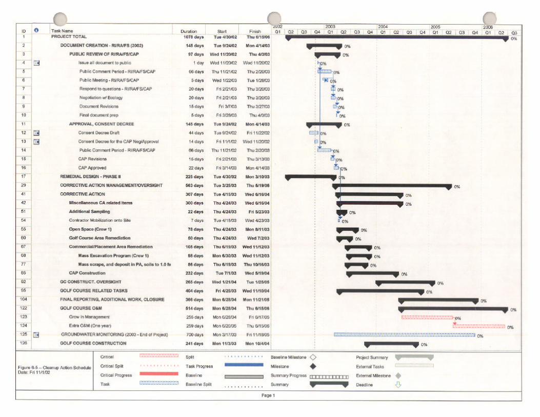


Cleanup Action Plan Former DuPont Works Site, DuPont, WA
July 2003 Page 7-1
Section 7 – REFERENCES CITED
Borden, R.K. and K.G. Troost. 2001. Late Pleistocene Stratigraphy in the South-Central Puget Lowland, Pierce County, Washington. (Washington Division of Geology and Earth Resources Report of Investigations 33.
Ecology (Washington State Department of Ecology). 1996. Personal Communication from Mike Blum to Vern
Moore/Weyerhaeuser Company regarding Russ McMillan’s June 14, 1996 Draft Parcel 2 Cleanup Action Plan comments during Parcel 2 CAP Meeting. June 26, 1996.
EPA (United States Environmental Protection Agency) 1996. Recommendations of the Technical Review
Workgroup for Lead for an Interim Approach to Assessing Risks Associated with Exposures to Lead in Soil. Technical Review Workgroup for Lead. Adult Risk Assessment Committee.
Hart, Crowser & Associates, Inc. 1992. Management Plan for Remedial Investigation/Feasibility Study (RI/FS),
Former DuPont Works Site, DuPont, Washington. January 17, 1992. HRA (Historical Reasearch Associates). 2002. Cultural Resources Protection Plan for the former DuPont Works
Site, DuPont, WA. MOA (Memorandum of Agreement) 2000. Memorandum of Agreement Among Weyerhaeuser Company,
Weyerhaeuser Real Estate Company, City of DuPont, The Nisqually Point Defense Fund, Committee for the Preservation of the Nisqually Mission Historical Site, The Nisqually Delta Association and the DuPont Historical Society. December 19, 2000.
PIONEER Technologies Corporation. 2003. Human Health and Ecological Risk Assessment for the Former
DuPont Works Site, DuPont, Washington. URS, Inc. and PIONEER Technologies Corporation. 2003. Remedial Investigation, Former DuPont Works Site,
DuPont, Washington. West Shore Corporation NW. 2003. Feasibility Study for the Former DuPont Works Site, DuPont, Washington.