field handbook for saskatchewan soils€¦ · field handbook for saskatchewan soils ... no form...
TRANSCRIPT

Field Handbook for Saskatchewan Soils
Prepared by Dan Pennock
Department of Soil Science University of Saskatchewan
August, 2005

2
Table of Contents Site and Sampling Point Description........................................................................ 3
Site Location ................................................................................................................. 3 Geomorphic Surface .................................................................................................... 3
Surface Form ............................................................................................................ 3 Surface Form Descriptions ..................................................................................... 4 Description of Genetic Materials ............................................................................ 4 Key to Parent Material ............................................................................................. 6 Slope Class ............................................................................................................... 8
Landform Position ........................................................................................................ 8 Soil Drainage Classes ............................................................................................... 10 Stoniness Class .......................................................................................................... 11
Soil Profile and Horizon Description ...................................................................... 12 Mineral and Organic Soil Definitions ....................................................................... 12 Soil Horizons and Other Layers ............................................................................... 13 Rules concerning horizon and layer designations ................................................ 13 Mineral horizons and layers...................................................................................... 14 Mineral horizon lowercase suffixes ......................................................................... 15 Organic horizons ........................................................................................................ 17 Named layers and materials of Organic soils ........................................................ 18 Recognition of Horizons ............................................................................................ 19 Horizon thickness and boundaries .......................................................................... 19 Colour........................................................................................................................... 19 Effervescence ............................................................................................................. 19 Texture ......................................................................................................................... 20 Structure ...................................................................................................................... 22 Redoximorphic Features ........................................................................................... 24 Tests for distinguishing organic layers: von Post scale of decomposition ........ 26 Horizon thickness and boundaries .......................................................................... 27 Pictorial Keys to Horizons ..................................................................................... 28
Taxonomic Classification of Saskatchewan Soils .............................................. 36 Key to Soil Orders ...................................................................................................... 37 Key to Soil Great Groups .......................................................................................... 39 Key to Soil Subgroups ............................................................................................... 41
B. Organic Order....................................................................................................... 41 C. Vertisolic Order.................................................................................................... 42 E. Gleysolic Order .................................................................................................... 42 F: Solonetzic Order ................................................................................................... 43 G; Chernozemic Order.............................................................................................. 45 H: Luvisolic Order .................................................................................................... 48 I: Brunisolic Order .................................................................................................... 49 J: Regosolic Order..................................................................................................... 50
3
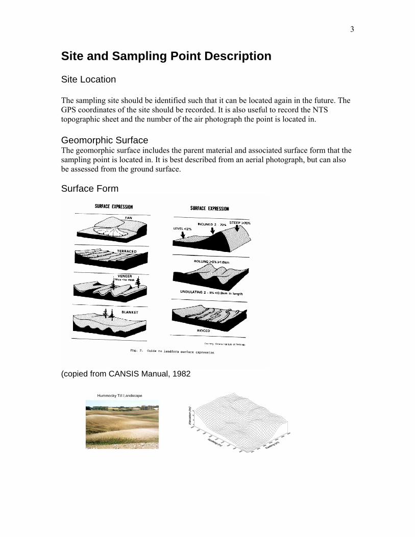
Site and Sampling Point Description Site Location The sampling site should be identified such that it can be located again in the future. The GPS coordinates of the site should be recorded. It is also useful to record the NTS topographic sheet and the number of the air photograph the point is located in. Geomorphic Surface The geomorphic surface includes the parent material and associated surface form that the sampling point is located in. It is best described from an aerial photograph, but can also be assessed from the ground surface. Surface Form
(copied from CANSIS Manual, 1982
4
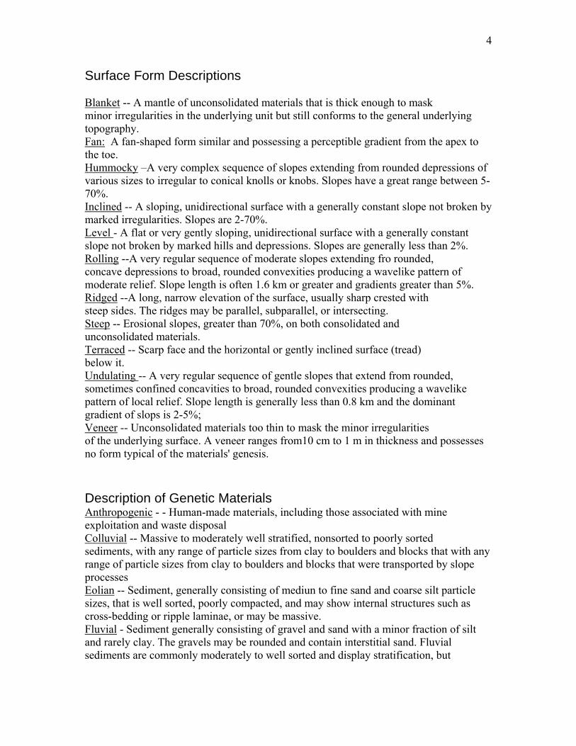
Surface Form Descriptions Blanket -- A mantle of unconsolidated materials that is thick enough to mask minor irregularities in the underlying unit but still conforms to the general underlying topography. Fan: A fan-shaped form similar and possessing a perceptible gradient from the apex to the toe. Hummocky –A very complex sequence of slopes extending from rounded depressions of various sizes to irregular to conical knolls or knobs. Slopes have a great range between 5-70%. Inclined -- A sloping, unidirectional surface with a generally constant slope not broken by marked irregularities. Slopes are 2-70%. Level - A flat or very gently sloping, unidirectional surface with a generally constant slope not broken by marked hills and depressions. Slopes are generally less than 2%. Rolling --A very regular sequence of moderate slopes extending fro rounded, concave depressions to broad, rounded convexities producing a wavelike pattern of moderate relief. Slope length is often 1.6 km or greater and gradients greater than 5%. Ridged --A long, narrow elevation of the surface, usually sharp crested with steep sides. The ridges may be parallel, subparallel, or intersecting. Steep -- Erosional slopes, greater than 70%, on both consolidated and unconsolidated materials. Terraced -- Scarp face and the horizontal or gently inclined surface (tread) below it. Undulating -- A very regular sequence of gentle slopes that extend from rounded, sometimes confined concavities to broad, rounded convexities producing a wavelike pattern of local relief. Slope length is generally less than 0.8 km and the dominant gradient of slops is 2-5%; Veneer -- Unconsolidated materials too thin to mask the minor irregularities of the underlying surface. A veneer ranges from10 cm to 1 m in thickness and possesses no form typical of the materials' genesis. Description of Genetic Materials Anthropogenic - - Human-made materials, including those associated with mine exploitation and waste disposal Colluvial -- Massive to moderately well stratified, nonsorted to poorly sorted sediments, with any range of particle sizes from clay to boulders and blocks that with any range of particle sizes from clay to boulders and blocks that were transported by slope processes Eolian -- Sediment, generally consisting of mediun to fine sand and coarse silt particle sizes, that is well sorted, poorly compacted, and may show internal structures such as cross-bedding or ripple laminae, or may be massive. Fluvial - Sediment generally consisting of gravel and sand with a minor fraction of silt and rarely clay. The gravels may be rounded and contain interstitial sand. Fluvial sediments are commonly moderately to well sorted and display stratification, but
5
massive, nonsorted fluvial gravels do occur. These materials have been transported and deposited by flowing water .Lacustrine -- Sediment generally consisting of either stratified.fine sand, silt, and clay deposited on the lake bed; or moderately well sorted and stratified sand and coarser materials that are beach and other near-shore sediments transported and deposited by wave action. Till or Morainal -- Sediment generally consisting of nonstratified material and contains a heterogeneous mixture of particle sizes, often in a mixture of sand, silt, and clay (loam) that has been transported beneath, beside, on, within, and in front of a glacier and not modified by any intermediate agent. Saprolite – Rock containing a high proportion of residual silts and clays forned by alteration, chiefly by chemical weathering. Marine -- Unconsolidated deposits of clay, silt, sand, or gravel that are well To moderately well sorted and well stratified to moderately stratified (and that may contain shells). They have settled from suspension in salt or brackish water bodies or have accumulated at their margins through shoreline processes such as wave action. Undifferentiated -- A layered sequence of more than three types of genetic material. Bedrock-- Clastic materials that are tightly packed or indurated. Bog – Sphagnum or forest peat materials formed in ombrotrophic environment due to the slightly elevated nature of the bog, which tends to disassociate it from the nutrient-rich groundwater or surrounding mineral soils. Fen -- Sedge peat materials derived primarily from sedges with inclusions of partially decayed stems of shrubs formed in a eutrophic environment due to the close association of the material with mineral-rich waters, Swamp --A peat-covered or peat-filled area with the water table at or above the peat surface. The dominant peat materials are shallow to deep, mesic fen peat formed in a eutrophic environment resulting from strong water movement from the margins or other mineral sources.
6
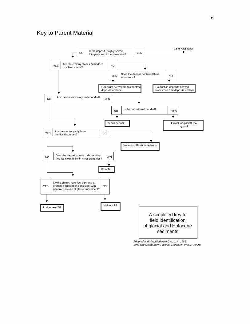
Key to Parent Material
Is the deposit roughly sortedInto particles of the same size?NO YES
Are there many stones embedded In a finer matrix?YES NO
Does the deposit contain diffuse A horizons?YES NO
Colluvium derived from stonefreedeposits upslope
Solifluction deposits derived from stone free deposits upslope
Are the stones mainly well-rounded?NO YES
Is the deposit well bedded?NO YES
Fluvial or glaciofluvialgravel
Beach deposit
Are the stones partly from non-local sources?YES NO
Various solifluction deposits
Flow Till
Does the deposit show crude bedding And local variability in most properties?NO YES
Do the stones have low dips and apreferred orientation consistent with general direction of glacier movement?
YES NO
Melt-out TillLodgement Till
Go to next page
A simplified key tofield identification
of glacial and Holocenesediments
Adapted and simplified from Catt, J. A. 1986. Soils and Quaternary Geology. Clarendon Press, Oxford.
7
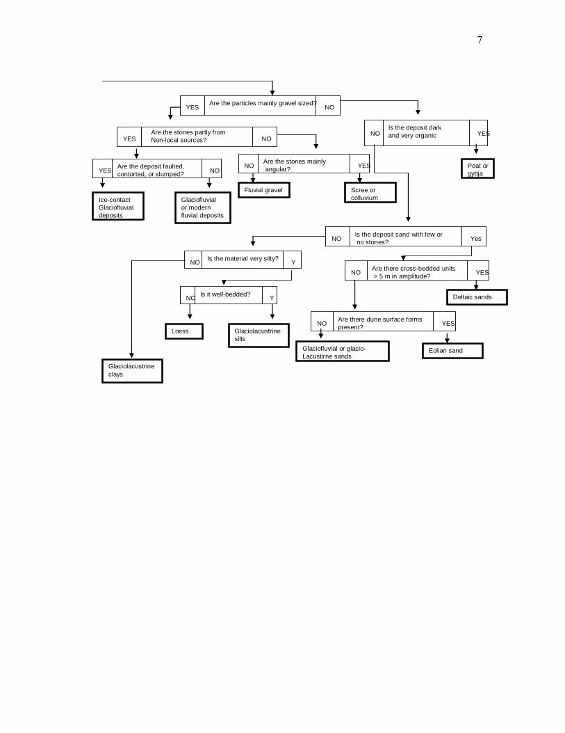
Are the particles mainly gravel sized?YES NO
YES NO
Are the stones mainlyangular?NO YES
Fluvial gravel Scree or colluvium
Are the deposit faulted, contorted, or slumped?YES NO
Is the deposit dark and very organicNO YES
Deltaic sands
Is the deposit sand with few orno stones?NO Yes
Glaciofluvial or glacio-Lacustirne sands
Glaciolacustrinesilts
Are there cross-bedded units> 5 m in amplitude?NO YES
Are the stones partly fromNon-local sources?
Glaciofluvialor modern fluvial deposits
Ice-contactGlaciofluvialdeposits
Peat orgyttja
Are there dune surface forms present?NO YES
Eolian sand
Is the material very silty?NO Y
Is it well-bedded?NO Y
Loess
Glaciolacustrineclays

8
Slope Class (from CANSIS Manual, 1982)
Landform Position Landform position describes the specific context of your sampling point within the geomorphic surface. It describes the shape and position of the 20 m2 area surrounding your point (i.e., look 10 m in all directions to assess the landform position) Inclined Surface
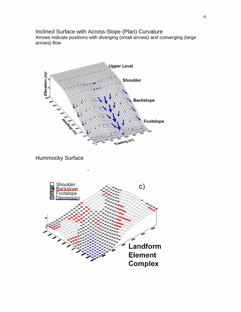
9
Inclined Surface with Across-Slope (Plan) Curvature Arrows indicate positions with diverging (small arrows) and converging (large arrows) flow
Hummocky Surface

10
Soil Drainage Classes (modified from CANSIS manual, 1982) Very rapidly to rapidly drained (RD) -- Water is removed from .the soil very rapidly in relation to supply. Excess water flows downward very rapidly if underlying material is pervious. There may be very rapid subsurface flow during heavy rainfall provided there is a steep gradient. Soils are usually coarse textured, or shallow, or both. Water source is precipitation. Well to Moderately well drained (MWD) -- Water is removed from the soil somewhat slowly in relation to supply. Excess water is removed somewhat slowly due to low permeability, shallow water table, lack of gradient, or some combination of these. Soils are usually medium to fine textured. Precipitation is the dominant water source in medium to fine textured soils; precipitation and significant additions by subsurface flow are necessary in coarse textured soils.
Imperfectly drained (ID) -- Water is removed from the soil sufficiently slowly in relation to supply to keep the soil wet for a significant part of the growing season. Excess water moves slowly downward if precipitation is the major supply. If subsurface water or groundwater, or both, is the main source, the flow rate may vary but the soil remains wet for a significant part of the growing season. Soils have a wide range in available water supply, texture, and depth, and are gleyed phases of well drained subgroups (i.e., with minor evidence of gleying). Poorly drained (PD) -- Water is removed so slowly in relation to supply that the soil remains wet for a comparatively large part of the time the soil is not frozen. Excess water is evident in the soil for a large part of the time. Subsurface flow or groundwater flow, or both, in addition to precipitation are the main water sources; there may also be a perched water table, with precipitation exceeding evapotranspiration. Soils have a wide range in available water storage capacity, texture, and depth, and are gleyed subgroups, Gleysolic, and Organic soils. Very poorly drained (VPD)-- Water is removed from the soil so slowly that the water table is at or on the surface for the greater part of the time the soil is not frozen. Excess water is present in the soil for the greater part of the time. Groundwater flow and subsurface flow are the major water sources. Precipitation is less important except where there is a perched water table with precipitation exceeding evapotranspiration. Soils have a wide range of texture, and depth and are Gleysolic, and Organic soils.
11
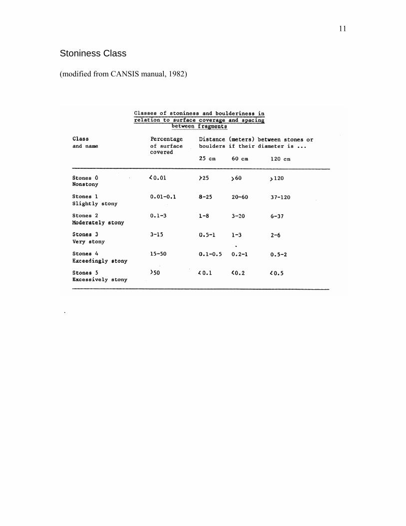
Stoniness Class (modified from CANSIS manual, 1982)
.
12
Soil Profile and Horizon Description
Mineral and Organic Soil Definitions
Control Section The control section is the vertical section of soil upon which classification is based. It is necessary to provide a uniform basis for soil classification. In general, pedons should be sampled at least to the depth of the control section. The properties of the material beneath the control section are important for many interpretive purposes. Therefore, the underlying material should be examined and its properties recorded whenever possible. Mineral soils For mineral soils in general, the control section extends from the mineral surface either to 25 cm below the upper boundary of the C, IIC, or permafrost table, or to a depth of 2 m, whichever is less (although soil pits to 2 m tend to somewhat rare!!). Organic soils A. Organic Order The control section for Fibrisols, Mesisols, and Humisols extends from the surface either to a depth of 1.6 m or to a lithic contact. It is divided into tiers, which are used in classification. The tiers are layers based upon arbitrary depth criteria. Surface tier The surface tier is 40 cm thick exclusive of loose litter, crowns of sedges and reeds, or living mosses. Mineral soil on the surface of the profile is part of the surface tier, which is used to name the soil family. Shallow lithic organic soils may have only a surface tier. Middle tier The middle tier is 80 cm thick. It establishes the great group classification if no ferric, lithic, or hydric substratum is present. Otherwise the dominant kind of organic material in this and the surface tier establishes the great group classification. The nature of the subdominant organic material in the middle or bottom tier assists in establishing the subgroup classification. Bottom tier The bottom tier is 40 cm thick. The material in this tier establishes in whole or in part the subgroup classification. The control section for Folisols is the same as that used for mineral soils. These soils must have more than 40 cm of folic materials if they overlie mineral soils or peat materials, or at least 10 cm if they overlie a lithic contact or fragmental materials.

13
Soil Horizons and Other Layers
The definitions of taxa in the Canadian system are based mainly on the kinds, degree of development, and the sequence of soil horizons and other layers in pedons. Therefore, the clear definition and designation of soil horizons and other layers are basic to soil classification.
The major mineral horizons are A, B. and C. The major organic horizons are L, F. and H. which are mainly forest litter at various stages of decomposition, and O. which is derived mainly from wetland vegetation. Subdivisions of horizons are labeled by adding lower-case suffixes to some of the major horizon symbols as with Ah or Ae.
Rules concerning horizon and layer designations
1. The uppercase letters A, B. and O must be accompanied by a lowercase suffix (e.g., Ah, Bf, or Om) indicating the estimated nature of the modification of the horizon from the parent material. The horizon and layer designations C, L, F. H. R. and W may be used alone.
2. Unless otherwise specified, additional lowercase suffixes indicate a feature or features in addition to those characteristic of the defined main horizon. For example, the symbol Btg indicates that in addition to illuvial clay in the B horizon there is evidence of strong gleying. Some combinations such as Bmj are not used.
3. All horizons except AB and BA may be vertically subdivided by consecutive numeral suffixes. The uppermost subdivision is indicated by the numeral 1; each successive subdivision with depth is indicated by the next numeral. For example, an acceptable subdivision of horizons would be Ael, Bf, Ae2, Btl, Bt2, C1, C2.
4. Roman numerals are prefixed to the contrasting master horizon or layer designation (A, B. C) to indicate lithological discontinuities either within or below the solum. The first, or uppermost, material is not numbered, because the Roman numeral I is understood; the second contrasting material is designated II, and the others are numbered consecutively, with depth. Thus, for example, a sequence from the surface downward might be Ah, Bm, IIBm, IICa, IICk, IIICk. Lithological discontinuity is due to a different mode of deposition, indicated by strongly contrasting textures (differing by two textural classes), or to a different mineralogical composition, indicating a difference in the material from which the horizons have formed. The appearance of gravel, or a change in the ratio between the various sand separates, normally suggests a difference in parent materials. These contrasting materials have resulted from geomorphic or geologic deposition rather than pedogenic processes. A change in the clay content associated with a Bt horizon (textural B) does not indicate a difference in parent material.
14
5. For transitional horizons uppercase letters are used as follows: If the transition is gradual, use AB, BC, etc. If the horizons are interfingered in the transitional zone, use A and B. B and C, etc. The dominance of horizons in the transitional zone may be shown by order, AB or BA, etc. Lower case suffixes may also be added in some instances, e.g., ABg, ABgj, etc.
6. The designations for diagnostic horizons must be given in the sequence shown in the horizon definitions, e.g., Ahe not Aeh.. Where j is used, the suffix or suffixes that it modifies are written after other horizon suffixes, e.g., Btnj, Bntj. Bfjtj, Bfcjgj.
Mineral horizons and layers Mineral horizons contain 17% or less organic C (about 30% organic matter) by weight. A-This mineral horizon forms at or near the surface in the zone of leaching or eluviation of materials in solution or suspension, or of maximum in situ accumulation of organic matter or both.
B-This mineral horizon is characterized by enrichment in organic matter, iron and aluminum, or clay; or by the development of soil structure; or by a change of color denoting hydrolysis, reduction, or oxidation.
C-This mineral horizon is comparatively unaffected by the pedogenic processes operating in A and B horizons, except the process of gleying (Cg), and the accumulation of calcium and magnesium carbonates (Cca) and more soluble salts (Cs, Csa).
R-This consolidated bedrock layer is too hard to break with the hands or to dig with a spade when moist.
W-This layer of water may occur in Gleysolic, Organic, or Cryosolic soils. Hydric layers in Organic soils are a kind of W layer as is segregated ice formation in Cryosolic soils.

15
Mineral horizon lowercase suffixes b-A buried soil horizon. c-A cemented (irreversible) pedogenic horizon. Ortstein, placic and duric horizons of Podzolic soils, and a layer cemented by CaCO3 are examples. ca-A horizon of secondary carbonate enrichment in which the concentration of calcium carbonate exceeds that of the primary carbonate in the unenriched parent materialand which shows more vigourous effervescence than the underlying C horizon.
cc-Cemented (irreversible) pedogenic concretions. e-A horizon characterized by the eluviation of clay, Fe, Al, or organic matter alone or in combination. When dry, it is usually higher in color value by one or more units than an underlying B horizon. It is used with A (Ae or Ahe). f-A horizon enriched with Al and Fe combined with organic matter. In the field it must have a hue of 7.5YR or redder, or its hue must be 10YR near the upper boundary and become yellower with depth. When moist the chroma is higher than 3 or the value is 3 or less.
g-A horizon characterized by gray colors, or prominent mottling, or both, indicating permanent or periodic intense reduction. Chromas of the matrix are generally 1 or less
h-A horizon enriched with organic matter. It is used with A alone (Ah), or with A and e (Ahe), or with B alone (Bh), or with B and f (Bhf).
j-A modifier of suffixes e, f, g, n, t, and v. It is used to denote an expression of, but failure to meet, the specified limits of the suffix it modifies. For example, Bfgj means a Bf horizon with a weak expression of gleying; Bfjgj means a B horizon with weak expression of both f and g features.
k-Denotes the presence of carbonate as indicated by visible effervescence when dilute HCI is added. It is used mostly with B and m (Bmk) or C (Ck) and occasionally with Ah or Ap (Ahk, Apk), or organic layers (Ofk, Omk). m-A horizon slightly altered by hydrolysis, oxidation, or solution, or all three to give a change in color or structure, or both. It is the most common B horizon in Chernozemic soils, and is diagnostic for the Brunisolic order. It has the following properties:
1. Evidence of alteration in one of the following forms: a. Higher chromas and redder hues than the underlying horizons. b. Removal of carbonates either partially (Bmk) or completely (Bm). c. A change in structure from that of the original material.
2. Illuviation, if evident, too slight to meet the requirements of a Bt or a podzolic B. 3. Some weatherable minerals.
16
n-A horizon in which the ratio of exchangeable Ca to exchangeable Na is 10 or less. It must also have the following distinctive morphological characteristics: prismatic or columnar structure, dark coatings on ped surfaces, and hard to very hard consistence when dry. It is used with B as Bn or Bnt. p-A horizon disturbed by man's activities such as cultivation, logging, and habitation. It is used with A and O. In highly eroded soils it commonly contains calcium carbonate (Ahk). s-A horizon with salts, including gypsum, which may be detected as crystals or veins, as surface crusts of salt crystals, by depressed crop growth, or by the presence of salt-tolerant plants. It is commonly used with C and k (Csk) but can be used with any horizon or combination of horizon and lowercase suffix. sa-A horizon with secondary enrichment of salts more soluble than Ca and Mg carbonates; the concentration of salts exceeds that in the unenriched parent material. The horizon is at least 10 cm thick. ss-Denotes the presence of several (more than two) slickensides. Slickensides are shear surfaces, with an aerial extent of at least 4 cm2, that form when one soil mass moves over another.. t-An illuvial horizon enriched with silicate clay. It is used with B alone (Bt), with B and g (Btg), with B and n (Bnt), etc.
u-A horizon that is markedly disrupted by physical or faunal processes other than cryoturbation or argillipedoturbation (mixing by shrinking and swelling) caused by Vertisolic processes. Such turbation can result from a blowdown of trees, mass movement of soil on slopes, and burrowing animals. The u can be used with any horizon or subhorizon with the exception of A or B alone; e.g., Aeu, Bfu, Bcu. v-A horizon affected by argillipedoturbation, as manifested by disruption and mixing caused by shrinking and swelling of the soil mass. It is characterized by the presence of the following Irregular shaped, randomly oriented, intrusions of displaced materials within the solum and vertical cracks, often containing sloughed-in surface materials.
x-A horizon of fragipan character. See definition of fragipan. y-A horizon affected by cryoturbation as manifested by disrupted and broken horizons, incorporation of materials from other horizons, and mechanical sorting in at least half of the cross section of the pedon. It is used with A, B. and C alone or in combination with other subscripts, e.g., Ahy, Ahgy, Bmy, Cy, Cgy, Cygj. z-A frozen layer. It may be used with any horizon or layer, e.g., Ohz, Bmz, Cz, Wz.
17
Organic horizons Organic horizons contain more than 17% organic C (about 30 % or more organic matter) by weight. Two groups of these horizons are recognized, the O horizons (peat materials) and the L, F. and H horizons (folic materials). O-This organic horizon is developed mainly from mosses, rushes, and woody materials. It is divided into the following subhorizons:
• Of-This O horizon consists largely of fibric materials that are readily identifiable as to botanical origin. Fibric material usually is classified on the van Post scale of decomposition as class 1 to class 4.
• Om-This O horizon consists of mesic material, which is at a stage of decomposition intermediate between fibric and humic materials. The material is partly altered both physically and biochemically. Mesic material usually is classified on the van Post scale of decomposition as class 5 or 6.
• Oh-This O horizon consists of Humic material, which is at an advanced stage of decomposition. Humic material usually is classified on the van Post scale of decomposition as class 7 or higher and rarely as class 6.
• Oco-This material is coprogenous earth, which is a limnic material that occurs in some Organic soils. It is deposited in water by aquatic organisms such as algae or derived from underwater and floating aquatic plants subsequently modified by aquatic animals.
L, F. and H-These organic horizons developed primarily from the accumulation of leaves, twigs, and woody materials with or without a minor component of mosses. They are normally associated with upland forested soils with imperfect drainage or drier. L-This organic horizon is characterized by an accumulation of organic matter in which the original structures are easily discernible. F-This organic horizon is characterized by an accumulation of partly decomposed organic matter. Some of the original structures are difficult to recognize. The material may be partly comminuted by soil fauna as in moder, or it may be a partly decomposed mat permeated by fungal hyphae as in mor. H-This organic horizon is characterized by an accumulation of decomposed organic matter in which the original structures are indiscernible. This horizon differs from the F by having greater humification due chiefly to the action of organisms. It is frequently intermixed with mineral grains, especially near the junction with a mineral horizon.
18
Named layers and materials of Organic soils
Limnic layer-This is a layer or layers, 5 cm or more thick, of coprogenous earth (sedimentary peat), diatomaceous earth, or marl. Except for some of the coprogenous earths containing more than 30% organic matter, most of these limnic materials are inorganic. Marl is composed of the shells of aquatic animals and CaC03 precipitated in water. It has a moist color value of 6+1 and effervesces with dilute HCI. The color of the matrix usually does not change on drying. Marl contains too little organic matter to coat the carbonate particles. It is designated Ck in horizon descriptions. Cumulic layer-This is a layer or layers of mineral material in Organic soils. Either the combined thickness of the mineral layers is more than 5 cm or a single mineral layer 5-30 cm thick occurs. Terric layer-This is an unconsolidated mineral substratum not underlain by organic matter, or one continuous unconsolidated mineral layer (with 17% or less organic C) more than 30 cm thick in the middle or bottom tiers underlain by organic matter, within a depth of 1.6 m from the surface. Lithic layer-This is a consolidated mineral layer (bedrock) occurring within 10-160 cm of the surface of Organic soils. Hydric layer-This is a layer of water that extends from a depth of not less than 40 cm from the organic surface to a depth of more than 1.6 m.
19
Horizon Properties Recognition of Horizons Dividing the soil exposure into horizons is the most critical part of the field description. Typically these divisions will occur where any of the following occur:
1. Organic materials overlie mineral materials. 2. There is a major change in the colour of the soil, 3. There is a major change in carbonate content (effervescence), 4. There is a major change in the texture of the soil (which is also typically
associated with a change in structure). 5. There is a change in the presence of special features such as gley colours,
mottles, salts etc. Clearly the minimal horizon description that can be made must include information on these properties along with the thickness of the horizon and the horizon boundaries. Other properties may be included as required. Colour Colour is described from the Munsell soil colour charts. Effervescence (modified from CANSIS manual, 1982) Effervescence is the bubbling, hissing or foaming noticed when a chemical reagent (usually 10% HCl) is added to a sample of soil. It is caused mainly by carbonates and manganese oxides, or sometimes by organic matter. It is recorded by noting the type and strength of reagent used and the degree of effervescence. Special care must be exercised on soils where dolomite is present. The reaction usually is slower, less visible and less audible. It can be enhanced by heating (with a match or lighter) the sample with HCl added in a spoon or other metal container. Degree of Effervescence of CaC03 Very weak - few bubbles Weak - bubbles readily observed Moderate - bubbles form low foam Strong - bubbles form thick foam
20
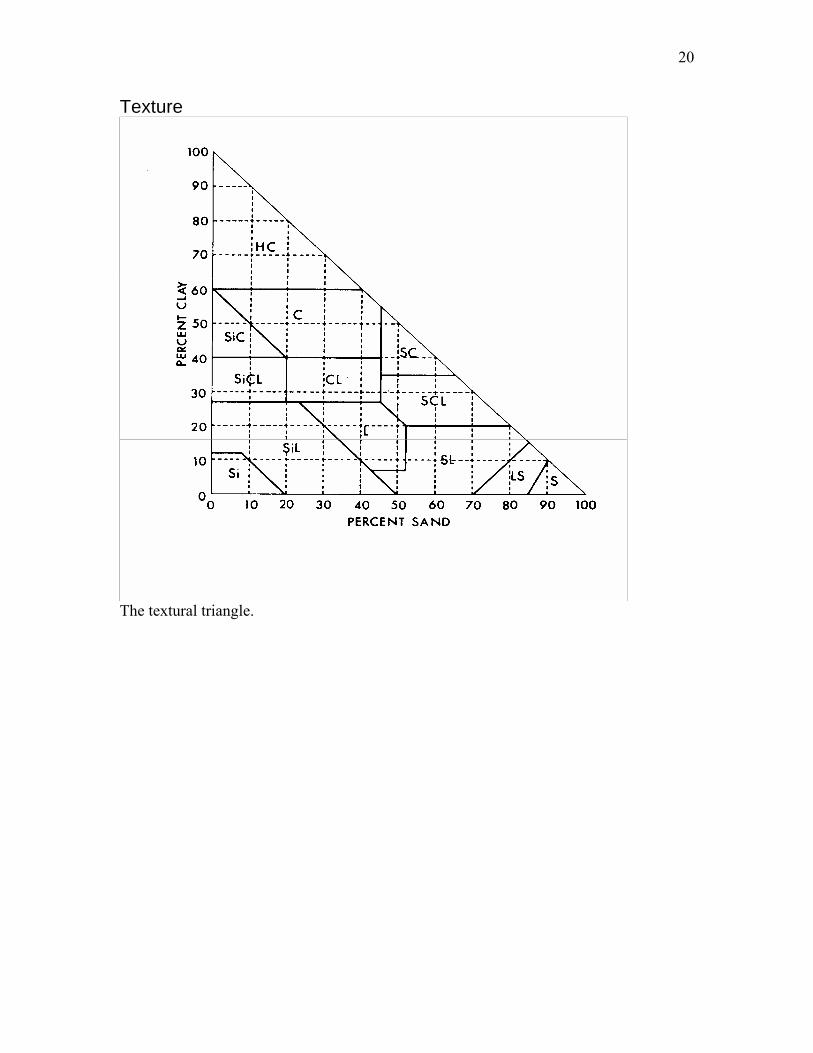
Texture
The textural triangle.
21
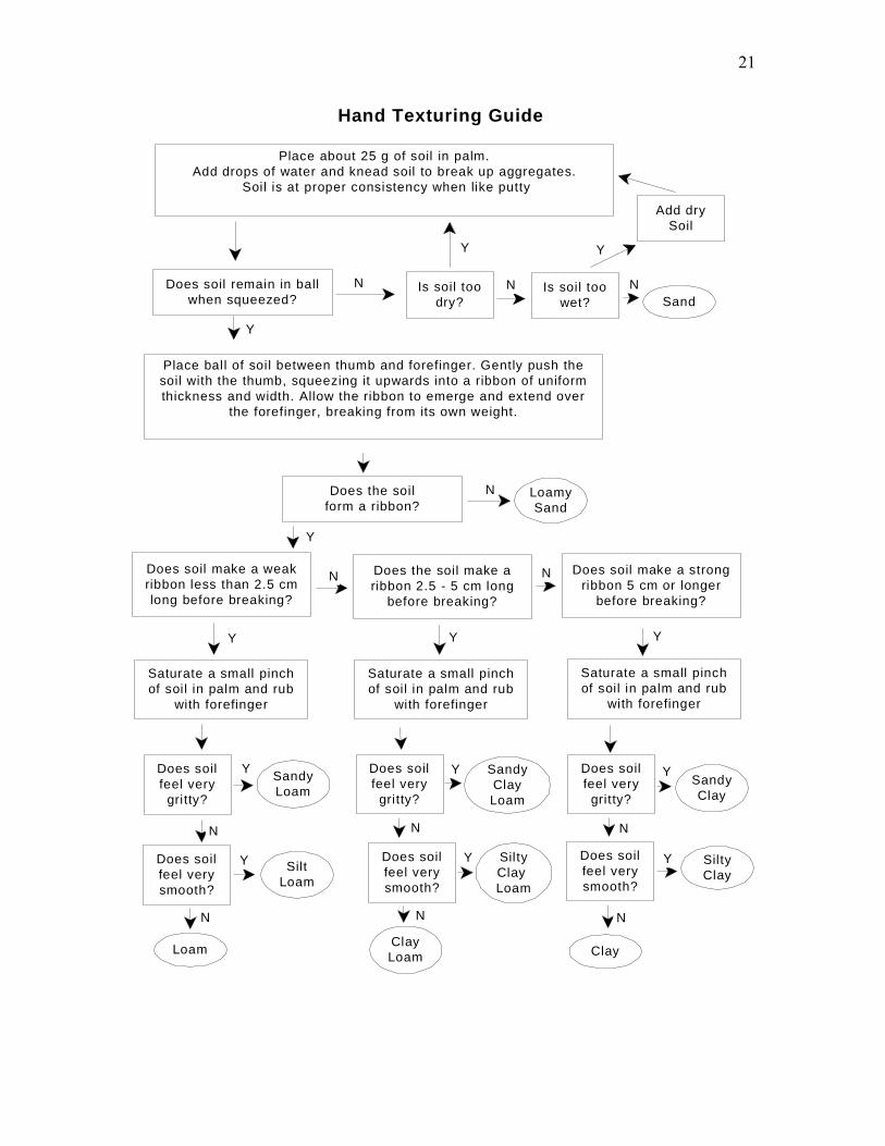
Place about 25 g of soil in palm.Add drops of water and knead soil to break up aggregates.
Soil is at proper consistency when like putty
Does soil remain in ballwhen squeezed?
Is soil toodry?
Is soil toowet? Sand
Place ball of soil between thumb and forefinger. Gently push thesoil with the thumb, squeezing it upwards into a ribbon of uniformthickness and width. Allow the ribbon to emerge and extend over
the forefinger, breaking from its own weight.
Does the soilform a ribbon?
Does soil make a weakribbon less than 2.5 cmlong before breaking?
Does the soil make aribbon 2.5 - 5 cm long
before breaking?
Does soil make a strongribbon 5 cm or longer
before breaking?
Saturate a small pinchof soil in palm and rub
with forefinger
Saturate a small pinchof soil in palm and rub
with forefinger
Does soilfeel very
gritty?
Does soilfeel verysmooth?
Does soilfeel verysmooth?
Does soilfeel verysmooth?
Does soilfeel very
gritty?
Does soilfeel very
gritty?
SandyLoam
SandyClayLoam
SiltyClay
SiltyClay Loam
SiltLoam
ClayClayLoamLoam
SandyClay
Add drySoil
Saturate a small pinchof soil in palm and rub
with forefinger
Y Y Y
Y Y Y
N
N N
N
N
N
Y
N
Y Y Y
N
N N N
LoamySand
Y
Y Y
N
Hand Texturing Guide
22
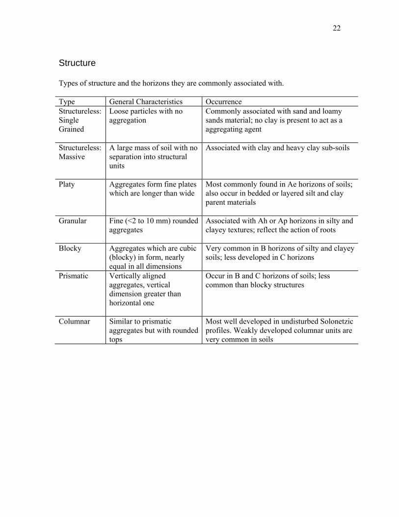
Structure Types of structure and the horizons they are commonly associated with. Type General Characteristics Occurrence Structureless: Single Grained
Loose particles with no aggregation
Commonly associated with sand and loamy sands material; no clay is present to act as a aggregating agent
Structureless: Massive
A large mass of soil with no separation into structural units
Associated with clay and heavy clay sub-soils
Platy Aggregates form fine plates which are longer than wide
Most commonly found in Ae horizons of soils; also occur in bedded or layered silt and clay parent materials
Granular Fine (<2 to 10 mm) rounded aggregates
Associated with Ah or Ap horizons in silty and clayey textures; reflect the action of roots
Blocky Aggregates which are cubic (blocky) in form, nearly equal in all dimensions
Very common in B horizons of silty and clayey soils; less developed in C horizons
Prismatic Vertically aligned aggregates, vertical dimension greater than horizontal one
Occur in B and C horizons of soils; less common than blocky structures
Columnar Similar to prismatic aggregates but with rounded tops
Most well developed in undisturbed Solonetzic profiles. Weakly developed columnar units are very common in soils

23
24
Redoximorphic Features Mottles are zones within the mass of soil (the soil matrix) that have discernibly different colours than the remainder of the matrix. The differences in colours can be quantified using the Munsell Soil Color Chart system. Mottles occur for many reasons in the soil. In Saskatchewan soils mottles are typically observed due to:
1) Reduction/oxidation and translocation of iron and manganese due to water-saturated conditions,
2) Translocation and concentration of salts, especially calcium carbonate and gypsum, and
3) Presence of weathered fragments of bedrock in the soil matrix. The initial process in the creation of these redoximorphic features is the removal or transformation of iron to form colors of low chroma and high value. This is termed a stripped or depleted matrix in the USDA system. The stripped matrix may be accompanied by mottles formed as redox concentrations (i.e., bodies of apparent accumulation of Fe/Mn oxides occurring as pore linings or soft masses in the matrix) or redox depletions (i.e., bodies of low chroma (2 or less) with values of 4 or more where fe/Mn oxides have been stripped). Mottles due to gleying (termed redoximorphic features by the USDA) are central to the classification of soils of the Gleysolic Order in Canada. However the recognition of gleyed soils in the Canadian system requires the presence of presence of a low chroma/high value matrix; the presence of the highly contrasted (i.e., high chroma) mottles is not required in all situations (see below). To be classified into the Gleysolic order in Canada, horizons that meet the following criteria must be present:
A. Other soils that are saturated with water and under reducing conditions either continuously or during some period of the year as indicated either by direct measurements of the water table and the oxidation-reduction status, or by any of the following morphological features within 50 cm of the mineral surface:
a. Chromas of 1 or less, without mottles, on peds surfaces (or in the matrix if peds are lacking) in materials that develop higher chromas under oxidizing conditions.
b. Chromas of 2 or less, in hues of 10YR and 7.5YR, on ped surfaces (or in the matrix if peds are lacking), accompanied by prominent mottles.
c. Chromas of 3 or less, in hues yellower than 10YR, on ped surfaces (or in the matrix if peds are lacking), accompanied by prominent mottles.
d. Hues bluer than 10Y, with or without mottles, on ped surfaces (or in the matrix if peds are lacking).

25
Mottles are described by their abundance, size and contrast. Abundance: the proportion of the exposed surface occupied by the features (see chart at the back of this manual) Few <2% Common 2-20 % Many >20% Size: the diameter if round or width if long and narrow Fine <5 mm Medium 5 – 15 mm Coarse >15 mm Contrast: This is the difference between the feature colour and the matrix colour and is assessed using Munsell colour charts. Difference from matrix in Hue Pages Value Units Chroma Units Faint 0 ≤2 ≤1 1 0 0 Distinct 0 3-4 2-4 1 ≤2 ≤1 Prominent 0 ≥4 ≥4 1 ≥2 ≥1 2+ ≥0 ≥0 Colour: The colour of the feature using the Munsell soil colour charts. Example description: Common, fine, distinct brown (10YR 5/3) The Canadian System of Soil Classification focuses largely on the presence of mottles as an indicator of gleying. The USDA has a much more comprehensive set of Hydric soil criteria. USDA, NRCS. 2003 Field Indicators of Hydric Soils in the United States, Version 5.01. G.W. Hurt, P.M. Whited, and R.F. Pringle (eds.). USDA,
26
Tests for distinguishing organic layers: von Post scale of decomposition In this field test squeeze a sample of the organic material within the closed hand. Observe the color of the solution that is expressed between the fingers, the nature of the fibers, and the proportion of the original sample that remains in the hand. Ten classes are defined as follows: 1-Undecomposed; plant structure unaltered; yields only clear water colored light yellow-brown. 2-Almost undecomposed; plant structure distinct; yields only clear water colored light yellow-brown. 3-Very weakly decomposed; plant structure distinct; yields distinctly turbid brown water, no peat substance passes between the fingers, residue not mushy. 4-Weakly decomposed; plant structure distinct; yields strongly turbid water, no peat substance escapes between the fingers, residue rather mushy. 5-Moderately decomposed; plant structure clear but becoming indistinct; yields much turbid brown water, some peat escapes between the fingers, residue very mushy. 6-Strongly decomposed; plant structure somewhat indistinct but clearer in the squeezed residue than in the undisturbed peat; about one-third of the peat escapes between the fingers, residue strongly mushy. 7-Strongly decomposed; plant structure indistinct but recognizable; about half the peat escapes between the fingers. 8-Very strongly decomposed; plant structure very indistinct; about two-thirds of the peat escapes between the fingers, residue almost entirely resistant remnants such as root fibers and wood. 9-Almost completely decomposed; plant structure almost unrecognizable; nearly all the peat escapes between the fingers. 10-Completely decomposed; plant structure unrecognizable; all the peat escapes between the fingers.
27
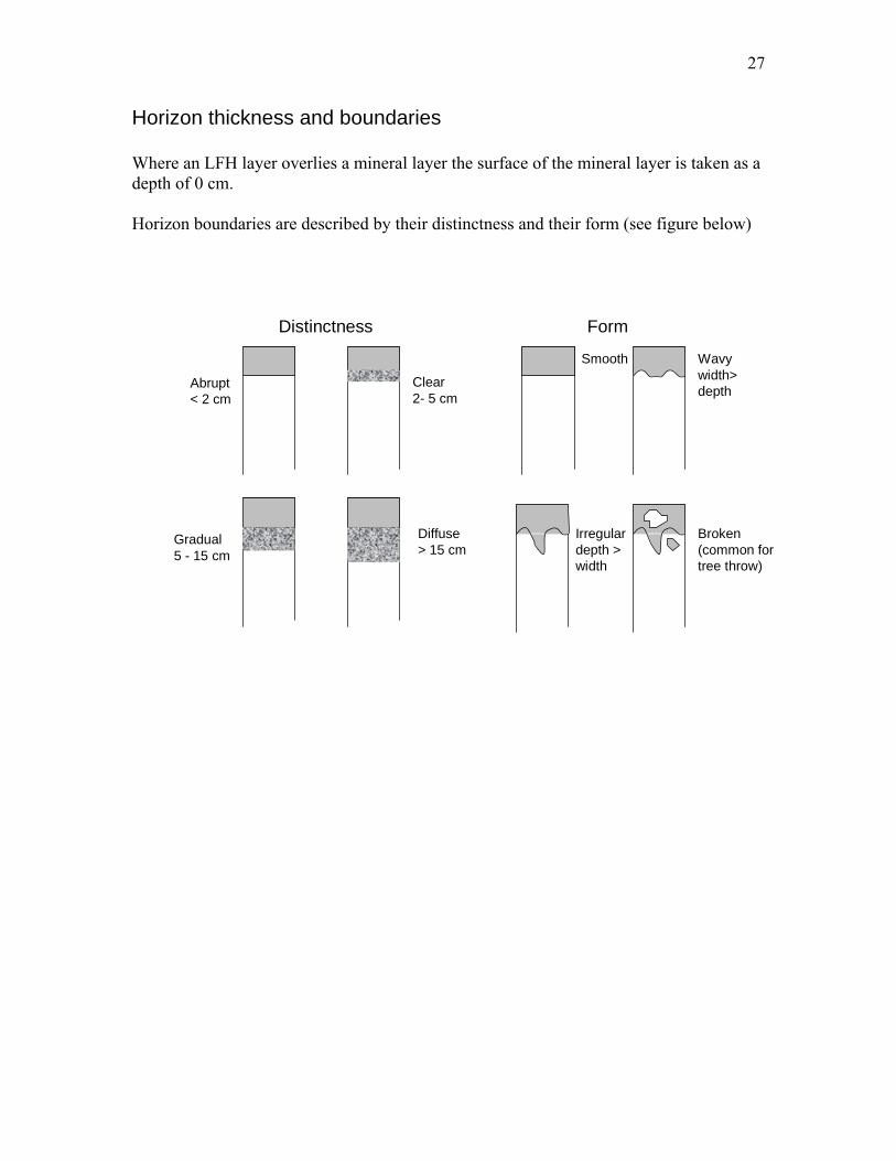
Horizon thickness and boundaries Where an LFH layer overlies a mineral layer the surface of the mineral layer is taken as a depth of 0 cm. Horizon boundaries are described by their distinctness and their form (see figure below)
Abrupt< 2 cm
Clear 2- 5 cm
Gradual5 - 15 cm
Diffuse> 15 cm
Irregulardepth >width
Broken(common fortree throw)
Wavywidth>depth
Smooth
FormDistinctness

28
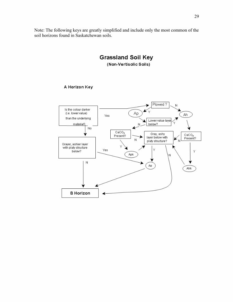
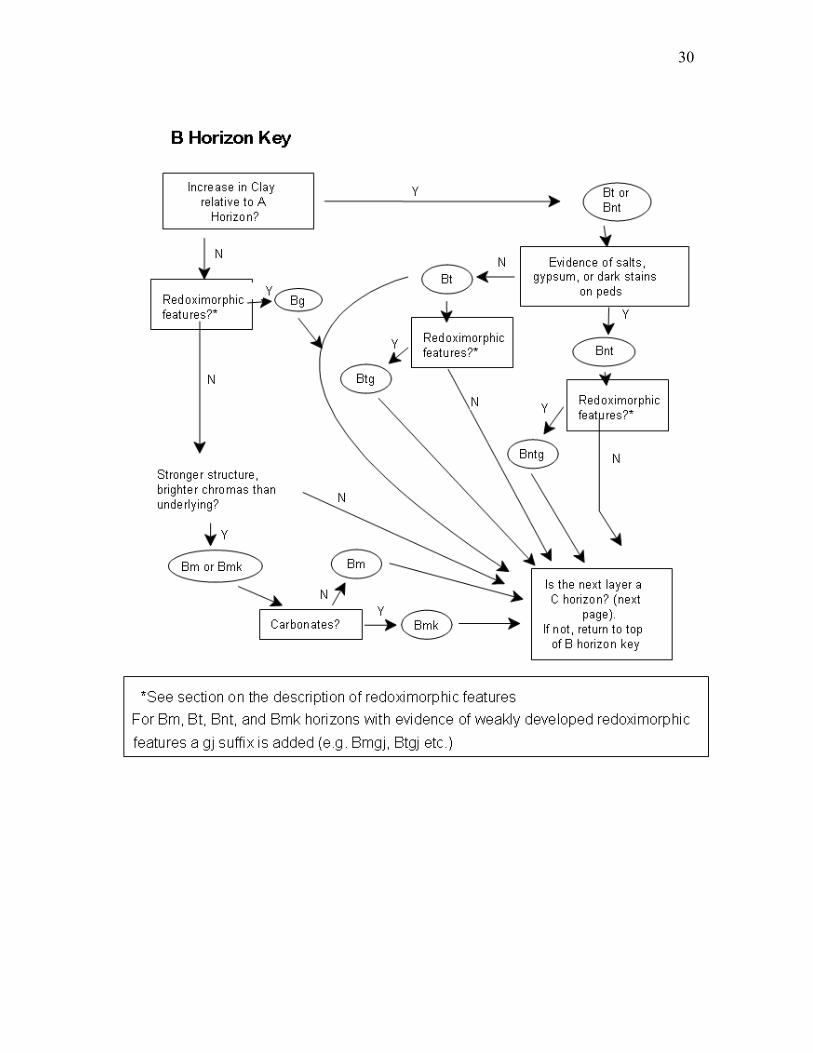
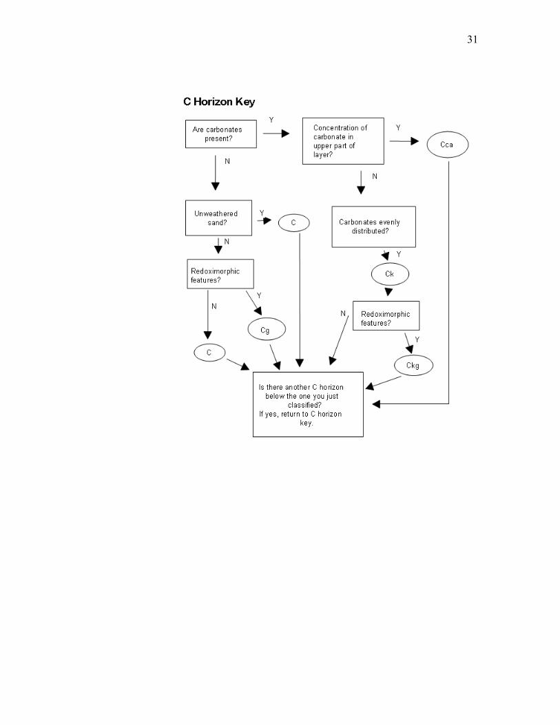
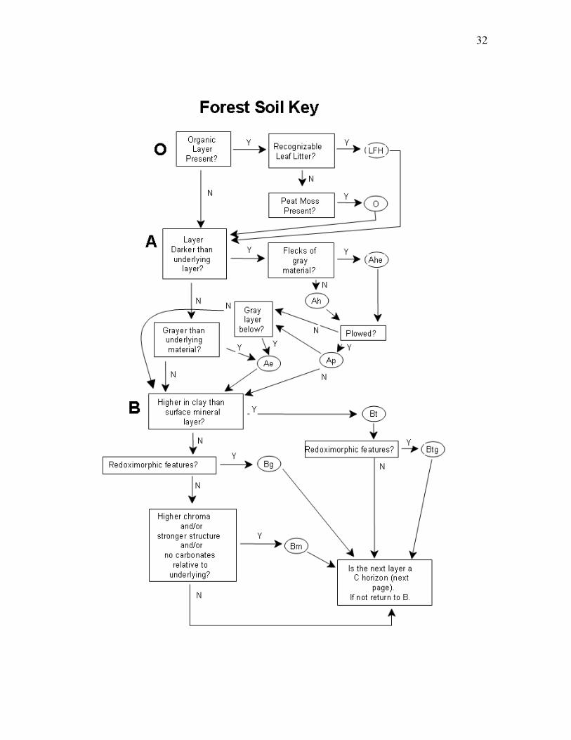
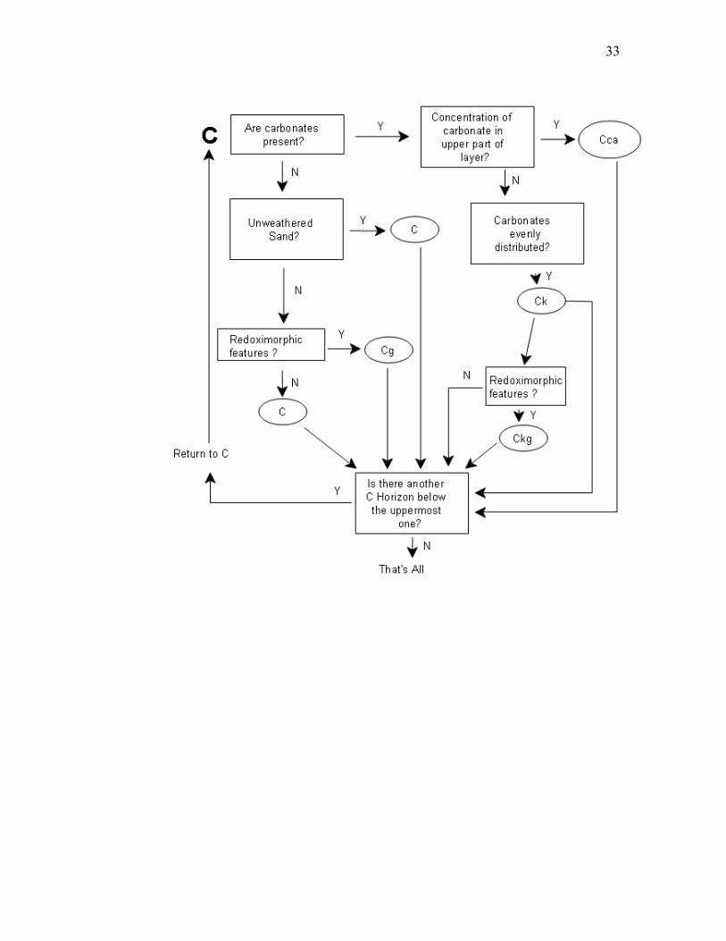
Pictorial Keys to Horizons
Grassland Soils Key: Vertisolic versus non-Vertisolic soils
Go to non-Vertisolicgrassland key.
No
Is the surfacelayer darker than
the underlyingmaterial?
Ah Ap
Ploughed?
Evidence ofmixing of soil?
Bv
Slickensides? Bss orCss
Yes
Y
N YN
N
Y
Y
Go tonon-vertisolicgassland key
N
Is the texturethroughout the
core heavy clay?
29
Note: The following keys are greatly simplified and include only the most common of the soil horizons found in Saskatchewan soils.
30
31
32
33

34

35

36
Taxonomic Classification of Saskatchewan Soils
The taxonomic class of a pedon can be determined by using the definitions and keys in this and other chapters. A knowledge of soil horizon definitions and soil terminology as presented in this publication is required to use the keys.
Keys to soil orders, soil great groups, and soil subgroups are presented in this section. All the keys are arranged in a systematic order and are based on diagnostic soil criteria (or criterion
The following procedure should be used to key out the classification of a pedon:
1. Expose a vertical section through the pedon, describe the horizons, and take appropriate samples if the designation of some horizons must be checked by laboratory analysis. In some cases the final classification must await the laboratory data.
2. Study the Key to Soil Orders in this chapter and select the first order in the key that apparently includes the pedon involved.
3. Turn to the page indicated and verify that the definition of the soil order includes the pedon concerned. Then using the Key to Soil Great Groups, select the appropriate great group.
4. Turn to the page indicated and verify that the definition of the soil great group includes the pedon concerned. Then using the Key to Soil Subgroups, select the appropriate subgroup.
5. Turn to the page indicated and verify that the definition of the soil subgroup includes the pedon concerned.
6. To classify the pedon at the series level, refer to a recent soil survey report for the area, or confer with the soil correlator of the province or territory.

37
Key to Soil Orders
B. Soils that have permafrost within 1 m of the surface or within 2 m if strongly cryoturbated...Cryosolic order
C. Other soils that either 1. Have organic horizon (More than 17% organic C by weight) that extend
from the surface to one of the following: a. A depth of 60 cm or more if the surface layer is fibric material
(Of). b. A depth of 40 cm or more if the surface layer consists of mesic or
humic material (Om or Oh). c. A depth of more than 40 cm if composed of folic materials (L, F,
and H), or at least 10 cm if a lithic contact or fragmental materials are present. Folic materials must be more than twice the thickness of a mineral soil layer if the mineral layer is less than 20 cm thick. or
2. Have one or more mineral horizons or layers within 40 cm of the surface in addition to the organic horizons (O) as follows:
a. If a mineral horizon or layer thinner than 40 cm occurs at the surface, the underlying organic horizon or horizons must have a total thickness of at least 40 cm.
b. If one or more mineral horizons or layers occur within 40 cm of the surface, the organic material must occupy more than 40 cm of the upper 80 cm of the control section . . .Organic order
D. Other soils that have both a vertic horizon and a slickenside horizon, the top of which occurs within 1 m of the mineral surface . . . Vertisolic order
E. Other soils that have a podzolic B horizon and do not have a Bt horizon within 50 cm of the mineral surface. . . Podzolic order
F. Other soils that are saturated with water and under reducing conditions either continuously or during some period of the year as indicated either by direct measurements of the water table and the oxidation-reduction status, or by any of the following morphological features within 50 cm of the mineral surface:
a. Chromas of 1 or less, without mottles, on peds surfaces or in the matrix if peds are lacking in materials that develop higher chromas under oxidizing conditions.
b. Chromas of 2 or less, in hues of 10YR and 7.5YR, on ped surfaces or in the matrix if peds are lacking, accompanied by prominent mottles.
c. Chromas of 3 or less, in hues yellower than 10YR, on ped surfaces or in the matrix if peds are lacking, accompanied by prominent mottles.
d. Hues bluer than 10Y, with or without mottles, on ped surfaces or in the matrix if peds are lacking. . . . Gleysolic order
G. Other soils that have a solonetzic B horizon . . . Solonetzic order H. Other soils that have a chernozemic A horizon and any one of the following:
1. No Ae horizon.

38
2. A weakly expressed Ae horizon (Aej) with a dry color value lower than 5. 3. An Ae horizon thinner than an overlying Ah or Ap horizon that does not
appear to be eluviated. 4. An Ae horizon not more than 5 cm thick if the chernozemic A is eluviated
(Ahe) as indicated by gray streaks and splotches when the soil is dry . . . Chernozemic order
I. Other soils that have a Bt horizon . . . Luvisolic order J. Other soils that have either Bm, Btj, or Bfj horizons at least 5 cm thick, or a Bf
horizon less than 10 cm in thickness . . . Brunisolic order K. Other soils . . . Regosolic order
39
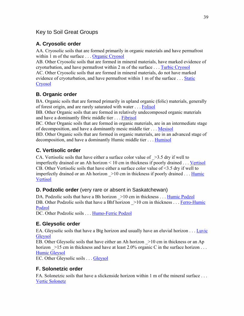
Key to Soil Great Groups
A. Cryosolic order AA. Cryosolic soils that are formed primarily in organic materials and have permafrost within 1 m of the surface . . . Organic Cryosol AB. Other Cryosolic soils that are formed in mineral materials, have marked evidence of cryoturbation, and have permafrost within 2 m of the surface . . . Turbic Cryosol AC. Other Cryosolic soils that are formed in mineral materials, do not have marked evidence of cryoturbation, and have permafrost within 1 m of the surface . . . Static Cryosol
B. Organic order BA. Organic soils that are formed primarily in upland organic (folic) materials, generally of forest origin, and are rarely saturated with water . . . Folisol BB. Other Organic soils that are formed in relatively undecomposed organic materials and have a dominantly fibric middle tier . . . Fibrisol BC. Other Organic soils that are formed in organic materials, are in an intermediate stage of decomposition, and have a dominantly mesic middle tier . . . Mesisol BD. Other Organic soils that are formed in organic materials, are in an advanced stage of decomposition, and have a dominantly Humic middle tier . . . Humisol
C. Vertisolic order CA. Vertisolic soils that have either a surface color value of _>3.5 dry if well to imperfectly drained or an Ah horizon < 10 cm in thickness if poorly drained . . . Vertisol CB. Other Vertisolic soils that have either a surface color value of <3.5 dry if well to imperfectly drained or an Ah horizon _>10 cm in thickness if poorly drained . . . Humic Vertisol
D. Podzolic order (very rare or absent in Saskatchewan) DA. Podzolic soils that have a Bh horizon _>10 cm in thickness . . . Humic Podzol DB. Other Podzolic soils that have a Bhf horizon _>10 cm in thickness . . . Ferro-Humic Podzol DC. Other Podzolic soils . . . Humo-Ferric Podzol
E. Gleysolic order EA. Gleysolic soils that have a Btg horizon and usually have an eluvial horizon . . . Luvic Gleysol EB. Other Gleysolic soils that have either an Ah horizon _>10 cm in thickness or an Ap horizon _>15 cm in thickness and have at least 2.0% organic C in the surface horizon . . . Humic Gleysol EC. Other Gleysolic soils . . . Gleysol
F. Solonetzic order FA. Solonetzic soils that have a slickenside horizon within 1 m of the mineral surface . . . Vertic Solonetz
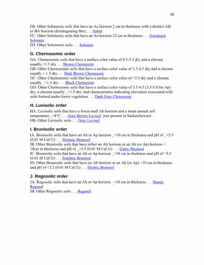
40
FB. Other Solonetzic soils that have an Ae horizon 2 cm in thickness with a distinct AB or BA horizon (disintegrating Bnt) . . . Solod FC. Other Solonetzic soils that have an Ae horizon 22 cm in thickness . . . Solodized Solonetz FD. Other Solonetzic soils . . . Solonetz
G. Chernozemic order GA. Chernozemic soils that have a surface color value of 4.5-5.5 dry and a chroma usually >1.5 dry . . . Brown Chernozem GB. Other Chernozemic soils that have a surface color value of 3.5-4.5 dry and a chroma usually > 1.5 dry . . . Dark Brown Chernozem GC. Other Chernozemic soils that have a surface color value of <3.5 dry and a chroma usually _<1.5 dry . . . Black Chernozem GD. Other Chernozemic soils that have a surface color value of 3.5-4.5 (3.5-5.0 for Ap) dry, a chroma usually _<1.5 dry, and characteristics indicating eluviation associated with soils formed under forest vegetation . . . Dark Gray Chernozem
H. Luvisolic order HA. Luvisolic soils that have a forest mull Ah horizon and a mean annual soil temperature _>8°C . . . Gray Brown Luvisol (not present in Saskatchewan) HB. Other Luvisolic soils . . . Gray Luvisol
I. Brunisolic order IA. Brunisolic soils that have an Ah or Ap horizon _>10 cm in thickness and pH of _>5.5 (0.01 M CaCl2) . . . Melanic Brunisol IB. Other Brunisolic soils that have either no Ah horizon or an Ah (or Ap) horizon < 10cm in thickness and pH of _>5.5 (0.01 M CaCl2) . . . Eutric Brunisol IC. Brunisolic soils that have an Ah or Ap horizon _>10 cm in thickness and pH of <5.5 (0.01 M CaCl2) . . . Sombric Brunisol ID. Other Brunisolic soils that have no Ah horizon or an Ah (or Ap) <10 cm in thickness and pH of <5.5 (0.01 M CaCl2) . . . Dystric Brunisol
J. Regosolic order JA. Regosolic soils that have an Ah or Ap horizon _>10 cm in thickness . . . Humic Regosol JB. Other Regosolic soils . . . Regosol
41
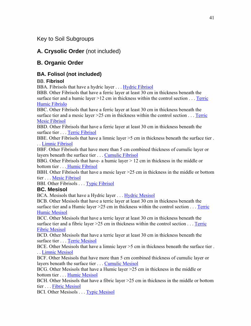
Key to Soil Subgroups
A. Crysolic Order (not included)
B. Organic Order
BA. Folisol (not included) BB. Fibrisol BBA. Fibrisols that have a hydric layer . . . Hydric Fibrisol BBB. Other Fibrisols that have a ferric layer at least 30 cm in thickness beneath the surface tier and a humic layer >12 cm in thickness within the control section . . . Terric Humic Fibrislo BBC. Other Fibrisols that have a ferric layer at least 30 cm in thickness beneath the surface tier and a mesic layer >25 cm in thickness within the control section . . . Terric Mesic Fibrisol BBD. Other Fibrisols that have a ferric layer at least 30 cm in thickness beneath the surface tier . . . Terric Fibrisol BBE. Other Fibrisols that have a limnic layer >5 cm in thickness beneath the surface tier . . . Limnic Fibrisol BBF. Other Fibrisols that have more than 5 cm combined thickness of cumulic layer or layers beneath the surface tier . . . Cumulic Fibrisol BBG. Other Fibrisols that have- a humic layer > 12 cm in thickness in the middle or bottom tier . . . Humic Fibrisol BBH. Other Fibrisols that have a mesic layer >25 cm in thickness in the middle or bottom tier . . . Mesic Fibrisol BBI. Other Fibrisols . . . Typic Fibrisol BC. Mesisol BCA. Mesisols that have a Hydric layer . . . Hydric Mesisol BCB. Other Mesisols that have a terric layer at least 30 cm in thickness beneath the surface tier and a Humic layer >25 cm in thickness within the control section . . . Terric Humic Mesisol BCC. Other Mesisols that have a terric layer at least 30 cm in thickness beneath the surface tier and a fibric layer >25 cm in thickness within the control section . . . Terric Fibric Mesisol BCD. Other Mesisols that have a terric layer at least 30 cm in thickness beneath the surface tier . . . Terric Mesisol BCE. Other Mesisols that have a limnic layer >5 cm in thickness beneath the surface tier . . . Limnic Mesisol BCF. Other Mesisols that have more than 5 cm combined thickness of cumulic layer or layers beneath the surface tier . . . Cumulic Mesisol BCG. Other Mesisols that have a Humic layer >25 cm in thickness in the middle or bottom tier . . . Humic Mesisol BCH. Other Mesisols that have a fibric layer >25 cm in thickness in the middle or bottom tier . . . Fibric Mesisol BCI. Other Mesisols . . . Typic Mesisol
42
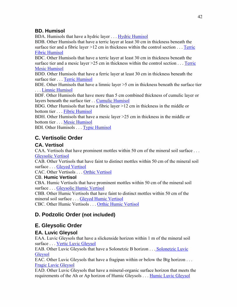
BD. Humisol BDA. Humisols that have a hydric layer . . . Hydric Humisol BDB. Other Humisols that have a terric layer at least 30 cm in thickness beneath the surface tier and a fibric layer >12 cm in thickness within the control section . . . Terric Fibric Humisol BDC. Other Humisols that have a terric layer at least 30 cm in thickness beneath the surface tier and a mesic layer >25 cm in thickness within the control section . . . Terric Mesic Humisol BDD. Other Humisols that have a ferric layer at least 30 cm in thickness beneath the surface tier . . . Terric Humisol BDE. Other Humisols that have a limnic layer >5 cm in thickness beneath the surface tier . . . Limnic Humisol BDF. Other Humisols that have more than 5 cm combined thickness of cumulic layer or layers beneath the surface tier . . Cumulic Humisol BDG. Other Humisols that have a fibric layer >12 cm in thickness in the middle or bottom tier . . . Fibric Humisol BDH. Other Humisols that have a mesic layer >25 cm in thickness in the middle or bottom tier . . . Mesic Humisol BDI. Other Humisols . . . Typic Humisol
C. Vertisolic Order CA. Vertisol CAA. Vertisols that have prominent mottles within 50 cm of the mineral soil surface . . . Gleysolic Vertisol CAB. Other Vertisols that have faint to distinct mottles within 50 cm of the mineral soil surface . . . Gleyed Vertisol CAC. Other Vertisols . . . Orthic Vertisol CB. Humic Vertisol CBA. Humic Vertisols that have prominent mottles within 50 cm of the mineral soil surface . . . Gleysolic Humic Vertisol CBB. Other Humic Vertisols that have faint to distinct mottles within 50 cm of the mineral soil surface . . . Gleyed Humic Vertisol CBC. Other Humic Vertisols . . . Orthic Humic Vertisol
D. Podzolic Order (not included)
E. Gleysolic Order EA. Luvic Gleysol EAA. Luvic Gleysols that have a slickenside horizon within 1 m of the mineral soil surface . . . Vertic Luvic Gleysol EAB. Other Luvic Gleysols that have a Solonetzic B horizon . . . Solonetzic Luvic Gleysol EAC. Other Luvic Gleysols that have a fragipan within or below the Btg horizon . . . Fragic Luvic Gleysol EAD. Other Luvic Gleysols that have a mineral-organic surface horizon that meets the requirements of the Ah or Ap horizon of Humic Gleysols . . . Humic Luvic Gleysol

43
EAE. Other Luvic Gleysols that have either a Bgf horizon _>10 cm in thickness, as well as a Btg horizon, or a Btgf horizon . . . Fera Luvic Glevsol EAF. Other Luvic Gleysols . . . Orthic Luvic Gleysol EB. Humic Gleysol EBA. Humic Gleysols that have a slickenside horizon within 1 m of the mineral soil surface . . . Vertic Humic Gleysol EBB. Other Humic Gleysols that have a solonetzic B horizon . . . Solonetzic Humic Gleysol EBC. Other Humic Gleysols that have a Bgf horizon _>10 cm in thickness . . . Fera Humic Gleysol EBD. Other Humic Gleysols that lack a B horizon _>10 cm in thickness . . . Rego Humic Gleysol EBE. Other Humic Gleysols . . . Orthic Humic Gleysol EC. Gleysol ECA. Gleysols that have a slickenside horizon within 1 m of the mineral soil surface . . . Vertic Gleysol ECB. Other Gleysols that have a solonetzic B horizon . . . Solonetzic Gleysol ECC. Other Gleysols that have a Bgf horizon _>10 cm in thickness . . . Fera Gleysol ECD. Other Gleysols that lack a B horizon _>10 cm in thickness . . . Rego Gleysol ECE. Other Gleysols . . . Orthic Gleysol
F: Solonetzic Order FA. Vertic Solonetz FAA. Vertic Solonetzs that have an Ah, Ahe, or Ap horizon with a color value >4.5 dry, a chroma usually >1.5 dry, and faint to distinct mottles within 50 cm of the mineral soil surface . . . Gleyed Brown Vertic Solonetz FAB. Other Vertic Solonetzs that have an Ah, Ahe, or Ap horizon with a color value >4.5 dry and a chroma usually >1.5 dry . . . Brown Vertic Solonetz FAC. Other Vertic Solonetzs that have an Ah, Ahe, or Ap horizon with a color value of 3.5-4.5 dry, a chroma usually > 1.5 dry, and faint to distinct mottles within 50 cm of the mineral soil surface . . . Gleyed Dark Brown Vertic Solonetz FAD. Other Vertic Solonetzs that have an Ah, Ahe, or Ap horizon with a color value of 3.5-4.5 dry and a chroma usually > 1.5 dry . . . Dark Brown Vertic Solonetz FAE. Other Vertic Solonetzs that have an Ah, Ahe, or Ap horizon with a color value <3.5 dry, a chroma usually >1.5 dry, and faint to distinct mottles within 50 cm of the mineral soil surface . . . Gleyed Black Vertic Solonetz FAF. Other Vertic Solonetzs that have an Ah, Ahe, or Ap horizon with a color value <3.5 dry and a chroma usually >1.5 dry . . . Black Vertic Solonetz FB. Solod FBA. Solods that have an Ah, Ahe, or Ap horizon with a color value >4.5 dry, a chroma usually >1.5, and faint to distinct mottles within 50 cm of the mineral soil surface . . . Gleyed Brown Solod FBB. Other Solods that have an Ah, Ahe, or Ap horizon with a color value >4.5 dry and a chroma usually >1.5 . . . Brown Solod
44
FBC. Other Solods that have an Ah, Ahe, or Ap horizon with a color value of 3.5-4.5 dry, a chroma usually >1.5, and faint to distinct mottles within 50 cm of the mineral soil surface . . . Gleyed Dark Brown Solod FBD. Other Solods that have an Ah, Ahe, or Ap horizon with a color value of 3.5-4.5 dry and a chroma usually >1.5 . . . Dark Brown Solod FBE. Other Solods that have an Ah, Ahe, or Ap horizon with a color value <3.5 dry, a chroma usually >1.5, and faint to distinct mottles within 50 cm of the mineral soil surface . . . Gleyed Black Solod FBF. Other Solods that have an Ah, Ahe, or Ap horizon with a color value <3.5 dry and a chroma usually >1.5 . . . Black Solod FBG. Other Solods that have an Ah, Ahe, or Ap horizon with a color value of 3.5-4.5 dry, a chroma usually <2, and faint to distinct mottles within 50 cm of the mineral soil surface and are associated with a subhumid climate . . . Gleyed Dark Gray Solod FBH. Other Solods that have an Ah, Ahe, or Ap horizon with a color value of 3.5-4.5 dry and a chroma usually <2 and are associated with a subhumid climate . . . Dark Gray Solod FBI. Other Solods that have an Ah, Ahe, or Ap horizon with a color value >4.5 dry, a chroma usually <2, and faint to distinct mottles within 50 cm of the mineral soil surface and are associated with a subhumid climate . . . Gleyed Gray Solod FBJ. Other Solods that have an Ah, Ahe, or Ap horizon with a color value >4.5 dry and a chroma usually <2 and are associated with a subhumid climate . . . Gray Solod FC. Solodized Solonetz FCA. Solodized Solonetzs that have an Ah, Ahe, or Ap horizon with a color value >4.5 dry, a chroma usually >1.5, and faint to distinct mottles within 50 cm of the mineral soil surface . . . Gleyed Brown Solodized Solonetz FCB. Other Solodized Solonetzs that have an Ah, Ahe, or Ap horizon with a color value >4.5 dry and a chroma usually >1.5 . . . Brown Solodized Solonetz FCC. Other Solodized Solonetzs that have an Ah, Ahe, or Ap horizon with a color value of 3.5-4.5 dry, a chroma usually > 1.5, and faint to distinct mottles within 50 cm of the mineral soil surface . . . Gleyed Dark Brown Solodized Solonetz FCD. Other Solodized Solonetzs that have an Ah, Ahe, or Ap horizon with a color value of 3.5-4.5 dry and a chroma usually > 1.5 . . . Dark Brown Solodized Solonetz FCE. Other Solodized Solonetzs that have an Ah, Ahe, or Ap horizon with a color value < 3.5 dry, a chroma usually > 1.5, and faint to distinct mottles within 50 cm of the mineral soil surface . . . Gleyed Black Solodized Solonetz FCF. Other Solodized Solonetzs that have an Ah, Ahe, or Ap horizon with a color value <3.5 dry and a chroma usually >1.5 . . . Black Solodized Solonetz FCG. Other Solodized Solonetzs that have an Ah, Ahe, or Ap horizon with a color value of 3.5-4.5 dry, a chroma usually <2, and faint to distinct mottles within 50 cm of the mineral soil surface and are associated with a subhumid climate . . . Gleyed Dark Gray Solodized Solonetz FCH. Other Solodized Solonetzs that have an Ah, Ahe, or Ap horizon with a color value of 3.5-4.5 dry and a chroma usually <2 and are associated with a subhumid climate . . . Dark Gray Solodized Solonetz FCI. Other Solodized Solonetzs that have an Ah, Ahe, or Ap horizon with a color value >4.5 dry, a chroma usually <2, and faint to distinct mottles within 50 cm of the mineral
45
soil surface and are associated with a subhumid climate . . . Gleyed Gray Solodized Solonetz FCJ. Other Solodized Solonetzs that have an Ah, Ahe, or Ap horizon with a color value >4.5 dry and a chroma usually <2 and are associated with a subhumid climate . . . Gray Solodized Solonetz FD. Solonetz FDA. Solonetzs that have a strongly alkaline A horizon with pH (H2O) >8.5 . . . Alkaline Solonetz FDB. Other Solonetzs that have an Ah, Ahe, or Ap horizon with a color value >4.5 dry, a chroma usually >1.5, and faint to distinct mottles within 50 cm of the mineral soil surface . . . Gleyed Brown Solonetz FDC. Other Solonetzs that have an Ah, Ahe, or Ap horizon with a color value >4.5 dry and a chroma usually >1.5 . . . Brown Solonetz FDD. Other Solonetzs that have an Ah, Ahe, or Ap horizon with a color value of 3.5-4.5 dry, a chroma usually >1.5, and faint to distinct mottles within 50 cm of the mineral soil surface . . . Gleyed Dark Brown Solonetz FDE. Other Solonetzs that have an Ah, Ahe, or Ap horizon with a color value of 3.5-4.5 dry and a chroma usually >1.5 . . . Dark Brown Solonetz FDF. Other Solonetzs that have an Ah, Ahe, OF Ap horizon with a color value <3.5 dry, a chroma usually >1.5, and faint to distinct mottles within 50 cm of the mineral soil surface . . . Gleyed Black Solonetz FDG. Other Solonetzs that have an Ah, Ahe, or Ap horizon with a color value <3.5 dry and a chroma usually >1.5 . . . Black Solonetz
G; Chernozemic Order GA. Brown Chernozem GAA. Brown Chernozems that have a slickenside horizon within 1 m of the mineral soil surface and faint to distinct mottles within 50 cm of the mineral soil surface . . . Gleyed Vertic Brown Chernozem GAB. Other Brown Chernozems that have a slickenside horizon within 1 m of the mineral soil surface . . . Vertic Brown Chernozem GAC. Other Brown Chernozems that have a Bnj, Bnjtj, or Btnj horizon and faint to distinct mottles within 50 cm of the mineral soil surface . . . Gleyed Solonetzic Brown Chernozem GAD. Other Brown Chernozems that have a Bnj, Bnjtj, or Btnj horizon . . . Solonetzic Brown Chernozem GAE. Other Brown Chernozems that have an eluvial horizon or horizons (Ahe, Ae, or Aej) at least 2 cm in thickness, usually underlain by a Btj or Bt horizon, and faint to distinct mottles within 50 cm of the mineral soil surface . . . Gleyed Eluviated Brown Chernozem GAF. Other Brown Chernozems that have an eluvial horizon or horizons (Ahe, Ae, or Aej) at least 2 cm in thickness, usually underlain by a Btj or Bt horizon . . . Eluviated Brown Chernozem GAG. Other Brown Chernozems that have a Bmk horizon at least 5 cm in thickness and faint to distinct mottles within 50 cm of the mineral soil surface . . . Gleyed Calcareous Brown Chernozem

46
GAH. Other Brown Chernozems that have a Bmk horizon at least 5 cm in thickness . . . Calcareous Brown Chernozem GAI. Other Brown Chernozems that either lack a B horizon or have a B horizon <5 cm in thickness and have faint to distinct mottles within 50 cm of the mineral soil surface . . . Gleyed Rego Brown Chernozem GAJ. Other Brown Chernozems that either lack a B horizon or have a B horizon <5 cm in thickness . . . Rego Brown Chernozem GAK. Other Brown Chernozems that have faint to distinct mottles within 50 cm of the mineral soil surface . . . Gleyed Brown Chernozem GAL. Other Brown Chernozems . . . Orthic Brown Chernozem GB. Dark Brown Chernozem GBA. Dark Brown Chernozems that have a slickenside horizon within 1 m of the mineral soil surface and faint to distinct mottles within 50 cm of the mineral soil surface . . . Gleyed Vertic Dark Brown Chernozem GBB. Other Dark Brown Chernozems that have a slickenside horizon GBF. within 1 m of the mineral soil surface . . . Vertic Dark Brown Chernozem GBC. Other Dark Brown Chernozems that have a Bnj, Bnjtj, or Btnj horizon and faint to distinct mottles within 50 cm of the mineral soil surface . . . Gleyed Solonetzic Dark Brown Chernozem GBD. Other Dark Brown Chernozems that have a Bnj, Bnjtj, or Btnj horizon . . . Solonetzic Dark Brown Chernozem GBE. Other Dark Brown Chernozems that have an eluvial horizon or horizons (Ahe, Ae, or Aej) at least 2 cm in thickness, usually underlain by a Btj or Bt horizon, and faint to distinct mottles within 50 cm of the mineral soil surface . . . Gleyed Eluviated Dark Brown Chernozem GBF. Other Dark Brown Chernozems that have an eluvial horizon or horizons (Ahe, Ae, or Aej) at least 2 cm in thickness, usually underlain by a Btj or Bt horizon . . . Eluviated Dark Brown Chernozem GBG. Other Dark Brown Chernozems that have a Bmk horizon at least 5 cm in thickness and faint to distinct mottles within 50 cm of the mineral soil surface . . . Gleyed Calcareous Dark Brown Chernozem GBH. Other Dark Brown Chernozems that have a Bmk horizon at least 5 cm in thickness . . . Calcareous Dark Brown Chernozem GBI. Other Dark Brown Chernozems that either lack a B horizon or have a B horizon <5 cm in thickness and have faint to distinct mottles within 50 cm of the mineral soil surface . . . Gleyed Rego Dark Brown Chernozem GBJ. Other Dark Brown Chernozems that either lack a B horizon or have a B horizon <5 cm in thickness . . . Rego Dark Brown Chernozem GBK. Other Dark Brown Chernozems that have faint to distinct mottles within 50 cm of the mineral soil surface . . . Gleyed Dark Brown Chernozem GBL. Other Dark Brown Chernozems . . . Orthic Dark Brown Chernozem GC. Black Chernozem GCA. Black Chernozems that have a slickenside horizon within 1 m of the mineral soil surface and faint to distinct mottles within 50 cm of the mineral soil surface . . . Gleyed Vertic Black Chernozem
47
GCB. Other Black Chernozems that have a slickenside horizon within 1 m of the mineral soil surface . . . Vertic Black Chernozem GCC. Other Black Chernozems that have a Bnj, Bnjtj, or Btnj horizon and faint to distinct mottles within 50 cm of the mineral soil surface . . . Gleyed Solonetzic Black Chernozem GCD. Other Black Chernozems that have a Bnj, Bnjtj, or Btnj horizon . . . Solonetzic Black Chernozem GCE. Other Black Chernozems that have an eluvial horizon or horizons (Ahe, Ae, or Aej) at least 2 cm in thickness, usually underlain by a Btj or Bt horizon, and have faint to distinct mottles within 50 cm of the mineral soil surface . . . Gleyed Eluviated Black Chernozem GCF. Other Black Chernozems that have an eluvial horizon or horizons (Ahe, Ae, or Aej) at least 2 cm in thickness, usually underlain by a Btj or Bt horizon . . . Eluviated Black Chernozem GCG. Other Black Chernozems that have a Bmk horizon at least 5 cm in thickness and faint to distinct mottles within 50 cm of the mineral soil surface . . . Gleyed Calcareous Black Chernozem GCH. Other Black Chernozems that have a Bmk horizon at least 5 cm in thickness . . . Calcareous Black Chernozem GCI. Other Black Chernozems that lack a B horizon or have a B horizon <5 cm in thickness and have faint to distinct mottles within 50 cm of the mineral soil surface . . . Gleyed Rego Black Chernozem GCJ. Other Black Chernozems that lack a B horizon or have a B horizon <5 cm in thickness . . . Rego Black Chernozem GCK. Other Black Chernozems that have faint to distinct mottles within 50 cm of the mineral soil surface . . . Gleyed Black Chernozem GCL. Other Black Chernozems . . . Orthic Black Chernozem GD. Dark Gray Chernozem GDA. Dark Gray Chernozems that have a slickenside horizon within 1 m of the mineral soil surface and faint to distinct mottles within 50 cm of the mineral soil surface . . . Gleyed Vertic Dark Gray Chernozem GDB. Other Dark Gray Chernozems that have a slickenside horizon within 1 m of the mineral soil surface . . . Vertic Dark Gray Chernozem GDC. Other Dark Gray Chernozems that have a Bnj, Bnjtj, or Btnj horizon and faint to distinct mottles within 50 cm of the mineral soil surface . . . Gleyed Solonetzic Dark Gray Chernozem GDD. Other Dark Gray Chernozems that have a Bnj, Bnjtj, or Btnj horizon . . . Solonetzic Dark Gray Chernozem GDE. Other Dark Gray Chernozems that have a Bmk horizon at least 5 cm in thickness and faint to distinct mottles within 50 cm of the mineral soil surface . . . Gleyed Calcareous Dark Gray Chernozem GDF. Other Dark Gray Chernozems that have a Bmk horizon at least 5 cm in thickness . . . Calcareous Dark Gray Chernozem GDG. Other Dark Gray Chernozems that either lack a B horizon or have a B horizon <5 cm in thickness and have faint to distinct mottles within 50 cm of the mineral soil surface . . . Gleyed Rego Dark Gray Chernozem
48
GDH. Other Dark Gray Chernozems that either lack a B horizon or have a B horizon <5 cm in thickness . . . Rego Dark Gray Chernozem GDI. Other Dark Gray Chernozems that have faint to distinct mottles within 50 cm of the mineral soil surface . . . Gleyed Dark Gray Chernozem GDJ. Other Dark Gray Chernozems . . . Orthic Dark Gray Chernozem
H: Luvisolic Order
HA. Gray Brown Luvisol (not included)
HB. Gray Luvisol HBA. Gray Luvisols that have a slickenside horizon within 1 m of the mineral soil surface and faint to distinct mottles within 50 cm of the mineral soil surface . . . Gleyed Vertic Gray Luvisol HBB. Other Gray Luvisols that have a slickenside horizon within 1 m of the mineral soil surface . . . Vertic Gray Luvisol HBC. Other Gray Luvisols that have a fragipan either within or below the Bt horizon and have either distinct mottles within 50 cm of the mineral soil surface or prominent mottles at depths of 50-100 cm . . . Gleyed Fragic Gray Luvisol HBD. Other Gray Luvisols that have a fragipan either within or below the Bt horizon . . . Fragic Gray Luvisol HBE. Other Gray Luvisols that have a Podzolic B horizon _>10 cm in thickness in the upper solum, a Bt horizon with its upper boundary within 50 cm of the mineral soil surface, and either distinct mottles within 50 cm of the mineral soil surface or prominent mottles at depths of 50-100 cm . . . Gleyed Podzolic Gray Luvisol HBF. Other Gray Luvisols that have a Podzolic B horizon _>10 cm in thickness in the upper solum and a Bt horizon with its upper boundary within 50 cm of the mineral soil surface . . . Podzolic Gray Luvisol HBG. Other Gray Luvisols that have an Ah or Ahe horizon _>5 cm in thickness and either distinct mottles within 50 cm of the mineral soil surface or prominent mottles at depths of 50-100 cm . . . Gleyed Dark Gray Luvisol HBH. Other Gray Luvisols that have either an Ah or Ahe horizon _>5 cm in thickness . . . Dark Gray Luvisol HBI. Other Gray Luvisols that have a Btnj horizon and either distinct mottles within 50 cm of the mineral soil surface or prominent mottles at depths of 50-100 cm . . . Gleyed Solonetzic Gray Luvisol HBJ. Other Gray Luvisols that have a Btnj horizon . . . Solonetzic Gray Luvisol HBK. Other Gray Luvisols that have in the upper solum either a Bm horizon _>5 cm in thickness with a chroma _>3, or a Bf horizon <10 cm in thickness that does not extend below 15 cm of the mineral soil surface, and either distinct mottles within 50 cm of the mineral soil surface or prominent mottles at depths of 50-100 cm . . . Gleyed Brunisolic Gray Luvisol HBL. Other Gray Luvisols that have in the upper solum either a Bm horizon _>5 cm in thickness with a chroma _>3, or a Bf horizon <10 cm in thickness that does not extend below 15 cm of the mineral soil surface . . . Brunisolic Gray Luvisol
49
HBM. Other Gray Luvisols that have either distinct mottles within 50 cm of the mineral soil surface or prominent mottles at depths of 50-100 cm . . . Gleyed Gray Luvisol HBN. Other Gray Luvisols . . . Orthic Gray Luvisol
I: Brunisolic Order IA. Melanic Brunisol IAA. Melanic Brunisols that have an Ae or Aej horizon _>2 cm in thickness and either faint to distinct mottles within 50 cm of the mineral soil surface, or distinct to prominent mottles at depths of 50-100 cm . . . Gleyed Eluviated Melanic Brunisol IAB. Other Melanic Brunisols that have an Ae or Aej horizon _>2 cm in thickness . . . Eluviated Melanic Brunisol IAC. Other Melanic Brunisols that have either faint to distinct mottles within 50 cm of the mineral soil surface, or distinct to prominent mottles at depths of 50-100 cm . . . Gleyed Melanic Brunisol IAD. Other Melanic Brunisols . . . Orthic Melanic Brunisol IB. Eutric Brunisol IBA. Eutric Brunisols that have an Ae or Aej horizon _>2 cm in thickness and either faint to distinct mottles within 50 cm of the mineral soil surface, or distinct to prominent mottles at depths of 50-100 cm . . . Gleyed Eluviated Eutric Brunisol IBB. Other Eutric Brunisols that have an Ae or Aej horizon _>2 cm in thickness . . . Eluviated Eutric Brunisol IBC. Other Eutric Brunisols that have either faint to distinct mottles within 50 cm of the mineral soil surface, or distinct to prominent mottles at depths of 50-100 cm . . . Gleyed Eutric Brunisol IBD. Other Eutric Brunisols . . . Orthic Eutric Brunisol IC. Sombric Brunisol ICA. Sombric Brunisols that have a duric horizon within the control section . . . Duric Sombric Brunisol ICB. Other Sombric Brunisols that have an Ae or Aej horizon _>2 cm in thickness and either faint to distinct mottles within 50 cm of the mineral soil surface, or distinct to prominent mottles at depths of 50-100 cm . . . Gleyed Eluviated Sombric Brunisol ICB. Other Sombric Brunisols that have an Ae or Aej horizon _>2 cm in thickness . . . Eluviated Sombric Brunisol ICC. Other Sombric Brunisols that have either faint to distinct mottles within 50 cm of the mineral soil surface, or distinct to prominent mottles at depths of 50-100 cm . . . Gleyed Sombric Brunisol ICD. Other Sombric Brunisols . . . Orthic Sombric Brunisol ID. Dystric Brunisol IDA. Dystric Brunisols that have a duric horizon within the control section . . . Duric Dystric Brunisol IDB. Other Dystric Brunisols that have an Ae or Aej horizon _>2 cm in thickness and either faint to distinct mottles within 50 cm of the mineral soil surface, or distinct to prominent mottles at depths of 50-100 cm . . . Gleyed Eluviated Dystric Brunisol IDC. Other Dystric Brunisols that have an Ae or Aej horizon _>2 cm in thickness . . . Eluviated Dystric Brunisol

50
IDD. Other Dystric Brunisols that have either faint to distinct mottles within 50 cm of the mineral soil surface, or distinct to prominent mottles at depths of 50-100 cm . . . Gleyed Dystric Brunisol IDE. Other Dystric Brunisols . . . Orthic Dystric Brunisol
J: Regosolic Order JA. Humic Regosol JAA. Humic Regosols that either have layers below the Ah horizon and vary in color value by one or more units, or have organic matter contents that vary irregularly with depth and have faint to distinct mottles within 50 cm of the mineral soil surface . . . Gleyed Cumulic Humic Regosol JAB. Other Humic Regosols that either have layers below the Ah horizon and vary in color value by one or more units, or have organic matter contents that vary irregularly with depth . . . Cumulic Humic Regosol JAC. Other Humic Regosols that have faint to distinct mottles within 50 cm of the mineral soil surface . . . Gleyed Humic Regosol JAD. Other Humic Regosols . . . Orthic Humic Regosol JB. Regosol JBA. Regosols that either have layers below the Ah horizon and vary in color value by one or more units, or have organic matter contents that vary irregularly with depth and have faint to distinct mottles within 50 cm of the mineral soil surface . . . Gleyed Cumulic Regosol JBB. Other Regosols that either have layers below the Ah horizon and vary in color value by one or more units, or have organic matter contents that vary irregularly with depth . . . Cumulic Regosol JBC. Other Regosols that have faint to distinct mottles within 50 cm of the mineral soil surface . . . Gleyed Regosol JBD. Other Regosols . . . Orthic Regosol
Source : The Canadian System of Soil Classification (third edition) Contact : Charles Tarnocai, M.Sc. Updated: 2001-11-30

51
From Schoeneberger, P.J., Wysocki, D.A., Benham, E.C., and Broderson, W.D. (editors), 2002. Field book for describing and sampling soils, Version 2.0. Natural Resources Conservation Service, National Soil Survey Center, Lincoln, NE.