ferreira 0809 mozambique - united nations · ii abstract mozambique has a long coastline with a...
TRANSCRIPT
DEVELOPING AN INTEGRATED OCEAN DEVELOPING AN INTEGRATED OCEAN DEVELOPING AN INTEGRATED OCEAN DEVELOPING AN INTEGRATED OCEAN
POLICY FOR MOZAMBIQUEPOLICY FOR MOZAMBIQUEPOLICY FOR MOZAMBIQUEPOLICY FOR MOZAMBIQUE
IZILDO ROQUE RANGEL FERREIRAIZILDO ROQUE RANGEL FERREIRAIZILDO ROQUE RANGEL FERREIRAIZILDO ROQUE RANGEL FERREIRA
The United NationThe United NationThe United NationThe United Nation----Nippon Foundation Fellowship ProgrammeNippon Foundation Fellowship ProgrammeNippon Foundation Fellowship ProgrammeNippon Foundation Fellowship Programme
2008200820082008----2009200920092009
DIVISION FOR OCEAN AFFAIRS AND THE LAW OF THE SEA OFFICE OF LEGAL AFFAIRS, THE UNITED NATIONS
NEW YORK, 2009

i
DISCLAIMER
The views expressed herein are those of the author and do not necessarily reflect
the views of the Government of Mozambique, the United Nations, the Nippon
Foundation of Japan or the National University of Ireland, Izildo Ferreira, 2008.

ii
ABSTRACT
Mozambique has a long coastline with a rich diversity of resources with occupy a very
relevant national social and economic impact and an important role regionally. Coastal
and marine issues have been explored within sectorial programmes following the need
for resolving immediate problems such as: erosion, pollution, population density,
conservation and management of the resources and others. Because these programmes
are normally developed in the short and medium term they do not represent the
ultimate solution for the coastal/ocean problems.
Coastal/ocean issues ought to be addressed holistically, as a dynamic system linking
the land and marine processes where apart from the general standard of how to
develop coastal/ocean policy particular aspects must be take into account for
Mozambique. The integrated coastal/ocean policy also must be developed to take into
account regional and global initiatives for it’s effective functioning.
On the other hand, Mozambique must look at the undefined maritime boundaries as a
potential focus of instability and cannot continue to trust simply the good relationships
with the neighbouring States. Its maritime boundaries must be defined to guarantee
solid peace and safety for the country as well as to exercise an effective sovereignty
where policies, strategies, rules and law are implemented within clear maritime
jurisdictions making sure that the national practices are in conformity with the LOS
Convention.
In this context, it is urgent the call for the necessary steps in order to reach agreement
for the maritime boundary delimitation with opposite and adjacent neighbouring
countries. This study is a reflection on the relevant Mozambican coastal/ocean issues
and ocean policy.

iii
ACKNOWLEDGEMENT
This study was only possible because of the Nippon Foundation of Japan, and the
Selection Committee who granted me the honour and opportunity to be part of the
Nippon Foundation-United Nations Fellowship Programme. I strongly believe that this
is an enormous contribution to the development of national skills which will be of
benefit for a comprehensive understanding and implementation of the LOS
Convention. For this reason, I would like to thank and wish long life to the
programme.
My regards also extend to the other individuals and institutions which helped me in
the conduct of my research, namely my supervisor professor Ronan J. Long in name
of the National University of Ireland which wisely conducted my six month research
phase. This regards are also extended to all individuals presented to me by Professor
Long during the research who contributed their experience and knowledge and to the
staff of the National University of Ireland which provided me the necessary facilities.
My very deep appreciation to all staff of the Division for Ocean Affairs and Law of the
Sea, I am in particularly grateful to Dr. Francois Bailet (the Programme Advisor) with
his inestimable technical knowledge and assistance in the study in particular, and for
his attention during the entire nine months.
My gratitude is also extended to the National Institute of Sea and Borers Affairs
represented by Mr. Miguel Alberto Chissano, who has been the incentive for officials
to develop their skills with respect to sea and borders affairs; the Directorate of Ms.
Maria Leonor Joaquin which always encouraged me to apply to the Programme, all
my colleagues and my family without their emotional support I could not successfully
undertake this study.

iv
Table of Contents: Pages
Disclaimer.............................................................................................................................i Abstract................................................................................................................................ii Acknowledgement...............................................................................................................iii List of Tables and Maps.....................................................................................................vii Abbreviations and Acronyms ...........................................................................................viii Introduction ………………………………………….……………………........................1
Part I
The context
Background information
1.1. Geography …………………………………………………………………...............2
1.2. Coastal features………………………………………………………………………5
1.3. Administrative Bodies responsible for maritime/marine affairs in Mozambique……5
1.4. Relevant domestic legislation …………………………………………………….....7
Maritime zones claimed by Mozambique
2. Baselines…………………………………………………………………….………...9
2.1 Territorial Sea…………………………………………………………….................20
2.2 Contiguos Zone………………………………………………………………...........23
2.3 Continental Shelf……………………………………………………………….........26
2.4 Exclusive Economic Zone …………………………………………….…….............30
3. Maritime Boundaries ………………………………………………………………....32
3.1Mozambique/Tanzania………………………………………………………..............32
3.2 Mozambique/South Africa…………………………………….....………………......33
3.3
Mozambique/Madagascar…………………………....……………………………..........33
3.4 Mozambique/Comoros…………………………....…………………………….…....35

v
Part II
Oceans Policy and Comparative Law and Policy
Introduction…………………………………………………………………………..…36
1. The concept of policy integration …………………………………………………….37
1.2 How does the policy process start and evolve? ……………………………………..38
2. Regional & global initiatives………………………………………………………….40
2.1 Some initiatives in Africa……………………………………………………………41
2.2 Security and Safety..…………………………………………………………………43
3. Comparative Law and Policy …………………………………………………………45
3.1 Canada……………………………………………………………………………….46
3.2 United State of America………………………………………………………….…..48
3.3 South Africa……………………………………………………….…………………50
3.4 Tanzania……………………………………………………………..……….......…..53
PART III
Developing a maritime policy model for Mozambique
Introduction……………………………………………………………………………..55
1 Pilots’ programmes along certain coastal zones ……………………………………...55
1.2 Analysing Integrated Coastal Zone Management and National Ocean Plan………..56
1.3 Who should take the lead in Mozambique in the policy process? …………….……59
1.4 Relevant elements for National Ocean plan in Mozambique...……………………...59
2. Resources and Environment..…………………………..……………………………..61
2.1 Fisheries ……………………………………………………………….…………….61
2.1.1 Aquaculture………………………………………………………………………...64
2.2 Offshore……………………………………………………………………………...65
2.2.1 Oil………………………………………………………………………………….65
2.2.2
Gas……………………………………………………………………………….………85
2.3 Tourism………………………………………………………………………………66
2.4 Maritime Transportation……………………………………………………………..69
vi
2.5 Environment………………………………………………………………………….72
CONCLUSION AND RECOMMENDATIONS……………………………………….76
BIBLIOGRAPGHY ……………………………………………………………….…….83
vii
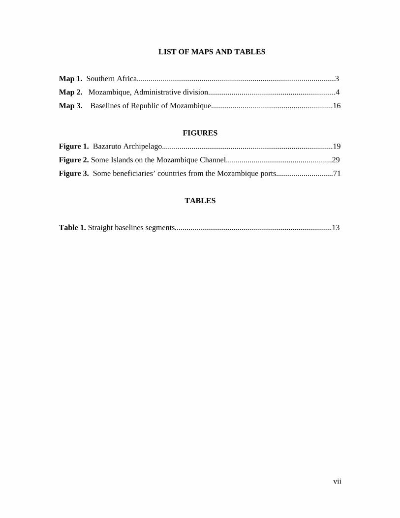
LIST OF MAPS AND TABLES
Map 1. Southern Africa.....................................................................................................3
Map 2. Mozambique, Administrative division.................................................................4
Map 3. Baselines of Republic of Mozambique..............................................................16
FIGURES
Figure 1. Bazaruto Archipelago.......................................................................................19
Figure 2. Some Islands on the Mozambique Channel......................................................29
Figure 3. Some beneficiaries’ countries from the Mozambique ports.............................71
TABLES
Table 1. Straight baselines segments................................................................................13
viii
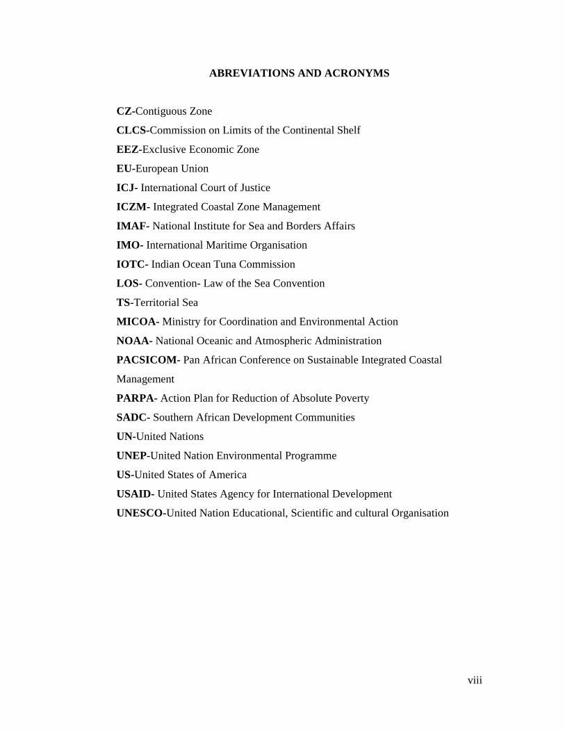
ABREVIATIONS AND ACRONYMS
CZ-Contiguous Zone
CLCS-Commission on Limits of the Continental Shelf
EEZ-Exclusive Economic Zone
EU-European Union
ICJ- International Court of Justice
ICZM- Integrated Coastal Zone Management
IMAF- National Institute for Sea and Borders Affairs
IMO- International Maritime Organisation
IOTC- Indian Ocean Tuna Commission
LOS- Convention- Law of the Sea Convention
TS-Territorial Sea
MICOA- Ministry for Coordination and Environmental Action
NOAA- National Oceanic and Atmospheric Administration
PACSICOM- Pan African Conference on Sustainable Integrated Coastal
Management
PARPA- Action Plan for Reduction of Absolute Poverty
SADC- Southern African Development Communities
UN-United Nations
UNEP-United Nation Environmental Programme
US-United States of America
USAID- United States Agency for International Development
UNESCO-United Nation Educational, Scientific and cultural Organisation

1
INTRODUCTION
The aim of this paper is to identify some key elements that need to be addressed by
Mozambique regarding the implementation of the 1982 United Nations Convention on
the Law of the Sea1. In addition, the paper identifies some core elements that must be
considered by Mozambique in developing an integrated approach to the management of
ocean and coastal resources. For convenience the paper is divided into three parts. The
paper starts out in Part 1 by providing some background information on Mozambique
including the marine resources in sea areas under national jurisdiction; the current
administrative structures that are in place for the management of maritime affairs at a
national level; the maritime zones claimed by Mozambique and the maritime boundaries
with neighbouring States. This is followed by Part II a description of the general
principles and core elements that constitute an oceans policy including an outline of the
policy integration process. The policies that have been adopted by Canada, the United
States, South Africa and Tanzania are briefly reviewed for comparative purposes.
Drawing from the comparative examples, the paper then explores in Part III the key
elements that need to be put in place for Mozambique to develop such a policy. The
paper concludes by identifying the advantages and disadvantages for developing such an
approach and places special emphasis on the need to develop an integrated approach to
the management of coastal resources.
1 It is an international treaty which was adopted in 1982 in the third United Nations Conference on the Law of the Sea (UNCLOS III), which took place from 1973 through 1982. The Law of the Sea Convention defines the rights and responsibilities of nations in their use of the world's oceans, establishing guidelines for businesses, the environment, and the management of marine natural resources.

2
PART I
THE CONTEXT
1. BACKGROUND INFORMATION
1.1 Geography
The Republic of Mozambique is situated on the eastern coast of southern Africa, between
the latitudes 10°27 South and 26˚ 52 South and between longitude 30° 12 East and 40˚ 51
East. Mozambique is bordered by United Republic of Tanzania in the North, by Malawi,
Zambia and Zimbabwe in the west and by South Africa and Swaziland in the South. The
total surface area is about 799,390 km², with 786,3880 km of firm land and a coast line of
2,700 km, 13,000 km is internal waters. The country is the 35th-largest in the world.
Mozambique has an inter-tropical climate with two seasons: a wet season which runs
from October to March and a dry season which runs from April to September.
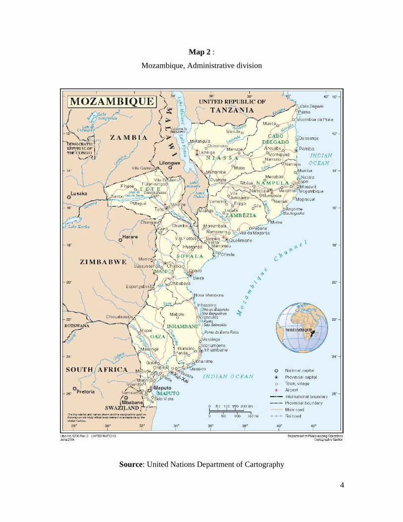
For purpose of public administration, the country is divided in three regions namely:
north, center and south. There are eleven provinces namely: Cabo Delgado, Niassa,
Nampula, Tete, Zambezia, Manica, Sofala, Inhambane, Gaza, Maputo Province and
Maputo City. The latter is the capital of the country and it is located in the south2.
According to the last census report which was completed in 2007 by the National
Institute of Statistic, the population is approximately 20,530,714. The highest number of
citizens live in Nampula province with 4,076,642, followed by Zambeze province with
3,892,854 4,076 and the lowest is in Maputo city with only 1,099,102.
2 The first capital was Ilha de Mozambique in the north of the country.

3
Map 1:
Southern Africa
Source: www.Index.php/Southern_Africa_map.
4
Map 2 :
Mozambique, Administrative division
Source: United Nations Department of Cartography

5
1.2 Coastal Features
The coast of Mozambique may be divided into four biogeographic systems ranging from
the coral coast in the north to deltas of the Zambeze and Save Rivers in the south. 3 The
country has 148 districts and 40 are located in the coastal areas, 10 of the 23 cities are
also located in the coastal areas. The high population density places a considerable
amount of urban pressure on the entire ecosystem of coast. Interestingly, 10 of the 11
administrative provinces are in coastal areas. 4 On a comparative basis, the coastal area5
of Mozambique is large and makes it the third largest coastal State in Africa after
Somalia6 and South Africa7. The importance of fishing, tourism, and maritime
transportation to the economy cannot be underestimated and it is clear that ocean and
coastal development will continue to have a major bearing on the prosperity of the
country in the future. It should also be emphasised that much of the Mozambican coast
feature consists of a pristine ecosystem with high biological diversity and numerous
endangered species. The preservation of marine environment as well as coastal fauna and
flora play an important part in sustaining the livelihoods of the population that live in
coastal areas.8 Two of the most important industries for the future of the economy are
fisheries and aquaculture.
1.3 Administrative Bodies responsible for maritime/marine affairs in Mozambique
Strictly speaking maritime and marine affairs in Mozambique are different issues. In the
case of the former, the scope of the maritime affairs portfolio is limited to managing
3 See Langa p. 34, the coral coast is 770Km in length and extends from Rovuma River in the North 10° 32’ S to the Archipelago in the South 17˚ 20’ S; mangal coast which is 978km in length and extends from Angoche 16° 14’ S to the Bazaruto Archipelago 21˚10’ S; parabolic dune coast with 850km of extension from Bazaruto Archipelago to Ponta de Ouro 26° 52’ S reaching the Mlalazi River 28˚ 57’ S, in South Africa; delta coast which occurs in the mouth of the Zambeze and Save rivers. 4 Namely: Maputo, Gaza, Inhambane, Sofala, Niassa, Nampula, Zambezia and Cabo Delgado. 5 By coastal area or zone is understood to be the interface between the land and the sea. It evolves a dynamic system of relevance economic and environment role, namely seasonal and permanent settlement at the coast, tourism and recreation, mineral extraction, fishing and shellfish gathering, aquaculture, infrastructure development, industrial development, landscape, wildlife, habitat protection and coastal defense. 6 Somalia has the longest national coastline in Africa with 3,025 Km. 7 It is the second largest with about 2,798 km. 8 Antonio Mubango Hongwana, Diagnosis of Mozambique Coastal Zone, 2007.

6
ships, ports, and in the case of the latter it includes responsibility for the protection and
preservation of the ecosystem as well as the exploration and exploitation of its natural
resources. The administrative structure is relatively simple with maritime affairs coming
under the auspices of the Ministry of Transport and Communication and marine affairs
coming within the responsibility of the Ministry for Coordination of Environment Action.
Prior to 2001 issues related to borders and sea affairs were under the scope of the
Ministry of Foreign Affairs and Cooperation. In practice however, many borders and sea
issues were dealt with by different institutions.
Since independence, Mozambique has been a member of the United Nations and ratified
the 1982 LOS Convention in 1997. Mozambique is also a State party to other
international organizations that deal with ocean affairs such as International Maritime
Organizations it also participates in the work of the International Seabed Authority. At a
regional level, it is a member of Southern Africa Development Community (SADC).
Responsibility for implementing various international treaties including the LOS
Convention rests with different Government departments and institutions, some of which
are not directly concerned with maritime or marine affairs. In 2001, the Government
recognised the importance of coordinating all departmental efforts aimed at implementing
the LOS Convention and created the National Institute for Sea and Borders Affairs
(IMAF) 9. Essentially, this is a subsidiary body of the Ministry of Foreign Affairs and
Cooperation which means that the parent Ministry is still responsible for policy in
relation to borders and sea affairs. IMAF on the other hand is an executive and technical
body which coordinates day-to-day issues for the parent Ministry. In discharging this
task, IMAF is assisted by two important bodies: the Technical Council which is the
coordination and consultation organ for sector actions regarding the sea and borders; and
the Coordinator Council10 which involves different Ministries which deal with sea and
borders issues.
9 Law n˚ 03/2001 of 3 July, I Serie, Number 7, 2° Supplement. 10 Decree no. 18/2001, I serie, Supplement 26.

7
1.4 Relevant domestic legislation
Notwithstanding the fact that some activities have gone on for many years such as fishing
and the management of maritime boundaries, many laws and institutions are in the earlier
stages of development as outlined below.
Below are listed and summarized examples of some acts related with the sea:
• 1990, 3/09 September Fishing Act
It provides the legal framework regarding the planification and management of fisheries
as well as the regulation and adoption of the necessary measures for resources
conservation, fiscalization of the fisheries quality products for exportation. As it will be
mentioned below because the law was enacted before the adoption of the LOS
Convention, there are some aspects that are not in conformity with the LOS Convention
which means that the law needs to be revised.
• 1996, 26/11 Ratification of UNCLOS
Taking advantage of the political change in the country, it was also
• 1996, 04/01 Law of Sea
This law defines the Mozambican maritime jurisdiction and provides the support for the
administration, regulation and maritime activities in the country.
• 1997, 01/11 Environment Act
The law provides the legal framework for a good management of the environment and its
components in order to achieve a sustainable development in the country.
Some institutions directly linked to the sea:
• 2001, 03/07 National Institute for Sea and Borders Affairs

8
This is the State body responsible for the coordination of all the sea and borders affairs
issues. Representing the Government effort to concentrate the resources in one main
organ and gain more benefit from its action.
• 2004, 18/08 Marine National Institute
Among other mandates, the Institute is entitled to exercise the maritime authority in the
maritime jurisdiction, lacrustine rivers and the public domain.
• 2004, 20/08 National Institute of Hydrograph and Navigation
This institute deals with technical and scientific activities in order to guarantee the safety
of navigation and contribute for the development to the country in the scientific and
environmental areas.
• 2004, 20/08 National Institute of Petroleum
It is the State institute that among other attributions is entitle to regulate and fiscalizate
the research, production, transportation of the petroleum as well as to propose
development policy and norms regarding petroleum operations.
Note that after independence, Mozambique experienced a civil war lasting sixteen years,
which end in 1990, this fact is obviously why there has only been recently (as shown
above) an increase in the number of approved acts concerning modern environment,
fishing and ocean affairs.
The law 4/96 of 4 January calls for a maritime policy11 in the article 3(1), this article
advances with some proposals of objectives such as:
11 Note that maritime policy written in the Mozambican Law of the Sea is substantially different then ocean policy that is being discussed in this paper. The perspective reflected in the Mozambican Law of the Sea deals with shipping and not exactly with the governance of the ocean. However, it is important to refer that ocean policy and maritime policy are two terms used by two groups of countries to refer the same reality. The first group of countries which use ocean policy includes the United States of America, Canada and all those who are be developing ocean policy, the second group are those who join the European Community. To be precise, maritime policy is a term mostly used by European Community to refer the governance of the sea. In the case of Mozambique, reading the articles it is clear that maritime policy relates to issues of shipping.

9
• Maintenance of sovereignty and national marine integrity;
• Development and improvement of the national marine economy;
• Development and social improvement; and
• Environmental and other issues related with the marine activities.
This article addresses Government responsibility in adopting plans and norms (laws) for:
• Exercise of State sovereignty under the maritime jurisdiction, in conformity with
the law in force and other international laws;
• Adoption of all necessary requirements to apply and implement all maritime
international convention which Mozambique is part;
• Administration of all maritime national and international traffic under the national
jurisdiction; and
• Development of the Mozambican maritime economy through incentives gives to
the owners and companies, promotion of the scientific and technological
development in the maritime sector.
2. MARITIME ZONES CLAIMED BY MOZAMBIQUE
Mozambique has established several maritime zones which include: internal waters;
territorial sea; the exclusive economic zone and the continental shelf. The maritime
limits of several of these zones are projected from the baselines which were first
established in 1975. Mozambique also shares a number of maritime boundaries with
neighboring States. It is now proposed to say a little more about the baselines, the
maritime jurisdictional zones and the boundaries with neighboring states in order to
analyze some elements related with the LOS Convention.
2.1 Baselines
In determining the maritime jurisdiction zones claimed by Mozambique, one first needs
to consider is the baselines. In this context, it is important to recall that the LOS

10
Convention does not define what constitutes the baselines, it simply presents the different
types of baselines that may be used in different geographical situations12. However, the
subject the baselines are significant for the following reasons: they define the maritime
jurisdictional zone (Territorial Sea, Contiguous Zone, Exclusive Economic Zone)13; and
may in certain instances be used in determining the outer limits of the Continental
Shelf.14. Importantly, the LOS Convention goes on to provide for two types of baselines:
the Normal and the Straight baselines15. The normal baselines is the low-water line along
the coast as shown on large scale charts officially recognized by the coastal States16. The
second type is straight baseline which may be used “where the coastline is deeply
indented and cut into or if there is a fringe of islands along the coast in its immediate
vicinity” 17. Significantly, Mozambique uses both type of baselines on different parts of
the coast.
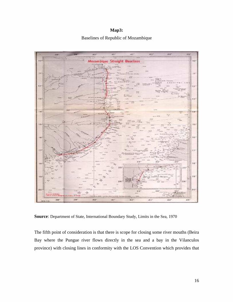
The baselines of Mozambique were first established by Portugal before independence18 in
1967. More specifically, article 1( 4) of Decree-Law no. 47,771 of 27 June 196719, reads
as follows “closing lines and straights baselines which supplement the normal baselines
in Mozambique”. This law came into force under Law no.2130 published on August 22
1966 by the Government of Portugal on the Territorial Sea of the States and the
12 LOS Convention articles 5 and 7. 13 See also Churchill, R.R and Vaught, A. Lowe, op cit, p.26 they considerate as one of the “...function of baselines from what points on the coastal the outer limits of such zone are to be measured”. In the same perspective: Symmons, Clive, Ireland and The Law of The Sea, p.39 understands that “baselines an essential concept because from it are drawn the major maritime zones known to international law the Territorial Sea Contiguous Zones, Fisheries Zone (and /or the 200 mile Exclusive Economic Zone) and even for certain purposes, the Continental Shelf under the new definition therefore in the LOS Convention, 1982”. 14 Manual on Technical Aspects of the United National Convention on The Law of The Sea p.9; The Law of the Sea, R.R Churchill A, Vaught Lowe “ Baselines is the line from which the outer limits of territorial sea and other coastal states (Contiguous Zones, Exclusive Fisheries Zone Exclusive Economic Zone is measured”. 15 LOS Convention articles 5 to 7. 16 See article 5 of the LOS Convention. 17 Article 7(1) of the LOS Convention. 18 Mozambique as well as Angola, Guinea was considerate at that time as ultramarine provinces of Portugal and they became independence in the same year; Mozambique became independent on 25 of July 1975. 19 The Law of the Sea, Baselines National Legislation with illustrative Maps. Division for Ocean Affairs and The Law of the Sea, United Nations, New York, 1989, p. 230-231 or website: www.un.org/depts/los.
11
Ultramarine Provinces20. The Government of Mozambique adopted these coordinates for
the baselines after gaining independence in 1976. This was initially achieved by Decree-
Law no.31/76 of 19 of August 1976, and subsequently by law no. 4/96 of 4 January 1996 21, see figure 1 .
The first observation that can be made about the Mozambican baselines is that they are
recognized by other States and have not been protested since their establishment in 1970.
Nevertheless, we can make number of brief observations about the baselines and their
conformity with the LOS Convention. Firstly, similar to many other coastal States such
as Ireland, the law in Mozambique omits to specify which tidal datum may be used in the
delineation of normal baselines22. This is an important oversight and ought to be
addressed in a future reform or revision of the legislation. Significantly, at the time of
writing, Mozambique is undertaking such as review. This omission is also significant
because Mozambique is in the process of making a submission to the Commission on the
Limits Continental Shelf (CLCS) in relation to its extended continental shelf. This
submission will address the outer limits of the Continental Shelf where these extend
beyond a distance of 200 nautical miles from the baselines from which the breadth of the
territorial sea was measure in accordance with the criteria set for the down in article 76 of
the LOS Convention.
The second aspect of the baselines that requires careful consideration is the straight
baselines. Along the Mozambican coastline from the North to South there are 28 points
specified in the regulation making up the straight baselines which supplement the normal
baselines in Mozambique. These points create five straight baseline systems. In two
cases these connect offshore islands and reefs with the mainland and, in three other cases,
close a deeply indented coast (see figure 1)23. These straight baselines were first studied
20 See research paper of Jamine, Elisio, Maritime Boundaries Delimitation, Management and Dispute Resolution, p15. United Nations-Nippon Foundation Fellowship Programme available on www.un.org/depts/los. 21 See Article 4 of the Law no. 4/96 of 4 January 1996. 22 The reason of this need is because there is a dangerous of do not having precise baselines, regarding the physically location of the Baselines, for further information see Long, Ronan, Marine Resource, Thompson Round Hall, 2007, p. 124. 23 Referred in the Decree Law no.47, 771.

12
by the US Geographer in a report that was published in the 11th of December 1970,
before Mozambique became an independent State24. Significantly, these lines are still in
force and a few key aspects merit further consideration here.
Firstly, the system of straight baselines are used in two areas, first in the North half of the
coastline as far the Zambeze province (from segment 1-2 to segment 25-26). Secondly in
the South by closing the Delagoa Bay (segment 27-28). As is evident from the figure1,
that from Cabo Delgado, Point no.1 to Ponta Maunhambe, Point No. 9, the use of straight
baselines is justified by the shoals, reefs, islands and bays which are located along the
coastline. After Ponta Maunhambe and to Memba Bay, the coastline is uniform and the
baseline is of the normal type: the low-water line. Memba Bay is enclosed by a straight
baseline, as well as the Fernão Veloso Bay. Between Fernão Veloso Bay and Canducia
Bay the shape of the coast is also uniform and again the baseline is of a normal type.
The second point of consideration is the nature of the coast. As is evident from the map
below, the coast of Mozambique has an irregular geographical shape which includes
some exceptional natural features such as islands, islets, shoals, and bays. In other words,
the structure of the coastline is not uniform and Mozambique benefits from the provisions
in the LOS Convention which provides that:
In the localities where the coastline is deeply indented and cut into or if there is a fringe of islands along the coast in its immediate vicinity […] the method of straight baselines joining appropriate points may be employed in drawing the baseline from which the breadth of the territorial sea is measured 25.
24 International Boundary Study, serie A, Limits in the Sea no. 29 Straight Baselines: Mozambique. The Geographer Office of Geographer Directorate for Functional Research, Bureau of Intelligence and Research. 25 Article 7 (1) The straight baseline method became in international law through the recognition by the International Court of Justice in the Anglo-Norwegian Fisheries case of 1951. The case examined the delimitation of Norwegian fisheries zone challenged by the United Kingdom claiming the legality of the lines which was established by the Decree of July 1935, accordingly the UK, See Brown, E.D, The International Law of the Sea, p.24, volume I, Dartmouth Publishing Company, Limited, 1994. It should also be noted that the LOS Convention expressly permits the use of different methods, including normal and straight baselines to suit different geographical conditions on the coastline.

13
Although some authors have suggested that: “It is difficult to see how the northern of
Mozambique coastline could be described as deeply indented”, it should nonetheless be
noted that “the claimed straight baselines do not appear to have protested by the other
States”26 which suggests that they are accepted by other States as a matter of customary
international law.
The third point of consideration is the length of the baseline segments. The longest
segment measures approximately 60.4 nautical miles in length, (segment 18-19) and the
shortest is 2.8 nautical miles, ( segment 16-17). In terms of average, the length is
approximately 19.7 nautical miles and the sum of the length of the segments is 453.4
nautical miles. There are 8 segments of the Mozambique straight baselines which exceed
24 nautical miles, as outlined in the table below:
Table 1:
Some Straight Baselines Segments
Segments: Length:
4-5 41.0 nautical miles
6-7 38.4 nautical miles
17-18 27.5 nautical miles
18-19 60.4 nautical miles ( Longest )
20-21 27.3 nautical miles
22-23 27.6 nautical miles
25-26 45.5 nautical miles
27-28 44.6 nautical miles
Source: Adapted by the author from The Geographer, Office of the Geographer Directorate for the Functional Research Bureau of Intelligence and Research International Boundary Study Series A. LIMITS IN THE SEAS No.29 straight baselines: Mozambique.
26 See Jane Exclusive Economic Zone, p.209.

14
Significantly, the 1982 LOS Convention does not specify any criteria regarding the
maximum length for baseline segment. Nevertheless, some scholars have suggested that
the maximum length of an appropriately drawn segment should not exceed 24 nautical
miles.27 However, as noted by Prescott and Schofield, the International Court of Justice
in reviewing Norway’s baselines decided that they were not contrary to international law
even though eight segments of the 1935 baseline exceeded 24 nautical miles in length28.
Furthermore, an interesting comparison may be made between Mozambique and
Madagascar29, two neighboring States which share a common maritime boundary not yet
delimited. Thus, for example, Mozambique’s longest segment as referred to above is
60.4 nautical miles and in the case of the Madagascar it is 123.1 nautical miles. There are
also many examples of other countries with longer baseline segments.30
The fourth point of consideration is that the LOS Convention prescribes in article 7(3)
that “the drawing of straight baselines must not depart to any appreciable extent from the
general direction of the coast” . The straight baselines in Mozambique are drawn in such a
manner that deviates from the general direction of the coast. Most notably, segments 1-2
and 7-8 deviate by more than 15˚. The question may thus be posed do these straight
baselines conform with the LOS Convention where it states clearly that straight baselines
“[…] must not depart from any appreciate extent from the general direction of the coastal
[…]”. Unfortunately the LOS Convention does not provide a precise answer to this
question. However, the general view is that the coastal States must conform with both
the letter and the spirit of the LOS Convention and draw their baselines in a manner that
is consistent with the LOS Convention. Moreover, it has also to be borne in mind that
State practice varies enormously. Many States take the view that the Norwegian baseline
system is the standard model31, and these baselines do not have an angle of deviation
27 See Roach , J.A ;Smith, Robert W, United States Responses to Excessive Maritime Claims, p.75. 28 Prescott, Victor and Schofield, Clive, The Maritime Political Boundaries of the World, second ediction, Martinus Njgoff Publishers, p.146. 29 Madagascar was the first country in the word to draw a long straight baseline segment. 30 Prescott, Victor and Schofield, Clive, op cit, p. 141 and 654. Notwithstanding, Mozambique does not appear in this table, but has also 8 segments longer than 24 nautical miles. 31 Churchill R.R, A. Vaught Lowe, The Law of the Sea, 3° edition Juris Publishing, Manchester University
Press, 1999, p39.

15
more than about 15˚. Therefore, it may be argued that any baseline that greatly exceeds
this angle may not be in conformity with the spirit of the LOS Convention. This is
perhaps another issue that ought to be addressed in mind during any future review of the
law governing Mozambique’s baselines.
16
Map3:
Baselines of Republic of Mozambique
Source: Department of State, International Boundary Study, Limits in the Sea, 1970
The fifth point of consideration is that there is scope for closing some river mouths (Beira
Bay where the Pungue river flows directly in the sea and a bay in the Vilanculos
province) with closing lines in conformity with the LOS Convention which provides that

17
“[…] the baseline shall be a straight line across the mouth of the river between points on
the low-water line of it banks”32.
The sixth point of consideration is the Bazaruto Archipelago33 which is composed of by 5
islands: Bazaruto (the main island), Magarugue, Banque and Santa Carolina Island.
Clearly, Mozambique is not an archipelagic State as defined in the LOS Convention and
therefore it is not possible to enclose these islands using a system of archipelagic
baselines similar to the practice of the United Kingdom in relation to the
Malvinas/Falklands as this would not conform with the LOS Convention.34 Nevertheless,
it should be noted that under Decree No.39/2001 of 27 November 2001, which creates the
Bazaruto National Park, this area is designated as a marine protected area for the purpose
of managing all the islands35 as an ecological, social and economic unit. There may
however be some merit for bringing these islands within the system of straight baselines
but this matter warrants careful technical consideration and analysis in any future review
of the baseline legislation of Mozambique.36 One particular feature which will require
32 LOS Convention article 9. 33 The Government of Mozambique determined by the Decree No.39/2001 of 27 November that the Bazaruto National Park (name given by the colonial Legislative Diploma No.46/71 of 25 of May) is considered the Bazaruto Archipelago National Park, article 2, and revoke the Legislative Diploma no.46/76, article 4. 34 The LOS Convention makes clear distinction between these two features, an Archipelagic State means a State constituted wholly by only one or more archipelagos and may include other islands, however an archipelago means a group of islands, including parts or islands interconnecting waters and other natural features which are so closely interacted that such islands, waters and other natural features form an intrinsic geographical, economic and political entity, or which historically have been regarded as such. At the time of the Third Conference on The Law of the Sea, some mainland Sates which possessed oceanic archipelagos, argued that there should be no distinction between archipelagos that formed a State and those that belongs to mainland States. This latter position wasn’t supported. See The Maritime Political Boundaries of the World, Prescott, Victor and Schofield, Clive, p. 141. 35 Santa Carolina, Banguerra, Magaruque and Bangue. 36 The first stage will be to link the islands, Bazaruto Island, Benguerra Island, Magaruque Island and Bangue Island, closing the spaces between them. Then, there would be two scenarios: The first scenario is to draw the straight baselines from point 26, the latter point of the current straight baselines in the North of the country linking the outermost point in the North of the Bazaruto archipelago, but this scenario can be subject of protest by the international community because of the area that can be involved, the length of the segment and it couldn’t follow the general direction of the coastline. Furthermore, the area between the latter point of straight baselines up to the Beira Bay the shape of the coastline is really uniform, and after Beira Bay to the area which is the Bazaruto archipelago the coastal configuration does not justify the use of straight baselines.

18
careful consideration is whether the most Northerly point on the island of Iha Bazaruto
aligns itself directly with the general direction of the coast.
In other words, normal baselines is the correct system which was applied in the most part of the Mozambican coastline but, in the Beira Bay area and in the Bazaruto Archipelago region, straight baselines should be applied. The other scenario is to connect the mainland with the point to the North of the Bazaruto archipelago in Inhambane province, but observing the general direction of the coastline, regarding what is provided in the article 7(3) and for both cases in the South the mainland can be linked by the outermost point of the Bangue Island. This scenario presents itself as more reasonable. The implication of this hypothetic analysis is that once it will be necessary to determine the territorial sea of these islands, Mozambique could gain more territory seaward. But, in the general context of the entire coastline, it won’t have a huge impact because even if Mozambique obtained territory in this region, the new territorial sea of the islands would be small as compared to the North of the country where the coastline is clearly naturally positioned more seaward. In other words, the territorial sea in the Bazaruto archipelago, south of the country, could never take more advantage than in the north of the country. But, of course, it could push more seaward in the south of the country. Therefore, the new points of the straight baselines could be Point No. 29 in the mainland, Point No. 30 in the north of Bazaruto island, Point No. 31 in the south of the Bazaruto islands, Point No. 32 in the North of the Benguerra Island, Point No. 33 in the South of the Benguerra island, Point No. 34 linked in the North of the Magaruque Island, Point No. 35 in the Bangue Island in the South, and finally Point No. 36 linking the mainland in Vilankulos province. The challenge to determine the maritime boundary with Madagascar increased because of these new straight baselines. Along, in all Mozambique coastline there are 9 basepoints connecting headlands of the mainland, Points No.1, 8, 9,10,11, 13,14, 26 and 27, 4 segments : 1-3, 10-11, 12-13 and one closing bay: 27-28, the remaining 16 points: 2, 4, 5, 6, 7, 15, 16, 17, 18, 19, 20, 21, 22, 23, 24, 25 connect with islands, islets, reefs, shoals, or other features seaward.

19
Figure 1:
Bazaruto Archipelago
Source: Extracted from the Paper of Paula Santana Afonso37 presented on the Workshop on MPAs- is MPAs a useful tool in Fisheries Management, Norway; 24-25 October 2006.
In conclusion and bearing in mind that the International Court of Justice has pronounced
that the straight baseline provisions of the LOS Convention ought to be interpreted
restrictively,38 a number of general recommendations may be made regarding the
baselines in Mozambique:
37 Paula Afonso, Bazaruto Archipelago National Park- Mozambique. 38 Quatar v. Oman ICJ; http://www.icj-cij.org/docket/index.php?p1=3&p2=3&sort=2&p3=0.

20
• Mozambique ought to review the baseline legislation and provisions ought to be made for many technical issues such as prescribing datums etc;
• The review of the law should take into account the area of the coastline which has not been enclosed within the straight baseline and consideration ought to be given to closing the mouth of the Pungue river in the Sofala bay;
• Consideration should also be given to closing the gap or space between Point No.26 and Point No.27); and
• Consideration should also be given to bringing Sofala Bay and especially the Bazaruto Archipelago within the system of straight baselines.
However, this suggestion will needed to be assessed to ensure that it conforms with both
the letter and the spirit of the LOS Convention.
2.2 Territorial Sea
Historically, the concept of territorial sea was first subject to academic comment during
the Middle Ages. One notable jurist during this era, Hugo Grotius, defended the concept
of freedom of navigation on the high seas and there was considerable debate among the
early jurisprudential scholars regarding the precise extent of the territorial sea.39 More
recently, the legal regime governing both the territorial sea and the high seas is codified
by the LOS Convention. Today, the maximum breadth of the territorial sea is well settled
and Article 3 of the LOS Convention provides that:
Every States have the right to establish the breadth of its territorial sea up to a limit not exceeding 12 nautical miles, measured from the baselines determined in accordance with this LOS Convention.
In practice, the territorial sea is the maritime jurisdiction zone where the coastal State
enjoys full sovereignty any subjected to very important limitations regarding the right of
ships of all States to exercise the right of innocent passage through the territorial sea.
Article 19 of the LOS Convention elaborates on the meaning of the passage and it is
important to note that such passage is innocent so long as it is not prejudicial to the peace,
39 See The Law of the Sea, Churchill A, Vaught Lowe, op cit, p71.
21
good order and security of the coastal State.40 The LOS Convention goes on to elaborate
in article 21 what laws and regulations the coastal State may prescribe relating to
innocent passage in the territorial sea41.
In general it may be said that the law in Mozambique pertaining to the width of the
territorial sea is well settled. More specifically, Decree-Law no. 31/76 of 19 of August
197642 provides that “the breath of territorial sea of people’s Republic of Mozambique is
twelve nautical miles from the baselines” 43. This provision was restated in Law no. 4/96
of 4 January 1996 which provides that “the width of the territorial sea is 12 nautical miles
measure from the baselines”. Within these coordinates Mozambique exercise its
sovereignty including sovereignty over the adjacent area in the air, space, soil and subsoil
of the territorial sea.44
Although the law in Mozambique relating to the extent of the territorial sea conforms
with international law, there is specific reference in the national law regarding foreign
warships or other Government ship operating for non-commercial purposes in the
territorial sea. While these ships enjoy the immunities confirmed on them by international
law, if they are found to be in non-compliance with laws of Mozambique they will be
immediately asked to leave the territorial sea. Moreover, if any foreign vessel during the
course of innocent passage violate the laws of Mozambique they will be responsible for
any loss and damage that they cause. Significantly, these are the only references to
innocent passage in the laws of Mozambique which has not enacted more elaborated
measures to give full effect to Part II of the LOS Convention. However some confusion
may arise from the misleading references in the parent law (resolution no.21/96, 26
November 1996) to Mozambique law related to the innocent passage. As it stands,
Mozambique has not adopted any such laws and resolution no.4/96 Law of the Sea
40 LOS Convention article 19(2). 41 LOS Convention articles 18 and 19. 42The Law of the Sea, Baselines National Legislation with illustrative Maps. Office for Ocean Affairs and The Law of the Sea, United Nations, New York, 1989, p. 230-231 or website: United Nations: International law, Law of the Sea Maritime spaces: Legislation and treaties, Date bases. 43 Article 1(1), Decree-Law no. 31/76. 44 It is inferred in the law of the sea, law no 4/96 of 4 January 1996.

22
simply repeats the general text of Article 31 of the LOS Convention without paying
particular regard to the judicial rigor of the language used in the transposition of the
international provision into domestic law. In any future reform of national law more
attention needs to be paid to implementing the provisions of the LOS Convention on
innocent passage in a more elaborate and concise manner.45
The other observation that can be made regarding Mozambican law is the specific
meaning that is given to the term “passage” and the omission of any reference to passage
including “[...] stopping and anchoring, but only in so far as the same are incidental to
ordinary navigation or...in danger or distress [...]” as set out in Article 18(2) of the
Convention.46 This omission needs to be addressed in any future review of national
legislation.
Mozambique has only concluded one bilateral agreement with a neighbouring State
(Tanzania) regarding the boundary of the territorial sea. This has not proved a problem in
relation to the mainland of Mozambique and Madagascar as both States are capable of
drawing their respective 12 nautical miles of territorial sea without overlapping the
boundary of the State. Nevertheless, the determination of boundary between the two
countries is more complex in the Mozambique Channel where there are a number of
islands.47 The general rule is that:
Neither of the two States is entitled, failing agreement between them to the contrary, to extend its territorial sea beyond the median line every point of which is equidistant from the nearest points on the baselines from which the breath of the territorial seas of each States id measured48.
45 The formulation of the text in national law Refer to the Mozambique law related with the innocent passage, it could be for example, adopted “when a foreign warship or other Government ship operated for non-commercial purposes for non-compliance with the Mozambique law or with the international principles of the innocent passage or other international law and cause loss and damage to the coastal State, the flag State shall bear international responsibility for any loss and damage resultant of it” . 46 To support this position of omission see the definition of “passage” See R.R Churchill A, Vaught Lowe, op cit, p.81. 47 See The Maritime Political Boundaries of the World, Prescott, Victor and Schofield, Clive, p. 467 and following, and, more recently, Jamine, Elisio, p.32 and 33. 48 LOS Convention, article 15.
Formatted: Font:
English (Ireland)
23
Similarly, the same rule may be applied in determining the territorial sea boundary
between Mozambique and Comoros49, and Mozambique and South Africa50.
The boundaries of the territorial sea with the adjacent State in the north, Tanzania, was
drawn using the equidistance method of drawing a median straight line, specifically from
point “B” to a point 12 nautical miles, located at latitude 10˚ 18’ 46” S and longitude 40°
40’ 07” E, hereinafter referred to as point “C”51.
With South Africa in the south, both States have claimed their territorial sea of 12
nautical miles but, there is a question of an undelimited common boundary which should
be agreed settled through a future bilateral agreement using the equidistant line which
appears to be accepted by both States because of the advantage for the States.
2.3 Contiguous Zone
The Contiguous Zone is an area that may not extend beyond 24 miles from the baselines
from which the territorial sea is measured. Essentially the contiguous zone is an
enforcement zone where States have limited enforcement jurisdiction to prevent or
punish infringement of its customs, fiscal, immigration and sanitary laws. The LOS
Convention has specific provisions relating to the control of archaeological and historical
objects removed from seabed of the contiguous zone52. Some States53, contrary to the
LOS Convention, have claimed the right to expand the competence of the Contiguous
Zone to include protection of national security interests and thus restrict or exclude
49 In the so-called “tri-point”, the point where the common boundaries meet: Mozambique, Tanzania and Comoros. 50 Jamine, Elísio, op cit, p.40-43; 51 Agreement between of the Government of United Republic of Tanzania and the Government of the People’s Republic of Mozambique regarding the Tanzania/ Mozambique boundary, article IV, 28 December 1988. 52 LOS Convention article 303 (2). 53 Bangladesh, Burma, Haiti, Iran, Sri Lanka, Sudan, Syria, Venezuela, Vietnam and Yemen, see United States Responses To Excessive Maritime Claims, J. Ashley Roach and Robert W. Smith, p.20.

24
warships and military aircrafts, however the US has diplomatically protested 11 of these
eighteen claims and conducted operational assertions against others54.
Mozambique has claimed its contiguous zone through Law no. 4/96 of 4 January 1996
which provides that:
The contiguous zone to the territorial sea is defined as the adjacent area to the contiguous zone, which extends beyond to 24 nautical miles measures from the baselines.
Significantly, this law is not a legal basis for the exercise of sovereignty in the
Contiguous Zone but is aimed at preventing punishing violations of customs regulations
and laws, immigration focalization, sanitary protection. However, the law also provides
for the punishment of offences related to the preservation of the marine environment and
Mozambican territory. 55 This clearly beyond what is foreseen in Article 33 of the LOS
Convention.
In sum, the Mozambican law prevents and punishes acts provided in the LOS Convention
committed in the territory and in the Territorial Sea. But, there is an extending for the
marine environment prevention which is not expressly provided for by the LOS
Convention. Note also that the only extension for State jurisdiction in the Contiguous
Zone is with respect to the control of archaeological and historical objects removed from
the seabed of the Contiguous Zone.
One aspect of the law in Mozambique that requires careful consideration is the absence of
clarity regarding the recovery of archaeological objects from the seabed. Historically, the
Mozambique Channel was regularly used as an international route for vessels on passage
too and from India. Consequently, there are many historical wrecks and artifacts on the
seabed. However, Mozambique has not enacted specific measures to protect underwater
cultural heritage and it is unclear how well the provisions of the LOS Convention relating
54 Bangladesh, Burma, Haiti, Cambodja, North Korea, Nicaragua, Pakistan, Syria, Vietnam, and Yemen. 55 Los Convention article 8( 2a), (2b).

25
to archaeological and historical objects found at sea56 are reflected in national law. In
addition, consideration should be given by Mozambique to becoming party to the 2001
UNESCO Convention on Underwater Cultural Heritage which at the time of writing had
been ratified by 20 States and came into force in 2008. Significantly, South Africa has
expressly claimed a maritime cultural zone and their national law provides that:
The sea beyond the territorial waters referred in section 4
(territorial waters) but within a distance of 24 nautical miles from the baselines, shall be the maritime cultural zone of the republic57.
The Mozambican law is silent on the delimitation of the Contiguous Zone between
opposite and adjacent States. Some authors have expressed the view that its delimitation
(for State claiming an EEZ) amount to a delimitation of a part of the EEZ or because an
absence of sovereignty or exclusive jurisdiction in this area, there is no reason why
Contiguous Zones should not overlap. 58 Accordingly, in such instances there is no need
for delimitation. However, in the absence of clarity on this issue and in view of the
difficulties that may arise in relation to the protection of underwater cultural heritage
perhaps this is an issue that should need to be resolved on basis of bilateral agreement
with Tanzania and South Africa. In the boundary agreement between Mozambique and
Tanzania there is no reference to the Contiguous Zone59 but there are provisions relating
to the Territorial Sea and Exclusive Economic Zone60. Tanzania has claimed a 24 nautical
miles Contiguous Zone. There may be provision for using the equidistance line to
delimit the boundary between both States. As mentioned previously South Africa has
also claimed 24 nautical mile contiguous zone61 and is in the process of negotiating
maritime boundaries with Mozambique. Significantly, South Africa has published a
56 LOS Convention articles 33(1a) and 303(2). 57 Article 6(1) of the Maritime Zones Act, No.15 of 1994 and in the article 6(2) prescribes the rights which are in respect of its territorial sea; 58 See Churchill, op cit, p.136-137, Ronan Long, op cit, p141. 59 With respect to Tanzania even in the Act 1989 which established the Territorial Sea and Exclusive Economic Zone, there is no reference to the Contiguous Zone. 60 Articles III and IV respectively, Boundary agreement between Mozambique and Tanzania. 61 Article 5(1) of the Maritime Zones Act No.15 of 1994 “the sea beyond the territorial waters referred in section 4 (territorial waters), but within a distance of twenty-four nautical miles from the baselines, shall be the Contiguous Zone of the republic.

26
chart showing its baselines and a maritime claim which shows a provisional boundary
with Mozambique based upon the equidistance line62.
2.4 Continental Shelf
The LOS Convention defines the Continental Shelf63 as the area that :
Comprises the sea-bed and subsoil of the submarine areas that extend beyond its territorial sea throughout the natural prolongation of its land territory to the outer edge of the continental margin, or to a distance of 200 nautical miles from the baselines from which the breadth of the territorial sea is measured where the outer edge of the continental margin does not extend up to that distance.64
The Continental Margin “comprises the submerged prolongation of the land mass of the
coastal State, and consists of the sea-bed and subsoil of the shelf, the slope and the rise. It
does not include the deep ocean floor with its oceanic ridges or the subsoil” . While
States can claim a 200 nautical mile EEZ they are entitled to a Continental Shelf of a
similar extent without any express proclamation provided that there are no overlapping
claims from opposite or adjacent neighboring States65,66. Moreover, some States have a
physical continental margin which extends beyond 200 nautical miles and special
provisions are made by the LOS Convention for delimiting such extended Continental
Shelf.
Typical and as compared to many other coastal States in the region, Mozambique has an
extensive continental shelf which has considerable biodiversity and other resources.
Surprisingly, Decree Law no.31/76 of 19 August 1976 which establishes the Baselines,
Territorial Sea, and Exclusive Economic Zone makes no reference to the continental
62 See Prescott, op cit, p.466. 63 This term is subject of two different interpretations, one scientific and other legal. 64 LOS Convention article 76(1). 65 LOS Convention article 76(5). 66 LOS Convention article 77(3).

27
shelf. The legal concept of the continental shelf is however addressed in Article 13(1),(2)
of Law no.4/96 of 4 January 1996 which sets out the limits of the Mozambican
Continental Shelf and the Continental Margin. At the time of writing, Mozambique was
undertaking the technical studies and the collection of data required in order to make a
submission to the Commission on the Limits of the Continental Shelf (CLCS) pursuant to
article 76 (8) of the LOS Convention. The preparation of this submission will have to
take into account the presence of neighboring States in the Mozambique Channel where
there are competing claims in relation to the Continental Shelf. Indeed, it is only in the
South of the Mozambique where it will be possible to make a submission without
prejudice to matters relating to the delimitation of the boundaries with neighboring
States. More specifically, boundaries with the French possessions in the Mozambique
Channel will have to be resolves. In the other areas, there are boundaries in the vicinity of
Europa Island, in the southwest of Madagascar, Bassas da Índia in the center of the
Channel, and Juan da Nova in the north, which need to be resolved prior to making a
submission to the CLSC. The possible course of action for Mozambique could include is
to making a partial submission in relation to the uncontested portion of the Continental
Shelf and later making a joint submission with neighboring States in relation to the
disputed areas. Essentially this follows the strategy adopted by Ireland in making their
submissions to the CLCS67.
With the adjacent countries, Tanzania68 in the North and South Africa in the South, there
is no recorded difficulty regarding the continental shelf boundary. However, there is a
matter for discussion in the tri-point junction between Mozambique, Tanzania and
67 “On 19 May 2006, France, Ireland, Spain and the United Kingdom of Great Britain and Northern Ireland submitted, through the Secretary-General, to the Commission on the Limits of the Continental Shelf, in accordance with Article 76, paragraph 8 of the LOS Convention, information on the limits of the continental shelf appurtenant to France, Ireland, Spain and the United Kingdom of Great Britain and Northern Ireland (hereinafter referred to as the "four coastal States") that lie beyond 200 nautical miles from the baselines from which the territorial seas of these four coastal States are measured in the portion of the continental shelf in the area of the Celtic Sea and the Bay of Biscay”. See http://www.un.org/Depts/los/clcs_new/submissions_files/submission_frgbires.htm. 68 In the Act of 1989 Tanzania does not claim its Contiguous Zone, South Africa did, article 8 stating as well as defined in the article 76 of the UN Convention on The Law of the Sea 1982.

28
Comoros, this latter State also which has an unresolved problem with France related with
the Mayotte Island located in North of the entrance of the Mozambique Channel69.
69 See Figure 1.

29
Figure 2:
Some Islands on the Mozambique Channel
Source: Figure extracted from the work paper “Boundaries situation “of the Directorate of Borders at the National Institute for Sea and Border Affairs.
30
2.5 Exclusive Economic Zone
One of the great achievements at the third Law of the Sea Conference was the
establishment of the Exclusive Economic Zone as a sui generis functional zone where
coastal States have certain sovereign rights in relation to resources and other economic
activities, as well as certain jurisdiction over activities such as marine scientific
research.70 The origin of the concept may be traced back to initiatives taken by Kenya
which was the first State to raise the idea of such a zone at the Asian-African Legal
Consultative Committee in January 1971 and subsequently at the UN Sea Bed
Committee71. The justification for such a concept was to satisfy the aspiration of the
developing countries for economic development and to realize their desire to gain greater
control over the economic resources off their coasts, particular the fish stocks, which in
many cases were largely exploited by the distant-water fleets of developed States.
Ultimately, the EEZ developed as a compromise solution which reconciled the competing
interests of these States,72 the States that claimed a 200-miles territorial sea, and
developed States which wished to retain freedom of navigation on the high seas73.
Today, over 85 countries claim an EEZ and many of these claims are generally consistent
with the provisions set out in Part V of the LOS Convention74.
The Exclusive Economic Zone of Mozambique was claimed established by the Decree
Law No. 31/76 of 19 August 1976 and it may be recalled from the introductory remarks
above that this was the first year of the independence.75 Today the legal regime is set out
in the Law of the Sea, Law 4/96 of 4 January 1996. Article 9 of Law of the Sea provides
that the EEZ extends to a distance of two hundred nautical miles from the baseline. In
this area, the State has sovereign rights to exploration and exploitation, conservation and
management of the natural resources, living or non-living of the seabed, subsoil and
superjacent waters. In addition to this, the State is entitled to regulate the establishment
70 Because of be a special functional zone situated between the territorial sea and the high seas. 71 See Law of the Sea, R. R Churchill A, Vaught Lowe, p.160. 72 Latino American and African States. 73 Japan, US, URSS, etc. 74 Ronan Long, Course Handout, Law of the Sea, National University of Ireland, without date, p.18. 75 Article 2 of the Decree Law No.31/76 of 19 August 1976.

31
and use of artificial islands, installation and structures, maritime scientific research and
protection and preservation of marine environment. Other States, coastal or land locked
enjoys freedom of navigation, over flight, and of the laying of submarine cables and
pipelines, and other internationally lawful actions76.
Maritime boundaries are reviewed as a separate topic below. Nevertheless, the law
establishing the EEZ of Mozambique calls for brief comment here. The first issue relates
to the delimitation of the EEZ boundary with neighboring States. The distance between
Mozambique and Madagascar is about 201 nautical miles in the north and 501 nautical
miles in the South which means that there is an EEZ boundary overlap in the north. This
situation is compounded by the dispute between France and Madagascar over The islands
in the Mozambique Channel, the Europe Islands, in the centre Bassas da India of the
Mozambique Channel and Mayotte Island in the North. Accordingly, it will first be
necessary to resolve the status of these islands before Mozambique and Madagascar open
negotiations to delimit their EEZ boundary. In addition, a further difficulty arises from
the law in Madagascar (ordinance No.85-013, Determining the Limits of the Maritime
Zones)77 which provides that:
In the case where there is a distance less than 400 miles between the baseline of the Democratic republic of Madagascar and those of one or several bordering States, delimitation shall be by agreement with the States(s) concerned78.
This clearly does not make any reference to the use of equidistant line in the process of
determining the maritime boundaries with neighboring States.
Mozambique will also have to determine an EEZ boundary with the Comoros which lie
in the Mozambique Channel at distance of about 147 nautical miles from Mozambique.
The boundary agreement which is already in place with Tanzania takes into account the
76 LOS Convention article 11. 77 This ordinance revokes the previous ordinance No.73-060 of 28 September 1973. 78 Ordinance, no.85-013, article 4.

32
maritime claims of the Comoros. The boundary with Tanzania in the North and South
Africa in the South are less problematic as there is already an agreed boundary in the
North (reviewed below) and negotiations are underway with South Africa in relation to
the EEZ boundary in the South.
3. Maritime Boundaries
This part of the chapter briefly outlines some of the maritime boundary issues with
neighboring States in order to provide some context to the subsequent below in Part III
which addresses with ocean policy matters. Not withstanding the fact that Mozambique
has one of the longest coastlines in Africa, many of its maritime boundaries with
neighboring States are not yet subject to delimitation agreements. There are many
reasons for this lack of progress, including the complexity of the physical geography of
the Mozambique Channel and the absence of technical expertise and resources to
undertake the necessary survey work. Thus, it is unsurprising that despite a number of
initiatives taken by the Government of Mozambique and with the support of the United
Nations, negotiations have not commenced to date on many of the key maritime
boundaries with opposite and adjacent States.
3.1 Mozambique/Tanzania
Mozambique and Tanzania have agreed land and maritime boundaries on their adjacent
coasts. Both boundaries were established on 28 December 1988 and, the maritime
boundary follows the course of the Rovuma River which flows into a bay. Thereafter
using the equidistance method, it follows the parallel of point D which is at 10° 05’ 29”
S79. This boundary lies at about 36 nautical miles from the three adjacent countries,
79 Article IV of the Agreement between the two States reads “The delimitation of the EEZ between the two countries is delimited in conformity with the equidistance method by prolongation the median straight line used for the delimitation of the territorial sea from point “C” to point 25.5 nautical miles, located at latitude 10˚ 05’ 29”S and longitude 41° 02’ 01”E, hereinafter referred to as point “D”. From this point, the EEZ is

33
Mozambique Tanzania and Comoros. Importantly, this boundary was drawn taking into
account the spirit of friendship, solidarity and, good neighborliness that has always
existed between the two States and as noted previously, also recognizes the negotiation of
a future boundary delimitation agreement with the Comoros80.
3.2 Mozambique/South Africa
Mozambique has a 472Km land boundary with South Africa and negotiations are
underway regarding a territorial sea/contiguous zone boundary. One of the issues under
consideration is the use of the equidistant line on the application of the data collected by
South Africa and Portugal for this purpose prior to the independence of Mozambique in
1976. At the time of writing, there has been agreement to use the mean low water mark
as a starting point for the determination of the maritime boundary and the equidistance
line. This is another example of a good working relationship between neighboring States
in the same geographical region. Both States have agreed that the boundary should start
at the low water marks and not follow the land boundary as projected seawards.
However, there is still considerable scope for negotiation regarding the precise point of
intersection between the land and the sea boundaries.81
3.3 Mozambique/Madagascar
The determination of a maritime boundary between Mozambique and Madagascar is
currently one of the most problematic law of the sea issues at the regional level. Besides
the difficult technical issues that must be resolved, there are also a number of political
matters which are impeding progress. Namely, these include the boundary difficulties delimited by application of the principle of equity, by a line running due east along the parallel of point “D”. The point to termination of this line will be established through exchange of notes between the United Republic of Tanzania and the People’s Republic of Mozambique at the future”. For a description of the maritime boundary between the two countries see Chaney, Jonathan I, and Alexander, Lewis M, International Maritime Boundaries, p. 900. 80 This possibility will be elaborated upon below. 81 See Jamine.
34
associated with the French islands (Europa Island, Bassas da India Island, Juan da Nova
Island) in the Mozambique Channel which are claimed by Madagascar, and the Mayotte
Island claimed by the Comoros. Prior to the resolution of this dispute it is unlikely that
Mozambique will be able to maritime boundary agreements with neighboring States in
this area. There have been a number of efforts by the UN to remove the current
impasse82. There are several possible solutions provided that the future legal status of the
islands can be agreed to, including whether they remain within the possession of France
or come under the sovereignty of Madagascar or they fall under the establishment of
some new joint governance arrangement. As mentioned previously, there is no specific
reference to use of an equidistance line in the Madagascar ordinance of 198383 as the
preferred means of boundary delimitation. Moreover, because of the geographical spread
of the islands that are under French possession, Mozambique and Madagascar only share
a common boundary of 75 nautical miles.84 However, the Mozambique Channel is 870
nautical miles in length85 and it may be possible to draw equidistance lines around the
islands consisting of two segments, 69 nautical miles in the North between the
trijunctions with Comoros and Juan de Nova, and 15 nautical miles in the middle of the
Mozambique Channel between the triconjuction with Juan the Nova and Europe Island.
The first solution offers little advantage to the neighboring States as the islands would
generate a considerable EEZ to the benefit of France. The second possible solution is
based on Madagascar exercising sovereignty over the islands. In such an instance, both
States could take the presence of the islands into consideration in achieving an equitable
agreement on a common boundary in the North, center and south of the channel. In 82 The UN General Assembly approved two resolutions regarding this issue, the first was resolution 34/91 in the 99 plenary meeting on 12 December 1979 where the Government of France was invited to “without further delay” initiate negotiation with the Madagascar Government for the reintegration of the islands, which in the opinion of the UN where arbitrarily separated from Madagascar. Is must be note that the Council of Ministers of the Organization of African Unity at its thirty-third ordinary session, held at Monrovia from 6 to 20 July 1979 had adopted a resolution on the same issue. One year latter besides the UN resolution nothing has happen, through Resolution 35/123 at 11 December 1980, the UN invites again the French Government, this time “as a matter of urgency” to undertake the negotiations provided in the previous resolution but 29 years after the first resolution and 28 after the last one those islands remains French possessions. 83 However, it had been incorporated in the 1973 Ordinance, see Jane’s Exclusive Economic Zone, p.113. 84 The French argument is base in the historical facts could be an object of an interesting debate if we considered that the first occupation was by the ex. Portuguese colony, and at that time Mozambique was under Portuguese domain and with the independence all the Portuguese ultramarines territories of the ex. Colonial Mozambique belong to Republic of Mozambique. 85 Prescott, p. 46.

35
considering this solution it ought to be borne in mind that, for France the possession of
those islands is more a political matter than a question of economic or strategic interests.
The last possibility is to bring the islands under a new governance regime with a mandate
from the UN and to draw a boundary between Mozambique and Madagascar taking into
consideration the unique legal status of the islands.
3.4 Mozambique/Comoros
Establishing a boundary with Comoros will involve three countries: Mozambique,
Tanzania and Comoros. The boundary of these three countries meet in the so-colled
trijunction point, this point is located at 9˚ 30’ S and 42° 21’ E, and the equidistance
boundary between Comoros and Mozambique measures about 275 nautical miles from
the already delimited boundary between Mozambique and Tanzania86. The Mozambique
basepoint lies along the coast from Cabo Delgado in the North, along Archipelago das
Quirimbas for 110 nautical miles, past Ponta Maunhane, Punta Uifondo and Pinda to
Cabo Condicia87. There have been a number of diplomatic initiatives taken by the
Government of Mozambique to open negotiations on this matter. However, the current
dispute between Comoros and France regarding the sovereignty of Mayotte Island will
have a major bearing on the decision of Comoros to address this boundary with
neighboring States.
86 Prescott, p.467. 87 See Prescott citing Geographer, p.467.

36
Part II
Oceans Policy and Comparative Law
Introduction
As seen above, Mozambique has a number of outstanding law of the sea issues that need
to be resolved to ensure the proper and effective implementation of the LOS Convention.
Apart from the maritime boundary issues which are complex, none of the others are
insurmountable and it is important that Mozambique keeps abreast of international best
practices regarding the management and utilisation of marine resources in areas under its
jurisdiction. In this context, it is important to recall that although most coastal countries
have adopted sector-specific policies to manage ocean use, such as fishing and oil and
gas, maritime transport, it has only been since the early 1990s that coastal States have
started introducing an integrated approach to managing ocean and coastal activities.88
Today there is considerable support in the academic literature that integrated ocean
approach is a better way to manage the ocean and its resources at global, regional and
national levels.89 Furthermore, as will be seen below, there is considerable evidence that
many coastal States are now heavily committed to the adoption of integrated measures to
address some of the most critical issues that needs to be addressed in modern ocean use.
Accordingly, the purpose of this part of the paper is to briefly examine the concept of
integration and to briefly review state practice in Canada, the United States, South Africa
and Tanzania with a view to understanding recent trends in the application of this concept
at a practical level. This part of the paper sets the scene for the final part which explores
the most appropriate course of action for Mozambique in meeting the future challenges
posed by coastal and ocean management of in sea areas under national jurisdiction.
88 The Ocean Policy Summit 2005 Bulletin, p.25. 89 Laurence Juda “Changing National Approaches to Ocean Governance: The United States of America, Canada and Australia", pag. 161-163.
37
1. The concept of integration
There are several different views as to what the concept of integration means. One view
is that it is not a legal term but a political concept which aims to harmonize the different
policies governing activities such as maritime transport, fishing, aquaculture, oil and gas
extraction, use of wind and tidal power, shipbuilding, tourism and marine research,
require necessary integration.90 Traditionally, States have taken sector policy decisions in
isolation without taking into account how these decisions impact on other policies. The
fragmented nature of the decision makes it difficult to measure the potential impact of
one set of activities on other policies or the potential conflicts that may arise. In recent
year, as will be seen below, there is an increasing tendency for States to achieve
integration through the adoption of a national oceans policy which set down common
principles and standards for the different sector areas. In other words, the objectives,
programs and measures to manage the marine environment and its resources are
developed in such a way that the different objectives, programs and measures are
harmonized with the ultimate aim of making them mutually consistent across the
different sectors. In short, many ocean related issues are global in nature and must
therefore be addressed in a holistic and integrated manner. However, in this context it is
important to note that as integration is realized over time and will continue to require
cooperation and coordination at different levels including Governmental, institutional,
geographical, and spatial levels. In addition, integration by definition requires a continual
process of reassessment of policy objectives and the adoption of a multidisciplinary
approach to all ocean related matters. One particular feature of ocean use is that many of
the problems encountered regarding resource use extend beyond national jurisdiction.
Accordingly it is often necessary to address such matters at a regional or global level.
For example, transboundary fish stocks need to manage at a regional level. This is
achieved in relation to the tuna fishery in the Western Indian Ocean by the Indian Ocean
Tuna Commission.
90 R. Long, Marine Resource.
38
1.2 How does the policy process start and evolve?
One general feature in the establishment of integrated management structures is that very
often the first steps are taken after the Government has made a commitment to draft a
general framework aimed at harmonizing various sector such as maritime transport,
fishing, energy, etc. In designing such a framework, account must be taken of the cross-
cutting issues such as the maintenance of biodiversity, the protection and preservation of
the marine environment, combating climate change, improving science and technology,
achieving sustainable development, and putting in place strategic plans to deal with
national disasters, (emergencies), poverty eradication, etc.
Different approaches have been taken by different Sates depending on how the political
system is organized within the State. For example, this issue may be addressed by the
Parliament or by the Government creating a specialized commission to deal with the
adoption of a national oceans policy. This was the approach adopted by the United
States. Alternatively, it is also possible to address this responsibility by tasking a specific
Ministry or other specialized institution with the development of the policy for those
countries which already have a national ocean plan. Very often, the challenge is how
best to coordinate and coordinate all the different maritime sectors both vertically and
horizontally. Countries such as the United States and Tanzania have started the process
by establishing a specialized commission or working group which is responsible for the
identification of the need for a national ocean plan. This work is essential as the
Commission must produce recommendations on which all the subsequent work will be
based. It must be borne in mind that the work of the Commission must involve all sectors
directly or indirectly related with the sea. Special attention must be given to public
participation, and consultation between stakeholders and decision-makers. As is evident
from the consultation process followed by New Zealand and Australia, this is an issue for
not only maritime experts, but must also reflect the concern of all citizens and in
particular the communities who live on the coast.

39
The Commission must be given enough time to complete its work and after considering
all the relevant elements there is usually a requirement to produce a national strategic
plan which can be enacted on the basis of the recommendations. In parallel, it is
important that this document must be followed by legal instruments which set down firm
legal obligations. In establishing the law and the plan, it is necessary to create or identify
the correct organ that will coordinate the integrated implementation of the plan of action.
Once again, State practice in countries such as Australia suggests that this is best
achieved be a new organ or institution which is mandated with this specific mission.
Strong leadership will be required for the success of the plan. Below is a suggested draft
structure of the process:
Integration is definitely the actually way to address policies. Sectorial policies are
harmonized and became a multifunctional structure instead of address them isolated
which have proved to be inefficiently because of not evolve connected or related matters
which at end will affect the entire policy drew.

40
2. Regional & global initiatives
Many ocean issues have to be addressed at a regional and international level. More
specifically, States must ensure that their national efforts are harmonized with regional
and global initiatives. Two of the best examples of regional initiatives are the European
maritime policy and, in Africa, the Agenda of African Union and of the Southern African
Development Communities. At a global level, initiatives such as Johannesburg Summit
on Sustainable Development, its Plan of Implementation, and Agenda 21 are all
important in advancing a more holistic approach to the management of ocean affairs.91.
Although the EU does not have legal competence to regulate the maritime policy of all its
member States because of its limited competence in specific areas such as maritime
transport, it has promoted the adoption of a maritime policy at a regional level with
further integration and the adoption of maritime policies by the member States.
Significantly, the European Commission’s Green Paper, a European vision for the Ocean
and Seas, calls upon stakeholders, the public and the European institutions to adopt an
integrated approach to maritime issues with a view to promoting economic development,
the quality of life in coastal regions, European leadership in maritime affairs, better
governance at national, European and Global level.
Globally speaking, Agenda 21 of the United Nations Conference of Environment and
Development has called for the adoption of approaches to marine management that “are
integrated in content and are precautionary and anticipatory in ambit”92. Chapter 17 aims
to improve the:
Protection of the oceans, all kinds of seas, including enclosed and semi-enclosed seas, and coastal areas as well as the protection, rational use and development of their living resources.93
91 Agenda 21 is one of the documents approved during the United Nation Conference on Environment and Development, in Rio Brazil, 1992. It was signed by 179 heads of Governments; it is a blueprint for sustainable development in the 21st century, aimed at providing a high quality environment and healthy economy for all the peoples of the world. 92 Agenda 21, paragraph 17.1. 93Ibid.
41
There is a specific reference to the adoption of approaches to the management of ocean
affairs that are integrated in content at the national, sub regional, regional and global
levels.
States have take advantage of regional and global organizations to extend their policies in
order to challenge transnational marine and environment problems. These initiatives such
as in the case of Agenda 21 have had a crucial impact in the national policy calling for
adoption of standard commitment with the ocean issues.
2.1 Some initiatives in Africa
Ocean policy issues at time of writing are not the top priority for many African States or
for regional bodies such as SADC.94 However, it doesn’t mean that these organizations
and States do not care about improving the quality of the marine environment or the
management of ocean resources. This is more of an acknowledgment of other more
serious and basic problems present such as war, access to education, poverty eradication,
food and other political and social problems. Despite the pressing nature of this reality,
there are many examples of initiatives aimed at improving marine resource management
including the following:
• 1993 Integrated Eastern African and Island States Conference held in Arusha;
Take into account the Agenda 21 adopted by the United Nation Conference on
Environment and Development calling for local efforts to integrated environment
protecting into local economic development, this meeting was the response of the Eastern
94 Analysing the Agenda of this organ at the time of writing indicated that there was nothing directly or specially related with the Ocean Policy in its provisions.

42
African countries to settle down a common vision for the region addressing specific
problems95.
• 1996 Second conference of the Integrated Eastern African and Island States held in Seychelles;
Based in the results of the first conference held in Arusha, the conference agreed to make
more concerted attempts to improve the situation of ICZM, including the development
and implementation of a strategy for capacity building as well as the establishment of a
multisectoral coordinating mechanism for ICZM in each country96.
• 1996 Adoption of a the Protection, Management and Development of the Marine and Coastal Environment Convention in Kenya;
This Convention is a legal platform which provides a framework for the countries of
Eastern Africa to cooperate and coordinate efforts in order to develop and protect
programs for coastal and marine environment sustainable97.
• 1998 Pan-African conference on Sustainable Integrated Coastal Management (PACSICOM), held in Maputo.
The aim of this Conference was to strengthen sustainable development in coastal zones
and areas. It was a unique moment for all African States to review the threats against the
marine and coastal environment and on the measures required to meet the complex
challenges. As a result of the share of ideas it was adopt the Maputo Declaration.
As will be seen below, the main thrust is towards the development of integrated
management indicatives at a local level.
At a regional level, in the case of the Eastern African States, Comoros, Kenya,
Seychelles, Madagascar, Mauritians, Reunion, Somalia, and Tanzania have all
participated in the United Nation Environment Programme (UNEP)98 for the protection
95 Lindén.O and Lundin C.G, Editors, The Journey from Arusha to Seychelles, October 1996, p.18. 96 http://www.ambio.kva.se/1997/Nr4_97/jun97_5.html. 97 http://www.unep.org/NairobiConvention/The_Convention/index.asp. 98 UNEP is the bodies under the United Nations responsible for environmental issues at the global and regional level. Its mandate is to coordinate the development of environmental policy consensus by keeping

43
of the marine environment of the region. As far back as 1981, a scientific project
discovered many instances of oil pollution throughout the coastal zone in the region.
There was also considerable evidence of land-based pollution from fertilizers and
untreated sewage. One of the positive outcomes was the subsequent adoption of a
regional Convention for the protection, management and development of the marine and
coastal environment, a protocol on protected areas and wild fauna and flora, and a
protocol on cooperation in combating marine pollution in cases of emergency99. These
initiatives can be seen as the first tentative steps by the countries in the region to develop
national policies aimed at protecting and managing their coasts.
2.2 Security and Safety
In parallel to the development of the national ocean plan, security is undoubtedly one
fundamental element to be taken into account when it comes to management of
ocean/coast areas. In the particular case of Mozambique, security is highlighted to justify
the need to determine maritime boundaries with neighbouring States and for the
implementation of the future national ocean plan. Fortunately, there is no record of any
serious problems regarding the security incidents between Mozambique and its neighbour
or other country in the seas. But, certainly the situation in the north of the Indian Ocean,
in Somalian waters which are characterized by piracy acts, affect directly or indirectly all
the countries in the Indian Ocean in particular and remain a problem.
In general, the International Maritime Organization (IMO) is the international authority in
the field of maritime safety who defines the rules and provides assistance for all its
members.
the global environment under review and bringing emerging issues to the attention of governments and the international community for action. Its mandate and objectives emanate from United Nations General Assembly resolution 2997 (XXVII) of 15 December 1972 and subsequent amendments adopted at UNCED in 1992. See http://www.unep.org/resources/gov. 99 http://www.unep.org/NairobiConvention/The_Convention/index.asp, the Convention.

44
In the particular case of countries laying in the Indian Ocean on the Mozambique
Channel there is no any specific and regional body to deal with maritime security, all
States are subject of the IMO protection. However, the IMO has been developing a long
term anti-piracy project which the aim is to foster the development of regional
agreements on implementation of counter piracy measures. Africa hasn’t be
contemplated, yet100.
The major sea security problems are, among others, terrorism, illegal fishing, piracy and
armed robbery at sea against ships.
Currently, on the Indian Ocean there is a substantial increase in piracy and armed robbery
at sea, especially in the Somalian waters, the largest coastline in Africa, and currently
considered some one of the most dangerous waters in the world.
Presently “14 ships and more than 280 seafarers from 25 nations are being held hostage
in Somalia101”, these acts disturb the need for freedom of navigation provided by the LOS
Convention, article 87 not only in the high seas but in the maritime zones where States
have rights such as innocent passage provide in the article 17 and others. Note that since
the beginning these acts mostly occur in the developing countries: West Africa Nigeria
1982-1986; Malacca Strait: Indonesia prior to 1989, Singapore and Malasia; South of
China Sea 1993; South America, 1998: Colombia, Venezuela, the Guianas and the
Caribbean; which means that this area in the Indian Ocean is a recently new area in
modern times targeted by the pirates specially after the degradation of the political
situation in Somalia102.
100 http://www.imo.org/.Piracy and armed robbery against ships. Background. 101 www.imo.org/facilitation/mainframe.asp?topic_id=1178, p.1. November 2008: IMO chief makes direct appeal to Security Council for Somalia piracy action. 102 http://www.imo.org/.Background: In 2005 it was adopted the resolution A.979 (24) by the IMO Assembly in order to stop the number of attacks took place in the coast of Somalia. Recently, because of the degradation of the situation a new resolution was adopted the resolution (A.1002 (25)) on piracy and armed robbery against ships in waters off the coast of Somalia. Among others the resolution rein-enforce the Transitional Federal of Government to take any necessary efforts against the pirates within Somalia and its coast including the guarantee of release of ships hijacked. Note that in parallel a number of other actions and important instruments had been taken by the Security Council of the United Nation including resolutions 1816(2008) and 1838 in June and October 2008 respectively. See also Op cit, Focus on IMO, January 2000, p, 2-5.

45
What can happen if these acts extend to other Indian Ocean waters? To Kenyan waters,
Tanzania Madagascar even Mozambique waters along the Mozambique Channel. As was
outlined above, there is no regional body which can deal with maritime security and each
country individually is not strong enough to be able to control alone similar illegal acts. If
IMO doesn’t take immediate action in regard to this situation, it will result in serious
impacts for transit of people and goods.
Currently, piracy in this area is operating between the Golf of Aden and the Kenyan
border along the Indian Ocean, but they can extend their illegal acts103. The role of each
State on the Indian Ocean, in particular as there are not capable to challenge the problem,
could be to at least, contribute by reporting immediately to the IMO any illegal act in the
seas which disturb the peace and security104.
Save better opinion the IMO decision providing necessary instruments and reinforce
bodies and other institutions to combat piracy acts recognising the lack of regional
capacity to deal with the problem remains to be the best solution for the problem.
3. Comparative Law and Policy
The purpose of this section is to review developments in a number of countries that are in
the process of developing national ocean policies. In addition, it should also be noted
that some countries such as the United States have considerable experience in
implementing both ocean policy and ICZM at a national level. The experiences of the
United States and Canada, as developed countries, are compared and contrasted with two
African countries: South Africa and Tanzania. Overall, the aim of this section of the
paper is to examine the procedures followed and current status of the policies being
implemented by these countries with a view of identifying lessons that may be applicable
to the development of an integrated oceans management policy by Mozambique.
103 The news paper: The New York Times, 31.10.2008, Africa. 104 http://www.imoorg/Piracy and armed robbery against ships. Initiatives to counter piracy and armed robbery at sea.

46
3.1 Canada
Canada, along with Australia was one of the first States to develop an integrated
approach to the management of ocean affairs in the 1990s. Prior to the development of
such an approach, the Minister of Fisheries and Oceans of Canada described the national
ocean policy to the Canadian parliament “as piecemeal, fragmented and scattered”105
after an extensive review process which involved entities inside and outside of
government.
Note that Fisheries and Oceans Canada (DFO) noted in its report that the use of
Canada’s coastal zone was under pressure by numerous demands including human
activities, such as waste discharges, marine mining, tourism, recreation, construction106.
Mitigating these demands will require immediate action, specifically with respect to the
use of the ocean’s resources so as to ensure sustainability of the marine environment.
Institutionally, and strengthend by the Ocean Act107, the Minister of Fisheries was tasked
with the responsibility for the development of a national ocean management strategy to
facilitate all Canada’s bodies: Federal, Government, provincial aboriginal organizations,
coastal countries communities in public and private sector108.
Taking into account this description, the Canadian Parliament enacted the Canada Ocean
Act in 1996, which came into force in January 1997. This act, among other things,
recognizes the maritime jurisdiction as stated in the LOS Convention: defining baselines,
internal waters, the twelve nautical mile territorial sea, the twenty-four nautical mile
contiguous zone, the two hundred nautical mile exclusive economic zone, the continental
shelf and provides a structure for new and future ocean management initiatives.
105 Ronan Long, Marine Resource, pág.735. 106 Laurence Juda, Op cit, p.170. 107 The Canada’s Oceans Act was assented in 18 December and entered into force on January 31, 1997.The full text provided by the Department of Justice of Canada can be found on: www.justice.gc.ca/en/o-2.4/index.html. 108 National Ocean Policy. The basic texts from: Australia, Brazil Canada, China, Colombia, Japan, Norway, Portugal, Russian Federation, United States of America, p.61-62.

47
The strategy for implementing the act identified three key principles as core elements in
the nascent policy: sustainable development, precautionary approach and integrated
management. The principal objectives of the policy were aimed at understanding and
protecting the marine environment, supporting economic opportunities and making
Canada an international leader in maritime affairs.
The policy was underpinned by a number of approaches to marine resource management,
namely: the ecosystem approach: promotion of an ecosystem based approach to
management, promotion of progressive improvement in understanding the marine
environment, sustainable development: Integration of social, economic and environment
aspects, and inter-generational equity, and the implementation of the precautionary
approach to the management of the marine environment.109: the exploitation and
management of resources in a comprehensive manner that do not compromise future
generations.
To guide the right coordination and management of the policy, a legislative framework
has been established which considers the ocean and coastal areas as belonging to a
“system”. Specific instruments are aimed at managing human impacts with different
parts of the system.
Surprisingly, one particular lesson that may be learned from Canada is that the
management of Canada’s maritime affairs is still fragmented with different Ministers
responsible for different aspects of the policy: agents of the Federal Government and
between the Federal and Provincial Government. A number of authorities have suggested
that the Government should give DFO responsibility for all matters concern with
management of Canada’s oceans and urged the Minister to exercise that role proactively.
There is no however effective correspondence between the expectations created and
109 Laurence Juda Op cit, pag. 171, citing “NAFO Accord on new Conservation and Enforcement Measures” (1995), 3 Nafo News; also 1995 NAFO Annual Report, at 34 and 58-72.

48
necessary institutional changes which means that expectations are beyond the reality.
There is still a lack of institution mechanisms for change.
3.2 United State of America
The United States is a major maritime power and immensely reliant on the ocean. The
offshore ocean area under United States jurisdiction is larger than its total land mass. The
issue of a national oceans policy was first addressed by the Commission on Marine
Science, Engineering and Resources (referred to as the Stratton Commission) in 1969 in a
report entitled “Our Nation and the sea. A Plan for National Action”. Some of the key
recommendations suggested by the Commission in their report were as follows:
• The establishment of a new coordinated national ocean policy framework;
• The collection of cutting edge ocean science data which would then be translated
into high-quality information for managers; and
• The implementation of lifelong ocean related education to create well-informed
citizens with a strong stewardship ethic.
The Stratton Commission report subsequently lead to the establishment of the National
Oceanic Atmospheric Administration (NOAA), a federal agency with a wide
administrative and research brief into the oceans and atmosphere110. In addition, a
number of important legal instruments were enacted namely, 1972 Coastal Zone
Management111, 1972 Marine Mammal Protection112, Marine Research Protection and
Sanctuaries Act113.
In 1990, the United State Commission on Ocean Policy was established to develop
recommendations for a coordinated and comprehensive national ocean plan for the
110 Laurence Juda, Op cit, preamble. 111 http://www.coastalmanagement.noaa.gov/programs/coast_div.html. 112 http://www.nmfs.noaa.gov/pr/laws/mmpa/. 113 http://www.epa.gov/history/topics/mprsa/index.htm.

49
United States. 114 The U.S. Commission presented over 200 recommendations in its report
which was aimed at moving the nation toward a more coordinated and comprehensive
ocean policy. Among others, some of the key recommendations included: the need for
improved governance, the collection of sound science, the improvement of ocean related
education for the future.115
The Commission also endorsed the following guiding principles for the policy:
• Stewardship;
• Sustainability;
• Ocean-land-Atmosphere connections;
• Ecosystem-based management;
• Preservation of marine biodiversity;
• Best available science and information;
• Participation governance understands laws and clear decisions;
• Multiple use management;
• Preservation of marine biodiversity;
• Adaptive management;
• Understandable laws and clear decisions;
• Participatory governance;
• Timeless; and
• Accountability116.
In addition, it was suggested that an Action Plan ought to be established including:
• The establishment of a cabinet-level Committee on Ocean Policy;
• The promotion of a greater use of market-based system for fisheries management;
114 The first was The Stratton Commission, chaired by Julius Stratton, the Commission, the second was created in 2001, it was chaired by retired Navy Admiral James Watkins and it was composed of representatives from the Government, military, academic and the private-sector. 115National Ocean Policy. Op cit, p.271. 116 Ronán Long, op cit, p.734.

50
• The building of a goal earth observation network, including integrated ocean observation;
• The development of an ocean research priorities plan and implementation strategy;
• The accession by the United States to the 1982 LOS Convention;
• The implementation of a coral reef local action strategies;
• The support a regional partnership in the Gulf of Mexico;
• The passage of NOAA Organic Act establishing NOAA within the Department of Commerce; and
• The implement the administration’s National Freight Action Agenda.
The Commission observed that the new national oceans policy could be implemented if it
balances ocean use with sustainability, is based on sound science and supported by
excellent education, and is overseen by a coordinated system of governance with strong
leadership at national and regional levels. It is clear the shift towards integrated decision-
making and interagency cooperation at State and fundamental level of the Government.
However, one study has concluded that the reforms are modest and do not address many
of the recommendation of the Commission on Ocean Policy.
3.3 South Africa
Although few African States have developed distinctive oceans policies along the lines of
Canada and the United States, some African States have considerable experience in
developing integrated management for the coastal zone (referred to as ICZM). In
contrast to ICZM, national ocean policies tend to be more ambitious and entail the
implementation of a wider management structure for all activities that impinge directly or
indirectly with the ocean. This may be compared with ICZM which is more restrictive
and refers essentially to the promotion of good management along the coast.

51
There are some good examples of the ICZM approach to marine resource management in
Africa. One such case is South Africa which has adopted a national coastal policy117.
This commenced with an initiative of the Ministry and Department of Environmental
Affairs and Tourism which is responsible for ICZM, marine pollution control and
sustainable use and conservation of marine living resources118. In addition, this initiative
had strong support from the British Department for International Development which
provided generous financial support, as well as expert advice on the practical aspects of
implementation119.
The first step was taken in 1995 with the establishment of a Policy Committee whose
members were appointed by the Minister of Environmental Affairs and Tourism. This
committee was responsible for the process and implementing the coastal management
policy programme with the ultimate goal of establishing a coastal policy120. In order to
achieve this, the committee was involved in preparing a Green Paper which elaborated on
the findings from consultations with the public and all institutions which work in the field
of ocean affairs. The purpose of the Green Paper was to open a debate on key issues and
challenges in coastal management121. Surprisingly, this process continued despite the
considerable political change in Government that took place in South Africa during this
period122. After the consultation process was completed, a draft White Paper was
published. Essentially, this set out the broad structure for the adoption of an environment
management policy which would provide an overall framework within which coastal
development in the country takes place123. The Policy Committee, the Department of the
Environment and several specialist task teams were actively involved in formulating the
117 Bruce C.Glavovic, A New Coastal Policy for South Africa, Coastal Management, 2000, introduction, See also same author on Coastal Sustainability-An Elusive Pursuit?: Reflections on South Africa’s Coastal Policy Experience, p118. 118 Bruce C.Glavovic, Ibdi., p.4. 119 Bruce C.Glavovic, Ibdi., p.4. 120 Bruce C.Glavovic, Ibdi., 264-267. 121 Bruce C.Glavovic, Ibdi ., 265-267 and also Bruce Gravovic the Evolution of Coastal Management in South Africa: Why blood is thicker than water, Bruce Gravovic, p.891-898. 122 Author Ocean & Coastal Management 49, the Evolution of Coastal Management in South Africa: Why blood is thicker than water, Bruce Gravovic, p.893. 123 Source: Bruce C.Glavovic, A New Coastal Policy for South Africa, Coastal Management, 2000, p.267-269.

52
policy. The document was finalised in February and handed to the Minister by the Policy
Committee on 11th March 1999. With a view to gaining widespread support for the
policy it was distributed to all those whom had participated directly in the policy
formulation process. As soon as it became evident that the policy had the support of all of
the actors that were involved in the consultation process, the cabinet approved the policy
in December 1999 and it was subsequently made public in 2000.
The White Paper has four key visions: recognising the value of the coast, facilitating
sustainable coastal development, promoting co-ordinated and integrated coastal
management and introducing a new style of management for coastal development.124
The policy is based on a shared vision for the coast, this vision is a wish of all South
Africans, to have one equitable use of it, achieving social development, cultural values,
spiritual fulfilment and ecological integrity, share responsibility for keeping the basic of
ecosystem providing benefits for the present and future generations at all levels125.
Some of the principles highlighted in the policy include the following: the coastal
environment are national asset, economic development, social equity, ecological
integrity, holism, risk aversion and precaution, accountability and responsibility, duty of
care, Integration and participation and cooperative governance.126,127 .
The policy required a number of actions to be undertaken, including the: institutional and
legal development, awareness, education and training, information and projects128.
Since its adoption, the feedback from the coastal stakeholders has been quiet positive.
There has been considerable progress in achieving the four main objectives of the coastal
management policy program: meaningful public participation, the promotion of scientific
124 www.capegateway.gov.za/eng/your_gov/595/pubs/white_papers/; Cape Gateway ( Government service aimed primarily at citizens of the Western Cape, providing information on local, provincial and national Government ). 125 Bruce C. Glavovic, Ibdi., p.267. 126 Selected article of the book Coastal Management, Bruce C. Gravovic, p.267. 127 Ocean & Coastal Management 49, Evolution of Coastal Management in South Africa: Why blood is thicker than water, Bruce Gravovic, p.898. 128 Bruce C. Glavovic, Ibdi.270.
53
research, the implementation of integrated management and the adoption of practical
instruments for policy implementation129. However, the challenge of implementation
should be underestimated and more investment is needed in coastal management.130
3.4 Tanzania
Tanzania and Mozambique share many similarities and as outline above have common
maritime boundaries. Tanzania, much like to South Africa, has developed an integrated
national coastal management strategy which is a document that provides a framework to
link sectors and local Governments131. The ultimate aim is to create a partnership
approach to ensure sustainable use of ocean resources. This initiative may be traced
back to the work undertaken by the Tanzanian National Environment Management
Council with the support of the University of Rhode Island Coastal Resources Centre and
the United States Agency for International Development (USAID)132. As in the case of
United States, South Africa, and the Europe an Community, the policy initiative
commenced with a Green Paper which drew together the findings of an inter-sectoral
working group which had been tasked with finding the key issues that needed to be
resolved in managing Tanzania’s coastal environment133. In addition, the Green Paper
reviewed and synthesized all available information from sources in and outside the
country. The Green Paper reflected the collective views of the sectors and stakeholders
on why Tanzania needed a coastal policy and what the policy should address. By 1999,
all the work had been reviewed by the working group and by representatives from each of
the five local coastal management programmes.
The integrated national coastal management strategy is focused on sustainable
development and linking resources with people. More specifically, people will benefit if 129 Bruce C. Glavovic, Ibdi.,270. 130 Bruce C. Gravovic, Coastal Management, , p.268-269. 131 National Integrated Coastal Environment Management Strategy of United Republic of Tanzania, preamble. 132 Ibid. 133 Author’s analisis.
54
they work actively to protect and sustain the considerable resources in the coastal
environment. The basic idea is to sustain coastal economic development and to grow
employment opportunities for all residents. The overall goal is to implement the National
Environment Policy with a view to conserving, protecting and developing the resources
of Tanzania coast for present and the future generation134.
Seven strategic objectives are to be achieved by the year 2025. These include:
• Better environment planning and integrated management;
• Promotion of environment friendly approaches to development and use of the coastal ecosystem;
• Building human and institutional capacity, and
• Providing meaningful approaches for stakeholders to engage in the policy process135.
In addition, a senior member of Tanzania’s National Environmental Council underscored
the importance of addressing poverty when discussing ocean policy objectives for the
future.136 This strategy provides a framework linking sectors and local governments and
creating partnerships among them to ensure sustainable use of ocean resources and a
mechanism for coastal resource management and EEZ management.
This sections as shown us that there are some identical elements which can be applied for
all States like the commitment and the role of the Government in taking a lead in the
process of developing an ocean policy and other certain reality that may be apply for
developed country: ocean policy, and developing countries: ICZM.
Depending on each specific reality, singular strategies are adapted as will see in the
following section in the case of Mozambique.
134 National Integrated Coastal Environment Management Strategy of United Republic of Tanzania, p.19. 135 Ibid. p.19. 136 Ocean Policy Summit 2005 Bullet, p.29.
55
PART III
Developing an Ocean policy model for Mozambique
Introduction
The purpose of the final part of this paper is to review international trends with a view to
identifying some elements in a model for ocean governance for Mozambique. The
proposed model is based on the best practices in both developed and developing
countries. Obviously, such a model cannot identify all the precise elements in a national
ocean/coastal policy. Rather the task here is to identify some common threads in
international best practices with a view to meeting some of the challenges that need to be
addressed by a developing States in Africa. This analysis takes into account the
experience of coastal zone management in a number of areas, namely in Maputo, Gaza
and Inhambane. Drawing from this experience, this part concludes by recommending the
expansion of the practice of ICZM as the first step in promoting a national oceans policy.
1.1 Pilots programmes along certain coastal zones
Certain Government action which been taken in Mozambique has incorporated
precaution in the process of management of the coastal areas. In 2003, it has been enacted
the Decree n°5/2003 of 18 February137 was enacted, creating the Sustainable
Development Centre for the Coastal Zone Management, established in the district of
Gaza province which is an institution subordinated to the Ministry of Co-ordination for
the Environment Affairs. This Center’s essential mandate is to coordinate and promote
studies, technical assistance, capacity and development of micro environment coastal,
marine and lacustrine management activities which contribute to the elaborate policies
and formulate legislation that promotes the development of coastal zones.
137 Bullentin of the Republic no.7, 1˚ Serie, 2º Supplement.

56
Some provinces have benefited from there pilots programs on the coast: Maputo, Gaza
and Inhambane. These initiatives are typically address the issues by sectors, and are also
the way to resolve immediate problems such as erosion138, pollution, arrangements for
tourism and to protect the biodiversity threaded because of some bad human actions and
others.
The trend among the academics opinions and State practices as shown that to address the
isolation of ocean/coastal issues is not the best way to deal with such problems.
U.S, Canada as developed countries, South Africa and Tanzania as developing countries,
as shown in the previous chapters are some of the examples of modern governance of the
ocean/coastal issues and the trend and calls of many international meetings has been for
the countries develop a new plan taking into account the environmental issues and
sustainable development, however this reality has begun in the earlier 70’s but only
recently States have assumed ocean/coastal government has a global agenda.
1.2 Analysing Integrated Coastal Zone Management and National Ocean Plan
States Practice has also shown that there are two realities that can be seen differently, one
is a national ocean plan and other is an integrated coastal zone management (ICZM). The
first has been developed mostly by developed countries, while developing countries have
tried to develop ICZM and Africa is not an exception.
Instead of developing sector programs such as those referred above in Maputo, Gaza and
Inhambane, Mozambique needs an ambitious national plan in this field, the question is
which model of plan can be applied.
138 In Mozambique erosion occur mainly in Maputo, Xai-Xai, Beira, Nacala and Pemba, and constraint in tacking these problems involve the usual combination of a lack of skilled personnel and of institutional coordination. See Bernardo Ferraz and Barry Munslow in Sustainable Development in Mozambique, p.131.
57
The desired139 plan is similar to that of the United States of America or Canada, both
developed countries, and this is the current and modern trend in the field of ocean/coastal
governance. The other option is the previous stage of evolution, which are being
developing by the African States: ICZM. Mozambique has to depart from to this latter
one, an integrated national coastal zone management first and then, achieves the level of
a national ocean plan.
ICZM is a national, complex but dynamic process which takes place holistically, where
strength is given in sustainable use, development, and protection of the coastal and
marine resources and it should contain continuous decision–making processes involving
the integration of scales (local, regional and national), themes (land and sea) stakeholders
(corporations, householders and Governments) and objectives (economic, environment
and safety). It means that it is developed take into account three relevant factors: policy,
institutions, and planning140.
An ocean policy is a wide process focused on the governance of the ocean/coastal as a
whole, ICZM is included in this huge process as an integral part of it. But, even
applying this plan there is also the risk of not resolving the coastal problems because of
lack of inclusion of many ocean issues which are essential for the good management of
the ocean and coast. The point is that if we take into account that the national ocean plan
is wider than ICZM, drafting the latter one, many elements of the first will be
undoubtedly excluded.
To write early a national ocean plan will mean to burnt stages of evolutions. Even most
of the countries that are being developing national ocean plan, they started to first
develop an ICZM therefore, they moved to the current stage.
139 Desire in terms of amplitude because in each case its always necessary to analyze the requirements for specific circumstances. It can’t be expected that a l successful plan applied in one country can necessarily be applied in others with the same results. 140 See Dwui Abada Tiwi, In Improving Environmental Impact Assessment for Better Integrated Coastal Zone Management, p.21, citing also Cicin-Sain and Kwecht (1998) and Vallejo (1993).

58
As it is known, ICZM is a recent phenomenon, customary view as started in the United
States of American as a result of recommendations made by the Stratton Commission.
Such as outlined the commission had emphasized and recommended to the federal
Government the consolidation of the area-based coastal programs and the modification of
the laws to improve coastal resource protection and sustainable use. In 1972, the
Congress enacted the Coastal Zone Management Act141, and other relevant instruments
strengthing the management capacities of coastal States of the union.
ICZM can be seen as a primary step for a wider ocean policy. Unfortunately, the degree
of problems today, especially environmental issues: climate change, pollution, erosion,
human pressure, over fishing, natural disasters and others requires more than simply
ICZM approaches.
Except for South Africa and Tanzania, which are still in the process of developing their
national ocean plans there are no records of successfully development and
implementation of a national ocean plan in Africa, which means that it’s a challenge for
any African State, if we take into account that all existent models are based on standards
and elements of developed countries.
However, countries like Colombia and Brazil have given an example for the developing
countries in developing national ocean plans.
A well drafted and implemented ICZM is half way toward sound ocean governance,
besides, it is better to have an integrated national coastal zone management plan working
properly rather than a national ocean plan which does not work at all. Note that the idea
of ICZM has also been indicated in several academics and professional workshops in
Mozambique.
141 Clear Water Act and other federal laws were amended to provide financial, technical, and institutional support to watershed initiatives.

59
1.3 Who should take the lead in the Mozambique policy process?
Article 3 of the IMAF statute provides that the institution shall: “coordinate the execution
of all State actions relating to sea and borders; and propose policies and strategic related
with sea and borders”. Despite having the mandate any such initiative will require
political commitment from the Government. In addition, a legal regime will be needed to
reinforce the implementation of any approved policy. One important consideration is that
IMAF itself can not approve any legislation as its mandate is strictly limited to proposals
and coordination. All plans should first be approved by the Minister Council. So even in
the hypothetical case, that this institution can has a lead it will stall require the approval
of the Council.
The implementation should also require special consideration. Some actual practices
related with territorial boundaries have shown that there is still some lack of full
coordination between all institutions which deal with boundaries. For example,
surprisingly the establishment of a boundary station in the borders with neighbouring
States, South Africa, Swaziland or others can be accomplished without the involvement
of IMAF but, with that of other institution such as Customs who also deal with
boundaries issues this is unacceptable if we take into account that IMAF is the main
institution for the coordination of all boundary issues in Mozambique.
1.4 Relevant elements for National Ocean Plan in Mozambique
To implement a national ocean plan in Mozambique special attention must be given to
certain aspects which typically affect the country in general and the coastal zone in
particular.
Some pillars issues of the national ocean plan which are commonly recommended
included: Government commitment, strong leadership, specialized commission,
precautionary approach, public participation, national framework, marine environment,
60
climate change, science and technologic, sustainable development, economic and social
growth, and others, all cross-cutting topics must be involved142.
In Mozambique, because of their particularity other elements should be considered as
relevant, such as:
• Poverty Eradication;
• Reinforce of sovereignty and national marine integrity;
• Protection of marine environment;
• Combat the erosion;
• The role of Mozambique in Maritime transportation in the region;
• Natural calamities;
• Enough Education;
• The role of local authority/communities;
• Financial resources;
• Week scientific research;
• Infrastructures; and
• Regional integration.
It is because of this particularity that the model for Mozambique must not be copied ipso
facto from the developed countries as stated by some authors143 it can however be useful
to identify certain coastal management programs in developed western nations as
alternative types or models, however it is misleading to think that these represent the full
range of possible approaches, the best programs, or even the programmes which have
greatest potential for widespread adoption in other parts of the world.
142 Authoris analisis. 143James K. Mitchell, Coastal Zone Management, A Comparative Analysis of National Programs, p. 295, 296.
61
There are significant differences between developed and developing countries in terms of
facing certain problems, aspirations, and all operate under different constraints144.
Notwithstanding the elements referred to above, it i possible to examine some other
crucial macro priorities that can be taken into account in Mozambique.
Analysing the Action Plan for the Reduction of Absolute Poverty in Mozambique,
PARPA I145, it can be recognized some important sectors which play relevant role in
ocean/coastal management and in the growth of the economy in general and thus must be
taken into account in the elaboration of an integrated coastal zone management policy.
2. Resources and Environment
Managing the resources is one of the elementary key issues to deal with the environment.
In this section are showed the potential of Mozambican resources and sensitive areas. All
of the issues are highlighted in the most important medium and long-term Governmental
action plan, PARPA. The aim is to show their role in developing an ocean/coastal master
plan.
These sectors are part of the strategic pillars for the development of PARPA II: Fishing,
Tourism, Maritime Transportation, and Environment.
2.1 Fisheries
Coastal resources include fish stock, coral, reefs, land and beach, mangrove, forests, flora
and fauna146. The fishery sector in particular contributes significantly to national exports.
144 James K. Mitchell, p.255, op cit. 145 PARPA II is the governmental plan which initiates with PARPA I, during the period of 2001-2005. PARPA II reflects the continuation of the Government commitment to reduce the poverty in the country from 54% in 2003 to 45 % in 2009. 146 Adapted from the study Seasonal variation of tides currents, salinity and temperature along the coast
of Mozambique, by Candida Sete, Jafar Ruby and Verónica Dove; UNESCO (IOC) ODINAFRA CENADO National Center for Ocean Data, p.4.
62
After independence, fisheries were first managed by the National Directorate within the
Ministry of Industry and Energy. More recently they have become part of the Ministry of
Agriculture and Fisheries. The principal task of the administrative structures is to
maximize the fishery resources in maritime areas under national jurisdiction147.
In Mozambique, there are six types of fisheries under the Law of Fisheries148:
• Subsistence fisheries;
• Artisanal fisheries;
• Semi-industrial;
• Industrial fisheries;
• Experimental and scientific fisheries; and
• Athletic and recreation fisheries
This classification of fisheries is based on the type of boat employed in the fishing
operation. The most significant fisheries for the purpose of this paper are artisanal
fisheries149, semi-industrial, and industrial fisheries, all of which will be further
elaborated upon below. The main species for the industrial and semi-industrial fisheries
are Kapenda, Prawns, Tuna fish, by catsh (small pelagic fish species) and deep-sea fish.
With the exception of Kapenda, all the others are commercial sea fisheries150. The main
species for the artisanal fisheries are Fin Fish, Prawns, Sharks, Octopus/Squids and
Crabs. The artisanal fishing takes place along the whole coast of Mozambique and
represents an important source of cash income and food for the local communities and
employs over 100,000 people directly151 and it is estimated that between 50,000 and
147 Mozpesca, quarterly magazine, Ministry of Fishery of Mozambique, edition 00, 2004, p.5 and 6. 148 Law of the fisheries no.3/90 September. 149 The reason is because it is the main sector of fish production in Mozambique. This sector contribute substantial for PARPA (Action Plan for the Reduction of Absolute Poverty), evolve the community has an important role in supplying the internal market and can also export. See Mozpesca, quarterly magazine, ministry of fishery of Mozambique, edition 00, 2004, p7. 150 Kapenda is a fresh water fish and it is fished in the manmade lake, Cahora Bassa Dam, in the central province of Tete. 151Maria Isabel Virgilio Omar, Overview of Fisheries Resources: Mozambique, workshop on fisheries and aculculture in Southern Africa: Development and Management Windhoek Namibia, 21- 24 August 2006.

63
60,000 fishermen152. It is therefore not surprising that the percentage of employed in
artisanal fishing is much higher than those that are employed in industrial or semi-
industrial fishing.
Overall, the fisheries sector plays an important role in Mozambique’s economy as is
evident from the data presented below in table 1 which illustrates the contribution of
fishing to the Gross Domestic Product. At the time of writing, it is estimated that the
potential for sustainable catch is around 300,000 tons a year, and about half of that is
being caught at the moment.153 The richer fishing grounds are in the center and Northern
provinces.
The fish sector is regulated by the law n˚3/90 of 26 September/1990, Law of Fisheries.
One interesting point to note is that the law was created ten years before the Ministry of
Agriculture and Fisheries was established. The fisheries sector plays also an important
role not only nationally but regionally. In some instances, fish stocks can be adversely
affected by actions which are not under national control. Regionally for example, the
Indian Ocean Tuna Commission (IOTC), an intergovernmental organization plays a key
role in the management, conservation and optimum utilisation of the stocks154. At the
time of writing, Mozambique is not a member of IOTC a matter which needs to be
addressed forthwith. Moreover, national the law on fisheries has been subject to criticism
notwithstanding that the principal law was approved just after the adoption of the 1982
LOS Convention. Some aspects of the law are not in conformity with international
law.155 The other pressing issues are over-fishing and the protection of marine
environment.
152 Antonio Mubango Hongwana, Marine Science and Oceanographic in Mozambique, see http://www.aaas.org/international/africa/moz/hoguane.html. 153 Master Plan 2004. 154 http://www.iotc.org/english/info/mission.php. 155 For more details see Jamine, p.75.

64
2.1.1Aquaculture
Aquaculture is a relatively new activity in Mozambique and the industry may be divided
into two broad categories. Namely freshwater aquaculture and coastal aquaculture, which
are each subdivided in subsistence and commercial aquaculture. There is considerable
potential for the future development of the industry in light of the long coastline, the
quality of the water in the coastal environment, the favorable climate (tropical and sub-
tropical), the availability of maritime space, and the good market conditions for
aquaculture products. Although the industry is in infancy with less than 2500 ha of land
in a semi intensive system committed to aquaculture and producing about 1000 tons a
year156. The national strategy for the development of aquaculture has three principal
objectives:
• Better supply of the fish to the internal market to address the shortage of food in the country;
• Improvement in the level of employment and an increase in the fish man yield as well as small scale producers; and
• Increase in fish production with a view to enhancing exports157.
There is a general Aquaculture Regulation that defines all rights and obligations of all
stakeholders.158 The legislation defines specific norms and requirements for aquaculture
farms and establishes procedures for licensing and parameters for each farming system.
The Fish Inspection Department159 is the competent authority for the control of quality
standards of all fish and fisheries products including aquaculture products.
156 Government of Mozambique Aquaculture Development Strategic for Mozambique 2008-2017, p.3, Ministry of Fisheries. 157 Op cit, p.2. 158 Mozambique, Decree 35/2001 of 13 November 2001. 159 Note that this department is an organ within the Ministry of Fishery.
65
2.2 OFFSHORE OIL AND GAS
The background of exploration of hydrocarbons in Mozambique goes back long time to,
when the early explorers discovered thick sedimentary basins onshore.
In general, poor technology and lack of funds made of exploring these resources very
difficult.
However, regarding this issue can be said that there are four proven gas fields in
Mozambique, namely: Pande, Temane, Buzi and Inhassoro.
2.2.1 Oil
Rovuma Basin
Centred on the Rovuma Delta it is located near the border between Mozambique and
Tanzania. It is about 400Km long by 160 Km.
Several oil seeps have been identified in both the Mozambican and Tanzania part of the
basin thus proving the presence of active systems.
Several oil seeps were sampled and analysed, showing that the oils are of natural origin,
having two distinct oil types, and being Jurassic age or older160.
There is only one well drilled in the Mozambican part of the basin, drilled onshore in
1986.
Mozambique Basin
2.2.2 Gas
Buzi Field
The gas potential has not been evaluated yet and gas extension areas not outlined as well
due to lackage of data. Few existing seismic is very sparse, but enough to show a
potential of gas at G-9 and probably G-10 horizon.
160 http://www.iotc.org/English/info/mission.php.

66
Currently the National Institute of Petroleum is the institution responsible for the
regulation and funding of all activities related with research, production and
transportation of petroleum, as well as all the adoption of necessary policy in the field; in
simple terms, the Institute manages the petroleum resources of Mozambique and
administers the related operations. This Institution was established by the Decree n˚
25/2004 of 20 August 2004. Three years after the establishment of the petroleum law
n˚3/2001 of 21 February 2001 which establishes the regime for the granting of rights for
the conducting of petroleum operation in the Republic of Mozambique.
Article 23 of the Petroleum Law is particularly relevant as it relates to environmental
protection and safety.
This law clearly recognize in the article 21, the law 4/96 of 4 of January law of the sea in
regulating the maritime jurisdiction for any access to petroleum operations sites located
in the national jurisdiction161.
In deed there are expectations in Mozambique regarding the discovering of oil. Note that
the geology of parts of Mozambique suggests that the rocks could bear oil, and it is true
that natural gas deposits are often but not always associated with oil deposits162.
2.3 Tourism
The strategic plan for tourism recognizes163 the importance of integrated developing
planning has one of the core processes that will lead to successful tourism development in
Mozambique. This is an example that tourism also plays an important role in developing
integrated coastal zone management. One of the initiatives of tourism in contributing for
the good management of the coastal areas is the protection and conservation of those
areas which are used for tourism. 161 Territorial Sea, Continental Shelf and Exclusive Economic Zone. 162 Exploration, Frontier with high Expectations, Geoexpro, March, 2006. See also on http://stockpro.no/ Msg.asp?GroupID=25&Group=Oslo+B%F8rs&TopicID=45&Topic=AGI&Keyword=AGI. 163 See Strategic Plan for Development of Tourism in Mozambique (2004-2013); Tourism Plan, February 2004, pag.69.
67
Note that irresponsible management of tourism can cause enormous damage to the
environment because of bad use of the natural resources and human pressures. As a
member of the International Union for Conservation of Nature, the Government has
committed to protecting tourism areas164.
Mozambique has the privilege to offer a diversity of beach, eco-tourism, and cultural
products, the country is administratively divided in three regions, north centre and south,
and this latter part of the country is where the tourism is concentrated, especially in
Maputo City, Maputo Province, Gaza and Inhambane.
Taking into account this feature, since 1994 the Government of Mozambique has taken
initiatives to adopt several policies and legislations concerning natural resources
management, which play an important role in tourism promotion. Following legal
instruments have direct relationship with the tourism sector:
• 1995 National Environmental Management Programme
The overall plan for the environment in Mozambique, containing a national environment
policy, environment umbrella legislation, and an environmental strategy. It is also a
program of sectoral plans, containing projections for the medium and long terms aiming
to lead the country to sustainable socio-economic development.
• 1995 National Forestry and Wildlife Policy and Strategy
This policy and strategy was based on the objectives and priority stated in Article 11 of
Agenda 21 of UNCED held in 1992 in Rio165, the sustainable conservation and
preservation of the diversity of the foresty and wildlife policy.
• Land Law 1997
164 It is not surprise that to better achieve this goal in 2001 the responsibility for conservation areas was transferred to the Ministry of Agriculture. This issue is reflected in the article 9 of the Law of Tourism, Law n˚4/2004 of 17 of June. 165 Forest is source of timber firewood and other goods. They also play an important role in soil and water conservation, maintaining a healthy atmosphere and maintaining biological diversity of plants and animals[…]” .

68
The land law represents the updated view of the Government as compared the previous
land law of 1979. It states the constitution, exercising, transmission and extinction of how
to use the land taking into account that in Mozambique the land belongs to the State.
• 1999 Forestry and Wildlife Law.
The law establishes the main principles regarding the protection, conservation and
utilisation of the forest resources and fauna in order to have a social and sustainable
development of the country.166
• 2003 Tourism Policy and Implementation Strategy.
This policy identifies the general principles, objectives and the target areas of
Government action through a strategy which will orient the implementation of the actions
in order to target the goal established in the policy167.
• 2004 Tourism Law.
Among other objectives, this law provides the framework for the improvement of the
social and economic development of the country by preserving and respecting the
multicultural, environment and identity of the citizens168.
• 1995-1999 Policy and strategic for tourism.
Among others, the policy re-defines the Strategic Zones for tourism development in order
to maximize the benefits of growth in the social and economic activities of the country. It
also attaches tourism development to other Government Programmes and concentrates
the scarce human, material and financial resources in the areas where such resources can
be better applied169.
166 Forestry and Wildlife Law article 2 of law no.10/99 12 July 1999, 1˚ serie , 4˚ Supplement, no. 27. 167 Strategic plan for tourism development in Mozambique (2004-2013), p.10. 168 Based on Article 3 of the Tourism Law. 169 www.transport.gov.za/library/docs/corridm6.html.
69
The law approved in 2004 established the legal base for tourism activities. It is a modern
law which aggregates economic and social development with the promotion and
protection of the biodiversity and land and marine ecosystems.
2.4 Maritime transportation
Mozambique has the privilege of being located laying in southern of Africa with 2,700
Km coastline. This natural fact transforms the other land States dependents. On the other
hand, the Mozambique Channel does function as an international route, the so-called
Route of Cabo, a route for several types of ships on route to many ports of the world,
ships carrying all king of good, including oil tankers with high quantities of crude, cross
ship, scientific ships and military expeditions and others.
Marine pollution170, illegal acts like fishing, the there are some of the problems facing the
Mozambican authorities, who are further challenged because week of capacity building.
Mozambique’s natural location gives it an important role in the region as a coastal State.
As it was mentioned in earlier chapters, the country has 12 nautical miles of territorial
sea, in which it exercise its sovereignty, and 200 exclusive economic zone, both maritime
jurisdictions claimed first by the Decree Law No. 31/76 of 19 August 1976 in the year of
the independence and then later incorporated in the Law of the Sea, Law 4/96 of 4
January 1996.
The LOS Convention prescribes that the Land-locked States shall enjoy the freedom of
transit through the territory of transit States by all means of transports, article 125, n°1 of
the LOSC Convention, in fine.
170 On 19 of April 2002 the master of the Greek-owned, Maltese-flagged vessel Katina P spelled in the Maputo Bay about 72.000 tonnes of oil and became one of the undesired natural disasters known in the navigation history. The vessel was en route from Venezuela to the Persian Gulf, had suffered structural damage during a storm. Two tankers were reported to be holed and an estimated 25,000 barrels of 6 fuel oil released.

70
Mozambique has important ports, which jointly with railways develop a crucial role in
maritime transportation for the wider region. The ports and harbors are in the three
administrative regions north Nacala, Pemba and Quelimane ports, center in Beira and
south in Maputo. As land-locked States Zimbabwe, Zambia, and Malawi are among
others, the biggest beneficent of the Mozambican ports.
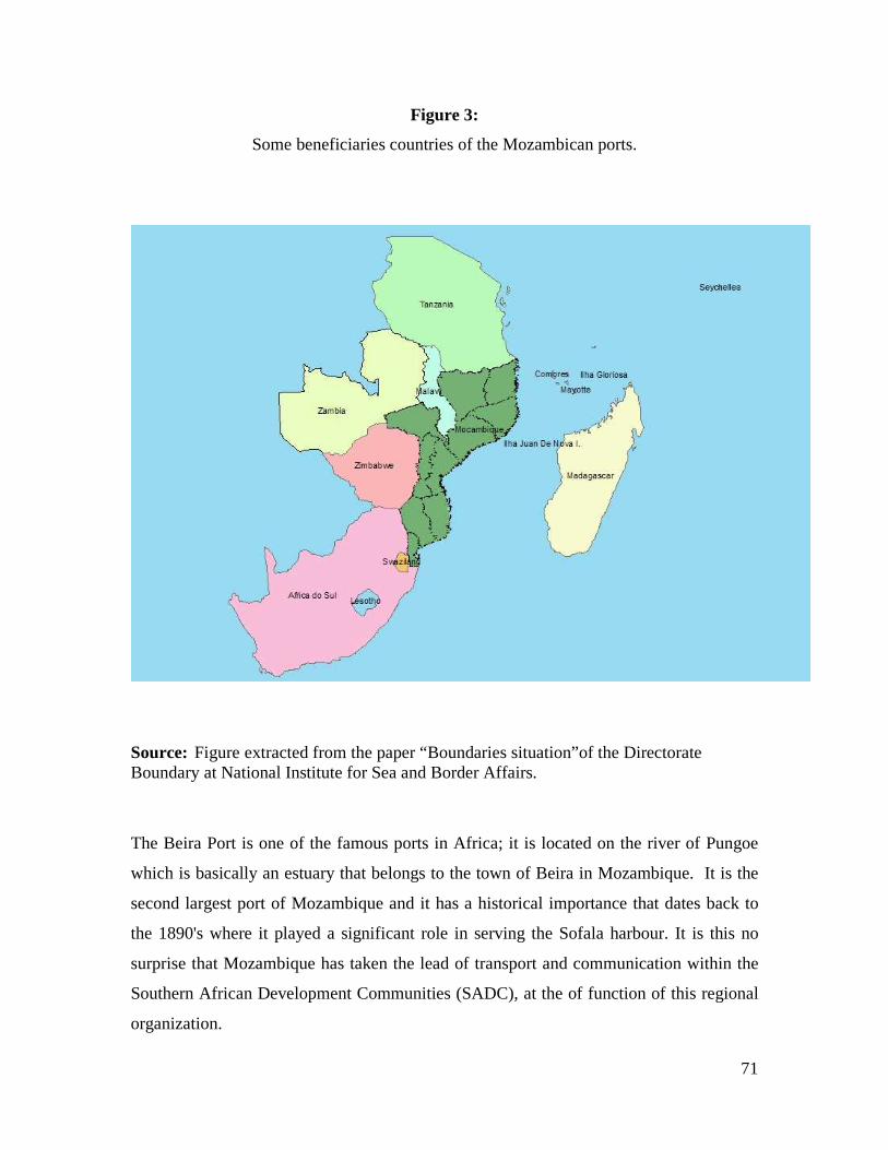
71
Figure 3:
Some beneficiaries countries of the Mozambican ports.
Source: Figure extracted from the paper “Boundaries situation”of the Directorate Boundary at National Institute for Sea and Border Affairs.
The Beira Port is one of the famous ports in Africa; it is located on the river of Pungoe
which is basically an estuary that belongs to the town of Beira in Mozambique. It is the
second largest port of Mozambique and it has a historical importance that dates back to
the 1890's where it played a significant role in serving the Sofala harbour. It is this no
surprise that Mozambique has taken the lead of transport and communication within the
Southern African Development Communities (SADC), at the of function of this regional
organization.

72
The maritime traffic is regulated by the Decree n°35/2007 of 14 August 2007, Decree for
commercial maritime transportation of goods, passengers which regulate the commercial
traffic in different fields of navigation and types of exploration.
It is indubitably, a challenge for the country to balance its position as a coastal State with
certain international obligations regarding the innocent passage, (article 7), (article 45)
straits used for international navigation, (article 37) transit passage, or to facilitate the
transit of goods and passengers, (article 125 n˚1) but, at the same time has the
responsibility to protect its marine areas against any illegal act including those against the
environment and its resources.
2.5 Environment
All successes integrating and managing the ocean/coastal issues depends mostly on a
better understanding of the environment. Although it may be very difficult, if not
possible, to totally control the environment at least, some precautionary actions must be
taken to minimize the negative effects on nature.
The LOS Convention in its Part XII has developed an important role calling States to
protect and preserve the marine environment. This call includes global and regional
cooperation, formulating and elaborating international rules, standards and recommended
practices and procedures consistent with the Convention, for the protection and
preservation of the marine environment171.
It is no surprise that at the beginning of this decade many internationals meetings had
been held all over the word to consider this aspect of the LOS Convention.
171 LOS Convention articles 192 and 197.

73
Recognizing the significance of this issue, the Government of Mozambique has
established in 1997 by the Law n˚20/97 of 1 October 1997, the Ministry for the Co-
ordination of Environment Affairs MICOA. This Ministry has responsibilities for key
environmental areas, but several other environmental fields are under the mandate of
other ministries172, this makes the coordinating role of MICOA crucial.
Note that environment issues are considered cross cutting topics in the PARPA, such as
HIV, natural disasters (drought, floods, storms, el Niño phenomenon, erosion, due to
floods, waves, winds, along shore drift) and others.
In the Mozambican environment strategy for sustainable development which was
approved in July 2007 for the next five ten years, recognized, the importance at the
management of the coastal, marine and island ecosystems taking into account as its vision
to stimulate the productivity and sustainable utilization of the natural and environment
resources, specialty the marine and coastal resources. This as a way to reduce the level of
poverty, as it is known that ocean, seas, islands and coastal zones are an integrated and
essential ecosystem of the earth173.
One of the most serious lacunas of the Law of The Sea in Mozambique, Law 4/96 of 4
January 1996 is that it is relatively poor with respect to addressing environment issues.
Notwithstand that the LOS Convention in the Part XII of the LOS Convention calls for
protection and preservation of the marine environment, the law makes few regard: article
3(c) maritime policy; article 8174; article 11(c) regarding the Exclusive Economic Zone;
article 16(2) regarding the lay of cables and pipelines on the Continental Shelf.
172 One example was referred earlier note related with for conservation areas. 173 See the Mozambican Environment Strategic for Sustainable Development, approved in the IX Session of the Ministry Council in 24 July 2007. 174 Note that in the earlier chapters it had been said that the reference to protection and preserve the marine environment in the contiguous zone is not provided by the LOS Convention.

74
But all theses stipulations are only indirectly included though other specific issues, and
not included in the law as one independent chapter to strengthen the provisions of the
LOS Convention and more substantial elements.
This is the unique opportunity for Mozambique to draft a model that should highlight the
commitment of the country with respect the protection of the environment:
marine/coastal ecosystems, while on the other hand, pursing a rational use of the
resources for its own economic development.
One of the critical impacts on the Mozambican cost areas and particularly for the
communities which live in the coastal areas, is the action of natural disasters: Tsunami,
floods and other catastrophic natural phenomenon175.
All coast zones constitute the occidental limits of the active zone in tropical cyclones of
the southwest basin of the Indian Ocean. Each year are nine tropical storm and cyclones
which is 10% of the world totally. Frequently their landfall is between Pemba and
Angoche, and close to Beira.
Unfortunately, Mozambique does not have an overarching act for the management of the
coastal area, such as in the case of the United States of America and its Coastal Zone
Management Act of 1972.
Drafting a comprehensive and holistic ICZM policy, Mozambique must take advantage
of its strategic location and assume the leadership and influence in the region in particular
and in the continent in general as an African maritime nation.
175 From 9 February to March 2000, Mozambique was devastated by high levels of precipitation where more than 700 people died because of floods and damage was estimated at 500 million U.S Dollars. Note the country is not new floods had occur also in the earlier years of independence: 1976 (Inkomati River), 1977 (Limpopo River), 1978 (Zambezi River). In the years 1982/83, 91/92 high dry weather was predominant. In 1984 the cycle of floods began and in 2000/1 the country suffered one of the mostly floods hadn’t seen before. In 2007 the floods has reached again critical level of precipitation. Extracted from the resume of the document “The role of the dams on floods mitigation in Mozambique”. 5˚ Engineer Congress Luso-Mozambican, 2˚ Engineer Mozambican Congress, Maputo 2-4 September 2008, Álvaro Carmo Vaz, Administrator, Consultec Lda.
75
Sectoral problems along the Mozambican coastal (Maputo, Gaza and Inhambane) have
demonstrated in some cases there is a need for holistic plan on ocean/coastal affairs.
Developing countries are still facing the challenge of developing ICZM which appears to
be more practical rather than a holistic national plan. However, State practice should not
be soley a result of an analysis ICZM or ocean policy in developing and developed
countries respectively it with subsequent ipso facto application of the former. This, as
there are particular aspects of such approachs and policies that refer specially to certain
countries which may not apply to others each States is unique, and each policy, while
drawing on relevant experiences from abroad, must meet the specific needs of State .
Mozambique, with its long coastline appears to be in a position to develop ICZM taking
also into account the diversity of its resources which need to be the subject of an
integrated management approach.
The lead agency for this process will depend manly on the level of Government
commitment, for better development of the plan the body should be strengthened with
enough leadership to facilitate the coordination of all national bodies which work in
marine affairs.

76
CONCLUSIONS AND RECOMMENDATIONS
After the adoption of the 1982 LOS Convention States all over the world were invited to
start a new era of use the seas established by that legal instrument which state the new
modern and complex international regime for the seas.
The implementation of its principles in some cases requires a comprehensive national
policy which fits with regional and international purposes. This study reviewed up
relevant elements in the Mozambican maritime zones which need to be addressed in
parallel with the development of an integrated ocean policy.
In Mozambique, notwhistanding the establishment of the baselines and the definition of
the maritime zone which are, in general conformity with the LOS Convention, some
other aspects required special consideration in the present paper.
This study demonstrated the common principles followed by State practices and the
differences between developed and developing countries regarding ocean policy. Finally,
an overview of the Mozambican coastal/ocean issues where demonstrating that there is
evidence that ICZM is the actual trend of developing countries and Mozambique has
distinctive aspects that will characterize its ocean policy. In particular, the relevant
aspects include:

77
Baselines
• Mozambique has established its baselines in 1976 before its independence, then
adopted by the subsequent domestic legislation176. But, a number of important
aspects have not been given enough considerations. As can be noted, the current
legislation, law of the sea, Law 4/96 of 4 of January 1996, omitted the Tidal
Datum used for draw the normal baselines.
• With respect to the Mozambican straight baselines there are twenty-three
segments and only two of them deviate from the general direction of the coast:
segment 1-2 (21°) and segment 7-8 (18˚). In general, all other segments are in
conformity with State practices, that is, they are less than 15°.
• Straight baselines are the system adopted in the north half of the country, however
close examination in other parts of the country suggest that even in other parts
along the coastline this system it can be applied.
First, in the centre of the country by closing Beira Bay, with bay closing line as
prescribed by article 10 of the LOS Convention.
Secondly, in the region opposite to Inhambane province, the location of the
Bazaruto National Park, close examination suggest that it could be taken into
account what is prescribes in the article 7 n˚1 of the LOS Convention and the
same ratio in article 1 (f) of the Law o the Sea from Mozambique.
In the localities where the coastline is deeply indented and
cut into or there is a fringe of islands along the coast in it’s immediately vicinity, the method of straight baselines joining appropriate points may be employed in drawing the baselines from which the breadth of territorial sea is measure.
176 Law no.4/96 January 1996; Law of the Sea article 4.

78
This because, in fact the region meets all the necessary requirements to apply straight
baselines.
Contiguous Zone
• The Maritime zones under national jurisdiction in Mozambique are internal
waters, territorial sea, contiguous zones, and exclusive economic zone. In all of
them, there are rights and duties which derive from the LOS Convention, which
means that States are not entitled to claim others, but to conform with those
existent into the national jurisdictions.
In the case of Mozambique, it can be observed that surprisingly, marine
environment prevention was expressly included as Mozambican duties in the
contiguous zone. Marine environment is indubitably an important issue of ocean
affairs but, States can not invoke rights or duties where the LOS Convention does
not mention, such as what is prescribed in the Mozambican Law of the Sea, article
8, n°2 a) in fine.
Bilateral Maritime Boundaries
• One of the big issues of ocean affairs in Mozambique is the delimitation of the
maritime boundaries. Note that besides being a matter of a nation security,
maritime boundaries are the key issues for other aspects such as defining of the
maritime jurisdiction under national control subject of this analyze, for draw an
ocean policy.
The Government has to re-enforce its commitment, taking a lead in a diplomatic
and technical process to negotiate with the neighboring States (Madagascar,

79
Comoros, South Africa) and may be with the involvement of France depending of
the development of the process in the Mozambique channel.
• The United Nations instruments should be taken into consideration by the
member States to avoid certain lethargy similar to France which was recalled
twice by that international organization to initiate without further delay
negotiation with Madagascar because of the islands in the Mozambique Channel
an issue which still remains unaddressed.
Ocean Policy
• Currently, there is no holistic plan for the Mozambican coastal zone management,
notwithstanding certain Governmental initiatives to mitigate the problems along
the coast for example managing certain parts of it. It is highlighted the need for a
wide plan for the management of oceans affairs instead of addressing the
problems by sectors.
At present 29 States (including bordering the Great Lakes) and 5 territories have
developed or are developed coastal management programme which together cover
more than 99% of the nation’s coastline177.
RECOMMENDATIONS
Baselines:
• The next legislation review should take this it into account and expressly refer
which Tidal Datum was used for drawing the normal baselines in Mozambique.
This fact is useful for determine the precise location of the baselines.
177 See Sarah Humphrey, Peter Burbidge, and Caroline Blatch, US Lessons for Coastal Management in the European Union, p.275.

80
Contiguous Zone
• It is recommended to follow what is stated in the LOS Convention extending the
duties for control of archaeological and historical objects removed from seabed of
the contiguous zone following the example of South Africa in claiming maritime
cultural zone of the republic178.
Bilateral Maritime Boundaries
• Taking advantage that the African Union has established that by 2012 all African
States should conclude their borders, this call should also be take into account by
all Mozambican neighbors, for reinforce their actions so as to conclude maritime
boundary delimitation process.
Ocean Policy
• For the materialization of that plan, a number of steps are also needed and
recommended in three dimensions: namely Institutional, Planning and Policy:
• Institutional:
Full Government commitment in developing integrated national coastal zone
management is needed;
Close assessment of the best way to address the ocean/coastal issues, taking into
account two options:
First: Create a new organ/department with a strong leadership such as NOAA, the
example of United States of America or the Tanzania National Environment
Management Council in Tanzania or; 178 Article 6(1) of the Maritime Zones Act, No.15 of 1994.

81
Second: Reinforce one of the existent organs with adequate needs, human and
material resources, similar to the Canada Minister of Fisheries and Ocean of
Canada, Ministry and Department of Environment Affairs and Tourism in South
Africa.
In both cases, a legal instrument is needed for supporting the overarching
ocean/coastal plan similar to Coastal Zone Management in United States of
America;
• Planning:
The planification should include a framework in which the process will be
developed; it is a guideline of compromise for developing problem-specific policy
and institutional responses for carrying out a number of options broadly similar in
most countries and under different circumstances.
Here a similar wide process such as a white paper undertaken in the United States
of America, the European Union, South Africa and Tanzania should be
considered as an example, which also includes by having a wide public
consultation.
Reasonable time is also needed for carrying out the work with in this dimension.
Sometimes, political changes in the country have constituted an obstacle for the
normal development of the process. South Africa is such an example where
political changes occurred during the drafting of the plan in 1990, at the time of
the first democratic elections.
• Policy:
82
The policy itself must be the culmination and materialization of all the
contributions collected during the previous stages, it is a way to achieve the goal
and not the end, integrated national coastal zone management is a continuous
dynamic process that must be implemented over time and accompanied by regular
monitoring.
As we are suggesting, integrated national coastal zone management is needed in
Mozambique. The ideal would be a wide ocean policy but, it is recommended to
follow the evolution and the capacity of the country, a national ocean plan
requires a high level of scientific knowledge and consolidation of the institutions
for example in terms of our understanding of nature depends largely on
observations. What we are able to observe depends on the means we have to
observe.
In Mozambique, research done so far in coastal waters and in open seas has been
conducted by ships of opportunity, i.e, according to the availability of occasional
research vessels in the region. Often these research vessels were attached to
research plans of their host institutions/countries, not always compatible to the
local needs. This method has made planning and systematic monitoring rather
difficult179.
Good experiences of the pilot activities in certain regions of the country should be
used for foster a national model with the necessary adaptation of the
circumstances.
179 Antonio Mubango Hongwana, op cit.
83
BIBLIOGRAPHY:
AFONSO, Paula S, Research Paper Is MPAs a useful tool in Fisheries Management?,
Norway; 24-25 October 2006.
Bulletin from the Republic (1976), Law n˚ 31/76 of 19 of August of 1976, I Serie,
Number 1, Supplement, Official publication of the Republic of Mozambique. It Defines
the rights about the economic resources of the adjacent sea to the coast of the Republic
of Mozambique.
Bulletin from the Republic (1990) Law of Fisheries, law n˚3/90 of 26 of September.
Bulletin from the Republic (1996), Law n˚ 4/96 of 04 of January of 1996, I Serie,
Number 1, Supplement, Official publication of the Republic of Mozambique, enact the
Law of the Sea.
Bulletin from the Republic (1997), Law n˚ 20/97 of 01 of October of 1996, I Serie,
Number 1, Supplement, Official publication of the Republic of Mozambique, enact the
Environment Law.
Bulletin from the Republic (2001), Law n˚ 03/2001 of 3 June, Approve the IMAF
statutory, I Serie, Number 7, 2° Supplement, Official publication of the Republic of
Mozambique, enact the National Institute for Sea and Borders Affairs.
Bulletin from the Republic ( 2001) Decree No.39/2001 of 27 of November 2001, I
Serie, Number 48, Supplement, Official publication of the Republic of Mozambique,
enact the Environment Law; shift the limits of the the Bazaruto National Park extending
and including to all archipelago islands namely Bazaruto, Santa Carolina, Benguerra,
Magarugue and Bangue likewise the adjacent water.

84
Bulletin from the Republic ( 2001 ), Decree n˚ 35/2001 of 31 of November, I Serie,
Number 45, 2° Supplement, Official publication of the Republic of Mozambique, which
regulates the Law n° 3/90, Law of Fishery, regarding the aquaculture activity.
Bulletin from the Republic ( 2003 ), Decree n˚5/2003 of 18 of February, I Serie,
Number 7, 2° Supplement, Official publication of the Republic of Mozambique;
Establish the Sustainable Center for the Coastal zone Management statutory.
Bulletin from the Republic (2003), Resolution of the Minister Council n˚14/2003 of 4
April 2003, I Serie, Number 18, Supplement, Official publication of the Republic of
Mozambique, Approve the Tourism policy and its implementation strategic.
Bulletin from the Republic (2004), Law n˚4/2004 of 17 of June of 2004, I Serie,
Number 24, Supplement, Official publication of the Republic of Mozambique, enact the
Law of Tourism.
Bulletin from the Republic (2004), Law n˚ 32/2004 of 18 of August, I Serie, Number
33, Supplement, Official publication of the Republic of Mozambique, enact the Marine
National Institute statutory.
Bulletin from the Republic (2004), Decree n˚ 27/2004 of 20 of August 2004, I Serie,
Number 33, Supplement, Official publication of the Republic of Mozambique, enact the
Hydrograph and Navigation.
Bulletin from the Republic (2004), Law n˚ 25/2004 of 20 of August 2004, I Serie,
Number 33, Supplement, Official publication of the Republic of Mozambique, enact the
Approve the National Institute of Petroleum.
Bulletin from the Republic (2007), Decree n˚ 35/2007 of 14 of August 2007, I Serie,
Number 32, III Supplement, Official publication of the Republic of Mozambique, enact
the Decree for Commercial Maritime Transportation.

85
BROWN, E.D, The International Law of the Sea; Volume I, Dartmouth Publishing
Company, Limited, 1994.
BRUCE C. Glavovics, selected article in Coastal Management, An International Journal
of Marine Environment Resources, Law and Society, Vol. 34, Number 1, pp.111-132,
January-March 2006;???/ article in MARCH J., Hersh.
CHARNEY , Jonathan I., and Alexander, Lewis M, International Maritime Boundaries,
The American Society of International Law, Martinus Njhoff Publishers,
Doedrecht/Boston/London, Volume I, 1992.
CHURCHILL R.R, A. Vaught Lowe, The Law of the Sea, 3° edition Juris Publishing,
Manchester University Press, 1999.
DIVISION FOR OCEAN AFFAIRS AND LAW OF THE SEA, The Law of The Sea
National Legislation on territorial sea, the Right of Innocent Passage and The
Contiguous Zone, 26.27.28.
ELISABETH, Mann Borges, Aldo Chircop and Moira McConnell, Ocean Yearbook 16,
Marine and Environment Law Programme of Dalhousie Law School University of
Chicago Press, 2002 Selected Write.
EXTRAVOUR, Winston Courad An Exclusive Economic Zone, A Study of Evolution
and Progressive Development of the International Law of the Sea. Institute Universitaire
de Lautes Étude Iternationales 132, 1979.
FERRAZ , Bernardo, Barry Munslow. Sustainable Development in Mozambique,
Published by Africa Word Press, Inc, 2000.
GEOGRAPHER, International Boundary Study, Straight Baselines, Madagascar US
Department of State, Serie A Limits in the Seas.

86
HUMPHREY , Sarah, Peter Burbidge, Caroline Blatch, Selected article from Marine
Policy, Volume 24, Number 4, July 2000 Published by Elsevier.
JAMINE, Elísio Maritime Boundaries Delimitation, Management and Dispute
Resolution, published by United Nations, Doalos, 2006/2007.
LAURENCE , Juda, selected article in Ocean Development & International Law, Edited
by Macdorman, Volume 34, Number 2, 2003;
LAURENCE , Juda, selected article in Ocean Development & International Law Edited
by Macdorman, Volume 38, Number 3, September 2007.
LAURENCE , Juda, selected article in Ocean Development & International Law Edited
by Macdorman, Volume 58, Number 3, 2007.
LINDÉN Olof & Carl, Gustav Lundin, Editors, The Journey from Arusha to Seychelles,
October 1996, published by the World Bank, Land water and Natural Habitat Division,
Environment Department.
MITCHELL , E. James, Coastal Zone Management: A Comparative Analysis of National
Programmes, Rutgers University.
MATEOS , Aurora, National Ocean Policy, Unesco/IOC/ Law of the Sea, 2007.
Manual on Technical Aspects of the United National Convention on The Law of The Sea,
published by International Hidrographic Bureau Monaco, July, 1993.
OECD/OCDE Organization for Economic Co-operation and Development, Coastal Zone
Management, selected article, Paris Cedex 16, France.

87
OMAR , Maria Isabel Virgilio, Overview of Fisheries Resources: Mozambique, workshop
on fisheries and aquaculture in Southern Africa: Development and Management
Windhoek Namibia, 21 st-24th August.
PRESCOTT, Victor and SCHOFIELD, The Maritime Political Boundaries of the World,
2˚Edition, Martinus Njhoff Publisher.
PRATT , Martin, Rachel Bradley and Clive Schofield, Exclusive Economic Zone, 1°
Edition 1999-2000.
ROACH , J.A; SMITH, Robert W. Smith, States Responses to Excessive Maritime
Claims, second ediction Martinus Nijhoff Publishers.
RONAN, Long, Marine Resources, Thompson Round Hall, 2007.
SYMMONS, Clive, Ireland and The Law of The Sea, 2° Ediction, Round Hall Sweet
Maxwell, 2000.
SALOMONS, W, TURNER, R.K, LACERDA, L.D. de, RAMACHANDRAN, S,
Perspectives on Integrated Coastal Zone Management, Springer, 1999.
TANAKA , Yoshifumi, selected article in Marine and Coastal Law, Volume 19, Number
4, 2004, Marinus Njhoff Publishers.
TIWI , Dwui Abada, In Improving Environmental Impact Assessment for Better
Integrated Coastal Zone Management, A. A. Balkema Publishers, 2004.
VIVIAN Louis Forbes, The Maritime Boundary of the Indian Ocean Region, Singapore
University Press, National University of Singapore, 1995.
88
VAZ , Álvaro Carmo, “The role of the dams on floods mitigation in Mozambique”. 5˚
Engineer Congress Luso-Mozambican, 2˚ Engineer Mozambican Congress, Maputo 2-4
September 2008.
UNESCO, Intergovernmental Oceanographic Commission National Ocean Policy. The
basic texts from Australia, Brazil Canada, China, Colombia, Japan, Norway, Portugal,
Russian Federation, United States of America. Paris, UNESCO, 2007.
United Nations, Law of the Sea, Baselines National Legislation with illustrative Maps.
Office for Ocean Affairs and The Law of the Sea, New York, 1989, p. 230-231.
United Nation General Assembly, resolution no.34/91 of 12 December 1979,
www.Un.Org./document/ga/res/34/a34res/91.pdf.
United Nation General Assembly, resolution no.34/91 of 12 December 1979,
www.Un.Org./document/ga/res/35/a35res/91.pdf.
VARIOUS AUTHORS , the Ocean Our Future, Press Syndicate of the University of
Cambridge Press, 1998.
Diploma No.46/71 of 25 of May Creating the Bazaruto National Park.
Decree Law No. 31/76 of 19 August 1976 Defining the rights of peoples Republic of
Mozambique.
Decree Law No. 47.771 of 27 June 1967 Approving the baselines of Ultramar Province
Normal baseline for measuring the breadth of the territorial sea of Guinea, Angola and
Mozambique.
GEOGRAPHIC ATLAS , Second Edition, Volume 1, 2°Edition reviwed and updated,
Ministry of Education of Republic of Mozambique, 1886.