federal mining claims information for alaska … alaska 201 federal mining claims information for...
TRANSCRIPT

BLM
Alaska 2014
Federal Mining Claims Information for Alaska
Energy and Minerals Branch
U.S. Department of the InteriorBureau of Land Management
Alaska State Office
BLM/AK/ST-05/009+9218+9321/Rev2015

Mission Statement The Bureau of Land Management (BLM) sustains the health, diversity, and productivity of the public lands for the use and enjoyment of present and future generations.
Cover Clockwise from top left: Prospecting, Placer Mining, Dredging, Reclamation. Photos by Joe Kurtak/BLM
The mention of any trade names or commercial products in this report does not constitute endorsement or recommendation for use by the federal government.
For more information regarding federal mining claims in Alaska, go to http://www.blm.gov/ak/st/en/prog/minerals.html

Contents
1. General Overview ................................................................................................. 1
2. Mining Claim Fee Requirements ................................................................. 15
3. Examples of Mining Claim Forms ............................................................... 17
4. Alaska Department of Natural Resources Fact Sheet: Investigate that Claim Before Buying ................................................ 41


1
General Overview
General Overview
Who can file a claim?Any citizen of the United States may locate a federal mining claim on federal public lands that are available for mineral entry. A corporation organized under state laws may also locate a federal mining claim. The federal government considers corporations to have the same standing as its citizens.
The ClaimA federal mining claim is a particular parcel of federally administered land that is valuable for a specific mineral deposit or deposits. This is a parcel for which an individual has asserted a right of possession.
The right of possession is restricted to the exploration, extraction, and development of a mineral deposit. It does not include abandoned old equipment, artifacts, or old buildings unless these have been purchased from past owners of these items.
Federal mining claims and sites are considered real property. Interests in these claims may be bought, sold, transferred, leased, rented, willed or inherited. If a claim or site meets all federal and state requirements, the claimant has a possessory right to develop and extract minerals found on the mining claim. A possessory right is much like an easement, where the United States holds paramount title. This remains true until a person is issued a mineral patent, when title to the lands and minerals are passed to the patentee. However, a patent moratorium has been in effect since 1994, and the federal government will not issue any new federal patents until the moratorium ends.
The public has the conditional right to cross mining claims or sites for recreational and other purposes; or to access federal lands beyond claim boundaries. Although this right of access to a mining claim or site across federal lands exists, it does not mean that the claimant has a right to cause undue degradation of the surface resources.

2
Federal Mining Claims Information for Alaska
Permanent or mobile structures and equipment storage on a mining claim or site requires prior approval from an authorized federal official.
Mining claim rights are valid against a challenge by the United States and other claimants only after the discovery of a valuable mineral deposit.
Valuable DepositAlthough federal statutes do not describe what constitutes a “valuable mineral deposit” under the General Mining Law of 1872, as amended, several government judicial and administrative decisions adopted an “economic” definition of locatable minerals. This definition resulted in a test, the “prudent man rule,” that makes use of the concept of an “economic ore body.” In 1894, a Department of the Interior Land Decision, Castle v. Womble,
19 LD 455 (1894), states “...where minerals have been found and the evidence is of such character that a person of ordinary prudence would be justified in the further expenditure of his labor and means, with a reasonable prospect of success in developing a valuable mine, the requirements of the statutes have been met.”
Since that time, the Interior Board of Land Appeals (IBLA) significantly refined the “prudent-man test” by defining “presently marketable at a profit.” This definition requires that a claimant “show that at
present, considering historical price and cost factors and assuming that they will continue, there is a reasonable likelihood of success that a paying mine can be developed” [Pacific Coast Molybdenum, 78 IBLA 16, 29, 90 I.D. 352, 360 (1983)]. This new definition responds to the large fluctuations in mineral commodity prices that occur during the preceding five years. This is why a claimant is not stuck with the latest market price of a commodity, but instead may average prices over time.
Staking the ClaimFederal law simply specifies that claim boundaries must be distinctly and clearly marked and readily identifiable on the ground. Mining laws allow states to establish their own laws for how mining claims and sites are located. When staking a claim, you must comply with both federal and state requirements. Most states have mining claim statutes and regulations that add to the General Mining Law of 1872, as amended, and outline the actual staking and recording of mining claims. These staking requirements usually include the placement, size, and acceptable materials for a corner post or discovery monument.
3
General Overview
The Alaska Statutes staking requirements include:
1. Posting at the northeast corner of the claim a plain sign or notice containing a. the name or number of the claim; b. the name of the locator or locators; c. the date of the location; d. the number of feet in length and width claimed; and
2. Erecting at each corner or angle of the claim substantial monuments or posts not less than three feet in height nor less than three inches in diameter hewn and marked with the name of the claim, the position or number of the monument and the direction of the boundary lines, and by cutting out, blazing or marking the boundary lines so that they can be readily placed.
You can find these requirements at Alaska Statutes 27:10.030 for lode claims and 27:10:040 for placer claims.
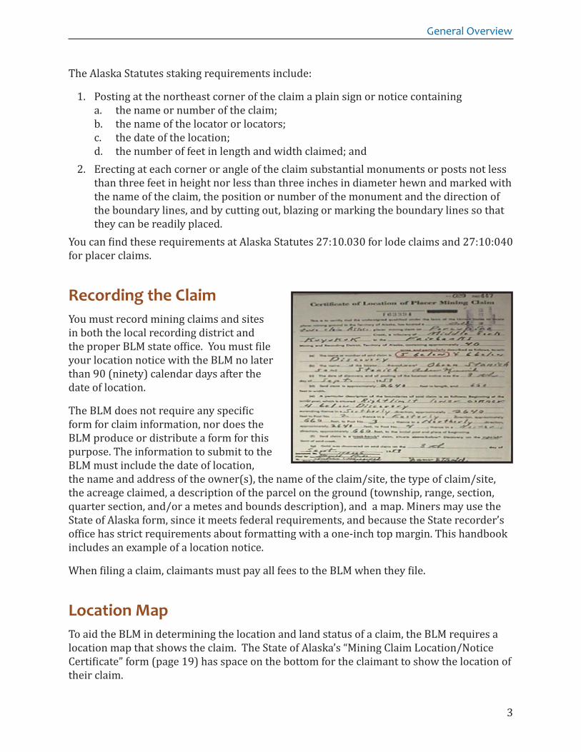
Recording the ClaimYou must record mining claims and sites in both the local recording district and the proper BLM state office. You must file your location notice with the BLM no later than 90 (ninety) calendar days after the date of location.
The BLM does not require any specific form for claim information, nor does the BLM produce or distribute a form for this purpose. The information to submit to the BLM must include the date of location, the name and address of the owner(s), the name of the claim/site, the type of claim/site, the acreage claimed, a description of the parcel on the ground (township, range, section, quarter section, and/or a metes and bounds description), and a map. Miners may use the State of Alaska form, since it meets federal requirements, and because the State recorder’s office has strict requirements about formatting with a one-inch top margin. This handbook includes an example of a location notice.
When filing a claim, claimants must pay all fees to the BLM when they file.
Location MapTo aid the BLM in determining the location and land status of a claim, the BLM requires a location map that shows the claim. The State of Alaska’s “Mining Claim Location/Notice Certificate” form (page 19) has space on the bottom for the claimant to show the location of their claim.

4
Federal Mining Claims Information for Alaska
In Alaska, BLM requests that claimants include the Geographical Position System (GIS) coordinates of their claim corners, but there are no legal requirements to provide this additional information.
Please note that the BLM requests copies of officially recorded notices or certificates of location for each claim recorded (or to be recorded) with the State of Alaska. This means the claimant can file a location notice not yet recorded with the State, but should provide the BLM with a copy of the recorded document at a later date.
The Paper Record Process This is how BLM-Alaska’s internal mining claim recording process works:
1. The claimant files location notices, amendments, or other related mining documentation in the BLM’s Public Information Center (Public Room). You can do this either in person or by mail. The public room date stamps these documents to record the official filing date with BLM-Alaska.
2. BLM sends a copy of the document back to the clamant to show receipt of the filings. For time-sensitive documents, such as small miner waivers or assessment affidavits, the BLM recommends that the claimant send those documents to the BLM by certified mail.
3. Any fees paid are receipted. The receipt(s) and documents are sent to the BLM’s Mineral Law Specialist, who then adjudicates the filing and claim status. The specialist creates the mining claim case file. Once the BLM determines that the certificate/notice of location meets all requirements, the BLM updates the Alaska Land Information System or ALIS database. The ALIS database is the official electronic record of the mining claim(s). The public can access this data through an external website, the “Alaska Case Retrieval Enterprise System (ACRES)”. The Mineral Law Specialist enters the claim locations into the database and retains the case file. You can find ACRES at http://sdms.ak.blm.gov/acres/acres_menu
BLM-Alaska State Office located in Anchorage

5
General Overview
Adjudicative ReviewThe BLM reviews and adjudicates all minerals documents for compliance with applicable laws and regulations. This process includes, but is not limited to, checking:
• Date of location and filing of documentation, and whether these documents are filed within 90 days of location;
• Name of the claim or site; • Name, address, and proper signatures of each locator; • Type of claim or site (lode, placer, mill site or tunnel site); • Legal description of the land where the claim is located, described to quarter section
(quarter section, section, township, range and meridian); • Drawing of claim location/map of claim; • Correct payment, when applicable; • Whether the land is under federal jurisdiction and is available for mineral entry; • Complies with rules for title evidence; and, • The allowable acreage per claimant for association claims.
NOTES:
1. If the mining claim is an association placer, the maximum acreage allowed is 160 acres with at least 8 locators, 20 acres per claimant.
2. A corporation is considered an individual claimant; therefore, as an individual claimant, it is allowed 20 acres per claim.
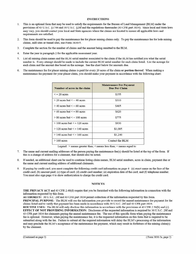
Fees and FilingsNEW FILINGS: You must pay the following fees for each federal mining claim and site:
• $37 location fee • $155 maintenance fee for every 20 acres or portion thereof for association placer
claims. All lode claims, mill and tunnel sites are $140 per claim or site. • $20 Service charge.
The assessment year begins and ends on September 1 (from September 1 to September 1 of any given year). The maintenance fee applies to the assessment year for locations filed PRIOR to September 1, except for claims located PRIOR to September 1 at the end of one assessment year; but FILED with the BLM AFTER September 1 in the next assessment year. In this case, the BLM charges maintenance fees for both the assessment year the claim is located and the assessment year the claim is filed.

6
Federal Mining Claims Information for Alaska
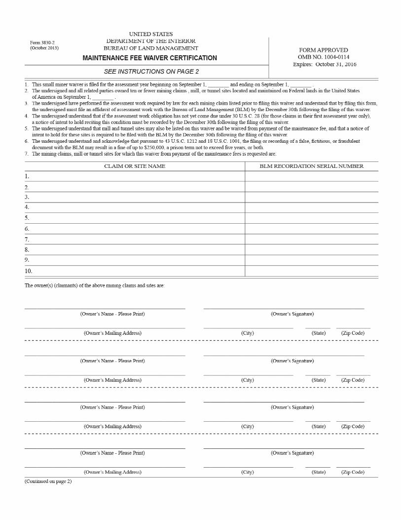
If a claimant holds ten or fewer claims nationwide, the claimant may file a waiver for a second maintenance fee, but claimants must file the waiver at the same time as filing the location notice. A “notice of intent to hold” must be filed by December 30 of the calendar year immediately following the filing of the maintenance fee waiver.
MAINTENANCE FEE: You must pay all maintenance fees in advance for the upcoming assessment year at the BLM-Alaska Office recording your claim/site, on or before September 1 of each year. You must include a list of the claim names and BLM serial numbers with the payment. You can file at one of two BLM-Alaska Public Information Centers:
1. Anchorage, BLM-Alaska State Office Public Information Center, 222 W. 7th Avenue (Anchorage Federal Building and Courthouse, first floor) (907) 271-5960.
2. Fairbanks, BLM-Alaska Fairbanks District Office Public Information Center, 1150 University Avenue. (907) 474-2200.
These two Public Information Centers receive and record documents, filings, and fees for all federal mining claims or sites located in Alaska.
MAINTENANCE FEE WAIVER: Miners with 10 or fewer federal claims or sites nationwide may file a maintenance fee waiver certificate with the BLM on or before September 1 of each year. You need to file this waiver certificate, like the maintenance fee, in advance for the upcoming assessment year that begins on September 1. If you elect to file this waiver, you must certify that you hold interest in no more than 10 mining claims or sites nationwide on the date your filing is due. In cases where there are multiple owners, each owner must sign the waiver. The BLM will not accept copies of the signed waiver, it must be the originally signed document.
Maintenance fee waiver certificates must be filed with the BLM on or before September 1. If you mail the waiver to the BLM, the BLM will only accept it if the postmark is on or before September 1.
ANNUAL ASSESSMENT WORK: When you file a maintenance fee waiver by September 1, you must also file an “affidavit of annual labor” with the BLM on or before December 30. When you file the affidavit, include a payment of $10 per claim or site with your filing. You must also record the affidavit of annual labor at the local recording district.
The BLM will not accept mailed affidavits or “notices of intent to hold” unless the postmark shows December 30 or earlier.
These are mandated filing deadlines by law and are very unforgiving. If you miss a filing deadline, the BLM issues a decision declaring the claim forfeited by operation of law. This decision is appealable to IBLA, but in most cases, unless the miner can prove a filing was

7
General Overview
made on time, the IBLA will normally uphold the decision of forfeiture. If an appeal is filed with the IBLA, the BLM loses jurisdiction of the case. Jurisdiction remains with the IBLA until the IBLA renders a decision for the appeal. At the time of filing, all required fees must be paid, or the documents will not be accepted.
Transfers of OwnershipWhen an owner of an unpatented federal mining claim sells, assigns, or conveys all or any part of their interest in the claim, it is the grantee’s responsibility to file the recorded
transfer document (Transfer of Interest or Quitclaim Deed) with the proper BLM Office (with the Alaska State Office or Fairbanks Public Room). The BLM will not accept a transfer unless the transfer document was first recorded in the local recording district. This handbook includes an example of a mining quitclaim deed. The transfer document must identify the grantor’s name and signature, the name and address of the new owner, the claim or site name(s), and their respective BLM serial number(s). The BLM has a $10 nonrefundable processing fee per grantee for each claim or site listed on the document.
Amendments and/or RelocationYou can make an amendment to a location filed for an active federal mining claim or site at any time. However, you must file the amendment at the local recording district before filing it with the appropriate BLM Office. The deadline to file is within 90 days of recording. You can create the amendment on the same type of form as you used for the original location notice, with “Amended” added to the title of the location notice. An amended location relates back to the original date that the mining claim or site was located. The BLM charges a $10 nonrefundable processing fee to file an amendment.
Amendments: 1. Correct or clarify omissions or defects in the original location notice2. Correct legal descriptions, due to an error made on the original location notice (the
location on the ground cannot be changed)3. Change the claim name

8
Federal Mining Claims Information for Alaska
A relocation, on the other hand, is treated as a new location that essentially covers the same land as a prior mining claim or site. The BLM assigns a relocation with a new serial number and posting date. The discovery date may remain the same as the original notice and may use the original boundary markings and monuments. The fees for a relocation are the same as a new location.
A relocation may not be established by the use of an amended location notice, but requires a new, original notice or certificate as prescribed by state law. This relocation usually occurs when a miner fails to timely file the required annual filings and the claim was on federal land that is available for mineral entry, so the miner wants to re-stake the same claim.
HELPFUL AIDS
There are many helpful databases to help you in determining mining claim locations. The federal website shows federal mining claims on a USGS quad map (figure on right). This database is the Spatial Data Management System or SDMS: http://sdms.ak.blm.gov/isdms/imf.jsp?site=sdms
When using SDMS, be sure to turn on the federal mining claims layer. The SDMS database for mining claims is updated regularly.
The State of Alaska’s website shows both federal and state mining claims (see figure on next page). Each time the BLM updates the SDMS, the BLM gives the data for federal mining claims to the State.
Additional websites that may be helpful include:
Investigate that Claim Before Buying, Alaska Division of Natural Resources fact sheet: http://dnr.alaska.gov/mlw/factsht/mine_fs/investig.pdf
Fact Sheet indices for the Alaska Division of Natural Resources: http://dnr.alaska.gov/mlw/factsht/
State land records on the State of Alaska website for state and federal mapped claims: http://dnr.alaska.gov/MapAK/
Alaska Department of Natural Resources Recorder’s Office, also eRecording for some districts: http://dnr.alaska.gov/ssd/recoff/searchRO.cfm
Alaska Miners Association: http://www.alaskaminers.org/
Hein Online (view Federal Register notices and the CFRs): http://heinonline.org/HOL/Welcome?collection=cfr

9
General Overview
U.S. Government Printing Office Federal Digital System (view Federal Register notices, CFRs, legislation, and more): http://www.gpo.gov/fdsys/search/home.action
Data portal to research federal plats, abstracts, and the SDMS: http://sdms.ak.blm.gov/sdms/
Alaska Division of Natural Resources Public Information Center: http://dnr.alaska.gov/commis/pic/index.htm
Federal website for case abstracts, the Alaska Case Retrieval Enterprise System or ACRES: http://sdms.ak.blm.gov/acres/acres_menu
Surface Management on BLM-Managed LandsThe BLM regulates surface management for mining activity on lands administered by the BLM under 43 CFR 3800 series. If a claim is located within another agency’s jurisdiction, such as U.S. Forest Service lands, there are different regulations for surface management and miners need to check with the agency for proper filing procedures.
The miner has the right to use as much of the surface of the claim or site as is reasonably necessary for mining and milling purposes, including: (1) access across federally managed surface to and from the claim or site, (2) use of as much of the timber and other surface resources as is necessary for the mining operation, and (3) construction of fences and gates to protect the immediate area of operations and equipment. Also allowed are temporary and permanent structures for storing equipment, housing for full-time employees, and testing and processing facilities.
1. Casual Use: The lowest level of mining activity is “casual use,” which identifies a miner or weekend prospector who creates only negligible surface disturbance.
2. Notice-Level Surface Disturbance: The second level of activity is notice-level surface disturbance, where five (5) acres (or less) is disturbed per year. The Notice-Level Surface Disturbance level requires a notice advising the BLM of the anticipated work at least 15 days before beginning work. This notice needs to be filed with the appropriate Field Office. Upon receipt within 15 days BLM will notify you if your notice is incomplete. If the BLM does not take any action within 15 calendar days, you may begin. Bonding is required.
10
Federal Mining Claims Information for Alaska
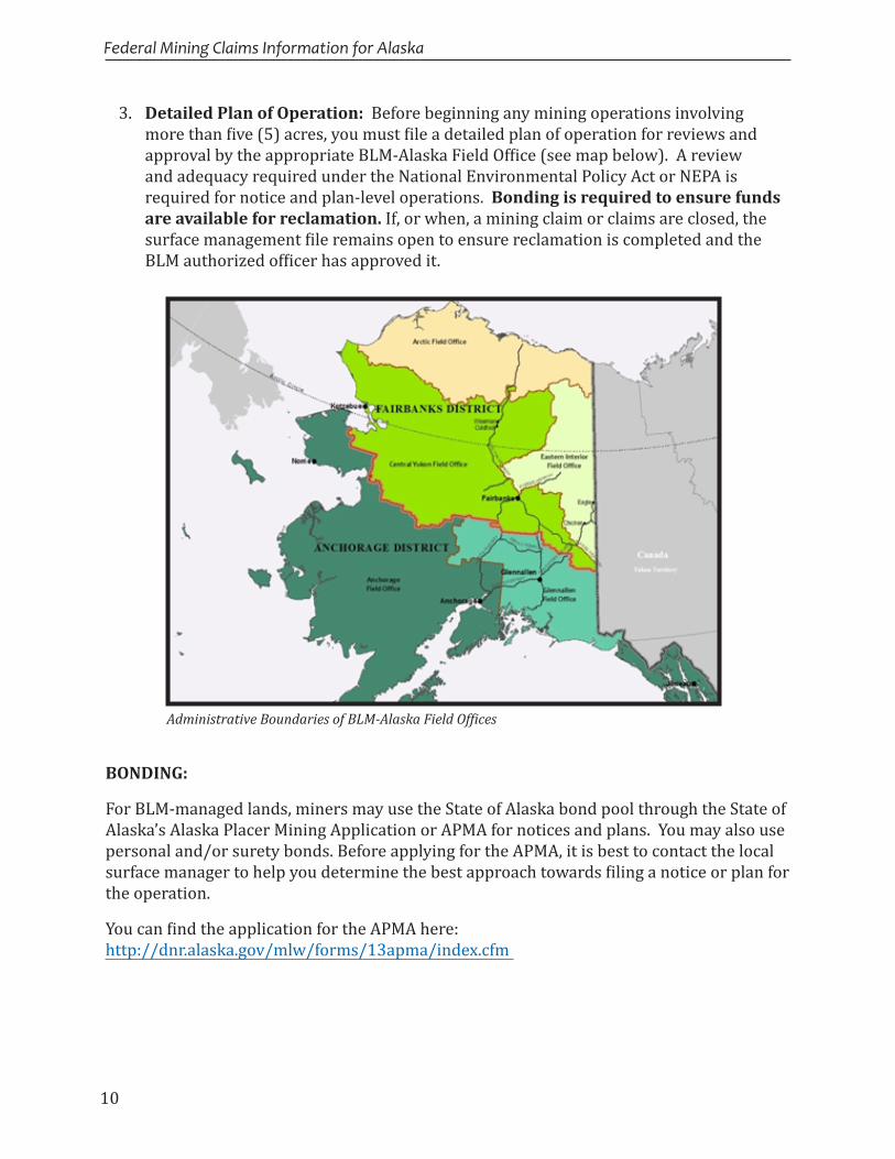
3. Detailed Plan of Operation: Before beginning any mining operations involving more than five (5) acres, you must file a detailed plan of operation for reviews and approval by the appropriate BLM-Alaska Field Office (see map below). A review and adequacy required under the National Environmental Policy Act or NEPA is required for notice and plan-level operations. Bonding is required to ensure funds are available for reclamation. If, or when, a mining claim or claims are closed, the surface management file remains open to ensure reclamation is completed and the BLM authorized officer has approved it.
BONDING:
For BLM-managed lands, miners may use the State of Alaska bond pool through the State of Alaska’s Alaska Placer Mining Application or APMA for notices and plans. You may also use personal and/or surety bonds. Before applying for the APMA, it is best to contact the local surface manager to help you determine the best approach towards filing a notice or plan for the operation.
You can find the application for the APMA here: http://dnr.alaska.gov/mlw/forms/13apma/index.cfm
Administrative Boundaries of BLM-Alaska Field Offices

11
General Overview
Reclamation
Satisfactory reclamation should emphasize three major objectives:
1. The productivity of the reclaimed land should at least equal that of the pre-mined surface. This does not necessarily mean that the site must be restored to an approximation of its original condition, or that surface uses after mining will be the same as those that existing before mining. As an example, an area used for marginal grazing prior to mining may be reclaimed to a useful and attractive recreational complex or perhaps a housing area.
2. Satisfactory reclamation should leave the mined area in a condition that will not contribute to environmental degradation, either in the form of air or water-borne materials or from chemical pollution.
3. The reclaimed area should be esthetically acceptable and safe for intended uses.
ENFORCEMENT ACTIONS UNDER 43 CFR 3809:
3809.601 What types of enforcement action may the BLM take if I do not meet the requirements of this subpart?
The BLM may issue various types of enforcement orders, including the following:
A. Noncompliance order: If your operations do not comply with any provision of your notice, plan of operations, or requirement of this subpart, the BLM may issue you a noncompliance order; and
B. Suspension order: (1) The BLM may order a suspension of all or any part of your operations

12
Federal Mining Claims Information for Alaska
CRIMINAL PENALTIES UNDER 43 CFR 3809:
3809.700 What criminal penalties apply to violations of this subpart?
The criminal penalties established by statute for individuals and organizations are as follows:
A. Individuals: If you knowingly and willfully violate the requirements of this subpart, you may be subject to arrest and trial under section 303(a) of federal Land Policy Management Act (FLPMA) (43 U.S.C. 1733(a)). If you are convicted, you will be subject to a fine of not more than $100,000 or the alternative fine provided for in the applicable provisions of 18 U.S.C. 3571, or imprisonment not to exceed 12 months, or both, for each offense; and
B. Organizations: If an organization or corporation knowingly and willfully violates the requirements of this subpart, it is subject to trial and, if convicted, will be subject to a fine of not more than $200,000, or the alternative fine provided for in the applicable provisions of 18 U.S.C. 3571.
Problems encountered over the years on these sites include petroleum products left or improperly stored from past operations.

13
General Overview
RESPONSIBLE PARTIES:
3809.116 As a mining claimant or operator, what are my responsibilities under this subpart for my project area?
• Mining claimants and operators (if other than the mining claimant) are liable for obligations under this subpart that accrue while they hold their interests.
Improperly stored equipment can cause compliance problems.
14
Federal Mining Claims Information for Alaska
PLACER CLAIMS: Mineral deposits subject to placer claims include all those deposits not subject to lode claims. Originally, these included only deposits of unconsolidated materials, such as sand and gravel, containing free gold or other minerals. By Congressional acts and judicial interpretations, many nonmetallic bedded or layered deposits, such as gypsum and high calcium limestone, are also considered placer deposits.
Placer claims, where practicable, are located by legal subdivision (for example: Township 10 South, Range 11 East, Section 9, SE1/4). The maximum size of a placer claim is 20 acres per locator. An association of two locators may locate 40 acres, and three may locate 60 acres, etc. The maximum area of an association placer claim is 160 acres for eight or more persons.
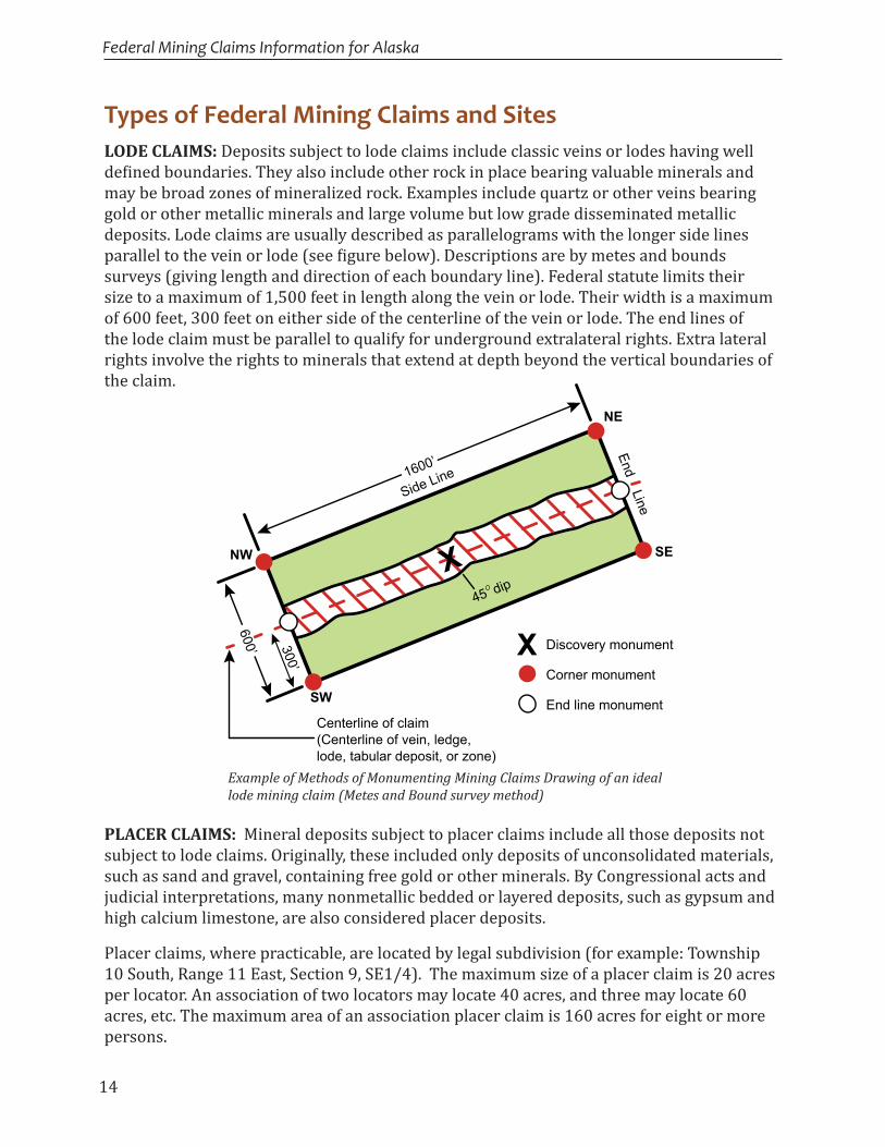
Example of Methods of Monumenting Mining Claims Drawing of an ideal lode mining claim (Metes and Bound survey method)
Types of Federal Mining Claims and SitesLODE CLAIMS: Deposits subject to lode claims include classic veins or lodes having well defined boundaries. They also include other rock in place bearing valuable minerals and may be broad zones of mineralized rock. Examples include quartz or other veins bearing gold or other metallic minerals and large volume but low grade disseminated metallic deposits. Lode claims are usually described as parallelograms with the longer side lines parallel to the vein or lode (see figure below). Descriptions are by metes and bounds surveys (giving length and direction of each boundary line). Federal statute limits their size to a maximum of 1,500 feet in length along the vein or lode. Their width is a maximum of 600 feet, 300 feet on either side of the centerline of the vein or lode. The end lines of the lode claim must be parallel to qualify for underground extralateral rights. Extra lateral rights involve the rights to minerals that extend at depth beyond the vertical boundaries of the claim.
Centerline of claim(Centerline of vein, ledge, lode, tabular deposit, or zone)
SW
NW SE
NE
End Line
300’
Side Line
X
Discovery monument
Corner monument
End line monument
X
1600’
600’
45 dip
15
General Overview
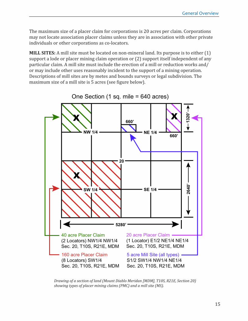
The maximum size of a placer claim for corporations is 20 acres per claim. Corporations may not locate association placer claims unless they are in association with other private individuals or other corporations as co-locators.
MILL SITES: A mill site must be located on non-mineral land. Its purpose is to either (1) support a lode or placer mining claim operation or (2) support itself independent of any particular claim. A mill site must include the erection of a mill or reduction works and/or may include other uses reasonably incident to the support of a mining operation. Descriptions of mill sites are by metes and bounds surveys or legal subdivision. The maximum size of a mill site is 5 acres (see figure below).
Drawing of a section of land (Mount Diablo Meridan [MDM], T10S, R21E, Section 20) showing types of placer mining claims (PMC) and a mill site (MS).
NW 1/4 NE 1/4
SE 1/4SW 1/4
660’
660’
5280’
2640
’13
20’
X
X
X
20
40 acre Placer Claim(2 Locators) NW1/4 NW1/4Sec. 20, T10S, R21E, MDM
160 acre Placer Claim(8 Locators) SW1/4Sec. 20, T10S, R21E, MDM
20 acre Placer Claim(1 Locator) E1/2 NE1/4 NE1/4Sec. 20, T10S, R21E, MDM
5 acre Mill Site (all types)S1/2 SW1/4 NW1/4 NE1/4Sec. 20, T10S, R21E, MDM
One Section (1 sq. mile = 640 acres)

16
Federal Mining Claims Information for Alaska
Federal Lands Open to Mining There are federally administered lands in 19 States where you may locate a mining claim or site. These States are Alaska, Arizona, Arkansas, California, Colorado, Florida, Idaho, Louisiana, Mississippi, Montana, Nebraska, Nevada, New Mexico, North Dakota, Oregon, South Dakota, Utah, Washington, and Wyoming. In these States, the BLM manages the surface of public lands and the Forest Service manages the surface of National Forest System lands. The BLM is responsible for the subsurface on both public lands and National Forest System lands.
You may prospect and locate claims and sites on lands open to mineral entry. Claims may not be staked in areas closed to mineral entry by a special act of Congress, regulation, or public land order. These areas are withdrawn from the operation of the mining laws.
TUNNEL SITES: A tunnel site is where a tunnel is run to develop a vein or lode. It may also be used for the discovery of unknown veins or lodes. To stake a tunnel site, two stakes are placed up to 3,000 feet apart on the line of the proposed tunnel. Recordation is the same as a lode claim. Some States require additional centerline stakes (for example, in Nevada centerline stakes must be placed at 300-foot intervals).
An individual may locate lode claims to cover any or all blind (not known to exist) veins or lodes intersected by the tunnel. The maximum distance these lode claims may exist is 1,500 feet on either side of the centerline of the tunnel. This, in essence, gives the mining claimant the right to prospect an area 3,000 feet wide and 3,000 feet long. Any mining claim located for a blind lode discovered while driving a tunnel relates back in time to the date of the location of the tunnel site.
Most State laws require conspicuous and substantial monuments for all types of claims and sites.
NOTE: Other states have other requirements for monuments. However, it is BLM policy to not use perforated or uncapped pipe as a monument. Methods of Describing Placer Mining Claims and Mill Sites examples:
3’+
2”+Metal Post
3 1/2”+Wood Post
StoneMound
1’+ 1’+
3’+3’+

17
General Overview
Brief Overview of Federal Mining Law HistoryThe history leading to passage of the Mining Law of May 10, 1872 extends back to the 16th century and reflects both our English and Spanish heritage.
On the east coast, during the settlement of the colonies the traditions developed from what were originally known as “Crown grants”, where settlers were given a grant for land development. The grant tended to reserve precious metal to the government much like the “Crown grants” reserved precious metals for the ruler or monarch. This grant system formed the basis for the early traditions regarding mineral rights.
However, on the west coast and western states the mining customs and traditions more closely followed the Spanish Royal Codes of 1783. These codes allowed for the acquisitions of mineral rights by miners and provided provisions for the settlement of disputes between mining claimants.
There were occasions when Congress passed leasing or sales acts relating to gold, silver, lead and iron that were administered by the War Department but for the most part during this time there were no federal laws regulating mining. It was not until the California gold rush that major conflicts began to occur between these two mining traditions. When eastern investors began financing large mine developments such as the Comstock Lode, silver mine in Nevada; and the California Mother Lode, a gold mine the west; the question of security of title and legal possession arose and became a major political issue in Congress.
Even with this political focus, for the next twenty years or so Congressional policy for the public land centered more on encouraging westward migration of settlers and development of western lands instead of the regulation of mining. A series of Congressional statues were passed which included agricultural entry laws; homestead acts; and other acts that were designed to emphasize mineral exploration and development.
It was not until 1866 that the first mining law was passed. The Lode Law of 1866 (RS 2318; 30 USC 21 et seq.) provided for the entry and location of lode claims, assessment work, and patenting of lode claims. Four years later, the Placer Act was passed (RS 2329; 30 USC 35 et seq.) which allowed for the entry location and patenting of placer claims on non-agriculture land by legal description.
In 1872, these two acts where consolidated, with amendments, into the General Mining Law of May 10, 1872 (RS 2319-2339; 30 USC 21-54)

18
Federal Mining Claims Information for Alaska
Over the years the General Mining Law has had several major amendments, the most predominant are:
• The Mineral Land Leasing Act of February 25, 1920. This act removed oil, gas, coal, sodium, potash, oil shale, and several other minerals from the mining law and made them subject to leasing only.
• The Act of July 23, 1955 (PL-167), (30 USC 611-615) which removed common variety minerals, such as sand, gravel, cinders, and other aggregates from the mining laws and made them salable under the Minerals Material Act of 1947.
• FLPMA – the Federal Land Policy and Management Act of October 21, 1976, which among other things established a Federal mining claim recordation system with several penalties for noncompliance, a surface management/ reclamation requirement, and special patent consideration for specifically identified areas.
However, The General Mining Laws of 1872, along with these and other amendments have never been replaced and still remains the core basis for our actions and the way we do business today.
Chronological Development of the Significant Federal Mining StatutesFrom “MINING LAW from Location to Patent”, by Terry S. Maley, 1985 (Reproduced by permission)
Act of March 3, 1807; 2 Stat. 448Lead mines and sections contiguous to each are reserved for future disposal; mines discovered after the date of the act may be leased for a limited term.
Act of February 15, 1811; 2 Stat. 617Salt springs and lead mines are reserved from sale in Louisiana.
Act of May 6, 1812; 2 Stat. 728Salt springs and lead mines are reserved from sale in the territories of Michigan, Illinois, and Louisiana.
Act of March 25, 1816; 3 Stat. 260Lead mines and salt springs on lands ceded to the United States are reserved from use except under presidential authority.
Act of April 20, 1832; 4 Stat. 505Salt springs and hot springs are reserved to the United States in the territory of Arkansas. The Governor may lease such deposits.
Act of July 11, 1846; 9 Stat. 37Reserved lead mines may be sold in Illinois, Arkansas, Wisconsin, and Iowa.
Act of March 1, 1847; 9 Stat. 146The Secretary of the Interior is to conduct geological surveys in Michigan to identify lands containing valuable ores. Such mineral lands are to be sold under supervision of the Secretary of the Treasury.

19
General Overview
Act of March 3, 1847; Stat. 179Mineral lands in Wisconsin may be surveyed and sold.
Act of September 26, 1850; 9 Stat. 472Mineral lands in the District of Michigan and the Chippewa District in Wisconsin are open to public sale.
Act of February 27, 1865; 13 Stat. 440Mining titles may be recovered through possessory actions.
Act of March 3, 1865; 13 Stat. 529Coal lands may be disposed from public lands. For actual coal mining operations, up to 160 acres of land may be acquired at a minimum rate of $20 per acre.
Act of July 26, 1866; 14 Stat. 251All mineral lands of the public domain are declared open to exploration and occupation. The act provides for the location of lode mining claims and, upon expenditure of at least $1,000 in improvements, a patent may be purchased at the rate of $5.00 per acre. The law allowed only one location per lode and limited each location to 200 feet along the lode or vein.
Act of July 9, 1870; 16 Stat. 217 This act amends the Act of July 26, 1866 to include placer locations. It allows placer claims to conform to legal subdivision on surveyed lands. Placer claims may not exceed 160 acres for any one person or association of persons. Payment for patent of placer claims is made at the rate of $2.50 per acre.
Act of May 10, 1872; 17 Stat. 91This act is the well known General Mining Law of 1872. It replaced much of the 1866 and 1870 laws. The 1872 law declared “all valuable mineral deposits in lands belonging to the United States…to be free and open to exploration and purchase.” It authorized placer and lode mining claims to be located by a procedure that is largely unchanged to this day. The act also requires that not less than $100 worth of work be performed on each claim per year. Patents may be issued for land containing “valuable deposits” up on expenditure of $500 worth of work.
Act of February 18, 1873; 17 Stat. 465The states of Michigan, Wisconsin, and Minnesota were excepted from the mining laws.
Act of March 3, 1873; 17 Stat. 607Entry may be made on vacant coal lands belonging to the United States.
Act of May 5, 1876; 19 Stat. 394Mineral lands in Missouri and Kansas are excluded from the mining laws.
Act of March 3, 1879: 20 Stat. 394The office of Director of the Geological Survey is established. Among other things, duties include geology and mineral resource studies and classification of the public lands.
Act of March 3, 1881; 21 Stat. 505If title to mineral lands is contested, patent is not issued until title is perfected.
Act of March 3, 1891; 26 Stat. 1104The President was authorized to appoint a mine inspector for each territory of the United States for the purpose of mine safety.
Act of August 4, 1892; 27 Stat. 348Land chiefly valuable for building stone may be located with placer mining claims.

20
Federal Mining Claims Information for Alaska
Act of May 14, 1898; 30 Stat. 413This act provides procedure for affidavits of location including filing, publishing and posting of notices in Alaska.
Act of May 14, 1898; 30 Stat. 415Canadians are given the same mining rights in Alaska as United States citizens are given in Canada. Act of June 6, 1900; 31 Stat. 327 Mining laws of the United States are extended to Alaska. The act specifies a 90-day time period and place for filing notices of location for mining claims in Alaska.
Act of January 31, 1901; 31 Stat. 745Salt deposits may be located and purchased under the placer mining laws.
Act of February 12, 1903; 32 Stat. 825Assessment work performed on any one of a group of contiguous placer claims for oil lands will be credited to the claim group, but not to exceed five claims.
Act of April 28, 1904; 3 Stat. 525 Procedure is given for locating coal lands in Alaska.
Act of May 28, 1908; 35 Stat. 424United States is given preference right to purchase coal in Alaska, if needed by the Army or Navy.
Act of March 3, 1909; 35 Stat. 844If entry is made under nonmineral land laws on lands later classified as valuable for coal, the entryman may use such coal for domestic purposes but the coal is reserved to the United States.
Act of May 16, 1910; 36 Stat. 369Bureau of Mines is established with duties covering health and safety, conservation, research and prevention of waste.
Act of June 25, 1910; 35 Stat. 847 (Pickett Act)The President is authorized to temporarily withdraw lands: but metalliferous minerals in withdrawn lands are to be open to exploration and purchase under the mining laws.
Act of March 2, 1911; 36 Stat. 1015If lands located under the mining laws are found to contain oil or gas after patent issues, the patent is not revoked.
Act of July 17, 1914; 38 Stat. 509Lands withdrawn and classified as valuable for phosphate, nitrate, potash, oil or asphalt may be patented subject to a mineral reservation to the United States.
Act of August 25, 1914; 38 Stat. 708This act is concerned with temporary agreements between the Secretary of the Interior and applicants for patent on withdrawn lands in which there has been a discovery of oil and gas.
Act of February 25, 1920; 41 Stat. 437The Mineral Leasing Act of 1920 provided that deposits of coal, phosphate, oil, oil shale, gas, and sodium could be acquired through a leasing system. This law specifies, among other things, royalty rates, rental rates, lease size, and term required for each kind of leasable mineral. The law also provides for issuance of prospecting permits prior to lease issuance and competitive bidding for certain deposits.

21
General Overview
Act of April 17, 1926; 44 Stat. 301This act authorizes prospecting permits and preference –right leases for sulphur on public lands in New Mexico and Louisiana.
Act of June 8, 1926; 44 Stat. 710The Secretary of the Interior may lease deposits of gold, silver or quicksilver deposits with preference to the grantee of lands that did not convey minerals.
Act of June 25, 1926; 44 Stat. 768The Secretary of the Interior and the Secretary of Commerce are authorized to aid owners of private potash rights in exploration for such deposits. Upon production from such deposits, royalty shall be paid to the United States.
Act of February 7, 1927; 44 Stat. 1057The Secretary of the Interior is authorized to grant prospecting permits and preference-right leases for chlorides, sulphates, carbonates, borates, silicates or nitrates of potash. This law amends the Act of February 25, 1920.
Act of May 21, 1930; 46 Stat. 373Oil and gas deposits may be leased under Rights-of-Way.
Act of April 23, 1932; 47 Stat. 136Public lands withdrawn under the reclamation laws may be open to location and patent under the general mining laws with certain rights reserved to the United States.
Act of May 2, 1932; 47 Stat. 14States that made lieu lands selections because the original grant lands were classified as valuable for minerals and hence, not available, may relinquish the lieu selections and acquire the mineral lands if still available.
Act of May 4, 1934; 48 Stat. 663The general mining laws of the United States are extended to Alaska.
Act of June 16, 1934; 48 Stat. 977The Mineral Leasing Act of 1920 is amended that if water in sufficient quality and quantity is discovered while drilling an oil and gas well that land is to be reserved as a water hole.
Act of August 25, 1937; 50 Stat. 808This act authorizes issuance of oil and gas prospecting permits and leases to applicants by listed serial numbers.
Act of June 7, 1939; 53 Stat. 811The President is authorized to stockpile strategic and critical minerals and the Secretary of the Interior is authorized to investigate and develop new sources of such minerals.
Act of May 7, 1941; 55 Stat. 177This coal mine safety act authorizes inspectors of coal mines and the distribution of health and safety information.
Act of May 9, 1942; 56 Stat. 273The Secretary of the Interior is authorized to lease deposits of silica and other nonmetallic minerals in lands previously withdrawn by Executive Order No. 5105 of May 3, 1939.
Act of September 27, 1944; 58 Stat. 745The Secretary of the Interior is authorized to dispose of land, stone, and gravel on public lands.

22
Federal Mining Claims Information for Alaska
Act of August 8, 1946; 60 Stat. 950Reduction of royalties and assignments on oil and gas leases are dealt with in this law.
Act of July 31, 1947; 61 Stat. 681The Materials Act of 1947 authorizes disposal of materials including, but not limited to, sand, stone, gravel, and common clay on public lands through a sales system. If the appraised value of the material exceeds $1, 000.00, it must be disposed by competitive bidding. The law also provides for free use of material by government agencies, municipalities or non-profit organizations, if the material is not to be used for commercial purposes.
Act of August 7, 1947; 61 Stat. 913The Acquired Lands Act authorizes mineral leasing on acquired lands.
Act of June 21, 1949; 63 Stat. 214Deferment of assessment work on mining claims may be approved if the claimant is unable to obtain access.
Act of June 30, 1950; 64 Stat. 311 Development of mineral resources is extended to certain public lands which were not open to such development at the date of this act.
Act of July 16, 1952; 66 Stat. 692This act amends the Coal Mine Safety Act of May 7, 1941 by increasing the scope and authority of the 1941 act. The 1952 act also creates a Federal Coal Mine Safety Board of Review.
Act of May 22, 1953; 67 Stat. 29The Submerged lands Act of 1953, among other things, grants title of lands beneath navigable waters to the respective states. The act also confirms the seaward boundary of the coastal states to extend three miles from the coastline of the state.
Act of August 7, 1953; 67 Stat. 462The Outer continental Shelf Lands Act of 1953 extends the jurisdiction of the United States to include that part of the continental shelf outside of the three mile zone. The act also authorizes the Secretary of the Interior to grant mineral leases on the Outer Continental Shelf through a competitive bidding system.
Act of August 12, 1953; 67 Stat. 539This act validates certain mining claims that were located on lands which at the time of location, were under a prospecting permit or mineral lease. In the event a mineral patent should issue, a mineral reservation is made to the United States.
Act of August 13, 1954; 68 Stat. 708This act permits multiple development of both leasable and locatable minerals on the same tract of lands under the mineral leasing and mining laws. If a mineral patent should issue, a reservation is made to the United States for the leasable minerals.
Act of August 30, 1954; 68 Stat. 934The Atomic Energy Commission is authorized to issue permits for exploration and mining of fissionable materials on public lands.
Act of July 23, 1955; 69 Stat. 367Common varieties of sand, gravel, cinders, pumice, pumicite and clay are removed from the category of locatable minerals and are placed under the Materials Act of 1947. This 1955 act also provides for multiple use of the lands and surface resources on mining claims.

23
General Overview
Act of August 11, 1955; 69 Stat. 679This act permits mining claims to be staked for uranium on lands classified or known to be valuable for coal.
Act of August 11, 1955; 69 Stat. 681Approximately seven million acres of land that had previously been withdrawn or reserved for power development were restored to mining location.
Act of July 20, 1956; 70 Stat. 592Reserved mineral deposits are subject to disposal under this law by mineral patent if located prior to the Mineral Leasing Act of 1920.
Act of July 3, 1958; 72 Stat. 323This act provides that oil and gas leases may be issued pursuant to the Mineral Leasing Act of 1920 for both lands beneath non-tidal, navigable, Alaskan waters.
Act of August 21, 1958; 72 Stat. 700The Secretary of the Interior is authorized to develop a program to encourage exploration for mineral reserves by private industry.
Act of August 23, 1958; 72 Stat. 829The period for doing assessment work is changed so that each year for assessment work begins on September 1 instead of July 1.
Act of September 2, 1958; 72 Stat. 1701Geological, geochemical and geophysical surveys may be used to fulfill the annual labor requirements. These surveys may be used for two consecutive years, but may not exceed five years and must be conducted by qualified experts.
Act of March 18, 1960; 74 Stat. 7This act provides for location and patent of up to 5 acres of nonmineral lands in connection with a placer mining claims.
Act of September 1, 1960; 74 Stat. 785This amendment to the Mineral Leasing Act of 1920 specifies new requirements for the leasing act minerals, including maximum leasehold per state, application procedures, assignment procedures.
Act of September 2, 1960; 74 Stat. 781Extension of primary term of noncompetitive oil and gas leases is authorized in this law.
Act of August 17, 1961; 75 Stat. 384This act authorizes the Secretary of the Interior to sell lands in Alaska with known coal, oil or gas deposits.
Act of September 26, 1962; 76 Stat. 652Petrified wood is defined and removed from the category of locatable minerals. Limited quantities of petrified wood may be obtained from the public lands on a free-use basis.
Act of October 23, 1962; 76 Stat. 1127The Mining Claim Occupancy Act of 1962 authorized the Secretary of the Interior to convey up to fee simple title to residential occupants of unpatented mining claims on which valuable improvements have been made.
Act of August 31, 1964; 78 Stat. 710The Secretary of the Interior may authorize collective prospecting, development or operation of coal areas to conserve coal resources.

24
Federal Mining Claims Information for Alaska
Act of September 16, 1966; 80 Stat. 772Federal Metal and Nonmetallic Mine Safety Act was passed to increase requirements for mine safety.
Act of December 24, 1970; 84 Stat. 1566The Geothermal Steam Act authorized the leasing of geothermal resources and associated byproducts in public lands through competitive and noncompetitive leasing systems.
Act of September 3, 1974; 88 Stat. 1079The Geothermal Energy Research, Development, Demonstration Act of 1974 was passed to promote the development and utilization of geothermal resources.
Act of August 4, 1976; 90 Stat. 1083The Federal Coal Leasing Amendments Act of 1975 substantially changed the procedure for leasing coal on Federal lands.
Act of September 28, 1976; 90 Stat. 1342 This act withdraws certain national parks and monuments, places a moratorium on exploration and development activity and establishes new recordation requirements for mining claims.
Act of October 21, 1976; 90 Stat. 2743The Federal Land Policy and Management Act of 1976 specifically affects locatable minerals by changing withdrawal procedures, requiring recordation of mining claims with the BLM and authorizing regulations for surface protection of the public lands.
Act of August 3, 1977; 91 Stat. 445The Surface Mining Control and Reclamation Act of 1977 established a new Office of Surface Mining, Reclamation and Enforcement (OSM) in the Department of the Interior. This law requires reclamation of all surface mined coal lands.
Act of November 9, 1977; 91 Stat. 1290The Federal Mine Safety and Health Amendments Act of 1977 repealed the Federal Metal and Nonmetallic Act of 1966 and amended the Federal Coal Mine Health and Safety Act of 1969. Responsibilities for enforcement of mine health and safety laws were transferred from the Department of the Interior (MESA) to the Department of Labor where it is called the Mine Safety and Health Administration (MSHA).
Act of September 18, 1978; 92 Stat. 629The Outer Continental Shelf Lands Act Amendments of 1978 establishes new policies and procedures for managing the oil and natural gas resources of the Outer Continental Shelf.
Act of June 28, 1980; 94 Stat. 553The Deep Seabed Hard Mineral Resources Act was passed by Congress to establish an interim legal regime under which technology can be developed and the exploration and recovery of hard mineral resources of the deep seabed can take place.

25
General Overview
General Information ContactsPublic Information Center, Anchorage 907-271-5960 Anchorage Federal Building and Courthouse 222 W. 7th Avenue, Anchorage, AK 99513
Public Information Center, Fairbanks 907-474-2200 or 1-800-437-7021 1150 University Avenue, Fairbanks, AK 99709
BLM-Alaska Surface Management Contacts Anchorage State Office Mining Contact:
• Rob Ellefson (Anchorage) 907-271-4194
Anchorage District Office Mining Contacts:
• Anchorage Field Office: James Whitlock 907-267-1284
• Glennallen Field Office: James Whitlock 907-267-1284
• Nome Field Station: Tom Sparks 907-443-2177
Fairbanks District Office Mining Contacts:
• Eastern Interior Field Office (Steese and the 40 mile): Michael Gibson 907-474-2263
• Central Yukon Field Office: Tim Hammond 907-474-2210
BLM Alaska Mineral Law Adjudicators Julie Capps (Anchorage) 907-271-3197 Melody Smyth (Anchorage) 907-271-5536

26
Federal Mining Claims Information for Alaska

Mining Claim Fee Requirements
27
MINING CLAIM FEES
* All association placer mining claims are subject to the maintenance fee schedule listed on the following page.
NOTES:1. For those claims located PRIOR to September 1, or the end of one assessment year
but filed with the BLM AFTER September 1, the beginning of the next assessment year; maintenance fees charged will apply to both the assessment year located and the assessment year filed.
2. Forward recorded copies of the Location Notice and the Annual Affidavit of Labor to the BLM for inclusion in the mining claim case file.
WAIVER FROM PAYMENT OF MAINTENANCE FEE (You must own 10 or fewer claims per person and/or sites per person - NATIONWIDE)
* Affidavit of Assessment, along with the appropriate processing fee – May be submitted with the Maintenance Fee Waiver Certification.
** Notice of Intent to Hold – Must be filed the first calendar year in which claims are located, and may be submitted with waiver form .
Mining Claim Fee Requirements
DOCUMENT REQUIRED DUE DATE FEES (per claim)
Notice/Certificate of Location
Within 90 Calendar days of Claim Location
$20 - Processing Fee $37 - Location Fee * $155 - Maintenance Fee Total Fees Due - $212 per claim
DOCUMENTS REQUIRED DUE DATES (on or before) FEES (per claim)
Form 3830-2 Small Miner Waiver September 1 No Fees
Affidavit of Assessment * December 30 $10
Notice of Intent to Hold ** December 30 $10

Federal Mining Claims Information for Alaska
28
ANNUAL MAINTENANCE FEE
All maintenance fees must be paid on or before September 1 of each calendar year. Claimants are responsible for providing a list of claims and a list of the BLM serial numbers with payment of the maintenance fees. Failure to do so may result in forfeiture of the claim(s).
DOCUMENT REQUIRED DUE DATE PROCESSING FEE
Copy of Recorded Quitclaim Deed $10 per claim, per grantee
Copy of Recorded Amended Notice of Location
Within 90 days of recording Amended Notice in proper recorder’s office
$10 per claim, per amendment
ACREAGE IN THE CLAIM MAINTENANCE FEE PAYMENT DUE
<= 20 acres $155.00
<= 20 acres and <= 40 acres $310.00
>= 40 acres and <= 60 acres $465.00
>= 60 acres and <= 80 acres $620.00
>= 80 acres and <= 100 acres $775.00
>= 100 acres and <= 120 acres $930.00
>= 120 acres and <= 140 acres $1,085.00
>= 140 acres and <= 160 acres $1,240.00
Key: <= means “less than or equal to”; > means “more than.”
TRANSFER OF INTEREST / AMENDED NOTICE OF LOCATION
AFFIDAVITS OF ASSESSMENT AND QCD’S MUST BE NOTARIZED PRIOR TO RECORDING WITH THE STATE OF ALASKA
NOTES: 1. For each mining claim or site transferred, the cost is $10 per claim per grantee/
transferee.2. Quit Claim Deeds and Amendments must be recorded at the local recording district
in which the claims are located before filing with the BLM.

Examples of Mining Claim Forms
29
Must be included
Legal name only
Important information
Required by regulations
***
* POSTING DATE: Must be filed with BLM within 90 days of this date
** SIZE OF CLAIM: Acreage or dimensions must be identified
Examples of Mining Claim Forms

Federal Mining Claims Information for Alaska
30
You may download State forms from http://dnr.alaska.gov/mlw/forms/
Be sure to indicate the type of claim, federal regulations require a legal description to the quarter section:
• See “Mining Claim Fee Requirements” for fees
• The BLM will accept a document that has (or will be) recorded with the State of Alaska. If recorded after filing with the BLM, please provide the BLM with a copy of the recorded document.
• These descriptions must be filed with the BLM WITHIN 90 calendar days of claim location.

STATE OF ALASKA DEPARTMENT OF NATURAL RESOURCES
STATE MINING LOCATION NOTICE / CERTIFICATE
Revised 2/10 DNR 10-162V MTRSC
(FOR MTRSC CLAIMS ONLY)
CLAIM NAME/NUMBER: DISCOVERY DATE:
POSTING DATE: LOCATOR INFORMATION:
(The locator is the owner. Print the Name / Address below where correspondence should be sent):
SIZE OF CLAIM (check one)
1. Owner’s Name: FULL Quarter Section (160 acres)::
Mailing Address: Quarter-Quarter Section (40 acres)
City, State Zip: RECORDING DISTRICT:
Contact Phone:
ADDITIONAL LOCATOR’S / OWNER’S (PRINT)
LEGAL DESCRIPTION:
2. Owner’s Name: Give the complete legal description below.
Mailing Address: Meridian:
City, State Zip: Township:
Contact Phone: Range: Section:
3. Owner’s Name: Quarter Secton:
Mailing Address:
Qtr-Qtr Section (if 40 acres) of
City, State Zip:
Contact Phone: CREEK NAME: (optional)
ALL OWNERS OR THEIR AGENTS MUST SIGN: I hereby certify that, on the date above, a location notice
was posted on the monument at the NE corner of this claim, to the best of my knowledge, in accordance with applicable State statutes and regulations.
CLAIM SKETCH: (See instructions on reverse side.)
Optional In place of the claim sketch below, a separate map showing the location of this site is:
1. Owner / Agent: Claim Sketch
2. Owner / Agent:
Attached to this certificate.
3. Owner / Agent:
Print Agent’s Name:
Attached to the certificate for the following claim:
Attach an extra sheet for Additional Owners and
Signatures 1 IN. = 1 MI.
SW SE
NW NE
Div of Mining, Land & Water Use:
ADL
$140.00 Qtr Section of a Township First Rental. $ 35.00 Qtr-Qtr Sec. of a Township First Rental.
Due Within 45 Days Of Posting.


You may download the Maintenance Fee Waiver Certification form from: http://www.blm.gov/style/medialib/blm/az/pdfs.Par.5345.File.dat/3830-002%20Waiver.pdf


Examples of Mining Claim Forms
37
* Must be notarized prior to filing with the BLM. You can find the link to the form at http://www.blm.gov/style/medialib/blm/ak/aktest/minerals/minerals_pdfs.Par.21267.File.dat/3830-004.pdf

Federal Mining Claims Information for Alaska
38


MINING QUITCLAIM DEED
THIS INDENTURE, made and given this date of _______________, 20___, by and between:
The Grantor(s) (name and address) and The Grantee(s) (name, address and phone)
__________________________________________ ________________________________________________ __________________________________________ ________________________________________________ __________________________________________ ________________________________________________ __________________________________________ ________________________________________________
WITNESSETH: Phone:_____________________________________________ That the Grantor, in consideration of $__________, and other valuable considerations, hereby convey and quitclaim unto the Grantee the following: Claim(s) is/are situated in Name of Claim(s) BLM No. Meridian, Township, Range, Section:
__________________________________ ___________________ ________________________________________________ __________________________________ ___________________ ________________________________________________ __________________________________ ___________________ ________________________________________________ _________________________________ ___________________ ________________________________________________ __________________________________ ___________________ ________________________________________________ __________________________________ ___________________ ________________________________________________ __________________________________ ___________________ ________________________________________________
IN WITNESS WHEREOF, the Grantor(s) have hereunto set his/their hand(s).
___________________________________ ___________________________________ Signature Signature
Return Originals to:
Name:______________________________________ Mailing Address:______________________________________ City, State, Zip:______________________________________
UNITED STATES OF AMERICA ) STATE OF ALASKA ) SS ______________Judicial District )
The foregoing Quitclaim Deed was acknowldeged before me by __________________ on this__________day of _____________, 20_____.
Signature of Notary: ____________________________
My Commission Expires on:____________________
Federal Mining Claims Information for Alaska
42
*You may download this form from the State of Alaska website: http://dnr.alaska.gov/mlw/forms/
• See “Mining Claim Fee Requirements” for fees• All transfers/QCDs must be recorded in the local recording district prior to filing with
the BLM.

Examples of Mining Claim Forms
43
You may use the following optional forms when paying maintenance fees for placer or
lode claims and tunnel or mill sites.There are no recording requirements for
these forms in Alaska.


Alaska Department of Natural Resources Fact Sheet
All of a sudden you have the opportunity to invest in a gold mine – in Alaska yet! Gold! Alaska! The Last Frontier! A dream come true! Sounds great, BUT…
At the risk of shattering your aspirations, we suggest taking the time to sit down, collect your senses, and most of all, hold on to your money until you have educated yourself as to what you may be getting into. If you don’t, your dream could become a nightmare!
As a prospective claim buyer or investor, investigate the facts! Gold fever always sparks a lot of interest and it’s a seller’s market. Keep in mind the old Latin phrase: “caveat emptor” – Let the buyer beware.
First of all:
• Realize there is no occupation man is so anxious to enter into, with so little knowledge, as mining!
• In Alaska, there are two sets of mining regulations to become familiar with, State and federal, depending on who manages the land on which a claim may be located. Regulations differ considerably and can be confusing.
• Alaska land status is complex and can lead to problems also. Besides State and federal ownership, you may encounter private and Native Corporation ownership of land.
• Easily accessible areas, with a history of mining, are, for the most part, already claimed – some more than once! The “unexplored frontier”, often associated with Alaska, is largely a myth.
Help is available! Several State and federal agencies offer assistance to the would-be miner. Initially, the best sources of information are the State’s Department of Natural Resources Public Information Center (Anchorage and Fairbanks), or the Bureau of Land Management (BLM) Public Information offices. Hopefully you haven’t made that investment yet and still have time to investigate a few facts. To do this, gather some basic information:
Alaska Department of Natural Resources Fact Sheet: Investigate that Claim Before Buying
Division of Mining, Land & Water January 2011
53

Federal Mining Claims Information for Alaska
ASK THE SELLER:
1. Is the claim state or federal? What is the claim name and number?
2. Who is the owner of record? Claims can have more than one owner. In such cases, remember if only the interest of one owner is being transferred, you will be a partner with other owners of record.
3. Ask for a recorded copy of the claim location certificate. All claims must be recorded in the State Recording District Office in which they are located within 45 days after staking. A recorded copy of the claim location certificate would have on it the Recording District Office stamp, date of recording, document number or book and page number.
From this basic information you will have an idea whom to contact for further information. The current status of a State mineral location can be determined by contacting the Department of Natural Resources Public Information Center in Anchorage or Fairbanks. These offices maintain all case file records for mineral properties located on State or State-selected land in Alaska. If the mineral location is federal, contact the Bureau of Land Management Public Information Office in Anchorage if the claim number is preceded with an “A” or “AA”; or in Fairbanks if the claim number is preceded with an “F” or “FF”. (See agency points-of contact page.)
These offices can inform you whether or not the claim is in good standing administratively by reviewing existing computer data or by existing paperwork available for review in the case file records; however, other factors enter into claim validity – factors that are often challenged in a court of law, especially if claim conflicts exist. These could include:
1. Whether the claim was established following the guidelines of appropriate State or federal regulations, including:
• Whether a “discovery” of a locatable mineral actually took place. The seller should be able to prove what type of discovery took place, i.e. geochemical sampling, panning, or drilling. If a visit to the location is possible, obtain permission to do your own sampling.
• Whether actual claim staking took place. Are posts or monuments erected? Are boundary lines brushed or flagged? Or, was the claim “paper-staked”?
• Whether the claim was properly recorded within 45 days of the date of staking in the District Recorder’s Office in which it was located.
2. Whether annual cash rental has been paid in a timely manner. On State mining claims the rental year begins at noon on September 1 and ends at noon on September 1 of the following year. Payments must be received no later than November 30 of the same year. Annual rental amounts vary. For a Traditional Location it is $35 per year for the first five years; $70 per year for the second five years; and $170 per year thereafter for up to 40 acre mining claims. The rental for an MTRSC Location (160 acres) is $140 per year for the first five years; $280 per year
54

Alaska Department of Natural Resources Fact Sheet
for the second five years and $680 per year thereafter. The penalty for failure to make a timely payment is abandonment of the location.
NOTE: A word of caution, if the staking date of a mining claim on State land is prior to September 1 of a particular year, two annual rental payments will be required. The first is due no later than 45 days after the staking date of the location, and the second, no later than November 30. An Annual Rental “Fact Sheet” is available from the Public Information Center in Anchorage or Fairbanks.
On federal claims, the maintenance fee is $155 for every 20 acres or portion over 20 for placer claims, or $155 for lode, tunnel, and millsite claims due by September 1 each year. Rental fees for new claims are due when they are filed with the Bureau of Land Management. Contact the BLM for details.
3. Whether Annual Labor or assessment work has been accomplished on a continuing basis; was acceptable; and has been properly recorded and filed according to State or federal regulations. (NOTE: Again, regulations vary considerably here! Detailed information can be obtained by contacting the appropriate information source for State and federal claims.) ***Be careful of claims offered for sale after September 1. This is the end of the annual labor year on both State and federal claims. Assessment work must have been accomplished for any specific year prior to that date and recorded no later than November 30th for the State claims and December 30th for federal claims. Have the seller show you, in writing, a properly recorded affidavit.
4. Whether the claim is in conflict with other mineral locations. Claim conflicts do occur and often end up in court when the parties involved cannot resolve the problem themselves.
AS THE BUYER:
There are other important concerns you should be aware of or have clarified before taking the big plunge of investing:
1. Is the seller legitimate and reputable? What is their mining, prospecting, or geological background? Is it documented? If so, how can it be verified?
2. Have any valuable minerals ever been produced or found on the land? Historical and geological reports on most areas in the State are available through the State Division of Geological and Geophysical Survey or the U.S. Geological Survey. (See agency points-of-contact page.)
3. Can the seller produce proof that he has operated on the claim? Depending on the type of equipment used, permits are normally required before any type of mining operation can begin. Operators who have submitted Annual Placer Mining Applications (APMAs) for intended mining activity involving mechanized equipment can be confirmed through a State Division of Mining, Land and Water Permitting Office.
55

Federal Mining Claims Information for Alaska
4. Be aware of what rights you have with a mining claim! A common misconception is that the buyer is actually buying the land. This is not true, unless the mining property has been patented under federal law and the owner has title to the land. (Patents are not issued under State mining laws.) Without a patent, the seller is only transferring their actual interest in the mining claim to you. Ownership of the land remains with the State, federal, or local government. As a claim owner, you have the right to possession and extraction of the minerals; but,:
• You may not use a mining claim for purposes other than mining. Incompatible uses would include residential use, placing any surface improvement on the claim without written approval; and use of the claim to pursue recreational or business interests such as hunting, fishing, trapping, guiding, or outfitting.
• You may not restrict public access without written approval from the land manager.
• If a third party has interest in the surface estate of a State mining claim, such as a grazing lease for example, you could be required to reimburse the lessee for damages caused by the use or development of the location.
5. Is the claim compatible with the type of mining you intend to do? For example, you intend to conduct suction dredging activities and the claim is located on a salmon spawning stream. If this is the case, be aware of the time frame restrictions as to when actual dredging can take place – generally from May 15 to July 15 annually. Note that on federal lands (federal mining claims), suction dredging is authorized at the discretion of the Authorized Officer. Consultation with the specific field office of jurisdiction for the area of interest is recommended before suction dredging decisions are made.
6. Access – Are you familiar with the claim’s general location? Is it reasonably accessible? If travel “cross country” is involved, check land status. Native corporation land, parks, refuges, stream crossings, area plans, type of equipment, time frame for intended travel, restrictive right-of-ways, etc., are potential problem areas. Charter flights to a “fly-in” only area can be expensive.
7. Water Rights – Are existing water rights associated with the claim? Water rights are registered with the State of Alaska and a certificate issued by the State’s Department of Natural Resources, Division of Mining, and Land & Water. Will they be transferred as part of the purchase? What is the availability of water in that particular stream during the course of a mining season?
8. What permitting requirements are there for mining activities, which include transportation of equipment; exploration; or actual mining, in Alaska? It’s important to know any such activity must be fully permitted before “start-up” can begin.
9. Can mining even be conducted on your claim? In recent years, lawsuits against the State and federal governments have restricted or stopped mining activity altogether in certain areas.
56

Alaska Department of Natural Resources Fact Sheet
This information should assist a potential claim buyer in making a logical decision as to what they might be getting into. Further assistance concerning specific subject areas can be obtained by contacting the agencies listed below.
SUBJECT AREA STATE CONTACT FEDERAL CONTACT
Mining Information Claim status Land status Forms General information
Department of Natural Resources Public Information Center
550 West 7th Ave., Suite 1260 Anchorage, AK 99501-3557 Phone: 907-269-8400
3700 Airport Way Fairbanks, AK 99709-4699 Phone: 907-451-2705
Bureau of Land Management Public Room 222 West 7th Ave., #13 Anchorage, AK 99513-7599 Phone: 907-271-5960
Fairbanks District Office 1150 University Avenue Fairbanks, AK 99709-3844 Phone: 907-474-2251
Mine Permitting Department of Natural Resources Division of Mining, Land & Water
550 West 7th Avenue, Suite 900B Anchorage, AK 99501-3577 Phone: 907-269-8647
3700 Airport Way Fairbanks, AK 99503-5935 Phone: 907-451-2788
Bureau of Land Management
Anchorage District Office 4700 BLM Road Anchorage, AK 99507-2591 Phone: 907-267-1246
Fairbanks District Office 1150 University Avenue Fairbanks, AK 99709-3844 Phone: 907-474-2251
Water Rights Department of Natural Resources Division of Mining, Land & Water 550 West 7th Avenue, Suite 1020 Anchorage, AK 99501-3577 Phone: 907-269-8600
None - all water rights are issued through the State’s Department of Natural Resources.
57