feasibility study for the implementation of green
TRANSCRIPT

MARK K. MORRISON LANDSCAPE ARCHITECTURE PC271 NORTH AVENUENEW ROCHELLE NY 10801212 . 629 . 9710www.markkmorrison.com
MKM LANDSCAPE ARCHITECTURE PCFEBRUARY 2021
FEASIBIL ITY STUDY FOR THEIMPLEMENTATION OF GREEN INFRASTRUCTURE
WITHIN SELECTED HOUSING SITESOWNED AND MANAGED BY THE
MULFORD CORPORATION, IN YONKERS, NY
GROUNDWORK HUDSON VALLEY WITHTHE MULFORD CORPORATION & MUNICIPAL HOUSING AUTHORITY FOR THE CITY OF YONKERS

2 FEASIBIL ITY STUDY FOR GREEN INFRASTRUCTURE INMULFORD CORPORATION HOUSING, YONKERS, NY MARK K. MORRISON
LANDSCAPE ARCHITECTURE PC
33-5
6-97-88
9-10
11
12-5112-1516-1920-2324-2728-3132-3536-3940-4344-4848-51
52
GREEN INFRASTRUCTURE FEASIBILITY STUDY
TABLE OF CONTENTS
EXECUTIVE SUMMARY..........................................................................................................PROJECT OBJECTIVES............................................................................................................
PROJECT DESCRIPTION.......................................................................................................... RECOMMENDED GREEN INTRASTRUCTURE PRACTICES............................................. WATER VOLUME CALCULATIONS TO BE MANAGED.................................................
YONKERS SITE ANALYSIS........................................................................................................
KEY PLAN..............................................................................................................................
PROPOSED PROPERTIES WITH EXISTING CONDITIONS AND CONCEPTUAL PLANS................... 1. DR. JAMES F.X. O’ROURKE TOWNHOUSES............................................................. 2. RALEIGH VALENTINE TOWNHOUSES.............................................................. . . . . . . . 3. WILLIAM A. WALSH HOUSES................................................................................ 4. FRANCIS A. REAGAN TOWNHOUSES ................................................................... 5. MARTINELLI MANOR.............................................................................................. 6. MONSIGNOR TROY MANOR................................................................................. 7. JUDGE ARTHUR J. DORAN SR. TOWNHOUSES...................................................... 8. LAWRENCE CHRISTOPHER TOWNHOUSES............................................................ 9. JUDGE ALBERT FIORELLO TOWNHOUSES................................................................ 10. ANDREW SMITH TOWNHOUSES............................................................................ SCHEDULING, MAINTENANCE, BUDGET.................................................................................

3 FEASIBIL ITY STUDY FOR GREEN INFRASTRUCTURE INMULFORD CORPORATION HOUSING, YONKERS, NY
EXECUTIVE SUMMARY
In this project , The Mulford Corporat ion, the nonprof i t aff i l iated
with the Munic ipal Housing Author i ty for the City of Yonkers
(MHACY), wi l l s ignif icant ly increase green infrastructure prac-
t ices across i ts affordable housing system. The project wi l l not
only reduce runoff into three regional watersheds, the Saw Mil l ,
Bronx, and Sprain Rivers, but wi l l advance the agency’s c l imate
res i l iency goals . Act iv i t ies wi l l take place at 10 propert ies, in-
c luding older, h igh-r ise bui ld ings near the Saw Mil l R iver and
smal ler-scale homes and apartments in the other watersheds.
Taken together, the propert ies are home to hundreds of low-
income people. In the project , more than 1,800,000 square-feet
of MHACY managed propert ies wi l l be converted to natural
b iof i l ters , captur ing an est imated 373,560 gal lons (49,943 Cubic
Feet) of stormwater annual ly. In addit ion, 427 new trees wi l l be
planted to capture more ra inwater and provide shade over t ime
to mit igate heat hazards. Groundwork Hudson Val ley (GWHV) is
the main partner and is working with MHACY on a broader Cl i -
mate Safe Neighborhood in i t iat ive. I ts youth corps, the Green
Team, wi l l ass ist in the project p lant ings to further their conser-
vat ion sk i l l s .
MARK K. MORRISON LANDSCAPE ARCHITECTURE PC
PROJECT OBJECTIVES: ENVIRONMENTAL AND SOCIAL
Yonkers is the fourth largest c i ty in New York State, with an av-
erage populat ion density of 11,178 people per square mi le ( tota l
of 18 square mi les. ) The c i ty offers a safe, fami ly-or iented com-
munity to an increas ingly diverse and growing populat ion. As
the cost of l iv ing in Manhattan and surrounding areas has in-
creased, Yonkers populat ion grew 2.75% since 2010. The mayor
and planning board of Yonkers recognize the need to grow sus-
ta inably. The City of Yonkers has introduced a Green Develop-
ment mandate with guidel ines for increas ing the qual i ty of l i fe,
a i r, increas ing access to open space, ensur ing environmental
just ice for res idents who have faced socia l and f inancia l hurdles,
and lower ing the heat is land effect in Yonkers through the intro-
duct ion of plants and other Green Infrastructure (GI ) systems.
This project proposes that Groundwork Hudson Val ley (GHV)

4 FEASIBIL ITY STUDY FOR GREEN INFRASTRUCTURE INMULFORD CORPORATION HOUSING, YONKERS, NY MARK K. MORRISON
LANDSCAPE ARCHITECTURE PC
work with the Mulford Corporat ion to introduce GI into se lected
publ ic housing developments in Yonkers. The object ives of this
project , GI in Mulford res idences, a l ign c losely with the Green De-
velopment mandate approved by the c i ty. This feas ib i l i ty study wi l l
analyze overal l condit ions in Yonkers, and determine which of the
Mulford Corporat ion s i tes best lend themselves to effect ive green
infrastructure insert ions. GI pract ices for the Mulford propert ies
wi l l inc lude the fol lowing: Bioretent ion associated with down-
spout disconnect ion, stormwater street trees, stormwater harvest-
ing and reuse, and urban forestry for stormwater mit igat ion.
There are two pr imary and over lapping goals for th is project :
environmental and socia l .
ENVIRONMENTAL GOALS
Stormwater runoff : GI i s an effect ive stormwater mit igat ion meth-
od, s lowing the rush of water, often containing pol lutants, into
water treatment fac i l i t ies , or in the worst case, combined storm-
water and sewer overf low (CSO) which can, in this case, go di-
rect ly into the Hudson River and other water bodies in Yonkers,
such as T ibbets Brook, the Saw Mil l R iver, the Bronx River, and
other smal l lakes and ponds. Yonkers Joint Wastewater Treat-
ment P lan, which handles wastewater from 22 munic ipal i t ies and
7 separate sewage distr icts , i s over capacity dur ing storm events.
Whi le the (11) green infrastructure insert ions at Mulford proper-
t ies covered in this study would not, in themselves, s ignif icant ly
reduce stormwater at the Yonkers fac i l i ty, an accret ion of l ike
projects would have a s ignif icant effect in lower ing costs for the
c i ty and in extending the l i fespan of the ex ist ing fac i l i ty.
Yonkers has extreme topography, and much exposed bedrock in
addit ion to paved surfaces, and therefore has s ignif icant storm-
water f lushing into street drains rather than inf i l t rat ing into the
ground water system. Reducing the volume of stormwater runoff
into c iv i l engineered systems, and holding i t on s i te with bioen-
gineer ing and plant mater ia ls , wi l l begin to restore natural pro-
cesses to urban areas. As urban soi ls begin to funct ion through
plant ing and proper grading, the soi l wi l l increas ingly be able to
support healthy plant l i fe. S lowing the movement of stormwater
in part icular neighborhoods wi l l reduce both local and regional
f looding.

5 FEASIBIL ITY STUDY FOR GREEN INFRASTRUCTURE INMULFORD CORPORATION HOUSING, YONKERS, NY MARK K. MORRISON
LANDSCAPE ARCHITECTURE PC
Slowed runoff keeps stormwater from col lect ing as much de-
br is , chemicals , sediments, and other pol lutants. Lower dis-
charge rates, both into the treatment fac i l i ty and by way of
CSO’s, wi l l reduce pol lutant loads into regional streams and r iv-
ers . GI pract ices a l low sediment to be f i l tered near i ts source;
often pol lutants are broken down or sequestered by plant ma-
ter ia ls .
Trees and plants: Introducing more plant mater ia l into prop-
ert ies, greening them, wi l l increase evapotranspirat ion, which
wi l l lower summer temperatures. This has the environmental
benef i t of lessening re l iance on air condit ioning in the summer.
Large canopy trees a lso lower heat indexes by increas ing shade.
Trees and plants hold water on s i te and re lease i t s lowly, pro-
v id ing pass ive i r r igat ion and reducing landscape maintenance
costs for The Mulford Corporat ion and increas ing the health
and longevity of the trees and plants on the propert ies.
SOCIAL GOALS
Plac ing green infrastructure in publ ic spaces provides v isual
access to natural processes which has educat ional benef i ts ,
as wel l the environmental and f iscal benef i ts descr ibed above.
Res idents of se lected publ ic housing units would become aware
of natural processes surrounding their apartments and homes.
Reducing local temperatures wi l l lessen the f inancia l burden on
res idents; p lant mater ia ls surrounding publ ic housing wi l l pro-
v ide shade and cool the areas considerably, reducing the need
for res idents to use a i r condit ioning which some cannot afford.
Economic and socia l project goals inc lude providing employ-
ment and tra in ing for young people in Yonkers, as the GI e le-
ments are bui l t and maintained. The f inancia l model ing for
this GHV grant is based on a combinat ion of volunteer and paid
labor which wi l l be returned to the community, increase com-
munity involvement, and teach both career-bui ld ing sk i l l s and
the value of local stewardship to those who ass ist in bui ld ing
the projects .

6 FEASIBIL ITY STUDY FOR GREEN INFRASTRUCTURE INMULFORD CORPORATION HOUSING, YONKERS, NY MARK K. MORRISON
LANDSCAPE ARCHITECTURE PC
PROJECT DESCRIPTION
The bui ld ings owned and managed by The Mulford Corporat ion which were considered for GI pract ices fa l l into two pr imary cat-egor ies, s ingle or adjoined townhouses with shared parking areas and shared front yards; and apartment bui ld ings with shared en-trances and elevators. In general , with some var iat ions based on avai lable space and to-pography, the Green Infrastructure (GI ) prac-t ices for the townhouses and the GI pract ices at the two apartment towers wi l l the same.
Universal i ssues to be amel iorated are:• Eros ion of topsoi l , and sediment loading
into local water bodies• Puddl ing, poor drainage, muddy areas
around housing structures • Landscapes requir ing extreme maintenance• Lack of plant mater ia l to shade pavements• Extreme, local ized heat condit ions (urban
heat is land effect ) in areas where paving dominates the landscape
• Over loading the CSO system in heavi ly paved areas, with excess ive stormwater runoff
Soi ls in Yonkers are predominant ly Urban Land-Char l ton Chatf ie ld ( rocky with 3-45% slope), and Urban Land-Paxton Woodbridge (10 - 25% slope.) Chatf ie ld soi ls are ex-tremely rocky and steep with numerous bed-rock outcroppings. These diff icult and shal-low soi ls , further degraded by bui ld ing and rebui ld ing, do not hold water wel l , adding to the diff iculty in growing plant mater ia ls and sequester ing ground water.
Map of Yonkers, showing areas of vegetation and areas where density and paved surfaces cause runoff.
Soil map of Yonkers, indicating shallow, rocky soils, extreme slope, and numerous areas of exposed bedrock.

7 FEASIBIL ITY STUDY FOR GREEN INFRASTRUCTURE INMULFORD CORPORATION HOUSING, YONKERS, NY MARK K. MORRISON
LANDSCAPE ARCHITECTURE PC
TOWNHOUSES / DUPLEXES• Bioretent ion can be used at the base of s lopes in front yards. P lant ings surround-ing the bioretent ion wi l l hold water and prevent eros ion. • Bioretent ion can be implemented at parking lot edges, captur ing storm water that sheet drains from the lot .• Downspouts can be disconnected from the townhouses, captur ing the storm water in c isterns. Overf low from the c is-terns can be channel ized to bioretent ion systems. Cisterns can be held and used for i r r igat ion of on-s i te plant ings. (Community gardens, community plant ings, etc. )• Shade trees should be planted to up-take stormwater near the curbs.• Any ex ist ing ra in leaders can be dis-connected or interrupted to direct water to bioretent ion areas.
Bioretention can be used at the base of slopes to retain water before it flows into the storm sewer. Gardens also provide habitat for pollinators.
Bioretention section view.
Rainwater can be collected on the rooftops, and used for landscape maintenance.

8 FEASIBIL ITY STUDY FOR GREEN INFRASTRUCTURE INMULFORD CORPORATION HOUSING, YONKERS, NY
P = 1.5
Catchment Number
Description Total Area(Acres)
Impervious Area (Acres)
Percent Impervious
%
Rv Required WQv (ft 3 )
1 O'Rourke 4.54 2.30 51% 0.51 12,5252 Valentine 0.61 0.31 52% 0.52 1,7083 Walsh 3.54 1.61 45% 0.46 8,8394 Reagan 8.14 1.48 18% 0.21 9,4735 Martinelli 1.15 0.49 43% 0.44 2,7316 Troy 0.72 0.44 62% 0.60 2,3557 Doran 2.51 0.49 20% 0.23 3,1018 Christopher 2.81 0.29 10% 0.14 2,1949 Fiorillo 1.24 0.51 41% 0.42 2,81210 Smith 1.86 0.75 41% 0.42 4,195
Total 27.11 8.68 49,934***
Bioretention layer includes 3" ponding, 18" soil with 20% soil porosity, and 6" of gravel with 40% voidsEach tree assumes 10' x 10' x 5' planting medium with 20% soil porosity
inchWQv (acre‐feet) = [(
MARK K. MORRISON LANDSCAPE ARCHITECTURE PC
APARTMENT BUILDINGS WITH SHARED ENTRANCES AND ELEVATORS
• Bioretent ion is a pract ice that can be used near apartment entrances, and near en-try s idewalks, and surrounding the propert ies e i ther near curbs or in street medians. • Large canopy shade trees should be in-sta l led in the bui ld ing courtyards, as needed, to provide shade and hold water both in the tree, and root systems. S i lva Cel l (or s imi lar technologies) i s an effect ive system to use for paved areas. The trees wi l l be ensured to surv ive, and the trees can be connected into a cont iguous system that holds water just be-low paved level .• In lawn / green areas, urban “forests”, or groves of trees, can be planted to reta in water on s i te in the roots, t runks, and leaves of trees, u l t imately a l lowing the water to evapotranspirate into the atmosphere.
PERMITTINGFor those s i tes within 200 feet of any fresh-water body, there may be rev iew required by the Army Corps of Engineers, and permit-t ing wi l l be required from the NYSDEC. Al l s i tes wi l l require land disturbance permitt ing by the City of Yonkers. I f any of these s i tes disturb more than 5,000 SF each, those s i tes shal l require a State Pol lutant Discharge E l im-inat ion System (SPDES) general permit .
Silva Cells allow trees to thrive in harsh urban conditions, and with roots spreading freely and between one another, the trees store more water.
WATER VOLUME CALCULATIONS TO BE MANAGED

9 FEASIBIL ITY STUDY FOR GREEN INFRASTRUCTURE INMULFORD CORPORATION HOUSING, YONKERS, NY
1. Dr. James F.X. O’Rourke Townhouses2. Rale igh Valent ine Townhouses3. Wi l l iam A. Walsh Houses4. Francis A. Reagan Townhouses 5. Mart inel l i Manor6. Monsignor Troy Manor7. Judge Arthur J . Doran Sr. Townhouses8. Lawrence Chr istopher Townhouses9. Judge Albert F iore l lo Townhouses10. Andrew Smith Townhouses
MARK K. MORRISON LANDSCAPE ARCHITECTURE PC
YONKERS SITE CONDITIONS
The Mulford propert ies in this study are near ly a l l s i ted in densely populated ar-eas, near or adjacent to major highways. Two are in downtown Yonkers. Due to the dense and paved condit ions of most of the propert ies, the annual recorded tempera-tures are much higher than housing in vegetated areas.

10 FEASIBIL ITY STUDY FOR GREEN INFRASTRUCTURE INMULFORD CORPORATION HOUSING, YONKERS, NY
NY State Surf ic ia l Geology, showing Yonkers predominant ly as poor ly dra in-ing soi l with numerous areas of bedrock st ipple or outcrops.
1. Dr. James F.X. O’Rourke Townhouses2. Rale igh Valent ine Townhouses3. Wi l l iam A. Walsh Houses4. Francis A. Reagan Townhouses 5. Mart inel l i Manor6. Monsignor Troy Manor7. Judge Arthur J . Doran Sr. Townhouses8. Lawrence Chr istopher Townhouses9. Judge Albert F iore l lo Townhouses10. Andrew Smith Townhouses
MARK K. MORRISON LANDSCAPE ARCHITECTURE PC
F looding to a depth of more than 4 inches is an issue that affects a l l the publ ic hous-ing which is near to waterways or highway corr idors. Also downtown Yonkers, due to the preponderance of paving, is prone to f lash f looding. GI pract ices would a l lev iate some of the f looding near the housing.
The extreme s lopes in Yonkers, coupled with rocky soi ls and mult ip le areas of ex-posed bedrock, intens i fy the damaging ef-fects of stormwater and f looding, and the diff iculty of plant ing large canopy trees in certa in areas.

11 FEASIBIL ITY STUDY FOR GREEN INFRASTRUCTURE INMULFORD CORPORATION HOUSING, YONKERS, NY
ANDREW SMITH TOWNHOUSES
JUDGE ALBERT FIORILLO TOWNHOUSES
FRANCIS A. REAGAN TOWNHOUSES
MARTINELLI MANOR
MONSIGNOR TROY MANOR
WILLIAM A. WALSH HOUSES
RALEIGH VALENTINE TOWNHOUSES
DR. JAMES F.X. O’ROURKE TOWNHOUSES
JUDGE ARTHUR J. DORAN SR. TOWNHOUSES
LAWRENCE CHRISTOPHERTOWNHOUSES
2
1
3
4
7
8
5
6
9
10
MARK K. MORRISON LANDSCAPE ARCHITECTURE PC
SITE PLAN OF YONKERS - KEY PLAN FOR PROJECTS

12 FEASIBIL ITY STUDY FOR GREEN INFRASTRUCTURE INMULFORD CORPORATION HOUSING, YONKERS, NY
525 Shoreview Dr, Yonkers, NY, 10710
Che
ster
Dr
Che
ster
Dr
Gra
ndvi
ewB
lvd
Avondale Rd Som
erse
t Dr
Gra
ndvi
ewB
lvd
ShoreView
Dr
Shore
Vi ew Dr
Avondale Rd
Avo
ndal
eR
d
Som
erse
t Dr
ShoreV
iewDr
Pie
tro
D r
February 4, 20211:2,257
0 220 440110ft
¯
Mapping Westchester CountyThe O’Rourke Town-houses are located in the Crestwood neigh-borhood. There are thirteen bui ld ings on the property, which inc ludes two-bedroom and three-bedroom units .
No brownfie lds or en-dangered species are documented in the v i -c in i ty of Curran Town-houses.
DR. JAMES F.X. O’ROURKE TOWNHOUSES525-101 T0 148 SHOREVIEW DRIVE, YONKERS, NY 107101
2
4
1
3
6
5
1
3 4
2
MARK K. MORRISON LANDSCAPE ARCHITECTURE PC
SITE PLAN
Unit 111 Shoreview Drive
Perimeter fence and planted slope.
Units 113 - 116
Units 117 - 120.

13 FEASIBIL ITY STUDY FOR GREEN INFRASTRUCTURE INMULFORD CORPORATION HOUSING, YONKERS, NY
Hel
ena
Ave
Cen
tral
Park
Ave
Longvue Ter
Alta Vista Dr
Ros
edal
eR
d
nerv
aD
r
Beaumont CirCanfield Ave
Gra
nge
Ave
Che
ster
Dr
Arm
onk
Ave
Alta
Vista
Dr
Avondale Rd
Som
erse
t Dr
Gra
ndvi
ewB
lvd
Woodrow Dr
LongvueTer
Webb
Pl
Alp
ine
Rd
ShoreView
Dr
Trou
bleso
me
Broo
k
CrestwoodLake
t eiP
roD
r
Maria Ln
Mar
iaLn
St. Vladimir'sOrthodox
TheologicalSeminary
Dodson School
Trou
bleso
me Bro
ok
Maria L nEnvironmental Features
Agricultural Uses - Farms, Stables, Nurseries
Single Family Residential
Two & Three Family and Multi-Structure Properties
Condominiums, Apartments & Multi-Family Residential Use
Common Land Homeowners Assoc.
Vacant Properties
Commercial and Retail
Manufacturing, Industrial and Warehousing
Office and Research (including Campus Office Parks)
Mixed Use
Institutional and Public Assembly
Transportation, Communication and Utilties
Cemeteries
Public Parks and Parkway Lands
Private Recreation
Nature Preserves
Water Supply Lands
Interior Water Bodies
February 4, 20211:4,514
0 440 880220ft
¯
Mapping Westchester CountyThe neighborhood is zoned for res ident ia l and commercia l , or inst i tut ional . Roads and s idewalks, as wel l as adjacent commercia l d istr icts , contr ibute to high heat.
5 6
MARK K. MORRISON LANDSCAPE ARCHITECTURE PC
Parking lot between Units 116 and 117. Back yard of Unit 148.
LAND USE

14 FEASIBIL ITY STUDY FOR GREEN INFRASTRUCTURE INMULFORD CORPORATION HOUSING, YONKERS, NY
Hel
ena
Ave
Cen
tral
Park
Ave
Longvue Ter
Alta Vista Dr
Ros
edal
eR
d
nerv
aD
r
Beaumont CirCanfield Ave
Gra
nge
Ave
Che
ster
Dr
Arm
onk
Ave
Alta
Vista
Dr
Avondale Rd
Som
erse
t Dr
Gra
ndvi
ewB
lvd
Woodrow Dr
LongvueTer
Webb
Pl
Alp
ine
Rd
ShoreView
Dr
Trou
bleso
me
Broo
k
CrestwoodLake
t eiP
roD
r
Maria Ln
Mar
iaLn
St. Vladimir'sOrthodox
TheologicalSeminary
Dodson School
Trou
bleso
me Bro
ok
Maria L nEnvironmental Features
Slopes 15%-25%
Slopes Over 25%
February 4, 20211:4,514
0 440 880220ft
¯
Mapping Westchester County
Hel
ena
Ave
Cen
tral
Park
Ave
Longvue Ter
Alta Vista Dr
Ros
edal
eR
d
nerv
aD
r
Beaumont CirCanfield Ave
Gra
nge
Ave
Che
ster
Dr
Arm
onk
Ave
Alta
Vista
Dr
Avondale Rd
Som
erse
t Dr
Gra
ndvi
ewB
lvd
Woodrow Dr
LongvueTer
Webb
Pl
Alp
ine
Rd
ShoreView
Dr
Trou
bleso
me
Broo
k
CrestwoodLake
t eiP
roD
r
Maria Ln
Mar
iaLn
St. Vladimir'sOrthodox
TheologicalSeminary
Dodson School
Trou
bleso
me Bro
ok
Maria L nEnvironmental Features
100 Year Flood Plain
500 Year Flood Plain
February 4, 20211:4,514
0 440 880220ft
¯
Mapping Westchester County
The O’Rourke Town-houses are not in e i ther the 100 year or the 500 year f loodpla ins.Crestwood lake, near-by, receives any runoff stormwater from the propert ies.
The townhouse s i te is quite f lat , and the surrounding s lopes and road infrastructure wi l l encourage water to drain across the property and toward Crestwood Lake.
MARK K. MORRISON LANDSCAPE ARCHITECTURE PC
PROXIMITY TO FLOOD PLAINS
SLOPE ANALYSIS

15 FEASIBIL ITY STUDY FOR GREEN INFRASTRUCTURE INMULFORD CORPORATION HOUSING, YONKERS, NY
Green infrastructure strategies to inc lude:• Bioretent ion• Disconnect gutters , d i rect stormwater to biore-
tent ion areas. • Street Trees
Cost Est imate for GI pract ices:$240,000
WQv Calculat ions:Required WQv = 12,525 Cubic Feet
MARK K. MORRISON LANDSCAPE ARCHITECTURE PC

16 FEASIBIL ITY STUDY FOR GREEN INFRASTRUCTURE INMULFORD CORPORATION HOUSING, YONKERS, NY
Westchester
January 29, 20211:1,500
0 140 28070ft
¯
165 Helena Ave . ID: 4.-4632-4 (Yonkers )
Tax parcel data was provided by local municipality. This map is generated as a public service to Westchester County residents for generalinformation and planning purposes only, and should not be relied upon as a sole informational source. The County of Westchester herebydisclaims any liability from the use of this GIS mapping system by any person or entity. Tax parcel boundaries represent approximate propertyline location and should NOT be interpreted as or used in lieu of a survey or property boundary description. Property descriptions must beobtained from surveys or deeds. For more information please contact local municipality assessor’s office.
Westchester County GIS
The Valent ine Town-houses are located in the Colonia l Heights neighborhood. There are three bui ld ings on the property, which contain two-bedroom and three-bedroom units . On-s i te parking is avai lable.
No brownfie lds or endangered species are documented in the v ic in i ty of Valent ine Townhouses.
RALEIGH VALENTINE TOWNHOUSES153 TO 177-2 HELENA AVENUE, YONKERS, NY 107102
1
4
2
3
6
5
1
3 4
2
MARK K. MORRISON LANDSCAPE ARCHITECTURE PC
SITE PLAN
View northwest from Helena Avenue, showing shared front yards.
Parking area viewed from Central Park Avenue.
View southwest from Helena Avenue
Parking lot viewed from Helena Avenue.

17 FEASIBIL ITY STUDY FOR GREEN INFRASTRUCTURE INMULFORD CORPORATION HOUSING, YONKERS, NY
HeightsDr
H eig htsDr
Cen
tral
Park
Ave
100
Hel
ena
Ave
Heights Dr
St GeorgePkwy
Cen
tral
Par
kA
ve
Cen
tral
Par
kA
ve
Hel
ena
Ave
Min
erva
Dr
Northrop Ave
St George
Pkwy
Cen
tral
Park
Ave
Cen
tral
Park
Ave
Ros
edal
eR
d
Min
erva
Dr
Ros
edal
eR
d
Ros
edal
eR
d
St
George
PkwyEnvironmental Features
Agricultural Uses - Farms, Stables, Nurseries
Single Family Residential
Two & Three Family and Multi-Structure Properties
Condominiums, Apartments & Multi-Family Residential Use
Common Land Homeowners Assoc.
Vacant Properties
Commercial and Retail
Manufacturing, Industrial and Warehousing
Office and Research (including Campus Office Parks)
Mixed Use
Institutional and Public Assembly
Transportation, Communication and Utilties
Cemeteries
Public Parks and Parkway Lands
Private Recreation
Nature Preserves
Water Supply Lands
Interior Water Bodies
February 3, 20211:2,257
0 220 440110ft
¯
Mapping Westchester CountyThe neighborhood is zoned for res ident ia l and commercia l / reta i l . Centra l Park Avenue, just adjacent to the townhouses, i s a busy commercia l avenue. Roads and s idewalks, as wel l as adjacent commercia l and reta i l d istr icts , contr ibute to high heat.
5 6
MARK K. MORRISON LANDSCAPE ARCHITECTURE PC
View of back yards, from Central Park Avenue. View outward, from parking area, toward Central Park Avenue.
LAND USE

18 FEASIBIL ITY STUDY FOR GREEN INFRASTRUCTURE INMULFORD CORPORATION HOUSING, YONKERS, NY
HeightsDr
H eig htsDr
Cen
tral
Park
Ave
100
Hel
ena
Ave
Heights Dr
St GeorgePkwy
Cen
tral
Par
kA
ve
Cen
tral
Par
kA
ve
Hel
ena
Ave
Min
erva
Dr
Northrop Ave
St George
Pkwy
Cen
tral
Park
Ave
Cen
tral
Park
Ave
Ros
edal
eR
d
Min
erva
Dr
Ros
edal
eR
d
Ros
edal
eR
d
St
George
PkwyEnvironmental Features
Slopes 15%-25%
Slopes Over 25%
February 3, 20211:2,257
0 220 440110ft
¯
Mapping Westchester County
100
100
Long
vue
Ter
Hel
ena
Ave
He l
ena
Ave
Ros
edal
eR
d
Gra
ndvi
ewB
lvd
Verona Ave
Min
erva
Dr
Min
erva
Dr
Heights Dr
Northrop Ave
Providence Ave
St George
Pkw
y
Cen
tral
Par
kA
ve
Long
vue
Ter
Hel
ena
Ave
Oxford Ave
Rosedale
Rd
Gra
ndvi
ewB
lvd
Colonel Ct
Min
erva
Dr
StG
eorgePkw y
Alta Vista Dr
Alt a VistaD
r
AltaPl
Rid
gela
ndR
d
Cre
sthi
llR
d
Cre
sthi
llR
d
Oakland Ave
Princeton Ave
Gra
ndvi
ewB
lvd
Bro
okda
leDr
Col
onia
l Pkw
yN
AlpineRd
Troublesom
eBrook
Carlton Ave
Lasa
lleD
r
Bro
okda
leD
r
Princeton Ave
Manhattan Ave
Clif
fsid
eD
r
Alta
V is ta Dr
Scar
sdal
eR
d
Environmental Features
100 Year Flood Plain
500 Year Flood Plain
February 3, 20211:4,514
0 440 880220ft
¯
Mapping Westchester County
The Valent ine Town-houses are not in the 100 or 500 year f lood pla ins. However the area is heavi ly paved and therefore is prone to poor drainage.
Steep s lope on the west s ide of Centra l Park Avenue contr ibutes to ra inwater washing downhi l l toward the Valent ine Townhouses.
MARK K. MORRISON LANDSCAPE ARCHITECTURE PC
PROXIMITY TO FLOOD PLAINS
SLOPE ANALYSIS

19 FEASIBIL ITY STUDY FOR GREEN INFRASTRUCTURE INMULFORD CORPORATION HOUSING, YONKERS, NY
Green infrastructure strategies to inc lude:• Bioretent ion• Disconnect gutters , d i rect stormwater to biore-
tent ion areas. • Street Trees
Cost Est imate for GI pract ices:$129,600
WQv Calculat ions:Required WQv = 1,708 Cubic Feet
MARK K. MORRISON LANDSCAPE ARCHITECTURE PC

20 FEASIBIL ITY STUDY FOR GREEN INFRASTRUCTURE INMULFORD CORPORATION HOUSING, YONKERS, NY
Westchester
February 4, 20211:3,000
0 290 580145ft
¯
(Yonkers )
Tax parcel data was provided by local municipality. This map is generated as a public service to Westchester County residents for generalinformation and planning purposes only, and should not be relied upon as a sole informational source. The County of Westchester herebydisclaims any liability from the use of this GIS mapping system by any person or entity. Tax parcel boundaries represent approximate propertyline location and should NOT be interpreted as or used in lieu of a survey or property boundary description. Property descriptions must beobtained from surveys or deeds. For more information please contact local municipality assessor’s office.
Westchester County GIS
Walsh Houses is a newly renovated se-nior community that consists of three e ight-story e levated bui ld ings that inc lude eff ic iency units , one-bedroom units , and mult ip le Handicap Access ib le units . Many of the units have verandas. Most open space and vegetat ion direct ly behind and adjacent to the housing towers is on steep s lopes.The Walsh Houses are located in the down-town area of Yonkers.
No brownfie lds or en-dangered species are documented in the v i -c in i ty of Walsh Houses.
WILL IAM A. WALSH HOUSES55,57,75,77,5,97 WALSH ROAD, YONKERS, NY 107013
1
42
36
5
1
3 4
2
MARK K. MORRISON LANDSCAPE ARCHITECTURE PC
SITE PLAN
View showing three towers along Walsh Road, novegetation between towers and road.
Steep slope behind three towers is prone to mudslides and continual erosion. Bioretention should be at base of hill.
Parking Lot along Walsh Road; all three parking lots should have permeable paving installed.
Saw Mill River next to Walsh Road, across from Walsh Houses, floods occasionally and receives sediment and point source pollutants.

21 FEASIBIL ITY STUDY FOR GREEN INFRASTRUCTURE INMULFORD CORPORATION HOUSING, YONKERS, NY
There are several hous-ing projects in the v ic in i ty - - as wel l as the avai labi l i ty of open space, the War Memori-a l Park. The towers are in a densely populated part of Yonkers, down-town. Due to the c lose proximity of the Saw Mil l R iver, vehicular c i r-culat ion is l imited.
5 6
MARK K. MORRISON LANDSCAPE ARCHITECTURE PC
Walkway along edge of Saw Mill River, across Walsh Road.Walsh Road just east of the towers, showing slope due north of the three towers.
LAND USE

22 FEASIBIL ITY STUDY FOR GREEN INFRASTRUCTURE INMULFORD CORPORATION HOUSING, YONKERS, NY
Locu
stH
illA
ve
Ashburton Ave
Martin L. KingP.s.
Pal
isad
eA
ve
Lafayette Pl
9A
Rit
ters
Ln
Stew
art
Pl
Pal
isad
eA
ve
JonesP
l
Ashburton Ave
SawMillRiver
Pal
isad
eA
ve
Oak
St
Walsh Rd WalshRd
Copcutt
Ln
Edw
inLo
veS
t
StC
asim
irAv
e
Lind
enSt
Nepperhan Ave
Neppe
rhan
Ave
War MemorialPark
St. Casmir'sChurch &
School
Sum
mit
St
Chanfrau Pl
Ashburton AveAshburtonAve
Nep
perh
anA
ve
Doyle Park
Wal
nut S
t
Wal
nut S
tC
urra
nsLn
Walsh
Rd
Porach St
Pond Rd
Su
mm
it St Cent
rePl
Nepperhan
Ave
Yonkers AveYonkers Ave
Trinity Plaza
Stefanik Park
Environmental Features
Slopes 15%-25%
Slopes Over 25%
February 3, 20211:4,514
0 440 880220ft
¯
Mapping Westchester County
Locu
stH
illA
veAshburton Ave
Martin L. KingP.s.
Pal
isad
eA
ve
Lafayette Pl
9A
Rit
ters
Ln
Stew
art
Pl
Pal
isad
eA
ve
JonesP
l
Ashburton Ave
SawMillRiver
Pal
isad
eA
ve
Oak
St
Walsh Rd WalshRd
Copcutt
Ln
Edw
inLo
veS
t
StC
asim
irAv
e
Lind
enSt
Nepperhan Ave
Neppe
rhan
Ave
War MemorialPark
St. Casmir'sChurch &
School
Sum
mit
St
Chanfrau Pl
Ashburton AveAshburtonAve
Nep
perh
anA
ve
Doyle Park
Wal
nut S
t
Wal
nut S
tC
urra
nsLn
Walsh
Rd
Porach St
Pond Rd
Su
mm
it St Cent
rePl
Nepperhan
Ave
Yonkers AveYonkers Ave
Trinity Plaza
Stefanik Park
Environmental Features
100 Year Flood Plain
500 Year Flood Plain
February 3, 20211:4,514
0 440 880220ft
¯
Mapping Westchester County
Hydrology on the s i te is problematic. Due to a very steep s lope di-rect ly behind the tow-ers, with reta ined soi l and rock, storm water washes downhi l l past the apartment bui ld-ings, across the park-ing lots inbetween the bui ld ings, and into the Saw Mil l R iver. The centra l tower is in the 100 and the 500 year f loodpla ins, and the easternmost tower is near the100 and 500 year f loodpla ins.
Topography is extreme and there is exposed bedrock on the steep, reta ined s lope, a long with thin soi ls . Much of the s i te is over 25% slope, in fact , i t i s wel l over that. Rainwa-ter streaming rapidly downhi l l erodes the soi l , caus ing sediment and point source pol-lut ion to f low direct ly into the Saw Mil l R iver.There was a mudsl ide on this s lope in 2018, which overturned reta in ing wal ls and caused bui ld ing evacuat ion.
MARK K. MORRISON LANDSCAPE ARCHITECTURE PC
PROXIMITY TO FLOOD PLAINS
SLOPE ANALYSIS

23 FEASIBIL ITY STUDY FOR GREEN INFRASTRUCTURE INMULFORD CORPORATION HOUSING, YONKERS, NY
Green infrastructure strategies to inc lude:• Bioretent ion• Disconnect gutters , d i rect stormwater to biore-
tent ion areas. • Street Trees
Cost Est imate for GI pract ices:$174,000
WQv Calculat ions:Required WQv = 8,839 Cubic Feet
MARK K. MORRISON LANDSCAPE ARCHITECTURE PC
24 FEASIBIL ITY STUDY FOR GREEN INFRASTRUCTURE INMULFORD CORPORATION HOUSING, YONKERS, NY
Westchester
January 29, 20211:1,500
0 140 28070ft
¯
1157 Central Park Ave . ID: 5.-5425-1 (Yonkers )
Tax parcel data was provided by local municipality. This map is generated as a public service to Westchester County residents for generalinformation and planning purposes only, and should not be relied upon as a sole informational source. The County of Westchester herebydisclaims any liability from the use of this GIS mapping system by any person or entity. Tax parcel boundaries represent approximate propertyline location and should NOT be interpreted as or used in lieu of a survey or property boundary description. Property descriptions must beobtained from surveys or deeds. For more information please contact local municipality assessor’s office.
Westchester County GIS
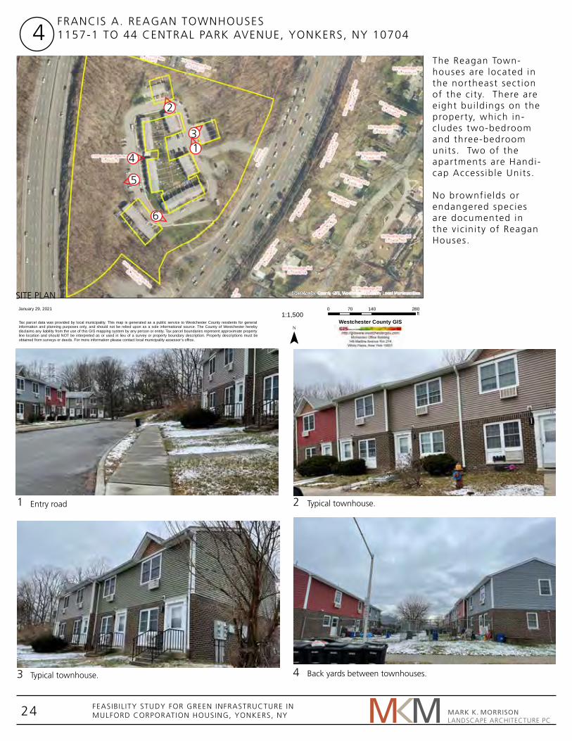
The Reagan Town-houses are located in the northeast sect ion of the c i ty. There are e ight bui ld ings on the property, which in-c ludes two-bedroom and three-bedroom units . Two of the apartments are Handi-cap Access ib le Units .
No brownfie lds or endangered species are documented in the v ic in i ty of Reagan Houses.
FRANCIS A. REAGAN TOWNHOUSES1157-1 TO 44 CENTRAL PARK AVENUE, YONKERS, NY 107044
14
2
3
6
5
1
3 4
2
MARK K. MORRISON LANDSCAPE ARCHITECTURE PC
SITE PLAN
Entry road
Typical townhouse.
Typical townhouse.
Back yards between townhouses.

25 FEASIBIL ITY STUDY FOR GREEN INFRASTRUCTURE INMULFORD CORPORATION HOUSING, YONKERS, NY
87
87
Fulle
rton
Ave
4
87
Roc
kled
geR
d
Rock
ledg
eRd
Devo
nRd
RutlandR
d
Centra
l Par
kAve
tral
Park
Ave
New
Yor
kS
tate
Thru
wa y
Rockl
edge
Rd
Kent Rd
Rutland Rd
Sunnybrook
Rd
Sunnybrook Rd
Durham
Rd
RockledgeR
d
Car
lton
Rd
Devon Rd
Essex
Pl
War
wic
kRd
Palmer Rd
Lawrence Park
Sunnybroo k Rd
Car
lton
Rd
Her
efor
dR
d
Environmental Features
Agricultural Uses - Farms, Stables, Nurseries
Single Family Residential
Two & Three Family and Multi-Structure Properties
Condominiums, Apartments & Multi-Family Residential Use
Common Land Homeowners Assoc.
Vacant Properties
Commercial and Retail
Manufacturing, Industrial and Warehousing
Office and Research (including Campus Office Parks)
Mixed Use
Institutional and Public Assembly
Transportation, Communication and Utilties
Cemeteries
Public Parks and Parkway Lands
Private Recreation
Nature Preserves
Water Supply Lands
Interior Water Bodies
February 3, 20211:4,514
0 440 880220ft
¯
Mapping Westchester CountyThe Reagan Town-houses are s i ted inbe-tween two major road systems, Route 87, and entra l Park Avenue. Surrounding landuse is res ident ia l with some commercia l and inst i tu-t ional .
5 6
MARK K. MORRISON LANDSCAPE ARCHITECTURE PC
Steep rocky slope on edge of property adjacent to Route 87. Entry walkway from Central Park Avnenue.
LAND USE

26 FEASIBIL ITY STUDY FOR GREEN INFRASTRUCTURE INMULFORD CORPORATION HOUSING, YONKERS, NY
87
87
Fulle
rton
Ave
4
87
Roc
kled
geR
d
Rock
ledg
eRd
Devo
nRd
RutlandR
d
Centra
l Par
kAve
tral
Park
Ave
New
Yor
kS
tate
Thru
wa y
Rockl
edge
Rd
Kent Rd
Rutland Rd
SprainBrook
Pkwy
Sunnybrook
Rd
Sunnybrook Rd
Durham
Rd
RockledgeR
d
Car
lton
Rd
Devon Rd
Essex
Pl
War
wic
kRd
Palmer Rd
Lawrence Park
Sunnybroo k Rd
Car
lton
Rd
Her
efor
dR
d
Environmental Features
Slopes 15%-25%
Slopes Over 25%
February 3, 20211:4,514
0 440 880220ft
¯
Mapping Westchester County
87
87
4
100
87
Gra
mer
cyA
ve
87
Roc
kled
geR
d
Rock
ledg
eRd
Devo
nRd
RutlandR
d
Centra
l Par
kAve
tral
Park
Ave
New
Yor
kS
tate
Thru
wa y
Long
va
le Rd
SprainBrook
Pkwy
Sunnybrook
Rd
Sunnybrook Rd
Durham
Rd
Here
ford
Rd
RockledgeR
d
Car
lton
Rd
Devon Rd
Essex
Pl
War
wic
kRd
Palmer Rd
SprainBrook Pkwy
Lawrence Park
Brooke Ave
Environmental Features
100 Year Flood Plain
500 Year Flood Plain
February 3, 20211:4,514
0 440 880220ft
¯
Mapping Westchester County
The townhouses are not in e i ther the 100 year or 500 year f lood-pla ins. However, ex-posed bedrock and the preponderance of high-way infrastructure near the townhouses causes stormwater to run into the propert ies.
There are steep s lopes on both s ides of the property, with the high-er s ide being where Route 87 passes by, and the property s lop-ing from there downhi l l to Centra l Park Avenue.
MARK K. MORRISON LANDSCAPE ARCHITECTURE PC
PROXIMITY TO FLOOD PLAINS
SLOPE ANALYSIS

27 FEASIBIL ITY STUDY FOR GREEN INFRASTRUCTURE INMULFORD CORPORATION HOUSING, YONKERS, NY
Green infrastructure strategies to inc lude:• Bioretent ion• Disconnect gutters , d i rect stormwater to biore-
tent ion areas. • Street Trees
Cost Est imate for GI pract ices:$144,600
WQv Calculat ions:Required WQv = 9,473 Cubic Feet
MARK K. MORRISON LANDSCAPE ARCHITECTURE PC

28 FEASIBIL ITY STUDY FOR GREEN INFRASTRUCTURE INMULFORD CORPORATION HOUSING, YONKERS, NY
Westchester
February 4, 20211:1,500
0 140 28070ft
¯
21 Ellison Ave . ID: 5.-5643-40 (Yonkers )
Tax parcel data was provided by local municipality. This map is generated as a public service to Westchester County residents for generalinformation and planning purposes only, and should not be relied upon as a sole informational source. The County of Westchester herebydisclaims any liability from the use of this GIS mapping system by any person or entity. Tax parcel boundaries represent approximate propertyline location and should NOT be interpreted as or used in lieu of a survey or property boundary description. Property descriptions must beobtained from surveys or deeds. For more information please contact local municipality assessor’s office.
Westchester County GIS
Mart inel l i Manor is a newly renovated seniors’ complex lo-cated in the northeast sect ion of the c i ty. I t consists of a three-story e levated bui ld ing.The bui ld ing has parking on s i te.
No brownfie lds or endangered species are documented in the v ic in i ty of Mart inel l i Manor.
MARTINELLI MANOR21 ELLISON AVENUE, YONKERS, NY 107085
1
3 4
2
MARK K. MORRISON LANDSCAPE ARCHITECTURE PC
SITE PLAN
Parking lot, and building facade.
View across parking lot toward Millard Avenue.
View of building from parking lot off Ellison Avenue.
Low point in yard, view from Palmer Road.
6
1
4
3
5
2

29 FEASIBIL ITY STUDY FOR GREEN INFRASTRUCTURE INMULFORD CORPORATION HOUSING, YONKERS, NY
Westchester
February 4, 20211:5,000
0 480 960240ft
¯
21 Ellison Ave . ID: 5.-5643-40 (Yonkers )
Tax parcel data was provided by local municipality. This map is generated as a public service to Westchester County residents for generalinformation and planning purposes only, and should not be relied upon as a sole informational source. The County of Westchester herebydisclaims any liability from the use of this GIS mapping system by any person or entity. Tax parcel boundaries represent approximate propertyline location and should NOT be interpreted as or used in lieu of a survey or property boundary description. Property descriptions must beobtained from surveys or deeds. For more information please contact local municipality assessor’s office.
Westchester County GIS
The neighborhood is zoned for res ident ia l and commercia l .
5 6
MARK K. MORRISON LANDSCAPE ARCHITECTURE PC
Mature trees along edge of Millard Avenue. Sidewalk and front facade along Ellison Avenue.
LAND USE

30 FEASIBIL ITY STUDY FOR GREEN INFRASTRUCTURE INMULFORD CORPORATION HOUSING, YONKERS, NY
Westchester
February 4, 20211:5,000
0 480 960240ft
¯
21 Ellison Ave . ID: 5.-5643-40 (Yonkers )
Tax parcel data was provided by local municipality. This map is generated as a public service to Westchester County residents for generalinformation and planning purposes only, and should not be relied upon as a sole informational source. The County of Westchester herebydisclaims any liability from the use of this GIS mapping system by any person or entity. Tax parcel boundaries represent approximate propertyline location and should NOT be interpreted as or used in lieu of a survey or property boundary description. Property descriptions must beobtained from surveys or deeds. For more information please contact local municipality assessor’s office.
Westchester County GIS
The townhouses are extremely c lose to, though not technia l ly within, both the 100 year f loodpla in and the 500 year f loodpla in. The proximity of the Sprain Brook Parkway, with Sprain Brook, as wel l as the Bronx River, create condit ions for f looding dur ing storm events.
The apartment bui ld ing is set into a s lope, cre-at ing very steep condi-t ions on one s ide of the property, and a low point or dip near Palm-er Road that is ideal for b ioretent ion.
MARK K. MORRISON LANDSCAPE ARCHITECTURE PC
PROXIMITY TO FLOOD PLAINS
SLOPE ANALYSIS

31 FEASIBIL ITY STUDY FOR GREEN INFRASTRUCTURE INMULFORD CORPORATION HOUSING, YONKERS, NY
Green infrastructure strategies to inc lude:• Bioretent ion• Disconnect gutters , d i rect stormwater to biore-
tent ion areas. • Street Trees
Cost Est imate for GI pract ices:$27,000
WQv Calculat ions:Required WQv = 2,731 Cubic Feet
MARK K. MORRISON LANDSCAPE ARCHITECTURE PC

32 FEASIBIL ITY STUDY FOR GREEN INFRASTRUCTURE INMULFORD CORPORATION HOUSING, YONKERS, NY
200 Willow St, Yonkers, NY, 10701
P.S. 18 /Scholastic
Academy forAcademicExcellen
ParkHill Ave
Par
kH
illA
ve
Willow
St
Willow
St
Park
Hill
Ave
Willow
St
Oak
St
Oak
St
Oak St
February 4, 20211:1,128
0 110 22055ft
¯
Mapping Westchester CountyTroy Manor is a seniors’ complex located in the Park Hi l l neighborhood. I t consists of a f ive-story e levated bui ld ing containing one-bed-room units .
No brownfie lds or endangered species are documented in the v ic in i ty of Troy Manor.
MONSIGNOR TROY MANOR200 WILLOW STREET, YONKERS, NY 107086
1
3 4
2
MARK K. MORRISON LANDSCAPE ARCHITECTURE PC
SITE PLAN
Main entrance along Willow Street.
Street view along Willow Street facing south.
Parking lot at Willow Street.
South end of Willow Street is a dead end into a steep slope.
6
1
4
35
2

33 FEASIBIL ITY STUDY FOR GREEN INFRASTRUCTURE INMULFORD CORPORATION HOUSING, YONKERS, NY
Celli Pl
Park Hill Ave
Par
kH
illA
ve
LindenS
t
Mt Carmel Pl
And
rew
Maf
fei S
t
Willow
St
Willow
St
Wav
erly
St
Columbus Park
Par
kH
illA
ve
Herriot Pl
Willow
St
P.S. 18 /Scholastic
Academy forAcademicExcellen
Van
Cor
tland
t Pk
Ave
Oak
St
Oak
St
Bee
chS
t
Mt Carmel Pl
Van
Cor
tlan
dtP
kA
ve
Oak St
Knollwood Rd
Environmental Features
Agricultural Uses - Farms, Stables, Nurseries
Single Family Residential
Two & Three Family and Multi-Structure Properties
Condominiums, Apartments & Multi-Family Residential Use
Common Land Homeowners Assoc.
Vacant Properties
Commercial and Retail
Manufacturing, Industrial and Warehousing
Office and Research (including Campus Office Parks)
Mixed Use
Institutional and Public Assembly
Transportation, Communication and Utilties
Cemeteries
Public Parks and Parkway Lands
Private Recreation
Nature Preserves
Water Supply Lands
Interior Water Bodies
February 4, 20211:2,257
0 220 440110ft
¯
Mapping Westchester CountyThe neighborhood is zoned for res ident ia l and commercia l , or inst i tut ional . The area has a high heat index.
5 6
MARK K. MORRISON LANDSCAPE ARCHITECTURE PC
Evergreen plantings in front of Troy Manor. Multi-family housing across Willow Street from Troy Manor.
LAND USE

34 FEASIBIL ITY STUDY FOR GREEN INFRASTRUCTURE INMULFORD CORPORATION HOUSING, YONKERS, NY
Celli Pl
Park Hill Ave
Par
kH
illA
ve
LindenS
t
Mt Carmel Pl
And
rew
Maf
fei S
t
Willow
St
Willow
St
Wav
erly
St
Columbus Park
Par
kH
illA
ve
Herriot Pl
Willow
St
P.S. 18 /Scholastic
Academy forAcademicExcellen
Van
Cor
tland
t Pk
Ave
Oak
St
Oak
St
Bee
chS
t
Mt Carmel Pl
Van
Cor
tlan
dtP
kA
ve
Oak St
Knollwood Rd
Environmental Features
Slopes 15%-25%
Slopes Over 25%
February 4, 20211:2,257
0 220 440110ft
¯
Mapping Westchester County
Met
roN
orth
Hud
son
Line
Fern
broo
kS
t
New
School S
tS
chool St
Morgan
St
Haw
thor
neA
ve
Nepperhan AveWestchesterCounty Family
Court
WestchesterCounty Civil
Court
Yonkers
Park Hill Ave
Par
kH
illTe
r
Pur
ser
Pl
Bue
naV
ista
Ave
Sch
ool S
t
Downing St
Pier St
Cedar
Pl
Ham
ilton
Ave
Knowles St
Stanley
Ave
SB
roadway
SB
road
way
Riv
erda
leA
ve
Cerrato Park
O'Boyle Park
St. Peter'sSchool
St Joseph'sMedical Center
Beech
St
Oak
St
Van
Cor
tland
t Pk
Ave
Maple St
Lind
enSt
Poplar St
Waverly
St
Willow
St
Park
Hill
Ave
Bry
ant
Rd
Hill
cre s
t Ave
Van
Cor
tlan
dtP
kA
ve
Oak
St
R ockla
ndAv
e
Beech
St
Alt a
Ave
LindenS
t
GlenbrookAve
Gle
nbro
okA
ve
Wallace Pkwy
Sullivan OvalPark
P.S. 23
Park Hill
Environmental Features
100 Year Flood Plain
500 Year Flood Plain
February 4, 20211:9,028
0 850 1,700425ft
¯
Mapping Westchester County
The townhouses are not affected by the 100 year f loodpla in or the 500 year f loodpla in. F looding is pr imar i ly due to the fact that the area is heavi ly paved.
The townhouse s i te is re lat ive ly f lat . Steep surrounding areas con-tr ibute to water f low-ing toward the bui ld-ing.
MARK K. MORRISON LANDSCAPE ARCHITECTURE PC
PROXIMITY TO FLOOD PLAINS
SLOPE ANALYSIS

35 FEASIBIL ITY STUDY FOR GREEN INFRASTRUCTURE INMULFORD CORPORATION HOUSING, YONKERS, NY
Green infrastructure strategies to inc lude:• Bioretent ion• Disconnect gutters , d i rect stormwater to
b ioretent ion areas. • Street Trees
Cost Est imate for GI pract ices:$38,700
WQv Calculat ions:Required WQv = 2,355 Cubic Feet
MARK K. MORRISON LANDSCAPE ARCHITECTURE PC

36 FEASIBIL ITY STUDY FOR GREEN INFRASTRUCTURE INMULFORD CORPORATION HOUSING, YONKERS, NY
Westchester
February 4, 20211:1,500
0 140 28070ft
¯
1 Wrexham Rd . ID: 5.-5364-72 (Yonkers )
Tax parcel data was provided by local municipality. This map is generated as a public service to Westchester County residents for generalinformation and planning purposes only, and should not be relied upon as a sole informational source. The County of Westchester herebydisclaims any liability from the use of this GIS mapping system by any person or entity. Tax parcel boundaries represent approximate propertyline location and should NOT be interpreted as or used in lieu of a survey or property boundary description. Property descriptions must beobtained from surveys or deeds. For more information please contact local municipality assessor’s office.
Westchester County GIS
The Doran Townhouses are located in the Lawrence Park neigh-borhood. There are f ive bui ld ings on the property, and al l of the apartments are two- bedroom units . The bui ld ings have been recendt ly developed.
No brownfie lds or endangered species are documented in the v ic in i ty of Doran Town-houses.
JUDGE ARTHUR J . DORAN SR. TOWNHOUSES1171-1215 MIDLAND AVENUE17-27 WREXHAM ROAD, YONKERS, NY 10708
7
1
3 4
2
MARK K. MORRISON LANDSCAPE ARCHITECTURE PC
SITE PLAN
Midland and Wrexham Avenue.
Parking lot between buildings.
Slope to sidewalk at Midland Avenue.
Elevation difference between two building units.
61
4
3
5
2

37 FEASIBIL ITY STUDY FOR GREEN INFRASTRUCTURE INMULFORD CORPORATION HOUSING, YONKERS, NY
Lawre
nce ParkTer
Lawrenc e
P
ar k Cres
Nob
leA
ve
Dewey Ave
Midland Ave
Mid
lnd
Ave
Lawton Ln
Tuni
sA
ve
McG
eory
Ave
Cross County Ctr
Cross County Pkwy 4N
Cross County Ctr
Cross County Pkwy5
Bou
lder
Trl
Wilgarth Rd
Wilgarth
Rd
Mid
land
Ave
Midland Ave
Wre
xham
Rd
Le dgewoodRd
Midland Ave
Kim
ball
Ave
Kim
ball
Ave
Yonkers School30
Nevada Pl
Nevada Pl
Cross County C tr
Midland Ave
Cross County Pkwy
5
Bould
erTr
lE
ton
Rd
Nevada Pl
Environmental Features
Agricultural Uses - Farms, Stables, Nurseries
Single Family Residential
Two & Three Family and Multi-Structure Properties
Condominiums, Apartments & Multi-Family Residential Use
Common Land Homeowners Assoc.
Vacant Properties
Commercial and Retail
Manufacturing, Industrial and Warehousing
Office and Research (including Campus Office Parks)
Mixed Use
Institutional and Public Assembly
Transportation, Communication and Utilties
Cemeteries
Public Parks and Parkway Lands
Private Recreation
Nature Preserves
Water Supply Lands
Interior Water Bodies
February 3, 20211:4,514
0 440 880220ft
¯
Mapping Westchester CountyThe neighborhood is zoned for res ident ia l and commercia l , with some inst i tut ional . Roads and s idewalks, as wel l as adjacent commercia l d istr icts , contr ibute to high heat. The proximity of Cross County Parkway has an impact on the stormwater.
5 6
MARK K. MORRISON LANDSCAPE ARCHITECTURE PC
Retaining wall on property. Slope with steps, buildings on hill.
LAND USE

38 FEASIBIL ITY STUDY FOR GREEN INFRASTRUCTURE INMULFORD CORPORATION HOUSING, YONKERS, NY
Lawre
nce ParkTer
Lawrenc e
P
ar k Cres
Nob
leA
ve
Dewey Ave
Midland Ave
Mid
lnd
Ave
Lawton Ln
Tuni
sA
ve
McG
eory
Ave
Cross County Ctr
Cross County Pkwy 4N
Cross County Ctr
Cross County Pkwy5
Bou
lder
Trl
Wilgarth Rd
Wilgarth
Rd
Mid
land
Ave
Midland Ave
Wre
xham
Rd
Le dgewoodRd
Midland Ave
Kim
ball
Ave
Kim
ball
Ave
Yonkers School30
Nevada Pl
Nevada Pl
Cross County C tr
Midland Ave
Cross County Pkwy
5
Bould
erTr
lE
ton
Rd
Nevada Pl
Environmental Features
Slopes 15%-25%
Slopes Over 25%
February 3, 20211:4,514
0 440 880220ft
¯
Mapping Westchester County
Nob
leA
veDewey Ave
Tuni
sA
ve
War
wic
kR
d
McG
eory
Ave
Loom
isA
ve
Cen
tral
Par
kA
ve
4N
5
4S
4N
Gunther Park
South Dr
Xav
ier
Dr
West
Dr
Cross County Ctr
MallW
alk
Cen
tral
Par
kA
ve
Cross CountyShopping
Center
5
Wild
way
Ard
ell R
d
Bou
lde r
Trl
Bronxvi lleRd
Wre
xham
Rd
Glen WashingtonRd
Marquand
Ave
Geo
rgia
Ave
Mid land Ave
Lang
don
Ter
Eto
nR
d
LedgewoodRd
Wellyn
Rd
Mea
dW
ay
Midland Ave
Kba
llA
ve
Kimba
llA
ve
SunnybrookPark
Sarah LawrenceCollege
Yonkers School30
BronxRiver
Vredenburgh Ave
Fox Ave
Nevada Pl
A rdel
l Rd
BronxvilleG
lenDr
Kim
ball
Ave
Bron
xR
iver
Pkw
y
Cross County Pkwy
6 5-4N-S
5
11E
Rossmore
Ave
Bro
nxvi
lleR
d
Col
lins
Ave
Par
kway
Rd
Bronx
Rive
rPk
wy
11W
11W
Pac
kman
Ave
Col
lins
Ave
W Broad St
67
Metro-North-Fleetwood
Environmental Features
100 Year Flood Plain
500 Year Flood Plain
February 3, 20211:9,028
0 850 1,700425ft
¯
Mapping Westchester County
The townhouses are not affected by the 100 year f loodpla in or the 500 year f loodpla in. This part of Yonkers is heavi ly paved which wi l l cause urban heat is land effect and f lash f looding.
There are s loping hi l l s surrounding the town-houses which may direct water toward the bui ld ings.
MARK K. MORRISON LANDSCAPE ARCHITECTURE PC
PROXIMITY TO FLOOD PLAINS
SLOPE ANALYSIS

39 FEASIBIL ITY STUDY FOR GREEN INFRASTRUCTURE INMULFORD CORPORATION HOUSING, YONKERS, NY
Green infrastructure strategies to inc lude:• Bioretent ion• Disconnect gutters , d i rect stormwater
to bioretent ion areas. • Street Trees
Cost Est imate for GI pract ices:$348,600
WQv Calculat ions:Required WQv = 3,101 Cubic Feet
MARK K. MORRISON LANDSCAPE ARCHITECTURE PC

40 FEASIBIL ITY STUDY FOR GREEN INFRASTRUCTURE INMULFORD CORPORATION HOUSING, YONKERS, NY
Mid
land
Ave
Teresa Ave
Mid
land
Ave
Mid
land
Ave
Teresa Ave
Lincoln HighSchool
February 3, 20211:1,128
0 110 22055ft
¯
Mapping Westchester County
The Chr istopher Town-houses are located in the L incoln Park neigh-borhood. There are three bui ld ings on the property, which in-c lude two-bedroom and three-bedroom units . The Chr istopher Town-houses are s i tuated in a res ident ia l (s ingle fami ly ) neighborhood that is located across from the T ibbetts Brook Park, the largest recre-at ional fac i l i ty in Yon-kers.
No brownfie lds or endangered species are documented in the v ic in i ty of Chr istopher Townhouses.
LAWRENCE CHRISTOPHER TOWNHOUSES326 TO 350 MIDLAND AVENUE, YONKERS, NY 107048
1
3 4
2
MARK K. MORRISON LANDSCAPE ARCHITECTURE PC
SITE PLAN
Signage of Lawrence Christopher Townhouses
Typical Townhouses
Planting and sidewalk along Midland Avenue.
View of the backyards of the townhouses
6
1
4
3
52

41 FEASIBIL ITY STUDY FOR GREEN INFRASTRUCTURE INMULFORD CORPORATION HOUSING, YONKERS, NY
Teresa Ave
Mid
land
Ave
Mid
land
Ave
Teresa Ave
Lincoln HighSchool
Environmental Features
Agricultural Uses - Farms, Stables, Nurseries
Single Family Residential
Two & Three Family and Multi-Structure Properties
Condominiums, Apartments & Multi-Family Residential Use
Common Land Homeowners Assoc.
Vacant Properties
Commercial and Retail
Manufacturing, Industrial and Warehousing
Office and Research (including Campus Office Parks)
Mixed Use
Institutional and Public Assembly
Transportation, Communication and Utilties
Cemeteries
Public Parks and Parkway Lands
Private Recreation
Nature Preserves
Water Supply Lands
Interior Water Bodies
February 3, 20211:2,257
0 220 440110ft
¯
Mapping Westchester CountyThe neighborhood is zoned for res ident ia l and inst i tut ional . The Chr istopher Townhous-es are s i tuated in a res-ident ia l (s ingle fami ly ) neighborhood that is located across from the T ibbetts Brook Park, the largest recreat ional fac i l i ty in Yonkers.
5 6
MARK K. MORRISON LANDSCAPE ARCHITECTURE PC
Parking lot between townhouses Street view from Midland Avenue and Teresa Avenue
LAND USE

42 FEASIBIL ITY STUDY FOR GREEN INFRASTRUCTURE INMULFORD CORPORATION HOUSING, YONKERS, NY
Teresa Ave
Mid
land
Ave
Mid
land
Ave
Teresa Ave
Lincoln HighSchool
Environmental Features
Slopes 15%-25%
Slopes Over 25%
February 3, 20211:2,257
0 220 440110ft
¯
Mapping Westchester County
Teresa Ave
Mid
land
Ave
Mid
land
Ave
Teresa Ave
Lincoln HighSchool
Environmental Features
100 Year Flood Plain
500 Year Flood Plain
February 3, 20211:2,257
0 220 440110ft
¯
Mapping Westchester County
The townhouses are not affected by the 100 year f loodpla in or the 500 year f loodpla in. The townhouses are at the base of a hi l l and receive stormwater that f lows downhi l l toward them.
Topography is var ied and s loping eventual ly down toward T ibbets Brook.
MARK K. MORRISON LANDSCAPE ARCHITECTURE PC
PROXIMITY TO FLOOD PLAINS
SLOPE ANALYSIS

43 FEASIBIL ITY STUDY FOR GREEN INFRASTRUCTURE INMULFORD CORPORATION HOUSING, YONKERS, NY
Green infrastructure strategies to inc lude:• Bioretent ion• Disconnect gutters , d i rect stormwater to
b ioretent ion areas. • Street Trees
Cost Est imate for GI pract ices:$100,200
WQv Calculat ions:Required WQv = 2,194 Cubic Feet
MARK K. MORRISON LANDSCAPE ARCHITECTURE PC

44 FEASIBIL ITY STUDY FOR GREEN INFRASTRUCTURE INMULFORD CORPORATION HOUSING, YONKERS, NY
Westchester
February 4, 20211:1,500
0 140 28070ft
¯
(Yonkers )
Tax parcel data was provided by local municipality. This map is generated as a public service to Westchester County residents for generalinformation and planning purposes only, and should not be relied upon as a sole informational source. The County of Westchester herebydisclaims any liability from the use of this GIS mapping system by any person or entity. Tax parcel boundaries represent approximate propertyline location and should NOT be interpreted as or used in lieu of a survey or property boundary description. Property descriptions must beobtained from surveys or deeds. For more information please contact local municipality assessor’s office.
Westchester County GIS
The F ior i l lo Townhous-es are located in the L incoln Park neighbor-hood. There are four bui ld ings on the prop-erty, which contain two-bedroom units . The townhouses are near the Cross County Shopping Center. Two bui ld ings are accessed from Clark Street, and two from Lor ing Av-enue. There is a shared parking lot on Centra l Park Avenue.
No brownfie lds or en-dangered species are documented in the v i -c in i ty of F ior i l lo Town-houses.
JUDGE ALBERT F IORILLO TOWNHOUSES3-1 TO 21 LORING AVENUE6-1-24 CLARK STREET, YONKERS, NY 10704
9
1
3 4
2
MARK K. MORRISON LANDSCAPE ARCHITECTURE PC
SITE PLAN
View along Loring Avenue.
Clark Street.
Front yard and setback, Loring Avenue.
Corner of Central Park Avenue and Clark Street.
6
14
352

45 FEASIBIL ITY STUDY FOR GREEN INFRASTRUCTURE INMULFORD CORPORATION HOUSING, YONKERS, NY
Westchester
February 4, 20211:5,000
0 480 960240ft
¯
(Yonkers )
Tax parcel data was provided by local municipality. This map is generated as a public service to Westchester County residents for generalinformation and planning purposes only, and should not be relied upon as a sole informational source. The County of Westchester herebydisclaims any liability from the use of this GIS mapping system by any person or entity. Tax parcel boundaries represent approximate propertyline location and should NOT be interpreted as or used in lieu of a survey or property boundary description. Property descriptions must beobtained from surveys or deeds. For more information please contact local municipality assessor’s office.
Westchester County GIS
The neighborhood is zoned for res ident ia l and commercia l , or inst i tut ional . Roads and s idewalks, as wel l as adjacent commercia l d istr icts , contr ibute to high heat. The proxim-iny of the Yonkers race track and the Cross County Shopping Cen-ter add to congest ion and the heat factor.
5 6
MARK K. MORRISON LANDSCAPE ARCHITECTURE PC
View of the parking lot Townhouses on Clark Street, offset from neighboring house.
LAND USE

46 FEASIBIL ITY STUDY FOR GREEN INFRASTRUCTURE INMULFORD CORPORATION HOUSING, YONKERS, NY
Westchester
February 4, 20211:5,000
0 480 960240ft
¯
(Yonkers )
Tax parcel data was provided by local municipality. This map is generated as a public service to Westchester County residents for generalinformation and planning purposes only, and should not be relied upon as a sole informational source. The County of Westchester herebydisclaims any liability from the use of this GIS mapping system by any person or entity. Tax parcel boundaries represent approximate propertyline location and should NOT be interpreted as or used in lieu of a survey or property boundary description. Property descriptions must beobtained from surveys or deeds. For more information please contact local municipality assessor’s office.
Westchester County GIS
The townhouses are not affected by the 100 year f loodpla in or the 500 year f loodpla in. F looding is pr imar i ly due to the fact that the area is heavi ly paved.
The townhouse s i te is re lat ive ly f lat . Steeper s lopes are across Cen-tra l Park Avenue.
MARK K. MORRISON LANDSCAPE ARCHITECTURE PC
PROXIMITY TO FLOOD PLAINS
SLOPE ANALYSIS

47 FEASIBIL ITY STUDY FOR GREEN INFRASTRUCTURE INMULFORD CORPORATION HOUSING, YONKERS, NY
Green infrastructure strategies to inc lude:• Bioretent ion• Disconnect gutters , d i rect stormwater to
b ioretent ion areas. • Street Trees
Cost Est imate for GI pract ices:$148,200
WQv Calculat ions:Required WQv = 2,812 Cubic Feet
MARK K. MORRISON LANDSCAPE ARCHITECTURE PC

48 FEASIBIL ITY STUDY FOR GREEN INFRASTRUCTURE INMULFORD CORPORATION HOUSING, YONKERS, NY
Tren
char
dSt
Huber Pl
Trenchard Park
Tren
char
dSt
Tren
char
dSt
Gaf
fney
Pl
Winfred Ave
Kettell Ave
Gaf
fney
Pl
Winfred Ave
Hun
ter
Ave
February 3, 20211:1,128
0 110 22055ft
¯
Mapping Westchester CountyThe Smith Townhouses are located in the southeast sect ion of the c i ty. There are four bui ld ings on the property, which inc lude a number of two-bedroom and three-bedroom units . The Smith Townhouses are s i tuated in a res ident ia l (s ingle fami ly ) neigh-borhood that is c lose to the Yonkers Raceway and Casino. The Cross County Shopping Cen-ter i s a lso nearby.
No brownfie lds or endangered species are documented in the v ic in i ty of Smith Town-houses.
ANDREW SMITH TOWNHOUSES101-1 TO 105 & 122-1 TO 126 TRENCHARD STREET & 106-121 GAFFNEY PLACE, YONKERS, NY 10704
10
1
3 4
2
MARK K. MORRISON LANDSCAPE ARCHITECTURE PC
SITE PLAN
Signage of Smith Townhouses
Typical townhouses
View towards the backyards of the townhouses
View of the parking lot and Townhouses on Gaffney Pl
61 4
3
52

49 FEASIBIL ITY STUDY FOR GREEN INFRASTRUCTURE INMULFORD CORPORATION HOUSING, YONKERS, NY
Central Park
Ave
Central Park
Ave
Huber Pl
YonkersAve
Whittier Ave
Hun
ter
Ave
Tren
char
dSt
Nels
o nS
t
Still
wel
l Ave
Map
lePl
Map
lePl
Gaf
fney
Pl
Winfred Ave
Hun
ter
Ave
Edgewood Ave
Thur
ton
Pl
Thur
ton
Pl
Villa Ave
Kettell Ave
Whittier Ave
Rid
gew
ood
Ave
HildrethPl N
YonkersAve
Trenchard Park
Maple
Pl
Sherwood Ave
Joan
Dr
Byr
onA
ve
Munn Pl
Mile
SquareRd
Joan
Dr
Winfred Ave
Byr
onA
ve
Edgewood Ave
BrandonRd
Vern
onA
ve
Villa Ave
Crestmont Ave
Kim
ball
Ave
Kim
ball
Ave
Crestmont AveEnvironmental Features
Agricultural Uses - Farms, Stables, Nurseries
Single Family Residential
Two & Three Family and Multi-Structure Properties
Condominiums, Apartments & Multi-Family Residential Use
Common Land Homeowners Assoc.
Vacant Properties
Commercial and Retail
Manufacturing, Industrial and Warehousing
Office and Research (including Campus Office Parks)
Mixed Use
Institutional and Public Assembly
Transportation, Communication and Utilties
Cemeteries
Public Parks and Parkway Lands
Private Recreation
Nature Preserves
Water Supply Lands
Interior Water Bodies
February 3, 20211:4,514
0 440 880220ft
¯
Mapping Westchester CountyThe neighborhood is zoned for res ident ia l and commercia l .
5 6
MARK K. MORRISON LANDSCAPE ARCHITECTURE PC
View of the parking lot at Trenchard St. View of the parking lot at Trenchard St.
LAND USE

50 FEASIBIL ITY STUDY FOR GREEN INFRASTRUCTURE INMULFORD CORPORATION HOUSING, YONKERS, NY
Central Park
Ave
Central Park
Ave
Huber Pl
YonkersAve
Whittier Ave
Hun
ter
Ave
Tren
char
dSt
Nels
o nS
t
Still
wel
l Ave
Map
lePl
Map
lePl
Gaf
fney
Pl
Winfred Ave
Hun
ter
Ave
Edgewood Ave
Thur
ton
Pl
Thur
ton
Pl
Villa Ave
Kettell Ave
Whittier Ave
Rid
gew
ood
Ave
HildrethPl N
YonkersAve
Trenchard Park
Maple
Pl
Sherwood Ave
Joan
Dr
Byr
onA
ve
Munn Pl
Mile
SquareRd
Joan
Dr
Winfred Ave
Byr
onA
ve
Edgewood Ave
BrandonRd
Vern
onA
ve
Villa Ave
Crestmont Ave
Kim
ball
Ave
Kim
ball
Ave
Crestmont AveEnvironmental Features
Slopes 15%-25%
Slopes Over 25%
February 3, 20211:4,514
0 440 880220ft
¯
Mapping Westchester County
OtsegoStCowles Ave
Emerson St
3
Bainton St
Huber Pl
YonkersAve
New York State Thruway
YonkersRaceway
Nola
nA
ve
Mile
SquareRd
Joan
Dr
Flor
ence
St
Whittier Ave
Byr
onA
ve
Tren
char
dSt
Still
wel
l AveCen
tral P
ark
Ave
Centr
alPar
kA
ve
Kim
ball
Ave
V redenburgh Ave
Map
lePl
Cre
scen
t Pl
Grant St
Vernon Pl
Em
pire
S t
Joan
Dr
Tren
char
dSt
Rid
gew
ood
Ave
Hild
reth
P l
Hild
reth
Pl
Gaf
fney
P
Sherwood Ave
Sherwood Ave
Hun
ter
Ave
Edgewood Ave
BrandonR
d
Vern
onA
ve
Vern
onA
ve
Villa Ave
Ray
mon
dPl
Thur
ton
Pl
Thur
ton
PlKettell Ave
Lincoln
Ave
Crestmont Ave
Huber Pl
StJa
mes
Ter
Yon
kers
Ave
YonkersAve
Kim
ball
Ave
Kim
ball
Ave
BronxRiverCr
esce
ntPl
Linc
oln
Ave
Rigby St
Brandon Rd
Bregano Park
11E
Met
roN
orth
Har
lem
Line
NTe
rrac
eAve
Cre
scen
t Pl
Locu
stSt
Howard St
Edgewood AveN
10thA
ve
Linc
oln
Ave
NHig
hSt
NW
est S
t
Mac
ques
ten
Pkw
yN
Mac
ques
ten
Pkw
yN
Halle
ySt
Oak St
WLi
ncol
nAve
Bro
nxR
iver
Rd
Bro
nxR
iver
Pkw
y
RosemarySiragusa
ElementarySchool
10B
Environmental Features
100 Year Flood Plain
500 Year Flood Plain
February 3, 20211:9,028
0 850 1,700425ft
¯
Mapping Westchester County
The townhouses are not affected by the 100 year f loodpla in or the 500 year f loodpla in. F looding is pr imar i ly due to the fact that the area is heavi ly paved.
The townhouse s i te is re lat ive ly f lat . Steeper s lopes are across Cen-tra l Park Avenue.
MARK K. MORRISON LANDSCAPE ARCHITECTURE PC
PROXIMITY TO FLOOD PLAINS
SLOPE ANALYSIS

51 FEASIBIL ITY STUDY FOR GREEN INFRASTRUCTURE INMULFORD CORPORATION HOUSING, YONKERS, NY
Green infrastructure strategies to inc lude:• Bioretent ion• Disconnect gutters , d i rect stormwater to
b ioretent ion areas. • Street Trees
Cost Est imate for GI pract ices:$277,800
WQv Calculat ions:Required WQv = 4,195 Cubic Feet
MARK K. MORRISON LANDSCAPE ARCHITECTURE PC

52 FEASIBIL ITY STUDY FOR GREEN INFRASTRUCTURE INMULFORD CORPORATION HOUSING, YONKERS, NY
1 O‐Rourke Townhouses ‐ Bioretention and trees 240,000$ 2 Valentine Townhouses ‐ Bioretention and trees 129,6003 Walsh Houses‐ Bioretention and trees 174,0004 Reagan Townhouses‐ Bioretention and trees 144,6005 Martinelli Manor‐ Bioretention and trees 27,0006 Troy Manor‐ Bioretention and trees 38,7007 Doran Townhouses ‐ Bioretention and trees 348,6008 Christopher Townhouses‐ Bioretention and trees 100,2009 Fiorillo Townhouses ‐ Bioretention and trees 148,20010 Smith Townhouses‐ Bioretention and trees 277,800
Landscape plugs& installation 100,000Green Team labor for installation 50,000Inspection and monitoring 150,000
a. Topographical Surveys‐ 10 sites 50,000b. Geotechnical Borings ‐ 10 sites 50,000c. Landscape Architectural design 55,000d. Civil Engineering & Permitting 75,000
Feasibility Study 16,000e. Signage for 10 sites 7,500
2,182,200$
a. Surveys shall be boundary and topographical surveys. b. Geotechnical borings shall be to depth of 12' or refusal.c. Landscape Architetural design includes planting plan, planting schedule,
project management and coordination, construction administration. d. Civil engineering and permitting includes site analysis, managing
geotechnical work, removals and sediment plan, design of bioengineered systems, e. 18 x 24 fiberglass sign with pedestal.
SCHEDULINGDurat ion of implementat ion: maximum 3 yearsProjects should be des igned as a group, bid as a group, and implemented in stages, in groups of 3 to 4.
MAINTENANCEProjects shal l be maintained by the Mulford Corporat ion Staff , a ided by Groundwork Hudson Val ley Green Team.
Once the bioretent ion areas are establ ished, they wi l l require only occas ional weeding. The areas to be mowed by the maintenance staff wi l l d iminish so that overal l mainte-nance costs should be less for the s i tes.
Landscape Architect tasked with des ign work shal l provide maintenance guidel ines and shal l work with Mulford Corporat ion maintenance staff to tra in them regarding care for bioretent ion areas. Total WQv in cubic feet required by NY State Law to capture storm-water from roof areas and other s i te runoff and reta in on s i te, for the 10 project s i tes, i s 49,934 Cubic Feet.
BUDGET
MARK K. MORRISON LANDSCAPE ARCHITECTURE PC
Total