feasibility study for a proposed marine research and ... · mrec feasibility study august 2006 iv...
TRANSCRIPT
Feasibility Study for a Proposed Marine Research and Education Center
Salt River Bay National Historic Park and Ecological Preserve
St. Croix, US Virgin Islands
August 2006

MREC Feasibility Study August 2006 i
CONTENTS Page LIST OF FIGURES ......................................................................................................................... LIST OF TABLES ........................................................................................................................... EXECUTIVE SUMMARY .....................................................................................................ES-1 1.0 INTRODUCTION......................................................................................................... 1-1 1.1 PROJECT BACKGROUND ............................................................................................. 1-1 1.1.1 Park History...................................................................................................... 1-1 1.1.2 Team (NPS, JICMS, UVI) ............................................................................... 1-1 1.1.3 Salt River Bay Marine Research & Educational Center .................................. 1-2 1.2 PURPOSE AND OBJECTIVES OF STUDY ....................................................................... 1-4
1.3 RELATED ENVIRONMENTAL DOCUMENTS ........................................................ 1-5 1.4 REQUIRED PERMITS................................................................................................ 1-7
2.0 DESCRIPTION OF ALTERNATIVES...................................................................... 2-1 2.1 GUIDELINES FOR THE PHYSICAL PLANT................................................................... 2-1 2.1.1 Building Program ............................................................................................. 2-2 2.1.2 The Main Building (MREC) ............................................................................ 2-3 2.1.3 Wet Labs........................................................................................................... 2-4 2.1.4 Marine Facilities............................................................................................... 2-4 2.1.5 Support Facilities.............................................................................................. 2-5 2.2 DESCRIPTION OF ALTERNATIVES ............................................................................... 2-6 3.0 EXISTING CONDITIONS AT SARI .......................................................................... 3-1 3.1 INTRODUCTION ....................................................................................................... 3-1 3.2 PHYSICAL FEATURES ................................................................................................ 3-2 3.2.1 Geology/ Soils................................................................................................. 3-2 3.2.1.1 Geological Formations of the Salt River Watershed ....................... 3-2 3.2.1.2 Seismicity......................................................................................... 3-4 3.2.1.3 Soils of SARI ................................................................................... 3-4 3.2.2 Land Cover and Land Use ............................................................................. 3-6 3.2.2.1 Land Cover....................................................................................... 3-6 3.2.2.2 Land Use .......................................................................................... 3-8 3.2.3 Bathymetry/ Currents..................................................................................... 3-9 3.2.3.1 Bathymetry....................................................................................... 3-9 3.2.3.3 Currents.......................................................................................... 3-10 3.2.4 Water Quality............................................................................................... 3-11 3.2.5 Floodplains and Coastal Barriers ................................................................. 3-13

MREC Feasibility Study August 2006 ii
CONTENTS (continued)
Page 3.2.5.1 Floodplains..................................................................................... 3-13 3.2.5.2 Coastal Barriers.............................................................................. 3-14 3.2.6 Air Quality .................................................................................................... 3-14 3.2.7 Noise ..................................................................................................... 3-17 3.2.8 Climate ..................................................................................................... 3-18 3.2.9 Hydrology ..................................................................................................... 3-18 3.2.9.1 Groundwater ................................................................................... 2-19 3.3 TERRESTRIAL RESOURCES...................................................................................... 3-19 3.3.1 Mangroves.................................................................................................... 3-19 3.3.2 Wetlands ..................................................................................................... 3-20 3.3.3 Plants ..................................................................................................... 3-21 3.3.4 Birds ..................................................................................................... 3-22 3.3.5 Mammals ..................................................................................................... 3-24 3.4 AQUATIC RESOURCES ............................................................................................. 3-25 3.4.1 Seagrasses .................................................................................................... 3-25 3.4.2 Reefs/ Hardbottom....................................................................................... 3-26 3.4.3 Fish ..................................................................................................... 3-28 3.5 THREATENED AND ENDANGERED SPECIES ............................................................ 3-29 3.6 UNIQUE NATURAL SYSTEMS ................................................................................... 3-30 3.7 CULTURAL RESOURCES .......................................................................................... 3-31 3.7.1 Background.................................................................................................. 3-31 3.7.2 National Historic Preservation Act .............................................................. 3-32 3.7.3 Archeological Resources ............................................................................. 3-32 3.7.4 Historical Resources .................................................................................... 3-35 3.8 SOCIOECONOMIC CONDITIONS ............................................................................... 3-35 3.8.1 Environmental Justice.................................................................................. 3-36 3.9 VISITOR EXPERIENCE AND PARK OPERATIONS..................................................... 3-37 3.10 PRELIMINARY SITE ASSESSMENT ........................................................................... 3-38 4.0 EVALUATION OF ENVIRONMENTAL IMPACTS OF THE ALTERNATIVES .......................................................................................................... 4-1 4.1 INTRODUCTION AND OVERVIEW .............................................................................. 4-1 4.1.1 Methods for Evaluating Environmental Impacts ........................................... 4-1 4.2 PHYSICAL FEATURES ................................................................................................ 4-2 4.2.1 Geology/ Soils................................................................................................ 4-2 4.2.1.1 Seismicity ......................................................................................... 4-3 4.2.2 Land Cover and Land Use ............................................................................. 4-3 4.2.3 Bathymetry/ Currents..................................................................................... 4-5 4.2.4 Water Quality................................................................................................. 4-5 4.2.5 Floodplains/ Coastal Barriers......................................................................... 4-6 4.2.6 Air Quality ..................................................................................................... 4-7
MREC Feasibility Study August 2006 iii
CONTENTS (continued)
Page 4.2.7 Noise .......................................................................................................... 4-8 4.2.8 Climate .......................................................................................................... 4-8 4.2.9 Hydrology/ Groundwater ............................................................................... 4-8 4.3 TERRESTRIAL RESOURCES........................................................................................ 4-9 4.3.1 Mangroves...................................................................................................... 4-9 4.3.2 Wetlands ...................................................................................................... 4-10 4.3.3 Plants ........................................................................................................ 4-10 4.3.4 Birds ........................................................................................................ 4-11 4.3.5 Mammals...................................................................................................... 4-12 4.4 AQUATIC RESOURCES ............................................................................................. 4-12 4.4.1 Seagrasses .................................................................................................... 4-12 4.4.2 Reefs/Hardbottom........................................................................................ 4-13 4.4.3 Fish ........................................................................................................ 4-13 4.4.3.1 Benthic Organisms ......................................................................... 4-14 4.5 THREATENED AND ENDANGERED RESOURCES ...................................................... 4-15 4.6 UNIQUE NATURAL SYSTEMS ................................................................................... 4-16 4.7 CULTURAL RESOURCES .......................................................................................... 4-16 4.7.1 Archeological Resources ............................................................................. 4-16 4.7.2 Historical Structures..................................................................................... 4-17 4.7.3 Cultural Landscapes..................................................................................... 4-17 4.8 SOCIOECONOMIC CONDITIONS ............................................................................... 4-19 4.9 VISITOR EXPERIENCE AND PARK OPERATIONS..................................................... 4-19 4.10 RESULTS OF THE PRELIMINARY SITE ASSESSMENT ............................................... 4-19 5.0 POTENTIAL ECONOMIC COSTS FOR EACH ALTERNATIVE....................... 5-1 6.0 FEASIBILITY OF POTENTIAL SITE LOCATIONS ............................................ 6-1 6.1 FACTORS USED IN CHOOSING BY ADVANTAGES PROCESS ...................................... 6-1 6.1.1 Function: Project Cultural/ Natural Resources .............................................. 6-1 6.1.2 Function: Meet the Needs of the Marine Research and Education Center .... 6-4 6.1.3 Function: Provide for Visitor Enjoyment ...................................................... 6-5 6.1.4 Function: Provide Benefits to Local Community .......................................... 6-5 6.2 FACTORS CONSIDERED BUT ELIMINATED ............................................................... 6-6 6.3 CBA MATRIX ....................................................................................................... 6-6 6.4 CONCLUSIONS ...................................................................................................... 6-7 7.0 REFERENCES ....................................................................................................... 7-1 APPENDIX A: Photographic record of SARI APPENDIX B: List of threatened and endangered species potentially found within the USVI

MREC Feasibility Study August 2006 iv
LIST OF FIGURES
Figure 1-1 General Location Map of SARI Figure 1-2 SARI Locator Map Figure 2-1 Summary Analysis Figure 2-2 East Site Concept Plan (Original) Figure 2-2a East Site Concept Plan (Revised) Figure 2-3 South Site Concept Plan Figure 2-4 West Site Concept Plan Figure 3-1 Land Cover Figure 3-2 Bathymetry Figure 3-3 Mapped Floodplains and Coastal Barriers Figure 3-4 Location of Mangroves Figure 3-5 Location of Seagrasses Figure 3-6 Location of Reefs and Hardbottom Substrate Figure 3-7 Recorded Archeological Sites at SARI Figure 6-1 Choosing by Advantages Process for the MREC

MREC Feasibility Study August 2006 v
LIST OF TABLES Table 1-1 Environmental, Site, and Facility-Related Concerns for the MREC Table 1-2 Permits and Consultations that may be Required for the Proposed MREC at SARI Table 2-1 Proposed MREC Facilities Table 3-1 Soils Found within SARI Table 3-2 Land Use within each Alternative Location Table 3-3 Average Values of Water Quality Variables Collected at Locations within SARI Table 3-4 Floodplain Zones Table 3-5 Air Pollutants and Their Characteristics Table 3-6 Recorded Archeological Sites at SARI Table 3-7 Population Demographic Data within the ROI for SARI Table 3-8 Race, Income and Poverty data for SARI Table 5-1 Potential Economic Costs for Each Alternative

MREC Feasibility Study August 2006
ES-1
EXECUTIVE SUMMARY The purpose of this study was to determine the feasibility of three alternatives for siting a proposed Marine Research and Education Center (MREC) at Salt River Bay National Historic Park and Ecological Preserve (or SARI) in St. Croix, U.S. Virgin Islands. To determine the feasibility of the alternatives several steps were taken including describing the existing conditions of the sites under consideration, evaluating the environmental impacts of the alternatives, and estimating the economic costs for each alternative. Finally, the Choosing by Advantages (CBA) process was applied which scored and ranked the alternatives. Project Background SARI’s natural resources include both sea and land resources, containing some of the largest remaining mangrove forests in the Virgin Islands, as well as coral reefs and a submarine canyon. The park’s reef and hard bottom habitats in the canyon once were among the most extensively studied and characterized coral structures in the world. However, since the closing of the National Oceanic and Atmospheric Administration’s (NOAA) Undersea Research Center in Salt River Bay, this is no longer the case. Concerns about the state of coral reef ecosystems in the Caribbean and elsewhere in the world has led to the formation of a partnership between the U.S. Department of Interior (U.S. DOI), through the National Park Service (NPS) and the Office of Insular Affairs, and the Joint Institute for Caribbean Marine Studies (JICMS). The formation of the JICMS was based on the concerns of the member organizations for the future of coral reef ecosystems in the Caribbean region. The JICMS has long considered St. Croix the most desirable location to establish a Marine Research and Educational Center (JICMS 2004). Alternatives Developed for the Marine Research and Education Center Several potential sites for a MREC at Salt River Bay were previously identified by the JICMS. This project examined the feasibility of these recommended sites, as well as other potential site locations, based on several environmental, site and facility-related concerns. After reviewing the proposed building, research and educational programs and evaluating four potential locations for the MREC, the team developed conceptual site plans for three alternatives:
Alternative 1 (East Site): Alternative 1, the east site, is located adjacent to the Estate Judith's Fancy on the eastern side of Salt River Bay. This alternative consists of approximately 70 acres of land owned by the NPS. A partially constructed hotel is located on a dredge spoil peninsula adjacent to a lagoon (Dredged Basin). The site is accessed by private paved roads that traverse a residential neighborhood to the south and east of the NPS-owned property.
Alternative 2 (South Site): Alternative 2, the south site, is the former location of the West Indies Marine Research Laboratory. This alternative is privately-owned, is approximately 58-acres, and includes several structures. Road access is limited to a private road that winds north to the site from the nearest public road.
MREC Feasibility Study August 2006 2
Alternative 3 (West Site): Alternative 3, the west site, encompasses two sites the Salt River Bay Marina and the NPS Visitor Contact Station. The Visitor Contact Station is located on the northwest shore of the bay. The site is made up of several parcels of approximately 6 acres in all and includes a house, guest quarters, accessory structures and a beach. The marina consists of approximately 14 acres along the western edge of the bay. This property is privately owned and includes buildings used for maintaining, constructing and painting boats, as well as for office space. Docking facilities and several mooring buoys are located in the bay.
These sites were examined in detail, given the information available on existing conditions, and preliminary site plans were developed for each alternative. Among the elements evaluated were floodplains, topography, susceptibility to hurricanes and earthquakes, cultural and historic resources, and environmental impacts. The individual site plans attempted to mitigate impacts to these elements and accommodate the building program in an environmentally responsible manner while providing the means to compare the advantages of each alternative. Environmental Impacts of the Alternatives The three alternatives were found to impact the physical features (i.e., soils, sediments, water and air quality, floodplains, and coastal barriers) at SARI; however; these impacts would be minor. Most of the impacts to these resources would be from the installation of the underwater pipeline to bring clean salt water from the sea to MREC facility, construction of a new boat dock and boat launch, and for maintenance dredging. Minor impacts would also occur to the terrestrial and aquatic resources at SARI. Impacts to mangroves and wetlands would occur from the installation of the underwater pipeline and from construction of a new boat dock and boat launch. These impacts would be minor and appropriate mitigation measures would be required. The loss of forest, shrubs, and vegetated field habitat would be required for the MREC facilities and access roads; however, most of the impacted vegetation is invasive. Birds and mammals would experience a loss of habitat due to vegetation removal; however, this would be a short-term, minor impact. Seagrasses, coral reefs/hardbottom, fish, and the benthic community would be impacted by the proposed pipeline and maintenance dredging activities. These impacts would pose short-term temporary impacts. Threatened and endangered species would not be affected by construction of the MREC facilities, maintenance dredging, or the proposed pipeline. All alternatives would require archaeological surveys and testing for terrestrial and submerged resources for any areas of new construction. Alternatives 2 (South Site) and 3 (West Site) should not have an effect on SARI's cultural landscape, so long as the new construction does not substantially vary from the height of the current structures. Alternative 1 (East Site) would have an effect on the SARI cultural landscape, however, depending on the mass and scale of the MREC's facilities, this effect may not be adverse. Demolition of the Virgin Grand Hotel shell, if

MREC Feasibility Study August 2006 3
completed in concert with construction of the MREC, could be considered as a mitigating factor for visual effect as the Virgin Grand structure is far more visually intrusive than the proposed MREC buildings. Implementing the MREC would improve the quality of life in the Salt River Bay region by providing additional opportunities for employment and additional opportunities for educational programs for students and the general public. In addition, MREC would contribute directly to the local economy by hiring permanent and part-time employees and purchasing goods and services from local suppliers. Feasibility of Alternatives The final steps in determining the feasibility of the alternatives involved a cost analysis and the Choosing by Advantages (CBA) process. A preliminary estimate of probable costs based on schematic designs was prepared for each the alternatives, which resulted in similar costs among alternatives. On December 6 and 7, 2005, the project team met in Christiansted, Virgin Islands to review the conceptual site plans and complete the CBA process, as well as a Value Analysis. CBA scores for each alternative were calculated, and the alternatives were ranked based on total CBA scores. Alternative 1 (East Site) scored the highest, so it was considered the best alternative for the MREC.
MREC Feasibility Study August 2006 1
1. INTRODUCTION 1.1 PROJECT BACKGROUND 1.1.1 Park History Salt River Bay National Historical Park and Ecological Preserve (or SARI) was created in 1992 to preserve, protect, and interpret nationally significant natural, historical, and cultural resources (United States Congress 1992). The National Park Service (NPS) and the Government of the Virgin Islands jointly manage and maintain the 1,015-acre park (Figures 1-1 and 1-2). A photographic record of SARI can be found in Appendix A. SARI’s natural resources include both sea and land resources, containing some of the largest remaining mangrove forests in the Virgin Islands, as well as coral reefs and a submarine canyon. NPS and the Virgin Islands government are working together to protect these resources. In 1994, the Salt River Bay Commission recommended approval of a Land Protection Plan, which was signed by the Governor of the Virgin Islands and the Director of the NPS in 1995. This plan set the priorities for the purchase of lands within the boundary of SARI. The park’s reef and hard bottom habitats in the canyon once were among the most extensively studied and characterized coral structures in the world. However, since the closing of the National Oceanic and Atmospheric Administration’s (NOAA) Undersea Research Center in Salt River Bay, this is no longer the case. Reefs that fall within the Salt River Bay Historical Park but are outside of the canyon itself have received virtually no attention. The seagrass and algae communities within the canyon were also studied intensively using the NOAA facility. Today they are largely unmonitored. Bathymetry within the park has been altered considerably over the past fifty years due to dredging activities (Kendall et al. 2005). Extensive dredging and filling (c. 1968) was done on the east side of the bay at Estate Judith’s Fancy to construct a boat basin and marina (later abandoned), dredging of a canal and small boat basin (c. 1975) in Triton Bay (later abandoned), dredging of a channel across the mouth of Triton Bay (1960’s) to provide access to the NOAA Hydrolab base bulkhead, and dredging in Sugar Bay (c. 1973) to construct a marina (later abandoned) (IRF 1993). Bathymetry will likely continue to change at an accelerated rate relative to natural conditions due to development and erosion in the watershed (Kendall et al. 2005). Kendall et al. (2005) reported that at one time, the park’s mangrove forests were among the most impressive in the region, however, today these forests have undergone dramatic changes. In 1989, Hurricane Hugo killed over 50 percent of the 1988 mangrove stand and reduced the density of much of the remaining canopy. Today the mangrove forests are recovering, both naturally and as a result of restoration activities. 1.1.2 Team (NPS, US DOI, JICMS) Concerns about the state of coral reef ecosystems in the Caribbean and elsewhere in the world has led to the formation of a partnership between the U.S. Department of Interior (US DOI), through the National Park Service (NPS) and the Office of Insular Affairs, and the Joint Institute

MREC Feasibility Study August 2006 2
for Caribbean Marine Studies (JICMS). JICMS is a university-based organization consisting of four initial members, including the University of North Carolina at Wilmington, the University of the Virgin Islands, Rutgers, the State University of New Jersey, and the University of South Carolina (JICMS 2005). The partnership recognizes that coral reefs and associated tropical and subtropical marine communities are among the most biologically complex and diverse ecosystems in the world. These systems are inextricably linked to the economic base of the U.S. tropical coastal regions. Evidence is overwhelming that these coral reef ecosystems are deteriorating at a rapid rate throughout the world (JICMS 2005). Joint Institute for Caribbean Marine Studies (JICMS) The formation of the JICMS was based on the concerns of the member organizations for the future of coral reef ecosystems in the Caribbean region. Although there are over 4.2 million acres of coral reef submerged lands under U. S. jurisdiction, few have been properly studied to assess their overall health, and evidence is overwhelming that coral reefs and associated ecosystems are deteriorating at a rapid rate throughout the world (JICMS 2005). According to The Twenty-Year Plan for the Salt River Bay Marine Science and Education Center (JICMS 2005), the purpose of JICMS is the following: 1) To foster understanding and proper management of coral reef and other tropical and sub-tropical marine ecosystems by initiating a comprehensive long-term research and education program in the U. S. Virgin Islands; 2) To foster public awareness of the importance of coral reefs and other marine ecosystems from economic, aesthetic and global health standpoints though educational programs for students and the general public; 3) To share information and research and to form partnerships with other nations within the Caribbean and adjacent regions with common interests in and concerns for the marine environment. In May 2004, a planning team consisting of SARI staff and members of the JICMS met to examine possible site locations and discuss facility requirements. 1.1.3 Salt River Bay Marine Research and Educational Center JICMS has long considered St. Croix the most desirable location to establish a Marine Research and Educational Center (JICMS 2004). Considering that coral reef systems are linked throughout the Caribbean, St. Croix’s central location and proximity to many nations within the region makes it a perfect site for a Marine Research and Educational Center. Additionally, the island has a rich coral reef research history. Extensive research was conducted from 1970-1989 at the former West Indies Laboratory on the eastern end of the island and at the

MREC Feasibility Study August 2006 3
NOAA Undersea Research Center based at Salt River Bay. Scientists collected significant amounts of chemical, physical and biological data that will serve as a baseline for comparative studies in the future. A NOAA-CREWS meteorological and oceanographic monitoring platform has been moored at Salt River Bay since 2002 and is collecting physical and biological data as part of NOAA’s International Coral Health and Monitoring Program (JICMS 2004). Perhaps most important is the availability of the site at Salt River Bay and other property, both dry and submerged, owned or managed by the National Park Service in St. Croix. The Salt River Bay National Historical Park and Ecological Reserve and the Buck Island Reef National Monument can all be closely linked to the Center’s programs (JICMS 2004). The Salt River Bay site is also within a short distance by boat and vehicle to a diverse ecosystem that is representative of coral reef systems throughout the Caribbean. Research and Educational Programs The Marine Research and Educational Center would have programs to promote the sustainable utilization and conservation of marine resources through sound scientific principles with application throughout the Caribbean, West Indies and southern U.S (JICMS 2004). According to the Guidelines to Establish the Salt River Bay Marine Science and Education Center (JICMS 2004) and the Twenty-Year Plan (JICMS 2005) the research program may include programs to:
• Provide long- and short-term monitoring of physical, biological, chemical, geological and
meteorological parameters to track the processes governing stability and change in coral reef systems;
• Conduct indigenous marine aquaculture research that could lead to stock enhancement of species that have been severely depleted in the wild;
• Conduct specific research on the causes of coral reef diseases and degradation;
• Conduct research that would lead to the restocking of depleted species of fish and other marine organisms; and
• Study of the deep reef systems including the effects of global warming and the cataloguing of its virtually unknown biodiversity.
The Center will also establish an educational program on marine issues aimed at Caribbean stakeholders including students, resource managers, local elected officials and the general public (JICMS 2004). According to the Guidelines for the Salt River Bay Marine Science and Education Center and the Twenty-Year Plan, projects may include: • Full-semester classes for credit in the marine sciences provided by the university partners;
• Short-term field courses taught by university partner faculty and visiting professors;
MREC Feasibility Study August 2006 4
• Student internships featuring hands-on field and lab experiences; Partnership programs between scientists and K-12 educators that bring real world marine science experiences into Caribbean classrooms;
• Coastal training programs and services to support science-based management of Caribbean coastal resources;
• Public programs focusing on current coastal policy and management issues; and
• Interaction with scientists in the field through video and telecommunication systems.
1.2 PURPOSE AND OBJECTIVES OF STUDY Project Description In May 2004, a planning team consisting of SARI staff and members of the Joint Institute for Caribbean Marine Studies (JICMS) met to examine possible site locations and discuss facility requirements. In November 2004, JICMS issued a report further defining the proposed Marine Research and Education Center facility requirements and preferred site locations. This report is the next step in that work. Purpose and Objectives The purpose of this feasibility study is to determine the feasibility of three alternatives for a proposed Marine Research and Education Center (MREC) at SARI. The study will provide a framework for further investigations of the sites and their constraints. In 2004, the Department of the Interior's Office of Insular Affairs asked the National Park Service to study the feasibility of constructing a MREC within the boundary of SARI. The NPS is a member of the JICMS, which identified several potential sites for a MREC at Salt River Bay. The purpose of this project is to examine the feasibility of these recommended sites, as well as other potential site locations, based on several environmental, site and facility-related concerns. These are included in Table 1-1.

MREC Feasibility Study August 2006 5
Table 1-1. Environmental, Site, and Facility-Related Concerns for the MREC
Environmental Site Related Facility Related Hazardous waste site
contamination Access to site Size of facility
Natural Resources Access to clean, high volume seawater Sizes of functional spaces
Cultural Resources Land ownership Functional relationships among spaces
Permit requirements Economic constructability Efficiency of space usage
Flexibility in operations/ scheduling of spaces
Water access The objectives of the project are to determine whether any or all of the proposed sites can support the MREC; weigh the advantages of each alternative to determine which site best fits the facility's needs; estimate the cost of these alternatives; determine the fatal flaws of the alternatives, if any; and identify a preferred alternative given these advantages and the weights given to them. 1.3 RELATED ENVIRONMENTAL DOCUMENTS Ecological Characterization Report The Ecological Characterization of the Salt River Bay National Historical Park and Ecological Preserve, U.S. Virgin Islands was completed in March 2005 by Kendall, M.S., L.T. Takata, O. Jensen, Z. Hillis-Starr, and M.E. Monaco. This report is the result of a partnership between the NPS and NOAA to develop a baseline characterization to enhance resource management of the park. Resources characterized in the report include major faunal groups (e.g., fish, birds), habitat types (e.g., land cover, coral reefs, mangroves), and physical features (e.g., geology, water quality, currents). Guidelines to Establish the Salt River Bay Marine Research and Educational Center The Guidelines from the Joint Institute for Caribbean Marine Studies (JICMS) to the National Park Service located in St. Croix, Virgin Islands was completed in November 2004 for a Feasibility Study to establish the Salt River Bay Marine Research and Educational Center. The Joint Institute for Caribbean Marine Studies includes the University of North Carolina at Wilmington, the University of the Virgin Islands, Rutgers, the State University of New Jersey, and the University of South Carolina. These guidelines are a collection of information solicited from scientists, educators, and administrators associated with the four universities and other individuals, all approved by the JICMS Board of Directors.
MREC Feasibility Study August 2006 6
Twenty-Year Plan for the Salt River Bay Marine Research and Educational Center This Twenty-Year Plan for the Salt River Bay Marine Science and Education Center was created through a partnership between the National Park Service and the Office of Insular Affair, U.S. Department of the Interior, and the Joint Institute for Caribbean Marine Studies. This partnership was established to address concerns about the state of coral reef ecosystems in the Caribbean and elsewhere in the world oceans. This twenty-year plan includes background environmental information as well as a strategic plan for the Salt River Bay Marine Research and Educational Center for the first five years and then over a twenty-year plan. Area of Particular Concern and Area for Preservation and Restoration The Salt River Bay and Watershed Area of Particular Concern and Area for Preservation and Restoration was prepared by the Island Resources Foundation (IRF) financed through a federal grant from the Office of Coastal Zone Management (V.I. Department of Planning and Natural Resource). It is a comprehensive analytic study of the Salt River Bay watershed which has been designated by the Planning Office as an Area of Particular Concern and Area for Preservation and Restoration. Island Resources Foundation (IRF). 1993. Salt River Bay and Watershed (APR) Area of Particular Concern (APC) and Area for Preservation and Restoration (APR). A Comprehensive Analytic Study. V.I. Department of Planning and Natural Resources Coastal Zone Management Program. Draft prepared by: Island Resources Foundation under Contract PC PNR-330-92 with assistance from: The University of the Virgin Islands. September 21, 1993. Alternatives Study and Environmental Assessment for the Columbus Landing Site The Alternatives Study and Environmental Assessment for the Columbus Landing Site in St. Croix, U.S. Virgin Islands was prepared for the Government of the U.S. Virgin Islands by the Division of Planning, Design, and Compliance, Southeast Region, National Park Service in June 1990. The purpose of this document is to provide preliminary planning information for further consideration and discussion. Economic Analysis The Economic Analysis for a New Scientific Facility on the U.S. Virgin Islands was prepared for the Belle W. Baruch Institute for Marine Biology and Coastal Research, University of South Carolina, Columbia, SC by Arthur G. Gaines, Elizabeth H. Gladfelter, Porter Hoagland, and Hauke Kite-Powell. This economic analysis was completed in April of 1999. This report analyzes the economic feasibility of establishing a scientific research and teaching facility on the island of St. Croix in the U.S. Virgin Islands. Appraisal Report for Judith’s Fancy The Appraisal Report for Plots No. 328 and 329 (Reclaimed Land) at Estate Judith’s Fancy, St. Croix, U.S. Virgin Islands was completed in January 1971. This document was prepared for the
MREC Feasibility Study August 2006 7
Department of Territories, Department of the Interior, Washington, D.C. by Juan B. Gaztambide, SREA, MIE, ASA, First Federal Building, Rio Piedras, Puerto Rico. The purpose of this appraisal is to establish an estimate of the fair market value as of October 1, 1969 of the fee interest of two parcels of approximately 3.0001 acres of land within the St. Croix, U.S. Virgin Islands. Geology Field Guide The Field Guide to the Geology of St. Croix, U.S. Virgin Islands was originally written in 1966 by John T. Whetten of the Department of Geology and Department of Oceanography at the University of Washington in Seattle. This guide provides an extensive description of the areas geology. Avifauna of St. Croix The Avifauna of St. Croix was compiled by Charles F. Leak, Department of Zoology, Rutgers University. The avifauna of the island was surveyed during the summers of 1970 and 1971, with particular attention to visiting areas representative to all major habitats. Vertebrates of St. Croix This report on the Vertebrate of St. Croix land mammals, reptile, and amphibians was written by John J. McManus from the Department of Biology at Fairleigh Dickinson in Madison, New Jersey. This report summarizes observations made on mammals, reptiles, and amphibians on St. Croix during the period of July 6 – August 6 1970. 1.4 REQUIRED PERMITS Implementation of federal regulations in territorial programs varies among agencies. Territorial regulations and agencies typically control the application process, review times, and fees. Permits may have to be obtained from the territory to construct and operate a facility if it will produce pollution, has the potential to be hazardous, involves dredging or filling of waterways or includes surface water or groundwater withdrawal. The U.S. Virgin Island’s Department of Planning and Natural Resources (DPNR) is the agency responsible for administration and enforcement of all laws pertaining to the preservation and conservation of fish and wildlife, trees and vegetation, coastal zones, cultural and historic resources, water resources, and air, water, and oil pollution. Other responsibilities of DPNR include compliance of land survey, land subdivision, development of building permits, code enforcement, earth change permits, zoning administration, boat registration, and mooring and anchoring of vessels within territorial waters. DPNR has created approximately eleven primary operating divisions. DPNR Division of Environmental Protection (DEP) is responsible for environmental protection and the enforcement of environmental laws and regulations in the USVI. These responsibilities have been delegated by the U.S. Environmental Protection Agency (EPA) under the auspices of Region 2.
MREC Feasibility Study August 2006 8
Table 1-1 provides information on permits and agency consultations that may be required for the proposed project at Salt River. Permit information is subject to change depending on the final design of the proposed project.

Draft MREC Feasibility Study March 2006
1-9
Table 1-2. Permits and Consultations that May Be Required for the Proposed Marine Research and Education Center
Permit/Consultation Level
(Territorial/ Federal)
Authority Responsible Agent Description
Section 7 of the ESA Federal 50 CFR 402 U.S. FWS and NMFS
Section 7 of the Endangered Species Act (Interagency Cooperation) requires that a Federal permitting action is "not likely to jeopardize the continued existed of any endangered species or threatened species or result in the destruction or adverse modification of the habitat of such species." If a proposed action "may affect" Federally listed species or critical habitat, consultation with the U.S. Fish and Wildlife Service is required.
404 Permit Federal CWA, Section 404 33
Code of Federal Regulations Chapter 26
USACE
To protect waters of the U.S., including wetlands, by authorizing only necessary and unavoidable impacts, including filling, soil movement and placement of certain pilings in wetlands. Discharges of dredged or fill material are regulated for all waters and wetlands regardless of size. Required for any activity that involves filling waters of the U.S., including rivers and wetlands. Although the Corps has a general permit for utility projects, an individual permit may be required in this case because of the magnitude of the project. Required for construction of marine facilities and construction that may impact wetlands.
FWCA Consultation Federal Fish and Wildlife Coordination Act U.S. FWS
Requires consultation with FWS and the fish and wildlife agencies of the states where "waters of any stream or other body of water are proposed or authorized, permitted or licensed to be impounded, diverted. . .or otherwise controlled or modified" by any agency under a federal permit or license. Consultation is to be undertaken for the purpose of "preventing loss of and damage to wildlife resources."

MREC Feasibility Study August 2006 10
Permit/Consultation Level
(Territorial/ Federal)
Authority Responsible Agent Description
National Park Service - Special Use
Permit Federal NPS Management
Policies NPS
A "Special Use Construction Permit" will be required by the NPS for each activity within the SARI property. A plan of action for each activity must be submitted to the NPS and then the NPS will put it into a permit form. Permits will include access for topographic work, core boring, archeological investigations, and actual construction. Pending the outcome of the topographical survey, a right-of-way permit may also be required. There would also be an "Assessment of Alternatives" which would require an evaluation of project options to minimize potential environmental perturbations. This could be accomplished using an EA or an EIS.
Section 10 Permit Federal Rivers and Harbor Act, Section 10 30 CFR
Part 322 USACE
Regulates any activity that affects the course location and capacity of a navigable water. Regulates all activities, including construction, excavation, or deposition of materials, that take place in, on, above, or underneath navigable waters. Permits issued under Section 10 are not associated with protection of wetlands. Section 10 permits are required along with permits under Section 404 of the CWA. Permit may be required for construction of seawater lines associated with the proposed wet labs and construction of marine facilities.
Air- Construction Permit (New Source
Review Permits) Territorial 12 VIC Ch 9 DPNR/DEP
Requires that industrial sources install good pollution control technology when they construct or significantly modify their facilities. Permit may be required for support facilities, including installation of generators.
Air- Operating Permit (Title V
Permits) Territorial 12 VIC Ch 9 (40 CFR
Part 70) DPNR/DEP
Implement and enforce air pollution and air quality requirements under Title V CAA and Virgin Island Air Pollution Control Act Rules and Regulations. The operating permit program requires that major industrial sources and certain other sources obtain a permit that consolidates all the applicable requirements for the facility into one document. Permit may be required for support facilities, including installation of generators.
Groundwater Protection Territorial 12 Virgin Island Code
(VIC) Chapter 5 DPNR
Development and enforcement of all regulations associated with groundwater and wellhead protection, management of databases containing information on hydrogeology of the USVI, wells, well-related permits, and other information management systems associated with groundwater protection, mapping of ground water supply and well location, and the delineation of wellhead protection areas, and other technical activities.

MREC Feasibility Study August 2006 11
Permit/Consultation Level
(Territorial/ Federal)
Authority Responsible Agent Description
Building Permit Territorial 12 Virgin Islands Code (VIC)
DPNR Division of Building Permits
Review of building designs, construction plans, contractor licenses and related documents, evaluate building permit applications, inspection of building and construction sites, and monitoring of existing building codes and the proposal of new codes and regulations to address changing demographics, public safety, and environmental issues. Required for construction of physical plant, the main building, wet labs, and marine facilities.
Earth Change Permit Territorial 12 Virgin Islands Code (VIC) DPNR DEP
Required prior to commencement of any work that makes a "change" to the land. This Permit insures that approved development plans are sound and buildings, roads, septic systems, drainage ways, etc. function safely and effectively. The program also insures that safeguards are in place during construction and that the development minimally impacts groundwater and other natural resources. Permit required for the physical plant, the main building, wet labs, marine facilities, and support facilities (i.e., sewage treatment plant, maintenance facilities, etc.).
Transport, Storage, Disposal Facility of
Used Oil Permit Territorial 19 VIC Chapter 56 DPNR/DEP
Permit required for transport, storage, or a disposal facility of used oil. Permit may be required for generators at the site and maintenance facilities that will serve as a warehouse and storage for hazardous materials.
Above Ground Storage Tank permit Territorial 40 CFR Part 112 DPNR/DEP
Regulates aboveground storage tanks (ASTs) that contain petroleum or hazardous substances. Permit required to construct/upgrade, own, operate, and close ASTs, including fuel storage tanks and other potentially polluting liquids.
Hazardous Waste Territorial 40 CFR Part 261 DPNR
Permit required for anyone who owns or operates a facility where hazardous waste is treated, stored, or disposed of. Do-it-yourself generators (generates, stores, or treats 5 gallons or less per day) is not required to have a permit. Permits for hazardous materials used in the wet labs will be required.
Underground Storage Tank Permit Territorial 40 CFR Part 280 and
281 DPNR/DEP
Regulates underground storage tanks (USTs) that contain petroleum or hazardous substances (as defined under the Comprehensive Environmental Response, Compensation, and Liability Act - CERCLA). To prevent and clean up releases from tanks, upgrading requirements for existing tanks and regulations to prevent, detect, and clean up releases at all UST sites. Permit required to construct/upgrade, own/operate, and close USTs.

MREC Feasibility Study August 2006 12
Permit/Consultation Level
(Territorial/ Federal)
Authority Responsible Agent Description
Submerged Land Use Concession
(consultation) Territorial
Act No. 23, the Organic Act, Regulation for the
Use, Surveillance, Conservation and Management of
Territorial Waters, Submerged Lands
There under and the Maritime Zone
DNER
The regulation is designed to impede or significantly reduce damage to natural systems, particularly in Natural Reserve areas, and to promote conservation and preservation. Under the act, any activity which generates profit or is hazardous to human health, property or the environment, must first be authorized by DNER.
401 Water Quality Certification Territorial CWA Section 401 DPNR/DEP
To prevent violations of water quality standards. Required for wetlands and waterways construction permits, potentially including construction of the marine facilities and seawater lines associated with the proposed wet labs.
National Historic Preservation Act
Consultation Territorial
National Historic Preservation Act,
Section 106 - Code of Federal Regulations,
Part 800
USVI State Historic
Preservation Office (SHPO)
Section 106 of the National Historic Preservation Act requires federal agencies to take into account the effects of their undertakings on historic properties, and to afford the Advisory Council on Historic Preservation a reasonable opportunity to comment. If the proposed action meets the criteria for an "undertaking" or has the potential to cause effects to historic properties, consultation with the USVI SHPO is required (36 CFR 800). The review should also consider historic properties included in State or local registers or inventories and any additional important cultural, traditional, or historic properties. USVI SHPO is the unit responsible for reviewing all state and federally assisted projects, to ensure compliance with historic preservation laws and regulations.
Non-Point Source Point Program Territorial NPS Management
Program DPNR/DEP
Protects ground water and coastal waters by mitigating both land and marine non-point pollution sources. Non-point sources in coastal watersheds are addressed in the Coastal Non-point Source Control Plan. Site controls prevent soil erosion and sediment runoff from construction sites. Required for land clearing and grading on NPS property. Site controls will be required for all construction activities at SARI.

MREC Feasibility Study August 2006 13
Permit/Consultation Level
(Territorial/ Federal)
Authority Responsible Agent Description
Territorial Pollutant Discharge
Elimination System (TPDES)
Territorial VI Code Title 12 Section 184-21 to 26 DPNR/DEP
Modeled after the National Pollutant Discharge and Elimination System (NPDES) permit program. TPDES permit is required for anyone directly discharging waste or wastewater into surface waters of the USVI. The USVI imposes effluent limits and other conditions necessary to meet USVI requirements. The USVI uses Federal NPDES Discharge Permit Program forms. Permit may be required for activities associated with the wet labs, sewage treatment plant, stormwater, and composting toilets.
Coastal Zone Management (CZM)
Permit Territorial
Virgin Islands Coastal Zone Management Act (VICZMA) Section 910
DPNR Division of Permits
Required for any development activity in the first tier of the coastal zone including alteration of the shoreline or submerged lands, construction of new structures for commercial or private use, discharge or disposal of waste materials, enlargement or expansion of existing structures, land clearing, grading, or excavation, and placement of permanent or temporary structures on submerged lands (e.g., moorings, docks, etc.). VICZMA divides the permit system into two categories: Major and Minor Permits, both with different requirements and procedures. Permit required for construction of marine facilities and any other construction within the firs tier of the coastal zone.
Energy Permit Territorial VIEO (Virgin Islands Energy
Office)
Contact USVI energy office - website under construction. Permit may be required for installation of alternative power such as solar panels and windmills.

MREC Feasibility Study August 2006 2-1
2. DESCRIPTION OF ALTERNATIVES After reviewing the proposed building, research and educational programs and evaluating four potential locations for the MREC, the team developed conceptual site plans for three alternatives. The potential locations included two on the western side of the Salt River Bay: the NPS Visitor Contact Station and the Salt River Bay Marina located on a lagoon; one at the southern edge of the Bay: the former West Indies Marine Research Laboratory; and one on the eastern side, west of Estate Judith's Fancy, where the Virgin Grand Hotel was planned and partially built. These sites were examined in detail, given the information available on existing conditions, and preliminary site plans were developed for each alternative. Among the elements evaluated were floodplains, topography, susceptibility to hurricanes and earthquakes, cultural and historic resources, and environmental impacts. The individual site plans attempted to mitigate impacts to these elements and accommodate the building program in an environmentally responsible manner while providing the means to compare the advantages of each alternative. The alternatives were designed to keep the MREC, dormitories and cafeteria buildings in close proximity to one another and thus allow for the efficient use of each site. The MREC itself was developed in a campus-like pattern to reinforce the center’s role as a research facility and to take advantage of site amenities and the proximity of the center to the Bay. After examining the Visitor Contact Station site, the team determined that the site did not have sufficient water access for a docking facility to accommodate the complete program. Additionally, the land area at the marina is insufficient to support the MREC program without eliminating some, if not all, of the existing marina uses. Given these constraints, the team combined the Salt River Bay Marina and the Visitor Contact Station into one alternative. Therefore, three alternatives were developed for the MREC: Alternative 1 (East Site) located west of Estate Judith's Fancy; Alternative 2 (South Site) the former West Indies Marine Research Laboratory; and Alternative 3 (West Site) the Salt River Bay Marina and the NPS Visitor Contact Station. It is assumed that more study, including engineering and geotechnical review, would be needed to determine an optimal design at each location. This would be accomplished during future phases of the plan. 2.1 GUIDELINES FOR THE PHYSICAL PLANT The alternatives were developed from the guidelines the JICMS created. For summary purposes, these guidelines are listed below. Provision was made to include windmills for wind power as appropriate on the sites. In places where water tanks would cause an inappropriate visual impact, the team assumed that they would be partially concealed at or below grade.

MREC Feasibility Study August 2006 2-2
2.1.1 Building Program The MREC facilities would include a series of buildings and other structures of approximately 30,000 square feet, not including parking, roads, and related site improvements. These facilities are included in Table 2-1.
Table 2-1. Proposed MREC Facilities
Building/Structure No. Sq ft Main Building (MREC) Administration offices 2 144 Director’s office 1 200 Visiting scientists' offices 4 115 Classrooms 4 400 Teaching Labs 4 400 Restrooms 4 240 Computer Labs 2 200 Atrium 1 1,000 Auditorium 1 2,000 Conference Rooms 1 400 Generator room 1 250 Cold room/Freezer 1 150 Library 1 1,200 Data Management Room 1 200 Museum/Preservation Room 1 200 GIS Lab 1 200
Total 11,386
Interpretation Center Main Hall (aquaria) 1 2,000 Theater 1 1,200 Classrooms 2 200 Lecture Hall 1 1,000
Total 4,600
Dormitories Sleeping Quarters (4 person) 8 150 Lounge 1 400 Restrooms/showers 2 240
Total 2,080
Marine Facilities Dive Locker 1 600 Decompression Chamber 1 300
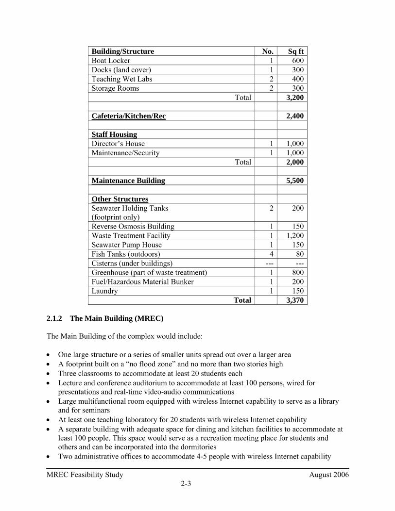
MREC Feasibility Study August 2006 2-3
Building/Structure No. Sq ft Boat Locker 1 600 Docks (land cover) 1 300 Teaching Wet Labs 2 400 Storage Rooms 2 300
Total 3,200
Cafeteria/Kitchen/Rec 2,400
Staff Housing Director’s House 1 1,000 Maintenance/Security 1 1,000
Total 2,000
Maintenance Building 5,500
Other Structures Seawater Holding Tanks (footprint only)
2 200
Reverse Osmosis Building 1 150 Waste Treatment Facility 1 1,200 Seawater Pump House 1 150 Fish Tanks (outdoors) 4 80 Cisterns (under buildings) --- --- Greenhouse (part of waste treatment) 1 800 Fuel/Hazardous Material Bunker 1 200 Laundry 1 150
Total 3,370 2.1.2 The Main Building (MREC) The Main Building of the complex would include: • One large structure or a series of smaller units spread out over a larger area • A footprint built on a “no flood zone” and no more than two stories high • Three classrooms to accommodate at least 20 students each • Lecture and conference auditorium to accommodate at least 100 persons, wired for
presentations and real-time video-audio communications • Large multifunctional room equipped with wireless Internet capability to serve as a library
and for seminars • At least one teaching laboratory for 20 students with wireless Internet capability • A separate building with adequate space for dining and kitchen facilities to accommodate at
least 100 people. This space would serve as a recreation meeting place for students and others and can be incorporated into the dormitories
• Two administrative offices to accommodate 4-5 people with wireless Internet capability

MREC Feasibility Study August 2006 2-4
• Five small offices equipped with computers with wireless Internet capabilities • A small museum and preservation room to isolate preservatives • An interactive interpretation center with aquaria for public viewing of local species and
ecosystems • A small data management room • Two climate-controlled dry labs equipped with pH meters, balances, centrifuges, research-
quality compound and dissecting scopes • Dorms separate from the main building for thirty students and ten visiting scientists with
wireless Internet capability • A small GIS laboratory with plotters and a satellite receiving station • Parking for staff and the public on site of approximately 30 to 45 spaces, depending on the
site layout 2.1.3 Wet Labs According to the JICMS, the wet labs and associated teaching spaces should be separate from the main building complex. JICMS also recommended that the wet labs be close to the marine operations (boats, diving) and to the main building for convenience and to assure the shortest possible seawater lines. In addition, the wet labs would include: • Three small research/teaching wet labs with clean seawater available with fume hoods for
handling and storing hazardous materials • Four outside seawater wet tables with shading • Two small air conditioned computer rooms equipped with at least six computers and wireless
Internet capability • Four to five holding tanks for live organisms 2.1.4 Marine Facilities The marine facilities would include: • Docks with space for two medium-sized vessels (25-45 ft) and four small boats (outboards),
equipped with 110/220v power • Mooring space for 4 to 6 small boats • Space for a diving boat (45ft) equipped with HP compressor, diving ladder and emergency
O2, and two smaller dive boats • Two-lock decompression chamber 60 inches in diameter in a closed building • Full dive locker with 20 sets of gear and two HP/HV compressors and dressing area • Small boat and diving gear maintenance shop • Two small boat trailers and vehicles to reach other regions of study on the island
MREC Feasibility Study August 2006 2-5
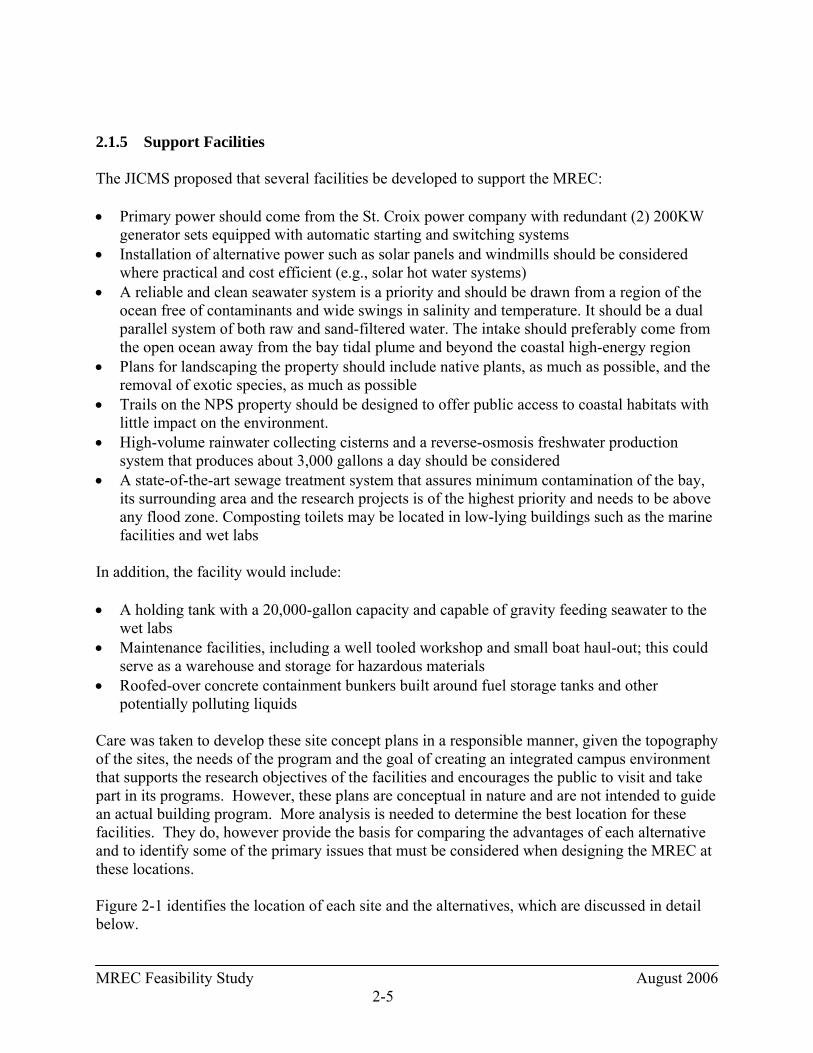
2.1.5 Support Facilities The JICMS proposed that several facilities be developed to support the MREC: • Primary power should come from the St. Croix power company with redundant (2) 200KW
generator sets equipped with automatic starting and switching systems • Installation of alternative power such as solar panels and windmills should be considered
where practical and cost efficient (e.g., solar hot water systems) • A reliable and clean seawater system is a priority and should be drawn from a region of the
ocean free of contaminants and wide swings in salinity and temperature. It should be a dual parallel system of both raw and sand-filtered water. The intake should preferably come from the open ocean away from the bay tidal plume and beyond the coastal high-energy region
• Plans for landscaping the property should include native plants, as much as possible, and the removal of exotic species, as much as possible
• Trails on the NPS property should be designed to offer public access to coastal habitats with little impact on the environment.
• High-volume rainwater collecting cisterns and a reverse-osmosis freshwater production system that produces about 3,000 gallons a day should be considered
• A state-of-the-art sewage treatment system that assures minimum contamination of the bay, its surrounding area and the research projects is of the highest priority and needs to be above any flood zone. Composting toilets may be located in low-lying buildings such as the marine facilities and wet labs
In addition, the facility would include: • A holding tank with a 20,000-gallon capacity and capable of gravity feeding seawater to the
wet labs • Maintenance facilities, including a well tooled workshop and small boat haul-out; this could
serve as a warehouse and storage for hazardous materials • Roofed-over concrete containment bunkers built around fuel storage tanks and other
potentially polluting liquids Care was taken to develop these site concept plans in a responsible manner, given the topography of the sites, the needs of the program and the goal of creating an integrated campus environment that supports the research objectives of the facilities and encourages the public to visit and take part in its programs. However, these plans are conceptual in nature and are not intended to guide an actual building program. More analysis is needed to determine the best location for these facilities. They do, however provide the basis for comparing the advantages of each alternative and to identify some of the primary issues that must be considered when designing the MREC at these locations. Figure 2-1 identifies the location of each site and the alternatives, which are discussed in detail below.

MREC Feasibility Study August 2006 2-6
2.2 DESCRIPTION OF ALTERNATIVES Alternative 1: East Site Description of Site On the eastern side of Salt River Bay are approximately 70 acres of land owned by the NPS, adjacent to the Estate Judith’s Fancy residential community. This site has a 10-foot-deep manmade lagoon (Dredged Basin) that opens into Salt River Bay and is about 300 meters from the primary Bay inlet and the open ocean. A partially constructed hotel is located on a dredge spoil peninsula adjacent to the lagoon. The site also features a large hill about 130 feet above sea level that provides a panoramic view of the ocean and the bay. The site is accessed by private paved roads that traverse a residential neighborhood to the south and east of the NPS-owned property. The circuitous and narrow character of these roads, as well as their private control, necessitates that more direct road access be developed if the MREC is to be built at this site. Although the initial concept for this plan assumed road access through the Estate Judith’s Fancy residential community, it was determined at the Choosing by Advantages work session that an unused north-south road alignment connecting to the property from the south should be improved to provide this access if the MREC were built here. Another option for access would be to provide a ferry connection from the Salt River Bay Marina to the East Site. Site Concept Plan The team began the site analysis by examining the dredge soil peninsula. Four factors led the team to conclude that the peninsula was inappropriate for construction: the fact that water surrounded it on three sides, its location within a floodplain, the fact that it was made of dredged materials and its susceptibility to seismic activity. Consequently, the team focused development activity on the east side of the lagoon. In this plan, the building facilities would be constructed along an access road that would run directly east of the lagoon. The wet labs and maintenance building would be constructed about 50 feet from the edge of the lagoon, and mangroves and native plant species would be reforested along the water’s edge. A parking area for cars and boat trailers would be located adjacent to the maintenance building and the wet lab. The parking facility also would serve the boat dock and boat launch. The land east of the road, wet lab and maintenance building could be reforested to provide a buffer between the facilities and the nearby homes.
MREC Feasibility Study August 2006 2-7
At the end of the road, a boat launch would be provided adjacent to boat docking facilities. A pipe for the seawater intake system would be constructed from the wet labs, underground to the lagoon on the seabottom and then under the dredge soil peninsula into the bay. North of the wet lab and up the hill would be a parking lot for the MREC. The visitor center would be adjacent to the parking lot. The MREC building would be oriented east-west, with dormitories and a cafeteria and maintenance building located north of it. Windmills could be constructed on a ridge north of the maintenance building to provide wind power. The seawater intake line would be routed under the peninsula to an appropriate intake point in the bay. The water tanks at the lagoon would be connected by pipeline to the MREC so the seawater will be available at the center for experimental work. Depending upon the location of the pipeline, pumps may be needed to get the seawater to the MREC. The facilities would be constructed in a location and manner not to disturb the nearby Columbus Landing site. They also would be constructed to minimize impacts to adjacent residents and to the mangroves/wetlands. Figure 2-2 depicts the characteristics of the East Site Concept Plan. NOTE: Upon completion of the Feasibility Study, the concept plan for the East Site was revised to move the boat launch, water tanks and boat dock to the north end of the lagoon and the vehicle and boat maintenance workshop to a location adjacent to the access road. This workshop would be screened so as to minimize its visual impact. The revised concept plan is shown on Figure 2-2a. Characteristics of the Site Concept Plan • This site would have a visual impact on the bay. • The facilities would be located on the inland slopes of the main hill and slightly behind a
minor spur of the hill. No development is proposed for the top of the hill. • The visitor center would be located so that is oriented for views across the bay of the
Columbus Landing site. It also has an oblique view of the ocean. • The visitor center and MREC facilities would be separate and have separate parking
facilities. • A sidewalk connecting the MREC development to the visitor center would continues to the
wet lab, maintenance building, and boat dock. This sidewalk would continue down the hill and have views of the bay, forming a major pedestrian connection throughout the site.
• The MREC building would look over the visitor center to the bay and have views of the ocean.
• The dormitories would be bungalow-style structures, each with balconies having unobstructed views to the bay and oblique views to the ocean.
• The cafeteria would be in very close proximity to both the MREC building and the dormitories but would not have significant views.
• Most buildings and parking would be sited so that grades would not be a major difficulty. • The ridge-top location would result in more breezes and may allow for the use of wind
power, although such a use would contribute to the visual impact of the development.

MREC Feasibility Study August 2006 2-8
• Most buildings are located outside the flood zone. The wet lab and maintenance building are located within the flood zone.
• Reforestation would partially screen the site from surrounding development. Buildings on the site would be oriented so that the surrounding development does not have a significant effect on the site.
Alternative 2: South Site Description of Site The former West Indies Marine Research Laboratory is located on eastern shore of this site. The site is located between Triton Bay and Sugar Bay at the headwaters of Salt River Bay. This privately-owned, 58-acre parcel includes several structures and a bulkhead on the water for docking boats. Road access is limited to a private road that winds north to the site from the nearest public road. Site Concept Plan The MREC buildings would be constructed along the existing road. The MREC itself would be located about 500 feet from the water’s edge at a bend in the road. The road would continue along the western and northern sides of the building and continue to a drop-off area at the boat dock adjacent to the visitor center at the shoreline. East of the MREC would be a parking lot connecting back to the road, as well as dormitories and cafeteria building in a line roughly parallel to the MREC parking lot. The boat dock and visitor center would be connected to the wet lab and maintenance building by a path along the water. A second road south of the visitor center access road would be constructed to connect to a boat launch at the bay and to provide separate access to the wet lab and maintenance building. The seawater intake system would connect directly from a pipe in the bay to the wet lab. This site has little potential for wind power as it lacks an appropriate ridge and is further inland. This plan is contingent upon the acquisition of the property by the NPS. Road access is circuitous and would have to be improved to support the public use of the site. Figure 2-3 depicts that characteristics of the South Site Concept Plan. Characteristics of the Site Concept Plan • This site would have the least visual impact on the Salt River Bay. This is especially true for
views looking from outside the bay. The visitor center would be located in an existing building and would not significantly add additional impact to the view to the site from the bay. The MREC and other buildings would be screened by topography and vegetation.
• This site is in a more protected location than the other two sites and may be less susceptible to storm damage.

MREC Feasibility Study August 2006 2-9
• The low lying nature of the site and its proximity to wetlands would result in fewer breezes and potentially more mosquitoes and other nuisance insects.
• The visitor center could have views of the bay, but might not have direct views of the Columbus Landing site. Constructing a new building could create more potential for views, but would most likely increase visual impact. Views could also be increased by selective clearing of vegetation.
• The visitor center and MREC facilities are separated. • The MREC building, cafeteria, and dormitories are in proximity to one another. • The dormitories are in separate bungalow style buildings, each having balconies and
unobstructed views to the mangrove area. • The cafeteria deck has a view of mangrove area. • The wet lab and maintenance building are accessible by sidewalk and separate road from the
MREC facilities. • The wet lab and maintenance building would have a boat launch and would be located near
the boat dock. • The visitor center would have a drop off area that would provide a drop off for the boat dock. Alternative 3: West Site Description of Site This alternative encompasses two sites: the NPS Visitor Contact Station and the Salt River Bay Marina. The NPS Visitor Contact Station is located on the northwest shore of the bay. The site is made up of several parcels of approximately 6.0 acres in all and includes a house, guest quarters, accessory structures and a beach. The marina hugs the shoreline on approximately 14 acres along the western edge of the bay. This property is privately owned and includes buildings used for maintaining, constructing and painting boats, as well as for office space. Docking facilities are located along the bay. Several mooring buoys are available in the bay. Site Concept Plan As noted above, the team analyzed both sites and determined it was appropriate to combine them into one alternative. Most of the building program would be located on the Visitor Contact Station site. This would include the main MREC building, a visitor center and cafeteria building, and dormitories converted from the existing residential buildings. At the marina would be located the maintenance building and wet labs, either constructed as new or located in an existing building. New docking facilities would need to be constructed since the existing docking facilities would be allowed to continue to function as a commercial marina due to the limited number of boat slips on the island. The seawater intake system would connect from the Visitor Contact Station site. Water holding tanks could be located on the Visitor Contact Station site or at the Marina, with a pipe connecting the MREC and wet labs along the public right-of-way.
MREC Feasibility Study August 2006 2-10
In this plan, it is assumed that the NPS would acquire most, if not all, of the parcels adjacent to the Visitor Contact Station to minimize impacts of the site on the existing and potential uses and vice versa. It should be noted that developing these parcels could create a visual impact, as both the Visitor Contact Center and MREC would be visible from the bay and the ocean; however, it does not detract from the cultural landscape of the bay as it is well elevated above the bay. This alternative also assumes that the marina owners would be willing to sell the marina to the NPS. If this is not so, this alternative is likely not feasible. Figure 2-4 depicts the characteristics of the West Site Concept Plan. Characteristics of the Site Concept Plan • The visitor center would be located in close proximity to the Columbus Landing site,
providing direct views to the location and allowing for pedestrian access to the site. • The visitor center parking could allow for the removal of parking and direct road access at
the Columbus Landing site. Access would be limited to pedestrians. A very small parking area could be included adjacent to the Columbus Landing site to serve disabled persons.
• The visitor center and deck would have views of the Columbus Landing site, Salt River Bay, and oblique views of the ocean.
• The main sidewalk along the parking lot would terminate with a view through the MREC facility courtyard of the ocean beyond. The view would be through an arcade connecting the MREC buildings.
• The sidewalk that crosses the road would have a terminal view through an arcade of Salt River Bay and the interior of the island. The other end would terminate with a view of the ocean.
• The sidewalk between the dormitories and the cafeteria would have an open view of the ocean.
• When one turns onto the entry drive, the road is on axis with the visitor center. The view is framed by trees on either side, which then opens up.
• The dormitory building would have an open vista of the ocean and bay on three sides. The patio overlooks the ocean.
• The cafeteria and cafeteria patio would have an open vista of the ocean. • The main MREC building and deck would have views of Salt River Bay and the ocean. • The dormitories and MREC facilities are in close proximity to one another. Both of these are
also convenient to the cafeteria building. • The visitor center is slightly set apart from the MREC facilities. The cafeteria is located
close enough to allow for convenient pedestrian access. • A drop-off area provides access to both the MREC facility and the dormitories. • Most buildings and parking are sited so that grades should not be a major difficulty. • The ridge-top location would result in more breezes and may allow for the use of wind power
although such a use would contribute to the visual impact of the development. • Access to the wet lab and maintenance building would be by vehicle or pedestrian sidewalk. • All buildings are located outside the flood zone. The wet lab and maintenance building could
be within the flood zone depending on the final layout and design of these facilities.
MREC Feasibility Study August 2006 2-11
• The site’s location on a ridge top results in visual impacts. However, most facilities would be located on the inland side of the ridge to reduce the visual impact from the ocean. The very top of the hill would be left undeveloped.
• Reforestation would screen views of the development to the west and help frame other views. A balance between maintaining important views and reestablishing native plants would be a priority.
MREC Feasibility Study August 2006 3-1
3. EXISTING CONDITIONS AT SARI 3.1 INTRODUCTION Chapter 3.0 describes the existing environmental conditions of three sites at SARI that would be affected if the alternatives under consideration were implemented. This chapter describes the existing environmental conditions within SARI generally, and to the extent possible, of the three site sites under consideration for location of the proposed Marine Research and Education Center. A detailed description of the sites can be found in Chapter 2. East Site: The irregularly shaped site resides on the northeast shore of Salt River Bay, west of Estate Judith’s Fancy. The site consists of several contiguous parcels of land totaling approximately 70 acres, which the Park Service currently owns. The site is unimproved with the exception of an old unfinished hotel that was abandoned in the 1970’s (Versar 2000). South Site: This site was the location of the former West Indies Marine Research Laboratory where operations for the NOAA Undersea Research Program saturation diving facilities (Hydrolab and Aquarius) were once based. It is located between Sugar Bay and Triton Bay. The site consists of a single plot of land totaling approximately 58 acres. The site currently includes a couple of structures and a bulkhead along the water for docking boats. West Site: This site consists of two non-contiguous areas. One area includes the Salt River Bay Marina, a thin, sinuously shaped property that is located along the western shoreline of Salt River Bay. This area consists of a single plot of land totaling approximately 14 acres. It includes several buildings used for boat maintenance, painting, constructing boats, office space, and parking lots for marina guests. The shoreline consists of long sections of steel bulkheads with docking facilities. Several mooring buoys are available in the bay. The other area that comprises the West Site is the NPS Visitor Contact Station. This roughly rectangular shaped area resides on the northwest shore of Salt River Bay. It consists of several contiguous plots of land totaling approximately 6.0 acres that was donated to the Park Service. The Visitor Contact Station includes a split-level house, guest quarters, several other structures including a well house, and a community beach (EA 2005). This chapter should not be considered a comprehensive description of all aspects of the environment within or surrounding the park. The following description of existing environmental conditions provides a better understanding of planning issues and establishes a benchmark by which the magnitude of potential environmental impacts of alternatives can be compared. Most of the information used to describe the existing environmental conditions in this chapter was taken from the NOAA Technical Memorandum entitled An Ecological Characterization of the Salt River Bay National Historical Park and Ecological Preserve, U.S. Virgin Islands (Kendall et. al 2005), unless otherwise stated.
MREC Feasibility Study August 2006 3-2
3.2 PHYSICAL FEATURES The physical environment at SARI, including geology/soils, land cover and land use, bathymetry/currents, water quality, floodplains, air quality, noise, climate, and hydrology is described in the following sections. 3.2.1 Geology/Soils 3.2.1.1 Geological Formations of the Salt River Watershed Human activity with SARI, particularly dredging to enhance boat access, and commercial and residential construction has affected the geologic and soil resources. Dredging specifically has altered the natural contours of the bays in the watershed. Salt River Bay The geological formations of Salt River provide the foundation for the region’s ecology. Limestone in the south of SARI and a variety of different rock types in the northern portion of the drainage comprise the two main geologic formations. Most of the drainage basin and area south of SARI is underlain by the Miocene Kingshill Formation. The northern portion of the basin including the exposed bedrock around the shoreline of SARI consists of the Cretaceous Judith’s Fancy Formation. The Kingshill Formation is primarily limestone whereas the Judith’s Fancy Formation is a mixture of volcanoclastics, sandstone, and mudstone, and contains a few small dioritic or gabbroic intrusions. The main streambed of Salt River consists of eroded surface sediments. Sediments in Sugar and Salt River Bay consist of two distinct types. Carbonate sediments with course grain size are generally located along the sides of Sugar Bay and the main body of Salt River Bay, where water depth is less than approximately 2 meters. Finer sediments such as terrigenous silt and clay with low carbonate content are primarily found in the southernmost reaches of Sugar Bay and in the deep, central area of Sugar Bay and Salt River Bay. In addition to these differences in sediment type according to water depth, there is also a gradual change from mostly terrigenous sediments in the southernmost reaches of Sugar Bay to carbonate marine sediments toward the mouth of Salt River Bay. The carbonate sediments are derived from calcareous algae as well as a variety of benthic organisms such as mollusks, foraminifera, and echinoids. Terrigenous sediments originate primarily from upland erosion and subsequent transport to the bays by freshwater runoff down the Salt River streambed as well as from a few outcrops exposed to wave action. The abundance of terrigenous sediment declines abruptly seaward of the reef at the mouth of Salt River Bay. This indicates that the reef is generally an effective depositional barrier that separates bay from canyon and shelf sedimentation. Overall, the shelf and canyon environments of SARI are subject to sedimentary processes largely separate from those inshore of the bay mouth. The prevalence of carbonate sediments in the bays in areas with water depth less than 2 meters is due in part to the high turbidity of the system. The calcareous algae, responsible for much of the

MREC Feasibility Study August 2006 3-3
carbonate sediments in the bay, do not receive sufficient light in water depths more than 2 meters. Waters become progressively less turbid in the bay from the southernmost reaches of Sugar and Triton Bays toward the reef at the mouth of Salt River Bay (see Water Quality, Section 3.2.5). East Site The sediments from the northern facing shores, flanking the mouth of the bay on the east shore consist of carbonate due to the shallow water depth (less than 1 meter). The Salt River Bay sediments from the East Cove, the area west of the abandoned Marina Cut, and the dredged basin consist of carbonate sediments in the shallow water areas near shore and terrigenous sediments in the deeper areas offshore (approximately 2 to 4 meters). South Site The sediments from Salt River Bay at the South Site consist of carbonate sediments close to shore and terrigenous sediments in the deeper areas offshore. West Site The sediments from Salt River Bay at the Salt River Bay Marina consist of carbonate sediments close to shore and terrigenous sediments in the deeper areas offshore. The sediments from the northern facing shores of the Visitor Contact Station, flanking the mouth of the bay consist of carbonate due to the shallow water depth (less than 1 meter). Salt River Canyon The sediments of the shelf and canyon outside the bays are carbonate, primarily a product of bio-erosion of corals. The dominant longshore drift in the area is east to west, driven by the trade winds. As a result, the shelf to the east serves as the major source of sediment to the floor of Salt River Canyon. Large quantities of material move from the shelf with the longshore current, down the east wall of the canyon to settle on the canyon floor. Carbonate sediments produced on the wall and shelf to the west of the canyon are either carried away westward by longshore currents or are rapidly channeled to the canyon floor through the numerous vertical cuts in the reef along the west wall. Consequently, the west canyon wall receives much less sediment than does the east wall. Carbonate sediments produced on the shelf and wall are primarily a result of bio-erosion of corals due to parrotfish and other rasping grazers. These sediments are also the result of the physical breakdown of the reef. The east to west longshore drift and associated transport of these sediments has influence on the morphology and benthic communities of the east versus west walls of the canyon. On the east slope, large quantities of sediment transported from the shelf into the canyon discourages extensive growth of hard corals (see Reefs/Hardbottom, Section 3.4.2). In contrast, more vigorous coral growth and a steeper wall formation are located on the west wall, where less sediment is received (see Currents, Section 3.2.4).
MREC Feasibility Study August 2006 3-4
3.2.1.2 Seismicity IRF (1993) reported that as a result of convergence between the Caribbean and North American tectonic plates, the Virgin Islands are located in one of the most earthquake prone regions of the world. Strong seismic shocks were recorded for the Virgin Islands in 1777, 1843, 1867, and 1918. Destructive tsunamis occurred in the Virgin Islands in 1867 and in 1918; the latter resulted in 116 deaths and economic losses estimated at $4 million (in 1918 dollars) [US 1984] (IRF 1993). The 1867 tsunami was reported to have a wave height of 27ft above sea level (Geoscience Associates 1984). Potential human and economic losses for a similar event occurring today would be several orders of magnitude higher (IRF 1993). There is a high seismic potential for a major fault rupture in the Puerto Rico Trench north of Puerto Rico and the Virgin Islands (USGS 1984). The Virgin Islands are classified as “Zone 4” for earthquake vulnerability, the highest damage zone and the same classification given to many parts of California (Brower and Beatley 1988). Waterfront areas that have undergone construction on filled (reclaimed land) land are vulnerable to impacts from earthquakes (IRF 1993). The peninsula between the East Cove and the Dredged Basin located within the East Site was filled with dredged material from the basin. These areas have a greater chance of liquefaction and ground settling. Buildings constructed on loose alluvial or man-made fill soils along the waterfront are at risk of destruction should an earthquake occur (Geoscience Associates 1984). 3.2.1.3 Soils of SARI There are a total of 11 National Resources Conservation Service (NRCS) soil types of varying grade (slope) within the Park (Table 3-1). The majority of top soils are approximately 0-9 inches deep, consisting of gravelly, sandy, stony, or clay loam. These include the Arawak, Cramer-Victory, Glynn, Solitude, and Victory-Southgate soil series. Tidal areas around Sugar Bay and Triton Bay are flat (0-2% grade) sections of sandy clay loam and black muck (fine, well decomposed organic soil) from the Sandy Point/Sugar Beach series, and patches of gravelly fine sandy loam from the Solitude series. These are frequently flooded by the waters of the estuary, and typically contain some salt. The Salt River floodplain south of the Sugar Bay tidal region consists of clay loam from the Carib series, frequently flooded by freshwater from the upland watershed. Beaches are located on the northern facing shores, flanking the mouth of the bay. The majority of soils within the park are not well suited for crops.
MREC Feasibility Study August 2006 3-5
Table 3-1. Soils found within SARI(a)
Soil Series Soil Description Total Area
(acres) Arawak Gravelly loam, very stony 90.93 Carib Clay loam, frequently flooded; slightly
saline to non-saline 39.78
Cramer-Victory Complex Gravelly clay loam and loam (patchy) 83.77 Glynn Gravelly loam, rarely flooded 14.08 Jaucas Sand on calcareous coastal beaches, rarely
flooded 2.47
Pitts, Quarries Areas where rock, gravel, or sand have been removed by humans
0.25
Redhook Extremely stony sand, rubbly, rarely flooded
5.68
Salt Flats Flooded, unvegetated areas of saline flats, saline marshes and salt ponds
1.73
Sandy Point and Sugar Beach Frequently flooded, sandy clay loam and black muck (patchy)
60.29
Solitude Gravelly fine sandy loam, frequently flooded; slightly to strongly saline
37.56
Southgate-Rock Outcrop Complex
Gravelly loam, extremely stony surface, exposed bedrock
1.24
Ustorthents Altered from natural state by human activity
18.78
Victory-Southgate Complex Very stony loam and gravelly loam (patchy)
51.15
(a)1998 USDA/NRCS Soil Survey of the US Virgin Islands Dredge and fill activities have taken place at SARI since the 1960’s in various locations around the bays to create marinas and improve boat access. This dredging resulted in dramatic alterations to the natural shape of the shoreline and bathymetry of the bays. Dredge disposal from these activities were deposited in several locations around the bay perimeter, creating new land and influencing soil characteristics. East Site The eastern northern facing shore consists of fine sand formed from calcareous deposits, classified as the Jaucas series. Spoils from dredging the bay were deposited around the Dredged Basin and the soil there contains elevated amounts of salt. Dredge fill can also be found on the peninsula between East Cove and the Dredged Basin, on the peninsula west of the Abandoned Marina Cut, and east of the salt pond.
MREC Feasibility Study August 2006 3-6
South Site The northwestern mouth of Triton Bay and the eastern shore of Sugar Bay is composed of Jaucas series sand. West Site Spoils from dredging the bay were deposited along the western side of the bay just north of the Salt River Bay Marina up to the Columbus Landing Site. The beach located adjacent to the Visitor Contact Station is calcareous, with a surface layer composed of large weathered coral pieces, characteristic of the Redhook series. 3.2.2 Land Cover and Land Use 3.2.2.1 Land Cover Unvegetated soil covers most of the non-aquatic areas of the park, approximately 5 acres, sand/beach covers the second largest area, approximately 2.5 acres, and bare rock covers 1.5 acres (Figure 3-1). Inland aquatic areas account for 6.2 acres, mostly from five saltwater ponds (5.9 acres). At least two of the ponds are man made; one on the northeastern side of East Cove, and the Abandoned Marina Cut. A single freshwater pond is located on the southeastern side of Sugar Bay, covering approximately 0.25 acres. Unpaved roads cover 7.2 acres of the park and are located primarily in the northwestern, central areas of the park, and around the dredged basin. Residentially developed areas account for approximately 4.2 acres. Dwellings are scattered in the developments of Estate Salt River on the northwestern side of SARI, Estate Morningstar in the southwest quadrant, Estate Montpellier on the peninsula between Triton and Sugar Bay, and Estate Judith’s Fancy northeast of the Park. Commercial development, consisting of the Salt River Bay Marina and the uncompleted resort west of Estate Judith’s Fancy, encompasses 3.5 acres, concentrating primarily along the western length of the park. The uncompleted resort is within the parcel of land purchased by NPS and is not currently used for commercial development, but is an abandoned structure. Most of the natural and semi-natural cover in the park consists of forest (262 acres). Approximately 83% of the forest canopy is closed, 16 % is open, and 1% is sparse. The bulk of forest cover is located in the southern inland portions of the park. Smaller patches of forest exist in the northeastern portions of the park, between the Columbus Landing Site and the Salt River Bay Marina, and along the northwestern ocean front shores. Due to the topography and relatively low rainfall, dry forest communities are characteristic of these areas, including semi-deciduous forest (confined to riparian corridors where additional moisture is available from runoff). Vegetated fields covered approximately 35 acres, the second most extensive natural and semi-natural cover in the park. Shrubs and bushes account for approximately 27 acres, or 8% of the vegetated areas. Most of the shrub and field cover is concentrated in the northwestern portions of the park.
MREC Feasibility Study August 2006 3-7
The Salt River watershed drains approximately 3000 acres, and although the “river” flows only intermittently, as a result of precipitation, a freshwater wetland is located south of the mangrove line in the Salt River Gut, prior to discharging in the mangrove marshes. Vegetation in the freshwater wetland is characterized by cattails (Typha domingensis). The swamp fern (Achrosticum danaefolium) is also occasionally found in this wetland. Table 3-2 details the amount (in acres) and type of land cover within each site being considered for the MREC. The land use within each site is discussed below.
Table 3-2. Land Cover (in acres) within Each Site Location
Site Locations
Land Cover East Site South Site West Site (Salt River Bay Marina)
West Site (Visitor Contact Station)
Forest 11.98 22.9 2.98 1.36
Mangroves 1.1
26.1 + (5.6 dead
mangroves) 2.79 ---
Shrubs 16.07 1.0 0.68 0.48 Vegetated Field 24.58 0.8 0.48 2.50 Bare Areas (rock/ soil/unpaved roads)
2.77 2.3 0.37 0.02
Inland Waterbodies 1.2 3.2 --- --- Developed (paved roads, residential) 4.13 1.6 3.48 1.28
Total 61.8 63.5 10.8 5.6 East Site The land use within the East Site is predominantly vegetated fields (24.6 acres), shrubs (16.1 acres), and forest (12 acres). Approximately 1 acre supports mangrove habitat, which is mainly located along the inlet and the saltwater pond, which is 1.2 acres in size. Approximately 3 acres is designated as bare areas, which mainly consist of open soil areas. The bare areas are found on the eastern portion of the site. More than 4 acres has been developed within the East Site. Figure 3-1 depicts the land cover for each site. South Site The predominant land cover within the South Site is mangrove habitat (26.1 acres) and forest (22.9 acres). This site also contains a large portion of dead mangroves (5.6 acres). An inland pond accounts for 3.2 acres. Vegetated fields and shrub areas occupy less than 2 acres of the site. Developed areas, mostly residential total 1.6 acres and the bare areas at the site occupy 2.3 acres with an even mixture of soil and unpaved roads. Figure 3-1 depicts the land cover within the South Site.
MREC Feasibility Study August 2006 3-8
West Site The Salt River Bay Marina is primarily classified as developed (3.5 acres). Forests and mangroves each comprise approximately 3.0 acres at the marina. The remaining marina site consists of shrubs (0.7 acres), vegetated fields (0.5 acres), and bare areas (0.4 acres). The predominant land cover within the Visitor Contact Station consists of forest (1.4 acres) and vegetated fields (2.5 acres). Less than ½ of an acre of shrubs make up the land cover at the Visitor Contact Station. Approximately 1.3 acres are designated as developed (mainly residential) at the Visitor Contact Station. Figure 3-1 depicts the land cover within the West Site. 3.2.2.2 Land Use Most of the land within the boundaries of the park is currently zoned for low and medium density residential development, and for waterfront pleasure. Although large residentially zoned areas are owned by various corporations, most have not been developed. A handful of tracts show evidence of attempted development, but appear abandoned in 2000 aerial photography. Additional land use designations in the park include public (owned by federal or local government), and mixed waterfront/pleasure/industrial. The Columbus Landing Site is owned by the Government of the Virgin Islands due to its historical and cultural significance (see Archaeological and Historical Resources Section 3.7). This site contains a prehistoric ceremonial ball court and the 17th century French and Dutch fortification, Fort Sale. The five-acre area has been impacted by vehicular traffic and archaeological looting. A second public area occupies the southeastern leg of the park, extending into the former 11 acre Nature Conservancy Wildlife Sanctuary east of Triton Bay. A former tropical fish hatchery was located in the upper Salt River floodplain. Mangroves were cleared 15 years ago for access to this site. Agricultural activity was evident from the 1992 aerial photographs in the southern Salt River floodplain. East Site The largest development tract is the abandoned resort located west of Estate Judith’s Fancy, on the peninsula between East Cove and the Dredged Basin. Additionally, a number of hotel and marina developments have been attempted or proposed there, from the 1950’s through the mid-1980s. Remnants of these efforts include the degrading remains of a hotel, a large pool, and several small cement pads scattered over the peninsula. There has also been more recent development that has occurred after the 2000 photographs were taken, including a multi-acre area of recently cleared land on the bay side slopes in preparation for residential development. South Site On the western shore of Triton Bay, is the site of the former Fairleigh Dickinson University/West Indies Marine Research Laboratory where operations for the NOAA Undersea Research Program saturation diving facilities (Hydrolab and Aquarius) were once based. The site is occupied by a

MREC Feasibility Study August 2006 3-9
private residence which includes a couple of structures and a bulkhead along the water for docking boats. West Site The Salt River Bay Marina facility includes 36 slips, a boat ramp, restaurant, and dive shop. To the east of the marina is Gold Coast Yachts, a boat construction facility. Together, the marina, boat yard and associated road cover approximately 3.5 acres. The Visitor Contact Station consists of a private residence located on approximately 6 acres of land that was donated to the park. 3.2.3 Bathymetry/Currents 3.2.3.1 Bathymetry A bathymetry map for the Salt River Bay area, Figure 3-2, was based on soundings from NOAA hydrographic surveys. The average mapped depth in Salt River Bay (shoreward of the barrier reef) is 2.2 m with a maximum of 5.4 m found in mid-bay. The average depth within the park boundaries (including Bay and Canyon waters) is 23 m. The deepest part of the Canyon within the park boundaries is 289 m. Using a tidal range of 0.3 m, the total area of the intertidal zone within the bay is estimated to be 5.9 acres (Figure 3-2). Notable bathymetric features within the park boundaries include the canyon walls (the western wall is vertical or overhanging in some places and steeper than the eastern wall), the barrier reef extending across the mouth of Salt River Bay, and the channel through the barrier reef. Dredged and filled areas include the Salt River Bay Marina (West Site), the southern tip of Triton Bay, a channel through the sand bar at the mouth of Triton Bay, the NOAA dock (South Site), and the Abandoned Marina Cut and Dredged Basin (East Site). Salt River, Triton, and Sugar Bays comprise a shallow estuary connected to a deep submarine canyon through a narrow break in the reef crest at the mouth of Salt River Bay. This unique geomorphology has important consequences for the ecology of the Bay-Canyon system and is responsible for the Salt River Bay’s value as a small protected harbor or “hurricane hole”. The narrow channel between the Bay and the Canyon allows for flux of water, nutrients, and marine organisms between these two areas, while protecting the Bay from waves. Areas of the bay where light availability at the substrate level is limited, deeper than 2 m, is unsuitable for submerged aquatic vegetation. The deeper areas of the mid-bay are also subject to anoxia and have limited biological communities. The intertidal zone within the bay is an important foraging area for many wading birds (see Section 3.3.4 Birds). East Site The depth of the eastern northern facing shore is less than one meter. The depth of the Dredged Basin ranges from approximately less than one meter to four meters. Depths in the East Cove and the Abandoned Marina Cut range from approximately less than one to three meters.
MREC Feasibility Study August 2006 3-10
South Site The depth of Triton Bay (east of the site) and Sugar Bay (west of the site) ranges from approximately one to four meters. The northern facing shore ranges from approximately one to two meters. West Site The depth of Salt River Bay Marina ranges from approximately two to five meters. The depth of the beach adjacent to the Visitor Contact Station is less than one meter. Salt River Canyon The east and west canyon walls have contrasting bathymetric profiles resulting from the interplay between longshore currents, sediment transport, and coral growth. Higher sedimentation rates along the eastern wall discourage extensive coral growth and accounts for the occurrence if a more gradual slope on that side of the canyon. Lower sedimentation rates along the western wall result in more vigorous coral growth and the formation of steeper, coral growth and the formation of steeper, often overhanging slopes. Natural processes responsible for changes in bathymetry due to movement of sediments include sedimentation from runoff and removal of sediment from the bays and canyon during storms. Continuing development of the watershed is likely to increase erosion and sedimentation. 3.2.3.2 Currents Water currents within SARI are highly variable and change intensities dramatically depending on local wind conditions. The easterly direction of winds throughout the year maintain an east to west longshore current. This current contributes to the gradual process of transporting shelf sediments into Salt River Canyon down the east canyon wall. Waves generated by the easterly winds refract around the northeastern headland portion of the park and transport water over the reef crest and into Salt River Bay. The Salt River system is not a true estuary and does not display the typical current patterns of an estuary. For the last several decades an ephemeral stream has run into Sugar Bay only during times of heavy rainfall. Typically, the salinity of the bay approximates that of the open Caribbean to the north, or is slightly higher due to evaporation. Currents within SARI are driven primarily by winds and to a lesser degree by tides. Tides in this part of the Caribbean are quite small and exhibit a diurnal pattern (one high and one low per day). Seaward of the reef, a fairly regular east-to-west current is driven by wind and waves breaking on the eastern end of the reef. The dominant trade winds from the northeast push water along the surface over the reef crest into Salt River Bay, before continuing westward. To compensate for the volume of water entering the bay over the reef crest, water exists through the channel connecting the bay and the head of Salt River Canyon. Currents in the canyon are
MREC Feasibility Study August 2006 3-11
highly oscillatory, alternating along the axis of the canyon at irregular intervals. Down canyon currents follow a predictable flow pattern once through the reef. Flow in Triton Bay and Sugar Bays reverse direction with the tides, resulting in exchange of water between the bay mouth and the southern reaches of these inner bays. Despite these general patterns, variable with intensities changing dramatically according to local wind conditions. East Site The eastern northern facing shore has a longshore current from the east. The surface currents in the bay adjacent to the Dredged Basin are wind driven from the east. The surface currents in the bay adjacent to East Cove and the Abandoned Marina Cut have a north to south ebb flood. South Site The surface currents in Triton Bay and Sugar Bay are a north to south ebb flood. West Site The surface currents in the Salt River Bay Marina are flood/ebb to the west. The bottom current pattern is an ebb tide to the east. The surface currents on the beach adjacent to the Visitor Contact Station are wind driven from the east. 3.2.4 Water Quality The most valuable natural resources within the United States Virgin Islands (USVI) are its pristine waters and its distinctive marine and wildlife habitats. The USVI Department of Planning and Natural Resources (DPNR), Division of Environmental Protection (DEP) is responsible of planning and implementing Water Quality Management Projects to ensure the protection of the marine waters of the USVI. Projects include ambient monitoring, revision and review of water quality standards, establishment and support of TMDL projects, and the preparation of water quality inventories. DPNR/DEP has established a Water Pollution Control Program (WPC) that implements and enforces water quality and pollution control laws in the USVI. Under the Clean Water Act (CWA), Section 106, the WPC program monitors marine waters and controls discharges into those waters. The major objectives of this program are to ensure compliance with Territorial water quality standards, build and maintain information management systems for ongoing data analysis and the development of critical environmental parameters, monitor the health of potentially threatened biological communities, prevent degradation of marine waters by reviewing development proposals, and ensure that discharges to the waters of the USVI meet the requirements established by the CWA and the Territorial Pollutant Discharge Elimination System (TPDES) Permitting Program. The WPC program also includes programs such as Ambient Monitoring Program, TPDES, and Virgin Islands Beach Monitoring Program. Under the CWA, Section 303(d), States and Territories are required to develop a list of impaired waters needing Total Maximum Daily Load (TMDLs). An impaired waterbody is one of which
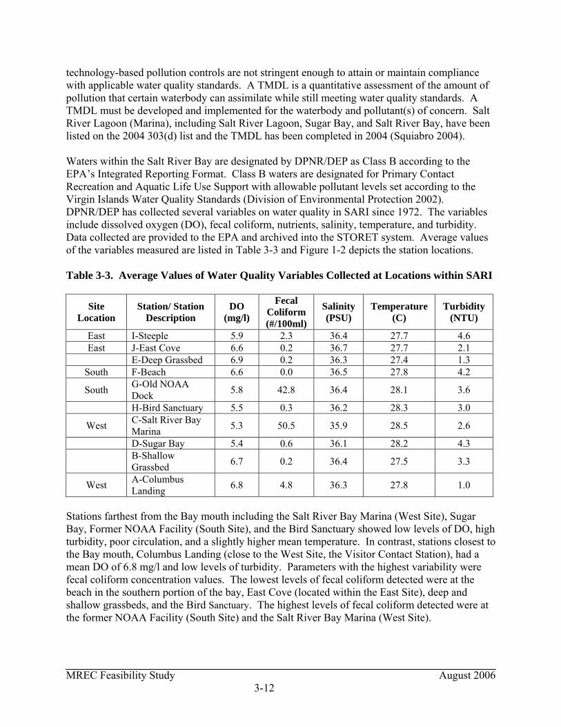
MREC Feasibility Study August 2006 3-12
technology-based pollution controls are not stringent enough to attain or maintain compliance with applicable water quality standards. A TMDL is a quantitative assessment of the amount of pollution that certain waterbody can assimilate while still meeting water quality standards. A TMDL must be developed and implemented for the waterbody and pollutant(s) of concern. Salt River Lagoon (Marina), including Salt River Lagoon, Sugar Bay, and Salt River Bay, have been listed on the 2004 303(d) list and the TMDL has been completed in 2004 (Squiabro 2004). Waters within the Salt River Bay are designated by DPNR/DEP as Class B according to the EPA’s Integrated Reporting Format. Class B waters are designated for Primary Contact Recreation and Aquatic Life Use Support with allowable pollutant levels set according to the Virgin Islands Water Quality Standards (Division of Environmental Protection 2002). DPNR/DEP has collected several variables on water quality in SARI since 1972. The variables include dissolved oxygen (DO), fecal coliform, nutrients, salinity, temperature, and turbidity. Data collected are provided to the EPA and archived into the STORET system. Average values of the variables measured are listed in Table 3-3 and Figure 1-2 depicts the station locations. Table 3-3. Average Values of Water Quality Variables Collected at Locations within SARI
Site Location
Station/ Station Description
DO (mg/l)
Fecal Coliform (#/100ml)
Salinity (PSU)
Temperature (C)
Turbidity (NTU)
East I-Steeple 5.9 2.3 36.4 27.7 4.6 East J-East Cove 6.6 0.2 36.7 27.7 2.1
E-Deep Grassbed 6.9 0.2 36.3 27.4 1.3 South F-Beach 6.6 0.0 36.5 27.8 4.2
South G-Old NOAA Dock 5.8 42.8 36.4 28.1 3.6
H-Bird Sanctuary 5.5 0.3 36.2 28.3 3.0
West C-Salt River Bay Marina 5.3 50.5 35.9 28.5 2.6
D-Sugar Bay 5.4 0.6 36.1 28.2 4.3
B-Shallow Grassbed 6.7 0.2 36.4 27.5 3.3
West A-Columbus Landing 6.8 4.8 36.3 27.8 1.0
Stations farthest from the Bay mouth including the Salt River Bay Marina (West Site), Sugar Bay, Former NOAA Facility (South Site), and the Bird Sanctuary showed low levels of DO, high turbidity, poor circulation, and a slightly higher mean temperature. In contrast, stations closest to the Bay mouth, Columbus Landing (close to the West Site, the Visitor Contact Station), had a mean DO of 6.8 mg/l and low levels of turbidity. Parameters with the highest variability were fecal coliform concentration values. The lowest levels of fecal coliform detected were at the beach in the southern portion of the bay, East Cove (located within the East Site), deep and shallow grassbeds, and the Bird Sanctuary. The highest levels of fecal coliform detected were at the former NOAA Facility (South Site) and the Salt River Bay Marina (West Site).
MREC Feasibility Study August 2006 3-13
3.2.5 Floodplains and Coastal Barriers 3.2.5.1 Floodplains Floodplain Management, Executive Order 11988 (Special Directive 93-4) issued May 24, 1977, directs all Federal agencies to avoid both long- and short-term adverse effects associated with occupancy, modification, and development in the 100-year floodplain when possible. Floodplains are defined in this order as “the lowland and relatively flat areas adjoining inland and coastal waters including floodprone areas of offshore islands, including at a minimum, that area subject to a one percent or greater chance of flooding in any given year.” Flooding in the 100-year zone is expected to occur once every 100 years on average. All Federal agencies are required to avoid building in a 100-year floodplain unless no other practical alternative exists. NPS has adopted guidelines pursuant to Executive Order 11998 stating that it is NPS policy to restore and preserve natural floodplain values and avoid environmental impacts associated with the occupation and modification of floodplains. It goes on to require that, where practicable alternatives exist, Class I actions be avoided within a 100-year floodplain. Class I actions include the location or construction of administration, residential, warehouse and maintenance buildings, non-excepted parking lots, or other man-made features that by their nature entice or require individuals to occupy the site. Class 2 actions are defined as those that would create an added disastrous dimension to a flood event. These include the location or construction of schools, hospitals, fuel storage facilities, museums, and archaeological artifact storage. Excepted actions include those which are functionally dependent on their proximity to water and those relative to park functions that are often located near water for the enjoyment of visitors but do not involve overnight occupation. The 100-year floodplain as mapped by the Federal Emergency Management Agency (FEMA) is depicted in Figure 3-3. Floodplain Zones A, B, and C are located within SARI and are defined in Table 3-4 below. The eastern portion of the East Site is located within the 100-year flood boundary (Zone A); Zone C comprises the remaining area of the East Site. Zone C is designated as an area of minimal flooding. Most of the South Site is located within Zone C; only a small portion on the eastern side and on the western side of the site is located within the 100-year flood boundary (Zone A). The southern portion of the Salt River Bay Marina (West Site) is located within the 100-year flood boundary (Zone A); Zone C comprises the remaining area of the Salt River Bay Marina (West Site). The Visitor Contact Station (West Site) is not located within the 100-year flood boundary; Zone C comprises the entire portion of the Visitor Contact Station.
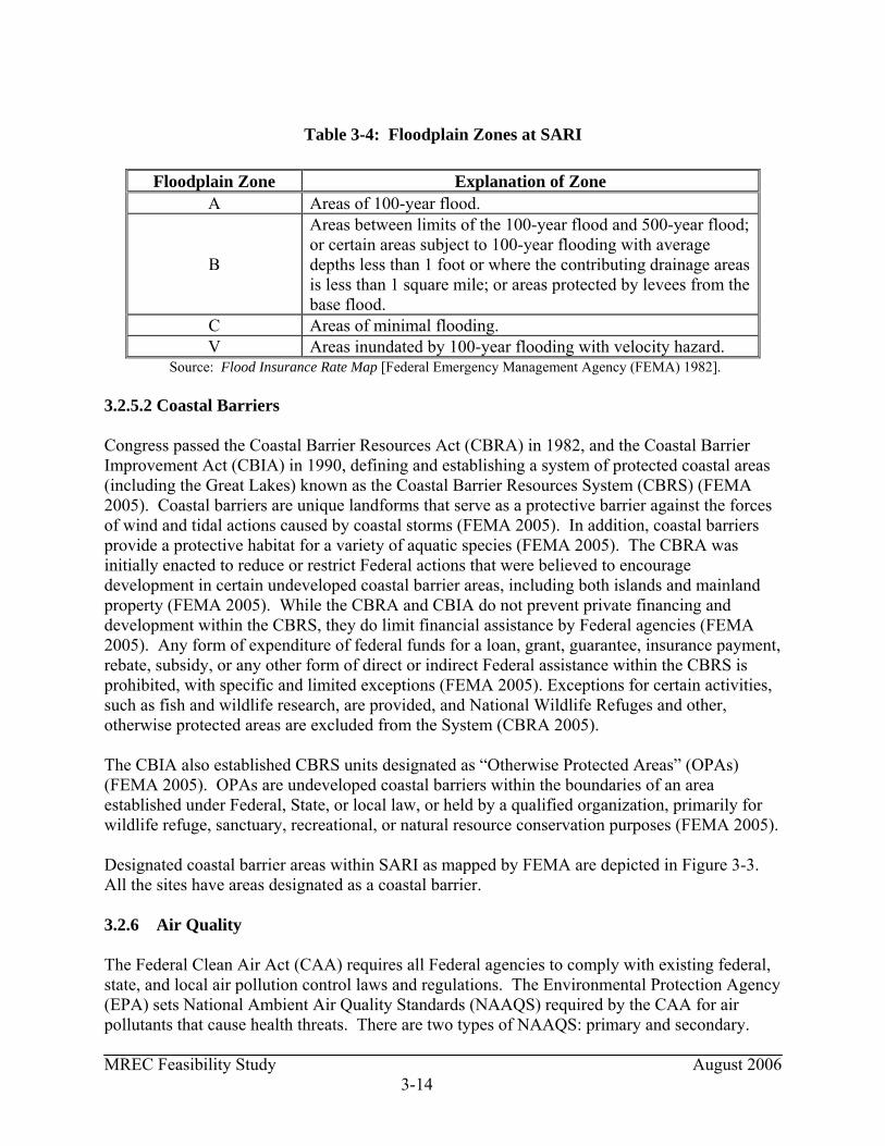
MREC Feasibility Study August 2006 3-14
Table 3-4: Floodplain Zones at SARI
Floodplain Zone Explanation of Zone
A Areas of 100-year flood.
B
Areas between limits of the 100-year flood and 500-year flood; or certain areas subject to 100-year flooding with average depths less than 1 foot or where the contributing drainage areas is less than 1 square mile; or areas protected by levees from the base flood.
C Areas of minimal flooding. V Areas inundated by 100-year flooding with velocity hazard.
Source: Flood Insurance Rate Map [Federal Emergency Management Agency (FEMA) 1982]. 3.2.5.2 Coastal Barriers Congress passed the Coastal Barrier Resources Act (CBRA) in 1982, and the Coastal Barrier Improvement Act (CBIA) in 1990, defining and establishing a system of protected coastal areas (including the Great Lakes) known as the Coastal Barrier Resources System (CBRS) (FEMA 2005). Coastal barriers are unique landforms that serve as a protective barrier against the forces of wind and tidal actions caused by coastal storms (FEMA 2005). In addition, coastal barriers provide a protective habitat for a variety of aquatic species (FEMA 2005). The CBRA was initially enacted to reduce or restrict Federal actions that were believed to encourage development in certain undeveloped coastal barrier areas, including both islands and mainland property (FEMA 2005). While the CBRA and CBIA do not prevent private financing and development within the CBRS, they do limit financial assistance by Federal agencies (FEMA 2005). Any form of expenditure of federal funds for a loan, grant, guarantee, insurance payment, rebate, subsidy, or any other form of direct or indirect Federal assistance within the CBRS is prohibited, with specific and limited exceptions (FEMA 2005). Exceptions for certain activities, such as fish and wildlife research, are provided, and National Wildlife Refuges and other, otherwise protected areas are excluded from the System (CBRA 2005). The CBIA also established CBRS units designated as “Otherwise Protected Areas” (OPAs) (FEMA 2005). OPAs are undeveloped coastal barriers within the boundaries of an area established under Federal, State, or local law, or held by a qualified organization, primarily for wildlife refuge, sanctuary, recreational, or natural resource conservation purposes (FEMA 2005). Designated coastal barrier areas within SARI as mapped by FEMA are depicted in Figure 3-3. All the sites have areas designated as a coastal barrier. 3.2.6 Air Quality The Federal Clean Air Act (CAA) requires all Federal agencies to comply with existing federal, state, and local air pollution control laws and regulations. The Environmental Protection Agency (EPA) sets National Ambient Air Quality Standards (NAAQS) required by the CAA for air pollutants that cause health threats. There are two types of NAAQS: primary and secondary.
MREC Feasibility Study August 2006 3-15
Primary standards set limits to protect public health and secondary standards set limits to protect public welfare, including protection against decreased visibility, and damage to animals, crops, vegetation, buildings and other property and ecological resources. The CAA defines six criteria pollutants. These criteria pollutants are carbon monoxide (CO), sulfur dioxide (SO2), particulate matter with size less than 10 μm3 (PM10), nitrogen oxides (NOX), ozone (O3), and lead (Pb). Volatile organic compounds (VOCs) are not criteria pollutants, but are of interest since they participate in the formation of ozone. The CAA requires that each NAAQS be revised every five years to reflect the most recently available health information. Areas of the U.S. where air pollution levels persistently exceed the NAAQS standards are normally designated as nonattainment areas. A geographic area that meets or performs better than NAAQS is designated as attainment area. A summary of the pollutant characteristics is provided in Table 3-5.
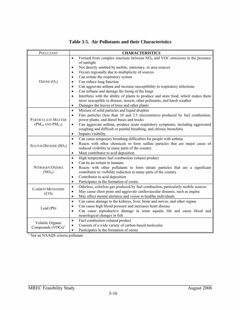
MREC Feasibility Study August 2006 3-16
Table 3-5. Air Pollutants and their Characteristics
POLLUTANT CHARACTERISTICS
OZONE (O3)
• Formed from complex reactions between NOX and VOC emissions in the presence of sunlight
• Not directly emitted by mobile, stationary, or area sources • Occurs regionally due to multiplicity of sources • Can irritate the respiratory system • Can reduce lung function • Can aggravate asthma and increase susceptibility to respiratory infections • Can inflame and damage the lining of the lungs • Interferes with the ability of plants to produce and store food, which makes them
more susceptible to disease, insects, other pollutants, and harsh weather • Damages the leaves of trees and other plants
PARTICULATE MATTER (PM10 AND PM2.5)
• Mixture of solid particles and liquid droplets • Fine particles (less than 10 and 2.5 micrometers) produced by fuel combustion,
power plants, and diesel buses and trucks • Can aggravate asthma, produce acute respiratory symptoms, including aggravated
coughing and difficult or painful breathing, and chronic bronchitis • Impairs visibility
SULFUR DIOXIDE (SO2)
• Can cause temporary breathing difficulties for people with asthma • Reacts with other chemicals to form sulfate particles that are major cause of
reduced visibility in many parts of the country • Main contributor to acid deposition
NITROGEN OXIDES (NOX)
• High temperature fuel combustion exhaust product • Can be an irritant to humans. • Reacts with other pollutants to form nitrate particles that are a significant
contributor to visibility reduction in many parts of the country • Contributor to acid deposition • Participates in the formation of ozone
CARBON MONOXIDE (CO)
• Odorless, colorless gas produced by fuel combustion, particularly mobile sources • May cause chest pains and aggravate cardiovascular diseases, such as angina • May affect mental alertness and vision in healthy individuals
Lead (Pb)
• Can cause damage to the kidneys, liver, brain and nerves, and other organs • Can cause high blood pressure and increases heart disease • Can cause reproductive damage in some aquatic life and cause blood and
neurological changes in fish
Volatile Organic Compounds (VOCs)1
• Fuel combustion exhaust product • Consists of a wide variety of carbon-based molecules • Participates in the formation of ozone
1 Not an NAAQS criteria pollutant.

MREC Feasibility Study August 2006 3-17
The Division of Environmental Protection (DEP) is responsible for managing St. Croix’s air resources and implementing programs designed to ensure that St. Croix’s air quality meets Federal standards. This includes laws and requirements under Title V of the CAA, as well as Virgin Islands Air Pollution Control Act Rules and Regulations (VR&R). Under the Air Pollution Control Program, the DEP is responsible for air quality monitoring, compliance monitoring, permitting, enforcement, and quality assurance within the USVI. Ambient air quality is monitored at various stations around the Territory for PM10, PM2.5, and SO2. There are no monitoring stations located within the vicinity of the sites. The particulate matter stations are located at the FAA emergency pump station within Mannings Bay and the Bethlehem Village Housing in St. Croix. SO2 emissions are conducted in St. Croix at monitoring stations operated by HOVENSA, a local oil refinery. There are no monitoring stations that measure ozone levels at St. Croix (DPNR/DEP 2004). DEP is currently working with EPA to expand the monitoring of local air quality to cover air pollutants not currently monitored. Emission levels monitored in the USVI has slightly increased over the past few years, but have remained below regulatory limits. The increased emission readings are attributed by high trade winds, occasional ash from volcanic activity (on the Island of Montserrat (UK)), and vehicle emissions. Various industrial plant sources have also been associated with intermittent increases in air pollution emissions (DPNR/DEP 2004). The region is in attainment for all six criteria pollutants. One of the requirements of the CAA amendments of 1990 that applies to areas of the country that are nonattainment with the NAAQS is the Conformity Rule, which may apply to an agency or entity that receives federal funding. The rule may require an analysis of the regional air quality impact of any changes or modifications at such facilities. The USVI has insignificant regional air quality impacts and is in conformity with the NAAQS. IRF (1993) reported that air quality within SARI is generally considered to be excellent. The only source of air pollution besides vehicle and boat emissions is from dust generated by boat sanding during construction of boats at Gold Coast Yachts at the Salt Bay River Marina. 3.2.7 Noise Current noise sources in the park are predominantly the result of human activities such as traffic from the local roadways, recreation, and boating activities (i.e., boat motors, boat construction). A secondary source of sound in the park is natural and includes birds and wildlife. Existing noise levels at the park are typical of those normally associated with nearby land uses. There are no constant sources of noise at SARI, except for the Salt River Bay Marina. Typical noises from the marina include the operation of boats and boat construction noises from the boat yard, Gold Coast Yachts. The existing land use in and around the park is zoned for low and medium density residential development, and for waterfront pleasure. Although large residentially zoned areas are owned by various corporations, most have not been developed. A handful of tracts show evidence of attempted development, but are currently abandoned.

MREC Feasibility Study August 2006 3-18
Current noise distractions at the East Site include recreation activities (i.e., ATVs, paintball). There is no noise associated with the South Site. Noise sources at the West Site include activities at the Salt River Bay Marina and human activities at the Visitor Contact Station. 3.2.8 Climate The USVI’s climate is dominated by the trade winds that vary seasonally in magnitude and direction. During the winter season (December through February), the trade winds are at their maximum intensity of 10 to no more than 20 knots from east-northeast. The trade winds typically are reduced during the spring (March through May) and fall (September through November) seasons. During the summer (June through August) season winds increase to moderate intensity and blow from the east or east-southeast. Winds play a dominant role in controlling currents in Salt River Bay and along the bay mouth. The easterly direction of winds throughout the year maintains an east to west longshore currently that plays a principle role in the gradual process of transporting shelf sediments into Salt River Canyon down the east canon wall. Rainfall is seasonably variable in SARI. Typical rainfall for the area is 25 to 45 inches annually and mostly occurs in the late summer and fall wet season. Periods of heavy rain from thunderstorms and tropical storms cause the only occurrences of freshwater flow down Salt River Gut into Sugar Bay. The dry season occurs in late winter and early spring. The average daily temperature ranges from a low of approximately 27 °C in February to a maximum of approximately 29 °C in September. Tropical storms and hurricanes occur between June and November with a peak in abundance in August and September. The intense rain from tropical storms and hurricanes can cause flash flooding in the Salt River watershed. This can temporarily reduce salinity and aggravate already high turbidity levels in the vicinity of Salt River. 3.2.9 Hydrology The Salt River watershed, the second on St. Croix, drains an area of approximately 2,880 acres (4 square miles) via the principal gut, Salt River (IRF 1993) (see Figure 1-2). Salt River Bay is comprised of three embayments: Sugar Bay, Salt River Bay, and Triton Bay. Salt River Bay is a partly-closed embayment, protected from the sea by a barrier reef with a natural channel opening (IRF 1993). Topography in the watershed is varied, and ranges from near flat land behind the mouth of Salt River to steep slopes in both the western and eastern portions of the watershed. Today Salt River is an intermittent stream, although there is historical evidence that it was once a greater and more permanent source of freshwater discharge into Salt River Bay (Hubbard 1989). The hydrology of the watershed has been significantly altered by a combination of clearing, filling, channelization, and road construction (IRF 1993). The cumulative effect of such change has been both a reduction in the frequency of fluvial activity in Salt River, and an increase in stormwater carried sediments which discharge into the bay during episodic, intense rainfall
MREC Feasibility Study August 2006 3-19
events (IRF 1993). The steep slopes combined with poorly drained soils result in short saturation times and relatively high runoff rates (IRF 1993). 3.2.9.1 Groundwater IRF (1993) reports that groundwater resources are significant within the Salt River watershed. The area contains three of the major groundwater areas of the island, and potential yields of as much as 15,000 gallons per day (GPD) in the lower parts of the valley (IRF 1993). Teytaud (1981) reports an important groundwater well field at Estate Concordia, adjacent to Salt River, and a potentially good well field on the Columbus Bay Marina at Estate Morning Star. Sand and gravel alluvium can be found within the Salt River basin, capable of producing 10 to 50 gallons per minute (GPM) of groundwater (NPS 1990). 3.3 TERRESTRIAL RESOURCES This section discusses the terrestrial resources at SARI, including mangroves, wetlands, plants, birds, and mammals. 3.3.1 Mangroves Mangroves contribute many benefits to the SARI ecosystem. Mangroves stabilize coastal sediment, buffer harmful effects of terrestrial runoff, regulate water temperature on tidal flats, and provide habitat for a diverse assemblage of terrestrial and aquatic organisms. They also trap various organic materials, distributing important nutrients to nearby marine habitats. Mangroves also serve as nursery grounds for commercially and recreationally important fishes in the USVI. The mangrove wetlands of the USVI have been impacted by natural and anthropogenic forces. Natural stressors include eustatic sea level rise and coastal erosion, hypersalinity, and hurricanes. Anthropogenic stressors include filling wetlands, drainage, or alteration for development. In addition, sewage and thermal effluent, oil pollution, fire, excessive harvesting, herbicides and pesticides, and sedimentations are also anthropogenic stressors that impact the mangrove wetlands. At one time, the mangrove forests of SARI were considered the best in the U.S. Virgin Islands. The mangroves of SARI represent the only large patch of this forest type along the northwestern quarter of St. Croix. However, the intense winds surrounding Hurricane Hugo depleted much of the old-growth mangrove forests in 1989. Valuable habitat, storm buffers, and mitigators of nonpoint source pollution (NPS) were also lost. In 1992, aerial photographs showed that mangrove forests only covered 43% of their former spread. The old growth mangrove forest within Sugar Bay was destroyed when St. Croix sustained a direct hit by the hurricane. In 1999, the St. Croix Environmental Association began a mangrove restoration project, which replanted 3.5 acres of the lost forest on the western side of Sugar Bay. The survival rate for restoration seedlings is estimated at 80%. Natural re-growth in SARI and has accounted for 2.2 acres of forest since 1992. More recent aerial photographs taken in 2000 indicate that naturally occurring and restoration mangroves now cover 29.7 acres or 54% of the 1988 forest.
MREC Feasibility Study August 2006 3-20
There are three main species observed within SARI. These include black mangroves (Avicennia germanis), white mangroves (Laguncularia racemosa), and red mangroves (Rhizophora mangle). These species are identified by their impenetrable tangle of aerial roots that sprout out from the saltwater. Approximately 1.1 acres of mangroves are located at the East Site. Red mangroves populate the shoreline surrounding the inlet and the salt pond at the East Site, and just northeast of the inlet there is a patch of mixed white and red mangroves that thrive. Approximately 26 acres of mangroves are located at the South Site. Red and black mangroves dominate the shores of both the east and west sides of the South Site. Additionally, 5.6 acres of dead mangroves are located on the southwestern side of the South Site. Red mangroves are the dominant species found at the Salt River Bay Marina (West Site) along the shoreline with some areas mixed with white mangroves. The Visitor Contact Station (West Site) is not located in an area populated by mangroves. Approximately 2.8 acres of mangroves are located at the West Site. Distribution of these mangroves within SARI can be found in Figure 3-4. DPNR is the principal agency requiring permit applications for construction activities in the coastal zone, where wetlands and mangroves usually form. In addition, DPNR comments on Federal permit applications to ensure consistency with the Coastal Zone Management Program (CZMP). The national Coastal Zone Management Act (CZMA) declares that certain areas are of greater significance and requires an inventory and designation of “Areas of Particular Concern” (Section 305(b)(3)). DPNR has provisions for procedures where specific areas may be designated for the purpose of preserving or restoring them for their conservation, recreation, ecological, or esthetic value. 3.3.2 Wetlands Wetlands are defined as areas sufficiently inundated or saturated by surface or groundwater to support vegetation adapted for life in saturated soils. Wetlands include swamps, bogs, marshes, and wet meadows. Wetlands provide a positive contribution to the social, economic, and environmental health of the USVI. Wetlands, in many ways, filter pollutants, nutrients, and sediment, protect water quality in the ocean, lakes, rivers, and streams, they store runoff from storm events, act as shoreline buffers, provide essential habitat for fish, waterfowl, and other animals, and create recreational opportunities. Human induced activities, including building, road construction, dredging, and vegetation removal increases the sediment input and turbidity in Salt River Bay. Increased sediment deposits and turbidity influence vegetation growth. The alteration of lands has the potential to alter water flow to the wetland communities located nearby. Section 404 of the Clean Water Act (CWA) and a number of territorial laws and provisions regulate activities in wetlands. DPNR has currently created a program designated to monitor wetlands in the territory. The objectives of this program are to update mapping in the Virgin Islands Rapid Environmental Assessment (REA) and design and test monitoring tools for wetland characterization in the USVI. DPNR/DEP programs work to protect wetlands by creating a wetlands inventory and maps, by limiting construction or clearing of wetlands, by monitoring water quality as part of the WPC Program and by managing discharges into the near-shore and marine environment through the TPDES and NPS Programs. DPNR/DEP works
MREC Feasibility Study August 2006 3-21
closely with the EPA, the USFWS and DPNR/DFW, the University of Virgin Islands and other agencies to protect our wetlands. The SARI watershed is the third largest watershed on St. Croix and drains approximately 3,000 acres. A freshwater wetland is located south of the mangrove line in Salt River Gut, prior to discharging in the mangrove marshes. Vegetation in the freshwater wetland is characterized by cattails (Typha domingensis) and occasionally the swamp fern (Achrosticum danaefolium). Wetlands within SARI are composed of mangrove swamps and salt ponds. East Site Wetlands at the East Site include mangrove habitat and an inland saltwater pond. A total of approximately 2.3 acres of wetlands are located within this site. The mangrove wetlands are composed of red mangroves along the shoreline surrounding the inlet and just northeast of the inlet there is a patch of mixed white and red mangroves. South Site Wetlands at the South Site include mangrove habitat and an inland saltwater pond. A total of approximately 35 acres of wetlands are located within this site. The mangrove wetlands of the South Site are composed of Red and black mangroves that dominate the shores of both the east and west sides of the site. Dead mangroves account for 5.6 acres of the 35 acres which are located on the southwestern side of the site. The salt pond is approximately 3.2 acres. West Site Wetlands at the Salt River Bay Marina include mangrove habitats. A total of approximately 2.8 acres of wetlands are located within the marina. Red mangroves are the dominant species found at the marina, which occur along the shoreline with some areas mixed with white mangroves. The Visitor Contact Station is not located in an area populated by wetlands/mangroves. 3.3.3 Plants DPNR/DFW is the responsible agent for inventorying and monitoring plants and wildlife according to the Virgin Islands Indigenous and Endangered Species Act. There have been no current surveys of the flora at SARI. A list of plant species observed in SARI can be found in Appendix C of the report, An Ecological Characterization of the Salt River Bay National Historical Park and Ecological Preserve, U.S. Virgin Islands (Kendall et. al 2005). Approximately 262 acres of SARI consist of forest. The bulk of forest cover is located in the southern inland portions of the park. Smaller patches exist in western portions of the park, between the Columbus Landing Site and Salt River Bay Marina, and along the northwestern ocean front shores (Figure 3-1). Vegetated fields cover approximately 35 acres. Most of the shrub and field cover is concentrated in the northeastern and northwestern portions of the park.

MREC Feasibility Study August 2006 3-22
East Site The vegetation of the East Site is composed of vegetated fields (24.6 acres), shrubs (16.1 acres), and forested areas (12.0 acres). Approximately one acre supports mangrove habitat, which is mainly located along the inlet and the saltwater pond (2.8 acres) (See Figure 3-1). South Site The vegetation of the South Site is composed of forest (22.9 acres), mangrove habitat (31.7 acres), and vegetated fields and shrubs (less than 2 acres) (Figure 3-1). West Site The vegetation of the Salt River Bay Marina is composed of mangroves (2.8 acres), forest (3.0 acres), shrubs (0.7 acres), and vegetated fields (0.5 acres). The vegetation of the Visitor Contact Station consists of forest (1.4 acres), vegetated fields (2.5 acres), and shrubs (0.5 acres) (See Figure 3-1). 3.3.4 Birds Specific bird species information for SARI is limited, however, species that occur in habitats elsewhere on the island of St. Croix that are similar to those habitats found within the SARI boundaries are likely to occur at SARI. The Department of Planning and Natural Resources recently completed a Comprehensive Wildlife Strategy (USVI-DPNR 2005) and unless otherwise noted, the information regarding the species and status of birds on St. Croix was found within that document. Additional information on bird species found on St. Croix was obtained from National Audubon Society Christmas Count circle data for 2000-2004 (National Audubon Society Christmas Bird Count Website, accessed on 30 August 2005.) Habitats at SARI provide nesting, roosting and foraging for a wide variety of birds including year round residents, overwintering residents, and species that stop briefly at St. Croix during annual migrations. SARI habitats that support avian species include two freshwater ponds, and approximately 30 acres of sand and mud salt flats, approximately 3 acres of sandy beach and approximately 6 acres of intertidal habitats including mangrove forests. Mangrove habitat at SARI is important to birds as nesting habitat for resident species and foraging habitat for over wintering and migrant species. Shallow water areas adjacent to the intertidal habitat provide foraging areas of shallow mud, sand, and seagrass areas for wading birds like bitterns, herons, egrets and shorebirds. Colonial waterbirds such as seabirds, herons, egrets and terns of a variety of species nest on cays and offshore islands near St. Croix. Many of these species visit St. Croix, particularly while foraging. One of the most common seabirds to visit SARI is the brown pelican (Pelecanus occidentalis; federally listed as endangered in the U.S. Virgin Islands (USFWS Endangered Species web-site accessed 01 September 2005). Cattle egrets (Bubulcus ibis) and little blue herons (Egretta caerulea) currently nest in a 200 square meter rookery within a large patch of red mangroves near the Salt River Bay Marina (West Site). The most abundant wading bird on St. Croix is the
MREC Feasibility Study August 2006 3-23
cattle egret a non-native species originating in Africa. It is proposed for listing as a controlled species because of its predation on the federally endangered St. Croix Ground Lizard, its competition for nest sites with native heron species and its nuisance status as a bird/aircraft strike hazard and in urban roosting/nesting sites on St. Croix. Several wading bird species: least bittern (Ixobrychus exilis) great blue heron (Ardea herodias), great egret (Ardea alba), and snowy egret (Egretta thula) and black-crowned night heron (Nycticorax nycticorax) may use mangrove, shoreline, and wetland habitats for foraging. Of those species least bittern is considered a territorially endangered species. Other wading birds that are widespread include little blue heron, green heron, and yellow-crowned night heron.
DPNR/DFW marked a least tern nesting site that covers approximately 4,000 square meters on the northeast side of SARI west of Estate Judith’s Fancy within the location of the East Site. Least terns (Sterna antillarum antillarum) have been documented nesting at 26 sites on St. Croix in various habitat types including beaches, salt flats, dredge spoil piles, and at the HOVENSA oil refinery. Although, the Caribbean race of least tern is not federally listed, it is listed as endangered in the U.S. Virgin Islands territory (see Section 3.5 for more information on threatened and endangered species). Populations of least tern have declined on St. Croix due to predation by dogs, cats, and mongoose as well as human disturbance. Shorebirds, marsh birds, and waterfowl typically use the open water, shoreline and wetland habitats for nesting and foraging. On St. Croix breeding shorebirds include Wilson’s plover (Charadrius wilsonia), killdeer (Charadrius vociferus), Black-necked Stilt (Himantopus mexicanus), American oystercatcher (Haematopus palliatus), and willet (Catoptrophorus semipalmatus). Wilson’s plover and black-necked stilt both use mangrove areas and nest in salt flats and salt ponds; Wilson’s plover will also nest on beaches. Nesting Wilson’s plover on St. Croix account for approximately 5% of the mainland United States population and is proposed for listing as a territorial species of concern. American oystercatcher is proposed for listing as endangered on the territorial list. According to the comprehensive wildlife strategy, black-necked stilt and killdeer are relatively common on St Croix. Black-necked stilt nest at approximately 14 sites on St. Croix. Marshbirds that breed in freshwater ponds and salt ponds include both least grebe (Tachybaptus dominicus) and pied-billed grebe (Podilymbus podiceps) with the pied-billed grebe being most common on St. Croix. Common rail species found on St. Croix include the common moorhen (Gallinula chloropus) and the American coot (Fulica americana). The common moorhen is a common resident on St. Croix, found in freshwater wetlands and some saline wetlands. The federally endangered Caribbean Coot (Fulica caribaea) breeds intermittently on St. Croix and may hybridize with the American coot. Open water areas and the shoreline may be used for foraging, resting and feeding by waterfowl. The most common species of waterfowl on St. Croix is the white-cheeked pintail (Anas bahamensis). It breeds on cays with salt ponds and at or near a variety of wetlands. Common migrants include blue-winged teal (Anas discors), ring-necked duck (Aythya collaris) and Lesser Scaup (Aythya affinis).

MREC Feasibility Study August 2006 3-24
Resident landbird species include white-crowned pigeon (Patagioenas leucocephala), bridled quail-dove (Geotrygon mystacea), Zenaida dove (Zenaida aurita), rock pigeon (Columba livia), scaly-naped pigeon (Patagioenas squamosa), American kestrel (Falco sparverius), red-tailed hawk (Buteo jamaicensis), mangrove cuckoo (Coccyzus minor), smooth-billed ani (Crotophaga ani), Antillean nighthawk (Chordeiles gundlachii), Caribbean martin (Progne subis), Caribbean elaenia (Elaenia martinica), gray kingbird (Tyrannus dominicensis), green-throated Carib (Eulampis holosericeus), Antillean crested hummingbird (Orthorhyncus cristatus), yellow warbler (Dendroica petechia), bananaquit (Coereba flaveola), black-faced grassquit (Tiaris bicolor), northern mockingbird (Mimus polyglottos), and pearly-eyed thrasher (Margarops fuscatus). White-crowned pigeon and bridled quail dove are proposed for downlisting from territorially endangered to threatened. White-crowned pigeon inhabits mangroves and littoral forests; bridled quail are found in forest interiors both are uncommon on St. Croix. Scaly-naped pigeon, rock pigeon, and zenaida dove are considered game birds on St. Croix however, zenaida dove and rock pigeon are the only species currently hunted. Zenaida doves have an abundant enough population to support hunting; rock pigeons may be hunted at any time as a non-native species. St. Croix is the only island of the U.S. Virgin Islands where the Antillean nighthawk is known to nest. The nighthawk is a species of open areas on St. Croix. Mangrove cuckoo, smooth-billed ani, Caribbean eleania, gray kingbird are all relatively common, and widely distributed. The green-throated carib and Antillean crested hummingbird are fairly common nectar feeders in forests and woodlands. Yellow warblers are found in mangroves, woodland and scrub areas and is the only resident warbler species. Bananaquit, black-faced grassquit, northern mockingbird and pearly-eyed thrasher are also common and widely distributed. Many species of landbirds migrate for the winter from the Arctic and temperate areas of North America to the tropics including the U.S. Virgin Islands and St. Croix. As many as 60 species of migrant Nearctic landbird species have been observed during the winter months in the U.S. Virgin Islands. National Audubon Christmas Count circle data for 2000-2004, the bird checklist for Sandy Point and Green Cay NWR (USGS website accessed 30 August 2005) and the Comprehensive Wildlife Strategy (USVI-DPNR 2005) indicates that common wintering migrants include shorebirds: black-bellied plover (Pluvialis squatarola), semi-palmated plover (Charadrius semipalmatus), greater yellowlegs (Tringa melanoleuca), lesser yellowlegs (Tringa flavipes), spotted sandpiper (Actitis macularia), ruddy turnstone (Arenaria interpres), and least sandpiper (Calidris minutilla). Shorebirds such as those found during the winter bird count are using the tidal areas along the shoreline, mudflats, beaches and sand flats to forage. Nearctic migrant passerine species such as barn swallow (Hirundo rusitca), northern parula (Parula americana), prairie warbler (Dendroica discolor), black-and-white warbler (Mniotilta varia), American redstart (Setophaga ruticilla), northern waterthrush (Seiurus novebracensis), and grasshopper sparrow (Ammodramus savannarum) can be found wintering on St. Croix. 3.3.5 Mammals There are few native terrestrial mammal species that inhabit the USVI. Among the terrestrial mammals, bats are the most common. Approximately 10 species of terrestrial mammals have
MREC Feasibility Study August 2006 3-25
established feral populations, including: domestic cat (Felis domesticus), domestic dog (Canis familiaris), small Indian mongoose (Herpestes javanicus), burro (Equus asinus), pig (Sus scrofa), white-tailed deer (Odocoileus virginianus), goat (Capra hircus), roof rat (Rattus rattus), Norway rat (Rattus norvegicus), and house mouse (Mus musculus) (DPNR/DFW 2005). Within SARI, there are several habitats including beaches, wetlands, shrubland/grassland, and forest (Figure 3-1) that inhabit several terrestrial mammals. Species found within each site are described below. East Site The habitats at the East Site include all four habitat types listed above and shown on Figure 3-1. Mammals that occupy these habitat and have the potential to be observed at the East Site include the small Indian mongoose, donkey (burro), white-tailed deer, red fruit bat (Stenoderma rufum), cave bat (Brachyphylla cavernarum), and rat species (Rattus spp.). South Site The habitats located within the South Site include beaches, wetlands, and forest (Figure 3-1). The mammals that inhabit these habitats include the small Indian mongoose, donkey (burro), white-tailed deer, red fruit bat, cave bat, and rat species. West Site The area within the Salt River Bay Marina is primarily developed. Surrounding the developed area of the marina includes a small portion of shrubs/bushes, bare areas, and small patches of mangrove wetland habitat (Figure 3-1). Within these habitats, the small Indian mongoose, donkey (burro), white-tailed deer, red fruit bat, cave bat, and rat species thrive. The habitat types within the Visitor Contact Station is dominated by shrubland and grassland surrounded by sparse forest (Figure 3-1). The terrestrial mammals that occupy this habitat include the red fruit bat, cave bat, small Indian mongoose, white-tailed deer, and rat species. 3.4 AQUATIC RESOURCES This section discusses the aquatic resources at SARI, including seagrasses, reefs/hardbottom, and fish. 3.4.1 Seagrasses Seagrasses are seed-producing, flowering marine plants that occur in shallow, nearshore, temperate, and tropical waters. Seagrasses also require circulation of the overlying water, which delivers nutrient and substrate material and removes waste products. They spread annually by dispersal of seeds. Seagrasses provide habitat and a source of food for a variety of small fishes and invertebrates such as shrimp and crabs. Seagrasses also trap sediment, which helps prevent erosion of the shallow sediments.
MREC Feasibility Study August 2006 3-26
Major problems that affect seagrasses include dredge and fill activities, soil erosion, and increased levels of water pollution. Excessive nutrients from residential septic tanks has caused short-term eutrophic conditions as well. Natural stressors include tropical storms and hurricanes and grazing by herbivores (natural exploitation of resource). Anthropogenic resources include dredging and filling, eutrophication, temperature and salinity, oil pollution, physical disturbance (i.e., boat propeller and anchor damage), and chemical pollutants from industry and non-point source pollution. In the year 2000, seagrasses were mapped using a hierarchical classification scheme. The seagrass classification system included 10% to less than 50% cover, 50% to less than 60% cover, and 90% to 100% cover. Seagrass coverage observed in 2000 was slightly higher than the last survey in 1992. Most of the seagrass in the bays of the park consists of two species, turtle grass (Thalassia testudinum) and manatee grass (Syringodium filiforme), with lesser areas of shoal grass (Halodule wrightii). Figure 3-5 shows the distribution of seagrasses within the SARI boundary. Patchy and continuous seagrasses are located within the East Cove and in the bay south of the abandoned hotel structure at the East Site. No seagrasses occur within the Dredged Basin. Continuous seagrasses can be found north of the South Site. Patchy seagrasses are located along the mouth of Sugar Bay and Triton Bay. Northwest of the Visitor Contact Station (West Site) a mixture of patchy seagrasses can be found. No seagrasses are located within the Salt River Bay Marina (West Site); however, patchy seagrasses are located northwest of the marina. The majority of seagrasses are located within the mouth of the Bay due to the water quality, turbidity, and the solar irradiance in that area. There are no specific federal regulations regarding seagrasses. Seagrasses are covered under the CZMA which stimulates state and territorial leadership in planning and managing the use of coastal areas. Territorial regulations include designation of Areas of Particular Concern (APC) that would provide conservation guidelines and site protection strategies for valuable resources. 3.4.2 Reefs/Hardbottom Coral reefs are the most complex, species-rich marine ecosystems. Reefs are formed by corals, which are animals that secrete a calcium carbonate skeleton. Coral reefs provide essential fish habitat, support threatened and endangered species, and protects marine mammals and turtles. In addition, coral reefs reduce wave action and protect the coastline from erosion and flooding. Coral reefs are being threatened mainly from human activity, including coastal development, over-fishing, over exploitation of marine resources, marine pollution, and increased terrestrial runoff. Sedimentation is a major control on reef characteristics at SARI. Transport of sediments serves to limit coral growth in the area. Within the SARI property, a submerged barrier reef extends west of Buck Island, along the length of the north coast narrow shelf, broken only by the Christiansted submarine canyon off Christiansted, and the Salt River submarine canyon off Salt River. The Salt River canyon walls differ in coral cover. The east wall ranged from less than 1% coral cover within the inner portion
MREC Feasibility Study August 2006 3-27
to 25% coral cover near the shelf. The most common species included Mycetophillia spp., M. annularis, D. strigosa, Agaricia spp., and M. carvernosa. The west wall is steeper with solid substrate that ranged from 22% to 59% coral cover with the most common species including M. cavernosa, Agaricia sp., Porites spp., and S. sidera (DPNR/DFW 2005). There have been approximately 287 acres of reef and hardbottom mapped at SARI (Figure 3-6), however this is an underestimate of the total area. In the northern portion of SARI, the deepest waters were mapped as “unknown” as the extreme depth did not allow for visual classification. These deep waters most likely contain large areas of reef/hard bottom. There are ten different coral reef and hard bottom types identified within SARI, however there many be other varieties that can be found within the deep “unknown” waters. When the NOAA saturation diving facility was in operation, the canyon walls of SARI were among the most extensively studied reef systems in the world. With the damage caused by Hurricane Hugo and the closing of these facilities, research on SARI reefs was virtually abandoned until 2001 when monitoring projects were reopened at two sites: the east and west walls of SARI submarine canyon. Approximately 41 species of corals have been observed during the studies at submarine canyon, 33 on the east wall and 38 on the west wall and approximately 86 species sponges have been observed within the canyon itself. As part of the coral reef monitoring program through USVI DPNR Division of Fish and Wildlife, 24 surveys were conducted in 2001 and 2002, six each on the east and west walls per year. Coverage of the walls included 10% live coral, 70-80% dead coral with turf algae, approximately 5% macroalgae, and approximately 4% sponges. A coral reef species list for Salt River Canyon found during previous research and monitoring activities can be found in. There are no coral reefs located near the South Site or the Salt River Bay Marina (West Site). Uncolonized hardbottom reef rubble and uncolonized bedrock can be found in the northern facing shores of the East Site. Uncolonized hardbottom with uncolonized pavement can be found in the northern facing shores of the Visitor Contact Station (West Site). Most of the coral reefs are located in the northern portion of SARI (Figure 3-6). Executive Order 138090 on Coral Reef Protection recognizes the significant ecological, social, and economic values provided by the Nation’s coral reefs and the critical need to ensure that Federal agencies are implementing their authorities to protect these valuable ecosystems. This guidance is intended to clarify and emphasize the protection of the coral reef ecosystems under the CWA, Section 404 regulatory program, the marine Protection Research, and Sanctuaries Act (MPRSA) Sections 102 and 103 provisions, Rivers and Harbors Act (RHA) Section 10 requirements, Coastal Zone Management (CZM) program, and Federal Projects conducted by the US Army Corps of Engineers (USACE), by statute and implementing regulations, give particular attention to protecting coral reefs as special aquatic sites from adverse chemical, biological, and physical impacts associated with discharges into the Nation’s waters, including marine waters. Projects that may directly or indirectly adversely affect coral reefs will be given the highest level of protection. In addition, the National Oceanic and Atmospheric Administration (NOAA) established a Coral Reef Conservation Program (CRCP) as part of the national effort to conserve coral reefs. CRCP serves as a secretariat for the U.S. Coral Reef Task Force (CRTF) that was established under Executive Order 13089-Preserve and Protect Coral Reef Ecosystems.
MREC Feasibility Study August 2006 3-28
3.4.3 Fish The USVI contains many natural resources that provide food and shelter for a variety of marine and terrestrial life. There are residential populations of fish and wildlife and a variety of fish and wildlife that migrate through the USVI annually. The marine waters are heavily fished by both recreational and commercial fisherman. In addition, tourist and economic development (i.e., housing development and hotel construction) continues to infringe on the coastal environment. DPNR Division of Fish and Wildlife (DFW) manages fisheries and marine resources by advising and supporting the Local Fisheries Advisory Committees, they conduct research to assess the fisheries and marine resources, review scientific literature and provide guidance when needed, and advise DPNR Commissioner on issues relating to fisheries and marine resources. DPNR/DFW began monitoring programs using a variety of fish census techniques to survey fish communities around St. Croix including a site at the west canyon wall at SARI. In order for marine fish to complete their life cycles, marine fish need a variety of benthic habitats such as mangrove forests, seagrass meadows, and reefs, all which SARI has in close proximity to each other. Laval fish need seagrass and sand areas for initial settlement sites when they transition from ocean drifting forms to bottom dwelling forms. During their juvenile stage, fish may use the prop roots of red mangroves for structural refuge and foraging. Today, there are 57 different species of fish in the mangrove habitat according to a recent study. Fish caught in traps included 40 species and 19 families. Fish observed in transects included 48 species and 26 families. The most abundant families were Lutjanidae, Haemulidae, and Gerreidae, which accounted for 82% of the fish observed on transects and 72% of fish caught in traps. Most fish caught during these studies were juveniles. Species richness was greater close to the Bay mouth relative to sites farther in Triton and Sugar Bay. The study revealed the importance of Salt River mangroves as a nursery ground to many recreational and commercial fish species. A list of fish species observed within SARI can be found in Appendix D of the report An Ecological Characterization of the Salt River Bay National Historical Park and Ecological Preserve, U.S. Virgin Islands (Kendall et. al 2005). Salt River Canyon Fish studies conducted outside of Salt River Bay focused on the fish associated with the submarine canyon walls. Numerous reef types such as the east and west walls of the canyon provide habitat for perhaps the largest diversity of adult and juvenile fish species. There have been 200 species of fish observed in SARI reefs so far (Kaufman and Ebersole 1984, Workman et al. 1985, Adams and Tobias 1994, Tobias 2002), and this despite nearly all sampling efforts expended only on the canyon walls. During the monitoring program at the west canyon wall lead by DPNR/DFW, a total of 91 species have been observed (see Appendix D of Kendall et al. 2005). All site locations contain mangrove habitat (see Mangrove Figure 3-4). A diverse number of fish can find suitable combination of habitats for larval settlement, juvenile growth, and adult life stages within the small boundaries of SARI. Inshore mangroves and seagrass beds provide

MREC Feasibility Study August 2006 3-29
important nursery area for fish that ultimately migrate to the reefs. In addition, mangroves have been shown to enhance biomass of commercially important fish. 3.5 THREATENED AND ENDANGERED SPECIES The Endangered Species Act (ESA) of 1973 was enacted to protect plant and animal species considered to be in danger of extinction. The Act affords legal protection to species listed as endangered and threatened, including protection of their habitats. The Act requires federal agencies to undertake affirmative actions to protect and restore populations of listed threatened and endangered species, and to prevent proposed and candidate species from being listed. Two additional federal regulations protect endangered and threatened wildlife species, these include the Fish and Wildlife Coordination Act, which includes provisions for the protection of bald and golden eagles and endangered species of fish and wildlife, and the Bald and Golden Eagle Protection Act, which prohibits pursuing, wounding, killing, or capturing of bald and golden eagles. An endangered species is defined as any species that is in danger of extinction throughout all or a significant portion of its range. A threatened species is defined as any species that is likely to become endangered within the foreseeable future throughout all or a significant portion of its range. Due to habitat loss and species fluctuations, the lists of protected species are constantly changing. The USVI currently contains ten species with federal endangered or threatened status (five reptiles, three birds, two plants). Territorially endangered species include 28 animals (one reptile, 22 birds, three mammals, one fish, and one coral) and 49 plant species. Appendix A contains a list of all federally and territorial threatened and endangered species potentially found within the USVI. Two federally listed endangered avian species and one federally listed threatened avian species may utilize the habitats within SARI. The federally listed endangered brown pelican (Pelecanus occidentalis) is one of the most common seabirds to visit SARI. The U.S. FWS is currently evaluating the brown pelicans nesting success and is considering this species for delisting. The federally listed endangered peregrine falcon (Falco peregrinus) is a rare winter migrant within St. Croix and the federally listed threatened roseate tern (Sterna dougallii) is a summer resident within St. Croix. Two federally listed endangered sea turtles [hawksbill turtle (Eretmochelys imbricate) and leatherback (Dermochelys coriacea)] and one federally listed threatened sea turtle [green turtle (Chelonia mydas)] has the potential to be found within SARI. The hawksbill sea turtle requires coral reefs for food and refuge and has a peak nesting season that ranges from July through November. The leatherback sea turtles live in oceanic waters and come ashore to nest on beaches during the summer months. The green sea turtle feed in seagrass beds and comes ashore on beaches from June through July to nest. Juvenile green sea turtles can be found in coastal bays, inlets, lagoons, and offshore warm reefs. IRF (1993) reported that green and hawksbill sea turtles have been observed nesting on beaches on both sides of the bay and occasionally, a leatherback turtle nests at the sandy beach at Columbus Landing.
MREC Feasibility Study August 2006 3-30
The federally listed endangered VI tree boa (Epicrates monensis granti) is presumed extirpated in the USVI. This species lives in dry-savannah like habitats or moderately mesic woodlands. The VI tree boa could conceivably exist at SARI. The St. Croix ground lizard (Ameiva polops) is a federally listed endangered species formally found on St. Croix, USVI and its offshore inlands and cays. The St. Croix ground lizard utilizes beach areas and upland forest habitats. This lizard prefers exposed and canopied areas, leaf or tidal litter, loose substrate, and crab burrows (USFWS 1992). Green Cay and Protestant Cay, off the north coast of St. Croix, are the only sites where this lizard is currently found. Both Green and Protestant Cay have been designated as Critical Habitat for the St. Croix ground lizard. The two federally listed endangered plant species include the Vahl’s boxwood (Buxus vahlii) and the prickly ash (Zanthoxyllum thomasianum). Vahl’s boxwood is an evergreen shrub that grows up to 15 feet tall. This plant is found in semi-evergreen seasonal forests on limestone at elevations between 80-650 feet. The prickly as is an evergreen shrubby-tree that can grow up to 20 feet. The prickly ash grows in rugged hilly areas on soils of volcanic origin as well as in limestone areas. This plant can be found in the semi-evergreen forests of Puerto Rico and the USVI. All federally and territorially listed species require protection and monitoring. Direct impacts on listed species include introduction of non-native species (including the non-native hogs, goats, donkeys, and the West Indian mongoose), boats speeding through the Park waters and upland development that results in people, lights, and dogs. 3.6 UNIQUE NATURAL SYSTEMS Salt River Bay is a living museum located within SARI. Prehistoric and colonial-era archeological sites and ruins are found in a tropical ecosystem that supports threatened and endangered species (NPS 2005). SARI’s blend of sea and land holds some of the largest remaining mangrove forests (see Section 3.3.1) in the Virgin Islands, as well as coral reefs (see Section 3.4.2), seagrasses (see Section 3.4.1), and a submarine canyon (V-shaped canyon or underwater gorge). Every major period of human habitation in the Virgin Islands is represented: Several South American Indian cultures, the 1493 encounter with Columbus, Spanish extermination of the Caribs, attempts at colonization by a succession of European nations, and enslaved West Africans and their descendants (See Section 3.7). More than a dozen major archeological investigations since 1880, together with historical research, reveal this story (NPS 2005). Salt River Bay’s natural history as well as the ecosystem of mangroves, estuary, coral reefs, and submarine canyon form a unique mix of resources. The Salt River Bay and watershed is one of 18 Areas of Particular Concern (APC’s) designated by the V.I. Department of Planning and Natural Resources in 1979 (IRF 1993). The bay was selected as an APC due to its unique mix of resources. The bay sustains the largest remaining area of mangrove forest in the Territory and provides critical nursery habitat for a variety of commercially and recreationally important
MREC Feasibility Study August 2006 3-31
marine organisms, including fish and crustacean (IRF 1993). As many as 26 bird species nest in the mangroves, while many others use the habitat for resting or foraging on their annual migration between North and South America (IRF 1993). IRF (1993) reported that with the adoption of the Coastal Zone Management (CZM) Program in 1979, the “Salt River Bay Complex” was identified as a potential Significant Natural Area. The exact boundary of the proposed SNA site is not clear, but it is believed that the designation was meant to include, as a minimum, the bay itself, all adjacent wetlands, and the Salt River submarine canyon (IRF 1993). In February 1980, a 690-acre portion of Salt River Bay was designated as one of five National Natural Landmarks for the U.S. Virgin Islands included in the National Registry of Natural Landmarks. National Natural Landmarks are areas determined to possess national significance illustrating the natural heritage of the United States and Territories. 3.7 CULTURAL RESOURCES 3.7.1 Background This section describes the cultural resources within SARI. Cultural resources include both archaeological sites and historic architectural resources, which are defined as buildings and structures that are 50 years old or older. SARI was created as a historical park and ecological preserve. Salt River Bay is the only known location on US-owned land where Columbus landed. On November 14, 1493, during his second voyage to the New World, Columbus anchored off-shore at Salt River Bay and sent a boatload of more than two dozen armed men to a Carib Indian village located on the bay's western shore. Returning from their reconnaissance with several enslaved Taino women and children whom they had "liberated," this party encountered a canoe of villagers who briefly skirmished with Columbus' party, resulting in one Spanish fatality. Columbus would name this location Cabo de las Flechas or Cape of the Arrows, in memory of this encounter. The village where the Spaniards landed is known as the Columbus Landing site and is the only prehistoric village in the USVI that is known to have had a ball court, and associated social and religious significance. Salt River Bay was subsequently home to seventeenth-century English (1641, 1645-50), Dutch (1642-45), and French (1650-1696) settlements, and the 1641 triangular fortification (known as Fort Flamand or Fort Salé) begun by the English and subsequently completed by the Dutch in 1642 remains in the park. SARI is thus home to several known historically significant sites and the Salt River Bay itself is a significant historic landscape. The archaeological resources of SARI have been the subject of investigations, excavations, and collection since the 1880s. A number of archaeological surveys and site investigations occurred prior to SARI's establishment in 1992, and the NPS has conducted additional investigations since the park's establishment. All of the land and waters within the park's boundaries have yet to be investigated for archaeological resources, and there is the potential for the identification of sites and resources in areas that have yet to be inventoried.
MREC Feasibility Study August 2006 3-32
3.7.2 National Historic Preservation Act This project is pursuant to Section 106 of the National Historic Preservation Act of 1966, as amended (36 CFR Part 800), which requires federal agencies to consider the effects of their undertakings on historic properties and affords the Advisory Council on Historic Preservation a reasonable opportunity to comment. The purpose of Section 106 is to ensure that federal agencies consult with state and local groups before non-renewable cultural resources are impacted or destroyed and ensures that preservation values are factored into Federal agency planning and decisions. Section 106 provides a systematic process for complying with the National Historic Preservation Act. 3.7.3 Archeological Resources Information on identified archaeological resources at SARI is taken from the draft Archaeological Overview being prepared by Archaeologist Meredith Hardy of the NPS' Southeast Archaeological Center (SEAC) and should not be cited without the permission of SEAC. Several terrestrial and underwater archaeological surveys have taken place on SARI prior to the creation of the park, and in some instances information on sites is missing and/or contradictory. This listing of sites is taken from the Appendix: Description of Archaeological Sites, from the draft Overview and employs the site numbers assigned by the NPS. Several of these sites are complexes of one or more resources, which are described separately.
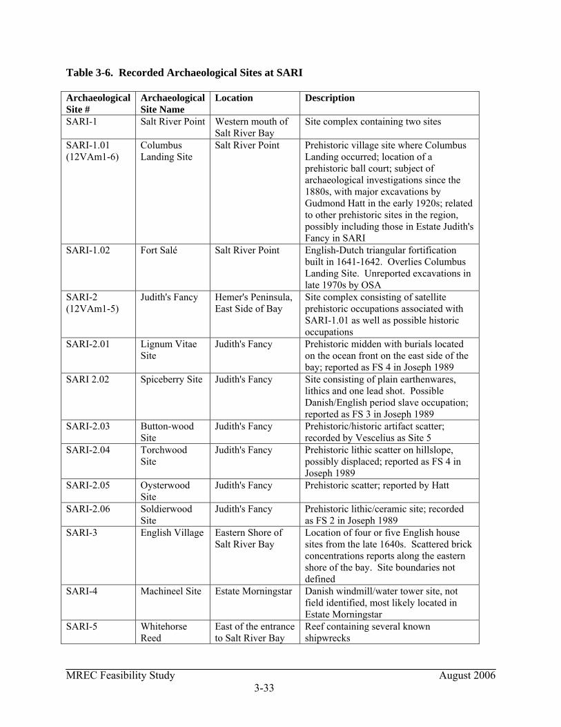
MREC Feasibility Study August 2006 3-33
Table 3-6. Recorded Archaeological Sites at SARI Archaeological Site #
Archaeological Site Name
Location Description
SARI-1 Salt River Point Western mouth of Salt River Bay
Site complex containing two sites
SARI-1.01 (12VAm1-6)
Columbus Landing Site
Salt River Point Prehistoric village site where Columbus Landing occurred; location of a prehistoric ball court; subject of archaeological investigations since the 1880s, with major excavations by Gudmond Hatt in the early 1920s; related to other prehistoric sites in the region, possibly including those in Estate Judith's Fancy in SARI
SARI-1.02 Fort Salé Salt River Point English-Dutch triangular fortification built in 1641-1642. Overlies Columbus Landing Site. Unreported excavations in late 1970s by OSA
SARI-2 (12VAm1-5)
Judith's Fancy Hemer's Peninsula, East Side of Bay
Site complex consisting of satellite prehistoric occupations associated with SARI-1.01 as well as possible historic occupations
SARI-2.01 Lignum Vitae Site
Judith's Fancy Prehistoric midden with burials located on the ocean front on the east side of the bay; reported as FS 4 in Joseph 1989
SARI 2.02 Spiceberry Site Judith's Fancy Site consisting of plain earthenwares, lithics and one lead shot. Possible Danish/English period slave occupation; reported as FS 3 in Joseph 1989
SARI-2.03 Button-wood Site
Judith's Fancy Prehistoric/historic artifact scatter; recorded by Vescelius as Site 5
SARI-2.04 Torchwood Site
Judith's Fancy Prehistoric lithic scatter on hillslope, possibly displaced; reported as FS 4 in Joseph 1989
SARI-2.05 Oysterwood Site
Judith's Fancy Prehistoric scatter; reported by Hatt
SARI-2.06 Soldierwood Site
Judith's Fancy Prehistoric lithic/ceramic site; recorded as FS 2 in Joseph 1989
SARI-3 English Village Eastern Shore of Salt River Bay
Location of four or five English house sites from the late 1640s. Scattered brick concentrations reports along the eastern shore of the bay. Site boundaries not defined
SARI-4 Machineel Site Estate Morningstar Danish windmill/water tower site, not field identified, most likely located in Estate Morningstar
SARI-5 Whitehorse Reed
East of the entrance to Salt River Bay
Reef containing several known shipwrecks
MREC Feasibility Study August 2006 3-34
Three sites are under consideration for the MREC: East Site (located west of Estate Judith's Fancy), South Site (former NOAA West Indies Lab), and West Site (Salt River Bay Marina and Visitor Contact Station). Only one of these locations, the East Site, has received comprehensive archaeological survey and is the location of known archaeological sites. The East Site, located within SARI on the eastern side of the Salt River Bay, has been surveyed on several occasions, most recently by Meredith Hardy during the summer of 2005. Gudmond Hatt visited this side of the Salt River Bay in 1924, while he was conducting excavations of the Columbus Landing Site (SARI-1.01) (see Figure 3-7), and Hatt located a small archaeological site on the basis of surface deposits (SARI-2.05). Gary Vescelius conducted survey in the area in the early 1950s as part of an island-wide survey of St. Croix by Yale University, and recorded a second site (SARI-2.03), with prehistoric components. Alfredo Figueredo conducted survey along Salt River Bay's eastern shore in 1986 for a proposed development by the Sugar Bay Land Development Company, and identified a large prehistoric site on the oceanfront (SARI-2.01). Both Figueredo and later New South Associates conducted testing of this site (SARI-2.01). New South Associates (Joseph 1989) also completed survey on this side of the bay in 1989 for a planned development that never came to fruition. Testing at SARI-2.01 revealed a dense dispersed midden deposit with human remains and suggested the presence of multiple households. Survey identified the locations of three more archaeological sites in the East Site (archaeological site name is Estate Judith's Fancy) (SARI-2.02, 2.04, and 2.06) (Joseph 1989). The results of Meredith Hardy's recent survey (2005) in this area confirmed the findings of prior surveys and verified the location of two archaeological sites within the proposed footprint of the East Site: archaeological sites SARI 2.03 (the Buttonwood Site) and SARI 2.06 (the Soldierwood Site). Hardy's survey consisted of two transects of shovel tests along the eastern shore of the marina that was dug for the proposed Virgin Grand hotel. Positive shovel tests were found in the areas of both SARI 2.03 and SARI 2.06 without negative tests between these sites, suggesting that both sites may be part of the same occupation. However, Hardy found that the area had been heavily disturbed and the deposits from both sites may have been scattered. Hardy's shovel tests in this area revealed a scatter of shell, possibly indicative of a prehistoric midden, although also possibly reflecting the excavation of the Virgin Grand marina from the salt pond that was once present in this location. Hardy's shovel tests A29, A30, and A31, located near the base of the hill that is located in the northeast corner of SARI's boundaries, encountered a small earthen mound covered with a scatter of burned and fire-cracked rocks. Shovel tests A30 and A31 encountered prehistoric sherds as well as shell. Hardy suggested that these deposits were likely associated with SARI 2.01 and are present within that site's western boundaries. She further indicated that time constraints precluded further testing of this location (Hardy 2005:31). Testing of SARI 2.01 completed by Hardy as well as prior investigations indicates that this is a National Register of Historic Places eligible site. Hardy (2005:48) recovered C14 days from the site between AD 540 and 890, and human remains have been uncovered during excavations by Hardy and others. The relationship of SARI 2.01 to the contemporary Columbus Landing Site (SARI 1) is unknown, but it is assumed that SARI 2.01 is either a satellite domestic occupation
MREC Feasibility Study August 2006 3-35
or a special activity locus. Next to the Columbus Landing Site, SARI 2.01 is the second most significant prehistoric site in SARI and should be protected. Meredith Hardy also conducted limited reconnaissance of the Visitor Contact Station (West Site) grounds (Hardy 2005). Hardy noted that "the area around the main house has been terraced and landscaped" and no sites were found on Greig Hill, on which the house sits. Alfredo Figueredo et al. (1989) conducted a reconnaissance on Salt River Bay Marina (West Site). Only limited shovel testing was conducted during this reconnaissance, which did not identify any archaeological remains on the marina site proper but which did recover prehistoric pottery due north of the marina that was attributed to the Columbus Landing Site (SARI-1.01). This reconnaissance was not of sufficient intensity to assess the presence of archaeological remains on the Salt River Bay Marina site. The Salt River Bay Marina site is partially mangrove swamp with low archaeological potential. Elevated portions of this location would appear to have a moderate to high site potential; however, these are also the locations of the existing buildings of the marina that may have impacted any archaeological resources that might be present. No archaeological survey has been completed for the South Site (former NOAA West Indies Lab). This property is located on a knoll and small projections in the upper reaches of the bay and should also be considered to have moderate to high site potential, with impacts where the existing structures are located. 3.7.4 Historic Resources There are no historic resources in the park other than Fort Salé, which is recorded as an archaeological site. 3.8 SOCIOECONOMIC CONDITIONS The Region of Influence (ROI) is a geographic area selected as the basis on which demographic and economic impacts of project alternatives are analyzed. The ROI for socioeconomic conditions is considered to be St. Croix and the census tracts in the Virgin Islands. The census tracts are 9706 and 9707 within SARI. Demographics Population demographics to the census block level are available from the U.S. Census Bureau for SARI from the 2000 census. Census blocks are the smallest geographic entity for which the Census Bureau collects and tabulates decennial census information. The census blocks and census tracts that are located within the ROI for SARI. The U.S. Census Bureau provides data for these areas and their subareas in hiarcial sequences down to the block, block group, and census tract. SARI is located within the census tract 9706 (block groups 1 and 4) and census tract 9707 (block group 2). Data for the block groups are located on Table 3-7.
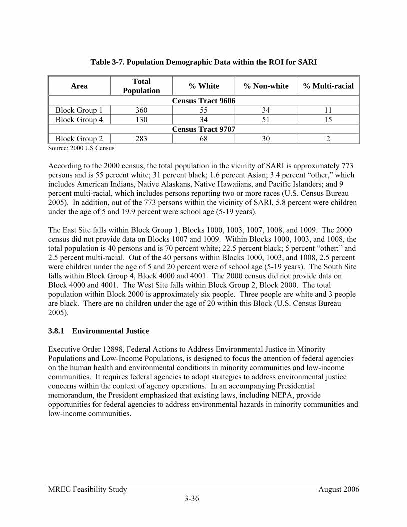
MREC Feasibility Study August 2006 3-36
Table 3-7. Population Demographic Data within the ROI for SARI
Area Total Population % White % Non-white % Multi-racial
Census Tract 9606 Block Group 1 360 55 34 11 Block Group 4 130 34 51 15
Census Tract 9707 Block Group 2 283 68 30 2
Source: 2000 US Census According to the 2000 census, the total population in the vicinity of SARI is approximately 773 persons and is 55 percent white; 31 percent black; 1.6 percent Asian; 3.4 percent “other,” which includes American Indians, Native Alaskans, Native Hawaiians, and Pacific Islanders; and 9 percent multi-racial, which includes persons reporting two or more races (U.S. Census Bureau 2005). In addition, out of the 773 persons within the vicinity of SARI, 5.8 percent were children under the age of 5 and 19.9 percent were school age (5-19 years). The East Site falls within Block Group 1, Blocks 1000, 1003, 1007, 1008, and 1009. The 2000 census did not provide data on Blocks 1007 and 1009. Within Blocks 1000, 1003, and 1008, the total population is 40 persons and is 70 percent white; 22.5 percent black; 5 percent “other;” and 2.5 percent multi-racial. Out of the 40 persons within Blocks 1000, 1003, and 1008, 2.5 percent were children under the age of 5 and 20 percent were of school age (5-19 years). The South Site falls within Block Group 4, Block 4000 and 4001. The 2000 census did not provide data on Block 4000 and 4001. The West Site falls within Block Group 2, Block 2000. The total population within Block 2000 is approximately six people. Three people are white and 3 people are black. There are no children under the age of 20 within this Block (U.S. Census Bureau 2005). 3.8.1 Environmental Justice Executive Order 12898, Federal Actions to Address Environmental Justice in Minority Populations and Low-Income Populations, is designed to focus the attention of federal agencies on the human health and environmental conditions in minority communities and low-income communities. It requires federal agencies to adopt strategies to address environmental justice concerns within the context of agency operations. In an accompanying Presidential memorandum, the President emphasized that existing laws, including NEPA, provide opportunities for federal agencies to address environmental hazards in minority communities and low-income communities.
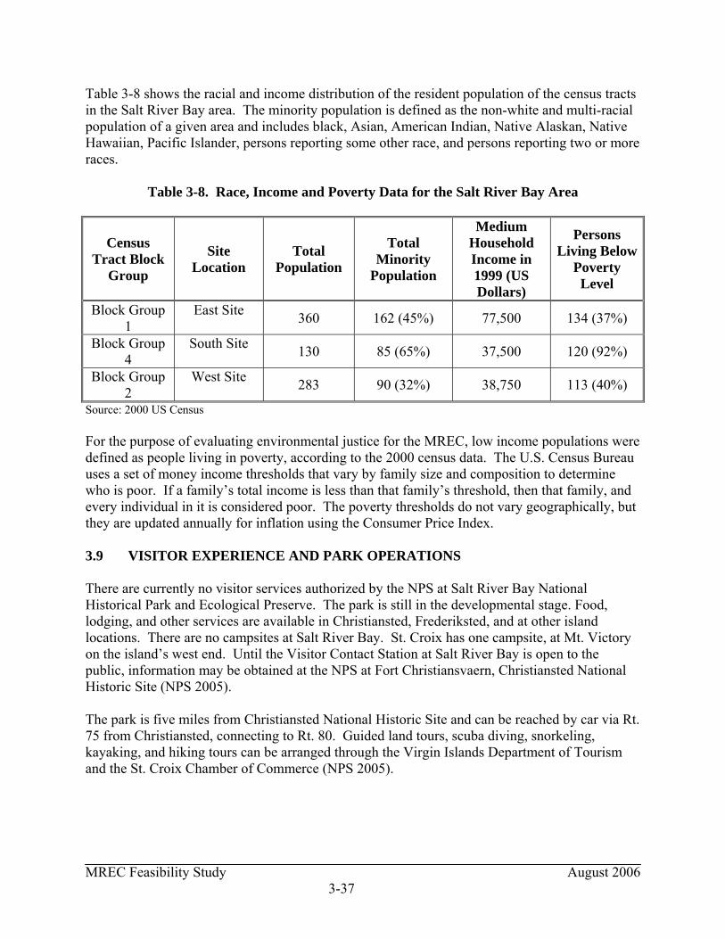
MREC Feasibility Study August 2006 3-37
Table 3-8 shows the racial and income distribution of the resident population of the census tracts in the Salt River Bay area. The minority population is defined as the non-white and multi-racial population of a given area and includes black, Asian, American Indian, Native Alaskan, Native Hawaiian, Pacific Islander, persons reporting some other race, and persons reporting two or more races.
Table 3-8. Race, Income and Poverty Data for the Salt River Bay Area
Census Tract Block
Group
Site Location
Total Population
Total Minority
Population
Medium Household Income in 1999 (US Dollars)
Persons Living Below
Poverty Level
Block Group 1
East Site 360 162 (45%) 77,500 134 (37%)
Block Group 4
South Site 130 85 (65%) 37,500 120 (92%)
Block Group 2
West Site 283 90 (32%) 38,750 113 (40%)
Source: 2000 US Census For the purpose of evaluating environmental justice for the MREC, low income populations were defined as people living in poverty, according to the 2000 census data. The U.S. Census Bureau uses a set of money income thresholds that vary by family size and composition to determine who is poor. If a family’s total income is less than that family’s threshold, then that family, and every individual in it is considered poor. The poverty thresholds do not vary geographically, but they are updated annually for inflation using the Consumer Price Index. 3.9 VISITOR EXPERIENCE AND PARK OPERATIONS There are currently no visitor services authorized by the NPS at Salt River Bay National Historical Park and Ecological Preserve. The park is still in the developmental stage. Food, lodging, and other services are available in Christiansted, Frederiksted, and at other island locations. There are no campsites at Salt River Bay. St. Croix has one campsite, at Mt. Victory on the island’s west end. Until the Visitor Contact Station at Salt River Bay is open to the public, information may be obtained at the NPS at Fort Christiansvaern, Christiansted National Historic Site (NPS 2005). The park is five miles from Christiansted National Historic Site and can be reached by car via Rt. 75 from Christiansted, connecting to Rt. 80. Guided land tours, scuba diving, snorkeling, kayaking, and hiking tours can be arranged through the Virgin Islands Department of Tourism and the St. Croix Chamber of Commerce (NPS 2005).

MREC Feasibility Study August 2006 3-38
3.10 PRELIMINARY SITE ASSESSMENT A Preliminary Site Assessment (PSA) for the three sites under consideration for the MREC facility was prepared by EA Engineering for the NPS entitled, “Preliminary Site Assessment Report Proposed Marine Research and Education Center Salt River Bay National Historic Park and Ecological Preserve St. Croix, U.S. Virgin Islands (EA 2006). The PSA was completed in accordance with ASTM E 1527-00 standard. The sites included tracts: 101-29 and 101-52 (East Site); tract 101-24 (South Site); and tracts 101-03 (Visitors Contact Station) and 101-11 (Salt River Bay Marina), which comprise the West Site. This study consisted of a review of current and historic activities and conditions at the property and surrounding properties, including a review of available federal regulatory database records, review of historic records, and a survey of the adjacent land uses. The purpose of the PSA is to evaluate the potential for a “recognized environmental condition” to exist at the property and to satisfy appropriate environmental due diligence. A recognized environmental condition (REC) is defined as the presence or likely presence of hazardous materials or petroleum products on a property under conditions that indicate a release, past release, or potential release into structures, ground, groundwater or surface water. Results of the PSA on the three sites under consideration for the MREC is presented in Section 4.10.
MREC Feasibility Study August 2006 4-1
4. EVALUATION OF ENVIRONMENTAL IMPACTS OF THE ALTERNATIVES 4.1 INTRODUCTION AND OVERVIEW Impacts are analyzed for the following park resources: the physical environment, terrestrial and aquatic resources, threatened and endangered species, unique natural systems, cultural resources, socioeconomics, and visitor experience/park operations. The recommendations of the Preliminary Site Assessment are also presented. Physical environmental impacts include effects from the alternatives on geology/soils, land cover and land use, bathymetry/currents, water quality, floodplains/coastal barriers, air quality, noise, climate, and hydrology. Terrestrial resource impacts include effects of the alternatives on mangroves, wetlands, plants, birds, and mammals. Aquatic resource impacts include effects of the alternatives on seagrasses, reefs/hardbottom, and fish/benthic organisms. The impacts to socioeconomics, visitor experience, and park operations are presented at the end of the chapter. Chapter 4.0 describes and analyzes potential environmental impacts associated with the proposed alternatives as presented in Chapter 2 (see Figures 2-1, 2-2, and 2-3). 4.1.1 Methods for Evaluating Environmental Impacts To analyze impacts, methods were selected to predict the potential change in park resources that would occur with the implementation of the alternatives. Potential impact is described in terms of intensity (negligible, minor, moderate, or major) as defined below: Negligible: Impacts would have no measurable or perceptible changes to the resource. Minor: Adverse: Impacts would be measurable or perceptible but would be localized within a relatively small area. The overall viability of the resource would not be affected and, if left alone, would recover. Beneficial: Resource improvement would be perceptible, but barely, and localized within a small area of SARI. Moderate: Adverse: Impacts would cause a change in the resource; however, the impact would remain localized. Beneficial: Resource improvements would be measurable, enhancing the viability of the resource within SARI. Major: Adverse: Impacts to the resource would be substantial, highly noticeable, and permanent. Beneficial: Resource improvements would be substantial, enhancing the viability of the resource within SARI, the surrounding community, and beyond. The study area was defined to include resources within SARI and the region that might reasonably be affected. Because resources vary in function and relation to environmental
MREC Feasibility Study August 2006 4-2
factors, the study area was defined independently for each impact topic. 4.2 PHYSICAL FEATURES This section discusses the impacts of the alternatives on the physical environment, including climate, geology/soils, land cover/land use, bathymetry/currents, water quality, floodplains/coastal barriers, air quality, noise, and hydrology. 4.2.1 Geology/Soils No impacts to the geology are anticipated as a result of the implementation of either of the alternatives. However, soils would be affected at the alternative locations. Grading and excavation of soil would be required for construction of some of the facilities that would comprise the MREC facility. Sediments in Salt River Bay would be disturbed during the installation of an underwater pipeline to bring clean salt water from the sea to MREC. Sediments would also be disturbed during construction of a new boat dock, boat launch, and mooring facilities. Finally, sediments in the Dredged Basin, Triton Bay, and Salt River Bay have the potential to be disturbed if future bathymetry studies reveal the need for maintenance dredging. A large research boat (approximately 40 ft with a 6ft draft) would need to have access to and from the Dredged Basin or Triton Bay, depending on the alternative. The impact to soils and sediments would be temporary and minor. Alternative 1 (East Site) Grading and excavation of soil would be required for construction of the MREC facilities. Sediments in the Dredged Basin, Salt River Bay, and possibly the East Cove would be disturbed when the underwater pipeline is constructed. Installation of the pipeline would also disturb soil as it crosses the peninsula west of the Dredged Basin to reach clean seawater. Sediments in the Dredged Basin would be disturbed during construction of a new boat dock, boat launch, and mooring facilities. Finally, sediments in the Dredged Basin and Salt River Bay have the potential to be disturbed for maintenance dredging if future bathymetry studies reveal shallow depths in the basin and bay. Areas in the bay and basin have silted in since the original dredging of the basin. This area may require maintenance dredging for a large research boat (approximately 40 ft with a 6ft draft) to have access to and from the Dredged Basin. Placement of the dredge material would need to be addressed in future studies. Alternative 2 (South Site) Grading and excavation of soil would be required for construction of some of the MREC facilities. Sediments in Salt River Bay and Triton Bay would be disturbed during the installation of an underwater pipeline. Installation of the pipeline would also disturb soil as it travels south from the Wet Lab to the MREC building; however, the route of the pipeline is recommended to follow existing roads to minimize additional disturbance. Sediments in Triton Bay would be
MREC Feasibility Study August 2006 4-3
disturbed during construction of a new boat dock, boat launch, and mooring facilities. Finally, sediments in Triton Bay and Salt River Bay have the potential to be disturbed for maintenance dredging if future bathymetry studies reveal shallow depths of Triton Bay. Areas in Triton Bay and Salt River Bay have silted in since the original dredging of this area for the former NOAA dock. This location may need maintenance dredging for a large research boat to have access to and from Triton Bay. Placement of the dredge material would need to be addressed in future studies. Alternative 3 (West Site) Grading and excavation of soil would be required for construction of some of the MREC facilities and sediments in the Caribbean Sea would be disturbed during the installation of an underwater pipeline. Installation of the pipeline would also disturb soil as it travels south from the MREC buildings to the Wet Lab; however, the route of the pipeline is recommended to follow existing roads to minimize additional disturbance. Additionally, sediments in the Salt River Bay would be disturbed during construction of a new boat dock and mooring facilities at the marina. Due to the limited number of marinas and boat slips on the island (Salt River Bay Marina is 1 of only 3 functioning marinas), the current facility would be allowed to continue to function as a commercial marina. Since no dock space would be available for the MREC boats, the Park Service would have to construct a new dock and mooring facilities at this location. Maintenance dredging would not be an issue at the marina, since boat access is currently adequate for a large research boat. Regardless of the alternative selected, appropriate agencies (i.e., U.S. Corps of Engineers, U.S. Fish and Wildlife Service, EPA Region 2, U.S. Virgin Island’s Department of Planning and Natural Resources) would be notified and consulted on the maintenance dredging and construction of new boat docks and mooring facilities to ensure compliance with Federal and Territory laws (i.e., CWA Section 404, Rivers and Harbor Act Section 10, NPS Management Policies). Applicable permits associated with maintenance dredging would be acquired (i.e., 404 Permit, Special Use Permit). 4.2.1.1 Seismicity IRF (1993) states that earthquake potential at St. Croix is relatively high. Waterfront areas that have undergone construction on filled (reclaimed land) land would be avoided for construction of the MREC facilities since this land is vulnerable to impacts from earthquakes. Reclaimed land includes the peninsula between the East Cove and the Dredged Basin located in the East Site. Recommendations to mitigate for earthquakes at MREC would include minimizing injury and damage from seismic activity by enforcing strict building standards (i.e., insulated steel-enforced concrete walls, stronger windows and doors). This would be accomplished by building beyond what current building codes require, building to a higher standard to construct earthquake-resistant structures.
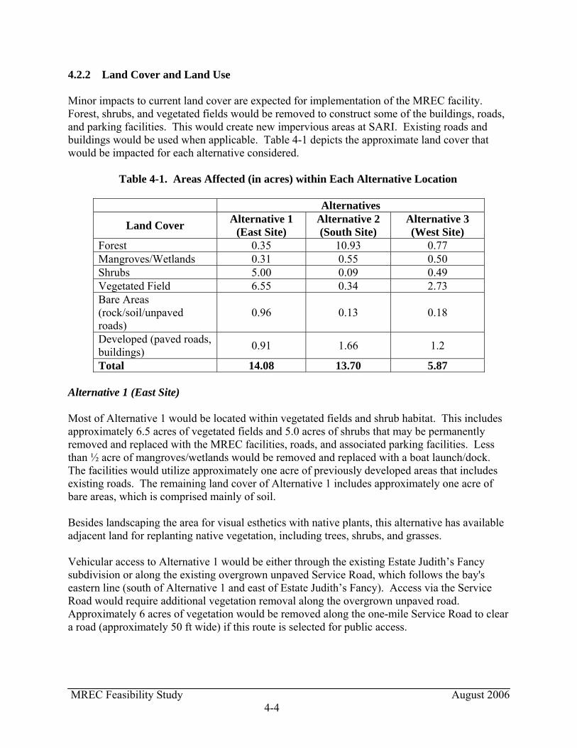
MREC Feasibility Study August 2006 4-4
4.2.2 Land Cover and Land Use Minor impacts to current land cover are expected for implementation of the MREC facility. Forest, shrubs, and vegetated fields would be removed to construct some of the buildings, roads, and parking facilities. This would create new impervious areas at SARI. Existing roads and buildings would be used when applicable. Table 4-1 depicts the approximate land cover that would be impacted for each alternative considered. Table 4-1. Areas Affected (in acres) within Each Alternative Location
Alternatives
Land Cover Alternative 1 (East Site)
Alternative 2 (South Site)
Alternative 3 (West Site)
Forest 0.35 10.93 0.77 Mangroves/Wetlands 0.31 0.55 0.50 Shrubs 5.00 0.09 0.49 Vegetated Field 6.55 0.34 2.73 Bare Areas (rock/soil/unpaved roads)
0.96 0.13 0.18
Developed (paved roads, buildings) 0.91 1.66 1.2
Total 14.08 13.70 5.87 Alternative 1 (East Site) Most of Alternative 1 would be located within vegetated fields and shrub habitat. This includes approximately 6.5 acres of vegetated fields and 5.0 acres of shrubs that may be permanently removed and replaced with the MREC facilities, roads, and associated parking facilities. Less than ½ acre of mangroves/wetlands would be removed and replaced with a boat launch/dock. The facilities would utilize approximately one acre of previously developed areas that includes existing roads. The remaining land cover of Alternative 1 includes approximately one acre of bare areas, which is comprised mainly of soil. Besides landscaping the area for visual esthetics with native plants, this alternative has available adjacent land for replanting native vegetation, including trees, shrubs, and grasses. Vehicular access to Alternative 1 would be either through the existing Estate Judith’s Fancy subdivision or along the existing overgrown unpaved Service Road, which follows the bay's eastern line (south of Alternative 1 and east of Estate Judith’s Fancy). Access via the Service Road would require additional vegetation removal along the overgrown unpaved road. Approximately 6 acres of vegetation would be removed along the one-mile Service Road to clear a road (approximately 50 ft wide) if this route is selected for public access.

MREC Feasibility Study August 2006 4-5
Alternative 2 (South Site) This alternative would require the removal of terrestrial vegetation. Approximately 10.9 acres of forest, 0.09 acres of shrubs, 0.34 acres of vegetated fields, and 0.55 acres of mangroves/wetlands would be replaced with MREC facilities, roads, boat ramp/dock, and associated parking facilities. Approximately 1.7 acres of existing roads and structures would be utilized. The remaining land cover of Alternative 2 includes bare areas (1.66 acres), which is comprised of soil and unpaved roads. Alternative 3 (West Site) Alternative 3 would have minimal land cover changes. A total of approximately 0.77 acres of forest, 0.49 acres of shrubs, and 2.73 acres of vegetated fields would be removed by constructing the MREC facilities and associated parking/roads. Approximately 1.2 acres of developed area (existing house and roads) would be used for the facility. Less than ½ acre of mangroves/wetlands would be removed and replaced with a boat dock. The remaining land cover of Alternative 3 includes unpaved roads (0.18 acres). A landscaping plan for the MREC location would address replanting native vegetation, including trees, shrubs, and maintained grasses, at the site regardless of which alternative is selected. 4.2.3 Bathymetry/Currents No impacts to the currents are anticipated as a result of implementing the MREC facility. Negligible impacts to bathymetry may occur as a result of the placement of the water intake and pipeline. Although the location of impacts from the pipeline would vary based on the site selected, impacts would be localized and would not be expected to alter the general bathymetry of the bay, regardless of the alternative selected. Impacts to the bathymetry may occur from maintenance dredging if future bathymetry studies reveal the need for dredging in the Dredged Basin and Salt River Bay for Alternative 1 and in Triton Bay and Salt River Bay for Alternative 2. Water depths are expected to increase in the basin and bay resulting in long term minor impacts to the bathymetry of the park if maintenance dredging is needed. 4.2.4 Water Quality Potential runoff from the MREC facilities may impact quality of surface water at SARI. There may be effects of increased stormwater runoff due to an increase in impervious surfaces. Potential impacts resulting from construction and operational activities would be addressed by required authorizations and permits. With these restrictions and controls in place, no adverse effects to water quality would be expected. Water quality impacts from potential runoff are expected to be minor. The operation of motorized watercraft associated with MREC could affect water quality through the introduction of chemicals and oils into the water via engine exhaust or during maintenance
MREC Feasibility Study August 2006 4-6
and fueling though drips and spills; however, these impacts would be expected to be minor. The water quality in Salt River Bay would be temporarily impacted from disturbing sediments when the underwater pipeline is constructed and for potential maintenance dredging; however, these impacts would also be expected to be minor. Alternative 1 (East Site) The water quality at Alternative 1 would be temporarily impacted from disturbing the sediments in the Dredged Basin and Salt River Bay during construction of a new boat dock, boat launch, and mooring facilities. If maintenance dredging is found to be necessary, it would temporarily impact the water quality. Public access to Alternative 1 would require upgrading (i.e., widening, vegetation clearing, paving) the existing overgrown unpaved Service Road that is located south of Alternative 1. Impervious surface area would increase as a result of upgrading the Service Road resulting in increased stormwater runoff. With required permits, restrictions and controls in place, no adverse effects to water quality would be expected. Water quality impacts from potential runoff are expected to be minor. Alternative 2 (South Site) The water quality at Alternative 2 would be temporarily impacted from disturbing the sediments in Triton Bay during construction of a new boat dock, boat launch, and mooring facilities. If maintenance dredging if found to be necessary, it would temporarily impact the water quality. Alternative 3 (West Site) The water quality at Alternative 3 would be temporally impacted from disturbing the sediments in Salt River Bay during construction of a new boat dock and mooring facilities. Maintenance dredging would not be needed at the marina. Alternative 3 has the potential to improve the water quality of Salt River Bay. If this alternative is implemented the NPS would acquire the Salt River Bay Marina and would require strict water quality standards for the onsite concessionaires and boat operators utilizing the marina. Currently, the marina (sewage leach field) and live aboards (lack of storage on boats) are the potential source of nutrients and fecal coliform in the bay. This alternative would benefit the water quality at SARI by reducing/eliminating the marina water quality issues when the NPS has control over the marina operations. Regardless of the alternative selected, appropriate agencies (i.e., U.S. Virgin Island’s Department of Planning and Natural Resources) would be notified and consulted on impacts to the water quality to ensure compliance with Federal and Territory laws (i.e., CWA Section 401). Applicable permits associated with water quality would be acquired (i.e., 401 Water Quality Certification, Territorial Pollutant Discharge Elimination System [TPDES] Permit).

MREC Feasibility Study August 2006 4-7
4.2.5 Floodplains/Coastal Barriers Floodplains Alternative 2 is not located within a 100-year floodplain (as mapped by FEMA); therefore no impacts are expected to the floodplain from this alternative. However, the boat dock and boat mooring facilities of Alternatives 1 and 3 would be located in the 100-year floodplain. Negligible impacts are anticipated to the floodplain from these alternatives. A Statement of Findings for floodplains would be required for Alternatives 1 and 3. The underwater pipeline that would bring salt water from the sea to the MREC facility and Wet Lab would impact the 100-year floodplain at Alternative 1. There would be no impact to the 100-year floodplain from the pipeline at Alternatives 2 and 3. However, it is not possible to fully evaluate the impacts of the pipeline at this time since site-specific water quality sampling would need to be completed before finalizing the location of the pipeline. Based on information available impacts would not be expected to be significant. Coastal Barriers The underwater pipeline that would bring salt water from the sea to the MREC facility and Wet Lab would impact the coastal barrier area regardless of the alternative. However, the impact to the coastal barrier area is anticipated to be negligible. Alternative 1 (East Site) The Wet Lab, Maintenance Building, boat dock/launch and mooring facilities, and maintenance dredging (if needed) required at this location would be located in an area designated as a coastal barrier. Alternative 2 (South Site) The boat dock and mooring facilities and maintenance dredging (if needed) required at this location would be located in an area designated as a coastal barrier. However, the MREC facilities are not located within an area designated as a coastal barrier. Alternative 3 (West Site) The Wet Lab, Maintenance Building, boat dock and mooring facilities of Alternative 3 would be located on the edge of an area designated as a coastal barrier. Regardless of the alternative, the NPS will coordinate with the V.I. Department of Planning and Natural Resources for compliance with the Coastal Zone Management Program (CZMP) for construction in an area designated as a coastal barrier. A Coastal Zone Management (CZM) Permit is required for any development activity in the first tier of the coastal zone.

MREC Feasibility Study August 2006 4-8
4.2.6 Air Quality Minor impacts to air quality may occur from stationary and mobile sources. Potential stationary sources include generators, space heating, and water heaters. Mobile sources that potentially have a minor impact include ground support equipment, vehicles, and boats. An Air Construction Permit or Air Operating Permit may be required for the installation of generators. The park will coordinate with the V.I. Department of Planning and Natural Resources for compliance with the Virgin Island Air Pollution Control Act Rules and Regulations. During the short-term construction phase of implementing the MREC, the operation of construction equipment would generate some criteria pollutant emissions, including carbon monoxide, nitrogen oxides, and particulate matter. However, these emissions would be minimal since the proposed construction activities are temporary. Short-term fugitive dust emissions would be generated primarily due to land-disturbing activities to remove the vegetation and install new parking areas and roads. The amount of PM10 should not be expected to be high due to the short duration and can be mitigated by using control techniques such as wet suppression and truck bed covers for construction vehicles hauling soil. Overall, the construction phase of the MREC facility is expected to create minor and temporary impacts. These impacts would be short-term in nature, lasting for the duration of construction activities. 4.2.7 Noise There would be minor impacts associated with the noise from the facility. Noise associated with the use of the facility may increase relative to current levels from standard building features (i.e., generators), additional visitor vehicle traffic, and boats. The construction phase of the project is expected to create minor and temporary noise impacts. These impacts would be short-term in nature, lasting for the duration of construction activities. Noise is expected, but noise impacts are generally localized at the vicinity of the construction site. Earthmoving equipment, asphalt pavers, and other construction equipment and vehicles would create localized increases in noise levels. These temporary noise impacts would not disrupt the surrounding area. If future bathymetry studies reveal the need for maintenance dredging, then there would be temporary moderate noise impacts to the local community surrounding Alternatives 1 and 2 during the maintenance dredging activities. 4.2.8 Climate No impacts to the climate at SARI are anticipated as a result of implementing the MREC facility. However, impacts from coastal storms to the proposed MREC facility should be addressed. The siting of facilities along the coast increases a cumulative threat potential with respect to three types of coastal storm impacts: (1) threats to public health, safety, and welfare; (2) costs for disaster relief and protection; and (3) losses of irreplaceable natural resources (IRF 1993).

MREC Feasibility Study August 2006 4-9
Preparation of a coastal storm hazard mitigation plan is recommended for the MREC. Recommendations to mitigate for coastal storm hazards would include strict building standards to achieve increased wind and/or flooding resistance. Although Salt River Bay is considered to be a “hurricane hole” for boats seeking refuge from a tropical storm, Hurricane Hugo demonstrated that the area is not safe during a storm of that magnitude (IRF 1993). 4.2.9 Hydrology/Groundwater No impacts to hydrology are anticipated as a result of implementing the MREC facility. Cisterns and reverse-osmosis freshwater production are proposed for the MREC facilities; however, if domestic groundwater wells for potable water are needed minor impacts to groundwater would occur. 4.3 TERRESTRIAL RESOURCES This section discusses the impacts of the MREC on terrestrial resources, including mangroves, wetlands, plants, birds, and mammals. 4.3.1 Mangroves
Depending on the final design of the MREC, minor impacts to mangroves may occur. Mangroves are found at all the alternative locations. Additionally, depending on the final design location of the underwater pipeline to bring salt water from the sea to the MREC facility, mangroves may be impacted. Mangroves should be avoided if possible when designing the location of the pipeline. If it is determined that mangroves would be impacted by the MREC facility, a mangrove survey would be required to ground-truth the existing mangrove data to determine the exact mangrove acreages impacted. Additionally, appropriate mitigation measures for mangroves would be required. Alternative 1 (East Site) Red mangroves populate the shoreline surrounding the inlet at Alternative 1 and just northeast of the inlet there is a patch of mixed white and red mangroves. The proposed wet lab and maintenance building would be located east of the existing mangroves. However, the proposed boat dock and launch associated with the MREC would impact approximately 0.31 acres of mangrove and mangrove habitat. Impacts to mangroves are expected to be minimal.
Alternative 2 (South Site) On the eastern side of Alternative 2, red mangroves are found to be dominant along the shoreline. Black mangroves can also be found inland at this location. Mangrove habitats should be avoided if possible, however the boat dock/launch would impact approximately 0.55 acres of mangroves and mangrove habitat. However, impacts to mangroves are expected to be minimal.
MREC Feasibility Study August 2006 4-10
Alternative 3 (West Site) Red mangroves are also the dominant mangrove species found at Alternative 3. These mangroves are found along the shoreline of the marina with some areas mixed with white mangroves. Mangrove habitats should be avoided if possible, however the boat dock would impact approximately 0.5 acres of mangroves and mangrove habitat. Impacts to mangroves are expected to be minimal. The Visitor Contact Station is not located in an area populated by mangroves. 4.3.2 Wetlands Depending on the final design of the MREC, wetlands may be impacted. If it is determined that wetlands would be impacted by the MREC facility, a wetland delineation and jurisdictional determination would be required to ground-truth the existing wetland data to determine the exact wetland acreages impacted. Appropriate agencies (i.e., U.S. Corps of Engineers, V.I. Department of Planning and Natural Resources) would be notified and consulted on the construction of new boat docks and mooring facilities to ensure compliance with Federal and territory laws (i.e., CWA Sections 401 and 404). Applicable permits associated with wetlands would be acquired (i.e., 404 Permit). Additionally, a Statement of Findings would be required as well as appropriate mitigation measures for wetlands. Wetlands within SARI are composed of mangrove swamps and salt ponds. Alternative 1 (East Site) Impacts to wetlands are anticipated at Alternative 1. Approximately 0.31 acres of wetlands would be impacted as a result of constructing the boat dock/launch. However, impacts to wetlands are expected to be minimal. Alternative 2 (South Site) Impacts to wetlands are anticipated at Alternative 2. Approximately 0.55 acres of wetlands would be impacted as a result of constructing the boat dock/launch. Impacts to wetlands are expected to be minimal. Alternative 3 (West Site) Impacts to wetlands are anticipated at Alternative 3. Approximately 0.5 acres of wetlands would be impacted as a result of constructing the boat dock at the marina. Impacts to wetlands at the marina are expected to be minimal. There is no documentation of wetlands occurring at the Visitor Contact Station; therefore, there would be no impacts to wetlands at the Visitor Contact Station.
MREC Feasibility Study August 2006 4-11
4.3.3 Plants
Minor to moderate impacts to vegetation are expected for implementation of the MREC facility. During the construction phase, the loss of forest, shrubs, and vegetated field habitat may be required. The loss of vegetated habitat should be mitigated by re-vegetating and stabilizing the area at the end of the construction period. This would be addressed in a landscaping plan for the MREC facility. Replanting native trees, shrubs, and maintained grasses at the site is recommended regardless of which alternative is selected. Additionally, the removal of exotic species should be attempted as applicable. Alternative 1 (East Site) Approximately 0.35 acres of forest, 6.55 acres of vegetated fields, and 5.0 acres of shrubs would be impacted due the MREC facilities, roads, and associated parking facilities. Impacts to plants from the MREC are expected to be minor since most of the vegetation at this site is invasive species. Mitigation of this non-native vegetation is an option for this alternative, invasive species can be removed and replanted with native vegetation. Vehicular access to Alternative 1 would be either through the existing Estate Judith’s Fancy subdivision or along the existing overgrown unpaved Service Road, which follows the bay's eastern line (south of Alternative 1 and east of Estate Judith’s Fancy). Access via the Service Road would require upgrading (i.e., widening, vegetation clearing, paving) the overgrown unpaved road. Approximately 6 acres of vegetation would be removed along the one-mile Service Road to clear a 50 ft road if this route is selected for public access. Alternative 2 (South Site) Approximately 10.93 acres of forest, 0.09 acres of shrubs, and 0.34 acres of vegetated fields would be impacted by the MREC. Impacts to plants are expected to be moderate. Alternative 3 (West Site) Approximately 0.77 acres of forest, 0.49 acres of shrubs, and 2.73 acres of vegetated fields would be impacted by the MREC. Impacts to plants are expected to be minor. Most of the vegetation at the Visitor Contact Station is invasive. The NPS is currently in the process of removing the non-native vegetation surrounding the Visitor Contact Station and plans on replanting the site with native plants. 4.3.4 Birds Impacts to avian species are a direct result of impacts to their habitat. Habitats at SARI provide nesting, roosting and foraging for a wide variety of birds including year round residents, overwintering residents, and species that stop briefly at St. Croix during annual migrations. Loss of habitat due to vegetation removal, including mangroves, is the primary impact to birds. Mangrove habitat at SARI is important to birds as nesting habitat for resident species and

MREC Feasibility Study August 2006 4-12
foraging habitat for over wintering and migrant species. The results of the vegetation impact analysis were used to assess impacts to avian species. The removal of vegetation for MREC has the potential to disrupt or displace birds in the area. There is a potential that vegetation would be removed in the mangrove, forested, shrub, and vegetated field habitat. There would be a net loss of forested habitat for birds in the MREC area. The increase in human activity at the site may also affect use of the available habitat by birds. There would be short-term, minor impacts to the birds in the area. Nearby avian species (landbirds and shorebirds) that nest and forage in the vicinity of the MREC area may be temporarily disrupted during the construction operations due to the unavoidable noise and human activity. Implementation of the MREC may cause species to relocate during the construction process. It is anticipated that these species would be re-established at the site or nearby available habitat after the completion of the MREC. 4.3.5 Mammals Impacts to mammals are a direct result of impacts to vegetation. Loss of habitat due to vegetation removal is the primary impact to mammals. The results of the vegetation impact analysis were used to assess impacts to mammals. The removal of vegetation for the MREC has the potential to disrupt or displace mammals in the area. There is a potential that vegetation would be removed in the forested, shrub, and vegetated field habitat. There would be a net loss of forested habitat for mammals in the MREC area. The increase in human activity at the site may also affect use of the available habitat by mammals.
Short-term, minor impacts on mammals in the area may occur. Potential mammals that would be impacted if either of the alternatives are implemented include the small Indian mongoose, donkey (burro), white-tailed deer, red fruit bat (Stenoderma rufum), cave bat (Brachyphylla cavernarum), and rat species (Rattus spp.). Nearby mammals that utilize the surrounding habitats within the vicinity of the MREC area may be temporarily disrupted during the construction operations due to the unavoidable noise and human activity. This may cause species to relocate during the construction process. It is anticipated that these species would be re-established at the site after the completion of the MREC. 4.4 AQUATIC RESOURCES 4.4.1 Seagrasses Seagrasses would be impacted by the proposed pipeline that would draw seawater from the ocean into the MREC facility. These impacts would pose a short-term temporary impact to SAV. It is likely that the SAV would become re-established in the location of the proposed pipeline. No seagrasses occur at the proposed boat dock locations for either alternative. Therefore, there would be no impacts to seagrasses from construction of the docks. Seagrasses would not be impacted from maintenance dredging activities (if needed) for Alternative 2, since no seagrasses are located where the dredging would occur.
MREC Feasibility Study August 2006 4-13
Seagrasses would be impacted from maintenance dredging activities for Alternative 1, if future bathymetry studies reveal the need. Seagrasses classified as continuous with 90%-100% cover are located adjacent to the shorelines of the East Cove and the southern portions of Alternative 1. This area also includes a mixture of seagrasses classified as patchy (discontinuous) with 50% to less than 90% cover and patchy with 10% to less than 50% cover. No seagrass occur within the Dredged Basin or Abandoned Marina Cut of Alternative 1. Even though seagrasses would be impacted by potential maintenance dredging at Alternative 1, the species of seagrasses located at this site are not the high quality seagrass habitat preferred by grazing sea turtles. Appropriate agencies (i.e., U.S. Fish and Wildlife Service, EPA Region 2, U.S. Virgin Island’s Department of Planning and Natural Resources) would be notified and consulted on the impacts to seagrasses due to maintenance dredging to ensure compliance with Federal and Territory laws (Section 7 of the Endangered Species Act). 4.4.2 Reefs/Hardbottom There would be no impacts to the coral reefs/hardbottoms from the MREC facilities. However, the location of the proposed pipeline that would draw seawater from the ocean into the facility is unknown. The location of the intake cannot be determined until further water quality studies have been completed. The pipeline should be designed to avoid impacts to reefs/hardbottom. 4.4.3 Fish Short-term minor adverse effects to fish would occur during construction of boat docks and mooring facilities and for maintenance dredging (if needed). Fish in the area being disturbed by construction equipment (i.e., barges, dredging equipment) needed for the installation of dock pilings and the potential maintenance dredging would be expected to avoid, or leave these areas. These construction activities would have temporary, localized effects to fish. Short-term minor adverse effects to fish would occur during installation of the water intake pipeline. Depending on the method of constructing the water in-take pipe, depends on the effects to aquatic wildlife. Alternative 1 (East Site) Fish that inhabit the Dredged Basin would be impacted during construction of a new boat dock/launch and mooring facilities. Fish in the Dredged Basin, Salt River Bay, and possibly the East Cove would be disturbed when the underwater pipeline is constructed. Finally, fish that inhabit the Dredged Basin and Salt River Bay would be impacted from maintenance dredging, if dredging if found to be needed. To minimize impacts to the fish population scheduling the dredging and boat dock construction simultaneously would reduce stress to this community. Overall, short-term minor adverse effects to fish would occur for this alternative.

MREC Feasibility Study August 2006 4-14
Alternative 2 (South Site) Fish that inhabit Triton Bay would be impacted during construction of a new boat dock/launch and mooring facilities. Fish in Triton Bay and Salt River Bay would be disturbed when the underwater pipeline is constructed. Finally, fish that inhabit Triton Bay and Salt River Bay would be impacted from maintenance dredging, if dredging is found to be needed at this location. However, short-term minor adverse effects to fish would occur for this alternative. Alternative 3 (West Site) Fish that inhabit Salt River Bay would be impacted during construction of a new boat dock and mooring facilities. Fish in Salt River Bay would be disturbed when the underwater pipeline is constructed. However, short-term minor adverse effects to fish would occur for this alternative. Regardless of the alternative selected, appropriate agencies (i.e., U.S. Fish and Wildlife Service, EPA Region 2, U.S. Virgin Island’s Department of Planning and Natural Resources) would be notified and consulted on the impact to fish from construction of boat docks and maintenance dredging to ensure compliance with Federal and Territory laws. 4.4.3.1 Benthic Organisms Short-term minor adverse effects to benthic organisms would occur during construction of boat docks and mooring facilities. Permanent adverse effects to benthic organisms would occur for maintenance dredging, if future bathymetry studies reveal the need for dredging. However, potential maintenance dredging would have a localized effect to the benthic community. Short-term minor adverse effects to benthic organisms would occur during installation of the water intake pipeline. Depending on the method of constructing the water in-take pipe, depends on the effects to aquatic wildlife. Alternative 1 (East Site) Benthic organisms that inhabit the Dredged Basin would be impacted during construction of a new boat dock/launch and mooring facilities. Benthic organisms in the Dredged Basin, Salt River Bay, and possibly the East Cove would be disturbed when the underwater pipeline is constructed and from potential maintenance dredging. Overall, short-term minor adverse effects to the benthic community would occur from dock construction and permanent adverse effects would occur from the potential maintenance dredging. Alternative 2 (South Site) Benthic organisms that inhabit Triton Bay would be impacted during construction of a new boat dock/launch and mooring facilities. Benthic organisms in Triton Bay and Salt River Bay would be disturbed when the underwater pipeline is constructed and from maintenance dredging (if needed). However, short-term minor adverse effects to benthic organisms would occur for this alternative.
MREC Feasibility Study August 2006 4-15
Alternative 3 (West Site) Benthic organisms that inhabit Salt River Bay would be impacted during construction of a new boat dock and mooring facilities. Benthic organisms in Salt River Bay would be disturbed when the underwater pipeline is constructed. However, short-term minor adverse effects to benthic organisms would occur for this alternative. Regardless of the alternative selected, appropriate agencies (i.e., U.S. Fish and Wildlife Service, EPA Region 2, U.S. Virgin Island’s Department of Planning and Natural Resources) would be notified and consulted on the impact to the benthic community from construction of boat docks and maintenance dredging to ensure compliance with Federal and Territory laws. 4.5 THREATENED AND ENDANGERED SPECIES In accordance with the federal and territorial requirements for threatened and endangered species, consultation would be required with USFWS, USVI Division of Fisheries, and NMFS Southeast Region Office prior to construction and dredging activities if needed. The MREC facilities would not adversely affect the federally listed species mentioned in Section 3.5. However, watercraft would be needed for construction activities (i.e., boat dock) and maintenance dredging (if needed), resulting in the potential to affect the listed sea turtles if contact with watercraft occurs. These activities would have to be coordinated with USFWS and USACE prior to construction and dredging for compliance with Section 7 of the Endangered Species Act. Alternative 1 (East Site) The territorially listed endangered least tern (nesting site covers approximately 4,000 square meters) has been observed on the northwest side of the East Site. However, Alternative 1 is located on the eastern side of the East Site. The MREC would not affect the least tern nesting area. Watercraft would be needed for construction activities (i.e., boat dock) and potentially for maintenance dredging at Alternative 1, resulting in a potential impact to the listed sea turtles. However, sea turtles are not expected to feed in the vicinity of Alternative 1 since no seagrasses are located within the Dredged Basin and the species of seagrasses in Salt River Bay at this location are not the high quality seagrass habitat preferred by grazing sea turtles. Alternative 2 (South Site)
The habitats in the vicinity of the Alternative 2 location have the potential to support federal and territorial listed species; however, there is no documentation that listed species have been observed at this alternative. Watercraft would be needed for construction activities (i.e., boat dock) and potentially for maintenance dredging at Alternative 2, resulting in a potential impact to the listed sea turtles. However, since no seagrasses are located in the vicinity of Alternative 2,
MREC Feasibility Study August 2006 4-16
which would attract sea turtles to graze, the impact from turtles coming in contact with watercraft is low. Alternative 3 (West Site)
Portions of Alternative 3 in the vicinity of the Salt River Bay Marina are currently developed. However, the surrounding habitats of the marina have the potential to support federal and territorial listed species. The habitats in the vicinity of the Visitor Contact Station also have the potential to support federal and territorial listed species. There is no documentation that endangered or threatened listed species have been observed at this alternative. The MREC would not adversely affect endangered or threatened listed species. Watercraft may be needed for construction activities (i.e., boat dock) at Alternative 3, resulting in a potential impact to the listed sea turtles. However, since no seagrasses are located in the vicinity of Alternative 3, which would attract sea turtles to graze, the impact from turtles coming in contact with watercraft is low. 4.6 UNIQUE NATURAL SYSTEMS Overall, the MREC facility would not alter the unique natural systems that occur at Salt River Bay, which includes the mangrove forests, coral reefs, seagrasses, and the submarine canyon. The MREC facility would benefit the unique natural systems at SARI, especially the coral reefs by fostering public awareness of the importance of coral reefs and other marine ecosystems from economic, aesthetic and global health standpoints though educational programs for students and the general public (JICMS 2005). The MREC would also foster the understanding and proper management of coral reef and other tropical and sub-tropical marine ecosystems by initiating a comprehensive long-term research and education program in the U. S. Virgin Islands (JICMS 2005). Lastly, the MREC would share information and research and form partnerships with other nations within the Caribbean and adjacent regions with common interests in and concerns for the marine environment (JICMS 2005). 4.7 CULTURAL RESOURCES This section describes the potential impacts of the project on archaeological and historical resources. The types of effects considered include direct impacts on archaeological and historical sites and visual impacts to the historic landscape of SARI. 4.7.1 Archaeological Resources Archaeological resources and potential for each of the alternatives under consideration for the MREC are discussed below. Alternative 1 (East Site) The East Site consists of lands that have been partially impacted by earlier construction associated with the Virgin Grand Hotel. This alternative is located on two recorded

MREC Feasibility Study August 2006 4-17
archaeological sites as well as a third recently identified resource. The proposed MREC wet labs, water tanks, visitors center, and connecting road are located on the locations of SARI 2.03 and SARI 2.06. Both of these sites have been heavily disturbed by prior construction and do not warrant further investigation. The location of the dormitories, as proposed, is near Hardy's shovel tests A29-A31, which encountered prehistoric ceramics and a small earthen mound associated with SARI 2.01, a National Register of Historic Places eligible site. These dormitories are located outside the presently defined limits of SARI 2.01. If Alternative 1 is selected, the dormitory area should receive further archaeological testing, and if necessary, excavation, to assess and recover archaeological deposits and define their temporal and spatial relationship to SARI 2.01. Vehicular access to Alternative 1 would be either through the existing Estate Judith’s Fancy subdivision or along the Service Road which follows the bay's eastern line and which is likely the location of a seventeenth-century road. If the latter is chosen for access, intensive survey and testing of the road would be necessary as it crosses the location of Hatt's site (SARI 2.05) and may cross locations associated with the seventeenth century English Village (SARI 2.3) Alternative 2 (South Site) Alternative 2 has not been surveyed. This site is considered to have a moderate to high potential for terrestrial archaeological sites and a low potential for submerged resources. Archaeological survey would be needed for any areas of new construction. Alternative 3 (West Site) Alternative 3 is composed of two parts – the house (Visitor Contact Station), located on Greig Hill, and the Salt River Bay Marina. Hardy (2005) determined that Greig Hill has been terraced and landscaped and appears to have little potential for archaeological remains. The Salt River Bay Marina site has not been intensively surveyed; a 1989 reconnaissance of the area is not sufficient to determine the presence or absence of archaeological remains. This site is considered to have a moderate to low potential for terrestrial or submerged archaeological resources but would require archaeological survey for the locations of new construction if this site is selected. Offshore Areas The site selected will require an underwater pipeline to bring salt water from the sea to the facility. Salt River Bay is suspected to contain the remains of historic shipwrecks and historic shipwrecks have been reported on Whitehorse Reef (SARI-5). An underwater archaeological survey should be completed for the route of this waterline to determine if submerged resources are present, and to investigate and evaluate the resources so identified. While the presence and nature of submerged resources has yet to be identified, Alternative 1, since it is closest to the Caribbean Sea, has a lower potential to affect submerged resources than either Alternative 2 or Alternative 3 (the Salt River Bay Marina), both of which are at the back of the bay. Specifications for this water line have not yet been developed; if feasible, designs that could be
MREC Feasibility Study August 2006 4-18
placed on the surface of the bay floor should be considered to lessen potential impacts on submerged resources. 4.7.2 Historic Structures None of these sites have the potential to affect SARI's only historic structure, Fort Salé. 4.7.3 Cultural Landscapes SARI is a cultural landscape, with the Salt River Bay being the only known US-owned location where Columbus landed as well as a focus of prehistoric and early historic settlement. Construction of the MREC thus has the potential to have an effect on this landscape. Cultural landscape elements and issues associated with each of the sites are discussed below. Alternative 1 Alternative 1 is located on the east side of the bay. This area currently contains no structures with the exception of the un-finished remains of the Virgin Grad Hotel, which represents a visual intrusion on SARI's cultural landscape. The proposed construction on this location would consist of wet labs and water tanks along the shore of the Dredged Basin, and the MREC building, visitors center, cafeteria and dormitories on the southern and eastern edges of the hill found in this corner of the park. The view of these structures would be shielded from ocean approaches from the east but would visible from the west as well as directly off shore from Salt River Bay. The MREC's design for this alternative intentionally hugs the hillside in this area, which partially but not completely mitigates its visual effect on the landscape. Construction on this alternative would have an effect on the SARI cultural landscape, however, depending on the mass and scale of the MREC's facilities, this effect may not be adverse. Demolition of the Virgin Grand Hotel shell, if completed in concert with construction of the MREC, could be considered as a mitigating factor for visual effect as the Virgin Grand structure is far more visually intrusive than the proposed MREC buildings. The visual effect (as well as potential effect on archaeological resources) could also be mitigated by moving the MREC building, visitors center, cafeteria and dormitories south of the wet lab and water tanks, further from the mouth of the bay. Alternative 2 Alternative 2 is located on a knoll at the back of the bay. The proposed construction on this location consists of wet lab facilities and a visitors center on Triton Bay and placement of the MREC building, cafeteria, and dormitories behind the hill which dominates this point. Use of this alternative should not have an effect on SARI's cultural landscape, so long as the mass and scale of buildings did not significantly exceed the height of this hill. Alternative 3 The Visitor Contact Station sits on a hill above Salt River Bay, and while visible, does not detract from the cultural landscape of the bay as it is well elevated above the bay and the

MREC Feasibility Study August 2006 4-19
Columbus Landing Site. The proposed use of this site would increase the density of buildings on Greig Hill, but the shoreline of St. Croix is already dotted with hillside homes. Construction on the structure should not have an effect on Salt River Bay's cultural landscape, so long as the new construction does not substantially vary from the height of the current house. Structures taller than three stories on this location could have an adverse affect. The Salt River Bay Marina is tucked back into the southwest corner of the bay and is not visible from the ocean. Use of this site would not have an adverse affect on SARI's cultural landscape, as long as the new facilities' mass and scale were appropriate. 4.8 SOCIOECONOMIC CONDITIONS Implementing the MREC would improve the quality of life in the Salt River Bay region by providing additional opportunities for educational programs for students and the general public. Through the participating institutions of MREC, scholarships and stipends to local students would be proposed. The MREC would also provide comprehensive long-term research and education programs. Finally, the MREC would provide additional opportunities for employment and provide incentives for partnering with local governments, community groups, and individual citizens; all of which would create a potential economic benefit to the community. As an individual entity, it is estimated that the MREC would contribute to the local economy by attracting more visitors to the park. It also has the potential in the future to become an integral component of the overall tourism experience for the USVI. In addition, MREC would contribute directly to the local economy by hiring permanent and part-time employees and purchasing goods and services from local suppliers. The local economy would benefit from a short-term increase in employment during construction. New jobs would be created and territory-level earnings would increase, which includes wages and salaries paid to new workers hired within the travel industry, as well as other sectors that support the travel industry. Regardless of the alternative, the local economy would benefit. 4.9 VISITOR EXPERIENCE AND PARK OPERATIONS There are currently no visitor services authorized by NPS at SARI National Historical Park and Ecological Preserve. Future park operations would include the MREC that would provide programs to promote the sustainable utilization and conservation of marine resources. The MREC would also establish educational programs on marine issues. Maintenance activities would be required and the increase in visitation would create more litter and waste than current conditions on site. Park maintenance and operations would be increased over current levels. Overall, the MREC would result in beneficial impacts as an improvement in park operations. Currently, NPS property at SARI Bay is utilized by the local residence, mainly for recreation (i.e., hiking, running). The visitor experience at SARI would be greatly enhanced from current conditions by the addition of the MREC facility. The addition of the research and education center would result in major beneficial impacts to visitor experience at SARI.
MREC Feasibility Study August 2006 4-20
4.10 RESULTS OF THE PRELIMINARY SITE ASSESSMENT A Preliminary Site Assessment (PSA) for three sites (alternatives) under consideration for the MREC facility was prepared by EA Engineering for the NPS (EA 2006). As stated in Chapter 3 the PSA consisted of a review of current and historic activities and conditions at the property and surrounding properties, including a review of available federal regulatory database records, review of historic records, and a survey of the adjacent land uses. The purpose of the PSA is to evaluate the potential for a “recognized environmental condition” to exist at the property and to satisfy appropriate environmental due diligence. A recognized environmental condition (REC) is defined as the presence or likely presence of hazardous materials or petroleum products on a property under conditions that indicate a release, past release, or potential release into structures, ground, groundwater or surface water. The PSA revealed no evidence of RECs in connection with the East Site (Alternative 1) and the Visitor Contact Station (West Site/Alternative 3). However, the assessment also revealed that the historical and current use of the remaining properties, the South Site (Alternative 2) and the Salt River Bay Marina (West Site/Alternative 3), should be further evaluated to determine the potential of RECs. The status of current or historical practices that could result in RECs can only be adequately addressed by performing a site inspection and interviews with appropriate personnel.
MREC Feasibility Study August 2006 5-1
5. POTENTIAL ECONOMIC COSTS FOR EACH ALTERNATIVE The following Class C Cost Estimate (Table 5-1) has been prepared based on the program and site concept plans described and illustrated in Chapter 2. Please note that: • This is a preliminary estimate of probable costs based on schematic designs. • The estimate does not account for market trends, labor fluctuations, inflation, hazardous
waste, cleanup, hauling, certain service utilities (phone, cable, etc.), survey data, permits, application fees, testing, bonds and insurance, contractor fees and any unforeseen or extenuating circumstances.
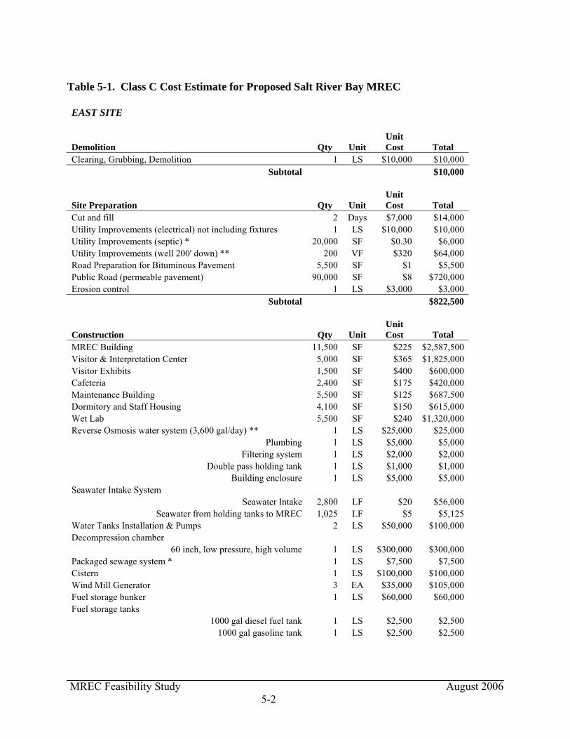
MREC Feasibility Study August 2006 5-2
Table 5-1. Class C Cost Estimate for Proposed Salt River Bay MREC EAST SITE
Demolition Qty Unit Unit Cost Total
Clearing, Grubbing, Demolition 1 LS $10,000 $10,000 Subtotal $10,000
Site Preparation Qty Unit Unit Cost Total
Cut and fill 2 Days $7,000 $14,000 Utility Improvements (electrical) not including fixtures 1 LS $10,000 $10,000 Utility Improvements (septic) * 20,000 SF $0.30 $6,000 Utility Improvements (well 200' down) ** 200 VF $320 $64,000 Road Preparation for Bituminous Pavement 5,500 SF $1 $5,500 Public Road (permeable pavement) 90,000 SF $8 $720,000 Erosion control 1 LS $3,000 $3,000
Subtotal $822,500
Construction Qty Unit Unit Cost Total
MREC Building 11,500 SF $225 $2,587,500 Visitor & Interpretation Center 5,000 SF $365 $1,825,000 Visitor Exhibits 1,500 SF $400 $600,000 Cafeteria 2,400 SF $175 $420,000 Maintenance Building 5,500 SF $125 $687,500 Dormitory and Staff Housing 4,100 SF $150 $615,000 Wet Lab 5,500 SF $240 $1,320,000 Reverse Osmosis water system (3,600 gal/day) ** 1 LS $25,000 $25,000
Plumbing 1 LS $5,000 $5,000 Filtering system 1 LS $2,000 $2,000
Double pass holding tank 1 LS $1,000 $1,000 Building enclosure 1 LS $5,000 $5,000
Seawater Intake System Seawater Intake 2,800 LF $20 $56,000
Seawater from holding tanks to MREC 1,025 LF $5 $5,125 Water Tanks Installation & Pumps 2 LS $50,000 $100,000 Decompression chamber
60 inch, low pressure, high volume 1 LS $300,000 $300,000 Packaged sewage system * 1 LS $7,500 $7,500 Cistern 1 LS $100,000 $100,000 Wind Mill Generator 3 EA $35,000 $105,000 Fuel storage bunker 1 LS $60,000 $60,000 Fuel storage tanks
1000 gal diesel fuel tank 1 LS $2,500 $2,500 1000 gal gasoline tank 1 LS $2,500 $2,500
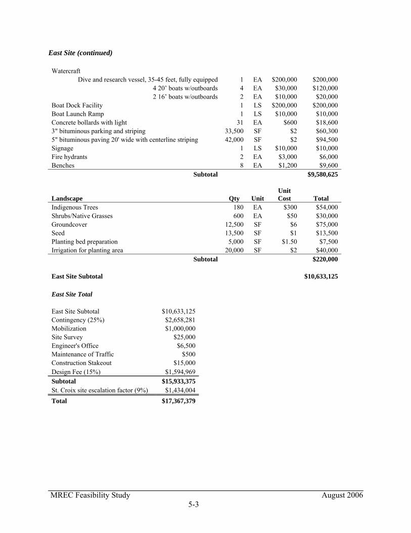
MREC Feasibility Study August 2006 5-3
East Site (continued) Watercraft
Dive and research vessel, 35-45 feet, fully equipped 1 EA $200,000 $200,000 4 20’ boats w/outboards 4 EA $30,000 $120,000 2 16’ boats w/outboards 2 EA $10,000 $20,000
Boat Dock Facility 1 LS $200,000 $200,000 Boat Launch Ramp 1 LS $10,000 $10,000 Concrete bollards with light 31 EA $600 $18,600 3" bituminous parking and striping 33,500 SF $2 $60,300 5" bituminous paving 20' wide with centerline striping 42,000 SF $2 $94,500 Signage 1 LS $10,000 $10,000 Fire hydrants 2 EA $3,000 $6,000 Benches 8 EA $1,200 $9,600
Subtotal $9,580,625
Landscape Qty Unit Unit Cost Total
Indigenous Trees 180 EA $300 $54,000 Shrubs/Native Grasses 600 EA $50 $30,000 Groundcover 12,500 SF $6 $75,000 Seed 13,500 SF $1 $13,500 Planting bed preparation 5,000 SF $1.50 $7,500 Irrigation for planting area 20,000 SF $2 $40,000
Subtotal $220,000 East Site Subtotal $10,633,125
East Site Total East Site Subtotal $10,633,125 Contingency (25%) $2,658,281 Mobilization $1,000,000 Site Survey $25,000 Engineer's Office $6,500 Maintenance of Traffic $500 Construction Stakeout $15,000 Design Fee (15%) $1,594,969 Subtotal $15,933,375 St. Croix site escalation factor (9%) $1,434,004 Total $17,367,379
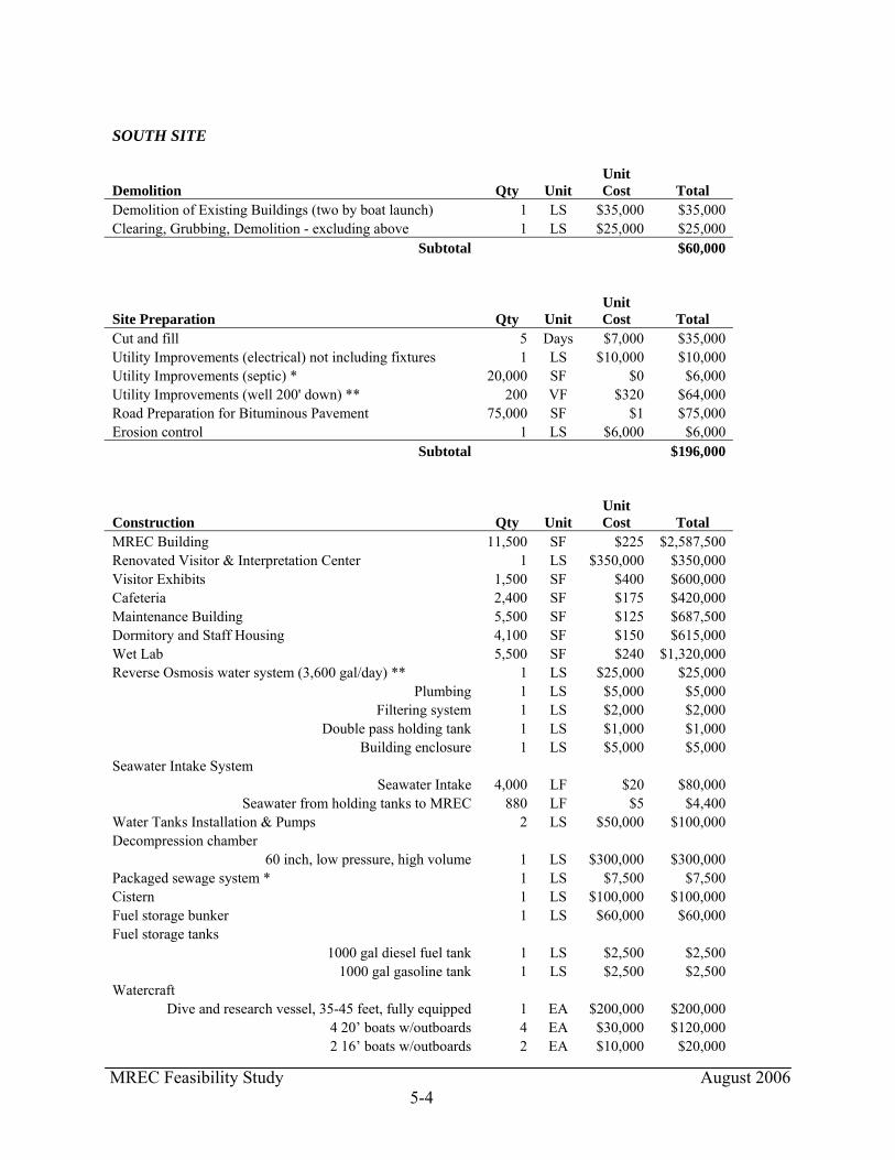
MREC Feasibility Study August 2006 5-4
SOUTH SITE
Demolition Qty Unit Unit Cost Total
Demolition of Existing Buildings (two by boat launch) 1 LS $35,000 $35,000 Clearing, Grubbing, Demolition - excluding above 1 LS $25,000 $25,000
Subtotal $60,000
Site Preparation Qty Unit Unit Cost Total
Cut and fill 5 Days $7,000 $35,000 Utility Improvements (electrical) not including fixtures 1 LS $10,000 $10,000 Utility Improvements (septic) * 20,000 SF $0 $6,000 Utility Improvements (well 200' down) ** 200 VF $320 $64,000 Road Preparation for Bituminous Pavement 75,000 SF $1 $75,000 Erosion control 1 LS $6,000 $6,000
Subtotal $196,000
Construction Qty Unit Unit Cost Total
MREC Building 11,500 SF $225 $2,587,500 Renovated Visitor & Interpretation Center 1 LS $350,000 $350,000 Visitor Exhibits 1,500 SF $400 $600,000 Cafeteria 2,400 SF $175 $420,000 Maintenance Building 5,500 SF $125 $687,500 Dormitory and Staff Housing 4,100 SF $150 $615,000 Wet Lab 5,500 SF $240 $1,320,000 Reverse Osmosis water system (3,600 gal/day) ** 1 LS $25,000 $25,000
Plumbing 1 LS $5,000 $5,000 Filtering system 1 LS $2,000 $2,000
Double pass holding tank 1 LS $1,000 $1,000 Building enclosure 1 LS $5,000 $5,000
Seawater Intake System Seawater Intake 4,000 LF $20 $80,000
Seawater from holding tanks to MREC 880 LF $5 $4,400 Water Tanks Installation & Pumps 2 LS $50,000 $100,000 Decompression chamber
60 inch, low pressure, high volume 1 LS $300,000 $300,000 Packaged sewage system * 1 LS $7,500 $7,500 Cistern 1 LS $100,000 $100,000 Fuel storage bunker 1 LS $60,000 $60,000 Fuel storage tanks
1000 gal diesel fuel tank 1 LS $2,500 $2,500 1000 gal gasoline tank 1 LS $2,500 $2,500
Watercraft Dive and research vessel, 35-45 feet, fully equipped 1 EA $200,000 $200,000
4 20’ boats w/outboards 4 EA $30,000 $120,000 2 16’ boats w/outboards 2 EA $10,000 $20,000
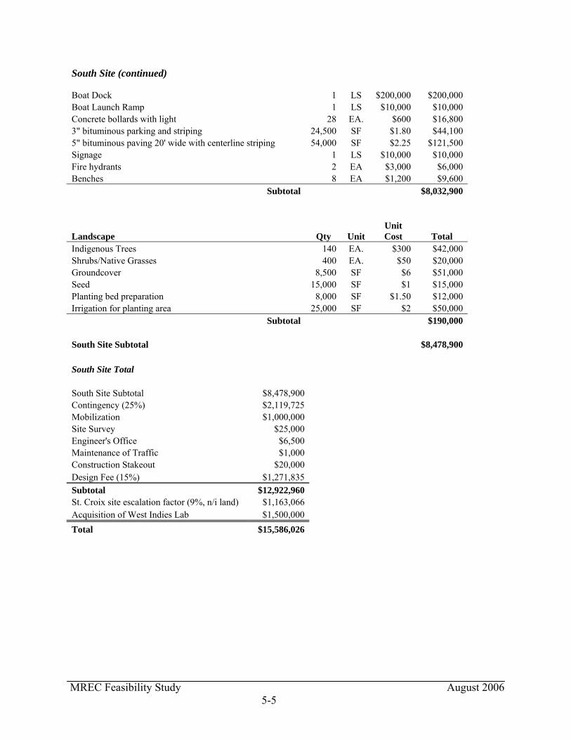
MREC Feasibility Study August 2006 5-5
South Site (continued) Boat Dock 1 LS $200,000 $200,000 Boat Launch Ramp 1 LS $10,000 $10,000 Concrete bollards with light 28 EA. $600 $16,800 3" bituminous parking and striping 24,500 SF $1.80 $44,100 5" bituminous paving 20' wide with centerline striping 54,000 SF $2.25 $121,500 Signage 1 LS $10,000 $10,000 Fire hydrants 2 EA $3,000 $6,000 Benches 8 EA $1,200 $9,600
Subtotal $8,032,900
Landscape Qty Unit Unit Cost Total
Indigenous Trees 140 EA. $300 $42,000 Shrubs/Native Grasses 400 EA. $50 $20,000 Groundcover 8,500 SF $6 $51,000 Seed 15,000 SF $1 $15,000 Planting bed preparation 8,000 SF $1.50 $12,000 Irrigation for planting area 25,000 SF $2 $50,000
Subtotal $190,000 South Site Subtotal $8,478,900
South Site Total South Site Subtotal $8,478,900 Contingency (25%) $2,119,725 Mobilization $1,000,000 Site Survey $25,000 Engineer's Office $6,500 Maintenance of Traffic $1,000 Construction Stakeout $20,000 Design Fee (15%) $1,271,835 Subtotal $12,922,960 St. Croix site escalation factor (9%, n/i land) $1,163,066 Acquisition of West Indies Lab $1,500,000 Total $15,586,026
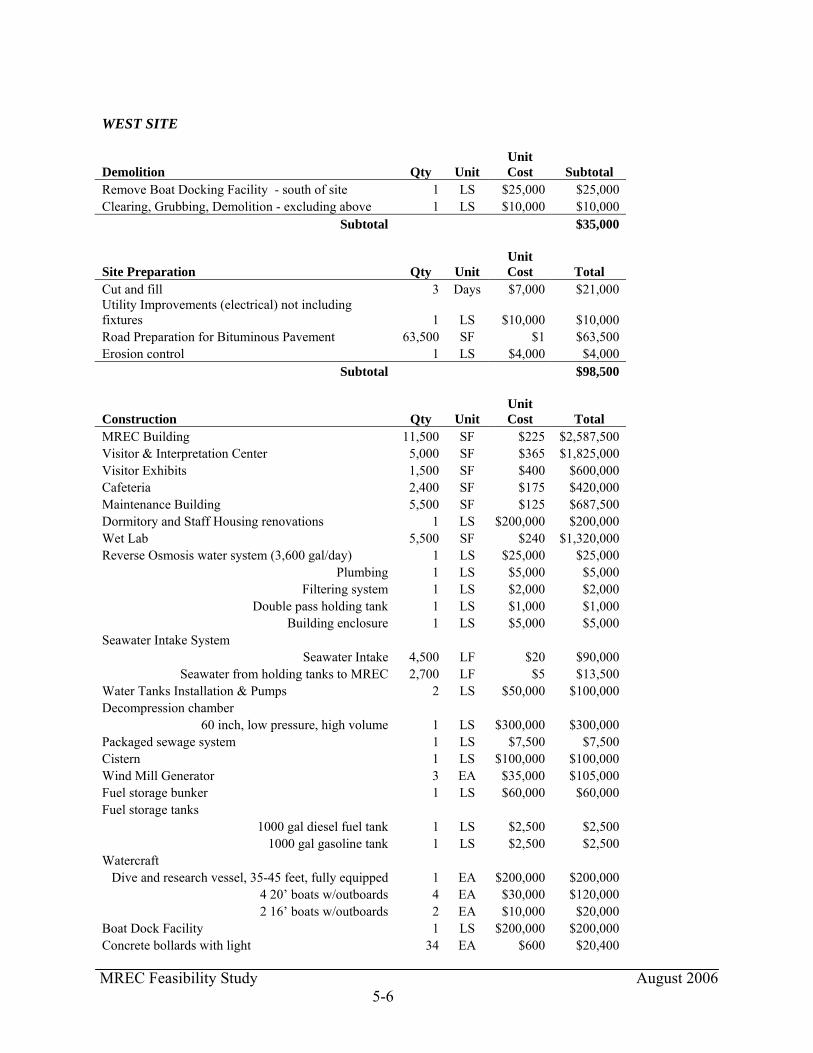
MREC Feasibility Study August 2006 5-6
WEST SITE
Demolition Qty Unit Unit Cost Subtotal
Remove Boat Docking Facility - south of site 1 LS $25,000 $25,000 Clearing, Grubbing, Demolition - excluding above 1 LS $10,000 $10,000
Subtotal $35,000
Site Preparation Qty Unit Unit Cost Total
Cut and fill 3 Days $7,000 $21,000 Utility Improvements (electrical) not including fixtures 1 LS $10,000 $10,000 Road Preparation for Bituminous Pavement 63,500 SF $1 $63,500 Erosion control 1 LS $4,000 $4,000
Subtotal $98,500
Construction Qty Unit Unit Cost Total
MREC Building 11,500 SF $225 $2,587,500 Visitor & Interpretation Center 5,000 SF $365 $1,825,000 Visitor Exhibits 1,500 SF $400 $600,000 Cafeteria 2,400 SF $175 $420,000 Maintenance Building 5,500 SF $125 $687,500 Dormitory and Staff Housing renovations 1 LS $200,000 $200,000 Wet Lab 5,500 SF $240 $1,320,000 Reverse Osmosis water system (3,600 gal/day) 1 LS $25,000 $25,000
Plumbing 1 LS $5,000 $5,000 Filtering system 1 LS $2,000 $2,000
Double pass holding tank 1 LS $1,000 $1,000 Building enclosure 1 LS $5,000 $5,000
Seawater Intake System Seawater Intake 4,500 LF $20 $90,000
Seawater from holding tanks to MREC 2,700 LF $5 $13,500 Water Tanks Installation & Pumps 2 LS $50,000 $100,000 Decompression chamber
60 inch, low pressure, high volume 1 LS $300,000 $300,000 Packaged sewage system 1 LS $7,500 $7,500 Cistern 1 LS $100,000 $100,000 Wind Mill Generator 3 EA $35,000 $105,000 Fuel storage bunker 1 LS $60,000 $60,000 Fuel storage tanks
1000 gal diesel fuel tank 1 LS $2,500 $2,500 1000 gal gasoline tank 1 LS $2,500 $2,500
Watercraft Dive and research vessel, 35-45 feet, fully equipped 1 EA $200,000 $200,000
4 20’ boats w/outboards 4 EA $30,000 $120,000 2 16’ boats w/outboards 2 EA $10,000 $20,000
Boat Dock Facility 1 LS $200,000 $200,000 Concrete bollards with light 34 EA $600 $20,400
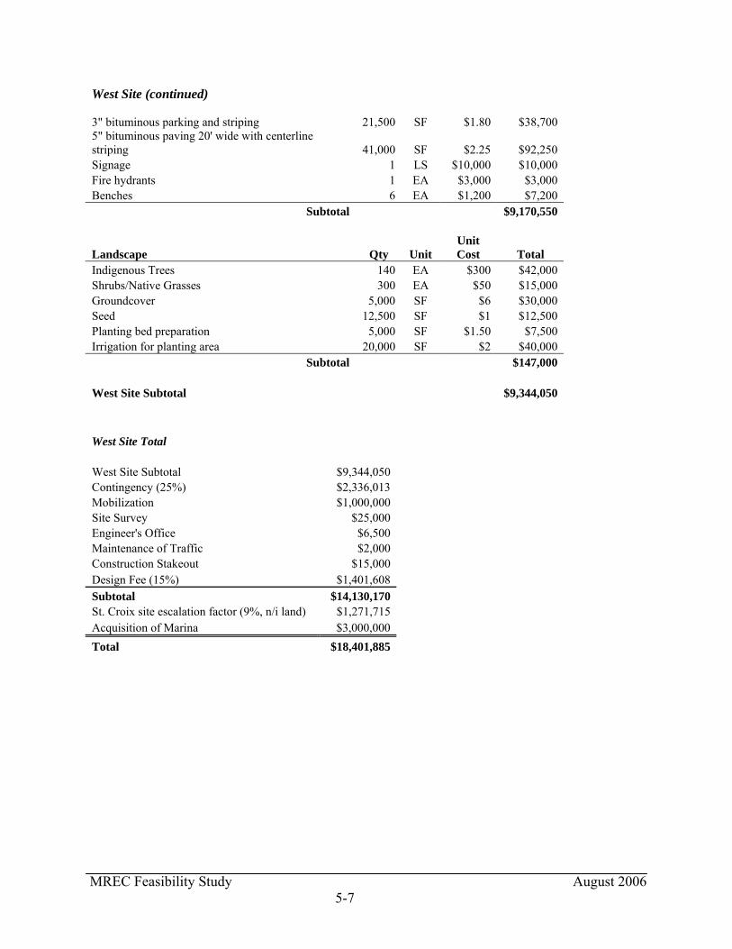
MREC Feasibility Study August 2006 5-7
West Site (continued) 3" bituminous parking and striping 21,500 SF $1.80 $38,700 5" bituminous paving 20' wide with centerline striping 41,000 SF $2.25 $92,250 Signage 1 LS $10,000 $10,000 Fire hydrants 1 EA $3,000 $3,000 Benches 6 EA $1,200 $7,200
Subtotal $9,170,550
Landscape Qty Unit Unit Cost Total
Indigenous Trees 140 EA $300 $42,000 Shrubs/Native Grasses 300 EA $50 $15,000 Groundcover 5,000 SF $6 $30,000 Seed 12,500 SF $1 $12,500 Planting bed preparation 5,000 SF $1.50 $7,500 Irrigation for planting area 20,000 SF $2 $40,000
Subtotal $147,000 West Site Subtotal $9,344,050
West Site Total West Site Subtotal $9,344,050 Contingency (25%) $2,336,013 Mobilization $1,000,000 Site Survey $25,000 Engineer's Office $6,500 Maintenance of Traffic $2,000 Construction Stakeout $15,000 Design Fee (15%) $1,401,608 Subtotal $14,130,170 St. Croix site escalation factor (9%, n/i land) $1,271,715 Acquisition of Marina $3,000,000 Total $18,401,885

MREC Feasibility Study August 2006 6-1
6. FEASIBILITY OF POTENTIAL SITE LOCATIONS On December 6 and 7, 2005, the project team met in Christiansted, Virgin Islands to review the conceptual site plans and complete the Choosing by Advantages (CBA) process, as well as a Value Analysis. In this analysis, the term “factor” describes a potential issue affecting the alternatives. For the purpose of this project, these factors were grouped under the four functions the MREC must serve in order to be feasible: Protecting Cultural and Natural Resources; Meeting the Needs of the Marine Research and Education Center; Providing for Visitor Enjoyment; and Providing Benefits to the Local Community. During the site analysis phase of the project, the consultant team developed a set of potential factors for the MREC, analyzing each to determine whether the alternatives differed on them, for it is the difference among alternatives that the CBA process considers an “advantage.” Factors for which the alternatives were considered not to differ in any substantial manner have been noted in this report as “Factors Considered but Eliminated.” The project team considered these at the session at Christiansted and concurred that a difference among them could not be determined. Elements of a “factor” are considered “attributes” in CBA parlance. For example, under the factor of “Minimizing Impacts to Water Resources,” the “attribute,” or measure, of the factor was determined to be the number of feet that the seawater intake line would need to traverse on the Bay floor to reach an acceptable intake point. The length of these lines would differ depending on where the MREC would be sited, and the advantage of an alternative is a shorter line, measured in feet. At the CBA session, the project team identified the advantages of each factor and compared these advantages to one another, to determine which advantage was most important to this project, or “paramount.” (This “paramount advantage” receives a score of 100 in the CBA matrix.) The next step is to compare the other advantages to this “paramount advantage” to determine their importance relative to the paramount advantage and then to assign an appropriate score for each. After this exercise is completed, the scores of each alternative are calculated, and the alternative that scores the highest is considered the best alternative. 6.1 FACTORS USED IN CHOOSING BY ADVANTAGES PROCESS The factors developed for the CBA process are described below, with the matrix of CBA scores in the next section. 6.1.1 Function: Protect Cultural/Natural Resources Minimize Impacts to Mangroves/Wetlands: This factor refers to the impact of the MREC to the mangroves and wetlands located at SARI. It is estimated that Alternatives 1 and 2 (East and South Sites) would impact 0.31 and 0.55 acres of mangroves/wetlands, respectively. Alternative 3 (West Site) would not impact mangroves/wetlands. Advantage: This factor’s attributes were measured as acres. The scores assigned to these advantages are shown in the matrix.

MREC Feasibility Study August 2006 6-2
Minimize Impacts to Coastal Barriers: This factor refers to the impact of the MREC in designated coastal barriers. The Wet Lab, Maintenance Building, boat dock, and mooring facilities of Alternative 1 (East Site) and Alternative 3 (West Site) would be located in an area designated as a coastal barrier. The maintenance dredging required at Alternatives 1 and 2 would also occur in an area designated as a coastal barrier. The only structures located within an area designated as a coastal barrier for Alternative 2 (South Site) would be the boat dock and mooring facilities. Additionally, the underwater pipeline that would bring salt water from the sea to the MREC facility would impact the coastal barrier at all alternatives. Advantage: This factor’s attributes were measured as impacts, on a high-medium-low scale, with low being the best. Alternative 2 (South Site) was considered to have the lowest impact. Minimize Impacts to Floodplains: This factor refers to the impact of the MREC on the 100-year floodplain (as mapped by FEMA). Alternative 2 (South Site) is not located within a 100-year floodplain. The boat dock, boat launch, and moorings of Alternatives 1 and 3 (East and West Sites) are located in the 100-year floodplain. Negligible impacts are anticipated to the floodplain from these alternatives. The underwater pipeline that would bring salt water from the sea to the MREC facility and Wet Lab would impact the 100-year floodplain at Alternative 1. There would be no impact to the 100-year floodplain from the pipeline at Alternatives 2 and 3. However, it is not possible to fully evaluate the impacts of the pipeline because site-specific water quality sampling would be needed to make this assessment. Based on available information, the impacts are not expected to be significant at any of the sites. Advantage: This factor’s attributes were measured as impacts, with Alternative 2 (South Site) considered not having direct impacts. Minimize Impacts to Water Resources: This factor refers to the impact of the seawater pipeline to resources located in the bay (i.e., underwater cultural resources, seagrasses, coral, fish, and benthos). An underwater archaeological survey would be needed for each alternative to determine if submerged resources are present, and to investigate and evaluate the impacts to these resources. Because Alternative 1 (East Site) is the closest to the Caribbean Sea, it has a lower potential to affect submerged resources than either Alternative 2 (South Site) or Alternative 3 (West Site - Salt River Bay Marina), both of which are at the back of the bay. Seagrasses would be impacted by the pipeline at all alternatives; however, these impacts would pose a short-term temporary impact. Impacts from the pipeline to coral are unknown until site-specific water quality data is collected. Short-term minor adverse effects to fish and benthos would occur during installation of the pipeline. Advantage: This factor’s attributes were measured as number of feet of pipeline, with the shorter lengths being considered advantages. Protect the Cultural Landscape: This factor refers to the impact of the MREC to the cultural landscape at SARI. SARI is a cultural landscape, with the Salt River Bay being the only known US-owned location where Columbus landed as well as a focus of prehistoric and early historic settlement. Construction of the MREC thus has the potential to have an effect on this landscape.

MREC Feasibility Study August 2006 6-3
Alternative 1 (East Site) would have an effect on the SARI cultural landscape, however, depending on the mass and scale of the MREC's facilities, this effect may not be adverse. The view of the MREC structures would be shielded from ocean approaches from the east but would visible from the west as well as directly off shore from Salt River Bay. Demolition of the Virgin Grand Hotel shell, if completed in concert with construction of the MREC, could be considered as a mitigating factor for visual effect as the Virgin Grand structure is far more visually intrusive than the proposed MREC buildings. The visual effect (as well as potential effect on archaeological resources) could also be mitigated by moving the MREC building, visitors center, cafeteria and dormitories south of the wet lab and water tanks, further from the mouth of the bay. Alternative 2 (South Site) is located on a knoll at the back of the bay. The proposed MREC facilities would be located behind a hill which dominates this point. Use of this alternative should not have an effect on SARI's cultural landscape, so long as the mass and scale of buildings did not significantly exceed the height of this hill. For Alternative 3 (West Site), the Salt River Bay Marina is tucked back into the southwest corner of the bay and is not visible from the ocean. Use of this marina would not have an adverse affect on SARI's cultural landscape, as long as the new facilities' mass and scale were appropriate. The Visitor Contact Station sits on a hill above Salt River Bay, and while visible, does not detract from the cultural landscape of the bay as it is well elevated above the bay and the Columbus Landing site. Reuse of this building or new construction on the site of the Visitor Contact Station should not have an effect on Salt River Bay's cultural landscape, so long as the new construction does not substantially vary from the height of the Visitor Contact Station. Structures taller than three stories on this location could have an adverse effect. Advantage: This factor’s attributes were measured as impacts, on a high-medium-low scale, with low being the best. Alternative 2 (South Site) was considered to create the least amount of disturbance. Provide Improvements to Water Quality Where Possible: This factor refers to the potential impact of the MREC to the water quality (i.e., fecal coliform, runoff) at SARI. Water quality impacts are expected to be minor from all alternatives. Alternative 3 (West Site) would benefit the water quality at SARI by reducing/eliminating the Salt River Bay Marina water quality issues when the NPS has control over the marina operations. Advantage: This factor’s attributes were measured as improvements to water quality, on an excellent-good-fair-poor scale, with qualitative assessments made by the team given their interpretation of the data. Alternative 3 (West Site) was considered to have the highest likelihood for significant improvements. Mitigate Impacts to Native Vegetation: This factor refers to the impact to native vegetation (other than mangroves and wetlands) from the MREC. Alternative 1 would impact approximately 0.35 acres of forest, 6.55 acres of vegetated fields, and 5.0 acres of shrubs due the MREC facilities, roads, and associated parking facilities. However, most of the vegetation at this site is invasive. Impacts to native plants are expected to be minor. Alternative 2 would impact approximately 10.93 acres of forest, 0.09 acres of shrubs, and 0.34 acres of vegetated fields by the MREC. Impacts to native plants are expected to be moderate for this alternative. Alternative 3 would impact approximately 0.77 acres of forest, 0.49 acres of shrubs, and 2.73 acres of vegetated fields at the Visitor Contact Station and the marina. Most of the vegetation at the
MREC Feasibility Study August 2006 6-4
Visitor Contact Station is invasive; therefore impacts to native plants are expected to be minor. Advantage: This factor’s attributes were measured as impacts, on a high-moderate-low-none scale, with Alternative 1 (East Site) considered to have low impact to native plants. 6.1.2 Function: Meet the Needs of the Marine Research and Education Center Provide Direct Vehicular Access to the MREC via a Public Right of Way: This factor refers to the ability of MREC staff, students and visitors to access the facility. If the MREC is to serve the public, it requires roadway access via a public right of way for users and support vehicles providing service to the center. Alternative 3 (Visitor Contact Station and Salt River Bay Marina) have adequate public road access. Road access to Alternative 1 (East Site) and Alternative 2 (South Site) are restricted. Public road access would have to be negotiated for these sites or new roads provided. Advantage: This factor’s attributes were measured as access, on an excellent-fair-good-poor scale, with Alternative 3 (West Site) having the best access and Alternative 1 (East Site) and Alternative 2 (South Site) requiring some road improvements. Have Access to Seawater: This factor refers to the MREC’s need for seawater for research to be undertaken in the Wet Lab and the MREC itself. To accomplish this, an intake pipe would be placed along the bottom of the bay to connect an intake point at an appropriate location to pumps and holding tanks adjacent to the Wet Lab. While it is believed that this intake line can be built and connected to the Wet Lab in each alternative, the length of the line will vary by alternative. It is estimated that this line would be at least 1,000 linear feet at Alternative 1 (East Site) and at least 1,600 linear feet from Alternative 2 (South Site) and Alternative 3 (West Site). The longer the line, the more it would cost to construct and maintain and the larger the impact it would have on water resources. Advantage: This factor’s attributes are measured as linear feet of the seawater intake line, with shorter lengths being considered advantages. Provide Adequate Space for Proposed and Existing MREC and NPS Programs: This factor relates to site capacity. Each site must have adequate developable area to support the MREC program and accessory facilities. In gross terms, Alternative 1 (East Site) is approximately 70 acres, Alternative 2 (South Site) is about 58 acres, and the combined area of Alternative 3 (West Site), which includes the Visitor Contact Station and Salt River Bay Marina, (including only the portion of the marina site proposed for use) is about 10 acres. Additional site analysis will be required to determine the actual developable area on each site. However, it is known that floodplains, cultural resources and other considerations including steep slopes would reduce the amount of developable land at each site. Advantage: This factor’s attributes are measured as acres, with more acres being considered advantages. Provide a Contiguous Site for All MREC Uses: This factor relates to the desire to create a unified MREC in a campus setting. Although it is not imperative that the MREC be contained on one site, the consortium has expressed a preference for this to be the case. Advantage: This factor’s attributes are measured as whether an alternative has or does not have contiguousness, with continuousness being the advantage. Construct the MREC on Available Land: This factor relates to the need for NPS to acquire properties for the MREC that it does not currently own if the MREC is to be constructed on those
MREC Feasibility Study August 2006 6-5
sites. The NPS owns the East Site and land at the Visitor Contact Station, but it does not own the South Site or land at the Salt River Bay Marina. Advantage: This factor’s attributes as measured on the amount of land acquisition needed, with the East Site (Alternative 1) considered best because no acquisition would be needed. Address Need for Dredging: This factor relates to the need for the NPS or other governmental body dredging the bay or an inlet to support the MREC and docking facility. Advantage: This factor’s attributes are measured as the likelihood for dredging in the near term, on a high-medium-low scale, with low as the best, with Alternative 2 (South Site) as the highest since this alternative has a high probability for dredging in the foreseeable future and is located further back in the bay. Improve Operational Efficiency and Sustainability: This factor relates to the potential for the MREC to improve the operational efficiency and sustainability of the Park Service’s existing facility and services in the area. Advantage: This factor’s attributes were measured as the likelihood of improved operations, on a high-medium-low scale, with high as the best. Alternative 3 (West Site) was considered the most likely to result in improved operations. 6.1.3 Function: Provide for Visitor Enjoyment Provide a Quality Visitor Experience: This factor refers to the impact of the MREC on visitor experience at SARI. There are currently no visitor services authorized by NPS at SARI. Regardless of the alternative, the visitor experience at SARI would be greatly enhanced from current conditions by the addition of the MREC facility. Additionally, Alternative 1 has the potential in the future to interpret archaeological sites and offer additional recreation at this site. Alternative 3 (West Site) has the potential in the future to interpret the Columbus Landing site. Advantage: This factor’s attributes are measured in the extent of improvement expected from each alternative, on a high-medium-low scale. Alternative 1 (East Site) was considered to have the most potential for improvement given the size of the site, the existing vista and cultural and historic resources available on the site. 6.1.4 Function: Provide Benefits to the Local Community Support Compatibility with Adjacent Land Uses: This factor relates to the relationship of the MREC to adjacent land uses as well as the impact of adjacent land uses to the MREC. The use of the facility will generate traffic and noise on the site, and these impacts will be greater if and when the center becomes more heavily used. Advantage: This factor’s attributes were measured as compatibility to and with adjacent land uses, on a high-medium-low scale, with high the best. Alternative 1 (East Site) was considered the most compatible because improvements at the site would result in more controlled use of the property. Provide Socio-Economic Benefits to the Local Community: This factor refers to the impact of the MREC to benefit the socioeconomics of the local community. Constructing the MREC would provide opportunities for employment and educational programs, which would create an economic benefit to the community. In each alternative, the local economy would benefit from the construction of the facility; in areas where commercial uses would be allowed, there may be

MREC Feasibility Study August 2006 6-6
some indirect economic impacts as well. Advantage: This factor’s attributes were measured as the potential for economic benefits, on a high-medium-low scale, with Alternative 3 (West Site) being considered the most likely to support economic uses, given the existing marina and the site’s proximity to a heavily-traveled public road and the potential for additional uses supporting the ones already in place. 6.2 FACTORS CONSIDERED BUT ELIMINATED The following factors were considered in the CBA process but were determined not to have significant differences among the alternatives: Air Quality: Minor impacts to air quality may occur from stationary and mobile sources at the MREC regardless of the alternative. RTE Species: The MREC would not adversely affect the federally listed species regardless of the alternative. Seismic Activity: Mitigation for seismic activity would occur regardless of the alternative. Noise: There would be minor impacts associated with the noise from the MREC regardless of the alternative. Hydrology/Ground Water: No impacts to hydrology or groundwater are anticipated as a result of implementing the MREC facility. Utilities: Access and use of utilities would be the same for each alternative. Hurricanes: Mitigation (i.e., thicker roof designed to withstand 150 mph winds, insulated steel-enforced concrete walls, stronger windows and doors) for earthquakes at MREC would occur regardless of the alternative. Land-Based Cultural Resources: An archaeological survey would be required for areas of new construction and such survey may identify archaeological resources requiring further investigation regardless of the alternative. Wildlife: There would be short-term, minor impacts to the birds and mammals in the area regardless of the alternative. 6.3 CHOOSING BY ADVANTAGES MATRIX The outcomes of the CBA process are shown on Figure 6-1.
MREC Feasibility Study August 2006 6-7
6.4 CONCLUSIONS The purpose of this study was to determine the feasibility of three alternatives for siting a proposed MREC at SARI. To determine the feasibility of the alternatives several steps were taken including describing the existing conditions of the sites under consideration and evaluating the environmental impacts of the alternatives. The alternatives (or sites) were examined in detail, given the information available on existing conditions, and preliminary site plans were developed for each alternative. Among the elements evaluated were floodplains, topography, susceptibility to hurricanes and earthquakes, cultural and historic resources, and environmental impacts. The individual site plans attempted to mitigate impacts to these elements and accommodate the building program in an environmentally responsible manner while providing the means to compare the advantages of each alternative. The final steps in determining the feasibility of the alternatives involved a cost analysis and the Choosing by Advantages (CBA) process. A preliminary estimate of probable costs based on schematic designs was prepared for each of the alternatives, which resulted in similar costs among alternatives. The project team reviewed the conceptual site plans and completed the CBA process, as well as a Value Analysis. The factors or attributes developed for the CBA process were to protect cultural/natural resources, meet the needs of the MREC, provide for visitor enjoyment, and provide benefits to the local community. CBA scores for each alternative were calculated, and the alternatives were ranked based on total CBA scores. Alternative 1 (East Site) scored the highest, so it was considered the best alternative for the MREC.
MREC Feasibility Study August 2006 7-1
7. REFERENCES Brower, D.J. and T. Beatley. 1988. Natural hazard mitigation plan for the U.S. Virgin Islands.
Prepared for the Virgin Islands Territorial Emergency Management Agency . St. Thomas, USVI.
Coastal Barrier Resources Act. 2005 (downloaded). Digest of Federal Resource Laws of
Interest to the U.S. Fish and Wildlife Service. http://laws.fws.gov/lawsdigest/coasbar.html
Department of Planning and Natural Resources Division of Environmental Protection (DPNR/DEP). 2004. State of the Environment, United States Virgin Islands. <http://dpnr.gov.vi/dep/pubs/1_29_SOE-Reportx_Final.pdf>. Accessed 8/23/05. Department of Planning and Natural Resources Division of Fish and Wildlife (DPNR/DFW). 2005. United States Virgin Islands Marine Resource and Fisheries Strategic and Comprehensive Conservation Plan. U.S. Virgin Islands. EA Engineering, Science and Technology, Inc, (EA). 2006. Preliminary Site Assessment Report
Proposed Marine Research and Education Center Salt River Bay National Historic Park and Ecological Preserve St. Croix, U.S. Virgin Islands. Prepared by EA Engineering, Science and Technology, Inc for the National Park Service. February 2006.
Federal Emergency Management Agency (FEMA). 1982. Flood Insurance Rate Map.
Federal Emergency Management Agency (FEMA). 2005 (downloaded) Flood Hazard Mapping. Coastal Barrier Resources System. http://www.fema.gov/fhm/fmc_cbrs.shtm.
Figueredo, Alfredo E. and George F. Tyson. 1986. Phase I Cultural Resources Survey of Sugar
Bay Land Development, Ltd., Estate Judith's Fancy, St. Croix. Cultural Resources Inc. Report prepared for Sugar Bay Land Development, Ltd.
Figueredo, Alfredo, Bruce Tilden, and John Winter. 1989. Phase I Cultural Resources Survey
of Plots 8, 9, 10 and 11, Estate Salt River. Manuscript on file, SEAC. Forman, Richard T. T. An Introduction to the Ecosystems and Plants on St. Croix, U.S. Virgin Islands. Department of Botany, Rutgers University, New Brunswick, New Jersey. 237 pp. Fosberg, F. R. Sketch of the St. Croix Flora. Smithsonian Institute, Washington, D.C. 1 pp.

MREC Feasibility Study August 2006 7-2
Gaines, Arthur G., Elizabeth H. Gladfelter, Porter Hoagland, Hauke Kite-Powell. 1999. An Earth Sciences Observatory at St. Croix: Economic Analysis for a New Scientific Facility on the U.S. Virgin Islands. Marine Policy Center, Woods Hole Oceanographic Institution Woods, MA 02543, 62 pp. Gaztambide, Juan B. SREA, MIE, ASA. 1971. Appraisal Report for Plots No. 328 and 329
(Reclaimed Land) at Estate Judith’s Fancy, St. Croix, U.S. Virgin Islands. 36pp. Geoscience Associates, 1984. Phase 2 Report; Vulnerability analysis, earthquake hazards of the
U.S. Virgin Islands. Prepared for the USVI Government, Office of the Governor, Disaster Programs Office. St. Thomas, USVI.
Hardy, Meredith D. 2005. Preliminary Report – Archaeological Investigations of Salt River
Bay National Historic Site and Ecological Preserve, St. Croix, US Virgin Islands. NPS SEAC, Accession Number 1953.
Hardy, Meredith D. No Date. Archaeological Overview of the Salt River Bay National Historical Park and Ecological Preserve, St. Croix, USVI. Draft in progress. NPS SEAC.
Hubbard, D.K. 1989. Depositional environments of Salt River Estuary and Submarine Canyon,
St. Croix, U.S. Virgin Islands. In Terrestrial and Marine Geology of St. Croix, U.S. Virgin Islands, Hubbard, D.K., eds. West Indies Laboratory, Special Publication No. 8.
Joseph, J. W. 1989. A Phase I Cultural Resources Survey of the St. Croix Virgin Grand
Development Site, Estate Judith's Fancy, St. Croix, USVI. Report prepared for the Allen-Williams Company. New South Associates, Stone Mountain, Georgia.
Joint Institute for Caribbean Marine Studies (JICMS). 2004. Guidelines from the Joint Institute
for Caribbean Marine Studies to the National Park Service, St. Croix, Virgin Islands for A Feasibility Study to Establish the Salt River Bay Marine Research and Educational Center. November 15, 2004.
Joint Institute for Caribbean Marine Studies (JICMS). 2005. Draft Twenty-Year Plan for the
Salt River Bay Marine Science and Education Center. A Partnership between the National Park Service and the Office of Insular Affairs, U.S. Department of Interior, and the JICMS.
Island Resources Foundation (IRF). 1993. Salt River Bay and Watershed (APR) Area of
Particular Concern (APC) and Area for Preservation and Restoration (APR). A Comprehensive Analytic Study. V.I. Department of Planning and Natural Resources Coastal Zone Management Program. Draft prepared by: Island Resources Foundation under Contract PC PNR-330-92 with assistance from: The University of the Virgin Islands. September 21, 1993.

MREC Feasibility Study August 2006 7-3
Kendall, M.S., L.T. Takata, O. Jensen, Z. Hillis-Starr, and M.E. Monaco. 2005. An Ecological Characterization of the Salt River Bay National Historical Park and Ecological Preserve, U.S. Virgin Islands. NOAA Technical Mémorandum NOS NC-COS##, 114 pp.
Leak, Charles F. Avifauna of St. Croix. Department of Zoology, Rutgers University. 10 pp. McManus, John J. Notes on the Vertebrate of St. Croix Land Mammals, Reptiles, and
Amphibians. Department of Biology, Fairleigh Dickinson University. 7 pp National Audubon Society Christmas Count Data website: http://audubon2.org/birds/cbc/hr/count_table.html, accessed 30 August 2005. National Park Service (NPS). 1990. Alternatives Study and Environmental Assessment,
Columbus Landing Site, St. Croix, U.S. Virgin Islands. Division of Planning, Design, and Compliance: Southeast Region, National Park Service, 103 pp.
National Park Service (NPS). 2005. Salt River Bay. National Historic Park & Ecological
Preserve, Virgin Islands. http://www.nps.gov/sari Squiabro, Hector A. 2004. The 2004 U.S. Virgin Islands 303(d) List.
<http://dpnr.gov.vi/dep/PubnotaVI%20303d_2004_revisedRenotice.htm>. Accessed 8/10/05.
Teytaud, A.R. 1980. Preliminary Report on Potential Significant Natural Area (SNA) sites.
Department of Conservation and Cultural Resources. St. Thomas, USVI. U.S. Census Bureau. 2005. American Fact Finder. <http://www.census.gov>. Accessed
8/12/05. United States Fish and Wildlife Service (USFWS). 1992. St. Croix Ground Lizard.
<http://www.fws.gov/endangered/i/c/sac/m.html>. Accessed 912/05. United States Geological Survey (USGS). 1984. A workshop on earthquake hazards in the
Virgin Islands region. Open-file report 84-762. U.S. Department of the Interior, USGS. Reston, VA.
United States Geological Survey (USGS) Northwestern Prairie Research Center Bird Checklists
of the United States website – Checklist Sandy Point and Green Cay National Wildlife Refuges, Christiansted, Virgin Islands accessed 30 August 2005.
United States Virgin Islands Department of Planning and Natural Resources (USVI-DPNR).
2005. A Comprehensive Wildlife Strategy for the U.S. Virgin Islands, June 1, 2005 216 pages.

MREC Feasibility Study August 2006 7-4
University of North Carolina at Wilmington, University of the Virgin Islands, Rutgers, The State University of New Jersey, University of South Carolina. 2004.
Guidelines from the Joint Institute for Caribbean Marine Studies to the National Park Service, St. Croix, Virgin Islands for a Feasibly Study the Salt River Bay Marine Research and Education Center. 10 pp.
Whetten, John T. Field Guide to the Geology of St. Croix, U.S. Virgin Islands. Department of
Geology and Department of Oceanography, University of Washington. 14 pp.