fayette county comprehensive transportation plan · fayette county comprehensive transportation...
TRANSCRIPT

Fayette CountyComprehensive Transportation Plan
November 2010
Prepared by
AECOM
in partnership with
Mallett Consulting, Inc.McGee PartnersSteer Davies Gleave
for the
Fayette County Board of Commissioners


3Fayette Forward Table of Contents
Acknowledgements
Fayette County Board of Commissioners
Robert Horgan, Post 1Herbert Frady, Post 2Lee Hearn, Post 3Jack Smith, Chairman, Post 4 (At-Large)Eric Maxwell, Post 5 (At-Large)
Jack Krakeel, County AdministratorPhilip Mallon, Director of Public WorksPete Frisina, Director of Planning and ZoningCarlos Christian, EngineeringTom Williams, Planning and ZoningBryan Keller, StormwaterVanessa Burrell, Stormwater
City of Fayetteville
Mayor Kenneth SteeleCouncilor Larry DellCouncilor Al Hovey-KingCouncilor Paul C. Oddo, Jr.Councilor Wilson PriceCouncilor Walt WhiteDonald Easterbrook, City EngineerEldridge Gunn and Linwood Robinson, Planning Department
City of Peachtree City
Mayor Don HaddixCouncil Member Eric Imker, Post 1Council Member Doug Sturbaum, Post 2Council Member Kim Learnard, Post 3Council Member Vanessa Fleisch, Post 4David Borkowski, City EngineerDavid Rast, City Planner
Atlanta Regional Commission
Regan Hammond, County Comprehensive Transportation Plan Program CoordinatorLyubov Zuyeva, Senior PlannerLaura Keyes, Past CTP Program Coordinator
Georgia Department of Transportation
Andrew Heath

iFayette Forward Table of Contents
Table of Contents
Chapter 1: Executive Summary and Action Plan
1.1 Transportation Action Plan 1-6
Chapter 2: Inventory and Assessment
2.1 Land Use and Development Conditions 2-3
2.1.1 Existing Land Use Patterns 2-3
2.1.2 Future Land Use Patterns 2-6
2.1.3 Developments of Regional Impact 2-10
2.1.4 Livable Center Initiative (LCI) Studies 2-12
2.1.5 Employment and Retail Centers 2-14
2.1.6 Schools 2-16
2.1.7 Natural Environmental Resources 2-18
2.2 Population and Demographic Trends 2-22
2.2.1 County Population and Growth Trends 2-22
2.2.2 Demographics 2-25
2.2.3 Population and Employment 2-27
2.3 Roadway Inventory 2-28
2.3.1 Inventory of Major Roadway 2-28
2.3.2 Functional Classifi cation 2-32
2.3.3 Traffi c Control Infrastructure 2-34
2.3.4 Bridges 2-36
2.4 Multi-modal Inventory 2-38
2.4.1 Existing Rail Inventory 2-38
2.4.2 Freight Corridors 2-40
2.4.3 Aviation 2-42
2.4.4 Sidewalks, Trails, and Bicycle Facilities 2-44
2.4.5 Transit 2-46
iiFayette Forward Table of Contents
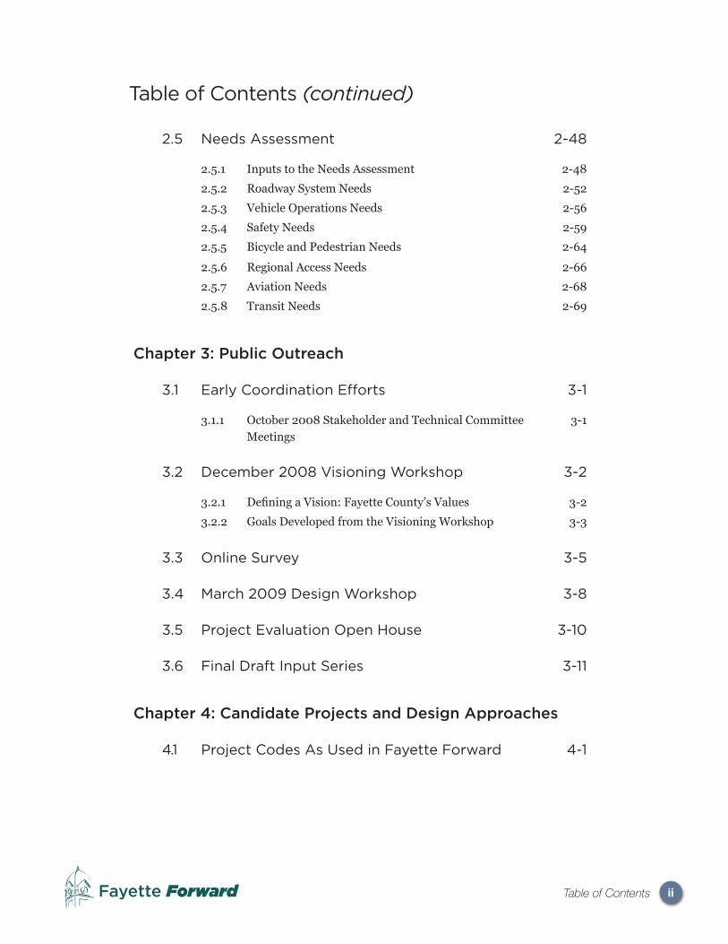
2.5 Needs Assessment 2-48
2.5.1 Inputs to the Needs Assessment 2-48
2.5.2 Roadway System Needs 2-52
2.5.3 Vehicle Operations Needs 2-56
2.5.4 Safety Needs 2-59
2.5.5 Bicycle and Pedestrian Needs 2-64
2.5.6 Regional Access Needs 2-66
2.5.7 Aviation Needs 2-68
2.5.8 Transit Needs 2-69
Chapter 3: Public Outreach
3.1 Early Coordination Efforts 3-1
3.1.1 October 2008 Stakeholder and Technical Committee Meetings
3-1
3.2 December 2008 Visioning Workshop 3-2
3.2.1 Defi ning a Vision: Fayette County’s Values 3-2
3.2.2 Goals Developed from the Visioning Workshop 3-3
3.3 Online Survey 3-5
3.4 March 2009 Design Workshop 3-8
3.5 Project Evaluation Open House 3-10
3.6 Final Draft Input Series 3-11
Chapter 4: Candidate Projects and Design Approaches
4.1 Project Codes As Used in Fayette Forward 4-1
Table of Contents (continued)
iiiFayette Forward Table of Contents
Chapter 5: Evaluation and Assessment
5.0 Project Evaluation Introduction 5-1
5.1 Technical Evaluation Criteria 5-2
5.1.1 Goal 1 - Safe and Balanced Transportation Choices 5-2
5.1.2 Goal 2 - Support Vision for Positive Growth 5-3
5.1.3 Goal 3 - Maintain Fiscal Sustainability 5-4
5.1.4 Goal 4 - Preserve Rural Character 5-5
5.1.5 Goal 5 - Desirable Places for All Citizens and Stages of Life
5-6
5.2 Travel Demand ModelEnhancement and Validation
5-7
5.2.1 Classifi cation of Roadway Network 5-7
5.2.2 Network Zone Refi nement 5-8
5.2.3 Socioeconomic Data Adjustment 5-10
5.2.4 Model Validation 5-11
5.3 Evaluation Using the Travel Demand Model 5-14
5.3.1 Grouping Candidates into Model Scenarios 5-14
5.3.2 Project Coding in the Travel Demand Model 5-15
5.3.3 Performance Measures of Effectiveness 5-18
5.3.4 Scenario Performance 5-20
5.4 Incorporating Community Preference and Need
5-23
5.5 Guidelines for Project Prioritization 5-24
Table of Contents (continued)

ivFayette Forward Table of Contents
Chapter 6: Plan Recommendations
6.1 Project Recommendations 6-1
6.1.1 Tier 1 Projects 6-2
6.1.2 Tier 2 Projects 6-2
6.1.3 Tier 3 Projects 6-18
6.1.4 Capacity and Operational Projects 6-18
6.1.5 Candidate Projects Not Recommended for Implementation 6-20
TIER 1 PROJECT LIST 6-3
TIER 2 PROJECT LIST 6-8
TIER 3 PROJECT LIST 6-14
6.2 Policy Recommendations andImplementation Strategies
6-21
6.2.1 New Project Scoping Phases 6-21
6.2.2 Facility Maintenance 6-23
6.2.3 Access Management 6-24
6.2.4 Transportation Demand Management 6-27
6.2.5 Public Transit Service 6-39
6.2.6 Transportation Services for the Elderly and Disabled 6-40
6.2.7 Land Use 6-41
6.2.8 Intelligent Transportation Systems 6-43
6.3 Funding Approaches and Strategies 6-44
6.3.1 Federal and State Funding Sources 6-44
6.3.2 Regional-Level Funding Sources 6-45
6.3.3 County Strategies: Capital Improvement Program 6-45
6.3.4 County Strategies: Future SPLOST 6-45
6.4 Monitoring Implementation of the Plan 6-46
6.4.1 Annual Call for Projects 6-46
6.4.2 Annual Staff Presentation of Administrative Change 6-47
6.4.3 Ongoing Planning Activities 6-47
Table of Contents (continued)

vFayette Forward Table of Contents
List of Figures
Chapter 1: Executive Summary
No Figures Included in Chapter 1
Chapter 2: Inventory and Assessment
No Figures Included in Chapter 2
Chapter 3: Public Outreach
Figure 3.1.1 Fayette County Rural Landscape Character 3-2
Figure 3.4.1 Fayette County March 2009 Design Workshop 3-8
Figure 3.4.2 County and City Staff Design Workshop 3-9
Chapter 4: Candidate Projects and Design Approaches
No Figures Included in Chapter 4
Chapter 5: Evaluation & Assessment
Figure 5.2.1A ARC Functional Classifi cation 5-7
Figure 5.2.1B GDOT Functional Classifi cation 5-8
Figure 5.2.2 TAZs for Modifi cations 5-10
Figure 5.2.4 Screenline Locations 5-11
Chapter 6: Evaluation & Assessment
Figure 6.2.3A Access Management Approaches for Existing Corridors
6-24
Figure 6.2.3B Access Management Cross Access Diagrams 6-26

viFayette Forward Table of Contents
List of Maps
Chapter 1: Executive Summary
No Maps Included in Chapter 1
Chapter 2: Inventory and Assessment
Map 2.1.0 Regional Context Map 2-2
Map 2.1.1 Existing Land Use Patterns 2-5
Map 2.1.2A Future Land Use Patterns 2-7
Map 2.1.2B Large Parcels 2-9
Map 2.1.3 Developments of Regional Impact 2-11
Map 2.1.4 Livable Center Initiative (LCI) Studies in Fayette County 2-13
Map 2.1.5 Employment and Retail Centers 2-15
Map 2.1.6 Locations of Schools 2-17
Map 2.1.7A Stream and Wetland Corridors 2-19
Map 2.1.7B Water Supply Watersheds 2-20
Map 2.2.1A Fayette County Population Growth Trends 2-23
Map 2.2.1B Current and Projected Population and Employment Densities
2-24
Map 2.2.2A Median Household Income Relative to Region 2-26
Map 2.2.2B Proportion of Residents aged 65 and Greater Relative to Region
2-26
Map 2.3.1 Roadways and Effective Network 2-31
Map 2.3.2 GDOT Functional Classifi cation 2-23
Map 2.3.3 Traffi c Signals 2-35
Map 2.3.4 Bridge Locations 2-37
Map 2.4.1 Rail Corridors 2-39
Map 2.4.2 ARC Freight Corridors Map 2-41
Map 2.4.3 Public Airports 2-43
Map 2.4.4 Sidewalks and Trails 2-45
Map 2.4.5 Concept 3 2-47
Map 2.5.2A 2005 Travel Demand Model Roadway Links 2-54
Map 2.5.2B 2030 Travel Demand Model Roadway Links with Project Volumes
2-54
Map 2.5.4A Crash Rates by Roadway Segment 2-60
Map 2.5.4B Crashes by Number of Injuries 2-62

viiFayette Forward Table of Contents
Map 2.5.4C Crashes by Number of Fatalities 2-63
Map 2.5.5A Latent Bicycle Demand Map 2-65
Map 2.5.5B Bicycle Level of Service Map 2-65
Map 2.5.6 Regional Access 2-67
Chapter 3: Public Outreach
No Maps Included in Chapter 3
Chapter 4: Candidate Project Descriptions
No Maps Included in Chapter 4
Chapter 5: Evaluation & Assessment
No Maps Included in Chapter 5
Chapter 6: Plan Recommendations
Map 6.2.4A Fayette Forward Street Framework Plan Map 6-29
Map 6.2.4B Fayette Forward Bicycle and Multi-Use Path Framework Plan Map
6-32
List of Maps (continued)

viiiFayette Forward Table of Contents
List of Tables
Chapter 1: Executive Summary
Chapter 2: Inventory and Assessment
Table 2.1.6 Major School Locations and Access 2-16
Table 2.1.7 Impervious Surface Areas 2-20
Table 2.2.1 Fayette County Population Growth Trends 2-22
Table 2.2.3 Fayette County Population and Employment Characteristics
2-27
Table 2.3.2 Overall Centerline Mileage per Classifi cation 2-32
Table 2.3.4 Bridges with Low Suffi ciency Ratings 2-36
Table 2.4.3 Comparison of Aviation Facilities Serving Fayette County
2-42
Table 2.5.2A Roadways Segments at LOS E or F, 2030 Travel Demand Model
2-52
Table 2.5.2B Description of Roadway and Intersection Levels of Service
2-53
Table 2.5.3A Comparison of Free-Flow and Congested Speeds 2-56
Table 2.5.3B Comparison of Average Trip Lengths 2-36
Table 2.5.3C Comparison of Projected Trips In and Through Fayette County
2-58
Table 2.5.3D Comparison of Projected Trips In and Through Fayetteville
2-58
Table 2.5.3E Comparison of Projected Trips In and Through Peachtree City
2-58
Chapter 3: Public Outreach
Table 3.1 Milestone Public Involvement Events 3-1
Table 3.3.1 Survey Responses on Places of Residence and Employment
3-5
Table 3.3.2 Survey Responses on Commute Times and Lengths 3-6
Table 3.3.3 A Typical Drive in Fayette County: What do Survey Respondents Like?
3-7
Table 3.3.4 What Would Survey Respondents Add to Fayette County Roads?
3-7

ixFayette Forward Table of Contents
Chapter 5: Evaluation & Assessment
Table 5.2.1A Recommended Changes to Travel Demand Model Classifi cation
5-9
Table 5.2.4A Screenline Validation Results 5-12
Table 5.2.4B Facility Type Change Validation Results (table continues on page 13)
5-13
Table 5.3.2A Highway Network Project Types Descriptions 5-15
Table 5.3.2B List of Highway Projects Included in Scenarios 3 and 4 5-16
Table 5.3.4A Regional Performance Measures, Year 2030 Scenarios (table continues on page 21)
5-21
Table 5.3.4B Study Area Performance Measures, Year 2030 Scenarios
5-21
Table 5.5.1 Sample Scoring Methodology Matrix for Technical Criteria
5-24
Table 5.5.2 Comparison of Prioritization and Funding Sources for Project Types
5-26
Chapter 6: Plan Recommendations
TIER 1 PROJECTS 6-3
TIER 2 PROJECTS 6-7
TIER 3 PROJECTS 6-10
Table 6.1.4A Comparison of Capacity and Operational Alternatives on Major Corridors
6-18
Table 6.1.4B Key Scoping Requirements for Major Corridors 6-19
Table 6.1.5 Candidate Projects Not Recommended for Implementation 6-20
Table 6.2.3 Access Management Approaches for Existing Corridors 6-24
Table 6.2.4A Fayette Forward Street Framework Plan Projects 6-30
Table 6.2.4B Fayette Forward Bicycle and Multi-Use Path Framework Plan Projects
6-33
Table 6.3.1 Transportation Funding Sources 6-44
Table 6.3.4 Potential Funding Mechanisms 6-46
List of Tables (continued)

xFayette Forward Table of Contents
Glossary of Acronyms
Acronym Meaning and Explanation
AADT Annualized Average Daily Traffi c. A measure used primar-ily in transportation planning and transportation engineering that expresses the total volume of vehicle traffi c of a highway or road for a calendar year, divided by 365 days. AADT is a useful and simple measurement of how busy the road is.
AASHTO American Association of State Highway and Transpor-tation Offi cials. A standards-setting body with nationwide representation which publishes specifi cations, test protocols and guidelines which are used in highway design and construction throughout the United States. The most widely-used publication is AASHTO’s Policy on the Geometric Design of Roadways and Streets, commonly referred to as the ‘Green Book’ because of the color of its print covers.
ARC Atlanta Regional Commission. ARC is a regional plan-ning body that serves as the Atlanta metropolitan area’s MPO, a federally-mandated agency that distributes federal transportation funding.
CAC Clean Air Campaign. A non-profi t organization representing the 20-county Atlanta metropolitan area that offers programs and services to employers, employees, schools and individual citizens that illustrate the economic and environmental benefi ts of ride sharing.
CMAQ Congestion Mitigation and Air Quality. A federal program created in the early 1990s to fund surface transportation and other related projects that contribute to air quality improvements and reduce congestion.
CTP Comprehensive Transportation Plan. CTPs are developed in all metropolitan Atlanta counties for the purpose of integrat-ing transportation with land use and other community planning concerns. ARC provides 80 percent of the funding for CTPs and the local government developing a CTP provides the remaining 20 percent.
DCA (Georgia) Department of Community Affairs. The state department responsible for local government planning affairs. DCA provides technical assistance on comprehensive planning and administers grants and other funding.

xiFayette Forward Table of Contents
Acronym Meaning and Explanation
DRI Development of Regional Impact. A large development exceeding a threshold of intensity (these thresholds are based on a County’s population). DRIs require review and approval by ARC and GRTA.
E-I External-Internal trips. In travel demand modeling and forecasting, this term is used to refer to any trips (mostly vehicle, though they can be through other transportation modes) that begin outside of a given study area but end inside of it. For Fay-ette Forward, the study area was the County itself, so an example of this kind of trip would be a one-way trip from Jonesboro to Peachtree City.
EJ Environmental Justice. This refers to refers to an equitable spatial distribution of burdens and benefi ts to groups such as ra-cial minorities or residents of economically disadvantaged areas. ARC has defi ned a series of ‘EJ Communities’ throughout the At-lanta region on the basis of ethnic or racial population distribution and income distribution. These communities are identifi ed so that planning efforts are aware of their socioeconomic characteristics and so that any impacts from planning decisions are distributed fairly throughout a larger community.
EPA (United States) Environmental Protection Agency. EPA is an agency of the United States federal government respon-sible for protecting human health and the environment through developing and enforcing regulations based on laws passed by Congress. Major legislation that the EPA enforces includes the National Environmental Policy Act, the Clean Air Act and the Clean Water Act.
FHWA Federal Highway Administration. A division of the United States Department of Transportation focused on highway trans-portation. FHWA distributes federal funds related to highways from the Highway Trust Fund and is involved in review of state transportation agency highway projects that are funded with fed-eral assistance.
FSS Fayette Senior Services. A non-profi t organization provid-ing social services and limited transportation assistance to senior citizens in Fayette County.
Glossary of Acronyms (continued)

xiiFayette Forward Table of Contents
Glossary of Acronyms (continued)
Acronym Meaning and Explanation
GDOT Georgia Department of Transportation. GDOT is the state’s primary transportation agency. GDOT is responsible for construction and maintenance on all state and federal roadways in Georgia and, on a limited basis, is involved in the development of public transportation and aviation facilities.
GIS Geographic Information Systems. A computer-based sys-tem that captures, stores, analyzes, manages, and presents data that are linked to location. In the simplest terms, GIS is the merg-ing of mapping and database technology. In the Fayette Forward process, GIS data maintained by Fayette County, ARC and GDOT were used to develop the inventory of facilities, the analysis of existing conditions, and the application of technical criteria in evaluating project candidates.
GRTA Georgia Regional Transportation Authority. An agency created by the Georgia governor and legislature in 1998 in order to address mobility, air quality and land use and how they relate to the transportation needs of the greater Atlanta region, including both roads and public transit.
HCM Highway Capacity Manual. The HCM is a research-based publication containing concepts, guidelines, and computational procedures for calculating the capacity and quality of service of various highway facilities. Its methodologies are often used as a basis for determining capacity and planning capacity-enhancing highway projects.
H-JAIA Hartsfi eld-Jackson Atlanta International Airport. The primary commercial passenger and freight airport of the Atlanta region and the only airport offering scheduled commercial pas-senger service. H-JAIA is the world’s busiest airport by passenger service and by aircraft movements. It is located north of Fayette County in Clayton and southern Fulton Counties.
HST Human Services Transportation. This term has been de-veloped by the Federal Transit Administration to describe trans-portation services for persons with disabilities, older adults, and individuals with lower incomes. The term has emerged as part of an effort to promote local-level coordination of these services and funding assistance for them.
xiiiFayette Forward Table of Contents
Glossary of Acronyms (continued)
Acronym Meaning and Explanation
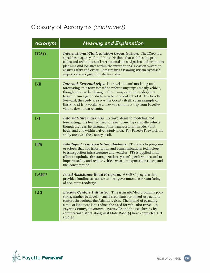
ICAO International Civil Aviation Organization. The ICAO is a specialized agency of the United Nations that codifi es the prin-ciples and techniques of international air navigation and promotes planning and logistics within the international aviation system to ensure safety and order. It maintains a naming system by which airports are assigned four-letter codes.
I-E Internal-External trips. In travel demand modeling and forecasting, this term is used to refer to any trips (mostly vehicle, though they can be through other transportation modes) that begin within a given study area but end outside of it. For Fayette Forward, the study area was the County itself, so an example of this kind of trip would be a one-way commute trip from Fayette-ville to downtown Atlanta.
I-I Internal-Internal trips. In travel demand modeling and forecasting, this term is used to refer to any trips (mostly vehicle, though they can be through other transportation modes) that begin and end within a given study area. For Fayette Forward, the study area was the County itself.
ITS Intelligent Transportation Systems. ITS refers to programs or efforts that add information and communications technology to transportion infrastructure and vehicles. ITS is applied in an effort to optimize the transportation system’s performance and to improve safety and reduce vehicle wear, transportation times, and fuel consumption.
LARP Local Assistance Road Program. A GDOT program that provides funding assistance to local governments for resurfacing of non-state roadways.
LCI Livable Centers Initiative. This is an ARC-led program spon-soring studies to develop small-area plans for mixed-use activity centers throughout the Atlanta region. The intend of pursuing a mix of land uses is to reduce the need for vehicular travel. In Fayette County, downtown Fayetteville and the Peachtree City commercial district along west State Road 54 have completed LCI studies.

xivFayette Forward Table of Contents
Glossary of Acronyms (continued)
Acronym Meaning and Explanation
LOS Level of Service. This is an engineering-based measure of infrastructure performance. In the case of transportation, it is typically determined by comparing traffi c volume using a facility to its capacity. LOS is conventionally expressed in terms of letter-based ratings (A, B, C, D, E or F) with A being the highest level of service and F being the lowest. Chapter 2 (Section 2.5.2) provides a description of different LOS characteristics.
LRTP Long-Range Transportation Plan. LRTPs are the long-range planning documents that are developed and administered by MPOs. They usually cover a long-term time frame (typically around 20 years).
MARTA Metropolitan Atlanta Rapid Transit Authority. The authority providing scheduled public transit and paratransit services in Fulton and Dekalb Counties. MARTA is funded largely by a one-percent sales tax levied in those two counties and by user fares.
MGD Million gallons per day. This refers to water and is used as a way of expressing a water facility’s capacity to provide and/or treat water.
MPO Metropolitan Planning Organization. MPOs are agencies defi ned by federal transportation legislation and are required to be created for each metropolitan area in the United States with a population of over 50,000. They serve as the distribution agen-cies for federal transportation funding and maintain long-range transportation plans and the transportation improvement pro-gram.
SAFETEA-LU Safe, Accountable, Flexible, Effi cient Transportation Eq-uity Act: A Legacy for Users. The current federal transporta-tion legislation at the time of Fayette Forward’s plan development. SAFETEA-LU was passed by Congress in 2005 and extended in 2009.
SPLOST Special Purpose Local Option Sales Tax. This is a one-percent sales tax that Georgia counties may enact by referendum and is to be used to fund construction and maintenance of parks, schools, roads, and other public facilities. Counties may enact two one-percent SPLOSTs over the base Georgia sales tax rate of 4 percent.

xvFayette Forward Table of Contents
Glossary of Acronyms (continued)
Acronym Meaning and Explanation
SRAS Southern Regional Accessibility Study. An ARC-sponsored study of the southern part of the Atlanta metropolitan region (specifi cally Coweta, Fayette, Clayton, Spalding and Henry Coun-ties) developed in response to recent increases in growth in this part of the region. The SRAS was intended to establish a strategic, long-term vision and area-wide plan that will provide structure and order for growth in this part of the metropolitan area while ensuring accessibility, mobility and quality of life.
SRTS Safe Routes to School. A federal transportation program that provides funding to promote non-vehicular access to and from schools. It funds a wide variety of programs and projects, from building safer street crossings to establishing programs that encourage children and their parents to walk and bicycle safely to school
STP Surface Transportation Program. A federal transportation program that provides fl exible funding that may be used by states and local governments for projects on any Federal-aid highway, bridge projects on any public road, transit capital projects, and intracity and intercity bus terminals and facilities.
TAZ Traffi c Analysis Zone. In travel demand modeling and fore-casting, TAZs are geographic areas that are the basis for traffi c demand estimation. Each geographic area is associated with socioeconomic input data (such as the number of households, the number of vehicles per household and the number of jobs in that zone) and serves as the basis for how trips that are produced and attracted throughout the travel demand model area. Typically TAZs are constructed to keep population and employment rela-tively consistent.
TDM Transportation Demand Management. The use of strate-gies and public policies to reduce travel demand, especially single-occupant private vehicle demand, or to lessen the concentration of this demand at peak travel times or along a limited number of roadways.

xviFayette Forward Table of Contents
Glossary of Acronyms (continued)
Acronym Meaning and Explanation
TE Transportation Enhancement grants. TE grants of-fer funding to expand transportation choices and enhance the transportation experience through a series of activities related to surface transportation, including pedestrian and bicycle infrastructure and safety programs, scenic and historic highway programs, landscaping and scenic beautifi cation, historic preser-vation, and environmental mitigation. TE projects must relate to surface transportation and must qualify under one or more of the 12 eligible categories. TE grants are a principal means of funding for bicycle and pedestrian projects.
TIP Transportation Improvement Program. The fi scally-constrained list of transportation projects and programs that have committed funding and are expected to be implemented in a shorter time-frame than that covered by the LRTP (typically this time frame is 3 to 5 years).
TTI Travel Time Index. This is a technical measurement compar-ing between the time spent traveling a given route or corridor in forecasted travel conditions, which may have traffi c congestion, and free-fl ow conditions, which are assumed not to have conges-tion. This is expressed in terms of a numeric ratio, with a TTI of 1.0 representing free-fl ow conditions (as the forecast travel time is divided by the free-fl ow travel time). ARC uses TTI as a way of gauging likely benefi t of specifi c transportation projects and the effects of a planned project or projects on the entire Atlanta region.
V/C Volume/Capacity ratio. A technical measurement that com-pares traffi c volume on a roadway or roadway feature (such as an intersection) to its designed capacity. V/C is used as a simple way of understanding a roadway’s performance and quality of service.
VHT Vehicle Hours Traveled. VHT is a measure of the total num-ber of hours spent in travel by all vehicles within a given time period and geographic area. It is used by regional transportation and environmental agencies for planning purposes.
VMT Vehicle Miles Traveled. VMT is a measure of the total num-ber of miles driven by all vehicles within a given time period and geographic area. It is used by regional transportation and environ-mental agencies for planning purposes.