favourable conservation status of boreal forests -...
TRANSCRIPT
Favourable conservation
status of boreal forests:
monitoring assessment management

Favourable conservation
status of boreal forests:
monitoring assessment management
Baltic Environmental Forum, 2006
Authors: Merle Kuris Anda Ruskule
Editorial team: Raimonds Bērmanis Raimondas Čiuplys Heidrun Fammler Kai Klein Žymantas Morkvėnas Anneli Palo Kaili Viilma
English language editing: Kaili Viilma
© Baltic Environmental Forum Rävala 8-40 10143 Tallinn, Estonia http://www.bef.ee
© Printing House: “B2”, Tallinn, 2006© Graphic design: Heiko Kruusi, OÜ Looduskiri© Illustrations: Anneli Palo (pp. 1-1, 1-3, 5, 8, 9, 10, 13, 20, 23, 26, 28, 35-3, 39-1, 39-2, 39-3, back cover 1); Heiko Kruusi (front cover, pp. 1-2, 18, 35-1, 35-2, 35-4, back cover 2); Žymantas Morkvėnas (pp. 37, 40); Saulis Skuja (back cover 3)
Thank you to all of the Baltic and Nordic experts who contributed to this publication.
ISBN-10: 9949-13-743-8
This publication is printed on recycled paper.
3
Fa
vo
ur
ab
le c
on
se
rv
at
ion
st
at
us
of b
or
ea
l fo
re
st
s:
mo
nit
or
ing
, a
ss
es
sm
en
t,
ma
na
ge
me
nt
Contents
Editorial .............................................................................................................................. 4Introduction ......................................................................................................................... 5Boreal forests in the Baltic and Nordic countries ................................................................ 6 General overview ....................................................................................................... 6 Boreal forest and associated habitat types of EU importance in the Baltic and Nordic countries .................................................................................................. 6Reporting needs on implementation of the Habitats Directive and readiness of Baltic and Nordic countries for reporting in 2007 ......................................................................... 8Conservation status assessment of boreal forest habitats ............................................... 10 Concept of favourable conservation status .............................................................. 10 Concept of indicators and their application for conservation status assessment ..... 11 Description of the proposed set of indicators for assessment of Boreal forest habitats ............................................................................................... 14Management measures for achieving/maintaining favourable conservation status of boreal forest habitats .................................................................................................... 20 Management of habitat types of Community importance ........................................ 21 Restoration of forest habitats not yet qualifying to be of European importance ...... 24 Sustainable forest management to provide backup ................................................. 26Recommendations for stakeholder information and involvement ..................................... 27Summary .......................................................................................................................... 28References ....................................................................................................................... 29
AnnexesAnnex I: Availability and potential sources of data in the Baltic States for the proposed indicators ............................................................................................... 30Annex II: Draft proposal of Baltic experts for typical species for Fennoscandian hemiboreal natural old broad-leaved deciduous forests (Quercus, Tilia, Acer, Fraxinus or Ulmus) rich in epiphytes (9020) ..................................................................... 34Annex III: Draft proposal of Baltic experts for typical species for Fennoscandian deciduous swamp woods (9080) ...................................................................................... 35Annex IV: Draft threshold values proposed for Fennoscandian deciduous swamp woods (9080) by Lithuanian experts .................................................................... 36Annex V: Management activities in forest habitats .......................................................... 38
4F
av
ou
ra
ble
co
ns
er
va
tio
n s
ta
tu
s o
f b
or
ea
l fo
re
st
s:
mo
nit
or
ing
, a
ss
es
sm
en
t,
ma
na
ge
me
nt
Editorial
Dear Reader,
“Favourable conservation status” of habitats and species is a magic term among European nature conservationists. It is defined in the Habitats Directive (92/43/EEC) and causes a lot of scientific discussion, development of guidelines and interpretation manuals.
“Favourable conservation status of boreal forests” is a challenge, if we take into consideration that boreal or “Nordic” forests are mainly managed forests and the original “Western Taiga” is nearly extinct. How can we maintain or restore a habitat, which should naturally cover most of Finland, Sweden, Estonia, Latvia and small parts of Lithuania where forestry and wood processing industry play an important role in the countries’ economy?
Nature conservationists need good arguments and clear definitions to negotiate with the forest sector about management and protection measures of the habitat. The definition given in the Directive is far not sufficient to have a good standing. Therefore the Nordic and Baltic experts came to the conclusion that favourable conservation status of boreal forests needs to be further developed. The aim is to define specific parameters and reference or threshold values to assess the conservation status and to be able to define management and protection requirements.
This publication, elaborated in the frame of a small Nordic-Baltic project, is an attempt to contribute to the European discussion and at the same time to give nature conservationists good instruments to their hands to protect the boreal forest more efficently and achieve its “favourable conservation status”.
We hope you find it interesting and invite you to comment the document on our home page: www.bef.ee.
Kai KleinProject Manager

5
Fa
vo
ur
ab
le c
on
se
rv
at
ion
st
at
us
of b
or
ea
l fo
re
st
s:
mo
nit
or
ing
, a
ss
es
sm
en
t,
ma
na
ge
me
nt
The project „Favourable Conservation Status of Boreal Forest – Experience Exchange among Baltic and Nordic Experts” was meant to bring together forest experts from six countries sharing the boreal region in Europe – Estonia, Latvia, Lithuania, Finland, Sweden and Norway - to find a common understanding on favourable conservation status (FCS) of boreal forest habitats and to develop indicators for assessing the conservation status of forest habitats. We also wanted to agree on the best management methods for achieving and maintaining FCS in forest habitats and to find the best strategy for cooperation with stakeholders. Norway was integrated in the discussions as it shares the boreal forest habitats and the responsibility for their conservation. However, as Norway is not a member of EU, this country will not be fully reflected in the publication, since EU Habitats Directive does not apply there.
To achieve the set goals, two expert meetings, a study trip for Baltic experts to Finnish boreal forest sites and a round-up meeting with participation of broader circle of stakeholders have been organised. The results of expert work and discussions carried out during the project are compiled in this publication. It will bring the project results to the wider audience - public authorities, experts and concerned stakeholders. We hope that this publication will assist Baltic Ministries of Environment in implementing the Habitats Directive and reporting to the European Commission as well as contribute to developing a common understanding among Baltic/Nordic countries and the European Commission on protection and management of boreal forests.
In the beginning of publication the reader will be
introduced to the basic facts about the forests in the Baltic and Nordic countries and occurrence of the forest habitat types of Community importance in this region.
The next chapter gives a short reflection on the reporting needs to the European Commission with regard to habitats and look briefly at readiness of Baltic and Nordic Member States for the coming reporting in June 2007.
The main part of the publication analyses the set of indicators for conservation status assessment of boreal forest habitats developed in frame of the project. It gives a reflection on expert discussions with regard to importance of particular indicators and the main problems related to interpretation or data availability. The authors of the publication acknowledge that the described set of indicators is only initial proposal and its applicability in different countries needs further analysis in order to incorporate it into national monitoring and assessment systems. But we hope that it can be used as a starting point while developing or improving the monitoring programmes and methodologies for assessment of forest habitats in the Baltic and Nordic countries.
A separate chapter describes the best management measures for achieving/maintaining FCS of boreal forest habitats and reflects also the main conclusions from the project meetings and the Finland trip with regard to management of Boreal forests.
And, last but not least, some recommendations for successful partnership with stakeholders are given based mainly on discussions in the round-up meeting of the project.
Introduction

6F
av
ou
ra
ble
co
ns
er
va
tio
n s
ta
tu
s o
f b
or
ea
l fo
re
st
s:
mo
nit
or
ing
, a
ss
es
sm
en
t,
ma
na
ge
me
nt
Boreal forests in the Baltic and Nordic countries
General overview
The Baltic States (Estonia, Latvia, and Lithuania) and Nordic countries (Finland, Sweden and Norway) share the responsibility for maintaining natural boreal forest habitats in Europe.
Forest cover in the Baltic and Nordic countries reaches from 31% up to 74% (see table 1). The European average forest cover is 46% increasing generally from south to north. Even though the forest area of Europe grows slowly, old-growth forests in Europe are rare and fragmented. Most of nowadays European forests have developed under human influence and commercial forestry is an important part of economy in many countries, including Boreal region. However, compared to Western Europe, the Baltic and Nordic countries are still quite rich in natural forests of high biodiversity value.
Protection of forests
According to the evaluation of BirdLife, most of European countries have sufficiently protected less than 1% of their forests, and the average for Europe, excluding the European part of Russia, is only 1.6%. Much of this is located in poorly productive or high-altitude areas of limited value for biodiversity2.
In the Baltic States the share of strictly protected forests ranges from 1,6% in Lithuania and ca. 2% in Latvia to ca. 7% in Estonia. In all Baltic States it is
planned to increase the area of protected forests to some extent. Estonian Forestry Development Programme sets the goal to increase the area of strictly protected forests to at least 10% of the forest area of Estonia until 2010.
Similar situation is in the Nordic countries where the lowest share of strictly protected forests is in Norway (1,45% of total productive forest) and ca 4% in Sweden and Finland. It should be noted that the biggest part of strictly protected forests in Finland and Sweden is located in northern parts and/or mountain areas of those countries. The set environmental objectives foresee increasing of protected forest areas also in the Nordic countries. Boreal forest and associated habitat types of EU importance in the Baltic and Nordic countries
The Habitats Directive determines obligations to the Member States to protect the species and habitats, which are deemed important/threatened on the European scale. The habitat types of Community importance are listed in Annex I of the Habitats Directive. Approximately ⅓ of them are forest habitats.
All Baltic and Nordic countries have developed their own interpretation manuals and found correspondence between the habitat types defined in the Directive and their national forest classification systems. Prof. Jaanus Paal from Estonia has acknowledged that despite some inconsistencies, there is rather good harmony in interpretations of forest habitat types in the Baltic and Nordic countries. Especially Finnish and Estonian approaches are quite similar, which is the result of joint work on Natura 2000 site selection.
Table 1. Forest cover in the Baltic and Nordic countries in the (hemi)boreal region1
CountryTotal land area
Total forest area
Forest cover, (% of total land area)
Mill. ha Mill. ha %Estonia 4,24 2,28 53,77Latvia 6,21 2,94 47,34Lithuania 6,53 2,07 31,47Finland 30,45 22,50 73,89Sweden 41,16 27,53 66,89Norway 30,63 9,39 30,66
1 Source: FAO (2005). Global Forest Resources Assessment 2 Hanski, I. & Walsh, M., BirdLife European Forest Task Force (2004) How Much, How To – Practical Tools for Forest Conservation.
7
Fa
vo
ur
ab
le c
on
se
rv
at
ion
st
at
us
of b
or
ea
l fo
re
st
s:
mo
nit
or
ing
, a
ss
es
sm
en
t,
ma
na
ge
me
nt
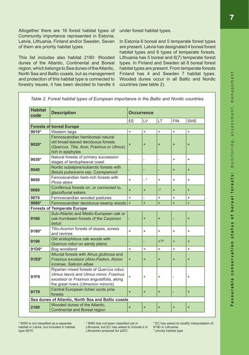
Altogether there are 16 forest habitat types of Community importance represented in Estonia, Latvia, Lithuania, Finland and/or Sweden. Seven of them are priority habitat types.
This list includes also habitat 2180: Wooded dunes of the Atlantic, Continental and Boreal region, which belongs to Sea dunes of the Atlantic, North Sea and Baltic coasts, but as management and protection of this habitat type is connected to forestry issues, it has been decided to handle it
under forest habitat types.
In Estonia 6 boreal and 5 temperate forest types are present. Latvia has designated 4 boreal forest habitat types and 6 types of temperate forests. Lithuania has 5 boreal and 6(7) temperate forest types. In Finland and Sweden all 8 boreal forest habitat types are present. From temperate forests Finland has 4 and Sweden 7 habitat types. Wooded dunes occur in all Baltic and Nordic countries (see table 2).
Table 2. Forest habitat types of European importance in the Baltic and Nordic countries
Habitat code Description Occurrence
EE LV LT FIN SWEForests of boreal Europe9010* Western taiga + + + + +
9020*
Fennoscandian hemiboreal natural old broad-leaved deciduous forests (Quercus, Tilia, Acer, Fraxinus or Ulmus) rich in epiphytes
+ + + + +
9030* Natural forests of primary succession stages of landupheaval coast - - - + +
9040 Nordic subalpine/subarctic forests with Betula pubescens ssp. Czerepanovii - - - + +
9050 Fennoscandian herb-rich forests with Picea abies + - 3 + + +
9060 Coniferous forests on, or connected to, glaciofluvial eskers + + -4 + +
9070 Fennoscandian wooded pastures + - + + +9080* Fennoscandian deciduous swamp woods + + + + +Forests of Temperate Europe
9160Sub-Atlantic and Medio-European oak or oak-hornbeam forests of the Carpinion betuli
- + + - +
9180* Tilio-Acerion forests of slopes, screes and ravines + + + + +
9190 Old acidophilous oak woods with Quercus robur on sandy plains - - +?5 + +
91D0* Bog woodland + + + + +
91E0*Alluvial forests with Alnus glutinosa and Fraxinus excelsior (Alno-Padion, Alnion incanae, Salicion albae
+ + + + +
91F0
Riparian mixed forests of Quercus robur, Ulmus laevis and Ulmus minor, Fraxinus excelsior or Fraxinus angustifolia, along the great rivers (Ulmenion minoris)
+ + + - +
91T0 Central European lichen scots pine forests + + + - +
Sea dunes of Atlantic, North Sea and Baltic coasts
2180 Wooded dunes of the Atlantic, Continental and Boreal region + + + + +
3 9050 is not classified as a separate habitat in Latvia, but included in habitat type 9010.
4 9060 has not been classified yet in Lithuania, but EC has asked to include it in Lithuanian proposal for pSCI.
5 EC has asked to modify interpretation of 9190 in Lithuania. * priority habitat type
8F
av
ou
ra
ble
co
ns
er
va
tio
n s
ta
tu
s o
f b
or
ea
l fo
re
st
s:
mo
nit
or
ing
, a
ss
es
sm
en
t,
ma
na
ge
me
nt
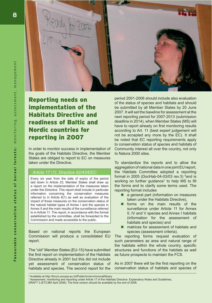
Reporting needs on implementation of the Habitats Directive and readiness of Baltic and Nordic countries for reporting in 2007
In order to monitor success in implementation of the goals of the Habitats Directive, the Member States are obliged to report to EC on measures taken under the Directive.
Based on national reports the European Commission will produce a consolidated EU report.
The “old” Member States (EU-15) have submitted the first report on implementation of the Habitats Directive already in 2001 but this did not include yet assessment of conservation status of habitats and species. The second report for the
period 2001-2006 should include also evaluation of the status of species and habitats and should be submitted by all Member States by 20 June 2007. It will set the baseline for assessment at the next reporting period for 2007-2013 (submission deadline in 2014), when Member States (MS) will have to report already on first monitoring results according to Art. 11 (best expert judgement will not be accepted any more by the EC). It shall be noted that EC reporting requirements apply to conservation status of species and habitats of Community interest all over the country, not only to Natura 2000 sites.
To standardize the reports and to allow the aggregation of national data in one joint EU report, the Habitats Committee adopted a reporting format in 2005 (DocHab-04-03/03 rev.3) 6and is working on further guidance7 to help MS to fill the forms and to clarify some terms used. The reporting format includes a general part (information on measures
taken under the Habitats Directive), forms on the main results of the
surveillance under Article 11 for Annex II, IV and V species and Annex I habitats (information for the assessment of habitats and species) and
matrices for assessment of habitats and species (assessment criteria).
The reporting forms request evaluation of such parameters as area and natural range of the habitats within the whole country, specific structures and functions of the habitats as well as future prospects to maintain the FCS.
As in 2007 there will be the first reporting on the conservation status of habitats and species of
Article 17 (1), Directive 92/43/EEC:Every six year from the date of expiry of the period laid down in Article 23, Member States shall draw up a report on the implementation of the measures taken under this Directive. This report shall include in particular information concerning the conservation measures referred to in Article 6(1) as well as evaluation of the impact of those measures on the conservation status of the natural habitat types of Annex I and the species in Annex II and the main results of the surveillance referred to in Article 11. The report, in accordance with the format established by the committee, shall be forwarded to the Commission and made accessible to the public.
6 Available at http://forum.europa.eu.int/Public/irc/env/monnat/library7 Assessment, monitoring and reporting under Article 17 of the Habitats Directive: Explanatory Notes and Guidelines, DRAFT 3 (ETC/BD April 2006). The final version should be available by the end of 2006.
9
Fa
vo
ur
ab
le c
on
se
rv
at
ion
st
at
us
of b
or
ea
l fo
re
st
s:
mo
nit
or
ing
, a
ss
es
sm
en
t,
ma
na
ge
me
nt
Community importance, the old and new MS are in the same situation: no country has yet any ideal monitoring system providing sufficient data for conservation status assessment. Currently the MS are dealing with development of new monitoring systems and methodologies or adaptation of old ones according to the needs of the Directive, but 2007 reporting will be mostly based on existing information, gained from Natura 2000 inventories carried out during site selection process, data from previous biodiversity monitoring programmes and national forestry databases. In absence of other data the best expert judgements will be accepted.
Since Baltic and Nordic countries have been carrying out different inventories focused both on biodiversity values as well as forest resources and have considerably well maintained forestry databases, there should be enough data on what to base the preliminary assessment of the conservation status of forest habitats. But this requests intensive involvement of experts to interpret the existing data in the categories of the habitat types and parameters defined in the reporting format. Most difficult is to evaluate the specific structures and functions of the habitat types, since appropriate methodologies for that mostly are not yet developed, as well as to insure habitat specific data outside of Natura 2000 sites. The official responsibilities for reporting in the countries are defined, while practical procedure how to come to the conservation status assessment seems not so clear yet.
In Estonia the Nature Conservation Department of the Ministry of Environment is responsible for reporting to EC but it will be done in cooperation with different structures. Data about range and area of forest habitats will be taken from forest register held by the Centre of Forest Protection and Silviculture. Data about range and area of more rare habitats will be gained from different experts and databases of NGOs. For assessing the quality of common forest habitats the data from Statistical Forest
Inventory (SFI) will be used, while more rare habitats will be assessed based on biodiversity monitoring data. In 2005 some biodiversity aspects were added to SFI and now the results are being analysed.
In Latvia Ministry of the Environment is responsible in general for reporting but filling the forms will be delegated to the Latvian Environment, Geology and Meteorology Agency. Most of the forest data should be provided by the State Forest Service. Reporting in 2007 will be mostly based on the same data as used while proposing Natura 2000 sites. There exist some data for estimating range and area of habitats but not so much about structure and function of the habitats. The recently adopted new monitoring programme is designed more or less in accordance with reporting needs but it will not be used for this reporting period.
In Lithuania Ministry of the Environment is responsible for reporting to EC. Mainly data existing in state institutions will be used and some data will be still gathered with help of experts. State Protected Areas Service, Marine Research Centre and Environmental Agency are responsible for data collection.
In Finland Ministry of Environment is responsible for reporting but the actual work is done by Finnish Environment Institute. Assessment will be based on interpretation of the existing data.
In Sweden the Environmental Protection Agency is responsible for reporting. During Baseline Survey in 2002-2007 the data on structure and functions and habitat distribution for all Natura 2000 sites are collected. But probably there will be not enough time to analyse the long term functionality of the network and consequently the future prospects for conservation status of habitats.
Experience with reporting in 2007 will probably highlight the data gaps as well as methodological problems and indicate how the monitoring programmes shall be restructured in order to secure appropriate assessment of the conservation status based on undertaken surveillance as defined in the Article 11 of the Habitats Directive. The set of potential indicators for conservation status assessment described in the following chapter could help to realise the complexity of the issue as well as to show some solutions and data needs.
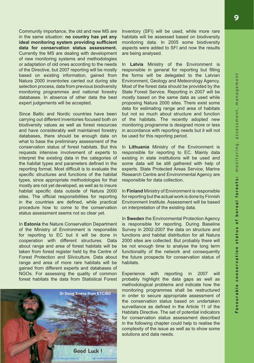
Dr Doug Evans from ETC/BD
10F
av
ou
ra
ble
co
ns
er
va
tio
n s
ta
tu
s o
f b
or
ea
l fo
re
st
s:
mo
nit
or
ing
, a
ss
es
sm
en
t,
ma
na
ge
me
nt
Conservation status assessment of boreal forest habitats
Concept of favourable conservation status
Maintaining or restoration of the natural habitats and species of wild fauna and flora of Community interest in a FCS is the key objective of the EC nature conservation policy.
The definition of the favourable conservation status is set out in the Habitats Directive:
The Member States are obliged to take the appropriate measure to achieve and maintain the FCS for species and habitats of Community interest (Article 2 (1), Habitats Directive). The national monitoring programmes have to be carried out to assess the actual conservation status and its trends on various levels as well as to evaluate the effectiveness of the taken measures. Based on results of monitoring the Member States shall report to EC every six years (as described in the chapter above) on implementation of the measures taken as well as evaluation of impacts of those measures on the conservation status of the natural habitat types of Annex I and the species of Annex II, IV and V of the Habitats Directive.
Fulfilment of reporting requirements and interpretation of the meaning of FCS of the forest habitat types has been one of the most difficult questions for the competent authorities and nature conservation experts in the Boreal region, like elsewhere in Europe. The main criteria for evaluation of the conservation status are size and quality of the habitat types as well as the connectivity of the sites. Boreal countries are considered as rather rich of forests in comparatively good status. So does it mean that we have enough of forests to maintain the FCS?
Article 1 (e) & (i),Directive 92/43/EEC:(e) conservation status of a natural habitat means the sum of the influences acting on a natural habitat and its typical species that may affect its long-term natural distribution, structure and functions as well as the long-term survival of its typical species within the territory referred to in Article 2.
The conservation status of a natural habitat will be taken as ‘favourable’ when:
its natural range and areas it covers within that range are stable or increasing, and
the specific structure and functions which are necessary for its long-term maintenance exist and are likely to continue to exist for the foreseeable future, and
the conservation status of its typical species is favourable as defined in (i);
(i) conservation status of a species means the sum of the influences acting on the species concerned that may affect the long-term distribution and abundance of its populations within the territory referred to in Article 2;
The conservation status will be taken as ‘favourable’ when:
population dynamics data on the species concerned indicate that it is maintaining itself on a long-term basis as a viable component of its natural habitats, and
the natural range of the species is neither being reduced nor is likely to be reduced for the foreseeable future, and
there is, and will probably continue to be, a sufficiently large habitat to maintain its populations on a long-term basis.
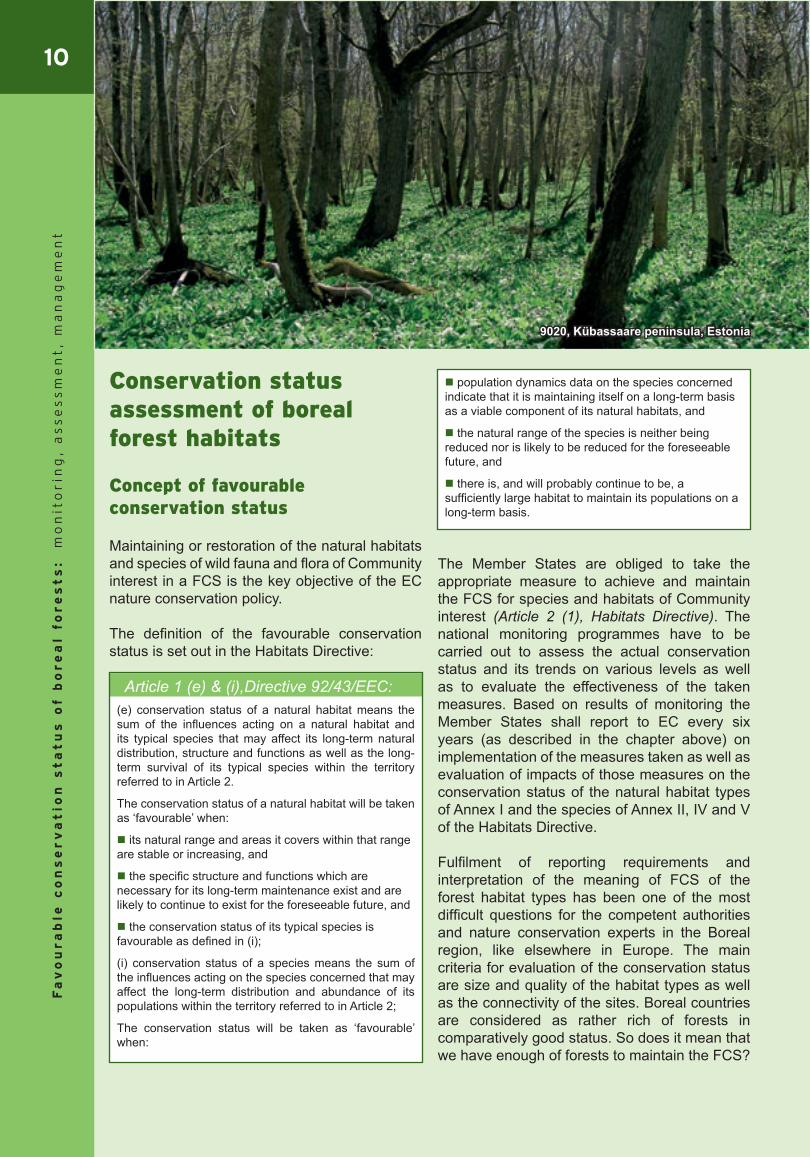
9020, Kübassaare peninsula, Estonia
11
Fa
vo
ur
ab
le c
on
se
rv
at
ion
st
at
us
of b
or
ea
l fo
re
st
s:
mo
nit
or
ing
, a
ss
es
sm
en
t,
ma
na
ge
me
nt
And is the ecological quality, e.g. structure and functions of the natural forest habitats sufficient and likely to be maintained also in future?
These questions have been discussed a lot between Baltic and Nordic nature conservation experts and foresters, also during the BEF workshops. One of the main conclusions at the BEF workshop on “Monitoring according to requirements of the Habitats and Birds Directives”, held in March 2005 in Sigulda, was that defining proper set of indicators and thresholds is the crucial condition for successful assessment of the conservation status.
Development of such set of indicators seems to be one of the major challenges for the Member States in order to comply with objectives of the Habitats Directive and EC reporting requirements but also fulfil national monitoring needs.
Some of the Member States have already achieved quite good progress in this field. For example, a new monitoring concept is developed in Austria, proposing a system of indicators and threshold values for assessment of conservation status of each habitat at the locality level. From new Member States, Slovakia has developed very comprehensive system for assessing the conservation status of forest habitats, including detailed descriptions of definitions, indicators and threshold values8. Also the Czech Republic has developed a monitoring scheme, which should fulfil the EC reporting requirements and provides basis for assessing the FCS.
Within the Boreal region Sweden has had the most systematic approach to assess the conservation status of habitats and species of the Community importance – there is developed an objectives-based monitoring system, including defined parameters and methods for the baseline survey. Lot of efforts have been put in formulating the conservation objectives for each habitat type at the biogeographical (national) level as well as site level. These conservation objectives are based on the Habitats Directive’s definitions of FCS and addressing the factors, which can be influenced by management or other measures (SEPA, 2004)9.
Just recently some light in common understanding of conservation status assessment has been provided by ETC/BD, by developing the Explanatory Notes and Guidelines for “Assessment, monitoring and reporting under Article 17 of the Habitats Directive”10. These guidelines provide the definitions and methodology for assessing the area and range of the habitats as well as criteria for selecting the typical species, while assessment of structure and functions of the habitats is left up to the Member States as rather country specific question.
In order to come to common understanding within the Boreal region on what is considered as FCS in the boreal forest habitats and how it shall be assessed, the Baltic and Nordic experts have tried to develop a common list of indicators. This could be used as a basis for national monitoring programmes and assist the countries in their duties to report to EC on conservation status of species and habitats of the Community importance.
It should be kept in mind that assessment of conservation status shall not be restricted to the reporting needs, but serve as a tool for proper implementation of the Habitats Directive and provide guidance for habitat management. By monitoring and assessing the conservation status we should gain understanding, if we manage our forests in a satisfactory manner and how we contribute to the broader policy goals for halting the depletion of biological diversity.
Concept of indicators and their application for conservation status assessment
Criteria for selection of indicators
The indicator concept has been widely applied in environmental policy to target data and information search, also to assess conditions and trends in relation to goals and targets11. Measurable indicators are the key condition for assessing status of selected parameters/ecological features and for reducing the complexity of data.
8 http://www.sopsr.sk/natura/index1.php?p=7&lang=en9 Abenius et al., Swedish Environmental Protection Agency (2004). Natura 2000 monitoring in Sweden10 European Environmental Agency’s Topic Centre on Biological Diversity (2006), Assessment, monitoring and reporting under Article 17 of the Habitats Directive: Explanotry Notes & Guidelines, Draft 311 Baltic Environmental Forum (2002), 2nd Baltic State of the Environment Report based on environmental indicators.

12F
av
ou
ra
ble
co
ns
er
va
tio
n s
ta
tu
s o
f b
or
ea
l fo
re
st
s:
mo
nit
or
ing
, a
ss
es
sm
en
t,
ma
na
ge
me
nt
For developing an efficient set of indicators one should consider its practical applicability – the set should not be too long, feasible to record or measure, easy to interpret, sensitive to influences and changes as well as cost-effective. Several Member States (e.g. Germany, Sweden, Slovakia) have developed rather complicated and costly biodiversity monitoring systems, while position of UK in this respect is that indicators should be chosen so that an average site can be assessed by one non-specialist in a half of day.
The set of indicators presented here was developed by the Baltic and Nordic experts keeping in mind national interests for assessing of conservation status as well as obligations for reporting to EC. In the same time the pragmatic approach was kept in mind – to select what is feasible to monitor and what data could be available to assess the trends. Still the proposal includes also indicators for which data quality and availability might be questionable, but they are kept in the list as quite important for assessment of the conservation status. Reactions on the proposed list from state authorities, other experts and foresters have been quite different – starting from very critical, saying that the list is much too complicate and not applicable with respect to resources, to quite positive evaluation, stating that this could be the minimum what is needed in order to judge about conservation status of forest habitats. Therefore application of this list depends very much on interest and possibilities of each country and its responsible authorities.
Categories of indicators
The grouping of the indicators in this publication is following the general principles of EC reporting format. There can be distinguished quantitative parameters like range and area of the habitats and qualitative parameters, reflecting structure and functions as well as threats, pressures and conservation measures, which provide basis for assessment of future prospects. The term “parameter” is used in this publication for a wider feature or factor that should be assessed in order to evaluate the conservation status of habitats. One parameter can have several specific “indicators” that can be measured and provide basis for assessment of the parameter.
Another important aspect to be considered is the recording level of data. For example area and range are always recorded at the national level
(or biogeographical for countries covering more than one biogeographical region), while structure and functions mostly can be monitored only on locality (site) level. However, for assessing the functionality of the system also landscape or regional level shall be taken into account. And only when having the complex view on situation at the site and landscape level as well as situation within and outside of Natura 2000 sites, conclusions can be drawn about conservation status of structure and functions of particular habitat at the national level. The future prospects, including threats and pressures should be assessed both – on locality and national level (see table 3). In order to evaluate situation on national level and in the same time to save resources and human power the representative coverage of monitoring plots would have to be selected all over the country (within and outside the Natura 2000 sites) in a statistically reliable number.
Table 3. Parameters for conservation status assessment and their recording level defined by the project.
Parameters Recording level
Quantitative parameters Natural range Favourable reference
range (FRR) Surface area Favourable reference
area (FRA)
National level
Qualitative parameters Structure & Functions
– Mean habitat size;– Edge
characteristics;– Tree species
composition;– Age class
distribution;– Tree stand
structural complexity;
– Typical species– Natural
disturbances
Locality level
Future prospects– Threats and
pressures– Conservation
measures
Locality & national level
13
Fa
vo
ur
ab
le c
on
se
rv
at
ion
st
at
us
of b
or
ea
l fo
re
st
s:
mo
nit
or
ing
, a
ss
es
sm
en
t,
ma
na
ge
me
nt
Area and range are parameters for quantitative evaluation of the conservation status of habitats. Definitions of indicators and methods for assessment of area and range are described by the ETC/BD guidelines. And there is also no question about that, if such parameters have to be assessed or not, since they make essential part in the EC reporting format. Therefore, within this project, area and range were discussed only with regard to data availability, practical application of the proposed assessment methods and interpretation of the results.
Structure & functions are looked as the quality parameters representing the most important basic conditions for the existence of a habitat. ETC/BD does not give any strict instructions for assessment of structure and functions and there are no commonly agreed indicators across the Europe, mainly because this varies a lot between the biogeographical regions, countries as well as by single habitats. Therefore, selection of the parameters and indicators for assessing the structure and functions of boreal forests has been the main task of this project. Since monitoring of functions might be rather difficult, the structural elements resulting from functions usually are chosen as parameters for monitoring. In addition typical species are used as indirect indicators for habitat quality. Even the ETC/BD provides certain guidelines on selection of typical species, a clear, commonly agreed concept and definition has not been yet developed. Therefore, different approaches and interpretation have been applied by the Member States. Moreover due to biogeographic differences the lists of typical species for the same habitat type might be very different in each country. Baltic experts within the project have tried to reach a common view of typical species for the Boreal habitat types
occurring in our countries through commenting the Estonian proposal.Assessment of future prospects involves evaluation of trends shown by the indicators on area, structure and functions, as well as the main pressures and threats affecting the particular habitat type and conservation measures applied. In this respect the project experts have tried to identify the pressures, threats and conservation measures, which would be important for our forest habitats and possible to assess.
Threshold values
In order to be able to conclude, if the particular habitat is in the FCS or not, clearly defined threshold or reference values would have to be set up for each indicator used for its assessment. Establishment of threshold values could be based on the ecological knowledge about particular habitat, expert judgement or reference to national or international policy goals or guidance documents. To reach the nature conservation objectives and FCS of the habitats, the threshold values would have to be integrated in the national policy objectives and relevant legal regulations on forest use.
Within the EC reporting format the favourable reference values (FRV) are used as key tool for assessment of conservation status – evaluation shall be made in relation to trends and FRV, which have to be defined for each species and habitat type depending on its specific situation. The reporting format requests to indicate the values of the favourable reference range (FRR), favourable reference area (FRA) for habitats as well as favourable reference population (FRP) for species. The conditions and principles how to estimate these values are explained in the introduction of the EC reporting format and more detailed in the ETC/BD guidelines on assessment, monitoring and reporting under Article 17.
During discussions of the Baltic and Nordic experts it was concluded that for some of the indicators it would not be necessary to identify a certain threshold value, but the trend would be sufficient to judge about the conservation status. However, as stated in the Note to the Habitats Committee (March, 2005) 12, such approach might be misleading since time series of available data or 6-year reporting period reflects only a certain
12 European Commission (2005), Note to the Habitats Committee. Assessment, monitoring and reporting of conservation status – Preparing the 2001-2007 report under Article 17 of the Habitats Directive (DocHab-04-03/03 rev.3)
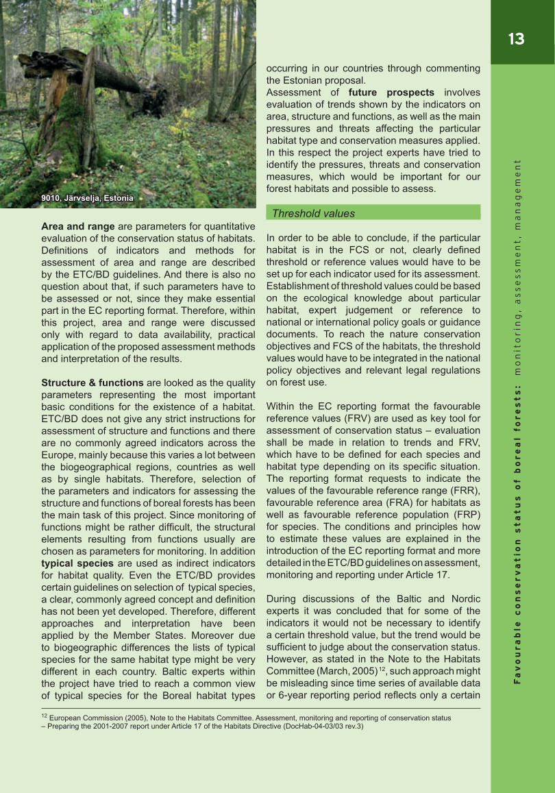
9010, Järvselja, Estonia

14F
av
ou
ra
ble
co
ns
er
va
tio
n s
ta
tu
s o
f b
or
ea
l fo
re
st
s:
mo
nit
or
ing
, a
ss
es
sm
en
t,
ma
na
ge
me
nt
“time-window” within much longer process of declining, stabilising or increasing trends.
Even there is not much experience in Europe to define habitat specific threshold values, some of the Member States have already come up with proposals on methodology how to estimate such or agreed on certain values as objectives to be reached. For example in Austria the threshold values for the habitat size to asses beech forest habitat on locality level are defined based on following criteria: space minimum (depending on number of species); resistance minimum (in ha) in order to resist alien influences; and regeneration minimum (in ha)13. In Swedish Natura 2000 monitoring programme conservation objectives have been defined for each habitat, consisting of set of parameters and methods for their assessment.
Description of the proposed set of indicators for assessment of boreal forest habitats
The presented set includes the definition of the parameter to be assessed, specific measurable indicators for each of the parameters, reasoning why parameter is essential for the conservation status assessment and some comments about the interpretation or methodological problems and data availability, stated at the meetings of the project. More detailed overview on the monitoring possibilities and data availability in each of the Baltic States is presented in the Annex I.
Quantitative parameters: range & area
Specific indicators:** natural range (km2)** change of the natural range (ha, +/- % of area per year)** map of natural range (grid 10x10 km)
The natural range of a habitat is dynamic – it can decrease or expand. In many cases present range of habitat can be insufficient to guarantee its maintenance on a long term basis, which among other factors could be the reason why it is identified as a habitat of Community interest. Therefore natural range and its trends is essential
element to judge about the conservation status of particular habitat.
Area over which habitat is occurring might be patchy or disconnected within its natural range. ETC/BD guidelines give explanations and certain conditions for estimation of the natural range: if the disjunctions in range are caused by
ecological factors, the isolated localities should not be interpreted as continuous natural range;
small gaps in distribution are considered as part of the range, while large disjunctions are accepted as brakes in the range (there should be at least gap of more than 40-50 km to justify the break in the range);
ETC/BD recommends using the grid map, where one grid is 10 x 10 km2, to illustrate the range.
Despite the rather clearly described definition of the natural range and principles for its assessment, the Baltic experts have stated that there is still lot of open interpretation and methodological questions. E.g. shall only areas with best quality habitats be included within the natural range or shall it consider also habitats which, left to the natural succession, could develop in the habitats of Community importance. As there are insufficient data about the spatial distribution of the habitats in the Baltic States, particularly outside of Natura 2000 sites, it will be rather difficult to assess their natural range.
FRR shall provide a threshold value for the natural range, in relation to what the present conservation status can be assessed. General evaluation matrix of the EC reporting format indicates that if the decrease of range is larger than 1% per year within period specified by
Member State or if the natural range is more than 10% below the FRR, then the conservation status is assessed as “Unfavourable – bad”.
FRR must be at least the range (in size and
13 Federal Environmental Agency, Austria (2005)
Natural range – outer limits of the overall area in which a habitat is found at present.
Favourable reference range (FRR) – range within which all significant ecological variations of the habitat are included for a given biogeographical region and which is sufficiently large to allow the long-term survival of the habitat.
15
Fa
vo
ur
ab
le c
on
se
rv
at
ion
st
at
us
of b
or
ea
l fo
re
st
s:
mo
nit
or
ing
, a
ss
es
sm
en
t,
ma
na
ge
me
nt
configuration) when the Directive came into force as stated in the Note to the Habitats Committee (DocHab-04-03/03 rev.3)14, however, if the range was insufficient in that time to guarantee maintenance of the habitat in the long term basis, then FRR should be larger than this. Estimation of the precise area of FRR should be based on the knowledge about the ecological requirements of the particular habitat type, historic data and/or modelling of potential range (even it is not necessary to be equal with FRR). In the absence of other data, “the best expert judgement” is accepted as a method to define the FRR.
It has been stated that only scientific criteria shall be taken into account for defining FRR, therefore for some habitats this could mean the whole country’s territory. Taking into account the set criteria for assessment of natural range in relation to FRR, probably most of the habitat types will be assessed as being in unfavourable conservation status.
Finland has defined a set of criteria, which have to be met to include the area into FRR (e.g. distance to the nearest suitable patch). Favourable reference values are discussed also at the expert group formed by Finland, Sweden and Estonia, where Latvian and Lithuanian experts are also welcome to participate. At the expert meetings of the project it was suggested to use the soil data to estimate the potential range of the habitats. Baltic countries have also lot of historic data on habitat distribution, but their application is difficult, since national classifications of forest habitats are different from Annex I habitat types in the Habitats Directive.
Specific indicators:** total surface area (ha, km2)** change of the total area (ha, +/- % of area per year)** habitat distribution map (grid 10x10 km)
Surface area and particularly its change is the basic parameter in overall assessment of the conservation status of the habitat type. Regular monitoring programmes shall show if it is stable, increasing or decreasing over the time period
of reporting. Baltic experts have admitted that estimation of the surface area is even more difficult than estimation of range. Assessing the surface area of the habitat types all over the country will be rather costly exercise. During selection of Natura 2000 sites the total area of habitats, particularly outside of Natura 2000 sites, was estimated mostly using “the best expert judgement” and data of statistical forest inventory. There is potential in using the remote sensing for this task, but distinguishing of Annex I habitat types in the medium resolution satellite images is still rather difficult and would request verification of data in nature. This methodology could be used more efficiently for monitoring the change of area of the habitat types already identified on a map.
FRA defines the objective that would have to be achieved or maintained. It should include the areas necessary for restoration or development of the habitat types for which the present coverage is not sufficient to ensure their long-term
viability. Same as for FRR it shall be at least the area when the Directive came into force. If the decrease of area is larger than 1 % per year within period specified by Member State or there are major losses in distribution pattern of the habitat within the range, or if the surface area is more than 10 % below the FRA, then the conservation status is assessed as ‘Unfavourable – bad’.
The historic distribution of the habitat as well as the ‘best expert judgement’ in case of absence of data might be used to define the FRA. However, ETC/BD admits that establishment of this reference value is the most difficult challenge. Even some theoretical studies have been made on the minimum area required for the long-term viability of the forest habitats, these usually are focused on single sites rather than a network of sites. ETC/BD suggests that in some cases FRA of habitats could be estimated from a consideration of conservation requirements of one or more ‘key’ species.
14European Commission (2005), Note to the Habitat Committee. Assessment, monitoring and reporting of conservation status – Preparing the 2001-2007 report under Article 17 of the Habitats Directive (DocHab-04-03/03 rev.3)
Surface area – area (in km2) currently occupied by the habitat.
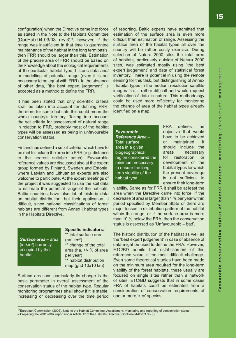
Favourable Reference Area –Total surface area in a given biogeographical region considered the minimum necessary to ensure the long-term viability of the habitat type.
16F
av
ou
ra
ble
co
ns
er
va
tio
n s
ta
tu
s o
f b
or
ea
l fo
re
st
s:
mo
nit
or
ing
, a
ss
es
sm
en
t,
ma
na
ge
me
nt
Qualitative parameters: structure & functions
Specific indicator:** change of the mean habitat size (ha, +/- % of area per year)
The mean habitat size is an important parameter for reflecting
the fragmentation effect. However, depending on habitat type optimum mean areas might be very different, which shall be taken in consideration when interpreting the data. For example, maintaining large areas of habitat is essential to ensure long-term functionality of Western taiga (9010*), while alluvial (91E0*) or swamp forests (9080) can be naturally more fragmented. Some habitat types are often forming integrated mosaics or habitat complexes (e.g. wooded meadows and broadleaved forests), which in assessment would have to be handled as one unit. Therefore, for judging about conservation status of a particular habitat type, the change of mean habitat size would be better indicator instead of actual size. Another problem with regard to interpretation of data on national level might be caused by situation when mean habitat size is increasing as result of cutting down smaller patches of habitat outside of Natura 2000 sites.
The project experts have acknowledged that mean habitat size could be very good indicator. It should be easy to calculate, if databases with habitat area on locality level or habitat maps would be available. However, taking into account present situation regarding data availability on habitat area, it would be difficult to get reliable figures on national level. In future, once accurate data on habitat distribution would be collected, the remote sensing could be a useful tool for monitoring of the change of the mean habitat size.
Another difficult question is establishment of threshold values for the mean habitat size. Some estimations have been carried out in Baltic countries, coming to conclusion that minimum area for 30 m high forest should be at least 180 m in diameter to avoid the edge effect. Though, as stated before, this could be very different from habitat to habitat, therefore additional research
would be needed to define more precise criteria for assessment.
Specific indicator:** change in length of edge (+/- m/ha)
Edge characteristic is another significant factor to assess the fragmentation effect.
Interpretation of data again depends very much on habitat type and the area with what it is bordering. Most important would be to know the change in length of the edge between natural and artificial biotopes. Therefore to carry out proper assessment the edge with agriculture land, forest clear cut, wetland or other forest type would have to be distinguished.
Potentially remote sensing in combination with GIS data could be used as a tool to assess the change in length of the edge, but the presently available satellite images allow identifying only the edge between forest and artificial land, forest clear-cut area or wetland.
Specific indicator:** Tree or tree-mixture distribution – (ha/%)
Assessment of tree species composition depends on particular habitat type (e.g. in Sweden proportion of deciduous trees in
spruce forests for Western Taiga (9010*) should be assessed15). This would be very important indicator for deciduous swamp forest (9080*), where increase of spruce shows that something is wrong with hydrological regime.
Interpretation of this parameter is based on the knowledge of succession cycles of particular habitat type; however, often it might be difficult to distinguish between the natural processes of forest dynamics and management effects. Monitoring of the tree species composition is very costly as entirely depends on the field work. In Latvia and Lithuania data about present and past situation could be gained from the national forest data registers, even they are not classified there
Mean habitat size – Statistically calculated mean habitat size of each habitat type.
15 Abenius et al., Swedish Environmental Protection Agency (2004), Natura 2000 Monitoring in Sweden
Edge characteristics – Length of edges with each biotope type (m/ha).
Tree species composition – proportion of different species or species groups in a forest stand, reflecting tree canopy dynamics.
17
Fa
vo
ur
ab
le c
on
se
rv
at
ion
st
at
us
of b
or
ea
l fo
re
st
s:
mo
nit
or
ing
, a
ss
es
sm
en
t,
ma
na
ge
me
nt
by the habitat types, but by applying selected plot method this would not be a problem.
Specific indicators:** age class distribution (ha, %)** uneven stage stand distribution (ha, %)
Age class distribution would be important
to assess in a combination with tree species composition to gain complete overview about the present process of forest dynamics. However, interpretation of this indicator is very complicated as, similar to the tree species composition, it would be difficult to distinguish between the natural processes of forest dynamics and management effects. Furthermore, even usually the uneven age class distribution is considered as precondition for a biologically valuable stand, sometimes also even-age stands can be very valuable (e.g. after burning). Therefore, practical application of such indicator was very much doubt by the experts participating in the project meetings.
Evaluation of the tree stand structural coplexity or the key elemets of biologicaly valuable forest have been widly tested during the Woodland Key Habitat inventories carried out in Sweden and Baltic States. For the purpose of these inventories a long list of indicators has been
developed for identification and evaluation of the woodland key habitats. This list can be partly applied also for assesment of the conservation status of Annex I habitat types. The potential indicators, which could be used for conservation status assesment are listed below.
Specific indicators:** Standing biologically old normal size (living/dead) trees; ** Standing biologically old small, slowly grown (living/dead) trees;
** Amount of dead wood;** Fallen trees: with/without bark and d>25 cm/d<25 cm;** Natural snags (d>15cm);** Hollow trees;** Laying dead wood in first/middle/end stage of decomposition** Living trees with fire scars (important for Western taiga)
In order to get more complete picture about the structural quality of the particular forest habitat, continuous existence of different types of dead wood in time and space should be assessed. Therefore, it would not be sufficient to monitor only the amount of the dead wood, but to cover at least few more aspects of the tree stand structural complexity. Implementation of such complex monitoring is very time consuming and costly. However, already now different dead wood qualities are included in national forest survey methodologies in the Baltic States and Finland.
The threshold value for the amount of dead wood for particular forest habitat types has been defined in Finland and Sweden. At the project meetings it was agreed that average threshold value of dead wood could be 50 m3/ha.
Age class distribution – Proportion of main age classes of particular tree species (e.g. dominant species).
Tree stand structural complexity – presence and amount of specific forest structures/key-elements, important for maintaining biological diversity of the forest stand.
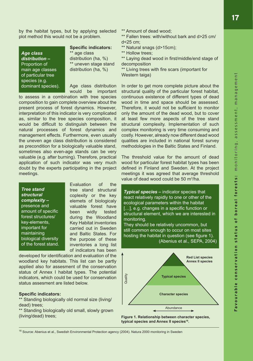
Typical species – indicator species that react relatively rapidly to one or other of the ecological parameters within the habitat […], e.g. changes in a specific function or structural element, which we are interested in monitoring. They should be relatively uncommon, but still common enough to occur on most sites hosting the habitat in question (see figure 1).
(Abenius et al., SEPA, 2004)
Figure 1. Relationship between character species, typical species and Annex II species16.
16 Source: Abenius et al., Swedish Environmental Protection agency (2004). Natura 2000 monitoring in Sweden
Abundance
Qua
lity
Character species
Typical species
Red List species Annex II species
18F
av
ou
ra
ble
co
ns
er
va
tio
n s
ta
tu
s o
f b
or
ea
l fo
re
st
s:
mo
nit
or
ing
, a
ss
es
sm
en
t,
ma
na
ge
me
nt
Typical species is one of the most discussed and in same time most controversial indicator to assess the conservation status of structure and functions in forest habitats. According to Habitats Directive (Article 1) conservation status of typical species is one of the criteria to define if a habitat is in FCS. It means that typical species should help to assess, if the important ecological functions, continuity and area of the habitat as well as its management is favourable to the conservation status of the habitat.
Habitats Directive does not provide precise definition of the typical species and there is no common agreement among the Member States about the lists of species of particular habitat types. Achieving of such agreement in fact is not possible, since distribution, abundance and function of species within the specific habitat type usually are not constant through its natural range and vary a lot between the countries and sometimes even within a country.
ETC/BD guidelines provide certain conside-rations, which shall be taken into account for
selection of typical species. It is stated that they should be good indicators for habitat quality, e.g. by indicating presence of a wider group of species with specific habitat requirements; they should be sensitive to changes in condition of the habitat; it should be possible to detect them by non-destructive and non-expensive means. There is also noted that degree of flexibility in choosing the species is restrained by the need to have certain consistency across the nations, particularly with regard to use of characteristic species, defined in Interpretation Manual, which normally should not be left out, especially if they have a wide distribution in EU.
Within the Boreal region Sweden has elaborated lists of typical species for the purpose of Natura 2000 monitoring programme, while Finland has rather critical attitude with regard to using of typical species for conservation status assessment and there are no plans so far to carry out additional monitoring for that purpose. Also the Baltic States do not have yet elaborated lists of typical species for each habitat.
The main problem concerning use of typical species for assessment of conservation status is very costly and time consuming monitoring based on field works. Costs for training of people on identification of the species also shall be considered. Moreover interpretation of the monitoring results might be difficult, especially if it includes only registration of the species’ presence but not their abundance. Some experts of the Boreal region are convinced that the direct indicators of the habitat quality characterising specific structures and functions are more essential for assessment of the conservation status of the Boreal forest habitats. The concept of typical species is regarded as more suitable for those Western and Central European countries where the structures and functions of natural forests are already lost.
Though within the meetings of the project Baltic and Nordic experts have come up with some proposals how to develop appropriate list of typical species, which could be easy to monitor. It was concluded that optimum number would be 6-10 species per habitat type and they should be chosen from different taxa (not only vascular plants), e.g. to include also bird species monitored for the purpose of Birds Directive. There has been also considered a possibility to develop a longer list, categorizing the species as good,
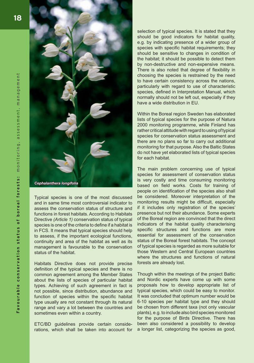
Cephalanthera longifolia
19
Fa
vo
ur
ab
le c
on
se
rv
at
ion
st
at
us
of b
or
ea
l fo
re
st
s:
mo
nit
or
ing
, a
ss
es
sm
en
t,
ma
na
ge
me
nt
moderate and poor indicators. A common draft proposal on typical species for habitats 9020 and 9080 was developed by the Baltic experts (see Annex II & III).
Natural disturbance is one of few parameters focused on the functions in the forest habitats. Since nowadays natural disturbances are relati-vely rare, they are re-garded as important factor to maintain the FCS of the forest.
Within the meetings of this project the natural disturbances were not
discussed in depth, but it was admitted that data could be rather easily available from the national forestry databases and also remote sensing could be applied to detect the newest developments.
Qualitative parameters: future prospects
Assessment of future prospects involves analysis of the conservation status of habitats (based on area, range, structure and functions) and its presumable trends in relation to the identified threats, pressures as well as response actions taken (e.g. applied conservation and management measures). General reporting format of EC requests the information about the designations of sites and management measures applied within the sites (not habitat specific), while identification of the threats and pressures is asked for the each habitat type. But for proper assessment of the future prospects of particular habitat type all these aspects would have to be considered habitat specific and countrywide (i.e. not restricted to Natura 2000 sites).
Threats and pressures:Threats in the EC reporting format are understood as the foreseeable impacts, affecting long term viability of the habitat, while pressures are meant to be the past or present impacts. Reporting format provides long list of possible pressures and threats, identified by the codes.
The project expert group has discussed the most
common threats/pressures in the Boreal region, and selected potential indicators for those, which might have significant effect for the conservation status of the Boreal forest habitats:
** Areas influenced by erosion: important for habitats on slopes or very sandy soils (e.g. 9180, 9050, 91T0);** Habitats with alien species (ha);** Area of clear cutting, selective cutting and final cutting: commercial use of forest has to be distinguished from the habitat management;** Area influenced by agriculture activities: important for highly fragmented habitats;** Area influenced by pollution (e.g. nitrogen): significant threat for poor habitats;** Area influenced by recreation activities: mainly large scale activities – e.g. ski resorts, hiking areas;** Area influenced by drainage or length of ditches (m/ha): mainly related to renovation of old ditches; ** Length and area influenced by roads and communication lines: most important is change – e.g. new or renovated roads;** Area of deforestation: data on land use change; important to analyses the purpose of the land use change.
Conservation measures:One of the easy measurable indicators for assessment of applied conservation measures is the area under protection. The project experts have proposed as indicators several types of protection regimes, although they could be of use only under condition, if the total surface area of the habitat in the whole country is known:
** Area of the habitat under strict protection status (% and ha)** Area of the habitat covered by Natura 2000 sites (% and ha)** Total area under protection, including voluntary protection (% and ha)
Area under strict protection would be the most important indicator to assess the future prospects of the habitat, as it indicates certain guarantees for preservation of the habitat type. For the purpose of international comparison it was suggested to use category I of the MCPFE17 classification, which includes 3 subclasses: protected forest without human invention (1.1);
Natural disturbance – disturbance processes in the forest caused by the natural reasons, e.g. fire, wind and snow, erosion, flooding, biological disturbances (including pests)
17 Ministerial Conference on the Protection of Forests in Europe
20F
av
ou
ra
ble
co
ns
er
va
tio
n s
ta
tu
s o
f b
or
ea
l fo
re
st
s:
mo
nit
or
ing
, a
ss
es
sm
en
t,
ma
na
ge
me
nt
protected forest with minimum human invention (1.2) and protected forest that are actively managed to conserve biodiversity (1.3).
Interpretation of the effects of the taken conservation measures is possible only in relation to the general conservation status assessment of the habitat type and its trends, since increase of protected area itself still does not mean that FCS will be achieved. There are also no clear threshold values defined for each habitat type how much of it should be under strict protection to ensure the FCS, even in Estonia an estimation18 has been made that at least 10% of each forest site type should have to be protected to maintain the existing biodiversity in all levels.
Main challenges for assessment of conservation status
The main obstacle for successful assessment of conservation status at the present moment is insufficient knowledge about habitat distribution on the national level (particularly outside of Natura 2000 sites). Lot of data can be found in the state registers, but they are not recorded according to Annex 1 habitat types, therefore it is difficult to interpret them for the habitat assessment. However, by applying selected monitoring plot method, this problem could be solved.
Another concern of the countries is the high costs of the necessary monitoring actions, as lot of indicators can be assessed only by resource-consuming field inventories. Application of remote sensing is still limited as available satellite images mostly do not allow to distinguish particular Annex I habitat types.
Problems are expected also regarding interpretation of trends in future. New data of the next reporting period might illustrate not only the change of the actual situation, but may show distorted trend caused by improvement of data quality, but also different interpretation of field data or satellite images by another expert in the next monitoring period. Taking into consideration the poor data quality of the present moment, this makes doubts about the baseline information provided at this reporting and to be used as a reference to assess the trends in the next reporting period.
Management measures
for achieving/maintaining favourable conservation status of boreal forest habitats
Achievement of the FCS might require very different management approaches, depending on habitat type and its conservation status. For some habitats like Western taiga it would mean protection of natural process, while for some, like wooded pastures – maintaining of certain status or succession stage. The management measures of boreal forest habitats in Natura 2000 areas can be grouped as following: Management of habitat types of European
importance Restoration of forest habitats not yet
qualifying to be of European importance Sustainable forest management to
18 Lõhmus et al 2004 Loss of old-growth, and the minimum need for strictly protected forests in Estonia. – Ecol. Bull. 51: 401–411.
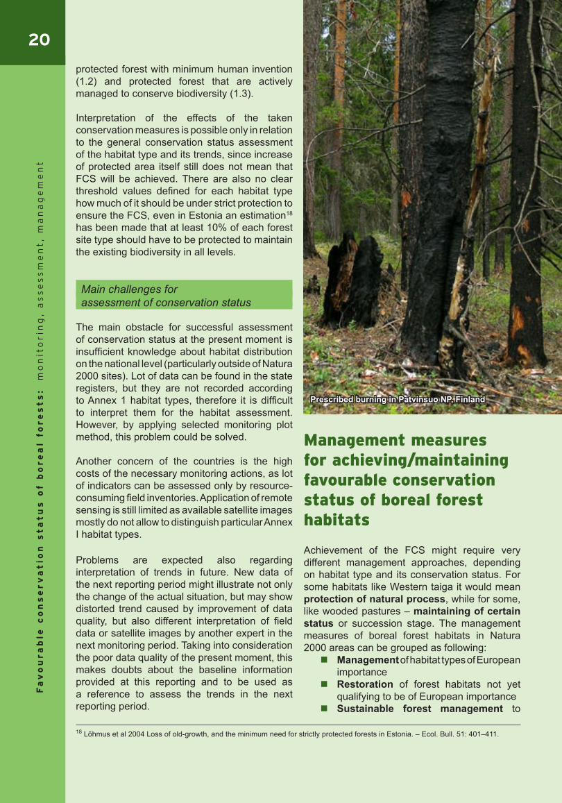
Prescribed burning in Patvinsuo NP, Finland
21
Fa
vo
ur
ab
le c
on
se
rv
at
ion
st
at
us
of b
or
ea
l fo
re
st
s:
mo
nit
or
ing
, a
ss
es
sm
en
t,
ma
na
ge
me
nt
provide backup resource for endangered species after disturbances in natural forest habitats.
European Commission has developed a set of recommendations and guidelines for sustainable forest management in Natura 2000 sites, which are included in the following papers: Managing Natura 2000 sites. The
provision of Article 6 of Habitat Directive (2000);
Interpretation Guide “Natura 2000 and Forests. Challenges and Opportunities” (2003).
Different countries have different approaches though. In Sweden no commercial exploitation is allowed in forests of Natura 2000 areas. Sweden aims to contain as high biodiversity related to each forest type as possible. Fennoscandian wooded pastures (9070) are the only habitat not fully strictly protected but planned to be managed through EU subsidiaries. In some areas non-commercial forestry activities are permitted as long as the forest type persists, also activities promoting biodiversity values (e.g. taking out invading spruce from deciduous forest). Natural disturbance is mimicked as much as possible. Sometimes also certain management or non-management is applied in the surroundings of habitats (e.g. establishment of buffer zones around wet forests).
In Finland 90% of the Natura 2000 sites are protected as nature conservation areas or wilderness areas and forestry is not allowed on any of these Natura 2000 sites or allowed only with certain limitations, in general. These sites represent habitats (9010*, 9030*, 9080*, 9180*, 9190*, 91D0*, 91E0*), which should be preserved untouched. On the remaining sites more management oriented implementation is possible because of the more tolerant requirements of the habitat types or species found there (9020*, 9050, 9060, 9070). On some sites also commercial use for forestry may be practiced and Forest Act, Nature Conservation Act, silvicultural recommendations, forest management guidelines and forest certification criteria are applied there. These documents secure that especially valuable habitats (surroundings of springs, forests with delicate – very dry or wet – surface, ravines etc.) will be preserved and sustainable forest management methods are used (keeping of retention trees, leaving buffer
zones around waterways, maintaining habitats of threatened species etc.). Landowners can get compensation for preserving forest habitats and species according to the Nature Conservation Act. Still, no guidelines are worked out for every habitat type.
One of the main preconditions to ensure the FCS of forest habitats is management plan that provides basis for conservation, management, restoration and monitoring activities. All nature values, including habitats and species of Community importance, forest key-habitats, endangered and rare forest communities, protected species, special cases of protection forest etc. as well as non-timber values, including cultural heritage, berry and mushroom picking areas etc. should be described in the management plan and taken into account in the planning of activities.
Every forest habitat is unique and management suggestions presented here should be adapted to specific condition by specialists.
Management of habitat types of Community importance
Certain forest management activities are considered to be a direct threat to FCS of forest habitats, leading to the loss of nature values and characteristics of the habitats, therefore they would have to be forbidden in all forest habitat types of Community importance. This includes regular commercial clear-cutting, establishment of new drainage systems, forest cultivation works (planting and
sowing), fertilizing, herbiciding and extraction of surface.
On the other side there are management measures that are essential for preservation of all types of natural forest habitats in a FCS. One of such important measures is removing of alien species, since the goal of the Habitat Directive is to protect species and habitats of native origin. Also leaving of dead and decaying wood is recommended for all habitat types to enrich their biodiversity.
Following there is short analysis of management methods that are expected to support or not to have negative impact on FCS of particular habitat types:
22F
av
ou
ra
ble
co
ns
er
va
tio
n s
ta
tu
s o
f b
or
ea
l fo
re
st
s:
mo
nit
or
ing
, a
ss
es
sm
en
t,
ma
na
ge
me
nt
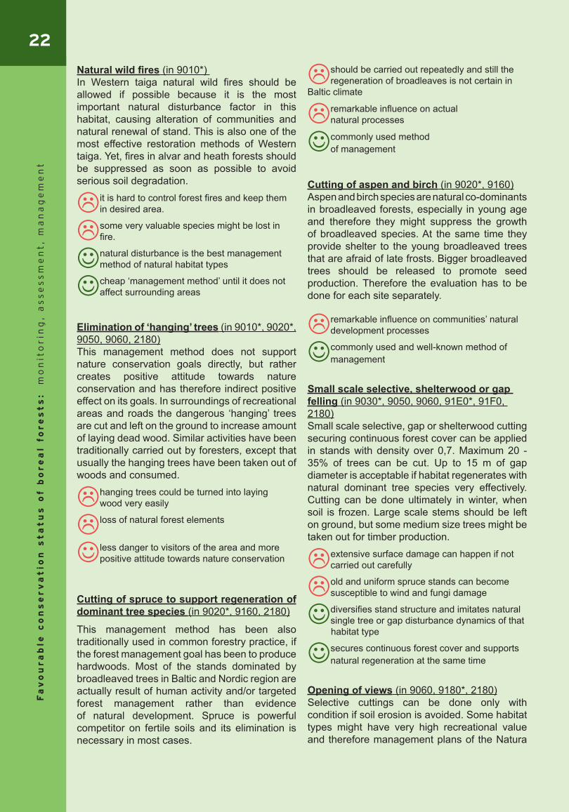
Natural wild fires (in 9010*) In Western taiga natural wild fires should be allowed if possible because it is the most important natural disturbance factor in this habitat, causing alteration of communities and natural renewal of stand. This is also one of the most effective restoration methods of Western taiga. Yet, fires in alvar and heath forests should be suppressed as soon as possible to avoid serious soil degradation.
it is hard to control forest fires and keep them in desired area.
some very valuable species might be lost in fire.
natural disturbance is the best management method of natural habitat types
cheap ‘management method’ until it does not affect surrounding areas
Elimination of ‘hanging’ trees (in 9010*, 9020*, 9050, 9060, 2180)This management method does not support nature conservation goals directly, but rather creates positive attitude towards nature conservation and has therefore indirect positive effect on its goals. In surroundings of recreational areas and roads the dangerous ‘hanging’ trees are cut and left on the ground to increase amount of laying dead wood. Similar activities have been traditionally carried out by foresters, except that usually the hanging trees have been taken out of woods and consumed.
hanging trees could be turned into laying wood very easily
loss of natural forest elements jcsaocjnaincajcnincai
less danger to visitors of the area and more positive attitude towards nature conservation
Cutting of spruce to support regeneration of dominant tree species (in 9020*, 9160, 2180)
This management method has been also traditionally used in common forestry practice, if the forest management goal has been to produce hardwoods. Most of the stands dominated by broadleaved trees in Baltic and Nordic region are actually result of human activity and/or targeted forest management rather than evidence of natural development. Spruce is powerful competitor on fertile soils and its elimination is necessary in most cases.
should be carried out repeatedly and still the regeneration of broadleaves is not certain in
Baltic climate
remarkable influence on actual natural processes
commonly used method of management
Cutting of aspen and birch (in 9020*, 9160)Aspen and birch species are natural co-dominants in broadleaved forests, especially in young age and therefore they might suppress the growth of broadleaved species. At the same time they provide shelter to the young broadleaved trees that are afraid of late frosts. Bigger broadleaved trees should be released to promote seed production. Therefore the evaluation has to be done for each site separately.
remarkable influence on communities’ natural development processes
commonly used and well-known method of management
Small scale selective, shelterwood or gap felling (in 9030*, 9050, 9060, 91E0*, 91F0, 2180)Small scale selective, gap or shelterwood cutting securing continuous forest cover can be applied in stands with density over 0,7. Maximum 20 -35% of trees can be cut. Up to 15 m of gap diameter is acceptable if habitat regenerates with natural dominant tree species very effectively. Cutting can be done ultimately in winter, when soil is frozen. Large scale stems should be left on ground, but some medium size trees might be taken out for timber production.
extensive surface damage can happen if not carried out carefully
old and uniform spruce stands can become susceptible to wind and fungi damage
diversifies stand structure and imitates natural single tree or gap disturbance dynamics of that
habitat type
secures continuous forest cover and supports natural regeneration at the same time
Opening of views (in 9060, 9180*, 2180)Selective cuttings can be done only with condition if soil erosion is avoided. Some habitat types might have very high recreational value and therefore management plans of the Natura
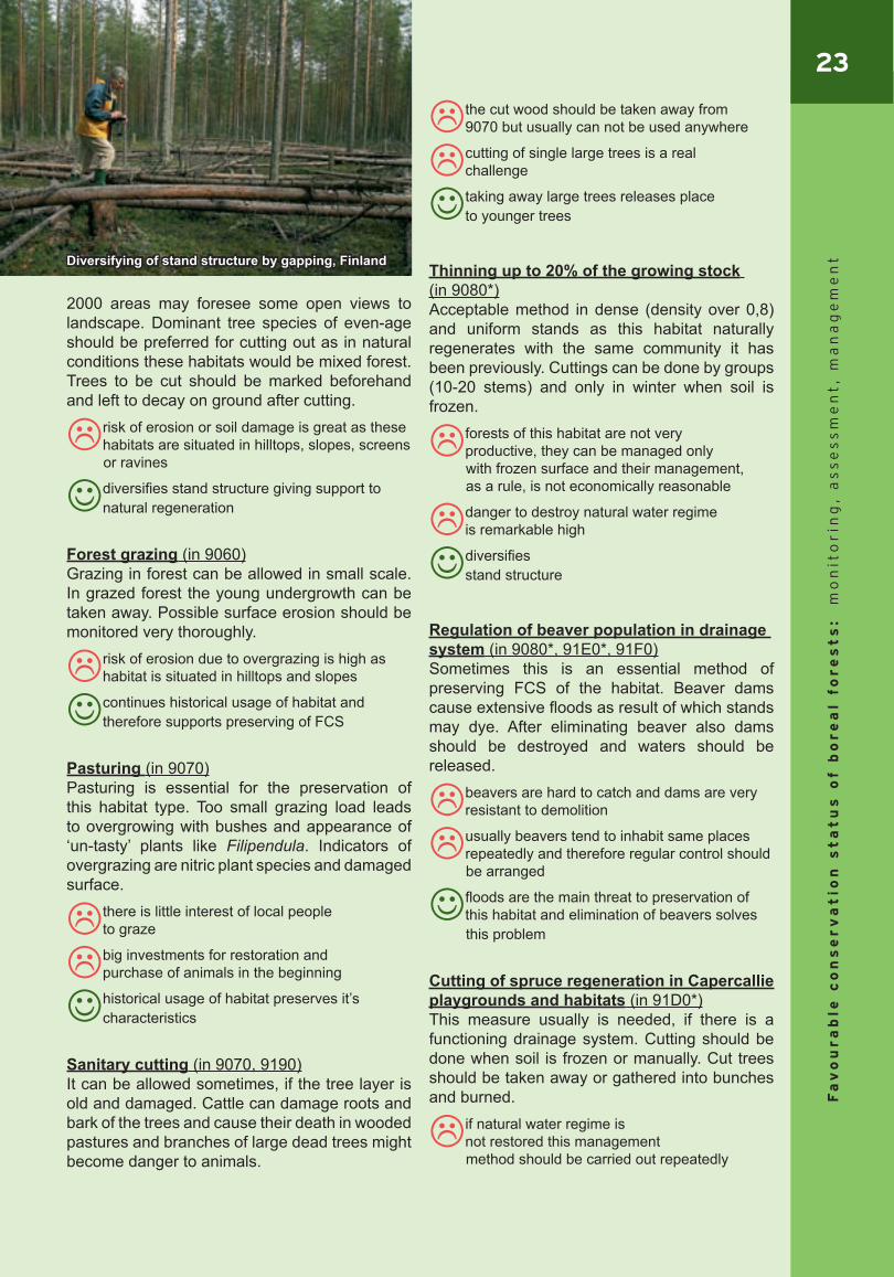
23
Fa
vo
ur
ab
le c
on
se
rv
at
ion
st
at
us
of b
or
ea
l fo
re
st
s:
mo
nit
or
ing
, a
ss
es
sm
en
t,
ma
na
ge
me
nt
2000 areas may foresee some open views to landscape. Dominant tree species of even-age should be preferred for cutting out as in natural conditions these habitats would be mixed forest. Trees to be cut should be marked beforehand and left to decay on ground after cutting.
risk of erosion or soil damage is great as these habitats are situated in hilltops, slopes, screens
or ravines
diversifies stand structure giving support to natural regeneration
Forest grazing (in 9060)Grazing in forest can be allowed in small scale. In grazed forest the young undergrowth can be taken away. Possible surface erosion should be monitored very thoroughly.
risk of erosion due to overgrazing is high as habitat is situated in hilltops and slopes
continues historical usage of habitat and therefore supports preserving of FCS
Pasturing (in 9070)Pasturing is essential for the preservation of this habitat type. Too small grazing load leads to overgrowing with bushes and appearance of ‘un-tasty’ plants like Filipendula. Indicators of overgrazing are nitric plant species and damaged surface.
there is little interest of local people to graze
big investments for restoration and purchase of animals in the beginning
historical usage of habitat preserves it’s characteristics
Sanitary cutting (in 9070, 9190) It can be allowed sometimes, if the tree layer is old and damaged. Cattle can damage roots and bark of the trees and cause their death in wooded pastures and branches of large dead trees might become danger to animals.
the cut wood should be taken away from 9070 but usually can not be used anywhere
cutting of single large trees is a real challenge
taking away large trees releases place to younger trees
Thinning up to 20% of the growing stock (in 9080*)Acceptable method in dense (density over 0,8) and uniform stands as this habitat naturally regenerates with the same community it has been previously. Cuttings can be done by groups (10-20 stems) and only in winter when soil is frozen.
forests of this habitat are not very productive, they can be managed only
with frozen surface and their management, as a rule, is not economically reasonable
danger to destroy natural water regime is remarkable high
diversifies stand structure
Regulation of beaver population in drainage system (in 9080*, 91E0*, 91F0)Sometimes this is an essential method of preserving FCS of the habitat. Beaver dams cause extensive floods as result of which stands may dye. After eliminating beaver also dams should be destroyed and waters should be released.
beavers are hard to catch and dams are very resistant to demolition
usually beavers tend to inhabit same places repeatedly and therefore regular control should
be arranged
floods are the main threat to preservation of this habitat and elimination of beavers solves
this problem
Cutting of spruce regeneration in Capercallie playgrounds and habitats (in 91D0*)This measure usually is needed, if there is a functioning drainage system. Cutting should be done when soil is frozen or manually. Cut trees should be taken away or gathered into bunches and burned.
if natural water regime is not restored this management
method should be carried out repeatedly
Diversifying of stand structure by gapping, Finland
24F
av
ou
ra
ble
co
ns
er
va
tio
n s
ta
tu
s o
f b
or
ea
l fo
re
st
s:
mo
nit
or
ing
, a
ss
es
sm
en
t,
ma
na
ge
me
nt
danger of surface damage
danger of fire
easy and fairly cheap management method
Fight against certain pathogens coming from beetles (in 91E0*, 91F0) This method is applicable only in Lithuania. Infected trees should be treated with pesticides or removed from forests to avoid massive outbreaks of bettles.
natural disturbance processes are affected
expensive and labour-consuming activity
forest remains healthy
Suppressing wild forest fires (in 2180*)Forest fires can damage surface for long time and therefore affect communities’ FCS. Burnt areas should be left to natural regeneration after fire.
natural disturbance processes are affected
expensive and labour-consuming activity
forest remains healthy
Directing visitors to specially prepared tracks (in 91D0*, 2180)In the areas with high recreational pressure this can be important and effective measure to avoid trampling as this habitat type is very easily affected by erosion and soil surface damage.
may attract even more visitors to the area
protects surface from extensive damage
In order to make final decision on management methods the following aspects should be analysed: position in landscape – what would be the
effect of forest management on surrounding communities;
size of the habitat – if the habitat is very small and isolated it might not be reasonable to expect it to maintain its FCS in a long term;
distance from settlements and/or actively visited places – Western taiga should not be restored close to hot-spots of human activity;
surrounding forests or other habitat types (meadows, water bodies etc.) – cutting out of regeneration of spruce or aspen is unreasonable if habitat is surrounded by spruce or aspen stands;
forest history – how this forest area has developed - is it really natural or result of long and targeted management;
traditional use of particular forest (recreation, nature conservation, berry picking etc.) – how this forest area is used currently and for what purpose;
presence of endangered and reare species – requirements of species of the European Importance should always have priority before FCS of habitats.
One should keep in mind that every forest community has to be looked at a broader context, evaluating possibilities to maintain the FCS in a long term. For example, there is no practical reason to restore former wooded pasture in the middle of closed forest area without any access road nearby and without any possibility to continue grazing in that area.
Restoration of forest habitats not yet qualifying to be of European importance
Previous commercial forests in Natura 2000 areas might require management measures aiming to restore some lost features of forest habitats typical to natural communities and vitally important to several species inhabiting the forests. Nature restoration should be based on restoration plan of the whole area and on precautionary principle – it should be carried out only where the effect of restoration is the greatest. Most of the forests in the protected areas are left to the natural development.
Broader goals of restoration can be: creation of buffer zones around forest
areas with high nature values; uniting of valuable forest areas; creation of homogeneous forest
massive; adding of decay wood and burned
materials;
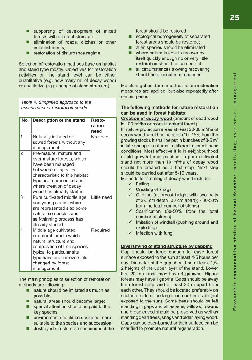
25
Fa
vo
ur
ab
le c
on
se
rv
at
ion
st
at
us
of b
or
ea
l fo
re
st
s:
mo
nit
or
ing
, a
ss
es
sm
en
t,
ma
na
ge
me
nt
supporting of development of mixed forests with different structure;
elimination of roads, ditches or other establishments;
restoration of disturbance regime.
Selection of restoration methods base on habitat and stand type mostly. Objectives for restoration activities on the stand level can be either quantitative (e.g. how many m³ of decay wood) or qualitative (e.g. change of stand structure).
Table 4. Simplified approach to the assessment of restoration needs
No Description of the stand Resto- ration need
1 Naturally initiated or sowed forests without any management
No need
2 Pre-mature, mature and over mature forests, which have been managed, but where all species characteristic to this habitat type are represented and where creation of decay wood has already started.
3 Pure cultivated middle age and young stands where are represented also some natural co-species and self-thinning process has already started.
Little need
4 Middle age cultivated or natural forests which natural structure and composition of tree species typical to particular site type have been irreversible changed by forest management.
Required
The main principles of selection of restoration methods are following: nature should be imitated as much as
possible; natural areas should become large; special attention should be paid to the
key species; environment should be designed more
suitable to the species and succession; destroyed structure an continuum of the
forest should be restored; ecological homogeneity of separated
forest areas should be restored; alien species should be eliminated; where nature is able to recover by
itself quickly enough no or very little restoration should be carried out;
all circumstances slowing recovering should be eliminated or changed.
Monitoring should be carried out before restoration measures are applied, but also repeatedly after certain period.
The following methods for nature restoration can be used in forest habitats: Creation of decay wood (amount of dead wood is 100 m3/ha or more in natural forest)In nature protection areas at least 20-30 m3/ha of decay wood would be needed (10 -15% from the growing stock). It shall be put in bunches of 3-5 m3
in late spring or autumn in different microclimatic conditions. Most effective it is in neighbourhood of old growth forest patches. In pure cultivated stand not more than 10 m3/ha of decay wood should be created as a first step. Next step should be carried out after 5-10 years. Methods for creating of decay wood include: Felling Creating of snags Girdling (at breast height with two belts
of 2-3 cm depth (30 cm apart)) - 30-50% from the total number of stems)
Scarification (30-50% from the total number of stems)
Imitation of windfall (pushing around and exploding)
Infection with fungi
Diversifying of stand structure by gappingGap should be large enough to leave forest surface exposed to the sun at least 4-5 hours per day. Diameter of the gap should be at least 1,5-2 heights of the upper layer of the stand. Lower that 20 m stands may have 4 gaps/ha. Higher forests may have 1 gap/ha. Gaps should be away from forest edge and at least 20 m apart from each other. They should be located preferably on southern side or be larger on northern side (not exposed to the sun). Some trees should be left standing in gaps and all aspens, willows, rowans and broadleaved should be preserved as well as standing dead trees, snags and older laying wood. Gaps can be over-burned or their surface can be scarified to promote natural regeneration.

26F
av
ou
ra
ble
co
ns
er
va
tio
n s
ta
tu
s o
f b
or
ea
l fo
re
st
s:
mo
nit
or
ing
, a
ss
es
sm
en
t,
ma
na
ge
me
nt
BurningIt is an exceptional measure, applicable only for some habitats (e.g. 9010). Tree crowns should be at least 6 m from ground in burning area and in the neighbouring stands. Burning area should be surrounded with the belt of mineral soil and irritated before burning. Most suitable time for burning is late spring or the second half of the summer. Sometimes additional laying-wood should be created for “fire food”.
In Finland burning is considered to be the most effective restoration method for Western taiga; however, the results depend very much on intensity of burning. Baltic States have a lot of accidental or natural fires (probably enough for fire depending species), so applicability of the prescribed burning is questionable.
Restoration of natural water regimeThis is very expensive measure, influencing large areas. For closing drainage ditches various types of dams are used, e.g. wooden, peat, plastic sheet, metal sheet and composite dams. Restoration is easiest in case of new drainage systems, when drainage ditches can be filled with the same surface soil that was taken out from the ditches while they were dug. In case of partial damming, the dams should be 30-50 m apart from each other. In forests drained for a longer time the water regime should be restored smoothly with partial dams and new dams should be established 10-15 years after first damming. Some old and partly not functioning ditches should be left to natural over-growing. Former natural streams should be restored in natural way (putting stones to the straightened streams).
Creating homogeneous forest areasFor creation of homogenous forest areas forestation of roads, tracks and compartment lines and liquidation of drainage are used.
The easiest and cheapest way for liquidating forest roads, tracks and compartment lines is to stop maintenance works and close the road for traffic with stones or barriers. However, this is effective only if roads are less than 10 years old and not with thickened surface. For old and intensively used roads additionally mineralization or ploughing is needed to support natural regeneration. Surface of the roads can be drugged into the ditches along the roads. By doing that at the same time the natural water is restored regime.
Colonisation of valuable speciesAdding of decay wood is used for creating more suitable habitats for species depending on decay wood. Colonization of species is very expensive method that always needs thorough scientific research and which final results cannot be predicted. Therefore it is used only in exceptional cases (e.g. if needed for saving endangered species from extinction).
Sustainable forest management to provide backup
Previous commercial forests in Natura 2000 areas might be managed in sustainable way to provide backup resource for endangered species after some natural or man-caused disturbances in natural forest habitats. Sustainable forest management does not aim at changing the features of the site but at maintaining them as they are. Rather soft methods are used such as small scale felling, grazing or mowing. Management plans often foresee also building of nature trails, camping places and waste management that are important activities for raising public awareness on forest habitats and their values and preventing also damage to forest habitats.
Forest burning in Koitajoki Natura 2000 area, Finland

27
Fa
vo
ur
ab
le c
on
se
rv
at
ion
st
at
us
of b
or
ea
l fo
re
st
s:
mo
nit
or
ing
, a
ss
es
sm
en
t,
ma
na
ge
me
nt
Recommendations for stakeholder information and involvement
As forests are not only important for biodiversity but also have an economic, aesthetic and protective value the fate of forests is important for a wide range of people, who often have different views and understanding of forest use. In several BEF seminars held on forest issues the experts from nature conservation and forestry side have sit together and tried to find out what are the main conflicts and how to solve them. For foresters the good forest is productive healthy forest, while for nature conservationists the most important is the high biodiversity of forests that can be achieved only in old natural stands with sufficient amount of different kind of dead wood. So it is obvious that stakeholders with different interests have different views on cutting age, melioration, amount of dead wood, monoculture plantations etc. The different understandings on forest value leads to conflicts related to forest fires as a management tool, clear cuttings and sanitary cuttings, timing of forestry activities, use of pesticides, limitations for economic use of forests causing economic losses for foresters etc.
Still there is also a potential for common ground. Both, nature conservationists as well as foresters are interested in sustainable management of forests, maintaining biodiversity, cost effective conservation, certification, avoiding pollution, education of stakeholders, establishment of recreational facilities, raising public awareness of importance of woodlands. Forestry experts have good knowledge on forest management measures and their effects that can be valuable knowledge for planning nature conservation management and restoration. At the same time forest owners are interested to know about species and different nature values in their forest. To avoid conflicts, partnership among stakeholders is needed reflecting common ground, different interests and potential conflicts.
For successful cooperation common under-standing on FCS of forest habitats, active data exchange and cooperation on practical management are important. In the round-up meeting of this project the recommendations for achieving this were developed:
For planning any nature conservation measures or forest management all different stakeholders should be involved and decisions should be made jointly to avoid later conflicts. In forest authorities should work also nature conservation experts and vice versa. Working together has proved to be very useful already in such projects as woodland key habitats inventories.
Forest certification supports partnership of foresters and nature conservationists. It is useful from economic point of view because it increases competitiveness on market as well as from nature conservation perspective as it requires sustainable forest management and maintaining biodiversity values.
Important is also data exchange between forestry and nature conservation databases, but to stimulate that the data should be free of charge. However, not all of the data can be public (e.g. exact information on location of very rare species). It is important to define official procedure for both ways of information flow.
For achieving common understanding on FCS of forest habitats education of people starting from kindergarten and school would be needed. Information should be distributed to stakeholders also through media and local forest associations.
Also the common understanding among the countries on FCS values would be helpful for convincing the decision makers. Nature conservation goals and measures for achieving FCS should be reflected in national legislation.
Cooperation on practical management can be ensured through the forest management plans. Consultants to private forest owners and demonstration objects to introduce management measures can be of great value. In addition to education of forest owners also education of workers doing practical job (e.g. drivers) would be needed.
For achieving successful cooperation among foresters and nature conservationists it is important to have compensation mechanism for losses caused by restrictions of forest use (although there is a danger of misuse). Tax reduction approach can be also applied, for example.

28F
av
ou
ra
ble
co
ns
er
va
tio
n s
ta
tu
s o
f b
or
ea
l fo
re
st
s:
mo
nit
or
ing
, a
ss
es
sm
en
t,
ma
na
ge
me
nt
This publication has brought together information acquired in the course of the project „Favourable Conservation Status of Boreal Forest – Experience Exchange among Baltic and Nordic Experts” that was financially supported by the Phare Cross-Border Co-operation Programme in the Baltic Sea Region 2003 in Estonia, Nordic Council of Ministers and Estonian Environment Investment Centre. The main reason for initiating this project was the common challenge that all EU Member States are standing for – the task to evaluate the conservation status of habitats and species of Community importance in our countries and report about it to the European Commission by June 2007. The key challenge lies in the fact that the assessment has to be done across the whole country, and not only within the Natura 2000 areas. It has to be done for the habitat types listed in Annex I of the Habitats Directive that are quite different from habitat classifications used so far in countries.There is also no clear guidance on how to do this assessment. Hence, the Member States are revising their biodiversity monitoring systems, developing methodologies for monitoring and conservation status assessment, trying to clarify unclear terms and concepts of FCS, Favourable Reference Values, Typical species.
The EC together with its Scientific Working Group and European Topic Centre on Biological Diversity is providing assistance to the Member States to fulfil this complex task. The Habitats Committee has adopted a reporting format in 2005 (DocHab-04-03/03 rev.3) to standardize the reports and allow the aggregation of national data for EU report later. ETC/BD is developing further guidance to help Member States to fill the forms, to clarify unclear terms and concepts and to propose methodologies for assessment as well as provide practical examples. It is intended to be an evolving document, with the addition of
further examples as expertise develops.
This project focused on forest habitats of the Boreal region as they form a big part of the habitats of Community interest occurring in the Baltic and Nordic countries; forests are very important for this region not only from biodiversity but also socio-economic point of view, and assessment of the conservation status of forest habitats is probably one of the most complicate tasks due to their complex structure and functions.
The main aim of this project was to bring together forest experts from countries sharing Boreal region in Europe to find common understanding on FCS of boreal forest habitats, develop indicators for its assessment as well as agree on best management methods and stakeholder involvement strategies to achieve the FCS. The results of the project are presented in this publication. The set of indicators presented here was developed by the Baltic and Nordic experts keeping in mind national interests for assessing of conservation status as well as obligations for reporting to EC and in the same time keeping in mind the pragmatic approach – to select what is feasible to monitor and for what data could be available to assess the trends. But still, the proposed set of indicators is only initial proposal and its applicability in different countries needs further analysis and further work to incorporate it into national monitoring and assessment systems.
We hope that information gathered in this publication will be helpful for Baltic and Nordic countries while developing monitoring programmes and methodologies for assessment of the status of boreal forest habitats as well as for planning management of forest habitats and achieving successful cooperation with stakeholders.
Summary
29
Fa
vo
ur
ab
le c
on
se
rv
at
ion
st
at
us
of b
or
ea
l fo
re
st
s:
mo
nit
or
ing
, a
ss
es
sm
en
t,
ma
na
ge
me
nt
ReferencesAbenius, J. et al., Swedish Environmental Protection Agency (2004) – Natura 2000 monitoring in SwedenAndersson, L., Ek, T., Külvik, M., Martverk, R. ja Palo, A. 2000. Metsa vääriselupaikade inventeerimise metoodika. Eesti Keskkonnaministeeriumi Metsaosakond ja Rootsi Östra Götalandi Lääni Metsaamet. Linköping-Tallinn-Tartu. 52 lk.+ lisad.Andersson, L., Martverk, R., Külvik, M., Palo A. ja A. Varblane. 2003. Woodland Key Habitat Inventory in Estonia 1999-2002. Tartu. 112 p. + 80 p.Baltic Environmental Forum (2002) – 2nd Baltic State of the Environment Report based on environmental indicatorsBaltic Environmental Forum (2005) - Biodiversity monitoring and reporting according to the EU requirements: the Baltic States, available electronically at www.bef.lvBütler R., Angelstam P., Ekelund P., Schlaepfer R., 2004: Dead wood threshold values for the three-toed woodpecker presence in boreal and sub-Alpine forest. – Biological Conservation 119: 305–318Ellmauer, T., Federal Environmental Agency, Austria (2005) - Conception of the Assessment of the conservation status in Austria. Presentation in the workshop on Implementation of biodiversity monitoring requirements according requirements to the Habitats Directive in the EU Member States, 3-4 March 2005, Sigulda, LatviaEstonian Ministry of the Environment (2003) - Estonian Forestry Development Programme until 2010ETC/BD (April 2006, a draft manuscript) - Assessment, monitoring and reporting under Article 17 of the Habitats Directive: Explanatory notes and Guidelines. DRAFT 3European Commission (2005) - Note to the Habitats Committee – Preparing the 2001-2007 report under Article 17 of the Habitats Directive (DocHab-04-03/03 rev.3) http://forum.europa.eu.int/Public/irc/env/monnat/libraryFAO (2005) - Global Forest Resources Assessment, data from http://www.fao.org/forestry/foris/webview/forestry2/index.jsp?siteId=5081&sitetreeId=18927&langId=1&geoId=0Hanski, I. & Walsh, M., BirdLife European Forest Task Force (2004) How Much, How To – Practical Tools for Forest ConservationJonsson, B.G., Kruys, N. & Ranius, T., 2005: Ecology of species living on dead wood – Lessons for dead wood management. – Silva Fennica, 39(2): 289–309.Liira, J, Kohv, K. 2004. Erineva majandamisrežii-miga metsade bioloogilise mitmekesisuse seire metoodika väljatöötamine. Metsanduse Arengukava. Tartu.
Lõhmus et al (2004) - Loss of old-growth, and the minimum need for strictly protected forests in Estonia. – Ecol. Bull. 51: 401–411.Mizaras S., Ruseckas J., Karazija S., 2005: Europos Bendrijos svarbos miško buveinių apsaugos ir tvarkymo reglamentų projektų parengimas. Mokslinio tiriamojo darbo ataskaita [Development of regulation projects for protection and management of forest of EEC interest. Research report ]. – Kaunas–Girionys.Paal, J. 1997. Eesti taimkatte kasvukohatüüpide klassifikatsioon. Tartu Ülikooli Botaanika ja Ökoloogia Instituut. Tallinn.Paal, J. (2006, manuscript) - Comparison of interpretations of forest habitat types in Finland, Estonia, Latvia, Lithuania and Sweden. Presentation in the first expert meeting on “Favourable Conservation Status of Boreal Forest Habitat Types”, January 19-20, 2005, Tallinn, EstoniaPalo, A. 2004. NATURA 2000 metsaelupaigad. EV Keskkonnaministeerium. Eesti Loodusfoto, Tartu. 24 lk. Palo, A., Abner, O., Kalamees, R., Ploompuu, T., Roosaluste, E., Truus, L., Vellak, K. 2005. Natura 2000 elupaikade seire integreerimine looduse mitmekesisuse seire taimekoosluste seire allprogrammi. Eesti XV Ökoloogiapäev, 22.aprill 2005. Natura 2000 Eestis. Toim. Frey, T., Tartu, lk. 25-35.Palo, A. (2006, manuscript) - Indicators characterizing forest types FCS on different levels (site, national, bio-geographical level). Results from consultations. Presentation in the expert meeting on Conservation status assessment and monitoring of boreal forest habitat types, April 11-12, 2006, Laagri, EstoniaRašomavičius V., 2001: Europinės svarbos buveinės Lietuvoje. Lietuvoje aptinkamų Europos Sąjungai svarbių buveinių tipų aiškinamasis vadovas [Interpretation manual for habitat types of EU interest occurring in Lithuania]. – Vilnius, 138 p.Stokland, J.N., Eriksen, R. et al. 2003. Forest biodiversity indicators in the Nordic countries. Status based on national forest inventories. TemaNord. Vol. 514, Nordic Council of Ministers, Copenhagen, 107 pp.Viilma, K. (2004) Management of forests in protected areas. Background paper. Baltic Environmental Forum, available electronically at www.bef.lvViilma, K. (2006, manuscript) - Management measures for achieving/maintaining favourable conservation status of boreal forest habitats. Presentation in the round-up meeting of the project “Favourable Conservation Status of Boreal Forests – Experience Exchange among Baltic and Nordic Experts”, June 15-16, 2006, Roosta, Estonia
Data from http://www.sopsr.sk/natura/ index1.php?p=7&lang=en
30F
av
ou
ra
ble
co
ns
er
va
tio
n s
ta
tu
s o
f b
or
ea
l fo
re
st
s:
mo
nit
or
ing
, a
ss
es
sm
en
t,
ma
na
ge
me
nt
AN
NE
X I
: A
vailab
ilit
y a
nd p
ote
nti
al s
ourc
es o
f dat
a in
the
Bal
tic
Sta
tes
for
the
pro
pos
ed indic
ators
Para
met
er/ *
*Indi
cato
rR
egis
trat
ion
in E
ston
iaR
egis
trat
ion
in L
atvi
aR
egis
trat
ion
in L
ithua
nia
Qua
ntity
indi
cato
rs: R
AN
GE
& A
REA
**N
atur
al ra
nge
(km
2 ) P
ilot d
ata
proc
essi
ng w
as o
rgan
ized
by
prof
. Jaa
nus
Paa
l fo
r hab
itats
inte
rpre
tatio
n m
anua
l R
esea
rch
done
alre
ady
durin
g N
ATU
RA
2000
site
iden
tifi-
catio
n pr
oces
s. F
or s
ever
al h
abia
ts ty
pes
the
natu
ral r
ange
ca
n be
like
who
le c
ount
ry.
Can
be
estim
ated
for m
ost t
ypes
, bu
t not
don
e ac
tual
ly.
**C
hang
e of
the
natu
ral r
ange
(k
m2
and
% p
er re
porti
ng p
erio
d)
Not
don
e ye
t.N
ot d
one
yet,
but i
ts s
houl
d be
like
exp
ert j
udge
men
tN
ot e
stim
ated
yet
**M
ap o
f nat
ural
rang
e
(grid
10x
10 k
m)
Pilo
t dat
a pr
oces
sing
was
org
aniz
ed b
y pr
of. J
aanu
s P
aal
for h
abita
ts in
terp
reta
tion
man
ual
Res
earc
h do
ne a
lread
y du
ring
NAT
UR
A 20
00 s
ite id
entifi
-ca
tion
proc
ess.
Exp
ert j
udge
men
t.N
ot d
one,
but
the
data
for m
any
type
s av
aila
ble
**Fa
vour
able
refe
renc
e ra
nge
(km
2 ) N
ot d
one
yet.
Bec
ause
the
data
abo
ut N
atur
a 20
00
curr
ent a
reas
doe
sn´t
mea
n it
is e
noug
h fo
r fav
oura
ble
refe
renc
e ra
nge.
Res
earc
h do
ne a
lread
y du
ring
NAT
UR
A 20
00 s
ite id
entifi
-ca
tion
proc
ess,
but
not
com
plet
ed fo
r 908
0. T
his
shou
ld b
e es
timat
ed b
ased
on
expe
rt ju
dgem
ent,
base
d on
soi
ls a
nd
avai
labl
e fo
rest
s to
day.
Pro
babl
y si
mila
r ass
essm
ent w
as
done
dur
ing
rese
arch
don
e by
Per
Ang
elst
am (S
wed
en) i
n La
tvia
on
2005
– re
port
“Mai
ntai
ning
fore
st b
iodi
vers
ity in
La
tvia
’s fo
rest
” (av
aila
ble
at h
ttp://
ww
w.v
md.
gov.
lv/d
oc_u
pl/
Gap
_rep
ort_
2006
) A
ll da
ta u
sed
for r
epor
t wer
e co
llec-
ted
from
Sta
te F
ores
t reg
iste
r.
Not
est
imat
ed y
et
**Su
rfac
e ar
ea o
f the
hab
itat (
km2 )
Pos
sibl
e by
usi
ng re
mot
e se
nsin
g in
com
bina
tion
with
in
vent
orie
s. R
emot
e se
nsin
g ap
proa
ch w
as u
sed
in
land
scap
e m
onito
ring
(Kiir
a A
avik
soo,
Jaa
nus
Paa
l), b
ut it
ne
eds
adju
stm
ent
Par
tly d
one
durin
g N
ATU
RA
2000
site
iden
tifica
tion
proc
ess.
For
est d
ata
base
pro
cess
ing
in c
ombi
natio
n w
ith
expe
rt ju
dgm
ent.
The
resu
lts o
f rem
ote
sens
ing
and
fore
stry
dat
abas
e an
alys
is v
ary
grea
tly fo
r mos
t typ
es, p
artic
ular
ly
for 9
010.
Hab
itat d
istri
butio
n m
aps
still
hav
e to
be
elab
orat
ed.
**C
hang
e of
the
tota
l are
a
(km
2 an
d %
per
repo
rting
per
iod)
Rem
ote
sens
ing
in c
ombi
natio
n w
ith in
vent
orie
s, c
ompa
-rin
g of
dat
a fro
m e
arlie
r and
now
aday
s. R
emot
e se
nsin
g ap
proa
ch w
as u
sed
in la
ndsc
ape
mon
itorin
g (K
iira
Aav
ik-
soo,
Jaa
nus
Paa
l), b
ut it
nee
ds a
djus
tmen
t
Par
tly d
one
durin
g N
ATU
RA
2000
site
iden
tifica
tion
pro -
cess
. For
est d
ata
base
pro
cess
ing.
Not
est
imat
ed
**H
abita
t dis
tribu
tion
map
(grid
10x
10
km)
GIS
-pro
cess
ing.
Pro
babl
y ne
eds
som
e m
ore
prec
ise
inve
ntor
ies
(fore
st h
abita
t typ
es h
ave
ofte
n ve
ry b
road
in
terp
reta
tion
leve
l).
Par
tly d
one
durin
g N
ATU
RA
2000
site
iden
tifica
tion
proc
ess.
For
est d
ata
base
pro
cess
ing
in c
ombi
natio
n w
ith
expe
rt ju
dgem
ent.
The
resu
lts o
f rem
ote
sens
ing
and
fore
stry
dat
abas
e an
alys
is v
ary
grea
tly fo
r mos
t typ
es, p
artic
ular
ly
for 9
010.
Hab
itat d
istri
butio
n m
aps
still
hav
e to
be
elab
orat
ed.
**Fa
vour
able
refe
renc
e ar
ea (k
m2)
Not
don
e ye
t. B
ecau
se th
e da
ta a
bout
Nat
ura
2000
cur
rent
ar
eas
does
n´t m
ean
it is
eno
ugh
for f
avou
rabl
e re
fere
nce
rang
e.
Res
earc
h do
ne a
lread
y du
ring
NAT
UR
A 20
00 s
ite id
en-
tifica
tion
proc
ess,
but
not
com
plet
ed fo
r 908
0. E
xper
t ju
dgem
ent.
Not
est
imat
ed y
et
31
Fa
vo
ur
ab
le c
on
se
rv
at
ion
st
at
us
of b
or
ea
l fo
re
st
s:
mo
nit
or
ing
, a
ss
es
sm
en
t,
ma
na
ge
me
nt
Qua
lity
indi
cato
rs: S
TRU
CTU
RE
& F
UN
CTI
ON
Frag
men
tatio
n ef
fect
sM
ean
habi
tat s
ize
(ha)
Pos
sibl
e ca
lcul
ate
from
dig
ital m
ap o
r rem
ote
sens
ing
data
Usi
ng fo
rest
dat
a ba
se in
com
bina
tion
with
dig
ital f
ores
t m
ap. T
o fu
lfil,
at fi
rst a
ll ha
bita
t typ
es s
houl
d be
des
crib
ed
rega
rdin
g fe
atur
es o
f for
est d
ata
base
. For
est d
ata
base
up
datin
g pe
riod
is 1
0 ye
ars.
Pos
sibl
e ca
lcul
ate
from
rem
ote
sens
ing
data
**C
hang
e of
the
mea
n ha
bita
t siz
e (h
a, +
/-%)
Pos
sibl
e ca
lcul
ate
from
dig
ital m
ap o
r rem
ote
sens
ing
data
Fore
st d
ata
base
pro
cess
ing.
Bef
ore
each
hab
itat t
ype
shou
ld b
e de
scrib
ed a
s m
uch
as p
ossi
ble
usin
g fe
atur
e fro
m fo
rest
dat
a ba
se a
nd a
lso
feat
ures
from
dig
ital m
ap.
Pos
sibl
e ca
lcul
ate
from
rem
ote
sens
ing
data
Edge
cha
ract
eris
tics
(edg
e w
ith
each
bio
tope
type
m/h
a)P
ossi
ble
calc
ulat
e fro
m d
igita
l map
or r
emot
e se
nsin
g da
taU
sing
fore
st d
ata
base
in c
ombi
natio
n w
ith d
igita
l for
est
map
. The
dat
a w
ill b
e on
ly p
er to
tal e
dge.
May
be u
sing
als
o re
mot
e se
nsin
g.
**C
hang
e in
leng
th o
f the
edg
e w
ith
each
bio
tope
type
(+/-
m/h
a)C
ompa
ring
of d
ata
from
ear
lier a
nd n
owad
ays
Com
parin
g of
dat
a fro
m e
arlie
r and
now
aday
sP
ossi
ble
calc
ulat
e fro
m re
mot
e se
nsin
g da
ta
Tree
spe
cies
com
posi
tion
** T
ree
or tr
ee m
ixtu
re d
istri
butio
n (h
a)Fo
rest
sur
vey.
Fore
st d
ata
base
pro
cess
ing
Fore
st s
urve
y
Age
cla
ss d
istr
ibut
ion
** a
ge c
lass
dis
tribu
tion
(dom
inat
ing
tree
spec
ies)
(ha
and
%)
Fore
st s
urve
y.Fo
rest
dat
a ba
se p
roce
ssin
g, a
lso
the
data
from
fore
st
reso
urce
mon
itorin
gFo
rest
sur
vey
** u
neve
n st
age
stan
d di
strib
utio
n (h
a an
d %
)Fo
rest
sur
vey.
Fore
st d
ata
base
pro
cess
ing,
als
o th
e da
ta fr
om fo
rest
re
sour
ce m
onito
ring
Fore
st s
urve
y?
Tree
sta
nd s
truc
tura
l com
plex
ity :
**st
andi
ng b
iolo
gica
lly o
ld n
orm
al
size
d liv
ing/
dead
tree
sFi
eldw
ork
(fore
st s
urve
y, m
onito
ring)
. Som
e in
form
atio
n po
ssib
le to
get
from
fore
stry
dat
abas
e (if
they
sur
vey
the
area
s), t
he e
arlie
r mon
itorin
g of
fore
st c
omm
uniti
es w
as
mor
e co
ncen
trate
d on
the
tree
and
vasc
ular
pla
nt s
peci
es
only.
WK
H d
ata
(whe
re a
vaila
ble)
.
In s
tate
fore
sts,
pro
tect
ed a
reas
Woo
dlan
d K
ey H
abita
ts
data
cou
ld b
e us
ed. P
robl
emat
ic in
priv
ate
fore
sts
whe
re
WK
H s
urve
y is
not
com
plet
e an
d da
ta fo
und
durin
g di
ffe-
rent
pro
ject
s no
t sum
mar
ized
WK
H d
ata
(whe
re a
vaila
ble)
, fie
ldw
ork
**st
andi
ng b
iolo
gica
lly o
ld s
mal
l, sl
owly
gro
wn
livin
g/de
ad t
rees
**ly
ing
dead
woo
d in
firs
t/mid
dle/
end
stag
es o
f dec
ompo
sitio
n
**fa
llen
trees
with
/with
out b
ark
(d>2
5 cm
/d<2
5 cm
)
**na
tura
l sna
gs (d
>15c
m)
**ho
llow
tree
s
livin
g tre
es w
ith fi
re s
cars
** A
mou
nt o
f dea
d w
ood
Fiel
dwor
k (fo
rest
sur
vey,
mon
itorin
g), W
KH
dat
a (w
here
av
aila
ble)
.N
ot re
ally
goo
d da
ta a
vaila
ble
toda
y, o
ne p
ossi
bilit
yty
to
use
the
data
from
Sta
te F
ores
t Ser
vice
, whi
ch a
re n
ot c
redi
-bl
e, th
e se
cond
alte
rnat
ive
- fro
m fo
rest
reso
urce
mon
ito-
ring
done
by
LFR
I “S
ilava
”.
WK
H d
ata
(whe
re a
vaila
ble)
, fiel
-dw
ork,
fore
st s
urve
y
32F
av
ou
ra
ble
co
ns
er
va
tio
n s
ta
tu
s o
f b
or
ea
l fo
re
st
s:
mo
nit
or
ing
, a
ss
es
sm
en
t,
ma
na
ge
me
nt
Typi
cal s
peci
es**
Num
ber o
f spe
cies
Fi
eldw
ork
(mon
itorin
g). P
ossi
ble,
but
tim
e- a
nd m
oney
-co
nsum
ing.
No
list o
f typ
ical
spe
cies
and
no
data
yet
.N
o go
od d
ata,
hug
e m
onito
ring
field
wor
k ne
eded
. Som
e da
ta a
re a
vaila
ble
from
cre
ated
mic
rore
serv
es –
info
rmat
ion
from
Sta
te F
ores
t ser
vice
and
Nat
ure
prot
ectio
n B
oard
Fiel
dwor
k (m
onito
ring)
** %
of c
hang
ed s
peci
esC
ompa
ring
of d
ata
from
ear
lier a
nd n
owad
ays
Com
parin
g of
dat
a fro
m e
arlie
r and
now
aday
sC
ompa
ring
of d
ata
from
ear
lier a
nd
now
aday
s
Nat
ural
dis
turb
ance
:Th
e st
ands
har
vest
ed a
fter d
iffer
ent t
ype
of d
amag
e ca
n be
id
entifi
ed th
roug
h re
ports
from
Sta
te fo
rest
ser
vice
and
fo-
rest
dat
a ba
se, b
ut u
nman
aged
sta
nds
shou
ld b
e id
entifi
ed
usin
g re
mot
e se
nsin
g, p
artly
als
o fo
rest
dat
a ba
se.
** F
ire in
fluen
ced
area
s (h
a)Fo
rest
sur
vey.
Dat
a fro
m S
tate
fore
st s
ervi
ce, b
oth
from
For
est fi
re
secu
rity
depa
rtmen
t abo
ut to
tal f
ores
t fire
, and
from
For
est
heal
th d
epar
tmen
t abo
ut fi
re d
emag
ed s
tand
s. A
lso
fore
st
reso
urce
mon
itorin
g, re
alis
ed b
y LF
RI “
Sila
va”.
In c
ombi
na-
tion
with
rem
ote
sens
ing
Fore
st s
urve
y. R
emot
e se
nsin
g.
** W
ind
and
snow
influ
ence
d ar
eas
(ha)
Fore
st s
urve
y.D
ata
from
Sta
te fo
rest
ser
vice
, fro
m F
ores
t hea
lth d
epar
t-m
ent a
bout
win
d an
d sn
ow d
amag
ed s
tand
s. A
lso
Fore
st
reso
urce
mon
itorin
g, re
alis
ed b
y LF
RI “
Sila
va”
Fore
st s
urve
y. R
emot
e se
nsin
g?
** B
iolo
gica
l dis
turb
ance
(ha)
Fore
st s
urve
y.D
ata
from
Sta
te fo
rest
ser
vice
, fro
m F
ores
t hea
lth d
epar
t-m
ent a
bout
pes
t dam
aged
sta
nds.
Als
o fo
rest
reso
urce
m
onito
ring,
real
ised
by
LFR
I “S
ilava
”
Fore
st s
urve
y. R
emot
e se
nsin
g?
**E
rosi
on in
fluen
ced
area
(ha)
No
syst
emat
ic d
ata
avai
labl
e.C
urre
ntly
no
avai
labl
e da
ta, e
xcep
t dat
a ab
out s
ever
al
exac
t are
as (f
or in
stan
ce in
cos
tal z
one)
, reg
istre
d du
ring
proj
ects
. Fie
ld s
urve
y on
ero
sion
end
ange
red
area
s.
No
data
ava
ilabl
e fo
r the
who
le
dist
ribut
ion
rang
e?
** F
lood
ed a
rea
(incl
. Bea
ver)
(ha)
Fore
st s
urve
y, re
mot
e se
nsin
g.D
ata
from
Sta
te fo
rest
ser
vice
, fro
m F
ores
t hea
lth d
epar
t-m
ent a
bout
wat
er in
fluen
ced
stan
ds (a
lso
from
bea
ver)
. P
robl
emat
ic c
an b
e to
iden
tified
floo
dpla
in a
reas
. Als
o fo
rest
reso
urce
mon
itorin
g, re
alis
ed b
y LF
RI “
Sila
va”
Rem
ote
sens
ing.
FUTU
RE
PRO
SPEC
TS, T
HR
EATS
, PR
ESSU
RES
Hum
an in
fluen
ce:
** F
lood
ed a
rea
beca
use
of a
rtific
ial
(hum
an-m
ade)
reas
ons
(ha,
%)
No
data
.N
o da
ta.
No
data
.
**H
abita
ts w
ith a
lien
tree
spec
ies
(ha)
Fore
st s
urve
y.Fo
rest
dat
abas
e.Fo
rest
sur
vey.
** a
rea
of c
lear
/sel
ectiv
e/fin
al c
uttin
g (h
a, %
from
tota
l are
a of
hab
itat t
ype)
Fore
st s
uvey
.Fo
rest
dat
a ba
se p
roce
ssin
gFo
rest
sur
vey.
Rem
ote
sens
ing
** a
rea
influ
ence
d by
agr
icul
tura
l ac
tiviti
es (h
a, %
from
tota
l are
a of
ha
bita
t typ
e)
PR
IA d
atab
ases
? O
ther
loca
l dat
abas
es?
From
Sta
te fo
rest
ser
vice
info
rmat
ion
abou
t for
est l
and
trans
form
atio
n to
oth
er la
nd u
se. A
dditi
onal
info
rmat
ion
rega
rdin
g pr
otec
ted
area
s an
d th
eir m
anag
emen
t usi
ng
graz
ing
from
Nat
ure
prot
ectio
n bo
ard.
No
or v
ery
limite
d da
ta?

33
Fa
vo
ur
ab
le c
on
se
rv
at
ion
st
at
us
of b
or
ea
l fo
re
st
s:
mo
nit
or
ing
, a
ss
es
sm
en
t,
ma
na
ge
me
nt
** a
rea
influ
ence
d by
recr
eatio
nal
activ
ities
(ha,
%)
Dat
a-pr
oces
sing
in d
iffer
ent d
atab
ases
, for
est s
urve
y.
Fiel
dwor
k?N
ot d
irect
info
rmat
ion
sour
ce. R
egar
ding
sta
te fo
rest
s in
form
atio
n fro
m L
VM
(Lat
vias
sta
te fo
rest
s), f
or s
tate
and
pr
ivat
e fo
rest
s fro
m N
atur
e pr
otec
tion
boar
d an
d ad
mi-
nist
ratio
ns o
f nat
iona
l par
ks. I
nfor
mat
ion
mai
nly
will
cov
er
crea
ted
recr
eatio
n pl
aces
.
No
or v
ery
limite
d da
ta?
** a
rea
influ
ence
d by
pol
lutio
n (h
a)D
ata
from
env
ironm
enta
l mon
itorin
g pr
ogra
mm
e.N
o di
rect
info
rmat
ion
sour
ce, c
an b
e us
ed th
e da
ta fr
om
ICP
fore
st m
onito
ring,
cro
wn
cond
ition
ass
essm
ent,
done
by
Sta
te fo
rest
ser
vice
. The
dat
a av
aila
ble
are
only
per
br
oad
regi
ons
in c
ount
ry, a
nd c
onne
cted
als
o w
ith o
ther
da
mag
e fa
ctor
s.
Nat
iona
l mon
itorin
g (fo
r ind
ustri
al
pollu
tion)
** a
rea
influ
ence
d by
dra
inag
e (L
eng-
th -
m/h
a, in
fluen
ced
area
- ha
)G
ener
al d
ata
is p
ossi
ble
to c
alcu
late
from
Est
onia
n B
asic
M
ap (v
ecto
r for
mat
map
, Lan
d-B
oard
). La
ter r
emot
e se
nsin
g (le
ngth
and
wid
th).
Exa
ct in
terp
reta
tion
is p
ossi
ble
with
GIS
dat
a-pr
oces
sing
. Est
imat
ion
of in
fluen
ced
area
ne
eds
a lo
t of c
alcu
latio
ns.
Exa
ct in
form
atio
n av
aila
ble
abou
t cre
ated
dra
inag
e sy
stem
s in
last
yea
rs, b
ut n
o in
form
atio
n ab
out t
otal
are
as
drai
nage
d. T
he g
reat
est p
art d
rain
age
syst
ems
was
est
abli-
shed
dur
ing
1960
-197
0. N
ot c
lear
how
man
y sy
stem
s to
day
are
out o
f wor
king
.
Fore
st a
nd la
ndus
e da
taba
ses.
Re-
mot
e se
nsin
g w
ith G
IS c
alcu
latio
ns
** c
hang
e of
the
drai
nage
sys
tem
(r
enov
atio
n)S
ee a
bove
. Exa
ct d
ata
avai
labl
e ab
out r
enov
atio
n of
dra
i-na
ge s
yste
ms
real
ised
in la
st y
ears
, inc
ludi
ng th
e ha
and
le
ngth
. Inf
orm
atio
n so
urce
- S
tate
fore
st s
ervi
ce.
** a
rea
of d
efor
esta
tion
(ha,
%)
Rem
ote
sens
ing.
D
ata
of fo
rest
tran
sfor
mat
ion
to o
ther
land
use
, inf
orm
atio
n so
urce
- S
tate
fore
st s
ervi
ce.
Fore
st a
nd la
ndus
e da
taba
ses
** R
oads
(m/h
a, %
)G
ener
al d
ata
is p
ossi
ble
to c
alcu
late
from
Est
onia
n B
asic
M
ap (v
ecto
r for
mat
map
, Lan
d-B
oard
). Fo
rest
dat
a ba
se p
roce
ssin
g, a
lso
the
data
from
rep
orts
on
this
issu
e. F
or s
tate
road
sho
uld
be d
one
fore
st tr
ansf
or-
mat
ion,
so
that
are
a w
ill in
clud
ed in
are
a of
def
ores
tatio
n.
The
data
abo
ut fo
rest
road
(no
need
for t
rans
form
atio
n)
avai
labl
e in
Sta
te fo
rest
ser
vice
.
Fore
st a
nd la
ndus
e da
taba
ses.
R
emot
e se
nsin
g
** C
hang
es in
road
s (m
/ha)
Com
parin
g of
dat
a fro
m e
arlie
r and
now
aday
sC
ompa
ring
of d
ata
from
ear
lier a
nd n
owad
ays
Com
parin
g of
dat
a fro
m e
arlie
r and
no
wad
ays
** C
omm
unic
atio
n lin
es, p
ower
lines
(m
/ha,
%)
Gen
eral
dat
a is
pos
sibl
e to
cal
cula
te fr
om E
ston
ian
Bas
ic
Map
(vec
tor f
orm
at m
ap, L
and-
Boa
rd).
Dat
a av
aila
ble
in S
tate
fore
st s
ervi
ce, b
ut th
e po
wer
line
are
also
the
obje
ct fo
r tra
nsfo
rmat
ion
Land
use
and
fore
st s
urve
y da
taba
-se
s. R
emot
e se
nsin
g
**C
hang
es in
com
mun
icat
ion
lines
, po
wer
lines
(m/h
a, %
)C
ompa
ring
of d
ata
from
ear
lier a
nd n
owad
ays
Com
parin
g of
dat
a fro
m e
arlie
r and
now
aday
sC
ompa
ring
of d
ata
from
ear
lier a
nd
now
aday
s
Con
serv
atio
n m
easu
res
**S
trict
pro
tect
ion
stat
us (h
a, %
)P
ossi
ble
as d
atab
ase-
proc
essi
ngFo
rest
dat
a ba
se p
roce
ssin
g. S
trict
pro
tect
ion
stat
us c
an b
e se
t for
are
as w
ith n
o m
anag
emen
t, m
ain
cutti
ng re
stric
tion.
P
ossi
ble
as d
atab
ase-
proc
essi
ng
**N
2000
are
a ou
t of t
otal
are
a of
that
ty
pe (h
a, %
) - fo
r all
type
sP
ossi
ble
as d
atab
ase-
proc
essi
ngD
ata
base
pro
cess
ing
Pos
sibl
e as
dat
abas
e-pr
oces
sing
, su
ppor
ted
by re
mot
ing
sens
ing
or
field
inve
ntor
ies
**to
tal p
rote
ctio
n st
atus
incl
. vol
unta
ry
prot
ectio
n (%
, ha)
Pos
sibl
e as
dat
abas
e-pr
oces
sing
Ass
essm
ent c
ould
be
real
ised
thro
ugh
fore
st d
ata
base
pr
oces
sing
in c
ombi
natio
n w
ith w
oodl
and
key
habi
tat d
ata
base
, als
o w
oodl
and
key
habi
tat c
once
ntra
tion
data
bas
e
Pos
sibl
e as
dat
abas
e-pr
oces
sing
34F
av
ou
ra
ble
co
ns
er
va
tio
n s
ta
tu
s o
f b
or
ea
l fo
re
st
s:
mo
nit
or
ing
, a
ss
es
sm
en
t,
ma
na
ge
me
nt
ANNEX II: Draft proposal of Baltic experts for typical species for Fennoscandian hemiboreal natural old broad-leaved deciduous forests (Quercus, Tilia, Acer, Fraxinus or Ulmus) rich in epiphytes (9020)Type group: Fresh boreo-nemoral forests (9020) Comments
Lithuania Latvia Estonia Vascular plants:Allium ursinum Good Good Sporadic, relatively rareBromous benekenii Good Good Sporadic, relatively rareCardamine bulbifera Good Also in spruce forests Quite good but too rare
Cephalanthera longifolia Average, very rare, edge-related Very rare in Latvia Broad range of habitats, weak indicative value
Corydalis cava Good Very rare, only W and central Latvia Not present in Estonia
Corydalis intermedia Good Very rare, not suitableCypripedium calceolus Good Rare Broad range of habitats
Daphne mezereum Good Broad range of habitatsBroad range of habitats, weak indicative value. Sensitive only to clear cut.
Epipactis helleborine Good Broad range of habitats Broad range of habitats, weak indicative value
Galium ododratum Good Also in 9050
Glyceria lithuanica Good Good Good? Occurs mainly in Filipendula-type in Estonia (9080, 9050)
Hypericum montanum Good, edge-related Very rare in Latvia Very rare, not suitable
Lathraea squamaria Good Relatively rare, connected to the broadleved trees
Lathyrus laevigatus Good, edge-related Not present in Latvia Not present in EstoniaLilium martagon Good Rare adventive species in Estonia
Sanicula europaea Good Good Broad range of habitats, weak indicative value
Vicia dumetorum Average, edge-related Rare adventive species in Latvia Not present in Estonia
Vicia pisiformis Average, edge-related Rare adventive species in Latvia Not present in Estonia
Mosses:
Anomodon attenuatus Good More related to 91E0, 91F0
Anomodon longifolius Good More related to 91E0, 91F0
Anomodon viticulosus Good More related to 91E0, 91F0
Antitrichia curtipendula Good Only W and N part, rareFrullania dilatata Good GoodLejeunea cavifolia Added by LatviaMetzgeria furcata Added by LatviaNeckera complanata Good GoodNeckera pennata Good GoodPorella spp. Good Rare
Lichens & FungiArthonia byssacea Good GoodClavicorona pyxidata Good Also in drained swamp forest
Grifola frondosa Good Mainly in parks in Estonia (related to Quercus)
Lobaria pulmonaria Good Good
Polyporus badius Good Probably not suitable, distributed in wide range of habitats
Pycnoporus cinnabarinus Good Not suitable, characteristic for clearings
InsectsFormica sp. Also in 9010, 9050Osmoderma eremita Good
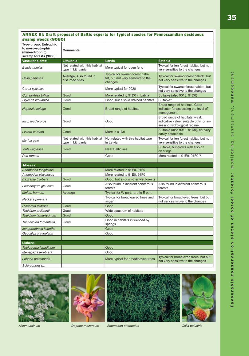
35
Fa
vo
ur
ab
le c
on
se
rv
at
ion
st
at
us
of b
or
ea
l fo
re
st
s:
mo
nit
or
ing
, a
ss
es
sm
en
t,
ma
na
ge
me
nt
Anomodon attenuatus Daphne mezereum
ANNEX III: Draft proposal of Baltic experts for typical species for Fennoscandian deciduous swamp woods (9080) Type group: Eutrophic to meso-eutrophic (minerotrophic) swamp forests (9080)
Comments
Vascular plants: Lithuania Latvia Estonia
Betula humilis Not related with this habitat type in Lithuania More typical for open fens Typical for fen forest habitat, but not
very sensitive to the changes
Calla palustris Average, Also found in disturbed sites
Typical for swamp forest habi-tat, but not very sensitive to the changes
Typical for swamp forest habitat, but not very sensitive to the changes
Carex sylvatica More typical for 9020 Typical for swamp forest habitat, but not very sensitive to the changes
Corralorhiza trifida Good More related to 91D0 in Latvia Suitable (also 9010, 91D0)Glyceria lithuanica Good Good, but also in drained habitats Suitable?
Huperzia selago Good Broad range of habitatsBroad range of habitats. Good indicator for assessing the level of management.
Iris pseudacorus Good GoodBroad range of habitats, weak indicative value, suitable only for as-sessing hydrological regime.
Listera cordata Good More in 91D0 Suitable (also 9010, 91D0), not very easily detectable
Myrica gale Not related with this habitat type in Lithuania
Not related with this habitat type in Latvia
Typical for fen forest habitat, but not very sensitive to the changes
Viola uliginosa Good Near Baltic sea Suitable, but grows well also on clearings
Poa remota Good More related to 91E0, 91F0 ?
Mosses:Anomodon longifolius More related to 91E0, 91F0Anomodon viticulosus More related to 91E0, 91F0Bazzania trilobata Good Good, but also in other wet forests
Leucobryum glaucum Good Also found in different coniferous forests
Also found in different coniferous forests
Mnium hornum Average Typical for W part, rare in E part
Neckera pennata Typical for broadleaved trees and aspen
Typical for broadleved trees, but but not very sensitive to the changes
Riccardia latifrons Good GoodThuidium philibertii Good Wide spectrum of habitatsThuidium tamariscinum Good Good
Trichocolea tomentella Good Good in habitats influenced by springs
Jungermannia leiantha GoodGeocalyx graveolens Good
Lichens:Thelotrema lepadinum GoodMenegazia terebrata Good
Lobaria pulmonaria More typical for broadleaved trees Typical for broadleved trees, but but not very sensitive to the changes
Sclerophora sp.
Allium ursinum Calla palustris

36F
av
ou
ra
ble
co
ns
er
va
tio
n s
ta
tu
s o
f b
or
ea
l fo
re
st
s:
mo
nit
or
ing
, a
ss
es
sm
en
t,
ma
na
ge
me
nt
ANNEX IV: Draft threshold values proposed for Fennoscandian deciduous swamp woods (9080) by Lithuanian experts
Parameter **Indicator Value Comment
Quantity indicators: RANGE & AREA National level
**Natural range (km2) 64934 km² The country’s total land area, because there are no larger gaps in distribution of this type in Lithuania
**Change of the total range (ha and % per reporting period)- for all types Not estimated No change is expected
**Map of natural range Prepared See WKH distribution map below.**Favourable reference range (km2) 64935 km² The country’s total land area.
Surface area of the habitat (ha) 16 304 ha
The area was calculated from Forestry Database data (Mizaras et al. 2005). The criteria applied for plot selection were differ-ent than those provided in the National Interpretation Manual (Rašomavičius, 2001). Actual area of 9080 is in the range of 25-30 thousand ha.
**Change of the total area (ha and % per reporting period)- for all types Not estimated No data available
Habitat distribution map Unprepared Data uncomplete
**Favourable reference area (km2) Approximately 25 000 ha
Data not sufficient. Gap analysis is needed to reveal the exact needed area, but it should not be less than total habitat area when Directive came into force (Assessment, monitoring and reporting under Article 17 of the Habitats Directive: Explanatory Notes & Guidelines DRAFT 3 April 2006). The provided number is the best expert judgment.
Quality indicators: STRUCTURE & FUNCTIONFragmentation effects National level
**Mean habitat size (ha) More than 10 ha
Calculated from several mapped sites, mean habitat size varied from 4,5 to 22 ha. One should bear in mind that there are many small sites (1-5 ha) of 9080 that harbour many typical species and have typical structure.
**Change of the mean habitat size (+/-%) Not estimated
Data not available. As a rule, should be increasing from basic level, when Directive came into force. However, decrease can indicate both increasing fragmentation or development of new small habitats, therefore in some cases could be assesed as positive.
**Edge characteristics (edge with each biotope type m/ha) Not estimated Data not sufficient. As a rule, should be increasing from basic
level, when Directive came into force.**Change of the edge characteristics (edge with each biotope type m/ha) Not estimated Data not sufficient
Tree species composition Site level** Tree or tree mixture distribution (ha) Not estimatedAge class distribution National level
** age class distribution (dominating tree species) (ha and %)
25% of 9080 black alder stands should be more than 80 years old. For birch - 15 % respectively.
Approximate calculation based on forestry statistics (2005). Cur-rently stands above 80 years old make 10.6 % of all black alder sites (birch - 8.4% in all sites). Sites considered as 9080 should include significantly more mature woods.
** uneven stage stand distribution (ha and %) Not estimated Data not sufficient. During WKH inventory only 0.8 % of 9080
sites with heterogenic age structure have been indicated Tree stand structural complexity Site level**standing biologically old normal sized living trees Not estimated WKH data available, but analysis for 9080 not performed
**standing biologically old normal sized dead trees
>=5 % of all stand-ing trees and snags (or appr. 15 m³/ha)
WKH data available, but analysis for 9080 not performed. 5 % is indicated as a treshold sufficient for sustaining of some special-ized woodpecker populations (Bütler et al., 2004)
**standing biologically old small, slowly grown living/dead trees Not considered Less related to this habitat type
**fallen trees with/without bark (d>25 cm/d<25cm) Not estimated WKH data available, but analysis for 9080 not performed
** Amount of dead wood
<20 m³/ha unfa-vourable, 20-40 - amber, favourable >40 m³/ha
Naturaly the amount of dead wood reaches 75-100 m³/ha in old growth woods. This amount depends greatly on site type, bio-mass production and decomposition rate. Forest of 9080 usually include slightly less dead wood comparing to fresh sites due to lower production and higher decomposition.
**lying deadwood in first stages of decom-position >=10 m³/ha Approximately 20 % of all lying deadwood in old growth forest
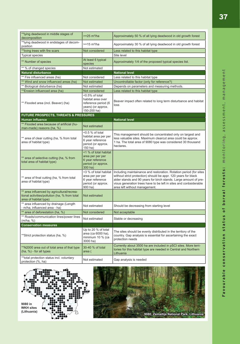
37
Fa
vo
ur
ab
le c
on
se
rv
at
ion
st
at
us
of b
or
ea
l fo
re
st
s:
mo
nit
or
ing
, a
ss
es
sm
en
t,
ma
na
ge
me
nt
**lying deadwood in middle stages of decomposition >=25 m³/ha Approximately 50 % of all lying deadwood in old growth forest
**lying deadwood in endstages of decom-position >=15 m³/ha Approximately 30 % of all lying deadwood in old growth forest
**living trees with fire scars Not considered Less related to this habitat typeTypical species Site level
** Number of species At least 6 typical species Approximately 1/4 of the proposed typical species list.
** % of changed species Not estimatedNatural disturbance National level** Fire influenced areas (ha) Not considered Less related to this habitat type** Wind and snow influenced areas (ha) Not estimated Uncontrollable factor (only for reference?)** Biological disturbance (ha) Not estimated Depends on parameters and measuring methods.**Erosion influenced area (ha) Not considered Less related to this habitat type
** Flooded area (incl. Beaver) (ha)
<0.5% of total habitat area over reference period (6 years) (or approx. 150-200 ha)
Beaver impact often related to long term disturbance and habitat loss
FUTURE PROSPECTS, THREATS & PRESSURESHuman influence National level** Flooded area because of artificial (hu-man-made) reasons (ha, %) Not estimated
** area of clear cutting (ha, % from total area of habitat type)
<0.5 % of total habitat area per per 6 year reference period (or approx. 150 ha)
This management should be concentrated only on largest and less valuable sites. Maximum clearcut area could be approx. 1 ha. The total area of 9080 type was considered 30 thousand hectares.
** area of selective cutting (ha, % from total area of habitat type)
<1 % of total habitat area per per per 6 year reference period (or approx. 300 ha)
** area of final cutting (ha, % from total area of habitat type)
<3 % of total habitat area per per per 6 year reference period (or approx. 900 ha)
Including maintainance and restoration. Rotation period (for sites without strict protection) should be appr. 120 years for black alder stands and 90 years for birch stands. Large amount of pre-vious generation trees have to be left in sites and conbsiderable area left without management.
** area influenced by agricultural/recrea-tional activities/pollution (ha, % from total area of habitat type)
Not estimated
** area influenced by drainage (Length - m/ha, influenced area - ha) Not estimated Should be decreasing from starting level
** area of deforestation (ha, %) Not considered Not acceptable** Roads/communication lines/power lines (m/ha, %) Not estimated Stable or decreasing
Conservation measures
**Strict protection status (ha, %)
Up to 20 % of total area (ca 6000 ha), minimum 10 % (ca 3000 ha)
The sites should be evenly distributed in the territory of the country. Gap analysis is essential for ascertaining the exact protection needs
**N2000 area out of total area of that type (ha, %) - for all types
30-40 % of total area (
Currently about 3500 ha are included in pSCI sites. More terri-tories for this habitat type are needed in Central and Northern Lithuania
**total protection status incl. voluntary protection (%, ha) Not estimated Gap analysis is needed
9080 in WKH sites (Lithuania)
9080, Žemaitija National Park, Lithuania
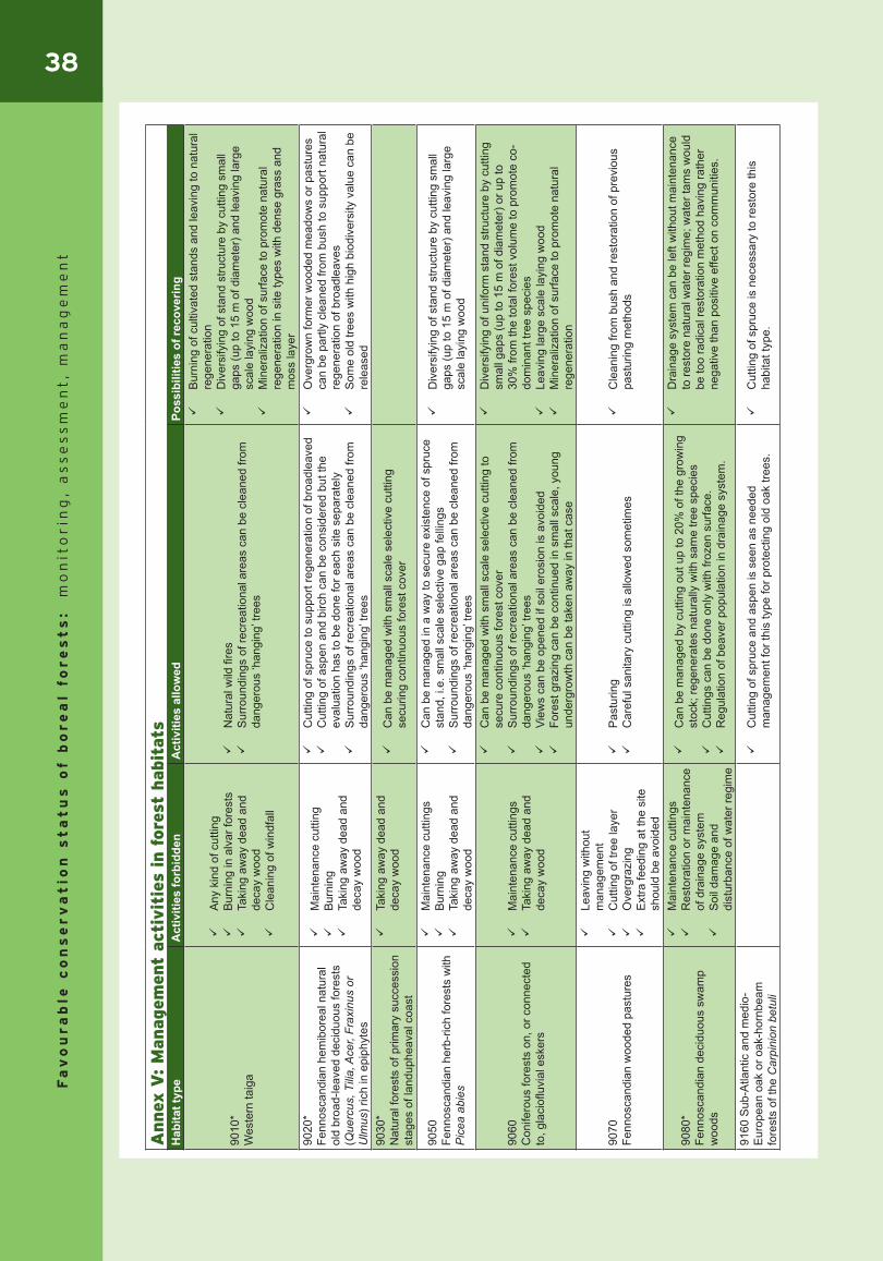
38F
av
ou
ra
ble
co
ns
er
va
tio
n s
ta
tu
s o
f b
or
ea
l fo
re
st
s:
mo
nit
or
ing
, a
ss
es
sm
en
t,
ma
na
ge
me
nt
Annex
V: M
anag
emen
t ac
tivit
ies
in f
ore
st h
abit
ats
Hab
itat t
ype
Act
iviti
es fo
rbid
den
Act
iviti
es a
llow
edPo
ssib
ilitie
s of
reco
verin
g
9010
*W
este
rn ta
iga
Any
kin
d of
cut
ting
Bur
ning
in a
lvar
fore
sts
Taki
ng a
way
dea
d an
d de
cay
woo
d
C
lean
ing
of w
indf
all
Nat
ural
wild
fire
s
S
urro
undi
ngs
of re
crea
tiona
l are
as c
an b
e cl
eane
d fro
m
dang
erou
s ‘h
angi
ng’ t
rees
Bur
ning
of c
ultiv
ated
sta
nds
and
leav
ing
to n
atur
al
rege
nera
tion
Div
ersi
fyin
g of
sta
nd s
truct
ure
by c
uttin
g sm
all
gaps
(up
to 1
5 m
of d
iam
eter
) and
leav
ing
larg
e sc
ale
layi
ng w
ood
Min
eral
izat
ion
of s
urfa
ce to
pro
mot
e na
tura
l re
gene
ratio
n in
site
type
s w
ith d
ense
gra
ss a
nd
mos
s la
yer
9020
*Fe
nnos
cand
ian
hem
ibor
eal n
atur
al
old
broa
d-le
aved
dec
iduo
us fo
rest
s (Q
uerc
us, T
ilia,
Ace
r, Fr
axin
us o
r U
lmus
) ric
h in
epi
phyt
es
Mai
nten
ance
cut
ting
Bur
ning
Taki
ng a
way
dea
d an
d de
cay
woo
d
Cut
ting
of s
pruc
e to
sup
port
rege
nera
tion
of b
road
leav
ed
Cut
ting
of a
spen
and
birc
h ca
n be
con
side
red
but t
he
eval
uatio
n ha
s to
be
done
for e
ach
site
sep
arat
ely
Sur
roun
ding
s of
recr
eatio
nal a
reas
can
be
clea
ned
from
da
nger
ous
‘han
ging
’ tre
es
Ove
rgro
wn
form
er w
oode
d m
eado
ws
or p
astu
res
can
be p
artly
cle
aned
from
bus
h to
sup
port
natu
ral
rege
nera
tion
of b
road
leav
es
S
ome
old
trees
with
hig
h bi
odiv
ersi
ty v
alue
can
be
rele
ased
9030
* N
atur
al fo
rest
s of
prim
ary
succ
essi
on
stag
es o
f lan
duph
eava
l coa
st
Taki
ng a
way
dea
d an
d de
cay
woo
d
C
an b
e m
anag
ed w
ith s
mal
l sca
le s
elec
tive
cutti
ng
secu
ring
cont
inuo
us fo
rest
cov
er
9050
Fenn
osca
ndia
n he
rb-r
ich
fore
sts
with
P
icea
abi
es
Mai
nten
ance
cut
tings
Bur
ning
Ta
king
aw
ay d
ead
and
deca
y w
ood
Can
be
man
aged
in a
way
to s
ecur
e ex
iste
nce
of s
pruc
e st
and,
i.e.
sm
all s
cale
sel
ectiv
e ga
p fe
lling
s
S
urro
undi
ngs
of re
crea
tiona
l are
as c
an b
e cl
eane
d fro
m
dang
erou
s ‘h
angi
ng’ t
rees
Div
ersi
fyin
g of
sta
nd s
truct
ure
by c
uttin
g sm
all
gaps
(up
to 1
5 m
of d
iam
eter
) and
leav
ing
larg
e sc
ale
layi
ng w
ood
9060
Con
ifero
us fo
rest
s on
, or c
onne
cted
to
, gla
ciofl
uvia
l esk
ers
Mai
nten
ance
cut
tings
Taki
ng a
way
dea
d an
d de
cay
woo
d
Can
be
man
aged
with
sm
all s
cale
sel
ectiv
e cu
tting
to
secu
re c
ontin
uous
fore
st c
over
S
urro
undi
ngs
of re
crea
tiona
l are
as c
an b
e cl
eane
d fro
m
dang
erou
s ‘h
angi
ng’ t
rees
View
s ca
n be
ope
ned
if so
il er
osio
n is
avo
ided
Fore
st g
razi
ng c
an b
e co
ntin
ued
in s
mal
l sca
le, y
oung
un
derg
row
th c
an b
e ta
ken
away
in th
at c
ase
Div
ersi
fyin
g of
uni
form
sta
nd s
truct
ure
by c
uttin
g sm
all g
aps
(up
to 1
5 m
of d
iam
eter
) or u
p to
30
% fr
om th
e to
tal f
ores
t vol
ume
to p
rom
ote
co-
dom
inan
t tre
e sp
ecie
s
Le
avin
g la
rge
scal
e la
ying
woo
d
M
iner
aliz
atio
n of
sur
face
to p
rom
ote
natu
ral
rege
nera
tion
9070
Fenn
osca
ndia
n w
oode
d pa
stur
es
Leav
ing
with
out
man
agem
ent
Cut
ting
of tr
ee la
yer
Ove
rgra
zing
E
xtra
feed
ing
at th
e si
te
shou
ld b
e av
oide
d
Pas
turin
g
C
aref
ul s
anita
ry c
uttin
g is
allo
wed
som
etim
es
C
lean
ing
from
bus
h an
d re
stor
atio
n of
pre
viou
s pa
stur
ing
met
hods
9080
*Fe
nnos
cand
ian
deci
duou
s sw
amp
woo
ds
Mai
nten
ance
cut
tings
Res
tora
tion
or m
aint
enan
ce
of d
rain
age
syst
em
Soi
l dam
age
and
dist
urba
nce
of w
ater
regi
me
Can
be
man
aged
by
cutti
ng o
ut u
p to
20%
of t
he g
row
ing
stoc
k; re
gene
rate
s na
tura
lly w
ith s
ame
tree
spec
ies
Cut
tings
can
be
done
onl
y w
ith fr
ozen
sur
face
.
R
egul
atio
n of
bea
ver p
opul
atio
n in
dra
inag
e sy
stem
.
Dra
inag
e sy
stem
can
be
left
with
out m
aint
enan
ce
to re
stor
e na
tura
l wat
er re
gim
e; w
ater
tam
s w
ould
be
too
radi
cal r
esto
ratio
n m
etho
d ha
ving
rath
er
nega
tive
than
pos
itive
effe
ct o
n co
mm
uniti
es.
9160
Sub
-Atla
ntic
and
med
io-
Eur
opea
n oa
k or
oak
-hor
nbea
m
fore
sts
of th
e C
arpi
nion
bet
uli
Cut
ting
of s
pruc
e an
d as
pen
is s
een
as n
eede
d m
anag
emen
t for
this
type
for p
rote
ctin
g ol
d oa
k tre
es.
Cut
ting
of s
pruc
e is
nec
essa
ry to
rest
ore
this
ha
bita
t typ
e.

39
Fa
vo
ur
ab
le c
on
se
rv
at
ion
st
at
us
of b
or
ea
l fo
re
st
s:
mo
nit
or
ing
, a
ss
es
sm
en
t,
ma
na
ge
me
nt
Hab
itat t
ype
Act
iviti
es fo
rbid
den
Act
iviti
es a
llow
edPo
ssib
ilitie
s of
reco
verin
g91
80*
Tilio
-Ace
rion
fore
sts
of s
lope
s,
scre
ens
and
ravi
nes
Any
kin
d of
fore
st
man
agem
ent
View
s ca
n be
ope
ned
in e
xcep
tiona
l cas
es
9190
Old
aci
doph
ilus
oak
woo
ds w
ith
Que
rcus
robu
r on
sand
y pl
ains
Mai
nten
ance
cut
tings
Taki
ng a
way
dea
d an
d de
cay
woo
d
Car
eful
san
itary
cut
ting
can
be a
llow
ed s
omet
imes
91D
0*B
og w
oodl
and
All
activ
ities
dis
turb
ing
natu
ral w
ater
regi
me
Any
kin
d of
fore
st
man
agem
ent
Pre
serv
atio
n of
Cap
erca
llie
play
grou
nds
and
habi
tats
may
re
quire
som
e cu
tting
of s
pruc
e re
gene
ratio
n
D
irect
ing
visi
tors
to s
peci
ally
pre
pare
d tra
cks
Dra
inag
e sy
stem
can
be
left
with
out m
aint
enan
ce
to re
stor
e na
tura
l wat
er re
gim
e; w
ater
tam
s co
uld
be c
onsi
dere
d
91E
0*A
lluvi
al fo
rest
s w
ith A
lnus
glu
tinos
a an
d Fr
axin
us e
xcel
sior
(Aln
o-P
andi
on, A
lnio
n in
cana
e, S
alic
ion
alva
e)
All
activ
ities
dis
turb
ing
natu
ral w
ater
regi
me,
any
ki
nd o
f riv
er fl
oodp
lain
en
gine
erin
g
Sm
all s
cale
gap
felli
ng
In
Lith
uani
a so
met
imes
figh
t aga
inst
cer
tain
pat
hoge
ns
com
ing
from
bee
tles
is n
eede
d.
Reg
ulat
ion
of b
eave
r pop
ulat
ion
in d
rain
age
syst
em.
Som
etim
es it
is n
eces
sary
to s
top
drai
nage
.D
iver
sify
ing
of s
tand
stru
ctur
e by
cut
ting
out
spru
ce a
nd d
omin
atin
g bi
rch
and
aspe
n, b
ut
leav
ing
layi
ng w
ood
91F0
Rip
aria
n m
ixed
fore
sts
of Q
uerc
us
robu
r, U
mus
laev
is a
nd U
lmus
m
inor
, Fra
xinu
s ex
cels
ior o
r Fra
xinu
s an
gust
ifolia
, alo
ng g
reat
rive
rs
(Ulm
enio
n m
inor
is)
All
activ
ities
dis
turb
ing
natu
ral w
ater
regi
me,
any
ki
nd o
f riv
er fl
oodp
lain
en
gine
erin
g
Sm
all s
cale
gap
felli
ng
In
Lith
uani
a so
met
imes
figh
t aga
inst
cer
tain
pat
hoge
ns
com
ing
from
bee
tles
is n
eede
d.
Reg
ulat
ion
of b
eave
r pop
ulat
ion
in d
rain
age
syst
em.
Som
etim
es it
is n
eces
sary
to s
top
drai
nage
.
D
iver
sify
ing
of s
tand
stru
ctur
e by
cut
ting
out
spru
ce a
nd d
omin
atin
g bi
rch
and
aspe
n, b
ut
leav
ing
layi
ng w
ood
2180
Woo
ded
dune
s of
the
Atla
ntic
, C
ontin
enta
l and
Bor
eal r
egio
n
Taki
ng a
way
larg
e-sc
ale
dead
and
dec
ay w
ood
Cle
anin
g of
win
dfal
l
Wild
fore
st fi
res
can
be s
uppr
esse
d an
d le
ft to
nat
ural
re
gene
ratio
n
S
mal
l sca
le s
elec
tive
or s
helte
rwoo
d cu
tting
sec
urin
g co
ntin
uous
fore
st c
over
Sur
roun
ding
s of
recr
eatio
nal a
reas
can
be
clea
ned
from
da
nger
ous
‘han
ging
’ tre
es
Lu
sh re
gene
ratio
n of
spr
uce
can
be e
limin
ated
and
vie
ws
can
be o
pene
d
D
irect
ing
visi
tors
to s
peci
ally
pre
pare
d tra
cks
Div
ersi
fyin
g of
sta
nd s
truct
ure
by c
uttin
g 20
…35
%
of s
tand
ing
trees
and
leav
ing
at le
ast 1
0 cm
b of
la
rge
scal
e la
ying
woo
d
91F0
, Sal
uora
, Est
onia
9080
, Em
ajõe
Suu
rsoo
, Est
onia
2180
, Kol
ga, E
ston
ia
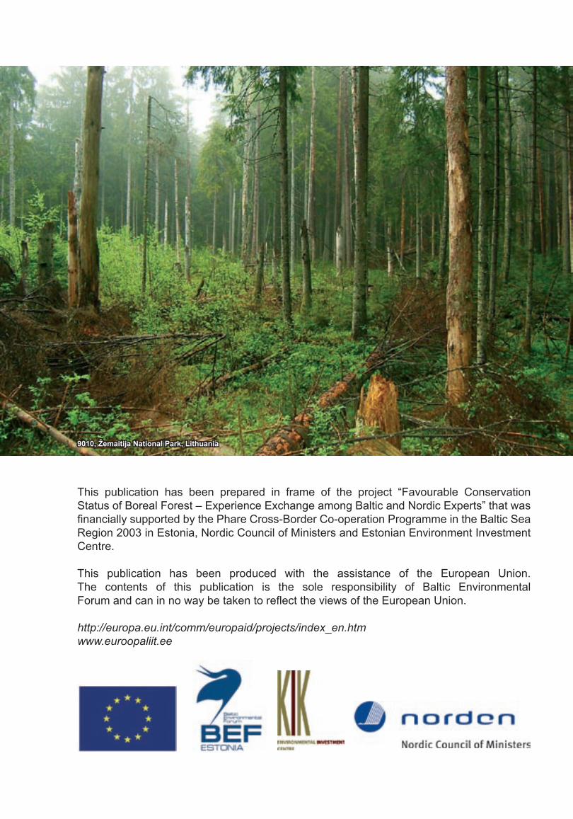
This publication has been prepared in frame of the project “Favourable Conservation Status of Boreal Forest – Experience Exchange among Baltic and Nordic Experts” that was financially supported by the Phare Cross-Border Co-operation Programme in the Baltic Sea Region 2003 in Estonia, Nordic Council of Ministers and Estonian Environment Investment Centre.
This publication has been produced with the assistance of the European Union. The contents of this publication is the sole responsibility of Baltic Environmental Forum and can in no way be taken to reflect the views of the European Union.
http://europa.eu.int/comm/europaid/projects/index_en.htmwww.euroopaliit.ee
9010, Žemaitija National Park, Lithuania