fao/unep worshop on integrated planning and management of ... · fao/unep workshop on integrated...
TRANSCRIPT

MINISTRY OF AGRICULTURE AND CO-OPERATIVES LAND USE PLANNING SECTION
FAO/UNEP Workshop on Integrated Planning and Management
of Land Resources
30 March – 3 April 1998in Mbabane, Swaziland
− PROCEEDINGS −
The Kingdom of SwazilandFood and Agriculture Organization of the United Nations
United Nations Environmental Programme
Mbabane – Rome, 1998

FAO/UNEP Workshop onIntegrated Planning and Management
of Land Resources
30 March – 3 April 1998in Mbabane, Swaziland
− PROCEEDINGS −
Edited by
A KutterM Coetzee
A Remmelzwaal
Mbabane – Rome, 1998


FAO/UNEP Workshop on Integrated Planning and Management of Land Resources Mbabane, Swaziland30 March – 3 April 1998
TABLE OF CONTENTS
Foreword N. Nkambule & R. Brinkman
Acknowledgements A. Kutter
Acronyms
Summary Report and Conclusions
Workshop Background, Objectives and ActivitiesA. Kutter
Workshop Methodology
Official Opening of Workshop N. Nkambule
Official Closing of Workshop H. Mamba
The FAO-UNEP Approach to Land Use Planning – A Review W. Verheye
Guidelines for Integrated Land Use Planning D. Radcliffe
Land and Water Interaction in Natural Resources Planning J-M. Faures
GTZ Approach in Integrated Land Use Planning W. Zimmermann
Editorial Report – Botswana. Relevance of the Guidelines to Botswana I. Mandevu
Editorial Report – Kenya. Focusing on Policy and Law Aspects H.W.O. Okoth-Ogendo
Editorial Report – Lesotho. Integrated and Community LUP in Lesotho N.S. Kabi
Editorial Report – Mozambique. Relevance of the Guidelines to Mozambique 68 A.H. Cambule, M. van den Berg, F.M. Mazuze
Editorial Report – Namibia. Focusing on Regulation of LUP in Namibia M.E. Coetzee
Editorial Report - South Africa. Focusing on the Convention to Combat Desertification R. Penny, G. Mogoane, H. Prinsloo
Land Use Planning in Swaziland – A Review. J.D. Vilakati

FAO/UNEP Workshop on Integrated Planning and Management of Land Resources Mbabane, Swaziland30 March – 3 April 1998
Land Use Planning in Swaziland - Land Degradation and Peri-Urban Growth A. Remmelzwaal
List of participants
Agenda
Press Release
Table of Content – Draft Guidelines
Working group issues/ presented group session results Working group 1 Working group 2 Working group 3
Workshop Expectations of the Participants
Participatory Workshop Evaluation

Foreword
FAO/UNEP Workshop on Integrated Planning and Management of Land Resources Mbabane, Swaziland30 March - 3 April 1998
1
FOREWORD
These proceedings are the results of a participatory workshop to improve and make more concrete theGuidelines for Integrated Land-use Planning based on the FAO/UNEP approach.
Integrated land-use planning (ILUP) is a prerequisite for the sustainable management and development ofland resources. This approach seeks to meet this objective by a better balancing of all relevant aspects(biophysical, technical, socio-economic, legal, institutional and social) in land-use planning. In particular, itstresses the importance of engaging the stakeholders and recognizing their different objectives through aplatform for negotiation; outlining the characteristics of an enabling institutional and policy environment atlocal, sub-national, and national levels; ensuring an accessible knowledge base; and providing a set ofplanning procedures. The guidelines which were the topic of this workshop are intended to be used byprofessional and technical practitioners of land-use planning and land resource management at national, sub-national and village levels.
The workshop was held to enable experts associated with the topic from eight countries in southern Africa toreview the draft guidelines critically and to offer insights and mechanisms for improving the documentincluding adding case studies to assist future users.
These proceedings first provide the summary report and workshop recommendations, and the objectives,activities and methodology of the workshop. Following these are a review of FAO’s activities related to ILUP,a summary of the draft of the Guidelines for Integrated Land-use Planning and a paper concerning theimportance of integrating land and water interactions in this work.
The next set of papers represents critical comments and suggestions on the Guidelines as well as country andproject reports by country representatives of Botswana, Kenya, Mozambique, Namibia, Lesotho, South Africaand Swaziland, and a project leader.
Each of these papers identifies issues which need to be added or strengthened in the Guidelines. Threeworking groups addressed these issues in depth and reported.
Finally, this participatory workshop formulated concrete recommendations to improve the Guidelines (detailedin Annex). The Guidelines are currently being edited and are intended for final publication in 1998.
Noah Nkambule, Principal Secretary, Robert Brinkman, Director,Ministry of Agriculture, Swaziland Land and Water Development Division, FAO

Acknowledgements
FAO/UNEP Workshop on Integrated Planning and Management of Land Resources Mbabane, Swaziland30 March - 3 April 1998
2
ACKNOWLEDGEMENTS
The idea for the publication “Guidelines on integrated land-use planning” has originated with Denis Sims, Landand Water Development Division, who subsequently teamed up with several people in other Divisions of FAOas well as international experts from other organisations to receive a broad input and holistic view on relevanttopics related to land.
Later, Andrea Kutter, Land and Water Development Division, continued this work in collaboration with FreddyO. Nachtergaele, coming up with the idea to organise an international workshop in Swaziland. The idea was toreceive feedback on the existing draft document from people working in that field, and thus potential users, tomake it more practical and useful. She organised the workshop in collaboration with Ms. Constance Neely,Land and Water Development Division, and Dr. Arie Remmelzwaal, FAO Swaziland. As with most efforts likethis, many other persons were involved.
The workshop was jointly sponsored by FAO, AGL Regular Programme and by UNEP, which is promotingFAO in its efforts.
Valuable inputs in the form of papers on the basic ideas of land-use planning and land resources managementwere provided by Willy Verheye, University of Gent, Belgium, David Radcliffe, Consultant, England and Jean-Marc Faures, Land and Water Development Division, FAO. The different country perspectives from Botswana(Mr. Mandevu), Kenya (Mr. Okoth-Ogendo), Lesotho (Mr. Kabi), Mozambique (Mr. Cambule), Namibia (Mrs.Coetzee), South Africa (Mrs. Penny and Mr. Mogoane) and Swaziland (Mr. Vilakati and Mr. Remmelzwaal)were presented in the form of problem-oriented papers. Each has contributed particular experience as anexpert in land-use planning or related matters.
Special thanks are due to Jameson Vilakati, the National Workshop Co-ordinator, and Arie Remmelzwaal fororganising the workshop (including the field excursion) in Swaziland.
Andrea KutterSoil Resources, Management and Conservation ServiceLand and Water Development Division

Acronyms
FAO/UNEP Workshop on Integrated Planning and Management of Land Resources Mbabane, Swaziland30 March - 3 April 1998
3
ACRONYMS
AEZ Agro-Ecological ZoningAGL Land and Water Development Division of FAOAGLS Soil Resources, Management and Conservation Service of FAOCBD Community Based DevelopmentCBO Community Based OrganizationsCCC Convention on Climate ChangeCCD Convention for Combating DesertificationCIG Common Interest GroupDAO District Authority OfficerDARD Department for Agriculture and Rural DevelopmentDWA Department for Water AffairsECOCROP 1 FAO Crop Environmental Requirements DatabaseFAO Food and Agriculture Organization of the United NationsFAO Rep. FAO RepresentativeGIS Geographical Information SystemGOVT GovernmentGP Growing PeriodGPZ Growing Period ZoneGTZ Gesellschaft für Technische Zusammenarbeit (Germany)ha HectareIIMI International Institute for Management and IrrigationILUP Integrated Land-use PlanningIMSCLUP Inter-Ministerial Standing Committee for Land-use PlanningINLUP Indicative National Land-use PlanISRIC International Soil Reference and Information CentreLRM Land Resources ManagementLRMG Land Resources Management GroupLSU Large Stock UnitLUD Land-use DatabaseLUEB Land-use and Environmental BoardLUP Land-use PlanningLUPD Land-use Planning DepartmentM&E Monitoring and EvaluationMAWRD Ministry of Agriculture, Water and Rural DevelopmentMET Ministry of Environment and TourismMFMR Ministry of Fisheries and Marine ResourcesMLRR Ministry of Lands, Resettlement and RehabilitationMME Ministry of Mines and EnergyMOAC Ministry of Agriculture and Co-operativesMoF Ministry of FinanceMRLGH Ministry of Regional and Local Government and HousingMTI Ministry of Trade and IndustryMWTC Ministry of Works, Transport and CommunicationNAMPAB Namibian Planning and Advisory BoardNEAP National Environmental Action Plan (World Bank)

Acronyms
FAO/UNEP Workshop on Integrated Planning and Management of Land Resources Mbabane, Swaziland30 March - 3 April 1998
4
NGO Non-Governmental OrganisationNOLIDEP Northern Livestock Improvement Development ProgrammeODA Overseas Department (United Kingdom)PRA Participatory Rural AppraisalPS Principal SecretaryRRA Rapid Rural AppraisalSARDEP Sustainable Animal and Rangeland Development ProgrammeTA Technical AssistanceUN United NationsUNCED UN Conference on Environment and Development (Rio de Janeiro, 1992)UNDP United Nations Development ProgrammeUNEP United Nations Environment ProgrammeUNFPA United Nations Population FundVDC Various Districts Committee
Summary Report and Recommendations
FAO/UNEP Workshop on Integrated Planning and Management of Land Resources Mbabane, Swaziland30 March – 3 April 1998
5
SUMMARY REPORT AND RECOMMENDATIONS
INTRODUCTION
In the past two decades FAO has prepared guidelines for land use planning (FAO,1993) and has gainedexperience in the identification of physical land constraints and remedial land interventions, management ofproblem soils and land evaluation. Over the same time period, generally there has been a very low successrate associated with development interventions to address sustainable land use. Several aspects of theseinterventions have been cited as reasons for their failure. These include the fact that interventions were basedon a sectoral approach, failed to involve land users, and because the institutional infrastructure was notstrengthened in the process.
Building upon the past foundation of proven methods (e.g. land evaluation) and incorporating aspects ofsuccessful field experiences, FAO and UNEP, with inputs from several partners, have developed an improvedapproach to integrated planning and management of land resources. This has led to a draft document on theapproach entitled “Integrated Planning and Management of Land Resources in the 21st Century”. Theapproach provides a framework in which the role of technical information and decision support tools foroptimizing land use and the crucial importance of institutional, legal and socio-economic considerations areacknowledged equally. In particular, it stresses the need for a more active participation of the stakeholders inplanning and decision-making.
Before publication, it should be ensured that these guidelines are realistic, practical and useful. This draftdocument was submitted to the workshop to be improved through review and discussion of its weaknessesand strengths, and through the participants valued insights and contributions. The participants were requestedto thoroughly review the document using their knowledge and experience. It was the basic document fordiscussion and improvement during the workshop.
RESULTS AND RECOMMENDATIONS
The main objective of the workshop was to improve the present FAO/UNEP approach to integrated planningand management of land resources. This was to be achieved by a critical discussion of the draft guidelines-document and by an exchange of experiences among the participants and various international agencies. Asthe summarized results and recommendations always refer to the various chapters in the draft-guidelines, alist with the corresponding titles is attached in annex 5.
Editorial Aspects
• The draft-guidelines are logical and easy to understand.• The draft-guidelines are too long (especially chapters 2, 3 and 4).• A link to international conventions in chapter 1 is highly recommended to provide a general orientation.• The executive summary should be reviewed and revised.• The structure of the chapters should be carefully reconsidered.• References should be made by chapters.• The headers should be corrected and be made chapter-specific.

Summary Report and Recommendations
FAO/UNEP Workshop on Integrated Planning and Management of Land Resources Mbabane, Swaziland30 March – 3 April 1998
6
• Each chapter should start with a summary.• Chapters and subchapters should be numbered to allow cross-referencing.• The appendices on land tenure and legislation should be included in the main body.• The document title should be carefully reconsidered.• The target group for the document should be more mentioned more explicitly.• There should be more case studies in the document.• Consider separating the methodology from the tools.
Aspects on Content
The comments related to the content of the draft-guidelines consider what should be found in a documentsuch as the guidelines. The input in this form seems to be very valuable as the comments came fromparticipants who are actively working in the field of land resources management or in related fields. In addition,they will be the potential users of the guidelines on land resources management.
• A land use policy should be inclusive of all land uses. Sectoral policies referring to land should becomplementary.
• Policy formulation should be based on an interactive approach, involving all stakeholders.• Laws should take account of local conditions and allow for different modes of implementation.• Laws should address means, processes and incentives. The enforcement mechanisms should address
incentives, as well as penalties.• Laws should incorporate some flexibility.• There is a need for national, sub-national and local Institutions.• Institutions should have clear mandates, which should include mechanisms for conflict resolution which
may arise at meso/local level.• There should be no overlaps or gaps in responsibility for institutional mandates.• Authority should be delegated and local institutions should be empowered.• Stakeholders. should be differentiated according to level (national, meso, local) and affiliated (government,
civil society, ‘mixed’ [including boards and commissions]).• A figure (graph) should be included showing power and dependence of stakeholders.• Top-down and bottom-up approaches should be merged to optimize flows of information, demonstrate
transparency etc.• There should be cross representation of stakeholders at different levels.• There should be emphasis on empowerment at local level, induced by grass-roots participation and
assumption of responsibility and ‘ownership’ of the any development resulting from the plan.• Community participation should be promoted using an integrated inter-disciplinary approach. The role of
supporting agencies should be to coordinate, facilitate and integrate.• Any planning exercise should understand the structure of the community. Special attention should be
given to disadvantaged or vulnerable groups, including (in some cases) women, youth, indigenousgroups.
Summary Report and Recommendations
FAO/UNEP Workshop on Integrated Planning and Management of Land Resources Mbabane, Swaziland30 March – 3 April 1998
7
• Emphasis should be given to creation and promotion of land resources management groups (LRMGs) .• There should be a balance between on-the-spot planning and further analysis (depending on objectives
and particular circumstances).• Types of conflicts should be noted.• Conflict avoidance measures should be noted.• Conflict resolution mechanisms should be noted.• Incentives should be planned and targeted to avoid the dependency syndrome.• Attention should be paid to recycling locally generated income; including that in wildlife management
areas.• Incentives for small scale investments (e.g. tree nurseries, agri-processing) should be considered.• Relationship between land-use planning and land resources management should be indicated as well as
between planning and management.• Reconsider steps in planning process. (figure 9). Consider if the process may be better represented as a
cycle. Start with identification of the problem or need for change.

Kutter Workshop Background, Objectives and Activities
FAO/UNEP Workshop on Integrated Planning and Management of Land Resources Mbabane, Swaziland30 March - 3 April 1998
8
WORKSHOP BACKGROUND, OBJECTIVES AND ACTIVITIES
Andrea KutterSoil Resources, Conservation and Management Service
Land and Water Development DepartmentFood and Agriculture Organization of the United Nations
INTRODUCTION
While preparing this event, and especially while thinking how to present to you the workshop frame with itsobjectives and activities, I remembered a quote by Rollo May, a British psychoanalyst, which I would like toshare with you:
‘ The most effective way to ensure the value of the future is to confront the present courageously andconstructively ’
For me, and at the end of these 5 days, I hope you will agree with me, it reflects in a very concise way whatwe have had in mind when planning this workshop.
I would like to develop the workshop frame in more detail and will come back from time to time to this quote.This is why I have it visualised on a board.
BACKGROUND
What has brought us together?Each of you comes from a country which faces threats to the sustainability of land resources:
• declining crop production,• increasing soil degradation, or• increasing competition for land
are common problems with an ever intensifying tendency. (Reasons are e.g. the use of inappropriate management practices, the increasing population pressure, etc.) In the past two decades, FAO and other organisations have prepared guidelines for land use planning,resources management, and have gained experience in the identification of physical land constraints. Therehave been projects in your countries to address sustainable land use or land management. But the success rate associated with these development interventions is generally very low and thoseapproaches obviously lack elements which make them successfully applicable and practical.

Kutter Workshop Background, Objectives and Activities
FAO/UNEP Workshop on Integrated Planning and Management of Land Resources Mbabane, Swaziland30 March - 3 April 1998
9
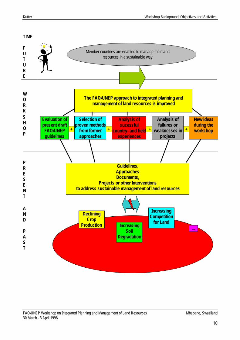
WORKSHOP ACTIVITIES AND OBJECTIVE Coming back to the quote. When Rollo May talks about the courageous and constructive confrontation withthe present and this in a most effective way, we want to do that during these 5 days. Our main objective is anambitious one: By end of this workshop we want to be able to present an improved approach to integrated planning andmanagement of land resources based on
• evaluation of the present approach (see distributed document)• proven methods from former approaches,• aspects of successful country- and field experiences,• evaluation of failures in projects, and• new ideas coming up during the workshop.
The countries’ specific application of this improved approach will enable member countries to manage theirland resources in a sustainable way, and to use Rollo May’s words, ‘to ensure the value of the future’. Coming back to the main objective of the workshop, I would like to outline the activities which will help us toreach the objective:
• The FAO/UNEP approach will be presented and analysed.• The editorial review of the participants will be presented.• The draft version will be commented upon and project and country experiences related to land use will
be highlighted.• Discussions will be initiated on land and water actions and their implications in terms of planning and
management of land resources.• Working group discussions on identified problem areas related to the present approach will be
initiated and recommendations will be presented to the auditorium.• General conclusions are drawn for inclusion into the guidelines.• Discussions will be started on how the workshop results and a follow-up will be discussed.
I hope with the presentation of this framework, you now have a clear picture of what will happen over the nextdays. I also hope that we will have constructive discussions and finally come up with a common documentwhich we can present to our member countries.
Kutter Workshop Background, Objectives and Activities
FAO/UNEP Workshop on Integrated Planning and Management of Land Resources Mbabane, Swaziland30 March - 3 April 1998
10
TIME
FUTURE
WORKSHOP
PRESENT
AND
PAST
+ + + +
Member countries are enabled to manage their landresources in a sustainable way
The FAO/UNEP approach to integrated planning andmanagement of land resources is improved
Evaluation ofpresent draftFAO/UNEPguidelines
Selection ofproven methods
from formerapproaches
Analysis ofsucessful
country- and fieldexperiences
Analysis offailures or
weaknesses inprojects
New ideasduring theworkshop
Guidelines,ApproachesDocuments,
Projects or other Interventionsto address sustainable management of land resources
DecliningCrop
Production IncreasingSoil
Degradation
IncreasingCompetition
for Land...

Workshop Methodology
FAO/UNEP Workshop on Integrated Planning and Management of Land Resources Mbabane, Swaziland30 March - 3 April 1998
11
WORKSHOP METHODOLOGY
PROGRAMME AND DESIGN
The programme of the workshop was structured in three major parts:• formal presentations and papers• working sessions in 3 groups• field excursion
The workshop was framed by the formal opening and closing session with representatives from theGovernment of Swaziland, UNDP and the FAO Representative Mozambique. (The detailed Agenda isattached as Annex 2)
Formal presentations
Three papers on general aspects of integrated land-use planning (ILUP) introduced the formal presentationsession. A review of FAO’s activities in LUP was given and the draft guidelines for ILUP were presented. Inaddition, a paper on land and water interactions was proposed.
Nine issue-oriented presentations from 7 south-African countries were given including an editorial review ofthe draft guidelines and a critical review on the country-specific relevance of the ILUP approach as proposedby FAO and UNEP. These presentations were based upon the draft document sent to the participants four-sixweeks prior to the workshop.
Working Sessions
During the presentations, relevant issues were identified and subsequently discussed for two days by threeseparate working group sessions.
Working group 1:• Policies• Laws• Institutions
Working group 2:• Land-use planning vs. land resources management• Methodology in land-use planning/land resources management• Information for decision-making
Working group 3:• Stakeholders and Community• Top-down/Bottom-up approaches• Conflicts

Workshop Methodology
FAO/UNEP Workshop on Integrated Planning and Management of Land Resources Mbabane, Swaziland30 March - 3 April 1998
12
In the final session, results of the working group discussions were presented and recommendations weregiven related to the structure and content of the guidelines to make them more practical (see Annexes 5/1, 5/2,5/3).
The working group sessions were lead by moderators. The process was facilitated by the FAO staff.
Field Excursion
Between the two days dedicated to the working group sessions, a one-day field excursion to the project areaof a FAO/UNDP project was conducted. This activity confronted the participants with the reality concerningthe complexity of land resources management in Swaziland and gave valuable input for further discussions inthe working groups.
During the workshop several participatory methods were used. This included feedback sessions after eachday which allowed the participants and facilitators to monitor and evaluate the working process and progresson a daily basis. Focus points were the working atmosphere as well as the objective-oriented workingprocess. At the last day, a final evaluation of the workshop was conducted in a participatory way. Results ofthis evaluation are attached in Annex 7.
During the working sessions, the main ideas in contributions were visualised on pin-boards using cards andmarkers. In addition, the positions as moderator and visualiser were changed after each half day to encouragethe participation of all group members and to avoid dominance effects.
PARTICIPANTS
Representatives working in the field of land-use planning/ land resources management or related matterswere invited from seven south-African countries: Botswana, Kenya, Lesotho, Mozambique, Namibia, SouthAfrica and Swaziland and from three international organisations: UNDP Swaziland, UNEP and GTZ. Inaddition, two experienced international land-use planning consultants participated. The list of participants isdetailed in Annex 1.

Nkambule Official Opening of Workshop
FAO/UNEP Workshop on Integrated Planning and Management of Land Resources Mbabane, Swaziland30 March - 3 April 1998
13
OFFICIAL OPENING OF WORKSHOP
Noah NkambulePrincipal Secretary,
Ministry of Agriculture and Co-operatives, Swaziland
Mr. Chairman,Course Co-ordinator,Participants,Ladies and Gentlemen.
I feel honoured and privileged to welcome you all on behalf of his Majesty’s Government and the people ofSwaziland to this important workshop on integrated planning and management of land resources. I urge inparticular those who are visiting us for the first time to find time to explore the countryside and discover the realSwaziland in our rural areas.
Mr. Chairman, this workshop is held at an opportune time when the world at large is grappling with land use andland degradation problems. Since the turn of the century, the human population on the surface of this planet hasbeen increasing at an alarming rate. Motivated by a host of scientific advancements, man has been exerting anexcessive demand on natural resources and the products of the land in particular. Over-exploitation of landresources has resulted in widespread land degradation particularly in countries of the developing world.
Overgrazing of natural pastures and over-exploitation of indigenous forests for quick economic gains are practicesthat continue to work against the natural ecological balance between man and his environment, especially in sub-Saharan Africa. We are witnessing widespread soil erosion as the natural soil cover continues to dwindle on thesurface of the earth. Our sister countries to the north of us are faced with an enormous problem of desertencroachment on agricultural land. Under these prevailing circumstances, can we really talk of sustainabledevelopment of land resources in our part of the world?
Nevertheless, Mr. Chairman, it is encouraging to note that the African countries have not set on their laurels anddid not allow the land management problems confronting them to remain unchallenged. At the 1992 UnitedNations Conference on Environment and Development, it was the African block of countries who lobbied andsucceeded in convincing the World Community of Nations of an urgent need for a Convention to CombatDesertification. Today this Convention has become a reality and a driving force in worldwide programmes that areaddressing the problem of land degradation. Here in Swaziland, a National Action Program under this Conventionis at an advanced stage of development.
Mr. Chairman, the problem of land administration and land use conflicts continues to escalate in many of ourcountries. Here in Swaziland poorly defined boundaries between chiefdoms is causing problems on the generaladministration of Swazi Nation Land, which is the land block administered under customary land law. Some ofthese problems have had a negative impact on development programmes on the ground. Furthermore, as the

Nkambule Official Opening of Workshop
FAO/UNEP Workshop on Integrated Planning and Management of Land Resources Mbabane, Swaziland30 March - 3 April 1998
14
population continues to increase we are witnessing haphazard land use practices on a large portion of the Swazilandscape. Towns and urban structures are being established on prime arable land.
Meanwhile this irrational land use development is taking place in a country that is small in size and dominated by arugged terrain. It is unbearable to witness this precious land being taken up by irrational land uses such as ruralhomestead development and other concrete structures. These are real problems which need real solutions if weare to embark in earnest on a path towards sustainable utilization of our God-given natural resources.
Nevertheless, on the local front, we are delighted to observe some tangible efforts being made towards resolvingsome of these formidable land management problems. A National Land Policy initiative is at an advanced stage ofdevelopment. The policy seeks inter alia to address the administrative, tenurial, legislative and institutionalproblems pertaining to the utilization of the country’s land resources. Furthermore, we are also developing thecountry’s resettlement policy which seeks (among other things) to rationalize the legal and institutional frameworkunder which the resettlement programme will be administered.
Mr. Chairman, in addition to the above initiatives, the Ministry of Agriculture and Cooperatives, with the support ofFAO has succeeded in implementing a Project on Land Use Planning for Rational Utilization of Soil and WaterResources. The project has equipped our land use planners with scientific tools for executing land use planningprojects using methodologies that are strongly anchored on ecological principles. A follow-up Project onImproving Land Use on Swazi Nation Land is currently being executed in collaboration with UNDP.
Mr. Chairman, your workshop on integrated planning and management of land resources represents a step in theright direction that (hopefully) will give birth to clear guidelines for planning and implementation of landmanagement projects in many of our countries. We commend FAO and UNEP for jointly undertaking this nobleexercise. This is a shining example of a co-operative effort by UN Agencies aimed at achieving a commonobjective for the benefit of mankind.
We in Swaziland are proud of our long association with FAO in particular. The Organization continues to be anengine of professional excellence that has had a positive impact on many of our agricultural developmentprogrammes in this country. We also note with delight the involvement of land management experts from differentparts of the subcontinent in the refinement of the manual on integrated planning and management of landresources. This participatory approach can only reinforce the effort to improve the end product of this exercise.
Mr. Chairman, in conclusion allow me to thank the sponsors and the co-ordinators of the Workshop for all theresources they have provided to make this workshop the success that it will be. I would also like to thank thefacilitators for availing themselves for a worthy cause during the entire duration of this seminar. I hope theexpectations of the participants will be fully met. With these remarks, it is now my honour and privilege to declarethis workshop officially open.
May God Bless You.
Mamba Official Closing of Workshop
FAO/UNEP Workshop on Integrated Planning and Management of Land Resources Mbabane, Swaziland30 March - 3 April 1998
15
OFFICIAL CLOSING OF WORKSHOP
H. MambaUnder Secretary,
Ministry of Agriculture and Cooperatives, Swaziland.
Mr. Chairman,FAO Representative in the Country,Distinguished Participants,Ladies and Gentlemen.
I am pleased and find it a privilege for me to have the opportunity to come and address a group dealing with suchan important subject like the one you have been deliberating on.
As you know Mr. Chairman, land is a key to survival of mankind. Thus the way we use it will determine the fate ofthose coming after us, thus we have a responsibility to safeguard their survival.
I have been told that the workshop was mainly forecast on an integrated approached in Land Use Planning. Thisworkshop has come at the right time for Swaziland as we are experiencing the problems caused by sectoralplanning. I would therefore urge that the process be speeded up as the problems are speeding at an alarmingrate. I’m sure the field-trip which you took on Wednesday enabled you to see for ourselves the problems I’mtalking about. I am also positive that you have given a solution to our local participants as to how we should solvesuch problems.
Mr. Chairman, let me take this opportunity to encourage the participants here to get back to their respectivecountries and consider implementing the recommendations of the workshop. Furthermore, I’m sure the exerciseis not over, further consultation will still be necessary, I therefore urge that consultation should not end here butshould continue until we are satisfied with the final product.
Mr. Chairman, distinguished participants, ladies and gentlemen, may I on behalf of the Government of Swazilandthank FAO and UNEP for organizing and supporting this important workshop. I am positive that this is not the end,but the two organizations will continue supporting our efforts of survival in the region.
Finally Mr. Chairman I would like to turn to our guest of the Kingdom. I am sure you have had a pleasant stay inthe country and hope to see you soon. I am sure our officials have taken good care of you. I now wish you all asafe journey to your respective countries.
I now take this opportunity to declare the FAO/UNEP workshop on planning and management of Land Resourceofficially closed.
Thank you all.

Verheye The FAO-UNEP Approach to Land Use Planning
FAO/UNEP Workshop on Integrated Planning and Management of Land Resources Mbabane, Swaziland30 March – 3 April 1998
16
THE FAO-UNEP APPROACH TO LAND USE PLANNINGA Review
Willy H. VerheyeResearch Director,
National Science Foundation,Belgium
1. INTRODUCTION
Worldwide, soils are being used with increasing intensity to meet the needs of a continuously growingpopulation. Such demands have to some extent been met through major progress in plant breeding, fertilizerapplication and soil management, or by opening up new land for agriculture. Unfortunately, such solutions cannot continue indefinitely.
From an estimated 427 million in 1500, world population has increased to 1650 million in 1900, 3600 million in1970 and 5.2 billion in 1990 (table 1). Recent projections point to a figure of around 10 billion by the year 2050(UNFPA, 1992). This corresponds to a growth rate of approximately 85 million per year, and the doubling ofthe present population within the next half century. Almost all of this increase has occurred and will continue totake place in the developing world where the need for extra food supply will be most acute.
The amount of potentially available land in the world, estimated at 3030 million ha (FAO, 1991) is finite. Theamount of effectively cultivated land in the world has almost stabilised (table 2). The increase is hardly 5% atworld level; in Europe the arable land surface has even gone down. The increase is highest in South America,where also the largest land reserves are located (Yudelman, 1994). Comparatively, the amount of peopleinvolved in agriculture has not increased accordingly as well, and in Europe and South America it has evenseriously decreased (table 3), indicating a continuous intensification and higher production output per ha. Atpresent, almost half of the potentially arable land, e.g. 1475 million ha, are under cultivation. The remainder iseither difficult in access, marginal in suitability or occupied by cities, mines, infrastructures,...
This situation is exacerbated by the fact that about 15% of all arable land (approximately 200 million ha) isunder degradation, mainly as a result of human interventions related to deforestation, erosion, overgrazing,desertification, pollution, nutrient depletion or species impoverishment (Oldeman et al., 1990).
The combination of population increase, limited expansion of arable land and intensification of croppingsystems will result in a significant decrease of available land per household, and in an obvious competition forland and related primary food supply. Per caput available arable land is already very low in some countries ofthe Far East (table 4), and is expected to nearly halve again in the next 15 years (FAO,1995).
Being aware of this rather explosive situation, international organizations like FAO and UNEP have for manyyears focused on a more rational land use, and have urged for national soils policies aimed at conservingthe precious natural soil resources and optimizing (food) production. In this context the World Soil Charter(FAO, 1981) was drafted, and UNEP issued its World Conservation Strategy (UNEP,1981) and itsEnvironmental Guidelines for the Formulation of National Soils Policies (UNEP, 1983). The UNCEDConference in Rio de Janeiro (1992) reiterated this concern through the resolutions of Agenda 21. For anumber of countries a national soils policy has been drafted already (FAO-UNEP, 1994a and 1994b).

Verheye The FAO-UNEP Approach to Land Use Planning
FAO/UNEP Workshop on Integrated Planning and Management of Land Resources Mbabane, Swaziland30 March – 3 April 1998
17
All these documents draw attention to the importance of soil as a natural and almost non-renewable resourcefor agriculture, forestry and other rural uses. They stress two major principles : one, of avoiding soil loss anddegradation; and two, of utilizing soils to their maxi-mum potential, but within the context of sustainability. Thesecond principle focuses in particular on a more rational and optimized use of soils and other land resourcesto meet present needs, whilst at the same time conserving the basic soil resource for populations of the future.
Table 1. Regional and worldwide increase in population (Clark, 1967; UN, 1958-1970; FAO Statistical Yearbooks 1963-1996).Year Population (in millions)
World Europe Africa Asia South America600 237 24 37 166 -
1000 280 44 50 172 -1500 427 82 85 223 401700 641 112 99 414 121800 890 179 100 594 191900 1651 430 133 926 741950 2486 - 217 1355 1621970 3632 459 344 2056 1911980 4449 484 479 2583 2391990 5295 498 642 3120 2931991 5387 500 661 3173 2981992 5479 501 681 3027 3031993 5544 503 688 3280 3091994 5629 504 708 3333 3141995 5716 505 728 3386 319
Table 2. Distribution of available land over the world (FAO Statistical Yearbooks, 1970-1996).Year Available land (in million ha)
World Europe Africa Asia South America1965 1399 152 190 447 821970 1408 146 169 438 1101980 1427 140 175 449 1011990 1463 138 186 - 1101991 1441 138 181 457 1151992 1443 136 182 459 1131993 1447 136 187 468 1021994 1450 135 185 472 1051995 1476 134 192 516 120
Table 3. Population active in agriculture (FAO Statistical Yearbooks, 1970-1996).Year Population active in agriculture (in millions)
World Europe Africa Asia South America1965 1775 107 222 1241 701970 1970 92 257 1435 731980 2194 60 310 1640 691990 2476 48 381 1864 691991 2449 46 388 1883 681992 2522 45 396 1901 671993 2544 43 403 1919 661994 2567 42 411 1936 651995 2590 41 419 1955 64

Verheye The FAO-UNEP Approach to Land Use Planning
FAO/UNEP Workshop on Integrated Planning and Management of Land Resources Mbabane, Swaziland30 March – 3 April 1998
18
Table 4. Land/man ratio evolution between 1965 and 1995 in various parts of the world (FAO Statistical Yearbook, 1970-1996).1965 1970 1975 1980 1985 1990 1992 1995
World 0.42 0.38 0.28 0.32 0.29 0.27 0.26 0.23Europe 0.34 0.32 0.30 0.29 0.28 0.28 0.27 0.26Africa 0.62 0.58 0.52 0.36 0.32 0.28 0.26 0.26South America 0.49 0.49 0.47 0.41 0.39 0.37 0.38 0.37Asia 0.25 0.23 0.21 0.17 0.16 0.15 0.14 0.15
Nigeria 0.61 0.54 0.48 0.38 0.33 0.30 0.28 0.29Senegal - - 0.44 0.41 0.37 0.32 0.30 0.27Kenya 0.17 0.15 0.13 0.17 - 0.19 0.18 0.16Lesotho 0.38 0.35 0.30 0.22 0.20 0.18 0.17 0.16Malawi 0.51 0.48 0.43 0.22 0.20 0.19 0.17 0.15Mozambique 0.36 0.36 0.29 0.25 0.23 0.22 0.22 0.20Namibia 0.98 0.85 0.57 0.50 0.44 0.49 0.46 0.53South Africa 0.70 0.66 0.57 0.47 0.42 0.41 0.34 0.38Swaziland 0.42 0.37 0.35 0.34 0.26 0.26 0.24 0.22Zambia 1.31 1.15 1.03 0.89 0.74 0.65 0.61 0.56Tanzania 0.37 0.38 - 0.15 0.13 0.14 0.13 0.12Zimbabwe 0.49 0.44 0.40 0.36 0.34 0.29 0.28 0.28
China 0.16 0.13 0.12 0.10 0.09 0.08 0.08 0.08Indonesia 0.16 0.15 0.15 0.13 0.13 0.12 0.12 0.11Pakistan 0.34 0.32 0.27 0.24 0.20 0.17 0.17 0.15
At the end of 1993 FAO was appointed UN Task Manager for the implementation of Chapter 10 “IntegratedApproach to the Planning and Management of Land Resources” within Agenda 21 (UNCED, 1992). Thischapter emphasizes on the development of policies, the improvement of planning and management systems,the strengthening of institutions, and a closer involvement of land users.
2. EVALUATING THE LAND USE POTENTIAL AND LAND USE OPTIONS
Over the past decades FAO has been instrumental in developing methodologies and databases fordetermining the land use potential in various parts of the world, dealing systematically and in a logicalsequence with soil and other natural resource mapping and data collection, land evaluation, land managementand reclamation, and land use planning.
In 1976 the FAO Framework for Land Evaluation (FAO, 1976) was developed, introducing the concept ofmatching land use requirements with land attributes. The principles outlined in this framework have beenwidely applied in rural development and land assessment studies all over the world, not only by FAO but alsoby many other institutions or individuals.
Over the past 20 years FAO has gained experience in the identification of physical land constraints andremedial land interventions for rainfed (FAO, 1983) and irrigated agriculture (FAO, 1985), and for extensivegrazing (FAO, 1988a). It has provided guidelines for the management of problem soils (FAO, 1974, 1988b,1988c, 1990) and for data collection and retrieval for land evaluation and land use/land cover. The concept ofagro-ecological zoning as a basis for resource mapping and data collection was developed (FAO, 1996) andguidelines for land use planning were prepared (FAO, 1993). In this process, data collection and interpretationhave advanced beyond the narrow bounds of soil science, focusing on the broader land requirements ofspecific crops and cropping systems.

Verheye The FAO-UNEP Approach to Land Use Planning
FAO/UNEP Workshop on Integrated Planning and Management of Land Resources Mbabane, Swaziland30 March – 3 April 1998
19
Notwithstanding these efforts the problem of forthcoming food shortages and conflict resolution over landissues is still not satisfactorily solved. Many projects have remained in the study phase and did not have thepractical impact they deserved. Studies of ODA (1983), World Bank (1986) and FAO (Hudson, 1991) haveshown that the results and benefits of development and conservation programmes are often quite meagre inrelation to the funds and efforts spent, and are not keeping pace with the increasing severity of the problems.Common reasons for this refer to: the failure to involve sufficiently the land users and the inability to addressand integrate all relevant issues.
All of the above are symptoms and results of our current inability to manage success-fully and sustainably ournatural resources in the face of a rapidly changing society. After more than 20 years of intensive work in landevaluation, land use planning and land management, present approaches are still in search for clear andsimple solutions to improve the living standards of its users by increasing land productivity while conservingand maintaining sustainable land resources. Obviously, the current approach is not enough demand-driven asit does not provide the relevant answers to the most urgent people’s demands. Reasons invoked for thissituation include a too technical and too sectoral approach, leading to a rigid top-down decision-makingwithout due care for the needs and priorities of the stakeholders; lack of interdisciplinarity, and institutionalweakness; and unclear procedures to link properly development and production objectives with environmentalissues (Verheye et al., 1997).
In the light of these developments and related socio-political consequences, Agenda 21 has reiterated itsconcern on the need for a more interactive approach in land use matters and has called for mechanismsaiming to promote a constructive and productive dialogue between the full range of stakeholders. Thisapproach should take into account the natural land use potential and find links between top-down and bottom-up concepts of decision-making in order to tap the maximum of the production potential.
3. WEAKNESSES OF THE PRESENT APPROACH
Though success or failure of planning generally depend on specific local conditions and on the involvementand enthusiasm of the people concerned, three major weaknesses can be identified which occur quitefrequently in the present approach (Verheye et al., 1997).
3.1 A too technical approach
Though the FAO clearly states that the suitability of land depends on a combination of biophysical parametersand socio-economic conditions, most if not all assessment work in the past has largely been dealing withphysical land attributes, with little or no attention being paid to social, economic and political aspects. Thisdevelopment has ultimately led to the commonly accepted conviction that land evaluation and land useplanning were limited to an assessment of the physical environment.
Research in the past decades has mainly focused on the impact of soil and climatic parameters on yields.Hence, more or less significant correlations could be obtained between those parameters and the yieldpotential, viz. the theoretical yield perspectives.Modern trends to quantify processes through computer models have given an additional push to this trend.The danger of an increased use of computer-assisted techniques in decision-making is, however, that the linkwith the field conditions might be lost, and that too often the outcome of the models is accepted as the onlyviable solution, at the expense of logical and simple common sense. Those trends include a major risk that, in

Verheye The FAO-UNEP Approach to Land Use Planning
FAO/UNEP Workshop on Integrated Planning and Management of Land Resources Mbabane, Swaziland30 March – 3 April 1998
20
search for academic accuracy, too optimistic and thus unrealistic correlations are obtained between suchfactors and so-called effective yields (Verheye and Dent, 1997).
There is indeed still a large gap between theoretical (or expected) yields, as estimated from models and othertypes of calculations, and effectively obtained farmers’ yields. This gap is still difficult to identify and quantify asit strongly depends on local conditions. In a recent study involving maize, barley and tef production in theEthiopian Highlands, Teshome Yizengaw (1994) found that calculated and effectively measured yields differedby 30-50% under controlled production conditions in research stations and by even more in farmers’ fields. Asimilar trend was observed for five field crops in Burundi (Hennebert et al., 1996).
In brief, what we have been doing up till now in terms of biophysical resource assessment is sound, but doesnot address properly the problems. The new approach does not pretend to replace the former concepts, but itadds and complements it to make the assessment more relevant. Clearly, our previous too narrow technicalapproach is not enough by itself to ensure that goals of higher production and additionally protection of theenvironment are effectively achieved by the people.
3.2 A too sectoral approach
Multidisciplinarity is one of the major assumptions on which the FAO Framework for Land Evaluation is based.However, current land use planning is still mostly carried out in view of agricultural uses and related cropproduction. Even in Agenda 21/Chapter 10 land use planning focuses mainly on the use of land for agriculturalpurposes, food production and development.
Land use and related activities should be viewed in a much broader context. The too narrow agriculturalobjective was first challenged by the forestry sector, in particular where it has become a natural associate ofenvironmental issues. The value of trees has been re-assessed, whether in the form of planted forests orindividual trees, as a mean for bio-fuel production, a regulator for water supply or water flow in catchmentareas, or as an anti-erosion measure. As a result, efforts are now being made to integrate forestrydevelopment into crop and animal husbandry, especially in ecologically fragile regions (Verheye, 1998).
In a society where more and more people get involved in urban and industrial activities the benefits ofagricultural land uses need to be matched with those of mining, industrial developments, infrastructure, leisureor tourism. And in this competition the balance is rarely in favour of agriculture. This situation occurs not onlyin the industrial world - in Europe for example less than 20% of the population is still employed in agriculture(NN, 1997), and it is expected that this will decrease with another 2 % per year in the future - but also in quitea lot of developing countries.
In Indonesia about 50,000 ha of good sawah land are annually lost for city expansion, and for thecompensation of (rice) production losses more than five times more land has to be cleared, usually from forestareas. Because of its higher economic return land designated for mining purposes - bauxite mining inJamaica, copper production in Zambia, diamond mining in Sierra Leone, Zaire, South Africa,... - will alwayshave a higher priority over other uses (Verheye, 1997).
The important income generated from tourism puts a number of countries like Namibia, Botswana or Kenyainto a position where they have to choose between the development, maintenance or expansion of gameparks and the welfare/survival of the local subsistence farmers in the immediate neighbourhood. Obviously,
Verheye The FAO-UNEP Approach to Land Use Planning
FAO/UNEP Workshop on Integrated Planning and Management of Land Resources Mbabane, Swaziland30 March – 3 April 1998
21
the interests of various stakeholders or interest groups, viz. individuals, communities or complete national orregional sectors, might vary widely.
Different land use options are dealt with at different ministries : agriculture, forestry, mining, tourism, city andcountry planning, and even the Ministry of Lands which is often only responsible for land tenure and titling.Competition between various land uses results therefore often in competition and conflicts betweeninstitutions. Because, moreover, economists, physical planners, sociologists and engineers working in thoseministries, have often different priorities and approaches to problem solving, each ministry or discipline withinthat ministry or sector tends to develop separate terminologies, classifications and data needs. These areoften incompatible with each other and hamper communication and the development of an integratedapproach (FAO-UNEP, 1997).
Institutional structures are largely sector-oriented, hierarchically structured and used to work in a verticalsense, either by collecting information or by issuing orders for implementing laws or other types of decision-making. They are not used to act in a horizontal way, and any attempt to a multidisciplinary/multisectoralapproach may lead to fears that collaboration between institutes and/or individuals could affect their powerand status.
Therefore, priorities, problems and development concepts have in the past almost inevitably been addressinga particular facet of the overall situation instead of a holistic and integrated approach. Each of the majordisciplines has tended to see itself as the starting point and centre of the process. At the present time, each isbeginning to perceive that the problem is wider than what used to be its traditional technical approach, but -driven by institutionally vested interests - each is still trying to expand its terms of reference and legitimizeacquisition of additional expertise to cover all the other factors as well. In this context, the rapidly increasingnumber of so-called land use planners is not a hazard (Sims, 1995; Verheye and Dent, 1997b). By-products ofthis process are additional inefficiency due to inter-institutional competition and mushrooming institutionaloverlap (Verheye et al.,1997). Obviously, the most serious problems in modern resource management areinstitutional, rather than technical (FAO-UNEP, 1997).
3.3 A too top-down approach ignoring stakeholders’ needs and priorities
A too technical or one-sided sectoral approach leads to the wrong impression to planners and decision-makers that land use planning is a simple exercise which can easily be imposed on the stakeholders. Those,whether it be individuals, communities or government entities with a traditional, current or future right to co-decide on the use of the land, are often considered a passive group of people who, anyhow, have to accept,obey and implement decisions taken at higher institutional levels (Sombroek and Eger, 1996).
Land use planning is complex and multifaceted, and one may wonder why so few plans are successful andeffectively implemented. The reason is that in the currently applied top-down approach planners have usuallynot the complete picture of the situation, and that very often they forget that planning is made for people, andin particular for meeting their direct and urgent needs. Moreover, planning goals of various interest groupsmight widely differ, both in space and in time. The objectives of the individual often tend to be primarily short-term and exploitive, while those of the community or nation are long-term and involve conservation ofresources and amenities (Verheye et al.,1997).
People everywhere will produce from the land if there is a need for it and if they have the power and means todo so. People will sustainably manage the land if there are incentives to do so and if constraints can be

Verheye The FAO-UNEP Approach to Land Use Planning
FAO/UNEP Workshop on Integrated Planning and Management of Land Resources Mbabane, Swaziland30 March – 3 April 1998
22
removed at reasonable cost and labour inputs. The top-down approach does not sufficiently support this, norcan governments even financially afford to do everything themselves without the active involvement of thepeople (Sims, 1995).
In spite of much reiteration of the need for change most programmes have often been - and are still -designed and implemented by development agencies or NGOs. The agency then identifies a problem inrelation to its own priorities, expertise and interests, and although a process of “consultation” may take placewith the target population and government, it is rare for the people to actually select the objectives and designof that programme. The result is that few, if any, development programmes are “owned” by the people ormatch their priorities, and that projects have therefore little lasting effect ( Sombroek and Eger, 1996; Pretty,1997). The following are some further deleterious effects of the top-down approach (Verheye et al.,1997):• a tendency for governments to try to do everything themselves; this is at least inefficient and often
impossible; it generally leads to unsustainable taxation levels;• a feeling by people, and in particular by women, that they are excluded from decision-making, and
that no care is taken of their particular concerns; this leads to the feeling that problems are primarily theresponsibility of the government rather than of the community;
• and a failure of many planners to utilize local knowledge and enthusiasm.
All these problems are basically due to the absence of a genuine negotiation between all stakeholders,including the population, and the unwillingness, unawareness or inability of government and donors toredesign their programmes and institutional structures to respond to real priorities and requirements of thesituation. Current programmes and institutions still tend too much to reflect the pre-conceived opinions ofdevelopment professionals and the interests of their parent institutions. The underlying reason of this can onlybe that government and donor programmes are not enough driven by the demands of the stakeholders(Verheye et al., 1997).
After all, nothing will change unless government institutional frameworks expand and evolve to include thecommunity voice. A new way for government and people to work together must be fostered which embracesthis community voice at the planning and policy-setting stages. This guarantees delivery of appropriatedecision-support information, provides incentives for cooperation at the grass roots, and commits publicresources to institutional tools that strengthen the process and removes those constraints that limit it (FAO-UNEP, 1997).
4. NEED FOR A MORE PARTICIPATIVE APPROACH
4.1 Background
The aim of land use planning is to create the preconditions to achieve a sustainable, environmentally sound,socially desirable, and economically appropriate form of land use (Sombroek and Eger, 1995; Verheye, 1996).Present approaches are, however, not sufficiently successful to cope with the growing needs for a rapidlyincreasing population and related pressures on the environment. They are likely to work even lesssuccessfully as population pressures will increase in the future.
Most of the technical solutions are known - we know how to classify land as to suitability, we know how toprevent erosion, we know the environmental requirements of most species,... - but society has been unable todevelop institutional structures which ensure the application of the necessary management techniques.
Verheye The FAO-UNEP Approach to Land Use Planning
FAO/UNEP Workshop on Integrated Planning and Management of Land Resources Mbabane, Swaziland30 March – 3 April 1998
23
Present land use does not optimize overall human wishes, intentions, or well-being due to the lack ofmechanisms to resolve conflicts between stakeholders (Sims, 1995).
An important aspect of the failure of the present approach is its dominant top-down attitude and the obviouslack of involvement of land users in the programme design and implementation. This is exacerbated by thepresent compartmentalization of institutions which results in fragmented efforts and failures to integrate allrelevant factors (Verheye, 1998).
4.2 Principles of the new approach
4.2.1. Key elements
The new approach advocates a more pragmatic and workable concept of land management and land useplanning. It hinges basically on 3 elements (FAO, 1995) : the stakeholders, the quality or limitations of the landfor a given use, and the viable land use options within the area concerned. In order to be of direct relevancefor meeting new challenges in the society it should be demand-driven (mainly though not exclusively from thebottom), meet the problems of the stakeholders, and provide realistic alternative solutions.
The new approach acknowledges the role of technical solutions without which land use can not be optimized,but stresses also the equal importance of institutional, legal and socio-economic aspects for theimplementation of those solutions. While not ignoring the successful results obtained from former work, thenew approach focuses on a closer integration of these four factors in land management and, in particular,stresses the need for a more active participation of stakeholders in planning and decision-making.
This strategy is not completely new, as it refers back to the basic principles of the FAO Framework. Moreover,most individual components have been in existence for some time. The difference with the former approachesis, however, that land use planning should not only be addressed to decision-makers, but also to the users ofthe land. This implies that from the beginning all stakeholders should be involved in the planning process.Within the framework of the natural production and use potential of the land, due attention should be paid topeople’s aspirations and to the engagement, viz. participation of the users in the conception andimplementation of the plans. This involves, inter alia, a more direct participation of women in decision-making,in particular because in many rural areas they have an important share in crop production activities and in themarketing of goods, while at the same time they manage the family budget.
The key elements in the development of the new approach under field conditions are (Kutter et al.,1997:• The potential of land is in the first place determined by climate, soil and landform. The range of crops and
their yields, as well as the nature of other land use types, are functions of those natural resources.• Land use planning and management involve both a production and a conservation component.
• The degree to which the natural potential can be tapped by the land users depends on technologicalknow-how as well as on peoples aspirations. In this respect a good understanding of indigenousknowledge may constitute a good basis on which external know-how can be built upon. Such technicalknow-how can be acquired and emphasizes the need for an appropriate transfer of knowledge, related topeople’s objectives and needs.
• A successful land use plan is not necessarily one that produces most, but one that has found areasonable balance between what can be obtained sustainably within the limits of the natural potential andthe aspirations of the people.
Verheye The FAO-UNEP Approach to Land Use Planning
FAO/UNEP Workshop on Integrated Planning and Management of Land Resources Mbabane, Swaziland30 March – 3 April 1998
24
• The primary objective of most land users is to meet their immediate needs for food, fuel and income. Todo so, they apply their energy and skills to exploit available resources in the most cost-effective way. Inother words, land users act according to what they think is best for them and their families (FAO-UNEP,1997). The best strategy for achieving their objectives is to increase production and to conserve theproductive potential of the land. All they need are the right incentives. This incentive system should have ashort-term and a long-term component.
4.2.2. Incentives to produce
The most important incentives to produce are (FAO-UNEP, 1996, 1997) :
• The right to land and ownership.This includes the ability of land users to control the use of their land - which may need to include theright to exclude other users - as well as a greater sensitivity related to women’s rights in this matter.Production is also encouraged when rights can be used as a security for borrowing. Obviously, thereare no reasons to plant perennial crops or to apply fertilizers unless there is a guarantee that the landuser can have long-term benefits of his labour and other inputs.
Factors which affect directly land tenure issues are: type, duration and origin of user rights; type ofboundary demarcation and land records systems; rights with respect to the use of specific resourcessuch as water, plant or tree resources, wildlife,...
• Economic and social rewards.These involve economic incentives, reasonable market demands and attractive prices to theproducers, expectations of a fair remuneration for work, and/or social rewards for high levels ofproduction. Conditions which affect directly economic rewards include : costs of inputs and sale pricesfor the produce; profitability; credit facilities to farmers; tax status;...
• Access to information and services, including technology transfer, extension advice, access to criticalinputs such as fertilizers, tools and machinery, as well as information about legal and administrativeaspects and restrictions, such as regulations affecting access to resources, land use practices permittedor forbidden, environmental restrictions, etc.... It includes also women’s’ access to information andeducation, and women rights in property holding.
• Access to improved infrastructure, e.g. transport networks, storage facilities,...
• Creation of an enabling environment for profitable production. Unstable social and political conditions donot stimulate production incentives as there is no guarantee for profit making. The development of coffee,cacao, rubber, oilpalm,... plantations is not stimulated if no long-term social and political stability can beexpected. Social unrest and threatening war situations make individual farmers reluctant to grow even thebasic food crops for fears of theft or destruction.
4.2.3. Incentives to conserve
A purely bottom-up approach has still to be adjusted to fit within the long-term objectives of society’s optionsand policies. Hence, people’s aspirations might be too ambitious or short-sighted and not in line withenvironmental concerns. A plan for a sustainable management includes, therefore, often an environmental

Verheye The FAO-UNEP Approach to Land Use Planning
FAO/UNEP Workshop on Integrated Planning and Management of Land Resources Mbabane, Swaziland30 March – 3 April 1998
25
component and requires a direct involvement of the stakeholders in this environmental concern. Majorincentives to conserve are (FAO-UNEP, 1996, 1997) :
• Awareness of the benefits of conservation. Although farmers are often well aware of the dangers and risksof soil degradation, they mostly feel unable to do anything about it, and therefore consider it as of lowpriority, mainly in the case of those who, anyhow, have no security of land tenure. If people are howeverencouraged and mandated to deal with local issues - and are supported by some technical expertise orfinancial assistance - they may well respond and contribute their knowledge, enthusiasm, time andresources. Apathy, frustration and social behaviour can then easily be replaced by satisfaction andincreased happiness when people feel they are contributing something worthwhile and are part of, andvalued by society (FAO-UNEP, 1997).
Farmers are nevertheless traditionally reluctant to new methods. Creation of awareness is therefore oftenlinked to obtaining confidence and collaboration in the undertaking and may take initially some time.
• Security of land tenure, for example by ownership or long-term leasehold. This aspect joins the incentivefor a long-term benefit and production referred to above.
• Access to land conservation techniques that are equally productive, as under conditions of scarcity of landno farmer can accept to loose part of his cultivated land for conservation practices if those do not provideany produce.
• Direct participation of stakeholders from the beginning in both analysing the problems and developing thepractices that reduce land degradation. This initial participation allows also to identify betterimplementation problems of conservation techniques through the incorporation of local knowledge, tosearch for users-friendly interventions acceptable to the community, and to make maximal benefit ofexisting local structures. Moreover, experience has learned that stakeholders who are excluded from anyplanning and decision-making process tend often to be contra-productive.
• Legal and punitive enforcement, charges and sanctions for those who do not comply with the overallagreements.
4.3. An action programme for management and land use planning
A pragmatic approach for land management and land use planning, that should ultimately lead to a workableland use policy, involves the following sequence of eight actions (FAO-UNEP, 1996).
(i) Installation of a national task force, which encompasses as well the technical expertise to deal withthe various problems and the power to take decisions and legal actions. Experience has shown that itis difficult to create such a group. In practice the Task Force should be composed of high-leveldecision-makers (who generally do not have the proper technical expertise) and be assisted by adhoc technical groups for specific issues. This may include expertise available in non-governmentalorganisations, private consultants or special interest groups.
In addition, lower level task groups/committees might be installed at sub-regional or district levels.They should maintain close links with the corresponding national body, providing it with information

Verheye The FAO-UNEP Approach to Land Use Planning
FAO/UNEP Workshop on Integrated Planning and Management of Land Resources Mbabane, Swaziland30 March – 3 April 1998
26
and receiving information and technical assistance from it. Lower level task groups might function aswell as direct monitoring bodies for the implementation of the plans in the field.
Though it is not necessary that a representative of the stakeholders forms part of this Task Force, it iscompulsory that one of the members of the group acts as a contact person in order to channel theattitudes and expectations of people at the grass root level - the so-called community voice - and whoat regular time intervals informs the Task Force about progress made in items 5, 6 and 7 below. Inorder to fulfil his role properly this contact person might attend - or be represented at - villagemeetings or interviews with stakeholders at various levels, so as to perceive at first hand the natureand degree of pending land issues, and to collect information and reactions on the way the land usersthemselves look to solutions, using by preference as much as possible the local structures.
The functions of the national Task Force should be to investigate and facilitate the exchange ofinformation, and to support and enable a holistic and integrated approach to land-related issues. Itshould take decisions based on social and technical considerations provided by experts andstakeholders, and which are in agreement with national development and planning objectives. Someof the more important subjects to be addressed are (FAO-UNEP, 1997):
• development of information systems on land resources, land use and their effects on theenvironment;
• prediction and tracing of land use needs and priorities; and• coordination in the formulation, implementation and monitoring of development and management
plans.
Its members should be neutral in a sectoral sense (which is often not easy as they are usuallydelegated from their sectoral group or ministry) since they must give unbiased advice on how toallocate or use land in accordance with the objectives of the planning agency and priorities of thestakeholders to whom the advice is given.
(ii) Awareness creation at all levels of the society about the needs to increase production whileconserving natural resources. The major aim of this process should be to generate the debate onthese issues, to receive feedback from experience at the grassroots, and to convey the message thatthe government cannot be expected to resolve every local conflict. Awareness creation is often not made through special meetings but is a process of confidence thatgradually grows along discussions and other social gatherings where other land matters are dealtwith. Awareness creation is often an important “by-product” of more general tools related to RapidRural Appraisal (RRA) and Participative Rural Appraisal (PRA) sessions.
(iii) Creation of a national resource data base, with information on physical, economic, legal and socialissues (databases, reports, studies). This is often a purely technical matter and can therefore be left toexisting institutions within the country. In addition, local knowledge on physical conditions, soilconservation techniques, legal aspects, historical developments, etc. can be of paramount importanceto better understand some local conditions. It can also be an additional source of information fordecision-making in other, more or less similar areas. The creation of a national or regional resourcedata base should therefore also have a component acknowledging the local indigenous expertise.

Verheye The FAO-UNEP Approach to Land Use Planning
FAO/UNEP Workshop on Integrated Planning and Management of Land Resources Mbabane, Swaziland30 March – 3 April 1998
27
Before the database is conceived it is necessary to define the format of data collection and retrieval.Moreover, clear agreements should be made about the intellectual property of the data, and about themodalities to disseminate and to make use of the information.
(iv) Identification of the natural resource potential and its particular constraints for a range of possible landuse scenarios, including both agricultural and non-agricultural uses. This section refers to thetraditionally developed system of land evaluation based on the matching of crop requirements withland attributes.
(v) Provision of information to land users (top-down) and of feedback on their objectives, aspirations andpriorities (bottom-up). Stakeholders can only effectively participate if they are fully informed and if theyare aware of the objectives of the plan. Usually, traditional ways of handling the problems might betaken care of, and local or indigenous knowledge may be tapped, as referred to under (3) above.
As it is often difficult to discuss with all individual stakeholders, this transfer of ideas can be organizedthrough the creation of platforms for negotiation and discussion (Röling, 1994). The essence ofnegotiating amongst stakeholders is that all affected groups should be fairly well represented in thediscussions and have the possibility to give their views. This helps to ensure that all interests arecatered for, and that results are accepted by all actors.
A proper negotiation process requires the involvement of identified (potential) local resourcemanagement groups, local chiefs, NGO’s working at village level, and planners. Organizationalstructures at village level have to be identified and existing groups have to be contacted in order toevaluate their potentials and constraints to work as local area management groups. In many casestraditional social structures might indicate the most effective way to proceed.
The integration of stakeholders in planning and decision-making leads ultimately to the empowermentof a part of the community which, traditionally, has always been excluded from decision-making.Empowerment ensures that stakeholders feel they have a responsibility and that they can derivesignificant advantages from participation; the latter are often a guarantee for the long-termsustainability of the process.
(vi) Identification of needs and constraints to production and conservation faced by local communities,and suggestions to remedy to the major issues. Local communities have usually already interestingsolutions in hand, but lack the means and technical support to implement them. Special attention inthis respect should be given to the active involvement of women’s groups. This includes also theidentification of conflicts.
Unresolved conflicts or competition leads to inefficient use of resources and often to their degradationand destruction. Effective conflict resolution involves a negotiating process, an institutional frameworkwithin which this can occur, and a common understanding of the potentials of the resource and theeffects of different use alternatives (FAO-UNEP, 1997).
A good understanding of this local knowledge is a good starting point on which to develop decision-making. Tools to catch this knowledge involve Rapid Rural Appraisal (RRA) and Participatory RuralAppraisal (PRA) approaches.

Verheye The FAO-UNEP Approach to Land Use Planning
FAO/UNEP Workshop on Integrated Planning and Management of Land Resources Mbabane, Swaziland30 March – 3 April 1998
28
(vii) Development of the land use plan based on long-term objectives of both government agencies andthe stakeholders. Action should be decided through negotiation, but preferably after a supportingtechnical group has prepared proposals for consideration by the stakeholders. It is essential todistinguish between the part of the process which involves assembling data and preparing proposals(which may be done by professional staff) and decision-making itself, which should be realised jointlyby planners and all stakeholders - but which is too often achieved by government departments orregional bureaucracies alone (FAO-UNEP, 1997).
The plan should outline a series of actions, define responsibilities and the role and involvement ofdifferent parties/ institutions, and the rules to be obeyed. Follow-up actions should be foreseen tomonitor the smooth implementation of the plans and to interfere when necessary in adjusting the initialprogramme or time frame.
A successful decision-making process can be seen as a negotiated agreement in which allstakeholders feel that they have achieved maximum possible satisfaction of their needs andobjectives, and which results in resources being used in the most efficient way (FAO-UNEP, 1997).
(viii) Provision of personnel and means to implement and monitor the plans, as well as the enactment of anenabling legislation. Participatory monitoring of the plans ensures transparency amongst thestakeholders and is a motivation for their integration in all stages of decision-making. A clear definitionof responsibilities and the agreement of a firm time-frame have a positive effect on project activities.Formulation from the early beginning of crucial assumptions under which alternative decisions can betaken will add in stakeholders' under-standings with respect to their participation and responsibilities,and ultimately to their motivation.
Enforcement of management plans or rules may be achieved through social sanctions. It may also begiven weight through national legislation.
5. SUMMARY AND CONCLUSIONS
Present approaches are not significantly successful to cope with the growing needs for a rapidly increasingpopulation and related pressures on the environment. An important aspect of the failure of the presentapproaches is their dominant top-down attitude and their obvious lack of involvement of land users in theprogramme design and implementation. This is exacerbated by the present compartmentalization ofinstitutions which results in fragmented efforts and failure to integrate all relevant factors.
The new approach acknowledges the role of technical solutions for optimizing land use, but stresses the needfor a more active participation of the stakeholders throughout the planning and decision-making process. Itpromotes the combination of top-down and bottom-up inputs towards a more interactive land use planning onthe understanding that a balanced partnership between supportive government agencies, external technicalexpertise when required and self-directing people-owned programmes might be far more effective than thetraditional too technical, too sectoral and too top-down approach.

Verheye The FAO-UNEP Approach to Land Use Planning
FAO/UNEP Workshop on Integrated Planning and Management of Land Resources Mbabane, Swaziland30 March – 3 April 1998
29
6. REFERENCES
C. Clark (1967) - Population growth and land use. Mc.Millan Cy, London/New York, 406p.
FAO (1970-1996) - Statistical Yearbooks on Agriculture. FAO, Rome.
FAO (1974) - Management properties of Ferralsols. FAO Soils Bull.23, FAO, Rome, 129p.
FAO (1976) - A framework for land evaluation. FAO Soils Bull. 32, FAO, Rome, 76p.
FAO (1981) - World Soil Charter. FAO, Rome, 8 p.
FAO (1983) - Guidelines land evaluation for rainfed agriculture. FAO Soils Bull. 52, FAO, Rome, 237 p.
FAO (1985) - Guidelines land evaluation for irrigated agriculture. FAO Soils Bull. 55, FAO Rome, 290 p.
FAO (1988a) - Guidelines land evaluation for extensive grazing. FAO Soils Bull. 58, FAO, Rome, 158 p.
FAO (1988b) - Salt-affected soils and their management. FAO Soils Bull. 39, FAO, Rome, 131 p.
FAO (1988c) - Nature and management of tropical peat soils. FAO Soils Bull. 59, FAO, Rome, 165 p.
FAO (1990) - Management of gypsiferous soils. FAO Soils Bull. 62, FAO, Rome, 81 p.
FAO (1991) - World Soil Resources. An explanatory note on the FAO soil resources map at 1: 25 million scale. World SoilResources Report 66, Rome, 61 p.
FAO (1993) - Guidelines for land use planning. Development Series 1, FAO, Rome, 96 p.
FAO (1995) - Planning for sustainable use of land resources. Towards a new approach. FAO Land and Water Bull. 2, Rome,60 p.FAO (1996) - Agro-ecological zones: Guidelines. FAO Soils Bull. 73, FAO, Rome, 78 p.
FAO-UNEP (1994) - Advisory services to Indonesia and Jamaica on the formulation of national soils policies. FAO, Rome.
FAO-UNEP (1996) - Our land, our future : A new approach to land use planning and management. FAO, Rome, 48 p.
FAO-UNEP (1997) - Negotiating a sustainable future for land : Structural and institutional guidelines for resources managementin the 21st century. FAO, Rome, 61 p.
P. Hennebert, E. Tessens, D. Tourenne and B. Delvaux (1996) - Validation of a FAO land evaluation method by comparison ofobserved and predicted yields of five food crops in Burundi. Soil Use and Management, 12(3): 134-142.
NW Hudson (1991) - A study of the reasons of success and failure of soil conservation projects. FAO Soils Bull. 64, FAO,Rome, 65 p.
Kutter, F. Nachtergaele and W. Verheye (1996) - The new FAO approach to land use planning and management, and itsapplication in Sierra Leone. Proceed. Intern. Confer. Geo-Information Systems for Sustainable Land Management, Enschede,The Netherlands , August 1997, 10 p.
NN (1997) - Agenda 2000 : Policy perspectives in the EC for the next century. Eur. Com. Brussels, draft paper, July 1997,127 p.
ODA (1983) - The lessons of experience : Evaluation work in ODA. Pub. HMSO, London.

Verheye The FAO-UNEP Approach to Land Use Planning
FAO/UNEP Workshop on Integrated Planning and Management of Land Resources Mbabane, Swaziland30 March – 3 April 1998
30
L.R. Oldeman, R.T. Hakkeling and W.G. Sombroek (1990) - World map of the status of human-induced soil degradation. Anexploratory note. Global assessment of soil degradation (GLASOD). Pub. ISRIC-FAO-UNEP, Wageningen, The Netherlands, 27 p.
J.Pretty (1997) - The sustainable intensification of agriculture : making the most of the land. The Land, 1(1): 45-65.
N. Röling (1994) - Platforms for decision-making about ecosystems. In Fresco et al., eds. : The Future of the Land. Mobilizing andintegrating knowledge on land use options. J.Wiley and Sons, Chichester, pp. 385-394.
D. Sims (1995) - Informal information network on land resources management issues. Internal Document, FAO-AGLS, mimeo,3pp.
W. Sombroek and H. Eger (1996) - What do we understand by land use planning : a state-of-the-art report.. Entwicklung undlandlicher Raum, 1996 (2) : 3-7.
Teshome Yizengaw (1994) - An approach towards a macro-scale land evaluation as a basis to identify resource managementoptions in Central Ethiopia. Ph.D. thesis, Univ. Gent, Belgium.
UN (1958-1970) - Demographic Yearbooks. Public. Statistics Office of the United Nations, Dept. Econ. and Social Affairs, UNNew York.
UNCED (1992) - Agenda 21 : Programme of action for sustainable development. Proceed. UN Conference for Environment andDevelopment, Rio de Janeiro, June 1992. UN New York, 294 p.
UNEP (19981) - World Conservation Strategy. UNEP, Nairobi, 70 p.
UNEP (1983) - Environmental guidelines for the formulation of national soils policies. UNEP Envir. Mang. Series 7, UNEP Nairobi,32 p.
UNFPA (1992) - The state of the world population. UN Population Fund, New York.
W. Verheye (1996) - Optimizing the use of natural resources nd national soils policies. Bull. Intern. Soc. Soil Sci., 89 : 68-70.
W. Verheye (1997) - Land use planning and national soils policies. Agric. Systems, 53: 161-174.
W.Verheye (1998) - Principles of interactive land use planning (in preparation).
W.Verheye and D.Dent (1997a) - Editorial. The Land, 1(1): 1-2.
W.Verheye and D.Dent (1997b) - Editorial : About definitions and misunderstandings. The Land, 1(3) : 157-158.
W.Verheye, R. Brinkman and D. Sims (1997) - Elements of a different approach to land development issues. The Land 1(2):143-152.
M. Yudelman (1994) - Demand and supply of foodstuffs up to 2050 with special reference to irrigation. IIMI Review, 8(1) : 4-14.

Radcliffe Guidelines for Integrated Land Use Planning
FAO/UNEP Workshop on Integrated Planning and Management of Land Resources Mbabane, Swaziland30 March - 3 April 1998
31
GUIDELINES FOR INTEGRATED LAND USE PLANNING
David J. Radcliffe
BACKGROUND TO THE GUIDELINES
In accordance with its responsibilities as task manager for implementation of Chapter 10 of Agenda 21, FAOwas requested by UNEP to prepare a series of documents presenting an integrated approach to the planningand management of land resources.
In relation to land resources, Agenda 21 states:
The broad objective is to facilitate allocation of land to the uses that provide the greatest sustainablebenefits and to promote the transition to a sustainable and integrated management of land resources.Protected areas, private property rights, the rights of indigenous peoples and their communities and otherlocal communities and the economic role of women in agriculture and rural development, among otherissues, should be taken into account.
The following specific needs are identified:
• The need to develop policies which will result in the best use and sustainable management of land.
• The need to improve and strengthen planning, management, and evaluation systems.
• The need to strengthen institutions and coordinating mechanisms
• The need to create mechanisms to facilitate the active involvement and participation ofcommunities and people at local level.
This work commenced with a Workshop in mid 1995. A decision was made to prepare three documents: ashort lavishly illustrated presentational document intended to raise general awareness, an intermediate lengthpublication aimed at decision makers, and a guideline, in which the concepts are explained more fully andguidance is provided on the introduction of integrated land use planning to interested countries. It is intendedthat the ILUP guidelines will provide the basis for practically oriented manuals based at the regional or countrylevel, and it is hoped that the present workshop will provide ideas and proposals as to the way forward.
The ‘short document’ and the ‘intermediate document’ were published in 1996 and 1997 respectively. In thispresentation the final draft of the ‘guidelines’ will be presented. The guidelines represents the work of anumber of consultants and considers a wide range of policy, institutional and technical issues. As much of thepreparation was done in 1995, some aspects may require updating. During the presentation, particular itemswill be highlighted for discussion.
STRUCTURE OF THE GUIDELINES
The present report proposes a new approach to land use planning based on an inter-active partnershipbetween governments and people. The new approach is focused on the concept of stakeholders and their

Radcliffe Guidelines for Integrated Land Use Plnning
FAO/UNEP Workshop on Integrated Planning and Management of Land Resources Mbabane, Swaziland30 March - 3 April 1998
32
objectives, and the role of the government in creating the conditions within which rural people can use theirland resources productively and sustainably. Integration of grass roots participation with systematicprocedures for evaluation and planning is the key to the new approach.
The key chapters in the report are Chapter 5, which presents the essential elements of the new approach,Chapter 6 which describes the methodology, Chapters 7 and 8 which describe its application at village andnational level, and Chapter 9 which outlines the practical steps required to introduce this approach at thecountry level. These chapters are given the most emphasis in this presentation. Chapters 2 to 4 areessentially introductory chapters, which justify a new approach to land use planning from perspectives of thedimensions of the current problem, the factors influencing land use decisions, and the limited success ofprevious approaches. These initial chapters will be dealt with briefly as they support the approach proposed inChapter 5.
CHAPTER 2. THE CHALLENGE
This chapter adopts the standpoint that the current challenge facing humanity is the increasing pressure onland caused by the growth and rising aspirations of the population. Such pressure is manifested in impactsboth on people and on the environment. Impacts on people include shortages of food, fuelwood and water,poverty, social disruption, and increased vulnerability to natural disasters. Adverse environmental impacts aredestruction of natural habitats, land degradation and desertification, and pollution. Some of these effects arenot merely localized but have global impacts. A well publicised example is the impact of destruction of tropicalforest on global warming and rise in sea level.
The argument is presented that humanity cannot manage its resources efficiently and sustainably in the faceof a rapidly changing global situation. This is often due to a lack of political will to address problems at a seniorlevel, a lack of technology, or of access to technology by farmers, or of an inability of institutions to deal withcurrent problems. The key to breaking out of the downward spiral of land degradation and poverty is todevelop the technologies needed to increase production and to make these technologies accessible tofarmers. Land use planning recognizes the variability of land resources and the differences in the objectives ofvarious stakeholder groups and the resources available to them. It is proposed that the new approach -Integrated Land Use Planning (ILUP) will play a key role in addressing the growing problem.
CHAPTER 3. LAND RESOURCE MANAGEMENT DECISIONS
Chapter 3 looks at the people and institutions responsible for making decisions on land use, and at the factorswhich motivate and influence such decisions. Recognition of these different objectives and motivation iscrucial to understanding why a new approach to land use planning is necessary, particularly when more thanone group of users competes for the same area of land. Key factors influencing decision making are the policyand regulatory environment within which decisions are made, the rural-urban balance, the need for self-improvement, and security of land tenure.
People’s attitudes to conservation are influenced by the same factors. On the one hand, the land user has avested interest in conserving the land upon which he or she depends for survival. On the other hand, societyat large is concerned with conservation of the environment as a natural capital resource, and for its aestheticor amenity value. In some cases, a small rural population may have to bear the costs of conservation, for

Radcliffe Guidelines for Integrated Land Use Plnning
FAO/UNEP Workshop on Integrated Planning and Management of Land Resources Mbabane, Swaziland30 March - 3 April 1998
33
example by non-use of a particular area, so that the benefits can be enjoyed by a larger number of people. Anawareness of such realities, and of conflicts of land use in general, should underly the policies ofGovernments on land.
CHAPTER 4. THE NEED FOR A NEW APPROACH
Land use planning shares the blame for the mixed success of rural development programmes. Chapter 4outlines the recent paradigm shift in land use planning, from a top-down prescription to a decision supportmechanism, and goes on to consider the reasons why rural development projects have often failed to meettheir objectives. Among these are:• Lack of clear and consistent policy for sustainable land use. Development programmes need to relate
to clearly defined policies for sustainable land resource use. Often such policies are not defined, areconfused with sectoral policies (for example on agriculture and on the environment), or are subject tochange as a result of political or economic pressures.
• Failure to address the legitimate goals of land users and to involve them in the planning process.Development projects often spring from the recognition of a problem or development opportunity by thegovernment or development agency. Such approaches are top-down and may ignore the objectives andconcerns of the land users who are ultimately charged with project implementation. The land usersperceive the project as belonging to the government, and directives from above are often resented,resisted, ignored, and sometimes overturned.
• Failure to address all relevant issues. A sectoral focus on a particular issue, such as soil erosion orprevention of foot and mouth disease, does not address some of the underlying socio-economic factorswhich contribute to the problem. Action on these factors may be prerequisites to solution of the problem,and a purely mono-sectoral technical solution simply does not work.
• Failure to integrate all the necessary disciplines and activities. There is a basic problem of integratingdata from different subject areas (e.g. physical, economic and social) which is not easily compatible. Thisdifficulty is sometimes compounded by the different fora in which action takes place (individual, family,community, and government) and the problem of disentangling cause and effect.
• Undue emphasis on technical solutions. Because it is often easier to solve the technical problem,rather than the more complex socio-economic issues, a technical solution may be offered, with the implicitassumption that any socio-economic or institutional constraints will also be solved.
• Institutional problems. This involves lack of institutional capacity to evaluate, integrate, design,coordinate, and execute, on the part of government and/or the aid agency. Frequently reasons have to dowith unclear or overlapping responsibilities, lack of communication or competition between institutions,bureaucracy, lack of staff of sufficient calibre, lack of imagination, leadership and management ability, andabsence of an overall planning framework.
• Inadequate or ineffective regulation of land use. Existing laws may be inadequate to guarantee landrights, to protect the land from degradation or pollution, to resolve conflicts over land use, and to registerand empower authorize any required institutions. There may be conflicts between statutory and customarylaw. Commonly, the laws which are in place are not enforced, particularly those relating to theconservation of land resources.
• Lack of well targeted incentives, or inappropriate incentives. Incentives may be used to facilitate thedesired change in land use or land management. However, these incentives are sometimes poorlydesigned and achieve different results from those intended. On the other hand, the lack of incentives mayimpede investment in required soil conservation or land reclamation measures.

Radcliffe Guidelines for Integrated Land Use Plnning
FAO/UNEP Workshop on Integrated Planning and Management of Land Resources Mbabane, Swaziland30 March - 3 April 1998
34
• Lack of funds. Absolute lack of funds is sometimes a less important constraint than the more effectivechannelling of the funds which are available. However, interruption in the flow of funds after thetermination of donor assisted programmes or projects has often been a major problem. Poor planning bydonors and recipients has often resulted in a culture of aid-dependence, failure to develop clear conceptsof sustainable development, and development of inappropriate or unsustainable institutions.
These shortcomings are used to highlight the role that integrated land use planning can play in revitalising therural development process. CHAPTER 5. INTEGRATED LAND USE PLANNING: ESSENTIAL ELEMENTS Chapter 5 is the key chapter in the Guidelines because it presents the elements of integrated land useplanning, which are:
• a recognition of stakeholders and their often differing objectives
• an enabling policy and regulatory environment
• effective institutions at local, sub-national, and national level
• an accessible knowledge base
• a platform for negotiation
• a set of planning procedures
Recognition of different stakeholders to land and their different objectives is essential, both in equitablesharing of benefits of development and in anticipating likely conflicts and including mitigation measures in theland use plan. Farmers, different classes within the farming community based on wealth or gender,pastoralists, NGOs and government departments may all be stakeholders with different interests in the samearea of land. The stakeholder concept can be extended to cover unborn generations who have an interest inconserving resources for their benefit.. A simplistic approach to planning may not recognize such differences.
Bearing in mind that decisions on land use are usually taken by the landholder, the role of government is toprovide an enabling environment which promotes the adoption of rational and sustainable land use practices.The policy environment should comprise both incentives and regulatory measures to steer land use in thedirection of efficiency, equity and sustainability. It is important to strike the right balance between incentivesand regulations and to ensure that policy contradictions do not occur when addressing production andconservation objectives. Peace is probably the overriding factor of the enabling environment in providing somesecurity of expectation.
Laws protect the rights of the land user, establish the institutions and mechanisms for support, and sanctionthe misuse of land through degradation or pollution. Laws in the last category are easy to enact but extremelydifficult to enforce. Public awareness may ultimately be a more effective means of land protection than legalprohibition.
Having created the enabling environment, the main function of institutions is to support the land user infacilitating access to inputs, credits and markets and extension advice, and in channeling information between

Radcliffe Guidelines for Integrated Land Use Plnning
FAO/UNEP Workshop on Integrated Planning and Management of Land Resources Mbabane, Swaziland30 March - 3 April 1998
35
land users and government. One of principle strategies of ILUP is to devolve decision making to the lowestpossible level that is consistent with the ability for implementation. As far as possible, decisions on land useand management in the village should be taken by village level institutions, within the broader framework ofgovernment land use policy. This strategy has the twin advantages of mobilizing resources and knowledge atthe grass-roots level and promoting participation of the people concerned, and of reducing the burden on thegovernment at a time when there is a tendency to cut back on infrastructure and services.
Perhaps the most important institution for ILUP is the Local Resource Management Group (LRMG). TheLRMG provides the basis for empowerment and mobilization at village level, and for interfacing between landusers and the services provided by government, NGOs, or the private sector. There is no single model for theLRMG. In some cases they may be organs of government, in others arise spontaneously, and in others beinstigated by NGOs. The framework within which the LRMG operates is shown in Figure 1. In most cases an intermediate, or meso-level body is needed between the village and national level. Thiswould be constituted at the province or district level and its main functions would be to coordinatedevelopments in villages and to channel information in both directions between the village and the institutionsof national government. At the national level the most important aim is coordination between the various institutions involved in landrelated activities. Coordination is needed both at the administrative level and the executive level. In somecountries a formal committee may operate effectively and others a working group without formal powers maybe appropriate. Ideally both institutions should be in place. In addition, there is a need for an independentwatchdog committee to ensure that rules are complied with. Effective negotiation and decision making on land use cannot take place without a knowledge base that isaccessible to the stakeholders. The two essential components of the knowledge base are information, andeducation to make the information accessible.
The following types of information are needed by decision makers:
• Information on the resource. For any form of land use planning, precise information is needed onarea, including climatic factors, topography, soil, present land use, and many other aspects.
• Information on improved technology of resource management and the opportunities it provides forincreased productivity and for conservation.
• Information on the needs and objectives of all stakeholder groups and of the community.
• Information on the institutional and legal framework, including rights of tenure to land, trees andwildlife. Stakeholders need to know their rights, what powers of decision they have, and where theycan obtain further information and assistance.
It is important to note that transfer of knowledge is not a one way process. Harnessing indigenous knowledgeis equally important in the planning process. The essence of negotiation between stakeholders is that all the people affected are fairly represented in thediscussions. This implies, firstly that each of them has been identified, secondly that arrangements are madefor them to effectively participate, and thirdly that they are all fully informed on the issues at stake. To ensurethat this happens it is necessary to establish and adhere to rules of procedure

Radcliffe Guidelines for Integrated Land Use Plnning
FAO/UNEP Workshop on Integrated Planning and Management of Land Resources Mbabane, Swaziland30 March - 3 April 1998
36
The institutions proposed at local, sub-national and national level: the LRMG, the District (or Province) LandUse Planning Group, and the National Working Group, are effectively platforms for negotiation. Consistentwith the policy of devolving responsibility to the lowest level, the LRMG will be the key institution fornegotiation and settlement of disputes at the local level. When conflicting objectives of different stakeholders,or land disputes cannot be resolved at this level, they can be referred to the sub-national body. The courts area last resort if negotiation fails to resolve the dispute.
CHAPTER 6. METHODOLOGY Chapter 6 presents suggested technical procedures to carry out land use planning. The steps in the processare shown in Figure 2. The presentation is comprehensive with the understanding that appropriate methodscan be selected depending on the objectives of the plan and the expertise and resources available. Forexample, systematic soil survey and land evaluation may be required for a national level plan, whereas asimple sketch map, perhaps using local soil names, with assessments of land quality based on farmerexperience, may suffice in some village situations. Key questions that need to be asked are:
• how much of this methodology is really essential?• to what extent can short cuts be made and methods be simplified?
A related question is who actually carries out land use planning? Is it a team of experts, a group of technicalofficers at the district level, or the villagers themselves? In the former case it is important to ensure continuingconsultation, so that the methods do not become detached from objectives. In the latter case, some form oftechnical assistance may be required to facilitate the planning process. Certain principles underly the planning process irrespective of scale or level of detail. For example:
• Data collection should be geared to gaining an understanding of how the land/land use ecosystemfunctions. What are the processes involved, how do land properties affect land use, and what is theimpact of changes in land use on the land resource?
• Data collection should be efficient, focusing on minimum data sets, and flexible, to allow collection ofany additional data which may be relevant.
• Data is needed in a spatial format, as maps or geo-referenced observations. The spatial variation inland resources is the main justification for land use planning.
• Data collection should be part of a continuous process. Rather than being seen as a one-off exerciseneeded to produce a rigid land use plan, the initial data set should be used to formulate a flexible,rolling land use plan, which can be later modified in the light of future information, or accordingchanging circumstances.
In many circumstances a comprehensive plan may not be produced in a single exercise but components,defined either by location or sector, may be tackled individually according to comparative urgency andresource availability. For example, if village grazing lands are severely degraded, some remedial actions couldbe put in place without a comprehensive land use plan of the entire village land. Subsequently, resources maybecome available to develop another area of village land with small scale irrigation. While such sectoral basedplanning is not the ideal, it introduces an element of flexibility which may present a way forward incircumstances where resources are limited or coordination is difficult. Developments in one sector should takeaccount of past, ongoing and future developments in other sectors, and of possible interactions (crops-

Radcliffe Guidelines for Integrated Land Use Plnning
FAO/UNEP Workshop on Integrated Planning and Management of Land Resources Mbabane, Swaziland30 March - 3 April 1998
37
livestock, livestock-wildlife etc).
CHAPTER 7. PLANNING SUSTAINABLE LAND MANAGEMENT AT THE VILLAGE LEVEL The village or local community provides a natural hub around which land use planning takes place. This levelof analysis is sufficiently detailed to clearly analyze the interests of groups and individuals, but is alsosufficiently broad to accommodate conflicting interests and to relate to land use plans at higher administrativelevels (District or Province). Due to its position in the administrative hierarchy, the village is the best unit toconsider the integration of people's participation and the conventional top-down approach.
The procedures outlined in Chapter 6 apply to the village level. However, stress is placed on simple effectiveprocedures that can be used by a local planning team with only a limited amount of technical support. Effectiveinteraction between the planning team, the land users in the area being planned, and the technical supportgroup is crucial to the success of village level ILUP (Figure 3). RRA or PRA methods may be valuable inorganizing traditional knowledge and experience into a planning framework. Aerial photographs are useful forconceptualising the actual situation on the ground. Direct Stakeholders at the village level may be analogous to farmers who are grouped according to suchfactors as gender and wealth. Such groups commonly have different needs and objectives, with respect tosuch factors as maximising profit, minimising risk and conserving soil and other features of the naturalenvironment. Village level ILUP is as much about recognizing these socio-economic differences as aboutrecognizing differences in land conditions. The aim of the plan should be to present a range of opportunitiesfrom which each farmer can choose according to physical conditions and socio-economic circumstances. Land evaluation is perhaps the most difficult part of the methodology to translate to village level. However, theconcepts are not alien to villagers who often have their own methods of deciding which land is good for whichcrop. Such indigenous knowledge can sometimes be systematised and used in the planning exercise (Box 36in Guideline). However its application will be limited to land uses and management systems of which thevillagers have direct experience. In most cases, a system based on the FAO framework may be used with asimple and easily understandable set of matching rules (Box 35 in Guideline). It is also difficult to lay down universally applicable rules for assessment of economic, social, andenvironmental impacts. All these factors should be considered. Details of financial or economic analysis areuseful if farmers are to apply for credit to implements some elements of the plan. An example of possiblesocial impacts on different groups in the community is given in Table 18 (Guidelines, p. 110). Village land use planning arises from a perceived need for change and it is therefore important that the resultsare directly translatable into implementable actions. A community Action Plan is a way of translating ILUPrecommendations into positive actions (Guideline, Table 20). CHAPTER 8. INDICATIVE LAND USE PLANNING AT THE NATIONAL LEVEL At the national level the responsibility for management and regulation of land resources falls on thegovernment. They may exercise this responsibility by formulating a policy on land use and implementingstrategies in support of policy objectives. An indicative national land use plan (INLUP), showing the spatial

Radcliffe Guidelines for Integrated Land Use Plnning
FAO/UNEP Workshop on Integrated Planning and Management of Land Resources Mbabane, Swaziland30 March - 3 April 1998
38
distribution of land resources of the country and the location of areas with particular potential or specificconstraints, is an essential aid to implementing national strategies of sustainable land resource use andenvironmental protection. The INLUP forms an input to (FAO,1993a):
• development of land use policy, balancing the competing demands for land between differenteconomic sectors;
• the national development plan and associated budget, including project and programme identificationand the allocation of resources for development;
• coordination of agencies in different sectors;
• legislation in such areas as land reform, forest clearance and water rights.
The INLUP can be prepared within the framework of integrated land use planning, following the proceduresdescribed in Chapter 6. At this level, it is inevitable that planning is carried out by a centralised agencyappointed by the government. However, the concerns of various groups of stakeholders can be made knownto the planning agency, who can choose to reflect these in the INLUP. There should also be opportunities forthe planning group to present findings to a forum of stakeholders at key points in the planning process. Grassroots involvement at this level will be necessarily limited, but it is important to remember that the INLUP is onlyintended to be indicative. The real decisions on implementation should follow a more active dialogue with landusers at the village level or in the area targeted for possible development. It is at the national level that the ‘classical methodology’ of land use planning is most appropriate, includinginventories of soils and other natural resources and development of GIS linked land information systems.Models to balance the supply of land with demand, both for agriculture and for other uses such as urban andindustrial development, can be brought in to strengthen the use of the national land use plan in policy making. Land use planning at the province or district level is not specifically included in the manual. It is envisaged thatsome elements of the village and national methodologies will be appropriate at this scale, depending on theobjectives of the plan and the resources available to carry it out. CHAPTER 9. INTRODUCING THE NEW APPROACH It is the responsibility of the government to ensure that the requirements are put in place, or that the conditionsare created for them to evolve. As effective implementation of ILUP depends on initiatives by rural people,obtaining popular support for the programme is more important than speed in making the necessary changes.Partnership between government and people is the key to the success of the programme.
Introduction of the new approach will therefore be a gradual process in most cases. Two sets of parallel andmutually supportive activities will be carried out as shown in Figure 4. At the national level, a coordinatingcommittee or working group will be established, an information campaign will be launched, and attention willbe given to the various institutional, fiscal and legal reforms necessary to create the enabling environment forILUP. At the same time, local resource management groups (LRMGs) will be created in pilot areas where theywill apply land use planning procedures on a trial basis. Experience from this pilot exercise will be used toguide the activities at the national level, and to provide the basis for a widespread adoption of the approach.As a first step, a national workshop is proposed to introduce ILUP to the people and to decide on the beststrategy for its adoption.
Radcliffe Guidelines for Integrated Land Use Plnning
FAO/UNEP Workshop on Integrated Planning and Management of Land Resources Mbabane, Swaziland30 March - 3 April 1998
39
Specific actions which must be undertaken to set ILUP in motion include the following:
• a campaign of information and education;
• establishing a national coordinating body or working group
• creating a favourable policy and regulatory environment
At the pilot area level specific attention should be given to how local resource management groups should beformed, how these groups would represent interests of various sections of the community and what powersshould be accorded to the group. It is unlikely that a single model for the LRMG will be applicable in allcountries.
The widespread application of integrated land use planning throughout the country will depend on the synergyestablished between the pilot areas studies and the activities being carried out in parallel at national level(Figure 23, p.). Successful demonstration of ILUP in the pilot area studies is essential if the new approach is tocapture public support and 'take off' in the countryside. The creation of enabling, incentives and laws, andeffective institutional support, including empowerment of local level institutions, is equally essential. Box 44lists guidelines for keeping the introduction of ILUP on course.
It is important that land use planning is integrated at the various levels of government, and that the linkagesbetween land use planning at national, sub-national and village level is transparent and obvious to thestakeholders. Given this mutual understanding, the preparation of a indicative national land use plan (INLUP),(Chapter 8), or the incorporation of land resource concerns in a National Environmental Action Plan (NEAP)should also act as a stimulus to land use planning at the local level. By locating strategies and programmes ingeographical, administrative or sectoral areas, the INLUP or NEAP should reveal opportunities for villages toaccess additional which may become available when such programmes are implemented.
The ILUP process is easily replicable and positive experience of application in the pilot areas should lead to itsrapid spread. Partnership between the government and the people is the key to success. Governments shouldbe seen as promoting a popular policy, which effectively empowers local people and gives them a greaterdegree of control over the resources on which their livelihoods depend. At the same time, the impact of landuse planning on sustainable resource use and on the conservation of natural resources will assist thegovernment in fulfilling its commitments made at the UNCED Earth Summit in 1992, and in the post-summitconventions on desertification, climate change, and preservation of biodiversity.
CONCLUSIONS This guideline represents an important step in bringing together the elements of an approach to land useplanning which attempts to integrate environmental, socio-economic and policy/ institutional aspects. It is aguideline, rather than a manual because the approach has not yet been tested in its entirety. However, someparts of the approach have been tried, often with some success, and it is by learning from these successes

Radcliffe Guidelines for Integrated Land Use Plnning
FAO/UNEP Workshop on Integrated Planning and Management of Land Resources Mbabane, Swaziland30 March - 3 April 1998
40
that progress can be made towards building a system of ILUP which is appropriate for a particular country orregion. However, meeting the challenge is not an easy task, particularly where institutional reforms are concerned.Among the major issues which must be confronted are: • Is land use planning a suitable focus for inter-institutional coordination? How can we justify this to
government decision makers?• Who actually carries out the planning, and how do they relate to I) the land users; ii) technical support
services; iii) government decision making bodies.• Can grass-roots institutions be created in which all stakeholders will be fairly represented (including
poorer farmers, women, pastoralists, indigenous groups etc.)? Can effective mechanisms be set up forconflict resolution and arbitration between different stakeholders?
It is hoped that the experience of the present workshop will enable this process to move forward.

Faurès Land and Water Interaction in Natural Resources Planning
FAO/UNEP Workshop on Integrated Planning and Management of Land Resources Mbabane, Swaziland30 March - 3 April 1998
41
LAND AND WATER INTERACTION IN NATURAL RESOURCES PLANNING
Jean-Marc FaurèsWater Resources Officer,
Land and Water Development Division, FAO
INTRODUCTION
By nature, a very strong interaction exists between water and the landscape. Issues related to land useplanning are of importance for the management of water resources, and, inversely, water planning hasimportant implications in land use and management. Yet, for several reasons discussed below, the linkbetween land and water planning is usually very weak, leading to imperfections, inconsistencies or evencontradictions in the planning processes. As land use planning should encompass all the elements related tothe use of land and the natural resources it is made of, the specific relation with the issues related to waterplanning are worth investigating in an attempt to better co-ordinate and integrate the two disciplines for thegreater benefit of the land users.
The purpose of the paper is to present the main issues related to water resources planning, to review theinterrelation between land and water, and to investigate the possible linkages between water resourcesplanning and land use planning. The paper should be understood as informative on the subject of waterresources planning, and as a basis for discussion on the purpose, needs, and opportunities to better integrateland and water planning.
PURPOSE OF WATER RESOURCES PLANNING
The joint management of a common good: conflicting interests
Water is distributed in time and space in modes which are increasingly incompatible with human needs.Problems related to water availability, its quality and the control of floods require human intervention in thesearch for sustainable water management. To meet the demand for the desired quantity and quality of water atthe right time at given locations, engineers, together with economists, lawyers, conservationists, sociologistsand planners have, through the centuries, gained considerable experience in constructing and operatingstructure and implementing non-structural measures that permit improved management of natural watersupply (Loucks et al, 1981).
Complexity of the systems and decision processes
The specific feature of water resources planning is that it must take into account multiple users, multipleobjectives and multiple purposes. Water resources planning is about finding a way to satisfy the needs ofseveral groups or individuals having different aims and objectives: it deals with the joint management of acommon good. As a result of this, it is most of the time confronted with conflicting interests.
In the past, the engineering aspect of water resources planning was dominant. Hydrologists and engineers

Faurès Land and Water Interaction in Natural Resources Planning
FAO/UNEP Workshop on Integrated Planning and Management of Land Resources Mbabane, Swaziland30 March – 3 April 1998
42
would receive the mandate to find a technically feasible solution to solve a specific water problem in a waywhich was considered by the decision makers as the most beneficial. Increasingly, however, direct publicinvolvement has re-dimensioned the role of the engineers and planners, shifting the responsibility for makingchoices from the engineers to representatives of the people, be they politicians or public officials.
Interdisciplinarity
Due to the increased understanding of the complexity of water resources management, planning has evolvedfrom a situation in which a few technological alternatives were submitted to decision makers, to a situationwhere a large number of possible alternatives are scrutinized in the light of their technical, economic, legal,institutional, social and environmental impact.
A system approach makes it possible, with the help of models and decision support systems, to help defineand evaluate, in a rather detailed manner, numerous alternatives that represent various possible compromisesamong conflicting groups. Models and decision support systems permit an evaluation of the economic andphysical consequences of alternative engineering scenarios, of various operation and allocating policies, andof different assumptions regarding hydrology, technology, costs, and social and legal requirements.
Yet, one should still recognize the limitation of models in representing the real world: the availability of inputdata, the uncertainly about the future and the need to use a series of assumptions in developing the modelslead to an uncertainty in the results.
Communication
This situation and the increasing recognition of the role and implication of the people or their representatives inthe decision making processes bring the need to set up a very flexible and iterative planning process, in whichthe role of the engineer and the planner becomes that of a technical advisor, illustrating the technicalimplications of different scenarios to the decision makers. Communication between the engineers, planners,analysts and decision makers, including the different interest groups takes an increasing importance in theplanning process.
THE RIVER BASIN AS A PLANNING UNIT
Like in any decision making process, planning and management of water resources should be systematicallymade at the lowest possible level while ensuring that the decisions taken does not produce adverse effects onpeople or the ecosystem outside the limits of the planning area.
As water resources planning is about finding adequate solutions to satisfy the needs of different users in asustainable way, such objectives can only be achieved through a division of the land which encompasses allthe users of a given resources. The natural reference geographical unit for water resources planning is thusthe river basin, only way to ensure the integrity of the water cycle. In arid regions, where surface water islimited and most of the water is withdrawn from the aquifers, the limits of these aquifers make the naturaldivision of land suitable for planning.
Faurès Land and Water Interaction in Natural Resources Planning
FAO/UNEP Workshop on Integrated Planning and Management of Land Resources Mbabane, Swaziland30 March – 3 April 1998
43
The challenge is thus to find a good balance between the need to place decision making at the lowest possiblelevel, and the need to respect the hydrological cycle. This is discussed more in details in the section related toscale.
The recognition to use the river basin as the unit for planning and management of water resources is now wellestablished. “Integrated river basin development” has been promoted by the UN for more than 40 years(United Nations, 1958). Initially, the focus was very much on infrastructure development. With time, and withincreased understanding of the interrelation between the different elements of the water cycle, the humanactivity system and the ecosystem, the focus shifted to the concept of integrated water management orintegrated river basin management (FAO, 1995; PAP-RAC, 1997). This change also reflects the currenttendency, all over the world and in a situation of increasing water scarcity, to shift from a situation dominatedby issues of water resources mobilization (construction of dams, hydraulic structures) to a situation of demandmanagement in which an increasingly sophisticated management of the resources is required.
In both cases, the term “integrated” is used as a recognition of the interconnection of the different componentof the water balance (including its use) and of the need to capture this complexity in the best possible way.
Water as an economic good and market imperfections
After the Dublin Conference on water and sustainable development (1991), and the Rio conference onenvironment and development (1992), the need to recognize water as an economic good as well as a socialgood has been emphasized. This important step in water resources management concepts was driven by theobservation that, in a situation of increasing water scarcity, water needs to be directed towards the mostbeneficial use.
Although such a policy is necessary to help increasing the beneficial use of water resources, significantmarket failures should be recognized in water resources management, leading to the need for co-operative, orpublic, intervention. These market failures lead to inadequate or insufficient investment and create perverseincentives to the misuse of these resources, resulting in sub-optimal global benefit and inequity. Laws,management regimes or corporate management rules are then necessary to mitigate the adverse effects ofindividual, often conflicting needs. Without a common management mechanism, individual users have noincentives to curb their use of water or invest in its protection; upstream land users do not have incentives toinvest in measures that would reduce flooding downstream, since many of the benefits are externalities thatwould accrue to others (Winpenny, 1997). The same applies to water pollution and discharge of wastewater.Similarly, the withdrawal of water from irrigation to more economically powerful sectors like domestic watersupply or industries may lead to situations of accrued poverty and rural exodus, resulting in exacerbatedinequalities and political instability. Searching for a water resources management option which promotes asatisfactory social balance, increased economic benefit and protection of the environment thus requiresadequate integrated planning and management mechanisms.
River basin management authorities or Commissions
The river basin having been recognized for some time as the logical land unit for intervention on waterresources, it is not surprizing that institutional arrangements have been sought to match this need for action atriver basin level. Some river basin authorities have been operating for several decades across the world, andthe trend is towards expansion of river basin management mechanisms.

Faurès Land and Water Interaction in Natural Resources Planning
FAO/UNEP Workshop on Integrated Planning and Management of Land Resources Mbabane, Swaziland30 March – 3 April 1998
44
River basin authorities have been created with very diverse aims and their degree of success vary greatlyfrom one to the other. Early river basin authorities were set up mostly for the purpose of water developmentconstruction: water supply and irrigation, hydropower or flood control; others were driven by a need to addresswater quality problems. Some have been set up for a single purpose, other have received broader mandates.
Among the typical functions of river basin authorities, one can find data collection, processing and sharing,planning, water allocations, fund raising, cost sharing, project implementation, project operation andmaintenance, monitoring of water use, control of pollution and protection of environmental conditions. Somehave management power, others work as advisory bodies, others are fora for discussion and negotiation (thislast function becomes very important in the case of international river basins).
Evaluation of several river basin authorities or mechanisms across the world show that in practice they oftenfocus on a single purpose rather than being used as a device for comprehensive, integrated planning andmanagement. While they might perform well for the particular purpose for which they were created, this oftenresults in sub-optimal performances regarding the other functions of the river basin. On the other side, someauthorities having received a broader mandate often did not manage to cope with the complexity of their taskand performed poorly in all fields (Winpenny, 1997).
MATCHING PLANNING TOOLS AND METHODS WITH SCALE AND ISSUES
As seen above, the division of land in adequate management units is of major importance for water resourceplanning. One can identify three different levels for which planning and management are of primaryimportance: the irrigation scheme; the river basin (or aquifer basin), and the international river basin. Adistinction is made between the last two due to the very different issues related to each of them.
The irrigation scheme
The irrigation scheme, whatever its size, is the first level for which a need exists for common management ofthe resource: usually, an irrigation scheme is characterized by one or a few sources of water (river, wells,dam), and the distribution among the different users requires established and enforced operating rules. Inaddition, the overall operation and maintenance of the scheme itself requires a co-operative structure capableof ensuring the sustainability of the scheme.
In the past, planning of irrigation schemes have been the prerogative of engineers, who would decide onoperation modalities and impose them to the users. Operation of irrigation schemes would be the responsibilityof large government-owned structures, dictating the rules to the water users.
The current trend in irrigation system modernization is towards more demand oriented control structures, asopposed to the traditional supply oriented structures. The advantage of such systems is that they gives theusers more flexibility in the choice of how they want to irrigate, reducing the need for organized action.However, such system imply profound modifications in the conception of the schemes, often leading toincreased investment costs. Early participation of beneficiaries in the design phase of irrigation schemes,although not always easy to organize, is now recognized as a better guarantee for future management of thescheme.

Faurès Land and Water Interaction in Natural Resources Planning
FAO/UNEP Workshop on Integrated Planning and Management of Land Resources Mbabane, Swaziland30 March – 3 April 1998
45
For those irrigation schemes which already exist and cannot be adapted to such a demand-oriented operationmode (they are the majority), the trend is to transfer the responsibilities of operation and maintenance to thefarmers through the settlement of water users’ associations. Water users’ associations are organizedaccording to the hydraulic division of the schemes and allow for a direct control of operation by the farmers.While in theory this approach is more suitable than the former large operation bodies, transfer ofresponsibilities implies a series of actions, including empowerment, training and capacity building, which arenot performed without problems.
The river basin
As seen above, the river basin is the only physical division of the land which allows for integrated watermanagement, as it encompasses all the users of a same resource. Some precautions should be taken,however, in applying this concept without clear understanding of its implications. The choice of a division ofthe land in river basin should be guided by a good knowledge of the hydrologic processes, and an evaluationof the degree of inter-dependency of the different users.
Indeed, there is no point for instance in centralizing all decision and implementation of rural water supplyactivities in a large river basin authority if it can be proved that these operations do not have any impact on theriver in terms of water volumes and quality. In the same way, there is no need to apply the river basin conceptto land use activities in mountainous areas if their impact on sedimentation and floods can be provednegligible to users downstream.
In other words, as the river basin division of the land is quite coercive by nature and cannot be subject tonegotiation, it is fundamental that it be used only when necessary. This rule poses the problem of assessmentof the degree of inter-dependency of the different users for different types of actions, which requires a goodknowledge of the physical processes. Such a knowledge is often difficult to obtain, and uncertainties can leadto inadequate planning and management strategies.
Indeed, there would be many very good reasons to use other divisions of the landscape for the purpose ofland use planning: according to farming systems, social and ethnic affinities, administrative boundaries,topological or agro-ecological zones, etc. It is thus important to adopt the most adequate or relevant way oforganizing and dividing the land. Several different ways of dividing the landscape may very well be needed toachieve several different results.
A classical problem of water management is the dichotomy between the river basin and the administrativedivision of a country or region. In many cases, conflicts of authority arise between regional administrations orpublic authorities and water managers on issues related to water management.
International river basins
Technically, issues of planning and management of water resources in rivers or water bodies shared byseveral countries are not different from those concerning one unique country. However, the political dimensionof the problems often supersedes all the other related issues. Issues of territorial sovereignty, food security, oreconomic development policy are at stake in such cases and can lead to serious regional tensions over theway to commonly manage the resources.
Faurès Land and Water Interaction in Natural Resources Planning
FAO/UNEP Workshop on Integrated Planning and Management of Land Resources Mbabane, Swaziland30 March – 3 April 1998
46
While the case of international river basins is the most complex situation, it is also the best example of theneed for a basin approach to the planning and management of water resources. There is no international ruleson ways to share the water of international rivers: the cases and situations of each river basin are too differentto make it possible to draw universal sharing principles. Only two general principles have been agreed uponby countries at international level (Arcari, 1997): the principle of equitable utilization of water resources and theduty not to cause significant harm to other watercourse states. Two additional sets of rules state the generalobligation to co-operate with other watercourse states and the duty to exchange data and information on thewatercourse.
While these rules might seem very general, they are already a significant achievement in the sense that thereis a recognition, on the part of the states, that some kind of responsibility exists in the way of usinginternational water and that co-operation is required in the quest of a sustainable management of the waterresources. Mechanisms for data exchange, discussion, negotiation or even joint planning and management ofthe water become then necessary, a role that can be best played by international river basin authorities or jointcommissions.
The degree of co-operation may vary considerably among river basins. Exchange of data and information isprobably a first step in co-operation between countries. This may include basic hydrological and water usedata or the development of joint hydrological models. The importance of shared data and of a commonunderstanding of the hydrology of the watercourse should not be underestimated in the process leading toagreements on water management. Data exchange can also be related to the exchange of real timeinformation on runoff for flood prevention and warning.
A more advanced stage would concern the establishment of rules for the quantity and quality of shared waterresources, leading to agreements between riparian countries, and the tools necessary to monitor the degreeof compliance to these rules.
In the most advanced stages, one can reach a level of fully integrated planning and management of the waterresources.
LAND AND WATER INTERACTION
A few of the most important relations between land and water use are presented below.
Upstream-downstream relation
A subject of importance for water management is the relation between land users located in the upper parts ofthe river basins (mostly the mountainous areas) and those living in the valleys. Most water users (irrigation,cities, industries) are usually located in the valleys, benefiting from the water generated in the mountains. Landuse practices in the mountains may have a direct impact on the volumes, distribution and quality of the wateravailable to users in the valleys. Deforestation, for instance, can lead to an increase in sediment yield andflood intensity in the rivers downstream. On the other side, afforestation in the upper catchments can lead to areduction in water yield due to increased evapotranspiration (Frenken and Bousquet, 1997).
The current trend in mountain-valley relationship calls for a recognition of the link between them through thewater cycle, and of the role mountains and mountains land users play in sustaining water availability for

Faurès Land and Water Interaction in Natural Resources Planning
FAO/UNEP Workshop on Integrated Planning and Management of Land Resources Mbabane, Swaziland30 March – 3 April 1998
47
downstream users. Such a recognition is the base for the development of integrated approaches in whichnegotiations can take place between all stakeholders to find satisfactory solutions to the water managementproblems. Solutions can include, for instance, the allocation by downstream water users of subsidies toupstream users as incentives to adopt water conservation practices. Once again, such achievement is onlypossible if a good understanding of the physical mechanisms is available, and if an adequate forum fornegotiation exists.
Land use and soil moisture management
In arid and semi-arid regions, soil and water conservation practices (including water harvesting and runofffarming techniques) are meant to reduce the losses of soil, nutrients and water at the field level for a betteragricultural production. Adoption of such practices on a large scale could, in theory, have either positive ornegative impacts on water availability for downstream users.
Positive impact would include reduced sediment yields in the rivers, and reduced floods intensity. Negativeimpact could be a reduction in water availability due to increased soil moisture conservation upstream. Whenproved significant, however, this negative impact does not necessarily mean that such practices should beavoided. It is one more illustration of the need to adopt an integrated vision of water use, and to consider allstakeholders in the decision making processes.
Intensive agriculture and irrigation
Intensive agriculture in parts of a river basin or aquifer usually leads to a washout of part of the fertilizers andpesticides by rainfall or irrigation water and a reduction of the quality of the water in rivers and aquifers. It isalso the case of intensive livestock farming.
In arid regions, irrigation results in increased water salinity. It is not rare that the same water be used severaltimes for irrigation on a water course, resulting in very high levels of salinity, making the water unfit foragricultural or other uses downstream.
In both cases, in situations of intensive use, water quality and quantity deteriorates from the upstream parts tothe downstream parts of the river.
CASE STUDIES
To illustrate the issues related to water resources planning, two cases studies are briefly described. The firstexample shows the importance of adequate fora for water resources planning and management and theinterrelation between all stakeholders sharing a common source of water, being at the level of the irrigationscheme or at that of the river basin.
The second example describes some practical problems encountered in water resources planning, and theimportance of a thorough understanding of the hydrological mechanisms for water resources planning.

Faurès Land and Water Interaction in Natural Resources Planning
FAO/UNEP Workshop on Integrated Planning and Management of Land Resources Mbabane, Swaziland30 March – 3 April 1998
48
Case study No 1. The example of the Kou valley, Burkina Faso.
In the Kou valley, in south-western Burkina Faso, an irrigation scheme has been developed several decadesago. Extending over about 400 ha, the scheme is used mainly for rice and maize production. The schemereceives its water from a river diversion through a 11 km-long primary canal. Seven secondary canalsdistribute the water, through gravity, to tertiary canals and finally to the individual plots.
Scheme management
Until recently, a state-supported co-operative was responsible of operation and maintenance of the wholesystem. With the withdrawal of Government from operational activities, the co-operative failed to take over andcollapsed a couple of years ago. As a result of this, no more operation and maintenance is ensured on thescheme. This situation leads on one side to a situation in which only part of the farmers (those located close tothe head of the system) still receive adequate and timely water allotments, while those situated in the tail endof the scheme do not receive their allotment and suffer from waterlogging caused by excessive water useupstream. In an attempt to solve the problems, farmers have spontaneously organized into eight small co-operatives. However, the groupings were made according to personal and ethnic affinities, and not followingthe hydraulic division of the land. As a result of this new organization system, a series of problems related toinput supply, marketing or processing could be satisfactorily addressed, but the problem of water managementremains and the degradation of infrastructures and inequitable distribution of water among user continues.
River basin issues
With the years, other water users (industries, intensive vegetable production) started withdrawing water eitherfrom the river upstream the irrigation scheme or directly from the primary canal. The amount of waterwithdrawn upstream of the scheme is now such that it is no more possible to satisfy the needs of the irrigationscheme, resulting in water shortage in the dry season.
Such a situation is typical of the need for adequate mechanisms for water resources management at riverbasin level. It has economic implications: in this case, upstream users make more beneficial use of the waterthan downstream users. It has managerial implications at the level of the scheme (how to cope with waterscarcity ?). It has social implications, as the users downstream are penalized and put out of business.
Currently, no operational legal mechanism is available to help solving the problem. A joint water userscommission has recently been set up as a first step towards finding an adequate way to manage water in theKou valley. It is expected that, through full participation of all stakeholders in the negotiation process, asolution will be find which can be acceptable to all of them.
Case study No 2. Swaziland: Water resources development study
In Swaziland, water is allocated to users through water permits. These permits are delivered without anyduration limit and a water permit user may use his/her water allocation for other purposes than that for which itreceived the permit. Water allocations are calculated per hectare, using a flat rate of 0.771 l/s.ha (or 0.875l/s.ha below 530 m. a.s.l.), 24 hours per day, 365 days per year.
In the Usutu river basin, the water resources of the basin are now committed to an extent that it is no longerpossible to deliver new water permits.

Faurès Land and Water Interaction in Natural Resources Planning
FAO/UNEP Workshop on Integrated Planning and Management of Land Resources Mbabane, Swaziland30 March – 3 April 1998
49
A recent study by FAO (Frenken and Bousquet, 1997) reviewed the situation of water withdrawal in the twobasins in an attempt to assess current and future water needs and to issue recommendations on the futuremanagement of the water permits.
In trying to assess water abstraction by basin and sub-basin, first step in the estimation of the water balance,the reviewers were severely limited by the availability of relevant information. Irrigation being the main user ofwater, a spatial distribution of irrigated land, including the main crops grown, would have been necessary toestimate net and gross water consumption.
Available land use maps, although very detailed, could not be used to estimate the extent of irrigated land witha sufficient level of precision. One of the reasons for this situation is that a large part of irrigation is made ofvery small plots, scattered among the basins, the mapping of which being feasible only at very large scale. Onthe other hand, statistics are available only on the basis of the administrative divisions of the country, whichmake them unfit for use at sub-basin level. Finally, estimates of land under irrigation were computed on thebasis of partial information provided by the Water Apportionment Board, and of information provided bygovernment experts, leaving room for considerable increase in precision.
Despite these uncertainties, the study could show that the water apportionment system, based on a flatallocation rate all over the year, largely over-estimated real withdrawals (approximately by a factor of three),and that a more precise computing method, taking into account actual crop water requirements, would allowfor a better distribution of the available water. The study also made it possible to obtain a distribution of waterabstraction within the year, identifying the months of high water demand and water deficit, and proposingmanagement rules to overcome these problems.
OPPORTUNITIES FOR MORE INTEGRATION IN LAND AND WATER PLANNING
This paper has shown how land use, and most of all agricultural land use, affects water resources and thushave an impact on water resources planning and management. On the other hand, but maybe to a lesserextent, the availability and distribution of water resources have a direct impact on land use, its planning and itsmanagement. In this, the impact of upstream water users on land use possibilities downstream is of relevantimportance.
In terms of water resources planning, land use is usually considered either as an external factor, affecting thequality and availability of water, while land use planning is considered as a tool in achieving sustainable andsatisfactory water resources management.
Conceptually, land use planning and water resources planning have developed from different bases anddifferent scientific disciplines. This is reflected at institutional level, where competencies over water and landare rarely united under the same responsibilities (which is further complicated by their multidisciplinarynature). These are probably the reasons at the origin of communication barriers which have hindered a betterintegration of the two disciplines.
While having different scopes and objectives, the concepts and approaches of land use planning and waterresources planning have evolved over the years towards adoption of some general principles in which theynow both find a common ground for action. The need for an integrated approach, in which all the elements of agiven system, including the environment, must be taken into account, is a common concern. It is the same forthe importance of effective participation of all stakeholders in the decision making processes and the crucial

Faurès Land and Water Interaction in Natural Resources Planning
FAO/UNEP Workshop on Integrated Planning and Management of Land Resources Mbabane, Swaziland30 March – 3 April 1998
50
role of negotiations. Probably, the importance of a good understanding of the physical processes and of thecharacteristics of the resources base is also a shared concern in seeking sustainable management of theresources.
It is the recognition of the close inter-relation between land and water which calls for more co-operationbetween the two disciplines of land and water planning. The issues of common interest mentioned abovemight be of good help in trying to bridge the gap between them.
CONCLUSION
The main purpose of this paper was to present the main concepts and issues which guide the actions of waterresources planners, the intellectual reasoning underlying water resources planning, and the current trends inthe development of water resources planning and management.
The need for an integrated approach to water resources planning has been emphasized, the river basin beingthe logical geographical land unit allowing for such integration. In this sense, it is argued that a goodunderstanding of the hydrological processes is a prerequisite to the adoption of adequate mechanisms forplanning, the general rule being that planning should be done at the lowest possible level.
The importance of a multidisciplinary approach to planning, and the role of negotiation, ensuring effectiveparticipation of all stakeholders (or their representatives) have also been underlined. Ensuring effectivenegotiation processes requires the choice of adequate mechanisms, supported by an enabling environment atthe political, institutional and legal levels.
Finally, the links between land and water use have briefly been reviewed, in an attempt to investigate theneeds and opportunities for a better integration of the two disciplines.
BIBLIOGRAPHY
Arcari, M. (1997): The draft articles on the law of international water courses adopted by the International law Commission: anoverview and some remarks on selected issues. in Natural Resources Forum. Vol. 21, No 3. Aug 1997, 169-180.
FAO (1995): Land and water integration and river basin management. Proceedings of an FAO informal workshop, 31/1-2/2 1993.FAO Land and water bulletin No 1. 85 pages.
Frenken, K, and M. Bousquet (1997): Water demand and water balance in the Usutu and Ngwavuma river basins - Swaziland.Project TSS1/SWA/95/01C. 2 volumes. FAO. Rome.
Loucks, et al. (1981): Water resources planning and analysis.
PAP-RAC (1997): Integrated approach to development, management and use of water resources. Split, Priority Action Programme- Regional Activity Centre. pp. vi + 254.
Rangely, R., Thiam, B.M, Andersen, R.A., and Lyle, C.A. 1994: International river basin organisations in sub-Saharan Africa. WorldBank Technical Paper No 250.
United Nations (1958): Integrated river basin development. Report by a panel of experts. U.N. Department of economic and socialaffairs, New York, 60 p + map.

Faurès Land and Water Interaction in Natural Resources Planning
FAO/UNEP Workshop on Integrated Planning and Management of Land Resources Mbabane, Swaziland30 March – 3 April 1998
51
Winpenny, T. (1997): River basin management: A review and assessment. A discussion paper prepared for the first FAO e-mailconference on river basin management. 4/3-9-4 1997. FAO (unpublished) 15 p.

Zimmermann GTZ Approach in Integrated Land Use Planning
FAO/UNEP Workshop on Integrated Planning and Management of Land Resources Mbabane, Swaziland30 March - 3 April 1998
52
GTZ APPROACH IN INTEGRATED LAND USE PLANNING
Willi ZimmermannDivision Rural Development and Land Management
GTZ, Eschborn,
GTZ (the German Agency for Technical Co-operation) has established an inter-disciplinary working group onINTEGRATED LAND USE PLANNING in 1993. Due to the interdisciplinary nature of the work carried out, alarge variety of different experiences and viewpoints has been incorporated in developing the concept of landuse planning. Every person has accentuated areas which are of particular importance to him or her. Thetypes of action taken in the course of the discussion process include workshops, conferences and thediscussion of and compilation of documents.
Between 1993 and 1995 five workshops were held on land use planning in four different languages and fivedifferent regions.
• Berlin in July 1993• Asian Workshop in Sri Lanka 1993• African Workshop (Francophone) in Niamey in 1994• African Workshop (Anglophone) in Kenya 1994• Latin-American Workshop in Bolivia in 1994
One of the results of the working group is the elaboration of the guide:Land Use Planning - Strategies, Tools and Methods -, which has been published by GTZ in German in1995. The guide is a further step in developing an concept on Land Use Planning within the framework ofDevelopment Co-operation.
Land use planning in technical cooperation is an iterative process based on dialogue amongstall participants whose aim is to define decisions on a sustainable form of land use in rural areasand to initiate the appropriate measures for implementation.
This basic understanding contains the following definitions:
1. The essential element of land use planning is the dialogue amongst all participants to reach decisionsbased on consensus. A major assignment of land use planning is to accompany and motivate theparticipants and those affected in order to attain a conciliation of interests on nature, type and extent ofland use.
2. The dialogue-orientated learning and voting process amongst participants leads to the development ofplanning capacities and lasting co-operative relations at local levels.
3. Participants in land use planning are direct and indirect land users, as well as those affected by theconsequences of usage. Another group is formed by contributors who often have political or economicinfluence; this includes authorities, organisations, middlemen and women, processing industries for

Zimmermann GTZ Approach in Integrated Land Use Planning
FAO/UNEP Workshop on Integrated Planning and Management of Land Resources Mbabane, Swaziland30 March - 3 April 1998
53
agricutural products, etc. However, the most important target group of land use planning is made up ofthe direct the direct land users themselves.
4. Land Use Planning covers all steps in a process extending from procurement of data through theprocessing, analysis, discussion and evaluation of that data right up to establishing consensus andmaking a decision on the form of land use planning to be practised. This includes clarification of theprerequisites for implementing and preparing, and initiating that implementation. However, in thecontext of technical co-operation, LUP does not normally provide for all planned measures to be carriedout in their entirety.
5. "Iteration" means putting the decision-making process into practice and converting it into step-by-stepplanning adapting to the situation in hand. It is a repeated or recurring process that seeks to approachan optimal solution. New developments and knowledge gained in the course of a planning processare thus incorporated in the process and may require revision and updating.This may result inrepetition of steps which have already been taken and can mean renewed data collection, analysis,discussion and decision.
6. Land use planning is first and foremost a process of clarification and understanding between peoplewho together wish to change something and prepare future action systematically. In the process, thecomponents of a plan are worked out cooperatively. At the heart of a planning process there istherefore always a commonly desired objective to be achieved by implementing the plan. Timeplanning is linked to physical/geographic/ecological planning of areas, and the two are mutuallydependent.
7. Rural areas, in contrast to urban areas are less densely populated with low building densities andrelatively little centralisation of infrastructure, facilities or services.
8. The nature of land use is considered to be sustainable when it is both socially and environmentallycompatible,desired by society, technically viable and when it makes economic sense. This means:
• Social justiceWhen considering the effects of planning measures, attention should be paid to the distribution andnature of use. Advantages should be spread in such a way that even socially weak parties shouldparticipate fully in the process.
• Long-term security of natural resourcesThe system of use should be designed to ensure that the natural basis for living is maintained inthe long-term, i.e. the use of resources should correspond to the natural potential. Existingenvironmental damage should be minimised and damaging developments avoided by supportingand developing suitable approaches.
• Acceptance and social compatibilityThe measures applied are to be desired, accepted, supported and largely carried out by thoseaffected by them. The effects of such measures can only be sustained if they are sociallycompatible and culturally suitable and if they take into account local knowledge and capacities.
Zimmermann GTZ Approach in Integrated Land Use Planning
FAO/UNEP Workshop on Integrated Planning and Management of Land Resources Mbabane, Swaziland30 March - 3 April 1998
54
• Economic efficiencyThe measures planned should be designed to contribute to the long- term security of the economicbasis of the participants. They should be conceived in such a way that they are self-financingand thereby economically justifiable. In this way, they contribute to improving living conditions andto the overall economic development.
• ViabilityThe planned measures should be guided by the tolerance of the local population in terms oftechnology, economy and organisation. Decisions are generally guided by local technologicalculture and locally available resources. Even if large expenses can be considered as investmentsfor the future, the magnitude must be assessed realistically and amortisation should be kept withinclear time limits. This applies particularly to major infra-structural measures.
On the basis of the guidelines given in the concepts, eleven principles of Land Use Planning are explainedbelow and converted into suggestions for practical action.
1st Principle Land use planning is orientated to local conditions in both method andcontentApplied planning often fails because global models and courses of action areapplied and transferred automatically and uncritically. But LUP is not a standardisedaction which is uniform the world over. Its content is determined according to theinitial regional or local situation analysis.
2nd Principle Land Use Planning takes cultural viewpoints into account and builds on localenvironmental knowledgeRural societies or groups can often provide complex indigenous knowledge of theenvironment. If this is the case, such local knowledge should form the basis for theadaptation, use and development.
3rd Principle Land Use Planning takes into account traditional strategies for solvingproblems and conflictsTraditional rural societies have their own way of approaching problems and settlingconflicts concerning use. In the course of land use planning such mechanisms haveto be recognised, understood and taken into account.
4th Principle Land Use Planning assumes a concept which understands development to bea "bottom-up" process based on self-help and self-responsibility.LUP should enable the population to actively participate. The planning andimplementation of measures can only be sustainable if plans are made with thepeople, not behind them or even against them. Planning is therefore not just amatter for specialist experts, but should be carried out together with those affectedby it. It is only when those affected make the planning their own that it can becomean important element of self-help.
5th Principle Land Use Planning is a dialogue, thereby creating the prerequisites for aconciliation of interests and co-operation between the key figures.The core task of LUP consists of initiating a process of communication and co-

Zimmermann GTZ Approach in Integrated Land Use Planning
FAO/UNEP Workshop on Integrated Planning and Management of Land Resources Mbabane, Swaziland30 March - 3 April 1998
55
operation which "allows all participants to formulate their interests and objectives inthe dialogue". On the basis of "decisions in harmony with each other", a sustainableform of land use is brought about "whereby the aims and interests of otherparticipating groups are taken into account to the greatest possible extent"
An important element of participation-orientated LUP is identifying the variousgroups of participants and differentiating them in terms of their roles in the use ofand access to resources, their position on the social scale (gender approach) andtheir capacity, either as stakeholders or as contributors in authorities and otherorganisations.
6th Principle Land Use Planning is a process leading to an improvement in the capacity ofthe participants to plan and act.The participatory methods used in all planning steps of LUP promote technical andorganisational capabilities of all participants, thereby extending their capacity to planand act. In the medium term, this qualification process leads to an improvement inthe capacity of local groups for self-determination.
7th Principle Land Use Planning requires transparency. Free access to information for allparticipants is therefore a prerequisite.Transparency in planning and, the extent to which stakeholders are informed,strengthen both their willingness to take part in planning and decision-making andtheir capacity to do so. It increases motivation for sustained implementation ofresults. An open exchange of information leads to objective discussion among thekey figures and increases the willingness to reach a consensus. The disseminationof information in local languages contributes to improved transparency andstrengthening of the trust which the population places on land use planning.
8th Principle Differentiation of stakeholders and the gender approach are core principles ofLand Use PlanningA prerequisite for realistic land use planning is the differentiated analysis of thevarious interest groups. The aim is to explore the various interests together withthe participants in order to create a basis for the necessary voting and decision-making process. Since men and women often have different access to naturalresources, different ways of articulating themselves and different interests arisingfrom the economic and social character of their roles and scope of duties, the role ofgender is an important criterion when differentiating stakeholders.
9th Principle Land Use Planning is interdisciplinary co-operationThe ecological, economic, technical, financial, social and cultural dimensions of landuse make it necessary to take an interdisciplinary approach to work. Land useplanning has at its disposal countless interfaces with other technical disciplines andplanning fields. It uses a broad spectrum of tools. One-sided view of planning isavoided due to the interdisciplinary and inter-sectoral configuration of the planninggroups.

Zimmermann GTZ Approach in Integrated Land Use Planning
FAO/UNEP Workshop on Integrated Planning and Management of Land Resources Mbabane, Swaziland30 March - 3 April 1998
56
10th Principle Land Use Planning is an iterative process, which means flexibility andopenness to reaction to new findings and changing conditionsLUP involves more than just preparing a planning document, it is an iterativeprocess. Iteration integrates both the principle and the method simultaneously, newdevelopments and findings are observed selectively and consciously incorporatedinto the planning process. They may lead to decisions being revised and therepetition of steps already taken. This can render superfluous both previousanalyses and data bases which had been set up at some expense. Iterativeplanning requires flexibility in planning, but in no way constitutes a "concealed lackof planning".
11th Principle Land Use Planning is implementation-orientatedIt makes no sense to have land use planning without considering how the decisionsreached and the solutions identified are to be implemented. LUP does not end withthe land use plan.
The implementation of limited measures (e.g. the development of cultivationtechniques which conserve natural resources) right at the outset, or parallel to LUP,plays an important role in winning the trust of village people in the planning processwhich is developing.
GTZ Products
The following products related to the subject have been elaborated by GTZ:• Land Use Planning - Strategies, Tools and Methods, GTZ -Publication available in July 1998• Land Tenure in Development Co-operation -Guiding Principles- GTZ-Publication, 1998• Tool Box on Land Use Planning, building up tools and case studies step by step

Mandevu Botswana
FAO/UNEP Workshop on Integrated Planning and Management of Land Resources Mbabane, Swaziland30 March – 3 April 1998
57
EDITORIAL REPORT - BOTSWANARelevance of the Guidelines to Botswana
Inyatseng MandevuMinistry of Agriculture,
Botswana.
GENERAL EASE OF USE
Is the way in which the manual is presented follow a logical framework?
In general the manual has been presented in a manner that follows a logical framework. Chapter 2 whichdescribes the nature of the problem to be addressed followed by chapter 4 which explains the inadequacies ofthe old approach to deal with the problem is a strong justification for a new and more effective approachwhose elements and sequential steps have been described in the chapters that follow.
While chapter 3 contains essential information dealing with the decision making process, it’s link with chapter4 does not seem to be clear.
Did you find it generally easy to follow and understand?
Generally the manual is easy to follow and understand primarily because of the logical framework adopted init’s presentation. The use of diagrams, boxes, tables etc. has also contributed significantly to the easyunderstanding of the main text.
Which aspects did you find to be unclear or difficult to follow.
The manual is clear and easy to follow.
What recommendations do you have to improve the manual to make it easy to follow?
No major recommendations.
CONTENT
What aspects of the content seemed most clearly relevant to your country experience?
In general many of the chapters in the draft manual contain aspects that are relevant and applicable inBotswana. For example, the methodology described in chapter 6 of the manual is to a large extent beingapplied in Botswana with minor variations only.

Mandevu Botswana
FAO/UNEP Workshop on Integrated Planning and Management of Land Resources Mbabane, Swaziland30 March – 3 April 1998
58
In Botswana planning can be carried out at three levels (village / extension, district and national level) whichare similar to those explained in chapters 7 and 8 of the manual. The major differences are mainly on thedetails of what should be done at each level.
Were there aspects which seemed irrelevant to your country experience?
Since the land use planning methodology in Botswana cannot be regarded as fully established no aspects ofthe draft manual can be referred to as irrelevant yet.
What issues did you find completely missing which need to be included?
The final manual could probably be improved by including a section / paragraph that deals with frequency ofupdating existing land use plans. Land use plans cannot remain relevant indefinitely. They should be reviewedand updated after a certain period in response to new challenges including changes in technology and socio-economic factors.
The manual should also identify and discuss who the users of a land use plan are. This is important to knowbecause the land use plan should take into account and endeavour to satisfy the needs and expectations ofthe clients who should be identified and discussed in the manual.
What issues need further explanation or clarification?
In chapter 6 the manual focuses on the methodology for land use planning including land evaluation andappraisal of options ( page 89). It is not clear how the financial performance of the competing uses will bemeasured when qualitative land evaluation is adopted. The assumption here is that quantitative landevaluation will produce predicted yields which can be used for calculations in the financial analysis while thequalitative land evaluation method gives no figures.
What needs additions, changes, or deletions need to be made to make this manual more realistic andpractical?
In chapter 1 page 1 there is a statement which indicates that “The new approach is centred on the concept ofstakeholders and their objectives...” However, in chapter 5 pages 45-46 there is section focusing onstakeholders which needs to be expanded . The analysis of stakeholders seems to concentrate onGovernment and the farmers only. The manual should attempt to:• identify more categories of stakeholders,• discuss their objectives.An in depth analysis of stakeholder categories would underscore the importance of identifying and involvingthem in planning for better management of land resources.In general the manual is well written and needs no major corrections.

Okoth-Ogendo Kenya
FAO/UNEP Workshop on Integrated Planning and Management of Land Resources Mbabane, Swaziland30 March – 3 April 1998
59
EDITORIAL REPORT - KENYAFocusing on Policy and Law Aspects
H.W.0. Okoth-OgendoUniversity Of Nairobi
GENERAL COMMENTS
This guidelines make very good and easy reading. The presentation is certainly logical even if repetitionbecomes inevitable after chapter 6. As text-book presentation of the necessary steps that ought to be followedin the design of land use management plans from the national down to the village level, I believe theguidelines will be very useful.
There are perhaps only two presentation problems which require further thought. The relate to chapter 7through 9; and the second to Appendices 1 and 2 Granted that chapter 7 and 8 are intended to apply themethodology set out in chapter 6, the repetitive nature of sequencing in these chapters remainsuncomfortable. Perhaps this could be minimised by merging material in these chapters with that in chapterswith that in chapter 9. The result would be that discussion shift to how the new approach (read "methodology")should be introduced at the "national" and village levels. This obviously would make it a very long chapter butI believe a more logical presented one.
Appendices I and discuss tenure and the legal framework for land use planning. Presumable, these aremeant to provide the philosophical back-drop against which chapters 1-9 are to be read. Two questions arise.First, are these two parameters the only ones we need to draw attention to? Should we not say more aboutthe institutional (as distinct from simply the regulatory) framework within which land use planning andmanagement decisions occur - both formal and informal? Second if tenure and law are that crucial, should wenot discuss them in the main body of the guidelines perhaps after chapter 2?
SPECIFIC COMMENTS
What follows is chapter commentary on the contents of the guidelines.
1. Chapter 1: Introduction
This chapter provides a succinct lead into the objective and needs which the guidelines seek to satisfy.Because the target group to which they are directed are identified as "professional and technical practitionersof land use planning and land resource management", the guidelines are presented more in the form of"advisory notes", than a "code book". That is not necessarily bad!
2. Chapter 2: The Challenge
This chapter identifies the primary challenge facing mankind in the natural resource field as one of

Okoth-Ogendo Kenya
FAO/UNEP Workshop on Integrated Planning and Management of Land Resources Mbabane, Swaziland30 March – 3 April 1998
60
stewardship rather than exploitation. That is in accord with the contemporary paradigm shift in the field ofenvironmental governance since the Stockholm Conference in 1972. Although the success or failure of effortsto meet that challenge will depend on what we do about human population and technology, not enough insightis given on these variables in the chapter. This chapter needs to say a little more about these variables. Whatpolicies and strategies should we adopt in an attempt to manage population growth in the next century? Andhow are we certain that the destructive force of technology (so well documented since the industrial revolution)will be avoided?
3. Chapter 3: LRM Decisions
The guidelines are supposed to emphasise both the top-down and bottom-up approaches to planning andmanagement. This chapter, like those after it, does not really provide that synergy. The role of government inLRM decisions appears overstated. It is important to indicate how, and with what consequences, national (i.e.top-down) policies are reinterpreted at meso and local levels before implementation items of concrete plans.
4. Chapter 4: Need for New approach
Perhaps the main issue here is: what is really new about the approach suggested here? The chaptersidentifies some of the reasons for past failures in development planning very well (see Box 7). Then itopposes a user-based approach operating within a framework of explicitly stated national land and land usepolicy. If that is what is "new" then we should define (or at least describe) what constitutes (or counts as)policy. Are we referring to a single published national policy framework (as in Tanzania) sectoral policyformulations (as in Kenya), or ad hoc policy pronouncements directed at particular problems (as in Malawi)?Should that policy be part of an overall ideology of development? Should there be different policies at thenational, meso or local levels.
5. Chapter 5: Essential Elements of ILUP
Although this chapter recognises that ILUP is always demand driven, what comes out are demands emanatingmore from the top than from the bottom. Perhaps the reason is that the land user as a stakeholder is castessentially in the role of a source for land use data. A more positive image is required here. However,technically optimal the land use plan may be, its implementation and outcomes will depend ultimately on whatthat user thinks of or does with it! Further, the chapter leans rather too heavily on the side of rigidly ("legally"as used here) defined institutions. This is neither necessary not always possible. Local land managementgroups are more likely to be informal and socially or culturally defined than to be statutory creations. At thenational level, or course, a statutory creation will be necessary perhaps along the Botswana than Namibiamodel. But even at this level a rigid mandate may be useful except perhaps at the conflict resolution level.
6. Chapter 6: Methodology
The eight steps listed in Figure 9 appear sound and logical. The only question is whether steps one and twoought not to be inter-changed. In other words, should we not identify the need or define the problem beforeinvestigating whose need problem it is?

Okoth-Ogendo Kenya
FAO/UNEP Workshop on Integrated Planning and Management of Land Resources Mbabane, Swaziland30 March – 3 April 1998
61
7. Chapter 7: LRM at the Village level
Because this is the level which ultimately matters, care should be taken in defining the LRMG. I find nosatisfactory definition of the village and consequently of the LRMG. Should it be anthropologically delineatedor would any legal construct suffice (e.g. Ujamaa Villages in Tanzania)? For operational purposes it may beimportant o indicate how a village however defined can generate their plans using the methodology set out inChapter 6.
8. Chapter 8: LUP at the National Level
It is important to emphasise that the National level plan can be only be indicative. For that reason one expectsbroad principles which can then be more concretely define at the meso and local levels; each lower levelbeing more detailed and "codelike" than the previous one. There is only one context of sectoral or ecologicalplanning. Otherwise there could be an unnecessary proliferation of bureaucracies.
9. Chapter 9: Introducing the approach
A phased approach to ILUP appears sensible especially if preceded by capacity building and education - thatis once a national policy has been defined or clarified. As regards the location of the national institution, anindependent Land Use Commission reporting to the legislative organ of the state through one of itsCommittees appears preferable.
10. Appendix 1: Tenure
As I have already indicated, consideration should be given as whether the material here should not beintegrated into the guidelines. That notwithstanding, I have reservations about the following issues:
(i) the assumption that private ownership is the quintessential tenure system capable of guaranteeing"security" and generating incentives;
(ii) the clear bias towards statutory regimes in the definition of tenure systems.;
(iii) the misleading and incorrect classification of state ownership to include land;
(iv) communal and individually held; and
(v) generalisations, mostly uncritical, of the supposed incidents state communal and individual tenureregimes.
If the guidelines are going to be useful, it must come to terms with the fact that in many parts ofthe World, individual tenure is not the accepted mode of proprietary control and management of land.Attention should therefore be directed at modalities of making ILUP possible in these jurisdictions.

Okoth-Ogendo Kenya
FAO/UNEP Workshop on Integrated Planning and Management of Land Resources Mbabane, Swaziland30 March – 3 April 1998
62
11. Appendix 2: Legal and Regulatory Framework
Several issues need clarification in the Appendix. First, the guidelines should approach law as a system ofnorms, institutions and processes reflecting agreed policies at nation, meso and local levels. Second law, asused should include socially binding norms in addition to statutory instruments generated at national, meso orlocal levels.
Indeed at the local level only socially binding may have efficacy even if, as the Appendix recommends, LRMGare "legally" established and "authorised to enact laws appropriate to the local situation". Third , nationalproperty and land use legislation should target only those normative and policy issues that are genetic andnational in chapter. In appropriate circumstances such laws should and must prescribe different standardswhere this makes ecological or cultural sense. Where a constitutional stipulation is considered necessary, thisshould be confined essentially to issue of radical title, territorial distribution of land resources, eminent domainand the police power. Forth, I do not believe that there is such a thing as "international land use law" whatthere is - as embodied in the post -Rio Conventions (CBD, CDD and CCC) and earlier instruments areframework for international environmental governance. Clearly those conventions/treaties/agreements are notof the same genre as national land use legislation. In any case should therefore either be deleted or relegatedto a footnote.
Kabi Lesotho
FAO/UNEP Workshop on Integrated Planning and Management of Land Resources Mbabane, Swaziland30 March - 3 April 1998
63
EDITORIAL REPORT - LESOTHOIntegrated and Community LUP in Lesotho
N.S. KabiRural Sociologist,
Ministry Of Agriculture, Cooperatives, Marketing, And Youth Affairs,Lesotho
INTRODUCTION
The draft guidelines document which is submitted for improvement and review before the workshop seemed to beclear and straight forward, and also follows a logical framework in land use planning process. It is easy to follow andcould be readily usable in most of the developing countries where we are facing severe land degradation, depletionof natural resources, declining production in all its spheres and Increasing demographic pressure while our naturalresources are finite. There is an utmost need to have rational approach or intervention to strike the balance on theenvironmental management, for future substance on land resources base.
The executive summary, as well as the first four chapters serve as an Introduction, and the basis for significantadoption of integrated land use planning approach. The first chapters relate on people's dependence and theirinteraction with land resources. And due to various people ever increasing demands our resources are depleted,and this ultimately results into a vicious cycle that will lead to a crisis in the future of us not being in position ofsustaining ourselves.
They also introduce us to land use decisions which have to be followed to integrate the communities perceptions,solutions and problems in planning; so as to avoid problems and failures that were experienced in the previousapproaches.
The last chapters (5-9) deal directly with Integrated land use planning approach at various levels, with regard toexisting social frameworks and guiding policies that have to be followed in the planning process. The draft manual iseasy to follow and understand with the exception of few topics/points which will be highlighted later in the report; aspart of comments in relation to Lesotho’s community land use planning approach.
INTEGRATED LAND USE PLANNING/COMMUNITY LAND USE PLANNING
The draft guidelines document has many aspects similar to those of the community land use planning approachwhich is used in Lesotho since 1981. Lesotho has its own unique problems and opportunities in natural resourcemanagement, which compel it to involve the local people in decision making and formulation of the community-basedland use plans; such as the rugged topography, harsh climate and socio-economic parameters. And also, itscommunity-based land administrative system provides an unusual opportunity to plan and manage its naturalresources with a high degree of popular involvement. This is done to strengthen the confidence and capacity of thelocal leadership, and to re-awaken the awareness at community level that natural resource management must beand can be effected at that level, upwards to the national/global level.

Kabi Lesotho
FAO/UNEP Workshop on Integrated Planning and Management of Land Resources Mbabane, Swaziland30 March - 3 April 1998
64
Overview of the Planning Process
In very generalised terms the planning process is as follows:-
Preparations -getting started
Defining goals
Defining the present situationPhysical environment.The social, Institutional and economic environment,
Defining and analysing problems and potentials.
Formulating plan alternatives
Finalising, documentation and approval
Implementation and follow-up
As derived from ‘Lesotho community land use planning manual’
The aforementioned planning process, in detail, is appended in this report as ‘step by step land use planningprocess’ whereby the local communities are made aware of their deteriorating environment and natural resources,through meetings. Then a planning area is chosen and delineated, for planning purposes; followed by conducting allthe relevant surveys for the entire area in order to get the land potentials to the plan and its implantation.
The local communities are then called for a headmen village workshop, where they discuss their problems, solutionsand opportunities in small groups. Important planning issues are highlighted. Participants are challenged to movefrom discussion of their interest towards action, by forming common Interest groups, with a spokesman to act as theirlink. Together, the plans of the common interest groups constitute the village development plan. The otherworkshop (community workshop) is conducted, whose participants are the community representatives from variousorganisations and institutions, with the sole purpose of encouraging the community members to discuss and directthe planning and implementation approach. This is normally, finalised during the ‘on-the-spot planning’ processwhere the same participants are asked to make a walk about throughout the area with government officials todetermine the various recommended land uses on different land units, depending on the land suitability/capability.
Then, final documentation of the plan is done, which is normally supported by detailed sector plan preparations fromvarious Government Ministries/Departments. Approval of the broad land use plan is done at the community level,district level, to ensure government staff commitment in providing technical assistance to the communities. Andlastly, approval is done by Land Use Planning Division Headquarters. Implementation, monitoring and evaluationare done, together, by government officials and the communities.
Page 67 reveals different levels of planning in Lesotho, and the purposes of conducting them.

Kabi Lesotho
FAO/UNEP Workshop on Integrated Planning and Management of Land Resources Mbabane, Swaziland30 March - 3 April 1998
65
General Comments on the Draft Manual
• The concept of holistic approach in planning was not clearly spelled out, that is, integrating all the threeeconomic sectors at the community and national levels. Those sectors are: agriculture, industry and servicessectors. By integration of these sectors during our planning process, the national policies could easily betranslated into operational terms applicable to a region to be planned. Plans for increasing agriculturalproduction rely not only on the choice of the most suitable and sustainable Land use, but also on the creation ofthe service facilities and industrial installation, as well as on the growth of urban makers and transportationnetworks. [p. 20]
• The draft guidelines document suggests the presence of the Agricultural Resources Board to ensureenforcement of land laws and policies designed to conserve or properly manage land resources, especiallythose which could link up with locally formulated land use plans. This we advocate, since we do not have suchco-ordinating boards or any legally independent body or office charged with the responsibility of enforcing thelaws or co-ordinating the local and national levels.
• In the Agricultural Resources Board, representatives of important NGO’s should be included, even at the locallevel where we have the local management resource groups.
• The draft document does not have the fora like workshops, where the local communities can use as theirplatforms for negotiations.
• The draft document, in its levels of planning (chapter 6); as compared to Lesotho community land use planning,it does not have ‘on-the-spot planning’ level, as well as agricultural sector planning, since we are only dealingwith agricultural sector.
• The National Co-ordinating body/working group should not be at the office of the president/prime minister, orunder parliamentary committee, to avoid politicisation of the entire planning process. It would rather be underthe neutral ministry or an independent land commission.
• Land tenure/security of tenure is problematic in developing countries with regard to integrated land use planningprocess, and also there are problems of land fragmentation (smaller parcels of land scattered all over the place,this disrupts the proper mapping of land units, or determination of land utilisation types.
Issues that Need Clarification/Explanation
P 88under preliminary identification and screening of options. e.g. example of results of quantitative land evaluationbased on modelling (How is it used in ILUP?).
P 94goals achievement matrix : An example from Dedza district, Malawi
P 95Multiple objective optimisation using aspiration - Led Decision support. An example from Bungoma District, Kenya.
P 102(RRA/PRA) Figure 17: An example of RRA Transect of Rehamabad Terraces is not indicated as well as figure 18,example of agricultural and rainfall data collected by RRA. And figure 20 P125. Kenya land suitability for.......

Kabi Lesotho
FAO/UNEP Workshop on Integrated Planning and Management of Land Resources Mbabane, Swaziland30 March - 3 April 1998
66
STEP BY STEP LAND USE PLANNING PROCESS
PUBLIC AWARENESS CAMPAIGN
SELECTION OF A PLANNING AREA
CONFIRMATION OF CHIEFTAINSHIP BOUNDARIES
HEADMEN VILLAGE WORKSHOP
FOLLOW-UPS ON CIG
COMMUNITY
ON-THE-SPOT PLANNING
DETAILED SURVEYS (if necessary)
DOCUMENTATION OF THE BROAD LAND USE PLAN
SECTOR PLAN PREPARATION
APPROVAL OF BROAD LAND USE PLAN BY COMMUNITY ,VDC, DAO & LUPD
IMPLEMENTATION
MONITORING & EVALUATION

67
LEVELS OF LAND USE PLANNING IN LESOTHO
INTERNATIONAL RESPONSIBILITIES– e.g. SADC, SARCCUS
INFORMATION,SHARING EXPERIENCE
EXTERNAL/GLOBAL STRATEGIES
INFORMATIONEXPOSURE TO OTHER IDEAS,APPROACHES, EXPERIENCES
NATIONAL CHARACTERISTICS, TRENDS, ISSUES,IMPLICATIONS, IN LAND USE AND MANAGEMENT,POLICY DEVELOPMENT ESP IN AGRIC AND LAND
MANAGEMENT
NATIONAL LAND USE PLAN
INFORMATION ON BASIC RESOURCES,MANAGEMENT WEAKNESSES, TRENDS,
NEEDS FOR NATIONAL PROG.POLICIES
DISAGGREGATION OF NATIONALPRIORITIES
INTERPRETATION OF NATIONALPOLICIES
DISTRICT CHARACTERISTICS, CONSTRAINTS,OPPORTUNITIES, RELATIVE ADVANTAGES,
RALATIONSHIPS BETWEEN PARTS, CATEGORIES OFCONSTRAINTS, STRATEGIES
DISTRICT/REGIONAL LAND USE PLANS
COMMUNITY NEEDS THAT REQUIREHIGHER LEVEL ATTENTION OR
COORDINATION
PRIORITIZING OFINFRASTRUCTURAL SUPPORT
FACILITIES. DEV OF APPROPRIATEPROGRAMS
DETAILED ANALYSIS OF LOCAL RESOURCES &CONSTRAINTS & PLAN FOR PARTICULAR LAND-
RELATED MATTERS
SUB-DISTRICT COMMUNITY PLANS
CUMULATIVE INPUTS AS BASICPRODUCTION UNITS.
INDIVIDUAL MANIPULATION OFCOMMUNAL RESOURCES
IMPLICATIONS OF COMMUNAL RESOURCEMANAGEMENT. ON-FARM HOUSEHOLD
OPERATIONS
DETAILED RESOURCE EVALUATION & SUITABILITYCLASSIFICATION – DETAILED DESCRIPTION OF
OPTIMAL LONT TERM UTILISATION OF ENTIRE FARMAREA
ON FARM PLAN

Cambule, Van den Berg, Mazuze Mozambique
FAO/UNEP Workshop on Integrated Planning and Management of Land Resources Mbabane, Swaziland30 March – 3 April 1998
68
EDITORIAL REPORT - MOZAMBIQUERelevance of the Guidelines to Mozambique
A.H. Cambule and M. van den BergFaculty of Agronomy and Forest Engineering,
Eduardo Mondlane UniversityF.M. Mazuze
Department of Soil and Water, National Institute for Agricultural Research,
Mozambique
GENERAL EASE OF USE
Does the way in which the manual is presented follow a logical framework?
In general the way in which the manual is presented follows a logical framework. However, the chapters 7, 8and 9 seem to be part of the methodology (chapter 6). Chapters 2, 3 and 4 appear to be too long, beingintroductory chapters.
Did you find it generally easy to follow and understand?
The language used allows one to follow and understand, but the train of thoughts is easily lost due to:• the big size of the chapters (especially the first four chapters),• the language style (with many redundancies, eg page 30) and• the text not being short and direct.In order to easily get a clear picture from the manual, one needs to read it several times.
Which aspects did you find to be unclear or difficult to follow?
The sequence and structure of the different boxes throughout the manual are not easy to follow. Some displayexamples or case studies while others highlight the fundamental points discussed in the text. While the latterhave the advantage of saving time for those who are mainly interested in fundamental points, the others pointout a particular example to elucidate the issues under discussion in the text.
The criteria based upon to chose either to display an example box or the summary one is not clear. This mayresult in incomplete picture both for those looking for fundamental points and those looking for examples. Withtoo many examples in text boxes, the reader is distracted and often looses the general line: He encounters areference to a text box; finds the text box; reads it; reflects about the example and wants to continue readingat the place where the reference was encountered, having by then lost the context.

Cambule, Van den Berg, Mazuze Mozambique
FAO/UNEP Workshop on Integrated Planning and Management of Land Resources Mbabane, Swaziland30 March – 3 April 1998
69
What recommendations do you have to improve the manual to make it easy to use?
The chapters 2, 3 and 4 should be shorter or alternatively include a brief summary in order to allow a quickand effective impression of the main points in each chapter.
The table of contents should have two to three levels, all numbered. A hard separator between differentchapters would make it easier to locate them.
There should be a list of boxes to make them easier to locate.
The header should depict the chapter title
The most important examples which are now displayed in text boxes, should be incorporated in the text.Others could be discarded or put in a separate sub-chapter. Sayings (e.g. text box 41) could be put at thebeginning of a chapter.
The subtitle of the manual: “the key to sustainable land reseource… ” is very pretentious, a more modest onecould read as “towards a sustainable land resource… ”.
CONTENT
Clearly relevant aspects to Mozambique
Chapter 4 highlights very well the Mozambican situation, lacking an integrated approach in Land UsePlanning.
Our experience shows that “imposed” projects by donors do not drag enough ownership and do not fine-tuneaccordingly with local expertise, and therefore are unsustainable. Centralized planning of e.g. communalvillages, without involvement of local people, resulted in similar situations.
Conflicting interests between commercial farmers and traditional communities are becoming increasinglyimportant issues.
So far, in Mozambique only the agricultural sector was able, very recently, to carry out a land use planningexercise at district (Xai-Xai and Mocuba) and community (Gondola) levels (eg. Nyamuno et. al.., 1995), beingpilot studies and part of the preparation of the National Agricultural Programme.
From these exercises it became clear that the proposed land use plan for agricultural activities as a stand-alone sector, is prone to potential frictions with the coming land use plans from other sectors (e.g. energy andmining; tourism). An ILUP seems to be critical to minimise frictions between different sectors.
Another relevant aspect is the creation of an enabling environment (in chapter 9). As for Mozambique theparliament and other Mozambican institutions are reviewing policies and legislative aspects.
Cambule, Van den Berg, Mazuze Mozambique
FAO/UNEP Workshop on Integrated Planning and Management of Land Resources Mbabane, Swaziland30 March – 3 April 1998
70
Aspects that need further explanation or clarification
Education: especially at community level, there is a great need to create awareness.
Many people live on the survival rim; they are mostly interested in solving their particular problems of this veryday, without having time to think in regional terms. This is also related with the educational level. People insuch conditions may not be expected to participate at equal level as e.g. representatives of privateenterprises. Then, the “I” of ILUP will not be much more than a nice looking varnish.
It’s not clear, who in the process of ILUP will act as facilitator(s). What will be his responsibilities? The way theprocess is described in the manual, it almost seems to be something that will occur spontaneously.
The manual focuses too strongly on agricultural use and wildlife.
ILUP is taken as a static process.• Will there be no changes of land uses in the course of time?• How conflict resolution will be carried out? Won’t there be losers?• Will the present commercial and the smallholder farmers continue the same?• Rationalisation of the agricultural sector will definitely spare people, resulting in unemployment. How the
“static” ILUP will solve this problem? Provision of agro-industries?
The ILUP exercise, although being time consuming is probably cost effective in the long run. Its adoptionseems to be a good choice. Is it financially auto-supportable by a country like Mozambique? Will the final LUPbe still relevant a decade from now knowing that the condition of land and its use will change in the course oftime?
It is stated in the manual (page 128) that “obtaining popular support for the programme is more important thanspeed in making the necessary changes.” Indeed, pilot plans in Mozambique suffered several delays.However, financing agencies, today more than ever, are interested in timely outputs. How to cope with thisinherent conflict?
EXPERIENCES AND CASE STUDIES
Programme titleNational family sector agricultural development programme (pre-programme)
ProjectLand use planning in Mozambique (Xai-Xai case study).
Responsible organizationMinistry of agriculture and fisheries
In relation to the manual, in general the exercise covers especially the methodology plus chapters 7 and 8.
Overall objectiveTo develop a basic methodology for the elaboration of a National Land Use Plan.
Cambule, Van den Berg, Mazuze Mozambique
FAO/UNEP Workshop on Integrated Planning and Management of Land Resources Mbabane, Swaziland30 March – 3 April 1998
71
Process of implementation and stakeholders involvedA draft methodology was tested as a case study. The exercise was executed under responsibility of ProvincialLand Use Brigade, which coordinated the participation of stakeholders through consultative meetings. Theobjective was to involve all stakeholders: provincial governor, district director, administrators, local authorities,etc and the local community. In this regard proper awareness to local community about the exercise wasmade.
Results and outputsThe direct result was the land use proposal for the Xai-Xai district . The results of the exercise contributedsignificantly for:• The elaboration of land use planning proposals• The elaboration of Land Act (approved 1997).• The elaboration of the Land Policy• The elaboration of the Agricultural Land Management Strategy and the respective investment plan (for 5
years).
Lessons learnedGive more emphasis on training national staff and not rely on external expertise.It should be a multi-sectoral (integrated) LUP.
Coetzee Namibia
FAO/UNEP Workshop on Integrated Planning and Management of Land Resources Mbabane, Swaziland30 March – 3 April 1998
72
EDITORIAL REPORT - NAMIBIAFocusing on Regulation of LUP in Namibia
Marina E CoetzeeMinistry of Agriculture, Water & Rural Development,
Namibia
GENERAL COMMENTS
I work on the fringe of land use planning, namely in physical data collection and processing, and thus do notfeel myself qualified to comment in depth on the main body of the report. I have read through it carefully, andconsider it a thorough, well thought-out document.
In general, the document is relatively easy to use, though the volume might be daunting for some readers.Chapter and section headings could perhaps be more descriptive, for improved ease in finding somethingspecific from the contents pages,
Some issues are repeated in several chapters. Although I understand that it is done to highlight issues atdifferent levels, I think that some rationalisation could be in order.
p38Technical assistance often lack a thorough training component. National staff assigned to technical assistanceproject usually have to continue with their normal work and have difficulty in spending enough time on the TAproject and in discussion with the advisors. This problem is not readily perceived by management.
p 54High level body: must have statutory powers and members must be obliged to attend meetings. Could beuseful to let one technical specialist (without voting power) accompany each decision maker from everyrelevant ministry or department.Technical specialist should meet regularly and have small secretariat.
p77FAO Soil Database is too inflexible for general application. Without the source codes users cannot makechanges to suit their own needs.I have not yet seen LUD.ECOCROP1 is too general. It should have some indications of yield levels.
I have summarized the way land use planning is regulated in Namibia, with reference to the institutional set-upat national level, the Land Use and Environmental Board Bill, and the Environmental Management Bill. Thislist is not exhaustive, and I may have left out important role players.
INSTITUTIONAL FRAMEWORK
The National Planning Commission co-ordinates all development planning in Namibia and acts as the linkbetween donor organizations and development programmes.

Coetzee Namibia
FAO/UNEP Workshop on Integrated Planning and Management of Land Resources Mbabane, Swaziland30 March – 3 April 1998
73
The Subdivision Regional Planning of the NPC is responsible for an overall framework to assist regionalplanning activities and to evaluate regional development programmes. It prepares financial analysis of capitalprojects presented by the Regions.
The Ministry of Lands, Resettlement and Rehabilitation (MLRR) has the mandate to carry out land useplanning. Their capacity is limited, but has improved considerably during the last four years.
Several line-Ministries are involved in sectoral land use planning, but recently the emphasis has shiftedconsiderably towards integrated, multi-sectoral land use planning, steered by MLRR. MLRR had started aprocess of integrated land use plan production in Kunene region, which will be completed around May 1998.MLRR assumed the role of co-ordinator between other ministries, to avoid duplication of functions.
Ministry of Agriculture, Water and Rural Development (MAWRD) used to do commercial farm planning.Through the Agro-ecological Zoning Programme, the Ministry is now involved in collection, processing anddissemination of information on all natural resources with an influence on agriculture. Through the FarmingSystems Research Unit, the Ministry is involved in studying communal farming systems. The SARDEP(Sustainable Animal and Rangeland Development Programme) and NOLIDEP (Northern LivestockImprovement Development Programme) programmes lean towards practical land use planning on communitylevel, with strong emphasis on participation of the community. The Directorate of Planning preparesagricultural policies, programs and projects, co-ordinates and monitors agricultural development projects.
Ministry of Works, Transport and Communication (MWTC) is inter alia responsible for planning and designingthe transport infrastructure of Namibia.
Ministry of Mines and Energy (MME) inter alia administers mining, prospecting and mineral rights by issuinglicenses. They work in close co-operation with MAWRD, MET and the Ministry of Finance,
Ministry of Environment and Tourism (MET) is inter alia involved in compiling environmental profiles for theRegions (Caprivi completed, next are Omusati, Ohangwene, Oshona, Otjikoto).
Ministry of Regional and Local Govemment and Housing (MRLGH) is inter alia responsible for co-ordinatingand regularizing development planning in the 13 Regions.
LUEBThe Land Use and Environmental Board is responsible for initiating, co-ordinating and regulating land use anddevelopment planning at national, regional and local levels.
NAMPABThe Namibian Planning and Advisory Board, consisting of various Ministries at Permanent Secretary level, aswell as representatives from the Municipal Association and NamPower, advises the Minister of Regional andLocal Government and Housing on matters related to the preparation and implementation of regional and townplanning schemes.
IMSCLUPThe Inter-Ministerial Standing Committee for Land Use Planning, now defunct, served as an interim measurefor co-ordinating land use planning in Namibia, until a formal national land use planning co-ordinating body(LUEB) could be established. It provided a forum where various Ministries could present and discuss their

Coetzee Namibia
FAO/UNEP Workshop on Integrated Planning and Management of Land Resources Mbabane, Swaziland30 March – 3 April 1998
74
specific projects and plans to ensure optimum co-ordination, and could exchange information to promotenetworking and reduce duplication.
When the LUEB Bill is promulgated, IMSCLUP will be revived as IMSCLUP-Rural and IMSCLUP-Urban, withsomewhat different composition, objectives and legal status.
Land Reform Advisory CommissionThis Commission has the mandate to review the suitability of commercial farms offered for sale, forresettlement of disadvantaged Namibians.
Environmental CommissionerThe Environmental Commissioner will be responsible for implementation of the Environmental Act, andscrutinizing of projects to determine whether they require environmental impact assessments.
Ombudsman and High CourtOne of the functions of the Ombudsman has been mentioned in the report. The High Court of Namibia hasthe right to overrule decisions by planning authorities.
LAND USE AND ENVIRONMENTAL BOARD ESTABLISHMENT BILL (First Draft, 4th version)
(NB!! Please note that my source is the FIRST DRAFT of the Bill. The content might change drastically infuture!!)
This Bill makes provision for the establishment of a Board (LUEB) to initiate, co-ordinate and regulate land useand development planning at national, regional and local levels.
General principles
All land use planning and land development decisions and practices in Namibia shall be subject to thefollowing general principles:• the principles enunciated in the Namibian Constitution, national land policies and a commitment to redress
the social and economic imbalances in Namibian society;• the co-ordination of urban and rural land use planning and land development by ensuring that effective
institutional connections are made with all Ministries and planning authorities;• ensuring efficient and integrated land uses and land development through
• promoting sustainable development by, inter alia ensuring that environmental assessments areconducted in terms of applicable law as part of the planning process;
• promoting the integration of the social, economic, institutional and physical aspects of land useplanning and land development;
• promoting integrated land uses and land development in rural and urban areas in support of eachother; and
• promoting a diverse combination of land uses;• the promotion of sustainable development by ensuring account is taken of environmental factors, and in
particular by requiring the application of environmental assessments in terms of applicable law;

Coetzee Namibia
FAO/UNEP Workshop on Integrated Planning and Management of Land Resources Mbabane, Swaziland30 March – 3 April 1998
75
• a the active participation of affected communities in land use planning and land development; and• the promotion of security of tenure, providing for the widest possible range of tenure alternatives, including
individual and communal tenure.
These general principles will apply throughout Namibia, to actions of the State and all other planningauthorities.
Disputes
In case of a dispute, a planning authority may first call for mediation. If that fails, the planning authority shallconduct a hearing. Decisions reached at such a hearing will be binding upon the parties affected, includingthe State or any regional or local authority. These hearings shall be open to the public and any person entitledto appear at the healing may be represented by any other person.
A planning authority shall upon request (by LUEB) provide written reasons for any decision reached by it.
A decision by a planning authority shall be subject to review by the High Court of Namibia.
Functions and powers
The functions and powers of the Land Use and Environmental Board (LUEB) are to -• ensure that land use planning and land development is promoted, co-ordinated and integrated on a
national and regional basis in both rural and urban areas;• promote sustainable development through ensuring that account is taken of the environment by the State
and any planning authority;• promote the fullest possible participation of affected and interested parties in land use planning and land
development.,• establish planning committees, including subordinate inter-ministerial committees in respect of
• land use planning in urban areas; and• land use planning in rural areas;
and delegate certain functions and powers to them..• determine appears referred to it by planning authorities concerning land use planning and land
development, including environmental assessments.• advise the President generally or in respect of any particular case in relation to the formulation or
implementation of national policy on land use planning and land development as well as the amendmentor application of the provisions of this Act or any other law relating to land use planning or landdevelopment;
• carry out such functions and exercise such powers as are specifically delegated to it by the President;• perform any act which may contribute towards the achievement of the objects of the Board.
The Board shall take decisions, or advise the President, as the case may be concerning land use planningand land development, and more specifically on the following matters:

Coetzee Namibia
FAO/UNEP Workshop on Integrated Planning and Management of Land Resources Mbabane, Swaziland30 March – 3 April 1998
76
• the appropriate scope of land use planning, including the relationship between spatial and non-spatialplanning;
• the appropriate levels at which land use planning should be carried out, the kind of land use planning to bedone at each level and the co-ordination between different Ministries, levels of government and otherplanning authorities;
• the appropriate documentation or instruments to be used for land use planning at each level ofgovernment;
• the appropriate emphasis that should be placed upon development, including land development, for thebenefit of low income and historically disadvantaged communities;
• the appropriate methods of monitoring compliance with the general principles set out above and thesetting and achievement of objectives for land use planning and land development;
• the appropriate levels and methods of public participation in land use planning and land development;• the integration of environmental protection with planning at all levels of government; and• any other matter specified by the President by notice in the Gazette.
The Board may do research, institute an inquiry or collect information (or let these activities be done) inconnection with any matter which has or is likely to have an effect on the physical development of any area inNamibia, including:• the physical, social and economic characteristics of the area (and any neighbouring area);• the distribution, increase, movement and the urbanisation of the population in that area;• the natural and other resources and the economic development potential of that area;• the existing and planned infrastructure, such as water, electricity, communications network and transport
systems in that area.• the general land utilisation pattern; and• the sensitivity of the natural environment.
The Board, in consultation with the National Planning Commission and the appropriate planning authorities,may arrange for the preparation of a national development plan, regional development plans, regionalstructure plans and urban structure plans. The objectives of these development plans are to promote orderlyphysical development of areas to the benefit of all their inhabitants, by reference to land use, landdevelopment and environmental protection.
The procedures to be followed for preparation of these development plans, are as follows:
• A planning committee will be formed.• Interested persons will be invited, by notice in the Gazette, to submit written proposals for inclusion in the
draft plan, to the planning committee.• The planning committee will consider these proposals, carry out an investigation, consult any Ministry,
regional or local authority or person, as it may deem necessary.• The planning committee will prepare a draft plan and submit it to the Board.• The Board will make the draft plan available for inspection by interested persons.• The Board will consider any comments submitted by interested persons and, if deemed necessary, carry
out (or commission) further investigations and consultations. These tasks may be delegated to ad hocinvestigating committee.

Coetzee Namibia
FAO/UNEP Workshop on Integrated Planning and Management of Land Resources Mbabane, Swaziland30 March – 3 April 1998
77
• Once a development plan had been approved by the Board, its commencement will be announced in theGazette.
• Interested persons may apply in writing to the Board for amendment of a development plan.• The Board may amend such plan either directly or after again following the whole procedure set out
above.• Development plans shall be reviewed at regular intervals.
Composition of the Board, Technical Committees
The Land Use and Environmental Board shall consist of the Director-General of the National PlanningCommission, who shall also be the Chairperson of the Board; the Permanent Secretaries of 9 Ministries /10Departments (MLRR, MRLGH, MET, MAWRD (DARD, DWA), MWTC, MFMR, MME, MTI, MoF); onerepresentative each of the Association of Local Authorities, the Association of Regional Authorities, theCouncil of Traditional Leaders, the National Development Corporation; two representatives of an associationof non-governmental organisations (one active in urban and the other in rural land use planning and landdevelopment issues), two persons, appointed by the President, the chairpersons of the subordinate inter-ministerial committees in respect of land use planning in urban and rural areas respectively (non-voting, ex-officio) and the Environmental Commissioner (non-voting, ex-officio).
Inter-Ministerial Standing Committees on Land Use Planning in respect of land use planning in rural areas ('Rural planning committee' / IMSCLUP-Rural) and urban areas (' Urban planning committee' / IMSCLUP-Urban), will be established to carry out functions delegated to them by the Board. These committees will eachconsist of 8 senior technical personnel at director level, from relevant ministries, and the EnvironmentalCommissioner. The chairperson of the Rural planning committee will serve on the Urban planning committee,and vice versa, to strengthen co-ordination between the committees.
The Board and two Inter-Ministerial Standing Committees may appoint additional committees and technicalsub-committees, respectively, for specific functions.
ENVIRONMENTAL MANAGEMENT BILL (Fifth Draft)
(NB!! Please note that my source is the FIFTH DRAFT of the Bill. The content might change drastically infuture!!)
This Bill makes provision for establishing general principles for the management of the environment andnatural resources, promotion of co-ordinated and integrated management of the environment, giving statutoryeffect to Namibia's Environmental Assessment Policy, enabling the Minister of Environment and Tourism togive effect to Namibia's obligations under international environmental conventions and establishing aSustainable Development Commission and Environmental Commissioner.
General principles
In planning and implementing acts likely to have a significant effect on the Namibian environment, including itsbiodiversity, Government Institutions and private persons shall apply the following principles:

Coetzee Namibia
FAO/UNEP Workshop on Integrated Planning and Management of Land Resources Mbabane, Swaziland30 March – 3 April 1998
78
• renewable resources shall be utilised on a sustainable basis for the benefit of current and futuregenerations of Namibians;
• community involvement in natural resource management and sharing in the benefits arising therefromshall be promoted and facilitated;
• public participation in decision-making affecting the environment shall be promoted;• fair and equitable access to natural resources shall be promoted ;• equitable access to sufficient water of acceptable quality and adequate sanitation shall be promoted and
the water needs of ecological systems shall be fulfilled to ensure the sustainability of such systems;• the precautionary principle and the principle of preventive action shall be applied;• there shall be prior environmental assessment of projects and proposals which may significantly affect the
environment or use of natural resources as provided for in Part 4 below and other legislation;• sustainable development shall be promoted in land-use planning;• Namibia's movable and immovable cultural and natural heritage including its biological diversity shall be
protected and respected for the benefit of current and future generations;• generators of waste and polluting substances shall adopt the best practicable environmental option to
reduce such generation at source;• the polluter pays principle shall be applied;• reduction, re-use and recycling shall be promoted;• there shall be no importation of nuclear, hazardous or toxic waste into Namibia.
Provision is made for the appointment of a Sustainable Development Commission, composed ofrepresentatives from relevant Ministries (MET, MME, MAWRD, MFMR, MLRGH, MLRR, MWTC), the NationalPlanning Commission, the mining industry (Chamber of Mines nominee), the commercial and industrial sector(Namibia National Chamber of Commerce and Industry nominee), town and regional planners (Institute forTown and Regional Planners nominee), environmental non-governmental organizations (three Namibian Non-Governmental Organizations Forum nominees) and two people appointed by the Minister. The EnvironmentalCommissioner will be an ex-officio member of the Commission.
The functions of the Sustainable Development Commission are discussed in detail in the Bill. Those with adirect impact on land use planning, are:• reviewing Environmental Assessment Reports and issuing or refusing toissue environmental clearances
in respect of projects;• making recommendations in respect of conditions to be imposed in respect of the implementation of
projects;• investigating complaints regarding acts or omissions affecting Namibia's environment, and referring the
matter to the Ombudsman or Prosecutor General or recommending other appropriate steps to the Ministeror other relevant Government Institution.
Provision is made for the appointment of an Environmental Commissioner He will basically be the executingagent of the Sustainable Development Commission. Some of his functions are to determine the form, scopeand content of environmental assessments, review the contents of Environmental assessment reports, andadvise the Commission on the granting of or refusal to grant environmental clearances.

Coetzee Namibia
FAO/UNEP Workshop on Integrated Planning and Management of Land Resources Mbabane, Swaziland30 March – 3 April 1998
79
The Bill establishes the circumstances requiring environmental assessments, the objectives and obligations ofthese assessments and the procedures to be followed by the Environmental Commissioner and SustainableDevelopment Commission, up to issuing of environmental clearances.
Schedule I of the Bill lists the activities requiring environmental assessment. There are sections onconstruction (e.g. of roads, railways, airfields, communication networks, electricity installations, tourismfacilities, drilling of boreholes and construction of dams, weirs, levees, reservoirs etc.) and resource extraction,manipulation and conservation. Of specific interest to land use planning authorities are the fact thatenvironmental assessments are required for:
• The rezoning of land from -• residential use to industrial or commercial use;• light industrial use to heavy industrial use;• agricultural or undetermined use to any other land-use;• use for nature conservation or zoned open space to any other land-use;
• Reclamation of land from below or above the high-water mark of the sea or associated inland waters;• Alteration of natural wetland systems.
INFORMATION
National Level
Information is scattered between Government Ministries, NGO's, developers and private companies(especially consulting engineers). Much is in the public domain and the rest can usually be acquired throughdata-exchange or agreeing to provide some services (e.g. developing databases and linking them to maps, tothe advantage of the data owners). We found that, in general, negotiations at technical level work better thantrying to obtain data through official channels.
Several institutions are at present collecting all available data and building up databases linked togeographical information systems. At the Ministry of Agriculture, Water and Rural Development, the AEZProgramme had been doing this for several years, and we have a good set of available data.
Where data are totally lacking, there is reasonably good communication between institutions on who will becollecting what. In general, there is a lot of goodwill to share data and not to duplicate expensive datacollection exercises. Usually, when a large survey is planned, the responsible organization hosts a workshopto get inputs from all interested parties. They try to incorporate those suggestions and data needs in theirsurveys. Usually another meeting is convened at the end of the survey to present results and conclusions.
Regional and Local Level
The distribution of information from national to regional level is not yet very efficient. The main reason for thisbeing the problem of scattered information. The intention of the AEZ Programme is to provide our wholedatabase to extension officers and other interested parties. This will be in the form of databases and mapswith very user friendly query interfaces. Where computer equipment is unavailable, maps with detailedlegends and additional documentation will be provided.

Coetzee Namibia
FAO/UNEP Workshop on Integrated Planning and Management of Land Resources Mbabane, Swaziland30 March – 3 April 1998
80
Commercial farmers can be reached reasonably effectively through the National Agricultural Union, Farmers'Associations, MAWRD extension officers and Farmers' Days / Information Days. The flow of information fromfarmers to MAWRD are through the same channels, as well as through the Agricultural Boards (Meat Board,Agronomy Board) and Producers' Associations.
Information dissemination to and collection from communal farmers are improving. This is through AWRDextension officers, the Namibia National Farmers Union, Farmers' Days / Information Days, NGO'S, the newlyformed FSR unit of MAWRD's Research Division.
The Namibia Broadcasting Corporation has several programs aimed at the farming community on National TV,and the National and Language Radio Services.
I have included remarks on some of the physical and management factors affecting land use potential inNamibia, as these may be more specific to our country than to other southern African countries:
PHYSICAL LAND FACTORS AFFECTING CARRYING CAPACITY AND LAND USEPOTENTIAL IN NAMIBIA
In Namibia, the role of climate on the land use potential is largely restricted to rainfall and related precipitationrisk.
Rainfall risk
Rainfall risk is very important in semi-arid areas, including most of Namibia. This risk refers to both temporaland spatial variability.
Temporal rainfall variability has to some extent been introduced in the classification of units for the GPZ Mapof Namibia where, besides the average length of growing period, also the concept of dependable GP hasbeen introduced. This refers in general to probability levels of 50% (1 year out of 2), 75% (3 years out of 4) or80% (4 years out of 5). Temporal variability and dependability have been worked out for 52 stations over arecording period of approximately 30-40 years (1951-1991). Several sources in the country have indicatedthat average rainfall over the past years has dropped by some 20% as compared to the period before 1985.In the case of cattle breeding, a very dry year will result in de-stocking, which needs a few years to recover,while this effect does not apply to arable cropping.
Spatial variability is very important in semi-arid areas and can only be overcome by extending grazing areas.This urges for large commercial farm sizes, the ability of communal farmers to move with their herds/flocks toareas where rain had fallen, an increased number of boreholes and provisions to be made for the productionor purchase of fodder.
Nature and length of growing period
Nature and length of GP expresses both the amount and distribution of rainfall over the year in an area. Thenature of the GP assesses the continuity of the moisture availability to plants and crops, taking into accountboth precipitation and soil moisture storage; at the same time it identifies important intermediate water stress

Coetzee Namibia
FAO/UNEP Workshop on Integrated Planning and Management of Land Resources Mbabane, Swaziland30 March – 3 April 1998
81
periods. The length of GP, in days, is a good indicator of the time in the year that biomass production, whethera grass or arable crop, can take place without major moisture or temperature constraints. For Namibia thereexists a good Growing Period Zones Map at scale 112,000,000, produced by the AEZ-FAO/TCP/NAM 6611project.
Temperature regime
Little information is available on the impact of temperature on crop growth and biomass production in thecountry, but it is believed that at national level this factor plays only a minor role in crop differentiation.Simulated data (r² > 0.92) for minimum and maximum monthly temperatures on a 5' grid exist for the wholecountry
Soil characteristics
The soil type affects crop growth, including grass growth, through 4 major parameters, namely water- andnutrient supply, rooting conditions and soil aeration. These are expressed by 5 major soil characteristics : soiltexture, profile depth, drainage, soil pH and salinity l sodicity.
Water availability and quality
It is considered that surface water supply is of little importance in agricultural and grazing land use types inNamibia. Most additional water supply has to come from groundwater. Water use in this context refers tohuman consumption, irrigation of crops and watering for animals.
The evaluation of water availability from depth of the ground water table and yield of borehole is made on theassumption that the deeper the borehole, the higher the drilling and pumping costs. Water yield from theborehole determines the surface and crop which can be irrigated and/or the number of animals which can bewatered.
With respect to water quality one must distinguish between the quality of drinking water for humanconsumption on one hand and for irrigation/animal watering.
LAND MANAGEMENT FACTORS AFFECTING CARRYING CAPACITY AND LAND USEPOTENTIAL IN NAMIBIA
Those factors refer mainly to technical know-how and costs to overcome constraints related to adverse naturalland conditions.
Slope, erosion hazards, stoniness, rock outcrops
Although these can be considered as natural physical land factors, they affect also land management aspects.Stoniness and rockiness adversely affect access to land, use of farm mechanical tools, availability ofnutrients, root development, and water retention of the soil.

Coetzee Namibia
FAO/UNEP Workshop on Integrated Planning and Management of Land Resources Mbabane, Swaziland30 March – 3 April 1998
82
Bush encroachment
Rangeland degradation due to bush encroachment is a major problem in Namibia. All the savannah veldtypes north of 23°S in Namibia (approximately 17 million ha) are subjected to one or another form of bushencroachment, and it is believed that the phenomenon extends at present over 8 to 12 million ha. The twomajor problem species for bush encroachment in the country are Acacia mellifera (black thorn) in the ThornBush Savannah and Dichrostachys cinerea (sickle bush) in the Karstveld.
Bush encroachment has a double adverse effect on grassland production in the sense that it reduces areasfor palatable grass growth and creates competition for available soil moisture. Hence, it results in decrease ofthe carrying capacity of the affected areas. Access is also severely restricted by dense bush.Carrying capacities in the country have declined between 20 and 80% over the past 20 years. In the ThornBushveld of Otjiwarongo carrying capacities for large stock units have dropped from 10 ha/LSU in 1970 to 15-20 ha/LSU nowadays. In the Karstveld Savanna carrying capacities have declined from 8 ha/LSU to thepresent situation of 15-20 ha/LSU. The average bush densities in the Thorn Bushveld and Karstveld areestimated at 6000 and 10000 stems/ha respectively. Bush densities of 14000 to 20000 stems have beenrecorded.
Methods of controlling bush encroachment are of mechanical, biological or chemical nature. Bush control isextremely costly and therefore requires substantial investments.
Poisonous plants
Plant poisoning is most common when food is scarce, such as during droughts or in the beginning of the rainyseason. In Namibia most poisonous species are of the second type. They occur mainly at the beginning ofthe rainy season on the footslopes of hills and dunes, where they develop faster than the surroundinggrasses, and hence are a direct target for grazing cattle.
Treating the problem of poisonous plants is in the first piace a management issue, as they need to be campedoff for a critical period of the year when grass is still scarce. This requires additional costs for fencing and theneed for more grazing space; in other words, the occurrence of poisonous plants on a farm has an indirecteffect on the size of the farm.
Animal diseases
The risk for animal diseases affects not only the average weight of the animal and the meat quality, butrequires also extra costs for veterinary care and quarantine. Ultimately, it seriously influences the marketprice, as a number of consumer countries put heavy controls and even embargoes on imported meat products
Provision of stock-watering points
The additional supply of watering points through boreholes adds to the sustainability of herds and reduces therisk factor in the case of rainfall shortage. In particular it defines the distance at which watering points areavailable to stock.

Penny, Mogoane, Prinsloo South Africa
FAO/UNEP Workshop on Integrated Planning and Management of Land Resources Mbabane, Swaziland30 March – 3 April 1998
83
EDITORIAL REPORT - SOUTH AFRICAFocusing on the Convention to Combat Desertification in South Africa
Roben PennyNational Coordinator,
UN Convention to Combat Desertification in South AfricaGodfrey Mogoane, Hélette PrinslooDirectorate Resource Conservation,National Department of Agriculture
GENERAL EASE OF USE
Does the way in which the manual is presented follow a logical framework?
Yes, very user friendly.
Did you find it generally easy to follow and understand?
Who is this document actually for ?Easy to follow. As the National co-ordinator of CCD, this is not the kind of document to be used, because it is tootechnical. It is likely to be useful for people who work for me, such as the Land Use Planners.For the NDA, DRC the document can be used within the Directorate, as well as giving it through to the ProvincialExtension Officers to be put to use.What about a popular version of the document, for extension workers and general information.General use: the boxes make the information easy to grasp.
Which aspects did you find to be unclear or difficult to follow?
Quite clear. Some of the technical information is information not needed to know by everyone, but will likely proveuseful to others.
What recommendations do you have to improve the manual to make it easy to use?
It would be helpful if some of the long, solid passages of text were broken up: perhaps bulleted for easierassimilation. The paragraphs can also be numbered for easier use.
The bibliography is useful, but could be referred to in the text (perhaps in boxed form). When reading aboutspecific methodologies, it would be handy to have reference right there with the particular work on the subject.

Penny, Mogoane, Prinsloo South Africa
FAO/UNEP Workshop on Integrated Planning and Management of Land Resources Mbabane, Swaziland30 March – 3 April 1998
84
CONTENT
What aspects seemed most clearly relevant to your country experience?
The whole document is relevant. Land use planning is a huge part of the CCD.
What aspects seemed irrelevant to your country experience?
No. There are so many LUP projects in different areas of South Africa that this information should be applicableacross the board.
What issues did you find completely missing?
Because women are so important in land resource management, and because the issue of gender is sensitive, Ifeel that we need a separate section on gender. We need to mainstream and sensitize people about the role andeffect that gender has in the whole development process. The underlying principle of gender is to integrate it intopolicies and institutions and ensure gender-sensitive policies for land resource management. There are concretesteps, mechanisms and processes that we can use as tools to ensure the above.
What issues need further explanation or clarification?
Gender aspects of land resource management.
The CCD states that we should concentrate on policies that are appropriate to dryland populations, as their needsand concerns need to be addressed in order to combat desertification. Not much work has been done on theissue in South Africa. Under the CCD, it appears that we need to concentrate particularly on communal landresource management, as much of our previous research has concentrated on commercial farming practices.
What additions, changes or deletions need to be made to make the manual more realistic and practical?
Throughout Chapter 6 and elsewhere, it seemed that scientific data collection was more important than collectionof data on socio-eoconomic factors. The whole document seemed to be top-down/scientific biased, to thedetriment of the socio-economic components.
The role of the extension worker has not been emphasised enough. In South Africa they play a major role in landuse planning. They are definitely one of the most important stakeholders.
Because many dryland populations are in marginal areas, one of the factors being considered by the CCD is‘alternative forms of income’ and this should form part of sustainable land resource management.
It is important that evaluation and monitoring is developed as part of the planning process.

Penny, Mogoane, Prinsloo South Africa
FAO/UNEP Workshop on Integrated Planning and Management of Land Resources Mbabane, Swaziland30 March – 3 April 1998
85
An important issue that needs to be looked at is bush encroachment, declared weeds and declared invaderspecies. These plants can always be used to create additional jobs, as well as a secondary income.
EXPERIENCES: Update on the Progress of the Convention to Combat Desertification (CCD) in SouthAfrica
I would like to report on the progress made on the National Action Programme related to the CCD for South Africa.
Assistant Environmental OfficerAn Assistant Environmental Officer has been appointed by the DEAT, to coordinate inter alia the gender issues tobe integrated in the NAP and will provide general assistance to the National Focal Point and the NAP coordinator.With the large training component related to the job, she in turn will be trained in order to build capacity withingovernment.
National SecretariatIt was decided that the coordinating body of the Convention in the DEAT will now be known as the NationalSecretariat, consisting of officials of the DEAT and the National Coordinator, assisted by EMG when necessary.
National Awareness Raising CampaignEMG hosted a Desertification Awareness Raising Strategy Workshop on 1December 1997 in Cape Town. Theaim of this workshop was to determine a South African awareness-raising strategy, short and long term objectives,target audiences and a key message. This was followed by another workshop on 11-13 March 1998 where theconsultant to the Environmental Monitoring Group (EMG and a team of involved officials form various fields,discussed a plan of action and map out a way forward within a framework that stresses consultation,organisational strengthening, capacity building, information and dissemination. It was decided that these actionswill culminate in a special effort to raise awareness on World Desertification Day on 17 June 1998.
Rapid Appraisal (National Audit)The coordinator of this component of the NAP, and his assistant held a series of very successful workshops inalmost all the provinces . The rapid appraisal is on schedule and it is envisaged that this appraisal will becompleted by July/August 1998 and the results be presented to the Reference Group.
Scientific Task GroupA four day workshop entitled Appropriate Restoration Technologies for South Africa was organized. It took placefrom 23 - 26 March 1998 in Potchefstroom and it was decided that this workshop would be the appropriate forumto elect further members for the Scientific Task Group, which was mentioned in the previous letter who will supportand advise on the NAP process and implementation in South Africa.
National Desertification Fund (NDF)Preliminary talks were held with the Development Bank of Southern Africa (DBSA) to do a feasibility study to setup a process to look into the most appropriate fund for South Africa. A proposal in this regard was formulated byan official of the DBSA and further actions will follow shortly.

Penny, Mogoane, Prinsloo South Africa
FAO/UNEP Workshop on Integrated Planning and Management of Land Resources Mbabane, Swaziland30 March – 3 April 1998
86
Southern African Development Community (SADC)South Africa's involvement in SADC will be strengthened by the participation in a workshop to be held in April1998 in Gabarone, Botswana where the integration of the Kalahari-Namib Action Plan into South Africa's NAP willbe workshopped. The 13 SADC countries will establish a Multidisciplinary Scientific and Technical ConsultativeCommittee (MSTCC).
Strategic Planning WorkshopThis workshop took place on 9 to 11 February 1998 at Roodevallei, Pretoria. The facilitator led us through aprocess to help us identify our individual roles, strengths, and priorities in order to put a good NAP together. Theoutcome of this workshop will be mailed to you in the near future.
Land careThis is an initiative driven by the Department of Agriculture and is a concept on land and resource management. Ithas been decided that at the appropriate level, linkages between Land Care and the CCD will beformalised.
GenderSouth African representatives attended a SADC workshop in Zambia on mainstreaming gender issues andconcerns in the implementation of the CCD. What we now need to focus on are structural and institutionalchanges that will eliminate discrimination against women by taking account of the contributions of both men andwomen during the formulation and implementation of the NAP.

Vilakati Swaziland
FAO/UNEP Workshop on Integrated Planning and Management of Land Resources Mbabane, Swaziland30 March - 3 April 1998
87
SWAZILANDLand Use Planning In Swaziland - A Review
Jameson D. VilakatiDirector,
Swaziland Environment Authority
INTRODUCTION
The challenges now facing Swaziland particularly in the environmental, educational, sociological, nutritionaland agricultural sectors, all of them intensified by the rapid increases in the Kingdom’s human and livestockpopulations, increases that threaten to reduce the quality of life of every Swazi, calls for a new approach in theuse and allocation of land to individual uses.
Land Use Planning, and more specifically rural land use planning, has been the preoccupation of the Ministryof Agriculture since the 1940's, when problems of natural resources depletion were manifested throughovergrazing and soil erosion on both arable and grazing lands. This became more evident as pressure onland increased as a result of human and livestock population growth.
THE LAND USE PLANNING PROCESS IN SWAZILAND
With the increase of land degradation in communal areas, it became evident that there was need for moreland and that land had to be used for the purposes for which it was well suited.
As early as in 1946 the Colonial Government introduced a land settlement scheme where privately ownedland was purchased and communities were settled in villages.
In the land settlement schemes, grazing and arable land were identified through soil surveys, and land forhomesteads and grazing was demarcated. While arable land was allocated on an individual household basis,grazing land was communal. The consolidation of the arable and grazing land into blocks was thought to leadto improved agricultural production and also to improved natural resources management.
Although the planning of land settlement schemes was based on natural resources evaluation and appearedgenuine and well thought, it did not provide for the participation of the communities in the planning process.Everything was being done for the people and it was perceived that the schemes were the most appropriateinnovations and would be suitable for the people. People were expected to fit into the schemes withoutquestioning it. Further, no future or forward planning was undertaken, with the result that the schemescrumbled because they did not take into consideration the interests of the communities. The people perceivedthe schemes as imposed on them by the Colonial Government. Problems of natural resources degradationcontinued despite the fact that the schemes were governed by the Land Settlement Act of 1946.
In 1950, the Swazi Administration Act was promulgated and this Act placed the responsibility of NaturalResources Management and the siting of settlement areas on communal land on the Ingwenyama and theChiefs. This legislation empowered the Ingwenyama and the Chiefs to issue orders on the method of

Vilakati Swaziland
FAO/UNEP Workshop on Integrated Planning and Management of Land Resources Mbabane, Swaziland30 March - 3 April 1998
88
settlement. In 1953 the Ingwenyama issued orders concerning the method of cultivating land and introducedgrass strips on arable land for reducing soil erosion. The 1950 the Swazi Administration Act also saw the birthof the Central Rural Development Board in 1954, with the responsibility for rural land use planning on SwaziNation Land. The Central Rural Development Board (CRDB) was empowered to oversee that appropriateland us planning was undertaken in communal areas with full community participation. The Ministry ofAgriculture was empowered to provide technical expertise to the CRDB and the communities. This meant thata community land use plan could be approved after all parties concerned were in agreement. This type ofarrangement continued until the early 70's.
From 1970 onwards, the Government of Swaziland intensified its agricultural development strategies througha Rural Development Area Programme (RDAP) which concentrated on intensified agricultural production,provision of infrastructure in rural areas, and addition of more private land to communal areas. Areas forarable irrigation, settlement of homesteads, and grazing were demarcated through technical land resourcessurveys with soil surveys taking the central role. The current Land Use Planning Division within the Ministryof Agriculture was born in 1968 with the following mandate:
“To ensure orderly development and exploitation of the country’s natural resources particularly onSwazi Nation Land”.
In all its activities the Land Use Planning Division has endeavoured to guide the country’s policy makers onareas of high potential agricultural value by providing appropriate information on soil types and their suitabilityfor various agricultural uses. The Division has also continued to participate in large scale land use planningexercises involving river basin development and was pivotal in producing community land use plans duringthe rural development area programme.
Land Use Plans produced during the RDA programme were often not implemented because of the poorcommunication that existed between the CRDB and the Division. CRDB decided to spearhead allocation ofland to various uses and ensured that communities participated in planning the use of their land since theirviews were sought. In some instances, the communities themselves drew up the plans of their areas andthese community plans were submitted to the Land Use Planning Division for technical appraisal before finaladoption by the communities and approval by the CRDB.
FAILURE OF LAND USE PLANNING EFFORTS TO MAKE SIGNIFICANT IMPACT
Despite the establishment of the CRDB, the creation of the Land Use Planning Division and some communityparticipation in the land use planning process in Swaziland, Land Use Planning has failed to make a significantimpact in the stewardship of land resources in the country. The failure of the process to make significantimprovement in the management of the natural resources in the country may be attributed to the following:
1. The Land Use Planning process tended to concentrate on sectoral issues, to focus on the planning of theland for agricultural purposes and to disregard the existence of urban development. In turn, UrbanDevelopment tended to disregard the existence of the agricultural sector.
2. The Land Use Planning exercise has not adequately identified the stakeholders and tended to concentrateon a broad community approach without focussing on different group and individual interests within acommunity.

Vilakati Swaziland
FAO/UNEP Workshop on Integrated Planning and Management of Land Resources Mbabane, Swaziland30 March - 3 April 1998
89
3. There has not been an adequate forum for dealing with communal grazing land management and noattractive alternatives to extensive livestock production in communal areas have been identified. Noincentives were put in place to attract households to other alternatives forms of land uses other thanlivestock.
4. There has been very poor institutional coordination between the CRDB and the Land Use PlanningDivision, even to such an extent that the two organisations appeared to be pursuing different objectives.
5. Even though people have been encouraged to plan the use of their own land, there has not been a forumof information sharing between the communities, the CRDB and the technical divisions within the Ministryof Agriculture.
6. Information produced by the Land Use Division aimed at rational Land Use Planning in rural areas hasbeen too technical even for technical departments within the Ministry, let alone for the communities.
7. Competing land use uses have emerged because of the absence of a National Land Use policy to guidedevelopment.
8. Integrated Land Use Planning has been absent and sectoral self interest tended to compound theproblem; e.g. there is no forum where agricultural and urban development interests and objectives arediscussed.
STRATEGIES FOR IMPROVING LAND USE PLANNING
In order to improve the Land Use Planning process the following is suggested:
1. Create institutional linkages that will ensure proper identification of all stakeholders.
2. Formulate and adopt a National land Use Policy that will guide land use allocation.
3. Develop Guidelines that will ensure that all key players are involved in the process of Land Use Planning.

Remmelzwaal Swaziland
FAO/UNEP Workshop on Integrated Planning and Management of Land Resources Mbabane, Swaziland30 March - 3 April 1998
90
LAND USE PLANNING IN SWAZILANDWith Special Reference to Land Degradation and Peri-Urban Growth
Arie RemmelzwaalSenior Technical Adviser,
FAO/UNDP/GOS Project SWA/95/002 Improving Land Use on Swazi Nation Land
INTRODUCTION
This presentation will serve a dual purpose, namely firstly to highlight some of the aspects of Land Use Planning inSwaziland, and secondly to give an introduction to the field excursion of the Workshop. A selection of slides willprovide an impression of conditions in the planning area an along the excursion route.
I will concentrate on two main issues in the project area, namely land degradation and problems related to peri-urban growth. In other words, the relationship between human settlement and the environment.
The project planning approach is holistic, looking into all aspects, factors and options of land use, and taking intoaccount the present and future role of all land users. The planning base has two major components, (1) thephysical framework, and (2) the socio-economic conditions. These two components form the information base forthe planning and decision making process in which all stakeholders participate.
The physical planning base follows the agroecological zoning (AEZ) concept and provides information onphysiography, soils, climate, present land use and land suitability. Socio-economic data includes populationgrowth, security of tenure, institutional arrangements, traditional leadership and an array of information fromsurveys on present living conditions and aspirations of the people.
Land use planning cannot be based on physical factors and aspirations only. Guidelines are required to determinethe overall direction of the planning process and the final choice of sustainable and balanced land uses atnational, regional and local levels. Over the past years Swaziland has defined a policy and strategy frameworkrelevant to land and environment development in general and interacting sectoral approaches in particular. Inagriculture, for instance, dryland crop production should be stimulated in the suitable areas of the subhumid UpperMiddleveld and Highveld, irrigated agriculture and extensive grazing in the semi-arid Lowveld, forestry in the steepparts of the Highveld, etc. Proper planning should help rectify situations where current land use and conditions arenot optimally matched.
THE PROJECT PLANNING AREA
The project area is located in the Upper Middleveld - a distinct agroecological zone - and forms part of the corearea of the nation along the Mbabane-Ezulwini-Manzini urban corridor. It has been selected because of severedegradation problems in the communal rangelands and uncontrolled peri-urban development. The area has very

Remmelzwaal Swaziland
FAO/UNEP Workshop on Integrated Planning and Management of Land Resources Mbabane, Swaziland30 March - 3 April 1998
91
favorable soil and climatic conditions for crop production, but most of the land with high potential is used forgrazing and occurs in a severely degraded state.
The project area is covered by four agroecological units, which have been subdivided in 35 Basic Planning Units(BPU’s) on the basis of physical factors and present land use. These BPU’s are homogeneous areas and are theunits for planning at local and community level. Information relevant to land use planning is recorded per BPU.Data collected includes present land use, land suitability, status of erosion and degradation, population growthand peri-urban development. Planning priorities have been determined and a number of BPU’s, or part of it, havebeen selected as priority planning areas. A selection of the available tabular and spatial information is shown inthis presentation (these tables and maps are not included in these proceedings, but available from the project).
PERI-URBAN DEVELOPMENT
Some of the main issues in the peri-urban areas on Swazi Nation Land under traditional leadership are thefollowing:• Unplanned growth and related environmental problems.• Unclear institutional responsibilities.• Poor social infrastructure.• Unclear tenure arrangements and inefficient plot allocations.• Unplanned changes in land use.• Traditional system becoming commercial.• Government unable to provide services.
Analysis of the population growth is an essential tool in assessing and defining peri-urban development. Antabular overview is given of the growth over the past 40 years in the different parts of the Mbabane -Manzinicorridor. The main conclusion is that the population has increased in the declared urban areas at a rate which is atleast double the country average, and in the inner peri-urban areas at a still higher rate.
Data from the enumeration areas in the outer peri-urban zone and rural areas have been correlated with the BasicPlanning Units. Amongst the BPU’s in the project area there is a large differentiation of population growth over thepast 10 years, ranging from almost zero to about 80 percent, which variation is shown on a map. As expected, theperi-urban zone directly adjacent to the city of Manzini shows a strong increase. However, there is also theinteresting phenomenon of high increases in specific BPU’s further away from the urban area, whereas otherBPU’s at the same distance have a lower than average growth. The explanation for this differentiation is thatconditions in certain areas are more favorable for settlement than in others (no population pressure yet, goodaccess, good soils, availability of land, etc.).
In planning it is essential to recognize peri-urban trends in an early stage, and not run behind the facts. Earlyrecognition will facilitate the identification of suitable locations for concentrated settlement, but also for other peri-urban land uses such as green belts. The classification of the BPU’s according to peri-urban development onSwazi Nation Land is shown on another map. Four classes have been distinguished: (1) Rural (no peri-urban

Remmelzwaal Swaziland
FAO/UNEP Workshop on Integrated Planning and Management of Land Resources Mbabane, Swaziland30 March - 3 April 1998
92
development), (2) Initial Peri-Urban, (3) Outer Peri-Urban, and (4) Inner Peri-Urban, using simple criteria, such asthe current population growth, building for residential purposes, changes in land use.
Government is currently developing a peri-urban growth policy to control peri-urban development through animproved institutional framework. The proposal is to have a high level Peri-urban Authority which will supportlower level Community Development Associations with technical advise and land use planning. Peri-urbansituations require early planning for infrastructure and zoning of the land for settlement, green belts, urbanagriculture, forestry, recreation, amenities, etc. Our land use planning project integrates various inputs from theMinistries of Agriculture, Housing, Natural Resources and Environment to achieve a balanced and sustainableplanning for all land uses.
The slides shown illustrate several of the problems in peri-urban areas, such as houses built on steep slopescausing erosion, uncontrolled dumping of solid and other waste in gullies and rivers causing environmental healthproblems, lack of infrastructure, settlement encroaching on good arable land, etc.
EROSION AND LAND DEGRADATION
Some of the main issues and conclusions on land degradation are:
• Actual erosion and land degradation occurs mainly on the communal rangelands.• The most serious erosion is found around dipping tanks and access routes.• The communal tenure system is not conducive to sustainable grazing and control of stocking rates.• Erosion hardly occurs on subsistence rainfed arable land due to sustainable management.
The Upper Middleveld has the most serious erosion status and poorest range conditions of all agroecologicalzones. The erosion and degradation status of each of the BPU’s in the project area has been determined. Themost severe degradation is found in the units which have large communal grazing areas with deep erodible soils,which is unfortunately also the land with the highest potential for crop production. In many places cattle trackshave developed into deep gullies, in particular along routes to dipping tanks. Some of these gullies are more than20m deep and develop with a speed of up to 10m per year. The most widespread type of erosion is sheet erosion,which has severely affected all rangelands.
The communities are aware of the seriousness of the land degradation, and have been very receptive to discussoptions for land rehabilitation. Depending on the situation, the communities have a choice from a number ofconservation measures, e.g. changing grazing land to arable, fencing of community owned grazing camps - to beused as fattening ranches -, leveling and planting of grass to eliminate small gullies and sheet erosion sites,stabilization measures to reduce runoff at the heads of the larger gullies, etc.
The slides shown illustrate the various forms of erosion, the deep and wide gullies of Mangcineni (included in theexcursion), examples of severe sheet erosion, terracette erosion and landslips. Arable fields, in contrast, showvery little erosion. Most fields have well maintained grass strips along the contour lines, which has proven anexcellent conservation measure.

Remmelzwaal Swaziland
FAO/UNEP Workshop on Integrated Planning and Management of Land Resources Mbabane, Swaziland30 March - 3 April 1998
93
CONCLUSION
The most important elements in the community based land use plans for the priority areas are strategies torehabilitate the degraded land and to control the peri-urban development.
The available options have been at length discussed with and within the communities until choices are made forthe final planning of the land uses, such as residential, concentrated settlement (transitional between rural andurban), traditional homestead areas with arable land, commercial arable, extensive grazing - open or in grazingcamps -, woodlots, etc. Protection and rehabilitation of degraded and vulnerable areas plays a major role in theuse and management of all the land.
As an additional note it can be reported that during the excursion a spontaneous community meeting took place inVusweni priority planning area - as a follow up to another meeting - where we were informed about the decisionsthey had made with regard to some of the major land issues. We also made a short visit to inspect one of thesites, and further discussed the decision to convert eroded grazing land to arable land and the more detailedaspects of the plan, such as areas with concentrated settlement, improved infrastructure, woodlots and irrigatedagriculture.

Annex 1
LIST OF PARTICIPANTS
No Name Institution Address E-mail Tel / Fax Expertise / ProfessionalBackground
1 Roben Penny Department of EnvironmentalAffairs and Tourism
Woodbine, Essex Road, KalkbayCape Town, South Africa 7975
[email protected] +27-21-7881285 (t/f) National Co-ordinator of the UNConvention to Combat Desertification
2 Wilson S. Dlamini Land use Planning, MOAC P.O. Box 162, Mbabane, Swaziland - +268-43858 (t) Agricultural Economist/Land UsePlanner
3 Kabi N. Shekeshe Land use Planning Division,Ministry of Agriculture
P. Bag A42, Maseru –FAO, Leshoto
- +266-325851 (t) Rural Sociologist
4 Willi Zimmermann GTZ Postfach 5980, 65726 Eschborn,Germany
[email protected] +49-6196-791311 (t)+49-6196-797153 (f)
Senior Planning Officer, LandManagement
5 Melvyn R. Mayisela Rural Water Supply Branch,MNRE
P.O. Box 961, Mbabane, Swaziland - +268-41231 (t)+268-44330 (f)
Civil Engineer (Planning)
6 Mathokoza S. Shengwe Ministry of Housing & UrbanDevelopment
P.O. Box 1832, Mbabane, Swaziland [email protected] +268-41741 (t)+268-44085 (f)
Assistant Physical Planner
7 Andrea Kutter FAO Viale delle Terme di Caracalla, 00100Rome, Italy
[email protected] +39-6-5703248 (t)+39-6-5706275 (f)
Geographer, Land-Use Planning
8 Brenton Xaba Animal Production, VeterinaryDept.
P.O. Box 162, Mbabane, Swaziland - +268-44700 (t) Range Management and AnimalNutrition
9 Dr. Arie Remmelzwaal FAO/Govt. of Swaziland P.O. Box 261, Mbabane, Swaziland [email protected] +268-43858 (t - office)+268-49118 (t - home)
Land Use Planner
10 Busa Ginidza Ministry of Housing & UrbanDevelopment
P.O. Box 1832, Mbabane, Swaziland [email protected] +268-41741 (t)+268-44085 (f)
Assistant Physical Planning Officer
11 Lukhele Sibongile Ministry of Housing & UrbanDevelopment
P.O. Box 1832, Mbabane, Swaziland [email protected] +268-41741 (t)+268-44085 (f)
DHHS
12 Dumesani Ngomezulu Ministry of Agriculture P.O. Box 162, Mbabane, Swaziland - +268-43858 (t) Land Use Planning13 H.W.O. Okoth-Ogendo Department of Public Law,
University of NairobiP.O. Bxo 30197, Nairobi, Kenya - +254-2-721818 (t) Land Policy Advisor
14 Dr. Adel Orabi UNEP P.O. Box 47074, Nairobi, Kenya [email protected] +254-2-623141 (t) Soil Scientist15 Hélette Prinsloo National Department of
Agriculture, Directorate ofResource Conservation
P. Bag 120, Pretoria 0001, SouthAfrica
- +27 - 12-3197559 (t) Conservation Inspector

Annex 1
No Name Institution Address E-mail Tel / Fax Expertise / ProfessionalBackground
16 David Radcliffe FAO Consultant 3 East End Farm Cottages,Pavenham, Beds., MK43 7PR, UK
+44 1234 824091 (t) Land Use Planner
17 Thandi Gama UNDP P.O. Box 261, Mbabane, Swaziland [email protected] +268-42301/45341 (t) Programme Officer18 Mduduzi Dlamini Ministry of Housing & Urban
DevelopmentP.O. Box 1832, Mbabane, Swaziland [email protected]
[email protected]+268-41741 (t)+268-44085 (f)
Physical Planner
19 Marina Coetzee Ministry of Agriculture, Water& Rural Development
P. Bag 13184, Windhoek, Namibia [email protected] +264-61-2022080 (t)+264-61-249247 (f)
Chemist, Head of AgricultureLaboratory, Co-ordinator of AEZProgramme
20 Inyatseng Mandevu Ministry of Agriculture P. Bag 003, Gaborone, Botswana - +267-307057 (t) Land Use Planner21 Godfrey Mogoane Department of Agriculture,
RSA,P. Bag X120, Pretoria 0001, SouthAfrica
[email protected] +27-12-3197565 (t) Resource Conservationist
22 Armindo Cambule University of Maputo, Facultyof Agronomy
C.P. 257, Maputo, Mozambique [email protected] +258-1-492179 (t)+258-1-492176 (f)
Soil Scientist
23 Michael Mc Dermott Department LD/MNRE P.O. Box 57, Mbabane, Swaziland [email protected] +268-46244 (t)+268-44085 (f)
Land Policy
24 Dr. Willy Verheye FAO Consultant Acacialaan, 21, De Pinte, Belgium [email protected] +32-9-2825473 (t/f) Soil Science/Land Use Planning andPolicy
25 Jameson D. Vilakati Swaziland EnvironmentAuthority
P.O. Box 2652, Mbabane, Swaziland [email protected] +268-46438/41719 (t) Environment
26 Solomon T. Gamadze Forestry Section, MOAC P.O. Box 162, Mbabane, Swaziland - +268-46361/44700 (t)+268-49229 (f)
Agriculture, Forestry Planning andPolicies
27 Tennyson M. Mabusela Ministry of Natural Resources P.O. Box 57, Mbabane, Swaziland - +268-42486 (t) Energy Economics (Planner)28 Jean-Marc Faurès FAO-Land & Water
Development DivisionViale delle Terme di Caracalla, 00100Rome, Italy
[email protected] +39-6-57053949 (t)+39-6-57056275 (f)
Water Resources Planning &Management
29 Constance Neely FAO-Land & WaterDevelopment Division
Viale delle Terme di Caracalla, 00100Rome, Italy
[email protected] +39-6-57055286 (t)+39-6-57056275 (f)
Participatory Watershed Management

Agenda
FAO/UNEP Workshop on Integrated Planning and Management of Land Resources Mbabane, Swaziland30 March - 3 April 1998
Annex 2
AGENDA
Date Period Topic Participants Responsibility• 30.3.1998 • 9:00
• 9:40
• 10:40• 11:15
• 12:00• 12.20• 12.50• 13:10• 14:10
• 14:40 • 15:30• 15:50• 16:30 • 17:30-17:45• 19:30-21:30
• Welcome of Participants• Presentation of participants and
expectations• Coffee/Tea Break• Presentation of the FAO /UNEP
approach on LUP• Opening• Presentation of workshop objectives• Presentation Nat. Coordinator• Lunch break• Paper on Land-Water Interactions
(20min +10)• Swaziland presentation (Project
SWA/95/002)• Coffee/Tea Break• Presentation of revised guidelines• 3 Country paper presentation
(15min)• Feedback• Reception
all
Chairmen:J.D. Vilakati
W.H. Verheye
• W. Dlamini MOAC• C. Neely / A.Kutter (FAO)
• W. Verheye
• UNDP, PS, MOAC• A.Kutter (FAO)• J.D. Vilakati
• J-M. Faurès (FAO)
• A.Remmelzwaal
• D. Radcliffe• Country representatives /
W.Verheye• Kutter• A. Remmelzwaal
31.3.1998 • 8:30
• 9:40• 10:00• 10:15
• 11:10• 11:50• 13:00• 14:00• 15.30• 16:00• 16:20
• 3 Country paper presentations(15 min)• Statement GTZ• Coffee/Tea Break• Summary of presentations
formulating working topics for thegroups
• Splitting up in working groups• Group work• Lunch break• Group work• Coffee/Tea Break• Feedback• Field excursion preparations +
instructions
all
in groups
all
• Country representatives /W.Verheye
• W. Zimmermann (GTZ)
• D. Radcliff/A. Kutter
• Kutter• Group leaders
• Group leaders
• A.Kutter• A.Remmelzwaal
1.4.1998 8:00 – 16:0017:30
• Field excursion• Feedback in relaxed atmosphere
all • A.Remmelzwaal / Project• A.Kutter
2.4.1998 • 8:30• 9:30• 10:30• 13:00• 14:00
• 15:30• 16:30
• Informal group progress reports• Group work• Coffee/Tea Break• Lunch Break• Group work and preparation for final
group statements• Coffee/Tea Break• Feedback
all
in groups
• Group leaders / A. Kutter / C. Neely• Group leaders
• A. Kutter/C. Neely3.4.1998 • 8:30
• 10:30• 10:50
• 11:30• 12:00
• 12:30
• Presentation of working groupresults and discussion
• Coffee/Tea Break• Formulating of a common statement
and recommendations for thepublication
• Final feedback• Closing
• Lunch
all • Group leaders / W.Verheye
• D. Radcliff / W.Verheye / A.Kutter
• Kutter / C. Neely• J.D. Vilakati (MOA),• Mr. Mamba (PS MOAC)• Ms.S.Ring (FAO Res.Rep.)
FAO/UNEP Workshop on Integrated Planning and Management of Land Resources Mbabane, Swaziland30 March – 3 April 1998
PRESS RELEASE
FAO/UNEP Workshop "Integrated Land Resources Management in the 21st Century"Mbabane, March 30 - April 3, 1998
The Food and Agriculture Organisation of the United Nations (FAO) and the United Nations EnvironmentProgramme (UNEP) are organising, in collaboration with the UNDP/FAO Project “Improving Land Use onSwazi National Land”, implemented at the Swazi Ministry of Agriculture, an international workshop on"Integrated Land Resources Management in the 21st Century". This event takes place in the Mountain Inn,Mbabane, between 30 March and 3 April 1998. Experts from 14 countries, most of them from Africa, andincluding a group of Swazi experts and representatives from FAO (Italy), UNEP (Kenya) and GTZ (Germany)are attending the meeting. The conference programme is given in the annex.
Over the past 20 years FAO and UNEP have expressed growing concern about the increasing demand forland and food production in the world in order to meet the growing needs for the future generations. Worldpopulation has increased from 3.6 billion in 1970 to over 6 billion in 1998, and it is expected that this willcontinue at an approximate rate of 85 million people per year - that is not less than 90 times the population ofSwaziland. In the meantime, the amount of available land is 'increasing at a much lower rate (5.7 billion ha in1997 as compared to 5.3 billion ha in 1990). A recent study has moreover indicated that some 15 % of allarable land in the world (200 million ha) is threatened by various forms of land degradation. This means thatthe world population is increasing much faster than available land. Moreover, land degradation is still notunder control.
These figures indicate clearly that we move towards problems of food shortage and competition for land if norapid and adequate action is taken.
The picture above is very much similar to the Swaziland situation where land degradationand institutional as well as management constraints prevent a sound and sustainable increase ofthe production to support the growing national population.
Over the past years FAO, UNEP and other international organisations have been instrumental in developingguidelines and providing methods for optimising crop production and establishing national soils and land usepolicies. Most of those have been focused on the technical aspects of land use planning, with little or noconcern paid to the position, attitudes and needs expressed by the farmers and all those who in one way oranother are affected by land use decisions. In the common technical jargon this group of people are called"stakeholders".
This concern was reiterated at the UNCED Conference in Rio de Janeiro (1992), and in 1993 FAO wasappointed Task Manager for the implementation of the land chapter in Agenda 21. This land chapter focuseson 3 major principles: avoiding further soil loss and degradation (soil conservation aspect), optimising land usein a sustainable way (production aspect), and involving both stakeholders and decision-makers in the planningprocess participatory aspect).
The international workshop will discuss strategies how to improve the present approach in terms of avoiding atoo technical, a too sectoral and a top-down approach. It will in particular emphasise on a more transparent,more holistic and more multidisciplinary approach, and will focus on the importance of involving stakeholders

FAO/UNEP Workshop on Integrated Planning and Management of Land Resources Mbabane, Swaziland30 March – 3 April 1998
at all levels of decision-making. In addition, it will also try to find ways to overcome institutional problems indealing with land issues.
The fact that the United Nations agencies have selected Swaziland to host the workshop is no hazard, as theSwazi situation is in many aspects representative for the type of problems and challenges to be taken care ofin many other parts of the world.

Table of Contents – Draft Guidelines
FAO/UNEP Workshop on Integrated Planning and Management of Land Resources Mbabane, Swaziland30 March - 3 April 1998
Annex 4
TABLE OF CONTENTS OF DRAFT GUIDELINESas submitted to the workshop for discussion
Title: INTEGRATED LAND USE PLANNING –the key to sustainable land resource management in the 21st century
Table of Contents:
Abbreviations................................ ................................ ................................ ................................ ................
Executive Summary................................ ................................ ................................ ................................ ......
Chapter 1. Introduction................................ ................................ ................................ ................................
Chapter 2. The Challenge................................ ................................ ................................ ............................
LAND RESOURCES AND PEOPLE: DEPENDENCE AND INTERACTION................................ ...........
Putting land in perspective................................ ................................ ................................ ......................
Functions of Land................................ ................................ ................................ ................................ ....
The basic relationship: Land, Population and Technology................................ ................................ ...
Historical Perspective ................................ ................................ ................................ .............................
LAND RESOURCES UNDER STRESS ................................ ................................ ................................ ....
Pressure of Population................................ ................................ ................................ ............................
Availability of land................................ ................................ ................................ ................................ ....
Symptoms of the Problem................................ ................................ ................................ .......................
Effects on the Global Environment ................................ ................................ ................................ .........
THE BASIC PROBLEM ................................ ................................ ................................ ..............................
THE FUTURE - A CRISIS IN THE MAKING? ................................ ................................ ...........................
MEETING THE CHALLENGE................................ ................................ ................................ ....................
Chapter 3. Land resource management decisions................................ ................................ ..................
THE DECISION MAKING PROCESS................................ ................................ ................................ ........
PRIORITIES OF TYPICAL GROUPS OF LAND USERS ................................ ................................ .........
The smallholder farmer................................ ................................ ................................ ...........................
Commercial agriculture................................ ................................ ................................ ...........................
The community................................ ................................ ................................ ................................ ........
The Government ................................ ................................ ................................ ................................ .....
FACTORS AFFECTING LAND USE DECISIONS................................ ................................ ....................
The Policy and Regulatory Environment ................................ ................................ ...............................

Table of Contents – Draft Guidelines
FAO/UNEP Workshop on Integrated Planning and Management of Land Resources Mbabane, Swaziland30 March - 3 April 1998
Annex 4
The Rural-Urban Balance................................ ................................ ................................ .......................
The Driving Force For Production................................ ................................ ................................ ..........
Security of Land Tenure ................................ ................................ ................................ .........................
Global aspects of land use choices ................................ ................................ ................................ .......
FACTORS AFFECTING ATTITUDES TOWARDS CONSERVATION................................ .....................
CONFLICT BETWEEN LAND USERS ................................ ................................ ................................ ......
CONCLUSIONS................................ ................................ ................................ ................................ ..........
Chapter 4. The need for a new approach................................ ................................ ................................ ..
LAND USE PLANNING AND RURAL DEVELOPMENT................................ ................................ ...........
PROBLEMS OF PREVIOUS APPROACHES TO DEVELOPMENT................................ ........................
COMMON REASONS FOR FAILURE................................ ................................ ................................ .......
Lack of Land Policy................................ ................................ ................................ ................................ .
Failure to involve the land user ................................ ................................ ................................ ..............
Failure to address all relevant issues................................ ................................ ................................ .....
Failure to integrate all relevant physical, social, and economic issues. ................................ ...............
Undue emphasis on technical solutions ................................ ................................ ................................
Institutional problems ................................ ................................ ................................ ..............................
Inadequate Regulatory Framework for Land Use................................ ................................ .................
Inadequate or Poorly Directed Incentives................................ ................................ ..............................
Lack of funds ................................ ................................ ................................ ................................ ...........
SHORTCOMINGS OF TECHNICAL ASSISTANCE ................................ ................................ .................
NEEDED: A NEW APPROACH AND A NEW NAME................................. ................................ ...............
Chapter 5. Integrated land use planning: essential elements................................ ................................
THE FRAMEWORK FOR AN INTEGRATED APPROACH................................ ................................ ......
THE STAKEHOLDER................................ ................................ ................................ ................................ .
AN ENABLING POLICY AND REGULATORY ENVIRONMENT ................................ .............................
Land use policy ................................ ................................ ................................ ................................ .......
Regulation of land use ................................ ................................ ................................ ............................
EFFECTIVE INSTITUTIONS................................ ................................ ................................ ......................
Institutions at the community level: Local Resource Management Groups ................................ .........
Institutions at the sub-national (meso-)level: Land Use Planning Groups ................................ ...........
Institutions at the national level: National Land Use Planning Group................................ ...................
ACCESSIBLE KNOWLEDGE BASE................................ ................................ ................................ ..........
PLATFORM FOR NEGOTIATION ................................ ................................ ................................ .............

Table of Contents – Draft Guidelines
FAO/UNEP Workshop on Integrated Planning and Management of Land Resources Mbabane, Swaziland30 March - 3 April 1998
Annex 4
LAND USE PLANNING PROCEDURES................................ ................................ ................................ ...
Chapter 6. Methodology ................................ ................................ ................................ ..............................
THE DECISION SEQUENCE................................ ................................ ................................ .....................
IDENTIFYING STAKEHOLDERS ................................ ................................ ................................ ..............
DEFINING OBJECTIVES ................................ ................................ ................................ ...........................
COLLECTING INFORMATION ................................ ................................ ................................ ..................
Scale factors and Maps ................................ ................................ ................................ ..........................
Land Resource Data................................ ................................ ................................ ...............................
Data on Land Utilization Types and Production Systems................................ ................................ .....
General Data ................................ ................................ ................................ ................................ ...........
How to collect the information ................................ ................................ ................................ ................
Information storage, retrieval and accessibility ................................ ................................ .....................
PRELIMINARY IDENTIFICATION AND SCREENING OF OPTIONS ................................ .....................
EVALUATING RESOURCES................................ ................................ ................................ .....................
General Principles................................ ................................ ................................ ................................ ...
Matching and Modelling................................ ................................ ................................ ..........................
Presenting results ................................ ................................ ................................ ................................ ...
APPRAISAL OF OPTIONS................................ ................................ ................................ .........................
Financial and economic viability................................ ................................ ................................ .............
Social impact ................................ ................................ ................................ ................................ ...........
Environmental impacts................................ ................................ ................................ ............................
SELECTION OF OPTIONS ................................ ................................ ................................ ........................
IMPLEMENTATION AND MONITORING ................................ ................................ ................................ ..
Chapter 7. Planning Sustainable Land Resource Management at the Village Level..........................
ISSUES AT THE VILLAGE LEVEL ................................ ................................ ................................ ............
IDENTIFYING THE STAKEHOLDERS................................ ................................ ................................ ......
NEEDS, WANTS, AND OBJECTIVES................................ ................................ ................................ .......
COLLECTING INFORMATION ................................ ................................ ................................ ..................
Secondary sources................................ ................................ ................................ ................................ .
RRA/PRA................................ ................................ ................................ ................................ .................
Surveys at the village level ................................ ................................ ................................ .........................
Data storage................................ ................................ ................................ ................................ ............
PRELIMINARY IDENTIFICATION AND SCREENING OF OPTIONS ................................ .....................
EVALUATING RESOURCES................................ ................................ ................................ .....................

Table of Contents – Draft Guidelines
FAO/UNEP Workshop on Integrated Planning and Management of Land Resources Mbabane, Swaziland30 March - 3 April 1998
Annex 4
Defining LUTs and Production Systems................................ ................................ ................................
Land Evaluation................................ ................................ ................................ ................................ .......
APPRAISING OPTIONS................................ ................................ ................................ .............................
Economic Factors ................................ ................................ ................................ ................................ ...
Social Factors................................ ................................ ................................ ................................ ..........
Environmental Impact ................................ ................................ ................................ .............................
SELECTING OPTIONS ................................ ................................ ................................ ..............................
IMPLEMENTATION AND MONITORING ................................ ................................ ................................ ..
Chapter 8. Indicative Land Use Planning at the National Level................................ .............................
AN INDICATIVE NATIONAL LAND USE PLAN ................................ ................................ ........................
MAKING THE INDICATIVE LAND USE PLAN................................ ................................ ..........................
IDENTIFYING THE STAKEHOLDERS AND DEFINING OBJECTIVES ................................ ..................
COLLECTING INFORMATION ................................ ................................ ................................ ..................
Secondary Data ................................ ................................ ................................ ................................ ......
Filling the Data Gaps................................ ................................ ................................ ...............................
New Surveys ................................ ................................ ................................ ................................ ...........
Information Management................................ ................................ ................................ ........................
Identification of Land Mapping Units and Land Utilization Types ................................ .........................
PRELIMINARY SCREENING OF OPTIONS................................ ................................ .............................
LAND RESOURCE EVALUATION ................................ ................................ ................................ ............
Agro-Ecological Zoning................................ ................................ ................................ ...........................
Major Land Uses................................ ................................ ................................ ................................ .....
Crop, Livestock and Wildlife Suitability ................................ ................................ ................................ .
Balancing Land Supply with Demand................................ ................................ ................................ ....
IDENTIFICATION AND APPRAISAL OF OPTIONS ................................ ................................ .................
IMPLEMENTATION AND MONITORING ................................ ................................ ................................ ..
LAND USE PLANNING AT THE DISTRICT OR SUB-NATIONAL LEVEL ................................ ..............
Chapter 9. How to introduce the new approach................................ ................................ ......................
INITIATING THE APPROACH ................................ ................................ ................................ ...................
The National Workshop and Task Force................................ ................................ ...............................
ACTIVITIES AT THE NATIONAL LEVEL................................ ................................ ................................ ...
A campaign of information and education................................ ................................ ..............................
Establishing a national coordinating body or working group ................................ ................................
Creating an enabling environment................................ ................................ ................................ .........

Table of Contents – Draft Guidelines
FAO/UNEP Workshop on Integrated Planning and Management of Land Resources Mbabane, Swaziland30 March - 3 April 1998
Annex 4
ACTIVITIES IN PILOT AREAS ................................ ................................ ................................ ...................
Establishment of local resource management groups................................ ................................ ..........
Specific training and technical support ................................ ................................ ................................ ..
Making a pilot land use plan ................................ ................................ ................................ ...................
EXTENDING THE APPROACH ON A COUNTRYWIDE BASIS................................ ..............................
Appendix 1. LAND TENURE ISSUES ................................ ................................ ................................ .........
WHY LAND TENURE IS IMPORTANT................................ ................................ ................................ ......
The extent of the rights enjoyed by the land user ................................ ................................ .................
Security of tenure ................................ ................................ ................................ ................................ ....
Duration of tenure ................................ ................................ ................................ ................................ ...
Land as a disposable asset................................ ................................ ................................ ....................
TYPES OF LAND TENURE SYSTEM ................................ ................................ ................................ .......
The concept of rights to land ................................ ................................ ................................ ..................
Rough classification of present-day land tenure types ................................ ................................ .........
STATE OWNED LAND................................ ................................ ................................ ...............................
Legal or de facto open access ................................ ................................ ................................ ...............
Traditional and legal, or quasi-legal user rights................................ ................................ .....................
Communal lands ................................ ................................ ................................ ................................ .....
State management................................ ................................ ................................ ................................ ..
Local government management................................ ................................ ................................ .............
Rented for fixed periods which may be extendible................................ ................................ ................
Private ownership................................ ................................ ................................ ................................ ....
ASCERTAINING THE CHARACTERISTICS OF EXISTING LAND TENURE SYSTEMS. .....................
Collecting the information ................................ ................................ ................................ .......................
Analysis ................................ ................................ ................................ ................................ ...................
PROBLEMS OF FRAGMENTATION................................ ................................ ................................ .........
LAND PRICES AND ACCESS TO LAND................................ ................................ ................................ ..
MODIFICATION OF LAND TENURE SYSTEMS................................ ................................ ......................
A SHORT NOTE ON LAND REGISTRATION................................ ................................ ...........................
Benefits of land registration ................................ ................................ ................................ ....................
Components of a land registration programme................................ ................................ .....................
Appendix 2. THE LEGAL AND REGULATORY FRAMEWORK................................ ...............................
THE ROLE OF LAW IN LAND USE................................ ................................ ................................ ...........
HOW LAND USE LAW WORKS AT THE LOCAL LEVEL ................................ ................................ ........
Table of Contents – Draft Guidelines
FAO/UNEP Workshop on Integrated Planning and Management of Land Resources Mbabane, Swaziland30 March - 3 April 1998
Annex 4
HOW LAND USE LAW WORKS AT THE NATIONAL LEVEL................................ ................................ ..
HOW LAND USE LAW WORKS AT THE INTERNATIONAL LEVEL................................ .......................
THE LEGAL FRAMEWORK FOR INTEGRATED LAND USE PLANNING ................................ .............
Legislative Policy................................ ................................ ................................ ................................ .....
Legislative Principles ................................ ................................ ................................ ..............................
Legislative Structure ................................ ................................ ................................ ...............................
Enabling Legislation For Local Resource Management Groups................................ ..........................
Establishing A National, Inter-Agency Land Resources Working Group................................ .............
Monitoring and Enforcing Local Land Use Decisions ................................ ................................ ...........
Conclusion................................ ................................ ................................ ................................ ...............
Appendix 3. GLOSSARY................................ ................................ ................................ ..............................
References................................ ................................ ................................ ................................ .....................

Working Group 1
FAO/UNEP Workshop on Integrated Planning and Management of Land Resources Mbabane, Swaziland30 March – 3 April 1998
Annex 5/1
WORKING GROUP 1
DISCUSSION TOPICS
• Policies• Laws• Institutions
PARTICIPANTS AND BACKGROUND
Brenton ABA Range Management/ Animal NutritionBusa N. Ginidza Physical PlanningSolomon T. Gamedze Forestry Policy and PlanningMarina Coetzee Land EvaluationJameson Vilakati EnvironmentArie Remmelzwaal Land-Use Planning/ Natural ResourcesH.O.W. Okoth-Ogendo Agrarian ReformAdel Orabi Soil ScienceAndrea Kutter Geography/ Land-Use PlanningWilly Verheye Applied Soil Science
ISSUES IDENTIFIED IN THE PRESENTATIONS TO BE DISCUSSED (VISUALISED ON CARDS)
Legal issues andnational
institutional set-up
Missing: extensionwork
Operative norms, informal-social/cultural defined
versus ‘LAW”
Conflictingpolicies
Sectoralpolicies
Tenure = access + control
versus Reality
(Assumption?)
ResourceTenure
Tenure versusStakeholders
How to match landuse with land
tenure?
Policy Regulation Legislation
What policy at whatlevel?
Inter-ministerialcommittee should havesome more power and
meet often Decentralisation
Physical Units ≠
Administrative unitsfor planning
“Neutral” Ministry Institutional barriers
Tenure/Law have to be in the main body of the
document
Institutionaldevelopment
Capacity building Stewardship:
Peoples oriented policyversus technology policy
Enablingenvironment
Link betweenGovernment and
people
Institutional Mandates Land-use planning task
at what level?
Capacity (Inst.development)
Clarity (Inst.mandates)
Networking

Working Group 1
FAO/UNEP Workshop on Integrated Planning and Management of Land Resources Mbabane, Swaziland30 March – 3 April 1998
Annex 5/1
DISCUSSION RESULTS
Policy
There must be a national Land Use Policy1.
a) Objective• create enabeling environment• give direction on major issues perceived by government + allocation of national resources + set long-term
goals
b) Content• link to international conventions (Agenda 21, CCD, Wetlands, Biodiversity)
c) Target levels• land use policy should cover all uses of land• land use policy should address both resources and users• land use policy as “basic” or “overall” policy• sectoral sub-policies should be developed out of the land use policy or should be developed in
accordance with it ( water policy, soil policy,...)
d) Formulation Process• top-bottom interaction leads to formulation of policy objectives according to the demands of the people
Law
Laws are formulated to enforce/legislate policies.
a) Concept• the concept of law must include both statutory law and customs/traditions• laws are dynamic; subject to review as society changes• before creating new laws, rationalization of existing laws• one “central” law, from which more “secoral” laws are formulated• structure of laws should be uniform 1 policy formulation is focused at national level
ProductionConservation
full/secure rights,access to land (=tenure)
as tool
sustainablemanagementpractices
as tool

Working Group 1
FAO/UNEP Workshop on Integrated Planning and Management of Land Resources Mbabane, Swaziland30 March – 3 April 1998
Annex 5/1
• harmony between public administration and practical land use• laws must be sensitive to local culture
b) Content• laws should define, manage and protect resources• laws should define rights to land• laws should define authority• should define institutions for implementation• resolve conflicts• enforcement: sanctions or incentives
penalties taxes susbsidies social control
Institutions
Institutions implement laws and enforce them. Laws must very clearly define the mandates of the institutions.
a) Levels of institutions• planning and administrative levels are not the same
National Institutions Meso-Institutions Local Institutions
one level (meso: subnational, at different levels) for small countries
b) Tasks/Role of institutions
National Institutions• coordinate• delegation of authority to lower levels• regulate• monitor• enforce• preperation of guidelines• conflict resolution/negotiation• ‘board’at highest possible level with representative institutions (with mandate to make decisions) Local Institutions• implement policy in form of plans• doing planning on their own land• representation should include all stakeholders:
community commitees, women groups, farmers associations, disadvantaged groups,NGOs at local level, government staff at local level, off-site stakeholders

Working Group 1
FAO/UNEP Workshop on Integrated Planning and Management of Land Resources Mbabane, Swaziland30 March – 3 April 1998
Annex 5/1
c) Empowerment of local institutions• empowerment: clear scope of authority implementation capacity resources • how?
MORAL ⇑ 4 awareness creation 4 access to information 4 training and education
4 improve management style4link to national institutions
MATERIAL ⇑ 4access to resources4control own budget
• information and feedback 4remove barriers to flow of information 4create platform for negotiation (exchange information, offer services, conflict resolution)
Monitor flow of Information (structure for that must be existing) d) Conflicts and Disputes
Institutions Stakeholders (land-use planners) (land users)
Problems:• overlapping mandates• political agendas• different priorities
• competition for access toresources
• competition for use ofresources
How to minimize conflicts?• clarity of mandates• “neutral”national institution has mandate to resolve conflicts• try to resolve disputes at administrative level rather than judical level
• ownership• stewardship• responsibility
National /Meso Institutions
Local Institutions
GUIDELINES FEEDBACK
CONFLICTS AND DISPUTES between

Working Group 1
FAO/UNEP Workshop on Integrated Planning and Management of Land Resources Mbabane, Swaziland30 March – 3 April 1998
Annex 5/1
• conflict between stakeholders will be resolved next higher level in case it cannot be resolved by local(neutral) institution
• local representatives in higher level organizations
EXAMPLES/ LESSONS LEARNED
1. Having one comprehensive law for production and conservation creates institutionalchaos.
KENYA
2. “Neutral”institution (board/committee) to coordinate LUP, composed of representativesof line ministries, NGOs, traditional leaders, local authorities, regional authorities,environmental commissioner and planning commission
NAMIBIA,BOTSWANA
3. Problem: Dual law system Government - Traditional SWAZILAND4. Problem: peri-urban areas encroaching on primary agricultural land. Who has
authority?SWAZILAND
5. Representatives that truly speak for the stakholders, not only in the name of them(farmers association)
SIERRALEONE
6. ZONING e.g. new urban areas in Egypt, developed in desert to leave arable land underagriculture
EGYPT
7. Misuse of authority/nepotism at local level. How to control it? EGYPT,SWAZILAND
KEY RECOMMENDATIONS ON CONTENT
Policy• In introduction, obligations under international conventions should be noted.• Sectoral land use policies should be prepared in the framework of the national (overall) land policy.• A good integrated land use policy should consider all land uses.• Policy formulation should be based on top-bottom interaction. Law• Laws should address norms, processes and institutions.• Laws should be ‘flexible’enough to take account of cultural issues and local conditions.• Enforcement mechanism should not only include penalties, but also incentives and other measures e.g.
taxes.• The concept of law should include both statutory law and customs/traditions. Institutions• There is a need for national, sub-national and local institutions.• Power of institutions has to be defined to prevent overlap, fragmentation and confrontation.• Authority should be delegated.• Local institutions should be empowered.• Mandates of national institutions should include a mechanism to resolve conflicts that may arise on sub-
national or local level.

Working Group 2
FAO/UNEP Workshop on Integrated Planning and Management of Land Resources Mbabane, Swaziland30 March – 3 April 1998
Annex 5/2
WORKING GROUP 2
DISCUSSION TOPICS
• Land–use planning/ Land resources management• Methodology• Information for decision-making
PARTICIPANTS AND BACKGROUND
Hélette Prinsloo Resources ConservationInyatseng Mandevu Land-Use PlanningArmindo Cambule Soil ScienceBongani Masuku Soil ScienceKabi M. Shekeshe Rural SociologyDumisani Ngomezulu Land-Use PlanningMduduzi Dlamini Physical PlanningJean-Marc Faurès Water Resources Planning and Management
ISSUES IDENTIFIED IN THE PRESENTATIONS TO BE DISCUSSED (VISUALISED ON CARDS)
Who is the targetaudience for the
guidelines
PlanningDevelopmentManagement
MultidisciplinaryMulti-sectoral
HolisticApproachin LUP ?
Integration ofLUP in
GovernmentSystem
Boundary ofLUP
(Definition)Peri-urbanareas also
considered?
More emphasis onimplementation andhow to implement
Development of anM&E system
Physical LUP-reference only or
tool?
Matching toolsand methods
with scaleEducation/Awarenesscreation at community
level
Section onupdating existing
LUPs
Which comes first?Stakeholder or
problem?
Missing:- Livestock andother land uses
(wildlife)- farming systems
What socio-economic data ?
Imbalance ofbiophysical andsocio-economic
aspects
Role of availabilityof good physical
data
Success stories andexamples/lessons
learned
Reference toConventions
Change Title
Science, policy,government versus
socio-economicfactors
How detailed hasthe document to
be?

Working Group 2
FAO/UNEP Workshop on Integrated Planning and Management of Land Resources Mbabane, Swaziland30 March – 3 April 1998
Annex 5/2
DISCUSSION RESULTS
Land-Use Planning/ Land Resources Management
a) Target audience• targeted primarily at professionals and technical practitioners of land-use planning• book is intended as a framework from which each country will develop its own methodology (manual)• secondary target audience: decision-makers and policy-makers
b) Definitions proposed by the working group• In recognition that planning without implementation is inadequate for ensuring sustainable land use, it was
suggested that the two – planning and implementing – be incorporated into land resources management.This implies an approach which is both multi-disciplinary and multi-sectoral.
• Integrated Land Resources Management (ILRM):ILRM is a set of coordinated actions aiming at the sustainable use of land. It encompasses all the uses ofthe land and includes all community level actions which contributes to the objective. ILRM can be pro-active and reactive.
c) Proposed title for the guidelines (no consensus could be found)• “A Framework for Integrated Land Resources Management”• “Guidelines for Integrated Land Resources Management”• “Land-Use Planning Guidelines: An Integrated Approach Towards Sustainable Land Resources
Management” Methodology • The manual should recognize the multi-disciplinary dimension of land uses.• It is recognized that the manual addresses primarily rural land use.• The methodology should be equally applicable to any land resources management programme:
• data collection• land evaluation• data management (GIS, RS)• gender analysis• RRA/PRA , communication• etc.
METHODOLOGY
TOOLS

Working Group 2
FAO/UNEP Workshop on Integrated Planning and Management of Land Resources Mbabane, Swaziland30 March – 3 April 1998
Annex 5/2
• proposed methodology: (iterative and cyclical)
KEY RECOMMENDATIONS ON CONTENT OF THE GUIDELINES • Land resources management should incorporate both planning and implementation.• A holistic approach implies multi-disciplinarity and a multi-sectoral working.• Clarify the target audience of the guidelines.• Guidelines, not manual.• The methodology should be separated from the tools.• Integrated land resources management can be pro-active or reactive.
NATIONAL POLICYOBJECTIVES
Community levelmanagement
Awareness creation
Consultation with thecommunity
Identify land area Identify stakeholders Set up multidisciplinary taskforce
Defineneeds/problems/objective
aspirations
Data collection (socio-economic, institutions
biophysical, tenure) Additional
Merging stakeholder’s needs withthe national objectives
Identify alternatives (multi-disciplinary.)
Community workshop: decision on alternatives
Develop implementation plan
Documentation of the plan
Implementation
M&E

Working Group 2
FAO/UNEP Workshop on Integrated Planning and Management of Land Resources Mbabane, Swaziland30 March – 3 April 1998
Annex 5/2
KEY RECOMMENDATIONS ON EDITORIAL ASPECTS OF THE GUIDELINES
• more case studies• summary at the beginning of each chapter• references at the end of each chapter

Working Group 3
FAO/UNEP Workshop on Integrated Planning and Management of Land Resources Mbabane, Swaziland30 March - 3 April 1998
Annex 5/3
WORKING GROUP 3
DISCUSSION TOPICS• Stakeholders• Community• Top-Down/Bottom-Up Approaches• Conflicts
PARTICIPANTS AND BACKGROUND
Thandi Gama PlanningGodfrey Mogoane Resources ConservationMathokoza S. Shengwe Physical PlanningMichael McDermott Land PolicyWilli Zimmermann Land ManagementRoben Penny Combat DesertificationDavid Radcliffe Land-Use PlanningConstance Neely Participatory Watershed ManagementMelvyn R. Mayisela Engineering/Planning
ISSUES IDENTIFIED IN THE PRESENTATIONS TO BE DISCUSSED (VISUALISED ON CARDS)
Land user –informant versus
active participant
Example ofcommunity basedland use planning
Section (add orchange) on
stakeholders tooweak
Who representsthe people?
Land user –commercial farmer,emerging farmer,
poorest of the poor
Which comes first,stakeholder or
problem?
External (consultants) versus Internal
(capacity building)
Morecommunal LUP
Local forum fornegotiation
Advisory or guidelines
to whom? – still topdown
Define village and localresource management
group
Which defines boundaries –community or ecology? i.e. community does not oftensettle in a biophysical area like
a watershed
environment and land useplanning
appropriateincentives
common interestgroups
different approach tocommunity Lesotho
and Botswana
missing: alternativeforms of income
participation at equal levels –day to day survival
versus regional panning
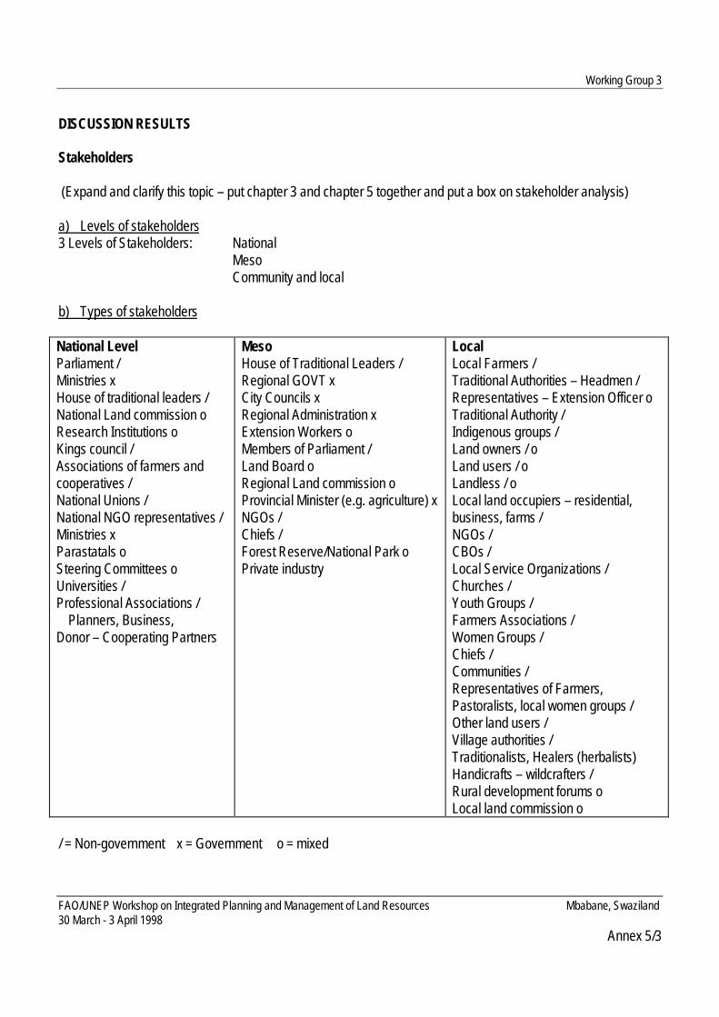
Working Group 3
FAO/UNEP Workshop on Integrated Planning and Management of Land Resources Mbabane, Swaziland30 March - 3 April 1998
Annex 5/3
DISCUSSION RESULTS
Stakeholders
(Expand and clarify this topic – put chapter 3 and chapter 5 together and put a box on stakeholder analysis)
a) Levels of stakeholders3 Levels of Stakeholders: National Meso
Community and local
b) Types of stakeholders
National LevelParliament /Ministries xHouse of traditional leaders /National Land commission oResearch Institutions oKings council /Associations of farmers andcooperatives /National Unions /National NGO representatives /Ministries xParastatals oSteering Committees oUniversities /Professional Associations / Planners, Business,Donor – Cooperating Partners
MesoHouse of Traditional Leaders /Regional GOVT xCity Councils xRegional Administration xExtension Workers oMembers of Parliament /Land Board oRegional Land commission oProvincial Minister (e.g. agriculture) xNGOs /Chiefs /Forest Reserve/National Park oPrivate industry
LocalLocal Farmers /Traditional Authorities – Headmen /Representatives – Extension Officer oTraditional Authority /Indigenous groups /Land owners / oLand users / oLandless / oLocal land occupiers – residential,business, farms /NGOs /CBOs /Local Service Organizations /Churches /Youth Groups /Farmers Associations /Women Groups /Chiefs /Communities /Representatives of Farmers,Pastoralists, local women groups /Other land users /Village authorities /Traditionalists, Healers (herbalists)Handicrafts – wildcrafters /Rural development forums oLocal land commission o
/ = Non-government x = Government o = mixed

Working Group 3
FAO/UNEP Workshop on Integrated Planning and Management of Land Resources Mbabane, Swaziland30 March - 3 April 1998
Annex 5/3
c) Interaction between local/meso/central levels (principles)• Information sharing and flowing• Grassroots participation• Pressure induced by demand• Lower representation in higher level• Strengthen decentralization• International – global community and neighbouring/regional countries• Strengthen role of boards and commission• Transparency in decision making process• Empowerment at regional and local level (negotiate)• Higher representation in lower levels• Ownership and then responsibility• Trust• Awareness raising• Information on process• Technical and local knowledge• Information on coping mechanisms• Formalize linkages/policy interaction at all levels
d) What is important for the approach/document?• Cross representation at all levels• Assess Strengths and Weaknesses of Stakeholders• Clarify relationship between power of stakeholders and dependence to land:
• Community Participation (where does this go in the document?)• Multidisciplinary approach• Implementation Agencies
Coordinate, integrate and facilitate (this requires specific training)Avoid consultation fatigue
• Understand structure of the communityAll groups
DEPENDENCE(directness of interest)
POWER

Working Group 3
FAO/UNEP Workshop on Integrated Planning and Management of Land Resources Mbabane, Swaziland30 March - 3 April 1998
Annex 5/3
Traditional LeadersWomen and disadvantaged groupsYouthMarginalized (special attention to vulnerable groups)
• LMRG’s Promotion/Creation (specific training/capacity building required here also)• On the spot planning vs. further analysis (next steps… )
Community
Organization of participation process on community level
Multidisciplinary / integrated approach• Recognize existing structure of community (including youth)• Identify disadvantaged groups• Recognize sensitize traditional leaders• identify potentials and constraints of each group• Interrelationships cause and effect analysis and awareness raising• Emphasis on women empowerment• Work with each existing group individually and exchange results – capture all voice• Promotion and creation of LRMGs through dialogue at community level (by preference use of existing
structures)• Capacity building on informed decision making on local level• Gender sensitive analysis of changing farming systems• Training of advisors in the new role of facilitators• Advisors need to act as facilitators• Ensure everyone is informed at all stages• Encourage on the spot action planning – where appropriate• Need for further analysis• Provide forum
Conflicts
a) Possible origins• Impact of empowerment on tradition, tenure jurisdiction (e.g. Chief Conflicts)• Influence of leadership on land use (development)• Competition for resources and land uses• Land tenure (parallel legal system)• Conflict between different policies

Working Group 3
FAO/UNEP Workshop on Integrated Planning and Management of Land Resources Mbabane, Swaziland30 March - 3 April 1998
Annex 5/3
• Offsite pollution or other impacts• NGOs versus Government• Demand versus environment• Conflicting interests and common good• Communal interest versus commercial interest• Culture vs. Economic interests• Social equity versus national economy• Conflict in land restoration• Conflict among existing groups in a community• Widening gap of poverty• Cultural interests versus economics• Power and insecurity• Donor conflict on recognition• Stakeholder conflict at local/community level
b) Conflict Resolution• Avoiding tactics
Common visionConsensus BuildingIntegrated Coordination/tradeoffsTrade-offs
• ResolutionTraditional Negotiating StructureFacilitator (ground rules, response of and respect for traditional authority)Traditional CourtOmbudsmanStatutory Court
c) Incentives to avoid/solve conflicts• to avoid dependency syndrome• Awareness raising/creation and education• Target incentives to share costs of conservation more widely• Recycling of locally generated income• Sharing benefits of wildlife conservation areas (campfire-Zimbabwe)• Incentives such as nurseries, etc. (trees, medicinal plants, etc.)

Working Group 3
FAO/UNEP Workshop on Integrated Planning and Management of Land Resources Mbabane, Swaziland30 March - 3 April 1998
Annex 5/3
Top-Down/Bottom-Up
• there was a proposal for editing figure 7 in the draft manual:
International
National(accountability, formalize linkages) Capacity Building
Awareness DecentralizationRaising (ex. FAO and GTZ)At all levels
Meso Information Flows ResponsibilityProcess StrengthenDecision making Roles ofCoping Mech. Boards and
Community IK and TK Commissions
Generate Pressure from DemandGrassroots participationOwnership and Responsibility
EXAMPLES/LESSONS LEARNED
1. Formulation of national development strategy. SWAZILAND2. National Environment Action Plan. SWAZILAND3. Village Area planning. BOTSWANA4. Decentralization GHANA5. Community Based Land Use Planning LESOTHO6. Bush Control Project NW province, SOUTH AFRICA, BURKINA
FASO/COLVILLE, AND ZIMBABWE IN HMCHINA
7. Water quality monitoring team PHILIPPINES
GENERAL RECOMMENDATIONS DRAWN FROM DISCUSSIONS
1. Stakeholders
This section should be expanded and clarified. The chapters 3 and 5 can be merged. It will be important to showthe various stakeholders that are within the national, meso and local levels and to show the relationships betweenthe levels. This section should also cover

Working Group 3
FAO/UNEP Workshop on Integrated Planning and Management of Land Resources Mbabane, Swaziland30 March - 3 April 1998
Annex 5/3
a) methods for assessing strengths and weaknesses of stakeholders (stakeholder analysis methods can beplaced in a box),
b) strengthening interaction between these levels including cross representation at all levels and enhancedownership. A graphic depicting the relationship between power of stakeholders and dependence on landshould be included.
2. Community
The section on Community must include promoting community participation, understanding the structure of thecommunity, using a multidisciplinary approach, and creation or promotion of LMRGs (including training). Withinthis section, many suggestions are made for organization of participation process on the community level (seeworking group outputs).
3. Top Down/Bottom Up Approaches
This section needs to be enhanced including the graphic currently identified as Figure 7. Specific aspects notedwere the importance of accountability, responsibility and formalized linkages across levels, the importance ofinformation flows across levels. The information includes information regarding awareness creation, process,decision making, coping mechanisms, and indigenous and technical knowledge. Decentralization issues need tobe addressed and the capacity building needed to work within this context. Examples from FAO and GTZ recentconferences can be drawn upon in this discussion. Capacity building at for implementing agencies shouldstrengthen their role as coordinators, integrators, and facilitators where as at grassroots levels it is concerned withenhanced participation and informed decision making.
4. Conflicts
There should be a section, which deals with possible origins of conflict as well as avoiding and resolution tactics.Case examples should be included where incentives served to avoid and or solve conflict by increasingownership.

Workshop Expectations of Participants
FAO/UNEP Workshop on Integrated Planning and Management of Land Resources Mbabane, Swaziland30 March - 3 April 1998
Annex 6
WORKSHOP EXPECTATIONS OF THE PARTICIPANTS
At the beginning of the workshop, the participants were asked for their expectations they came with to theworkshop. Three questions were given:• What do we hope to learn or to give during the workshop?• What do we hope to share or contribute?• What would we like to gain personally?The expectations were written by the participants on cards and visualised on a pin-board.
1. What do we hope to learn or give?
I would like to (learn):• how to coordinate between land and water agencies• about case study experiences from other countries• widen personal scope and pick up interesting new ideas• to interchange ideas , views and methodologies with regard to sustainable LRM• share views and experience on ILUP• about new approaches to ILUP and what the concept of ILUP entails• the evidence of success land policy development• to have a better understanding of LUP• to get more knowledge on the aspects of LUP• about a practical guidance on the ILUP process• the evidence of successful land use planning schemes• basic concepts and principles of ILUP• about a holistic understanding of LUPs• new ideas and approaches to land-use planning – technologies and legislation• better coordination of how the stakeholders could be achieved• to understand the basic principles of ILUP• to find a balance between socio-economic and physical factors affecting LUP• how the countries plan their land use and solve land related problems• to get a broad understanding of land related problems and their solutions• to give input to case studies to build ILUP guidelines• to get a practical guidance in planning• a clearer definition of planning and management• a practical definition of the word “integrated”• to listen to experience from participants• to meet people make contacts with others working on LUP in Southern Africa• about country case studies and success stories• to get other peoples opinions on how the manual should look like

Workshop Expectations of Participants
FAO/UNEP Workshop on Integrated Planning and Management of Land Resources Mbabane, Swaziland30 March - 3 April 1998
Annex 6
• to get ideas referring introducing advanced management systems in rural areas• how to make an ILUP feasible• how to strengthen community participation in LRM• how to prime the community development process• get a document with workable strategy for strengthening institutions coordination• to discuss ideas with people with common interests• how to bridge local knowledge with scientific knowledge in ILUP• what is really appropriate in LRM• to achieve consensus on the main issues• about the grazing animal environment interactions• to have a better understanding of the scope of LUP.
2. What do we hope to share or contribute?
I would like to share (or to contribute):• countries experiences in LUP• my opinion on how the document should look like• coordination, experiences, views from our countries• experiences on various approaches to ILU management systems• country level experiences in LUP and RM• sectoral needs in conducting ILUP• approaches within Swaziland’s draft national land policy• information on Namibia’s AEZ –programme• information on two draft bills with reference to LUP in Namibia• experiences from our countries on various land issues as high lighted in these documents• experience in participatory NRM• contribution towards sustainable land management decisions• integrated land uses and sound land use policies• ideas on integrated planning with particular emphasis on the region• information and experiences that might improve the manual• my experience in the subject also suggestions on the adaptation of the new approach• new concepts in LUP• experience/problems encountered in planning eg bureaucracy versus participation and constraints versus
expectations• ideas gained from participatory planning during NEAP development process• challenges of drawing up a policy• to expand knowledge on how land use planning is carried out in other countries• discussions on new strategies for ILUP• we always learn something new from such workshops• UNDP’s experiences in supporting environmental management and water supply

Workshop Expectations of Participants
FAO/UNEP Workshop on Integrated Planning and Management of Land Resources Mbabane, Swaziland30 March - 3 April 1998
Annex 6
• experiences, ideas, new views and a better understanding• experience of editing guidelines and land use planning in 15 countries• examples, good experiences, bad experiences• land use planning experience from Swaziland
3. What would we like to gain personally?
I would like to:• create a future network to facilitate the exchange of experiences• have constructive discussion of ILUP issues• meet new people• get a better sense of LUP• get to know new colleagues• make friends• have a practical workshop on ILUP in the future – model area• look forward to an exhilarating field excursion• learn about the view from other participants on planning resettlement properly• strongly emphasis on resettlement• gain greater insight on ILUP with how to improve coordination between land and water agencies• learn about the indication of whether and how village land use planning actually works• work in an open relaxed atmosphere• get a detailed overview of land use planning in Swazi national land areas• gain knowledge on communal land use planning• learn about country experiences in LUP• learn about clearly demonstrated evidence of success stories of ILUP from case studies• have time for lively debate• have adequate time for plenary discussions• learn about a programme for capacity building in ILUP• have constructive inputs• have open free discussion on topic at hand• have more independent discussions and less facilitator intervention• get to know interesting people• gain and share knowledge in a relaxed atmosphere• have a positive working atmosphere• no comments• see decision-makers actively participating in a similar workshop• visit to land use planning projects in Swaziland• come out of here with an understanding of land-use planning• have discussions in a relaxed manner

Workshop Expectations of Participants
FAO/UNEP Workshop on Integrated Planning and Management of Land Resources Mbabane, Swaziland30 March - 3 April 1998
Annex 6
• see something of Swaziland, especially the rural areas• make contacts for future follow up activities – jointly• meet people and share ideas on NRM and the promotion of sustainable livelihoods.

Participatory Evaluation of the Workshop
FAO/UNEP Workshop on Integrated Planning and Management of Land Resources Mbabane, Swaziland30 March - 3 April 1998
Annex 7
PARTICIPATORY EVALUATION OF THE WORKSHOP
BACKGROUND
The Feedback-Technique is a special form of communication. In addition, it is an instrument for monitoring thelevel awareness of people what is going on in a communication process. It is aimed at:• monitoring the awareness status concerning project objectives as well as project progress as seen by the
people involved; and• the creation of a transparent and open (working) atmosphere in a group. It supports the group dynamic.
DAILY FEEDBACK
The workshop was designed such that each day, the participants could provide feedback on the workshopwith regard to:• how well we were meeting the objectives of the workshop, and• how the “atmosphere” felt for the workshop.
This was done using a feedback board (picture) on which participants and organisers could visually andanonymously place their mark – either good, neutral and bad - as to the how the day went. Through thisexercise it was possible for the participants as well as the workshop organisers to follow the trend of theworkshop, discuss the daily ‘rating’ and make mid-course corrections where necessary.
PARTICIPATORY WORKSHOP EVALUATION
On the last day, a final participatory workshop evaluation was conducted. Two questions were formulatedfocusing on positive aspects and aspects which could be improved. The participants used cards to write downtheir ideas and fixed it visible for everybody on the board. The following are the sorted results of that exercise:
What has been good?
Discussions, Ideas and Experiences• the information and knowledge gained• the discussion (3)• all the ideas that have been shared• bringing together the various disciplines and experiences• I have learned so much• sharing of ideas• the discussions have been very good
The Field Trip• the tour was marvellous• the field trip (2)

Participatory Evaluation of the Workshop
FAO/UNEP Workshop on Integrated Planning and Management of Land Resources Mbabane, Swaziland30 March - 3 April 1998
Annex 7
• field trip in the middle of the week was beneficial to atmosphere and learning experience
Atmosphere, Organisation and Progress• the very good atmosphere (2)• relaxed and conducive atmosphere• the organisation of the workshop (2)• the workshop was very well guided by the organisers and participants• organisation for moving forward (2)• creative and pleasant working methods and atmosphere• we have made much improvement in the manual• comments on how the manual should look like• timing
Other• everything
What could have been better?
Discussions, Ideas and Experiences• more time for reflection on group presentation• more multidisciplinary panel• not enough discussion on case studies and examples• more participatory issues identification
The Field Trip• sandwiches for the field trip• field trip arrangement could have been better
Other• the social atmosphere could have been better• nothing could have been better (4)
SUMMARY
From the point of the organisers and the participants, it was generally felt that the workshop was successful inmeeting the objectives and in convening a workshop based on a participatory approach. The points forimprovement will be used in planning future workshops.