false creek anchoring map - vancouvervancouver.ca/files/cov/false-creek-anchoring-map5.pdf · false...

1
Charleson Park David Lam Park East Basin Vanier Park Creekside Park Granville Street e g d i r B e i b m a C Smithe Street Burrard Street Charleson Bay Alder Bay Granville Island Brokers’ Bay English Bay Park Gr a n v il l e Br id g e B u r r a rd Br id g e navigable channel n a v i g a b l e c h a n n e l naviga b le ch a n n e l PUBLIC BOAT RAMP Burrard Bridge Civic Marina PUMP OUTS PUMP OUTS Heather Civic Marina PUMP OUTS Stamp’s Landing ANCHORING PERMITS Boating Centre Pelican Bay Marina Spruce Harbour Marina False Creek Harbour Authority Quayside Marina PUMP OUTS False Creek Yacht Club PUMP OUTS Anchoring in False Creek N MAX Km/h 10 No anchoring Dinghy dock Map not to scale Legend To reserve a dinghy spot at Quayside Marina, call Channel 66A or 604.681.9115 Longer stays are subject to a fee. False Creek Anchoring Boundary Kits Point False Creek Anchoring Boundary The area lying east of a line drawn from Kits Point 45 degrees northeast across the mouth of the creek. Visiting boaters wishing to anchor in this area require an anchoring permit. The area to the west falls under the jurisdiction of Transport Canada.

Upload: dinhdat

Post on 29-May-2018

221 views

Category:

Documents


0 download

TRANSCRIPT

CharlesonPark

David Lam Park

East Basin

Vanier Park

Cree

ksid

e Pa

rk

Granv

ille

Stre

et

egdirB ei bmaC

Smithe Street

Burra

rd S

treet

CharlesonBay

AlderBay

GranvilleIsland

Brokers’Bay

EnglishBay

Park

Gra

nvill

e Br

idge

Burrard Bridge

navigable channel

navigable channel

navigable channel

PUBLIC BOAT RAMP

Burrard BridgeCivic Marina

PUMP OUTS

PUMP OUTS

Heather Civic Marina

PUMP OUTS

Stamp’s Landing

ANCHORING PERMITS

Boating Centre

Pelican BayMarina

Spruce HarbourMarina

False CreekHarbour Authority

QuaysideMarina

PUMP OUTS

False CreekYacht ClubPUMP OUTS

Anchoring in False Creek

N

MAX Km/h10

No anchoring

Dinghy dock

Map not to scale

Legend

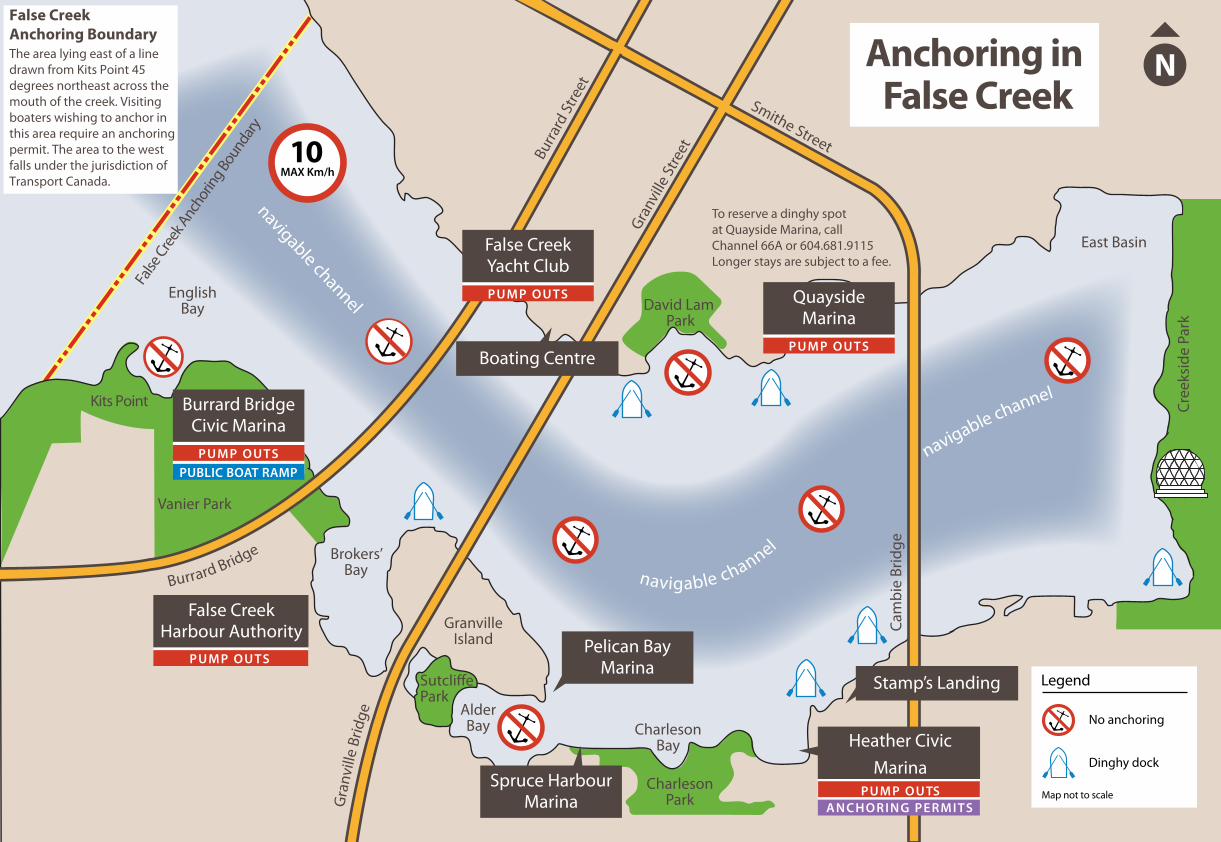
To reserve a dinghy spotat Quayside Marina, callChannel 66A or 604.681.9115Longer stays are subject to a fee.

False

Creek

Anc

horin

g Bou

ndar

y

Kits Point

False Creek Anchoring BoundaryThe area lying east of a line drawn from Kits Point 45 degrees northeast across the mouth of the creek. Visiting boaters wishing to anchor in this area require an anchoring permit. The area to the west falls under the jurisdiction of Transport Canada.