faculty of engineering - ir.unimas.my effect at sungai maong kiri... · malaysia sarawak dengan...
TRANSCRIPT

BACKWATER EFFECT AT SUNGAI MAONG KIRI
Basil Anak Benjamin
Bachelor of Engineering with Honours
(Civil Engineering)
2008
Faculty of Engineering

UNIVERSITI MALAYSIA SARAWAK
BORANG PENGESAHAN STATUS TESIS
Judul: BACKWATER EFFECT AT SUNGAI MAONG KIRI
SESI PENGAJIAN: 2008/2009
Saya, BASIL ANAK BENJAMIN_____________________
(HURUF BESAR)
mengaku membenarkan tesis * ini disimpan di Pusat Khidmat Maklumat Akademik, Universiti
Malaysia Sarawak dengan syarat-syarat kegunaan seperti berikut:
1. Tesis adalah hakmilik Universiti Malaysia Sarawak.
2. Pusat Khidmat Maklumat Akademik, Universiti Malaysia Sarawak dibenarkan membuat
salinan untuk tujuan pengajian sahaja.
3. Membuat pendigitan untuk membanguankan Pangkalan Data Kandungan Tempatan.
4. Pusat Khidmat Maklumat Akademik, Universiti Malaysia Sarawak dibenarkan membuat
salinan tesis ini sebagai bahan pertukaran antara institusi pengajian tinggi.
5. ** Sila tandakan (√) di kotak yang berkenaan.
SULIT (Mengandungi maklumat yand berdarjah keselamatan atau kepentingan Malaysia
seperti yang termaktub di dalam AKTA RAHSIA RASMI 1972).
TERHAD (Mengandungi maklumat TERHAD yang telah ditentukan oleh organisasi/badan di
mana penyelidikan dijalankan).
TIDAK TERHAD
Disahkan oleh
_________________________ ___________________________ (TANDATANGAN PENULIS) (TANDATANGAN PENYELIA)
Alamat tetap: No. 1345 Lorong Bayor, DR. ONNI SUHAIZA BINTI SELAMAN
Bukit No. 8, Nama Penyelia
Tabuan Jaya, 93350 Kuching,
Sarawak.
Tarikh: 8 JUN 2009 Tarikh: 8 JUN 2009
CATATAN * Tesis dimaksudkan sebagai tesis bagi Ijazah Doktor Falsafah, Sarjana dan Sarjana Muda
** Jika tesis ini SULIT dan TERHAD, sila lampirkan surat daripada pihak berkuasa/organisasi
berkenaan dengan menyatakan sekali sebab dan tempoh tesis ini perlu dikelaskan sebagai
SULIT dan TERHAD.

The Final Year Project Report as follow:
Title: Backwater Effect at Sungai Maong Kiri
Author: Basil Anak Benjamin
Matric: 13800
is hereby read and approved by:
_________________________________ 8 JUNE 2009
Dr. Onni Suhaiza Selaman Date
Project Supervisor

BACKWATER EFFECT AT SUNGAI MAONG KIRI
BASIL ANAK BENJAMIN
A dissertation submitted to
Faculty of Engineering, University Malaysia Sarawak
in partial fulfillment of the requirement for the
Degree of Bachelor of Engineering
With Honours (Civil Engineering)
2009

ii
Dedicated To
my beloved family, friends and lecturers
for your
….Tolerance
….encouragement
….help

iii
ACKNOWLEDGEMENT
In preparing this thesis, I was in contact with many government departments which
are Department of Irrigation and Drainage of Kota Samarahan and Marine Department
Sarawak. They have contributed towards all my data collection for this project.
In particular, I wish to express my deep and sincere appreciation to my main
research supervisor, Dr. Onni Suhaiza Selaman, for encouragement, guidance, critics
and friendship. I am also indebted to Universiti Malaysia Sarawak (UNIMAS) for
providing an accessible academic websites and journals.
I am also very thankful to my friends for their helping hands, guidance, advices and
motivation. Without their continued support and interest, the thesis would not have been
the same as presented here.
My sincere appreciation also extends to all my colleagues and others who have
indirectly provided assistance at various occasions. Their views and tips are useful
indeed. Unfortunately, it is not possible to list all of them in this limited space. I am
grateful to all my family members for their continuous support morally and financially.

iv
ABSTRAK
Sungai Maong Kiri adalah salah satu sungai di tadahan Sungai Sarawak yang
berkecenderungan mengalami masalah banjir disebabkan Sungai Maong Kiri adalah
kawasan yang dipengaruhi aliran pasang surut. Analisa air balik dijalankan untuk
mengkaji kapasiti Sungai Maong Kiri yang sedia ada sama ada masih mampu untuk
menampung kadaralir air yang merangkumi air larian dari kawasan tadahan di hulu
sungai dan kesan pasang surut di hilir sungai. Kesan air balik boleh menyebabkan
limpahan di saliran Sungai Maong Kiri yang sedia ada. Analisa hidrologik menggunakan
kaedah Rational dijalankan untuk mendapatkan purata kadaralir puncak dengan kala
kembali yang berbeza digunakan sebagai syarat sempadan hulu semasa analisa aliran
mantap. Aras tertinggi air pasang surut 6.4m dipilih sebagai syarat sempadan hilir. Data
aras air pasang surut tertinggi didapati daripada Jabatan Laut Sarawak. Analisa air balik
dijalankan menggunakan HEC-RAS 4.0 berkeadaan aliran mantap. Keputusan analisa
hidraulik telah menunjukkan bahawa Sungai Maong Kiri yang sedia ada mampu
menampung kadaralir daripada CH 0 ke CH 20000 tetapi terdapat limpahan air dari CH
25000 ke CH 30780. Untuk mengelakkan limpahan pada saliran sungai sedia ada dan
memenuhi piawai freeboard saliran terbuka, penghadang limpahan air yang setinggi
0.4m dan 0.6m telah dicadangkan untuk dibina pada kedua-dua belah tebing sungai
sepanjang CH 0 ke CH 30780.

v
ABSTRACT
Sungai Maong Kiri is one of the rivers in Sungai Sarawak River Basin that may face
flood tendency because Sungai Maong Kiri is under tidal influence. Backwater analysis
is carried out to investigate whether existing channel of Sungai Maong Kiri is still able
to accommodate the volume of water comprises the discharge from upstream and high
tide from downstream. Backwater effect will cause overflow at Sungai Maong Kiri
existing channel. Hydrologic analysis by using Rational Formula has been carried out to
achieve average peak discharge. Different Average Recurrence Interval (ARI) has been
used as the upstream boundary condition during the steady flow analysis. Highest
Astronomical Tide (HAT) 6.4m has been chosen as a downstream boundary condition.
Highest Astronomical Tide data was collected from Sarawak Marine Department.
Backwater analysis is carried out by using HEC-RAS 4.0 on steady flow analysis. From
the result, the channel is still capable to accommodate the water from CH 0 to CH 20000
but water overflow from CH 25000 to CH 30780. To prevent overflow at existing
channel and satisfy the standard freeboard size for open channel, a 0.4m and 0.6m height
leeve has been proposed to build at both side of the channel along CH 0 to CH 30780.

vi
TABLE OF CONTENTS
PAGE
Dedication ii
Acknowledgement iii
Abstrak iv
Abstract v
Table of contents vi
List of Tables x
List of Figures xi
List of Abbreviations xiii
List of Abbreviations xiv
CHAPTER 1 INTRODUCTION
1.1 Research Background 1
1.2 Problem Statements 3
1.3 Objectives 6
1.4 Scope of Study 6
CHAPTER 2 LITERATURE REVIEW
2.1 Introduction 7

vii
2.2 Rainfall-runoff Estimation Methods 7
2.2.1 Rational Formula 8
2.2.2 Characteristics of Rational Method 13
2.2.3 Limitations of Rational Method 15
2.3 Open Channel Flow 17
2.4 Unsteady Flow 19
2.4.1 Governing Equations 21
2.4.2 Dynamic Equation 21
2.4.3 Continuity Equation 24
2.4.4 Methods of Solution 25
2.5 Gradually Varied Flow 26
2.5.1 Flow Classification 27
2.5.2 Backwater Profiles Computation 31
2.6 Hydrologic Engineering Center – River 33
Analysis System
2.7 Types of Tide Phenomena 35
2.8 Chart Datum 37
2.9 Case Study: Backwater Effect in the 39
Amazon River Basin of Brazil
2.10 Summary of Literature Review 39
CHAPTER 3 METHODOLOGY
3.1 Introduction 40

viii
3.2 Acquiring and Analyzing the Digital Map 41
3.3 Division of Area 42
3.4 Determination of Runoff Coefficient 43
3.5 Determination of Rainfall Intensity 44
3.6 Determination of Rational Peak Discharge 44
3.7 Hydraulic Analysis Data Collection 45
3.8 Hydraulic Model – HEC-RAS 46
3.8.1 Geometry Data 46
3.9 Flow Regime 48
3.10 Steady Flow Analysis 49
3.10.1 Boundary Conditions and Flow Data 51
CHAPTER 4 RESULT AND DATA ANALYSIS
4.1 Introduction 53
4.2 Hydrology Analysis 54
4.3 Hydraulic Analysis 55
4.3.1 Geometrical Data 56
4.3.2 Flow Data and Boundary Condition 57
4.3.3 Flow Regime of Sungai Maong Kiri 59
4.3.4 Results of Steady Flow Analysis 60
4.4 Leeve Introduction 64
CHAPTER 5 DISCUSSION
5.1 Discussion 67

ix
CHAPTER 6 CONCLUSION AND RECOMMENDATIONS
6.1 Conclusion 73
6.2 Recommendations 74
REFERENCES 75
APPENDIX A Calculation for Average Rational peak discharge, 78
(m3/s) for all ARI
APPENDIX B Determination of Flow Regime at Sungai Maong Kiri 86
APPENDIX C Profile Output Table –Steady Flow Analysis 88
x
LIST OF TABLES
Page
Table 2.1: Runoff Coefficient Values for the Rational Method 12
Table 2.2: Mild Slope Profile (Backwater Curve) 30
Table 4.1: Average Rational Peak Discharge 55
Table 4.2: Highest Astronomical Tide Table for Pending Station from year
1997-2007
58
Table 4.3: Boundary Condition and Flow Data 59
Table 4.4: Normal Depth, yo and Critical Depth, yc 60
Table 4.5: Water Levels With Different ARI at CH 30780 62
Table 4.6: Comparisons between existing system and proposed system 65

xi
LIST OF FIGURES
Page
Figure 1.1: Flooded area at Bau Police Station due to high tide 2
Figure 1.2: Flood occur due to the creation of backwater from tide at Bau
Town in 1963
3
Figure 1.3: Sungai Maong Catchment Area 5
Figure 2.1: Prismatic channels 18
Figure 2.2: Derivation of the dynamic equation for gradually varied
unsteady flow
21
Figure 2.3: Flow Transitions 26
Figure 2.4: Profile types for a mild slope 29
Figure 2.5: Water surface profile definition 32
Figure 2.6 (a): Semi-Diurnal Tide 35
Figure 2.6 (b): Diurnal Tide 36
Figure 2.6 (c): Mixed Tide 37
Figure 2.7: Datum for tide level measurement 38
Figure 3.1: Backwater analysis of Sungai Maong Kiri 41
Figure 3.2: River Schematic Diagram 46
Figure 3.3: Cross section data, Manning’s n values and other data of CH 0 47
Figure 3.4: Analyzing steady flow 49
Figure 3.5: Input of steady flow data 50

xii
Figure 3.6: Boundary Conditions for Sungai Maong Kiri Hydraulic
Analysis
51
Figure 4.1: Schematic Cross Section 56
Figure 4.2: Geometric input data from one of river station 57
Figure 4.3: Water surface profile plot 61
Figure 4.4 (a): Cross Section at CH 25000 62
Figure 4.4 (b): Cross Section at CH 30000 63
Figure 4.4 (c): Cross Section at CH 30780 63
Figure 4.5: Water levels along channel cross section with different ARI 66
Figure 5.1: Water surface profile with propose of leeve at both side of
channel
70
Figure 5.2: Water level at CH 5000 71
Figure 5.3: Water level at CH 15000 71
Figure 5.4: Water level at CH 25000 72
Figure 5.5: Water level at CH 30780 72

xiii
LIST OF ABBREVIATIONS
ARI - Average recurrence interval, year
HAT - Highest Astronomical Tide
HEC -RAS - Hydrologic Engineering Center – River Analysis System

xiv
LIST OF SYMBOLS
IL - Invert level, m
RL - Reduced level, m
R - Storage coefficient, hr
tc - Time of concentration, hr
Qpeak - Peak discharge, m3/s
t - Duration, hr
n - Manning’s coefficient representing the roughness of
channel bed
u - Changing factor unit, 1.0 for Unit SI System
So - Slope of channel bed
A, R - Function for yo
g - Gravity acceleration, m2/s
Ac, Tc - Function of yc
yc - Critical depth, m
yo - Normal depth, m
E - Specific energy, m
z - Elevation, m
zo - Bed elevation
αv2/2g - Specific velocity
θ - Bottom elevation

xv
h - Specific energy
H - Peizometric head
1
CHAPTER 1
INTRODUCTION
1.1 Research Background
Flood frequently occurred in our country since few years ago. Besides the
significant changes of global climate, the impact from urbanization process is the main
reason that causes flood occurs at many places in our country. With the increase of
impervious area, the volume of surface runoff from catchment area will also be
increased. Flood will occur if the existing drainage system or channel not capable to
accommodate the big volume of flow from catchment area.
The flood problem is more serious especially at the downstream part of channel
which having a low topographic profile. The condition becomes worse if the existing
channel is under tidal influence. Flood might occur at upstream part of the channel due
to the creation of backwater from tide as shown in Figure 1.1 and Figure 1.2. Therefore,
in this research, impacts of backwater to the river basin need to be studied in order to
avoid any flood problem. Not only this, more detail and thorough investigation to the
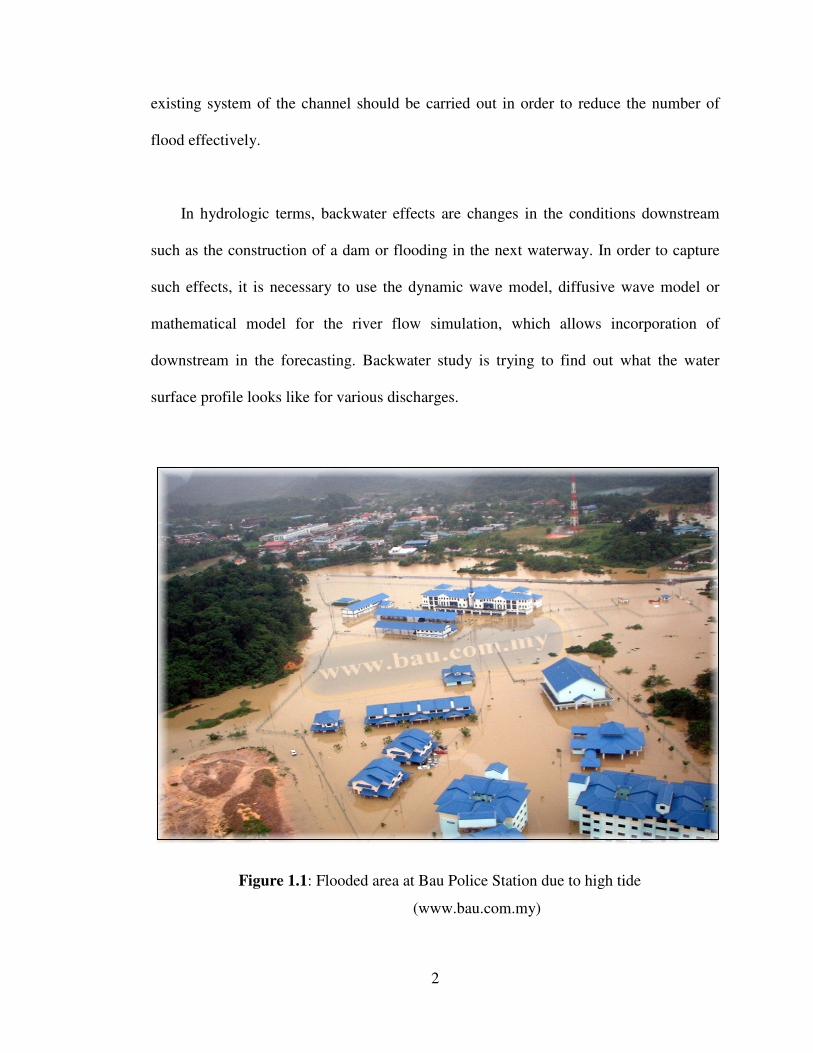
2
existing system of the channel should be carried out in order to reduce the number of
flood effectively.
In hydrologic terms, backwater effects are changes in the conditions downstream
such as the construction of a dam or flooding in the next waterway. In order to capture
such effects, it is necessary to use the dynamic wave model, diffusive wave model or
mathematical model for the river flow simulation, which allows incorporation of
downstream in the forecasting. Backwater study is trying to find out what the water
surface profile looks like for various discharges.
Figure 1.1: Flooded area at Bau Police Station due to high tide
(www.bau.com.my)

3
Figure 1.2: Flood occur due to the creation of backwater from tide
at Bau Town in 1963 (www.bau.com.my)
1.2 Problem Statement
Sungai Maong is one of the small tributaries of Sungai Sarawak which is located in
the Kuching City. Sungai Maong can be divided into two, which are Sungai Maong
Kanan and Sungai Maong Kiri. Length of main Sungai Maong before it separate into
Sungai Maong Kiri and Sungai Maong Kanan is about 1.5 km. This project will focused
on Sungai Maong Kiri area due to the development and urbanization process.

4
Sungai Maong Kiri begins at near the center of the Kuching City. It then traverses
the Central Park at the 3rd
Miles, Kuching. Sungai Maong Kiri area also includes the
Batu Lintang residential area and Taman Bergawut. All of these places are consist of
residential area, commercial area and some open area.
The discharges and runoff from the residential area and commercial area would
flow through the trunk drain which is in the rectangular shape and 6 meter wide. The
discharges and runoff would then flow into Sungai Maong Kiri. At the downstream part
of Sungai Maong Kiri, it traverses some residential areas; include Taman Wee and Wee,
Taman Sky and Stapok. Along Sungai Maong Kiri, there is no industrial area. It has
small jungle area at the downstream part.
This project analysis is to investigate the existing of backwater at the Sungai
Maong Kiri channel. When the flows of the channel come across the tide from
downstream and collide with peak discharge, backwater will be created. Most probably
effect of backwater such as flood will be occurring because the channel cannot
accommodate the volume of backwater due to the high tide.
Therefore, hydrologic and hydraulic analyses have been carried out in order to
determine effect and extent of backwater at Sungai Maong Kiri. The worst scenario if
there is a high capacity of runoff from the upstream catchments coincided with highest
astronomical tide continuously will occur backwater effect such as flooding. Figure 1.3
shows a Sungai Maong catchment area which is about 40 km2. (KTA, 1997)

5
Figure 1.3: Sungai Maong Catchment Area (Google Earth, 2008)
Sungai Maong Kanan
40 km2
Sungai Maong Kiri
6
1.3 Objectives
Main objectives of my research are to:
i) Determine whether existing Sungai Maong Kiri channel is able to accommodate
excessive water that affected by backwater.
ii) Find out the extent of which the Sungai Maong Kiri channels affected by
backwater effect by analyzing using HEC-RAS software.
iii) Proposed new system on how to prevent backwater effect such as flood for area
affected.
1.4 Scope of Study
Location of the study is located at Sungai Maong Kiri catchment. Scope of study
mention below, which is:
i) Estimate flow of surface runoff by using Rational Formula method.
ii) Undergo hydraulic analysis on the existing river channel by using HEC-RAS
software and supervise the overflow area.
iii) Data collection that includes rainfall intensity, stream flow, channels cross
section and tide level in order to evaluate the backwater profile.
iv) Evaluate the causes of backwater effect and proposed new irrigation system that
afford to cater overflowed water.