faculty details proforma for du web-site - university of delhidu.ac.in/du/uploads/faculty...
TRANSCRIPT

www.du.ac.in Page 1
Title Dr. First Name Ashis Kumar
Last Name Saha Photograph
Designation Assistant Professor
Address Department of Geography Delhi School of Economics University of Delhi Delhi – 110 007, India
Phone No Office +91-11-27666491
Residence -
Mobile -
Email [email protected] ; [email protected]
Web-Page http://people.du.ac.in/~aksaha/
Educational Qualifications
Degree Institution Year
Ph.D. (Earth Sciences) IIT Roorkee 2004
M.Tech. (Applied Geology)
University of Roorkee (Now IIT Roorkee) 1999
B.Sc. (Geology) Presidency College, University of Calcutta 1996
Career Profile
Apr. 2009 – till date : Assistant Professor (Stage-II, Re-designated from Sr. Lecturer), Department of Geography, DSE, University of Delhi
Apr. 2005 – Apr. 2009 : Assistant Professor (Stage-I, Re-designated from Lecturer), Department of Geography, DSE, University of Delhi
Dec. 2004 – Mar. 2005: Senior Research Associate, Ashoka Trust for Research in Ecology and Environment (ATREE), Bangalore
Administrative Assignments
Resident Tutor, Gwyer Hall (2005-07)
Teacher In-Charge, Computer/GIS Lab., Department Website (2018-19)
Member, Departmental Council, MPhil Committee, SAP Advisory Committee, NAAC Committee, Syllabus
Revision Committee etc. (2018-19)
Areas of Interest / Specialization
Geo-environmental Studies using Remote Sensing and GIS: Landslide Hazard Zonation; Landuse / Landcover Mapping and Change Detection; OBIA; Digital Image Classification; Drought Assessment; Mangrove Mapping; Digital Terrain Modeling
Subjects Taught
MA: [103] Fundamentals of Remote Sensing and GIS
[201] Advanced Physical Geography
[203] Computer-aided Mapping and Thematic Cartography
[301] Advanced Remote Sensing and GIS
[401] Project Report / Dissertation
[444] Terrain Modeling and Analysis
Faculty Details proforma for DU Web-site
(PLEASE FILL THIS IN AND Email it [email protected])
www.du.ac.in Page 2
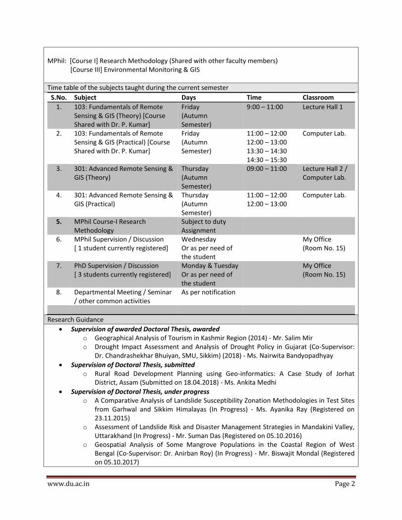
MPhil: [Course I] Research Methodology (Shared with other faculty members) [Course III] Environmental Monitoring & GIS
Time table of the subjects taught during the current semester
S.No. Subject Days Time Classroom
1. 103: Fundamentals of Remote Sensing & GIS (Theory) [Course Shared with Dr. P. Kumar]
Friday (Autumn Semester)
9:00 – 11:00 Lecture Hall 1
2. 103: Fundamentals of Remote Sensing & GIS (Practical) [Course Shared with Dr. P. Kumar]
Friday (Autumn Semester)
11:00 – 12:00 12:00 – 13:00 13:30 – 14:30 14:30 – 15:30
Computer Lab.
3. 301: Advanced Remote Sensing & GIS (Theory)
Thursday (Autumn Semester)
09:00 – 11:00 Lecture Hall 2 / Computer Lab.
4. 301: Advanced Remote Sensing & GIS (Practical)
Thursday (Autumn Semester)
11:00 – 12:00 12:00 – 13:00
Computer Lab.
5. MPhil Course-I Research Methodology
Subject to duty Assignment
6. MPhil Supervision / Discussion [ 1 student currently registered]
Wednesday Or as per need of the student
My Office (Room No. 15)
7. PhD Supervision / Discussion [ 3 students currently registered]
Monday & Tuesday Or as per need of the student
My Office (Room No. 15)
8. Departmental Meeting / Seminar / other common activities
As per notification
Research Guidance
Supervision of awarded Doctoral Thesis, awarded o Geographical Analysis of Tourism in Kashmir Region (2014) - Mr. Salim Mir o Drought Impact Assessment and Analysis of Drought Policy in Gujarat (Co-Supervisor:
Dr. Chandrashekhar Bhuiyan, SMU, Sikkim) (2018) - Ms. Nairwita Bandyopadhyay
Supervision of Doctoral Thesis, submitted o Rural Road Development Planning using Geo-informatics: A Case Study of Jorhat
District, Assam (Submitted on 18.04.2018) - Ms. Ankita Medhi
Supervision of Doctoral Thesis, under progress o A Comparative Analysis of Landslide Susceptibility Zonation Methodologies in Test Sites
from Garhwal and Sikkim Himalayas (In Progress) - Ms. Ayanika Ray (Registered on 23.11.2015)
o Assessment of Landslide Risk and Disaster Management Strategies in Mandakini Valley, Uttarakhand (In Progress) - Mr. Suman Das (Registered on 05.10.2016)
o Geospatial Analysis of Some Mangrove Populations in the Coastal Region of West Bengal (Co-Supervisor: Dr. Anirban Roy) (In Progress) - Mr. Biswajit Mondal (Registered on 05.10.2017)
www.du.ac.in Page 3
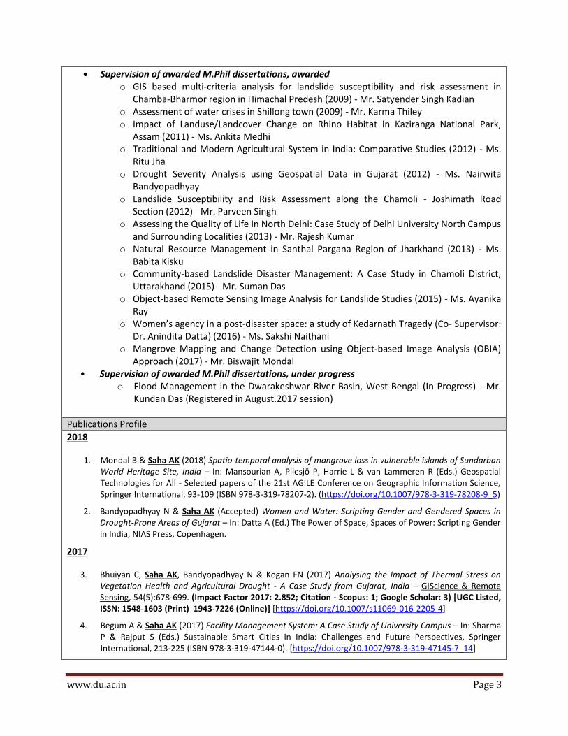
Supervision of awarded M.Phil dissertations, awarded o GIS based multi-criteria analysis for landslide susceptibility and risk assessment in
Chamba-Bharmor region in Himachal Predesh (2009) - Mr. Satyender Singh Kadian o Assessment of water crises in Shillong town (2009) - Mr. Karma Thiley o Impact of Landuse/Landcover Change on Rhino Habitat in Kaziranga National Park,
Assam (2011) - Ms. Ankita Medhi o Traditional and Modern Agricultural System in India: Comparative Studies (2012) - Ms.
Ritu Jha o Drought Severity Analysis using Geospatial Data in Gujarat (2012) - Ms. Nairwita
Bandyopadhyay o Landslide Susceptibility and Risk Assessment along the Chamoli - Joshimath Road
Section (2012) - Mr. Parveen Singh o Assessing the Quality of Life in North Delhi: Case Study of Delhi University North Campus
and Surrounding Localities (2013) - Mr. Rajesh Kumar o Natural Resource Management in Santhal Pargana Region of Jharkhand (2013) - Ms.
Babita Kisku o Community-based Landslide Disaster Management: A Case Study in Chamoli District,
Uttarakhand (2015) - Mr. Suman Das o Object-based Remote Sensing Image Analysis for Landslide Studies (2015) - Ms. Ayanika
Ray o Women’s agency in a post-disaster space: a study of Kedarnath Tragedy (Co- Supervisor:
Dr. Anindita Datta) (2016) - Ms. Sakshi Naithani o Mangrove Mapping and Change Detection using Object-based Image Analysis (OBIA)
Approach (2017) - Mr. Biswajit Mondal • Supervision of awarded M.Phil dissertations, under progress
o Flood Management in the Dwarakeshwar River Basin, West Bengal (In Progress) - Mr. Kundan Das (Registered in August.2017 session)
Publications Profile
2018
1. Mondal B & Saha AK (2018) Spatio-temporal analysis of mangrove loss in vulnerable islands of Sundarban World Heritage Site, India – In: Mansourian A, Pilesjö P, Harrie L & van Lammeren R (Eds.) Geospatial Technologies for All - Selected papers of the 21st AGILE Conference on Geographic Information Science, Springer International, 93-109 (ISBN 978-3-319-78207-2). (https://doi.org/10.1007/978-3-319-78208-9_5)
2. Bandyopadhyay N & Saha AK (Accepted) Women and Water: Scripting Gender and Gendered Spaces in Drought-Prone Areas of Gujarat – In: Datta A (Ed.) The Power of Space, Spaces of Power: Scripting Gender in India, NIAS Press, Copenhagen.
2017
3. Bhuiyan C, Saha AK, Bandyopadhyay N & Kogan FN (2017) Analysing the Impact of Thermal Stress on Vegetation Health and Agricultural Drought - A Case Study from Gujarat, India – GIScience & Remote Sensing, 54(5):678-699. (Impact Factor 2017: 2.852; Citation - Scopus: 1; Google Scholar: 3) [UGC Listed, ISSN: 1548-1603 (Print) 1943-7226 (Online)] [https://doi.org/10.1007/s11069-016-2205-4]
4. Begum A & Saha AK (2017) Facility Management System: A Case Study of University Campus – In: Sharma P & Rajput S (Eds.) Sustainable Smart Cities in India: Challenges and Future Perspectives, Springer International, 213-225 (ISBN 978-3-319-47144-0). [https://doi.org/10.1007/978-3-319-47145-7_14]

www.du.ac.in Page 4
5. Das S & Saha AK (2017) Community Based Disaster Management For Climate Change Adaptation: A Conceptual Model – In: Negi VS (Ed.) Climate Change Perspectives and Challenges in 21st Century, Research India Press, New Delhi, 155-163 (ISBN 978-93-5171-094-3).
6. Das S & Saha AK (2017) GIS based Landslide Risk Assessment: A Case Study of Kandey Village, Chamoli District, Uttarakhand – In: Pandey BW, Negi VS & Kumria P (Eds.) Environmental Concerns and Sustainable Development in Himalaya, Research India Press, New Delhi, 158-175 (ISBN 997-79-3517-1096-7).
2016
7. Bandyopadhyay N, Bhuiyan C & Saha AK (2016) Heat waves, temperature extremes and their impacts on monsoon rainfall and meteorological droughts in Gujarat, India – Natural Hazards, 82(1):367-388. (Impact Factor 2017: 1.901; Citation - Scopus: 8; Google Scholar: 11) [UGC Listed, ISSN: 0921-030X (Print) 1573-0840 (Online)] [https://doi.org/10.1007/s11069-016-2205-4]
8. Bandyopadhyay N & Saha AK (2016) A comparative analysis of four drought indices using geospatial data in Gujarat, India – Arabian Journal of Geosciences, 9(5):341. (Impact Factor 2017: 0.860; Citation - Scopus: 2; Google Scholar: 2) [UGC Listed, ISSN: 1866-7511 (Print) 1866-7538 (Online)] [https://doi.org/10.1007/s12517-016-2378-x]
2015
9. Rai SC & Saha AK (2015) Impact of urban sprawl on groundwater quality: a case study of Faridabad city, National Capital Region of Delhi – Arabian Journal of Geosciences, 8(10):8039-8045. (Impact Factor 2017: 0.860; Citation - Scopus: 2; Google Scholar: 3) [UGC Listed, ISSN: 1866-7511 (Print) 1866-7538 (Online)] [https://doi.org/10.1007/s12517-015-1811-x]
10. Bandyopadhyay N, Bhuiyan C & Saha AK (2015) Temperature Extremes, Moisture Deficiency and Their Impacts on Dryland Agriculture in Gujarat, India, In: Andreu J, Solera A, Paredes-Arquiola J, Haro-Monteagudo D & van Lanen H (Eds.) Drought: Research and Science-Policy Interfacing, CRC Press, Balkema, 119-124 (ISBN 978-1-138-02779-4). (Citation - Scopus: 3; Google Scholar: 6) [https://www.taylorfrancis.com/books/e/ 9781315687223/chapters/10.1201%2Fb18077-21]
11. Bandyopadhyay N & Saha AK (2015) Mapping Gender and Gendered Spaces in Drought-Prone Areas of Gujarat, In: Datta A (Ed.) Proceedings of International Conference on Re Orienting Gender : Geographies of Resistance, Agency, Violence and Desire in Asia, R K Books, New Delhi, 127-137 (ISBN 978-93-82847-41-0).
2014
12. Medhi A & Saha AK (2014) Land cover change and rhino habitat mapping of Kaziranga National Park, Assam, In: Singh M, Singh RB & Hassan I (Eds.) Climate Change and Biodiversity: Proceedings of IGU Rohtak Conference, Springer, Japan, 1:125-138 (ISBN 978-4-431-54837-9). (Citation - Google Scholar: 1) [https://doi.org/10.1007/978-4-431-54838-6_10]
13. Bandyopadhyay N & Saha AK (2014) Analysing Meteorological and Vegetative Drought in Gujarat, In: Singh M, Singh RB & Hassan I (Eds.) Climate Change and Biodiversity: Proceedings of IGU Rohtak Conference, Springer, Japan, 1:61-71 (ISBN 978-4-431-54837-9). (Citation - Google Scholar: 5) [https://doi.org/10.1007/978-4-431-54838-6_5]
2013
14. Kundu S, Saha AK, Sharma DC & Pant CC (2013) Remote Sensing and GIS Based Landslide Susceptibility Assessment using Binary Logistic Regression Model: A Case Study in the Ganeshganga Watershed, Himalayas – Journal of Indian Society of Remote Sensing, 41(3):697-709. (Impact Factor 2017: 0.810;

www.du.ac.in Page 5
Citation - Scopus: 22; Google Scholar: 33) [UGC Listed, ISSN: 0255-660X (Print) 0974-3006 (Online)] [https://doi.org/10.1007/s12524-012-0255-y]
15. Bandyopadhyay N & Saha AK (2013) Analysis of Spatio-temporal Drought Pattern in Gujarat, In: Singh G (Ed.) Proceedings of National Seminar on Drought Mitigation: Special Reference to Rajasthan (DMRR-2013), Sagar Publishers, Jaipur, 1:3-8 (ISBN 978-93-81914-14-4).
2012
16. Kundu S, Sharma DC, Saha AK, Pant CC & Mathew J (2012) GIS-based Statistical Landslide Susceptibility Zonation: A Case Study in Ganeshganga Watershed, The Himalayas – ArcIndia News, 6(1):26-31. [http://www.esriindia.com/~/media/esri-india/files/pdfs/events/uc2011/ papers/DM_UCP008.pdf]
17. Mir S & Saha AK (2012) Truncating the Life Cycle of a Tourism Destination: An Analysis of Tourism-Terrorism Relationship with Respect to Butler’s TALC Model, In: Aima A, Manhas PS & Bhasin J (Eds.) Tourism Destination Management: Strategic Practices and Policies, Kanishka Publishers Distributors, New Delhi, 374-389 (ISBN 978-81-8457-370-1).
18. Arora MK, Saha AK, Gupta P & Gupta RP (2012) LaSIRF: Landslide Safe Intelligent Route Finder for mountainous terrain in GIS environment, In: Pradhan B & Buchroithner M (Eds.) Terrigenous Mass Movements, Springer-Verlag Berlin Heidelberg, 349-368 (ISBN 978-3-642-25495-6). [https://doi.org/10.1007/978-3-642-25495-6_11]
2005
19. Saha AK, Gupta RP, Arora MK, Virdi ML & Csaplovics E (2005) GIS-based route planning in landslide prone areas, International Journal of Geographic Information Science, 19(10):1149-1175. (Impact Factor 2017: 2.370; Citation - Scopus: 39; Google Scholar: 62) [UGC Listed, ISSN: 1365-8816 (Print) 1362-3087 (Online)] [https://doi.org/10.1080/13658810500105887]
20. Saha AK, Gupta RP, Sarkar I, Arora MK & Csaplovics E (2005) An approach for GIS-based Statistical Landslide Susceptibility Zonation – with a case study in the Himalayas, Landslides, 2(1):61-69. (Impact Factor 2017: 3.811; Citation - Scopus: 164; Google Scholar: 248) [UGC Listed, ISSN: 1612-510X (Print) 1612-5118 (Online)] [https://doi.org/10.1007/s10346-004-0039-8]
21. Saha AK, Arora MK, Csaplovics E and Gupta RP (2005) Land cover classification using IRS LISS III imagery and DEM in a rugged terrain: A case study in Himalaya, GeoCarto International, 20(2):33-40. (Impact Factor 2017: 1.759; Citation - Scopus: 36; Google Scholar: 70) [UGC Listed, ISSN: 1010-6049 (Print) 1752-0762 (Online)] [https://doi.org/10.1080/10106040508542343]
2002
22. Saha AK, Gupta RP & Arora MK (2002) GIS –based Landslide Hazard Zonation in a part of the Himalayas – International Journal of Remote Sensing, 23(2):357-369. (Impact Factor 2017: 1.782; Citation - Scopus: 178; Google Scholar: 305) [UGC Listed, ISSN: 0143-1161 (Print) 1366-5901 (Online)] [https://doi.org/10.1080/01431160010014260]
2000
23. Gupta RP & Saha AK (2000) Mapping Debris Flows in the Himalayas – GIS@Development (Geospatial World), 4(12):26-27. (Citation - Google Scholar: 5) [UGC Listed: ISSN: 0971-9377 (Print) 2277-3134 (online)] [Appeared online on 01.09.2009; URL: https://www.geospatialworld.net/article/mapping-debris-flows-in-the-himalayas/]
1999
24. Gupta RP, Saha AK, Arora MK & Kumar A (1999) Landslide Hazard Zonation in a part of the Bhagirathi Valley, Garhwal Himalayas, Using Integrated Remote Sensing – GIS, Himalayan Geology, 20(2):71-85. (SCI Journal Impact Factor 2017: 0.214, Citation - Scopus: 49; Google Scholar: 80) [UGC Listed, ISSN: 0971-

www.du.ac.in Page 6
8966 (Print)] [http://www.himgeology.com/volume_abstract.php?abstract=514]
* Citation as on 05.08.2018, h-index : 6 (www.scopus.com)
Publications in the Last one year
(2017-2018)
1. Mondal B & Saha AK (2018) Spatio-temporal analysis of mangrove loss in vulnerable islands of Sundarban World Heritage Site, India – In: Mansourian A, Pilesjö P, Harrie L & van Lammeren R (Eds.) Geospatial Technologies for All - Selected papers of the 21st AGILE Conference on Geographic Information Science, Springer International, 93-109 (ISBN 978-3-319-78207-2). (https://doi.org/10.1007/978-3-319-78208-9_5)
2. Bandyopadhyay N & Saha AK (Accepted) Women and Water: Scripting Gender and Gendered Spaces in Drought-Prone Areas of Gujarat – In: Datta A (Ed.) The Power of Space, Spaces of Power: Scripting Gender in India, NIAS Press, Copenhagen.
3. Bhuiyan C, Saha AK, Bandyopadhyay N & Kogan FN (2017) Analysing the Impact of Thermal Stress on Vegetation Health and Agricultural Drought - A Case Study from Gujarat, India – GIScience & Remote Sensing, 54(5):678-699. (Impact Factor 2017: 2.852; Citation - Scopus: 1; Google Scholar: 3) [UGC Listed, ISSN: 1548-1603 (Print) 1943-7226 (Online)] [https://doi.org/10.1007/s11069-016-2205-4]
4. Begum A & Saha AK (2017) Facility Management System: A Case Study of University Campus – In: Sharma P & Rajput S (Eds.) Sustainable Smart Cities in India: Challenges and Future Perspectives, Springer International, 213-225 (ISBN 978-3-319-47144-0). [https://doi.org/10.1007/978-3-319-47145-7_14]
5. Das S & Saha AK (2017) Community Based Disaster Management For Climate Change Adaptation: A Conceptual Model – In: Negi VS (Ed.) Climate Change Perspectives and Challenges in 21st Century, Research India Press, New Delhi, 155-163 (ISBN 978-93-5171-094-3).
6. Das S & Saha AK (2017) GIS based Landslide Risk Assessment: A Case Study of Kandey Village, Chamoli District, Uttarakhand – In: Pandey BW, Negi VS & Kumria P (Eds.) Environmental Concerns and Sustainable Development in Himalaya, Research India Press, New Delhi, 158-175 (ISBN 997-79-3517-1096-7).
Conference Organization/ Presentations (in the last three years)
(2015-2018)
1. Saha AK (2017) - Using GIS to Solve Real World Problems, UGC National Seminar on Application and Emerging Trends of Geospatial Technologies for Sustainable Resource Analysis & Management, 13 January, Department of Geography, Kabi Sukanta Mahavidyalaya (under University of Burdwan), Bhadreswar, West Bengal.
2. Saha AK & Das S (2016) - Community-based Landslide Disaster Management: A Case Study of Kandey Village, Chamoli District, Uttarakhand, 5th NAGI (National Association of Geographers, India) International Conference on Future Earth Perspectives in South Asia, 5-7 February, Department of Geography, Bharathidasan University, Tiruchirappalli.
Research Projects (Major Grants/Research Collaboration)
“Mapping and Monitoring of Mangroves in Indian Sundarban using Time-Series Remote Sensing Data” Funded by: University of Delhi; Duration: Phase-I (2015-16) Grant Amount: Rs. 1,50,000
“Landuse/landcover change detection using Object-based Image Analysis (OBIA) approach in Chamoli Region (Uttarakhand)” Funded by: University of Delhi; Duration: Phase-I (2013-14)

www.du.ac.in Page 7
Grant Amount: Rs. 60,000
“Landslide Susceptibility Zonation using Weights-of-Evidence and Logistic Regression Model: A Comparative Analysis in the Chamoli-Joshimath Road Section, Uttarakhand” Funded by: University of Delhi; Duration: Phase-I & II (2011-13) Grant Amount: Rs. 1.9 Lac
“Development of Object-based Remote Sensing – GIS Methodology for Landslide Recognition and Hazard Zonation in the Garhwal Himalayas” Funded by: Department of Science & Technology, Government of India under SERC Fast Track Proposal for Young Scientists, 2010-11; Duration: 3 Years (2011-14); Grant Amount: Rs. 17.57 Lac
“Remote Sensing – GIS based Landslide Inventory Mapping and Susceptibility Zonation using Analytical Hierarchy Process (AHP) in a Himalayan Terrain” Funded by: University of Delhi; Duration: Phase-I, II & III (2008-11); Grant Amount: Rs. 2.85 Lac
Awards and Distinctions
2018 : German Academic Exchange Service (DAAD) Re-invitation Fellowship, Bonn, Germany 2014 : German Academic Exchange Service (DAAD) Re-invitation Fellowship, Bonn, Germany 2009 : German Academic Exchange Service (DAAD) Re-invitation Fellowship, Bonn, Germany 2001 – 2002 : German Academic Exchange Service (DAAD) Sandwich Model Fellowship, Bonn, Germany
Association With Professional Bodies
1. Reviewer • GeoCarto International (Taylor & Francis) • Journal of Zhejiang University-SCIENCE A (Springer) • Journal of Development & Agricultural Economics (Academic Journals) • Journal of Mountain Science (Springer) • Environmental Earth Sciences (Springer) • Cartography and Geographic Information Science (Taylor & Francis) • Indian Journal of Geosciences (Geological Survey of India) • Geomatics, Natural Hazards and Risk (Taylor & Francis) • Natural Hazards (Springer) • Disaster and Development (NIDM)
Journal of Indian Society of Remote Sensing (Springer)
GeoRisk (Taylor & Francis)
Egyptian Journal of Remote Sensing (Elsevier)
Asian Journal of Water, Environment and Pollution (Capital Publishing)
Land Degradation & Development (Wiley)
Remote Sensing Letters (Taylor & Francis)
Arabian Journal of Geosciences (Springer)
2. Memberships • Life Member, Indian Society of Remote Sensing, Dehradun, India • Life Member, National Association of Geographers, India (NAGI), Delhi, India • Life Member, The Association for Geographical Studies, Delhi, India • Fellow, The Society of Earth Scientists, Lucknow, India • Life Member, The Indian Science Congress Association, Kolkata, India

www.du.ac.in Page 8
• Member, European Drought Centre • Member, International Association for Promoting Geoethics (IAPG)
3. Office Bearer • Joint Secretary, National Association of Geographers, India (NAGI), since December 2015
Other Activities -
Signature of Faculty Member
[Ashis Kumar Saha]