faa satellite navigation – status briefing 1 federal aviation administration january 5, 2007
TRANSCRIPT

FAA Satellite Navigation – Status Briefing1Federal Aviation
AdministrationJanuary 5, 2007

FAA Satellite Navigation – Status Briefing2Federal Aviation
AdministrationJanuary 5, 2007
U.S. Satellite-Based Navigation Systems
Basic GPS:
Approved for Aviation Use in 1992
WAAS (SBAS):
Commissioned for Aviation Use in 2003
LAAS (GBAS):
Currently in Development, Initial Certification ~ 2008

FAA Satellite Navigation – Status Briefing3Federal Aviation
AdministrationJanuary 5, 2007
Wide Area Augmentation System (WAAS)

FAA Satellite Navigation – Status Briefing4Federal Aviation
AdministrationJanuary 5, 2007
WAAS Architecture
29 Operational
Reference Stations
9 International
Sites Not Yet Operational
3 Master
Stations
4 Signal Generator
System/ Ground
Earth Stations
2 Geostationary
Satellite with Uplinks
2 Operational
Control Centers

FAA Satellite Navigation – Status Briefing5Federal Aviation
AdministrationJanuary 5, 2007
• April 2007 – Telesat Becomes Operational
GEO Transition
POR178E
AOR/W54W
Telesat107W
PanAmSat133W
• Former Constellation – AOR/W and POR• February 2006 – AOR/W Moved From 54° to 142°• November 2006 – PanAmSat Became Operational
AOR/W142W

FAA Satellite Navigation – Status Briefing6Federal Aviation
AdministrationJanuary 5, 2007
Future GEOs
Telesat107W
PanAmSat133W
• Future Constellation – PanAmSat and Telesat

FAA Satellite Navigation – Status Briefing7Federal Aviation
AdministrationJanuary 5, 2007
WAAS Service CoverageSnapshots
January 3, 2007
FAA Satellite Navigation – Status Briefing8Federal Aviation
AdministrationJanuary 5, 2007
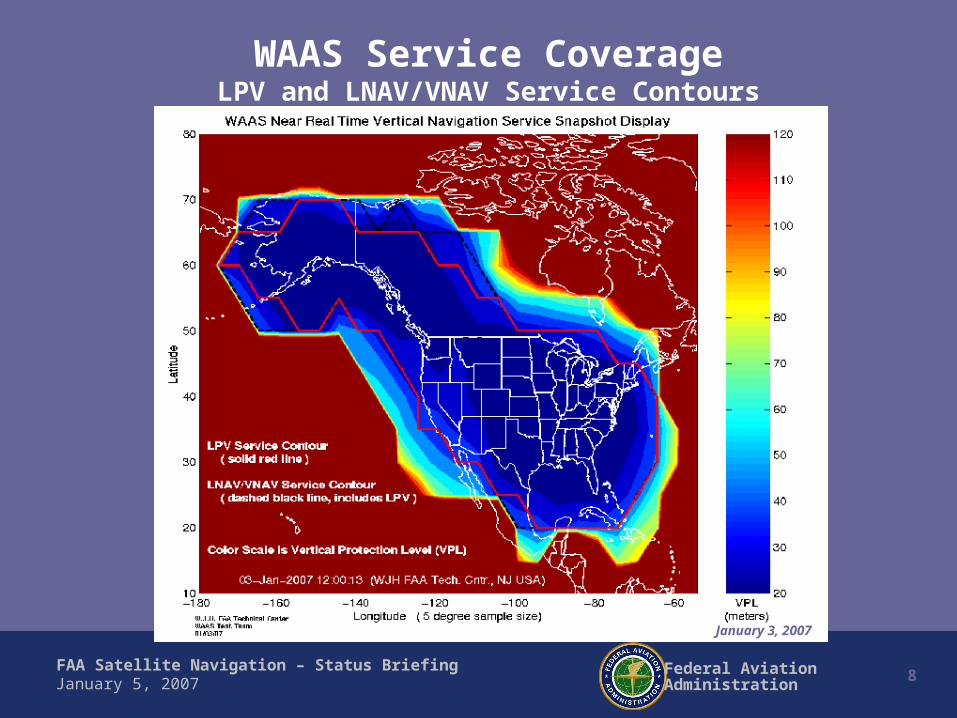
WAAS Service CoverageLPV and LNAV/VNAV Service Contours
November 1, 2006January 3, 2007

FAA Satellite Navigation – Status Briefing9Federal Aviation
AdministrationJanuary 5, 2007
WAAS Service Coverage NPA Service Contour
January 3, 2007

FAA Satellite Navigation – Status Briefing10Federal Aviation
AdministrationJanuary 5, 2007
* As of December 21, 2006
Airports with WAAS (LPV) Procedures
646 Approaches*
FAA Satellite Navigation – Status Briefing11Federal Aviation
AdministrationJanuary 5, 2007
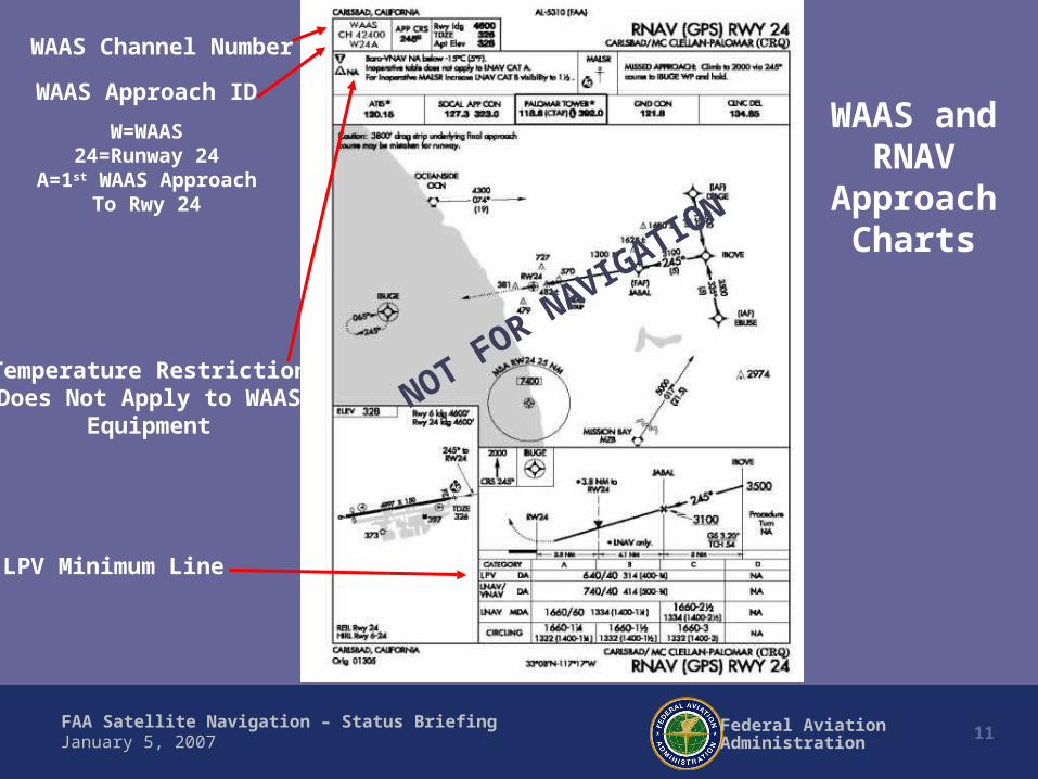
LPV Minimum Line
WAAS Channel Number
WAAS Approach ID
W=WAAS24=Runway 24
A=1st WAAS ApproachTo Rwy 24
Temperature RestrictionDoes Not Apply to WAAS
Equipment
WAAS andRNAV
Approach Charts
NOT FOR NAVIGATION

FAA Satellite Navigation – Status Briefing12Federal Aviation
AdministrationJanuary 5, 2007
WAAS Approach Procedures
Existing Procedures*:– 2,891 GPS NPA – 1,046 LNAV/VNAV– 646 LPVs
* As of December 21, 2006
Procedure Production:– 300 new LPVs each year
(FAA Flight Plan Goal)

FAA Satellite Navigation – Status Briefing13Federal Aviation
AdministrationJanuary 5, 2007
WAAS Avionics
• Avionics– Garmin GNS-480/CNX-80 – Available Now
• Estimated 4,000 units sold (as of late 2006)
– Garmin 400/500 Series Upgrade – Available January 2007• Of the 70,000 units sold, roughly 18,000 have pre-paid for the upgrade (as of late
2006)
– Rockwell Collins unit supporting high-end FMS users (initial delivery to FAA for approval) - Expected March 2008
– Rockwell Collins WAAS LPV Upgrade for Challenger 604 (FAA flight inspection aircraft) - Scheduled for August 2007
– Chelton, CMC, Universal, and Thales – Expected availability 2007/2008

FAA Satellite Navigation – Status Briefing14Federal Aviation
AdministrationJanuary 5, 2007
Preparing Airports for WAAS • WAAS Provides a Space-Based ILS-like Approach
– No ground navigation hardware required– WAAS uses the same ILS obstacle evaluation area and procedure criteria *
• Airport Infrastructure Needed– Paved runways over 3200 ft. long by 60 ft. wide– Non-precision runway markings (or better)– Runway safety zone
• Airport Infrastructure Recommended to Obtain the lowest possible minima– Parallel taxiway (reduces decision height, but not mandatory)– Medium Intensity Runway Lights (reduces visibility and provides for night operations)
• Steps To Prepare Airport1) Review information on getting an instrument approach at: http://avn.faa.gov/index.asp?
xml=ifp/index2) Contact Airport District Office to determine Infrastructure requirements/improvements3) Determine if required level of airport survey exists, is scheduled, or will be acquired.
* The same terrain issues that can prevent an ILS approach also pertain to LPVs.
FAA Satellite Navigation – Status Briefing15Federal Aviation
AdministrationJanuary 5, 2007
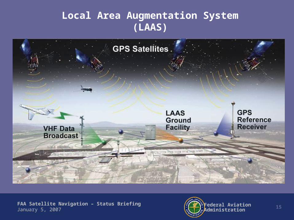
Local Area Augmentation System(LAAS)

FAA Satellite Navigation – Status Briefing16Federal Aviation
AdministrationJanuary 5, 2007
LAAS Benefits
• Precision Approach Service - CAT I/II/III• One LAAS Serves All Runway Ends• Potential for Reduced Facility Costs• Guided Missed Approaches• Provides Guidance for Complex Approaches• Siting Flexibility allows service where ILS Can’t be
installed• May eliminate some ILS Critical Areas• Tighter Spacing Due to More Accurate Navigation• Parallel Simultaneous Instrument Approach Procedures

FAA Satellite Navigation – Status Briefing17Federal Aviation
AdministrationJanuary 5, 2007
Multiple Approach Capability of LAAS
70,000 square mileservice volumecould include
other nearby airports
Similar set of reciprocalway-points can define
missed-approach,go-around procedures,
SIDs and STARs
VDB transmission include• Differential GPS corrections• Final approach segment (FAS)• Way-point data listing blocks• Ground station and approach ID
Omni-directional VDBRadiates out to 150 miles
(line of site)
Pilot selects one of several
“approved” approaches
Control codes selectVHF frequency and
approach listingblocks of way-points
21340
25016
30156
38254
49502
LAAS
GPS RX VHF TX
Angled Approach
Straight Approach
Sectored Approach
Parallel Approach
Curved Approach

FAA Satellite Navigation – Status Briefing18Federal Aviation
AdministrationJanuary 5, 2007
What Is the Status of LAAS?
• In Research and Development
• Initial CAT I Capability Scheduled for 2008
• LAAS Ground System Prototype Being Tested in Memphis
• Avionics Already Available on Boeing & Airbus Aircraft
– Boeing 737 new generation aircraft equipped with Multi Mode Receiver (MMR) Terminal Area
• Procedures Being Developed and Flight Tested at FAA Technical Center
– Flight Tests Completed in Memphis in September 2006 Using FedEx Aircraft
• Prototype LAAS procedures (ILS overlays) developed for Memphis (MEM)
FAA Satellite Navigation – Status Briefing19Federal Aviation
AdministrationJanuary 5, 2007
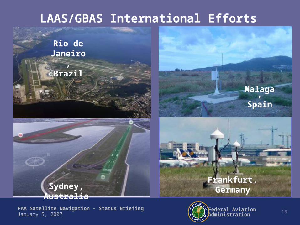
Frankfurt, Germany
Rio de Janeiro,
Brazil
Malaga,Spain
LAAS/GBAS International Efforts
Sydney, Australia

FAA Satellite Navigation – Status Briefing20Federal Aviation
AdministrationJanuary 5, 2007
GPS
Available Now!
Summary
WAAS (SBAS)
Available Now!
LAAS (GBAS)
Scheduled for 2008