f. wentz, t. meissner, j. scott and k. hilburn remote sensing systems [email protected] 2014...
TRANSCRIPT

The Aquarius Salinity Retrieval Algorithm Beyond Version 3.0
F. Wentz, T. Meissner, J. Scott and K. HilburnRemote Sensing [email protected]
2014 Aquarius / SAC-D Science Team MeetingNovember 11- 14, 2014Seattle. Washington, USA

Outline
1. Short Review: V2.0 → V3.0
2. Going Forward: V3.0 → V4.0 → Future

Aquarius Version 3.0Released June 2014
ADPS V2.0 ADPS V3.0Surface Roughness Correction
Based on NCEP wind speeds and scatterometer sigma-0.
Reflected GalaxyPhysical model:
Ocean surface modelled as ensemble of tilted facets: Geometric Optics
Antenna Pattern Correction based on GRASP 2012 computer antenna simulations
Surface Roughness CorrectionBased on Aquarius wind speedsHH-pol scatterometer +
H-pol radiometerReflected Galaxy
Geometric Optics (about 90%)Symmetrization between
ascending and descending swathsAntenna Pattern Correction
Reduced biases over land + iceReduced biases in 3rd Stokes
Q/C and RFI flaggingd_SSS(SST) bias adjustment

Symmetrization of Galaxy Reflections
Month
Latitude
GO (V2.0) GO + empirical adjustment (V3.0)
Ascending Minus DescendingSalinity Differences

SST Dependent BiasesPost-hoc Correction
Caused by SST dependent biases in GMF 0.1 K uncertainty in GMF is 0.2 psu uncertainty in SSS Dielectric constant of seawater Oxygen absorption (non-resonant continuum) Surface roughness model Most likely a combination of such See talk T. Meissner
"Bias adjusted" SSS product is provided in V3.0 in addition to standard product Derived after filtering out rain

Impact on PerformanceLocal Biases
V3.0bias adjusted
V3.0 no adjustment

Antenna Pattern Correction: V2.0 → V3.0 About 1.5% reduction in spillover
Spillover values η from scale model APCross pol values χ from GRASP 2012 AP
Adjustment in the 3rd Stokes couplings
Change in the V/H asymmetry of spillover values of horn 2 and horn 3
A big improvement over V2. Ocean, land, cold space more consistent (4 K for land).
Clear and straightforward documentation (RSS Tech. Report 05192014 and the Revised ATBD).

Impact on PerformanceTriple Colocation Statistics
Global. Rain Filtered
AQ – HYCOM – ADPRC ARGO Differences σ [psu]3o monthly averages
AQUARIUS – HYCOM
AQUARIUS – ARGO
HYCOM – ARGO
V3.0 0.29 0.31 0.25SST Bias adjusted 0.24 0.27 0.25
Estimated Individual Errors σ [psu]AQ – HYCOM – ADPRC ARGO σ [psu]
3o monthly averages (1.5o monthly averages)
AQUARIUS HYCOM ARGOV3.0 0.24 (0.27) 0.16 0.19
SST bias adjusted 0.18 (0.22) 0.16 0.19

Version 4.0• Replace dSSS(SST) correction with Updated Geophysical Model
• Replacement for MWR Rain Flagging and Correction
Future• Continue TB Modeling Research into Causes of Salinity Anomalies
• SST Impact Comparison Study
• Estimate of Error (Cold water, land, galaxy)
• Improved Land Correction: (Hybrid Antenna, Land Emissivity Model)
• Reflected Galaxy (Harmonic Analysis based on SMAP)
Upcoming and Future Work
Improved Geophysical Model
Small errors (0.1K) in model for L-band TOA TB are likely the cause for regional SSS errors of order 0.2 psu.
Dielectric constant of seawaterOxygen absorption (non-resonant continuum)Surface roughness modelMost likely a combination of suchSee talk T. Meissner

Rain Flagging and Correction
NCEP Cloud Water is currently being used for rain flagging and correction
NCEP does a poor job of locating and quantifying rain
NCEP was intended as just a placeholder for MWR, which is great for rain flagging
Alternatives: CMORPH, MW Imager Array
CMORPH has the advantage of always available
Listen to Thomas Meissner Talk
The Rain Splashing Effect
Any splashing effect seems to be removed by the wind correction algorithmAquarius winds may have error, but SSS seem OKHence no additional correction is required

SST Comparison Study
SSS retrievals required that SST be specified: TB(SSS,SST, wind, etc.) 0.5C = 0.2 psu, but not constant Currently using NCEP daily SST product (Reynolds)
Previous studies on the choice of SST product were limited Early (more noisy) versions of SSS Looking for large obvious errors Only 2 products were consider
We will do a more careful and extended impact analysis of choice of SST product Approximately 5 SST products: MW only, IR, Hybrid Coordinate with NASA SST Science Team
Will provide an estimate of error in SSS retrieval due to uncertainty in SST
May result in a change in ancillary SST product for Version updates after V4.

Provide Users with Estimate of SSS Retrieval Error
The SSS retrieval error is a dynamic quantity
Larger in cold water: fairly easy to model using dTB/dSSS High winds will degrade retrievals Biasing close to land Areas of RFI
This is Becoming a Standard Requirement
Formal Approach based on partial derivatives
Empirical Approach based on cal/val experience
RSS experience with MW imagers: a complex problem
But, Aquarius is simpler

Improved Land Correction
Quick Review of Current Land CorrectionDone at the TA LevelReally an Antenna Side-lobe Correction
New Hybrid Antenna Pattern for the SimulationFollowing approach of Emmanuel Dinnat: Remove power from the
back-lobe and put it into main lobe.1.5% reduction in spillover
New Land TB model based on Aquarius Observations

Side-Lobe Correction
Exact TB is simulated as integral of Earth TB over AP.
Need land emissivity model to compute Earth TB.
Correction table is stratified according to the spacecraft nadir longitude, the spacecraft position in orbit, month (climatology), polarization (v-pol, h-pol), and horn (inner, middle, and outer).
How good is our current land emissivity model?
,
3,
3
toa i
dB footprttoa
dB footprt
dA
dA
BE
BE
T
T , , ,ˆ
toa toa toa BE BE BET T TCorrection:Table form
Ocean boresight TB
Exact TBIntegrate over AP
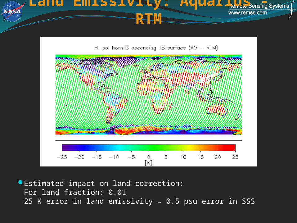
Land Emissivity: Aquarius - RTM
Estimated impact on land correction:For land fraction: 0.0125 K error in land emissivity → 0.5 psu error in SSS

Galaxy Reflections1.4 GHz is a protected band because of the AstronomersGalaxy glows at 1.4 GHz and we see the reflections from the
oceanLargest reflections as large as 5 K (10 psu)Basic geometric optics (tilted mirror-like facets) used as model
Accurate to about 5-10%Residual errors about 0.5 psu
4-fold integral used to compute reflected galactic radiation
New Information and ImprovementsHarmonic Analysis of SMAP ObservationsNew Hybrid Antenna Pattern for the Simulation

Version 4.0• Replace dSSS(SST) correction with Updated Geophysical Model
• Replacement for MWR Rain Flagging and Correction
Future• Continue TB Modeling Research into Causes of Salinity Anomalies
• SST Impact Comparison Study
• Estimate of Error (Cold water, land, galaxy)
• Improved Land Correction: (Hybrid Antenna, Land Emissivity Model)
• Reflected Galaxy (Harmonic Analysis based on SMAP)
Summary