exploring the submerged new world 2009 - noaa ocean
TRANSCRIPT

oceanwww.oceanexplorer.noaa.gov
1
Image captions/credits on Page 2.
Exploring the Submerged New World 2009
What is a Karst?(Adapted from the 2008 Thunder Bay Sinkholes Expedition)
FocusLimestone landforms and aquifers
Grade Level5-6 (Physical Science/Earth Science)
Focus QuestionWhat processes create limestone landscapes and aquifers?
Learning Objectivesn Students will be able to compare and contrast igneous, sedimentary,
and metamorphic rocks, and name examples of each.
n Students will be able to define karst landforms, describe typical features of these landforms, and explain processes that shape them.
n Students will be able to define a sinkhole, and discuss the relevance of karst landforms to sinkholes.
n Students will be able to discuss why sinkholes are promising sites for archaeologists interested in paleoamerican settlements in Florida.
MaterialsFor each student group:q Copy of Karst Inquiry Worksheetq Approximately 50 ml vinegarq Small dish, watch glass, or jar topq Erlenmeyer or Florence flask, 250 - 500 ml, or narrow-neck bottleq Cork or stopper to fit the flask or bottle q One drinking straw for each student; mark one end with a black markerq 100 ml of a slightly basic solution (add a pinch of sodium bicarbonate
(baking soda) to tap water; see Learning Procedure, Step 1)q About 5 drops phenol red indicator solution (Carolina Biological
Supply item no. 879875 or equivalent)q (Optional) Samples of igneous, metamorphic, and sedimentary rocks
Audio-Visual Materialsq None
Teaching TimeOne or two 45-minute class periods
Florida

2
Image captions/credits on Page 2.
www.oceanexplorer.noaa.gov Exploring the Submerged New World 2009: What is a Karst?Grades 5-6 (Physical Science/Earth Science)
Seating ArrangementClassroom style or groups of three to four students
Maximum Number of Students32
Key WordsSinkholeKarst landformIgneousMetamorphicSedimentaryRock cyclesBedrockPaleoamerican
Background InformationNOTE: Explanations and procedures in this lesson are written at a level appropriate to professional educators. In presenting and discussing this material with students, educators may need to adapt the language and instructional approach to styles that are best suited to specific student groups.
Many theories have been suggested to describe the origin of the first humans to inhabit North and South America. Current evidence (Goebel, et al., 2008) indicates that these humans migrated from Siberia around 15,000 years ago crossed a land bridge to the Pacific coast of North America, and continued southward, possibly using boats. Descendants of these migrants spread across what is today the United States, eventually reaching the Atlantic coast. Others continued southward into South America.
Coastal areas inhabited by early Americans are difficult to explore because the coastlines of 15,000 years ago are now under more than 300 feet of water! As the last ice age drew to a close, melting ice sheets caused a rapid rise in sea level just as the first Americans were entering the New World. Drowned settlements may contain well-preserved artifacts that can provide important new information about how the first Americans lived and when they arrived at various locations in North and South America. The eastern Gulf of Mexico, in the vicinity of the Ocala Uplift Zone is particularly promising as a potential location for drowned coastal settlements because:• There are numerous onshore archaeological sites along the same zone
that are more than 13,000 years old;• Clusters of similar sites have been identified along drowned shore-
lines in the northern Gulf of Mexico;• Rivers that discharge into this part of the Gulf do not carry large
quantities of sediment, so sites should not be deeply buried;
Images from Page 1 top to bottom:The eastern Gulf of Mexico showing the three sub-areas examined in 2008, the Florida Middle Grounds, and the Suwanee River paleo channel.http://oceanexplorer.noaa.gov/explorations/09newworld/background/plan/media/fmg_surveyareas.html
During the Late Pleistocene Florida’s shoreline extended much farther offshore than the pres-ent coast. The Florida Middle Grounds were part of the exposed coastal margin.http://oceanexplorer.noaa.gov/explorations/09newworld/background/climatechange/media/pleistocene.html
Map of the Bering land bridge during the late Wisconsin glaciation, when global sea level dropped to about 120 meters or more below its present position.http://oceanexplorer.noaa.gov/explorations/09newworld/background/occupation/media/beringia_late_wisconsin.html
This image portrays a more accurate reconstruc-tion of Ice Age human behavior with a focus on small familial groups and the processing and use of plants as opposed to athletically fit young men attacking large, dangerous animals. http://oceanexplorer.noaa.gov/explorations/09newworld/background/beliefs/media/correctpaleobehavior.html
All images courtesy NOAA.

3
Image captions/credits on Page 2.
www.oceanexplorer.noaa.gov Exploring the Submerged New World 2009: What is a Karst?Grades 5-6 (Physical Science/Earth Science)
• The coastal shelf is gently sloped which would reduce the impact of waves and storms; and
• Rapid sea level rise would have reduced the impact of waves as coastal settlements were inundated.
The geologic conditions that make Florida such a promising source for remains of paleoamerican settlements began over 40 million years ago during the Eocene epoch when the entire region was at the bottom of the ocean. The Florida Plateau is part of the North American tectonic plate that underlies the entire state, and in Eocene times formed an underwater shelf that became covered with shells, coral skeletons, and the remains of other calcifying organisms. Over time, these deposits formed a limestone bedrock several thousand feet deep. When tectonic movements and changing sea levels raised portions of the Florida Plateau above the ocean’s surface, the limestone became exposed to rainwater. Rainwater is slightly acidic because dissolved atmospheric carbon dioxide forms a weak acid (carbonic acid). Rainwater flowing over land surfaces may also pick up organic acids produced by decaying leaves and other once-living material. Limestone rocks are soluble in acid, and the weakly acidic rainwater can slowly dissolve limestone rocks to form caves, springs, and sinkholes. The resulting landscape is called karst. Florida is sometimes nicknamed the “sinkhole state” because the limestone that underlies much of the state contains numerous sinkholes. Sinkholes provide natural reservoirs for fresh water, and this provides the link to paleoamerican settlements.
When the first humans arrived in Florida, sea level was much lower and there was more than twice as much dry land as exists today. The climate was considerably drier, and water was scarce. Not surprisingly, early American settlements that have been discovered in the state are almost always associated with a reliable water supply such as rivers and springs. These areas would also have been attractive to animals, increasing the likelihood that human hunters would be able to find food. So it is not surprising that some of the most artifact-rich paleoamerican sites are located near sinkholes. This association means that archaeologists looking for early American settlements along drowned shorelines of Florida can look for sinkholes as indicators of promising sites.
The Northeastern Gulf of Mexico 2008 expedition focused on ancient river channels in the vicinity of the Florida Middle Grounds, which are now several hundred feet below the Gulf’s surface. Major accomplishments included:• Locating and high resolution mapping of a large, essentially intact,
and infilled ancient river channel several kilometers long, east of the Florida Middle Grounds;
• Identifying additional stream and river channels, some with clearly visible deposits along the banks;

4
Image captions/credits on Page 2.
www.oceanexplorer.noaa.gov Exploring the Submerged New World 2009: What is a Karst?Grades 5-6 (Physical Science/Earth Science)
• Locating and identifying more than 100 sinkhole features filled with material in stratified layers that may contain human artifacts as well as plant and animal material from early American times; and
• Mapping nearly 10 square kilometers of intact, shallow-water, near-shore sand ripples/ridges adjacent to an area that would have been Florida’s shoreline when sea level was at it lowest point during the last glacial period.
The latter achievement is particularly important because it shows that the oldest shoreline is extraordinarily well preserved. Most interesting, though, are the infilled sinkholes with multiple layers of distinct strata. These sinkholes are potentially a treasure trove of new information about the late Pleistocene landscape and environment, as well as about the humans who lived there.
In this lesson, students will investigate some characteristics of karst landforms and the processes that shape these landforms and lead to the formation of aquifers.
Learning Procedure1. To prepare for this lesson:
(a) Review introductory essays for the Exploring the Submerged New World 2009 Expedition at http://oceanexplorer.noaa.gov/explorations/09newworld/welcome.html; and
(b) Review procedures for Karst Inquiry Worksheet activities(c) Prepare solutions for Inquiry Step 4: Add 4-5 drops phenol red indicator solution to about 100 ml tap
water in the flask or bottle. If necessary, adjust the pH so that the solution is red by adding a small pinch of sodium bicarbonate (baking soda). Do not add too much, since if the solution is very basic a lot of blowing will be required to acidify the solution! Test the solution by blowing bubbles through a straw until the color changes to yellow. Then re-adjust the pH with sodium bicarbonate until the solution is red again. Stopper the flask or bottle.
2. Briefly introduce the Exploring the Submerged New World 2009 Expedition. Highlight the timing of human migration into North and South America, and the fact that these people were hunters who co-existed with mammoths, mastodons, sabre-toothed cats, and giant sloths. Briefly explain the relationship between ice ages and sea level. Tell students that the first humans arrived in Florida near the end of the last ice age, and that Earth’s ocean was much lower than it is today. Explain that the climate of Florida was also different, and was much drier. With this information as background, ask students to hypothesize where these humans would have wanted to locate their settlements. Students should realize (possibly with some assistance) that fresh water and food would have been very important considerations, and that springs and lakes could have provided both.

5
Image captions/credits on Page 2.
www.oceanexplorer.noaa.gov Exploring the Submerged New World 2009: What is a Karst?Grades 5-6 (Physical Science/Earth Science)
Do not discuss the formation of sinkholes or karst landscapes at this point, since these are topics for student inquiry.
3. Ask students to define karst landforms. If someone is able to offer an accurate definition, then have them explain how karst landforms are formed. If no one knows what a karst landform is, then tell them that their challenge is to discover what karst landforms are, and how they are formed.
Provide each student group with supplies listed under Materials, and a copy of the Karst Inquiry Worksheet. Depending upon the maturity of students and their ability to follow instructions, you may want to do steps 3 and 4 as group demonstrations. Steps 1, 2, and 5-8 can be done in class if adequate research materials (or Internet access) are available, or can be assigned as homework.
If rock samples are available, you may want to provide each group with an unidentified specimen and have them classify the specimen as igneous, metamorphic, or sedimentary as part of Step 1.
4. Lead a discussion of students’ answers to inquiry topics. The following points should be included:(1) Igneous rocks are formed by the cooling and hardening of
molten rock (magma). Common igneous rocks include:Granite - coarse-grained, speckled appearance; composed primarily
of feldspar and quartz; formed from magma that cooled within the Earth’s crust
Gabbro - coarse-grained, dark color; high content of iron and magnesium; formed from magma that cooled within the Earth’s crust
Basalt - fine-grained rock, dark color; high content of iron and magnesium; formed by magma that cooled on the surface of the Earth or in the ocean
Rhyolite - fine-grained, light colored, composed primarily of feldspar and quartz; formed by magma that cooled on the surface of the Earth or in the ocean
Sedimentary rocks are produced by the accumulation and compression of sediments, and range from fine-grained particles to large irregular fragments such as pieces of shell. Fossils are contained in sedimentary rocks (heat and pressure that form igneous and metamorphic rocks destroy fossil remains). Common sedimentary rocks include:Sandstone - formed from grains of sand produced by the
weathering and breakdown of other rocks; may have a banded appearance if different layers of sediment have been compressed
Shale - formed from silt and clay; easily split along layers of sediment, resulting in flat pieces

6
Image captions/credits on Page 2.
www.oceanexplorer.noaa.gov Exploring the Submerged New World 2009: What is a Karst?Grades 5-6 (Physical Science/Earth Science)
Limestone - formed from calcium carbonate derived from the shells and skeletons of plants and animals; colors range from white to almost black
Chert - composed primarily of silicon dioxide; may be formed from silica-rich skeletons of organisms such as diatoms, radiolaria, and sponges, or by precipitation from silica-rich fluids leached out of magma; flint is a type of chert that has a black or dark gray color
Metamorphic rocks are formed when existing rocks are subjected to extreme heat and/or high pressure. Common metamorphic rocks include:Slate - formed from shales subjected to high pressureSchist - formed from slates subjected to high pressureGneiss - formed from schists subjected to high pressure; if gneiss
is subjected to temperatures high enough to melt the rock, it becomes an igneous rock (granite); this is an example of the “rock cycle”
Marble - formed from limestone
(2) Limestone is a sedimentary rock formed from calcium carbonate.
(3) When limestone is exposed to vinegar, students should observe bubbles forming on the rock’s surface. Students should infer that a chemical reaction is taking place between the vinegar and the limestone. They may also infer that the rock is dissolving. Depending upon students’ familiarity with basic chemistry, you may want to discuss the reaction and identify the gas being produced as carbon dioxide.
CaCO3 + 2(CH3COOH) > Ca(CH2COOH)2 + CO2 + H2O
calcium carbonate + acetic acid (vinegar) > calcium acetate + carbon dioxide + water
(4) After blowing into the flask for a sufficient amount of time, students should observe the color of the solution change from red to yellow, and should infer that gases in their exhaled breaths have caused the solution to become acidic. Students should know that their exhaled breath contains more carbon dioxide than the air they inhale, and may infer that carbon dioxide has caused the solution to become more acidic.
(5) Based on their observations and inferences in Step 4, students should infer that carbon dioxide in the atmosphere may dissolve in rainwater, causing rainwater to become more acidic. Based on observations and inferences in Step 3, students should infer that acidic rainwater falling on limestone rocks may cause the rocks to dissolve.

7
Image captions/credits on Page 2.
www.oceanexplorer.noaa.gov Exploring the Submerged New World 2009: What is a Karst?Grades 5-6 (Physical Science/Earth Science)
(6) A karst landform is an area where limestone is the major rock underlying the land surface (that is, limestone is the bedrock), and the limestone has been partially dissolved to form caves and sinkholes.
(7) A sinkhole is a hole in the ground that is formed when the roof of an underground cave collapses. In Florida and other karst landscapes, underground caves are formed by acidic rainwater that dissolves limestone rock. When the roof of the cave becomes unstable, it collapses to form a sinkhole.
(8) Sinkholes may be filled with water from rain or underground aquifers (aquifers are rocks and sediments that contain large amounts of water). Florida’s climate was much drier when the first humans arrived, so reliable sources of water would have been important to meet the humans’ needs. In addition, places with reliable water would have been attractive to other animals that humans might have used for food.
The BRIDGE Connectionhttp://www2.vims.edu/bridge/ – Type “rain” into the search box on the left side of the page to locate links to lessons and activities dealing with acid rain.
The “Me” ConnectionHave students investigate the primary sources for water supplied to their homes, and whether aquifers are involved.
Connections to Other SubjectsEnglish/Language Arts, Earth Science
EvaluationStudents’ answers to inquiry topics provide a basis for assessment.
Extensions1. Visit http://oceanexplorer.noaa.gov/explorations/09newworld/
welcome.html for more about the Submerged New World 2009 Expedition.
2. Visit http://www.fi.edu/fellows/payton/rocks/lesson.htm for more lesson plan ideas about rocks.

8
Image captions/credits on Page 2.
www.oceanexplorer.noaa.gov Exploring the Submerged New World 2009: What is a Karst?Grades 5-6 (Physical Science/Earth Science)
Other Relevant Lesson Plans from NOAA’s Ocean Exploration Program(The following Lesson Plans are targeted toward grades 5-6)
What’s That? (7 pages, 356k) (from the The Lost City 2005 Expedition)http://oceanexplorer.noaa.gov/explorations/05lostcity/background/edu/media/lostcity05_whatsthat.pdf
Focus - Investigating Lost City hydrothermal field ecosystems by remotely operated vehicles (Life Science/Physical Science)
In this activity, students will be able to describe a sampling strategy for investigating an unknown area, and will be able to explain why this strategy is appropriate for such an investigation; identify and discuss some of the limitations faced by scientists investigating unexplored areas of the deep ocean; and discuss how an autonomous underwater vehicle such as the Autonomous Benthic Explorer (ABE) can contribute to discoveries such as the Lost City Hydrothermal Field.
Shipwreck Explorers(PDF, 299 kb) (from the Lophelia II 2008 Expedition)http://oceanexplorer.noaa.gov/explorations/08lophelia/background/edu/media/shipwreck.pdf
Focus: Marine Archaeology (Physical Science)
In this activity, students use data about the location and types of artifacts recovered from a shipwreck site to draw inferences about the sunken ship and the people who were aboard.
Call to Arms (PDF, 329 kb) (from the Lophelia II 2008 Expedition)http://oceanexplorer.noaa.gov/explorations/08lophelia/background/edu/media/calltoarms.pdf
Focus: Robotic Analogues for Human Structures (Life Science/Physical Science)
In this activity, students will describe the types of motion found in the human arm, and describe four common robotic arm designs that mimic some or all of these functions.
Ship of the Line (9 pages, 293k) (from AUVfest 2008)http://oceanexplorer.noaa.gov/explorations/08auvfest/background/edu/media/shipline.pdf
9
Image captions/credits on Page 2.
www.oceanexplorer.noaa.gov Exploring the Submerged New World 2009: What is a Karst?Grades 5-6 (Physical Science/Earth Science)
Focus: Maritime History (Physical Science/Social Science)
In this activity, students will be able to describe general characteristics and technologies used in 18th century naval ships; draw inferences about daily life aboard these ships; and explain at least three ways in which simple machines were used on these vessels.
Looking for Clues(8 pages, 556k) (from the RMS Titanic Expedition 2004)http://oceanexplorer.noaa.gov/explorations/04titanic/edu/media/Titanic04.Clues.pdf
Focus: Marine Archaeology of the Titanic (Physical Science)
In this activity, students will be able to draw inferences about a shipwreck given information on the location and characteristics of artifacts from the wreck, and will list three processes that contribute to the Titanic’s deterioration.
Wreck Detectives (5 pages, 384k) (from the 2003 Steamship Portland Expedition)http://oceanexplorer.noaa.gov/explorations/03portland/background/edu/media/portlandwreckdetec.pdf
Focus: Marine Archaeology (Physical Science)
In this activity, students use a grid system to document the location of artifacts recovered from a model shipwreck site; use data about the location and types of artifacts recovered from a model shipwreck site to draw inferences about the sunken ship and the people who were aboard; and identify and explain types of evidence and expertise that can help verify the nature and historical context of artifacts recovered from shipwrecks.
Other Resources The Web links below are provided for informational purposes only. Links outside of Ocean Explorer have been checked at the time of this page’s publication, but the linking sites may become outdated or non-operational over time.
http://oceanexplorer.noaa.gov – NOAA’s Ocean Explorer Web site
http://celebrating200years.noaa.gov/edufun/book/welcome.html#book – A free printable book for home and school use introduced in 2004 to celebrate the 200th anniversary of NOAA; nearly 200 pages of lessons focusing on the exploration, understanding, and protection of Earth as a whole system

10
Image captions/credits on Page 2.
www.oceanexplorer.noaa.gov Exploring the Submerged New World 2009: What is a Karst?Grades 5-6 (Physical Science/Earth Science)
Beck, B. 1986. Sinkholes in Florida: an Introduction. Florida Sinkhole Research Institute, College of Engineering, University of Central Florida. Report 85-86-4; available online at ftp://ftp.dep.state.fl.us/pub/geo/FGS_Publications/FGS%20Library%20Documents/SinkholesInFlaAnIntroBeck1986.pdf
http://www.dep.state.fl.us/geology/geologictopics/sinkhole.htm – Web page on Sinkholes from the Florida Department of Environmental Protection
http://centerfirstamericans.org/index.php – Web site for the Center for the Study of the First Americans
http://www.jqjacobs.net/anthro/paleoamericans.html – Online article on issues and evidence relating to peopling of the New World
http://www.nps.gov/history/aad/eam/index.htm – National Park Service Archaeology and Ethnography Program’s Web site, The Earliest Americans
Goebel, T., M. R. Waters, and D. H. O’Rourke. 2008. The Late Pleistocene Dispersal of Modern Humans in the Americas. Science 319:1497-1502.
http://www.fi.edu/fellows/fellow1/oct98/lesson.htm – “Rock Hounds” lesson plans by Tammy Payton, from the Franklin Institute
http://edtech.kennesaw.edu/web/rocks.html – Links to information, activities, and lessons about rocks and minerals; from the Educational Technology Center at Kennesaw State University
http://www.sdnhm.org/exhibits/mystery/fg_timeline.html – Geologic timeline on the “Fossil Mysteries” Web page from the San Diego Natural History Museum
National Science Education StandardsContent Standard A: Science As Inquiry
• Abilities necessary to do scientific inquiry • Understandings about scientific inquiry
Content Standard B: Physical Science• Properties and changes of properties in matter
Content Standard D: Earth and Space Science • Structure of the Earth system • Earth’s history
Content Standard F: Science in Personal and Social Perspectives • Populations, resources, and environments

11
Image captions/credits on Page 2.
www.oceanexplorer.noaa.gov Exploring the Submerged New World 2009: What is a Karst?Grades 5-6 (Physical Science/Earth Science)
Ocean Literacy Essential Principles and Fundamental Concepts
Essential Principle 2. The ocean and life in the ocean shape the features of the Earth. Fundamental Concept a. Many earth materials and geochemical cycles originate in the ocean. Many of the sedimentary rocks now exposed on land were formed in the ocean. Ocean life laid down the vast volume of siliceous and carbonate rocks.Fundamental Concept b. Sea level changes over time have expanded and contracted continental shelves, created and destroyed inland seas, and shaped the surface of land.
Essential Principle 4. The ocean makes Earth habitable.Fundamental Concept a. Most of the oxygen in the atmosphere originally came from the activities of photosynthetic organisms in the ocean.Fundamental Concept b. The first life is thought to have started in the ocean. The earliest evidence of life is found in the ocean.
Essential Principle 5. The ocean supports a great diversity of life and ecosystems.Fundamental Concept c. Some major groups are found exclusively in the ocean. The diversity of major groups of organisms is much greater in the ocean than on land.Fundamental Concept e. The ocean is three-dimensional, offering vast living space and diverse habitats from the surface through the water column to the seafloor. Most of the living space on Earth is in the ocean.Fundamental Concept f. Ocean habitats are defined by environmental factors. Due to interactions of abiotic factors such as salinity, temperature, oxygen, pH, light, nutrients, pressure, substrate and circulation, ocean life is not evenly distributed temporally or spatially, i.e., it is “patchy”. Some regions of the ocean support more diverse and abundant life than anywhere on Earth, while much of the ocean is considered a desert.
Essential Principle 6. The ocean and humans are inextricably interconnected.Fundamental Concept a. The ocean affects every human life. It supplies fresh water (most rain comes from the ocean) and nearly all Earth’s oxygen. It moderates the Earth’s climate, influences our weather, and affects human health.

12
Image captions/credits on Page 2.
www.oceanexplorer.noaa.gov Exploring the Submerged New World 2009: What is a Karst?Grades 5-6 (Physical Science/Earth Science)
Essential Principle 7. The ocean is largely unexplored.Fundamental Concept a. The ocean is the last and largest unexplored place on Earth—less than 5% of it has been explored. This is the great frontier for the next generation’s explorers and researchers, where they will find great opportunities for inquiry and investigation.Fundamental Concept b. Understanding the ocean is more than a mat-ter of curiosity. Exploration, inquiry and study are required to better understand ocean systems and processes.Fundamental Concept d. New technologies, sensors and tools are ex-panding our ability to explore the ocean. Ocean scientists are relying more and more on satellites, drifters, buoys, subsea observatories and unmanned submersibles.Fundamental Concept f. Ocean exploration is truly interdisciplinary. It requires close collaboration among biologists, chemists, climatolo-gists, computer programmers, engineers, geologists, meteorologists, and physicists, and new ways of thinking.
Send Us Your FeedbackWe value your feedback on this lesson.Please send your comments to: [email protected]
For More InformationPaula Keener-Chavis, Director, Education ProgramsNOAA Ocean Exploration and Research ProgramHollings Marine Laboratory331 Fort Johnson Road, Charleston SC 29412843.762.8818843.762.8737 (fax)[email protected]
AcknowledgementsThis lesson plan was produced by Mel Goodwin, PhD, The Harmony Project, Charleson, SC for NOAA’s Office of Ocean Exploration and Research. If reproducing this lesson, please cite NOAA as the source, and provide the following URL: http://oceanexplorer.noaa.gov
13
Image captions/credits on Page 2.
Exploring the Submerged New World 2009: What is a Karst?Grades 5-6 (Physical Science/Earth Science)
www.oceanexplorer.noaa.gov
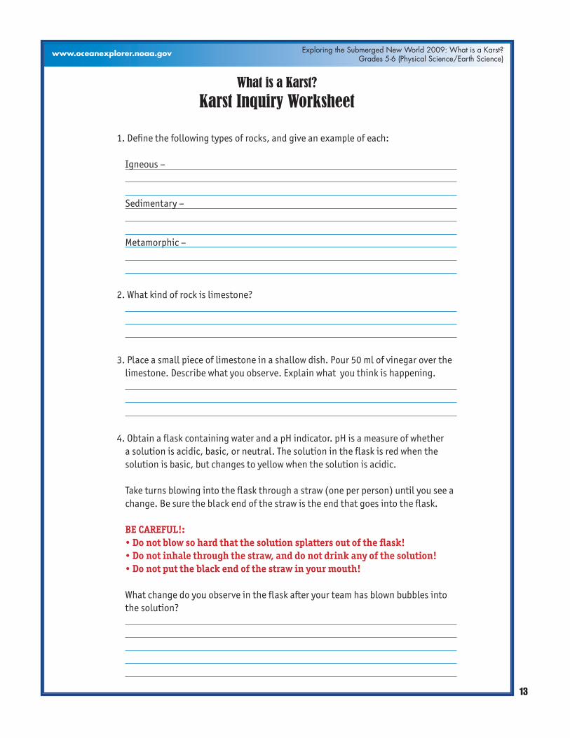
What is a Karst?
Karst Inquiry Worksheet
1. Define the following types of rocks, and give an example of each:
Igneous –
Sedimentary –
Metamorphic –
2. What kind of rock is limestone?
3. Place a small piece of limestone in a shallow dish. Pour 50 ml of vinegar over the limestone. Describe what you observe. Explain what you think is happening.
4. Obtain a flask containing water and a pH indicator. pH is a measure of whether a solution is acidic, basic, or neutral. The solution in the flask is red when the solution is basic, but changes to yellow when the solution is acidic.
Take turns blowing into the flask through a straw (one per person) until you see a change. Be sure the black end of the straw is the end that goes into the flask.
BE CAREFUL!: • Do not blow so hard that the solution splatters out of the flask! • Do not inhale through the straw, and do not drink any of the solution! • Do not put the black end of the straw in your mouth!
What change do you observe in the flask after your team has blown bubbles into the solution?

14
Image captions/credits on Page 2.
Exploring the Submerged New World 2009: What is a Karst?Grades 5-6 (Physical Science/Earth Science)
www.oceanexplorer.noaa.gov
Why do you think this happened?
What gases are in the air from your lungs that you blew into the flask?
5. Air in the atmosphere contains about 3.8% carbon dioxide. What do you think happens when rain falls through the atmosphere?
What do you think happens when rainwater falls on limestone rocks?
6. What is a karst landform?
7. What is a sinkhole? How do you think sinkholes might be formed in areas where there is a lot of limestone rock?
8. Archaeologists who want to find places where the first humans lived in Florida often look for places where there are sinkholes. Why are sinkholes good places to look for prehistoric human settlements? Hint: What is an aquifer?
What is a Karst?
Karst Inquiry Worksheet – 2