explanatory notes on the sir samuel geological sheet...explanatory notes on the sir samuel...
TRANSCRIPT


GEOLOGICAL SURVEY OF WESTERN AUSTRALIA
1 : 250 000 GEOLOGICAL SERIES-EXPLANATORY NOTES
SIR S A ~ U E L WESTERN AUSTRALIA SHEET SG 51-13 INTERNATIONAL INDEX
COMPILED BY J. A. BUNTING AND S. J. WILLIAMS
PERTH, WESTERN AUSTRALIA 1979
77483-1

DEPARTMENT OF MINES, WESTERN AUSTRALIA Minister: The Hon. A. Mensaros, M.L.A.
Under-Secretary: B. M. Rogers
GEOLOGICAL SURVEY OF WESTERN AUSTRALIA Director: J. H. Lord
NATIONAL LIBRARY OF AUSTRALIA CARD NUMBER AND ISBN 0 1244 1140 3

Explanatory Notes on the Sir Samuel Geological Sheet compiled by J. A . Bunting and S. J. Williams
INTRODUCTION The Sir Samuel 1:250000 Geological Sheet, reference SG/51-13 of the Inter- national Series is bounded by latitudes 27'00's and 28"OO'S and longitudes 120"OO'E and 121'30'E. The sheet name is taken from the now abandoned mining town of Sir Samuel (see Appendix 1 for coordinates of localities). The population of the sheet area is small and involved in the pastoral and mineral exploration industries. During the gold and copper mining era four towns were in existence: Sir Samuel, Kathleen, Vivien and Woodarra, as well as several other smaller mining centres all of which are now abandoned. However, nickel mining operations have commenced at Perseverance, and a town (Leinster) is being built near this location to accommodate mining personnel. Yeelirrie and Mount Keith are also potential mine sites. Access within the sheet area is generally good. An all-weather, graded road link- ing Leonora to Wiluna passes through the sheet, and all pastoral homesteads are serviced by graded roads. Most outcrop can be reached by station and mineral ex- ploration company tracks. Travel off the tracks usually presents no problem to four-wheel drive vehicles, except in areas of dense mulga cover or dunes. The climate is semi-arid to arid with hot summers and cool to mild winters. the mean annual rainfall is about 215 mm, but this is unreliable and the area is sub- ject to both drought and localized short-term floods. The first half of the year is generally the wettest. Annual potential evaporation varies from 2 500 mm to 3 500 mm. January is the hottest month with an average maximum temperature of 36°C and an average minimum of 22°C. July is the coolest month with an aver- age maximum temperature of 18°C and an average minimum of 6°C. Vegetation assemblages described by Burbidge (1942) occur throughout the area, and her four subdivisions largely correspond to physiographic units. Floodplain (broad areas of colluvium, alluvium and sheetwash) is characterized by small shrubs and mulga (Acacia spp.) with Cassia sp., Eucalyptus sp. and sandalwood (Santalum sp.) in defined creeks. Hills scrub (rock outcrop and adjacent collu- vium) has mainly mulga (Acacia sp.), with some sheoak (Casuarina sp.), kurra- jong (Brachychiton sp.) and shrubs. Shurb steppe (areas marginal to salt-lakes) carries halophytes such as samphire (Arthrocnemum sp.), saltbush ( A triplex sp.) and bluebush (Kochia sp.). Sandplain is characterized by spinifex (Triodia sp.) and mallee (Eucalyptus sp.).
PREVIOUS INVESTIGATIONS Early regional geological reports covering part of the Sir Samuel Sheet area in- clude Blatchford (1899), Clarke (1925) and Talbot (1928). These reports give very general descriptions of the physiography and geology, and are concerned mainly with the eastern part of the sheet. Descriptions of early gold mining centres, in- cluding some detailed work on local geology, are provided by: Reed (1897) for the Lawlers and Sir Samuel districts; Gibson (1907) for the Sir Samuel and Lake Darlot mines; Talbot (1914) for the Mount Keith Mines; and Jutson (1914, 1917) and Montgomery (1909, 1928), for the deep lead at Darlot. The discovery of major nickel deposits in the Agnew-Mount Keith belt in 1968-71 initiated a perioa of intensive exploration activity. This has resulted in several papers describing the deposits and their exploration (Martin and Allchurch, 1976;
1 77483-2

Burt and Sheppy, 1976; Turner and Ranford, 1976; Burt and Sheppy, 1975). The discovery of uranium at Yeelirrie also produced an exploration boom, resulting in research into the genesis of calcrete-type uranium deposits (Langford, 1974; Mann, 1974). Durney (1972) recognized a major unconformity within the Archaean succession at Jones Creek at which, for the first time in the Eastern Goldfields Province, part of the layered succession was found in unconformable contact with granitic rock. Aeromagnetic and radiometric surveys of the Sir Samuel Sheet were carried out by the Bureau of Mineral Resources (Shelley and Waller, 1967).
PHYSIOGRAPHY The main physiographic features are presented in Figure 1. The area is character- ized by low relief with a range in elevation from about 430m to 650m. Two major drainage divides trend approximately northwest, splitting the area into three main trunk valley systems. The overall gradient is to the southeast and is very gentle (the Lake Miranda-Lake Darlot system falls 60 m in 175 km across the sheet area, an average fall of 34cm/km). The trunk valleys form part of an in- tegrated but now largely inactive drainage system of Cretaceous to Early Tertiary age which can be recognized throughout much of the arid interior of Western Australia (Bunting and others, 1974). The drainage divides are marked for much of their length by lines of low cliffs, or breakaways, in lateritized bedrock. The breakaways define the eroding edge of an old erosion surface (Jutson, 1934) and are predominantly southwest-facing. Traces of the inactive drainage system can be found on top of the old surface. Below the breakaways, the gentle slopes of the main trunk valleys form a new erosion sur- face produced by active but intermittent drainage. The presence of old and new erosion surfaces is an important feature of the region, but, while the distinction between the two surfaces is readily apparent in areas of breakaways, elsewhere the distinction is not obvious, and its usefulness as a means of describing the physiography is limited. Therefore for the purposes of this report the physiography has been divided into three groups (Fig. 1): I ) eroding areas; 2) intermediate areas; 3) saline drainages. Group 1 includes all areas of higher relief, such as outcrop, breakaways and later- ite hills, and their associated pediments. The greenstone belts form ranges of low hills which in places are very rugged. Hills in these areas are commonly elongated parallel to the strike of bedrock foliation or primary layering, whichever is domi- nant. Chert and banded-iron formation form long, resistant strike-ridges (e.g. Mount McClure, Mount Harold). Granitoid rocks can form spectacular tor and domed features (e.g. Mount Macdonald), but more commonly form sheets or bouldery hills. Breakaways are formed in the weathering products of most rock types, but are best developed in weathered granitic rock. Group 2 can be subdivided into two units: a) sheet-wash plains and valley floors which unit includes flat, mulga-covered plains of clayey colluvium and alluvium, with wide, poorly defined drainages characterized by thick vegetation; and b) eolian sandplain, which is gently undulating, and contains patchy development of longitudinal dunes 3 to 5 m high, and up to 3 km long. The dunes, in three widely separate areas (west of Wonganoo, north of the Barr Smith Range, and northwest of Agnew) trend consistently northwest. The sandplain in places preserves tributary valleys of the palaeo-drainage system. Group 3 represents the infilling of trunk drainages in the Cretaceous-Tertiary palaeodrainage system. Three physiographic units are present: a) flat, bare salt lakes containing saline clay, which collect shallow saline water after heavy rain; b) dunes and sheets of eolian and alluvial deposits marginal to salt lakes (this unit is
2

w
15808
usually covered by samphire or saltbush and contains numerous small claypans); and c) calcreted valley floors in which low mounds of rubbly calcrete are separ- ated by soil-filled depressions.
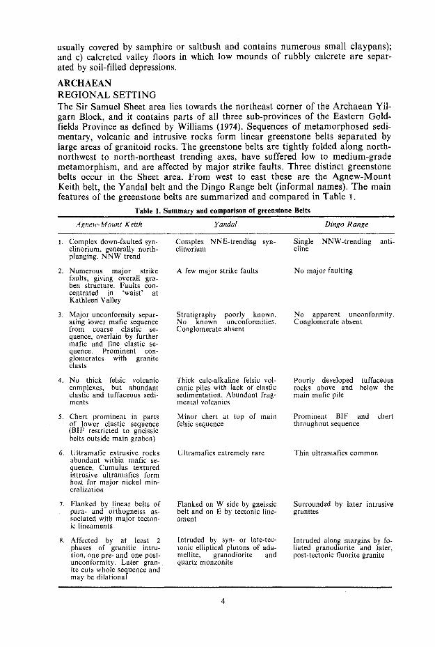
ARCHAEAN REGIONAL SETTING The Sir Samuel Sheet area lies towards the northeast corner of the Archaean Yil- garn Block, and it contains parts of all three sub-provinces of the Eastern Gold- fields Province as defined by Williams (1974). Sequences of metamorphosed sedi- mentary, volcanic and intrusive rocks form linear greenstone belts separated by large areas of granitoid rocks. The greenstone belts are tightly folded along north- northwest to north-northeast trending axes, have suffered low to medium-grade metamorphism, and are affected by major strike faults. Three distinct greenstone belts occur in the Sheet area. From west to east these are the Agnew-Mount Keith belt, the Yandal belt and the Dingo Range belt (informal names). The main features of the greenstone belts are summarized and compared in Table 1.
Table 1. Summary and comparison of greenstone Belts
/Ignew-Moun? Kei?h Yandal Dingo Range
1. Complex down-faulted syn- clinorium, generally north- plunging. N N W trend
2. Numerous major strike faults, giving overall gra- ben structure. Faults con- centrated in ‘waist’ at Kathleen Valley
3. Major unconformity separ- ating lower mafic sequence from coarse clastic se- quence, overlain by further mafic and fine clastic se- quence. Prominent con- glomerates with granite clasts
4. N o thick felsic volcanic complexes, but abundant clastic and tuffaceous sedi- ments
5 . Chert prominent in parts of lower clastic sequence (BIF restricted to gneissic belts outside main graben)
6 . Ultramafic extrusive rocks abundant within mafic se- quence. Cumulus textured intrusive ultramafics form host for major nickel min- eralization
7. Flanked by linear belts of para- and orthogneiss as- sociated with major tecton- ic lineaments
8. Affected by at least 2 phases of granitic intru- sion, one pre- and one post- unconformity. Later gran- ite cuts whole sequence and may be dilational
Complex NNE-trending syn- clinorium
A few major strike faults
Stratigraphy poorly known. No known unconformities. Conglomerate absent
Thick calc-alkaline felsic vol- canic piles with lack of clastic sedimentation. Abundant frag- mental volcanics
Minor chert at top of main felsic sequence
Ultramafics extremely rare
Flanked on W side by gneissic belt and on E by tectonic line- ament
Intruded by syn- or late-tec- tonic elliptical plutons of ada- mellite, granodiorite and quartz monzonite
Single NNW-trending anti- cline
N o major faulting
No apparent unconformity. Conglomerate absent
Poorly developed tuffaceous rocks above and below the main mafic pile
Prominent BIF and chert throughout sequence
Thin ultramafics common
Surrounded by later intrusive granites
Intruded along margins by fo- liated granodiorite and later, post-tectonic fluorite granite
4

Most of the granitoid rocks in the Eastern Goldfields were emplaced in the period 2700 to 2550 m.y. ago (Arriens, 1971). With the exception of some fluorite-granite and syenitic rocks on the eastern side, all the granitoid rocks in the sheet area probably fall within this range. Generally the granitoid rocks are younger than the layered succession. Gneissic rocks of possibly older age form linear belts along some greenstone belt margins.
THE LAYERED SUCCESSION Ulframafic rocks The ultramafic rock group comprises intrusive peridotite and dunite (Aup), strati- form piles of peridotite lava (Aus), altered high-Mg basalt (Aur), and alteration products of peridotite which consist of schistose talc-carbonate-chlorite-serpentine assemblages (Aue). The intrusive rocks are largely serpentinized, but cumulus textures are well pre- served. Peridotite-dunite bodies occur as concordant sills within piles of ultramafic flows (see below), and as sub-concordant ?post-folding intrusions. The most im- portant of these is the Mount Keith intrusion, which extends intermittently over a distance of 200km from Weebo in the Leonora Sheet area, through the Per- severance and Mount Keith areas to beyond Wiluna, and which contains several major nickel deposits (Fig. 2). Over most of its length the intrusion has the ap- pearance of a near-vertically ernplaced dyke (Burt and Sheppy, 1976; Binns and others, 1975) in which a nickel sulphide-bearing dunitic core is flanked by narrow peridotitic and pyroxenitic margins. At Perseverance the intrusion is dunitic, and contains massive sulphides near the western contact; this has been interpreted by Martin and Allchurch (1976) as the product of gravity differentiation in a sub- horizontal (now vertical) sheet. The enigma of these two modes of formation in what appears to be the same intrusion has yet to be resolved. The Mount Keith intrusion and nearby smaller peridotite intrusions appear to have been emplaced along faults associated with the Keith-Kilkenny Lineament. This appears to represent a major fracture zone which tapped the upper mantle, and which allowed ultrarnafic magma to intrude the supracrustal rocks. Within these fractures the magma differentiated to dunitic, peridotitic and pyroxenitic types. Binns and others (1975) point out that the fractionation along the length of the Mount Keith intrusion coincides with a variation in grade of metamorphism, and that this may be due to the exposure of progressively higher levels of the dyke from south to north. A tilt of only a few degrees would be sufficient to account for the variation. Peridotitic lavas are present at Mount Roberts and northeast of Mount Keith homestead. Near Mount Keith, the flows display an upper zone of spinifex-tex- lured pyroxene-rich peridotite containing minor tremolite and some relict olivine, and a lower zone of granular or porphyritic olivine-rich peridotite. The olivine- rich peridotite contains cumulus euhedral olivine and long-bladed grains, suggest- ing that the flow extruded as a crystal mush which rapidly differentiated and crys- tallized. Vesicles in the olivine-rich peridotite testify to its extrusive origin. At both localities, the extrusive piles are intruded by stratiform peridotite sills. A more clearly exposed pile of similar flows at Mount Clifford, 60 km southeast of Agnew, has been described in detail by Barnes and others (1974). The high-Mg basalt suite consists of tremolite-actinolite-chlorite-talc assem- blages and is similar to the komatiites of South Africa (Viljoen and Viljoen, 1969a). These rocks occur as concordant or sub-concordant units within piles of tholeiitic basalt. They are usually schistose due to alignment of amphibole and chlorite, but in places a relict texture preserves the branching form of former py roxene.
5 71483 3

- ;2iiopb + +
+ + + c + + +
+ + + t i + + + + +
t i + + + + + I - + + + + + + t + + +
+ + + + + + + + + + + + + + i + +
+ + + + + + + "?-' i + + + + + + + + + i i t + + + + + + + i Keith
i t + + + + + + + + + i + + +
FIGURE 2
AGNEW-MT KEITH REGIONAL GEOLOGY
0 20
km I
+ + + + + + + + + t + + + + + + + + + + + + + + + + + + + -,+ + + i + + i i i \+ i + i + i i i +
i + + +
k----L-& i f + +++ ... + + + + + p-. - _ _ \+i c i + t
C T f f i i + + i t + + t i i i + i + i i + i i i t + i
+ i f + + + + + + + + + + i f + +
+ + i f + + + + - + f i * f i i
+ + f + i i + L=PF i i i f i i
t i t + + + i + i f + + + i +
t i i i + + + + + i f + i i i i 4 - i + i + i i i i + + + +
t i + Y + + i f + + + + + + + + i t + + i i i + i + + i + + i +
t i i i i
f i i i i i f + + + + + + + + + + i f + i i i i + + + + i t + + + + f + i + + + +
+ + + + + + + i i
+ i f +
C i i i + + i f
t i i i + + +
+ i t + + i i +
i f + + + + i f +
15809
R E F E R E N C E
il Granitic rucks
pJ Gneiss
Arkore and conglomerate
Pellie. yrevwacke
.I Felsic volcanitr
Mafic voIcanics
Layered metayabhro
Uitramafic voicanics
uitiarnaftc m w w e
%% Antrcline and Svnciine
X Nickel mine or prospect
K K L KeMi Ki lkenv j Lrneainent
MF Miranda Fault
PF Perseverance Fault
L A Leinstei Anticline
WS Mt White Syncline
A A Agnew Anticl ine
6

Table 2. Chemical analyses of rocks from the layered succession
G.S. W . A . No. 40361 40338 43332 42821 43330 43331 42820 42822 42827
52.2 49.2 51.1 52.9 56.1 69.4 5.7 15.6 15.6 14.9 16.4 13.8 1.4 2.1 2.4 I .8 2.4 0.6 6.49 9.64 8.88 8.88 5.28 S.21
15.8 8.6 6.8 5.9 4.9 1 .o 15.35 12.53 12.36 8.68 8.77 1.53 0. I6 1.46 1.48 3.16 2.19 4.73 0.3 0.2 0.2 0.3 0.6 1.6 2.19 1 S O 1.88 2.87 2.92 I .86 0.19 0.12 0.00 0.00 0.00 0.00 0.21 0.14 0.00 0.00 0.00 0.00 0.26 0.76 0.99 1.06 0.79 0.88 0.11 0.15 0.20 0.22 0.26 0.23 0.25 0.27 0.24 0.29 0.13 0.11
79.1 76.9 75.6 11.0 12.2 12.6 0.2 0.0 0.5 1.29 1.22 1.16 0.1 0.0 0.1 0.25 0.23 1.64 1.69 2.43 4.13 5.9 6.3 2.6 0.47 0.51 0.67 0.00 0.00 0.09 0.00 0.00 0.43 0.08 0.10 0.20 0.06 0.07 0.08 0.03 0.02 0.06
TOTAL 100.6 102.3 102.1 101.0 100.7 101.0 100.2 100.0 99.9
Ba ppm Be* Cr Cu* Li* MnO* MO* Ni Pb* Rb Sn* Sr Th U* V* W* Zn* Zr k * N b
140 45
840 340
8 16
750 1
350
2350
1 2 2
60
180
L
190
2040
140 240 108 12
580 0.5
60
220 1195 975 3.0
180 140
10 5
45 80
30
10
45
10-100
25 30 25
10-100
35
1-10
30 70
3 135
6 2
10-100 10-100
190 235 290 2
148
360 2
135
160 15 2 1
72 71
35 40 1
13 1
52 85
180
L
17 30 45 30 90
4 7 11 19 24 20
*Analysis by chemical methods (all others by X-ray fluorescence)
La1 27' 28'00" 27"46'10" 27" 38'20" 27'40'00' 27"53'15" 27°53'00" 27"40'00" 27°40'00" 27°41'00"
Long 1 20° 34'30'' 120" 39' 10" 120" 33'20" 12 I " 1000" 121° 1020" 121° 1 0 1 5 " 121 "09'50' 121 "09'50" 121'1 1'30"
40361 40338 43332 4282 1 43330 4333 1 42820 42822 42827
Meta-high-Mg basalt Metabasalt. Perseverance area Metabasalt, Sir Samuel Metabasalt, 2 km SE of Katherine Well Meta-andesite, Spring Well area Crystal-lithic tuff, Spring Well Crystal tuff, Katherine Well area Crystal-vitric tuff, 2 km S E of Katherine Well Mylonitized porphyry, 2 km E of Yandal Lagoon
A chemical analysis (Table 2) of a tremolite rock containing minor relict cli- nopyroxene from 4 km south of Six Mile Well shows similarities with the "Bad- plaas" type komatiite from South Africa (Viljoen and Viljoen, 1969a). It has an MgO content of 15.8 per cent and CaO/Al,O, ratio of 2.7 which is unusually high for the Eastern Goldfields where high-Mg basalts generally have ratios of less than 1.0 (Hallberg and Williams, 1972).
7

aJic extrusive rocks Most of the metamorphosed basaltic rocks are included under the general symbol Ab. They are fine-grained, poorly foliated featureless rocks, although occasionally they are vesicular and porphyritic. The symbol Abi indicates abundant pillows. Vague pillow shapes are present in places in otherwise featureless metabasalt, and in such cases the Ab symbol is retained. Metabasalt with abundant secondary car- bonate (Abk ) is present southeast of Katherine Well. The rnetabasalt typically has a relict igneous texture, in which small plagioclase laths, occasionally showing crude flow alignment, are set in a fine mosaic of pale- green amphibole (usually actinolite) with minor epidote, quartz and sphene. Plagioclase commonly retains its original composition of zoned labradorite-ande- sine, but in places it is replaced by calcic oligoclase.
With increasing dynamic regional metamorphism primary igneous texture is des- troyed, a strong penetrative foliation develops and the rock is termed amphibolite (Aba). This unit is generally restricted to the margins of the greenstone belts, ex- cept for some amphibolite in the Kathleen Valley area which may be related to deformation associated with the convergence of major strike faults. Foliation and lineation are defined by alignment of bladed, green amphibole poikiloblasts (usually hornblende) in a mosaic of plagioclase and minor quartz. In the Kathleen Valley area some amphibolites are derived from mafic sediments and are desig- nated Asm. These are described in more detail in the section dealing with meta- sediments. Where the origin is in doubt the symbol Aba is used.
Analyses of metabasalt from the Perseverance area and Mount Goode (Table 2) are comparable with tholeiites from elsewhere in the Eastern Goldfields (Hallberg, 1972). Nesbitt and others (1975) report that metabasalts from the upper and lower mafic sequences in the Agnew area (in the Mount White Syncline and Agnew An- ticline respectively-Nesbitt, written cornm.) are indistinguishable on chemical grounds.
MaJic intrusive rocks edium- to coarse-grained mafic intrusive rocks ( A d ) are widely distributed
c, felsic and sedimentary sequences, commonly as concordant neralogically these rocks are similar to the metabasalts, and
consist primarily of pale green amphibole (usually actinolite) and plagioclase. Primary gabbroic and doleritic textures are commonly preserved, and in some cases relict clinopyroxene occurs as cores within the actinolite prisms. The pres- ence of oscillatory labradorite indicates a lack of recrystallization of plagioclase retrogression during the static metamorphism. As with the metabasalt, increasing dynamic metamorphism of the gabbro and dolerite produces amphibolite, but this has not been distinguished on the 1:250000 map.
A variation in the norm rnafic intrusives occurs near Mount Goode, Mount Doolette and Qckerburry ill, where metadolerite contains altered phenocrysts of plagioclase up to 3 cm long (Adp).
I n the Spring Well felsic volcanic complex, and 2 km east of Katherine Well, metagabbro and fine-grained metadolerite contain primary orthopyroxene and cli- nopyroxene, both largely replaced by tremolite-actinolite. West of Kathleen Valley, a composite layered mafic intrusion has been informally named the Kathleen Valley gabbro. Rock types range from anorthosite to amphi- bolitized pyroxenite, but most of the body is gabbroic. Original igneous textures and Loned plagioclase (labradorite) are preserved, but the original mafic mineral ('~clinopyroxene) is entirely altered to blue-green acicular, or fibrous, amphibole.
8

The body consists of four units trending east-northeast and dipping steeply north. Differentiation indicates the body is overturned. From base to top the units are: ( 1 ) Layered gabbro with 2 to 10m banding due to varying proportions of amphi- bole and plagioclase (Adjl) . Plagioclase phenocrysts are common. (2) Anorthositic gabbro (Adja). This unit varies from anorthosite to leucogabbro, but there is no banding. The original (?)clinopyroxene, now fibrous amphibole, formed poikilitic crystals up to 5 cm across which contained up to 90 per cent eu- hedral plagioclase and thus produced a net-like effect.
(3) Quartz gabbro (Adjq). This is a fairly homogeneous unit in which quartz varies from 2 to 5 per cent. A primary flow foliation of euhedral plagioclase laths is well preserved in places.
(4) Tonalite, quartz diorite and quartz gabbro (Adjt) . In the tonalitic varieties, up to 30 per cent quartz is present, and a granophyric texture is preserved. Garnet is common close to the contact with the underlying quartz gabbro unit. The unit is interpreted as an early differentiate of the main gabbro which was statically meta- morphosed by a later magma pulse.
Thus the Kathleen Valley gabbro is a multiple intrusion with at least two periods of magma emplacement. The gabbro was intruded by dolerite dykes prior to re- gional metamorphism. A 5-m-wide xenolith of anorthosite 4 km west of Six Mile Well, and numerous enclaves of metamorphosed porphyritic gabbro in adamellite west of Blow Well indicate that the granitic rocks to the north are younger than the gabbro.
Felsic extrusive, intrusive and fragmental rocks The predominant rock type is a fine to medium-grained tuffaceous rock (Afx), with or without a sedimentary clastic component. In the Spring Well area such rocks contain large volcanic fragments and have the symbol Afv. Felsic lava (AJI) has been mapped at numerous localities, but thin section examination has shown many of them to tuffaceous. Where felsic volcanic rocks are too schistose to be subdivided they are given the symbol Afi. uartz-feldspar porphyry (Ap) in- trudes mafic or felsic rocks; in places it is di It to distinguish from quartz and feldspar-phyric lava or crystal tuff. Cornpositionally most of the felsic volcanic rocks are dacite or rhyodacite, although rhyolite is present east of Katherine
The Spring Well complex west of Melrose is a major felsic volcanic centre com- prising a thick pile of coarse fragmental rocks with associated tuffs, lavas and in- trusive rocks, which overlie a thick mafic sequence to the sou occupies the area betweeen Mount Doolette, Jarrah Well and possible extensions across strike to Ockerburry ity of Katherine Well. The fragmental rocks in the main part of the complex con- tain abundant fiamme and glassy shards which exhibit eutaxitic textures and may in part be ignimbritic. The coarser fragmentals contain angular blocks up to 50 cm across of quartz and feldspar-phyric lava and crystal tuff. These fragments commonly possess reaction rims and must therefore have been cold when incorporated into the hot matrix. The matrix contains quartz and feldspar crystals, small devitrified glass shards, and larger fiamme which are probably collapsed pumice fragments. A streaky flow foliation is developed in the matrix. The finer-grained fragmental rocks are similar to the matrix of the coarser varieties, and can be described as welded crystal-vitric tuffs. The fragmental rocks are interpreted as a pile of ignimbritic ash Rows that in places carried along cold blocks. The lack of any clastic sediments or cherts and welding of the tuffs suggest a subaerial environment.
9

The felsic volcanic rocks of the Spring Well complex are laced with sinuous dykes of vesicular andesite and basalt that truncate the primary layering. A faint origi- nal flow alignment of plagioclase laths is preserved, along with relict clinopyro- xene and occasionally orthopyroxene. To the northwest of the Spring Well complex, across the strike of the primary layering, the rocks become finer grained, and the tuffaceous rocks acquire a sedi- mentary clastic component. At Ockerburry Hill, tuffaceous sediments interbedded with chert and pyritic black shale probably mark the top of the felsic volcanic pile. East of Katherine Well, along strike from the main centre of activity, coarse frag- mentals are rare, and there is a clastic component in some of the rocks. T o the north the proportion of clastic material increases until the rocks are pre- dominantly shales, siltstones and fine sandstones. Chemical analyses of felsic volcanic rocks are given in Table 2. The agglomerate matrix from Spring Well (Sample 43331) is typical of the flow-banded crystal-vit- ric tuff at this locality, and its chemical composition is that of a dacite. Two fine- to medium-grained crystal-vitric tuffs (42820, 42822) from southeast of Katherine Well are similar in appearance, both in thin section and outcrop, to the finer grained rocks at Spring Well, but chemically are rhyolites. Recent work by Gower (1974) and Hallberg and others (1976) has revealed the presence of calc- alkaline felsic volcanic centres at Laverton and Marda respectively. The occurrence of rocks ranging from basalt (sample 42821) through andesite (43330), dacite and rhyolite at Spring Well places this complex in the calc-alkaline field alongside Laverton and Marda. Comparison with the AFM plot of the Marda complex (Hallberg and others, 1976) shows that the Sir Samuel rocks, with the exception of the rhyolites, are slightly alkali deficient and iron rich. The good exposure and lack of secondary alteration in the Spring Well area makes this a highly suitable area for further work on the genesis of Archaean felsic volcanic corn plexes. In the Mount Keith belt felsic tuffaceous rocks with minor lavas form the bulk of the sequence north of Mount Keith, but elsewhere they are restricted to a tuf- faceous component in some of the metasediments. The sequence north of Mount Keith is predominantly dacitic to andesitic (Burt and Sheppy, 1976) and in places a flow alignment of plagioclase laths is well preserved. In the Dingo Range belt, the only representatives of the felsic volcanic suite are a few small porphyry bands near Mount Mundy and some tuffaceous rocks northwest of Wonganoo.
Clast ic metasedimen tary rocks Polymictic conglomerate (Asc) contains clasts of granitic rocks, felsic porphyry, chert, minor metabasalt, metagabbro and chlorite-amphibole schist, in an arkosic, mafic, or ultramafic matrix. The clasts are commonly flattened within the matrix schistosity, particularly where the matrix is mafic and the matrix:clast ratio is high. Arkosic matrix is similar to that in the oligomictic conglomerate (described below). Mafic or ultramafic matrix is strongly schistose and consists of chlorite and tremolite/actinolite, with variable amounts of quartz and plagioclase. The clasts in the oligomictic conglomerate (Aso) are almost entirely granitic. They are commonly well rounded, very closely packed, and range in size from a few centimetres to over 1.5 m. The unconformity with the underlying adamellite is well exposed at Jones Creek (Durney, 1972). In emhayments in the unconformity, the blocks are angular and lithologically identical to the underlying adamellite. The unconformity is less well exposed in the Kathleen Valley area, where it is in part strongly sheared, but in places a band up to a few metres thick contains mafic fragments where the conglomerate overlies mafic rocks. The matrix of the
10

granite-clast conglomerate consists of quartz, plagioclase microcline, biotite, mus- covite and epidote. Textures are largely recrystallized, and there is a preferred orientation of quartz, feldspar, and secondary mica. Arkose (Am) occurs as bands within conglomerate in the Jones Creek-Kathleen Valley area, but near Agnew it predominates over conglomerate. Feldspathic sedi- ment near the eastern margin of the Yandal belt, north of Yandal, has been in- cluded under Asa, and probably derives from erosion of penecontemporaneous fel- sic volcanic rocks. The arkose in the Jones Creek-Kathleen Valley area and northwest of Agnew is similar to the matrix of the oligomictic conglomerate. It grades into the con- glomerate by the incorporation of scattered pebbles and also grades into fine sandstone and shale. Cross-bedding and scour structures are common. In the Agnew-Mount Keith belt, and to a lesser extent the Yandal belt, there are rare bands up to about 100m thick of schistose mafic and ultramafic rocks with unusual compositions and textures. A fine banding is common. Northwest of Agnew, and in the Jones Creek-Kathleen Valley area, these rocks contain scat- tered granitic pebbles and grade into mafic- and ultramafic-matrix conglomerate. They are thus regarded as metamorphosed mafic and ultramafic sediments (Asm). A common assemblage is tremolite and chlorite, with variable amounts of plagio- clase and quartz. De la Hunty (1960) recognized the sedimentary origin of ultra- mafic schist from drillholes west of Agnew, because of the presence of small por- phyry and quartz pebbles. Immediately southeast of Mount Mann quartz-chlorite schist and intercalated quartz-andalusite-muscovite schist contain abundant rutile. The depositional environment of the conglomerates and related arkose is discussed by Marston and Travis (1976) and Donaldson and Platt (1975). Marston and Travis suggest accumulation as alluvial fans along a fault-controlled elongate basin. Donaldson and Platt recognize a progradational sequence west of Agnew, from a lower deltaic environment through a braided river, or alluvial-fan or sheet- flood environment (pebbly arkose), to an upper conglomeratic alluvial fan envi- ronment. In most of the oligomictic conglomerate the granite boulders a re too rounded and too closely packed for normal alluvial fan conditions. The roundness also precludes a talus deposit, although angular clasts in the unconformity ernbay- ments may be of such an origin. The high degree of roundness indicates a high- energy environment, and the very close packing suggests that the clasts may have accumulated as an openwork gravel such as a beach or river gravel (R. D. Gee, pers. comm.). The voids would then be filled in by matrix sand associated with ar- kose development. Bedding lamination is recognizable in the sandstone filling some of the voids. A possible mode for the development of the Jones Creek Con- glomerate in the Jones Creek-Kathleen Valley area is as follows: a rapidly subsid- ing, fault-bounded, elongate trough was flanked, at least to the west, by a rapidly eroding upland area. The erosion products were transported a very short distance (via talus slopes and small alluvial fans) to a high-energy shoreline. Periods of emergence produced more extensive alluvial fans, with associated sheet-flood de- posits which occasionally covered the underlying beach deposits. Fine-grained clastic rocks of various types are designated Ass. They include black shale, mudstone, siliceous shale, feldspathic shale, and their metamorphosed phyl- litic and schistose equivalents. The shales are commonly finely laminated and fis- sile, and may contain thin greywacke bands. Where greywacke is predominant over shale the symbol Asg is used. As well as forming major units by itself, shale can occur as thin bands scattered throughout most rock types of the layered suc- cession. Graded bedding is common in some greywacke/shale units, but sedi- mentary structures are generally lacking. Porphyroblastic andalusite is common in some quartz-muscovite schists, giving them a knotted appearance. Fine-grained,
1 1
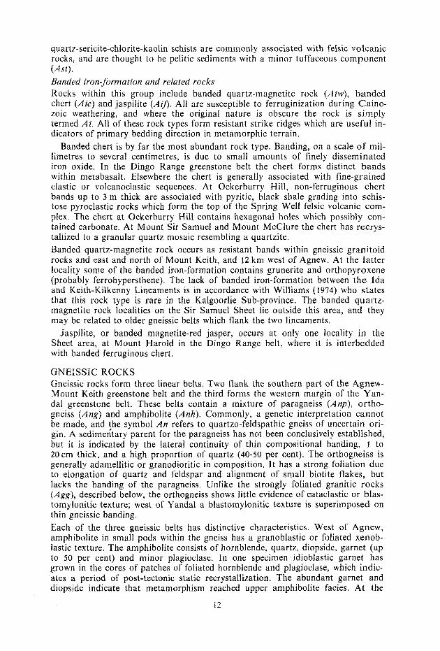
quartz-sericite-chlorite-kaolin schists are commonly associated with felsic volcanic rocks, and are thought to be pelitic sediments with a minor tuffaceous component (Ast).
nded iron-formation and related rocks ocks within this group include banded quartz-magnetite rock (Aiw), banded
chert (Aic) and jaspilite (AiJ). All are susceptible to ferruginization during Gaino- zoic weathering, and where the original nature is obscure the rock is simply termed Ai. All of these rock types form resistant strike ridges which are useful in- dicators of primary bedding direction in metamorphic terrain.
nded chert is by far the most abundant rock type. Banding, on a scale of mil- res to several centimetres, is due to small amounts of finely disseminated
iron oxide. In the Dingo Range greenstone belt the chert forms distinct bands within metabasalt. Elsewhere the chert is generally associated with fine-grained clastic or volcanoclastic sequences. At Ockerburry Hill, non-ferruginous chert bands up to 3 m thick are associated with pyritic, black shale grading into schis- tose pyroclastic rocks which form the top of the Spring Well felsic volcanic com- plex. The chert at Ockerburry Hill contains hexagonal holes which possibly con- tained carbonate. At Mount Sir Samuel and Mount McClure the chert has recrys-
llized to a granular quartz mosaic resembling a quartzite. anded quartz-magnetite rock occurs as resistant bands within gneissic granitoid
rocks and east and north of Mount Keith, and 12 km west of Agnew. At the latter locality some of the banded iron-formation contains grunerite and orthopyroxene (probably ferrohypersthene). The lack of handed iron-formation between the Ida and Keith-Kilkenny Lineaments is in accordance with Williams (1974) who states that this rock type is rare in the Kalgoorlie Sub-province. The banded quartz- magnetite rock localities on the Sir Samuel Sheet lie outside this area, and they may be related to older gneissic belts which flank the two lineaments.
Jaspilite, or banded magnetite-red jasper, occurs at only one locality in the Sheet area, at Mount Harold in the Dingo Range belt, where it is interbedded with banded ferruginous chert.
GNEISSIC ROCKS Gneissic rocks form three linear belts. Two flank the southern part of the Agnew- Mount Keith greenstone belt and the third forms the western margin of the Yan- dal greenstone belt. These belts contain a mixture of paragneiss (Anp), ortho- gneiss (Ang) and amphibolite (Anh) . Commonly, a genetic interpretation cannot be made, and $he symbol A n refers to quartzo-feldspathic gneiss of uncertain ori- gin, A sedimentary parent for the paragneiss has not been conclusively established, but it is indicated by the lateral continuity of thin compositional banding, 1 to 20cm thick, and a high proportion of quartz (40-50 per cent). The orthogneiss is generally adamellitic or granodioritic in composition. It has a strong foliation due to elongation of quartz and feldspar and alignment of small biotite flakes, but lacks the banding of the paragneiss. Unlike the strongly foliated granitic rocks (Agg) , described below, the orthogneiss shows little evidence of cataclastic or blas- tomylonitic texture; west of Y andal a blastomylonitic texture is superimposed on thin gneissic banding. Each of the three gneissic belts has distinctive characteristics. West of Agnew, amphibolite in small pods within the gneiss has a granoblastic or foliated xenob- lastic texture. The amphibolite consists of hornblende, quartz, diopside, garnet (up to 50 per cent) and minor plagioclase. In one specimen idioblastic garnet has grown in the cores of patches of foliated hornblende and plagioclase, which indic- ates a period of post-tectonic static recrystallization. The abundant garnet and diopside indicate that metamorphism reached upper amphibolite facies. At the
12

northern end of the same gneissic belt, east of Little Well (Yeelirrie), amphibolite bands contain quartz, diopside, hornblende and andesine, but no garnet. Minor components of the gneissic belt west of Agnew include banded iron-formation, lenses of talc schist and lenses of chlorite schist. The gneissic belt east of Perseverance is largely deeply weathered but is well band- ed and probably paragneiss. Amphibolite occurs as narrow lenses and contains quartz, hornblende and minor oligoclase. Relict diopside cores in the hornblende indicate that these rocks suffered upper amphibolite facies metamorphism.
The belt west of the Yandal greenstone belt consists mainly of orthogneiss and rare lenses of quartz-muscovite schist and amphibolite. In places the orthogneiss has a platiness in outcrop due to bands of quartzo-feldspathic material separated by thin films of biotite. Some bands of amphibolite (up to 10m wide) are traceable over several kilometres. The amphibolite is fine grained and displays a strong foliation which, unlike the adjacent greenstone belt amphibolites, is defined by alignment of elongate plagioclase and quartz grains as well as hornblende.
The tectonic and stratigraphic significance of the gneissic belts is not fully under- stood. The two belts adjacent to the Agnew-Mount Keith greenstone belt show evidence of polymetamorphism of a higher grade than the greenstone belt, and are separated from it by the Ida and Keith-Kilkenny tectonic lineaments (see STRUCTURE). It seems likely that they represent rocks of an earlier cycle of basin development which were intruded and metamorphosed, and became the foreland for the rifting that accompanied development of the Agnew-Mount Keith greenstone belt. An unlikely alternative is that the belts are reworked parts of the Agnew-Mount Keith greenstone belt, either as metamorphosed and sheared margins, or as high-grade root zones of the greenstone belt, which have been brought to higher crustal levels. The arguments against this are that the gneissic belts contain only minor mafic and ultramafic material, and that the Agnew- Mount Keith belt contains no banded iron-formation.
GRANITOID ROCKS Lirhology Non-porphyritic granites and adamellites are subdivided into fine- to medium- grained (Age), and medium- to coarse-grained (Agb). These rocks contain micro- cline and plagioclase (usually oligoclase) in approximately equal amounts, but mi- crocline is dominant in the granitic varieties. Biotite (commonly chloritized) is the predominant mafic mineral. The porphyritic granite and adamellite (Ago contains phenocrysts of microcline and rarely oligoclase, in a groundmass which is similar to Agb. Contacts between these three units are commonly gradational.
The granodiorite and tonalite (Agt ) are medium- to coarse-grained and generally non-porphyritic. Microcline forms less than one-third of the total feldspar. Os- cillatory zoning in plagioclase (oligoclase) is common. Mafic minerals are horn- blende and olive-green biotite.
Quartz monmnite (Agh) is well exposed in the vicinity of Mount Macdonald. Its principal minerals are microcline and oligoclase with 15 to 20 per cent quartz and minor biotite and hornblende. Sphene is abundant and forms yellow euhedral crystals up to 2 mm long.
Quartz syenite (Ags), and related pyroxene-amphibole granite, contain quartz, mi- crocline, minor plagioclase, and green aegerine-augite which is altering to blue- green amphibole (arfvedsonite). In some rocks plagioclase is sufficiently abundant for the rock to be classified as quartz monzonite.
13 77483 4

Textures in all the above rock types are allotriomorphic granular. Near the mar- gins of the major batholiths cataclasis has produced a tectonic foliation. Where the original rock type is recognizable this shearing is indicated on the map. Where the foliation obscures the original rock type the symbol Agg is used. The blas- tomylonitic fabric of these rocks serves to distinguish them from most of the granitic gneiss within the gneissic belts (Ang), although the distinction is not always clear. These granitoids will now be discussed in relation to four zones bounded by tec- tonic lineaments (Fig. 3).
Zone 1 (West of Ida Lineament) This zone is occupied by a large batholith of adamellite which is in part porphy- ritic, and which grades from fine- to coarse-grained over distances of several kilo- metres. The adamellite intrudes the gneissic belt west of Agnew. East of Little Well (Yeelirrie) this contact is a line of strong shearing. Foliation within the bath- olith is poorly developed, but generally strikes north-northwest. Local deviations may be due to flow cells. The batholith belongs to a group of major post-tectonic batholiths of adamellite composition (Table 3), which occur in an almost continuous belt south from here, through the western sides of the Leonora, Menzies and Kalgoorlie Sheet areas and into the Lake Johnstone Sheet area (Williams, 1974; Archibald and Bettenay, 1977). They separate the greenstone belts of the Kalgoorlie Sub-province from those of the Southern Cross Province.
Zone 2 (Between Ida and Keith-Kilkenny Lineaments) The main grmitoid body of this zone extends from Jones Creek westwards along the Barr Smith Range, and probably at least as far north as Nuendah. The im- portance of this body lies in its position below the unconformity at Jones Creek. Relationships are not clear on the western side, where it is in contact with nebulit- ic-structured tonalite. Roddick and others (1976) named that part of the body be- tween Jones Creek and Mount Keith Homestead the Mount Keith Granodiorite, and reported a Rb/Sr age of 2 689 k 17 m.y. However, much of the body is petro- graphically plagioclase-rich adamellite, despite a generally granodioritic chemistry (Table 4, samples 40382, 40388 and 42856). The rock contains microcline phenocrysts except in outcrops of even-grained granodiorite/adamellite around Beale Well and Jones Creek. Microc1ine:plagioclase (including albite) ratio ranges from 1:1.5 to 1:4.5 in sdmples collected during the mapping, but Roddick and others (1976) reported a range of 1:2.5 to 1:4.5. Textures in thin section have been considerably modified by alteration, deformation and recrystallization. Southwest of Perseverance fine- to medium-grained granite separates the Mount Roberts area from the Perseverance area. Structures in the two flanking green- stone sequences are broadly comparable, and the granite probably intruded dilati- onally. The margins of the intrusion show a strong cataclastic deformation, but with this exception the intrusion is post-tectonic in style and post-dates the main period of folding.
Zone 3 (between Keith-Kilkenny and Celia Lineaments) West of the Yandal greenstone belt this zone consists of a large adamellite bathol- ith similar to that of Zone 1. Again fine, coarse and porphyritic varieties are present, with gradational contacts. The western side is marked by a zone of shear- ing where the adamellite is adjacent to the Keith-Kilkenny Lineament. In the southern part of the sheet area the adamellite is bounded on the east and west by older gneissic belts.
14

-ZONE i -1-20~~ 2-1 - Z O N E 3 .-I_- ZONE4 c
F I G U R E 3
GRANITOID ROCKS SIR SAMUEL SHEET SG 51-13
0 20 krn
REFERENCE
Fluorite-bearing adamel l~ te and granlie 3 (Mt Boreas and Mt Blackburn types)
3 auartz syemte
3 Porphymc granite and adamellite a Medium t o cmire. eveo-grained granite 3 :;pU;w;;;n and adarneliite even-qmincd granite
7 Mount Keith Gramdinri le
SJ Quartz i"0nZO"l le
Granodioitte and quart! monzonite
3 Layered s u c c e ~ s t o ~ i
Gneirsic rocks
T e c t m c lineament
A!!' Foilation, wstti rhp
+ ioiiat ion, vertical
-
___ - ~-. Strong gneissic or i i i y l ~ o i i i r fol iat ion
l ieological boundaries
- Type unknown
-r IiltlliSiVe
Unconformabie
Gradationai
- - Sheared or faulted
-7- __ Inferred and concealed
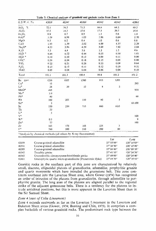
Table 3: Chemical analyses of granitoid and gneissic rocks from Zone 1
G.S.W.A. No. 42859 40341 40389 40342 40343 42861
SiO, % A1203
Fe,03 FeO* MgO CaO h , O * K,O
H,O-* CO,*
p20,
H,O+*
TiO,
MnO
72.1 15.5 0.9 1.29 0.2 1.93 4.53 3.3 0.46 0.10 0.39 0.22 0.13 0.05
74.2 14.3 0.7 0.96 0.2 1.39 3.86 4.4 0.52 0.10 0.24 0.21 0.13 0.04
71.5 15.6 0.9 1.03 0.4 2.02 4.59 3.6 0.44 0.13 0.18 0.26 0.15 0.04
66.6 17.5
1.1 1.86 1 .o 4.09 5.09 1.3 0.55 0.09 0.15 0.33 0.12 0.06
64.2 20.7 0.6 0.84 0.6 4.37 7.92 1.2 0.30 0.11 0.09 0.08 0.19 0.04
69.3 14.4 1.4 2.70 0.8 2.29 3.04 4.6 1.61 0.00 0.00 0.64 0.3 1 0.10
Total 101.1 101.3 100.8 99.8 101.2 101.2
Ba ppm CU* Li* MnO* M#* Pb* R b Sn* Sr Th U* V* W* Zn* Zr F*
1250 1025 15 28 20
445 1 .o 40
160 205 3
530 220 23
5
0.5 17
165 170 760 580
1380 815 1285
12 8 2 265
950
60
10-100 110 40 5
715 660 I655
100 9
100 165 125 5 5 10 390 80
*Analysis by chemical methods (all others by X-ray lluorescence)
Lat Long 42859 Coarse-grained adamellite 27"55'00" 120" 16'05" 4034 1 Coarse-grained adamellite 27"34'50" 120" 1040 ' 40389 Coarse-grained adamellite 27°0640" 120"09'10" 40342 Tonalitic gneiss 27'41'10~ 120"24'30" 40343 Granodioritic clinopyroxene-hornblende gneiss 27"40'00" 120"24'40" 42861 Granophyric quartz micro-granodiorite (Proterozoic dyke) 27O49'30" 120O 16'45"
Granitic rocks in the southern part of this zone are characterized by relatively small, discrete, ellipsoidal plutons of granodiorite, adamellite, porphyritic granite and quartz monzonite which have intruded the greenstone belt. This zone con- tinues southeast into the Laverton Sheet area, where Gower (1974) has recognized an order of intrusion of the plutons from granodiorite, through adamellite to por- phyritic granite. The long axes of the plutons are aligned parallel to the regional strike of the adjacent greenstone belts. There is a tendency for the plutons to in- trade anticlinal positions, but this is more apparent in the Laverton Sheet than in the Sir Samuel Sheet. Zone 4 (east of Celia Lineament) Zone 4 extends eastwards as far as the Laverton Lineament in the Laverton and Duketon Sheet areas (Gower, 1974; Bunting and Chin, 1975). It comprises a com- plex batholith of various granitoid rocks. The predominant rock type between the
16

Table 4: Chemical analyses of aranitoid rocks from Zone 2 -
G S W A N o 35 823 35 886 40 382 40 388 42 856 42 858
SiO, % '41203
Fe203 FeO* MgO CaO Na,O* K2O H,O+* H20-* CO,* TiO, PZO, MnO
71.5 15.6 0.9 1.29 0.3 2.22 4.74 3.0 0.43 0.04 0.08 0.34 0.16 0.05
72.0 15.1 0.9 1.29 0.3 2.12 4.54 3.0 0.50 0.08 0.13 0.29 0.15 0.05
71.9 14.9 0.9 1.09 0.4 1.98 4.55 3.0 0.58 0.11 0.25 0.27 0.13 0.05
70.7 15.5
1 .o 1.22 0.4 2.21 4.89 2.7 0.5 1 0.10 0.16 0.28 0.16 0.04
70.7 16.0 0.9 1.48 0.9 2.81 4.07 2.5 0.62 0.12 0.17 0.29 0.16 0.04
66.9 17.0
1.3 2.06 1.3 3.56 6.12 1.5 0.5 I 0.09 0.17 0.37 0.16 0.06
__ -
Total 100.7 100.5 100.1 99.9 100 8 101.1
Ba PPm 850 1210 1060 1280 1340 330 CU* 25 25 Li* 54 30 36 26 18 26 MnO* 400 580 MO* 0.5 1 .o Pb* 30 30 Rb 115 105 105 100 80 65 Sn* 3 3 Sr 565 500 4 70 540 550 565 Th 16 18 U* 2 4 W* 0.5 0.5 Zn* 87 110 Zr 165 145 145 175 155 145 F* 880 5 20 730 460 410 1100
*Analysis by chemical methods (all others by X-ray fluorescence)
Lat. Long. 35823 Strongly foliated granite 27'55'50" 120'4 1'30" 35886 Porphyritic granodiorite (Mount Keith Granodiorite) 27"22'20" 120" 3 1' 10" 40382 As for 35886 27"26'00" 120" 32'00" 40388 As for 35886 27'1 1'30' 120°24'10" 42856 As for 35886 27"07'15" 120°18'40" 42858 Tonalite 27"07'30' 120" 14'45"
Dingo Range greenstone belt and the Celia Lineament is a pink adamellite (Agb) locally granite, which is characterized by finely disseminated fluorite, chloritized biotite, lack of tectonic foliation, and a high K,O content (range 4.8-5.8 per cent, Table 5 ) . Principal exposures are east of Ninnis Bore, and west of Wonganoo. It is similar to the Mount Boreas Adamellite in the Duketon and Laverton Sheet areas, which has been dated by Roddick (written comm.) a t 2480 t- 30m.y. The features described above indicate a fractionated, post-tectonic granite, and Bun- ting and Chin (1975) have compared it with the potassic hood granites of South Africa (Viljoen and Viljoen, 1969b). The shape of the individual intrusions in the Sir Samuel Sheet area is difficult to establish; however, a primary flow foliation which strikes consistently north-northwest and dips shallowly east may indicate a sheet-like body similar to the Mount Boreas Adamellite. At Mount Blackburn, a small, irregular body of potassic adamellite (Table 5, samples 42831, 42832, 42833) contains abundant fluorite. It is similar to the
17

Table 5: Chemical analyses of granitoid rocks from Zone 3
G.S. W.A. No. 35825 358 74 35885 43301 35831 42854 42855
71.8 72.3 14.8 14.2 0.7 1 .o 1.16 1.74 0.0 0.6 1.27 2.45 3.71 3.72 5.2 3.1 0.53 0.78 0.10 0.15 0.43 0.49 0.27 0.29 0.11 0.16 0.04 0.07
72.5 73.4 14.8 13.5 0.7 1.2 0.96 1.35 0.0 0.6 1.53 1.80 4.20 3.77 4.1 3.2 0.56 0.58 0.11 0.11 0.09 0.24 0.21 0.27 0.09 0.09 0.03 0.06
71.5 15.1
1 .o 1.35 1.1 2.51 4.46 3.0 0.72 0.14 0.12 0.30 0.18 0.05
70.6 16.1
1, .O 1.42 1.1 2.91 5.24 2.1 0.57 0.13 0.19 0.31 0.15 0.05
69.0 15.8 1.2 2.00 1.1 3.12 4.62 2.4 0.59 0.11 0.23 0.43 0.15 0.06
Total 100.1 101.1 99.9 100.2 101.5 101.9 100.8
Ba ppm CU* Ll*
MnO* Mo* Pb* K b Sn* Sr Th U* w* Zn Zr F*
1200 465 860 620 40
20 44 50 40 440 1 .o 30
210 140 175 110 3
225 145 295 115 23
2 0.5 48
225 145 160 165 300 430 290 540
690 80 58
385 1 .o 40
140 1-10 415 I5 14
0.5 79
I25 410
500 35 73
385 1 .o 20 70 10
460 2 4 1
64 115 560
520 40 33
480 1 .o 40 15
3 370
2 4 1
74 125 420
*Analysis by chemical methods (all others by X-ray fluorescence)
35825 Medium-grained adamellite 35874 Adameilite 35885 Porphyritic adarnellite 43301 Medium-grained adamellite 35891 Biotite-hornblende granodiorite 42854 Boitite-hornblende granodiorite 42855 Biotite-hornblende granodiorite
Lat. 27O47'40" 27" 19'35" 27'3 1'50" 27"30'30" 27"29'00" 21057' 10" 27"56'15"
Long. 120"48'50" 121c10'50" 120°42'50" 120"55'00" 121"00'30" 12 l"24' 15" 121°20'45"
Mount Boreas type, but possesses a tectonic lineation, which plunges gently south, along with an 070' trending fracture cleavage. The eastern contact is sharp, and indicates intrusion of the potassic adamellite into fine-grained adamellite. The westen contact is very irregular.
Quartz syenite and related pyroxene granite occur as irregular bodies around Red Hill and 2 km northeast of Woorana Well. At both localities the syenitic rocks are intruded by Mount Boreas type potassic adamellite.
Northeast of Wonganoo, an intrusion of adamellite consists of a north-south trend- ing even-grained core with porphyritic margins. The body appears to have intrud- ed dilationally, splitting the northern end of the Dingo Range greenstone belt.
18

Table 6: Chemical analyses of Mount Blackburn and Mount Boreas type granite/adamellite, zone 4.
G.S. W . A . No. 42830 42831 42832 42833 42841 42845 42850 +A verage
SiO,% AI203 Fe@, FeO* MgO CaO Na,O*
H,O+* H,O-*
TiO,
MnO
CO2
P20,
~
72 2 75.3 73.3 72.3 71.0 1 3 .O 72 9 14.3 13.8 14.2 14.1 15.0 14.1 14.5 0.8 0.5 0.8 1.3 0.9 0.8 1 .o 1.09 0.90 0.84 0.71 1.48 1.09 1.29 0.4 0.1 0.2 0.1 0.5 0.2 0.5 1.26 0.89 0.86 0.91 1.40 1.02 1.06 4.03 3.83 4.48 4.82 3.74 3.33 3.57 4.9 4.8 4.8 4.9 5.3 5.6 5.8 0.52 0.35 0.40 0.35 0.64 0.52 0.67 0.09 0.07 0.08 0.07 0.07 0.07 0.07 0.33 0.13 0.20 0.22 0.26 0.24 0.37 0.26 0.14 0.17 0.27 0.35 0.21 0.27 0.12 0.09 0.09 0.15 0.16 0.08 0.12 0.04 0.05 0.05 0.04 0.04 0.04 0.03
72.00 14.00
1.19 0.86 0.46 1 .oo 3.89 5.16 0.63 0.09 0.07 0.28 0.08 0.02
TOTAL 100.3 101.0 100.5 100.2 100.8 100.3 102.2
Ba P P ~ 900 440 550 780 1300 760 1010 1 460 cu* 90 100 155 90 70 110 40 LI* 34 92 75 41 62 31 14 31 MnO* 340 385 420 350 295 335 285 MO* 1 .O 1.5 1 .o 1.0 1.0 1.5 2.0 Pb* 60 60 70 60 50 60 50 Rb 255 415 415 335 295 265 190 220 Sn* 10 10-100 10-100 1-10 1-10 1-10 1-10 Sr 250 120 130 290 265 170 225 285 Th 46 58 73 80 88 88 97 U* 6 10 4 4 16 20 2 W* 1 1 3 2 1 2 1 Zn* 72 58 115 92 77 66 78 Zr 260 145 205 350 310 230 305 119 F* 620 920 1900 2100 740 340 3 20 1100
*Analysis by chemical methods (all others by X-ray fluorescence)
Lat. 42830 Coarse-grained adamellite (Mount Boreas type) 27"28'30" 4283 1 Sheared granite (Mount Blackburn) 27"36'30" 42832 Fluorite adamellite (Mount Blackburn) 27"36'00" 42833 Fluorite adamellite (Mount Blackburn) 27' 36'40" 42841 Adamellite (Mount Boreas type) 27"28'00" 42845 Adamellite (Mount Boreas type) 27" 17'30" 42850 Adamellite (Mount Boreas type) 27°09'40"
Long. 121 13'05" 121O 19'30" 12 1 20'00" 121° 21'30' 121°17'40" 12 1 18'05" 121O 12'55"
t Average Mount Boreas Adamellite, Duketon and Laverton Sheet areas (Bunting and Chin, 1975)
Chemistry Chemical analyses of granitoid rocks are presented in Tables 3 to 7. Two chemical suites, termed calc-alkaline and alkaline, are apparent in the gran- itoid rocks (Fig. 4). The calc-alkaline suite which is evident over much of the Eastern Goldfields Province, forms a fractionation trend from tonalite to granite. Most rocks are in the adamellite range. The trend is sub-parallel to the corres- ponding trend of average compositions of Nockolds (1954), but is relatively enriched in sodium and deficient in calcium. This trend embraces rocks from the syntectonic ellipsoidal plutons of Zone 3, and the syn- to late-tectonic Mount Keith Granodiorite, and post-tectonic bathol- iths of Zones 1 and 3. The trend has therefore operated throughout the main
19

FIGURE 4
CHEMICAL & NORMATIVE VARIATION DIAGRAMS OF GRANITIC ROCKS
REFERENCE 9 Gran8te/adamellite, even-grained
Y Giantteladamellite, p o f p h y m c
Mt Boreas Adamellite IOuketon-Lavenon)
Mt Boreas type adamellite (Sir Samuel1 . 6 Mt Blackburn adamellitelgranire
L Quartz syenite and related rocks . MI Keith Granodiorite
, , Granodiorite and tonalfie
,,' Quartz monronite
~ Gneiss
8 Nockold's (19541 averages
1 peralkaline granfie, 2 alkaline granlfe
3 calc -alkaline grantte.4 adamelI,te,
5 granodlorite 6 ionalite 7 dtorne
\
Fig 4b Nornative variation diagram of granitic rocks
15811
20

Table 7: Chemical analyses of syenitic and monzonitic rocks (Zones 3 and 4) and miscellaneous gran- itoid rocks (zone 4)
G.S.W.A. No. 40397 42834 42848 42849 42852 32887 42824 42828 42846
SiO, %
A1203 Fe@, FeO* MgO CaO Na20* K,O H,O+* H,O-* CO,* TiO,
MnO p20,
~
69.6 67.4 72.4 71.1 69.5 68.5 72.7 73.8 68.0 14.9 16.2 14.0 14.2 16.3 16.4 14.5 14.3 14.8 1.2 1.8 0.7 0.9 1.1 1.3 0.9 0.5 1.7 0.90 0.71 0.84 1.03 0.97 1.03 1.09 1.09 1.61 0.3 0.6 0.4 0.4 0.4 0.1 0.4 0.1 1 .o 1.39 1 .OO 1.64 1.37 1.43 1.63 1.79 1.10 1.78 5.15 6.12 3.79 3.98 5.52 5.32 4.32 3.70 3.89 5.5 5.4 6.2 6.3 4.5 4.6 3.8 5.2 5.4 0.33 0.23 0.30 0.28 0.23 0.34 0.59 0.54 0.59 0.11 0.07 0.04 0.09 0.09 0.08 0.12 0.09 0.07 0.06 0.20 0.42 0.14 0.06 0.16 0.39 0.28 0.33 0.34 0.26 0.19 0.31 0.26 0.31 0.27 0.21 0.69 0.21 0.18 0.16 0.16 0.11 0,13 0.17 0.13 0.18 0.06 0.07 0.05 0.10 0.05 0.05 0.05 0.04 0.04
TOTAL 100.1 100.2 101.1 100.4 100.5 99.9 101.1 101.1 100.1
Ba PPm 825 280 964 1120 1290 1300 970 810 2300 c u * 80 80 40 70 155 75 190
MnO* 540 440 840 425 515 380 3 60
Pb* 20 40 40 40 40 70 70 R b 205 250 205 235 165 180 130 290 190
L1* 32 13 10 10 39 50 34 59 21
MO* 1 .o 0.5 1.5 1 .o 1 .o 1.5 1.5
Sn* 10 1-10 3 3 10 1-10 10-100 Sr 405 65 600 625 1170 1145 5 60 210 395 Th 7 4 2 9 16 60 71 U* 2 2 2 8 2 16 10 w* 2 0.5 O S I 1 0.5 1 Zn * 77 53 84 60 76 65 125 Z r 70 130 10 15 155 195 140 185 580 F* 160 170 160 220 690 860 760 690 1300
*Analysis by chemical methods (all others by X-ray fluorescence)
40397 42834 42848 42849 42852 32887 42824 42828 42846
Pyroxene-quartz monzonite (Ags) Pyroxene-quartz syenite Pyroxene adamellite (Ags) Pyroxene-quartz syenite Biotite-hornb1ende:quartz monzonite (Agh) Biotite-hornblende adamellite (Agh) Sheared adamellite Coarse-grained adamellite (possibly Mt. Moreas type) Sheared adamellite
Lat. 27"28'30" 27" 36'45" 27' 1035" 27"09'40" 27'51'50'' 27"52'10" 27"05'45" 27"33'40" 27" 11'45''
Long. 12 l"02'30' 121°21'30" 12 1 15'05" 121°14'20" 121"21'05" 121 O21'50" 121 O22'1.5'' 121 15'30' 121°16'30"
period of Archaean crustal development in this area. Elsewhere in Archaean ter- rains the fractionation trend has been shown to be partly time-dependent (Glik- son, 1971, Viljoen and Viljoen, 1969b), the earlier rocks being predominantly gran- odiorite (sodium rich) and the post-tectonic rocks, adamellite or granite (potas- sium rich). This evolutionary trend may also operate on Sir Samuel. It is also true of more restricted time spans, for example the intrusive sequence granodior- ite-adamellite-porphyritic granite in the ellipsoidal plutons of Zone 3. The alkaline suite is confined to Zone 4 and is illustrated by the trend of the sye- nitic rocks. In Figure 4a the field of the Mount Boreas type adamellite/granite (including data from the Duketon and Laverton Sheet areas) is elongate sub-par-
21

allel to the syenite trend and also the join of the average alkaline and peralkaline granites, although some of the Mount Boreas type rocks could equally well be end- members of the calc-alkaline trend. Most rocks of the alkaline suite are post-tec- tonic, and the Mount Boreas Adamellite has been dated at 2480 m.y. (Roddick, written comm.); thus, in late Archaean, granitic magmas whose fractionation his- tory differs from that of the main granitic rocks, intruded this part of the Eastern Goldfields Province. The quartz monzonite at Mount Macdonald does not fit either of the main trends. Although it shows chemical affinities to the alkaline trend, i t is spatially and pet- rographically related to the granodiorite and adamellite plutons of Zone 3.
The analyses in Table 3 to 7 illustrate a problem with the name “adamellite” in the northeast Yilgarn Block. As used by the Geological Survey of Western Aus- tralia, the term is used for a granitoid rock in which the ratio alkali feldspar: plagioclase is between 1:2 and 2:1. In the Sir Samuel Sheet area this term em- braces most of the granitoid rocks, which range from plagioclase-dominant ada- mellites in the Mount Keith Granodiorite, through the “normal” adamellites to the alkali feldspar-dominant adamellites of the Mount Boreas type. The analyses show an even greater range; many of the Mount Keith “adamellites” are chem- ically granodiorite while those of the Mount Boreas type a re chemically granite. A possible explanation (which has not been investigated) is that the albite feldspar component has gone preferentially into perthitic microcline in the Mount Keith body, and into plagioclase in the alkaline rocks.
STRUCTURE The structure is dominated by north-northwest-trending lineaments, faults and tight folds. These are shown on a generalized structural interpretation map (Fig. 5). In Figure 2, the Agnew-Mount Keith belt is shown in more detail.
Tectonic lineaments Tectonic lineaments are major zones of disruption across which there is no ob- vious correlation of lithdogy, stratigraphy, or structure. They can be traced over much of the Eastern Goldfields Province, and have a history of movement com- mencing in early Archaean and culminating in vertical movements in late Archae- an times. The lineaments also show as zones of intense foliation. In the Sir Samuel Sheet area they commonly mark greenstone/granite or granite/gneiss contacts. The intrusion of ultramafic magmas along the Keith-Kilkenny Lineament and its subsidiary strike faults suggests that they are fractures which may have penetrated the crust and tapped the mantle. The Ida and Keith- Kilkenny Lineaments bound a graben structure that preserves the younger rocks in the greenstone belt.
Faults Major strike faults splay from the tectonic lineaments (Fig. 5 ) and dislocate the fold patterns. The Perseverance Fault (Martin and Allchurch, 1976) is coincident with the Keith-Kilkenny Lineament at Perseverance, but diverges north of Lake Miranda. Similarly the Miranda Fault diverges from the Ida Lineament, truncates the northern end of the Mount White Syncline, and connects with the Per- severance Fault near Six Mile Well. This convergence of the Miranda and Per- severance-Keith-Kilkenny Fault systems has resulted in the structural complexity of the Kathleen Valley area.
In the Yandal greenstone belt, a major fault (the Ockerburry Fault) is postulated along the centre of the belt, connecting the Celia Lineament with the Keith-Kil- kenny Lineament in the Leonora Sheet. The two faults postulated along the west-
22

w W
- - Fault or mainr shear zone
Anticline with plunge $- Synclinewith plunge
~ Trend line
I L Ida Lineament
KKL Keith Kilkenny Lineament
CL Celia Lineament
PF Perseverance t.auit
M F Miranda Fault
O F Ockerburry Fault
AA Agnew Anticline
LA Leinster Anticline
WA Wonganoo Anticline
WS Mt White Syncline
YS Yandal Syncline
15812

ern side of the greenstone belt are apparent mainly as zones of shearing within the granitic and gneissic rocks. The western fault truncates structure in the greenstone belt south of Calowindi Well. Folds Folds in the southern part of the Agnew-Mount Keith greenstone belt are tight and plunge north. Donaldson and Platt (1975) report two periods of isoclinal fold- ing from the metasediments (equivalent to Jones Creek Congiomerate) west of Agnew. The Agnew Anticline probably relates to the second of these. The Mount White Syncline is confirmed by facing evidence from pillow lavas and cleavage- bedding relationships. The Leinster Anticline has been split along its eastern limb by the dilational intru- sion of granite. Facing evidence from pillow lavas and graded bedding indicates a synclinal structure northwest of Perseverance in an area complicated by strike faults parallel to the Keith-Kilkenny Lineament. A north-plunging anticline a t Mount Sir Samuel is possibly only of local significance. Martin and Allchurch (1976) report differentiation in the Perseverance ultramafic intrusion which indicates east facing; thus, a major anticlinal structure to the west has been cut out by the strike faults. Associated with all of these folds is a strong sub-vertical axial-surface foliation which is the dominant directional fabric in the rocks, and a 20’ to 50’ north-plunging lineation. A persistent later crenulation cleavage trends 040’ to 060’. North of Lake Miranda strike faulting has severely disturbed the fold pattern of the belt. On structural evidence a north-plunging antiform is present through the mafic rocks at McDonoughs Lookout. The western side of the belt faces east , and the “Western Greenstone” and granite of Durney (1972) is unconformably over- lain by conglomerate. A faulted-out syncline must exist between this and McDonoughs Lookout, possibly along the eastern margin of the conglomerate, where facing in spinifex-textured ultramafic is westerly (Marston and Travis, 1976; Naldrett and Turner, 1977). In the Six Mile Well area the “Eastern Greenstone” of Durney contains east-facing spinifex zonation and forms an attenuated syncline. A fault must be present between this and the McDonoughs Lookout sequence. In the Yandal greenstone belt, facing evidence is almost entirely lacking. T h e main structure of the belt is thought to be a north-northeast-trending syncline (the Yandal Syncline). Much of the core and western limb are cut out by the Ocker- burry Fault. Evidence for this syncline lies in the facies gradation within the Spring Well felsic volcanic centre which indicates west-facing. There is no appar- ent folding whithin the central part of the complex which probably acted a s a stable block during folding. West of the Ockerburry Fault, the gross structure is problematical. The shape of the lithological units suggests a north-northwest-trending fold through Bates Range, and the presence of an elliptical syntectonic granitoid intrusion suggests the fold may be anticlinal. South of Calowindi Well structural evidence indicates that a tight southwest-plunging synform has been refolded by an open south- plunging antiform. An antiform is indicated at Ockerburry Hill by parasitic folds in chert, but this is probably a minor fold near the core of the regional Yandal Syncline. The Dingo Range belt is unusual in that the dominant structure is an anticline (the Wonganoo Anticline) surrounded by intrusive granitoid rocks. Only at Stir- ling Peaks is there the suggestion of a flanking syncline. Evidence for the Wong- anoo Anticline is abundant and includes: northerly dip and bedding around the fold closure in the Dingo Range, parasitic folds in chert bands, northerly plunging mineral elongation lineation associated with axial-plane foliation, and facing from pillows and graded bedding in the vicinity of Wonganoo.
24

Structural sequence We have not attempted a detailed structural analysis, but several events can be distinguished. The following sequence refers to the greenstone belts only, not the gneissic belts, and deals mainly with the Agnew-Mount Keith belt. ( 1 ) An early phase of folding is demonstrated by the high angle unconformity oe- tween the mafic sequence and the younger conglomerate at Kathleen Valley. (2) A second period of deformation comprising at least two phases, resulted in the main sub-vertical, north-northwest-trending folds and foliation. Most granitoid in- trusion occurred during this period, as did the main movements along the major lineaments and faults. In most areas the dominant schistosity parallel to the axial surfaces of the major folds, but in the Kathleen Valley area the schistosity is de- formed by chevron and crumple folds of the second phase. These later folds are associated with a major north-plunging synform 4 km south of Six Mile Well; these two phases may correspond to the two phases of isoclinal folding postulated by Donaldson and Platt west of Agnew, and to the folded fold south of Calowindi Well. (3) This event was characterized by brittle to semi-brittle deformation, producing crenulation and fracture cleavage. Cleavage is generally a t a high angle to the dominant north-northwest foliation thus in the Agnew-Perseverance area a region- al crenulation cleavage trends 010' to 060' and in the Bates Range-Mount McCIure area crenulation and fracture cleavages trend 080'
(4) Crenulations with sub-horizontal axes occur along the Keith-Kilkenny Line- ament zone east of Kathleen Valley. The axes trend parallel to the lineament, and vergence of the asymmetrical crenulations suggests they may represent late vertic- al movements of the lineament zone, in which the eastern block rose.
METAMORPHISM No systematic study of metamorphism was attempted during the 1:250 000 map- ping, but several points have emerged. The pelitic rocks have limitations as meta- morphic indicators due to their susceptibility to surface weathering. Andalusite is common in pelitic schists in the Perseverance-Mount Sir Samuel and Kathleen Valley areas where it displays rolling effects and is syntectonic with the main fo- liation. However, immediately southeast of Mount Mann, porphyroblastic anda- lusite in pelites associated with chlorite schist is a product of static meta- morphism, possibly due to the nearby intrusion of the Kathleen Valley gabbro. Mafic rocks in the greenstone belts are characterized in the lower grades by ac- tinolitic amphibole, with hornblende being restricted to the higher grade margins. Plagioclase composition is not a good metamorphic grade indicator in the mafic rocks, because at medium and lower grades it may retain its original magmatic composition and form. Binns and others (1975) attribute this phenomenon (and the presence of relict olivine in some medium grade ultramafic rocks) to a non- progressive type of static, IOW pressure metamorphism in which the medium grade rocks did not pass through phases of alteration in the lower grades, Because of the problems outlined above, metamorphic grades based on mineral assemblages are of dubious value in surface regional mapping. A more workable tool is the variation in fabric produced by different metamorphic styles. In the centrai parts of greenstone belts, primary textures are largely preserved. Plagio- clase laths in mafic volcanic rocks retain their igneous textures and in places (for example the Dingo Range) and original flow texture. The mafic minerals have generally recrystallized to a directionless mat of actinolite. I n mafic rocks along greenstone belt margins a penetrative foliation developed due to alignment of re- crystalked hornblende grains while the felsic minerals recrystallized to a granular
25

mosaic. In fine-grained mafic rocks, the symbols A b and Aba distinguish these two styles of metamorphism. Binns and others (1975) refer to static and dynamic style domains in this context. In the Agnew and Kathleen Valley areas, tremolite-chlorite schists commonly con- tain random or stellar aggregates of tremolite blades growing across an ear l ier chlorite-tremolite foliation. This indicates either a period of static metamorphism after the period of foliation development, or that static recrystallization continued after deformation had ceased. Metamorphic grade of the gneissic belts is higher than in the adjacent greenstone belts. This is best shown west of Agnew, where mafic enclaves in the gneiss con- tain garnet (up to 50 per cent), hornblende, diopside and quartz, indicative of upper amphibolite facies metamorphism. Textures are predominantly granoblastic. One sample shows high grade static growth of garnet and diopside superimposed on an earlier period of dynamically metamorphosed foliated amphibolite (horn- blende-quartz-plagioclase). No confirmed granulites have been found in this belt . Ferro-hypersthene occurs in grunerite-bearing banded iron-formation, but t h e un- usual rock composition suggests the assemblage may have a chemical as well as metamorphic control. Further north in the same belt (west of Lake Miranda a n d near Little Well) and in the gneissic belt east of Perseverance, the garnet is miss- ing from the mafic rocks, but they have the same granoblastic textures. N e a r Charlie Well (Lake Way) small garnets are common in gneissic adamellite near the margin of the greenstone belt, close to the Keith-Kilkenny Lineament.
STRATIGRAPHY Stratigraphic successions of varying degrees of confidence can be set up for e a c h of the greenstone belts (Fig. 6 ) . Because of the spatial separation and contrasting lithologies of the three belts, correlation between them is impossible. In fact, t h e differences are so striking (Table l ) , that we suggest that these belts were never physically joined across strike, but developed in separate linear basins or rift val- leys branching off a main basin to the south. The gneissic belts may represent the older material between the linear basins. Agnew-Mount Keith belt The stratigraphy in the southern half of the belt is relatively simple, and can be represented by sections from the core of the Agnew or Leinster Anticlines to the core of the Mount White Syncline. A lower mafic/ultramafic sequence (at Agnew and Mount Roberts) is overlain by feldspathic sediments and conglomerate, which grade upwards into pelitic sediments. These are overlain by pillow basalts at Mount White. The core of the syncline is occupied by pelite and greywacke. Wi l - liams (pers. comm.) correlates the mafic succession at Agnew with the More lands Formation of the Kurnalpi Sheet (Williams, 1970); thus, the overlying sedimentary unit may equate with the Gindalbie Formation, the pillow basalts at Mount W h i t e with the Mulgabbie Formation, and the overlying pelite and greywacke with the Gundockerta Formation. These correlations are extremely tenuous, and imply a lateral continuity of lithological associations throughout the Eastern Goldfields Province. The mafic rocks in the syncline northwest of Perseverance probably correlate w i t h the pillow basalts at Mount White, while the feldspathic sediments between Per- severance and Mount Sir Samuel may correlate with the Sediments below the Mount White basalts. No such simple picture emerges from the Kathleen Valley area. Durney (1972) proposed a succession which an older “Western Greenstone” (Kathleen Val ley gabbro and Mount Goode basalt), which probably correlates with the mafic suc- cession at Agnew, is unconformably overlain by the Jones Creek Conglomerate
26

MT ROBERTS - MT WHITE
Mt White
Mt Roberts
J v
3Yv v v
I V V ~
' 1 ',:
FIGURE 6 STRATIGRAPHIC SUCCESSIONS
SIR SAMUEL SHEETSG 51-13 YANDAL BELT
Mt Goode V t
KATHLEEN VALLEY I (Alternative interpretations) I - Six Mile We1
CMc Donough Lookou t,
Granitic rocks
Chert and B.I.F.
Conglomerate and arkose
Fine-grained sedirnents
1 . .
m
-_1- Kathleen Valley - \ I , ,
i+ .+ .+I + + + I (After Naldrett and Turner unpublished data)
/T-TYq A a Felsicextrusive
~
Mafic intrusive
r/ Mafic extrusive
1:
Ultrarnafic
Ockerburry Hill
A A A A A
lvyvyvl I
A A A Complex l A A A A
',:I--
~ v V V G ' iws Hills
/\'v'
v v v v v
v v
+ + +
DINGO RANGE BELT
Dingo Range
Duketon Sheet
I.+ + + I
15km
10
5
0 Because of structural uncertainties,
thickness calculations are only very approximate
15813

which is conformably overlain by “Eastern Greenstone”. Because of the structural complexity of the area this view is oversimplified, and some controversy exists over the stratigraphic position of the conglomerate. Marston and Travis (1976) and Naldrett and Turner (1977) propose that the conglomerate is the youngest unit in the area, sitting in a complex syncline and deriving material from both the eastern and western greenstones. Spinifex zonation in ultramafics east of the con- glomerate face east near Six Mile Well and west near Mount Goode (Turner, pers. comm.) suggesting that the eastern contact of the conglomerate is a major fault. An alternative hypothesis is that the conglomerate is, as Durney suggests, in the middle of the succession, but that the eastern contact is a major fault separ- ating the east-facing conglomerate from, in the south, an anticline through McDonough Lookout, and in the north an east facing younger mafic succession south of Six Mile Well. There are detailed arguments for and against both theo- ries, and the stratigraphic interpretation of the Kathleen Valley area is by no means finalized. The two alternative successions are set out in Figuie 6. Marston and Travis (1976) consider the Jones Creek Conglomerate to be the youngest unit not only in the Kathleen Valley area but also west of Agnew, pro- posing that it lies in a young fault-bounded basin, and that the conglomerate which is folded around the Agnew Anticline is an older unit. However, we believe that there may be only one conglomerate unit, and that it is older than the rocks in the Mount White Syncline. The development of the Agnew-Mount Keith belt can be briefly summarized as follows. ( I ) Rifting of gneissic basement, accompanied by mafic and ultramafic volcanism, and layered gabbro intrusion. (2) Folding, and intrusion of adamellite and granodiorite plutons. (3) Downfaulting, producing a graben structure between tectonic lineaments, which rapidly filled with conglomeratic, feldspathic, and mafic sediments; and was accompanied by minor felsic volcanism. (4) Mafic volcanism, followed by marine sedimentation. (5) Main period of tight folding, in several phases, accompanied by new and re-ac- tivated strike faulting; followed by ultramafic intrusion along major fractures; and a final phase of granitic intrusion, some dilational. (6) Late vertical movements along tectonic lineaments prior to uplift and erosion of Yilgarn Block.
Yandal belt East of the Ockerburry Fault a thick mafic sequence (Gipps Hills) is overlain by the thick, Spring Well, felsic volcanic complex. The felsic unit thins to the north away from the volcanic centre, and a band of mafic volcanic rock up to 2 km wide occurs within the felsic rocks east of Yandal. Interbedding with similar felsic volcanic rocks along both sides of the mafic band indicates that it represents only a hiatus in felsic volcanic activity. West of the Ockerburry Fault the simplest hypothesis is that the sequence east of the fault (and the Yandal Syncline) is repeated to the west, with an anticlinal structure through the Bates Range. Thus, there are again two major units-a lower mafic unit and an upper felsic unit.
Dingo Range belt Interbedded metabasalt and high-Mg basalt (mainly in the Duketon Sheet area) in the core of the Wonganoo Anticline passes upwards into a prominent chert and banded iron-formation horizon with interbedded shale and weathered felsic vol-
28

canic rocks. Above this is a thick metabasalt unit containing chert and intrusive peridotite. Poorly exposed tuffaceous and shaly sediment forms the top of the se- quence.
PROTEROZOIC DYKE SUITE Dykes trending about 080' cut granitic rocks near Kaluweerie Hill. They a re mainly granodioritic in composition, with small oligoclase phenocrysts, biotite and muscovite set in an interstitial granophyric intergrowth of quartz and microcline. Pyrite is a common accessory. The dykes are sub-vertical, up to 10m wide, and , in the larger examples, display a vertical primary layering 10 to 50mm thick. In an exposure east of Langford Well this layering displays complex flow folding, presumably because of turbulence within the magma. A small east-trending post metamorphic dolerite dyke has been reported from the Mount Keith area (Burt and Sheppy, 1976). A small dolerite dyke trending 080° cuts granitic rocks 10 km east of Melrose. All of the dykes are presumed to be related to the Widgiemooltha Dyke Suite of the Kalgoorlie-Norseman area which has been dated at about 2400m.y. T h e dykes probably intruded along a tensional fracture system which may also relate to a suite of quartz-filled fractures in the same direction (e.g. Wild Cat Hills).
KALUWEERIE CONGLOMERATE Near Kaluweerie Hill an outlier of presumed Proterozoic sediments lies uncon- formably on Archaean granitic rocks. Present exposure forms a sinuous east- trending belt 15 km long by 1.5 km wide. In drillholes 10 km west of Kaluweerie Hill the conglomerate is 35 m thick, but the maximum exposed thickness is 25 m. Two lithological types are present: (1) polymictic conglomerate and pebbly lithic arenite, and (2) fine- to coarse-grained lithic arenite. The conglomerate generally forms a lower unit, whereas arenite is dominant in the upper part of the sequence. The deposit is described in detail by Allchurch and Bunting (1976). Important features are the high proportion of mechanically un- stable clastic grains (e.g. carbonate, epidote, chlorite, amphibole, felsic lava) in the sand fraction, and the variety of igneous and metamorphic rock types in the conglomerate. Bedding structures in both conglomerate and arenite are poorly de- veloped. Allchurch and Bunting (1976) consider the deposit to be derived locally from the west, possible in a partly confined channel or as a valley-fill deposit. The con- glomerate shows some features characteristic of the rapid flow of water-lubricated material found in debris flow deposits close to areas of strong erosion. The upper (arenite) part of the sequence may be transitional into a marine environment.
PERMIAN Scattered outliers of fluviatile and glacigene deposits are equated with the Lower Permian Paterson Formation of the Office Basin (Lowry and others, 1972). AS in the Officer Basin, three facies have been recognized: (1) poorly sorted sandstone, conglomerate and minor siltstone (Pan probably of fluviatile origin; (2) claystone and siltstone (Pal) of lacustrine origin; (3) clay-matrix conglomerate, probably til- lite. In breakaways in the western part of the sheet area horizontally bedded grits overlie deeply weathered granitic rock, About 13 km north of Albion Downs this consists of 8 m of poorly bedded, poorly sorted grit, in which coarse, subangular
29

quartz grains are set in a clay matrix overlying 1 m of silicified quartz pebble con- glomerate. These deposits are considered to be of Permian age, but they may be Tertiary. Permian rocks near Ockerburry Hill were first described by MacLeod (1969). Archaean schists and chert are unconformably overlain by up to 50m of gently folded sediments, with an overall dip of about 5 O west. A 2m-thick basal unit of coarse-grained, poorly sorted quartz-rich sandstone, with subangular to sub- rounded grains is overlain by 5 m of tillite consisting of angular to sub-rounded boulders in a silty clay matrix. The clasts are mostly of granitic rock, but include mafic and felsic volcanics, metasediment, vein quartz and chert. Some of the boul- ders are striated and faceted. The tillite is disconformably overlain by a thin unit of laminated (?varved) siltstone, followed by 42 m of well-bedded sandy mudstone and siltstone. The lower 16 m of this siltstone has spectacular liesegang banding and is popularly known as “Weebo Stone”. Northwest of Agnew, on the Sir Samuel-Leonora Sheet boundary, there are boulder beds and associated sub-horizontal gritty sediments with thin claystone intercalations. These beds are probably Permian glacial deposits, and represent the most westerly recorded encroachment of such rocks over the Yilgarn Block.
CAINOZOIC Mapping of Cainozoic units is based on lithology and morphological expression. For the purpose of continuity with other 1:250000 sheets in the Eastern Gold- fields, the middle letter of the Q units has been retained, but it does not have any significance here. The stratigraphic relationship of the various Cainozoic units is shown in Figure 7.
FIGURE 7
CAINOZOIC ROCK UNIT RELATIONSHIPS
SIRSAMUElSHEETSG51-13
Unit symbols as m map reference
Undifferentiated The Cz units, with the exception of calcrete (Czk), form part of the deep weath- ering profile. Czo denotes deep-weathered kaolinized rock, which is partly ferrugi- nized and silicified. Bedrock textures may be preserved, depending on the depth of weathering. Silcrete (Czb), a hard siliceous duricrust containing angular quartz grains, may occur above the kaolinized zone over granitic rocks. Laterite (Czl), a ferruginous, pisolitic, duricrust, is most commonly developed over mafic and ultramafic rocks, though it may form over any rock type. Laterite caps over iron-rich rocks are usually darker. The name “caprock” (Czj) is a col- lective term for a variety of weathering products developed over ultramafic rocks. It consists of a dark-brown limonite deposit containing chrysoprase, magnesite, chalcedony and opaline silica. This type is best developed over massive serpenti- nites, whereas a massive, yellow to pale brown siliceous deposit is more common over talc-carbonate rocks. Calcrete (Czk) is a carbonate and opaline silica rock formed in ancient drainage systems. It commonly outcrops at the margins of present day salt lakes. The thickness of calcrete deposits in the centre of ancient valleys ranges from 15 to 50 metres.
30

Quaternary Colluvium, consisting of angular to rounded rock and quartz fragments contained in calcareous loam (Qqc), occurs marginal to rock outcrops and forms a thin ve- neer over fresh and weathered rock. Ironstone gravel and laterite debris contained in calcareous loam (Q& forms eluvial and colluvial deposits, commonly mantling low hills over mafic rocks. Quartz and feldspar sand (Qpm) occurs adjacent to, or overlying, granitic rock and its presence usually indicates shallowly buried, fresh granite. All of the above deposits grade transitionally into coalesced alluvial fans and broad sheet-wash areas, consisting of clay and loam (Qqz). This unit is the most extensive Quaternary deposit in the sheet area. Alluvial deposits in drainage chan- nels are grouped as (Qpv). Both Qpv and Qqz units support fairly dense mulga and shrub growth. The Qq units and Qpv are commonly underlain by hardpan, and indurated collu- vial deposit cemented by silica, iron oxide or carbonate (Bettenay and Church- ward, 1974).
Eolian deposits of red-brown sand (Qps), unrelated to salt lakes, are widespread. The sand forms extensive gently undulating sheets characteristically vegetated by spinifex, and only occasionally are distinct dunes developed. Most of the sand plain is probably underlain by granite. Several distinct Quaternary deposits are associated with the saline, ponded envi- ronment of ancient drainage systems. The term “salt lake” is usually restricted to bare, expansive flats with lacustrine deposits of saline, silty clay (Qra) which often contains large gypsum crystals. This unit grades into coarser grained, saline allu- vium and lacustrine deposits (Qrm) which occupy samphire, salt-bush flats and claypans. Both of the above units may be up to 100 metres thick in the larger salt lakes. Eolian lake units include: Qrs, a saline, calcareous and gypsiferous sand which occurs in sheets, and occasionally in dunes, marginal to salt lakes; and Qpk, a cal- careous and gypsiferous loam deposited in dunes, which flank and encroach upon salt lakes. The material deposited in Qpk dunes is derived by deflation of gypsum from salt lake surfaces and by deflation of calcium carbonate from nearby eroding calcarete deposits. The large expanses of calcrete on- the Sir Samuel Sheet account for the significant calcareous component in these eolian deposits compared with similar deposits further south in the Eastern Goldfields, where calcarete is not common and the calcareous component in eolian lake units is insignificant. Silty clay deposits in non-saline to brackish clay-pans from the Qrp unit.
MINERAL DEPOSITS GOLD AND SILVER Most of the gold and silver recovered from the Sir Samuel Sheet area was associ- ated with quartz reefs and lenses. Host rocks for these reefs vary, they include: sheared metabasalts for the Sir Samuel, Bronzewing, Lake Darlot mine groups, and some of the Lawlers group; sheared conglomerate and arkose for the Kath- leen Valley group and some of the Lawlers Group; sheared felsic volcanics at Mount Keith; and granite-metabasalt contacts, for the Corboys group and the Brilliant mine of the Lawlers group. Significant amounts of gold have also been recovered from shallow alluvial deposits, and a deep alluvial lead near Lake Dar- lot. Some of the early workings are described by Reed (1897), Gibson (1907), Tal- bot (1914); Jutson (1914, 1917) and Montgomery (1928).
31
Production figures are given in Table 8. Only minor production has been reported since the 1940s; however, at the time of preparation of this report active explor- ation for gold was proceeding in the area to the north of the E.M.U. mine, near the Sir Samuel-Leonora Sheet boundary.
NICKEL All the major nickel discoveries in the sheet area are confined to ultramafic intru- sive rocks along the Keith-Kilkenny Lineament and its subsidiary faults (Fig. 2 ) . The geology of these rocks is discussed earlier in this report. The Perseverance ore body (Martin and Allchurch, 1976) occurs in a lens of mass- ive serpentinized dunite intruded into metasediments. The lens, which strikes north-northwest and dips steeply west, is 3 500 m long and has a maximum width of 800m. Mineralization, in the form of massive and disseminated sulphides, occurs along the western contact and in some younger fault zones cutting the metasediments. Primary sulphides consist mainly of pyrrhotite and pentlandite; some secondary sulphides (e.g. violarite and pyrite) also occur. Indicated reserves (December, 1973) are 45 Mt at a grade of just over 2% Ni using a 1% cut-off. The Mount Keith orebody, which is larger and of lower grade than that at Per- severance, has been described by Burt and Sheppy (1976). Disseminated pentlan- dite occurs in the centre of a near vertical to steeply westward-dipping, serpenti- nized dunite body with pyroxenite margins. Burt and Sheppy have interpreted the dunite as a dyke-like body emplaced in previously folded metavolcanics and metasediments. Mineralization occurs in a zone 1830m long with an average width of about 180m. Approximately 65% of the ore is present in a mass of black, magnetite-rich, serpentinite, which is centrally located within the dyke-like body. Pentlandite is the predominant sulphide; and pyrrhotite, millerite and viola- rite are subordinate sulphides. Some accessory minerals are chromite, stichtite and cobalt sulphides. Calculated reserves are 290 Mt at 0.60% nickel. Several small deposits are clustered around Six Mile Well, along the same line of ultramafic intrusion. The principal deposit has been described by Turner a n d Ranford (1976).
U RANI U M The Yeelirrie uranium deposit occurs in calcarte in a relict drainage channel which straddles the sheet boundary northwest of Yeelirrie homestead. The ura- nium occurs in carnotite deposited in cavities, fractures, and on grain boundaries (E. Cameron and C. I. Fletcher, written comm.) The mineralized zones form ir- regular sub-horizontal sheets that are related to present or past water tables. T h e origin of uranium ores in calcrete-type environments, with special reference t o Yeelirrie, is discussed by Dall’Aglio and others (1974), Langford (1974) and M a n n (1974). Drilling by Western Mining Corporation has proven an estimated 30 Mt of ore, at an average grade of 0.15 per cent, i.e. 46 kt of contained U,O,. Average depth to the deposit is 8 m. A similar, but smaller, deposit occurs in calcrete at Lake Maitland (Lorimer, 1973). The ultimate source of the uranium is probably the Archaean granitoid rocks, and it is noteworthy that the drainage area of the Lake Maitland prospect embraces some of the Late Archaean potassic granites of the Mount Boreas type which have moderately high uranium values (Table 6 and 7). Proterozoic conglomerate in drill-holes west of Kaluweerie Hill contains traces of carnotite (Allchurch a n d Bunting, 1976) and it is possible that the Yelirrie uranium went through an inter- mediate, concentrating cycle in the Proterozoic sediments which possibly covered much of this part of the Yilgarn Block.
32
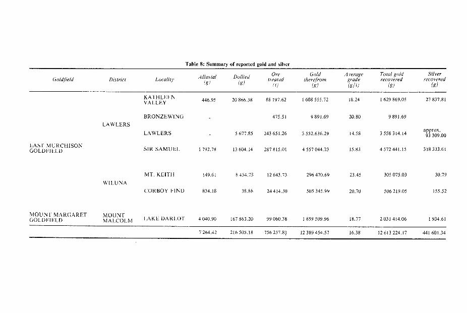
Table 8: Summary of reported gold and silver
Ore Gold A verage Total gold Silver Do"ied treated therefrom grade recovered recovered Alluvial
(0 lg) ( g l t i l g ) (g) igl lRl Goldfield District Locality
EAST MURCHISON GOLDFIELD
M O U N T MAKGARET GOLDFIELD
KATHLEEN VALLEY 446.95 20 866.38 88 197.62 1608 555.72 18.24 1 629 869.05 27 837.81
BRONZEWING 475.51 9 891.69 20.80 9 89 1.69 LAWLERS
3 558 314.14 93 309.00
S I R S A M U E L 1792.78 13 604.14 287 815.01 4 557 044.23 15.83 4 572 441.15 318 333.61
LAWLERS 5 677.85 243 651.26 3 552.636.29 14.58
MT. KElTH 149.61 8 454.73 12 643.73 23.45 305 075.03 30.79 296 470.69
WILUNA CORBOY FIND 834.18 38.88 24 414.30 505 345.99 20.70 506 219.05 155.52
M O U N T MALCOLM LAKE DARLOT 4 040.90 167 863.20 99 060.38 1 859 509.96 18.77 2031 414.06 1934.61
7 264.42 216 505.18 756 257.81 12 389 454.57 16.38 12 613 224.17 441 601.34

COPPER The earliest recorded copper production was in 1908 from workings in the Kath- leen Valley (Montgomery, 1909). This area remained the major copper producer until operations closed in 1966. Other copper deposits near the Sir Samuel town- site were worked between 1942 and 1967. Total copper production for t h e Sheet area amounts to 435 t, mainly as cupreous ore, Of this 424 t are from the Kath- leen deposits. The ore bodies are pyrite-chalcopyrite-quartz veins, often containing significant gold and silver, which have intruded mafic rock along north-trending shear zones. Secondary enrichment is common, and Low (1963) records malachite, azurite, chrysocolla, oxides, bornite, chalcocite and covellite in the workings.
TIN A cassiterite-bearing lepidolite-albite-pegmatite 3 km south-southwest of Kathleen Valley was mentioned by Miles and others (1945). This and another small t i n de- posit 0.4 km southwest of Sir Samuel townsite were worked between 1945 and 1953, and together produced about 8 t of ore, containing 0.2 t of tin.
CORUNDUM Corundum occurs in a massive granular deposit inter-mixed with andalusite 1 km south-southeast of Mount Mann (Carter, 1976). The only production recorded is for 1952 when 55 t of ore were mined.
TUNGSTEN Production of 15.3 t of scheelite ore yielding 63 kg of concentrate (equivalent to 23.87 kg WO,) was recorded in 1952 from Moriarty’s Mine, 5 km north-northwest of Kathleen.
WATER RESOURCES The area is one of low irregular rainfall, and it has an internal drainage system. Surface run-off is channelled into internal drainage lines leading to extensive salt lake systems, where ponded water soon evaporates. Surface water supplies are confined to pools in creeks, water holes, soaks, rock holes and gnamma holes, which are of limited capacity and quickly dry up. Low rainfall, high evaporat ion and low topographic relief prevent the establishment of any large surface water storage area. The best quality water is found furthest from the salt lakes near drainage divides, especially in areas of granitic rock. Nearer to the salt lakes, salinities increase markedly. Colluvial aquifers have the best quality water, but these are usually small. Calcrete aquifers, on the other hand, have water of variable quality, often with high salinites, but because they have efficient recharge characteristics dur ing short duration floods, they have the capacity to yield large quantities of water , and thus represent the major potential source of water for possible future mining and metallurgical use. Sanders (1969) includes the Sir Samuel Sheet area in a discussion of the hydrogeology of calcrete in the East Murchison and M o u n t Margaret Goldfields. The Perseverance nickel project will utilize very la rge quan- tities of groundwater in calcrete in the depot springs area. Cowan and Ornnes (1975) discuss the exploration of the Depot Springs aquifers with special reference to resistivity techniques. Underground water provides the main source of supply for domestic and stock purposes. Aquifers are mainly shallow and include: weathered bedrock a n d collu- vial aquifers near the base of large outcrop hills; alluvial aquifers in d ra inages ; and calcrete aquifers in ancient drainage systems.
34

Wells and bores a re present over most of the area and as many as possible of these were sampled for total dissolved solids (TDS). The results together with gen- eralized salinity contours are shown in Figure 8. Full chemical analyses were carried out on 11 water samples and the results for representative samples are given in Table 9.
Table 9: Representative chemical analyses of groundwater
Galowindi Well Yandal Station
Anderson Well Scottie Well No. 5 WelZ Well Name Leinster Downs Albion Downs Wonganoo
Station Station Station
Water level - 25.9 metres 5.9 metres 3.8 metres
Total dissolved solids 720 mg/ 1 (by evaporation)
1 340 mg/ 1 1 240 mg/ 1 5 350 mg/ l
Total hardness 220 408 436 1130 (calculation as
Total alkalinity 208 80 148 303 (calculated as CaCO,) Calcium 22 76 92 145 Magnesium 40 53 5 0 186 Sodium 164 260 242 1470 Potassium 9 25 21 60 Bicarbonate 223 98 180 369 Carbonate 15 nil nil nil Sulphate 85 134 238 566 Chloride 161 498 340 2 430 Nitrate 79 104 137 90 Silica 34 84 8 2 14
Remarks Colluvial aquifer Aquifer within or Alluvial aquifer on Calcrete aquifer ad-
C a C W
near drainage divide above deep-weath- major drainage off jacent to salt lake in greenstones ering profile in granitic rocks
granite
Analyses by Government Chemical Laboratories, Perth.
ACKNOWLEDGEMENTS The Geological Survey of Western Australia acknowledges the co-operation of Australian Selection Pty. Ltd. and Anaconda Australia Ltd. in providing maps and information that were invaluable aids during the field mapping and the prepa- ration of the interpretative figures of these notes. In particular the authors thank P. D. Allchurch, A. R. Turner and R. J. Marston for their valuable discussions.
35

W 4

Appendix: Co-ordinates of localities mentioned in text Name Latitude Longitude
A new (Leonora Sheet) Afbion Downs Anderson Well Arnold Bore Barr Smith Range Bates Range Beale Well Blow Well Brilliant (mine) Bronzewing (mine) Calowindi Well Charlie Well (Lake Way) Cogboy Find (mine) Depot Springs Dingo Range E.M.U. Mine (Leonora Sheet) Gipps Hills Jarrah Well Jones Creek Kaluweerie Hill Katherine Well Kathleen Kathleen Valley (mine) Lake Darlot Lake Darlot (mine) Lake Maitland Lake Miranda Langford Well Leinster Downs Little Well (Yeelirrie) McDonough Lookout Melrose Mt. Blackburn Mt. Doolette Mt. Goode Mt. Grey Mt. Harold Mt. Joel Mt. Keith Mt. Keith (homestead) Mt. Keith (gold mine) Mt. Keith (nickel prospect) Mt. Macdonald Mt. McClure Mt. Mann
28'00'45'' 120" 3045" 27" 17'15" 120"23'15" 27"5 1'00" 120° 36'30" 27"36'00" 120"56'30" 27'06'00'' 120" 17'00" 27"28'00" 27"2000" 27'19'15'' 27 O 5 8'30" 27' 18'45" 27"43'00" 27"02'15" 27"05'00' 27OS6'10' 27°16'00" 28"00'30" 27"53'00" 27"57' 15" 27"3000" 27'50'30'' 27" 38'30" 27"31'00" 27°30'30" 27"45'00" 27'55'45'' 27°1000" 27"41'00" 27°50'00" 27°51'00" 27°20'00" 27"37'30" 27O55'45" 27O35'15" 27O51'45" 27O34'30" 27O2.5'00" 27"23'00" 27"13'30' 27O10'30" 27" 16'45" 27"10'15" 27'14'20'' 27"50'30" 27"39'00" 27"28'45"
12 1 003'00" 120"53'30" 120"26' 15" 120"4 1'30'' 120"59'30" 120" 5 7'45" 120" 3045" 120" 57'30" 120"03'10" 12 1 " 24'00" 120"30'00" 12 1 18'00" 12 1 '09' 15" 120" 30'00'' 120"09'30" 12 1 08' 30" 120" 33'00" 120" 33'00" 12 l"29'00" 121°17'45" 12 1 "05'OO" 120"30'00" 120" 13'15" 120" 3 6'00" 120" 14'00" 120" 37 '00 ' 121"18'00" 12 1 " 19'45" 12 l"07'30" 120" 33' 00' 121 "09' 15'' 12 1 27' 15" 121"02'30' 120" 32' 15" 120" 30'30" 120" 3 1'45" 120" 3 2' 50" 121"19'30" 120" 59' 15" 120"33'00"
Mt. Mundy 27"30'45" 121"27' 15" Mt. Roberts 27"52'00" 120"36'45" Mt. Sir Samuel 27"43'00' 120" 38'30" Mt. White 27 52'30" 120"34'15" Ninnis Bore 27"35'00" 121°13'30"
Nuendah 27"02' 15" 120° 2 1'30" No. 5 Well (Wonganoo) 27' 13'30" 12 1 2 0 15" Ockerburry Hill 27°51'00" 12 l"03'30" Overland Well 27'54'15" 121 "05'15" Perseverance (nickel mine) 27O49'15" 120"42'00"
Red Hill 27"09'45" 121"14'15" Scottie Well 27"06'00" 12 1 "22'30" Sir Samuel 27"37'45" 121 '32'45'' Six Mile Well 27' 26'00" 1 20° 34'30" Spring Well 27'53' 75" 121"09'30'
Stirling Peaks 27"29'15" 12 1 "22'45'' Vivien 27O59'00" 120"33' 15" Wild Cat Hills 27°51'00" 12 l"08'00'
Woodarra 27 * 56'00'' 121°17'30"
Woorana Well 27" 29'45" 121"11'30" Yandal 27'33'45" 12 l"08'45"
Yeelirrie (homestead) 27°17'00" 120"05'30"
Wonganoo 27"08'30" 121"2000"
Yandal Lagoon 27°41'00" 12 1 ".10'00'

REFERENCES Allchurch, P. D., and Bunting, J . A., 1976, The Kaluweerie Conglomerate: A Proterozoic fluviatile
Archibald, N. J . and Bettenay, L. F., 1977, Indirect evidence for tectonic reactivation of a pre-green-
Arriens, P. A., 1971, The Archaean geochronology of Australia: Geol. Soc. Australia Spec. Pub . No.
Barnes, R. G., Lewis, J . D., and Gee, R. D., 1974, Archaean ultramafic lavas from Mount Clifford: West. Australia Geol. Survey Ann. Rept. 1973, p. 59-70.
Bettenay, E., and Churchward, H. M. 1974, Morphology and stratigraphic relationships of the Wiluna Hardpan in arid Western Australia: Geol. Soc. Australia Jour. v.21, p.73-80.
Binns, R. A., Guntborpe, R. J., and Groves, D. I., 1975, Metamorphic patterns and development of greenstone belts in the Eastern Yilgarn Block, Western Australia, in The Early History of the Earth, ed. B. F. Windley: New York, John Wiley.
Blatchford, T., 1899, A geological reconnaissance of the country a t the heads of the Murchison and Sandford Rivers, in the Murchison, East Murchison and Peak Hill Goldfields: West. Australia Geol. Survey Ann. Prog. Rept. 1898, p.44-47.
Bunting, J . A., and Chin, R. J., 1975, Explanatory notes on the Duketon 1:250000 Geological Sheet, W.A.: West. Australia Geol. Surv. Rec. 1975/7 (unpublished).
Bunting, J. A., van de Graaff, W. J . E., and Jackson, M. J., 1974, Palaeodrainages and Cainozoic pa- laeogeography of the Eastern Goldfields, Gibson Desert and Great Victoria Desert: West . Aus- tralia Geol. Survey Ann. Rept. 1973, p.45-50.
Burbidge, N. T., 1943, Notes on the vegetation of the North-east Goldfields: Roy. Soc. West . Austra- lia Journ. v.27, p.119-132.
Burt, D. R. L., and She py N. R , 1976, Mount Keith nickel sulphide deposit, in Economic geology of Australasia ancf Pipua-New Guinea, ed. C. L. Knight: Melbourne, Australasian Inst . Mining Metall. Mon 5
Butt, C. R. M., and Sheppy, N. R., 1975, Geochemical exploration problems in Western Austral ia ex- emplified by the Mount Keith area, in Geochemical exploration 1974, Proc. 5th In te rn . Geo- chem. Expl. Symp., eds. I . L. Elliott and W. K. Fletcher: Amsterdam, Elsevier.
Carter, J . D., 1976, Corundum and emery in Western Australia, in Economic geology of Australasia and Papua-New Guinea; Industrial Minerals Vol. Melbourne, Australasian Inst. Mining Metall Mon 8
Clarke, E. de C., 1925, The field geology and broader mining features of the Leonora-Duketon Dis- trict: West. Australia Geol. Survey Bull. 84.
Cowan, D. R., and Omnes, G., 1975, Resistivity surveys for groundwater a t Depot Springs, near Agnew, Western Australia: Australasian Inst. Mining Metall. Conference, South Australia, 1975, Papers p.527-536.
Dall’Aglio, M., Gragnani, R., and Locardi, E., 1974, Geo-chemical factors controlling t h e formation of the secondary minerals of uranium: Symposium on the formation of uranium ore deposits, Athens, May 6-10, 1974.
de la Hunty, L. E., 1960, Report on diamond drilling on G. M. L. 1856 “Warronga Extended South” , Agnew, East Murchison Goldfield: West. Australia Geol. Survey Bull. 114, p.50-65.
Donaldson, J . A., and Platt, J . P., 1975, Structure and sedimentology of Archaean metasediments near Lawlers, Yilgarn Block, Western Australia: Geol. Soc. Australia, Abs. 1st Australia Geol . Con- vention, Adelaide, p.106.
Durney, D. W., 1972, A major unconformity in the Archaean, Jones Creek, Western Austral ia : Geol. Soc. Australia Jour. v.19, p.251-259.
Gibson, C. G., 1907, The geology and mineral resources of Lawlers, Sir Samuel, and D a r l o t (East Murchison Goldfield), Mount Ida (North Coolgardie Goldfield) and a portion of t h e M o u n t Margaret Goldfield: West. Australia Geol. Survey Bull. 28.
Glikson, A. Y. 1971, Primitive Archaean element distribution patterns: chemical evidence a n d geotec- tonic significance: Earth and Planetary, Sci. Letters. v.12, p.309-320.
Gower, C. F., 1974, Explanatory notes on the Laverton 1:250000 Geological Sheet, Western Austral ia : West. Australia Geol. Survey Rec. 1973/28 (Unpublished).
Hallberg, J . A., 1972, Geochemistry of Archaean volcanic belts in the Eastern Goldfields of Western Australia: Jour. Petrology v.13, p.45-56.
Hallberg, J . A., Johnstone, C., and Bye, S. M., 1976, The Archaean Marda Igneous Complex, West- ern Australia: Precamb. Research, v.3, p.111-136.
Hallberg, J . A., and Williams, D. A. C., 1972, Archaean mafic and ultramafic rock associations in the Eastern Goldfields Region, Western Australia: Earth Planetary Sci. Lett. v.15, p.191-200.
sediment from the Yilgarn Block: West. Australia Geol. Survey Ann. Rept. 1975.
stone sialic basement in Western Australia: Earth and Planetary Sci. Letters, v. 33, p . 370-378.
3, p. 11-23.
38

Jutson, J . T., 1914, Darlot deep lead: West. Australia Geol. Survey Ann. Rept . 1913, p.24. -1917, The deep lead at Darlot, East Murchison Goldfield: West. Australia Geol. Survey Bu11.74.
p.58-64. -1934, The physiography (geomorphology) of Western Australia: West .
Bu11.95. Australia Geol. Survey
Langford, F. F., 1974, A supergene origin for vein-type uranium ores in t h e light of the Western Aus- tralian calcrete-carnotite deposits: Econ. Geol. v.69, p.516-526.
Lorimer, J., 1973, Lake Maitland Prospect, in Geol. Soc. Australia Specialist Group in the Genesis of Ore Deposits, Symposium.
Low, G. H., 1963, Copper deposits of Western Australia: West. Australia Geol. Survey Min. Re- sources Bu11.8, p. 148-152.
Lowry, D. C., Jackson, M . J., van de Graaff, W. J. E., and Kennewell, P . J., 1972, Preliminary results of geological mapping in the Officer Basin, Western Australia, 1971: West. Australia Geol. Sur- vey Ann. Rept. 1971 p.50-56.
MacLeod, W. N., 1969, Geological aspects of the Weebo Stone: West. Australia Geol. Survey Rec.1969/12 (unpublished).
Mann, A. W., 1974, Chemical ore genesis models for the precipitation of carnotite in calcrete: C S I R O Division of Mineralogy Rept. No.FP.7.
Marston, R. J., and Travis, G. A., 1976, The Jones Creek Conglomerate in the Kathieen Valley area, Northeastern Goldfields, Western Australia: Tectonic and stratigraphic significance: Geol. Soc. Australia Jour. v.23, pt.2, p.141-156.
Martin, J . E., and Allchurch, P. D., 1976 Perseverance nickel deposit, Agnew, in Economic Geology of Australasia and Papua-New Guinea, ed. C. L. Knight: Melbourne, Australasian Inst. Mining Metall. Mon. 5.
Miles, K. R., Carroll, D., and Rowledge, H. P., 1945, Tantalum and Niobium: West. Australia Geol. Survey Min. Resources Bu11.3, p.39.
Montgomery, A., 1909, Report on the progress of mining in the district between Leonora and Wiluna: West. Australia Dept. Mines Rept. of State Mining Engineer.
-1928, Report on deep alluvial lead at Lake Darlot: West. Australia Dept. Mines, Rept. of State Mining Engineer.
Naldrett, A. J. and Turner, A. R., 1977, The geology and petrogenesis of a greenstone belt and related nickel sulphide mineralization at Yakabindie, Western Australia: Precambrian Research, v.5,
Nesbitt, R. W., Purvis, A. C. , and Stolz, G. S., 1975, Geology and geochemistry of Archaean meta- basaltic sequences from three areas of the Yilgarn Block, Western Australia, in Correlation of the Precambrian (Abs. vol.), Moscow, 1975, p.107-109.
p.43-103.
Nockolds, S . R., 1954, Average chemical compositions of some igneous rocks: Geol. Soc. America B~11.65, p.1007-1032.
Reed, F., 1897, Report on the geological features and state of mining in the Lawlers and Mount Sir Samuel districts: West. Australia Dept. Mines Ann. Rept. 1896, p.33-35.
Roddick, J. C., Compston, W., and Durney, D. W., 1976, The radiometric age of the Mount Keith Granodiorite, a maximum age estimate for an Archaean greenstone sequence in the Yiigarn Block, Western Australia: Precamb. Research, v.3, p.55-78.
Sanders, C. C., 1969, Hydrogeological reconnaissance of calcrete areas in the East Murchison and Mount Margaret Goldfields: West. Australia Geol. Survey Ann. Rept . 1968, p.14-17.
Shelley, E. P., and Waller, D. R., 1967, Sir Samuel-Duketon airborne magnetic and readiometric sur- vey, Western Australia: Australia Bur. Mineral Resources Rec. 1967/136 (unpublished).
Talbot, H. W. B., 1914, The Mount Keith district, East Murchison Goldfield: West. Australia Geol. Survey Bu11.59, p.82-90.
-1928, The geology and mineral resources of the Northwest, Central and Eastern Divisions, Western Australia: West. Australia Geol. Survey Bull. 83.
Thom, R., and Barnes, R. G., 1974, Explanatory notes on the Leonora 1:250000 Geological Sheet, W.A.: West. Australia Geol. Survey Rec. 1974/8 (unpublished).
Turner, A. R., and Ranford, L. C., 1976, Six Mile nickel prospect, in Economic geology of Austra- lasian and Papua-New Guinea, ed. C. L. Knight: Melbourne, Australasian Inst. Mining Metall. Mon. 5 .
Viljoen, M. J., and Viljoen, R. P., 1969a, The geology and geochemistry of the lower ultramafic unit of the Onverwacht Group, and a proposed new class of igneous rocks: Geol. Soc. South Africa, Spec. Pub. No. 2, p.55-85.
-1969b, a proposed new classification of the granitic rocks of the Barberton region: Geol. Soc. South Africa, Spec. Pub. No. 2, p.153-188.
39

Williams, D. A. C. , 1972, Archaean ultramafic, mafic and associated rocks, Mt. Monger, W e s t e r n
Williams, I . R., 1970, Kurnalpi, W.A.: West. Australia Geol. Survey 1:250000 Geol. Series Explan .
-1974, Structural subdivision of the Eastern Goldfields Province, Yilgarn Block: West. Aus t ra l ia
Williams, I . R., Gower, C . F., and Thom, R., 1971, Explanatory notes on the Edjudina 1:250000
Australia: Geol. Soc. Australia Jour. v.19, p.163-188.
Notes.
Geol. Survey Ann. Rept. 1973, p.53-59.
Geological Sheet, W.A.: West. Australia Geol. Survey Rec. 1971/26 (unpublished).
77483/7/78-1,500-L/2851 WILLIAM C BROWN Government Printer Western Austral ia
