expanded site inspection phase 1 – groundwater ... · expanded site inspection, phase 1 –...
TRANSCRIPT

EXPANDED SITE INSPECTION PHASE 1 – GROUNDWATER INVESTIGATION REPORT
FOR
SAN MATEO CREEK BASIN URANIUM LEGACY SITE CIBOLA AND MCKINLEY COUNTIES, NEW MEXICO
Prepared for
U.S. Environmental Protection Agency Region 6 1445 Ross Avenue
Dallas, Texas 75202
Contract No. EP-W-06-042 Technical Direction Document Nos. 35/WESTON-042-14-001 and 19/WESTON-042-13-001
WESTON Work Order Nos. 20406.012.035.0846.01 and 20406.012.019.0833.01 NRC No: N/A
CERCLIS ID: NMN000606847 FPN: N/A
Prepared by
Weston Solutions, Inc. 5599 San Felipe, Suite 700
Houston, Texas 77056 (713) 985-6600
30 August 2016
Final
Expanded Site Inspection, Phase 1 – Groundwater Investigation Report, San Mateo Creek Basin Uranium Legacy Site, Cibola and McKinley Counties, New Mexico
TDD NOS 35/WESTON-042-14-001 & 19/WESTON-042-13-001
SAN MATEO CREEK BASIN ESI DOC i CERCLIS ID: NMN000606847
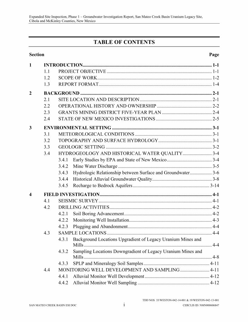
TABLE OF CONTENTS
Section Page
1 INTRODUCTION.......................................................................................................... 1-1
1.1 PROJECT OBJECTIVE ...................................................................................... 1-1
1.2 SCOPE OF WORK .............................................................................................. 1-2
1.3 REPORT FORMAT............................................................................................. 1-4
2 BACKGROUND ............................................................................................................ 2-1
2.1 SITE LOCATION AND DESCRIPTION ........................................................... 2-1
2.2 OPERATIONAL HISTORY AND OWNERSHIP ............................................. 2-2
2.3 GRANTS MINING DISTRICT FIVE-YEAR PLAN ......................................... 2-4
2.4 STATE OF NEW MEXICO INVESTIGATIONS .............................................. 2-5
3 ENVIRONMENTAL SETTING .................................................................................. 3-1
3.1 METEOROLOGICAL CONDITIONS ............................................................... 3-1
3.2 TOPOGRAPHY AND SURFACE HYDROLOGY ............................................ 3-1
3.3 GEOLOGIC SETTING ....................................................................................... 3-2
3.4 HYDROGEOLOGY AND HISTORICAL WATER QUALITY ........................ 3-4
3.4.1 Early Studies by EPA and State of New Mexico ..................................... 3-4
3.4.2 Mine Water Discharge ............................................................................. 3-5
3.4.3 Hydrologic Relationship between Surface and Groundwater .................. 3-6
3.4.4 Historical Alluvial Groundwater Quality................................................. 3-8
3.4.5 Recharge to Bedrock Aquifers ............................................................... 3-14
4 FIELD INVESTIGATION ............................................................................................ 4-1
4.1 SEISMIC SURVEY ............................................................................................. 4-1
4.2 DRILLING ACTIVITIES .................................................................................... 4-2
4.2.1 Soil Boring Advancement ........................................................................ 4-2
4.2.2 Monitoring Well Installation.................................................................... 4-3
4.2.3 Plugging and Abandonment ..................................................................... 4-4
4.3 SAMPLE LOCATIONS ...................................................................................... 4-4
4.3.1 Background Locations Upgradient of Legacy Uranium Mines and Mills ......................................................................................................... 4-4
4.3.2 Sampling Locations Downgradient of Legacy Uranium Mines and Mills ......................................................................................................... 4-8
4.3.3 SPLP and Mineralogy Soil Samples ...................................................... 4-11
4.4 MONITORING WELL DEVELOPMENT AND SAMPLING ........................ 4-11
4.4.1 Alluvial Monitor Well Development ..................................................... 4-12
4.4.2 Alluvial Monitor Well Sampling ........................................................... 4-12

Expanded Site Inspection, Phase 1 – Groundwater Investigation Report, San Mateo Creek Basin Uranium Legacy Site, Cibola and McKinley Counties, New Mexico
TABLE OF CONTENTS (CONTINUED)
Section Page
TDD NOS 35/WESTON-042-14-001 & 19/WESTON-042-13-001
SAN MATEO CREEK BASIN ESI DOC ii CERCLIS ID: NMN000606847
4.4.3 Existing Well Sampling ......................................................................... 4-13
4.5 INVESTIGATION-DERIVED WASTE MANAGEMENT ............................. 4-16
5 SAMPLE ANALYSES AND DATA VALIDATION.................................................. 5-1
5.1 LABORATORY ANALYSES, DATA VALIDATION, AND DATA REPORTING ....................................................................................................... 5-1
5.1.1 Test America Laboratories, Inc................................................................ 5-1
5.1.2 ALS Environmental Laboratories ............................................................ 5-2
5.1.3 Isotech Laboratories, Inc. ......................................................................... 5-2
5.1.4 DCM Science Laboratories, Inc. .............................................................. 5-3
5.2 DATA VALIDATION......................................................................................... 5-3
5.3 CHEMICAL DATA USABILITY ...................................................................... 5-4
5.4 RADIOLOGICAL DATA USABILITY ............................................................. 5-6
6 FIELD INVESTIGATION RESULTS ........................................................................ 6-1
6.1 SUMMARY OF ALLUVIAL SOIL AND SATURATION THICKNESS ........ 6-1
6.2 ALLUVIAL GROUNDWATER SAMPLE RESULTS ...................................... 6-5
6.2.1 Monitoring Wells Upgradient of Potential Legacy Mine and Mill Sources ..................................................................................................... 6-5
6.2.2 Monitoring Wells Downgradient of Potential Legacy Mine and Mill Sources ............................................................................................. 6-7
6.2.3 Total Uranium Exceedances .................................................................... 6-9
6.2.4 Total Selenium Exceedances ................................................................... 6-9
6.2.5 Total Dissolved Solids Exceedances ..................................................... 6-10
6.2.6 Sulfate Exceedances............................................................................... 6-10
6.2.7 Combined Radium-226 + Radium-228 Exceedances ............................ 6-10
6.2.8 Gross Alpha Exceedances ...................................................................... 6-11
6.2.9 General Chemistry ................................................................................. 6-11
6.2.10 Stable Isotopes ....................................................................................... 6-12
6.2.11 Mineralogy ............................................................................................. 6-13
6.2.12 Soil SPLP ............................................................................................... 6-14
6.3 PRIVATELY-OWNED WELLS SAMPLED ................................................... 6-15
7 CONCLUSIONS ............................................................................................................ 7-1
8 REFERENCES ............................................................................................................... 8-1

Expanded Site Inspection, Phase 1 – Groundwater Investigation Report, San Mateo Creek Basin Uranium Legacy Site, Cibola and McKinley Counties, New Mexico
TDD NOS 35/WESTON-042-14-001 & 19/WESTON-042-13-001
SAN MATEO CREEK BASIN ESI DOC iii CERCLIS ID: NMN000606847
LIST OF APPENDICES
Appendix A START-3 Quality Assurance Sampling Plan (QASP)
Appendix B START-3 Site-Specific Health and Safety Plan (SSHASP)
Appendix C Bird Seismic Services Geophysical Report
Appendix D State of New Mexico Well Completion Records
Appendix E Boring Logs
Appendix F Summary of START-3 Water Quality Measurements
Appendix G Test America Laboratory Analytical Reports
Appendix H ALS Laboratory Analytical Reports
Appendix I Isotech Laboratory Analytical Reports
Appendix J DCM Science Analytical Report
Appendix K START-3 Chemical Data Validation Reports
Appendix L START-3 Radiological Data Validation Reports
Appendix M START-3 Groundwater Analytical Results
Appendix N SPLP Soil Analytical Results

Expanded Site Inspection, Phase 1 – Groundwater Investigation Report, San Mateo Creek Basin Uranium Legacy Site, Cibola and McKinley Counties, New Mexico
TDD NOS 35/WESTON-042-14-001 & 19/WESTON-042-13-001
SAN MATEO CREEK BASIN ESI DOC iv CERCLIS ID: NMN000606847
LIST OF FIGURES
Figure 1-1 Site Location Map
Figure 2-1 Site Area Map
Figure 2-2 Site Plan
Figure 2-3 NMED Phase 1 Site Investigation Map
Figure 2-4 NMED Phase 2 Site Inspection Map
Figure 3-1 Historical State Sampling Locations
Figure 3-2 Homestake Mining Company Near Up-Gradient Well Location Map
Figure 4-1 Well and Boring Location Map
Figure 4-2 BG-01, BG-01A Soil Boring Location Map
Figure 4-3 BG-02, BG-02A Soil Boring Location Map
Figure 4-4 BG-03, BG-04, BG-05, PV-02 Soil Boring Location Map
Figure 4-5 BG-06, BG-06A Soil Boring Location Map
Figure 4-6 BG-07, BG-07A, BG-07B, BG-07C, SMC-09 Soil Boring Location Map
Figure 4-7 C-3, OTERO-1,2,3,4 Soil Boring Location Map
Figure 4-8 C-5, C-5A, C-5B, C-5C, C-5D, C-5E, C-5F, C-5G Soil Boring Location Map
Figure 4-9 N-1, N-1A, N-2, N-2A, N-3, N-3A Soil Boring Location Map
Figure 4-10 N-4 Soil Boring Location Map
Figure 4-11 N-5 Soil Boring Location Map
Figure 4-12 Alluvial Wells Sampled During Phase I
Figure 4-13 Existing Alluvial and Bedrock Wells Sampled During Phase I
Figure 4-14 907, 928, 943 Well Location Map
Figure 4-15 MW-35-8, MW-35-9 Well Location Map
Figure 4-16 PV-01, SMC-10, SMC-11, SMC-12, SMC-13, SMC-14 Well Location Map
Figure 4-17 PV-02, BG-03, BG-04, BG-05 Well Location Map
Figure 4-18 PV-03, SMC-26 Well Location Map
Figure 6-1 Alluvial Monitoring Wells Summary of Results Map
Figure 6-2 Trilinear Diagrams Alluvial Monitoring Wells
Figure 6-3 Bedrock Monitoring Wells Summary of Results Map
Expanded Site Inspection, Phase 1 – Groundwater Investigation Report, San Mateo Creek Basin Uranium Legacy Site, Cibola and McKinley Counties, New Mexico
TDD NOS 35/WESTON-042-14-001 & 19/WESTON-042-13-001
SAN MATEO CREEK BASIN ESI DOC v CERCLIS ID: NMN000606847
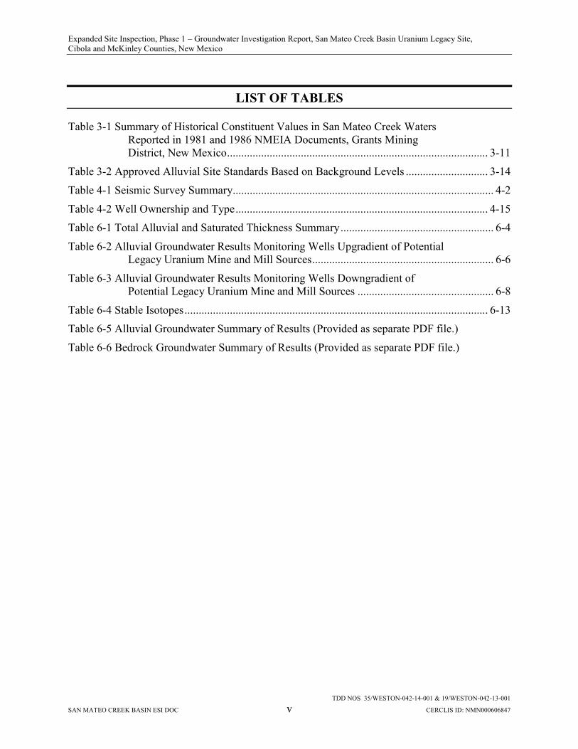
LIST OF TABLES
Table 3-1 Summary of Historical Constituent Values in San Mateo Creek Waters Reported in 1981 and 1986 NMEIA Documents, Grants Mining District, New Mexico ............................................................................................ 3-11
Table 3-2 Approved Alluvial Site Standards Based on Background Levels ............................. 3-14
Table 4-1 Seismic Survey Summary............................................................................................ 4-2
Table 4-2 Well Ownership and Type ......................................................................................... 4-15
Table 6-1 Total Alluvial and Saturated Thickness Summary ...................................................... 6-4
Table 6-2 Alluvial Groundwater Results Monitoring Wells Upgradient of Potential Legacy Uranium Mine and Mill Sources ................................................................ 6-6
Table 6-3 Alluvial Groundwater Results Monitoring Wells Downgradient of Potential Legacy Uranium Mine and Mill Sources ................................................ 6-8
Table 6-4 Stable Isotopes ........................................................................................................... 6-13
Table 6-5 Alluvial Groundwater Summary of Results (Provided as separate PDF file.)
Table 6-6 Bedrock Groundwater Summary of Results (Provided as separate PDF file.)

Expanded Site Inspection, Phase 1 – Groundwater Investigation Report, San Mateo Creek Basin Uranium Legacy Site, Cibola and McKinley Counties, New Mexico
TDD NOS 35/WESTON-042-14-001 & 19/WESTON-042-13-001
SAN MATEO CREEK BASIN ESI DOC vi CERCLIS ID: NMN000606847
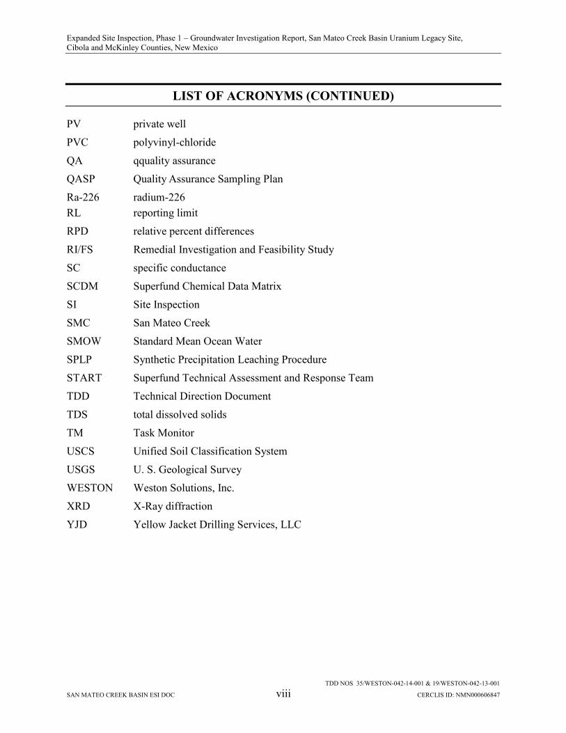
LIST OF ACRONYMS
%R percent recovery
aka also known as
ARCO Atlantic Richfield Company
bgs below ground surface
BVDA Bluewater Valley Downstream Alliance
C Centigrade
CDT Canyon Diablo meteorite
CERCLA Comprehensive Environmental Response, Compensation, and Liability Act
CERCLIS Comprehensive Environmental Response, Compensation, and Liability Information System
COPCs contaminants-of-potential-concern
D diluted
DO dissolved oxygen
DOE U.S. Department of Energy
EPA U.S. Environmental Protection Agency
ESI Expanded Site Inspection
F Fahrenheit
Ft/lb feet per pound
GMD Grants Mining District
gpm gallons per minute
GPS Global Positioning System
HASP Health and Safety Plan
HCO3 Anion Bicarbonate
HMC Homestake Mining Company
HRS Hazard Ranking System
HUC Hydrologic Unit Code
ICP inductively coupled plasma
IDW Investigation-Derived Waste
IRMS Isotope Ratio Mass Spectrometry
LCS Laboratory Control Sample

Expanded Site Inspection, Phase 1 – Groundwater Investigation Report, San Mateo Creek Basin Uranium Legacy Site, Cibola and McKinley Counties, New Mexico
LIST OF ACRONYMS (CONTINUED)
TDD NOS 35/WESTON-042-14-001 & 19/WESTON-042-13-001
SAN MATEO CREEK BASIN ESI DOC vii CERCLIS ID: NMN000606847
LM Legacy Management
LSM lower San Mateo
LTP Large Tailing Pile
MASE Multi-cultural Alliance for a Safe Environment
MCL Maximum Contaminant Level
MDC minimum detectable concentration
MDL method detection limit
mg/L milligrams per liter
MOU Memorandum of Understanding
mph miles per hour
MREM/YR millirem per year
MS/MSD Matrix spike/matrix spike duplicate
MSL mean sea level
Na Sodium
NELAP National Environmental Laboratory Accreditation Program
NM New Mexico
NMED New Mexico Environment Department
NMEIA New Mexico Environmental Improvement Agency
NMWQCC New Mexico Water Quality Control Commission
NPDES National Pollutant Discharge Elimination System
NPL National Priorities List
NRC U.S. Nuclear Regulatory Commission
ORP oxidation reduction potential
OSE New Mexico Office of the State Engineer
pCi/g picocuries per gram
pCi/L picocuries per liter
PDB PeeDee belemenite
PDF Portable Document Format
ppb parts per billion
PRB Prevention and Response Branch
Expanded Site Inspection, Phase 1 – Groundwater Investigation Report, San Mateo Creek Basin Uranium Legacy Site, Cibola and McKinley Counties, New Mexico
LIST OF ACRONYMS (CONTINUED)
TDD NOS 35/WESTON-042-14-001 & 19/WESTON-042-13-001
SAN MATEO CREEK BASIN ESI DOC viii CERCLIS ID: NMN000606847
PV private well
PVC polyvinyl-chloride
QA qquality assurance
QASP Quality Assurance Sampling Plan
Ra-226 radium-226 RL reporting limit
RPD relative percent differences
RI/FS Remedial Investigation and Feasibility Study
SC specific conductance
SCDM Superfund Chemical Data Matrix
SI Site Inspection
SMC San Mateo Creek
SMOW Standard Mean Ocean Water
SPLP Synthetic Precipitation Leaching Procedure
START Superfund Technical Assessment and Response Team
TDD Technical Direction Document
TDS total dissolved solids
TM Task Monitor
USCS Unified Soil Classification System
USGS U. S. Geological Survey
WESTON Weston Solutions, Inc.
XRD X-Ray diffraction
YJD Yellow Jacket Drilling Services, LLC

Expanded Site Inspection, Phase 1 – Groundwater Investigation Report, San Mateo Creek Basin Uranium Legacy Site, Cibola and McKinley Counties, New Mexico
TDD NOS 35/WESTON-042-14-001 & 19/WESTON-042-13-001
SAN MATEO CREEK BASIN ESI DOC 1-1 CERCLIS ID: NMN000606847
1 INTRODUCTION
The U.S. Environmental Protection Agency (EPA) Region 6 Prevention and Response Branch
(PRB) tasked Weston Solutions, Inc. (WESTON®), the Superfund Technical Assessment and
Response Team (START-3) contractor, under Contract Number EP-W-06-042, Technical
Direction Document (TDD) Nos. 35/WESTON-042-14-001 and 19/WESTON-042-13-001, and
the authority of the Comprehensive Environmental Response, Compensation, and Liability Act
as amended (CERCLA), to conduct an Expanded Site Inspection (ESI) at the San Mateo Creek
Basin Legacy Uranium Site (Site) located near Grants, Cibola and McKinley Counties, New
Mexico. A Site Location Map is included as Figure 1-1. The Comprehensive Environmental
Response, Compensation, and Liability Information System (CERCLIS) number assigned to the
Site is NMN000606847. START-3 has prepared this report as part of the TDD requirements to
describe the field investigation activities, analytical scope of work, summary of findings, and
conclusions of the initial phase (Phase 1) of the ESI.
1.1 PROJECT OBJECTIVE
The Phase 1 project objective was to conduct an investigation of alluvial groundwater within the
San Mateo Creek Basin (SMC Basin) to assess potential impacts from legacy uranium mining.
As part of the investigation, groundwater samples were collected from the alluvial water-bearing
zones in specific areas of the SMC Basin and analyzed for chemical and radiological
constituents. The sample analytical results were compared to EPA Primary and Secondary
Drinking Water Maximum Contaminant Levels (MCLs) and the New Mexico Water Quality
Control Commission (NMWQCC) groundwater standards for the following contaminants of
potential concern (COPCs):
EPA National Primary and Secondary MCLs
Total Uranium – 0.03 milligrams per liter (mg/L) Total Selenium – 0.05 mg/L Sulfate – 250 mg/L Total Dissolved Solids (TDS) – 500 mg/L
Expanded Site Inspection, Phase 1 – Groundwater Investigation Report, San Mateo Creek Basin Uranium Legacy Site, Cibola and McKinley Counties, New Mexico
TDD NOS 35/WESTON-042-14-001 & 19/WESTON-042-13-001
SAN MATEO CREEK BASIN ESI DOC 1-2 CERCLIS ID: NMN000606847
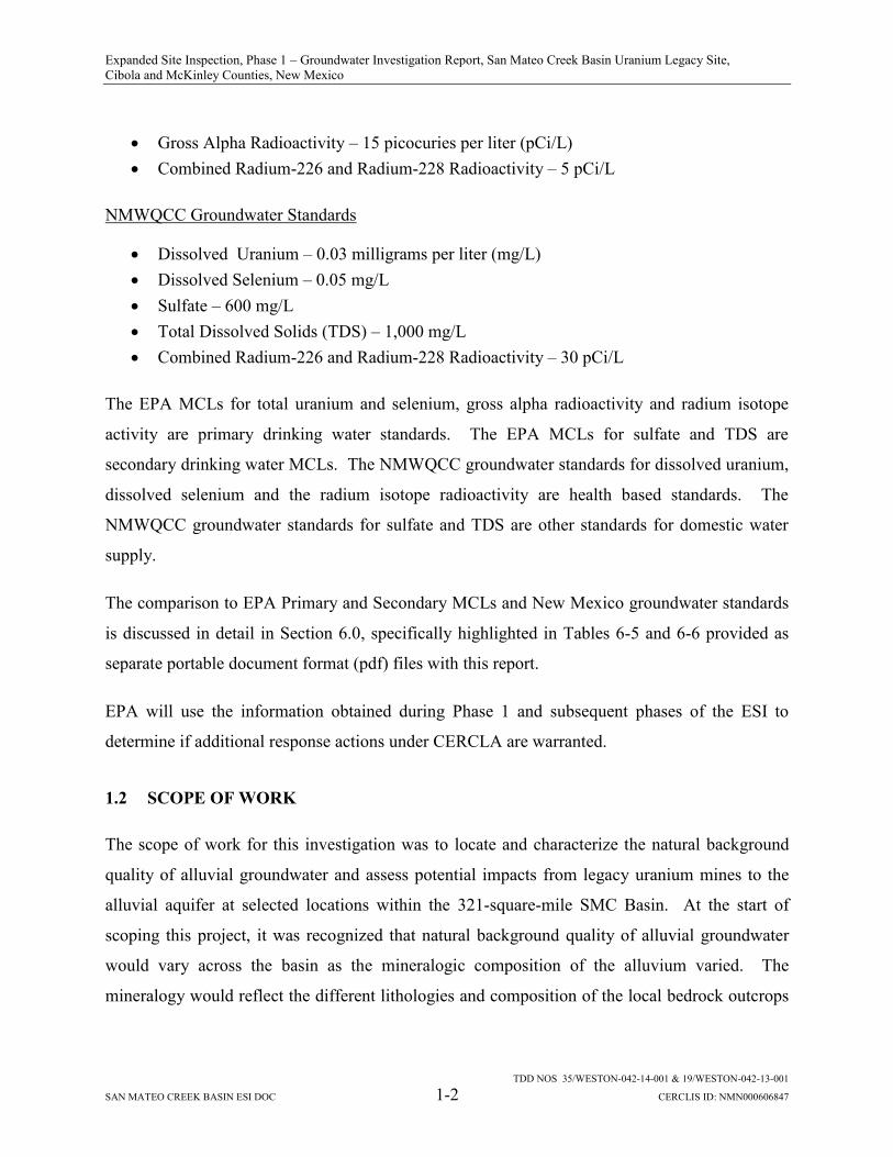
Gross Alpha Radioactivity – 15 picocuries per liter (pCi/L) Combined Radium-226 and Radium-228 Radioactivity – 5 pCi/L
NMWQCC Groundwater Standards
Dissolved Uranium – 0.03 milligrams per liter (mg/L) Dissolved Selenium – 0.05 mg/L Sulfate – 600 mg/L Total Dissolved Solids (TDS) – 1,000 mg/L Combined Radium-226 and Radium-228 Radioactivity – 30 pCi/L
The EPA MCLs for total uranium and selenium, gross alpha radioactivity and radium isotope
activity are primary drinking water standards. The EPA MCLs for sulfate and TDS are
secondary drinking water MCLs. The NMWQCC groundwater standards for dissolved uranium,
dissolved selenium and the radium isotope radioactivity are health based standards. The
NMWQCC groundwater standards for sulfate and TDS are other standards for domestic water
supply.
The comparison to EPA Primary and Secondary MCLs and New Mexico groundwater standards
is discussed in detail in Section 6.0, specifically highlighted in Tables 6-5 and 6-6 provided as
separate portable document format (pdf) files with this report.
EPA will use the information obtained during Phase 1 and subsequent phases of the ESI to
determine if additional response actions under CERCLA are warranted.
1.2 SCOPE OF WORK
The scope of work for this investigation was to locate and characterize the natural background
quality of alluvial groundwater and assess potential impacts from legacy uranium mines to the
alluvial aquifer at selected locations within the 321-square-mile SMC Basin. At the start of
scoping this project, it was recognized that natural background quality of alluvial groundwater
would vary across the basin as the mineralogic composition of the alluvium varied. The
mineralogy would reflect the different lithologies and composition of the local bedrock outcrops

Expanded Site Inspection, Phase 1 – Groundwater Investigation Report, San Mateo Creek Basin Uranium Legacy Site, Cibola and McKinley Counties, New Mexico
TDD NOS 35/WESTON-042-14-001 & 19/WESTON-042-13-001
SAN MATEO CREEK BASIN ESI DOC 1-3 CERCLIS ID: NMN000606847
that supplied detritus to the drainage basin. Therefore, several areas of the SMC Basin were
targeted for locating and characterizing alluvial groundwater that may represent background.
These areas were located primarily in the upper elevations of the SMC Basin where alluvial
groundwater, if present, would be upgradient of legacy uranium mines and mills that could be
potential sources of COPCs and other constituents to alluvial groundwater.
At the time of scoping, the central portion of the SMC basin was not targeted for characterizing
alluvial background water quality because it was downgradient of many legacy mines and mills
with respect to the alluvial groundwater flow direction as well as downstream of these sites along
San Mateo Creek, Arroyo del Puerto, and other surface drainages. Furthermore, the nature and
extent of potential impacts to the alluvial groundwater in this area of the basin from legacy
uranium mining and milling operations were not well defined.
Areas of the SMC Basin located downgradient of legacy mines or groups of mines that operated
as wet mines1 were targeted for locating and sampling alluvial groundwater that may have been
impacted by the mine water discharge operations.
The scope of work also included sampling a number of private water wells and industry
monitoring wells that were known to be alluvial wells. Some of these wells were selected by
EPA to help characterize the alluvial aquifer or water-bearing zones within different parts of the
basin. Others were sampled at the request of the private well owners. Additionally, EPA
decided to sample three San Andres/Glorieta bedrock wells located in the southern part of the
SMC Basin when the environmental group known as the Multi-cultural Alliance for a Safe
Environment (MASE) requested monitoring of the San Andres/Glorieta aquifer.
1 The term “wet mine” refers to a mining operation that targeted an ore-bearing formation that was saturated. The underground mine workings were dewatered by pumping, and the collected mine water was discharged to nearby surface drainage features such as arroyos or creeks. After the establishment of state or federal discharge permitting programs (e.g., the National Pollutant Discharge Elimination System (NPDES) permitting program), mine water discharge was regulated and typically required treatment prior to discharge to surface drainages. Prior to that time, mine water discharges in the Grants Mining District were likely not treated.

Expanded Site Inspection, Phase 1 – Groundwater Investigation Report, San Mateo Creek Basin Uranium Legacy Site, Cibola and McKinley Counties, New Mexico
TDD NOS 35/WESTON-042-14-001 & 19/WESTON-042-13-001
SAN MATEO CREEK BASIN ESI DOC 1-4 CERCLIS ID: NMN000606847
Field activities included: exploratory borehole drilling and coring; monitoring well installation,
development, and sampling; privately-owned domestic and livestock well sampling, and industry
well sampling. As part of the exploratory siting of potential drilling locations, a seismic survey
was conducted in a limited number of areas to identify the axes of any paleo-alluvial channels in
the subsurface that would make optimal targets for the placement of boreholes and monitoring
wells. The project scope of work included the following activities:
Review of available background files.
Attendance at a scoping meeting with EPA personnel in Dallas, Texas.
Preparation of a site-specific quality assurance sampling plan (QASP), site-specific health and safety plan (HASP), and investigation-derived waste plan (IDW).
Preparation of cost estimates and procurement laboratories to conduct chemical, radiological, and geotechnical analysis prior to initiating field activities at the Site.
Management of field activities including: exploratory drilling and borehole logging; installation of monitoring wells; seismic survey; and collection of soil and groundwater samples.
Evaluation of alluvial water quality and geochemistry and comparison of analytical results to EPA Primary and Secondary Drinking Water MCLs and NMWQCC groundwater standards.
Comparison of background water quality and geochemical analytical results to the alluvial groundwater quality and geochemical analytical results from wells located downgradient to legacy uranium wet mines or groups of mines and former uranium mills.
Validation of data and preparation of defensible data validation reports.
Preparation of residential well results letters, maps, and data tables.
Preparation of a Phase I Groundwater Investigation Report for the Site to include validated analytical data from the samples collected during the field investigation.
Appendix A includes the EPA-approved QASP, and Appendix B includes the site-specific
HASP.
1.3 REPORT FORMAT
This report is organized as follows:
Section 1 – Introduction

Expanded Site Inspection, Phase 1 – Groundwater Investigation Report, San Mateo Creek Basin Uranium Legacy Site, Cibola and McKinley Counties, New Mexico
TDD NOS 35/WESTON-042-14-001 & 19/WESTON-042-13-001
SAN MATEO CREEK BASIN ESI DOC 1-5 CERCLIS ID: NMN000606847
Section 2 – Background Section 3 – Environmental Setting Section 4 – Field Investigation Section 5 – Sample Analyses and Data Validation Section 6 – Field Investigation Results Section 7 – Conclusions Section 8 – References
All figures are included as separate portable document format (PDF) files.
Expanded Site Inspection, Phase 1 – Groundwater Investigation Report, San Mateo Creek Basin Uranium Legacy Site, Cibola and McKinley Counties, New Mexico
TDD NOS 35/WESTON-042-14-001 & 19/WESTON-042-13-001
SAN MATEO CREEK BASIN ESI DOC 2-1 CERCLIS ID: NMN000606847
2 BACKGROUND
Information regarding the Site location, description, operational history, and ownership is
presented in the following subsections.
2.1 SITE LOCATION AND DESCRIPTION
The SMC Basin (Hydrologic Unit Code [HUC] 1302020703), by which the boundary of the Site
is defined, comprises approximately 321 square miles within the Rio San Jose drainage basin in
McKinley and Cibola Counties, New Mexico (NMED, 2012). A Site Area Map is provided as
Figure 2-1. This basin is located within the Grants Mining District (GMD), which is an area of
uranium mineralization occurrence approximately 100 miles long and 25 miles wide
encompassing portions of McKinley, Cibola, Sandoval, and Bernalillo counties which has been
extensively mined by the domestic uranium industry. The GMD includes the Ambrosia Lake
Mining Sub-district. The terms “Grants Mineral Belt” and “Grants Uranium Region” have been
used historically to define an area of uranium deposits extending from Gallup on the west to the
western edge of the Rio Grande trough on the east. The principal areas within this belt or region,
from west to east, are Gallup, Churchrock, Crownpoint, Smith Lake, Ambrosia Lake, Grants, and
Paguate or Jackpile (Kelly, 1963). The GMD and the Site lie within this larger Grants Mineral
Belt or Grants Uranium Region. Main access into the Site is provided via New Mexico State
Highways 605 and 509.
There are 85 legacy uranium mines with recorded production and four legacy uranium mill sites
within the SMC Basin. A Site Plan identifying the location of former mills and mines is
presented as Figure 2-2. Many of these legacy mines operated as wet mines where the
underground workings were dewatered and the collected mine water was discharged (untreated
and treated) to nearby surface drainage features, including San Mateo Creek and Arroyo del
Puerto. The average underground mine in the GMD continuously discharged more than 1,000
gallons per minute (gpm) of produced water. Collectively, more than 150 billion gallons of
water were pumped from aquifers in the GMD between 1956 and 1982 (Gallaher and Cary,
1986). The mine discharge water infiltrated channel fill sediments and saturated portions of the
Expanded Site Inspection, Phase 1 – Groundwater Investigation Report, San Mateo Creek Basin Uranium Legacy Site, Cibola and McKinley Counties, New Mexico
TDD NOS 35/WESTON-042-14-001 & 19/WESTON-042-13-001
SAN MATEO CREEK BASIN ESI DOC 2-2 CERCLIS ID: NMN000606847
alluvium and underlying bedrock aquifers along the basin channels. Tailing liquids from the
former uranium mills also seeped downward into the alluvium and underlying bedrock aquifers.
These mining and milling operations contributed to degradation of the groundwater quality
within the basin (Gallaher and Cary, 1986). Analyses of groundwater samples collected from
private water wells throughout the basin by the New Mexico Environment Department (NMED)
show exceedances of federal drinking water MCLs and NMWQCC ground-water standards for
uranium, selenium, and other constituents (NMED, 2012).
2.2 OPERATIONAL HISTORY AND OWNERSHIP
Uranium ore was discovered in the Todilto Limestone at Haystack Butte in 1950, and production
began prior to mill construction in the area by open-pit mining. Uranium was discovered at
Ambrosia Lake in 1955. Downdip drilling from the initial surface discoveries delineated ore
bodies within the Jurassic Todilto Limestone Formation and Westwater Canyon Member of the
Jurassic Morrison Formation within the Ambrosia Lake Mining Subdistrict. The discovery of
large subsurface uranium deposits within the Westwater Canyon Member resulted in the
establishment of two-thirds of the active uranium mines in New Mexico within the Ambrosia
Lake Mining Subdistrict by 1980; most of these mines were underground room-and-pillar
operations at depths averaging 900 feet (NMED, 2012).
The Anaconda Copper Company built the Bluewater Mill northwest of Milan, New Mexico, in
1953 to process ore from the Jackpile Uranium Mine. This mill used a carbonate-leach process
with a capacity of 300 tons per day and operated until 1959. An acid-leach mill was operated
from 1957 through 1982, reaching a production capacity of 6,000 tons per day in 1978. Atlantic
Richfield Company (ARCO) reclaimed the site between 1991 and 1995 for long-term
stewardship under the U.S. Department of Energy (DOE) Legacy Management (LM) Program
(NMED, 2012). The Bluewater Mill Site was transferred to the DOE LM Program in 1997 for
long-term monitoring and surveillance, including monitoring groundwater quality. Monitoring
results indicate that the upper two aquifers (alluvium and San Andreas aquifers) beneath the mill
site are contaminated with mill-related constituents and that groundwater with elevated
concentrations of uranium is migrating beyond the site boundary. A groundwater conceptual site

Expanded Site Inspection, Phase 1 – Groundwater Investigation Report, San Mateo Creek Basin Uranium Legacy Site, Cibola and McKinley Counties, New Mexico
TDD NOS 35/WESTON-042-14-001 & 19/WESTON-042-13-001
SAN MATEO CREEK BASIN ESI DOC 2-3 CERCLIS ID: NMN000606847
model was developed by DOE in 2014 that describes the aquifers and the potential exposure of
downgradient groundwater users to mill-related contamination (DOE, LMS/BLU/S11381,
November, 2014).
Two mills were built in 1957 at the present Homestake Mining Company (HMC) uranium mill
tailing National Priorities List (NPL) site, located about 5.5 miles north of Milan and 4.5 miles
east of the DOE Bluewater Mill site, in Cibola County, New Mexico. The first mill closed in
1962. HMC originally owned the second larger mill in a partnership. When that partnership was
dissolved in 1981, HMC became the sole owner. Mill production ceased in 1981, but resumed in
1988 to process ore from its Section 23 Mine and the Chevron Corporation Mount Taylor Mine.
In 1974, New Mexico signed an agreement with the U.S. Nuclear Regulatory Commission
(NRC), formerly the Atomic Energy Commission, authorizing New Mexico to regulate uranium
milling activities under the Atomic Energy Act as an “Agreement State.” New Mexico
subsequently issued HMC a radioactive materials license for the mill. Elevated levels of
selenium were discovered in the alluvial aquifer downgradient of the site by New Mexico and
EPA in 1975 and EPA placed the site on the NPL in September 1983, primarily due to
groundwater contamination. At that time, HMC began an aquifer protection and restoration
program under New Mexico Groundwater Discharge Permit (DP) 200, including groundwater
injection and collection efforts. EPA issued a “No Action” Record of Decision for off-site radon
in residential subdivisions in September 1989.
In 1986, at the request of the governor, New Mexico returned its regulatory responsibility for
uranium mills back to the NRC. NRC subsequently issued Source Materials License SUA-1471
to HMC for the NPL site. The mill was demolished in 1990. The site groundwater restoration
project continued pursuant to SUA-1471 and DP-200. In 1993, EPA and NRC signed a
Memorandum of Understanding (MOU) establishing the roles, responsibilities, and relationships
of the two agencies due to their overlapping authorities. Under the MOU, the NRC is the lead
regulatory agency for the tailing disposal area reclamation and closure activities and EPA
monitors such activities to ensure all activities conducted under the NRC’s regulatory authority
allowed the attainment of appropriate CERCLA requirements outside of the tailing disposal area.
Expanded Site Inspection, Phase 1 – Groundwater Investigation Report, San Mateo Creek Basin Uranium Legacy Site, Cibola and McKinley Counties, New Mexico
TDD NOS 35/WESTON-042-14-001 & 19/WESTON-042-13-001
SAN MATEO CREEK BASIN ESI DOC 2-4 CERCLIS ID: NMN000606847
In 2001, HMC merged with Barrick Gold Corporation (NMED, 2012). HMC is currently
conducting a CERCLA Remedial Investigation and Feasibility Study (RI/FS) equivalency
process for EPA to assess whether site corrective actions are equivalent to a CERCLA-quality
remedy.
Kermac Nuclear Fuels Corporation, which was in partnership with Kerr-McGee Oil Industries,
Inc., Anderson Development Corporation, and Pacific Uranium Mines Company, built the Kerr-
McGee Uranium Mill at Ambrosia Lake in 1957-1958, and operated the mill for nearly 30 years.
Quivira Mining Company, a subsidiary of Kerr-McGee Corporation, became the operator of the
mill in 1983. Quivira later became Rio Algom Mining, LLC and currently BHP Billiton through
corporate mergers. From 1985 through 2002, the mill produced uranium concentrate using only
recirculated mine water from the Ambrosia Lake area underground mines. The tailing
impoundment at the site reportedly contains 33 million tons of uranium ore within an area of 370
acres (NMED, 2012). The Rio Algom Mill Site is in the process of meeting the NRC
requirements for mill closure and requesting transfer into the DOE LM program for long-term
monitoring and surveillance.
Phillips Petroleum Company built a mill at Ambrosia Lake in 1957 and 1958 and began to
process ore from the Ann Lee, Sandstone, and Cliffside mines in 1958. United Nuclear
Corporation acquired the property in 1963 when the mill closed. United Nuclear Corporation
operated an ion exchange system at the mill site to extract uranium from mine water in the late
1970s to early 1980s. All operations ended in 1982 (NMED, 2012). DOE remediated the site
from 1987-1995 pursuant to the 1978 Uranium Mill Tailings Radiation Control Act (UMTRCA)
Title I Program and it is designated as the Ambrosia Lake Site under the LM program for long-
term monitoring and surveillance.
2.3 GRANTS MINING DISTRICT FIVE-YEAR PLAN
In 2010, EPA and other federal, state, and Pueblo of Laguna regulatory agencies with the
authority and responsibility for protecting human health and the environment released a five-year
plan to assess health and environmental impacts of uranium mining and milling in the Grants

Expanded Site Inspection, Phase 1 – Groundwater Investigation Report, San Mateo Creek Basin Uranium Legacy Site, Cibola and McKinley Counties, New Mexico
TDD NOS 35/WESTON-042-14-001 & 19/WESTON-042-13-001
SAN MATEO CREEK BASIN ESI DOC 2-5 CERCLIS ID: NMN000606847
Mining District (Five-Year Plan). The Five-Year Plan was intended to compile all activities
contributing to the identification and cleanup of legacy uranium milling and mining activities in
the Grants Mining District. The participating agencies committed to assessing legacy
contamination of structures, surface and groundwater resources, and sediment to eliminate,
reduce, or manage associated risk to human health and the environment. The agencies
established specific objectives to guide this endeavor. The agencies also agreed to coordinate the
assessment efforts. The agencies would implement appropriate laws, regulations, and policies
within their jurisdiction to accomplish cross-organizational activities. The participating agencies
released a second Five-Year Plan in June 2016. One of the goals of the second Five-Year Plan is
to build a conceptual site model as a tool to understand impacts from legacy uranium mining and
milling on surface and groundwater systems in the SMC Basin.
2.4 STATE OF NEW MEXICO INVESTIGATIONS
NMED representatives conducted a Site Inspection (SI) during the week of March 30, 2009, that
involved sampling 28 residential and livestock wells within the SMC Basin north of the HMC
site. The location of the wells are depicted on Figure 2-3. The objective of the SI was to
evaluate the Site using the Hazard Ranking System (HRS) and the Superfund Chemical Data
Matrix (SCDM) to determine if a threat to human health and the environment exists such that
further action under CERCLA would be warranted.
The findings were published in the NMED June 2010 Phase 1 Site Investigation Report, San
Mateo Creek Legacy Uranium Site. The conclusions presented in the SI Report were as follows:
All groundwater samples collected for the SI had at least one contaminant concentration exceeding a respective EPA MCL;
TDS concentrations increased generally from north to south within the sample set;
Alluvial groundwater samples typically had higher TDS concentrations than samples from bedrock aquifers;
Areas of relatively elevated nitrate + nitrite concentrations were identified north of the HMC site and near the junction of state highways 605 and 509;
Dissolved uranium concentrations averaged approximately 58 mg/L for the entire SI sample set;

Expanded Site Inspection, Phase 1 – Groundwater Investigation Report, San Mateo Creek Basin Uranium Legacy Site, Cibola and McKinley Counties, New Mexico
TDD NOS 35/WESTON-042-14-001 & 19/WESTON-042-13-001
SAN MATEO CREEK BASIN ESI DOC 2-6 CERCLIS ID: NMN000606847
Analysis of the hydrochemical data indicated a positive correlation between dissolved uranium and selenium concentrations;
The highest concentrations of uranium and selenium were found in a presumed alluvial well located in the southern part of the basin north of the HMC site;
Qualitative analyses suggested that the average concentrations of these analytes are higher than background concentrations; and
The highest activity values for Radium 226 (2.90 pCi/l) and Radium 228 (3.91 pCi/l) came from bedrock well SMC-32, which was inferred to be completed in the Morrison Formation.
NMED representatives conducted SI Phase 2 activities on November 8 and 9, 2010, that
involved the collection of groundwater samples from three private domestic wells within the
SMC Basin and a private domestic well outside of the basin, within the town of Cubero, New
Mexico. The objective of the SI Phase 2 was to evaluate the Site using the HRS and the SCDM
to determine if a threat to human health and the environment exists such that further action
under CERCLA was warranted. The four domestic wells were sampled by NMED at the
request of the well owners in response to the ongoing investigation of potential environmental
impacts from legacy uranium mine and mill sites within the Grants Mining District. One
additional sample (RH11-001A) collected by Roca Honda Resources from the north vent hole at
the Johnny M Mine was used by NMED for geochemical interpretation of the hydrogeology in
the area of the GMD-04 well and the Johnny M Mine. Figure 2-4 illustrates the location of the
wells and vent hole sampled during the SI Phase 2. The ground-water samples collected from
the private wells were designated as follows:
GMD-01 GMD-02 GMD-03 (Duplicate of GMD-02) GMD-04 GMD-05
A summary of the analytical results is presented in the NMED document entitled “Site
Inspection Report, Phase 2, San Mateo Creek Basin Legacy Uranium Mine and Mill Site Area,
CERCLIS ID NMN000606847, Cibola-McKinley Counties, New Mexico, June 2012” (Phase 2
SI Report). The findings of the Phase 2 SI Report included the following:

Expanded Site Inspection, Phase 1 – Groundwater Investigation Report, San Mateo Creek Basin Uranium Legacy Site, Cibola and McKinley Counties, New Mexico
TDD NOS 35/WESTON-042-14-001 & 19/WESTON-042-13-001
SAN MATEO CREEK BASIN ESI DOC 2-7 CERCLIS ID: NMN000606847
Gross alpha exceeded the EPA MCL of 15 pCi/L in samples GMD-01, GMD-02, GMD-04, and RH11-001A;
Combined Radium-226 and Radium-228 exceeded the EPA MCL of 5 pCi/L in samples GMD-04 and RH11-001A’
Uranium exceeded the EPA MCL of 0.030 mg/L in sample RH11-001A;
Sulfate exceeded the secondary EPA MCL in samples GMD-02, GMD-04, and GMD-05; and
TDS exceedances above the secondary EPA MCL of 500 mg/L included GMD-02, GMD-04, and GMD-05.
NMED representatives returned to the SMC Basin in October 2014 and January 2015 to collect
additional groundwater samples from 24 private wells for analysis. The results of this
investigation are presented in the September 2015 NMED report entitled “Site Reassessment
Report, Lower San Mateo Creek Basin Site, Cibola and McKinley Counties, New Mexico,
CERCLIS ID NMN000606847”.

Expanded Site Inspection, Phase 1 – Groundwater Investigation Report, San Mateo Creek Basin Uranium Legacy Site, Cibola and McKinley Counties, New Mexico
TDD NOS 35/WESTON-042-14-001 & 19/WESTON-042-13-001
SAN MATEO CREEK BASIN ESI DOC 3-1 CERCLIS ID: NMN000606847
3 ENVIRONMENTAL SETTING
A discussion of meteorological conditions, topography, geologic setting, and site hydrogeology
is provided in the following subsections.
3.1 METEOROLOGICAL CONDITIONS
At the Grants-Milan, New Mexico Airport the average annual maximum temperature is 67.8°
Fahrenheit (F) and the average annual minimum temperature is 33° F. The highest maximum
temperature of 88.4° F occurs in July and the lowest minimum temperature of 14.4° F occurs in
January. The average annual total precipitation as rainfall is 10.4 inches. The maximum average
monthly precipitation of 2.03 inches occurs in August, and the minimum average monthly
precipitation of 0.44 inches occurs in February. Average annual snowfall is 12.3 inches, with the
maximum snowfall of 4.1 inches occurring in December. Prevailing wind direction is from the
northwest (NMED, 2012).
3.2 TOPOGRAPHY AND SURFACE HYDROLOGY
The SMC Basin is mainly rangeland within the Colorado Plateau physiographic province. It is
characterized by rough, broken terrain, including steep mountainous areas, plateaus, cuestas, and
mesas intermingled with steep canyon walls, escarpments, and valleys. Additional topographic
features in the area indicate volcanic activity expressed as erosion-resistant volcanic plugs and
black-colored basalt capped plateaus and mesas (USDA, 2005).
In the eastern part of the SMC Basin, the headwaters of San Mateo Creek originate on the north
flank of Mount Taylor. One branch of the headwaters originates in San Mateo Canyon above the
community of San Mateo while another branch drains the San Mateo arch/Jesus Mesa area via
Marquez and Maruca Canyons. Within the San Mateo Canyon branch, springs maintain a small
perennial flow that is captured in the San Mateo Reservoir, located above the community of San
Mateo (USDA, 2005). San Mateo Creek flows west and turns southwest above the NM State
Highways 605 and 509 junction where it continues until it terminates in the vicinity of the HMC
NPL site.
Expanded Site Inspection, Phase 1 – Groundwater Investigation Report, San Mateo Creek Basin Uranium Legacy Site, Cibola and McKinley Counties, New Mexico
TDD NOS 35/WESTON-042-14-001 & 19/WESTON-042-13-001
SAN MATEO CREEK BASIN ESI DOC 3-2 CERCLIS ID: NMN000606847
The north and northwestern parts of the SMC Basin are drained by the ephemeral network of dry
alluvial channels contained in Martin Draw and Hijino Draw. These two drainages pass the now
dry Ambrosia Lake shallow depression and the former Rio Algom Mill site and join to form the
Arroyo del Puerto. The Arroyo del Puerto continues east and south to the confluence with San
Mateo Creek just past the NM State Highways 605 and 509 junction. From this point, surface
water flow in San Mateo Creek is southward in the direction of the HMC NPL site.
3.3 GEOLOGIC SETTING
The SMC Basin is generally characterized by large faulted, tilted, and eroded ridge-forming
sedimentary strata, broad valleys, and a large volcanic complex called Mount Taylor in the
northeastern part of the basin. The SMC Basin is located along the southern margin of the
underlying San Juan Basin where it is influenced by three regional tectonic features: the Zuni
Uplift on the south, the Chaco Slope on the west and north, and the Acoma Sag on the east. The
major tectonic and structural geologic feature in the SMC Basin is the centrally located San
Mateo Fault Zone. The highest point, Mount Taylor Peak, at an elevation of 11,301 feet, stands
approximately one mile in elevation above the Rio San Jose located 12 miles to the south.
Mount Taylor is part of a northeast-trending volcanic field that includes Mesa Chivato, a broad
plateau on the northwest side and Grants Ridge on the southwest side. Basalt that caps Mesa
Chivato and other mesas surrounding Mount Taylor makes up about 80% of the volume of the
volcanic field (Brod and Stone, 1981).
The general dip of the San Juan Basin sedimentary bedrock units in the study area is toward the
north and northeast. The San Mateo Fault Zone is a northeast-southwest trending fault zone
within the San Juan Basin that extends from the Zuni Uplift through the HMC NPL site and
parallel to NM State Highway 605 until it ends near the Cliffside Mine and the edge of San
Mateo Mesa. The fault zone underlies the central portion of the SMC Basin and it likely
influenced early drainage features and channel development within the basin. The maximum
vertical displacement of the San Mateo fault (with the east side of the fault being downthrown) is
estimated to be about 450 feet in the vicinity of the NM State Highways 605 and 509 junction
(Brod and Stone, 1981).
Expanded Site Inspection, Phase 1 – Groundwater Investigation Report, San Mateo Creek Basin Uranium Legacy Site, Cibola and McKinley Counties, New Mexico
TDD NOS 35/WESTON-042-14-001 & 19/WESTON-042-13-001
SAN MATEO CREEK BASIN ESI DOC 3-3 CERCLIS ID: NMN000606847
The geologic bedrock formations within the SMC Basin that are important water-bearing units
and aquifers are primarily sedimentary in origin. From south to north across the study area
Triassic, Jurassic, Cretaceous, and Tertiary rocks are exposed at the surface. The major aquifers
or water-bearing units consist of the Permian San Andres Limestone and Glorieta Sandstone
formations, Jurassic Morrison Formation (Westwater Canyon Member), and the Quaternary
alluvium. Other aquifer units may include undifferentiated Triassic Chinle Formation,
undifferentiated Jurassic and Cretaceous Dakota Sandstone, Mancos Shale, and Mesa Verde
Group (Cooper and John, 1968).
Quaternary alluvial material is located primarily along the edge of cliff forming ridges in the
lower parts of open valleys and in the longer reaches of eroded channels irregularly located
throughout the basin. Alluvial groundwater flow within the SMC Basin generally mirrors the
local topographic surface and flows down slope and mostly in a southerly direction.
Groundwater flow in the bedrock aquifers is generally north and northeast. Quaternary alluvium
consists primarily of unconsolidated sands, silts, and some clays and gravels with an average
thickness of 10 to 80 feet (Cooper and John, 1968). The occurrence and condition of saturated
alluvial material to yield usable quantities of water to a well is a discontinuous, highly variable,
and transitory phenomenon in the SMC Basin. Most of the upper SMC Basin alluvium is
unsaturated except for some thin and decreasing zones near former and current recharge areas or
in the very lower and deeper reaches of the San Mateo Creek and Arroyo del Puerto paleo
channels. The greatest thicknesses of saturated alluvial material are found in the vicinity of the
HMC NPL site in the southern part of the SMC Basin. However, beginning a few miles north of
the HMC NPL site and moving up the drainage, the occurrence of saturated alluvium to support
a domestic or livestock well decreases significantly. Since the discharge of mine water to
surface drainages ended in the mid-1980s when the last remaining uranium mines stopped
pumping and closed, the occurrences of saturated alluvium in the central and northern SMC
Basin have steadily declined due to the absence of artificial recharge.

Expanded Site Inspection, Phase 1 – Groundwater Investigation Report, San Mateo Creek Basin Uranium Legacy Site, Cibola and McKinley Counties, New Mexico
TDD NOS 35/WESTON-042-14-001 & 19/WESTON-042-13-001
SAN MATEO CREEK BASIN ESI DOC 3-4 CERCLIS ID: NMN000606847
3.4 HYDROGEOLOGY AND HISTORICAL WATER QUALITY
A summary of the hydrogeology and historical water quality of the SMC Basin is presented in
the following sections.
3.4.1 Early Studies by EPA and State of New Mexico
In 1974, the New Mexico Environmental Improvement Agency (NMEIA) (predecessor to the
New Mexico Environmental Improvement Division and NMED) requested the assistance of EPA
Region 6 to assess the impacts of uranium mining and milling activities in the Grants Mining
District on surface and groundwater. The results of this cooperative study are documented in the
1975 EPA report entitled “Summary of Ground-Water Quality Impacts of Uranium Mining and
Milling Activities in the Grants Mineral Belt, New Mexico.” EPA concluded that shallow
groundwater contamination had occurred in proximity to uranium mines and mills and adjacent
to surface drainages, and that the contamination was caused by infiltration of effluents from mill
tailing ponds, mine discharge water, and effluent discharge from former ion exchange plants.
Based on recommendations made by EPA in 1975, NMEIA, in collaboration with EPA, initiated
a water quality monitoring study in the Grants Mining District in 1977. As part of this study,
NMEIA installed a network of surface water sampling stations and shallow groundwater
monitoring wells in the SMC Basin. The surface water sampling stations were installed along
San Mateo Creek and Arroyo del Puerto. The shallow groundwater monitoring wells were
constructed along San Mateo Creek, including an upland area in the northeast part of the basin
where the alluvium is saturated by natural spring flow and precipitation runoff from the western
flank of Mount Taylor. In the northwest SMC Basin, in the Ambrosia Lake area, no upland
monitoring wells were installed along the Arroyo del Puerto because the alluvial material was
reportedly dry (Bostick, 1985). Even though there is a network of several unnamed drainages in
the Arroyo del Puerto upland, the arid conditions, elevation, and low annual precipitation prevent
a saturated alluvial system from forming and persisting all year. Figure 3-1 depicts the NMEIA
surface water and shallow groundwater sampling locations.

Expanded Site Inspection, Phase 1 – Groundwater Investigation Report, San Mateo Creek Basin Uranium Legacy Site, Cibola and McKinley Counties, New Mexico
TDD NOS 35/WESTON-042-14-001 & 19/WESTON-042-13-001
SAN MATEO CREEK BASIN ESI DOC 3-5 CERCLIS ID: NMN000606847
Additionally, NMEIA selected locations for collecting grab samples of precipitation runoff
(natural runoff) from storm events and snowmelt to characterize natural surface water quality
(Gallaher and Cary, 1986). Runoff sampling locations are also depicted on Figure 3-1.
3.4.2 Mine Water Discharge
Beginning in the mid-1950s, the discharge of uranium mine water into the normally dry,
intermittent to ephemeral washes created a perennial flow of surface water in the San Mateo
Creek and Arroyo del Puerto channels. This perennial flow was observed to extend downstream
in the channels for several miles. The two flows commingled at the confluence of the channels
near the junction of NM State Highways 509 and 605 and continued southward along San Mateo
Creek. At times, when the creek contained enough flow, it extended past “Deadman’s Curve,”2 a
bend in Highway 605 approximately 3.5 miles south of the San Mateo Creek and Arroyo del
Puerto confluence. The perennial flow also extended past the Bert Roundy Ranch located
another 1.5 miles south of Deadman’s Curve where dams were constructed to divert/impound
some of the creek’s water to promote growth of cattle forage. The stream flow not contained by
the dams was observed to continue as far southward as the HMC NPL site tailing impoundment,
which was constructed across the former channel of San Mateo Creek (EPA, 1980).
The volume of mine water discharged to these channels constituted billions of gallons of
groundwater of variable quality over nearly three decades of active mining. Mine discharge
water quality likely varied for several reasons, including:
1. Aquifer water quality varied naturally among the dewatered formations;
2. Life of mine operations changed over time, beginning with conventional (room and pillar) underground mining, followed by old stope leaching operations that included the recirculation of mine water fortified with sodium bicarbonate or sulfuric acid, for secondary uranium recovery;
3. Backfilling of the underground workings with slurried mill tailings at several large mines; and
2 Deadman’s Curve has been referred to as “Sand Curve” by some local residents.

Expanded Site Inspection, Phase 1 – Groundwater Investigation Report, San Mateo Creek Basin Uranium Legacy Site, Cibola and McKinley Counties, New Mexico
TDD NOS 35/WESTON-042-14-001 & 19/WESTON-042-13-001
SAN MATEO CREEK BASIN ESI DOC 3-6 CERCLIS ID: NMN000606847
4. Little to no treatment of the mine water until the late 1970s to minimize the release of toxic trace elements (heavy metals) and radiological constituents.
By the early 1980s, many mines had closed and the remaining mines minimized the amount of
mine water discharge by using recirculation and settling-evaporation ponds to treat and store
water. By late 1979, a combined discharge rate of approximately 7,400 gpm is cited by Gallaher
& Goad (1981) for the Ambrosia Lake-San Mateo area uranium mining operations.
Very little to no systematic monitoring of water quality downgradient of mine water discharge
areas was conducted until the mid and late 1970s. The NMEIA water quality monitoring study
provided a quantitative assessment of impacts from mine discharge water to surface water and
shallow groundwater. The NMEIA results are documented by Gallaher and Cary (1986).
Precipitation runoff in the SMC drainages was characterized by trace elements and radionuclides
being associated with suspended sediments and precipitates, but mine discharge water was high
in the dissolved form of trace elements and radionuclides. The gross alpha activity of mine
discharge water was as much as 100 times higher than gross alpha levels in natural runoff and 10
to 40 times higher than shallow groundwater. Dissolved levels of molybdenum, selenium, and
uranium were also higher in mine water than natural runoff. Occasionally, dissolved
concentrations of arsenic, barium, and vanadium were elevated in mine water compared to
natural runoff and shallow groundwater. Since the chemical form of many of the trace elements
and radionuclides in the mine water is dissolved, constituents remained in solution and were
transported from the surface down to the zone of saturation with little to no attenuation.
Uranium decay products like Radium-226 and Lead-210 were elevated in mine discharge waters,
but their chemical nature inhibited their solubility and they were removed from the water not far
from the discharge point.
3.4.3 Hydrologic Relationship between Surface and Groundwater
The discharge of billions of gallons of mine water to the Arroyo del Puerto and San Mateo Creek
channels resulted in perennial flows and dramatically increased the volume of water that
recharged the underlying alluvial aquifer. This artificial recharge resulted in the rise of alluvial
groundwater levels on a basin wide scale. As part of its water quality study, NMEIA sought to

Expanded Site Inspection, Phase 1 – Groundwater Investigation Report, San Mateo Creek Basin Uranium Legacy Site, Cibola and McKinley Counties, New Mexico
TDD NOS 35/WESTON-042-14-001 & 19/WESTON-042-13-001
SAN MATEO CREEK BASIN ESI DOC 3-7 CERCLIS ID: NMN000606847
document the hydrologic (and water quality) relationships between surface and groundwater.
For the SMC Basin, 12 shallow monitoring wells were constructed in clusters at various
locations along San Mateo Creek. The wells, illustrated in Figure 3-1, were located in the
northeast portion of the basin (Lee-1 and Lee-2 wells); the NM State Highways 605 and 509
junction area (Sandoval-1, Sandoval-2, and Sandoval-3 wells); and the central basin area (Otero-
1, Otero-2, Otero-3, and Otero-4 wells and the Roundy-1 well).
The NMEIA investigation results showed a hydraulic connection between surface waters and
shallow groundwaters in the SMC Basin (Gallaher and Cary, 1986). The elevations of the
unconfined water table surfaces in the NMEIA monitoring wells were directly related to the
amount of surface flow in the nearby mine water-dominated stream channel. Heightened stream
flows were shown to increase infiltration to the underlying alluvium and rapidly raise
groundwater levels. A mine operator reported a rise of nearly 50 feet for an alluvial monitoring
well along Arroyo del Puerto from the beginning of mining operations in the mid-1950s until
approximately 1980. However, by the early 1980s and later with a steady decline and eventual
cessation of mine dewatering, the saturated thickness and extent of the alluvial groundwater
system steadily and significantly declined as the source of perennial recharge diminished and
stopped.
Gallaher and Cary (1986) also reported that one NMEIA monitoring well (Otero-1 well), located
across from the entrance to Poison Canyon, showed a dramatic decline in water table elevation in
response to the cessation of mine water discharge. During 1978-1982, the water level at Otero-1
fell at a rate of approximately 2 feet per year. In 2014, EPA inspected the Otero well cluster
during drilling of nearby borehole C-3 as part of EPA’s Phase 1 groundwater investigation. The
Otero wells, which were completed to depths ranging from 54 to 72 feet bgs, were dry. The well
record for Otero-3 showed the depth to water at the time of well completion in 1977 was 30 feet
below top of casing (NM Office of the State Engineer (OSE) Permit No. HC# 70729, B-0415-0-
10). The dry Otero wells and the water level measured by EPA at C-3 in 2014 (a depth of 84 feet
below top of casing) indicated that the groundwater level in this area of the alluvial system had
declined by approximately 55 feet since 1977. It also indicates that the ground-water level had
risen by about the same amount in response to the large volume of mine discharge water that

Expanded Site Inspection, Phase 1 – Groundwater Investigation Report, San Mateo Creek Basin Uranium Legacy Site, Cibola and McKinley Counties, New Mexico
TDD NOS 35/WESTON-042-14-001 & 19/WESTON-042-13-001
SAN MATEO CREEK BASIN ESI DOC 3-8 CERCLIS ID: NMN000606847
saturated the alluvium prior to 1977. This rise in water levels is consistent with that reported by
the mine operator along Arroyo del Puerto.
In 2008, NMED tried sampling the Sandoval-1, Sandoval-2, and Sandoval-3 wells but the wells
were either dry or contained insufficient saturated thickness to collect a representative sample.
The total depths of the Sandoval wells ranged from 80 to 95 feet bgs. The depth to water at the
time of well completions in 1977 ranged from 72-74 feet below top of casing (OSE Well Permit
Nos. HC# 70729, B-0415-0-5, -6, and -7).
In contrast to the steady decrease in thickness of saturated alluvium in the central part of the
SMC Basin at Well C-3, water levels measured in an alluvial monitoring well (Well R) located 3
miles south of C-3 and approximately a mile north of the HMC NPL site indicate a slight rise in
saturated alluvial thickness (3-4 feet) since the mid-1990s (HMC 2015). Well R and other HMC
monitoring wells are discussed in Section 3.4.4 of this report.
3.4.4 Historical Alluvial Groundwater Quality
The Quaternary alluvium consists of mostly sand, silt, and clay with some layers of gravel often
near the bottom of paleo drainage channels. The thickness of the alluvium varies spatially but
deposits averaging 50-100 feet are common depending on the topography of the underlying
bedrock surface that forms the base of the alluvium. Alluvial groundwater is present from a few
feet to approximately 100 feet below ground surface.
Historically, the quality of the groundwater in the alluvial system varied across the SMC Basin.
In the northeast part of the basin, the groundwater quality was good, with low concentrations of
TDS, because there was an ample amount of annual recharge facilitated by the orographic high
of Mount Taylor. The local recharge water and mineralogy of the alluvial material created a
groundwater geochemical water type that was dominated by the cation sodium (Na) and the
anion bicarbonate (HCO3). The average TDS of alluvial groundwater in the northeast part of the
basin was 400 mg/L (Brod and Stone, 1981).

Expanded Site Inspection, Phase 1 – Groundwater Investigation Report, San Mateo Creek Basin Uranium Legacy Site, Cibola and McKinley Counties, New Mexico
TDD NOS 35/WESTON-042-14-001 & 19/WESTON-042-13-001
SAN MATEO CREEK BASIN ESI DOC 3-9 CERCLIS ID: NMN000606847
The alluvium in the northwestern part of the basin lacked any low TDS source of perennial
recharge water. Without natural recharge, the infiltration of mine discharge water in the
drainages saturated the alluvium such that the groundwater was geochemically more similar to
mine water than to any natural water. Gallaher and Cary (1986) indicated that the evaluation of
the change in alluvial water quality was hampered by the lack of pre-mining groundwater quality
data, especially along Arroyo del Puerto. However, Brod and Stone (1981) noted that the
general contamination of the alluvial aquifer by mine and mill discharges was indicated by high
levels of TDS, chloride, and nitrate.
Brod and Stone (1981) described alluvial groundwater in the Ambrosia Lake area as having a
3,300 mg/L average TDS content south of Arroyo del Puerto and a 5,900 mg/L average TDS
content north of Arroyo del Puerto. To the east near the junction of NM State Highways 509 and
605, Kaufmann and others (1975) reported that groundwater in the alluvium associated with San
Mateo Creek contained about 700 mg/L TDS above its confluence with Arroyo del Puerto and
2,000 mg/L TDS below the confluence. Additionally, this alluvial groundwater upstream of the
creek’s confluence with Arroyo del Puerto typically contained about 1 mg/L nitrate, whereas
higher nitrate concentrations of 18 and 24 mg/L were reported in wells located downstream of
the confluence.
Historically, the levels of uranium, molybdenum, and selenium in alluvial groundwater within
the SMC Basin were considered by NMEIA to be impacted by mine dewatering if levels were
greater than 0.030 mg/L (uranium) upstream of the San Mateo Creek and Arroyo del Puerto
confluence and 0.100 mg/L (uranium) downstream of the confluence3, 0.030 mg/L
(molybdenum), and 0.150 mg/L (selenium), respectively (see Gallaher and Cary 1986 Report,
3 In the 1986 Gallaher and Cary report, the discussion of uranium levels in the alluvial groundwater associated with San Mateo Creek is limited to the 1975 EPA investigation sample results. The 1975 investigation was hampered by the sparsity of alluvial wells to sample. A groundwater sample from a private well near the state highway junction and upstream of the San Mateo Creek and Arroyo del Puerto confluence measured below 0.030 mg/L uranium in 1975 and could be representative of the range of natural uranium levels in the alluvium. However, the 1986 report suggests that natural levels of uranium in the alluvium downstream of the San Mateo Creek and Arroyo del Puerto confluence could be as high as 0.100 mg/L but there was no explanation or substantiation for such a value.

Expanded Site Inspection, Phase 1 – Groundwater Investigation Report, San Mateo Creek Basin Uranium Legacy Site, Cibola and McKinley Counties, New Mexico
TDD NOS 35/WESTON-042-14-001 & 19/WESTON-042-13-001
SAN MATEO CREEK BASIN ESI DOC 3-10 CERCLIS ID: NMN000606847
Section 8.2, p. 101). NMEIA also considered other factors indicative of impacts from mine
dewatering on alluvial groundwater, including a major change in the TDS level within 3 miles of
a mining operation and stratification of water quality (low TDS, non-anthropogenic groundwater
below higher TDS mine water recharge). Table 9.13 (p. 131) of the 1986 Gallaher and Cary
report, Mean Concentrations of Groundwater Constituents Exceeding Use Criteria and
Standards, indicates that levels of molybdenum, selenium, and gross alpha exceeded standards
for these parameters at the Sandoval and Otero monitoring well clusters.
Elevated concentrations of molybdenum, selenium, and vanadium were identified within the
uranium ore bodies of the Ambrosia Lake Mining Sub-district, including those at the Ann Lee,
Sandstone, and Cliffside mines (Granger and others, 1961; Hazlett and Kreek, 1963). Prior to
closure, a few Ambrosia Lake area mines were observed to discharge mine water with selenium
levels above 1.0 mg/L (Gallaher and Cary, 1986). A groundwater sample collected from a
private well (SMC-13) south of Poison Canyon by NMED in 2009 was reported to have
selenium at 0.618 mg/L. Based on these findings, it is possible that a source of the elevated
selenium in alluvial wells located south of Poison Canyon is the discharge water released by the
Ambrosia Lake area mines.
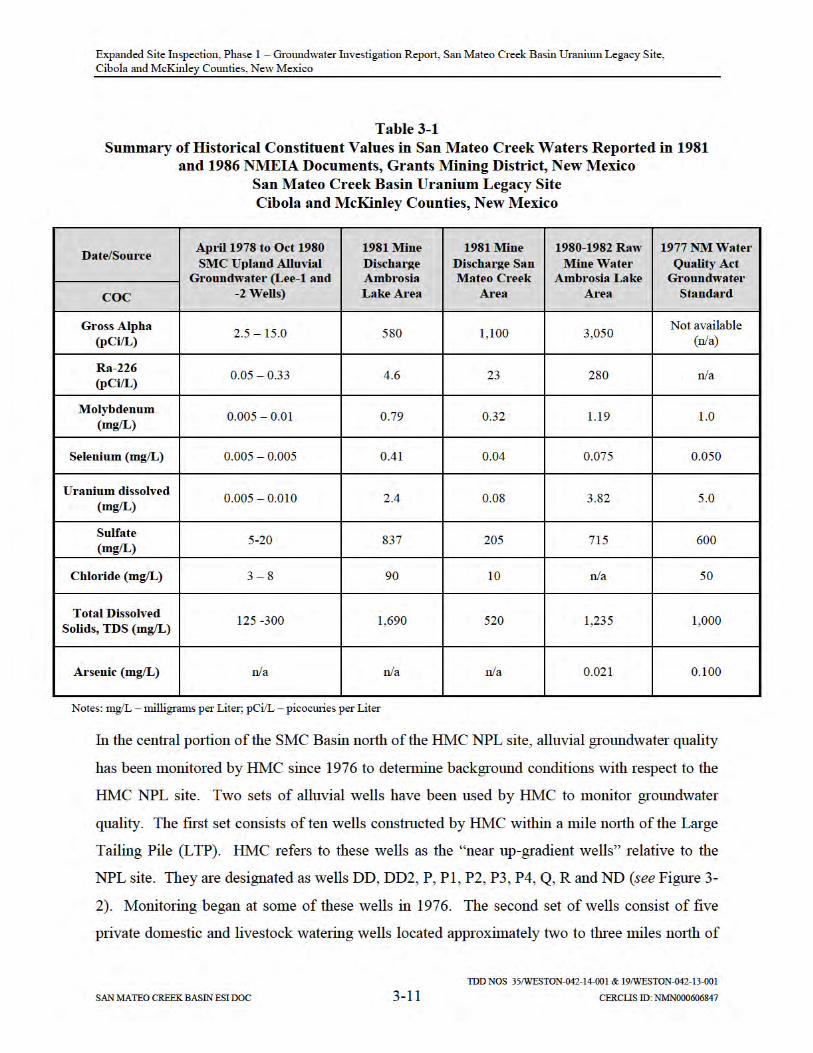
Table 3-1 presents a summary of alluvial and mine discharge water quality data from the 1970s-
1980s in the northern portion of the SMC Basin (Gallaher and Cary, 1986).
Expanded Site Inspection, Phase 1 – Groundwater Investigation Report, San Mateo Creek Basin Uranium Legacy Site, Cibola and McKinley Counties, New Mexico
TDD NOS 35/WESTON-042-14-001 & 19/WESTON-042-13-001
SAN MATEO CREEK BASIN ESI DOC 3-12 CERCLIS ID: NMN000606847
the LTP. HMC refers to these wells as the “far up-gradient wells” relative to the NPL site. They
are designated as wells 914, 920, 921, 922 and 9504,5 (see Figure 3-2). The earliest monitoring
by HMC was at well 920 beginning in late 1981. The far up-gradient wells were sampled by
NMED in 2009 and 2015 and by EPA as part of the Phase 1 groundwater investigation. The
EPA analytical results are discussed later on in this report and the NMED results in a separate
report (NMED 2015).
Historically, HMC has reported a large areal variability in the alluvial water quality from the
near up-gradient and far up-gradient wells over the 40 years of ground-water monitoring. The
results are documented in annual reports submitted to the NRC, NMED, and EPA. The earliest
water quality data for the far up-gradient alluvial wells show a uranium concentration of 0.008
mg/L at well 920 in late 1981. From 1981 to 1994, concentrations of uranium at well 920
trended steadily upward to 0.132 mg/L.
The earliest water quality data from the near up-gradient alluvial wells showed uranium
concentrations ranged from 0.010 to 0.093 mg/L (with no apparent trends) at well R in the late
1970s. Well R is located about a mile north of the LTP. At well DD, located a half mile north of
the northwest corner of the LTP, uranium concentrations ranged from 0.076 to 0.180 mg/L (with
an apparent slightly upward trend) in the late 1970s and early 1980s.
The latest annual report, entitled “2015 Annual Monitoring Report/Performance Review for
Homestake’s Grants Project Pursuant to NRC License SUA-1471 and Discharge Plan DP-200”
(2015 Annual Report), presents groundwater quality data covering the last 15 years.
Concentration versus time plots presented in the 2015 Annual Report show trends in
4 No geologic boring logs or well construction diagrams were found in the New Mexico Office of the State Engineer’s database to confirm that the private wells are actually alluvial wells. However, the relatively shallow depths of the wells suggest that some of them (well 920, 921 and 950) likely are screened in alluvial sediments. The results of subsequent drilling by EPA near these wells in 2015 indicate that others (well 922) may actually be screened in a bedrock formation.
5 The far up-gradient wells have been given other well identifications by NMED as part of the private well sampling activities within the SMC Basin, including designations SMC-10 through SMC-14.

Expanded Site Inspection, Phase 1 – Groundwater Investigation Report, San Mateo Creek Basin Uranium Legacy Site, Cibola and McKinley Counties, New Mexico
TDD NOS 35/WESTON-042-14-001 & 19/WESTON-042-13-001
SAN MATEO CREEK BASIN ESI DOC 3-13 CERCLIS ID: NMN000606847
concentrations of COPCs since 2000. Uranium concentrations at the near-up-gradient wells
show consistent or slightly decreasing trends, with concentrations ranging from approximately
0.010 to over 0.260 mg/L in various wells. The approximate ranges in concentrations for
uranium in individual wells are 0.200 – 0.260 mg/L for well DD2, 0.105 – 0.180 mg/L for well
DD, 0.055 – 0.060 for well Q, 0.020 – 0.025 mg/L for well R, 0.10 – 0.20 mg/L for well P, and
0.010 – 0.020 for well ND. In contrast, selenium concentrations have steadily increased in the
two most distal near-up-gradient wells R (from approximately 0.430 mg/L to near 0.700 mg/L)
and Q (from approximately 0.220 mg/L to nearly 0.400 mg/L).
A statistical analysis was performed by HMC on the near up-gradient historical groundwater
quality data from 1994 to 2004 to determine background water quality and propose a
modification to site cleanup standards for several contaminants under the NRC’s Source
Materials License SUA-1471 and NMED’s groundwater discharge permitting program (HMC
2004). HMC proposed the modifications to account for the variability in natural background
concentrations. The proposed site standards and background values were reviewed and approved
by the NRC and agreed upon by EPA in 2008. NMED also provided a letter to HMC supporting
the proposed site standards and background values and incorporated them into groundwater
discharge permit DP-200 in 2014. Subsequently, several water quality site standards were
approved based on the background statistics for the alluvial aquifer by the NRC through a license
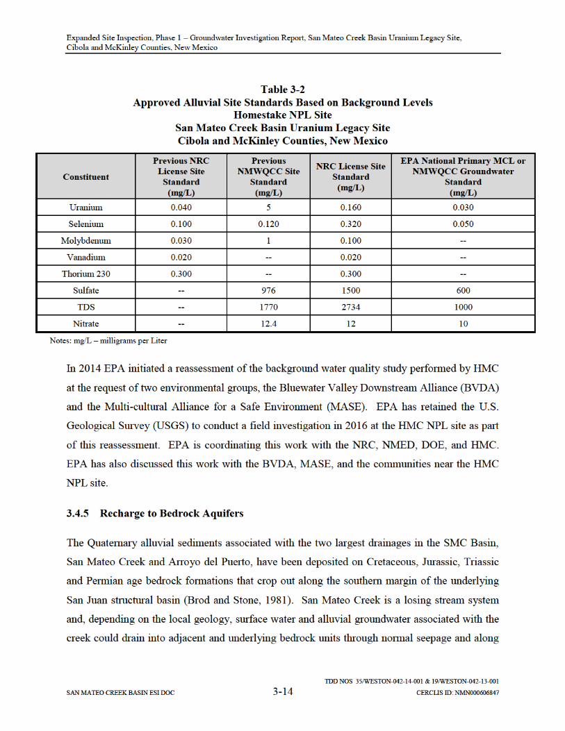
amendment. They are depicted in Table 3-2. See HMC 2015 Annual Report.
Expanded Site Inspection, Phase 1 – Groundwater Investigation Report, San Mateo Creek Basin Uranium Legacy Site, Cibola and McKinley Counties, New Mexico
TDD NOS 35/WESTON-042-14-001 & 19/WESTON-042-13-001
SAN MATEO CREEK BASIN ESI DOC 3-15 CERCLIS ID: NMN000606847
faults, fractures, and bedding planes. The prominent San Mateo Fault, which trends
northeasterly through the basin and has displacements of up to 450 feet (Brod and Stone, 1981),
is a major structural feature that could control groundwater recharge and movement in the
bedrock aquifers.
In the Ambrosia Lake area, mine discharge water was a significant source of recharge water to
the Jurassic Morrison Formation and the Cretaceous Dakota Sandstone (Gallaher and Cary
1986). In the central part of the SMC Basin, mine discharge water that has drained from the San
Mateo Creek alluvium was possibly a significant source of recharge to the Triassic Chinle
Formation. Tailing seepage from the HMC NPL site impoundments in the southern part of the
basin recharged and contaminated three Chinle water-bearing zones where they subcrop under
the alluvium (HMC 2015 Annual Report).
Wherever there is hydraulic communication between the base of the saturated alluvium and the
surface of the underlying bedrock subcrop, there is likely some recharge. Given that the rate of
alluvial water decline mirrored the cessation of mine water discharge, the high permeability and
low storage capacity of the alluvium helped facilitate the movement of mine water into
underlying bedrock formations.

Expanded Site Inspection, Phase 1 – Groundwater Investigation Report, San Mateo Creek Basin Uranium Legacy Site, Cibola and McKinley Counties, New Mexico
TDD NOS 35/WESTON-042-14-001 & 19/WESTON-042-13-001
SAN MATEO CREEK BASIN ESI DOC 4-1 CERCLIS ID: NMN000606847
4 FIELD INVESTIGATION
START-3 field investigation activities were initiated October 2014 and completed January 2015.
Field activities included completing a seismic survey, drilling, and sampling of exploratory soil
borings, coring, alluvial monitor well installation, monitor well development and sampling, and
IDW management. Figure 4-1 illustrates a broad overview of well and boring locations
including borings drilled, monitor wells installed, and wells sampled as part of the field effort.
Detailed illustrations of soil borings, monitoring wells sampled, seismic lines shot, and former
mines and mills are included in Figures 4-2 through 4-18.
4.1 SEISMIC SURVEY
In November 2014, START-3 subcontracted Bird Seismic Services, Inc. of Globe, Arizona, to
conduct a high-resolution 2-dimesional seismic reflective survey to map the base of alluvium/top
of shallow bedrock surface to identify paleo-alluvial stream channels within the SMC Basin.
This survey was performed to select optimal drilling locations for finding alluvial groundwater.
It was recognized that if any significant saturation was present in alluvial sediments, it would be
in the deepest portions of the paleo channels. Seismic surveys were conducted across four
different drainage systems locations at BG-01, BG-02, BG-06, and N-3.
Each seismic reflection profile was approximately 2,000 feet long and laid out across the four
drainage systems in an approximate perpendicular orientation to the surface drainage flow. Data
were collected from geophones spaced at 10-foot ground-station intervals. The seismic source
was on a 4x4 truck mounted with a United Service Alliance AWD-450 accelerated weight drop,
capable of procuring approximately 90,000 feet per pound (ft/lb) of energy. The geophones
recorded velocity data for post processing. The Bird Seismic Services Final Report is included
in Appendix C.
EPA, START-3, and Bird Seismic Services representatives reviewed the seismic information or
“stacks” and selected the drilling locations that appeared to be optimal targets for paleo-alluvial
stream channels. Two optimal targets were identified at each location. The Global Positioning

Expanded Site Inspection, Phase 1 – Groundwater Investigation Report, San Mateo Creek Basin Uranium Legacy Site, Cibola and McKinley Counties, New Mexico
TDD NOS 35/WESTON-042-14-001 & 19/WESTON-042-13-001
SAN MATEO CREEK BASIN ESI DOC 4-3 CERCLIS ID: NMN000606847
grouting followed State of New Mexico rules and regulations. State of New Mexico well
completion records are included as Appendix D.
Each boring was drilled using an YJD CME-850 track-mounted rig using hollow-stem augers
and continuously sampled using a 5-foot-long, split-barrel core sampler through the entire
alluvium section to the top of bedrock. Soil classification was conducted by the START-3
geologist according to the Unified Soil Classification System (USCS). The soil boring logs are
provided as Appendix E. At the completion of each boring, a determination was made between
the EPA Task Monitor (TM) and the START-3 field geologist to install a groundwater
monitoring well. If a sufficient volume of groundwater was not encountered in the borehole, no
well was installed. If a sufficient volume of groundwater was encountered in the borehole, a
well was installed and the appropriate screened interval was based on field observations. All
borings were left standing overnight and observed the next day for water before any decision was
made to grout the borehole.
At some of the drilling locations, multiple exploratory borings were drilled in close proximity to
each other and along a line striking perpendicular to the surface drainage alignment to identify
the deepest portion of the paleo-alluvial stream channel (i.e., paleo-channel axis). Seismic
surveys were not shot at these drilling locations.
4.2.2 Monitoring Well Installation
Each monitoring well installed was constructed of clean unused 2-inch-diameter, Schedule 40,
flush-threaded polyvinyl-chloride (PVC) casing and a minimum of 10 feet of 0.010-slotted
screen. The annular space around the screen was filled with clean, uniform-sized (20 to 40)
Colorado silica sand to a minimum height of 2 feet above the top of the screen. A minimum 3-
to 5-foot-thick layer of bentonite pellets was placed immediately above the sand pack and
hydrated with potable water. The bentonite pellets were allowed to hydrate for at least 30
minutes before the well was tremie grouted to the surface.
A 5-foot-long, 6-inch-diameter outer protective steel casing with a lockable-hinge cap was
installed 2 to 3 feet into the grout seal. A 4-foot-by-4-foot concrete pad was installed around the

Expanded Site Inspection, Phase 1 – Groundwater Investigation Report, San Mateo Creek Basin Uranium Legacy Site, Cibola and McKinley Counties, New Mexico
TDD NOS 35/WESTON-042-14-001 & 19/WESTON-042-13-001
SAN MATEO CREEK BASIN ESI DOC 4-4 CERCLIS ID: NMN000606847
outer base of the protective casing. In some cases, a locking flush-mount completion was
installed at the request of the property owner. Well construction information is included in the
boring logs (Appendix E).
4.2.3 Plugging and Abandonment
Boreholes that did not produce a sufficient volume of water were grouted according to State of
New Mexico guidelines using a mixture of 6 to 8 pounds of bentonite powder per 94-pound bag
of Portland cement, mixed with 6 to 8 gallons of water. The boreholes were pressure grouted
using a tremie pipe from the bottom to the ground surface.
4.3 SAMPLE LOCATIONS
The sample locations selected for this investigation were based on a twofold need to: 1)
characterize natural background quality of alluvial groundwater; and 2) assess potential impacts
to alluvial groundwater quality downgradient of legacy uranium mines and mills.
4.3.1 Background Locations Upgradient of Legacy Uranium Mines and Mills
One of the primary objectives of the investigation was to locate and characterize background
alluvial groundwater quality at those locations known to be upgradient of any legacy mining or
milling operations within the SMC Basin. Five areas located geographically in the northwest,
north, northeast, southeast, and west parts of the SMC Basin were targeted for exploratory
drilling to locate saturated alluvial material for well construction and sampling. These locations
were in the higher elevations of the basin where alluvial groundwater, if present, would be
upgradient of the legacy mines and mills as well as upstream of arroyos, creeks, and other
surface drainages at the mines and mills and represent natural background water quality. The
central and southern parts of the SMC Basin were not targeted to characterize background water
quality because they were downgradient to many legacy mines and mills within the basin and it

Expanded Site Inspection, Phase 1 – Groundwater Investigation Report, San Mateo Creek Basin Uranium Legacy Site, Cibola and McKinley Counties, New Mexico
TDD NOS 35/WESTON-042-14-001 & 19/WESTON-042-13-001
SAN MATEO CREEK BASIN ESI DOC 4-5 CERCLIS ID: NMN000606847
was unknown whether areas of unimpacted groundwater existed today6. Information regarding
the five background locations is provided in the following subsections.
4.3.1.1 BG-01
Two soil borings (BG-01 and BG-01A) were drilled in the north-northwest section of the SMC
Basin along Martin Draw, a valley located in McKinley County at an elevation of approximately
7,000 feet. Figure 4-2 illustrates the seismic line and corresponding boring locations. The soil
borings were upgradient of the Section 10 Mine along the north and south side of Martin Draw.
During drilling, dry alluvial material was observed until auger refusal occurred which was
encountered at an approximate depth of 60 feet below ground surface (bgs). The boring
locations were selected based on a review of a seismic line shot in a north-to-south orientation
and perpendicular to Martin Draw. No evidence of moisture was observed by the field geologist
in any of the samples collected from either boring, and the boreholes were grouted to the surface.
The alluvium in Martin Draw was observed to be dry at the time the borings were drilled.
4.3.1.2 BG-02
Borings BG-02 and BG-02A, shown in Figure 4-3, were drilled in an un-named valley located in
the northern section of the SMC Basin approximately 0.5 mile east of Julian Hill and 0.65 mile
northeast of the Section 17 Mine at an elevation of approximately 7,100 feet MSL. Both borings
were drilled along the seismic line shot in an east-to-west orientation. There are two intermittent
creeks noted on the Ambrosia Lake USGS Quadrangle; however, only one dry intermittent creek
was observed during the drilling activity. The eastern-most boring (BG-02A) was advanced first
through the alluvial layer to a depth of 63.5 feet bgs and terminated at an approximate depth of
72 feet bgs or 8.5 feet, into weathered Mancos Shale. BG-02A was drilled to a maximum depth
6 HMC reported that the alluvial water quality north of the HMC NPL site from 1994 to 2004 represents natural background conditions (HMC 2004 Background Study, 2015 Annual Report). However, because EPA had decided to reassess HMC’s background study, this area of the basin was not included as part of the background evaluation for Phase 1.

Expanded Site Inspection, Phase 1 – Groundwater Investigation Report, San Mateo Creek Basin Uranium Legacy Site, Cibola and McKinley Counties, New Mexico
TDD NOS 35/WESTON-042-14-001 & 19/WESTON-042-13-001
SAN MATEO CREEK BASIN ESI DOC 4-6 CERCLIS ID: NMN000606847
of 48 feet bgs where Mancos Shale was encountered and drilling was stopped. Neither borings
produced water and were grouted to the surface.
4.3.1.3 BG-03, BG-04, and BG-05
The selection of drilling locations BG-03, BG-04, and BG-05 was based on the proximity to San
Mateo Creek and Marquez Canyon Creek that receive runoff from Mount Taylor. The Mount
Taylor Mine (currently in standby status) is located approximately 1.2 miles east-northeast and
upgradient of background locations BG-03, BG-04, and BG-05, and any potential impact to the
alluvial and deeper water-bearing formations from operations at this mine is unknown. During
mining operations, uranium ore was extracted from depths of over 3,000 feet bgs from ore zones
of the Morrison Formation using room and pillar and stope mining methods. Groundwater in the
Westwater Canyon Member of the Morrison Formation (ore host rock) at mine level contained
concentrations of uranium and radium above the human health standards for drinking water
quality. Mine water was reportedly pumped from the mine level to eight lined water treatment
ponds where ion exchange and barium chloride treatment methods were used to reduce levels of
uranium and radium. Six of the eight treatment ponds were clay lined and two ponds were lined
with hypalon geomembranes. Treated mine water was reportedly pumped off-site through a 4.3-
mile-long, 24-inch pipeline and discharged to San Lucas Canyon under authority of National
Pollutant Discharge Elimination System (NPDES) Permit No. NM0028100 (Rio Grande
Resources, 2010) and NMED groundwater discharge permit DP-61.
Background soil borings BG-03, BG-04, and BG-05 were drilled in an approximate north-to-
south orientation between San Mateo Creek and Marquez Canyon Creek near the village of San
Mateo (see Figure 4-4). The village of San Mateo is at an elevation of approximately 7,300 feet.
Runoff from Mount Taylor discharges to Marquez Canyon and San Mateo Creek and flows east-
to-west through the village of San Mateo. A seismic line was not shot at this background
location due to the known presence of saturated alluvial conditions created by the runoff and
infiltration of San Mateo Creek and Marquez Canyon Creek surface water into the alluvial
sediments. Saturated alluvial conditions were observed at approximately 45 feet bgs in all three
borings and they were converted to background monitor wells. BG-03 was drilled adjacent to

Expanded Site Inspection, Phase 1 – Groundwater Investigation Report, San Mateo Creek Basin Uranium Legacy Site, Cibola and McKinley Counties, New Mexico
TDD NOS 35/WESTON-042-14-001 & 19/WESTON-042-13-001
SAN MATEO CREEK BASIN ESI DOC 4-7 CERCLIS ID: NMN000606847
San Mateo Creek to a total depth of 61 feet bgs and screened from 48 to 58 feet bgs. BG-04 was
drilled between San Mateo Creek and Marquez Creek, north of an unnamed tributary, to a total
depth of 55 feet bgs and screened from 41 to 51 feet bgs. BG-05 was drilled close to Marquez
Creek to a depth of 53 feet and screened from 40 to 50 feet bgs.
4.3.1.4 BG-06
Soil borings BG-06 and BG-06A were drilled in the western part of the SMC Basin in an un-
named valley approximately 0.65 mile west-northwest of the former Red Point Mine. As shown
on Figure 4-5, the borings were drilled east to west along a seismic line shot and perpendicular to
an ephemeral creek and a small man-made pond. The ephemeral creek was observed to be dry at
the time the borings were drilled but the pond contained water. The western boring (BG-06) was
drilled through the alluvial layer to refusal at a depth of 77 feet bgs. BG-06A was advanced to a
refusal that was encountered at a depth of 60 feet bgs. Neither boring produced water and were
grouted to the surface.
4.3.1.5 BG-07
Four background soil borings (BG-07 through BG-07C), shown on Figure 4-6, were drilled in a
north-to-south orientation and perpendicular to Lobo Creek in the southern portion of the SMC
Basin. Surface water run-off from Mount Taylor discharges to Lobo Creek and other un-named
intermittent creeks in the area. Lobo Creek flows mostly intermittent from east to west in the
direction of the HMC site. The closest mines to BG-07 are the F-33 Mine and the La Jara and
Zia Mines to the south.
Boring BG-07 was advanced through alluvial material until auger refusal at 56 feet bgs. The
borehole was allowed to stand overnight as a minimal amount of moist soil was noted by the
field geologist during drilling at 45 to 46 feet bgs. The borehole did produce water the following
day, and a monitoring well was set and screened from 46 to 56 feet bgs. A static water level
measurement was taken after the well was set, and approximately 1 foot of water was recorded in
the well. During well development, the well was pumped dry and less than 0.5 gallons of
development water was removed. The well was allowed to recover overnight, and

Expanded Site Inspection, Phase 1 – Groundwater Investigation Report, San Mateo Creek Basin Uranium Legacy Site, Cibola and McKinley Counties, New Mexico
TDD NOS 35/WESTON-042-14-001 & 19/WESTON-042-13-001
SAN MATEO CREEK BASIN ESI DOC 4-8 CERCLIS ID: NMN000606847
approximately 3 inches of water had accumulated in the well. After conversations with the EPA
TM and the field geologist, it was determined that the well would not produce enough water to
fill all of the sample bottles required for laboratory analyses, and a sample was not collected
during the field effort.
START-3 returned to the well BG-07 location and drilled three more exploratory borings
identified as BG-07A, BG-07B, and BG-07C in an effort to identify another zone of background
alluvial groundwater in the deepest part of the channel axis along Lobo Creek. The three borings
were drilled south of the original BG-07 location starting at BG-07A adjacent to Lobo Creek.
BG-07A was drilled until auger refusal at 20 feet bgs. BG-07B was drilled approximately 750
feet due north of BG-07A until auger refusal at a depth of 33 feet bgs. BG-07C was drilled
approximately 500 feet due north of BG-07B until auger refusal at a depth of 17 feet bgs. There
was no evidence of moisture in any of the soil samples collected, and water was not observed the
following day after the boreholes were allowed to stand overnight.
4.3.2 Sampling Locations Downgradient of Legacy Uranium Mines and Mills
A primary objective was to assess potential impacts to alluvial groundwater from legacy uranium
mines that discharged mine water to soils and sediments in surface drainages. The mine
discharge water saturated or significantly re-saturated the alluvium and may have also recharged
underlying bedrock aquifers along the San Mateo Creek channel, Arroyo del Puerto, and other
un-named drainages. A summary of downgradient drilling locations is summarized in the
following subsections.
4.3.2.1 C-3
As shown on Figure 4-7, the C-3 borehole was drilled adjacent to San Mateo Creek and
advanced to a total depth of 94 feet bgs. C-3 is located approximately 900 feet north of Moe No.
4 mine and just south of the state Otero alluvial well cluster that was installed in 1977. The
boring was drilled in close proximity to the San Mateo Creek. Saturated soil conditions were
observed by the field geologist at 85 feet bgs in coarse gravel and sand. A well was installed and
screened from 80 to 90 feet bgs. The static water level was measured at 84 feet below top of
Expanded Site Inspection, Phase 1 – Groundwater Investigation Report, San Mateo Creek Basin Uranium Legacy Site, Cibola and McKinley Counties, New Mexico
TDD NOS 35/WESTON-042-14-001 & 19/WESTON-042-13-001
SAN MATEO CREEK BASIN ESI DOC 4-9 CERCLIS ID: NMN000606847
casing. During the drilling and installation of alluvial well C-3, the San Mateo Creek was
observed to be dry on the surface. The nearby Otero wells (the deepest to 72 feet bgs) were also
observed to be dry.
4.3.2.2 C-5
A total of eight exploratory soil borings were drilled at location C-5 (C-5 to C-5G; Figure 4-8) in
close proximity to the Arroyo del Puerto Creek within the central portion of the SMC Basin.
This location was selected due to its downgradient position of legacy milling and mining
operations to target potentially impacted alluvial groundwater. According to the USGS Dos
Lomas Quadrangle, the Arroyo del Puerto is identified as an intermittent creek that intersects the
San Mateo Creek approximately 1.0 mile from the NM State Highways 605 and 509 junction.
Rio Algom Mill and the Phillips Mill are located approximately 4.0 miles to the north of C-5
area. Six former mines are also located upgradient of C-5 and include Isabella Mine, Spencer
Mine, Section 32 and 33 Mines, and John Bully Mine.
The eight boreholes were drilled with total depths ranging from 15 feet bgs (C-5D and C-5F) to
51 feet bgs (C-5C). Moisture was not observed in any of the soil samples collected during the
drilling operation. Therefore, a monitoring well was not constructed at the C-5 location and all
boreholes were grouted. Surface water was not observed in Arroyo del Puerto during any part of
the field investigation.
4.3.2.3 N-1, N-2, N-3, and N-4
Locations N-1 and N-1A (Figure 4-9) were advanced in an east-to-west direction and
perpendicular to Martin Draw. The former Bucky Mine is located approximately 0.5 mile to the
north of the N-1 and N-1A locations. Four additional former mines are located approximately
1.5 to 2.0 miles to the north and include Mary No. 1, Section 10, Dysart No. 1 and Dysart No. 2
mines. Boring N-1 was drilled until auger refusal at a depth of 48 feet bgs. No water was
observed and the borehole was grouted the next day. A second boring, N-1A, was selected
adjacent to Martin Draw and advanced until auger refusal at a depth of 38 feet bgs. The field
geologist observed a 4-inch saturated zone at a depth of approximately 20 feet bgs, and the

Expanded Site Inspection, Phase 1 – Groundwater Investigation Report, San Mateo Creek Basin Uranium Legacy Site, Cibola and McKinley Counties, New Mexico
TDD NOS 35/WESTON-042-14-001 & 19/WESTON-042-13-001
SAN MATEO CREEK BASIN ESI DOC 4-10 CERCLIS ID: NMN000606847
boring was allowed to stand overnight. Upon returning the next day, water was not observed and
the borehole was grouted to the surface. During the drilling of N-1, a small amount of water was
observed in a man-made culvert crossing over Martin Draw, but it is not known if this
accumulation was due to recent rain or actual flow within the creek.
Two borings (N-2 and N-2A), shown on Figure 4-9, were drilled approximately 2.0 miles
southeast of borings N1 and N1-A where an un-named tributary to Hijinio Draw passes under
NM State Highway 509. The Section 30 West Mine is located approximately 0.5 miles
southwest of N-2 and N-2A locations. The Section 19 Mine is located approximately 0.5 miles
due north. Borings N-2 and N-2A were advanced to a depth of 25 and 35 feet bgs, respectively.
Damp soil was noted by the field geologist at depths of 20 to 25 feet bgs but water did not
accumulate in the borehole the next day and both borings were grouted. Water was not observed
in Hijinio Draw during the drilling activity.
Locations N-3 and N-3A were drilled generally in a north-northeast to south-southwest
orientation along a seismic line shot. Figure 4-9 illustrates the location of the seismic line and
two borings drilled at this location. The Section 24 and Section 25 mines are located
approximately 0.5 miles northwest and southwest of locations N-3 and N-3A. The north boring
(N-3) was drilled through dry alluvial material until auger refusal at 61 feet bgs at the contact
with the top of the Mancos Shale. N-3A was advanced approximately 250 feet south of N-3 to a
depth of 63 feet bgs where saturated soil was observed by the field geologist at a depth of 56.6
feet bgs, and a well was set and screened from 53 to 63 feet bgs.
N-4 boring (Figure 4-10) was drilled approximately 0.75 miles northeast of the former Phillips
Mill. The boring was advanced through dry alluvial material to a depth of approximately 92 feet
bgs until auger refusal where the contact with the top of the weathered Mancos Shale was
observed. No evidence of water was noted in any of the samples taken throughout the logging of
the borehole. The Mancos Shale was cored from 92 to 110 feet bgs. Observations from the field
geologist indicated that the Mancos Shale was less weathered with depth. No water accumulated
over a 2-day period and the borehole was grouted to the surface.
Expanded Site Inspection, Phase 1 – Groundwater Investigation Report, San Mateo Creek Basin Uranium Legacy Site, Cibola and McKinley Counties, New Mexico
TDD NOS 35/WESTON-042-14-001 & 19/WESTON-042-13-001
SAN MATEO CREEK BASIN ESI DOC 4-11 CERCLIS ID: NMN000606847
4.3.2.4 N-5
Location N-5 (Figure 4-11) was drilled in close proximity to the San Mateo Creek channel and in
the vicinity of the former Chill Willis, Marquez, and Hogan Mines. Drilling N-5 adjacent to San
Mateo Creek was not possible due to land access restrictions. N-5 was drilled through dry
alluvial material until auger refusal was encountered at a depth of 32 feet bgs. No water was
observed and the boring was grouted to the surface.
4.3.3 SPLP and Mineralogy Soil Samples
In areas where groundwater was not encountered, at-depth sediment samples were collected from
selected borings (BG-07-55 feet, C-5B-40 feet, N-1-47 feet, N-2-24 feet, N-4-9 feet, and N-5-32
feet) for Synthetic Precipitation Leaching Procedure (SPLP) and analysis of general chemistry,
metals, and radiological parameters. The intent of the at-depth sediment samples submitted for
SPLP was to measure the mobility of constituents (e.g., uranium) that may be adsorbed to the
sediments and could leach into the groundwater upon being resaturated. The sediment samples
submitted for SPLP analysis were from both background soil borings and soil borings in areas
where mine water discharges may have saturated alluvial sediments during legacy mining
discharge operations. Heavy metals such as uranium in the mine water discharges may have
adsorbed onto the alluvial sediment grains before the mine water drained out and the alluvial
sediments dried up. The adsorbed constituents could then potentially move back into the
suspended and dissolved phases upon re-saturation of alluvial sediments, possibly resulting in
elevated concentrations above background in alluvial groundwater. In this case, the alluvial
sediment could act as a new anthropogenic source of mining-related contamination. Mineralogy
analysis was also conducted on borehole drilling samples to determine crystalline and clay
content of the sediment samples.
4.4 MONITORING WELL DEVELOPMENT AND SAMPLING
Alluvial monitoring well development and sampling activities techniques are summarized in the
following subsections. All groundwater samples were analyzed for total and dissolved metals
including mercury; pH; TDS; anions; alkalinity; gross alpha/beta; Radium-226 and Radium-228;

Expanded Site Inspection, Phase 1 – Groundwater Investigation Report, San Mateo Creek Basin Uranium Legacy Site, Cibola and McKinley Counties, New Mexico
TDD NOS 35/WESTON-042-14-001 & 19/WESTON-042-13-001
SAN MATEO CREEK BASIN ESI DOC 4-12 CERCLIS ID: NMN000606847
and alpha spectroscopy. Stable isotope analysis was conducted on three groundwater samples
from location PV-03. Stable isotope analysis was performed for the ratio of heavier to lighter
isotopes of hydrogen, oxygen, carbon, and sulfur against a known standard value and expressed
in units of “per mil” (o/oo, parts per thousand). The ratio of 2 H/1H is expressed as delta
deuterium (δD o/oo); the ratio of 18O/16O is expressed as delta oxygen-18 (δ18O o/oo); the ratio
of 13C/12C is expressed as delta carbon-12 (δ13C o/oo); and the ratio of 34S/32S is expressed as
delta sulfur-34 (δ34S o/oo). Specific analytical methods of analyses are presented in Section 4 of
this report (Faure, 1986).
4.4.1 Alluvial Monitor Well Development
The newly installed alluvial monitoring wells BG-03, BG-04, BG-04, C-3, and N-3A were
developed no sooner than 24 hours after completion using a Monsoon® pump connected to a 12-
volt battery. The submersible pump was initially set at the bottom of the well and slowly moved
toward the top of the screen to enhance the flow of groundwater through all portions of the
screened interval. Dedicated sample tubing was used at each well location to reduce the
possibility of cross-contamination between locations. The pump housing and electrical lines
were decontaminated between each well location using potable water and non-phosphate soap.
Development and decontamination water generated during well development activity was
contained in sealed 55-gallon drums and transported back to the EPA soil staging pad located at
500 Elkins Road in Milan, New Mexico (Figure 2-2).
4.4.2 Alluvial Monitor Well Sampling
Five newly installed monitor wells were sampled by START-3 following EPA low-flow
sampling guidance methods (U.S. EPA, 540/S-95/504, 1996). They are:
BG-03 BG-04 BG-05 N-3A C-3

Expanded Site Inspection, Phase 1 – Groundwater Investigation Report, San Mateo Creek Basin Uranium Legacy Site, Cibola and McKinley Counties, New Mexico
TDD NOS 35/WESTON-042-14-001 & 19/WESTON-042-13-001
SAN MATEO CREEK BASIN ESI DOC 4-13 CERCLIS ID: NMN000606847
The monitoring well locations are depicted on Figure 4-12. They were sampled using a stainless
steel Monsoon® XL pump connected to a 12-volt battery and controller. Groundwater samples
were transferred directly from the dedicated sample tubing to laboratory-prepared containers.
After sample collection, the containers were placed on ice to reduce and maintain the
temperature at or near 4 degrees Celsius. Dedicated sample tubing, potable water, and non-
phosphate soap were used to decontaminate the pump and electrical leads between each sample
location to reduce cross-contamination.
4.4.3 Existing Well Sampling
START-3 sampled a total of 15 existing alluvial and bedrock wells as part of the field
investigation activities (Figure 4-13). For reporting purposes, START-3 well identifications
(IDs) (and alternate well IDs where they are known for the sample location or well) are included.
PV is defined as “Private Well”. SMC and LSM are defined as “San Mateo Creek” and “Lower
San Mateo,” respectively.
Of the 15 existing wells sampled, 10 are privately owned wells used for domestic, livestock
watering, or irrigation purposes. They are as follows:
PV-01 (aka LSM-7) PV-02 (aka SMC-30) PV-03 (aka LSM-61/SMC-20) SMC-09 SMC-10 (aka LSM-35) SMC-11 SMC-12 SMC-13 SMC-14 SMC-26
The other five existing wells sampled are industry monitoring wells. They are as follows:
907 928 943 MW-35-8
Expanded Site Inspection, Phase 1 – Groundwater Investigation Report, San Mateo Creek Basin Uranium Legacy Site, Cibola and McKinley Counties, New Mexico
TDD NOS 35/WESTON-042-14-001 & 19/WESTON-042-13-001
SAN MATEO CREEK BASIN ESI DOC 4-14 CERCLIS ID: NMN000606847
MW-35-9
Table 4-2 identifies the well ownership (private, industry or municipality) and use (monitoring,
domestic, livestock watering, or irrigation) for each well sampled. The locations of monitor
wells 907, 943, and 928, designated as San Andres/Glorieta wells, are illustrated on Figure 4-14.
They are located north and south of the LTP at the HMC NPL Site. The locations of monitor
wells MW-35-8 and MW-35-9, designated as alluvial wells, are south of the Section 35 and
Cliffside Mines in the northern part of the SMC Basin. The locations are depicted on Figure 4-
15. Private Wells SMC-10, SMC-11, SMC-12, SMC-13, SMC-14, and PV-01 (aka LSM-7) are
located in the central part of the basin, approximately two miles north of the LTP. Their
locations are shown on Figure 4-16. Private well PV-02 (aka SMC-30), is located near the
village of San Mateo and EPA monitoring wells BG-03, BG-04 and BG-05 (see Figure 4-17).
Private wells PV-03 (aka LSM-61 and SMC-20) and SMC-26 are located near the junction of
NM State Highways 509 and 605 (see Figure 4-18). Private well SMC-09 is located east of the
HMC NPL Site near Lobo Creek and EPA boring BG-07. The location of SMC-09 is depicted
on Figure 4-1.
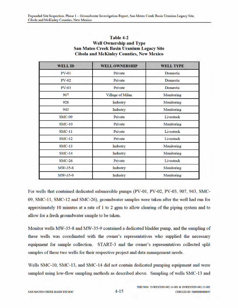

Expanded Site Inspection, Phase 1 – Groundwater Investigation Report, San Mateo Creek Basin Uranium Legacy Site, Cibola and McKinley Counties, New Mexico
TDD NOS 35/WESTON-042-14-001 & 19/WESTON-042-13-001
SAN MATEO CREEK BASIN ESI DOC 4-16 CERCLIS ID: NMN000606847
SMC-14 was coordinated with owner’s representatives and split samples of each of these wells
were taken for laboratory analyses.
START-3 collected field parameters using a pre-calibrated YSI Model 600XL water quality
meter to check well stabilization parameters prior to collecting the water sample. In wells where
no pump was installed, START-3 measured the depth to groundwater and total depth using a
water-level meter. For wells where dedicated pumps were installed, no groundwater
measurements were collected. Field parameters were recorded in the site logbook and field data
sheets. Stabilization was reached when the following readings were achieved:
pH was within 0.1 or 0.2 of a standard unit;
Temperature was within 0.2 degrees Centigrade (C) or 3%;
Specific conductance (SC) was within 5% for values equal to or less than 100 micro-Siemens and 3% for values greater than 100 micro-Siemens;
DO (dissolved oxygen) was within 10%; and
ORP (oxidation reduction potential) was within 10 millivolts.
A summary of water quality measurements collected from START-3 sampled wells is included
in Appendix F.
Following sample collection, each sample was labeled, placed in individual plastic bags, and
placed on ice in a cooler. All samples were shipped for overnight delivery via Federal Express to
a National Environmental Laboratory Accreditation Program (NELAP)-certified laboratory for
analyses. Specific laboratory information is included in Section 5 of this report.
4.5 INVESTIGATION-DERIVED WASTE MANAGEMENT
Non-dedicated equipment used during drilling activities was decontaminated using high-pressure
steam cleaning prior to drilling and between each location. In addition to steam cleaning
between drilling locations, the core barrel sampling equipment was high-pressure steam cleaned
between each location. This equipment was rinsed with potable water before reuse.
Decontamination activities were conducted at a temporary decontamination space constructed at
each drilling location.

Expanded Site Inspection, Phase 1 – Groundwater Investigation Report, San Mateo Creek Basin Uranium Legacy Site, Cibola and McKinley Counties, New Mexico
TDD NOS 35/WESTON-042-14-001 & 19/WESTON-042-13-001
SAN MATEO CREEK BASIN ESI DOC 4-17 CERCLIS ID: NMN000606847
The fluids and excess soil generated as a result of equipment decontamination was containerized
and transported back to the EPA soil staging pad. Water generated from the monitor well
installation and development activities was containerized and transported back to the soil staging
pad and used to support dust suppression measures. An estimated 5 cubic yards of soil was
generated during drilling operations and stored at the soil staging pad. This material was
managed with soil generated during excavation activities under EPA TDD No. 1/WESTON-042-
14-031 for Removal Action. As part of the EPA Removal Action, all soil was characterized,
profiled, manifested, and loaded into trucks and transported off-site for disposal at the Clean
Harbors Deer Trail, LLC Disposal Site in Deer Trail, Colorado.
Expanded Site Inspection, Phase 1 – Groundwater Investigation Report, San Mateo Creek Basin Uranium Legacy Site, Cibola and McKinley Counties, New Mexico
TDD NOS 35/WESTON-042-14-001 & 19/WESTON-042-13-001
SAN MATEO CREEK BASIN ESI DOC 5-1 CERCLIS ID: NMN000606847
5 SAMPLE ANALYSES AND DATA VALIDATION
START-3 conducted sample analyses, data validation, and data management as part of the
project activities. These tasks were conducted in accordance with START-3 October 2014 San
Mateo Creek Basin Uranium Legacy QASP (Appendix A). Information regarding laboratory
analyses, data validation, and data reporting tasks are discussed in the following subsections.
As part of the overall sampling effort, START-3 collected a combined total of 24 groundwater
samples and 5 soil samples (including field duplicate samples) for laboratory analyses. START-
3 utilized a standard data management system that includes the use of bound field logbooks,
sample management, tracking procedures, document control, and inventory procedures for both
laboratory data and field measurements. SCRIBE software was used to track sample information
and generate report tables for inclusion into this report.
5.1 LABORATORY ANALYSES, DATA VALIDATION, AND DATA REPORTING
The supporting laboratories and analytical methods utilized are summarized in the following
subsections.
5.1.1 Test America Laboratories, Inc.
START-3 subcontracted Test America Laboratories, in St. Louis, Missouri, to analyze a total of
24 groundwater samples for the following methods:
SW846 Method 6010C
Total and dissolved mercury by SW846 Method 7470A
pH by EPA Method 150.1
Total dissolved solids (TDS) by EPA Method 160.1
Anions (bromide, chloride, fluoride, nitrate as N, nitrite as N, orthophosphate, and sulfate) by EPA Method 300 and 9056A
Alkalinity by EPA Method 310.1
Gross alpha/beta by EPA Method 9310
Radium-226 by EPA Method 9315
Radium-228 by EPA Method 9320

Expanded Site Inspection, Phase 1 – Groundwater Investigation Report, San Mateo Creek Basin Uranium Legacy Site, Cibola and McKinley Counties, New Mexico
TDD NOS 35/WESTON-042-14-001 & 19/WESTON-042-13-001
SAN MATEO CREEK BASIN ESI DOC 5-2 CERCLIS ID: NMN000606847
Alpha spectroscopy by Method A-01-R
Five soil samples were collected and prepared for SPLP using procedures specified in SW-846
Method 1312. Samples were prepared and analyzed for anions (bromide, chloride, fluoride,
nitrate as N, nitrite as N, orthophosphate, and sulfate) using the procedures specified in SW-846
Method 9056A.
A complete set of Test America Laboratory Analytical Reports is included in Appendix G.
5.1.2 ALS Environmental Laboratories
ALS Environmental Laboratories, in Fort Collins, Colorado, was subcontracted to analyze three
confirmation groundwater samples collected from location PV-03 designated as PV-03UF, PV-
03F, and PV-03DW for the following methods:
SW846 Method 6020A
Total and dissolved mercury by SW846 Method 7470A
pH by EPA Method 150.1
Total dissolved solids (TDS) by EPA Method 160.1
Anions (bromide, chloride, fluoride, nitrate as N, nitrite as N, orthophosphate, and sulfate) by EPA Method 300.0 Revision 2.1
Alkalinity by EPA Method 310.1
Gross alpha/beta by EPA Method 9310
Radium-226 by EPA Method 9315
Radium-228 by EPA Method 9320
Alpha spectroscopy by Method A-01-R
The analytical report provided by ALS Laboratories is included in Appendix H.
5.1.3 Isotech Laboratories, Inc.
Stable isotope analyses were performed on a subset of the groundwater samples (PV-03UF, PV-
03F, PV-03DW) by Isotech Laboratories located in Champaign, Illinois by Isotope Ratio Mass
Spectrometry (IRMS) method. Stable isotope analysis was performed for the following isotopes:

Expanded Site Inspection, Phase 1 – Groundwater Investigation Report, San Mateo Creek Basin Uranium Legacy Site, Cibola and McKinley Counties, New Mexico
TDD NOS 35/WESTON-042-14-001 & 19/WESTON-042-13-001
SAN MATEO CREEK BASIN ESI DOC 5-3 CERCLIS ID: NMN000606847
hydrogen-deuterium (D)
oxygen-18/16 (18O)
carbon-13/12 (13C)
sulfur-34/32 (34S)
The Isotech Laboratory Analytical Reports is included in Appendix I.
5.1.4 DCM Science Laboratories, Inc.
DCM Science Laboratories, Inc. in Wheat Ridge, Colorado conducted X-Ray diffraction (XRD)
to identify crystalline compounds and bulk mineralogy, including clay separation determination
for seven soil samples collected from borings C-3, BG-07, C-5B, N-5, N-1, N-2, and N-4. The
DCM Science Analytical Report is included in Appendix J.
5.2 DATA VALIDATION
START-3 performed data validation for the Test America and ALS Laboratories data packages
in accordance with the EPA data review guidance documents (U.S. EPA, 2014). A second data
package provided by ALS Laboratories and Isotech Laboratories was also validated to determine
whether quality control specifications were achieved as per the EPA data review guidance.
START-3 reviewed the data packages to verify that they met the EPA technical requirements and
Quality Assurance (QA) guidelines established for the respective analytical methods. The
following list includes the items evaluated for each laboratory sample delivery group (as
applicable):
The chain-of-custody was reviewed to verify the sample IDs and the analyses requested.
The sample receipt temperature was reviewed to verify that the cooler temperature was within acceptable range.
Holding times were reviewed to verify the samples were extracted and analyzed within the required holding time.
Laboratory blanks were reviewed to determine whether laboratory contamination was present.

Expanded Site Inspection, Phase 1 – Groundwater Investigation Report, San Mateo Creek Basin Uranium Legacy Site, Cibola and McKinley Counties, New Mexico
TDD NOS 35/WESTON-042-14-001 & 19/WESTON-042-13-001
SAN MATEO CREEK BASIN ESI DOC 5-4 CERCLIS ID: NMN000606847
Matrix spike/matrix spike duplicate (MS/MSD) samples were reviewed to determine whether matrix interference was present and to determine if laboratory precision was within the acceptable range.
Laboratory control samples and/or laboratory control sample duplicates were reviewed to verify the accuracy of the method.
Surrogate recoveries were reviewed to verify that the recoveries were within the acceptable range.
Initial calibrations were reviewed to confirm conformance to method acceptance criteria for percent recovery and/or correlation coefficient.
Continuing calibrations were reviewed to confirm that calibration verification was performed before sample analysis and at the method-specified frequency. The calibration verification percent recoveries were reviewed and compared to acceptance criteria.
Internal standards were reviewed to verify that the recoveries were within the acceptable range.
Field duplicates were reviewed to verify that field precision was within the acceptable range.
Reporting limits were reviewed to confirm that they were adjusted to reflect dilution factors and percent solids, if applicable.
Sample results were reviewed to confirm that the detected concentration was within the instrument calibration range. If the concentration exceeded the instrument calibration range, the data were reviewed to determine if the sample was re-analyzed at a secondary dilution.
Calculations were performed for sample results from each analytical package to confirm the final result reported by the laboratory. These calculations consider the result produced by the analytical instrument, sample volume, sample weight, calibration correlations, dilution factor, and percent solids, if applicable.
START-3 Chemical and Radiological Data Validation Reports are included in Appendices K and
L, respectively.
5.3 CHEMICAL DATA USABILITY
START-3 reviewed the analytical results to verify that the data were acceptable for their
intended use in meeting the objectives of the project. Overall, the data are considered acceptable
for use with qualifications noted in the respective data tables presented in this report.
Expanded Site Inspection, Phase 1 – Groundwater Investigation Report, San Mateo Creek Basin Uranium Legacy Site, Cibola and McKinley Counties, New Mexico
TDD NOS 35/WESTON-042-14-001 & 19/WESTON-042-13-001
SAN MATEO CREEK BASIN ESI DOC 5-5 CERCLIS ID: NMN000606847
START-3 subcontracted Test America Laboratories in Earth City, Missouri, to analyze
groundwater samples using SW-846 Method 6010C for inductively coupled plasma (ICP) metals
and mercury. Following review of preliminary data packages, the START-3 data validation
team observed that the laboratory reporting limit (RL) of 0.26 mg/L for total and dissolved
uranium was above the EPA MCL of 0.03 mg/L. Test America Laboratories indicated that in
some cases, due to matrix interference or analytes present at high concentrations in the water to
be analyzed, samples were diluted to enable the ICP mass spectrometer to run aliquots
acceptably. Matrix interferences are attributed to high TDS (sodium, magnesium, potassium,
calcium, bicarbonate) and total suspended solids (TSS). For diluted samples, the RLs were
adjusted (raised) relative to the number of dilutions to the sample water required by the
laboratory analytical procedure. START-3 discussed this issue with the EPA TM and directed
the laboratory to reanalyze 22 groundwater samples (including 2 duplicate samples) at a RL
below the EPA MCL. Test America Laboratories reported there was sufficient sample extract
remaining within the 180-day preservation holding time to re-run the total and dissolved metals
following SW-846 Method 6020A with an RL of 0.01 mg/L. A reanalysis of the 22 groundwater
samples was performed by Test America Laboratories located in Sacramento, California.
The reanalysis of the 22 groundwater samples following Method 6020A resolved the RL limit
issue taking into consideration sample dilution requirements. The groundwater samples
reanalyzed following Method 6020A for total and dissolved uranium included: SMC-09, SMC-
10, SMC-11, SMC-12, SMC-13, SMC-14, SMC-26, SMC-26 (duplicate sample), MW-35-8,
MW-35-9, C-3, N-3A, 943, 943 (duplicate sample), BG-03, BG-04, BG-05, PV-01, PV-02, PV-
03, 928, and 907. With the exception of dissolved uranium reanalysis for PV-02, the reanalyzed
data have been incorporated in the report data tables with applicable data qualifications. There
was an inadequate amount of sample volume to reanalyze PV-02 for both total uranium and
dissolved uranium. Therefore, only total uranium was reanalyzed for sample PV-02. All
reanalyzed samples met the established holding time limit of 180 days with the exception of
SMC-11, SMC-12, SMC-13, and SMC-14 (total and dissolved), which were prepared within 180
days but analyzed less than 24 hours beyond the holding time limit. In four samples (PV-03, N3-
A, 928, and 907), the dissolved uranium result is slightly greater than the total uranium result.
Possible sources of the differences include that the dissolved fractions for samples PV-03, N3-A,
Expanded Site Inspection, Phase 1 – Groundwater Investigation Report, San Mateo Creek Basin Uranium Legacy Site, Cibola and McKinley Counties, New Mexico
TDD NOS 35/WESTON-042-14-001 & 19/WESTON-042-13-001
SAN MATEO CREEK BASIN ESI DOC 5-6 CERCLIS ID: NMN000606847
928, and 907 were prepared at a different laboratory and were prepared approximately two
months prior to analysis. These two factors could lead to differences in the results, first from
different digestion conditions and secondly from potential concentration of the sample over the
two-month period of storage depending on the storage conditions. Samples are typically stored
for a period of time by the laboratory while final data packages are prepared and electronic data
deliverables (EDDs) are generated. Following final data package and EDD delivery, data
loading and data validation followed by data table generation is conducted. The laboratory
responded to questions about the discrepancy, indicating that it was not unexpected for the
results to differ by 1‐2 ppb at a 10× dilution. The difference of 1-2 ppb between the total and
dissolved analytical values is greater than expected for laboratory quality. The samples were not
qualified for these occurrences or discrepancy in the results.
5.4 RADIOLOGICAL DATA USABILITY
START-3 data validation was performed on the Test America and ALS Laboratories analytical
reports, and overall, the data are acceptable for use except where noted. Analytical methods
employed were alpha spectrometry for isotopic thorium and isotopic uranium, and gas flow
proportional counting for Radium-226 and Radium-228, gross alpha and gross beta.
The analytical methods cited are generally accepted industry methods for the requested
radioisotopes. Appropriate tracers for isotopic thorium (Th-229) and isotopic uranium (U-232)
were used, and percent recovery (%R) were within tolerances. The suite of LCS included
blanks, duplicates, and spikes for all laboratory methods and were within tolerances, except for
the matrix spike and duplicate as discussed in the next paragraph. The minimum detectable
concentrations (MDC) for most analyses met the requested detection limit and were acceptable,
with the exception of the gross alpha and beta analyses. The gross alpha and beta results were
correctly coded “G.” The laboratory explained the MDCs for the gross alpha and beta did not
meet the specified reporting limit due to high solids content. The requested RLs were 1.0
picocuries per gram (pCi/g) for alpha spectrometry and gas flow proportional counting, 3.0
pCi/L for gross alpha, and 4.0 pCi/L for gross beta.

Expanded Site Inspection, Phase 1 – Groundwater Investigation Report, San Mateo Creek Basin Uranium Legacy Site, Cibola and McKinley Counties, New Mexico
TDD NOS 35/WESTON-042-14-001 & 19/WESTON-042-13-001
SAN MATEO CREEK BASIN ESI DOC 5-7 CERCLIS ID: NMN000606847
Current EPA standards for radionuclides in drinking water are: a combined Radium-226 +
Radium-228 standard of 5 pCi/L; a gross alpha standard of 15 pCi/L (minus radon and uranium);
a combined standard of 4 millirem per year (mrem/yr) for beta emitters (also used is a 50 pCi/L
standard for gross beta, and a 0.030 mg/L standard for uranium).

Expanded Site Inspection, Phase 1 – Groundwater Investigation Report, San Mateo Creek Basin Uranium Legacy Site, Cibola and McKinley Counties, New Mexico
TDD NOS 35/WESTON-042-14-001 & 19/WESTON-042-13-001
SAN MATEO CREEK BASIN ESI DOC 6-1 CERCLIS ID: NMN000606847
6 FIELD INVESTIGATION RESULTS
This section summarizes the field exploratory drilling results with a focused discussion on the
condition of alluvial saturation thickness observed during this phase of the SMC Basin
investigation (see Table 6-1). A discussion of groundwater quality is based on the results in
Table 6-2 and Table 6-3. The comparison of water sample analyte values against EPA Primary
and Secondary MCLs and NMWQCC health-based standards is contained in Tables 6-5 and 6-6.
Groundwater analytical results tables for all wells sampled during Phase 1 are included in
Appendix M.
6.1 SUMMARY OF ALLUVIAL SOIL AND SATURATION THICKNESS
Alluvial saturated and unsaturated thicknesses were determined from the boring logs collected
during the exploratory drilling investigation and these data are summarized in Table 6-1.
Alluvial deposition in the northern portion of the SMC Basin at location BG-01 along Martin
Draw and BG-02 located approximately 0.5 miles east of Julian Hill ranged in thickness from 60
to 72 feet bgs. Prior to drilling, seismic lines were shot at BG-01 and BG-02 to help focus the
exploratory drilling and target the deepest portion of paleo-alluvial stream channels as the
optimal locations for finding saturation. However, no visible water or soil moisture zones of any
significance were observed during the drilling and borehole logging at either of the BG-01 and
BG-02 locations.
The selection of background locations BG-03, BG-04, and BG-05 was based on the proximity to
Mount Taylor and the fact that surface runoff discharges into the San Mateo Creek and Marquez
Canyon channels. The alluvial thickness at these three locations ranged from 53 feet at BG-05 to
61 feet at BG-03 (the deepest boring drilled and closest to adjacent Marquez Canyon). The
alluvial saturated thickness was 24 feet at BG-03, 13 feet at BG-04, and 16.5 feet at BG-05.
Soil borings BG-06 and BG-06A were drilled in the western side of the SMC Basin in an un-
named valley southwest of Mesa Montanosa approximately 0.25 mile west-northwest of the
former Red Point Mine. The alluvium at these two borings was unsaturated. Alluvial
thicknesses in BG-06 and BG-06A were observed to range from 60 to 77 feet. No visible water

Expanded Site Inspection, Phase 1 – Groundwater Investigation Report, San Mateo Creek Basin Uranium Legacy Site, Cibola and McKinley Counties, New Mexico
TDD NOS 35/WESTON-042-14-001 & 19/WESTON-042-13-001
SAN MATEO CREEK BASIN ESI DOC 6-2 CERCLIS ID: NMN000606847
or soil moisture zones of any significance were observed during the drilling and borehole logging
at either of these two locations.
The BG-07 through BG-07C exploratory drilling locations were sited west of Mount Taylor
where highland runoff discharges to Lobo Creek and other un-named intermittent creeks in the
southern part of the SMC Basin. BG-07 boring was advanced through 56 feet of alluvial
material until auger refusal. Some moist soil was noted in the 45 to 46 feet bgs interval and a
well was constructed based on this depth resulting in approximately 2 feet of saturation upon
completion. Further exploratory drilling was conducted and the thickness of the alluvium at
locations BG-07A, BG-07B, and BG-07C was measured at 20 feet, 33 feet, and 17 feet,
respectively. Unfortunately, no visible water or soil moisture zones of any significance were
observed during the drilling and borehole logging at any of the BG-07A, BG-07B, and BG-07C
locations.
Location C-3 was drilled adjacent to the main reach of the lower part of San Mateo Creek. The
alluvial thickness and saturation at C-3 was measured at 94 feet and 5 feet, respectively. Based
on the reported water levels in the nearby Otero well cluster in 1977 (30 feet bgs), the amount of
saturated thickness within the alluvium in this part of the basin has dramatically decreased since
1977, with a loss of approximately 55 feet of saturated thickness.
The thickness of the alluvium increases along San Mateo Creek from its headwaters near Mount
Taylor (53 to 61 feet at locations BG-03, BG-04, and BG-05) to the central part of basin (94 feet
at C-3). However, the thickness of alluvial saturation appears to decrease along San Mateo
Creek based on the amount of saturated thickness observed at the BG-03 to BG-05 sites
compared to C-3 (13 to 24 feet compared to approximately 5 feet).
The alluvium thickness near the Arroyo del Puerto at locations C-5 through C-5G ranged from
15 to 51 feet with no observable saturation or wet zone. All borings appeared to reach auger
refusal at the contact of the alluvium with weathered Mancos Shale.
In the area north of the former Rio Algom and Phillips uranium mills in the Ambrosia Lake area
the thickness of alluvial material ranged from 25 feet at N-2 to 92 feet at N-4, but all sites were
Expanded Site Inspection, Phase 1 – Groundwater Investigation Report, San Mateo Creek Basin Uranium Legacy Site, Cibola and McKinley Counties, New Mexico
TDD NOS 35/WESTON-042-14-001 & 19/WESTON-042-13-001
SAN MATEO CREEK BASIN ESI DOC 6-3 CERCLIS ID: NMN000606847
unsaturated with the exception of N-3A. N-3A was drilled to a depth of 63 feet bgs and upon
well completion, 9.5 feet of saturated alluvial thickness was measured in the well.
Existing Rio Algom wells MW-35-8 and MW-35-9, located near the Section 35 Mine and
Cliffside Mine, were included as part of the alluvial wells sampled for this investigation. Field
data collected during well sampling indicate that MW-35-8 has 5.35 feet of saturation, based on
a total depth of approximately 47.10 feet and a static water level measurement of 41.75 feet. The
boring for MW-35-9 was drilled to a total depth of 95.0 feet bgs. The lithologies described on
the boring log are sand to 80 feet bgs and gravel to 95 feet bgs. Yet the boring log also notes that
the “Driller felt bedrock at 70 feet bgs.” Casing for MW-35-9 was set to a depth of 72.70 feet.
A static water level measurement of 37.90 feet indicates 32.10 feet of saturation. However, if the
top of bedrock is not at 70 feet bgs and the sand and gravel observed in drill cuttings to the
borehole’s total depth of 95 feet actually represents alluvial material, then the saturated thickness
at MW-35-9 may be greater than the 32.10 feet.


Expanded Site Inspection, Phase 1 – Groundwater Investigation Report, San Mateo Creek Basin Uranium Legacy Site, Cibola and McKinley Counties, New Mexico
TDD NOS 35/WESTON-042-14-001 & 19/WESTON-042-13-001
SAN MATEO CREEK BASIN ESI DOC 6-5 CERCLIS ID: NMN000606847
6.2 ALLUVIAL GROUNDWATER SAMPLE RESULTS
A summary of alluvial groundwater sample results is provided in the following subsections.
6.2.1 Monitoring Wells Upgradient of Potential Legacy Mine and Mill Sources
Three monitor wells (BG-03, BG-04, and BG-05) were sampled to provide geochemical data to
characterize background constituent concentrations in an area of the alluvium near the village of
San Mateo. This area was thought to be outside the influence of (upgradient of) legacy mine
water discharge operations and former mill sites, with the exception of the Mount Taylor Mine.7
The analytical results from monitor wells BG-03, BG-04, and BG-05 are summarized in Table 6-
2 and Figure 6-1. Table 6-2 also depicts the historical ground-water data collected by NMEIA at
the two upland alluvial groundwater wells (Lee-1 and Lee-2) for comparative purposes. The
Lee-1 and Lee-2 wells were located upgradient of legacy mines and mills and the groundwater
data collected from those wells represent background water quality in the upper SMC Basin, near
Mount Taylor for that time. The Lee-1 and Lee-2 wells were also located in a separate tributary
drainage (El Rito Creek) from the San Mateo Creek drainage and, therefore, would not be
downgradient of any potential groundwater contamination originating from the Mount Taylor
Mine.
7 The Mount Taylor Mine is located approximately one half mile upgradient to BG-03, BG-04, and BG-05. However, because of the historical mine water discharge operation that conveyed treated mine water to San Lucas Canyon, it was anticipated that the potential impact to the San Mateo Creek alluvial groundwater, if any, would be minimal (see Section 4.3.1.3, above). Therefore, EPA opted to install these three monitoring wells in an attempt to characterize natural backgroundwater quality in the eastern part of the SMC Basin. It is noted that identifying suitable drilling locations for characterizing background water quality in the alluvium was difficult considering the number and location of legacy uranium mines and mills and the limited degree of saturation in many parts of the basin.
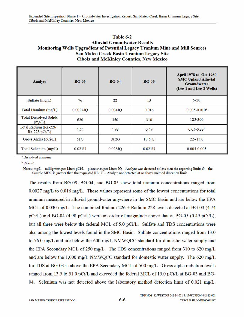
Expanded Site Inspection, Phase 1 – Groundwater Investigation Report, San Mateo Creek Basin Uranium Legacy Site, Cibola and McKinley Counties, New Mexico
TDD NOS 35/WESTON-042-14-001 & 19/WESTON-042-13-001
SAN MATEO CREEK BASIN ESI DOC 6-7 CERCLIS ID: NMN000606847
When considering the levels detected for combined Radium-226 + Radium-228 and gross alpha
radiation levels at these three wells, it is uncertain whether these levels represent natural
background water quality or anthropogenic impacts for this part of the SMC Basin.
The comparison of the results at BG-03, BG-04, and BG-05 to the historical data collected by
NMEIA at the upland background wells (Lee-1 and Lee-2) show the water quality to be similar
except for the higher levels of combined Radium-226 + Radium-228 and gross alpha radiation
detected at BG-03 and BG-04, and the higher selenium detected at BG-03 and BG-04.
A determination of natural background water quality for the alluvial aquifer in the central part of
the basin north of the HMC site was not undertaken as part of this phase of the SMC Basin
groundwater investigation. Rather, this area of the basin was included as part of the Phase 2
ground-water investigation. EPA installed and sampled several alluvial monitoring wells north
of the HMC site in 2015 as part of Phase 2. The results of this work will be documented in a
Phase 2 ground-water investigation report which is scheduled for completion in late 2016.
Additionally, as discussed earlier in this report, EPA is currently working with NMED to
evaluate background water quality of the alluvial aquifer in this area of the basin and will be
collecting additional ground-water data in 2016 with support of the USGS.
6.2.2 Monitoring Wells Downgradient of Potential Legacy Mine and Mill Sources
Alluvial monitor wells N-3A, MW-35-8, MW-35-9, and C-3 were sampled to provide alluvial
groundwater quality data in locations downgradient of legacy uranium mines and mills and
compare the downgradient groundwater quality data to EPA drinking water standards and
NMWQCC groundwater standards as well as background water quality data.
Since most of the alluvium in the western and northern parts of the upper SMC Basin is
unsaturated, comparisons to background were based on the area near the village of San Mateo
and Mount Taylor (i.e., current data from wells BG-03, -04 and -05 wells). A summary of the
sample analytical results along with the standards and water quality data from the BG-03, BG-
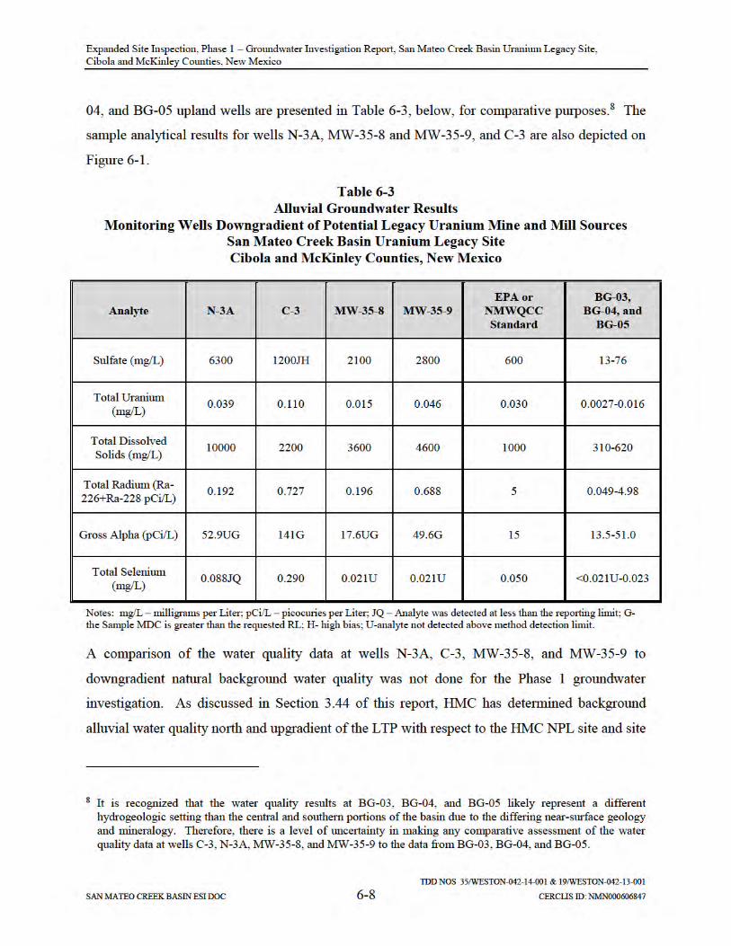

Expanded Site Inspection, Phase 1 – Groundwater Investigation Report, San Mateo Creek Basin Uranium Legacy Site, Cibola and McKinley Counties, New Mexico
TDD NOS 35/WESTON-042-14-001 & 19/WESTON-042-13-001
SAN MATEO CREEK BASIN ESI DOC 6-9 CERCLIS ID: NMN000606847
standards have been approved by the NRC under an amendment to License SUA-1471 to reflect
background water quality (see Table 3-2). The background levels established by HMC for the
COPCs are significantly higher than the concentrations at the upland wells BG-03, BG-04, and
BG-05 and HMC has concluded that they represent natural background upgradient of the LTP
(HMC 2004 Background Report; 2015 Annual Report). As discussed above, EPA is continuing
to reassess alluvial groundwater quality north of the LTP to determine if the HMC background
levels are appropriate.
The following subsections describe COPCs reported above EPA MCLs and NMWQCC
groundwater standards in samples collected from alluvial monitor wells N-3A, MW-35-8, MW-
35-9, and C-3 and compares the sample data to the upland alluvial monitoring wells BG-03, BG-
04, and BG-05.
6.2.3 Total Uranium Exceedances
As illustrated in Table 6-3 and Figure 6-1, total uranium was reported above the EPA MCL of
0.03 mg/L in wells N-3A, MW-35-9, and C-3. The maximum total uranium result was noted in
well C-3 (0.11 mg/L), which is almost seven times the maximum concentration of 0.016 mg/L
detected in wells BG-03, BG-04 and BG-05. Well C-3 is located adjacent to the San Mateo
Creek and approximately 2.5 miles south of the junction of New Mexico State Highways 605
and 509. Well C-3 is located downgradient from most of the legacy uranium wet mines that
operated in the SMC Basin.
6.2.4 Total Selenium Exceedances
Total selenium was reported above the EPA MCL of 0.050 mg/L in wells N-3A (0.088 mg/L)
and C-3 (0.290 mg/L). No selenium was detected in wells MW-35-8 and MW-35-9 above the
laboratory method detection limit of 0.021 mg/L. The selenium concentration at N-3A is more
than three times the maximum concentration of 0.023 mg/L detected at the BG-03, BG-04, and
BG-05 wells. The selenium concentration at C-3 is more than 10 times the maximum
concentration at those wells.

Expanded Site Inspection, Phase 1 – Groundwater Investigation Report, San Mateo Creek Basin Uranium Legacy Site, Cibola and McKinley Counties, New Mexico
TDD NOS 35/WESTON-042-14-001 & 19/WESTON-042-13-001
SAN MATEO CREEK BASIN ESI DOC 6-10 CERCLIS ID: NMN000606847
6.2.5 Total Dissolved Solids Exceedances
TDS concentrations exceeded the EPA Secondary MCL of 500 mg/L and the NMWQCC
groundwater standard of 1,000 mg/L in wells N-3A (10,000 mg/L), MW-35-8 (3,600 mg/L),
MW-35-9 (4,600 mg/L), and C-3 (2,200 mg/L). The TDS concentrations in all four wells were
more than three times the maximum concentration of 620 mg/L detected at the BG-03, BG-04,
and BG-05 wells. The TDS concentration at well N-3A was more than 10 times the maximum
concentration at those wells.
TDS concentrations are comparatively low in the upper SMC Basin near the village of San
Mateo (at BG-03, BG-4, BG-05), and generally increase moving east and south. The low TDS
concentrations in this area are consistent with previous observations and suggest a relatively low-
residence time in the subsurface of snowmelt and rainwaters from Mount Taylor as reported by
the USGS. The highest TDS concentration was measured at well N-3A in the Ambrosia Lake
area where much of the alluvium appears to be dry (based on borehole drilling), with the
exception of the area near the former Rio Algom Mill Site.
6.2.6 Sulfate Exceedances
Concentrations of sulfate exceeded the EPA Secondary MCL of 250 mg/L and the NMWQCC
groundwater standard of 600 mg/L in wells N-3A, MW-35-8, MW-35-9, and C-3 with the
concentrations ranging from 1,200 in well C-3 to the maximum concentration of 6,300 mg/L in
well N-3A. Well N-3A had the highest concentrations of both sulfate and TDS. Monitoring
wells MW-35-8 and MW-35-9, located approximately one mile downgradient of the Section 35
and Cliffside mines, had the next highest sulfate levels at 2,100 and 2,800 mg/L, respectively, as
well as high TDS levels (3,600 and 4,600 mg/L respectively). The sulfate concentrations for all
four wells are more than 10 times the maximum concentration of 78 mg/L detected in wells BG-
03, BG-04, and BG-05. Sulfate ions comprise the majority of the TDS.
6.2.7 Combined Radium-226 + Radium-228 Exceedances
For combined Radium-226 + Radium-228, there were no exceedances of the EPA MCL of 5.0
pCi/L in monitoring wells N-3A, MW-35-8, MW-35-9, and C-3. Concentrations reported for
Expanded Site Inspection, Phase 1 – Groundwater Investigation Report, San Mateo Creek Basin Uranium Legacy Site, Cibola and McKinley Counties, New Mexico
TDD NOS 35/WESTON-042-14-001 & 19/WESTON-042-13-001
SAN MATEO CREEK BASIN ESI DOC 6-11 CERCLIS ID: NMN000606847
these wells ranged from 0.090 to 0.727 pCi/L and are within the range of concentrations detected
at wells BG-03, BG-04, and BG-05 (0.049 to 4.98 mg/L).
6.2.8 Gross Alpha Exceedances
Gross alpha levels detected in monitoring wells MW-35-9 (49.6 pCi/L) and C-3 (141 pCi/L)
were above the EPA MCL of 15 pCi/L. These levels were not greater than three times the
maximum level of 51.0 pCi/L detected in wells BG-03, BG-04, and BG-05. The two samples
collected from wells N-3A and MW-35-8 did not report detectable amounts of gross alpha
radiation. At well N-3A and MW-35-8 levels of gross alpha were less than the laboratory
method detection limits of 52.9 pCi/L and 17.6 pCi/L, respectively. These method detection
limits from dilutions are noted to be above the EPA MCL of 15 piC/L. The possibility exists that
gross alpha is present at or above the EPA MCL at these locations.
6.2.9 General Chemistry
Cation and anion data for the water samples collected during Phase 1 were normalized and
plotted on Trilinear Diagrams (Figure 6-2) using the USGS Groundwater Chart Program. The
cation and anion data indicate two major water types for the SMC Basin alluvial groundwater
samples: Ca-HCO3 water type in the north eastern portion of the basin, and Na/Mg-SO4 water
type in the northwestern, central, and southern parts of the basin.
Water sample major ion chemistry represented by BG-03, BG-04, and BG-05 displays TDS
concentrations that are an order of magnitude lower than the rest of the alluvial sample results.
The overall increase in TDS and a Na-SO4 water type at other alluvial sample locations may
reflect a difference in geologic conditions, mineralogy of the aquifer sediments, and surface
hydrology. The groundwater residence time at other locations may be much greater than the
short time of residence near Mount Taylor. A longer groundwater residence time increases the
concentration of dissolved solutes as water moves along a flow path. This occurs in natural, arid
systems, but may be exacerbated by groundwater and/or meteoric water percolating through
mine wastes.
Expanded Site Inspection, Phase 1 – Groundwater Investigation Report, San Mateo Creek Basin Uranium Legacy Site, Cibola and McKinley Counties, New Mexico
TDD NOS 35/WESTON-042-14-001 & 19/WESTON-042-13-001
SAN MATEO CREEK BASIN ESI DOC 6-12 CERCLIS ID: NMN000606847
The increase in TDS and Na-SO4 water type may also reflect anthropogenic impacts on the
general chemistry by legacy uranium mines and mills. As discussed in Section 4.4 (Historical
Alluvial Water Quality), Brod and Stone (1981) and Gallaher and Cary (1985) report high levels
of TDS and sulfate in mine water discharges and alluvial groundwater. Kaufmann and others
(1975) report an increase of TDS and other constituents in alluvial groundwater below the
confluence of Arroyo del Puerto and San Mateo Creek.
6.2.10 Stable Isotopes
Stable isotope analyses, presented in Table 6-4, were performed on a subset of the groundwater
samples (PV-03F, PV-03UF, and PV-03 DW). Lightweight stable isotopes, including the
hydrogen-deuterium system (D), the oxygen-18/16 system (18O), the carbon-13/12 system
(13C), and the sulfur-34/32 system (34S), fractionate readily at surface temperatures and
pressures, and are commonly used to assist with the differentiation of water sources. Results are
presented as deviation, on a per thousand basis (known as “per mil”), from published standards,
including Standard Mean Ocean Water (SMOW) for deuterium and oxygen, PeeDee belemenite
(PDB) for carbon, and troilite (iron sulfide mineral) extracted from the Canyon Diablo meteorite
(CDT).
Results for D range from -66.3 to -87.6 o/oo, and 18O results range from -9.09 to -12.21 o/oo,
indicating depletion of the heavier isotopes with respect to SMOW. Results for 13C range from
7.9 to -13.1 o/oo, indicating depletion of carbon with respect to the PDB standard. Results are
consistent with the range of meteoric waters for the latitude of the study area (Faure, 1986).
Results for 34S range from 15.0 to -22.0 o/oo with respect to the CDT standard. The wide range
of deviation from the standard suggests a wide range of provenance of the sulfur in the water,
which may include terrestrial and marine sediments, and/or hydrothermal deposits. Sulfur-
reducing bacteria, however, can play a significant role in 34S fractionation in near-surface
conditions. Additional data are necessary to make any kind of definitive conclusion from these
34S isotope analyses.

Expanded Site Inspection, Phase 1 – Groundwater Investigation Report, San Mateo Creek Basin Uranium Legacy Site, Cibola and McKinley Counties, New Mexico
TDD NOS 35/WESTON-042-14-001 & 19/WESTON-042-13-001
SAN MATEO CREEK BASIN ESI DOC 6-14 CERCLIS ID: NMN000606847
Gypsum [CaSO2(H2O)] is present as a significant phase in sample C-5, which is also the highest
clay content; gypsum in this sample is most likely a secondary phase due to its high solubility
and softness.
Jarosite [KFe3(OH)6(SO4)] is present at trace quantities in sample N-5. It is a common
breakdown product of sulfide minerals and may represent circumstantial evidence of the
presence of mine waste.
The presence of carbonate and sulfate minerals in these samples is consistent with an arid
depositional environment, where carbonate-bicarbonate and sulfate readily move back and forth
between aqueous and solid phases as local water approaches saturation for these constituents.
Sediments high in clay minerals often have a high organic content, which can reduce and solidify
aqueous uranium. In addition, clay fractions also commonly contain trace quantities of
uranophyllic phases, such as apatite and zircon, which produce uranium daughter products on
decay.
6.2.12 Soil SPLP
In areas where groundwater was not encountered at-depth, soil samples were collected from
selected borings (BG-07-55 feet, C-5B-40 feet, N-1-47 feet, N-2-24 feet, N-4-91 feet, and N-5-
32 feet) for SPLP general chemistry, metals, and radiological analyses. The objective of
submitting at-depth soil samples to a synthetic leaching procedure was to identify COPCs that
may have leached (or will leach) into the soil as a result of historical mine water discharge.
In review of the six soil samples for SPLP analyses, the data appear to be inconclusive with
respect to identifying historical mine waste COPCs in the alluvial water-bearing zone. Total
uranium was not reported above the detection limit in any of the samples submitted; however,
the reported method detection limit (MDL) range was 0.026 mg/L to 0.26 mg/L, with all but one
of the MDLs being higher than the MCL of 0.03 mg/L. Some radiological detections, including
Uranium-233/234, were reported in samples C5-B (collected at 40 feet bgs), N2 (24 feet bgs),
and N5 (32 feet bgs). Uranium-238 was noted in soil samples C-5B (40 feet) and N5 (32 feet
Expanded Site Inspection, Phase 1 – Groundwater Investigation Report, San Mateo Creek Basin Uranium Legacy Site, Cibola and McKinley Counties, New Mexico
TDD NOS 35/WESTON-042-14-001 & 19/WESTON-042-13-001
SAN MATEO CREEK BASIN ESI DOC 6-15 CERCLIS ID: NMN000606847
bgs). Thorium-228, Thorium-230, and Thorium-232 isotope detections were reported for the N-
5 soil sample.
The low uranium concentrations in non-saturated soils are consistent with the high solubility of
uranium in an oxidizing environment. Uranium in an oxidized valence state is prone to remain
in solution and migrate in the direction of water flow. Lower detection limits might improve the
analytical results for reportable uranium levels, but the general observation is that the sediments
at these locations and depths probably do not yield significant uranium to groundwater.
Sulfate concentrations mostly range from <0.05 to 19 mg/L in the SPLP sample suite, with the
anomalous exception of sample N-5, with a sulfate concentration of 1,700 mg/L. Sample N-5
also has anomalously high calcium and magnesium concentrations, suggesting a high precipitate
concentration in this soil sample. SPLP soil results are included in Appendix N.
6.3 PRIVATELY-OWNED WELLS SAMPLED
For the purposes of this report and based on the objectives of the investigation, the results
summary focused on COPCs in the newly installed alluvial monitoring wells and the two
industry monitoring wells located near the Section 35 and Cliffside mines that are known to be
completed in the alluvial water-bearing zone (Tables 6-2 and 6-3). There is uncertainty with the
remaining 13 current or former privately-owned water wells9 sampled by START-3 regarding
the well completion depth, screened interval, and construction to make a confident determination
if the groundwater sampled is from the alluvium or other bedrock water-bearing units such as the
Upper-Middle-Lower Chinle, Morrison, and San Andreas/Glorieta formations. There is a high
probability that a number of these wells may be screened over one or more water-bearing units.
START-3 researched the New Mexico Office of the State Engineer (OSE) database for well
drilling reports and coordinates to verify well location, screened interval, and well depth.
Interviews of the respective well owners were also conducted to verify well depth, construction,
9 Some water wells that were once privately owned in the vicinity of the HMC NPL site are now owned by HMC and used for monitoring groundwater quality. Well 907, which is an old irrigation well currently owned by the Village of Milan, is also used by HMC for monitoring.

Expanded Site Inspection, Phase 1 – Groundwater Investigation Report, San Mateo Creek Basin Uranium Legacy Site, Cibola and McKinley Counties, New Mexico
TDD NOS 35/WESTON-042-14-001 & 19/WESTON-042-13-001
SAN MATEO CREEK BASIN ESI DOC 6-16 CERCLIS ID: NMN000606847
and groundwater use. Table 6-6, as well as Figure 6-2, include the 13 privately-owned water
wells sampled by START-3.
START-3 sampled wells included 907, 928, 943, PV-01, PV-02, PV-03, SMC-09, SMC-10,
SMC-11, SMC-12, SMC-13, SMC-14, and SMC-26 as part of the field investigation activities.
All 13 wells exceeded NMWQCC groundwater standards and/or the EPA National Primary and
Secondary Drinking Water Standard MCLs for one or more analytes. Of the three private water
wells used for domestic water supply (PV-01, PV-02, and PV-03), only PV-03 exceeded the
EPA primary drinking water MCLs of 0.03 mg/L for total uranium, 0.05 mg/L for total selenium,
and 15 piC/L for gross alpha. Private well PV-03 also exceeded the NMWQCC human health
groundwater standards for dissolved uranium (0.03 mg/L) and dissolved selenium (0.05 mg/L).
No other EPA primary drinking water standards or NMWQCC human health standards for
groundwater were exceeded for the three domestic water wells. Private well PV-01 exceeded the
NMWQCC’s sulfate and TDS standards of 600 mg/L and 1,000 mg/L for domestic water supply.
Monitoring or livestock wells SMC-11, SMC-12, SMC-13, and SMC-26 exceeded the EPA
MCLs for total uranium and gross alpha and the NMWQCC human health standard for dissolved
uranium. All of these wells with the exception of SMC-26 also exceeded the EPA MCL for total
selenium and the NMWQCC human health standard for dissolved selenium. Wells SMC-11,
SMC-12, and SMC-13 exceeded the NMWQCC’s sulfate and TDS groundwater standards.
Livestock well SMC-09, exceeded the EPA Primary MCL for gross alpha and the Secondary
MCL for TDS.
The three San Andres/Glorieta monitoring wells 907, 928, and 943 exceeded the EPA drinking
water MCL of 15 piC/L for gross alpha. Only well 928 exceeded the EPA’s 0.03 mg/L MCL for
total uranium. The NMWQCC human health standard of 0.03 mg/L dissolved uranium was
exceeded in wells 928 and 943. The NMWQCC groundwater standards for sulfate (600 mg/L)
and TDS (1,000 mg/L) were exceeded in all three wells.
There were no EPA MCL exceedances above 5 piC/L for combined Radium-226 and Radium-
228 in any of the START-3 sampled well results. The laboratory results for these wells are
included in Figure 6-3 and Table 6-6.
Expanded Site Inspection, Phase 1 – Groundwater Investigation Report, San Mateo Creek Basin Uranium Legacy Site, Cibola and McKinley Counties, New Mexico
TDD NOS 35/WESTON-042-14-001 & 19/WESTON-042-13-001
SAN MATEO CREEK BASIN ESI DOC 7-1 CERCLIS ID: NMN000606847
7 CONCLUSIONS
Based on the findings of the Phase 1 groundwater investigation, the following conclusions can be
made:
1. Alluvial sediments in the northern and western upland areas of the San Mateo Creek
basin (SMC Basin) are mostly dry with the exception of an isolated area near the Rio
Algom Mill Site along Arroyo del Puerto and a second area south of the Section 35 and
Cliffside mines. Based on extensive borehole drilling, the saturation within the alluvial
sediments along Arroyo del Puerto does not appear to be hydraulically connected with
the alluvial aquifer beneath San Mateo Creek at the confluence of the two drainages. It is
not known whether the second area of alluvial saturation is hydraulically connected to the
San Mateo Creek alluvial aquifer. The lack of alluvial saturation in the upland areas
prevented the collection of groundwater samples along tributary drainages upgradient of
the legacy mines and mills in the Ambrosia Lake area. Therefore, a determination of
natural alluvial background water quality in this area was not possible.
2. Significant alluvial saturation was encountered in the northeast part of the SMC Basin
near the village of San Mateo and the western flank of Mount Taylor. Monitoring of
groundwater quality from upland wells BG-03, BG-04, and BG-05 showed
concentrations of the contaminants of potential concern (COPCs) were below EPA MCLs
and NMWQCC ground-water standards for all COPCs with the exception of gross alpha
at wells BG-03 and BG-04. Combined Radium-226 + Radium-228 in these two
monitoring wells was an order of magnitude higher than BG-05, but the levels were still
below the EPA MCL. Groundwater samples collected from these wells were expected to
represent background water quality, but because of the elevated radium and gross alpha
levels, it is uncertain whether the alluvial water quality has been impacted by the nearby
Mount Taylor Mine.
3. Alluvial groundwater samples collected from all of the wells downgradient of legacy
uranium mines and mills had concentrations of COPCs which exceeded EPA MCLs and
NMWQCC groundwater standards. In comparing the sample results from these wells to

Expanded Site Inspection, Phase 1 – Groundwater Investigation Report, San Mateo Creek Basin Uranium Legacy Site, Cibola and McKinley Counties, New Mexico
TDD NOS 35/WESTON-042-14-001 & 19/WESTON-042-13-001
SAN MATEO CREEK BASIN ESI DOC 7-2 CERCLIS ID: NMN000606847
the alluvial water quality at the upland monitoring wells BG-03, BG-04 and BG-05, the
concentrations of uranium, selenium, TDS, and sulfate in certain downgradient wells
were greater than three times the concentrations of the upland wells. Sulfate
concentrations in all four downgradient wells were 10 times higher than sulfate levels at
the upland wells and the TDS concentration at N-3A was 10 times higher than the upland
wells.
4. Alluvial groundwater at wells N-3A near the Rio Algom Mill Site and MW-35-8 and
MW-35-9 south of the Section 35 and Cliffside mines was of the poorest quality
measured during Phase 1 based on TDS and sulfate levels. A comparison of sample data
from these wells to historical data of the 1981 mine water discharges for the Ambrosia
Lake area and San Mateo Creek area shows that the TDS and sulfate levels are similar.
This is consistent with the findings of Brod and Stone (1981).
5. Mine water discharges resulted in the saturation or resaturation of alluvial sediments
along the Arroyo del Puerto and San Mateo Creek channels on a very large scale with
water levels in the central part of the basin (in the vicinity of the Otero well cluster and
Well C-3) being raised approximately 55 feet by 1977. This is evident by static water
level measurements at Well C-3 in 2015, which are now about 55 feet lower than those
recorded at the nearby Otero well cluster in 1977. The drop in the C-3 water level
indicates a dramatic decline in the alluvial saturated thickness since 1977 in response to
the cessation of mine water discharge within the basin. Mine discharge water that
saturated alluvial sediments during the peak mining period has mostly drained out of the
alluvium in the northern and central parts of the SMC Basin. The draindown observed at
Well C-3 in the central part of the basin is not evident in monitoring wells located
downgradient at the Homestake Mining Company (HMC) NPL site, a distance of
approximately three miles. The static water level elevations measured at the HMC
monitoring well R have actually increased slightly (3-4 feet) since the mid-1990s.
6. The two areas of alluvial saturation in the Ambrosia Lake area and south of the Section
35 and Cliffside mines, with similar poor water quality as historical mine water

Expanded Site Inspection, Phase 1 – Groundwater Investigation Report, San Mateo Creek Basin Uranium Legacy Site, Cibola and McKinley Counties, New Mexico
TDD NOS 35/WESTON-042-14-001 & 19/WESTON-042-13-001
SAN MATEO CREEK BASIN ESI DOC 7-3 CERCLIS ID: NMN000606847
discharges with respect to TDS and sulfate, may represent residual pockets of mine water
that may be draining into underlying bedrock formations.
7. Groundwater samples collected from twelve existing private water wells and industry
monitoring water wells (alluvial and bedrock wells) exceeded EPA MCLs and/or
NMWQCC groundwater standards for one or more COPCs. For the three private wells
known to be used for domestic water supply (PV-01, PV-02, and PV-03), only well PV-
03 had exceedances of the EPA primary drinking water standards and NMWQCC human
health standards. EPA completed the installation of two point-of-use filtration systems at
the residential taps for PV-03 to reduce COPC concentrations to below health-based
standards.
8. Additional data are needed to make any definitive conclusions about the different stable
isotope values. EPA has collected additional isotopic data (stable isotopic and radiolocal
isotopic data) from monitoring wells as part of the ongoing Phase 2 groundwater
investigation.
Expanded Site Inspection, Phase 1 – Groundwater Investigation Report, San Mateo Creek Basin Uranium Legacy Site, Cibola and McKinley Counties, New Mexico
TDD NOS 35/WESTON-042-14-001 & 19/WESTON-042-13-001
SAN MATEO CREEK BASIN ESI DOC 8-1 CERCLIS ID: NMN000606847
8 REFERENCES
Bostick, K., 1985. Ground-Water Discharge Plan Analysis for Kerr-McGee Nuclear Corporation Ambrosia Lake Uranium Mill Quivira Mining Company: Report by New Mexico Environmental Improvement Division, Groundwater Quality and Hazardous Waste Bureau, Groundwater Section, February 1985
Brod, R. C., and Stone, W. J. 1981. Hydrogeology of Ambrosia Lake-San Mateo area, McKinley and Cibola Counties, New Mexico, New Mexico Bureau of Mines and Mineral Resources Hydrogeologic Sheet 2.
Cooper, J.B. and E.C. John. 1968. Geology and Ground-Water Occurrence in Southeastern McKinley County, New Mexico, New Mexico State Engineer Technical Report 35.
DOE (U.S Department of Energy) 2014. Legacy Management, Site Status Report: Groundwater Flow and Contaminant Transport in the Vicinity of the Bluewater, New Mexico, Disposal Site, November 2014.
Drever, J. I., 1982. The Geochemistry of Natural Waters, 388 p.
EPA (U.S. Environmental Protection Agency). 1975. Impact of Uranium Mining and Milling on Water Quality in the Grants Mineral Belt, New Mexico, U.S. Environmental Protection Agency, Region VI, Dallas, Texas, EPA 906/9-75-002, 40 p.
EPA. 1980. EPA Region VI Decision on Ranchers Exploration and Development Corporation, Johnny M Mine, NPDES Permit NM0026567.
EPA. 1992. Hazard Ranking System Guidance, EPA 540-R-92026 OSWER Directive 9345.1-07.
EPA. 1996. Low-flow (Minimal-Drawdown) Groundwater Sampling Procedures. EPA/540/S-95/504.
EPA. 2014. National Functional Guidelines (NFGs) for Inorganic Data Review. EPA Contract Laboratory Program.
Faure, Gunter. 1986. Principals of Isotope Geology. Wiley, publ, 1986; 608 p.
Gallaher B. M., and Cary, S. J. 1986. Impacts of Uranium Mining on Surface and Shallow Groundwaters, Grants Mineral Belt, New Mexico, Health and Environment Department, New Mexico Environmental Improvement Division, 170 p.
Gallaher B. M., and Goad, M. S. 1981. Water Quality Aspects of Uranium Mining and Milling in New Mexico, Wells, S. G. and W. Lambert (eds) New Mexico Geol. Soc. Spec. Publ. No. 10, pp. 85-91.

Expanded Site Inspection, Phase 1 – Groundwater Investigation Report, San Mateo Creek Basin Uranium Legacy Site, Cibola and McKinley Counties, New Mexico
TDD NOS 35/WESTON-042-14-001 & 19/WESTON-042-13-001
SAN MATEO CREEK BASIN ESI DOC 8-2 CERCLIS ID: NMN000606847
Granger, H. C., Santos, E. S., Dean, B. G., and Moore, F. B., 1961, Sandstone-type Uranium Deposits at Ambrosia Lake, New Mexico, Econ. Geol., v. 56, n. 7, p. 1179-1209.
Hazlett, G.W., and Kreel. J. 1963. Geology and Ore Deposits of the Southwestern Part of the Ambrosia Lake Area, Memoir 15 – Geology and Technology of Grants Uranium Region, New Mexico Bureau of Mines and Mineral Resources, p. 82-89.
Hem, J. D., 1985. Study and Interpretation of the Chemical Characteristics of Natural Water, USGS WSP-2254.
Homestake Mining Company and Hydro-Engineering, 2015, 2015 Annual Monitoring Report/Performance Review for Homestake’s Grants Project Pursuant to NRC License SUA-1471 and Discharge Plan DP-200, Technical Report prepared for U.S. Nuclear Regulatory Commission and New Mexico Environment Department.
Homestake Mining Company and Hydro-Engineering, 2004 Grants Reclamation Project Background Water Quality Evaluation of the Chinle Aquifers, Technical Report prepared for U.S. Nuclear Regulatory Commission, Rockville, Maryland.
Kaufmann, R. F., Eadie, G. G., and Russell, C. R., 1975 Summary of Ground-Water Quality Impacts of Uranium Mining and Milling in the Grants Mineral Belt, New Mexico, U.S. Environmental Protection Agency, Office of Radiation Program – Las Vegas Facility, Technical Note ORP/LV – 75 – 4, 71 pp.
NMED (New Mexico Environment Department). 2010. Geochemical Analysis and Interpretation of Groundwater Data Collected as part of the Anaconda Company Bluewater Uranium Mill Site Investigation and San Mateo Creek Site Legacy Uranium Sites Investigation, McKinley and Cibola County, New Mexico, Draft Report, New Mexico Environment Department, 62 p. with 12 tables and 43 figures.
NMED. 2010. Point Lookout Sandstone and Menefee Formation.
NMED. 2012. Groundwater Quality Bureau Document titled Site Inspection Report Phase-2, San Mateo Creek Basin, Legacy Uranium Mine and Mill Site Area, Cibola-McKinley Counties, New Mexico. April 2012.
NMED. 2012. Site Inspection Report Phase 2 San Mateo Creek Basin Legacy Mine and Mill Site Area.
NMED. 2015. “Site Reassessment Report, Lower San Mateo Creek Basin Site, Cibola and
McKinley Counties, New Mexico, CERCLIS ID NMN000606847”.
Expanded Site Inspection, Phase 1 – Groundwater Investigation Report, San Mateo Creek Basin Uranium Legacy Site, Cibola and McKinley Counties, New Mexico
TDD NOS 35/WESTON-042-14-001 & 19/WESTON-042-13-001
SAN MATEO CREEK BASIN ESI DOC 8-3 CERCLIS ID: NMN000606847
Rio Grande Resources Application of Revision of Mine Permit, June 16, 2010.
USGS (U.S. Geological Survey). 2015. Groundwater Chart Program accessed online at (http://water.usgs.gov/nrp/gwsoftware/GW Chart/GW Chart.html).
U.S. Department of Agriculture, Natural Resources Conservation Service. Soil Survey of McKinley County Area, New Mexico, McKinley County and Parts of Cibola and San Juan Counties. 2005.


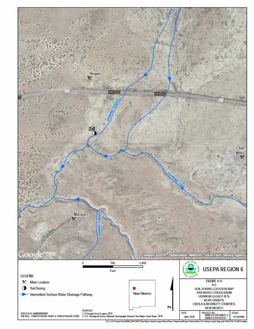
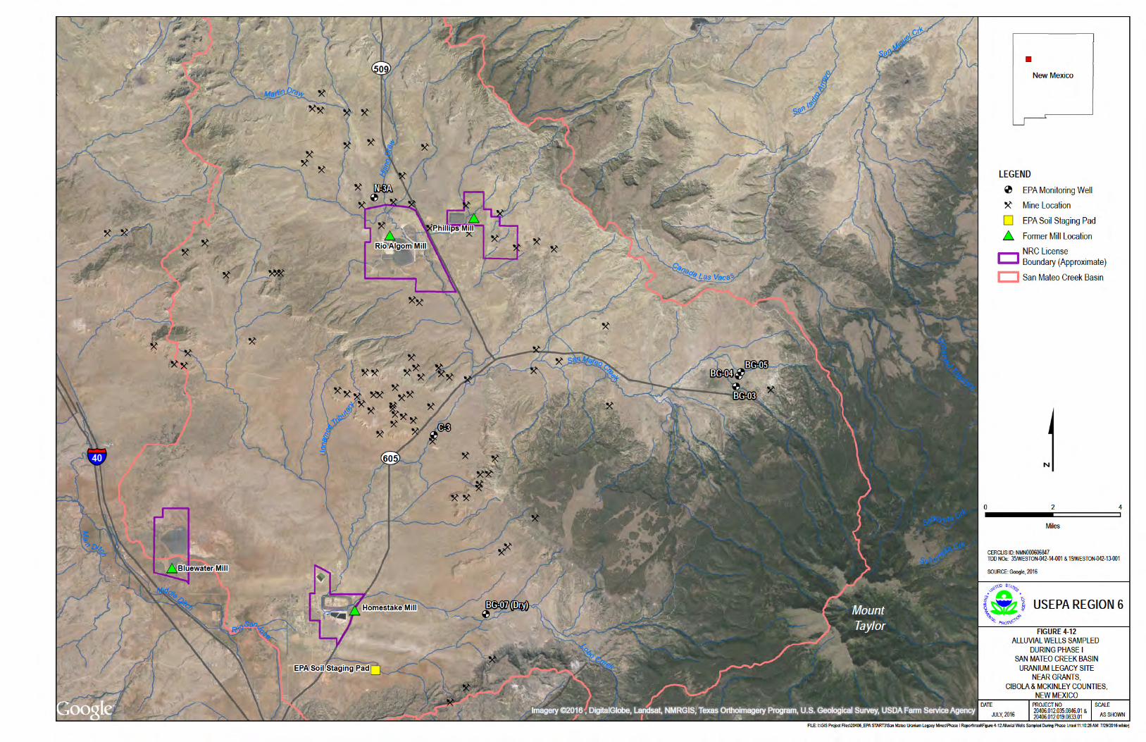


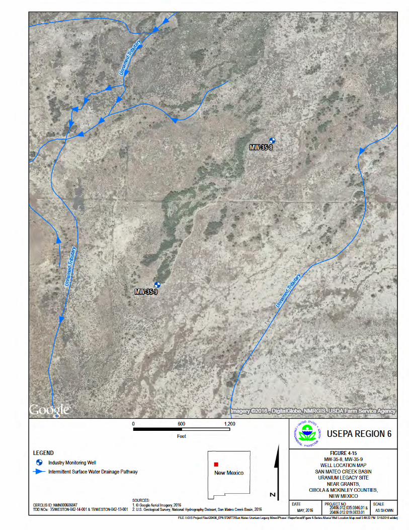
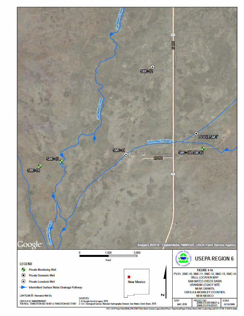
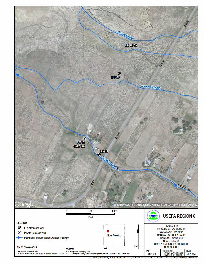
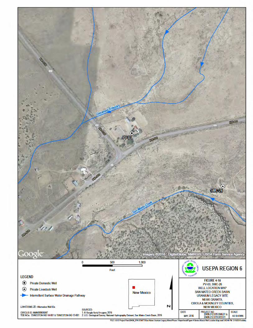

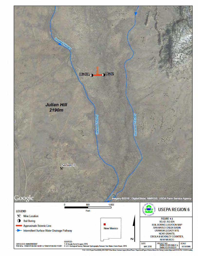


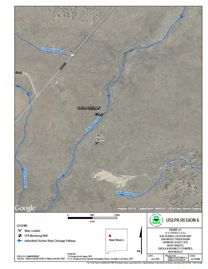
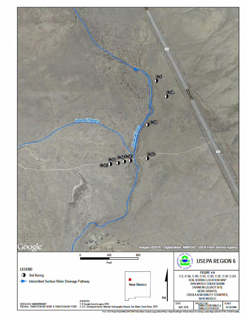
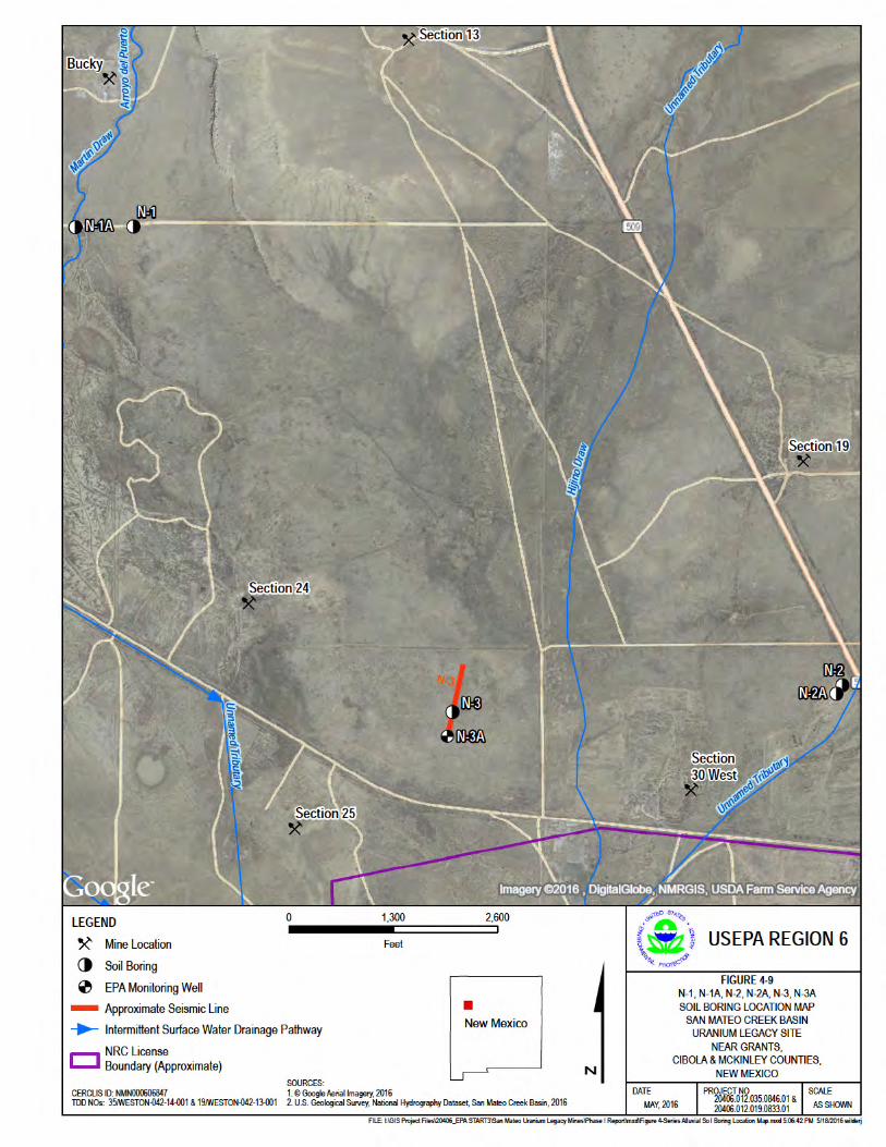
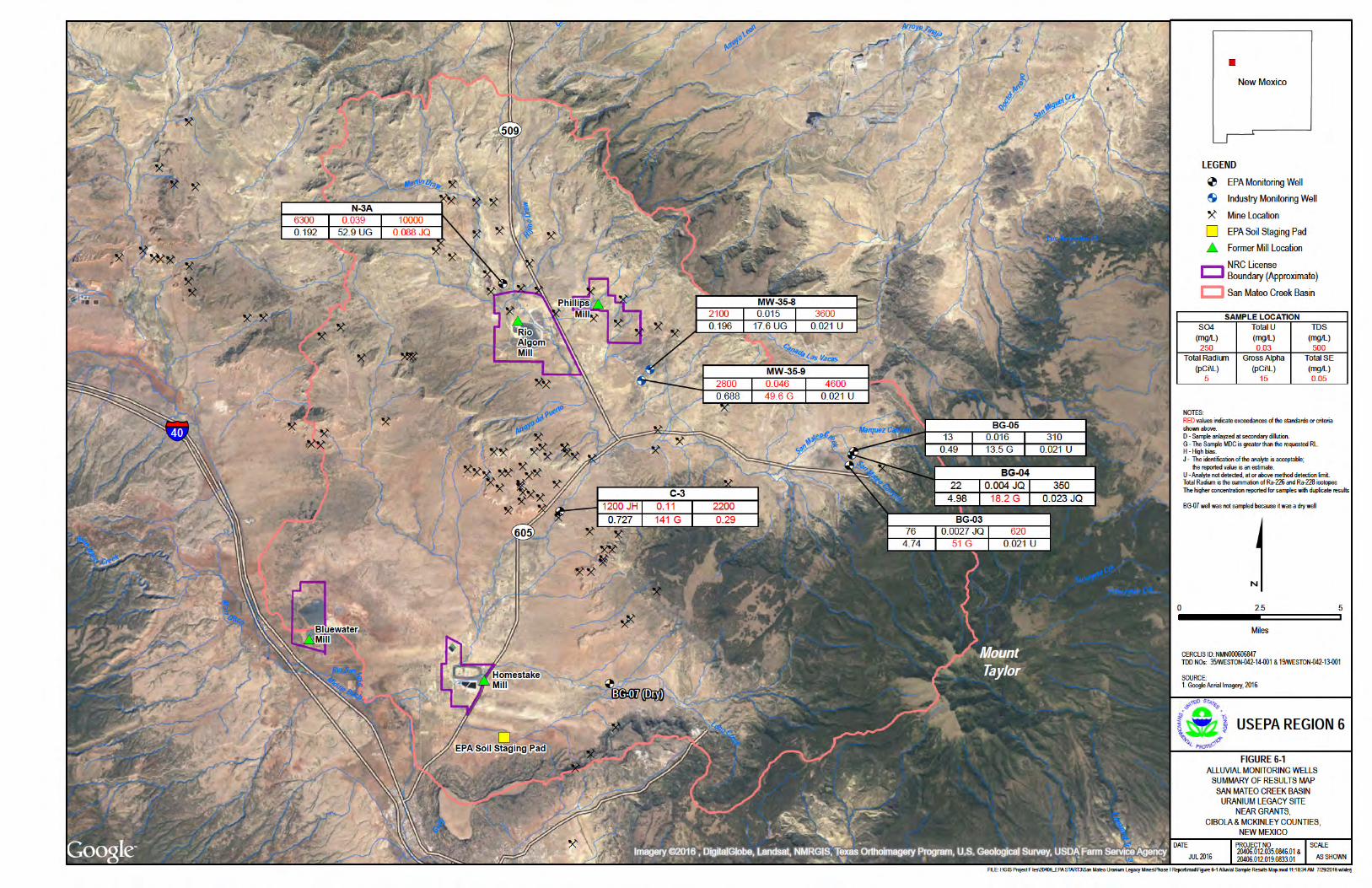
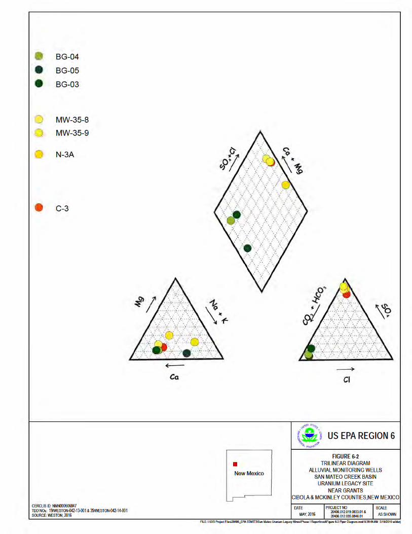


Table 6-5Alluvial Groundwater Summary of Results
San Mateo Creek Basin Uranium Legacy SiteNear Grants, Cibola, and McKinley Counties, New Mexico
Analyte CAS.NO Units
EPA National Primary1 & Secondary2
Drinking Water Standard MCL
New Mexico Water Quality
Control Commission (NMWQCC)
Well IDSample ID
DateType
BG-03BG03-20141114-21
11/14/2014Field Sample
BG-04BG04-20141114-21
11/14/2014Field Sample
BG-05BG05-20141114-21
11/14/2014Field Sample
C-3C-3-20141117-21
11/17/2014Field Sample
MW-35-8MW358-20141113-21
11/13/2014Field Sample
MW-35-9MW359-20141113-21
11/13/2014Field Sample
N-3AMWN3-20150127
1/27/2015Field Sample
Metals, DissolvedSelenium 7782-49-2 mg/L NP 0.05 -- 0.021 UJK 0.021 UJK 0.021 UJK 0.31 JK 0.021 UJK 0.021 UJK 0.075 JKQUranium 7440-61-1 mg/L NP 0.03 -- 0.0024 JQK 0.0038 JQK 0.012 JK 0.1 JK 0.016 JK 0.048 JK 0.054 JKMetals, TotalSelenium 7782-49-2 mg/L 0.05 NP -- 0.021 U 0.023 JQ 0.021 U 0.29 0.021 U 0.021 U 0.088 JQUranium 7440-61-1 mg/L 0.03 NP -- 0.0027 JQ 0.004 JQ 0.016 0.11 0.015 0.046 0.039 RadiologicalGross Alpha 12587-46-1 pCi/L 15 NP -- 51 (+/- 14.8) G 18.2 (+/- 5.93) G 13.5 (+/- 4.66) G 141 (+/- 26.7) G 17.6 (+/- 12.7) U G 49.6 (+/- 22.2) G 52.9 (+/- 44.1) U GRadium-226 13982-63-3 pCi/L 5 30 -- 1.96 (+/- 0.465) 2.14 (+/- 0.483) 0.49 (+/- 0.273) 0.348 (+/- 0.141) 0.196 (+/- 0.111) 0.306 (+/- 0.134) 0.192 (+/- 0.0693) Radium-228 15262-20-1 pCi/L 5 30 -- 2.78 (+/- 0.729) 2.84 (+/- 0.705) 0.77 (+/- 0.575) U 0.379 (+/- 0.232) 0.0594 (+/- 0.182) U 0.382 (+/- 0.224) 0.0725 (+/- 0.214) UWet/General ChemistrySulfate3 14808-79-8 mg/L 250 600 -- 76 22 13 1200 JH 2100 2800 6300 Total Dissolved Solids3 TDS mg/L 500 1000 -- 620 350 310 2200 3600 4600 10000
Notes:1 EPA Primary MCLs (PMCLs) are the highest level of a contaminant allowed in drinking water PMCL's are enforceable standards 2 EPA does not enforce Secondary Maximum Contaminant Levels (SMCLs) They are established only as guidelines to assist public water systems in managing their drinking water for aesthetic considerations, such as taste, color, and odor These contaminants are not considered to present a risk to human health at the SMCL3 SMCL analytes include: Aluminum, Copper (not shown, 1 mg/L) Iron, Manganese, Silver, Zinc, Chloride, Fluoride, pH, Sulfate, and Total Dissolved SolidsEPA MCL - Combined Radium 226/228 of 5 pCi/LNMWQCC - Combined Radium 226/228 of 30 pCi/Lmg/L - milligrams per LiterpCi/L - picocuries per LiterNA - Not analyzed / Not applicableNP - Not PublishedG - The Sample MDC is greater than the requested RLJ - The identification of the analyte is acceptable; the reported value is an estimateK - Unknown biasU - Analyte not detected Value exceeds the minimum of the MCL or NMWQCC Value exceeds the detection limit for specific sample analyteTotal & Dissolved Uranium results represent the reanalyzed results
19/WESTON-042-13-00135/WESTON-042-14-001

Table 6-6Bedrock Groundwater Summary of Results
San Mateo Creek Basin Uranium Legacy SiteNear Grants, Cibola, and McKinley Counties, New Mexico
Analyte CAS.NO Units
EPA National Primary1 & Secondary2
Drinking Water Standard MCL
New Mexico Water Quality
Control Commission (NMWQCC)
Well IDSample ID
DateType
907MW-907-20150209
2/9/2015Field Sample
928MW-928-20150209
2/9/2015Field Sample
943943-20141117-21
11/17/2014Field Sample
943943-20141117-22
11/17/2014Field Duplicate
PV-01PV01-20141023-21
10/23/2014Field Sample
PV-02PV02-20141028-21
10/28/2014Field Sample
PV-03PV-03-20141118-21
11/18/2014Field Sample
PV-03-DWPV03-20150716-21DW
7/16/2015Field Sample
PV-03-FPV03-20150716-21F
7/16/2015Field Sample
Metals, DissolvedSelenium 7782-49-2 mg/L NP 0 05 -- 0.052 JQK 0 042 UJK 0 021 UJK 0 023 UB 0 021 UJK 0.025 JKQ 0 07 UB 0.072 0.073 Uranium 7440-61-1 mg/L NP 0 03 -- 0.019 JK 0.064 JK 0.031 JK 0.029 JK 0 002 UJK NA 0.065 JK 0.017 0.06 Metals, TotalSelenium 7782-49-2 mg/L 0 05 NP -- 0 042 U 0 042 U 0 021 UB 0 025 UB 0 021 U 0 021 U 0 063 UB 0.12 0.076 Uranium 7440-61-1 mg/L 0 03 NP -- 0.013 0.056 0.028 0.029 0 004 U 0 002 U 0.057 0.1 0.059 RadiologicalGross Alpha 12587-46-1 pCi/L 15 NP -- 19.3 (+/- 6.97) 60.7 (+/- 13.5) 36 (+/- 12.8) G 48.1 (+/- 14.2) G 7 5 (+/- 8 13) U G 4 21 (+/- 2 92) U G 42.5 (+/- 7.9) G 44.7 (+/- 7.8) 48.4 (+/- 9.5) Radium-226 13982-63-3 pCi/L 5 30 -- 0.378 (+/- 0.123) 2.42 (+/- 0.293) 0.332 (+/- 0.164) 0.211 (+/- 0.143) 0.261 (+/- 0.135) 0 102 (+/- 0 117) U 0.91 (+/- 0.172) 0.34 (+/- 0.2) 1.84 (+/- 0.6) Radium-228 15262-20-1 pCi/L 5 30 -- 0.67 (+/- 0.432) 0.66 (+/- 0.266) 0 231 (+/- 0 205) U 0 318 (+/- 0 213) U 0.721 (+/- 0.302) 0 146 (+/- 0 205) U 0.473 (+/- 0.215) 0 42 (+/- 0 32) U 1.09 (+/- 0.39) Wet/General ChemistrySulfate3 14808-79-8 mg/L 250 600 -- 670 870 720 JH 560 JH 630 11 97 110 D 98 DTotal Dissolved Solids3 TDS mg/L 500 1000 -- 1400 1600 1800 1800 2200 230 JK 460 410 470
Notes:
EPA MCL - Combined Radium 226/228 of 5 pCi/LNMWQCC - Combined Radium 226/228 of 30 pCi/LNA - Not analyzed / Not applicableNP - Not Publishedmg/L - milligrams per LiterpCi/L - picocuries per LiterB - The analyte detected in sample may be attributable to blank contaminationJ - The identification of the analyte is acceptable; the reported value is an estimateL - Low biasH - High biasJ - The identification of the analyte is acceptable; the reported value is an estimateK - Unknown biasU - Analyte not detectedG - The Sample MDC is greater than the requested RLD- The concentration reported was determined in the re‐analysis of the sample at a secondary dilutionValue exceeds the minimum of the MCL or NMWQCCValue exceeds the detection limit for specific sample analytePV02-20141028-21 was not reanalyzed for dissolved Uranium due to inadequate volume of sampleUranium (Total & Dissolved) represents the reanalyzed result; excluding PV03-21DW, PV03-21F, and PV03-21UFa - Some of these wells may be alluvial wells, but without well construction diagrams or boring logs, the formations which these wells are screened could not be verified
1 EPA Primary MCLs (PMCLs) are the highest level of a contaminant allowed in drinking water PMCL's are enforceable standards 2 EPA does not enforce Secondary Maximum Contaminant Levels (SMCLs) They are established only as guidelines to assist public water systems in managing their drinking water for aesthetic considerations, such as taste, color, and odor These contaminants are not considered to present a risk to human health at the SMCL3 SMCL analytes include: Aluminum, Copper (not shown, 1 mg/L) Iron, Manganese, Silver, Zinc, Chloride, Fluoride, pH, Sulfate, and Total Dissolved Solids
19/WESTON-042-13-00135/WESTON-042-14-001

Table 6-6Bedrock Groundwater Summary of Results
San Mateo Creek Basin Uranium Legacy SiteNear Grants, Cibola, and McKinley Counties, New Mexico
Analyte CAS.NO Units
EPA National Primary1 & Secondary2
Drinking Water Standard MCL
New Mexico Water Quality
Control Commission (NMWQCC)
Well IDSample ID
DateType
Metals, DissolvedSelenium 7782-49-2 mg/L NP 0 05 --Uranium 7440-61-1 mg/L NP 0 03 --Metals, TotalSelenium 7782-49-2 mg/L 0 05 NP --Uranium 7440-61-1 mg/L 0 03 NP --RadiologicalGross Alpha 12587-46-1 pCi/L 15 NP --Radium-226 13982-63-3 pCi/L 5 30 --Radium-228 15262-20-1 pCi/L 5 30 --Wet/General ChemistrySulfate3 14808-79-8 mg/L 250 600 --Total Dissolved Solids3 TDS mg/L 500 1000 --
Notes:
EPA MCL - Combined Radium 226/228 of 5 pCi/LNMWQCC - Combined Radium 226/228 of 30 pCi/LNA - Not analyzed / Not applicableNP - Not Publishedmg/L - milligrams per LiterpCi/L - picocuries per LiterB - The analyte detected in sample may be attributable to blank contaminationJ - The identification of the analyte is acceptable; the reported value is an estimateL - Low biasH - High biasJ - The identification of the analyte is acceptable; the reported value is an estimateK - Unknown biasU - Analyte not detectedG - The Sample MDC is greater than the requested RLD- The concentration reported was determined in the re‐analysis of the sample at a secondary dilutionValue exceeds the minimum of the MCL or NMWQCCValue exceeds the detection limit for specific sample analytePV02-20141028-21 was not reanalyzed for dissolved Uranium due to inadequate volume of sampleUranium (Total & Dissolved) represents the reanalyzed result; excluding PV03-21DW, PV03-21F, and PV03-21UFa - Some of these wells may be alluvial wells, but without well construction diagrams or boring logs, the formations which these wells are screened could not be verified
1 EPA Primary MCLs (PMCLs) are the highest level of a contaminant allowed in drinking water PMCL's are enforceable standards 2 EPA does not enforce Secondary Maximum Contaminant Levels (SMCLs) They are established only as guidelines to assist public water systems in managing their drinking water for aesthetic considerations, such as taste, color, and odor These contaminants are not considered to present a risk to human health at the SMCL3 SMCL analytes include: Aluminum, Copper (not shown, 1 mg/L) Iron, Manganese, Silver, Zinc, Chloride, Fluoride, pH, Sulfate, and Total Dissolved Solids
PV-03-UFPV03-20150716-21UF
7/16/2015Field Sample
SMC-09SMC-09-20141027-21
10/27/2014Field Sample
SMC-10a
SMC1052-20141023-2110/23/2014
Field Sample
SMC-11a
SMC1153-20141022-2110/22/2014
Field Sample
SMC-12a
SMC1251-20141022-2110/22/2014
Field Sample
SMC-13a
SMC1354-20141022-2110/22/2014
Field Sample
SMC-14a
SMC1455-20141022-2110/22/2014
Field Sample
SMC-26SMC26N4-20141023-21
10/23/2014Field Sample
SMC-26SMC26N4-20141023-22
10/23/2014Field Duplicate
0.068 0 042 UJK 0 021 UJK 0.25 JK 0.27 JK 0.62 JK 0 0021 UJK 0 021 UJK 0 021 UJK0.059 0.022 JK 0.0044 JQK 0.19 JK 0.12 JK 0.18 JK 0 002 UJK 0.18 JK 0.19 JK
0.068 0 021 U 0 021 U 0.26 0.28 0.52 0 021 U 0 021 U 0 021 U0.061 0.022 0.0041 JQ 0.22 JL 0.14 JL 0.21 JL 0 002 UJL 0.2 0.19
39.8 (+/- 6.9) 16.3 (+/- 4.74) G 9 15 (+/- 6 73) U G 178 (+/- 32.2) G 93.1 (+/- 19.4) G 198 (+/- 35.8) G 2 9 (+/- 4 78) U G 134 (+/- 19.1) G 140 (+/- 20) G1.37 (+/- 0.47) 0.173 (+/- 0.117) 0 103 (+/- 0 113) U 0.26 (+/- 0.0985) 0 0501 (+/- 0 0615) U 0.22 (+/- 0.099) 0 107 (+/- 0 0766) U 0 00606 (+/- 0 113) U 0 0771 (+/- 0 109) U0.56 (+/- 0.29) 0 113 (+/- 0 197) U 0 0685 (+/- 0 246) U 0.418 (+/- 0.25) 0 0959 (+/- 0 206) U 0.411 (+/- 0.258) -0 0497 (+/- 0 219) U -0 0956 (+/- 0 212) U 0 0892 (+/- 0 224) U
95 D 140 900 1500 800 1600 320 120 120 470 530 1800 3100 B 1800 B 3000 B 720 B 660 610
19/WESTON-042-13-00135/WESTON-042-14-001