exercises in earth and environmental science workbook
TRANSCRIPT
Exercises in Earth and Environmental Science
Godfrey A. Uzochukwu, PhD, Professor North Carolina A & T State University
Greensboro, NC 27411
Table of Contents Preface....................................................................................................................................v Exercise and Due Dates........................................................................................................vii Exercise 1 - The Metric System of Measurement and Road Maps................................................................................................1 Exercise 2 - Newspaper Articles Reflection of Problems of Society...................................................................5 Exercise 3 - The Warming Earth..........................................................................................8 Exercise 4 - The Earth and the Solar System......................................................................10 Exercise 5 - The Radiation World.......................................................................................19 Exercise 6 - Groundwater.....................................................................................................23 Exercise 7 - Soil Textural Class Determination..................................................................27 Exercise 8 - Application of Soil Properties........................................................................32 Exercise 9 - The Earth’s Interior and the Earth Beneath the Sea...............................................................................................35 Exercise 10 – Topographic Maps...........................................................................................38 Exercise 11 - Self-Guided Field Trip....................................................................................43 Exercise 12 - Determination of Earthquake Epicenters.........................................................46 Acknowledgement...................................................................................................................48

PREFACE
Exercises in Earth and Environmental Sciences are for beginning undergraduate
students who have little or no science background. This is a text supplement for lecture
work. Each exercise includes introductory material that illustrates basic principles. The
exercises and introductory materials are self-contained to facilitate individual study and
permit assignment of work outside lecture sessions. The course text may be used as a
reference.
Science, by definition, is any activity that requires methodology and study. As
students complete the exercises in this supplemental text, the application of scientific
method to problem-solving will be apparent. Scientific method includes observation,
identification, hypothesis, data collection, experiment, results, and conclusion. A
structured set of questions accompanies each exercise. Exercises differ in format. Some
require reading articles about various subjects related to the earth and the environment;
others require interpretation of scientific data and a self-guided field trip.
All exercises must be written in ink. Remember that exercises are 10% of your
course grade.
THIS BOOK IS DEDICATED TO THE CURIOUS SCIENCE STUDENTS FROM THE
SCHOOLS OF AGRICULTURE, BUSINESS AND ECONOMICS, EDUCATION,
NURSING, TECHNOLOGY, COLLEGES OF ENGINEERING AND ARTS AND
SCIENCES.

EXERCISES DUE DATE 1............................................................................................................ ___________ 2............................................................................................................ ___________ 3............................................................................................................ ___________ 4............................................................................................................ ___________ 5............................................................................................................ ___________ 6............................................................................................................ ___________ 7............................................................................................................ ___________ 8............................................................................................................ ___________ 9............................................................................................................ ___________ 10.......................................................................................................... ___________ 11........................................................................................................... ___________ 12........................................................................................................... ___________
1

EXERCISE 1
The Metric System of Measurement and Maps This exercise is to help familiarize you with the Metric System and its
relationship to the English System. You are probably aware that the whole world has
gone “metric”. The English units (inches, feet, miles, etc.) are gradually being phased
out. We’re all required to learn the new “metric” units of measurement, among other
things, to enable us to understand distances traveled on the earth’s surface.
Most maps (graphic representation of the earth’s surface) use the English System
of measurement. In 1977, in accordance with national policy, the United States
Geological Survey formally announced its intent to convert all of its maps to the Metric
System. New maps published today show distances on the earth’s surface in kilometers
and elevations in meters.
Problem Examples -
Converting from one scale to another: A. English Units of Linear Measurement 12 inches = 1 foot 3 feet = 1 yard 1 mile = 1,760 yards, 5,280 feet, 63,360 inches B. Metric Units of Linear Measurement 10 millimeters = 1 centimeter 100 centimeters = 1 meter 1,000 meters = 1 kilometers C. Conversion of English Units to Metric Units symbol when you know multiply by to find symbol in. inches 2.54 centimeters cm ft. feet 30.48 centimeters cm yd. yards 0.91 meters m mi. miles 1.61 kilometers km 2
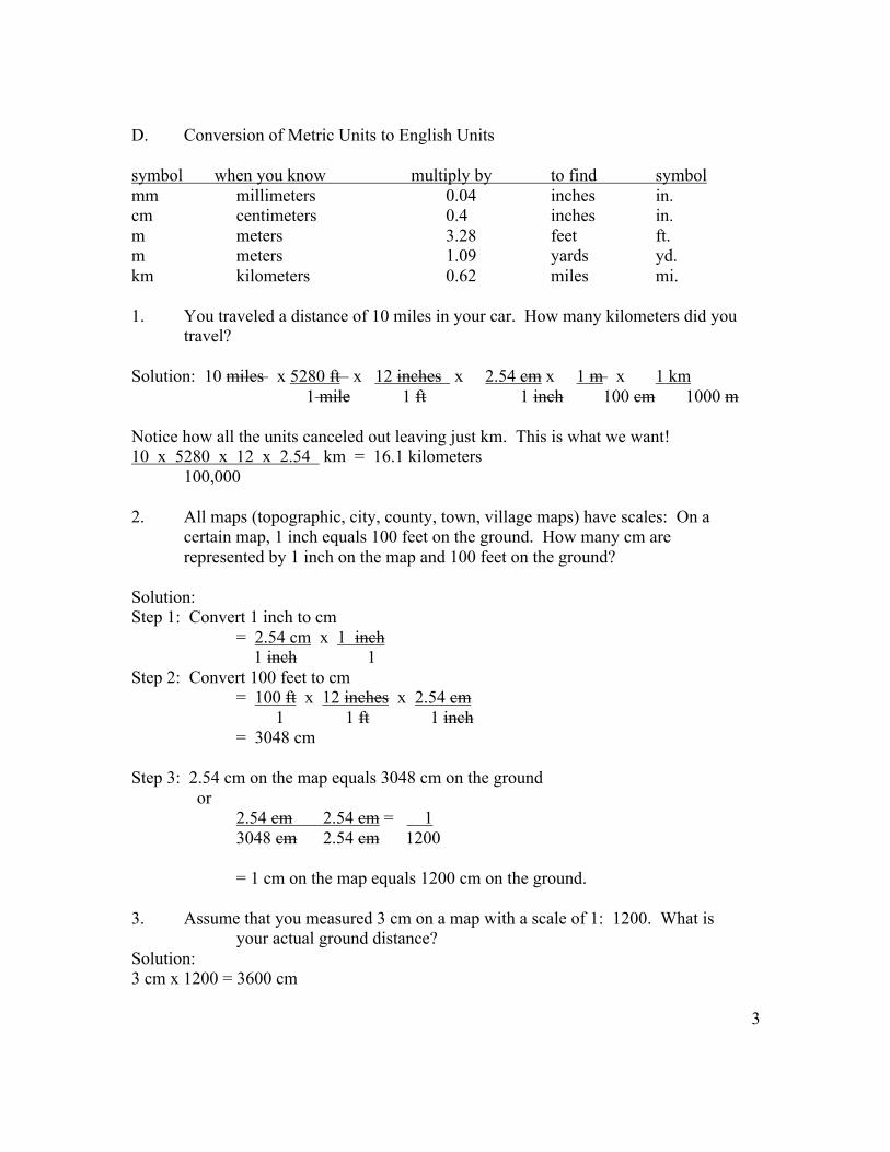
D. Conversion of Metric Units to English Units symbol when you know multiply by to find symbol mm millimeters 0.04 inches in. cm centimeters 0.4 inches in. m meters 3.28 feet ft. m meters 1.09 yards yd. km kilometers 0.62 miles mi. 1. You traveled a distance of 10 miles in your car. How many kilometers did you travel? Solution: 10 miles x 5280 ft x 12 inches x 2.54 cm x 1 m x 1 km
1 mile 1 ft 1 inch 100 cm 1000 m Notice how all the units canceled out leaving just km. This is what we want! 10 x 5280 x 12 x 2.54 km = 16.1 kilometers 100,000 2. All maps (topographic, city, county, town, village maps) have scales: On a certain map, 1 inch equals 100 feet on the ground. How many cm are represented by 1 inch on the map and 100 feet on the ground? Solution: Step 1: Convert 1 inch to cm = 2.54 cm x 1 inch 1 inch 1 Step 2: Convert 100 feet to cm = 100 ft x 12 inches x 2.54 cm 1 1 ft 1 inch = 3048 cm Step 3: 2.54 cm on the map equals 3048 cm on the ground or 2.54 cm 2.54 cm = 1 3048 cm 2.54 cm 1200 = 1 cm on the map equals 1200 cm on the ground. 3. Assume that you measured 3 cm on a map with a scale of 1: 1200. What is your actual ground distance? Solution: 3 cm x 1200 = 3600 cm
3

THE METRIC SYSTEM OF MEASUREMENT AND ROAD MAPS
QUESTIONS - EXERCISE 1
1. Convert the following English units to Metric units. Show your work for credit! a. 100 miles ______________ ft. b. 528,000 ft. ____________ inches c. 6,336,000 inches ___________ centimeters d. 16,093,440 centimeters ________ meters e. 160,934 meters __________ kilometers 2. On your Guide to Greensboro map shown on Page 4 with a scale of 1: 67,000 (1 cm on the map equals 67,000 cm on the ground). What is the linear distance between A&T State University and.......? a. Bennett College: ____________ meters, ____________ km b. Greensboro Coliseum: _________ meters, __________ km c. Guilford College: ____________ ft., _____________ meters d. UNCG: __________ inches, ______________ miles *Show how you arrived at the above answers!
4

5
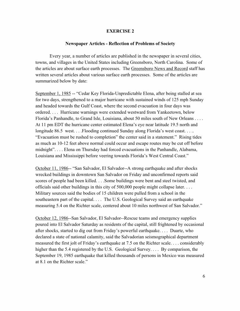
EXERCISE 2
Newspaper Articles - Reflection of Problems of Society
Every year, a number of articles are published in the newspaper in several cities, towns, and villages in the United States including Greensboro, North Carolina. Some of the articles are about surface earth processes. The Greensboro News and Record staff has written several articles about various surface earth processes. Some of the articles are summarized below by date: September 1, 1985 -- “Cedar Key Florida-Unpredictable Elena, after being stalled at sea for two days, strengthened to a major hurricane with sustained winds of 125 mph Sunday and headed towards the Gulf Coast, where the second evacuation in four days was ordered. . . . Hurricane warnings were extended westward from Yankeetown, below Florida’s Panhandle, to Grand Isle, Louisiana, about 50 miles south of New Orleans . . . . At 11 pm EDT the hurricane center estimated Elena’s eye near latitude 19.5 north and longitude 86.5 west. . . .Flooding continued Sunday along Florida’s west coast. . . .. “Evacuation must be rushed to completion” the center said in a statement.” Rising tides as much as 10-12 feet above normal could occur and escape routes may be cut off before midnight”. . . . Elena on Thursday had forced evacuations in the Panhandle, Alabama, Louisiana and Mississippi before veering towards Florida’s West Central Coast.” October 11, 1986-- “San Salvador, El Salvador--A strong earthquake and after shocks wrecked buildings in downtown San Salvador on Friday and unconfirmed reports said scores of people had been killed. . . .Some buildings were bent and steel twisted, and officials said other buildings in this city of 500,000 people might collapse later. . . . Military sources said the bodies of 15 children were pulled from a school in the southeastern part of the capital. . . . The U.S. Geological Survey said an earthquake measuring 5.4 on the Richter scale, centered about 10 miles northwest of San Salvador.” October 12, 1986--San Salvador, El Salvador--Rescue teams and emergency supplies poured into El Salvador Saturday as residents of the capital, still frightened by occasional after shocks, started to dig out from Friday’s powerful earthquake. . . . Duarte, who declared a state of national calamity, said the Salvadorian seismographical department measured the first jolt of Friday’s earthquake at 7.5 on the Richter scale. . . . considerably higher than the 5.4 registered by the U.S. Geological Survey. . . . By comparison, the September 19, 1985 earthquake that killed thousands of persons in Mexico was measured at 8.1 on the Richter scale.”
6

NEWSPAPER ARTICLES
QUESTIONS - EXERCISE 2 1. What does the article refer to as “Elena”? 2. Differentiate: hurricanes, tropical storms, and tornadoes. 3. Why is it always important to post a hurricane warning when hurricane is anticipated? 4. Differentiate between: a. a hurricane warning and a hurricane watch b. a tornado warning and a tornado watch 5. Explain the meaning of the term “hurricane eye.” 6a. Who assigns names to tornados? 6b. Why are names not assigned to tornadoes?
7
Exercise 2 continued 7. “Rising tides as much as 10-12 feet above normal could occur and escape routes may be cut off before midnight.” Explain briefly the meaning of the term tide. 8. “The Salvadorian Seismographical Department measured the first jolt of Friday’s earthquake at 7.5 on the Richter scale. . . . Considerably higher than the 5.4 registered by the U.S. Geological Survey.” Why the above two are numbers different? Be complete in your answer. 9. What is a seismograph? 10. List the components of a seismographic station.
8

EXERCISE 3 The Warming Earth
“The Great Plains has become a dust bowl and people are moving into Canada’s uplands to seek work. Even in Alaska, changing ocean currents are boosting the fish catch. New York is sweltering in 95oF weather that began in June and will continue through Labor Day. In the Southeast, the hot spell started six weeks earlier.” Time, July 4, 1988.
QUESTIONS - EXERCISE 3
1. Discuss the effects of high levels of carbon dioxide on the earth’s temperature and global economy. 2. (a) List the % of carbon dioxide in the atmosphere. (b) List some man-made sources of carbon dioxide. 3. Explain the following: (a) Sunlight
(b) Infrared Radiation
9
Exercise 3 continued (c) Temperature 4. Explain the meaning of greenhouse effect __________________________________________________________________ 5. Is the concept of greenhouse effect a theory or a hypothesis? __________________________________________________________________ __________________________________________________________________ __________________________________________________________________ 6. List the: (a) Advantages of greenhouse effect __________________________________________________________________ __________________________________________________________________ (b) Disadvantages of greenhouse effect __________________________________________________________________ __________________________________________________________________ __________________________________________________________________ 7. Explain how the greenhouse effect would affect the hydrologic cycle. __________________________________________________________________ __________________________________________________________________ _________________________________________________________________
10
EXERCISE 4
The Earth and the Solar System
The earth and other planets have characteristics which make them suitable or
unsuitable to be our environment. The planets fall into two categories: the inner planets
of Mercury, Venus, Earth and Mars are solid while the outer planets of Jupiter, Saturn,
Uranus and Neptune are gaseous, large and rotate fairly rapidly. Very little is known
about Pluto, but it seems to resemble the inner planets more than the other ones. Figure 4
shows the relationship between the earth and other planets.
Mercury - smallest of the planets and like the moon in some respect but lacks the
extensive lava flows. Astronauts (The Mariner 10 Spacecraft) detected a weak magnetic
field around Mercury but no atmosphere. Surface temperature is 300oC. There is no
atmosphere to transfer or return heat, and temperature drops at night to about 175oC.
Venus - In size and mass, the planet Venus resembles the Earth more closely than
any other member of the Sun’s family. Apart from the Sun and Moon, Venus is the
brightest object in the sky. Venus rotates “backwards” - clockwise very slowly; whereas,
the Earth and other planets rotate counter-clockwise. The surface is observed by thick
layers of clouds. The dense atmosphere is mainly carbon dioxide, with a little nitrogen
and a trace of water vapor also present. On the Earth, carbon dioxide is an important
absorber of heat from the Earth that prevents the rapid loss of heat from the ground after
sunset, but Venus retains more heat. From the data radioed back by astronauts
(spacecraft), the average temperature is about 430oC, which is enough to melt lead. It is
too hot to support life.

11
Figure 4. The Earth and other members of the solar system.
12

The Moon
The scientific study of the moon is important in order to understand the
composition and characteristics of the moon in addition to determine if the moon has
features similar to the Earth that would support the same kind of life supported by the
Earth. Until July 20, 1969, the study of the moon was more notable for the questions
asked than for the answers available. On July 20, 1969, Neil Armstrong set foot on the
moon, the first man ever to do so, after a 4-day voyage aboard the spacecraft Apollo II
with two companions. It took them three days to reach the moon and at the same rate, it
would have taken them three years to reach the sun.
The astronauts discovered that lunar (moon) landscape has wide plains, jagged
(irregular or uneven) maintain ranges and innumerable craters of all sizes. Each
mountain range stands out distinctly. When the moon passes before a star, the star
remains bright and clear up to the moons very edge. They returned to earth after four
days and brought with them samples of the lunar surface.
The moon was hardly a mystery before the voyage of Apollo II and of the manned
spacecraft that followed it there. From the observations made by the astronauts, the
moon has little or no atmosphere nor surface water, no lakes, oceans, or rivers and is
closer to Earth than any other celestial body.
Furthermore, travel to the moon requires a spacecraft or space shuttle which is not
the safest or an economical way to travel to the moon, and people may not want to risk
their lives. History has revealed that some spacecrafts have gotten lost in traveling
around the Earth or while going to the moon. Also, the spending of 2-3 billion dollars for
space exploration is rather expensive, which means that people would have to pay a
comparative amount of money for the trip to the moon and many persons may not be able
to pay the fare.
13
People can live in spacecrafts because of their created environments which are unlike the
environment of the moon. Finally, we know what is down here on the Earth, but we are
not too sure of what is really up there on the moon.
Mars
The reddish planet has long fascinated astronauts and laymen. It has a thin
atmosphere which does little to screen solar ultraviolet radiation. Because of its
environment (thin atmosphere), any life which would exist there would easily be
destroyed. Also on Mars is a scarcity of water. It rotates on its axis in a little less than 24
hours. Its rotation about the Sun requires nearly 2 years. It receives less light and heat.
Marine 9 Spacecraft in 1972 strongly suggested that erosion by running water within the
past million years could probably be responsible for the scarcity of water today on Mars.
Jupiter
This giant planet, like Venus, is shrouded in clouds which occur in bands of
changing colors - yellow, red, brown, blue, and purple. It is about 1,300 times the size of
the Earth, very hot - about 500,000oC (Jupiter’s interior), and it contains ammonia,
methane, hydrogen and helium. Jupiter, Saturn, Uranus and Neptune are mainly
composed of hydrogen and helium. Life of some kind may exist in Jupiter’s atmosphere
(such as micro-organism - bacteria and yeast when exposed to gas mixture). Jupiter has a
strong magnetic field that radiates more energy than it receives. U.S. Spacecraft Pioneer
10 passed close to Jupiter in 1973 after a journey that lasted 20 months. Of the wealth of
information that was radioed back, it was discovered that Jupiter has a magnetic field
about 8 times stronger than the Earth and traps high-energy protons and electrons from
the Sun.
14

Saturn
The most beautiful of the Earth’s planets, and is much like Jupiter. It has two
bright rings and a fainter inner one - famous rings that surround the planet in the plane
of the equator. It moves in its leisurely 29-year journey around the Sun. It possesses a
dense atmosphere hidden by banded clouds. Further from the Sun than Jupiter, Saturn is
colder than Jupiter. Ammonia is largely frozen out of its atmosphere, and the clouds
consist mainly of methane.
Uranus, Neptune, and Pluto
Owing its discovery to the telescope, Uranus was found by accident in 1781
during a systematic search of the sky by the English astronaut, Herschel. It is barely
visible to the eye; in fact, it has been identified as a faint star. Herschel suspected it to be
a planet because it appeared as a disk rather than a point of light. Observations made
over the years show the position to be changing relative to the stars.
The discoveries of Neptune in 1846 and Pluto in 1930 were made as a result of
predictions based on their gravitational effects on other planets. Uranus and Neptune are
large bodies, each with a diameter of about 3 1/2 times that of the Earth. Pluto is
somewhat smaller than Mars, and may once have been a satellite of Neptune that pulled
away to pursue its own orbit around the Sun.
Because these planets are so far away from the Sun, their surface temperatures are
below 200oC, and since ammonia is present, it would have been frozen out of the
atmosphere. Pluto is so small, so far away and so feebly illuminated, that reliable
information about it is still difficult to obtain.

15
The Sun
The Sun is a glorious body that dominates the solar system, and the origin and
destiny of the Earth, as well as our daily lives, are closely connected with solar
phenomena.
The Sun is so large that 1,300,000 earths would fit into it. Like all other
astronomical bodies, it is rotating, and its rotation is shorter near its equator than near
its poles. Although conditions of the Sun are very different from those of the Earth, the
basic matter of the two bodies appears to the same. Even the relative amounts of
different elements are similar except for a greater abundance of the lightest elements -
hydrogen and helium on the Sun. At the low temperatures, prevailing on the Earth, most
of the elements have continued to form compounds. In the hot Sun, the elements are
usually present as individual atoms, most of them ionized. The surface temperature of
the Sun is about 5700oC. At this temperature, all matter is gaseous which means the Sun
is a glowing gas envelope. Above the surface of the Sun is a rapidly thinning atmosphere
that consists principally of hydrogen, helium and calcium.
During a total eclipse of the Sun when the Moon obscures the Sun’s disk
completely, a wide halo of pearly light can be seen around the dark Moon. The halo or
corona consists of ionized atoms and electrons in extremely rapid motion. The outflow
of ions and electrons in this atmosphere constitutes the solar wind.

16 QUESTIONS - EXERCISE 4
THE EARTH AND THE SOLAR SYSTEM 1. Explain why the inner and outer planets are not suitable environments for humans and other forms of life. __________________________________________________________________ __________________________________________________________________ __________________________________________________________________ 2. Discuss the most generally accepted hypothesis for the formation of the Universe. What is the big bang theory? __________________________________________________________________ __________________________________________________________________ __________________________________________________________________ 3. Explain why the moon was the “first” celestial body selected for investigation by the United States government. __________________________________________________________________ __________________________________________________________________ __________________________________________________________________ __________________________________________________________________ 4. List the inner and outer planets of the solar system. __________________________________________________________________ __________________________________________________________________ __________________________________________________________________
17
Exercise 4 continued 5. Do you think that it is a good idea to continue to spend billions of dollars in space exploration? Explain your answer. __________________________________________________________________ __________________________________________________________________ __________________________________________________________________ __________________________________________________________________ 6. What efforts are being made to explore the Sun? Include recent findings in your answer. __________________________________________________________________ __________________________________________________________________ __________________________________________________________________ 7. Discuss the overall benefits that may be derived from space exploration. __________________________________________________________________ __________________________________________________________________ __________________________________________________________________ 8. List the planets described by the following: _________________ Innermost _________________ Veiled _________________ Red _________________ Lord of the Heavens _________________ Elegant Planet _________________ Twins _________________ Planet X _________________ Terrestrial _________________ Jovian
18 Exercise 4 continued 9. Explain the following: Black holes ___________________________________________________________ ___________________________________________________________ Hydrogen burning ___________________________________________________________ ___________________________________________________________ Galaxy ___________________________________________________________ ___________________________________________________________ Milky Way ___________________________________________________________ ___________________________________________________________ 10. How does solar wind form?
___________________________________________________________ ___________________________________________________________ 11. What is the relationship between halo and total eclipse?
___________________________________________________________ ___________________________________________________________
19
EXERCISE 5
The Radiation World There has been much publicity about radiation in recent years. Nuclear accidents
and the dumping of low-level, radioactive waste in the ocean have been widely reported.
We are constantly and will continue to be exposed to natural radiation from outer space,
rocks, minerals, soils, buildings, air, food, medical diagnosis, nuclear weapons testing,
etc.
The average person receives about 200 millirems per year from natural and man-
made sources. Radiation received is expressed using the term REM (Roentgen
Equivalent Man). The amount of radiation received by people varies according to local
conditions (air quality, water quality, soils, rocks, TV viewing and elevation, etc.).
You are now ready to answer the questions that follow.
EXERCISE 5 - QUESTIONS
1. Complete the table below to get an idea of the amount of radiation that you are
exposed to every year. The average American is exposed to about 180 units
per year.
YOUR FACTORS COMMON SOURCES OF RADIATION ANNUAL DOSE (REM) ____________________________________________________________ WHERE Stone, concrete or masonry YOU building. . . . . . . . . . . . . . . . . . . . . . . . . . 7 LIVE Elevation (Greensboro-700 ft). . . . . . . 1.5 ____________________________________________________________ WHAT YOU Food, water, air . . . . . . . . . . . . . . . . . . . 24 EAT, DRINK, AND BREATHE Weapons test fallout . . . . . . . . . . . . . . . 4
20

EXERCISE 5 continued _______________________________________________________________ Medical Number of chest x-rays . . . . .. .._______x 10 _______ Number of lower gastrointestinal x-rays . . . . . . . . . . . . . . . . . . . . . ._______x 500_______ Number of radiopharmaceutical examinations (brain scan, thyroid uptakes) . . . . . . . . . . . . _______x 300 ______ Number of extremity (arms, legs) x-rays . . . . . . . . . . . . . . . . . . . . . _______x 20 _____ (Average dose to total US population - 92 mrem) HOW YOU LIVE Dental Number of bitewing series . . . _______x 40 _______ Number of panorex x-rays . . . _______x 500 _______ Jet plane travel: For each 2500 miles add 1 _______ Luminous clocks . . . . . . . . . . . . ._______x 9 ______ Luminous wristwatch. . . . . . . . . . . . . . . . .add 2 ______ TV viewing: For each hour per day. . . . . . . . . . . . . . . . . . ._______x 0.15______ Smoke detectors . . . . . . .. . . . .. _______x .002 ______ Sleep with spouse. . . . . . . . . . . . . . . . . add 0.1 ______

21 EXERCISE 5 continued __________________________________________________________________ At site boundary: Average number of hours per day _______x 0.2 ______ One mile away: Average number of HOW CLOSE YOU hours per day _______x 0.02 ______ LIVE TO A NUCLEAR PLANT Five miles away: Average number of hours per day _______x .002 ______ More than 5 miles away None ______ __________________________________________________________________ Total _____ __________________________________________________________________ 2. How does your answer in #1 compare with the U.S. average? _____________________________________________________________ _____________________________________________________________ 3. List examples of: (a) two natural radiation sources _____________________________________________________________ (b) two man-made radiation sources _____________________________________________________________ 4. Discuss the effects of high radiation exposure on humans. _____________________________________________________________ _____________________________________________________________
22

5. What factors determine the amount of radiation that you receive per year? _____________________________________________________________ _____________________________________________________________ 6. Explain the following: (a) Radiation _____________________________________________________________ _____________________________________________________________ (b) Radioactive material _____________________________________________________________ _____________________________________________________________ (c) Radioactive world _____________________________________________________________ _____________________________________________________________ 7. List some uses of radiation _____________________________________________________________ _____________________________________________________________ 8. Express 200 millirems in REMS. Show you work! Hint! 1000 millirems = 1 REM
23

EXERCISE 6
Groundwater
Groundwater is water within the ground. Groundwater accumulates when rainfall
or melt water of snow, hail, or sleet infiltrates into the subsurface (Figures 6A & B).
Water continues to percolate downward until it reaches a point below which open spaces
and voids in rock are completely filled with water. The level of saturation below which
are pores are filled with water.
Groundwater is constantly moving. It may reach the surface again and join with
surface waters. As groundwater moves through porous and permeable rock strata, it may
dissolve soluble rocks such as limestone/dolomite-carbonate rocks. These carbonate
rocks dissolve easily if the groundwater is high in carbon dioxide and organic acids. The
solution of carbonate rocks results initially in the widening of cracks, joints, and other
openings leading to the formation of caverns. These caverns will eventually collapse and
sink holes will develop. This condition is seen in the state of Florida because most
underground rocks are carbonate rocks. The developed sinks are eventually filled with
water and become lakes. The sinkholes may form solution valleys. Any land-surface
exhibiting sink holes and solution valleys is called Karst land-surfaces.
24

25
QUESTIONS - EXERCISE 6
GROUNDWATER
1. What will happen to groundwater table during: (a) Dry season (no rainfall) ______________________________________________________ ______________________________________________________ ______________________________________________________ (b) Wet season (plenty of rainfall) ______________________________________________________ ______________________________________________________ ______________________________________________________ 2. The groundwater zone containing well water is called ______________________________________________________ The groundwater zones where well water may be absent are called _______________________ and ___________________________ 3. What other rocks besides a carbonate rock is susceptible to dissolution? ______________________________________________________ ______________________________________________________ 4. What kind of weathering is associated with rock dissolution? Write the chemical equation. ______________________________________________________ ______________________________________________________ ______________________________________________________ 5. Explain the meaning of the following: infiltration, groundwater table and voids? ______________________________________________________ ______________________________________________________ ______________________________________________________
26 6. Artesian systems occur when inclined aquifers are surrounded by _______________________________ 7. What is the difference between aquicludes and aquifers? ______________________________________________________ ______________________________________________________ ______________________________________________________ 8. Would you recommend building a nuclear power plant in our area containing carbonate rocks? Explain. ______________________________________________________ ______________________________________________________ ______________________________________________________ 9. Would you build your house in an area high in carbonate rocks? Explain. ______________________________________________________ ______________________________________________________ ______________________________________________________ 10. What can be done to save a sinking land? Be brief. Draw a sinking land. _____________________________________________________ _____________________________________________________ _____________________________________________________
27
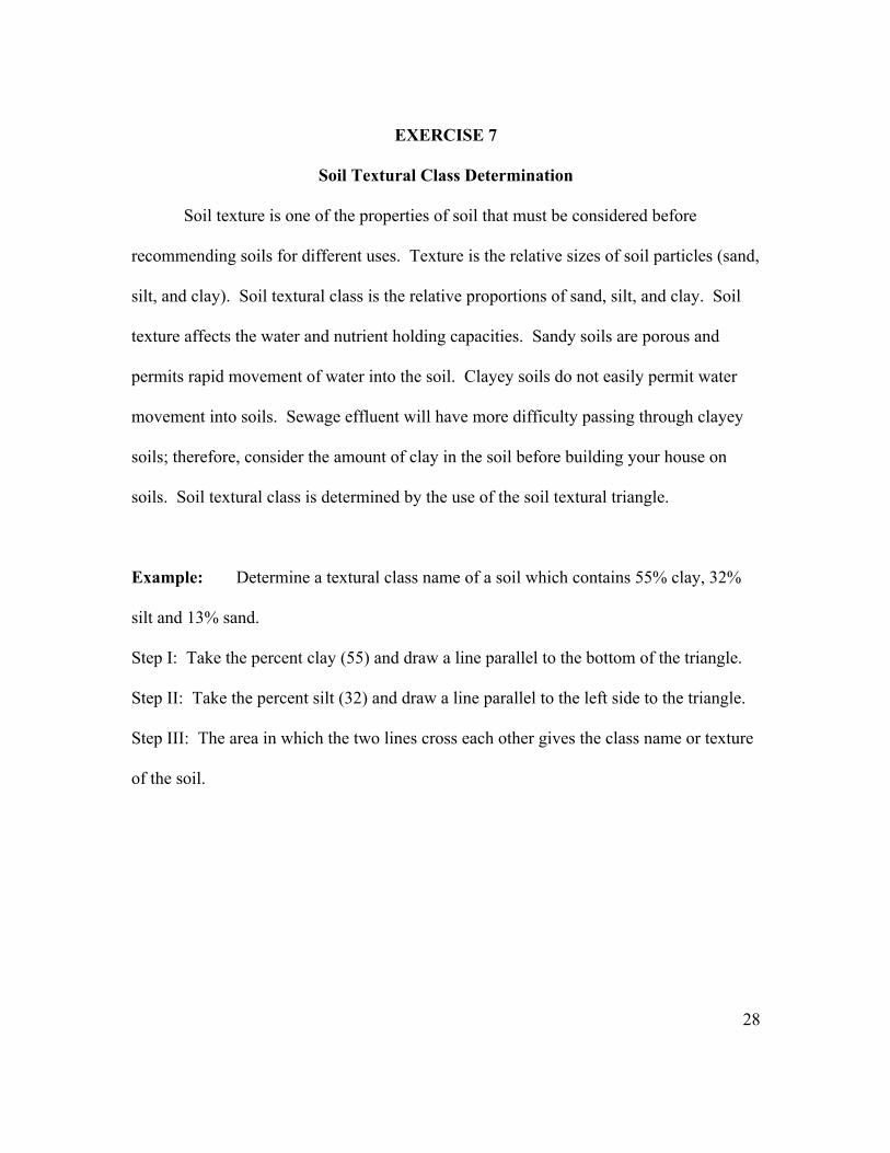
EXERCISE 7
Soil Textural Class Determination
Soil texture is one of the properties of soil that must be considered before
recommending soils for different uses. Texture is the relative sizes of soil particles (sand,
silt, and clay). Soil textural class is the relative proportions of sand, silt, and clay. Soil
texture affects the water and nutrient holding capacities. Sandy soils are porous and
permits rapid movement of water into the soil. Clayey soils do not easily permit water
movement into soils. Sewage effluent will have more difficulty passing through clayey
soils; therefore, consider the amount of clay in the soil before building your house on
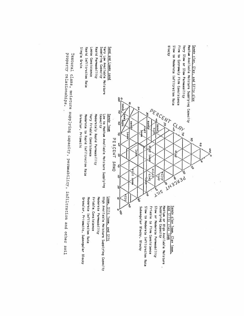
soils. Soil textural class is determined by the use of the soil textural triangle.
Example: Determine a textural class name of a soil which contains 55% clay, 32%
silt and 13% sand.
Step I: Take the percent clay (55) and draw a line parallel to the bottom of the triangle.
Step II: Take the percent silt (32) and draw a line parallel to the left side to the triangle.
Step III: The area in which the two lines cross each other gives the class name or texture
of the soil.
28

29

30
QUESTIONS - EXERCISE 7
SOIL TEXTURAL CLASS DETERMINATION
A. Use the textural triangle on Page _ to determine the textural class of soils
with the following % sand, % silt and % clay. Also determine the moisture supplying
capacity, permeability, and infiltration rate for the different soil textural classes. Use the
information on Page 33.
Moisture
Soil Textural Supplying Infiltration
Name % Clay % Sand % Silt Class Capacity Permeability Rate
Baker 35 35 30 _______ _______ _________ _________
Bush 15 65 20 _______ _______ _________ _________
Fort 10 25 65 _______ _______ _________ _________
Dunn 35 10 55 _______ _______ _________ _________
Webb 70 10 20 _______ _______ _________ _________
Craig 45 50 5 _______ _______ _________ _________
Keil 20 40 40 _______ _______ _________ _________
Gayle 5 10 85 _______ _______ _________ _________
Ross 2 95 3 _______ _______ _________ _________
Alex 45 10 45 _______ _______ _________ _________
B. Explain the meaning of the following briefly:
(1) Soil texture
_____________________________________________________
_____________________________________________________
31
(2) Soil textural class
_____________________________________________________
_____________________________________________________
_____________________________________________________
(3) Moisture supplying capacity
_____________________________________________________
_____________________________________________________
_____________________________________________________
(4) Permeability
_____________________________________________________
_____________________________________________________
_____________________________________________________
(5) Infiltration
_____________________________________________________
_____________________________________________________
_____________________________________________________
C. Soils of the world are classified into 11 orders. The orders are
based on soil characteristics.
(1) The Carolinas (North and South) are dominated by __________ soil
order. List the characteristics of this soil order.
______________________________________________________
______________________________________________________
______________________________________________________
(2) List the soil orders that dominate the Australian continent.
___________________________________________________
__________________________________________________
32

EXERCISE 8
APPLICATION OF SOIL PROPERTIES
Soil properties are important in determining limitations on performance of waste
disposal systems. Waste disposal is a major problem in every society today. For good
effluent seepage, soils should be permeable with no high water tables or flooding and
also on gentle slopes and deep to bedrock. The location of homesites, shopping centers,
malls, roads, schools, etc., depends on soil properties. Siting of nuclear power plants
considers soil conditions. Nuclear fallout is absorbed on soil particles depending on clay
content. Soil restrictive features for buildings, radioactive waste disposals, sanitary
landfills, plant and crop growth are listed below:
(1) Depth to bedrock (less than 100 cm). . . . . . . . . . . unsuitable
(2) Slope (greater 7%) . . . . . . . . . . . . . . . . . . . . . . . . . unsuitable
(3) Occasional flooding. . . . . . . . . . . . . . . . . . . . . . . . .unsuitable
(4) Carbonate rocks. . . . . . . . . . . . . . . . . . . . . . . . . . . .unsuitable
(5) Water table (less than 1.2 meters or 4 ft.). . . . . . . . unsuitable
(6) Soil textural class (clay, silty clay, sand). . . . . . . . .unsuitable
(7) Expansive soils (smectite and montmorillonite
minerals--causes cracks to foundations, roads
and grounds). . . . . . . . . . . . . . . . . . . . . . . . . . . . . . .unsuitable
(8) pH (less than 4) causes corrosion of pipes in
the ground and kills crops. . . . . . . . . . . . . . . . . . . . .unsuitable
You are now ready to think and answer questions.
33
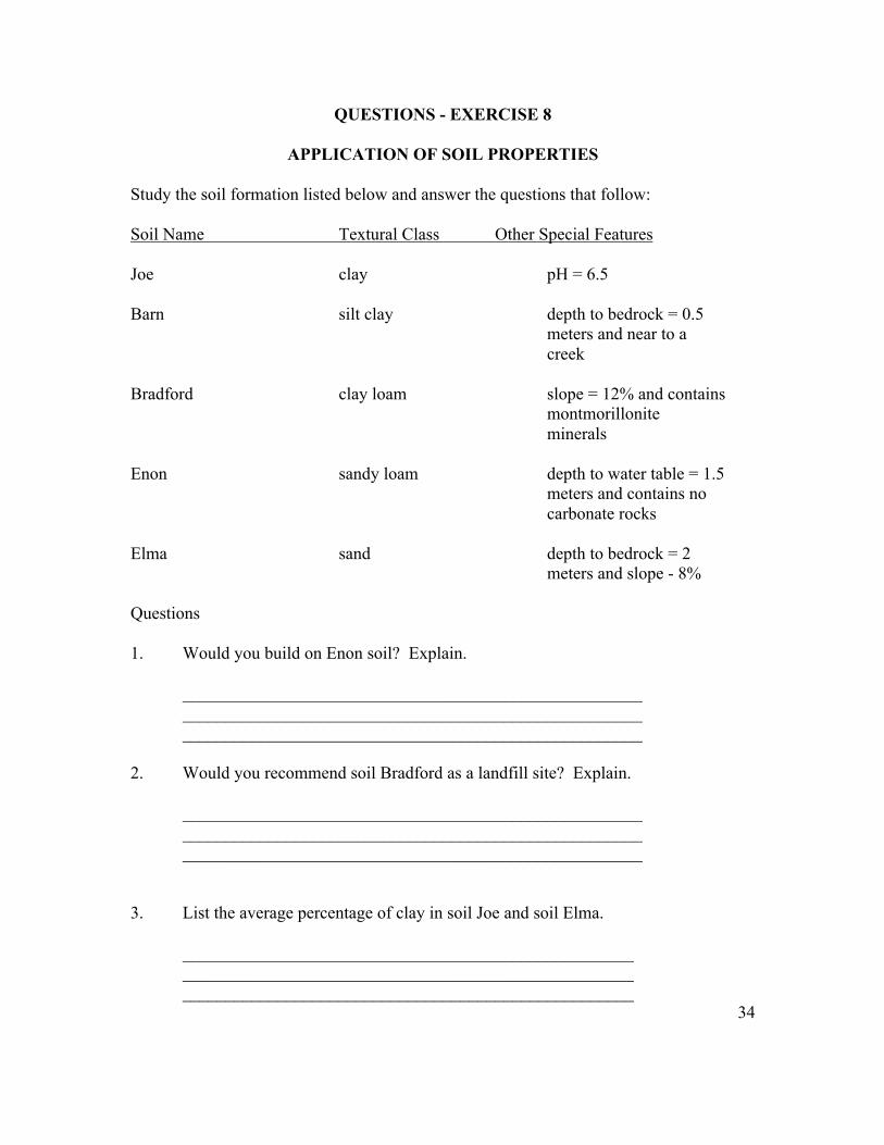
QUESTIONS - EXERCISE 8
APPLICATION OF SOIL PROPERTIES
Study the soil formation listed below and answer the questions that follow: Soil Name Textural Class Other Special Features Joe clay pH = 6.5 Barn silt clay depth to bedrock = 0.5 meters and near to a creek Bradford clay loam slope = 12% and contains montmorillonite minerals Enon sandy loam depth to water table = 1.5 meters and contains no carbonate rocks Elma sand depth to bedrock = 2 meters and slope - 8% Questions 1. Would you build on Enon soil? Explain. _____________________________________________________ _____________________________________________________ _____________________________________________________ 2. Would you recommend soil Bradford as a landfill site? Explain. _____________________________________________________ _____________________________________________________ _____________________________________________________ 3. List the average percentage of clay in soil Joe and soil Elma. ____________________________________________________ ____________________________________________________ ____________________________________________________
34
4. List the most expensive (dollar value) soil from above and provide explanation. ____________________________________________________ ____________________________________________________ 5. Explain the meaning of the following terms: (1) pH ____________________________________________________ ____________________________________________________ (2) water table ____________________________________________________ ____________________________________________________ 6. Which of the above soil is best suited for crop growth? Explain. ____________________________________________________ ____________________________________________________ 7. Which of the above soil is not suited for sewage disposal? ____________________________________________________ ____________________________________________________ 8. Would you recommend building a nuclear power plant on soil Joe? Explain. ____________________________________________________ ____________________________________________________ 9. Explain why it is necessary to give soils names. ____________________________________________________ ____________________________________________________ 10. List a typical name for a soil in your hometown. ____________________________________________________ ____________________________________________________
35

EXERCISE 9
The Earth’s Interior
The study of the earth’s environment will not be complete without understanding
the nature of the earth’s interior. What do we know about the interior of the earth?
__________________________________________________________
__________________________________________________________
__________________________________________________________
The Earth Beneath the Sea
If all the water was drained from the ocean basins, the surface that would be
revealed might surprise you. The features revealed would be just as varied as that on the
continents (land). The topography of the ocean basins are divided into three units:
(1) continental margins (continental shelf and continental slope)
(2) the ocean basin floor
(3) mid-ocean ridges
Study figures 9A and 9B on page 37 and answer the following questions:
1. Discuss briefly the nature of the surface that would be revealed if all the water
was drained from the ocean.
________________________________________________________
________________________________________________________
2. Compare the topography of the ocean floor with the topography of
the continent.
____________________________________________________
____________________________________________________
____________________________________________________
36

3. Differentiate: continental margins, ocean basin floor and mid-ocean ridges. ____________________________________________________ ____________________________________________________ ____________________________________________________ 4. Differentiate between continental shelf and continental slope. ____________________________________________________ ____________________________________________________ ____________________________________________________ 5. List the kinds of earth materials that may be found at the bottom of the ocean. ____________________________________________________ ____________________________________________________ ____________________________________________________ 6. What benefits are being derived from ocean exploration? ____________________________________________________ ____________________________________________________ ____________________________________________________ 7. The ocean is “restless.” Explain this concept with examples. __________________________________________________ __________________________________________________ __________________________________________________ 8. Diagram the relationship of the earth to the moon and the sun during high (spring) tide and low (neap) tide. 9. What is the condition of the ocean at high and low tides? ___________________________________________________ ___________________________________________________ ___________________________________________________ 10. What are the benefits of ocean tides? ___________________________________________________ ___________________________________________________
37

38
EXERCISE 10
TOPOGRAPHIC MAPS Topography represents features (hills, valleys, etc.) shown in topographic maps.
A topographic map is simply graphic representation of any part of the earth’s surface
with emphasis on relief. Relief refers to elevations or inequalities of land surface.
Features shown on topographic maps include:
relief (hills, valleys, etc.)
water features (lakes, rivers, canals, swamps, ponds)
culture (works of man; such as, roads and land boundaries).
Topographic maps have direct applications in:
(a) Geology - used to interpret the geological processes from landforms of a
map area.
(b) Engineering - used to locate sites for buildings, dams, tunnel, pipelines,
and general urban planning.
(c) Agricultural - used in irrigation planning and to locate where to plant
crops.
(d) Military - used to plan site for airfields, bombing ranges.
Scales Used in Topographic Maps
1. Fractional or Representative Fraction:
This is a fixed ratio between linear measurements on the map and
corresponding ground distances.
Example: 1: 62000
1 unit of the map = 62000 units on the ground
1 cm on the map = 62000 cm on the ground
1 m on the map = 62000 m on the ground, etc.
39

2. Graphic scale: This refers to a bar or line drawn on a map and divided into units
that represent ground distances.
0 100m
I___________________________ I
3. Verbal Scale: This is simply stating in words the relationship of map distance to
ground distance.
Example: one cm equals one km; i.e., one cm on the map equals one km on ground.
Map Direction
Most maps, including topographic maps, are so constructed that the top edge of
the map is North, the bottom is South, the left is West, and the right is East. The exact
direction of North is usually given by a small arrow at the bottom of the map.
Interpretation of Topographic Maps
Contour lines give an accurate three-dimensional picture of the land surface. A
Contour is an imaginary line connecting points of equal elevation. Therefore, all points
along a contour line must have the same elevation. The shoreline of an island in the
ocean would be the contour line of 0 elevation. If the sea level were to rise 10 feet, the
new shore line would coincide with the original 10-foot contour line. An additional rise
of 10 feet would bring the shoreline to the 20’ contour line.
The contour interval, given at the bottom of the map, is the vertical distance
between two adjacent contour lines. The size of the interval, which may vary from as
little as one foot to more than 100 feet, depends upon the relief (difference in elevation
between the highest and lowest points) of the map area and upon the detail with which
the mapping is done. Along the Mississippi River flood plain, which is nearly flat, a 5-
foot interval is common. A 100-foot contour interval is commonly used in the Rocky
Mountains.
40
Elevation and Height Elevation is the vertical distance above sea level. Height is the vertical distance from the base to the top. Depression Contours Every contour line closes on itself, either within or beyond the limits of the map. The surface immediately inside a normal closed contour has a higher elevation than the contour line. If the land surface within the contour has a lower elevation than the contour, then a hachured contour line is used, with the hachure indicating the direction of slope. Principles Governing Contour Lines 1. All points on any one contour line have the same elevation. 2. Contour lines never intersect or cross unless they are merged on a vertical or overhanging cliff. 3. Contour lines bend up valleys and point upstream when they cross valleys and streams. 4. Contour lines never split. 5. Closed contours represent hills. Closed contours with hachures short lines perpendicular to contour line) represent depressions. Every contour line closes on itself, either within or beyond the limits of the map. If beyond the limits of the map, the contour line will run to the edge of the map. 6. Evenly spaced contour lines indicate a uniform slope; uneven spacing indicates an uneven slope. 7. Closely spaced contours indicate a steep slope; widely spaced contours indicate a gentle slope. 8. Usually every fifth contour line is heavier than the others and has the elevation printed at intervals throughout its length. 9. The contour interval (C.I.) given on the bottom margin of a map is usually the same over the entire map.
41

QUESTIONS - EXERCISE 10
TOPOGRAPHIC MAPS
1. How many contour lines would be necessary to show an island having a height of 251 meters? (contour interval = 25 meters) 2. Use contour lines to represent the above island. 3. List 4 characteristics of contour lines shown above. 4. Complete the missing elevations on the topographic map* on the next page. What is the length of the Fork River (meters)? Show your work. (map scale 1: 200000) 5. What features are shown by the following colors on topographic maps: ________________ blue ________________ green ________________ black ________________ brown ________________ red
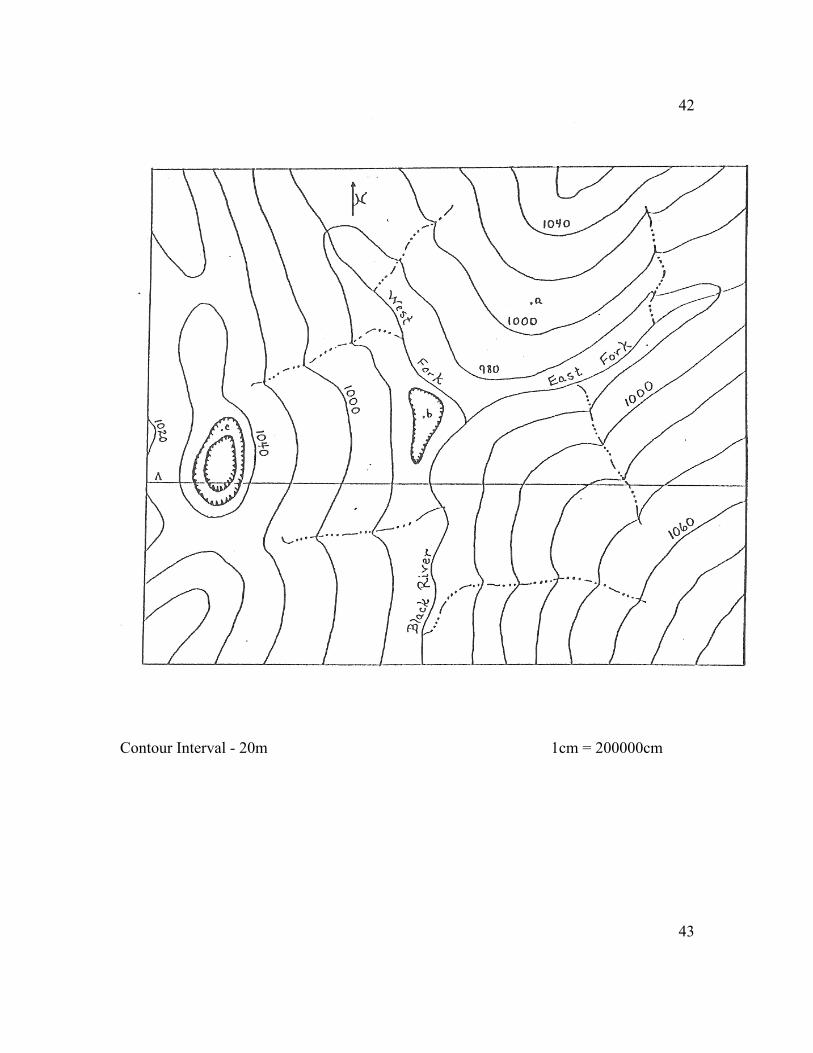
42
Contour Interval - 20m 1cm = 200000cm
43

EXERCISE 11
Self-Guided Field Trip* Our everyday activities involve an interaction with the earth’s natural environment. This entire field trip is within the campus of NC A&T State University. Man’s impact on the environment should be very noticeable, and the impact varies from place to place. Your answers will indicate how much you thought about the questions when you arrive at each point. 1. Observation point 1 is located along Sullivan Street and Carver Hall. What color is the exposed soil? _____________________________________________________ _____________________________________________________ List the mineral present in the soil from its color. _____________________________________________________ _____________________________________________________ What is a mineral? _____________________________________________________ _____________________________________________________ _____________________________________________________ 2. Point 1 continues. Explain what would happen to the exposed soil during a heavy rainfall. _____________________________________________________ _____________________________________________________ _____________________________________________________ What term is used to describe your answer above? _____________________________________________________ _____________________________________________________ *Redesign this exercise to meet your needs if you are not in the Greensboro, NC (USA) area.
44

3. Point 2 includes the new library and Webb Hall. These buildings are new on campus. What properties of rocks and soils do you think were considered before the construction of the buildings? _____________________________________________________ _____________________________________________________ _____________________________________________________ 4. Trees and grass vegetation can be seen throughout campus. Who planted them? _____________________________________________________ _____________________________________________________ Discuss the environmental functions of vegetation. _____________________________________________________ _____________________________________________________ _____________________________________________________ What would happen to A&T’s campus if all the tree and grass vegetation were removed? _____________________________________________________ _____________________________________________________ _____________________________________________________ 5. Point 3 is located near Dowdy building (back entrance facing Webb Hall). There is a sign that reads ‘KEEP OFF GRASS.” Why must you keep off grass? ______________________________________________________ ______________________________________________________ ______________________________________________________ What would happen to the grass and the soil if you should decide to walk on them? _____________________________________________________ _____________________________________________________ _____________________________________________________
45
6. List the most common forms of “waste” found on A&T’s campus. _____________________________________________________ _____________________________________________________ What method(s) is(are) used to dispose of the above waste? _____________________________________________________ _____________________________________________________ 7. Discuss the major pollution problems on A&T’s campus. _____________________________________________________ _____________________________________________________ _____________________________________________________ _____________________________________________________ _____________________________________________________ List examples of the kind of pollutants found on campus. _____________________________________________________ _____________________________________________________ _____________________________________________________ _____________________________________________________ 8. If you have the opportunity to travel to outer space, would you go up or down? _____________________________________________________ _____________________________________________________ _____________________________________________________ Describe the characteristics of space. __________________________________________________________ __________________________________________________________ __________________________________________________________ How many miles and kilometers are you from space? Miles _____________________________________________________ Kilometers _________________________________________________ In your “walk” through life, you will be in touch with the environment. Never forget, you are a part of nature and--you should never consider yourself above nature.
46
Determination of Earthquake Epicenters Earthquake epicenters are determined by using geographic coordinates (latitude and longitude). Use the data below and the map on the next page to determine the epicenters of earthquakes at selected locations of the world. 1. Richter Scale Latitude Longitude Epicenter Magnitude 4.1 1.0S 40.1E _________ 5.4 18.2N 65.2W _________ 6.2 5.2N 78.2W _________ 3.8 36.0N 80.0W _________ 4.8 30.2N 82.2E _________ 7.5 66.1S 120.2E _________ 6.9 36.2S 140.2E _________ 4.8 0.0 80.4W _________ 5.6 28.1N 122.3W _________ 2.9 12.1N 60.4W _________ 2. Relate earthquakes to plate tectonic theory.
_____________________________________________________ _____________________________________________________ 3. Explain the following terms: Earthquakes and epicenters ________________________________ _____________________________________________________ Plate Tectonic Theory ___________________________________ _____________________________________________________ Latitude ______________________________________________ _____________________________________________________ Longitude _____________________________________________ _____________________________________________________ 4. Earthquakes and volcanoes are close cousins. Explain. ___________
____________________________________________________
5. Discuss why it is important to determine earthquake epicenters. ______________________________________________________ _____________________________________________________
47

Seismographic Stations of the world (Courtesy of Map by J. Oliver and L. Murphy.

ACKNOWLEDGEMENT
The author is pleased to acknowledge (1) Mary Shanks Petty and Hazel Lee for
their help with the preparation of this manual, (2) former earth science students for their
suggestions, (3) the Greensboro Chamber of Commerce, and (4) the Greensboro News
and Record for the use of their materials. The author also is pleased to acknowledge Dr.
Samuel J. Dunn (retired) for his contributions to science education at North Carolina
A&T State University.
