evaluation of spatial analysis application for urban ... · abdalla springerplus doi...
TRANSCRIPT

Abdalla SpringerPlus (2016) 5:2081 DOI 10.1186/s40064-016-3723-y
REVIEW
Evaluation of spatial analysis application for urban emergency managementRifaat Abdalla*
Abstract
Background: This paper provides multidisciplinary scope to the utilization of geospatial data frameworks for urban disaster management with accentuation on particular events. The emergency management events presented in this review are universally known and represent high risk for different parts of the world.
Results: The discussion starts with addressing the application issues related to how spatial analysis can be used intending to disaster management operations by characterizing its ease of use and impediments in managing the inquiries of vulnerability and hazard assessment. It also highlights best practices for the approaches to integrating spatial data for hazard mapping and risk perception.
Conclusions: The goal of this study is to give conceptual coverage to appropriate solutions for emergency prepar-edness and response, using spatial analysis and GIS. The paper emphasized that among different issues that may confront the use of spatial analysis, is the accuracy of data and time of processing, in addition to collective coordina-tion of stakeholders working in the field. The findings of this research conclude that a challenge to possible risk reduc-tion is furnishing disaster managers with access to information and methodologies that may help them in analyzing, evaluating and mapping hazard models.
Keywords: GIS, Emergency management, Urban centers, Spatial analysis, Environmental modeling
© The Author(s) 2016. This article is distributed under the terms of the Creative Commons Attribution 4.0 International License (http://creativecommons.org/licenses/by/4.0/), which permits unrestricted use, distribution, and reproduction in any medium, provided you give appropriate credit to the original author(s) and the source, provide a link to the Creative Commons license, and indicate if changes were made.
BackgroundGIS applications in Disaster Management are progres-sively turning into a necessary component of disaster and emergency management activities in many parts of the world. The time considerations are extremely critical in emergency management operations. Emergency Manag-ers are required to take significant decisions, promptly to provide fast response to extreme situations. The spa-tial dimension of geospatial data makes it exceptionally critical for decision-makers in the different phases of emergency management operations. It is important for policy makers to have the right information at the ideal time exhibited off base models to permit them to react, arrange or moderate catastrophes. The temporal nature of disasters does not allow emergency managers to gather the critical data, in a timely, in many situations. As such,
more often, pre-arranged disaster management scenarios are utilized Becerra-Fernandez et al. (2008). GIS Tech-nology is capable of filling up the gap of perception and investigation of simulating emergency scenarios showing various situations and their temporal attributes. This per-mits disaster managers to have access to sufficient data stored in spatial databases and exhibited in a PC created maps or intuitive models Miura et al. (2007). GIS can be exceptionally useful to make well-thought counter dis-aster response patterns, which can address the overall population. It is a helpful tool in disaster management planning, tabletop activities, and a fundamental element of Emergency Operations Centers (EOC) (ESRI 1999). GIS gives a component to perception and demonstrating of primary data different levels of details and for various regions after a disaster strikes (ESRI 1999). This provides a user-driven approach, which envelops the phases of dis-aster management, to bolster the procedure of improved primary leadership and builds the level of inclusion of
Open Access
*Correspondence: [email protected] Department of Hydrographic Surveying, Faculty of Maritime Studies, King Abdulaziz University, P. O. Box 80401, Jeddah 21589, Kingdom of Saudi Arabia

Page 2 of 10Abdalla SpringerPlus (2016) 5:2081
every group of workforce related exercises and systematic methods (Smirnov et al. 2006).
Discussion about disaster management is tending to the issues of preparedness. This is a crucial part of dis-aster and emergency management and can assume an indispensable part if contingency activities, which gets to be vital. The convenience of GIS as a decision support system is in helping disaster managers and emergency first responders to falls in the following:
1. Risk and Threads Assessment.2. What-if scenario modeling.3. Maintaining situational awareness.4. Allocation of Resources and documenting disrup-
tions.5. Alerting and notification of communities.6. Minimizing vital service disruptions during the
response stage.
Saadatseresht et al. (2009) have presented the factors above are especially of significance from spatial analy-sis point of view In an emergency management situa-tion. It showed that spatial analysis can be performed for emergency management evacuation operations, in order to relocated population at risk for a safer location, this is usually a complicated process, dense population. Anjum et al. (2011) indicated that it is important to use utilize the state-of-the-art of spatial analysis tools for emergency planning operations, related to evacuation of masses, during extreme events. A major challenge for using spatial analysis as a part of search and rescue plans is in deciding the evacuation process to relocate the evacuees to a safer place. This indicates that supporting the choice of where and from which street every evacuee ought to go is an essential factor in the best utilization of spatial analysis capabilities (Cova and Church 1997). Sev-eral factors are involved in determining the efficiency of utilizing the process of spatial analysis for disaster man-agement. To adequately accomplish the point of spatial investigation in crisis administration operations, a few goals are brought into thought and fulfilled at the same time through this paper. These objectives are (a) how a decision-maker can utilize the effectiveness of spatial analysis for prioritizing important decisions, during an emergency. (b) What are essential capacities that spatial analysis can help with amid disaster management cycle in the ten chosen disaster themes focused in this paper? (c) How decision-makers could better actualize spatial analysis process as a significant aspect of their everyday operations.
Successful disaster management calls for includ-ing multi-modal decision-making competencies; that includes aggregates at all levels of relief and response,
notwithstanding total relief endeavors that address the origin of vulnerability. Morrow (1999) the vulnerability of group is correctly credited to the socioeconomic vari-ables that influence the group, i.e., the directly affected, whether expanded or diminished as a consequence of the socio-economic well-being of a community, as it identi-fies with their everyday practice (ESRI 1999). Emergency Management planners, policy makers, risk analysts and first responders usually attempt to characterize and find high-risk factors utilizing Community Vulnerability Maps, consolidating this information into GIS frame-works, and for this, spatial analysis is essential (Kumar 2013).
Emergency management operationsComprehensive Emergency Management (CEM) is a concept that ensures the effectiveness of all aspects of emergency management by anticipating, minimizing the risks introduced by various emergencies, by prepar-ing for emergency situations, and by helping in recover-ing from an emergencies. This approach is systematically addressed by Gordon (2002), where he provided a frame-work for comprehensive approach for dealing with risks.
According to Bullock et al. (2006), the impact of dis-aster can impact every community, state or authorities within the proximity of the event. As such, there is no person immune to the impact of disasters. According to Mileti (1999) many disaster losses are to some degree predictable, which make them manageable to a certain extent. Effective processes in disaster management help to reduce devastation and high costs at both the local and regional levels. A comprehensive emergency manage-ment system is composed of the interaction of policies and procedures, as well as the institutional and financial mechanisms, to constitute community-based approach to disaster risk management (Carter 1991).
Urban emergency managementThis part covers a critical review on the use of spatial analysis in some urban emergency management situ-ations. It provides an inside and out scope of the work cited in this regard to in such manner that it highlights the process of enhanced decision-making process. The extent of the scope will concentrate on the most impor-tant progressions in the utilization of spatial analysis methods for emergency management in urban situations.
Spatial analysis applications in natural hazardsEarthquakes and humanitarian coordinationThe literature on GIS and humanitarian coordination has started by first looking at the different approaches in which GIS can be utilized for effective coordination. Regardless of the way that GIS has been predominately

Page 3 of 10Abdalla SpringerPlus (2016) 5:2081
seen, within the disaster management community, as a cartographic tool, an approach to managing initial analy-sis and visualization, or an electronic navigational system, this does not attractively depict the best way of GIS utili-zation in humanitarian assistance (Currion 2006). There are numerous potential utilizations of GIS for humanitar-ian aid. For instance, the usage of enhancement, which is the use of cutting edge GIS calculations to take care of an outline issue, can be utilized to discover reasonable areas for clearing. For example, a support investigation, for analysis of spatial relationships using GIS as a tool, can be employed to gauge vulnerability to various hazards based on proximity.
In 2005, a Complex Humanitarian Emergencies Study by Verjee (2005) drew from contextual analyses and examples in innovative progression to format the poten-tial GIS applications for humanitarian emergencies, which were:
1. Mapping and Cartography (Land use Mapping, Infrastructure Mapping, Demographic Mapping, Logistics, and Sustainability).
2. Outreach, Media and Communications (Public Access to Information, Reporting, Program Assess-ment, News Coverage).
3. Modeling and Simulation for Disaster Scenarios (Practice, drills, and exercises, Data information flow, planning for contingencies).
4. Environmental Management and Planning (Planning, Yield Cultivation, resources assessment).
5. Risk and Hazard Management (seismic analysis, site selection and planning, and water level estimation and mitigation).
6. Vulnerability Analysis and Assessment (Early Warn-ing frameworks for the dry season, desertification and starvation, Epidemics modeling and Tsunami Planning).
7. Risk Reduction (‘problem areas’ distinguishing proof and relief programming).
8. Response Policies and Organizational Management (administration, planning, and training).
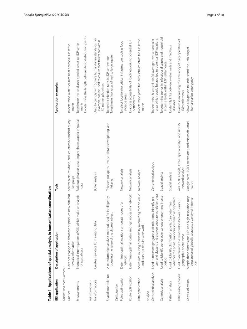
Table 1 is demonstrating the capabilities of GIS in this situation. In spite of the fact that there are various appli-cations of spatial analysis as a GIS technique, they all share an ultimate target, which is to which is to exploit the situational the situational awareness to all areas tak-ing an interest so fundamental concerns can be perceived and after that together achieved.
A late analysis by Eveleigh et al. (2007) and Al-Ahmadi et al. (2014) has utilized spatial analysis for earthquake disaster studies. The adopted approach recognizes that within the scope of humanitarian assistance “GIS
innovation is battling with how to address complex issues that require the modeling of rapidly changing dynamic phenomena, feature, behavior, data and. They concluded that there is a high potential for GIS-based assessment models to give the leap forward expected to address the random way of humanitarian emergencies.
Bally et al. (2005) presented the use of remote sensing for Humanitarian Aid, showing that the utilization of remote detecting and GIS permitted 200,000 IDPS to be migrated to longer-term settlements that had a renewable water source and with improvement potential in regards to sanitation, farming, and even hydropower. Another powerful GIS application used to support humanitarian emergencies was The Global Connection Project, which included Carnegie Mellon University, NASA, Google and National Geographic, contributing to the relief planning for October 8, 2005, South Asian earthquake and tsu-nami. In this project, GIS was utilized to gain and convey high-resolution imagery from Digital Globe’s Quickbird.
Wild fireESRI (1999) has shown an approach to depicting a rapidly spreading fire event precisely; spatial analysis can be uti-lized to recognize high-risk fire zones and set up buffer zones for evacuation. Notwithstanding the determination of high-risk regions, spatial analysis can be combined with statistical analysis as a verification method for the specifying areas of final damage assessment, in addition to deciding to provide visual models for highly impacted areas, according to Goodchild (2006). Lentile et al. (2006) gave direction by distinguishing potential layers that can be utilized for urban fire identification. The initial step was to employ scope and longitude directions to plot the different flames (based upon a decision of lightning or human-ignited fire) during a particular period. Fire infor-mation may seem, by all accounts, to be situated inside waterways. However, this is mainly a reason for adjust-ing buffer zones to give some slack to such errors. The process of connecting attributes information and pre-sent four analytical techniques for simulation and visu-alization out of control fire. In spite of the fact that their emphasis particularly on human-brought ablaze catas-trophes, in proposing the four prescribed alternatives for finish urban fire examination:
a. the territory influencedb. temporal expandc. spatial extendd. probability
The urban fire hazard is hard to avert. Notwithstand-ing, through the recognizable specification of the high-risk zones, the recurrence of flame can be minimized.
Page 4 of 10Abdalla SpringerPlus (2016) 5:2081
Tabl
e 1
App
licat
ions
of s
pati
al a
naly
sis
in h
uman
itar
ian
coor
dina
tion
GIS
app
licat
ion
Des
crip
tion
of a
pplic
atio
nTo
ols
App
licat
ion
exam
ples
Que
ries a
nd m
easu
rem
ents
Que
ries
Doe
s no
t cha
nge
the
data
base
or p
rodu
ce n
ew d
ata
but
reve
als
info
rmat
ion
Scat
ter p
lots
, res
idua
ls, a
nd s
truc
ture
d/st
anda
rd q
uery
la
ngua
geTo
det
erm
ine
wat
er s
ourc
es n
ear p
oten
tial I
DP
sett
le-
men
ts
Mea
sure
men
tsN
umer
ical
inte
rrog
atio
ns o
f GIS
, whi
ch m
ake
an a
naly
sis
of s
patia
l dat
aM
akeu
p di
stan
ce, a
rea,
leng
th, s
hape
, asp
ect o
f spa
tial
data
To e
stim
ate
the
tota
l are
a ne
eded
to s
et u
p ID
P se
ttle
-m
ents
To d
eter
min
e th
e le
ngth
bet
wee
n fo
od d
istr
ibut
ion
poin
ts
Tran
sfor
mat
ions
Tran
sfor
mat
ions
Cre
ates
new
dat
a fro
m e
xist
ing
data
Buffe
r ana
lysi
sU
sed
to c
ompl
y w
ith S
pher
e hu
man
itaria
n st
anda
rds.
For
exam
ple,
can
be
used
to e
nsur
e th
at to
ilets
are
with
in
50 m
eter
s of
she
lters
Spat
ial i
nter
pola
tion
A tr
ansf
orm
atio
n an
alys
is m
etho
d us
ed fo
r int
ellig
ently
gu
essi
ng th
e va
lue
of th
e di
scre
et o
bjec
tTh
iess
en p
olyg
ons,
inve
rse-
dist
ance
wei
ghtin
g, a
nd
Krig
ing
To p
redi
ct in
fect
ion
rate
s in
IDP
sett
lem
ents
To e
stim
ate
flow
rate
s of
wel
l to
larg
e aq
uife
r
Opt
imiz
atio
n
Poin
t opt
imiz
atio
nD
eter
min
es o
ptim
al lo
catio
ns a
mon
gst n
odes
of a
ne
twor
kN
etw
ork
anal
ysis
To s
elec
t loc
atio
n fo
r crit
ical
infra
stru
ctur
e su
ch a
s fo
od
stor
age
area
s
Rout
e op
timiz
atio
nD
eter
min
es o
ptim
al ro
utes
am
ongs
t nod
es o
f a n
etw
ork
Net
wor
k an
alys
isTo
acc
ess
acce
ssib
ility
of r
oad
netw
orks
to p
oten
tial I
DP
sett
lem
ents
Path
opt
imiz
atio
nSo
lves
are
rout
ing
prob
lem
s by
min
imiz
ing
frict
ion
valu
e an
d do
es n
ot re
quire
a n
etw
ork
Net
wor
k an
alys
tTo
det
erm
ine
path
s fo
r util
ity in
frast
ruct
ure
for I
DP
sett
le-
men
ts
Anal
ysis
Geo
stat
istic
al a
naly
sis
Use
d to
mea
sure
geo
grap
hic
dist
ribut
ions
, ide
ntify
pat
-te
rn a
nd c
lust
ers,
and
anal
yze
geog
raph
ic re
latio
nshi
psG
eost
atis
tical
ana
lysi
sTo
det
erm
ine
hist
oric
al ra
infa
ll av
erag
es o
ver a
par
ticul
ar
area
, whi
ch c
ould
be
appl
ied
to p
oten
tial I
DP
loca
tions
Cent
roid
ana
lysi
sU
sed
to id
entif
y tr
ends
ove
r var
ious
phe
nom
ena
in a
set
pe
riod
Spat
ial a
naly
stTo
det
erm
ine
tren
ds in
infe
ctio
us d
isea
ses
and
hous
ehol
d in
com
e le
vels
with
in ID
P se
ttle
men
ts
Patt
ern
anal
ysis
Use
d to
iden
tify
dist
ribut
ion
poin
ts. C
an d
eter
min
e w
heth
er th
e po
int i
s ra
ndom
, clu
ster
ed o
r dis
pers
edSp
atia
l ana
lyst
To id
entif
y lin
ks b
etw
een
wat
er w
ells
and
infe
ctio
us
dise
ases
Rela
tions
hip
anal
ysis
Use
d to
det
erm
ine
the
rela
tions
hip
betw
een
vario
us
geog
raph
ic p
heno
men
aA
rcG
IS 3
D a
naly
st, A
rcG
IS s
patia
l ana
lyst
and
Arc
GIS
ne
twor
k an
alys
tTo
ass
ist i
n in
crea
sing
the
effici
ency
of d
aily
ope
ratio
n of
ID
P se
ttle
men
ts
Geo
visu
aliz
atio
nSi
mpl
e th
ree
dim
ensi
ons
(3D
) and
hig
h-re
solu
tion
map
-pi
ng a
re u
sed
glob
ally
to a
cces
s a
varie
ty o
f inf
orm
a-tio
n
Goo
gle
eart
h, E
SRI’s
arc
expl
orer
, and
mic
roso
ft v
irtua
l ea
rth
Allo
ws
a la
yper
son
to u
nder
stan
d th
e un
fold
ing
of
hum
anita
rian
emer
genc
y

Page 5 of 10Abdalla SpringerPlus (2016) 5:2081
Jaiswal et al. (2002) have demonstrated that GIS when joined with satellite imagery, can be useful in identifying high-hazard regions within given vicinity and restrict the fire spread and thus minimize the impact. Jaiswal et al. (2002) have also examined the utilization of ArcGIS for this idea, declaring that the mix of topographic founda-tion data and remote sensing for vegetation mapping can make a precise estimation of high-risk fire territories uti-lized for moderation and reaction purposes. In Jaiswal et al. (2002) different layers of vegetation, slope, proxim-ity to settlements, and distance from roads were made to provide an indication about high-risk fire regions. After this data was plotted, buffer zones of 1000, 2000, 3000, and 4000 m surrounding the high-risk zones were plot-ted to extend the distinctive levels of danger. Although they have investigated a particular instance of India, the concept of using GIS spatial analysis consolidated with satellite imagery for distinguishing areas prone to high-risk of fire hazard has demonstrated the adequacy of GIS as a tool for urban disaster management. If GIS can be utilized to model and simulate high-risk fire zones with buffers, which gives benchmark understanding that GIS could likewise be used to show damage assessment mod-els using different software and different data layers, regardless of the geographic location.
Pradhan et al. (2007) utilized GIS examination to decide fire susceptibility, using a “vector spatial database” with GIS and consolidated with topographic information, fuel information, base overview focuses, and maps. This took into account figuring variables, which were then changed over to a raster grid, recognizing 112 cells inside the fire events. A frequency-based proportion approach was used to characterize the “connections between hot-spot areas and the components in the study area”. The challenges, notwithstanding, were in processing “a sig-nificant amount of data”. The conclusion is drawn from Pradhan et al. (2007) on the utilization of such projec-tions for fire risk mapping and mitigation was quite com-pelling. In foreseeing fire susceptibility when utilizing frequency analysis, the prescribed results were recom-mended to be used with alert, according to Pradhan et al. (2007). It was suggested that the analysis approaches their examination is used fundamentally amid fire event, which proposes mapping fire-influenced zones instead of driving toward the relief bit of fire disaster management process.
FloodsCorreia et al. (1998) demonstrated that GIS had been seen as a successful tool to organize and visualize data from different sources on far-reaching floodplain admin-istration. As a part of this overall approach to man-age floodplain management, it is crucial to have the
ability to predict the aftereffects of different situations as to flooded regions and related regions at risk. Mor-row (1999) discussed the hydrologic and water controlled zones accept a crucial part, and there is much to get in uniting these exhibiting capacities in a GIS system. The perspective of the using Intergraph GIS with IDRISI GIS provided an effective way in dealing with flood emergen-cies in both 2D and 3D. Using multidimensional mod-eling usually extended the flexibility of using GIS as an instrument for flood modeling. Gogoaşe Nistoran et al. (2016) have shown the effectiveness of spatial analysis using GIS for modeling flood inundation as a result of dam-break.
The role of GIS in Flood Disaster Management was ana-lyzed by Cova (1999), through the perspective of Com-prehensive Emergency Management (CEM) and its four phases: mitigation, preparedness, response and recov-ery. In the wake of a disaster, GIS is getting the chance to be vital in supporting damage assessment, evaluation, and cost estimation for development. In the aftermath of a catastrophe, GIS is a valuable tool in supporting cost evaluation and rebuilding. Abbas et al. (2009) proposed a GIS-based contemplate regarding the change of surge showing and representation for Allahabad Sadar Sub-District (India). This joins the framework, the method-ology/approach that planned to research the degree for spatial analysis application for a rapid response. The flood affected zones have been recognized, and their positions are checked, where the GIS handiness has been manhan-dled to get the spatial information for the fruitful calam-ity organization for surge affected reaches. The adopted approach has helped in recognizing issues that may upgrade the present practices of emergency management organizations. The approach gives a suitable and quick fundamental authority instrument for snappy response to emergencies if used appropriately, which along these lines would help in minimizing loss of life and property. Al-Sabhan et al. (2003) proposed a GIS-construct study, in light of the change of flood levels and representation. This consolidates the arrangement, the investigated the present status of progressing hydrological models used for flood modeling and risk mitigation. It indicated how electronic systems could overcome a bit of the obstruc-tion of existing structures. While hydrological GIS-based models are open, they are ineffectually suited to the con-sistent application and are frequently not primarily con-solidated with spatial datasets.
Buchele et al. (2006) and Chen et al. (2009) discussed a modern approach for integrated flood risk assessment. In light of the setting of a more relative examination of different flood risk assessment models, for mapping, in the midst of extreme situations. The ampleness of syn-chronous and in-house proprietary methods using was

Page 6 of 10Abdalla SpringerPlus (2016) 5:2081
analyzed by Chen and Zhan (2008). The study used an operator-based technique to model movement streams at the level of individual vehicles and examines the total practices of modeling and visualization of moving objects, during an emergency. De Silva (2000) presented a model Spatial Decision Support System (SDSS) which was normal for credibility making blueprints for emer-gency mapping, where response operations using spatial information dealing with and representation points of confinement in a GIS. It interfaces together with the geo-spatial part of the spatial analysis section is given by the GIS. The SDSS, so that gives a detailed spatial informa-tion of flood zone extension and involved layers.
Moreri et al. (2008) proposed an approach to man-age making an internet-based Geographic Information Systems (WebGIS) application, which would reinforce people living in flood zones, which may at one point be unprotected in light of their closeness to the stream and the adequacy of the flooding. Zerger and Wealands (2004) showed that spatially quick hydrodynamic flood models could expect an essential part in average danger peril reducing. A key element of these models that make them suitable for risk exhibiting is the capacity to give time-blueprint immersion data about the onset, length, and embarking to an emergency situation. Such data can be the start for region utilize orchestrating, for map-ping, for clearing directing, and for finding sensible crisis organization to give a couple of representations hazard responses. To address these confinements, a structure has been made that interfaces, with emergency response team with a GIS-based decision support system.
Dust stormsDust Storms are otherwise called Sand Storms; it rep-resents one of the common hazards with a broad range of environmental impacts. During an event of a stand storm, it affects human health in various ways. Sand-storms are a critical reason for car crashes and cause air transportation delays. Goudie (2008a, b) discussed the products during the process of stand storm eruption. It presents fine particles, salts and chemicals (counting herbicides) into the environment, with a suite of health effects, including respiratory complaints as well as dif-ferent serious illnesses. Dust storms can transport aller-gens including microscopic organisms and growths, in this manner affect human health. Spatial Analysis can be exceptionally successful in displaying and representation the degree and the effect of sandstorms. Specifically, we can utilize GIS to give the accompanying capacities in managing dust storms disaster management.
The recent developments in global warming and climate change have prompted increased activity of sand storms in various parts of the word. Numerous
researchers including Goudie (2008a, b; Xu et al. 2006) have dealt with the examination of sandstorms events and its impact on the land surface, utilizing GIS and Remote Sensing. Goudie (2009), discussed the first meth-odology relies upon the investigation of weather station information and representation of the spread of particu-late matter in particular space in association with Dry Mid Temperature and Sub-Dry Temperature, particu-larly in the desert or semi-desert or zones. Measurable investigates exhibit that the event of sand–dust storms relate to a high degree of wind speed, which thus is firmly identified with land surface components; then again, a significant relationship between rain event and other atmospheric elements, for example, precipitation and temperature were not watched. This is notwithstanding the part of vegetation cover, which has been unequivo-cally connected to dust storms.
Health hazardsAccording to Cioccio and Michael (2007) Emergency management of health impacts, specifically focus on the vulnerable population; and access to medical services; GIS technology is capable in extreme heat attacks, by providing the degree and application for spatially ana-lyzing the distribution of services and its relation to the population at risk. Despite all that, the literature that covers the use of GIS for health impact is somewhat lim-ited. Many requests for the use of GIS in health focuses on the methodology, and the practical applications to the domains of vulnerable population, health care facilities distribution, and emergency shelters distribution. These three themes could be linked to the census and traf-fic information to provide more detailed spatial models, when dealing with this hazard.
Sharma et al. (2008) pointed out that one of the key uti-lizations of GIS in pandemic modeling and simulation is to encourage access to health services by inhabitants who live in and around the security area of a mass gathering or a social event. This will be achieved by outlining an application GIS to help health authorities in the planning and implementation of emergency medical response, with an emphasis on improving support of vulnerable population, including:
a. Ensuring continuous routine for health services amid times of restricted access to a security area;
b. Ensuring evacuation procedures for medical emer-gencies that are non-event related;
c. Providing timely evacuation and health care in the event of mass causality incident.
This can be accomplished by outlining a mapping tool to locate vulnerable community members inside the

Page 7 of 10Abdalla SpringerPlus (2016) 5:2081
affected zone, if there should arise an occurrence of a pending natural or technological disaster, for example, a heat wave or power outage. Becerra-Fernandez et al. (2008), explained that GIS could be used to for specifying access and evacuation routes, for approaching or in pro-gress emergency or disaster management events. Goals may incorporate shelters, schools or other predefined destinations outside of the security zone Chandana et al. (2007). The key support of GIS in a pandemic episode can be through the utilization of GIS intending to general public health issues, particularly, to characterize its uses and restrictions in managing the inquiries of describ-ing the vulnerable population. GIS supports advanced intervention operations, for example, Roland Daley et al. (2015) have highlighted some of these issues as following:
a. Choosing sites for community flu centers and vacci-nation stations.
b. Monitoring and assessing effect of vaccination cent-ers and stations.
c. Canceling public events, and gatherings.d. Closing schools, meetings and gatherings.e. Restricting utilization of public transportation frame-
works.f. Identifying potential groups quarantine and isolation
facilities.g. Enforcing people to follow group or individual iso-
lates.
Spatial analysis applications in technological hazardsInfrastructure disruption and malfunctionCova and Church (1997) and Cimellaro (2016) discussed an approach for purposely recognizing neighborhoods that may go up against transportation challenges during an emergency evacuation. A description of this nature offers an interesting approach to manage assessing group of defenselessness in regions subject to advanced dynamic risks of uncertain spatial impact (e.g., hazardous spills on roadways). A heuristic estimation is delineated which can be usable for conveying useful, the excellent answer for this model in a GIS setting, as it was associ-ated with a study region.
Camps (1993) presented a new computerized risk management framework for use by less experienced risk management personnel who to reduce the likelihood and seriousness of accidents. The framework, which was developed, is suitable for use in oil, gas, or chemical pro-cessing sites. It joins scientific models and calculation tools for accident simulation and building a database that incorporates accidents scenarios and response plans. It can likewise be utilized as a part of an emergency situation to decide favored approaches to find external assistance.
Spatial analysis applications in manmade hazardsMass gathering and civil unrestNumerous sorts of mass gathering and the concentration of population change participating in such events may vary, depends on the nature of the event, its location and the time and season of the event. For instance, civil dem-onstrations, outdoor rock concerts, and a football match are typical examples where there is clear variation in the density of population attending these events. Accord-ing to McDonald (2008), these occasions regularly, don’t draw in one sort of participants. Therefore, risks might be connected with weather related sickness, harmful impacts of medications, or injury because of members attempting to draw near to the stage. Bradler et al. (2008), concluded that political events, for example, political parties conventions might have several risks, associated with. This incorporate trauma or toxic impacts of depres-sion related to a political protest or terrorism-related incidents. Becerra-Fernandez et al. (2008) have indicated that GIS spatial analysis is valid in this applications, as it provides:
1. Specifying the dissemination of individuals around the event proximity.
2. Analyzing the scope and approach for mapping evac-uation if there should be an occurrence of an emer-gency.
3. Determining the positions and movement of law enforcement in the field.
4. Analyzing the pattern of development of masses.5. Supporting effective decision-making on evacuation
and response to an emergency situation.
TerrorismKwan and Lee (2005) have shown that the terrorist attacks on the World Trade Center (WTC) in New York City and the Pentagon on September 11, 2001, has not quite recently impacted multi-level structures in an urban center. They have also influenced by their surroundings at the street level in ways that reduced the time limits for the speed of emergency response. The capacity of using progressing 3D GIS for the headway and execution of GIS-based intelligent emergency response systems. The fact was at urging a quick emergency response to ter-rorist attacks on multi-level structures (e.g., multi-story office structures). A system design and a framework data show that facilitates the ground transportation capabili-ties with the inside courses inside multi-level structures into a protected 3D GIS was examined. Issues of using adaptable representation stages were also discussed especially the prerequisite for the remote and versatile response plan. Critical decision support functionalities were moreover considered with particular reference to

Page 8 of 10Abdalla SpringerPlus (2016) 5:2081
the utilization of framework based most restricted way computations. A test use of expected 3D structure data shows a GIS database for a nearby study area was dem-onstrated by Kwan and Lee (2005). The study indicates that reaction delay inside multi-level structures can be any longer than deferrals caused on the ground trans-portation framework, have the potential for impressively decreasing these postponements.
Johnson (2003) demonstrated that in times of crisis, the disaster managers have the necessary commitment in regards to quickly and adequately managing any situ-ation that may happen. An adjusted GIS application was delivered engaging a brief based examination of a catas-trophe occasion facilitated with the centralization of masses distinguished correctly to the room level. The GIS Emergency Management System (GEMS) application is an astute structure to be utilized as a part of the Emer-gency Operation Center (EOC) to help the heading of the response. On the off chance that a calamity needs to happen, the intervention and recovery attempts could be at initially focused on the most fundamental areas of the greatest convergence of people.
Challenges and trendsGoodchild (2006) indicated that various events, includ-ing the Indian Ocean Tsunami of 2005, the Hurricanes of the 2005 season, and the 7/7 and 9/11 terrorist’s attacks, have made each one of us seriously aware of the short-coming of the modern society. Knowing the chronicled record of the events and where such situations have hap-pened, notwithstanding the geographic limits of their effects are apparently essential, primarily when consoli-dated with data on human population and distribution, along with other spatially circulated wonders that might apply to reaction and recuperation (Abdalla et al. 2014). Regardless, GIS and spatial technologies that gather, ana-lyze, and take into account visualization of such data, using advanced geomatics technologies in the form of GIS, remote sensing, GPS, and Photogrammetry. These technologies are unmistakably indispensable in all parts of the disaster management cycle, from protection, response, and recovery through acknowledgment to the reply and conceivable recovery. GIS give the preface to evaluating and mapping hazards, from evacuation plan-ning to delivery to shelters, to routes planning to reha-bilitation and restoration. Abdalla (2015) describes it as it likewise allows for choosing ranges where human pop-ulation is well on the way to have been influenced by a disaster, and for allocating assets amid the recuperation procedure, among various other irreplaceable and crucial assignments that the GIS brings.
One of the distinct challenges in the utilization of GIS for urban disaster management is the location
dependency of the event, or what is known as the geo-graphic interdependence of the event. The proximity of the event can prompt many complexities in deciding the location, space and temporal parameters of the event. Various episodes in similar areas can bring about falling or raising impacts among the diversely affected entities.
As to the utility of Spatial Analysis in coordination approaches, the status of the spatial analysis confront noteworthy insufficiencies that can be condensed by the absence of some standard methods in a few districts and additionally the unstructured conventions that are being used when managing complex situations of disasters in various parts of the world. Some portion of this can be additionally ascribed to the absence of preparing in utilizing GIS frameworks, which can at times cause spe-cialists on call for act wastefully when managing calami-ties. Spatial Analysis can bolster viable preparing for disaster management professionals to manage complex circumstances. More critically, the advocated require-ment for geospatial information in a few parts of the world requires compelling access to worldwide SDI uti-lizing advanced access protocols and to strengthen the advancement of techniques and strategies for effective decision-making. This can be ascribed to the absence of interoperability in data exchange and processes standardization.
The decision-making process confronts a few difficul-ties on the lack of common operating picture for efficient policy implementation process. Decision-makers require to access spatial models actually in the form of real-time data feeds from planning teams, from field observers and remotely gathered information. This supports the viable access to operations areas monitoring devices, and as well it enhances the output of emergency management decision making.
SummaryThe spatial analysis gives powerful means in manag-ing risk and in dealing with hazard mapping and assess-ment. It is likewise compelling in providing visual models that assist decision-makers with utilizing these advances adequately. However, spatial analysis can’t be satisfied without getting the exact information, defining proficient strategies and securing viable execution of HR required in Emergency Management.
The extent of this exploration is challenging, with an endeavor to cover a few risks that may cause disas-ters in urban regions. It is essential to deal adequately with emergency management in any of its four stages, i.e., preparedness, mitigation, response, and recov-ery. The discussion of the detailed application of spatial analysis overviewing the state-of-the-art application the technology has raised a few issues identified with the

Page 9 of 10Abdalla SpringerPlus (2016) 5:2081
development of the utilization of spatial advances in dis-aster management, specific questions are:
1. The co-locality of an impact as a result of a series of events may require more progressed spatial analysis answers for giving details about the extent of damage, the cost of harm, the distribution of vulnerable popu-lation, the indicators of vulnerability and the mean for a response.
2. Issues with data and information frameworks of interoperability are essential in giving an available prearrangement through spatial analysis.
3. Health related emergencies are more complex to ana-lyze spatially because of issues identified with private access to patient’s data, also the difficulty of covering various scales of events in the limited temporal time-frame.
4. Although the present GIS systems contribute to advanced spatial analysis capabilities; yet new meth-odologies for investigation, representation, and inte-gration are required to offer additional means for support to urban disaster and emergency manage-ment community.
AbbreviationsGIS: geospatial information systems; GEMS: GIS emergency management system; EOC: emergency operations centers; ESRI: Environmental Systems Research Institute; SDSS: spatial decision support system; SDI: spatial data infrastructure; GPS: global positioning system; 3D: three dimensional; HR: human resources.
Authors’ informationDr. Rifaat Abdalla is Associate Professor of Geospatial Information Science with King Abdulaziz University, Jeddah. During the past ten years, he served as Defence Scientist with Defence Research and Development Canada; the Federal Government of Canada research arm in Defense and Security Research. Also, he was Adjunct Professor with the graduate program in Disaster and Emergency Management, York University, Toronto; he also served as a contract faculty with the Geomatics Program, Ryerson University, Toronto. Dr. Abdalla received his Ph.D. from York University, in 2006. Dr. Abdalla has published extensively in the field of Web-based GIS for Disaster Management and has received many recognitions and awards, including the 2007 ESRI Best Scientific Paper, presented by the American Society for Photogramme-try and Remote Sensing (ASPRS) for papers published in Photogrammetric Engineering and Remote Sensing Journal and the Best Paper Award of 2009 Conference on Geo-Web Services, held in Cancun, Mexico.
AcknowledgementsThis project was funded by the Deanship of Scientific Research (DSR) at King Abdulaziz University, Jeddah, under Grant No. G-290/980/1434. The author, therefore, acknowledge with thanks DSR for technical and financial support.
Competing interestsThe author declare that he has no competing interests.
Availability of data and materialsThe material used in this is paper is in form of published articles and they are all listed in the reference section.
FundingThis research was part of a project funded by King Abdulaziz University, Dean-ship of Scientific Research under Grant Number G-290/980/1434.
Received: 6 May 2016 Accepted: 21 November 2016
ReferencesAbbas S et al (2009) GIS-based disaster management: a case study for Alla-
habad Sadar subdistrict (India). Int J Manag Environ Qual 20(1):33–51Abdalla R (2015) Strategic framework for advancing the utility of GeoICT
in emergency preparedness. In: Proceedings of the 2nd international conference on information and communication technologies for disaster management (ICT-DM). IEEE, Rene
Abdalla R, Elawad Y et al (2014) A GIS-supported fuzzy-set approach for flood risk assessment. Can Water Resour J Rev Can Ressour Hydr 39(1):3–14
Al-Ahmadi K, Abdullah A-A, Linda S (2014) A spatial statistical analysis of the occurrence of earthquakes along the Red Sea floor spreading: clusters of seismicity. Arab J Geosci 7(7):2893–2904
Al-Sabhan W, Mulligan M et al (2003) A real-time hydrological model for flood prediction using GIS and the WWW. Comput Environ Urban Syst 27:9–32
Anjum M, Rana M et al (2011) GIS-based emergency management scenario for urban petroleum storage tanks. In: Proceedings of the 2011 international workshop on multi-platform/multi-sensor remote sensing and mapping
Bally P et al (2005) Remote sensing and humanitarian aid: a life-saving combi-nation. Bull Eur Space Agency (ESA) 122:37–41
Becerra-Fernandez I, Prietula M et al (2008) Design and development of a virtual emergency operations center for disaster management research, training, and discovery. In: Proceedings of the 41st annual Hawaii interna-tional conference on system sciences
Bradler D, Kangasharju J et al (2008) Systematic first response use case evalu-ation. In: Second international conference on pervasive computing technologies for healthcare, 2008. PervasiveHealth 2008
Buchele B et al (2006) Flood-risk mapping: contributions towards an enhanced assessment of extreme events and associated risks. Nat Hazards Earth Syst Sci 6:485–503
Bullock JA, Haddow GD, Coppola DP (2006) Introduction to homeland secu-rity. Butterworth-Heinemann, Waltham
Camps R (1993) Controlling the danger zone. New Sci 138(4):16–17Carter WN (1991) Disaster management: a disaster manager’s handbook. Asian
Development Bank, ManilaChandana S, Leung H et al (2007) Disaster management model based on
modified fuzzy cognitive maps. In: IEEE international conference on systems, man and cybernetics, 2007. ISIC
Chen X, Zhan FB (2008) Agent-based modelling and simulation of urban evacuation: elative effectiveness of simultaneous and staged evacuation strategies. J Oper Res Soc 59:25–33
Chen J, Hill AA et al (2009) A GIS-based model for urban flood inundation. J Hydrol 373:184–192
Cimellaro GP (2016) A comprehensive methodology for the evaluation of infrastructure interdependencies. Urban resilience for emergency response and recovery: fundamental concepts and applications. Springer, Cham, pp 139–223
Cioccio L, Michael EJ (2007) Hazard or disaster: tourism management for the inevitable in Northeast Victoria. Tour Manag 28(1):1–11
Correia FN et al (1998) Coupling GIS with hydrologic and hydraulic flood modelling. Water Resour Manag 12:229–249
Cova TJ (1999) GIS in emergency management. In: Longley MFGPA, Maguire DJ, Rhind DW (eds) Geographical information systems: principles, tech-niques, applications, and management. Wiley, New York, pp 845–858
Cova TJ, Church RL (1997) Modelling community evacuation vulnerability using GIS. Int J Geogr Inform Sci 11(8):163–784
Currion P (2006) Emergency capacity building project information technology and requirements. Assessment Report Global. 2006, Emergency Capacity Building Project. I. W. Group. London, p 34
de Silva FN (2000) Integrating simulation modelling and GIS spatial support systems for evacuation planning. J Oper Res Soc 51(4):423–430
ESRI (1999) GIS for emergency management. ESRI White PaperEveleigh TJ, Mazzuchi TA et al (2007) Spatially-aware systems engineering
design modeling applied to natural hazard vulnerability assessment. Syst Eng 10(3):16–24

Page 10 of 10Abdalla SpringerPlus (2016) 5:2081
Gogoaşe Nistoran DE, Gheorghe Popovici DA et al (2016) GIS for dam-break flooding. In: Boştenaru Dan M, Crăciun C (eds) Study area: Bicaz-Izvorul Muntelui (Romania). Space and time visualisation. Springer, Cham, pp 253–280
Goodchild MF (2006) GIS and disasters: planning for catastrophe. Comput Environ Urban Syst 30(2006):227–229
Gordon JA (2002) Comprehensive emergency management for local governments: demystifying emergency planning. Rothstein Publishing, Brookfield, Connecticut
Goudie AS (2008a) Dust storms: recent developments. J Environ Manag 90:89–94
Goudie AS (2008b) The history and nature of wind erosion in deserts. Annu Rev Earth Planet Sci 36:97–119
Goudie AS (2009) Global deserts and their geomorphological diversity. In: Parsons AJ, Abrahams AD (eds) Geomorphology of desert environments, 2nd edn. Springer, New York, pp 9–20
Jaiswal RK, Mukherjee S et al (2002) Forest fire risk zone mapping from satellite imagery and GIS. Int J Appl Earth Obs Geoinform 4(1):1–10
Johnson K (2003) GIS emergency management for the University of Redlands. In: ESRI international user conference
Kumar A (2013) Natural hazards of the Arabian Peninsula: their causes and possible remediation. In: Earth system processes and disaster manage-ment. Society of Earth Scientists Series, pp 155–180
Kwan M, Lee J (2005) Emergency response after 9/11: the potential of real-time 3D GIS for quick emergency response in micro-spatial environ-ments. Comput Environ Urban Syst 29(2):93–113
Lentile LB, Smith FW, Shepperd WD (2006) Influence of topography and forest structure on patterns of mixed severity fire in ponderosa pine forests of the South Dakota Black Hills, USA. Int J Wildland Fire 15(4):557–566
McDonald R (2008) New considerations for security compliance, reliability and business continuity. In: Rural electric power conference, 2008 IEEE
Mileti D (1999) Disasters by design: a reassessment of natural hazards in the United States. Joseph Henry Press, Washington, DC
Miura H, Yamazaki F et al (2007) Identification of damaged areas due to the 2006 Central Java, Indonesia earthquake using satellite optical images. In: Urban remote sensing joint event, 2007
Morrow B (1999) Identifying and mapping community vulnerability. Disasters 23(1):1–18
Moreri KK et al (2008) Web based geographic information systems for a flood emergency evacuation. In: 3rd International ISCRAM China workshop, Harbin
Pradhan B, Suliman MD et al (2007) Forest fire susceptibility and risk mapping using remote sensing and geographical information systems (GIS). Disas-ter Prev Manag 16(3):344–356
Roland Daley FF, Orly J, Abdalla R (2015) GIS for pandemic zoning: application of Brampton, Ontario, Canada. Comput Sci Inform Technol 3(5):149–158
Saadatseresht M, Mansourian A et al (2009) Evacuation planning using multiobjective evolutionary optimization approach. Eur J Oper Res 198(2009):305–314
Sharma RK, Kumar BS et al (2008) SAR for disaster management. IEEE Aerosp Electron Syst Mag 23(6):4–9
Smirnov A, Pashkin M et al (2006) Context-based disaster management support. In: IEEE workshop on distributed intelligent systems: collective intelligence and its applications, 2006. DIS 2006
Verjee F (2005) The application of geomatics in complex humanitarian emer-gencies. J Humanit Assist
Xu X, Levy JK et al (2006) An investigation of sand–dust storm events and land surface characteristics in China using NOAA NDVI data. Glob Planet Change 52:182–196
Zerger A, Wealands S (2004) Beyond modelling: linking models with GIS for flood risk management. Nat Hazards 33:191–208