evaluation of remote sensing altimeter and asar wave data
TRANSCRIPT

“
”
Evaluation of Remote Sensing Altimeter and ASAR Wave Data in the East North
Atlantic
Isabel Gonçalves BuéDoutoranda na Faculdade de Ciências da Universidade de Lisboa
Docente militar na Escola Naval (Navegação)
Co-authorsÁlvaro Semedo, Escola Naval (CINAV) and FCUL (IDL)
João Catalão, FCUL – IDLLotfi Aouf, Météo-France
21st june, 2016
4AS JORNADAS DE ENGENHARIA HIDROGRÁFICA

OUTLINE
INTRODUCTION
- Wave Spectra; Significant wave height; Altimetry and SAR
RESEARCH DESCRIPTION
- Data; Methodology
RESULTS AND DISCUSSION
CONCLUSIONS
WORK PLAN (NEAR FUTURE)
“Evaluation of Remote Sensing Altimeter and ASAR Wave Data in the East North Atlantic”
Isabel Bué
2

INTRODUCTION
Isabel Bué
Wave Climate
MeasuringOcean surface waves
In situ Buoys
Remote Sensing(microwave sensors)
- disproportional distributed - near the coasts of industrialized countries - located in the north hemisphere- Time series inhomogeneity
Radar Altimeters (RA)
Synthetic Aperture Radar (SAR)
Wave reanalyses and hindcasts
3
“Evaluation of Remote Sensing Altimeter and ASAR Wave Data in the East North Atlantic”

Isabel Bué
INTRODUCTIONThe ocean wave field is the SUM of many WAVES
WIND SEA + SWELL
OCEAN WAVE SPECTRUM
4
“Evaluation of Remote Sensing Altimeter and ASAR Wave Data in the East North Atlantic”

Isabel Bué
INTRODUCTION5
“Evaluation of Remote Sensing Altimeter and ASAR Wave Data in the East North Atlantic”

SWH from altimeters
Isabel Bué
INTRODUCTION6
“Evaluation of Remote Sensing Altimeter and ASAR Wave Data in the East North Atlantic”

SWH from altimeters SWH from SAR
Isabel Bué
INTRODUCTION7
“Evaluation of Remote Sensing Altimeter and ASAR Wave Data in the East North Atlantic”

RESEARCH DESCRIPTION
STUDY Significant wave height (SWH) comparisons between remote sensing altimetry and Synthetic Aperture Radar (SAR)measurements and several wave buoy observations, are confronted with the ECMWF* ERA-Interim reanalysis, through a triple-collocation method.
Different time and space resolutions for the different datasets.
The buoy positions are the key element for the positioning of all measurements.
The hour of the satellite overpass are the time key element the time of all observations.
*European Center Medium-Range Weather Forecast
Isabel Bué
8
“Evaluation of Remote Sensing Altimeter and ASAR Wave Data in the East North Atlantic”

Isabel Bué
RESEARCH DESCRIPTIONDATA
Buoys observations- Puertos del Estado (buoys 2246 and 2248);
- UK Met Office (buoys 62442 and 62029);
- Météo-France (buoys 62001 and 62163),
- Marine Institute-Met Éireann (buoys 62090 and 62095)
- Instituto Hidrográfico (Leixões e Sines buoys).
9
“Evaluation of Remote Sensing Altimeter and ASAR Wave Data in the East North Atlantic”

RESEARCH DESCRIPTION
Isabel Bué
10
DATASatellite measurements*- RA (radar altimeter) – sample spacing ~ 8 Km (every second)- SAR – sample spacing ~ 100 Km (wave mode, small images covering 6km x 5km to 10km x 5km and 20km x 20km)
* Data made available from IFREMER (GlobWave project)
“Evaluation of Remote Sensing Altimeter and ASAR Wave Data in the East North Atlantic”

Isabel Bué
RESEARCH DESCRIPTION
Assimilation of altimeter data in the ERA-Interim wave analysis.
11
DATA
ERA-Interim reanalysis*- resolution 1º x 1º;- 6H output;- 2D wave energy spectrum F(ƒ, θ);-Altimetry wave data assimilation;- No wave buoy data assimilated.
* Produced by European Center for Medium-Range Weather Forecasts (ECMWF).
“Evaluation of Remote Sensing Altimeter and ASAR Wave Data in the East North Atlantic”

Isabel Bué
RESEARCH DESCRIPTION
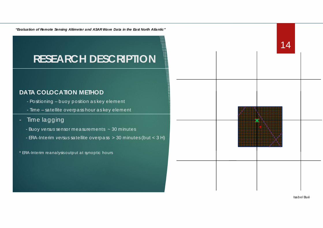
DATA COLOCATION METHOD - Positioning – buoy position as key element
- Time – satellite overpass hour as key element
- BOX 1º (LAT) x 1º (LON)
12
“Evaluation of Remote Sensing Altimeter and ASAR Wave Data in the East North Atlantic”

Isabel Bué
RESEARCH DESCRIPTION
DATA COLOCATION METHOD - BOX 1º (LAT) x 1º (LON)
- RA – sample spacing ~ 8 Km (every second)
- SAR – sample spacing ~ 100 Km (wave mode, small images covering 6km x 5km to 10km x 5km)
13
“Evaluation of Remote Sensing Altimeter and ASAR Wave Data in the East North Atlantic”
Isabel Bué
RESEARCH DESCRIPTION
DATA COLOCATION METHOD - Positioning – buoy position as key element
- Time – satellite overpass hour as key element
- Time lagging- Buoy versus sensor measurements ~ 30 minutes
- ERA-Interim versus satellite overpass > 30 minutes (but < 3 H)
* ERA-Interim reanalysis output at synoptic hours
14
“Evaluation of Remote Sensing Altimeter and ASAR Wave Data in the East North Atlantic”

RESEARCH DESCRIPTION
Isabel Bué
15
STATISTICS
*Standard error metric statistics: BIAS; root mean square error (RMSE); linear correlation coefficient (R) and scatter index (SI). N - number data pairs; b – buoy observation ; s – satellite measurements (or model); overbar – mean value.
“Evaluation of Remote Sensing Altimeter and ASAR Wave Data in the East North Atlantic”

Isabel Bué
Altimeter versus buoy SWH (Leixões and Sines buoys not included).
RESULTS AND DISCUSSION16
Statistics results – all buoy data (exception made for Leixões and Sines buoys) compared with each Altimeter sensor.
“Evaluation of Remote Sensing Altimeter and ASAR Wave Data in the East North Atlantic”

RESULTS AND DISCUSSION- Altimeter vs. buoy SWH* (Leixões and Sines buoys not included).
Isabel Bué* All buoys data compared with each Altimeter sensor
17
“Evaluation of Remote Sensing Altimeter and ASAR Wave Data in the East North Atlantic”

Altimeter versus Leixões and Sines buoy SWHmeasurements.
* All altimeter sensors compared with Leixões and Sines buoy SWH
Scatter plots – Altimeter vs. Leixões and Sines buoy SWH.
Statistics – Altimeter vs. Leixões and Sines buoy SWH.
18
“Evaluation of Remote Sensing Altimeter and ASAR Wave Data in the Eastern Northern Atlantic”
RESULTS AND DISCUSSION
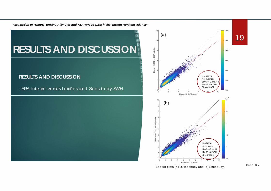
RESULTS AND DISCUSSION
- ERA-Interim versus Leixões and Sines buoy SWH.
Scatter plots: (a) Leixões buoy and (b) Sines buoy. Isabel Bué
19(a)
(b)
“Evaluation of Remote Sensing Altimeter and ASAR Wave Data in the Eastern Northern Atlantic”
RESULTS AND DISCUSSION

RESULTS AND DISCUSSION- ERA-Interim vs. buoy SWH* (Leixões and Sines buoys not included)
Isabel Bué* Scatter plots: : (a) 62095 buoy, (b) 62090 buoy, (c) 62442 buoy, (d) 62029 buoy, (e) 62163 buoy, (f) 62001 buoy, (g) 2246 buoy and (h) 2248 buoy
20
“Evaluation of Remote Sensing Altimeter and ASAR Wave Data in the Eastern Northern Atlantic”

RESULTS AND DISCUSSION
- SAR versus buoys SWH; and - SAR versus ERA-Interim.
* SAR data only from ENVISAT mission** All buoy observations vs. SAR
Scatter plots: (a) SAR versus buoys and (b) SAR versus ERA-Interim.
Isabel Bué
21
(a)
(b)
RESULTS AND DISCUSSION
“Evaluation of Remote Sensing Altimeter and ASAR Wave Data in the East North Atlantic”

CONCLUSIONS
Altimeter and SAR wave observations (SWH) were compared with buoy observations and reanalysis data. The buoy positions were the center of the 1ºx1º sampling boxes.
The comparison between the altimeter SWH and the in situ measurements showed very good agreement, exception made for Leixões and Sines buoys - Altimetry low performance in coastal areas.
Despite the fact that SAR SWH neglects the high frequency waves, these wave estimations showed some agreement with buoy observations that would most probably be better if only the swell SWH had been compared
– Complex wave spectra extraction algorithms.
Isabel Bué
22
“Evaluation of Remote Sensing Altimeter and ASAR Wave Data in the East North Atlantic”

FUTURE WORK
Compare the Sentinel-1 C-SAR SWH measurements with buoy observations, and assess the goodness of incorporating SAR spectra into modeled wave spectra.
- Altimeter, SAR, and reanalysis wave data will be collocated into buoy positions (triple-collocation method)
Investigation - main goals- SWH altimeter versus buoys;
- SWH swell SAR versus buoys;
- SWH ERA-Interim versus buoys and SAR;
- SAR spectra incorporated in ERA-Interim
- ERA-Interim spectrum “corrected”;
- SWH (re)calculated from ERA-Interim;
- “new” SWH compared again with buoys.
Isabel Bué
23
“Evaluation of Remote Sensing Altimeter and ASAR Wave Data in the East North Atlantic”

FUTURE WORK (short term)
Apply the triple-collocation method to estimate the absolute errors of the different datasets.
Optimal interpolation of 2D SAR wave spectra with ERA-Interim spectra (the re-assimilation post-processing process).
The SWH computed from the corrected spectra will further be collocated and compared with buoy observations and altimeter SWH measurements, as well as with the original ERA-Interim SWH, to assess the goodness of the spectral correction model.
Follow this method for existing SAR observations (used in this study) but also with data soon to be available from the C-SAR Sentinel-1 and Sentinel-3 Radar Altimeter.
Isabel Bué
24
“Evaluation of Remote Sensing Altimeter and ASAR Wave Data in the East North Atlantic”

“Evaluation of Remote Sensing Altimeter and ASAR Wave Data in the East North Atlantic”
4as Jornadas de Engenharia Hidrográfica
Isabel Bué
Thank you for your attention!