evaluation of innovative monitoring systems for the queen … · brown pelican (pelicanus...
TRANSCRIPT
I. Report No. 2. Government Accession No.
TX-98/2973-S
4. Title and Subtitle
EVALUATION OF INNOVATIVE MONITORING SYSTEMS FOR THE QUEEN ISABELLA CAUSEWAY TO ASSIST IN THE PRESERVATION OF ENDANGERED BROWN PELICANS
7. Author(s)
Mark Shafer and Debbie Jasek
9. Performing Organization Name and Address
Texas Transportation Institute The Texas A&M University System College Station, Texas 77843-3135
12. Sponsoring Agency Name and Address
Texas Department of Transportation Research and Technology Transfer Office P. 0. Box 5080 Austin, Texas 78763-5080
15. Supplementary Notes
Project Director: Velma Garcia Pharr District Office (210) 702-6100
Teehnical Report Documentation Pa2e
3. Recipient's Catalog No.
5. Report Date
September 1997
6. Performing Organization Code
8. Performing Organization Report No.
Research Report 2973-S
l 0. Work Unit No. (TRAIS)
11. Contract or Grant No.
Study No. 7-2973
13. Type of Report and Period Covered
Project Summary: September 1995 - August 1997
14. Sponsoring Agency Code
Research performed in cooperation with the Texas Department of Transportation. Research Study Title: Evaluation oflnnovative Monitoring Systems for the Queen Isabella Causeway to Assist in the Preservation of Endangered Brown Pelicans
16. Abstract
The Queen Isabella Causeway, also kno\\-n as Park Road 100, is a 3.86 kilometer (2.4 mile) bridge that crosses the Intracoastal Waterway and connects Port Isabel with South Padre Island. The Queen Isabella Causeway presents several unique challenges which influence transportation operations. These challenges include an endangered species of Brown Pelican (Pelicanus occidentalis carolinensis) (B. Pelican) which land on the causeway and are hit and killed, and traffic incidents which have the ability to completely close down access between Port Isabel and South Padre Island. In September of 1984, the first documented B. Pelican mortality occurred on the Queen Isabella Causeway, causing considerable public concern. Since that death in 1984, the population of B. Pelicans has dramatically increased, and the number of B. Pelican mortalities has also increased but at a slower rate. Observations of the B. Pelicans in the area show that a majority of the birds forage on the south side of the bridge during the day and return to the Laguna Madre on the north side of the bridge in the evening to roost. Although the increasing population of the B. Pelican may cause the pelican to be removed from the endangered species list in the future, an increase of mortality events on the causeway may cause a hazard to the motoring public.
17. Keywords 18. Distribution Statement
Brown Pelicans, Weather, Monitoring No restrictions. This document is available to the public through NTIS:
19. Security Classif.(ofthis report)
Unclassified Form DOT F 1700.7 (8-72)
National Technical Information Service 5285 Port Royal Road Springfield, Virginia 22161
20. Security Classif.(ofthis page)
Unclassified Reproduction of completed page authorized
21. No. of Pages
102 22. Price


EVALUATION OF INNOVATIVE MONITORING SYSTEMS FOR THE QUEEN ISABELLA CAUSEWAY TO ASSIST IN THE PRESERVATION
OF ENDANGERED BROWN PELICANS
by
Mark Shafer Assistant Research Scientist
Texas Transportation Institute
and
Debbie Jasek Research Associate
Texas Transportation Institute
Research Report 2973-S Research Study Number 7-2973
Research Study Title: Evaluation oflnnovative Monitoring Systems for the Queen Isabella Causeway to Assist in the Preservation of Endangered Bro\\'n Pelicans
Sponsored by Texas Department of Transportation
September 1997
TEXAS TRANSPORTATION INSTITUTE The Texas A&M University System College Station, Texas 77843-3135

IMPLEMENTATION STATEMENT
The Queen Isabella Causeway presents several unique challenges which influence transportation operations. These challenges include an endangered species of Brown Pelican (Pelicanus occidentalis carolinensis) (B. Pelican) which land on the causeway and are hit and killed, and traffic incidents which have the ability to completely close down access between Port Isabel and South Padre Island. Implementation recommendations made as a result of this project are found in Chapter 6.0.
v


DISCLAIMER
The contents of this report reflect the views of the authors who are responsible for the opinions, findings, and conclusions presented herein. The contents do not necessarily reflect the official views or policies of the Texas Department of Transportation. This report does not constitute a standard, specification, or regulation.
vii

ACKNOWLEDGMENT
The authors wish to acknowledge several individuals who assisted \Vith this study. We would like to recognize the members ofTxDOT who assisted us in conducting this study. Our thanks and appreciation goes to Ms. Velma Garcia and members of the Pharr District Office in assisting us in this study. Special recognition goes to the Pelican Patrol from the TxDOT Maintenance Office in Laguna Vista; Mr. Gregario Puentes, Jr., Mr. Cosme C. Garza, and Mr. Reynaldo Cantu provided invaluable information about pelican mortalities on the bridge. The authors would also like to thank Mr. Ricardo Gallega, Mr. Barney Garcia, and Mr. Kenneth Todd from the San Benito TxDOT Office for assistance with the installation and monitoring of the weather station. Ms. Kim Jenkins from the TxDOT Austin Office is also thanked and recognized for the assistance she provided in data collection on the field expeditions.
The research team would like to acknowledge and thank Mr. Art Kuykendall formerly from the U.S. Fish and Wildlife Service in McAllen, Mr. Gary Waggerman and his staff from Texas Parks and Wildlife Office in Edinburg, and Mr. Randy Blankenship from the Brownsville Fish Hatchery for their assistance and advice on the project. We would like to recognize and thank area game wardens, Sgt. Lauro Salinas, Mr. Jacinto Gonzalez, and Ms. Krystal Gosnay, for taking time from their enforcement duties to act as guides for the field expeditions on the Laguna Madre and South Bay.
A special thanks is extended to Dr. Keith Arnold and Mr. Sam Patten for their valuable advice, assistance, and expertise in answering our questions.
Vlll
TABLE OF CONTENTS
Page
LIST OF FIGURES . . . . . . . . . . . . . . . . . . . . . . . . . . . . . . . . . . . . . . . . . . . . . . . . . . . . . . xii LIST OF TABLES . . . . . . . . . . . . . . . . . . . . . . . . . . . . . . . . . . . . . . . . . . . . . . . . . . . . . . . xiii SUMMARY ............................................................. xv
1.0 INTRODUCTION . . . . . . . . . . . . . . . . . . . . . . . . . . . . . . . . . . . . . . . . . . . . . . . . . . l 1.1 INTRODUCTION . . . . . . . . . . . . . . . . . . . . . . . . . . . . . . . . . . . . . . . . . . . . 1 1.2 OBJECTIVES . . . . . . . . . . . . . . . . . . . . . . . . . . . . . . . . . . . . . . . . . . . . . . . 1 1.3 ANTICIPATED BENEFITS . . . . . . . . . . . . . . . . . . . . . . . . . . . . . . . . . . . . 2
2.0 AN OVERVIEW OF THE BROWN PELICAN . . . . . . . . . . . . . . . . . . . . . . . . . . . 3 2.1 INTRODUCTION . . . . . . . . . . . . . . . . . . . . . . . . . . . . . . . . . . . . . . . . . . . . 3 2.2 DESCRIPTION . . . . . . . . . . . . . . . . . . . . . . . . . . . . . . . . . . . . . . . . . . . . . . 3
2.2. l Adult Pelicans . . . . . . . . . . . . . . . . . . . . . . . . . . . . . . . . . . . . . . . . . 4 2.2.2 Nestling and Juvenile Pelicans . . . . . . . . . . . . . . . . . . . . . . . . . . . . . 4 2.2.3 Immature or Subadult Pelicans . . . . . . . . . . . . . . . . . . . . . . . . . . . . 4
2.3 NON-BREEDING HABIT AT . . . . . . . . . . . . . . . . . . . . . . . . . . . . . . . . . . . 5 2.4 NESTING HABITAT . . . . . . . . . . . . . . . . . . . . . . . . . . . . . . . . . . . . . . . . . 5 2.5 FOOD AND FORAGING BEHAVIOR . . . . . . . . . . . . . . . . . . . . . . . . . . . 6 2.6 FLIGHT PATTERNS FOR THE BROWN PELICAN................ 8
3.0 HISTORY AND STATUS OF THE BROWN PELICAN . . . . . . . . . . . . . . . . . . . 11 3.1 HISTORY OF THE BROWN PELICAN IN TEXAS . . . . . . . . . . . . . . . . 11 3.2 HISTORY OF MORTALITY TRENDS IN THE BROWN
PELICAN ................................................... 14 3 .2.1 Nesting and Reproductive Success of the B. Pelican . . . . . . . . . . . . 15 3.2.2 Mortality Among the Newly Hatched B. Pelican . . . . . . . . . . . . . . 16 3.2.3 Mortality Among the Immature B. Pelican . . . . . . . . . . . . . . . . . . . 16 3.2.4 Mortality Among the Adult B. Pelican . . . . . . . . . . . . . . . . . . . . . . 16
3.2.4.1 Disease and "Die-Offs" . . . . . . . . . . . . . . . . . . . . . . . . . . . 16 3.2.4.2 Monofilament Fishing Line and Fish Hooks . . . . . . . . . . . 18 3.2.4.3 Other Mortality Causes . . . . . . . . . . . . . . . . . . . . . . . . . . . 19
4.0 FIELD OBSERVATIONS IN THE SOUTH PADRE ISLAND AREA ......... 21 4.1 QUEEN ISABELLA CAUSEWAY .............................. 21
4.1.1 Existing Traffic Control Devices . . . . . . . . . . . . . . . . . . . . . . . . . . . 21 4.1.2 Existing Traffic Conditions . . . . . . . . . . . . . . . . . . . . . . . . . . . . . . . 22
4.2 INTERACTION OF BROWN PELICANS WITH THE QUEEN ISABELLA CAUSEWAY ...................................... 23
IX

TABLE OF CONTENTS (Continued)
Page
4.3 BROWN PELICAN LOAFING ACTIVITIES IN THE SOUTH PADRE ISLAND AREA . . . . . . . . . . . . . . . . . . . . . . . . . . . . . . . . 25
4.4 BROWN PELICAN FORAGING ACTIVITIES IN THE SOUTH PADRE ISLAND AREA . . . . . . . . . . . . . . . . . . . . . . . . . . . . . . . . 27
4.5 ROOST AREAS IN THE LAGUNA MADRE AND SOUTH PADRE ISLAND AREA . . . . . . . . . . . . . . . . . . . . . . . . . . . . . . . . . . . . . . . 28
4.6 BROWN PELICAN NESTING SITES . . . . . . . . . . . . . . . . . . . . . . . . . . . . 29
5.0 HISTORY OF BROWN PELICAN MORTALITY ON THE QUEEN ISABELLA CAUSEWAY . . . . . . . . . . . . . . . . . . . . . . . . . . . . . . . . . . . . . . . . . . . . 31 5.1 CHRONOLOGY OF BROWN PELICAN MORTALITIES ........... 31
5 .1.1 Implementation of "Pelican Patrol" . . . . . . . . . . . . . . . . . . . . . . . . . 3 1 5.1.2 Summary of Mortality Events by Month . . . . . . . . . . . . . . . . . . . . . 32 5 .1.3 Necropsies of B. Pelicans Killed on the Queen Isabella
Causeway . . . . . . . . . . . . . . . . . . . . . . . . . . . . . . . . . . . . . . . . . . . . . 32 5.2 METEOROLOGICAL CONDITIONS DURING BROWN
PELICAN MORTALITIES . . . . . . . . . . . . . . . . . . . . . . . . . . . . . . . . . . . . . 33 5.2.l National Weather Service Data . . . . . . . . . . . . . . . . . . . . . . . . . . . . 33 5.2.2 Campbell Scientific Weather Station . . . . . . . . . . . . . . . . . . . . . . . . 33
6.0 IMPLEMENTATION ............................................... 39 6.1 INTRODUCTION . . . . . . . . . . . . . . . . . . . . . . . . . . . . . . . . . . . . . . . . . . . . 39 6.2 REMOVAL OF BROWN PELICAN FROM ENDANGERED
SPECIES LIST . . . . . . . . . . . . . . . . . . . . . . . . . . . . . . . . . . . . . . . . . . . . . . 39 6.3 INCREASED PUBLIC EDUCATION . . . . . . . . . . . . . . . . . . . . . . . . . . . . 39 6.4 CONTINUED MONITORING OF THE BROWN PELICAN . . . . . . . . . . 40 6.5 INCIDENT MANAGEMENT . . . . . . . . . . . . . . . . . . . . . . . . . . . . . . . . . . . 40
7.0 CONCLUSIONS AND SUMMARY . . . . . . . . . . . . . . . . . . . . . . . . . . . . . . . . . . . 41 7.1 INTRODUCTION ............................................ 41 7.2 BROWN PELICAN MORTALITY GENERAL OVERVIEW
AND CONCLUSIONS ........................................ 41 7.3 CONCLUSIONS ABOUT THE BROWN PELICAN IN THE
SOUTH PADRE ISLAND AREA . . . . . . . . . . . . . . . . . . . . . . . . . . . . . . . . 42 7.4 CONCLUSIONS ABOUT BROWN PELICAN MORTALITIES
AT THE QUEEN ISABELLA CAUSEWAY . . . . . . . . . . . . . . . . . . . . . . . 43 7.5 INCIDENT MANAGEMENT . . . . . . . . . . . . . . . . . . . . . . . . . . . . . . . . . . . 44 7.6 CHANGEABLE MESSAGE SIGN USAGE . . . . . . . . . . . . . . . . . . . . . . . 45 7.7 SUMMARY ................................................. 46
x

TABLE OF CONTENTS (Continued)
Page
8.0 REFERENCES . . . . . . . . . . . . . . . . . . . . . . . . . . . . . . . . . . . . . . . . . . . . . . . . . . . . 49
9.0 APPENDIX A: FIELD NOTES . . . . . . . . . . . . . . . . . . . . . . . . . . . . . . . . . . . . . . . 53
10.0 APPENDIX B: PELICAN PATROL LOGS ............................. 61
11.0 APPENDIX C: MONTHLY WEATHER INFORMATION .................. 69
12.0 APPENDIX D: WEATHER AND MORTALITY LOGS . . . . . . . . . . . . . . . . . . . . 79
XI

LIST OF FIGURES
Figure Page
2.1 Adult Brown Pelicans Swimming . . . . . . . . . . . . . . . . . . . . . . . . . . . . . . . . . . . . . . 3 2.2 B. Pelican Nest with Eggs . . . . . . . . . . . . . . . . . . . . . . . . . . . . . . . . . . . . . . . . . . . . 6 2.3 Daily Activity Pattern of A Radio-Tagged Brown Pelican . . . . . . . . . . . . . . . . . . . 7 3.1 B. Pelican Sightings on Texas Coast (1974-1994) . . . . . . . . . . . . . . . . . . . . . . . . . 12 3.2 B. Pelican Sightings in South Texas (1974-1994) . . . . . . . . . . . . . . . . . . . . . . . . . . 13 3.3 B. Pelican Sightings in Brownsville/Port Isabel/South Padre Island
Area (1974-1994)................................................... 14 3.4 Dead B. Pelican Ensnared in Monofilament Fishing Line . . . . . . . . . . . . . . . . . . . 19 4.1 "Watch for Pelicans When Flashing'' Signs . . . . . . . . . . . . . . . . . . . . . . . . . . . . . . 21 4.2 Existing Changeable Message Sign on South Padre Island . . . . . . . . . . . . . . . . . . . 22 4.3 Queen Isabella Causeway and the Laguna Madre . . . . . . . . . . . . . . . . . . . . . . . . . . 24 4.4 Observed Loafing Sites for B. Pelican in the Port Isabel/South
Padre Island Area . . . . . . . . . . . . . . . . . . . . . . . . . . . . . . . . . . . . . . . . . . . . . . . . . . . 26 4.5 Pelicans on Docks at Sea Ranch Marina on South Padre Island . . . . . . . . . . . . . . . 26 4.6 Pelicans Loafing at Sea Ranch Marina on South Padre Island ................ 27 4. 7 Spoil Island in Laguna Madre . . . . . . . . . . . . . . . . . . . . . . . . . . . . . . . . . . . . . . . . . 28 4.8 Location of Spoillslands in Laguna Madre . . . . . . . . . . . . . . . . . . . . . . . . . . . . . . . 29 5.1 Campbell Scientific Weather Station . . . . . . . . . . . . . . . . . . . . . . . . . . . . . . . . . . . . 34
Xll

LIST OF TABLES
3 .1 Causes of Mortality for Banded B. Pelicans in Florida and the Carolinas . . . . . . . . . . . . . . . . . . . . . . . . . . . . . . . . . . . . . . . . . . . . . . . . . . . . . . 1 7
4.1 Average Daily Traffic for the Queen Isabella Causeway (vpd) . . . . . . . . . . . . . . . . 23 5.1 Mortality Events by Month of Occurrence . . . . . . . . . . . . . . . . . . . . . . . . . . . . . . . 32 5.2 Meteorological Conditions Present When B. Pelican Deaths Occurred
1984-1989 . . . . . . . . . . . . . . . . . . . . . . . . . . . . . . . . . . . . . . . . . . . . . . . . . . . . . . . . 3 5 5.3 Meteorological Conditions Present When B. Pelican Deaths Occurred
1989-1996 ........................................................ 36 5.4 Meteorological Conditions Present When B. Pelican Deaths Occurred
1996-1997 ........................................................ 37
Xlll


SUMMARY
In 1974 the Queen Isabella Causeway, also known as Park Road 100, was completed. The 3.86 kilometer (2.4 mile) bridge crosses the Intracoastal Waterway and connects Port Isabel with South Padre Island. The Queen Isabella Causeway presents several unique challenges which influence transportation operations. These challenges include an endangered species of Brown Pelican (Pelicanus occidentalis carolinensis) (B. Pelican) which land on the causeway and are hit and killed, and traffic incidents which have the ability to completely close down access between Port Isabel and South Padre Island.
In September of 1984 the first documented B. Pelican mortality occurred on the Queen Isabella Causeway. This first death of a B. Pelican caused considerable public concern. Since that death in 1984, the population of B. Pelicans has dramatically increased. The number of B. Pelican mortalities has also increased but at a slower rate. Observations of the B. Pelicans in the area show that a majority of the birds forage on the south side of the bridge during the day and return to the Laguna Madre on the north side of the bridge in the evening to roost. Although the increasing population of the B. Pelican may cause the pelican to be removed from the endangered species list in the future, an increase of mortality events on the causeway may cause a hazard to the motoring public.
Over the past two years, Texas Transportation Institute personnel have made nine field trips to the Port Isabel/South Padre Island area to observe the interaction of the B. Pelican with the Queen Isabella Causeway and to observe the habitat of the B. Pelican. With help from personnel from the Texas Department of Transportation, the Texas Parks and Wildlife Service, the U.S. Fish and Wildlife Department, and the area game wardens, the amount of knowledge concerning the Texas B. Pelican has greatly increased. The effort by the "Pelican Patrol" has provided much needed information in the actual number of B. Pelican mortalities on the causeway. Prior to the patrol, mortality information was for the most part undocumented. This effort should be continued to develop a long-term database of information. This is only way to determine what effect the Queen Isabella Causeway is having on area B. Pelicans.
With the increase of the B. Pelican population in Port Isabel/South Padre Island area over the last decade, the overall popula~ion of the Texas B. Pelican should be studied to determine if the species should be removed from the endangered species list and placed on the protected list. A study of this sort must be proposed by the U.S. Fish and Wildlife Department to have the credibility needed for this effort. TxDOT should fully pursue this action. Removal of the B. Pelican from the endangered species list would help reduce the environmental impact of any future project TxDOT might want to pursue.
In order to help mitigate the effects of random deaths of B. Pelicans on the Queen Isabella Causeway, TxDOT should take an active role in protecting B. Pelicans in other areas. For example, the islands that are being used for nesting need to be protected from disturbance
xv

by people. Education on the dangers that fishing equipment, such as monofilament line and hooks, pose to B. Pelicans and other species is also needed. The educational efforts started by the Public Service Announcement (PSA) created in 1996 should be continued and expanded to include additional television ads, radio ads, and literature to be distributed through information centers.
Nothing practical can be done to scare the birds away from the bridge. Likewise, nothing practical can be added to the bridge to prevent the birds from landing it without compromising bridge or vehicle safety. It could not be determined whether the overhead lighting on the bridge had any effect on the pelicans, but the banners placed on the light poles did not act as a deterrent to the B. Pelicans flying over the bridge. TxDOT should attempt to increase public awareness of the situation, and attempt to have local law enforcement better monitor speed conditions on the causeway.
XVI

1.0 INTRODUCTION
1.1 INTRODUCTION
In 1974 the Queen Isabella Causeway, also known as Park Road 100, was completed. The 3.86 kilometer (2.4 mile) bridge crosses the Intracoastal Waterway and connects Port Isabel with South Padre Island. The Queen Isabella Causeway presents several unique challenges which influence transportation operations. These challenges include an endangered species of Brown Pelican (Pelicanus occidentalis carolinensis) (B. Pelican) which land on the causeway and are hit and killed, and traffic incidents which have the ability to completely close down access between Port Isabel and South Padre Island.
In September of 1984, the first documented B. Pelican mortality occurred on the Queen Isabella Causeway. This first death of a B. Pelican caused considerable public concern. Since that death, the number of B. Pelicans killed on the bridge has increased as the number of B. Pelicans in the area has increased. Observations of the B. Pelicans in the area show that a majority of the birds forage on the south side of the bridge during the day and return to the Laguna Madre on the north side of the bridge in the evening to roost. Although the increasing population of the B. Pelican may prompt the pelican to be removed from the endangered species list in the future, an increase of mortality events on the causeway may be a hazard to the motoring public.
1.2 OBJECTIVES
The following are the primary objectives of this research:
• Research and review incident management strategies currently in use on the Queen Isabella Causeway;
• Research and review the situation with the B. Pelican and the interaction of the birds with the Queen Isabella Causeway;
• Determine short term solutions for improved incident management or mitigation of mortality events of the B. Pelican that can be utilized with current hardware or by the addition of a small number of components to current hardware;
• Implement short term solutions if they are determined to be feasible; and
• Provide long term solutions and recommendations to improve incident management and the mitigation of mortality events of the B. Pelican on the causeway, with an emphasis on the use of Intelligent Transportation Systems (ITS) technologies.

1.3 ANTICIPATED BENEFITS
It is expected that the results of this project will result in the following benefits:
• Quicker detection of incidents on the Queen Isabella Causeway;
• Indication of methods to help predict when conditions are favorable for incidents caused by B. Pelican mortalities or ice on the bridge;
• Possible reduction in the number of B. Pelicans killed after landing on the Causeway; and
• Valuable insight and potential applications to ITS developing throughout the state and nation.
2

2.0 AN OVERVIEW OF THE BROWN PELICAN
2.1 INTRODUCTION
The B. Pelican, also called the American Brown Pelican, or common pelican, is one of the smaller members of the pelican family. There are seven species of pelicans worldwide. The subspecies of B. Pelican that is common to Texas is the Eastern Brown Pelican (Pelicanus occidentalis carolensis). It is a coastal resident of North America and breeds locally on the Atlantic and Gulf Coasts from Maryland to Mexico. The B. Pelican inhabits only coastal marine areas and is rarely seen inland or far out at sea ( 1 ).
2.2 DESCRIPTION
The B. Pelican has a lifespan of 30 or more years. It is a large bird that measures between 1.06 and 1.37 meters (42 and 54 inches) from its broad webbed feet to the tip of its 300 mm (12 inch) bill. An adult pelican weighs from 3.6 to 4.5 kilograms (8 to I 0 pounds) and has a wingspan of 1.9 to 2.3 meters (6.5 to 7.5 feet.) A healthy adult bird will eat from 1.4 to 1.8 kilograms (3 to 4 pounds) of fish per day. The B. Pelican, as shown in Figure 2.1, is easily identified by its distinctive plumage and flight.
Figure 2.1 Adult Brown Pelicans Swimming
3

B. Pelicans are social and gregarious birds. Males, females, juveniles, and adults often congregate in large flocks for much of the year. B. Pelicans have a complex series of plumage changes from the time they are hatched until they reach adult or breeding status at 3 to 4 years of age. Once they are breeding adults, the B. Pelican undergoes a seasonal plumage change. By comprehending the coloration changes for various stages of the B. Pelican, estimates of the age groups that compose the local population can be achieved.
2.2.1 Adult Pelicans
The adult plumage of the B. Pelican in summer, which is the off-breeding season, is grayish silver on the back and wing feathers. They have a white head, light blue eyes, a chocolate-brown neck, a slate colored belly, and a chalky yellowish-white bill. In the fall, after a body molt, the chocolate-brown neck turns to snowy white and the white head becomes golden. The bill acquires orange hues, and the tissues around the eyes become reddish pink. This is the winter or breeding plumage and occurs only in mature adults.
2.2.2 Nestling and Juvenile Pelicans
B. Pelican chicks are naked when they hatch, and have pink or grayish colored skin for the first 3-5 days. Their skin then begins to tum gray, then purplish, and finally blackish by 9 days. Pin feathers protrude through certain areas of the skin, and down feathers begin appearing just under the skin about the 11th day after hatching.
B. Pelican chicks must be closely guarded and protected from the elements by the parent birds, since they cannot regulate their body temperature(2, 3 ). Soft white down covers the body of the young chicks at 3 to 3 Yz weeks, and the chicks still require some protection. By the time the young pelicans are ready to leave their nests, they are 11 to 12 weeks old and have all major feathers.
As juveniles (first year), B. Pelicans have a medium to pale brown head and neck, a gray or grayish blue bill and pouch, and a dull grayish brown upper body. The underpart or belly of the juvenile pelican is dull white (3 ).
2.2.3 Immature or Subadult Pelicans
By one year, the young B. Pelicans are entirely brown with an occasional scattering of grayish dorsal feathers. The underbelly of the young pelican is white. The tail feathers look ragged and are in a more or less continual molt between the ages of 8 and 16 months (4). As the birds grow older (2-3 years), the feathers on the top of the head and surrounding the pouch become white, and the brown upper parts become more interspersed with gray to grayish silver feathers. The distinctive adult plumage is achieved at approximately 36 months.
4
2.3 NON-BREEDING HABITAT
Sandbars, mud lumps, and spoil islands exposed to the Gulf of Mexico or in adjacent bays are important non-nesting habitat for the B. Pelican. These islands are used by the birds for loafing and roosting throughout the year. Previous research notes that there is often a gradual progression of use of these islands by the pelicans. The B. Pelican may initially use these islands as occasional loafing and resting areas, then may progress to using them as loafing and roosting areas throughout the year, and eventually may use the islands as nesting colony islands (5). In some locations the birds use the nesting colony islands throughout the year. Although all roosting-loafing areas do not become nesting sites, spoil islands remain important for resting, preening, and sleeping.
2.4 NESTING HABITAT
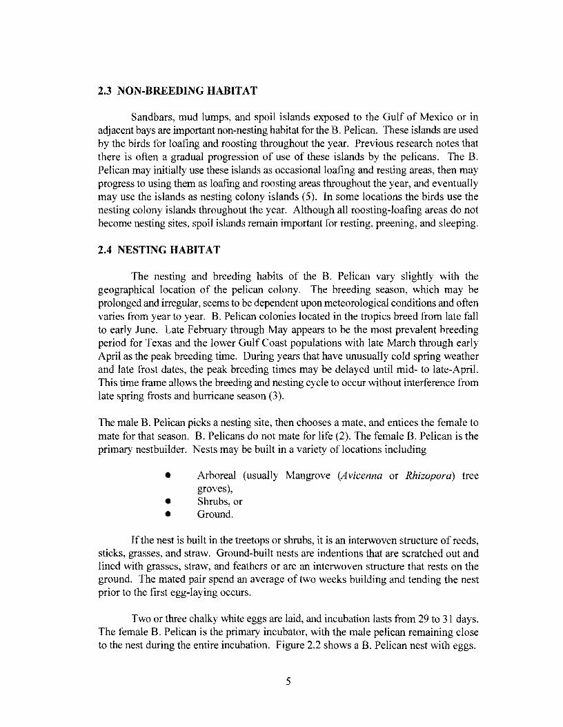
The nesting and breeding habits of the B. Pelican vary slightly with the geographical location of the pelican colony. The breeding season, which may be prolonged and irregular, seems to be dependent upon meteorological conditions and often varies from year to year. B. Pelican colonies located in the tropics breed from late fall to early June. Late February through May appears to be the most prevalent breeding period for Texas and the lower Gulf Coast populations with late March through early April as the peak breeding time. During years that have unusually cold spring weather and late frost dates, the peak breeding times may be delayed until mid- to late-April. This time frame allows the breeding and nesting cycle to occur without interference from late spring frosts and hurricane season (3).
The male B. Pelican picks a nesting site, then chooses a mate, and entices the female to mate for that season. B. Pelicans do not mate for life (2). The female B. Pelican is the primary nestbuilder. Nests may be built in a variety of locations including
• Arboreal (usually Mangrove (Avicenna or Rhizopora) tree groves),
• Shrubs, or • Ground.
If the nest is built in the treetops or shrubs, it is an interwoven structure of reeds, sticks, grasses, and straw. Ground-built nests are indentions that are scratched out and lined with grasses, straw, and feathers or are an interwoven structure that rests on the ground. The mated pair spend an average of two weeks building and tending the nest prior to the first egg-laying occurs.
Two or three chalky white eggs are laid, and incubation lasts from 29 to 31 days. The female B. Pelican is the primary incubator, with the male pelican remaining close to the nest during the entire incubation. Figure 2.2 shows a B. Pelican nest with eggs.
5
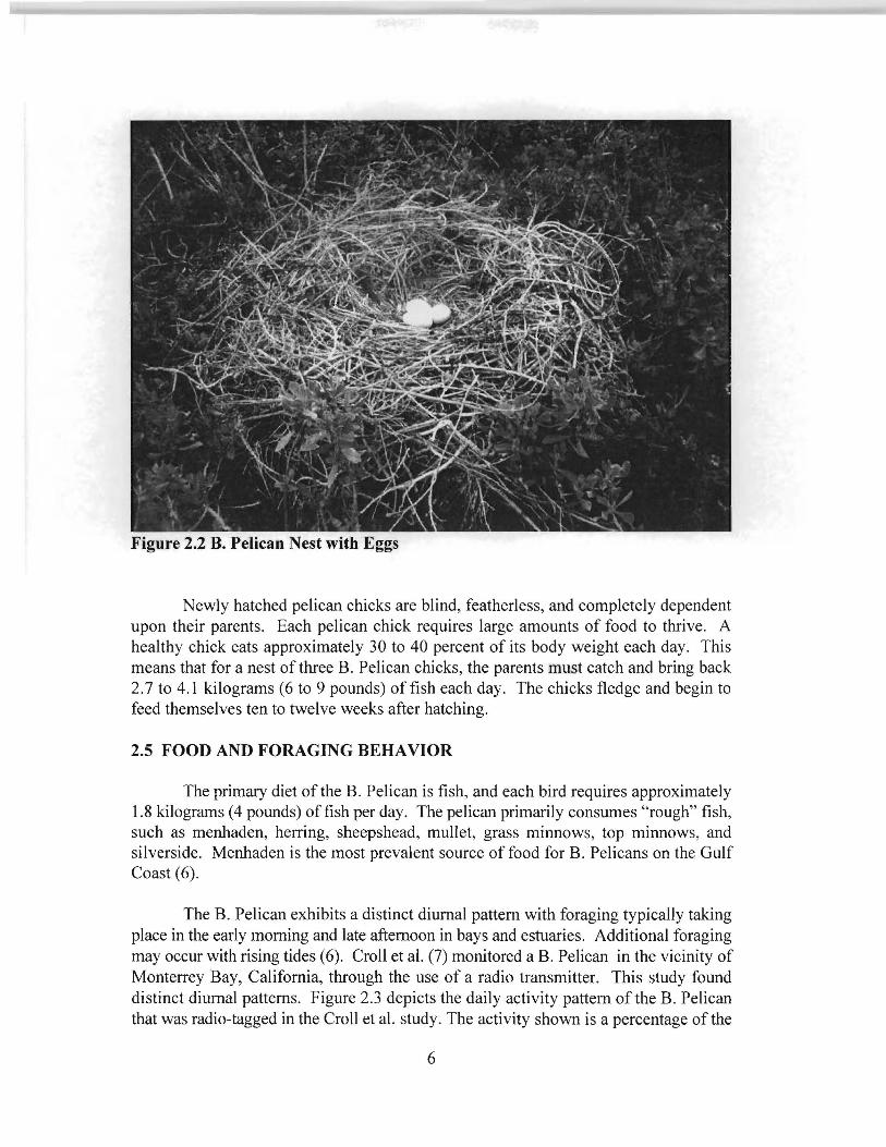
Figure 2.2 B. Pelican Nest with Eggs
Newly hatched pelican chicks are blind, featherless, and completely dependent upon their parents. Each pelican chick requires large amounts of food to thrive. A healthy chick eats approximately 30 to 40 percent of its body weight each day. This means that for a nest of three B. Pelican chicks, the parents must catch and bring back 2. 7 to 4.1 kilograms (6 to 9 pounds) of fish each day. The chicks fledge and begin to feed themselves ten to twelve weeks after hatching.
2.5 FOOD AND FORAGING BEHAVIOR
The primary diet of the B. Pelican is fish, and each bird requires approximately 1.8 kilograms (4 pounds) offish per day. The pelican primarily consumes "rough" fish, such as menhaden, herring, sheepshead, mullet, grass minnows, top minnows, and silverside. Menhaden is the most prevalent source of food for B. Pelicans on the Gulf Coast (6).
The B. Pelican exhibits a distinct diurnal pattern with foraging typically taking place in the early morning and late afternoon in bays and estuaries. Additional foraging may occur with rising tides (6). Croll et al. (7) monitored a B. Pelican in the vicinity of Monterrey Bay, California, through the use of a radio transmitter. This study found distinct diurnal patterns. Figure 2.3 depicts the daily activity pattern of the B. Pelican that was radio-tagged in the Croll et al. study. The activity shown is a percentage of the
6

total monitoring time of 68.8 hours. Of the total time observed, excluding roosting time, the bird was active for 22. 7 hours and inactive for 46.1 hours. Briggs et al. (8) found a similar diurnal pattern in B. Pelicans in Elkhorn Slough, California. Hundreds of B. Pelicans observed in this study left the roost in the morning and returned at dusk.
0 100 w > a: w f8 0 w ~ i== 50 u.. 0 1-z w 0 a: w 0...
0 04:30 07:30 10:30 13:30 16:30
TIME OF DAY 19:30
Source: Croll et al. (7) Figure 2.3 Daily Activity Pattern of A Radio-Tagged Brown Pelican
Foraging pelicans fly or glide slowly above the water searching for prey. The B. Pelican has extremely keen eyesight, and often flies at heights of 18.2 to 21.3 meters (60 to 70 feet) when foraging (1). Most of the fish caught by the B. Pelican are in schools swimming within a foot or two of the surface. Once prey is sighted and the individual fish to be taken is selected, the B. Pelican dives into the water. The pelican often dives from a height of9. l to 18.2 meters (30 to 60 feet). The shock of hitting the water from that height would kill many birds; however, the B. Pelican is equipped with air sacs that are just beneath the skin which cushion the impact. The B. Pelican is the only pelican species that dives for fish (9).
7

The plunge dive begins with the wings of the B. Pelican folded halfuray back, feet forward, and neck tucked. During the dive the pelican may rotate its entire body by wingtip movement to correct for lateral movement of the prey. Speeds of 18 meters per second (59 feet per second) may be reached during the dive (3). The B. Pelican enters the water with the tip of the bill pointed downward, and the expandable pouch tightly closed. Once the bill enters the water the pelican opens its mouth, expands its pouch, and scoops as many fish as can be quickly caught. The gular pouch of the B. Pelican holds up to 10 liters (2 .2 gallons) of water and fish. As the pelican slowly raises its head above the surface of the water, it allows the water to drain from the pouch leaving the fish. If the bird has an unsuccessful dive, it will rapidly pull its head out of the water with the bill open (10).
2.6 FLIGHT PATTERNS FOR THE BROWN PELICAN
The wingspread of the B. Pelican ranges from 1.9 to 2.3 meters (6.5 to 7.5 feet). They can fly in calm winds up to 56.3 km/h (35 mph). To become airborne, the B. Pelican must flap its wings a number of times due to its size and weight. The pelicans seem to prefer taking off into a headwind of 8-13 km/h (5- 8 mph) or more (11 ).
An airborne B. Pelican flies with its head resting on its back, using slow, powerful wingbeats. The B. Pelican usually flies in flocks, utilizing gliding or flapgliding to maintain a V or an angled slash line formation. Each bird "drafts" or utilizes the turbulence created by birds flying at the head of the formation for extra lift. Because this type of formation flying requires the lead bird to expend additional effort, pelicans in the formation will switch positions during flight.
When flying, the B. Pelican appears to be particularly aware of, and responsive to, air currents and thermals. The pelican is particularly adept in utilizing these phenomena in flight through soaring and guiding. Pennycuick observed in a study in 1983, that the B. Pelican soars in thermals in the course of moving between roosting and feeding areas. He describes flocks of pelicans flying in formation that "would maintain their coherence for short periods of slope soaring, all the birds in the flock turning together at the end of the slope. In thermals the flock structure gradually degenerated into a milling mass of pelicans circling in either direction" (12). Pennycuick also noted that although pelicans soar on thermals as an energy efficient method of migration, they also often soar on thermals for no apparent reason other than perhaps gaining high altitude to gain visual perspectives on their surroundings (12).
In 1978, fifteen B. Pelicans were rescued in Yuma, Arizona. The pelicans were caught in thermals associated with a storm in Mexico's Gulf of California and were carried inland. The U. S. Fish and Wildlife Service noted that the pelicans were found on the highway because "looking for a place to land, they often mistake pavement for rocks or water" (2).
8

Brown (1983) reports that when thermals are absent, or when headwinds become a problem for the pelican, the bird will descend to almost sea level and utilize a technique known as "troughing." With wingtips almost dipping into the water on each downbeat, the pelican glides on a cushion of air that is created between the bird and the water. Troughing reduces the effort required by the bird (2).
The research team for this study observed both soaring and troughing techniques utilized by B. Pelicans in the Port Isabel/South Padre Island area. B. Pelicans flying in V and angle slash formations were also observed. Formation flying was especially prevalent in evening hours when the B. Pelicans were heading to the northeast and the roosting sites. The degenerations of formations into milling masses as described by Pennycuick were also observed as the pelicans approached the Port Isabel side of the Queen Isabella Bridge. This may indicate the presence of thermals near the bridge.
9


3.0 HISTORY AND STATUS OF THE BROWN PELICAN
3.1 HISTORY OF THE BROWN PELICAN IN TEXAS
In 1918 T. Gilbert Pearson (13) estimated that the adult B. Pelican population forthe Gulf Coast between Corpus Christi, Texas, and Key West, Florida, was 65,000 birds. The Texas population of the B. Pelican consisted of 17 colonies in 1918 (14). Pearson estimated the Texas population to be approximately 5,000 birds in 1921 (15). The B. Pelican has few natural enemies; however, the population has suffered a series of serious declines in the last hundred years.
The first serious decline in the l 930's was caused by fishermen (14, 16). During food shortages of the Depression and Post World War I era, fishermen complained that pelicans were eating a million dollars of "food" fish every day, and hurting the commercial fishing industry. These complaints resulted in fishermen killing the pelican whenever they could, resulting in the slaughter of thousands of pelicans (1 ). The estimated population ofB. Pelicans in Texas by 1939 was 500 (14 ).
This slaughter forced scientists and naturalists to investigate the eating habits of pelicans. Biologists collected almost 4,000 species of fish from samples of pelicans. Of the thousands of fish examined, only 27 food fish were found (17). A. M. Bailey (7) reported that a joint study conducted in Louisiana and Texas by the Department of Conservation of Louisiana and the Louisiana State Museum found similar results. All stomach samples collected from B. Pelicans consisted primarily of menhaden, which is a small bony sardine.
A second more serious decline became apparent in the early l 950's. This second decline was attributed a combination of factors including severe weather conditions, disease, and exposure to chlorinated hydrocarbon pesticides (18). Goldman reported that "Brown Pelicans that had a somewhat-below-normal nesting season had a repeat this year with hundreds of adults having been killed by the freeze of January 29 to February 3, 1951" (19). By 1962 no B. Pelicans were reported in locations that formerly served as either wintering or breeding areas. These cold spells in conjunction with the effects of the pesticide DDT, which caused eggshell thinning, devastated the population of the B. Pelican in Texas. Because the dwindling population was not able to reproduce, the number of pelicans dropped to less than 100 birds during the years 1967-1974 (20). In 1970 the U.S. Department oflnterior placed the Texas subspecies of the Eastern Brown Pelican on the endangered species list.
Since 1971 the B. Pelican has made a dramatic recovery in Texas due to reduced contaminant levels. A review of the Audubon Christmas Bird Counts from 1974 to 1994 shows the recovery of the B. Pelican in the Texas as shown in Figure 3.1 (21).
11

3000
2500
"D s s::. .e> 2000 en en c
"' .Y Qi 1500 Q.
al -0 Q; 1000 .c E ::J z
500
0
Texas
9 7 0 29 15 21
384 316
628 514
2843
1566
1046
654
74 75 76 77 78 79 80 81 82 83 84 85 86 87 88 89 90 91 92 93 94 Year
Figure 3.1 B. Pelican Sightings on Texas Coast (1974-1994)
The Audubon Christmas Bird Count (CBC), which began in 1900, is one of the oldest and largest wildlife surveys in the world. The CBC is an early winter survey of birds sponsored by the National Audubon Society. It is designed as a series of circular area counts that are 24.1 kilometers (15 miles) in diameter. Varying numbers of volunteers count all of the birds that they see in the circle during a single day that is within 2 weeks of December 25. CBCs, which may involve over 40,000 volunteers each year, provide a snapshot of population estimates during a specified time period (22). CBC's population estimates may vary from year to year due to the number of volunteers, the weather the day of the count, and other variables. However the data gathered during the CBCs do indicate trends in populations over a period of time.
The 1974 CBC showed that only 9 birds were sighted in Texas. In 1976 there were no B. Pelicans sighted in Texas. Since 1977, when 29 birds were sighted, the number of birds has continued to steadily increase. Colonies have become established in the Rockport area on two small reefs and Pelican Island near Corpus Christi (2). In 1993, 2,843 B. Pelicans were sighted in Texas. The estimated population of the B. Pelican in Texas for 1995 is 2400 breeding pairs
12

(20). There are currently 3 established Pelican nesting colonies for B. Pelicans in Texas. These colonies are on Pelican Island in Corpus Christi Bay, Sundown Island in Matagorda Bay, and Little Pelican Island in Galveston Bay. The limiting factors in Texas for an increased B. Pelican population and an increase in nesting colonies now appear to be human disturbance and restricted habitat (23). The 1994 CBC shows that the B. Pelican was sighted in 15 different locations along the Texas Coast.
Figure 3.2 depicts the number of birds shown for the South Texas Gulf Coast. This region encompasses the entire Padre Island area including Corpus Christi. The Pelican Island nesting site is included in this portion of the Audubon CBC. Pelican Island is a dredge spoil island that is located off Ingleside-on-the-Bay, along the Corpus Christi Ship Channel. The entire nesting population for Texas was located on Pelican Island from 1984 to 1988. It currently serves as one of the established nesting sites for the Brown Pelican in Texas.
140 11
South Texas I ' L___;
135
128 124
120 110 111 -
"O 104 ~
s 100 .r:. .5!> UJ fl) c 80 tV .~ 'ii 0..
m 60 -0
58 -~
'-CD
..0 40 E :::J z
20 I
I I I I I I I I I I i
8 ~I~ 0 ,o o o 7 + o o o on o 111 11111--r-
74 75 76 77 78 79 BO 81 82 83 84 85 86 87 88 89 90 91 92 93 94 Year
Figure 3.2 B. Pelican Sightings in South Texas (1974-1994)
13

Figure 3.3 graphically depicts the CBC observations for the Port Isabel/Brownsville area. It includes the Brownsville Coastal Tip Circular Area and the Laguna Atacosa Circular area. The Port Isabel/South Padre Island study area is generally located between these two circular areas. B. Pelicans were not observed in this area by the CBCs until 1985. The numbers for the Port Isabel/Brownsville area also increased steadily between 1985 and 1993. The 1993 CBC recorded 86 sightings for this area and the 1994 CBC recorded 78 B. Pelican sightings. Current winter population estimates by local wildlife experts are between 200 and 300 B. Pelicans.
140 Brownsville/Port Isabel
120
105 't:J -.! 100 .r:. .9 (/) .,,, c ca .9 1D a. m -0 .... CD .c E :::J z
93 -88 - 86
80 78 ~
60 55 53 -I n
40 I 39 -
20 12
0 _ a a ~· a a a a a a a a a n I I I I I I I I I I I I I I I I I I
74 75 76 77 78 79 80 81 82 83 84 85 86 87 88 89 90 91 92 93 94 Year
Figure 3.3 B. Pelican Sightings in Brownsville/Port Isabel/South Padre Island Area (1974- 1994)
3.2 HISTORY OF MORTALITY TRENDS IN THE BROWN PELICAN
In order to understand and properly address the matter of traffic mortalities of the B. Pelican on the Queen Isabella Causeway Bridge, the issue of all mortality threats to the pelican must be examined. A life table for the B. Pelican has not been completed, although some
14

studies have been conducted in this area. The following paragraphs discuss general mortality threats to the B. Pelican.
3.2.1 Nesting and Reproductive Success of the B. Pelican
Schreiber (24) conducted a study of nesting and reproductive success in the B. Pelican in Florida in 1979. The study of328 nests with a total of 860 eggs had a 71 percent (610 chicks) hatch rate. However, only 52 percent of the hatched chicks (318) fledged. This result shows an overall success rate, eggs laid that produce fledged young, of 37 percent. This success rate equates to an overall mortality rate of 63 percent and a 48 percent mortality rate for hatched chicks.
Henny in 1972 conducted a study that included first-year mortality rates for the B. Pelican (25). This study found a mortality rate of about 70 percent during the first year. This is similar to the to the mortality rate described by Schreiber.
During the nesting season, one of the most significant threats to B. Pelican survival is man. Human intrusion, however slight, at nesting sites during the early phase of the nesting cycle may disturb breeding and cause the birds to abandon the nest Once the nest is abandoned, the B. Pelican may not attempt to establish another nest If the pelicans do renest, the likeihood of success in producing fledged B. Pelican chicks in the new nest is greatly reduced. Other threats to nesting sites may include racoons, coyotes, crows, gulls, and fire ants. These predators will raid the nests for eggs.
Although human disturbance and intrusion at nesting sites are causes for concern and should be avoided, the limits of tolerance for the B. Pelicans towards human activity near nesting sites is not clear. In recent years in Florida, large colonies of B. Pelicans have nested in close proximity to established human activity centers. At Port Orange, a colony was established at the edge of the heavily traveled lntracoastal Waterway, approximately 150 yards from a drawbridge. Pelicans built nests near an occupied home at Fort Pierce, and at Cocoa Beach a nesting colony was established within the city limits (2).
Pelican Island, Texas, is a dredge island that is adjacent to the Corpus Christi Ship Channel. During the 1996 nesting cycle, a large nesting colony of B. Pelicans was disturbed. The island, which is owned by the Port of Corpus Christi Authority, is a part of the National Audubon Sanctuary System. Although there was no evidence that the pelicans were maliciously disturbed, more than 200 of the 889 nests on the Island had been abandoned. This resulted in a hatch rate 60 percent below recent years (26).
3.2.2 Mortality Among the Newly Hatched B. Pelican
Once the B. Pelican chick is hatched, the major threats are predators and the weather. The B. Pelican chick is susceptible to overexposure to the sun during the first few weeks of life.
15

Mosquitoes and fire ant infestations at the nesting site also pose danger to the newly hatched chick. Since during the summer, the B. Pelican often nests near the waters edge, hurricanes and tropical storms pose a threat to nest sites.
Starvation is also a problem for newly hatched chicks. If fish are not in abundant supply, the parents may not be able to supply adequate amounts of food for hatchlings. Each baby bird requires 4 pounds of fish per day, and will consume approximately 150 pounds of fish in the 9 weeks before it fledges ( 17). If there are inadequate supplies of fish in the area, the smaller or weaker hatchlings may not survive. Declines in menhaden and other forage fish populations, due to fish kills and red tide occurrences, may affect the mortality rate of the B. Pelican.
3.2.3 Mortality Among the Immature B. Pelican
Newly fledged B. Pelicans have a small amount of stored fat that has been accumulated during the first few months of life. However, since the young bird is no longer dependent upon its parents for food, it must immediately learn to successfully forage. Arnqvist documented that the success rate for prey capture is a learned skill. Adult pelicans averaged a success rate of approximately 82 percent, while immature pelicans averaged a success rate of approximately 68 percent (l 0). This difference in success rate confirmed an earlier study by Orians in 1969 that found hunting skills to be age related (27). A 22 percent mortality rate has been estimated for immature B. Pelicans during the first two years after fledging (3).
3.2.4 Mortality Among the Adult B. Pelican
After the first few years of life, the annual mortality rate for the B. Pelican drops significantly. Mortalities of adult pelicans can be produced by a number causes, including oil spills, pesticides, fishing hooks, fishing lines, guns, cars, boats, power lines, disease, predation, starvation, weather, and in some cases freak accidents. Schreiber and Mock documented the causes of mortality for B. Pelicans that were banded and recovered in Florida and the Carolinas. Table 3.1, illustrates mortality causes found by Schreiber and Mock (28).
3.2.4.1 Disease and "Die-0.ffe"
Disease and "die-offs" precipitated by starvation, and in some instances, unknown causes, comprise a large portion of adult B. Pelican mortalities. Documented diseases and die-offs that have affected B. Pelican populations include viral diseases, botulism, Escherichia coli (E. coli), toxic effects of "red tide", major marine ecological disturbances (MMED), weather related conditions, and the ingestion of organophosphate. Deaths caused by diseases and die-offs are often isolated and non-recurring. Often these events go undocumented.
The cause of the mortalities is not easily documented if the event is not reported in a timely manner. Collazo (29) noted the death of 125 B. Pelicans in the vicinity of Dorado Lagoon in Puerto Rico, in the spring and summer of 1982. These deaths were apparently caused by
16

organophosphate contamination in the lagoon. Collazo also documented the deaths of 25 B. Pelicans in the Santa Theresa Lagoon, Humacao, in November and December 1992. These deaths were attributed to botulism (29).
Table 3.1 Causes of Mortality for Banded B. Pelicans in Florida and the Carolinas
Florida Carolinas
Cause Nestling 1st Adult Nestling 1st Adult Total Year Year
Unknown 299 151 314 1156 25 35 1980 (found dead)
"Natural Causes" 60 12 39 154 7 5 277 (predation, disease, starvation, etc.)
Hit by Vehicle 3 1 4 11 0 1 20
Shot 12 20 45 39 0 5 121
Fishing Gear (hooked, 49 27 46 70 3 2 197 or fishing line)
Oil/Tar 1 0 0 2 0 0 3
Traps 0 1 0 1 0 0 2
Total 424 212 448 1433 36 48 2601
A die-off of B. Pelicans in Puerto Rico and the U. S. Virgin Islands in 1989 was reported by Williams et al (30). A total of 19 birds were reported dead during a time period beginning January 22, 1989, and ending March 28, 1989. The deaths, which occurred at 8 separate locations, happened the same time as a widespread coral-reef bleaching bout transpired in Puerto Rico, the U.S. Virgin Islands, and Mona Island. A mass mortality of herrings in St. Vincent and Barbados also occurred during this same time period. All of these events were eventually attributed to an MMED of unknown origin.
Die offs or rapid depletion of the species of fish (herring, menhaden, and anchovies) that serve as the major food source for the B. Pelican result in starvation or rapid declines in the pelican population. These declines are especially damaging to the population of the B. Pelican if they occur during breeding season, when pelicans are fishing for both themselves and their newly hatched chicks.
17

As previously noted, B. Pelicans are vulnerable to cold weather and may die from exposure during extreme cold spells. Goldman reported that "Brown Pelicans that had a somewhat-below-normal nesting season had a repeat this year with hundreds of adults having been killed by the freeze of January 29 to February 3, 1951" (19). In December 1989, a number of B. Pelicans died in the South Texas area due to cold weather. Eighteen B. Pelicans were found on Dressing Point, seven B. Pelican carcasses were found on the Aransas National Wildlife Refuge, and at least two others were found along the coast. Necropsies were performed on the B. Pelicans found on Dressing Point and results indicated that the cause of death was freezing.
3.2.4.2 Monofilament Fishing Line and Fish Hooks
The most prevalent manmade hazard to the B. Pelican has received little publicity. It is fishing gear, specifically monofilament fishing line and fish hooks. Monofilament fishing line, which is composed of a single strand of chemically produced line, is incredibly strong, lightweight, and lasts for years. B. Pelicans can get snared in monofilament line that has been discarded by fisherman from a backlashed reel.
Injuries from fish hooks usually occur in one of two ways. First, the B. Pelican may spot and attempt to catch a fish that is hooked on a trotline. Trotlines are fishing lines attached to floats that are left unattended. The B. Pelican then becomes hooked by the line and dies. The second way is when a B. Pelican is attracted by the bait on a fisherman's line and becomes hooked. Rather than fight a hooked pelican, some fishermen cut the line, leaving the pelican hooked and trailing a length of mono filament line. The line can then become entangled in trees or shrubs and the pelican can die from strangulation, starvation, or exposure. Injuries caused by hooks can also lead to serious infections (2).
A B. Pelican that has been nicknamed "Captain Hook" was found in October 1996 on South Padre Island with a large fish hook stuck in his beak and fishing line wrapped around his bill. Employees at a local restaurant rescued the pelican, removed the hook and line, and nursed the pelican back to health (31 ). Another B. Pelican, nicknamed "Duffuss", resides on the Port Isabel side of the bridge. Duffuss is a young bird that is missing part of a wing. Local fishermen and the owner of a pier next to the bridge stated the bird lost the wing when it was tangled in monofilament line. The bird stays near the bridge and "begs" fish from the fishermen that fish from the pier and from passengers on the fishing boat that docks on the south side of the bridge.
The TTI research team found a dead B. Pelican on a spoil island in the Laguna Madre during the May 1997 field expedition. The pelican carcass, shown in Figure 3.4, was found with the feet entangled in a piece monofilament fishing line with weight and float, that was ensnared in vegetation. It was surmised that the pelican died of either starvation or exposure.
18

Figure 3.4 Dead B. Pelican Ensnared in Monofilament Fishing Line
3.2.4.3 Other Mortality Causes
Other less known dangers for the B. Pelicans include power lines and boats. Power transmission lines are almost invisible to pelicans in flight. When the pelicans strike the lines at any speed, the lines may cause serious injury or death. B. Pelicans also can become accustomed to the noise and proximity of boats. The birds will then tend to ignore the boats, especially when they are foraging. If the boat swerves too near the pelican, the bird simply does not have time to get out of the way.
An August 24, 1997, article in the Houston Chronicle documented the death of ten B. Pelicans at Matagorda Beach. A total of 12 birds were shot in the neck and pouch area. Ten of the birds died and two were able to be saved through surgical procedures. One wounded B. Pelican lost a portion of a wing and cannot be released back into the wild. The wing of the other B. Pelican may be saved and the bird may be released from captivity after treatment and recovery at the wildlife center at Burroughs Park (32).
19


4.0 FIELD OBSERVATIONS IN THE SOUTH PADRE ISLAND AREA
4.1 QUEEN ISABELLA CAUSEWAY
The Queen Isabella Causeway, also known as either the South Padre Island Bridge or the Park Road I 00 (Pl 00) bridge, is a 3.86 kilometer (2.4 mile) long bridge that connects Port Isabel with South Padre Island, Texas. The bridge has 4-lanes with a center span rising 25.6 meter (84 feet) above the Gulflntracoastal Waterway. The bridge, which was completed in 1974, is the only access to the island for vehicles.
4.1.1 Existing Traffic Control Devices
TxDOT has used several signing methods in an attempt to alert motorists to the possibility of B. Pelicans being on the deck of the Queen Isabella Causeway. First, a series of static signs that stated "Watch for Brown Pelicans - Endangered Species," were placed on each side of the causeway. These signs were followed by a new version of signs that added two flashing beacons. These signs are depicted in Figure 4.1. The new signs removed the supplemental placard of "Endangered Species" and replaced it with a "45 mph." placard. This placard was an attempt to reduce the speed of vehicles traveling on the section of the bridge where a majority of mortalities
Figure 4.1 "Watch for Pelicans When .Flashing" Signs
21

were thought to occur. Additional signs were placed on the elevated section of the causeway which attempted to further slow the traffic to 48 km/h (30 mph.) Problems have occurred when signs were placed on the bridge railing. The large gusts of wind, which are common to the area, have blown several sets of these signs off the bridge.
In addition to the flashing signs, overhead changeable message signs (CMS) have been constructed on each side of the Causeway. Figure 4.2 shows the CMS on the South Padre Island side of the causeway. These signs are primarily used for hurricane evacuation information, but serve other functions. One function involves alerting motorists when weather conditions are favorable for an increased possibility of B. Pelican mortalities. There are two messages used to warn motorist. The first message simply states, "WATCH FOR PELICANS - 45 MPH." The second message gives additional instruction by adding, "CAUTION!! - REDUCE SPEED" to the original message. At other times, when the sign is not being used for hurricane evacuation information or for B. Pelican warnings, it is being used to broadcast drive friendly messages along with the current time.
Figure 4.2 Existing Changeable Message Sign on South Padre Island
4.1.2 Existing Traffic Conditions
Traffic volumes over the past years have steadily increased from an average annual daily traffic (AADT) volume of 15637 vehicles per day (vpd) in 1989 to 18722 vpd in 1996. This is a 2.6% increase per year. The heaviest volumes occur in the months of March, due to spring
22

break, and July, due to summer vacations. Fortunately the heaviest volumes occur when the probability of B. Pelican mortality is the lowest. Table 4.1 presents the average daily volumes for each month from January, l 989 to March, 1997.
Table 4.1 Avera2e Daily Traffic for the Queen Isabella Causeway (vpd)
J~ 1990 1991 1992 1993 1994 1995 1996 199.?__J
1: January 13551 13213 12608 12489 13238 14818 16319 16683 16388 I
! February 16085 17354 16647 17172 17477 18892 20132 20256 20157
March I
23360 21226 24449 21652 21427 24684 23339 23523 25183
April 14215 16643 13651 16603 18361 18430 19228 18766
May I 15298 15480 15694 15835 16964 18658 19177 19200 I
June 17843 18954 18448 19012 17805 21063 21887 22872
July 21568 20925 21357 22928 24530 26252 26738
August 19736 18338 19599 19713 20601 20514 18834 19845
September 13342 12359 12383 13559 14424 16022 16080 15453
October 11
11307 11447 11394 12089 13023 14066 14124 13868 I November I! 10916 10859 10434 10565 11277 13264 12810 13409
December I 10421 10616 10821 11346 12301 13772 13361 13790 I ~ AADT 15637 15618 15624 16080 16786 18370 18502 18722 1i
Shaded value is an estimate due to counter malfunction.
The posted speed limit on the causeway is 88 km/h (55 mph). Observations on the bridge have shown that the speed limit is regularly disregarded, except on the section closest to the end of each side of the causeway. At the ends of the causeway the speed limit is obeyed because it is enforced by the local police departments. The causeway itself is under the jurisdiction of the county sheriff's department. But the location of the causeway is many kilometers from any of the other areas under the jurisdiction of the sheriffs department. In addition to this, the causeway itself is not conducive to speed enforcement. The lack of shoulders prevents motorist from being pulled over on the bridge and the lack of a tum-around on the bridge prevents law enforcement officials from turning around anywhere but at the end of the causeway. Therefore, speed enforcement on the causeway is not a high priority.
4.2 INTERACTION OF BROWN PELICANS WITH THE QUEEN ISABELLA CAUSEWAY
In a previous study of the problem of mortalities ofB. Pelicans on the Queen Isabella Causeway, Owens et al. (33) stated that there was evidence that some B. Pelicans remain south
23

of the bridge at night. The report chronicled an aerial survey conducted by the Texas Parks and Wildlife Department on October 26, 1988. The survey also recorded observations of B. Pelicans roosting on the Central Power and Light (CP&L) transmission lines near the west end, Padre Island side, of the Old Causeway. The birds were observed just prior to dusk, after dark, and early morning. Roosting on the wires was later confirmed when a group of volunteers, who were organized for the study, observed B. Pelicans roosting after dark in the same general area October 20-21, 1989. The current research team confim1ed that the B. Pelicans continued to roost on these lines until the removal of the power transmission lines in the winter of 1997.
The B. Pelicans, which can be observed interacting with the Causeway daily, are habitual in their daily actions. Deviations from daily routines seem to be weather related. For the following discussion, one may refer to Figure 4.3 in order to visualize the B. Pelican' s movement. The figure depicts the Causeway and the southern end of the Laguna Madre. The map in the figure is correctly oriented.
Figure 4.3 Queen Isabella Causeway and the Laguna Madre
Based on nwnerous observations, a typical day begins with the B. Pelicans arriving either individually, or in small flocks of 3 to 5 birds, roughly 15 minutes after first light (6:45 a.m. -7:00 a.m. in the winter months). The birds will continue to arrive until about 9 a.m. Summer observations were similar with the times adjusted to reflect earlier first light. However, there was a smaller number of birds counted in late spring and summer. The birds approach the bridge area from the northwest. Most birds cross the bridge near the center span on the Port Isabel side.
24

Approximately 60 percent of the pelicans fly over the bridge and 40 percent fly under the bridge. The number of birds that fly under the bridge is dependent upon whether the water is calm or choppy and the direction of the wind. If the water is calm the birds tend to fly in at a very low level, just above the water, and therefore a greater number fly under the bridge. If the water is choppy, the pelicans fly at higher altitudes, and a greater number fly over the bridge. If the wind is at the backs of the pelicans, they tend to fly at a higher altitude and use the wind to soar. If the pelicans are flying into the wind, they fly at as low as possible or practical.
The pelicans can be observed returning to their roosting areas in the late afternoon, just prior to sunset. In winter, flocks of pelicans flying in formation of 3 to 30 birds, begin crossing the bridge to return to their roosting area beginning approximately 5: 15 p.m. This time may be earlier on rainy or overcast days. The peak winter evening observation times are between 5:30 p.m. and 6: 15 p.m.
As the B. Pelicans approach the bridge, their interaction with the bridge seems to depend upon their flight level. If the birds are flying at an altitude well above the bridge and the light standards, they simply fly over the bridge with no noticeable interaction. If the pelicans are flying at a very low level, just above the water, they fly under the bridge with little interaction or hesitation. However, if the birds approach the bridge at an altitude that is level or just below or above the level of the bridge (below the light standards), there is a noticeable interaction. As the B. Pelicans near the bridge they often break formation and begin a milling action, similar to those described by Pennycuick in 1983. He describes flocks of pelicans flying in formation that:
would maintain their coherence for short periods of slope soaring, all the birds in the flock turning together at the end of the slope. In thermals the flock structure gradually degenerated into a milling mass of pelicans circling in either direction (12).
B. Pelicans observed approaching the bridge at an altitude even with the bridge or higher than the bridge but below the light standard, often break formation. The birds then fly back and forth parallel to the bridge before crossing the bridge deck. This action was also noted in the previous research study on the bridge by Owens et al (33).
4.3 BROWN PELICAN LOAFING ACTIVITIES IN THE SOUTH PADRE ISLAND AREA
The B. Pelican utilizes a number of areas in the Port Isabel/South Padre Island area on a regular basis for loafing and non-nesting activities. These sites are often close to fishing areas, or in some cases, close to areas where fisherman clean the day's catch. Figure 4.4 is a map depicting the loafing sites in the immediate vicinity of the bridge. B. Pelicans have been observed using mudflats on the Port Isabel side near Isabella Point; mudflats near the swing bridge entrance to the small boat turning basin; Southpoint Marina; utility lines, pilings, and jetties from the old Padre Island Bridge; pilings and bridge piers of the Queen Isabella
25

Causeway; spoil islands in the small boat turning basin near Outdoor Resorts; and the dock area for the Sea Ranch Marina (Figures 4.5 and 4.6) on South Padre Island.
' BAHM. • . • /
Figure 4.4 Observed Loafing Sites for B. Pelican in the Port Isabel/South Padre Island Area
Figure 4.5 Pelicans on Docks at Sea Ranch Marina on South Padre Island
The research team also observed loafing activities at other sites in the area that are not in the immediate vicinity of the bridge. These sites included White Sands Marina, mud flats and sandbars just north of the South Padre Island Convention Center, the County Park, and various pilings, mud lumps, and spoil islands in the Laguna Madre north of the bridge.
26

4.4 BROWN PELICAN FORAGING ACTIVITIES IN THE SOUTH PADRE ISLAND AREA
As previously noted, B. Pelicans begin arriving at the Port Isabel/South Padre Island area approximately 15 to 20 minutes before sunrise. After crossing the bridge, the pelicans immediately begin to fish directly south of the bridge. The birds continue to fish in the area near the bridge until approximately I 0:00 or 11 :00 a.m. The pelicans then leave for their loafing areas or continue on to other fishing areas. If the weather is overcast, many of the birds tend to stay in the bay or the immediate vicinity. If the weather is sunny, the birds will continue on to the southern portions of the bay or to the surf side of the Island.
Figure 4.6 Pelicans Loafing at Sea Ranch Marina on South Padre Island
The ITI research team observed fishing activities by the B. Pelican throughout the day in various locations within the South Padre Island area. Pelicans were observed fishing in the surf in various locations on Gulf side of the island, at Boca Chica, in South Bay, in the Laguna Madre, and in the bay just south of the bridge. When the days are cold, rainy or overcast in the winter months, the pelicans often remain in the bay area just south of the bridge for the majority of the day. In the late afternoon when the pelicans begin to return to their roost areas, some of the pelicans often linger in the bridge area fishing.
27

4.5 ROOST AREAS IN THE LAGUNA MADRE AND SOUTH PADRE ISLAND AREA
The researchers observed groups of B. Pelicans roosting in two separate locations in the Laguna Madre and South Padre Island area. The first roosting location was the "dead" CP&L transmission lines near the old bridge. The previous TTI study by Owens, et al. (33) documented that the B. Pelicans were using the lines as a roosting site as early as 1989. In August 1996 approximately thirty B. Pelicans were sighted roosting on the lines. In November 1996 researchers counted approximately 450 B. Pelicans roosting on the lines. The large increase in population was attributed to a seasonal influx of B. Pelicans from Mexico that winter in the area. B. Pelicans continued to roost on the transmission lines until the lines were removed in early 1997
The second roosting area for B. Pelicans is a group of three large spoil islands some 11 to 13 kilometers (7 to 8 miles) north of the bridge. These lightly vegetated spoil islands (Figure 4.7) are near flashing green beacon number 115 on the lntracoastal Waterway (Figure 4.8). The islands can also be identified by their proximity to the Collins home, which is a prominent feature on the mainland shoreline of the Laguna Madre. The home is on a promontory point that extends from the mainland just south of Story Cove. The spoil islands were identified as loafing areas and possible roost sites during an August 1996 field trip when approximately 250 B. Pelicans were sighted loafing on the second spoil island. The status of these islands was verified during a November 1996 field expedition. Approximately 200 birds were sited on the islands.
Figure 4.7 Spoil Island in Laguna Madre
28
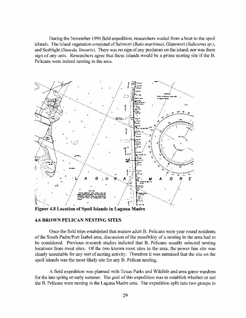
During the November 1996 field expedition, researchers waded from a boat to the spoil islands. The island vegetation consisted ofSaltwort (Batis maritima), Glasswort (Salicorna sp.), and Seablight (Suaeda, linearis). There was no sign of any predators on the island; nor was there sign of any ants. Researchers agree that these islands would be a prime nesting site if the B. Pelicans were indeed nesting in the area.
. ""
' .
I I ,
4.6 BROWN PELICAN NESTING SITES
Once the field trips established that mature adult B. Pelicans were year round residents of the South Padre/Port Isabel area, discussion of the possibility of a nesting in the area had to be considered. Previous research studies indicted that B. Pelicans usually selected nesting locations from roost sites. Of the two known roost sites in the area, the power line site was clearly unsuitable for any sort of nesting activity. Therefore it was surmised that the site on the spoil islands was the most likely site for any B. Pelican nesting.
A field expedition was planned with Texas Parks and Wildlife and area game wardens for the late spring or early summer. The goal of this expedition was to establish whether or not the B. Pelicans were nesting in the Laguna Madre area. The expedition split into two groups to
29

survey the area for signs of nesting B. Pelicans. No signs of nesting were found in South Bay, although approximately 10 B. Pelicans were observed fishing the area.
The expedition moved to the Arroyo Colorado boat launch, which is located north of the bridge and the Laguna Atacosa Wildlife area. The expedition began to survey spoil islands in the Laguna Madre. On Green Island, researchers observed Roseate Spoonbills, and other islands revealed nesting sites for gulls, herons and other shorebirds. However, no B. Pelicans were observed.
Researchers then traveled to the three spoil islands where B. Pelicans had been observed on previous expeditions. The islands, which are directly perpendicular to the flashing green beacon number 115, consist of three spoil islands that are mostly covered with vegetation but have 2 tiny barren spoil areas. The middle island has pier pilings extending to the channel side and a beached house boat on the leeward side. This spoil island is where B. Pelicans were spotted in August 1996.
A number of B. Pelicans in mating plumage were spotted and some appeared to be nesting. The island was carefully and quietly checked. Eight nests were found, each with 2 to 3 eggs. At least three other pelican eggs had been rolled from nest. Since the island also held numerous Seagull nests; it was surmised that Gulls may have attempted to rob the nest. One empty abandoned nest was also found. This nest appeared to be an older nest, because the material was a different color and there was numerous bird droppings visible in immediate area. The B. Pelicans watched from about 9 meters (30 feet) and then immediately returned to nest. There were no signs of predators or any other animal life on island.
30

5.0 HISTORY OF BROWN PELICAN MORTALITY ON THE QUEEN ISABELLA CAUSEWAY
5.1 CHRONOLOGY OF BROWN PELICAN MORTALITIES
Owens et al. (33) reported that the first recorded B. Pelican mortality on the Queen Isabella Causeway occurred in September 1984. This study indicated an apparent connection between the passage of cold fronts that are accompanied by strong north winds and B. Pelican mortalities. All of the recorded deaths have occurred during the fall/winter from September through March. All depictions of time periods in this portion of the report will therefore refer to fall and winter seasons rather than chronological years. The B. Pelican mortalities discussed in this report were documented in the previous study (33), in various correspondence, and in the course of this study. It should also be recognized that until September 1995, there was no deliberate long term effort to gather and record data on B. Pelican mortalities on the Causeway. TxDOT has committed to a long term data gathering effort on B. Pelican mortalities on the Queen Isabella Causeway. This commitment should result in a more complete picture of what is actually happening on the bridge.
Nine pelicans were killed in the 1986-1987 fall and winter season. Another five pelicans were killed during the 1987-1988 winter season. The 1988-1989 winter was mild with few strong fronts passing through the area and only one B. Pelican was reported killed. The 1989-1990 season resulted in the deaths of eight B. Pelicans. The deaths of these eight B. Pelicans occurred between the months of October and December. The remainder of this winter season was mild with few strong fronts.
There were no documented deaths in the 1990-1991 season or the 1991-1992 season. One B. Pelican death was documented for the 1992-1993 season and no deaths were documented for the 1993-1994 fall and winter season. The lack of documented B. Pelican deaths during the fall and winter seasons from 1990-1994 may be the result of two factors. First, some of these seasons were relatively mild winter seasons with few strong fronts. Second and perhaps most importantly, there was no concerted effort to gather or record data on B. Pelican mortalities on the Causeway.
5.1.1 Implementation of "Pelican Patrol"
lbere were three documented deaths of B. Pelicans during the 1994-1995 fall and winter season, with the deaths occurring in the later portion of the season. During the 1995-1996 fall and winter season, fourteen B. Pelican deaths were documented on the Causeway. It should be noted that during this season TxDOT implemented the "Pelican Patrol," which is a long term effort to accurately document the mortality ofB. Pelicans on the Causeway. Each time the patrol traveled across the causeway in an effort to find and remove any B. Pelicans from the causeway, a log entry was made into a field book. The log entry documented whether a B. Pelican was
31

found on the bridge, the area of the bridge on which it was found, the time at which it was found, and the current weather conditions. This field log from the "Pelican Patrol" for the 1995-1996 season can be found in Appendix B. The patrol monitors the bridge twice each day that conditions are present for possible mortalities. The patrol began in September 1995 with the passage of the first cold front and continued through the fall and winter season until the last cold front in March 1996. In an effort to continue the monitoring of the B. Pelican around the Queen Isabella Causeway, the "Pelican Patrol" was continued for the 1996-1997 season. The field log for this season can also be found in Appendix B.
5.1.2 Summary of Mortality Events by Month
Table 5.1 documents the number of mortality events by month of occurrence. A mortality event is defined as a 24 hour period in which one or more birds died. November, December, and January have the most mortality events.
Table 5.1 b h fO Mortality Events ·v Mont o ccurrence
Season September October November December January February March
84-85 1
85-86
86-87 2 2 1
87-88 1 1
88-89 1
89-90 1 2 2
90-91
91-92
92-93 1
93-94
94-95 1 1
95-96 2 6 I 4 I
96-97 2 2 2 1
5.1.3 Necropsies ofB. Pelicans Killed on the Queen Isabella Causeway
In December 1989, two B. Pelicans were killed on the south lane at the curve on the Causeway. One bird was an adult in winter plumage, and the other bird was a first year
32

immature. Deaths occurred between 7:30 and 10:00 p.m. and the carcasses were fresh when retrieved. The carcasses were shipped the next morning by air to the Texas Veterinary Medical Diagnostic Laboratory at Texas A&M University for necropsy. Necropsy reports indicated that the birds were in good flesh, with no lesions. Numerous flukes were found in the small intestine, insecticide screens were negative, and lead levels were less than 1 ppm. There were no indicators for a contributing cause of death (33).
5.2 METEOROLOGICAL CONDITIONS DURING BROWN PELICAN MORTALITIES
5.2.1 National Weather Service Data
The previous study by Owens et al. (33) indicated an apparent connection between the passage of cold fronts that are accompanied by strong north winds and B. Pelican mortalities. The deaths have all occurred in the months from September through March. Weather conditions for the days that documented B. Pelicans killed on the Causeway were obtained from the National Weather Service. The closest National Weather Service Station is at the Brownsville International Airport, which is 41.8 kilometers (26 miles) from the Port Isabel/South Padre Island area. Weather data for the time between September of 1984 and March of 1 996 was obtained from this station. Table 5.2 and Table 5.3 provide the meteorological conditions present during the time that documented B. Pelican deaths occurred.
5.2.2 Campbell Scientific Weather Station
Although the National Weather Service Station is only 41.8 kilometers (26 miles) from the causeway, it is felt that this distance is too great to accurately represent the true weather conditions at the bridge. While general conditions might be similar between the two areas, it is the presence, or lack thereof, of rain, fog, wind speed and wind direction which are of critical importance at the bridge.
To collect weather data at the causeway, a weather station, purchased from Campbell Scientific, will continuously monitor and record weather data. This station, which is located approximately 61 meters (200 feet) before the beginning of the causeway on the Port Isabel side, monitors and records air temperature, relative humidity, wind speed and wind direction. The weather station is connected, by modem, to a computer in TxDOT's San Benito office. From this computer, an operator is able to monitor current conditions at the weather station or download the weather information which is stored in the weather station's memory. Figure 5 .1 presents a picture of the weather station as it is installed at Port Isabel.
The weather station was configured to record a value for the temperature, relative humidity, wind speed, and wind direction once every hour. At the end of each day, the weather station records the maximum wind speed and the maximum and minimum air temperature. By examining the weather values recorded every hour, a picture of the weather patterns can be seen.
33

Figures C.l through Figure C.7 in Appendix C, present graphs of the hourly weather data for the months of September 1996, through March 1997.
In these graphs, the hourly air temperature, relative humidity, and wind speed are shown for each month. The line representing the fog cutoff defines the amount of humidity required for fog to form. There must be a relative humidity of approximately 96 percent for fog to occur. Without that much humidity, fog cannot be created. Even though there might be relative humidity of 96 percent, fog may not develop. Several other factors must occur with the high relative humidity: a low wind speed, a drop in air temperature, and an air temperature that is lower than either the land temperature or the sea temperature.
Also, it should be noted that the wind direction and wind speed data for the dates between January 3, 1997 and January 21 , 1997 were not recorded. The wind propeller came off of the wind monitoring sensor and it took this amount of time to install a replacement propeller.
Table 5.4 provides the meteorological conditions present during the time of documented B. Pelican deaths for the 1996/1997 season. This information was taken from the Campbell Scientific weather station. The PM period in the table represents the evening before the "Pelican Patrol" found the dead B. Pelican. This data is presented since it is unknown if the B. Pelican died early the morning it was found or late in the previous evening.
Figure 5.1 Campbell Scientific Weather Station
34
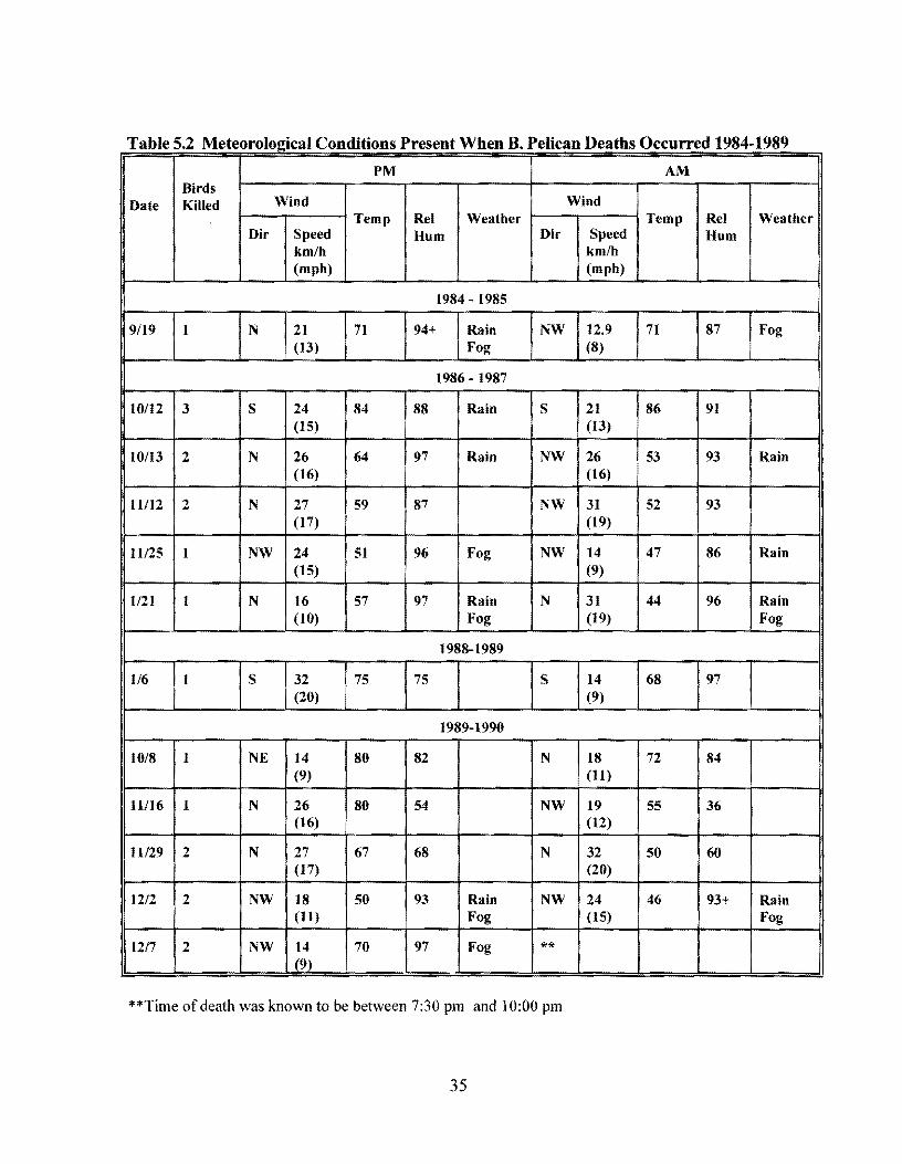
T bl 52 Mt I . IC d'ti P tWh BP I' D th 0 d 1984 1989 a e . e eoro 021ca on 1 ODS resen en . e 1can ea s ccurre . PM AM
Birds Date Killed Wind Wind
Temp Rel Weather Temp Rel Weather Dir Speed Hum Dir Speed Hum
km/h km/h (mph) (mph)
1984 - 1985
9/19 I N 21 71 94+ Rain NW 12.9 71 87 Fog (13) Fog (8)
1986 - 1987
10/12 3 s 24 84 88 Rain s 21 86 91 (15) (13)
10/13 2 N 26 64 97 Rain NW 26 53 93 Rain (16) (16)
11/12 2 N 27 59 87 NW 31 52 93 (17) (19)
Il/25 I NW 24 51 96 Fog NW 14 47 86 Rain (15) (9)
1/21 I N 16 57 97 Rain N 31 44 96 Rain (IO) Fog (19) Fog
1988-1989
1/6 I s 32 75 75 s 14 68 97 (20) (9)
1989-1990
10/8 1 NE 14 80 82 N 18 72 84 (9) (11)
11/16 1 N 26 80 54 NW 19 55 36 (16) (12)
11129 2 N 27 67 68 N 32 50 60 (17) (20)
12/2 2 NW 18 50 93 Rain NW 24 46 93+ Rain (11) Fog (15) Fog
12/7 2 NW 14 70 97 Fog ** (9)
**Time of death was known to be between 7:30 pm and 10:00 pm
35

T bl 53 Mt l . IC d"f P tWh BP r D th 0 d 1989 1996 a e . e eoro 021ca on I tons res en en . e 1can ea s ccurre -PM AM
Birds Date Killed Wind Wind
Temp Rel Weather Temp Rel Weather Dir Speed Hum Dir Speed Hum
km/h km/h (mph) (mph)
1989-1990
ll/26 5 NW 14 58 44 NW 16 55 64 (9) (10)
1995 - 1996
9/10 2 E 8 83 72 0 0 75 87 Fog {5) {O)
9/23 2 N 27 58 84+ NW 21 62 80 (17) (13)
11/4 2 NW 19 51 80 NW 21 54 80 (12) (13)
11/5 4 N 26 50 95 NW 21 49 96 Fog (16) (13)
12/25 2 N 23 45 93+ Rain N 23 45 96 Fog (14) Fog (14)
117 1 N 24 47 58 N 14 33 64 (15) (9)
2/1 1 E 19 50 96 Fog N 24 43 Fog (12) (15)
212 1 N 24 43 Fog N 24 41 Fog (15) (15)
2/19 2 s 32 75 Fog s 31 77 Fog (20) (19)
317 I s 40 71 Fog N 48 56 Fog (25) (30)
36

T bl 5 4 Mt I . IC d'ti P tWh BP I' D th 0 d 1996 1997 a e . e eoro 021ca on 1 ODS resen en . e 1can ea s ccurre -PM AM
Birds Date Killed Wind Wind
Temp Rel Weather Temp Rel Weather
Dir Speed (F) Hum Dir Speed (F) Hum
km/h (%) km/h (O/o)
(mph) (mph)
1996 - 1997
ll/2 1 s 12 82 83 Clear N 40 65 95 Fog (7) (25)
11/3 1 NI 32 66 76 N 18 65 78 NE (20) (11)
12/16 2 N 50 52 97 Fog/ N 42 46 89 Fog/ (31) Rain (26) Rain
117 2 -na- -na- 60 91 -na- -na- 46 99 Rain
2/14 1 NE 19 58 87 N 41 53 94 (12) (25)
37


6.0 IMPLEMENTATION
6.1 INTRODUCTION
The original intent of this research project was to research and review the interaction of the B. Pelican with the Queen Isabella Causeway and determine the methods, if any, of mitigating the number of mortalities. Additionally, incident management methods on the causeway were to be reviewed. As a result of this study, the following implementation strategies are recommended.
6.2 REMOVAL OF BROWN PELICAN FROM ENDANGERED SPECIES LIST
As a top priority, TxDOT needs to take the initiative to begin the process of removing the B. Pelican from the endangered species list and having it placed on the protected list. Although TxDOT can not remove the bird from the list, it can provide the impetus for beginning the process. The U.S. Fish and Wildlife Department is the agency involved with preserving endangered species, and making recommendations to the Secretary of the U. S. Department of the Interior on matters involving endangered species. TxDOT should request U.S. Fish and Wildlife to consider conducting a survey of the B. Pelican population in Texas as the preliminary action that may result in recommending the removal of the B. Pelican from the endangered species list. This study would more than likely take eighteen months to two years and involve a master's level graduate student surveying the B. Pelican population along the entire Texas coast. 6.3 INCREASED PUBLIC EDUCATION
TxDOT has produced a public service announcement (PSA), for local television stations. The intent of the PSA, which was produced in both English and in Spanish, is to educate the public on the situation of the B. Pelican with the Queen Isabella Causeway. The research team recommends that additional PSAs be created that continue to alert the public about condition of the B. Pelicans. These PSAs should focus on several topics. The first topic concerns the speed at which vehicles travel on the causeway when the pelican warning signs are flashing. The message needs to emphasize that a reduced speed limit is needed on the causeway in the event of inclement weather. Reduction of speeds increases general safety on the causeway as well as reduces the risk of a car striking a downed B. Pelican.
The second topic involves the use of monofilarnent fishing lines, fishing hooks, and boats around B. Pelicans in the area. It is believed that more pelicans are injured and killed by these factors than any other manrnade hazard. Other species that are injured by people carelessly and improperly discarding snarled lines and fishing equipment would also benefit from this PSA. This PSA topic would be appropriate for use along the entire Texas coast.
39

The PSA third topic addresses the spoil islands that are located in the Laguna Madre north of the causeway. These islands are being used for roosting and nesting. With the evidence of nesting by the B. Pelicans on these island, the interference by unknowing and uninformed individuals could be disastrous. People should be encouraged to remain off of the spoil islands. If this PSA is produced as a general information PSA, it would also be appropriate for other areas of the Texas coast.
Additionally, TxDOT should work with the Texas Parks and Wildlife Department in using the information gathered by this project concerning the nesting sites of the B. Pelicans and participate in protecting these sites. By protecting the young B. Pelicans and helping them survive their first year of life, TxDOT would be helping to increase the number of B. Pelicans in the area. This action may help to mitigate the impact of any mortalities that occur on the causeway.
6.4 CONTINUED MONITORING OF THE BROWN PELICAN
The "Pelican Patrol" has greatly increased the amount of information known about the mortalities of the B. Pelicans that occur on the Queen Isabella Causeway. This monitoring program, which is the first systematic and explicit documentation regarding actual mortalities, should be continued. In addition to the patrol, the information from the weather station located at the bridge should continued to be collected and analyzed. While there is a strong indication that there is a relationship between weather conditions and B. Pelican mortalities, continued monitoring will help to determine the type and extent of that relationship.
6.5 INCIDENT MANAGEMENT
Incident detection on the Queen Isabella Causeway is a great concern for the continuous flow of traffic between South Padre Island and Port Isabel. In order to reduce the time from when an incident occurs and when it is cleared, a cellular phone reporting program should be implemented. This program would consist of the creation of a single phone number, such as *BRIDGE. Motorists could then call this number when an incident occurs on the causeway, a wounded or dead B. Pelican is seen on the causeway, or any other situation that impacts traffic operations on the causeway occurs. This cellular number should be set up to be received at one of the local police dispatch stations. This dispatch station which is already staffed 24 hours a day and would be able to dispatch the appropriate response to a call. For matters concerning the B. Pelicans on the causeway, the "Pelican Patrol" could be dispatched to resolve the matter.
40

7.0 CONCLUSIONS AND SUMMARY
7.1 INTRODUCTION
Over the course of this study, a number of germane facts and observations have been made concerning B. Pelicans and the Queen Isabella Causeway. This chapter discusses these conclusions and summarizes the research performed during this research project.
7.2 BROWN PELICAN MORTALITY GENERAL OVERVIEW AND CONCLUSIONS
Through the use of a thorough literature search on the B. Pelicans, several relevant facts were determined. One of the first elements revealed was that 70 percent of all B. Pelicans die within their first year of life (25). During the nesting season, one of the most significant threats to B. Pelican survival is man. Human intrusion, however slight, at nesting sites during the early phase of the nesting cycle may disturb breeding and cause the birds to abandon the nest. Once the nest is abandoned, the B. Pelican may not attempt to establish another nest. If the pelicans do renest, the likelihood of successfully producing fledged B. Pelican chicks in the new nest is greatly reduced. Other threats to nesting sites may include, racoons, coyotes, crows, gulls, and fire ants which will raid the nests for eggs.
Additionally, 22 percent of the survivors of that first year die during their second year of life. Once the B. Pelican chick is hatched, the major threats in addition to predators are weather related. The B. Pelican chick is susceptible to overexposure to the sun during the first few weeks of life. Mosquitoes and fire ant infestations at the nesting site also pose danger to the newly hatched chick. Since the B. Pelican nests during the summer often near the waters edge, hurricanes and tropical storms pose a threat to nest sites upon occasion. Starvation is also a problem for newly hatched chicks. If fish are not in abundant supply, the parents may not be able to supply adequate amounts of food for hatchlings. Therefore, only a small percentage of B. Pelicans make it into adulthood.
Once a young B. Pelican fledges, the mortality rate drops significantly. However, both young and adult B. Pelicans remain susceptible to oil spills, pesticides, fishing hooks, fishing lines, guns, cars, boats, power lines, disease, predation, starvation, weather, and in some cases freak accidents. The most prevalent manmade hazard to the B. Pelican, has received little publicity. It is fishing gear, specifically monofilament fishing line and fish hooks. Monofilament line is composed of a single strand of chemically produced line which is incredibly strong, lightweight, and lasts for years. B. Pelicans can get snared in monofilament line that has been discarded by fisherman from a backlashed reel. Injuries from fish hooks usually occur two ways. First the B. Pelican may spot and attempt to catch a fish that is hooked on a trotline (fishing line that is left unattended on floats). The B. Pelican then becomes hooked by the line and dies. The B. Pelican may be attracted by the bait on a fisherman's line and
41

become hooked. Rather than fight a hooked pelican, some fishermen cut the line, leaving the pelican hooked and trailing a length of monofilament line which can then become entangled in trees or shrubs causing the pelican to die from strangulation or starvation (2). Over time many more B. Pelicans have been killed by monofilament fishing lines, fishing hooks, boats, and guns than by vehicles on the Queen Isabella Causeway. If steps are taken to minimize the damage to the B. Pelican population by these other non-natural causes of death, the population could be growing at a rate faster than that currently being experienced.
Other relevant information regarding the B. Pelican that was discovered during the literature search includes:
The B. Pelican exhibits a definite diurnal pattern of activity. The birds typically rise off of the roost early in the morning and return just before twilight. Very little to no activity occurs during the night.
Cold weather effects B Pelicans. B. Pelicans may attempt to migrate to areas where cold weather will be minimized. Several large die-offs, including some in the south Texas area, have occurred when B. Pelicans have been caught in a bitterly cold storm.
B. Pelicans are visual birds. Their vision is their strongest sense. They develop this accurate vision in order to dive into the water and feed.
7.3 CONCLUSIONS ABOUT THE BROWN PELICAN IN THE SOUTH PADRE ISLAND AREA
The number ofB. Pelicans has continued to dramatically increase over the past decade. When the first B. Pelican mortality occurred on the Queen Isabella Causeway, the death of one bird represented a significant percentage of the population being killed, this is no longer the case. Over the course of this study, over 600 B. Pelicans were observed in one day. B. Pelicans are now resident to the Port Isabel/South Padre Island area year round. TTI researchers observed B. Pelicans in the area at different times throughout the year. With the conclusion of the final field trip of this study in April of 1997, it was clearly evident that B. Pelicans are now nesting on some of the spoil islands in the Laguna Madre. These nests, as seen in Figure 2.2, were a surprise to many of the concerned parties.
A separate group of B. Pelicans from those nesting on the spoil islands, used abandoned CP&L transmission lines south of the Queen Isabella Causeway as a roost site. These power lines were removed during the winter of 1997. Removal of these power lines may result in a short term reduction in the number of B. Pelicans in the immediate area around the causeway. A reduction in the nocturnal, late evening, and predawn interaction between the B. Pelican and the Queen Isabella Causeway may also occur.
42

7.4 CONCLUSIONS ABOUT BROWN PELICAN MORTALITIES AT THE QUEEN ISABELLA CAUSEWAY
After two seasons of observations of the interaction between B. Pelicans and the causeway, several conclusions can be made. The number of mortalities does not seem to be related to size of B. Pelican population. While the population of the B. Pelican appeared to continue to increase during the study, the number of mortalities reported by the "Pelican Patrol" actually decreased from 16 to 7. A review of previous population estimates and known mortalities also indicated that increases in population do not necessarily result in increased mortalities. Although this does not necessarily prove that the number of mortalities is independent of the population, this possibility should be continuously monitored to see if a pattern emerges.
B. Pelican mortalities seem to be connected to weather conditions, but it is not clear which weather conditions are the controlling factor. The B. Pelican mortality rate seems to be greater during cold fronts than at other times. North winds, lower barometric pressure, precipitation, decreased visibility, and dramatic temperature decrease are all associated with this type of front. Using the data from the Campbell Scientific weather station, it was determined that 20 major cold fronts passed through the area during the 1996/1997 season. During these 20 cold fronts, B. Pelicans were killed only on five days. Two of those days occurred during the same cold front. This means that only four of the twenty, or 20 percent, of the cold fronts resulted in mortalities during an unusually cold winter and a cool spring.
Although during the 1996/1997 season all of the B. Pelican mortalities occurred during a cold front, this was not true for previous years. Several deaths have occurred without the presence of a cold front. Therefore, it appears that while the probability of a B. Pelican mortality increases during a cold front, it is not a certainty. The severity of the cold front does not seem to be an indicator of possible mortalities. During the 199611997 season, several of the coldest fronts that moved through the area did not result in a mortality.
Additionally, the location of a mortality along the length of the causeway seems to be random. Dead B. Pelicans were found by the "Pelican Patrol" along the entire length of the causeway. It was initially believed that the mortalities were occurring only around the area of the "hump" over the Intracoastal Waterway. In fact, very few of the B. Pelicans found by the "Pelican Patrol" were found on the "hump."
One of the original theories about the cause of the B. Pelican mortalities on the causeway indicated that a strong north wind forced B. Pelicans flying over the causeway down onto the deck of the bridge. If a strong north wind was the only reason for the mortalities, the question must be asked, "why are there no mortalities during the rest of the year when strong south winds are present"? The question must also be asked, "if a strong north wind is the only reason for mortalities, why are there a number of pelicans found near the island side of the bridge where the bridge is not perpendicular to a north wind"? Since mortalities occur so infrequently, and
43

are very rarely seen, it is difficult, if not impossible, to develop a solid theory on B. Pelican mortalities. Of the two mortalities witnessed by individuals, one reported that a B. Pelican appeared to be fishing over the deck of the bridge and dove down onto the deck of the bridge. The second individual reported that he saw a B. Pelican fly into the side of a large truck.
After talking to several experts on coastal birds, it is highly unlikely that B. Pelicans are being forced down onto the deck of the causeway. It seems more likely that certain pelicans become confused in the inclement weather as they fly over the causeway and attempt to land on the deck of the bridge. Research has shown that when B. Pelicans are confused, their first instinct is to land as quickly as possible. Research has also documented B. Pelicans mistaking pavement for water and rocks. In 1978, fifteen B. Pelicans were rescued in Yuma, Arizona. The pelicans were caught in thermals associated with a storm in Mexico's Gulf of California and were carried inland. The U. S. Fish and Wildlife Service noted that the pelicans were found on the highway: "Looking for a place to land, they often mistake pavement for rocks or water" (2).
Since the causeway causes major disruptions in the air flow patterns and currents around the bridge, when the B. Pelicans fly through this area of air disturbance, they may become confused and react to the disturbance. Part of this theory can be observed by watching the B. Pelicans cross over the causeway. B. Pelicans which fly high over the causeway or under the causeway do not seem to react to the bridge. But those B. Pelicans which approach the bridge at a height equal to the height of the deck appear to be confused and begin a milling action before attempting to cross the bridge. This reaction has also been documented in previous research. Pennycuick observed in a study in 1983, that the B. Pelican soars in thermals in the course of moving between roosting and feeding areas. He describes flocks of pelicans flying in formation that "would maintain their coherence for short periods of slope soaring, all the birds in the flock turning together at the end of the slope. In thermals the flock structure gradually degenerated into a milling mass of pelicans circling in either direction" (12). Once a B. Pelican has landed on the deck of the bridge, it is very difficult for the pelican to take off. This is because the pelican needs room to prepare for flight and because, B. Pelicans prefer to take off by moving into the direction of the wind. On the deck of the bridge, this is difficult due to air currents that are disrupted by the bridge railings and center median.
7.5 INCIDENT MANAGEMENT
The Queen Isabella Causeway is a 4.0 km (2.5 miles) long, 4 lane divided roadway with no shoulders. If a vehicle breaks down or is involved in an incident, there is no way to remove the vehicle from the traffic lanes without towing the vehicle off of the bridge. It is also possible for an accident to completely shut down operations on the bridge thereby cutting off access between South Padre Island and Port Isabel. The quick detection of any type of problem on the causeway is essential to a continuous flow of traffic over the causeway. Traditional methods of monitoring traffic activity are not applicable to this bridge setting. These methods include, inductive loop detectors in the pavement, roadside call boxes, and closed circuit television cameras.
44

One technology that is practical in this particular situation is the cellular phone. A large number of motorists have cellular phones and the number of new owners is growing daily. Many areas around the country have abandoned some of the traditional methods of incident detection for the use of cellular phones. Incident detection is almost immediate and usually a second call will serve to verify information from the first call. On the causeway, cellular phone reporting could serve two functions. One function would be the reporting of accidents or disabled vehicles on the causeway. The second function could assist the "Pelican Patrol" in the removal or assistance ofB. Pelicans. A single phone number could be created to allow motorists the opportunity to report any situation on the bridge. One example of a simple phone number that could be used by motorists is *BRIDGE. By creating a special phone number for incidents involving the causeway, several problems that have occurred with other cellular phone reporting of incidents would be avoided. These problems include an overloading of the 911 system with traffic related calls and the answer of 911 calls by dispatch stations that are not in a position to respond to the call. Cellular 911 calls are not necessarily received by the closest police dispatch station.
While a closed circuit television camera might not be applicable for incident detection, it would be useful in the monitoring fog conditions. The Campbell Scientific weather station located by the causeway records the current temperature, relative humidity, wind direction, and wind speed. Although it can indicate when the conditions are conducive to the formation of fog, it cannot determine whether or not fog is present in the area. Fog detection on the causeway is important for two reasons: ( 1) fog is a dangerous driving condition for motorists on the bridge and (2), it may be a factor in B. Pelican mortalities. The information gathered by the weather station can be used to attempt to predict when fog is occurring. One way to check that prediction is the use of a CCTV camera to verify at a remote location, the conditions around the causeway. This additional information would help in the use of the CMSs that are located on either side of the causeway.
7.6 CHANGEABLE MESSAGE SIGN USAGE
A system consisting of Changeable Message Signs (CMS) located on either side of the causeway and a series of flashing warning signs are used to warn motorists of the possibility that a B. Pelican might be on the road surface of the bridge. This system is manually controlled and is activated anytime a cold front passes through the area. This may leave the sign system on for days at a time. This significantly decreases the effectiveness of the message that the system is trying to relay to the motorists. The newly installed weather station is being used to help control the activation of the sign system. Future research should be focused toward directly connecting the weather station to the changeable message sign and allowing the weather station to have partial control of the message being displayed.
The proper usage of a CMS system is a current topic of debate. Some districts in Texas believe that it is best to leave the CMS blank during times when a message is not required. Other districts believe that some type of message should always be displayed. Both positions have
45

opposition within the motoring public. If the CMS is left blank most of the time, motorists feel that their money is being wasted on signs that never display any information. If messages are displayed that do not require motorist's attention, necessary messages are often ignored when they are displayed. It is impossible to satisfy all of the motoring population with regards to CMS usage.
According to C. Dudek (34 ), the advisory message on a CMS should consist of the following elements:
A problem statement (accident, construction, etc.), An effect statement (delay, bridge blocked, etc.), An attention statement (addressing a certain group or audience) and, An action statement (what to do).
At a minimum the message should consist of the problem statement and the action statement. The current message states, "WATCH FOR PELICANS - 45 MPH/CAUTION!! - REDUCE SPEED." The "WATCH FOR PELICANS" portion of the message is vague. Motorists may wonder if this is a tourist information message instructing them that pelicans can be seen from this bridge. The speed reduction message is an appropriate action statement but the word "CAUTION!!" should be removed. The fact that there is a message on the CMS signals the motorists that caution should be used.
Some possible alternatives for the CMS message follow:
DURING INCLEMENT WEATHER/REDUCE SPEED TO 45 MPH, WATCH FOR PELICANS ON BRIDGE DECK/REDUCE SPEED TO 45 MPH, PELICANS MAY LAND ON BRIDGE/REDUCE SPEED TO 45 MPH
7.7SUMMARY
Over the past two years, Texas Transportation Institute personnel have made nine field trips to the Port Isabel/South Padre Island area to observe the interaction of the B. Pelican with the Queen Isabella Causeway and to observe the habitat of the B. Pelican. With help from personnel from the Texas Department of Transportation, the Texas Parks and Wildlife Service, the U.S. Fish and Wildlife Department, and the area game wardens, the amount of knowledge concerning the Texas B. Pelican has greatly increased. The effort by the "Pelican Patrol" has provided much needed information in the actual number of B. Pelican mortalities on the causeway. Prior to the patrol, mortality information was for the most part undocumented. This effort should be continued to develop a long term database of information. This is only way to determine what effect the Queen Isabella Causeway is having on area B. Pelicans.
With the increase of the B. Pelican population in Port Isabel/South Padre Island area over the last decade, the overall population of the Texas B. Pelican should be studied to determine if
46
the species should be removed from the endangered species list and placed on the protected list. A study of this sort must be proposed by the U.S. Fish and Wildlife Department to have the credibility needed for this effort. TxDOT should fully pursue this action. Removal of the B. Pelican from the endangered species list would help reduce the environmental impact of any future project TxDOT might want to pursue.
In order to help mitigate the effects of random deaths of B. Pelicans on the Queen Isabella Causeway, TxDOT should take an active role in protecting B. Pelicans in other areas. For example, the islands that are being used for nesting need to be protected from disturbance by people. Education on the dangers that fishing equipment, such as monofilament line and hooks, pose to B. Pelicans and other species is also needed. The educational efforts started by the PSA created in 1996 should be continued and expanded to include additional television ads, radio ads, and literature to be distributed through information centers.
Nothing practical can be done to scare the birds away from the bridge. Likewise, nothing practical can be added to the bridge to prevent the birds from landing on the bridge without compromising bridge or vehicle safety. It could not be determined whether the overhead lighting on the bridge had any effect on the pelicans, but the banners placed on the light poles did not act as a deterrent to the B. Pelicans flying over the bridge. TxDOT should attempt to increase public awareness of the situation, and attempt to have local law enforcement better monitor speed conditions on the causeway.
47


8.0 REFERENCES
1. U. S. Fish and Wildlife Service, "Bro"Wn Pelican, Pelecanus occidentalis," Biologue Series, U.S. Department oflnterior, Washington, D. C., 1995.
2. Brown, J.E., The Return of the Brown Pelican, Louisiana State University Press, Baton Rouge, LA., 1983.
3. Johnsgard, P. A., Cormorants, Darters, and Pelicans of the World, Smithsonian Institution Press, Washington, D. C., 1993.
4. Schreiber, R. W., Schreiber, E. A., Anderson, D. W., and Bradley, D. W., "Plumages and Molts of Bro"Wn Pelicans," Contributions in Science: Los Angeles County Museum Natural History, Report 402 pages 1-43, Los Angeles County Museum Natural History, Los Angeles, CA., 1989.
5. Schreiber, R. W. and Schreiber, E. A., "Essential Habitat of the Brown Pelican in Florida," Florida Field Naturalist, 10:9-17,
6. Bailey, A. M., "The Brown Pelican, A Good Citizen," The Wilson Bulletin, Number 104. 1947.
7. Croll, D. A., Ballance, L. T., Wi.irsig, B. G., and Tyler, W. B., "Movements and Daily Activity Patterns of a Brown Pelican in Central California" The Condor, Volume 88, Pages 258-260, The Cooper Ornithological Society, 1986.
8. Briggs, K. T., Tyler, B., Lewis, D. B., Kelly, P.R., and Croll, D. A., ••Brown Pelicans in Central and Northern California," Journal Field Ornithology, Volume 54, Pages 353-373, 1983.
9. Schreiber, R. W., Woolfenden, G. E., and Curtsinger, W. E., ••Prey Capture by the Brown Pelican," Auk, Vol 92, pages 649-654, 1975.
10. Amqvist, G., "Brown Pelican Foraging Success Related to Age and Height of Dive," The Condor, Vol 94, Pages 521-522, The Cooper Ornithological Society, 1992.
11. Schreiber, R. W., Maintenance Behavior and Communication in the Brown Pelican, Ornithological Monographs No. 22, American Ornithologists' Union, Washington, D. C., 1977.
49
12. Pennycuik, C. J., "Thermal Soaring Compared in Three Dissimilar Tropical Bird Species, Fregata Magnificens, Pelecanus Occidentalis, and Coragyps Atratus," Journal of Experimental Biology, Volume 102, pages 307-325, Company of Biologists Limited, Great Britain, 1983.
13. Pearson, T. G., "Report ofT. Gilbert Pearson, Secretary," Bird-Lore, Volume 20, page 455, National Audubon Society, New York, New York, 1918.
14. Gustafson, A. F., Guise, C.H., Haminton, Jr., W. J., and Rise, H., Conservation in the United States, Comstock Publishing Co., Ithaca, New York, 1939.
15. Pearson, T. G., "Notes on the Bird-Life of Southeastern Texas," The Auk, Volume 38, pages 513-523, American Ornithologists' Union, Washington, D. C., 1921.
16. Henny, C. J., "An Analysis of the Population Dynamics of Selected Avian Species with Special Reference to Changes During the Modem Pesticide Era," U. S. Bureau Sport Fishing and Wildlife Research Report 1, 1972.
17. Scott, J. D., That Wonderful Pelican, G. P. Putnam's Sons, New York, NY, 1975.
18. Paul, R. T., "Pelican Comeback," Texas Parks and Wildlife, Vol. 35, number 3, pages 12-15, Texas Parks and Wildlife Department, Austin, Texas, 1977.
19. Goldman, L. C., "South Texas Region," Audubon Field Notes, Volume 5, pages 298-300, National Audubon Society, New York, New York, 1951.
20. Texas Parks and Wildlife, Eastern Brown Pelican (Pelecanus Occidentalis Occidentalis), Information Bulletin, Texas Parks and Wildlife, Austin, Texas, July 1996.
21. Christmas Bird Counts, American Birds, Volumes 28 - 48, National Audubon Society, New York, New York, 1974-1994.
22. Butcher, G. S., "Audubon Christmas Bird Counts," Survey Designs and Statistical Afethods for The Estimation of Avian Population Trends U. S. Fish and Wildlife Service Report Number 90, pages 5 -13, Department of the Interior, Washington, D. C., 1990.
23. U. S. Fish and Wildlife Service, Threatened and Endangered Species of Texas, Department of the Interior, Washington, D. C., Revised June 1995.
24. Schreiber, R. W., "Reproductive Performance of the Eastern Brown Pelican (Pelecanus Occidentalis)," Contributions in Science: Los Angeles County Museum of Natural History, Number 317, pages 1- 43, Natural History Museum of Los Angeles County, Los Angeles, CA, 1979.
50

25. · Benny, C. J ., "An Analysis of the Population Dynamics of Selected Avian Species," Bureau Sport Fisheries and Wildlife Research Report I, Government Printing Office, Washington, D. C., 1979.
26. Parker, D., "Pelican Ghost Town Worries Wildlife Watchers," Bryan-College Station Eagle, page Al2, Bryan, Texas, August 12, 1996.
27. Orians, G. H., "Age and Hunting Success in the Brown Pelican (Pelecanus Occidentalis)," Animal Behavior, Volume 17, pages 316 - 319, Informational Retrieval Limited, London, 1969.
28. Schreiber, R. W. and Mock, P. J., "Eastern Brown Pelicans: What Does 60 Years of Banding Tell Us," Journal of Field Ornithology, Volume 59, pages 171 - 182, Northeastern Bird Banding Association, Rutland, VT., 1988.
29. Collazo, J. A., Status and Ecology of the Brown Pelican in the Greater Puerto Rican Bank Region, Ph.D. Dissertation, Iowa State University, Ames, Iowa, 1985.
30. Williams, Jr., E. H., Bunkley-Williams, L., and Lopez-Irizarry, I., "Die-Off of Brown Pelicans In Puerto Rico, and the United States Virgin Islands," American Birds, Volume 46, Number 5, Pages 1106- 1108, National Audubon Society, New York, NY, 1992.
31. Allen, E. A., "Don't be Careless With Your Hooks," Island Times, page 25, South Padre Island, Texas, November 1996.
32. Olafson, S., "Pelicans' Deaths Trouble Officials," Houston Chronicle, on-line edition, Houston, Texas, August 18, 1997.
33. Owens, L. K., James, R. W., and Slack, R. W., Mitigation of Traffic Mortality of Endangered Brown Pelicans on Coastal Bridges, Research Report 1226-lF, Texas Transportation Institute, Texas A&M University, College Station, TX, 1990.
34. Dudek, C., Guidelines on the Selection and Design of Messages for Changable Message Signs, Research Report 1232-10, Texas Transportation Institute, Texas A&M University, College Station, TX, 1992.
51


9.0 APPENDIX A FIELD NOTES
53


FIELD NOTES
Field Notes Jan 24-25, 1996
Jan 24 Arrived at Port Isabel early afternoon. Drove the bridge, island, and South Garcia Street
to find best area to film bridge. No pelicans were noted during early afternoon. Parked just south of the bridge on the Port Isabel side. The first Pelicans were spotted at 5 :41 p.m. and continued until dark approximately 6:20 p.m. or 6:30 p.m. The lights on bridge came on at 6:13 p.m. The weather was sunny with a wind from the south or southwest. Water was calm to slightly choppy.
The Pelicans were in route to roosts north of bridge. Pelicans traveled usually in pairs or small groups. However, two groups were in excess of 30 birds. A total of 96 birds was counted. When they approached the bridge, 6 birds went under the bridge and 90 birds went over the top.
When the birds in formations came close to the bridge, they broke formation but went over the bridge with little to no hesitation. Once they crossed the bridge, they again assembled into a line formation.
Jan 25 Arrived at Port Isabel in early afternoon. Once again drove the bridge, and South Garcia
Street to area where old bridge was located. No pelicans noted. Parked in same spot as day before just south of bridge on Port Isabel side. Spotted for the first time a pelican nicknamed "Duffus." Duffus is a young immature Brown Pelican, that is missing part of his left wing. Local fisherman and the pier owner stated the bird lost the wing when it was tangled in monofilament line. The bird stays near the bridge on the Port Isabel side and "begs" fish from the fishermen who fish from the Fishing Pier and the fishing boat that docks on the south side of the bridge. He can be quite comical in begging, hence his nickname. The weather was partly cloudy, with a south to southwest wind and calm to slightly choppy water.
The first Pelicans arrived at 5:50 p.m and observations continued until 6:30 p.m. A total of94 birds was observed with the.largest group consisting of 20 birds. Three birds went under the bridge and 91 birds crossed over the bridge.
Field Notes Feb 5 - 9, 1996
Feb5 Arrived at Port Isabel at 5:30 a.m. Parked at the fishing pier just north of bridge on Port
Isabel side. ·First birds arrived at 6:55 a.m. which was approximately 15 to 20 minutes after first light. By 7: 10 a.m. a total of 35 birds had arrived. All birds crossed over the bridge at an
55

altitude half way below the top of the light standard. Birds continued to arrive either individually or in small groups throughout the morning.
Once the birds crossed the bridge, they immediately began fishing in water just south of bridge. By 10 a.m. approximately 50 pelicans were in the water. The weather was cold, overcast and hazy and the water was relatively calm. There was only a slight wind from the southeast.
As the pelicans fished in the bay, they glided very low to the water as they flew into the wind. At times their wingtips almost touched the water. They also sat on the water as they fished. Did not see any of the usual high altitude dives for fish.
In the early afternoon 10 to 12 birds were spotted preening and loafing on the mud flats near the swing bridge on South Garcia Street, which is the entrance to the small boat turning basin. Thirty to forty White Pelicans were also loafing on the mud flats near the old bridge site. Three pelicans were also spotted loafing on the spoil islands in the basin across from Outdoor Resorts. All of these birds were identified as immature or subadults. Many of the birds (30 to 40) remained in this area of the bay the entire day. White pelicans, anhingas, cormorants, coots, and various types of gulls also remained in the bay throughout the day.
The birds started flying north to return to their roosts approximately at 5 :00 p.m. This is earlier than previous observations, possibly because of the overcast day. In addition to the 50 or so pelicans in the immediate bay, 32 additional Pelicans were observed crossing the bridge. Approximately half of the pelicans flew under the bridge.
Feb6 Arrived at Port Isabel in the early afternoon; the water was slightly choppy with the wind
from the southeast. The weather was clear to partly cloudy. A pod of 10 to 12 porpoises was observed for an hour or so in the bay. White Pelicans were also in the bay. No Brown Pelicans were noted. B. Pelicans were spotted loafing in the early afternoon at the following areas: the Sea Ranch Marina on docks and pilings (Padre Island), the U. S. Coast Guard docks (Padre Island), the spoil islands in the small boat turning basin (Port Isabel), and in the water trap on the Outdoor Resorts golf course.
Pelicans were observed crossing the bridge toward the roost between 5.58 p.m. and 6:22 p.m. Approximately 42 pelicans were observed with the largest group numbering 20 birds. The group approached the bridge in formation. Upon reaching the bridge, the birds began flying parallel to the bridge and milling back and forth before finally crossing. This pattern was repeated quite often. The majority of the birds flew over the bridge.
Feb 7 Arrived at the bridge at 7:00 a.m. The weather was sunny but still hazy from morning
fog. The water was very calm, almost glasslike. There was little to no wind and the weather was
56

warmer that the two previous days. Thirty-five birds were observed crossing the bridge between 7:00 a.m. and 7:50 a.m. The birds immediately began to fish once they crossed the bridge.
In the early afternoon, birds were spotted at the Sea Ranch marina loafing on pilings and docks . Pelicans were also seen loafing on spoil islands in the small boat, turning basin and near Outdoor Resort.
In the afternoon, the weather was clear and sunny. The water was calm with a slight south wind. The birds started crossing at 5:45 p.m. Thirty-seven birds were observed crossing between 5:47 p.m. and 6:20 p.m. As one large group of 13 approached the bridge, the birds began to mill and then split into two groups, one group headed east parallel with the bridge and one headed west Both groups eventually went over the bridge. Approximately half of the birds went over the bridge and half of the birds went under the bridge.
Feb 8 The weather was warm, sunny, with southwest winds. The water was calm. Only 20
birds were sighted crossing the bridge this afternoon. All of the birds fished in the bay south of the bridge and in the Intracoastal channel directly under the bridge prior to heading to the roost. All of the birds were immature.
Field Notes Jun 10, 1996
Jun 10 Arrived at Boca Chica at approximately noon. Three pelicans were fishing in the surf.
Traveled to S. Padre; several B. Pelicans were observed fishing in the surf north of the convention center. Several B. Pelicans were also observed crossing the bridge toward the north in the late evening.
Field Notes Aug 13-16, 1996
Aug 14 Arrived at Port Isabel Padre Island area at 6:30 a.m. Met Kim Jenkins, TxDOT Biologist
from Austin; Velma Garcia, Project Director, Pharr District; and Gregorio Puentes, TxDOT Maintenance Office, Laguna Vista. We launched the TxDOT boat and left the docks at the Sea Ranch Marina approximately 7:20 a.m. The previous afternoon a small plane with two people on board crashed into the bridge just north of the Intracoastal Channel. We inspected the vvreckage and crash site at the bridge before heading north in the Laguna Madre. Several miles to the north a number of small spoil islands were spotted. The first of these islands were bare and no birds were spotted. At Flashing Beacon 115, just southwest of the Collins home (this home is a large house on a prominent bluff), three larger spoil islands were sighted. These islands had vegetation. Closer investigation of the first island, the smallest of the three, revealed seven Brown Pelicans loafing. The second spoil island, which can be identified by beached small boat on the leeward side of the island and a concrete block and pilings on the windward
57

side, had approximately 250 Brown Pelicans loafing. Plumage indicated juveniles, subadults, and adults were present.
Field Notes Nov 18-20, 1996
Nov 18 Arrived in Port Isabel in early evening. Observed a large number of B. Pelicans loafing
on the "dead" CP&L power lines near the Sea Ranch Pier. Estimated number of birds on line to be in excess of 200. Observed the birds until thirty to forty minutes after dark.
The next morning at 6:30 a.m. we met Gary Waggerman, wildlife biologist for Texas Parks and Wildlife; members of Texas Parks & Wildlife Staff; Kim Jenkins, TxDOT biologist, Randy Blankenship, bay ecosystem biologist at the Brownsville Fish Hatchery, and two Game Wardens at the Sea Ranch public docks. We divided into two groups. The B. Pelicans were still on the CP&L power lines near the docks. A count made by Gary Waggerman and myself estimated between 400 and 425 birds on the lines. We then proceeded north to the spoil islands in the Laguna Madre. When we reached the three spoil islands that had pelicans loafing in August, we again found Pelicans. This time there were approximately 175 to 200 B. Pelicans. We also visited Green Island, a bird sanctuary that is a nesting area for egrets and Roseate Spoonbills. On the return trip we waded out from the boat to several of the islands. No evidence of nesting was found.
Field Notes May 19 - 21, 1997
May 19 When we reached S. Padre, we traveled to Sea Ranch Pier and Marina to check on BP's
we were shocked to find that the old power lines had been removed. These lines had been used extensively for a roost and loaf site for over 200 BP's during the spring and winter months. We talked to the clerk at the Sea Ranch Pier and discovered that the lines had been removed during the winter months. When we asked if she knew where the Pelicans went, she stated that a number had been observed roosting on the spoil islands near Outdoor Resorts in the small boatturning basin after the lines were removed.
May20 Went in search of B.P. 's in early a.m. 2 or 3 were sighted fishing in Gulf and 1 or 2 in
Laguna just below Bridge.
At 8:00 we met with group to go out on boats in search of BP's. We split into two groups; my group consisted of Sgt. Lauro Salinas, Sam Patten, and myself.
My group traveled along Intracoastal toward south bay in direction of Boca Chica. A dead porpoise was sighted near P. Isabel jetty. A preliminary observation revealed no visible signs of wounds such as blade strikes. No nesting areas were found in South Bay, although
58

approximately 10 BP's were sighted fishing. We agreed to load boat and check out area north and east of Bridge.
Launch boat around 12:30 at Arroyo Colorado boat launch. Head out to spoil islands. Skirt around Green Island see Roseates. Other islands show many gull, herons. No Pelicans. Head to area of 3 spoil islands just south of the Collins ranch. The islands are directly perpendicular to the flashing green beacon number 115 This area consists of three spoil islands that are vegetation covered and 2 tiny barren spoil areas. The middle island has pier pilings extending to the channel side and beached house boat on the leeward side. This is where BP's were spotted last August.
BP's spotted, some appeared to be nesting. Sam Patten and I very carefully and quietly as possible went on island to check area. Eight nests were found each with 2 to 3 eggs. At least 3 other eggs were noted to be rolled from nest. One other empty nest was found; it looked to be an older nest as the material was different color and there was numerous bird droppings visible in immediate area. The BP's watched us from about 30 feet and immediately returned to nest as we moved off. There were also numerous gull nests. No other sign of any other animal life on island.
The first or southmost island was being used by approximately 75 to 100 BP's as a loafing area. All of these BP's were immatures or subadults. On this island we found a dead BP (almost skeletonized). The BP's feet had become entangled in fishing line (weights still attached) and then the line had become entangled in vegetation at edge of island. BP probably died of starvation or exposure.
59


10.0 APPENDIX B PELICAN PATROL LOGS
61


TRANSCRIBED PELICAN PATROL LOGS
The pelican patrol was instituted in the fall of 1995, in an effort to monitor mortalities on the bridge and to document the location, date, and approximate time of any mortalities. A license to handle dead endangered species was granted by U. S. Fish and Wildlife so that the dead birds could be removed from the bridge. The pelican patrol was dispatched whenever a cold front with strong north winds pushed through the area. All entries originally recorded by Mr. Gregario Puentes, Jr., Cosme Garza, and Reynaldo Cantu from the Laguna Vista TxDOT Maintenance office.
9122195
9123195
9124195
10/3/95
1995-1996
Approximately 11 :50 a.m. Friday morning Ricardo Gallaga called and said turn flashing lights on bridge, watch for pelicans, and to start a pelican patrol on bridge for pelicans that might be down. The bridge will be patrolled morning, noon, and late afternoon. It was 1 :30 p.m. when the lights were turned on. Bridge was driven at approximately 1:00 p.m. and 4:15 p.m. Bridge was clear, no pelicans.
I started to make the patrol, but first I checked the lights and sign, both of which were on. It was 8:05 a.m. when I went over the bridge. There were 2 dead pelicans. Both had been hit by vehicles. The dead pelicans were about 100 feet apart.
Went across the bridge at approximately 5: 15 p.m. The bridge was clear.
Pelican patrol at approximately 8:05 a.m. The lights and signs were working and the bridge was clear.
Bridge was driven at about 5:45 p.m. The bridge was clear of pelicans; however, I observed pelicans flying very low near the bridge.
It was approximately 7:01 a.m. when I went over the bridge for pelican patrol. I turned on the lights, the wind was blowing, no birds were in sight.
I drove over the bridge around 4:00 p.m. It was clear, there were no birds, and the lights were working.
63

10/14/95
10115/95
10121195
1113195
11/4/95
1115195
12/9/95
12/10/95
It was approximately 7:00 a.m. when I turned the lights and the "Watch for Pelicans" sign on. They were both working fine. Went over the bridge. No pelicans.
I also went over the bridge on patrol around 6:00 p.m. It was clear, the wind was blowing but no pelicans.
Went over the bridge around 7:00 a.m. The wind was still blowing, but the bridge was clear; no pelicans.
Went over the bridge around 5:45 p.m. Everything was ok. No pelicans were on the bridge, however they were flying low over the bridge.
Went on pelican patrol at approximately 7: 15 a.m. The bridge was clear, the wind died down. No pelicans were seen. Since it was becoming a nice day, I turned off the lights.
It was approximately 8: 10 a.m. when I turned on the lights on the bridge. The '"'1.nd was blowing and it was drizzling. The bridge was clear and no pelicans were seen.
Drove over the bridge at 3:30 p.m., no pelicans were seen.
Went over the bridge at approximately 8:03 a.m. Two dead pelicans were dead in the eastbound lanes. I think they were killed during the night.
Drove over the bridge at 4: 10 p.m., the bridge was clear, and there were no pelicans.
Went over the bridge at 7: 15 a.m. There were 3 dead pelicans in the westbound lane and there was one dead pelican in the eastbound lane.
Drove over the bridge at 4:30 p.m. The bridge was clear, no dead birds.
Went on pelican patrol in morning. It was clear. No dead birds and everything was working ok.
Drove over the bridge at 4:05 p.m. It was clear and there were no birds. The wind was blowing and pelicans were seen sitting on the water.
It was windy and cold when I went over the bridge this morning. There were no dead birds.
64

12/24/95
12125195
116196
117196
1127196
1/28/96
211196
212196
2/3/96
214196
2119196
Drove over the bridge at 3:30 p.m. It was cold and clear, there were no dead birds.
Drove across the bridge. It was drizzling and cold. There were no dead birds.
Drove across the bridge. It was drizzling and cold. There were 2 dead birds.
Drove across the bridge. It was cold and windy. There were no birds. Checked the lights.
Drove across the bridge at 5: 15 p.m. It was still windy and cold. The bridge was clear and there were no birds.
It was approximately 9:45 a.m. when I went over the bridge. There was a dead pelican on the eastbound lane about a mile from the end of the bridge nearest the island.
Drove over the bridge at 7 :20 a.m. on pelican patrol. Set the lights and went over. It was clear and windy. There were no dead birds.
Went over the bridge on pelican patrol at 8:00 a.m. It was clear and there were no dead birds.
Drove over the bridge on patrol at 8:15 a.m. It was cold and windy. There was a dead bird on the eastbound lane. The bird was approximately 1/4 mile from the hump on the island side.
Drove over the bridge at 8:25 a.m. The lights were working fine. It was cold and windy. The eastbound side was clear. I found a dead pelican on the westbound side, approximately 400 feet from the Port Isabel side of the bridge.
Drove over the bridge at 8:30 a.m. It was windy and cold. It was clear with no dead birds.
Drove over the bridge at 8:00 a.m. It was \\<indy and cold. The lights were working fine. Bridge was clear and there were no dead birds.
I got a call that there were 2 dead pelicans on the bridge. It was approximately 7:28 a.m. when I drove over the bridge. One bird was in the eastbound lanes about 80 feet from the end of the bridge on the Island side. The other bird was in the same area only was in the westbound lanes.
65

2129196
317196
1112/96
11/3/96
11/28/96
11/29/96
12/1/96
12/6/96
12/7/96
12/8/96
12/12/96
12/13/96
12116/96
Drove over the bridge just after a cool front came through. There were no dead birds.
Drove over the bridge at 8:25 a.m. A cold front had come in earlier and the wind was blowing from the north and it was cold. I found a dead pelican about 200 feet from the end of the bridge on the island side in the eastbound lanes.
1996-1997
At approximately 4:30 p.m. I drove across the bridge on pelican patrol. A norther had come in early in the morning and the wind was blowing. A dead pelican was found in the eastbound lanes, just over the hump about 1.3 miles from Port Isabel.
Drove over the bridge at 7: 15 a.m. The wind had died down. I found a dead pelican approximately 1.4 miles from Port Isabel on the eastbound lane of the bridge.
Drove pelican patrol. All clear.
Drove pelican patrol. All clear.
Drove pelican patrol. All clear.
Drove pelican patrol at 7:30 a.m. It was foggy.
It was foggy till noon.
Drove the pelican patrol at 7: 15 a.m. While I was on the patrol the cold front blew through. The wind was blowing from the north, but it was clear. There were no dead birds.
We had an early morning fog, but it was clear by noon.
We had an early morning fog, but it was clear by noon.
A cold front came through on Sunday, Dec 15, in the afternoon. There was rain and high winds. At 8:42 a.m. I drove the bridge on the 16th. There were 2 dead pelicans. One was on the eastbound lane, approximately 12 mile from
66

12/17/96
12/18/96
12/19/96
12/20/96
12/21/96
12/24/96
12125196
12127196
12/30/96
1/7/97
1/8/97
1112197
1113197
the hump on the Padre Island side. The other bird was on the westbound lane, approximately 200 feet from Port Isabel.
Drove the pelican patrol at 8:45 a.m. It was cold and windy. There were no dead birds.
At 8:30 a.m. I drove the bridge on pelican patrol. It was cold and windy. There were no dead birds.
Drove the bridge at 8:23 a.m. on pelican patrol. It was cold, but there was no wind. It was clear and there were no dead birds.
Drove the bridge at 8:35 a.m. When I went over the bridge, it was drizzling. I didn't even see a bird.
It was approximately 7: 15 a.m. when I drove the bridge on pelican patrol. It was cold and drizzling. There were no dead birds.
It was approximately 11 :00 a.m. when the cold front came through. It began to drizzle and the wind began to blow. I drove over the bridge. There were no dead birds. I put on the blinking lights.
It was approximately 8: 15 a.m. when I drove the bridge. It was cold and the wind was blowing. There were no dead birds.
There was a morning fog that was heavy until noon. Then it cleared.
There was a heavy morning fog.
Drove the bridge at 8:30 a.m. When I crossed the bridge the wind was pretty strong out of the north. There were 2 pelicans dead on the bridge. They were close together in the eastbound lanes about 1 y; miles from the hump on the Padre Island side.
Drove the bridge at 9:00 a.m. The wind was from the north and it was cold and drizzling. There were no dead birds.
A cold front came through at 12:30 p.m. Checked the bridge for dead birds. All clear.
It was approximately 11 :30 p.m., when I drove over the bridge to check for icing. The wind was blowing and it was drizzling and cold. I saw a pelican land on the bridge. I stopped to pick him up and he flew into the bed of my
67

1115/97
1/22/97
217/97
2/10/97
2/14/97
2/21/97
2/24/97
3/10/97
pickup truck. I drove off the bridge with the pelican in the bed of the pickup. When I got to the island, I stopped. The pelican flew off.
Drove the bridge at 8:30 a.m. It was foggy. There were no dead birds.
Morning fog.
Morning fog that cleared by noon. Evening fog.
Drove over the bridge at 8:30 a.m. Wind was blowing from the north and it was drizzling. No dead birds.
Drove the bridge at 9:35 a.m. The wind was blowing from the north and it was cold. A dead pelican was found approximately 1/4 mile from the hump on the Island side.
Morning fog that cleared by 11 :00 a.m.
Morning fog.
Morning fog that cleared by noon. Fog returned at 4:00 p.m.
68

11.0 APPENDIX C MONTHLY WEATHER INFORMATION
69


100-----------------------------------,..._.----....---------,._.----..,_.------~.----------------...-----------....---. ~ a'Q. I ·: = .. JI: ('II 90 .
·-+-
~ """' ~ ('II
a Cl" ('II .. ;" ;' ..
. I I .. : :
• ~ i I t 1 I • I
- - T"
I I 70
a = -.... e ~
= = Q
.. I • ,. I I I
--l---1--+---+---+---+- - +-+- --1 60 ~---
;' .:: .. :e tl'J g ('II u "Cl - ... ('II Gil
-..J a A
....... -C" If ('II ~ '"I
"""'
50 -l---+---1- - ~ --f----1---l ---+---+- -+---+---t--t--+----+--t--+----+--1---;r---+---+---<>---+---.
40 1----
~-~- ~~-~---'
• • • • • ·Wind Speed (mph)
---Temperature (F) ~-+-- --+--+--- --1----+----1 - --I--+---+-____.___ -
- • • - Relative Humidity (%)
\C \C P"
---Fog Cutoff(%) !'--------. --~------
-4---4--r--11-r ~--r---r~-11-1--r-r:t· +--4---
··~
30
I • .. I( )
20 I I I I - -~-- -- - • 1i : I I I -t --- ---.--
! 1 ,. I I 1
I I •• I I \ I i .• I ; I \
10 -1- • • i • : I '· " ,i ~ ~ .:.. I ~ •• 1• ' ~ • I ' ' ... .. .. ~ • • • '• • ·.. • ,. •' "' I I t. • ' "' I I - ~..... - >-;-...t--'-.i;,--i~--:..+-~1>1--..:~-1- I
' I ' ' ' .. I o o ' '••' 1 \\ I ' ' ' 1'#0 .. 0 .!_ ,1 I I " 0 r a 1 "' I l ,., ,.~ t ... It fl I 'to I • ~ I t l
1,, I,, f,j I t# I .: •I I ,_
\~ j.. I ,. ,· c I .. 'I .... .., I ,,I ' • ~ •
0 ' j •I ""' I ' I
~-+--+---1--4_:'~-1--+'!.. ,• I I
' ·~~:::: .. , . I I , ' 'I vL·1...,
;. t~• r
2 3 4 5 6 7 8 9 10 11 12 13 14 15 16 I 7 18 19 20 21 22 23 24 25 26 27 28 29 30
Date and Time

....J N
~
~· r2 0 !:-.>
~
i ~ ~ a' a a c;· = a' ., :I 0:8 ~ ·-.... "CJ Q = ~d ., "" 0 ..... ..c \C .... \C ~ ?'~
100 -.--I ~_...,...,J "-. ...-I --,-, -' ...-, ,..J__,.J-...-1 __,.!-...-! __,!__,....I --.1---.-1 -1,._..........I ---.-I 1i. .....-1-1. ---, --, ....... ,--, __,.!___,__! r1_l_r. ....-~ ......,!,..._..,.,._! --.-I -, ---.-1 I .. ..
' ( I I
90 I '1 . ---~-'-'-'-'-'-~
80 --
70 1--+-·-
I 60-<-- - ·-+- 1-----1-t - --+-- -
I "---
• • • • • ·Wind Speed (mph) 50 --t-- l--+-------1--1-----+--+--+----t- -+---l-+---1----+----+~1.---+- ---1----l- -·-1-----+-+ - --f- --1-
- - - • Relative Humidity (%) I I I I I I ! I ' t' Temperature(F) [ I ! I I I I I I ~J I -·
40 ---FogCutoff(%) 1 H-+-t--i-~-t · --H I, 1 '.--+---+-----i--+--1--~--
30
1 •• .. .. ..
,. ' "' I ' I ' ' .:, , I I ' • ~ ' I ""' • •
20 ..: .. ~ - ; • ~. - --+- --+-- ----+-- --+ --+-- --t---1. ' I' ,., ... , ,,,. I t: I t a, • ~. ! • .. ~ .... ·"· ,.
! .. .. ' • ,., ... 1 ...... I ' • ~. l I I •
,I • ·"'- .,, .. , .. I 1· I •• ' #~"ilc : t•• • ' :~ • 1 t1 '· • I 1
1
i-* -~I ' • •• l , , • ' I • I , • I ; I I
I •''. "• f f '• t I , I h •1• - '' -'- •- -j-•-,.J'-\!""-~i,o.;"'-1~~;..,.j'c-f--.--j--~--t-"'--1 10 ~~ •'" "' , I"'*-! •• ,L .... ~. -;fl I ...... '• ••• ;.1 I • I. • • '. .·.. I I I ·' ,........ • .. :1 } I I I ...... , ,.,. ... ··1 I I '"· I 1., ... • • :'II f .... • I •••• I I I .... "'•'I .. • ,\ I • ,., • 1 ·~ '.( ,. • : ~ •• I I • I ' .: 1• • • • '
\ : .. ' I. '. . 11 ' I ~. • • ,· ' ~ I .' ~ ,. ,, • •
I \ I t It I ttJ llli
0 •
2 3 4 5 6 7 8 9 10 II 12 13 14 15 16 17 18 19 20 21 22 23 24 25 26 27 28 29 30 31
Date and Time

~--· .... I
-"""' . I ! I
I
0 0 ....
• ._..
t'
....
""
...
'!...~ - """"' .. - ~-...;
I . ,,,..,,:•.., - .. : : ,.,. • ,llA.t' -,_ ~
-... " - •••• >· ·-· ..... .,,,.i~ ,... . - . . . - .. ...
~ I ••• 6 ••
"-•-· ·-. .,,..,, ... " --·~ - ---...... ~ ~\- .. _ , __ .,._:,,, ...
i"" ·- :: ... -·-·- -. ---____ ... --- • I' •••
·..:~ -- .... - ----- . - . ~~ ::; --I -~'!ICW-'= ~-=~
.. ... .::t:f'.t'.,,,.,. ...... ·-:ii.> • ,,~,.- ..... -~ ·-·..,,....... ........... - ....,_. . ... . -... ...... -· " . .... ·?·------· --- -· i . ·-v~ --- .,....,..,,,,..--
·-=·i~'". ~-- ~ I ..::::.. ___ ~-- I . ;:, .... -··---"-,.-"!;"" ·- ..... -......... · .1: 4 I ··- ~· . , .. .. -· .,.
t "i' · .. -, ... --- - 2 ci:: "i' :a:.:·· :.-: ::- '-' . "":' ....... g €·f e . ·. ·-· :.:,,.,. I .,, --·---~ 1! i ....
.. -=.A' ---· ---~ 0 i = ..... """:. j -... ,,,... ~ .... ·- ~--
11 ~~ j'""'. ·-·-· .,, ~ .! .
~.::...-:- -·-· . 5 "° ·.:-= , . ~-- -- ~ ~ ~ ~ .- .......... ! .
I _ ... ,~ _,,... .
I I .-.. . i .... -·- < . . I ~ l~~ > -:: . -... ~ ....... I
. I I . -~- .
--·~1 ~ ! I -::::-.. ~-...........-... "::. .. ... .,,.•, .-...-:-~ --- ! :",,,.
~--........... I "# i.L.JJ.• • .... -
.~~ ~- ! • ,r_-l_· . 1111. • ..... ~ - .. .. ~~ .. "!:""- ·.:~ - ..... ' ... ~-.. - •..!.-=~ -· -· -.:.""' ........... i!' .... 7' • ....... _..,_
•' ~ .......:.._ _.._...,. _,,.
-·-·- ."C • •• "·-:: ·-~ ---I ./ -: .. _~ .... ~!4-. I I -- -- . i ·~
I .c - ·--.:; -...... - ,. .r-'
I > ........ =<!!"
.... --- .. --~ -·- ·- ~-"'::...·.-...+- - •• 11.: •• y -- .- -- . .:-,.,,..,. ...
-~ --.,.. .... -.. ---~ ,. - I .,.._ ----i:::r I I
'"'I:":" .• - . - ,'-;' I i •;i
~ I I -~· - . ..:..~ -... - ... I
I ~-= ~:..~ i I ___ t! ....... ~...,s. .... ..,.._ •
.-~__,....._ . .___
~-- ·-·-· -· -.i!tt:!"""' 2"'-
0
""
---::;-... I ,,, I
I
0
"'
I 1
I
__ .... -_ .. - ~ .. : = •• :. - ,. .. ~"!:"io";.
-·-· -1 • : •...;..it-11..1 . ..... /.·' !' •
. -"' . .r"'\1 '!.. .... -
---:<-.. ,._ ·: :--
I :.• :~:: --<-
I . .. -.... .:: . . :... .
;"?"1 .:=. ... -e..&.· -•-,:"...::;. -..
0
"'
--___ .,.,,, .. -= .• -.
:·:-.....
Figure C.3 Weather Information for November 1996.
73
0
"' "' N
"" N
"" N
IO N
"' N
..,. N
"' N
N N
.... N
0 N
~
?: u
~ e {::
~ -= i "'
u 1S = ..,. ....
n
~
0

-...J ~
~ o'Q' = ~ n ;,... ~ ~ -:r ~ ., Er e' a = -.... e = e' ., t;:j
~ a c::r ~ ., """ \0
"'
§ ·::: .... ~ ~ <c;
~
100 ---~ - ---r---- r\ Ji--~-,-i- I 1- !1 -b:-r(E-1-:L I JJ ' I 18li;1f I ~~I iiii~ 1 l ~!I ;11 ;,,it;!.
10
: ".: I i ~ I ,· 1 _· • t . • ; ·, 1 ~ ~ 1;1• :i •J: : ' • • I I ii I , : I 1' : I I : I f • • I I. I '1 I 'J l ~ (' I. .. f • • I .. I. •• 1' • ,
90 -l----1--- I t. • • I I • • I I . • • I ,, ' t I II • I ' If I I 11 I l•l I ; 1 l I • I I . I I I I I • J • I' " I ' : 0 1' ~ ) v I • I i ~ i . I . • I . . • . . I I ' • I , I • l ! I • ,I ;J
~.:~ ~ 1• i 1 ~ il ~I ~ i ! ! i ! ! ! ! ~ i t ! ~ <\ ! i ~~ i ~ f 80 , lr~Ji' l , 1.1 11 .1 1. 1 • • • 1 •• . ---1---+--1
I l I I ~ •• ' I}' ii I I • •• I' I I I ~ ' J I ' '4 • ~ 70 J ; ' .. ... I J f! : I~ ~ ~ "' t . J, i JI l . I ~~I
~I ' ~""' \"'-~ , ~ l.f"'\ ' , f V ! I } ' l l ~ ,It I ) ; ' ~ I I • • . ' ,, I Iii
•• I ' • • I I I 1 • ,. ~ ' I ~ I 'I ~ l I I I
6o••ui' i '~' l1•' ir' 'i---+--1 l\J ~: , .• I ,I .. ~ j II
l4 . I, !! r v 1 .. ' "
50 I I ·-- ·~ i( N
• • • • • ·Wind Speed (mphd-+ + t j Temperature (F) r
40 +--+-- I I I I ! · - · Relative Humity (%) ·- , V lJ 1- --+- -+---+
L~FogThreshold(%) : ,: Y
I'• .·.~ 'J. • ., - ---+- --+---+ --+----1----t---+-------+---+ ------\- ----1-----! • • • - • :I .: I • '"• . ... : :· ' 1 s I I I 1
1 I I llildl I I 'I I # I •1 I I 1, 11111
20 \ • - • • • ~'"" • • • • . " •• : • • I •\ I I ;• •
It I -~ I I I I .. II I I -~ I I I ~ \I I I • 11' ... I I •t"• 1 .. • ••• 'st I : • • • .. '... .... .. .... • ., I I t .. ti I II f' I I '• I I I: ..; I) .. ~ .. : I • I • ' ' • • • ~. \. • • • l ••• • •• • 11 j • ~I~ • I I .. • ... •• 1 ... • • •• I __L_ ill • \j ... I 7~ '-I • It ~ ·- • • • • • • .. .~. .. I l ~ I ,t .. # f I ., f I I I I ~ •,.1 I I'.~ .. 'l l.,. t I • '" I " ' ('1-f • I t I •I I 'lf \ • • ft";. ··~; .~.,,~
I !Iii I I 1111 •• • • I • • • r.. • ..... ..... .. • • ti .. 1' I,, " • • H .... • • " ,• ". ill~ / I , : .!!' ~; 1111
1'1 I~, ... I I I 111 ~ ti
1• ,',lj 1 11;~ ~· ~. I ·~ t': ~~I I I fl .ft, t illl. :\ f ~ I~.,
•· ' • ., "'.. • I I • l'· ' " ' '• I • 1 • 111 • ,. • .. ~' • • • ....... ... t\ ••• • .. I • •
• I .. , • '" • • ' • • ~ 1 •• • 'II • .,. • .. • I. ~- \ .. , ,. ..,. t ~ I # rlt I '"' \ • .. 'a Ill I " ' t I .,
0 I • t 1 • 1 1
v ~~~
30
2 3 4 S 6 7 8 9 IO 11 12 13 14 IS 16 17 18 19 20 21 22 23 24 2S 26 27 28 29 30 31
Date and Time

100
~ = til ~
90
I.II
~ ti> = 80 .... =" I'll ., ~ ~ 70
a = .... -· c Oil = .~ 60
~ ., ~ ;- = = 8 50
= t -J = Vi ~ ~
"'"" ~ "°
40
"° ;-l
30
20
10
0
,; I •' !- l ~ ! I : 'f ·t..t !I r. ~ i "-' ~ •I*\. !·i : I : I : ! ; ! " i 1 i ·' t I! : I I I ;! ~ . ! ' ? 1P 'I I ij I Ii I' ! : ~ i ~ ,.t;j' ! i i ~. ;i i
'f I ' ' ' '1 !J.__ ~I~ I I I 1 ' •, ~. • ! I I I. I' • • l • • '71 •• : j I ~ '1 ' t 'IJ ~ j j j ~·\ ' ~ : I ' I l ! t ! 1 ' ! I ! \ ~ ~ 1 • ' I I ! l I •) ' I Ii ! . ;I I ! ~ \ J • ' ~ I II ll ! I • l ~ i· 11 ){ ' 1 , t • J, .. ~ • ' ! 1 t •• ' • I ·I 'I
,tt I ·~~J ~J\ \ I i - -~ . . . i \ .t L1
" "- ' \. ~ ,,~ 1 l : , i . ; . l ~ " • \ ~ \ 11
~ ' • I I 11 ~ • ~~ J rl i \JA / 1 ~ ~ ( f )J'
~-- -- ~ ~ I ;J "' N. \ • . -- ~ J -<--t----<--- _j__ 1 -- \ ./ _,__ •• • • • •WW.Spood(mph) -+---+-----1
l ./ Temperature (F) lo
~ - • - • Relative Humidity(%) :i -+----+---1- -1---+----+--+---+--+ -r- __ __ __ Fog Threshold(%) '-1
_ __ __ _
- ·~ I I
• • • .
• • •• ---+---+ - ---~ -- - r--- - - ~ ---t---1----1---t----ir----l--t----1--~--+----+--r-----1---t---t---l------;-------i-----1
1:• "'I .. • I wi
I I ~ : :n I~' II I .. ,.: ----- ! ~ l ,.. • ... .)' \ii·~ .. • " •• ,, ,.. .. t• I• •. •1"' ;-., ¥ I .. • •• • ••
1 II\ 1
lti '1f' I ' I I .. I 1
« • 111 • I I I ~ \• I 1~1111•t 1••• ;!'\t1•1.t 1• • I I 1'1
~ r \,, • •• •• ·~1.• ••\ -\,~ ... 11'-!1 ·~ • •' t rt/ • t I tf H ' tf \"f.I t ' •t I • 'l •
~ 11 •111111 11 I , e I t. f • I ·" .. - . . ' ' l 2 3 4 5 6 7 8 9 10 11 12 13 14 15 16 17 18 19 20 21 22 23 24 25 26 27 28 29 30 31
Date and Time
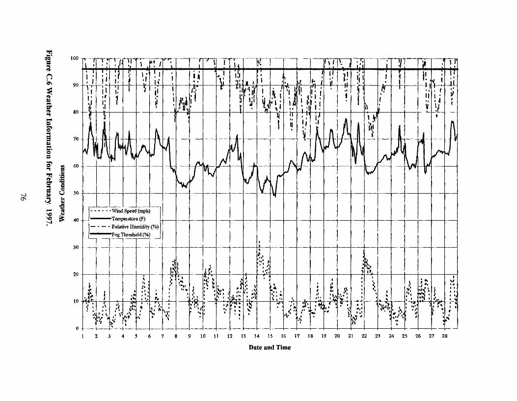
-...J 0\
~
~· ~ ~ C\
~ a. ::r ~ '"'I
~ ~ a ~ .... e = ~ '"'I
~ d ~
~ .... \0 \0 :-"
g ·:: .... "Cl
el u
t ~
100 n frT:'fl \ •I • • I • ~TT,- .r~-lf--~ 1-1 ii-,~! rr1;r-v111 I ~;!I\ 1 ;!;I I i I ~I ! 'j I :i ! !1 ' I I• lj I • • • •r i; l; I •
90 ti' I 1 I I· - ·I' I! I ' . ' j! '1' J j1 JJHi ~
.1 I . 80 +- ' '
• l
jl;Ttr~-;++-+-~_J'
. . ' . .. " t II I · ,, . ' II I
...
" I t .
• .. II M . u
~ 60+-i---t---+--l·~l-~
50 I I l I- --4-- -j--l-- I - -+-------!
-~~
• • • • • ·Wind Speed (mph)
40 -1-l Temperature (F) 1-------4 - ~ -----4- --1---t---+ ~ ---t-- ----1 --
- • - • Relative Humidity(%)
og Threshold(%) 1----r - ------. - -----,---~--
30 +----!---+-- -1---
I . ,;
,• I• I , ... ,, ' I • 1• .:;.
·~ \ I f'' I I • ._. 201 u\ .i~• - ••:, \1t
' •:~· ~·~ ,I •1 I t I • •• •• .... 4,\ili ~at • • \ ,. :• l • ..,. 11 : ' .. I # ~ t
1 ' :,. ; ~ 1
\ t
~ • • • I I • : • I • ( • • • ._\.• ••• ; : • ., •• I • I •• ~\ • •, t ": 7,;,,,. I ... • I • ' I I • • • • • i I •• ••• •• " •• I I • I • • • • ••
10 ' .. 'l~h I •'- I •1 '• f__j,__ ., .~: I - , .. I t }\~h :. 1•1 \:le •, 11~ 1 l,! •:,,.'I - ~ 'r .. : : t
·:: ,\ 'i :;; I I .i, I '*·r:·: ·~··:: •S ·---~ .-. :C· .~'':'I •• ·'-·-·., ·~'! ) I I I 1
1 I \ 1 • ~ ,.t I ,. 0._ ,: ! If t 11 ~ t • ~ .,. 11 ~ •' ~ t ·~~; • 1; .... "'''' I ·, I : ,t t\ I I ':., I \• ... ,.. I " lillit
1• I • • 4 I ,1 I I t .. t \ f II • ~.,. 1":1~ ,,.
,. . .... .. '• .-__ ' ,, • \ .. l ~ I I • • .... " .. ,,11,• I ~'II '\ \ '..', ~· I "
o' 1 l~ ' , h •
I .... v . ... . .. .I JI ' I I
"'""' . , ' . P.'.'\ • I ' ,, ... , I•'...- -~ . . ~ 'I I I Ill I • ~ . , - & I .... .
2 3 4 5 6 7 8 9 10 11 12 13 14 15 16 17 18 19 20 21 22 23 24 25 26 27 28
Date and Time

~ .... (JQ
= t2 ~ -J
~ ~ ~ .... l:S" ~ ., ,... = ;i ., a » .... .... e = ...
= ;i .2 ., .::: 'O
a:: = 0 ~ u ri a..
~
-l l:S" -= -l
.... .... ~ \D at \D ;--1
100 • ' I • •I 1 • ·- I 11 I • • • • ' • • ,,, I 1'i '. ~ I 1 r r I I. ... ! .. 11 I I 1 :. 'J 1 • I
80
Ll: , , 11 1' I \I I :; I ·'! :1 1 : ~ ; . ; ! 11 I if' •I " ~ 1 It ~ ·~ I,: ~I 1 •
90 l- • ·-1·1-J-1- . .. .~ . . ; I . . I •. ' I ! 1! I h I I • '
~•X 'I• fl) 1 I ,
11r-1-- -i; ---' • ;· I • I
l
601 1.,. I i , 1-1-j -h . _i_.
'I JJ I l I I tttl I I so.i --~--,---, I-~ trt -1, l,_---,.U. l-·--+1~-~~ -4-l--·-+·--f-·l·-+---
40 ..... , -+--j --'!.- r-~ -r- · · · · ·Wind Speed (mph) t - - --l- -4.- -1--
I I 1 Temperature (F)
-----
. I I I I i . I 1-· -· Relative Humidity (%) I
. I ! I 30 -1-
11-r1
- Fogcutoff<%> --1----+--·-j··--f--
' Li- -r·-1 ~ I I I ., •
'
I I I I I I 'I' I I ! • • I •1; ••
:· I I..: ) • •.•/ I\ l . I . I I .. • I
20 -,-~·Q--1·- - : •' 1 I •. -T ··~ • -;---+-·-~ ··- >-·-
.. .. ' I I '• ' \ I • '• ~ o# I • • ,, I • '· I• .. \ • r:
I I .If ! • \"14 I • ~ .. I '· '• •• .. • I '· ! ,. ; I : .., iw. : . .. : ··. . .. I .. ,, •• ~ .. • ·.; I •• I .. I ... "' /... .,, I • • •• ., • 1\ •• I. •
10 -1r~;_ • • ~ .... _.. I - - • 'I I _ ....... I ' •• ~ ~~t----t---"'-t-~·-_,_ .......... ..,......,.__..,.,_..,._...~,......_~ 1 la 7 1 '\U ' ftt I t1I ,. 111 ti I I \f... I ail It I I
---+--4 ~ -"1----+~--t------1--
: l ~ l I 'lf I ~ l f \il1 W ,.._. I \ t I • t t• I f'I \ • ' .,. ,. • I I • .. I " h N '" • f' .. - ' 1 f ,.... • ' ,. I • ... • 11 .;, r" #' • .... • : : • ,, • • '
# I ! I f I 1 I '
0 • I I I •
----.\~-+---\--
. '
'lti
'
2 3 4 s 6 7 8 9 10 11 12 13 14 15 16 17 18 19 20 21 22 23 24 25 26 27 28 29 30 31
Date and Time


12.0 APPENDIX D WEATHER AND MORTALITY LOGS
79


1st Quarter 1995
Date Wind Fog Temp Pelican Location if Known Dir/Speed Mortality (mph)
111 N/8-18 Yes 50's 112 N/10-13 Rain 40's 1/3 N/13-16 Drizzle 40's 114 N/13-17 Drizzle 40's 2 Westbound, Padre
Island Side Eastbound, Padre Island Side
115 N/10-13 Fog 40's 1118 N/10-20 Fog 60's 1119 NW/3-8 60's 1/23 N/10-20 50's 1/24 N/3-10 50's 1128 N/0-15 Fog 60's 1/29 N/5-16 50's 1130 N/0-17 50's
214 N/6-15 50's 2/12 N/6-15 60's 2/13 N/6-7 50's 2/17 N/7-17 Fog 50's 2/18 N/6-12 50's 2/19 N/5-15 Drizzle 60's 2120 N/3-15 Fog 50's
311 N/7-12 60's 312 NW/8-14 Drizzle 50's 3/3 NW/9-15 Rain 40's 314 NNW/5-8 Fog 50's 317 N/5-28 Drizzle 60's 3/8 N/5-17 40's 1 Westbound, past
hump on island side 319 NNE/5-10 50's 3/29 NNW/13-17 Drizzle 50's 3130 N/8-14 Fog 50's 3/31 N/8-13 Rain 50's
81

3rd and 4th Quarter 1995
Date Wind Fog Temp Pelican Location if Known Dir/Speed Mortality (mph)
919 ENE/0-14 Fog 80's 2 9122 NW/5-22 Drizzle 50's 9/23 N/6-16 70's 2 9124 N/6-9 70's 9125 N/6-14 80's 9126 N/5-14 Fog 80's
10/1 N/5-16 80's 10/3 N/6120 70's 10/6 NE/3-16 Fog 70's 10/7 NE/3-12 70's 10/11 N/5-14 70's 10/12 N-NE/5-12 Drizzle 70's 10/13 N/7-14 Drizzle 70's 10/14 N/10-23 70's 10/15 N/5-15 60's 10/16 N/5-13 70's 10/17 N/3-10 70's 10/18 N/5-15 70's 10120 N/5-20 Fog 70's
11/3 N/12-21 Drizzle 50's 1114 NW/14-20 50's 2 Eastbound 1115 N 4 1 Westbound
3 Eastbound 11/24 N/5-15 60's 11/28 N/3-18 Fog 60's 11/29 N/3-10 50's
12/9 N/14-20 50's 12/10 N/5-15 40's 12/20 N/5-13 50's 12/21 N/8-16 Drizzle 50's 12/22 N/6-20 Drizzle 40's 12/23 N/12-14 Fog 40's 12/24 N/12-18 Drizzle 40's 12/25 N/10-17 Fog 40's 2
82

12126 NW/9-12 Drizzle 40's 12/27 N/7-10 50's
1996
Date Wind Fog Temp Pelican Location if Known Dir/Speed Mortality (mph)
111 N 79-54 112 N 50's 116 N Fog 40's 117 N 30's 1 Eastbound, 1 mile from
Padre Island 1111 N 50's 1112 NINE 50's 1/18 NINE 60's 1119 NINE 40's 1124 NINE 50's 1/25 NINE 50's/60's 1/31 NEIN Rain 50's 2/1 N Fog 40's Eastbound, 1/.i mile from
hump on Island side 212 N Fog 40's Westbound, 400 feet from
Port Isabel end of bridge 213 N 30's 2119 S/SW Fog 70's 2 1 Eastbound,
approximately 80 feet from end of Bridge on Padre Island side. 1 Westbound, approximately 80 feet from end of Bridge on Padre Island side
2/28 N Fog 60's 2129 N Fog 40's 317 N Fog 50's 1 Eastbound, approximately
200 feet from end of bridge Padre Island side
83

1996
Date Wind Fog Temp Pelican Location if Known Dir/Speed Mortality (mph)
11/2 N 60's 1 Eastbound, 1.3 miles from Island 1113 60's 1 Eastbound, 1.4 miles from Island 11/28 60's 11/29 60's 12/1 60's 12/6 Yes 70's 12/7 Yes 70's 12/8 N 60's 12112 Yes 70's 12/13 Yes 70's 12/16 N 50's 2 Eastbound, . 5 miles from
Island Westbound, 200 ft from Port Isabel end of bridge
12/17 N 50's 12/18 N 40's 12/19 40's 12/20 Drizzle 50's 12/21 Drizzle 60's 12/24 N Drizzle 60's 12/25 N 50's 12/27 Fog 60's 12/30 Fog 60's
84

1997
Date Wind Fog Temp Pelican Location if Known Dir/Speed Mortality (mph)
117 N 40's 2 Eastbound, 1.5 miles from hump, Island side
1/8 N Drizzle 40's 1112 N 40's 1113 N Drizzle 30's 1/15 Fog 40's 1122 Fog 60's 217 Fog 60's 2/10 N Drizzle 50's 2/14 N 50's 1 Eastbound, 114 mile from
hump Island side 2/21 Fog 60's 2/24 Fog 60's 3110 Fog 60's
85
