evaluating shoreline response to offshore sand mining for beach
TRANSCRIPT

Journal of Coastal Research 20 1 89–100 West Palm Beach, Florida Winter 2004
Evaluating Shoreline Response to Offshore SandMining for Beach NourishmentSean W. Kelley, John S. Ramsey, and Mark R. Byrnes
Applied Coastal Research and Engineering, Inc.766 Falmouth Road, Suite A-1Mashpee, MA 02649, USA
ABSTRACT
KELLEY, S.W.; RAMSEY, J.S., and BYRNES, M.R., 2004. Evaluating shoreline response to offshore sand mining forbeach nourishment. Journal of Coastal Research, 20(1), 89–100. West Palm Beach (Florida), ISSN 0749-0208.
An analytical approach that incorporates analysis of nearshore wave transformation and wave-induced longshoresediment transport was developed to quantify the significance of potential physical environmental impacts associatedwith offshore sand mining. Calculation of longshore sediment transport potential for a series of wave cases provideda method for determining the extent and magnitude of alterations to nearshore processes, but the magnitude of changealone did not provide enough information to determine the significance of changes for a particular coastline. Thispaper documents a method for evaluating the significance of borrow site impacts that incorporates temporal andspatial variations in the incident wave field. Example applications of this method are presented for borrow sitesoffshore Oregon Inlet, North Carolina; Martin County, Florida; and Corsons Inlet, New Jersey. As a managementtool, this methodology holds several advantages over methods previously employed to assess the significance of borrowsite impacts, including: 1) a model-independent component (observed shoreline change) is used to verify model results;2) impacts associated with borrow site excavation can be directly related to their potential influence on observedcoastal processes; 3) site-specific temporal variability in wave climate and sediment transport potential is calculatedas part of the methodology; and 4) the procedure accounts for spatial and temporal variability in wave climate, aswell as provides a means of quantifying significance of impacts relative to site-specific conditions.
ADDITIONAL INDEX WORDS: Wave transformation modeling, longshore sediment transport, cumulative effects,Oregon Inlet, North Carolina, Martin County, Florida, Corsons Inlet, New Jersey.
INTRODUCTION
During the past few decades, there has been increased in-terest in sand and gravel resources on the Outer ContinentalShelf (OCS) of the USA (e.g., FIELD and DUANE, 1974; MEIS-BURGER and WILLIAMS, 1980; WILLIAMS, 1987). The poten-tial for exploitation of these sand resources as a source forbeach and barrier island restoration has grown rapidly assimilar resources in State waters are being depleted or pol-luted. Beach nourishment, as a form of erosion control, hasbecome a standard engineering alternative to coastal engi-neering structures (e.g. groins, seawalls, and breakwaters)because nourishment projects dissipate wave energy and re-plenish the local sediment supply.
However, beach nourishment programs potentially cancause adverse environmental impacts at beach fill locationsand borrow sites if an offshore sediment source is mined. Inaddition to concerns regarding biological resources, the phys-ical effects of offshore sand mining on the incident wave fieldand associated sediment transport regime may alter localshoreline change. This is demonstrated well in the exampleof a 1983 nourishment of Grand Isle, Louisiana (COMBE andSOILEAU, 1987) where a 2.1 million cubic meter (MCM) beachfill was constructed using sand from two borrow sites located800 m offshore. Modifications to the wave and sedimenttransport climate of the area resulted in the unintended for-
7 received and accepted in revision 6 June 2003.
mation of large cuspate bars and erosion hot spots on thebeach, which persisted long after the borrow sites had filled.
Many past offshore borrow site studies have used computermodeling of waves and shoreline change to determine post-dredging impacts (e.g., HORIKAWA et al., 1977; KRAUS et al.,1988). Less attention has been focused on determining therelative significance of potential changes to the physical en-vironment associated with offshore sand mining. To this end,an analytical approach was developed that incorporates anal-ysis of nearshore wave transformation and wave-inducedlongshore sediment transport. The most effective means ofquantifying incremental and cumulative physical environ-mental changes from sand dredging on the continental shelfis through the application of wave transformation numericalmodeling tools that recognize the random nature of incidentwaves as they propagate onshore. Spectral wave models, suchas STWAVE (e.g., SMITH and HARKINS, 1997), REF/DIF-S(e.g., CHAWLA et al., 1994), SWAN (BOOIJ et al., 1999), andothers typically reproduce field measurements. As such, spec-tral wave transformation modeling was applied to evaluatethe potential negative effects of sand removal from offshoreborrow sites to coastal and nearshore environments. Al-though the interpretation of wave modeling results is rela-tively straightforward, evaluating the significance of predict-ed changes for accepting or rejecting a borrow site is morecomplicated.
A three-phase approach was implemented to evaluate the

90 Kelley et al.
Journal of Coastal Research, Vol. 20, No. 1, 2004
Figure 1. Surface plot with 2.5-m contours of bathymetry grid used for idealized borrow site model runs.
potential physical effects of offshore sand mining on localwave and sediment transport processes. First, a standardmethod was developed to quantify the significance of changesassociated with borrow site excavation and to determine theinfluence of borrow site geometry on wave refraction and sed-iment transport patterns. Because large spatial and temporalvariability exists within the wave climate at a particular site,determination of physical impacts associated with sand min-ing must consider the influence of process variability. Thesecond phase of the project focused on wave spectra devel-opment, wave transformation modeling, and coastal sedimenttransport calculations. The final phase addressed potentialcumulative effects and significance of sand dredging from off-shore sand borrow sites. A site-specific determination of ac-ceptable limits of borrow site impacts relative to sedimenttransport potential was determined for each case.
WAVE AND SEDIMENT TRANSPORT PROCESSES
In recent years, there has been increased focus on the near-shore zone due to rapid development of coastal regions andthe need to protect infrastructure from storms and long-termcoastal erosion. This effort has concentrated on developinganalytical tools to evaluate the transformation of waves inshallow water and to quantify sediment transport induced bybreaking waves along the shoreline. Although improvementshave been made, evaluation of coastal processes still requiresa combination of analytical capability, interpretation of manycomplex and often apparently conflicting data sets, and ex-perience gained from analyzing a variety of shorelines.
Nearshore Wave Transformation
Variations in seafloor elevation tend to dominate wavetransformation as waves propagate into intermediate andshallow water. Although a small amount of energy is lostthrough bottom stresses (frictional drag), most nearshorewave transformation results from six processes: 1) refraction,2) shoaling, 3) breaking, 4) diffraction, 5) reflection, and 6)wave-current interactions. These processes determine the
size and incident angle of breaking waves, the dominant fac-tors influencing nearshore sediment transport. Although mi-nor wave diffraction and reflection may occur at an offshoreborrow site, typically, the combined influence of wave refrac-tion, shoaling, and breaking dominate transformation pro-cesses. Therefore, consideration of these three dominant pro-cesses represents the critical components of any spectralanalysis used to evaluate alterations to a wave field associ-ated with offshore sand mining.
Excavation of an offshore borrow site can alter waveheights and wave propagation direction. The existence of anoffshore trough or trench may cause waves to refract towardthe shallow edges of the borrow site. This alteration to thewave field changes local sediment transport rates, wheresome areas may experience a reduction in longshore trans-port and other areas may show an increase. The magnitudeand significance of the change at the shoreline would dependupon the wave climate and the borrow site distance fromshore. Analysis of wave modifications at an idealized borrowsite was performed using STWAVE to illustrate how alter-ations in offshore bathymetry can modify existing wave con-ditions and resulting sediment transport processes. Figure 1shows the configuration of a hypothetical borrow site, exca-vated into idealized bathymetry developed using straight andparallel contours and an Aym profile for southern New Jersey(DEAN, 1977). The idealized borrow site was located approx-imately 400 m offshore, centered on the 210 m (mean waterlevel, MWL) bathymetric contour, with an excavation depthof 3 m below the seafloor. To evaluate a range of wave trans-formation possibilities, wave spectra centered at 2308, 2158,08, 158, and 308 relative to shore normal were modeled, eachwith the same significant wave height and peak period, andhaving an equal percent occurrence (20%).
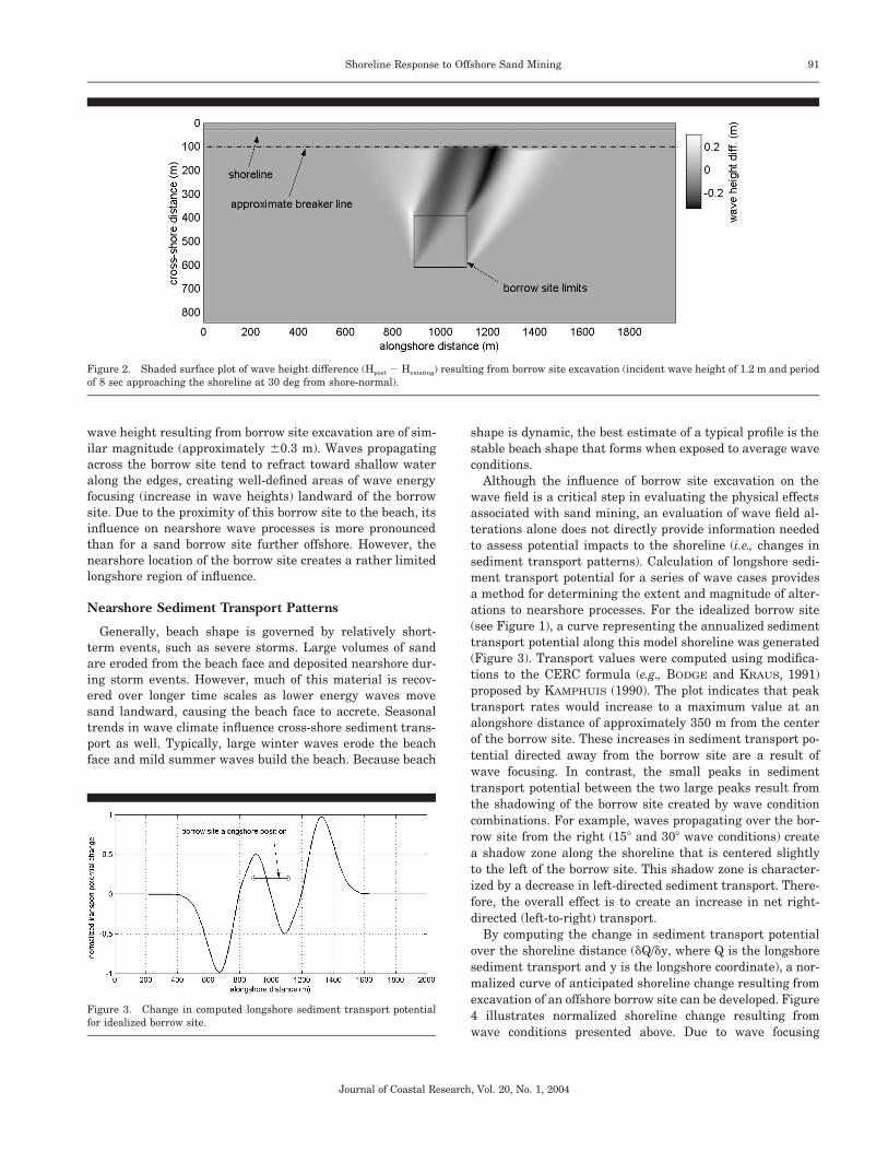
Figure 2 illustrates the influence of the idealized borrowsite on nearshore waves for a single wave condition approach-ing the shoreline from 2308 relative to shore-normal. For thiswave modeling case, the influence of the borrow site extendsapproximately 900 m alongshore measured at the breakerline. In addition, the maximum increase and decrease in
91Shoreline Response to Offshore Sand Mining
Journal of Coastal Research, Vol. 20, No. 1, 2004
Figure 2. Shaded surface plot of wave height difference (Hpost 2 Hexisting) resulting from borrow site excavation (incident wave height of 1.2 m and periodof 8 sec approaching the shoreline at 30 deg from shore-normal).
Figure 3. Change in computed longshore sediment transport potentialfor idealized borrow site.
wave height resulting from borrow site excavation are of sim-ilar magnitude (approximately 60.3 m). Waves propagatingacross the borrow site tend to refract toward shallow wateralong the edges, creating well-defined areas of wave energyfocusing (increase in wave heights) landward of the borrowsite. Due to the proximity of this borrow site to the beach, itsinfluence on nearshore wave processes is more pronouncedthan for a sand borrow site further offshore. However, thenearshore location of the borrow site creates a rather limitedlongshore region of influence.
Nearshore Sediment Transport Patterns
Generally, beach shape is governed by relatively short-term events, such as severe storms. Large volumes of sandare eroded from the beach face and deposited nearshore dur-ing storm events. However, much of this material is recov-ered over longer time scales as lower energy waves movesand landward, causing the beach face to accrete. Seasonaltrends in wave climate influence cross-shore sediment trans-port as well. Typically, large winter waves erode the beachface and mild summer waves build the beach. Because beach
shape is dynamic, the best estimate of a typical profile is thestable beach shape that forms when exposed to average waveconditions.
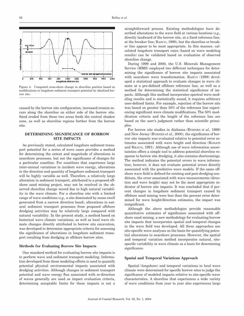
Although the influence of borrow site excavation on thewave field is a critical step in evaluating the physical effectsassociated with sand mining, an evaluation of wave field al-terations alone does not directly provide information neededto assess potential impacts to the shoreline (i.e., changes insediment transport patterns). Calculation of longshore sedi-ment transport potential for a series of wave cases providesa method for determining the extent and magnitude of alter-ations to nearshore processes. For the idealized borrow site(see Figure 1), a curve representing the annualized sedimenttransport potential along this model shoreline was generated(Figure 3). Transport values were computed using modifica-tions to the CERC formula (e.g., BODGE and KRAUS, 1991)proposed by KAMPHUIS (1990). The plot indicates that peaktransport rates would increase to a maximum value at analongshore distance of approximately 350 m from the centerof the borrow site. These increases in sediment transport po-tential directed away from the borrow site are a result ofwave focusing. In contrast, the small peaks in sedimenttransport potential between the two large peaks result fromthe shadowing of the borrow site created by wave conditioncombinations. For example, waves propagating over the bor-row site from the right (158 and 308 wave conditions) createa shadow zone along the shoreline that is centered slightlyto the left of the borrow site. This shadow zone is character-ized by a decrease in left-directed sediment transport. There-fore, the overall effect is to create an increase in net right-directed (left-to-right) transport.
By computing the change in sediment transport potentialover the shoreline distance (dQ/dy, where Q is the longshoresediment transport and y is the longshore coordinate), a nor-malized curve of anticipated shoreline change resulting fromexcavation of an offshore borrow site can be developed. Figure4 illustrates normalized shoreline change resulting fromwave conditions presented above. Due to wave focusing
92 Kelley et al.
Journal of Coastal Research, Vol. 20, No. 1, 2004
Figure 4. Computed cross-shore change in shoreline position based onmodifications to longshore sediment transport potential by idealized bor-row site.
caused by the borrow site configuration, increased erosion oc-curs along the shoreline on either side of the borrow site.Sand eroded from these two areas feeds the central shadowzone, as well as shoreline regions further from the borrowsite.
DETERMINING SIGNIFICANCE OF BORROWSITE IMPACTS
As previously stated, calculated longshore sediment trans-port potential for a series of wave cases provides a methodfor determining the extent and magnitude of alterations tonearshore processes, but not the significance of changes fora particular coastline. For coastlines that experience largeinter-annual variations in incident wave energy, alterationsin the direction and quantity of longshore sediment transportwill be highly variable as well. Therefore, a relatively largealteration in sediment transport, attributed to a proposed off-shore sand mining project, may not be resolved in the ob-served shoreline change record due to high natural variabil-ity in the wave climate. For a shoreline site with a limitedrange of wave conditions (e.g., a site dominated by ocean swellgenerated from a narrow direction band), alterations in nat-ural sediment transport processes from proposed offshoredredging activities may be relatively large compared withnatural variability. In the present study, a method based onhistorical wave climate variations, as well as local wave cli-mate changes directly attributed to borrow site excavation,was developed to determine appropriate criteria for assessingthe significance of alterations in longshore sediment trans-port resulting from dredging at offshore borrow sites.
Methods for Evaluating Borrow Site Impacts
One standard method for evaluating borrow site impacts isto perform wave and sediment transport modeling. Informa-tion developed from these modeling efforts is used to quantifypotential physical environmental impacts associated withdredging activities. Although changes in sediment transportpotential and wave energy flux associated with re-directionof waves generally are used as impact evaluation criteria,determining acceptable limits for these impacts is not a
straightforward process. Existing methodologies have de-scribed alterations to the wave field at various locations (e.g.,directly landward of the borrow site, at a fixed reference line,at the breaker line; BASCO, 1999), but the shoreline or break-er line appear to be most appropriate. In this manner, cal-culated longshore transport rates (based on wave modelingresults) can be validated based on evaluation of observedshoreline change.
During 1999 and 2000, the U.S. Minerals ManagementService (MMS) employed two different techniques for deter-mining the significance of borrow site impacts associatedwith nearshore wave transformation. BASCO (1999) devel-oped a statistical approach to evaluate changes in wave cli-mate at a pre-defined offshore reference line, as well as amethod for determining the statistical significance of im-pacts. Although this method incorporates spectral wave mod-eling results and is statistically sound, it requires arbitraryuser-defined limits. For example, rejection of the borrow sitewas based on greater than 50% of the reference line experi-encing significant wave climate modifications. The 50% mod-ification criteria and the length of the reference line arebased on the user’s judgment rather than scientific princi-ples.
For borrow site studies in Alabama (BYRNES et al., 1999)and New Jersey (BYRNES et al., 2000), the significance of bor-row site impacts was evaluated relative to potential error es-timates associated with wave height and direction (ROSATI
and KRAUS, 1991). Although use of wave information uncer-tainties offers a simple tool to address potential shoreline re-sponse to borrow site dredging, it also contains shortcomings.The method indicates the potential errors in wave informa-tion; however, it does not evaluate potential errors directlyassociated with the predictive wave models. If the same off-shore wave field is defined for existing and post-dredging con-ditions, the error associated with wave measurements (direc-tion and wave height) may not be the most appropriate in-dicator of borrow site impacts. It was concluded that if per-cent changes in longshore sediment transport caused byoffshore sand mining were less than the percent error deter-mined for wave height/direction estimates, the impact wasinsignificant.
Although the above methodologies provide reasonablequantitative estimates of significance associated with off-shore sand mining, a new methodology for evaluating borrowsite impacts that incorporates spatial and temporal changesin the wave field was developed. All three approaches usesite-specific wave analyses as the basis for quantifying poten-tial alterations to nearshore processes. However, the spatialand temporal variation method incorporates natural, site-specific variability in wave climate as a basis for determiningsignificance.
Spatial and Temporal Variations Approach
Spatial (longshore) and temporal variations in local waveclimate were determined for specific borrow sites to judge thesignificance of modeled impacts relative to site-specific wavecharacteristics. A shoreline that experiences a wide varietyof wave conditions from year to year also experiences large
93Shoreline Response to Offshore Sand Mining
Journal of Coastal Research, Vol. 20, No. 1, 2004
Figure 5. Comparisons of cumulative distributions of wave energy from three WIS stations located at a) Station 67, offshore New Jersey; b) Station 56,offshore North Carolina; and c) Station 14, offshore Florida. Normalized energy distributions based on wave approach angle to the shoreline (solid line)are plotted against normal distributions (dash-dot line) determined for each data set.
variability in sediment transport rates. Thus, the level of ac-ceptable borrow site impacts would be relatively high. Con-versely, a shoreline that experiences a limited range of waveconditions cannot accept the same level of borrow site im-pacts. Because the natural variability in inter-annual shore-line movements change along the coast, certain portions ofthe shoreline will be more tolerant of alterations to the waveclimate and associated sediment transport patterns.
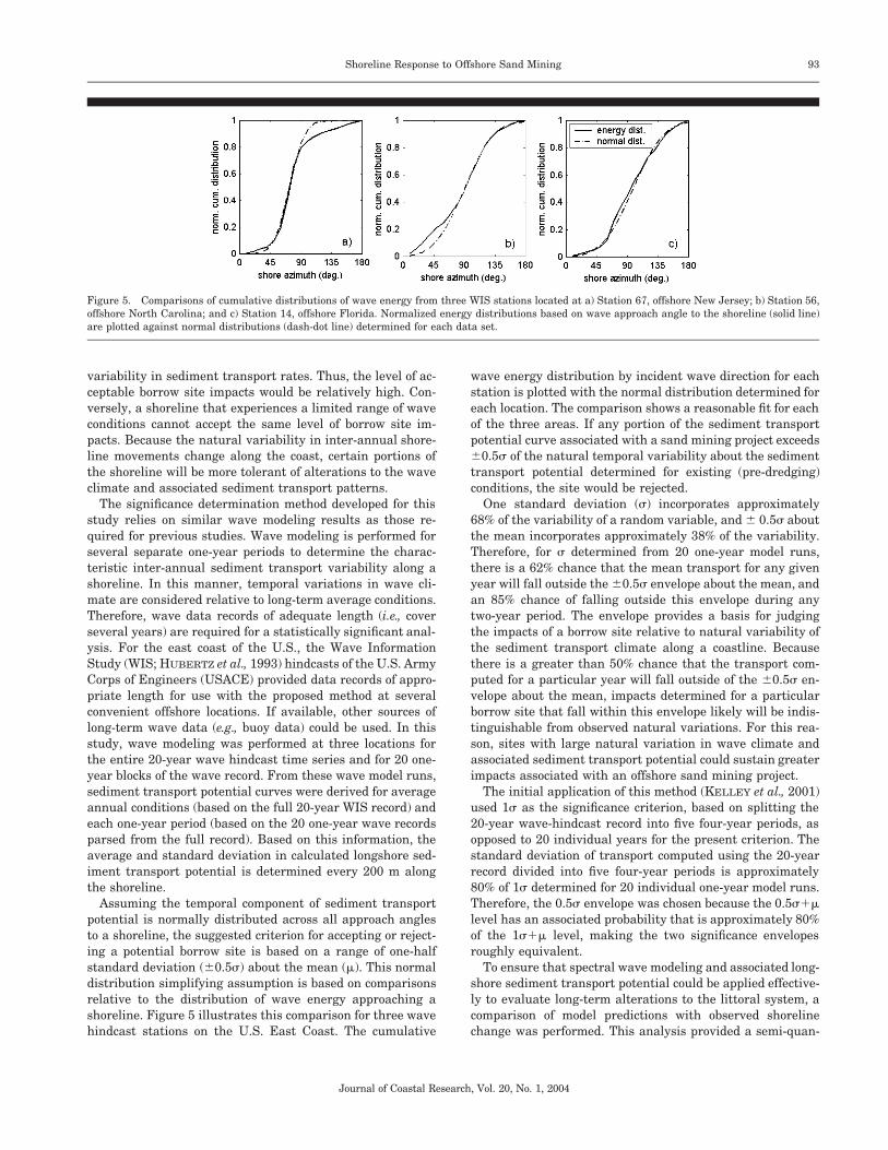
The significance determination method developed for thisstudy relies on similar wave modeling results as those re-quired for previous studies. Wave modeling is performed forseveral separate one-year periods to determine the charac-teristic inter-annual sediment transport variability along ashoreline. In this manner, temporal variations in wave cli-mate are considered relative to long-term average conditions.Therefore, wave data records of adequate length (i.e., coverseveral years) are required for a statistically significant anal-ysis. For the east coast of the U.S., the Wave InformationStudy (WIS; HUBERTZ et al., 1993) hindcasts of the U.S. ArmyCorps of Engineers (USACE) provided data records of appro-priate length for use with the proposed method at severalconvenient offshore locations. If available, other sources oflong-term wave data (e.g., buoy data) could be used. In thisstudy, wave modeling was performed at three locations forthe entire 20-year wave hindcast time series and for 20 one-year blocks of the wave record. From these wave model runs,sediment transport potential curves were derived for averageannual conditions (based on the full 20-year WIS record) andeach one-year period (based on the 20 one-year wave recordsparsed from the full record). Based on this information, theaverage and standard deviation in calculated longshore sed-iment transport potential is determined every 200 m alongthe shoreline.
Assuming the temporal component of sediment transportpotential is normally distributed across all approach anglesto a shoreline, the suggested criterion for accepting or reject-ing a potential borrow site is based on a range of one-halfstandard deviation (60.5s) about the mean (m). This normaldistribution simplifying assumption is based on comparisonsrelative to the distribution of wave energy approaching ashoreline. Figure 5 illustrates this comparison for three wavehindcast stations on the U.S. East Coast. The cumulative
wave energy distribution by incident wave direction for eachstation is plotted with the normal distribution determined foreach location. The comparison shows a reasonable fit for eachof the three areas. If any portion of the sediment transportpotential curve associated with a sand mining project exceeds60.5s of the natural temporal variability about the sedimenttransport potential determined for existing (pre-dredging)conditions, the site would be rejected.
One standard deviation (s) incorporates approximately68% of the variability of a random variable, and 6 0.5s aboutthe mean incorporates approximately 38% of the variability.Therefore, for s determined from 20 one-year model runs,there is a 62% chance that the mean transport for any givenyear will fall outside the 60.5s envelope about the mean, andan 85% chance of falling outside this envelope during anytwo-year period. The envelope provides a basis for judgingthe impacts of a borrow site relative to natural variability ofthe sediment transport climate along a coastline. Becausethere is a greater than 50% chance that the transport com-puted for a particular year will fall outside of the 60.5s en-velope about the mean, impacts determined for a particularborrow site that fall within this envelope likely will be indis-tinguishable from observed natural variations. For this rea-son, sites with large natural variation in wave climate andassociated sediment transport potential could sustain greaterimpacts associated with an offshore sand mining project.
The initial application of this method (KELLEY et al., 2001)used 1s as the significance criterion, based on splitting the20-year wave-hindcast record into five four-year periods, asopposed to 20 individual years for the present criterion. Thestandard deviation of transport computed using the 20-yearrecord divided into five four-year periods is approximately80% of 1s determined for 20 individual one-year model runs.Therefore, the 0.5s envelope was chosen because the 0.5s1mlevel has an associated probability that is approximately 80%of the 1s1m level, making the two significance envelopesroughly equivalent.
To ensure that spectral wave modeling and associated long-shore sediment transport potential could be applied effective-ly to evaluate long-term alterations to the littoral system, acomparison of model predictions with observed shorelinechange was performed. This analysis provided a semi-quan-

94 Kelley et al.
Journal of Coastal Research, Vol. 20, No. 1, 2004
Figure 6. Bathymetry surface and borrow sites for offshore North Car-olina. As designed, Site 1 is a 7.2 MCM borrow area, with a 3-m exca-vation depth; Site 2 has 5.8 MCM, with a 3-m excavation depth; Site 3east has 1.4 MCM, with a 2-m excavation depth; Site 3 west has 2.5 MCM,with a 3-m excavation depth; and Site 4 has 2.3 MCM, with a 2-m exca-vation depth.
titative method for determining whether (a) longshore wave-induced transport is responsible for observed shorelinechange, and (b) long-term shoreline change trends are con-sistent with the shorter-term (20-year) sediment transportpotential analyses. An evaluation of model output was per-formed using a comparison of computed gradients in sedi-ment transport with historical shoreline change data. The ba-sis for this comparison is the relationship between shorelinemovement and the longshore gradient of sediment transport(e.g., DEAN and DALRYMPLE, 2002). Simply expressed, thisrelationship is
]Q ]x} (1)
]y ]t
where Q is sediment transport, y is alongshore distance, x isthe cross-shore position of the shoreline, and t is time. A com-parison of results should illustrate similar trends in long-term shoreline change and transport potential computed us-ing wave conditions that represent long-term average condi-tions. Good general agreement between these two quantitieswould suggest that the transport potential model reasonablyrepresents long-term coastal processes for a given area, andthus, the model’s ability to predict the likely impacts thatwould result from offshore dredging.
As a management tool, this methodology provides severaladvantages over methods previously employed to assess thesignificance of borrow site impacts. First, observed long-termshoreline change is compared with computed longshorechange in sediment transport potential. Close comparison be-tween these two quantities indicates that longshore sedimenttransport potential calculations are appropriate for assessinglong-term natural change. Therefore, this methodology has amodel-independent component (observed shoreline change)used to ground truth model results. Second, the method isdirectly related to sediment transport potential and associ-ated shoreline change. Therefore, impacts associated withborrow site excavation can be directly related to their poten-tial influence on observed coastal processes (annualized var-iability in shoreline position). Third, site-specific temporalvariability in wave climate and sediment transport potentialis calculated as part of the methodology. For sites that showlittle natural variability in inter-annual wave climate, allow-able coastal processes impacts associated with borrow sitedredging similarly would be limited, and vice versa. In thismanner, the inter-annual temporal component of the naturalwave climate is a major component in determining impactsignificance. Finally, similar to methodologies incorporated inprevious MMS studies, the longshore spatial distribution ofborrow site impacts is considered. However, the allowablelimit of longshore sediment transport variability is computedfrom the temporal component of the analysis. Therefore, thefinal results of this analysis provide a spatially-varying en-velope of allowable impacts in addition to the modeled im-pacts directly associated with borrow site excavation. Themethodology accounts for spatial and temporal variability inwave climate, as well as providing a defensible means of as-sessing significance of impacts relative to site-specific condi-tions.
SEDIMENT TRANSPORT VARIATIONS ATPROPOSED BORROW SITES
The potential impacts of dredging at three proposed borrowsites offshore Dare County, North Carolina (Figure 6); off-shore Martin County, Florida (Figure 7); and offshore Cor-sons Inlet, New Jersey (Figure 8) were evaluated within thecontext of natural variations in wave climate and sedimenttransport rates. For the North Carolina, Florida, and NewJersey examples, nearshore wave heights and directionsalong the shoreline landward of proposed borrow sites wereestimated using the spectral wave model STWAVE to simu-late the propagation of offshore waves to the shoreline. Off-shore wave conditions used as input for wave modeling werederived from measured spectral wave data from offshore databuoys or hindcast simulation time series data from the USA-CE Wave Information Study (WIS; e.g., HEMSLEY andBROOKS, 1989; and HUBERTZ et al., 1993). In general, buoydata are the preferred source of wave information, becausethey represent actual offshore wave conditions rather thanhindcast information derived from large-scale models. How-ever, very few sites along the U.S. coast have wave measure-ment records of sufficient length to enable their use as asource of long-term information.
Offshore North Carolina
The shoreline north of Oregon Inlet in the North CarolinaOuter Banks has been the focus of many previous monitoring

95Shoreline Response to Offshore Sand Mining
Journal of Coastal Research, Vol. 20, No. 1, 2004
Figure 7. Bathymetry surface and borrow site for offshore Martin Coun-ty, Florida. As designed, the site is a 24 MCM resource, with a 4.5-mexcavation depth.
and modeling studies (e.g., INMAN and DOLAN, 1989; LARSON,1995; KIM, WRIGHT, and KIM, 1997; MILLER, 1999). In thepresent study, the potential impacts of five offshore borrowsites were investigated. Wave input conditions for simula-tions offshore North Carolina were developed using hindcastdata from WIS station 56, located approximately 33 kmnortheast of Bodie Island, NC (HUBERTZ et al., 1993). ThisWIS record covers a 20-year period from January 1976 toDecember 1995.
Historical shoreline change analysis provides a without-project assessment of shoreline response for comparison withpredicted changes in wave-energy focusing at the shorelineresulting from potential offshore sand dredging activities. Be-cause continuous measurements of historical shorelinechange are available at 50-m alongshore intervals (seeBYRNES et al., 2003), model results (wave and sedimenttransport) at discreet intervals along the coast can be com-pared with historical data to develop process-response rela-tionships for evaluating potential impacts. Shoreline datacovering the periods 1849 to 1980 for Dare County, NorthCarolina were used to quantify trends. Methods for compilingand analyzing historical data sets are described in BYRNES
and HILAND (1994). Alongshore variations in sediment trans-port were determined from computed values of transport po-tential for each shoreline for modeled existing conditions.
Trends in shoreline change generally agree with modeledtransport gradients for the North Carolina coast north ofOregon Inlet (Figure 9). Results of both analyses illustrate a
stable to erosional shoreline, with an area of maximum ero-sion between 5 and 7 km north of Oregon Inlet. For the mod-eled transport gradient, there is an area of accretion locatedapproximately 3 km north of the point of maximum erosionthat is not indicated in the shoreline change analysis. Thismay be due to a lack of detailed nearshore bathymetry datafor a 2 km section of coastline at this location. Bathymetrydata used for developing the model grid was from the U.S.National Ocean Service (NOS) Geophysical Data System(GEODAS) database (NOS, 1998), but supplemental data dig-itized from a National Oceanic and Atmospheric Administra-tion (NOAA) navigational chart were required in the areanorth of the inlet. Therefore, the bathymetry data in this areadoes not have a high level of detail as is available in the dataused for adjacent sections of coast, and may affect the modelresults.
An exact match between the gradient in sediment trans-port potential and measured shoreline change was not ex-pected due to the differing time scales of the two analysistechniques (several decades for shoreline change and 20years for sediment transport potential). Significant migrationof Oregon Inlet also may be responsible for some of the dif-ferences between observed and modeled shoreline changetrends, where the peak in erosion likely has migrated southwith the inlet. Therefore, the peak erosion area determinedfrom the gradient of modeled transport potential, based on20 years of recent wave information, may be more represen-tative of present conditions than long-term shoreline change(based on more than 100 years of shoreline data). Overall,good agreement exists between observed shoreline changeand longshore gradient in modeled transport potential. Minordifferences between the two methods, especially in the regionof maximum erosion, likely are due to long-term alterations(spanning several decades) in shoreline position and the his-torical migration of Oregon Inlet.
In Figure 10, the computed change in transport potentialfor the two modeled scenarios (where sites 3 east and 3 westwere modeled alternately with sites 1, 2, and 4) falls withinthe 60.5s significance envelope determined for this shorelinereach. Therefore, according to the impact significance anal-ysis, the modeled borrow site configurations are acceptablewithout any additional stipulations. It is likely that if sites 3east and 3 west were dredged at the same time as the otherthree sites, the resulting change in computed sediment trans-port potential would exceed the 0.5s significance envelope. Ifthe impacts did fall outside the envelope, a redesign of theborrow site configuration would be required to minimize theimpact.
Offshore Eastern Florida
Results from the analysis of a single large borrow site off-shore the east coast of Florida are shown in Figure 11. Thisproposed site is located approximately 5 km offshore, approx-imately 17 km north of St. Lucie Inlet. The resource site wasidentified to contain approximately 24 million cubic meters(MCM) of sand, with an excavation depth of 4.5 m (15 ft).Analyses of potential changes due to dredging at this sitewere conducted in a similar fashion as the previous analyses

96 Kelley et al.
Journal of Coastal Research, Vol. 20, No. 1, 2004
Figure 8. Bathymetry surface and borrow site limits for offshore New Jersey.
presented for offshore North Carolina. Waves from WIS sta-tion 14 (HUBERTZ et al., 1993) were used as input conditionsfor STWAVE model runs developed for this area. The 60.5smaximum influence envelope determined for this shoreline,along with the change in sediment transport potential re-sulting from dredging the borrow site, is shown in Figure 11.Unlike offshore North Carolina, the significance envelope isexceeded in an area updrift of the borrow site and nearlyexceeded in an area downdrift of the borrow site. Because theresulting changes to longshore transport are determined tobe greater than the allowable envelope for an approximate 2-km length of shoreline, this site would be rejected and wouldrequire redesign to reduce potential adverse modifications tothe sediment transport regime. Additional model runs forthis site indicated that an excavation depth of approximately2 m would bring the transport variability caused by the bor-row site within the 0.5s1m envelope. Therefore, an approx-imate 12 MCM excavation at this site would be deemed ac-ceptable based on potential impacts associated with coastalsediment transport processes.
Multiple Dredging Events Offshore New Jersey
As an example of evaluating potential cumulative effectsassociated with multiple dredging events at a single borrow
site, wave and sediment transport modeling results were an-alyzed for multiple dredging excavation depths at Site M8,located approximately 7 km seaward of Corsons Inlet, NewJersey. This analysis applied the initial method for evaluat-ing impacts, where the 20-year wave-hindcast record wassplit into five four-year periods, rather than 20 individualyears. As described previously, the significance envelope re-sulting from this analysis technique is roughly equivalent tothe 0.5s1m envelope developed from splitting the 20-yearwave hindcast record into individual years. Waves from WISstation 67 (HUBERTZ et al., 1993) were used as input condi-tions for STWAVE model runs. The 61s maximum influenceenvelope determined for this area, along with changes in sed-iment transport potential resulting from a series of dredgingdepths at Site M8, are illustrated in Figure 12.
As the borrow site is excavated to greater depths (see Fig-ure 12), the impact it has on wave-induced sediment trans-port potential along the shoreline increases. Exploring arange of reasonable excavation depths provides site-specificinformation regarding anticipated increase in impacts rela-tive to dredging depth. Because of the proximity of the siteto shore and its relatively large perimeter, deep excavationsat Site M8 would have pronounced effects on modeled sedi-ment transport patterns at the shoreline. Model runs were

97Shoreline Response to Offshore Sand Mining
Journal of Coastal Research, Vol. 20, No. 1, 2004
Figure 9. Comparison of historical shoreline change and gradient of modeled transport potential (dQ/dy) for the North Carolina shoreline.
Figure 10. Plot of transport potential difference between existing andpost-dredging conditions, with the 60.5s maximum influence envelope(dash-dot line), for borrow sites located offshore North Carolina. The plotshows change in transport for Sites 1, 2, and 4, modeled with 3 east (solidblack line) and 3 west (dashed line), separately. The longshore extent ofeach borrow site also is indicated. A positive difference in sediment trans-port potential is defined as an increase in north-directed transport.
Figure 11. Plot of transport potential difference between existing andpost-dredging conditions (solid black line), with the 60.5s maximum in-fluence envelope (dash-dot line), for a single 24 MCM borrow site locatedapproximately 5 km offshore Martin County, Florida. A positive differ-ence in sediment transport potential is defined as an increase in north-directed transport potential.

98 Kelley et al.
Journal of Coastal Research, Vol. 20, No. 1, 2004
Figure 12. Plot of change in sediment transport potential computed for five excavated depths at Site M8, offshore Corsons Inlet, New Jersey. Theindicated dash-dot envelope represents the maximum transport influence that is allowed by the impact significance criterion, or 61s about the meansediment transport potential for this case.
made for 2, 3, 5, 7, and 9 m excavation depths. The resultingchange in sediment transport potential at the shoreline as-sociated with each of these model scenarios is shown in Fig-ure 12. Included with the plot of transport difference is theenvelope of maximum change as defined by the impact sig-nificance criterion. Based on this information, excavationdepths greater than 5 m would not be acceptable for this site,as the allowable limit criterion is exceeded along a portion ofthe shoreline south of Corsons Inlet.
DISCUSSION
To establish useful criteria for estimating impacts of sandmining on the nearshore littoral system, a comparison of sed-iment transport potential and long-term shoreline changewas performed at each of three sites. The analysis provideda semi-quantitative method for determining whether long-shore wave-induced transport was responsible for observedshoreline change and whether long-term shoreline changetrends were consistent with the 20-year sediment transportpotential analysis. In general, the comparison indicated thatthe longshore gradient in computed wave-induced sedimenttransport followed similar trends as observed long-termshoreline change. Exceptions occurred at locations whereSTWAVE modeling was not applicable (areas where wave dif-fraction was important) or where wave-induced processesmay not control sediment transport rates (in the vicinity oftidal inlets).
Because modeled longshore gradients in sediment trans-
port potential generally matched observed shoreline changetrends, wave and sediment transport modeling provided areasonable basis for evaluating long-term shoreline responseassociated with offshore sand mining. Because the naturalvariability in inter-annual shoreline migration changes alongthe coast, certain portions of a shoreline will be more tolerantof alterations to the wave climate and associated sedimenttransport. The method used to evaluate borrow site impactsprovided a reliable technique for developing acceptable site-specific limits associated with changes in sediment transportpotential.
Based on site-specific analyses for each of the three sites,an evaluation of impacts to the local wave and sedimenttransport regime ranged from insignificant to unacceptable.For offshore North Carolina, the two modeling scenarios in-dicated that the influence of excavating four borrow siteswith a combined sand volume of between 16.7 and 17.8 MCMwas deemed acceptable based on the significance criterion.As expected, excavation of Site 3 west had a greater impacton nearshore sediment transport patterns due to the largesand extraction volume, its proximity to the shoreline, andthe relatively shallow water depths. Because it has been sug-gested that borrow sites located in close proximity illustrateadditive impacts (KELLEY et al., 2001), the influence of mul-tiple sites on sediment transport along a coastline is an ad-ditive effect, rather than a more complicated non-linear effector amplification. Therefore, it is likely that excavation of Site3 east and Site 3 west would cause changes to the transport

99Shoreline Response to Offshore Sand Mining
Journal of Coastal Research, Vol. 20, No. 1, 2004
potential to fall outside the significance envelope, and theexcavation plan would be considered unacceptable.
Due to the relatively shallow water at the borrow site off-shore Martin County, Florida (approximately 8 to 10 m), a4.5 m excavation creates a pronounced effect on nearshoresediment transport processes. The maximum influence of thisborrow site causes a reduction in net south-directed transportof nearly 100,000 m3/year. As a result of limited variabilityin incident wave climate, the influence of the 24 MCM sandmining scenario exceeds the allowable 6 0.5s limit about themean natural sediment transport potential (m). By reducingthe excavation depth to less than 2.3 m (an excavation vol-ume of approximately 12 MCM), the influence of borrow siteexcavation on sediment transport potential falls within thesignificance criterion boundary. It is likely that re-orientationof the borrow site and/or expansion of the borrow site surfacearea with a decreased excavation depth also will decrease theimpact to sediment transport process.
The quantitative methodology for assessing borrow site im-pacts can be used to determine allowable excavation depths.An example of this analysis was shown for the southern NewJersey coast, where the influence of dredging Site M8 todepths ranging from 2 to 9 m was evaluated. Due to the rel-atively narrow variability in wave-induced sediment trans-port potential (one standard deviation about the mean of ap-proximately 640,000 m3/year), it was determined that themaximum allowable excavation depth for this site is about 5m. Although variability in sand transport potential along theshoreline of Martin County, Florida is significantly largerthan off the coast of southern New Jersey (allowable limitsabout the mean of approximately 675,000 m3/year comparedto 640,000 m3/year), excavation of the shallow shoal offshoreFlorida has a larger influence on wave refraction and asso-ciated sediment transport potential.
CONCLUSIONS
A quantitative method for evaluating the significance ofchanges to coastal processes that result from offshore sandmining is introduced and applied at three borrow site loca-tions along the east coast of the U.S. As the basis for thismethod, temporal variations in wave climate and longshoresediment transport are evaluated relative to average annualconditions. The suggested criterion for accepting or rejectinga potential borrow site is based on a range of one-half stan-dard deviation (60.5s) about the mean. If any portion of thesediment transport potential curve associated with a sandmining project exceeds 60.5s of the natural temporal vari-ability about the sediment transport potential determined forexisting conditions, the site would be rejected.
Sediment transport changes that fall within this envelopewill be indistinguishable from observed natural variations.For this reason, sites with large natural variation in waveclimate and associated sediment transport potential couldsustain greater changes associated with an offshore sandmining project.
As a coastal management tool, this analysis procedure pro-vides several advantages over methods previously employedto assess the significance of borrow site impacts. First, it has
a model-independent component (measured shorelinechange) with which to validate model results. Second, im-pacts associated with borrow site excavation can be directlyrelated to their potential influence on observed coastal pro-cesses. Third, site-specific temporal variability in wave cli-mate and sediment transport potential is calculated as partof the methodology. Finally, the method accounts for spatialand temporal variability in wave climate, and provides ameans of assessing significance of changes relative to site-specific conditions.
LITERATURE CITED
BASCO, D.R., 1999. A methodology and criteria to assess the impactsof sand volume removed in federal waters on the nearshore waveclimate. Coastal Engineering Center, Old Dominion University,Norfolk, VA.
BODGE, K.R; and KRAUS, N.C., 1991. Critical examination of long-shore transport rate magnitude. Proceedings, Coastal Sediments’91 (ASCE), pp 139–155.
BOOIJ, N.; RIS, R.C., and HOLTHUIJSEN, L.H. 1999. A third-gener-ation wave model for coastal regions, Part I, Model description andvalidation. Journal Geographical Research, C4(104), 7649–7666.
BYRNES, M.R.; HAMMER, R.M.; VITTOR, B.A.; KELLEY, S.W.; SNY-DER, D.B.; COTE, J.M.; RAMSEY, J.S.; THIBAUT, T.D.; PHILLIPS,N.W., and WOOD, J.D., 2003. Collection of Environmental DataWithin Sand Resource Areas Offshore North Carolina and the Im-plications of Sand Removal for Coastal and Beach Restoration. U.S.Department of the Interior, Minerals Management Service, Leas-ing Division, Sand and Gravel Unit, Herndon, VA. OCS ReportMMS 2000-056, Volume I: Main Text 257 pp. 1 Volume II: Ap-pendices 70p.
BYRNES, M.R.; HAMMER, R.M.; VITTOR, B.A.; RAMSEY, J.S.; SNYDER
D.B.; BOSMA, K.F.; WOOD, J.D.; THIBAUT, T.D., and PHILLIPS,N.W., 1999. Environmental Study of Identified Sand Resource Ar-eas Offshore Alabama: Volume I: Main Text, Volume II: Appendices.U.S. Department of the Interior, Minerals Management Service,International Activities and Marine Minerals Division (INTER-MAR), Herndon, VA. OCS Report MMS 99-0052, Volume I: MainText 326 p. 1 Volume II: Appendices 132p.
BYRNES, M.R.; HAMMER, R.M.; VITTOR, B.A.; RAMSEY, J.S.; SNY-DER, D.B.; WOOD, J.D.; BOSMA, K.F.; THIBAUT, T.D., and PHIL-LIPS, N.W., 2000. Environmental Survey of Potential Sand Re-source Sites: Offshore New Jersey. U.S. Department of the Interior,Minerals Management Service, International Activities and Ma-rine Minerals Division (INTERMAR), Herndon, VA. OCS ReportMMS 2000-052, Volume I: Main Text 380 p. 1 Volume II: Appen-dices 291p.
BYRNES, M.R. and HILAND, M.W., 1994. Compilation and Analysisof Shoreline and Bathymetry Data (Appendix B). In: KRAUS, N.C.;GORMAN, L.T., and POPE, J. (eds.), Kings Bay Coastal and Estu-arine Monitoring and Evaluation Program: Coastal Studies. U.S.Army Engineer Waterways Experiment Station, Coastal Engi-neering Research Center, Technical Report CERC-94-09, pp. B1–B89.
CHAWLA, A.; OZKAN-HALLER, H.T., and KIRBY, J.T., 1998. Spectralmodel for wave transformation over irregular bathymetry. Journalof Waterway, Port, Coastal and Ocean Engineering, 124, 189–198.
COMBE, A.J., III and SOILEAU, C.W., 1987. Behavior of Man-MadeBeach and Dune Grand Isle, Louisiana. Proceedings Coastal Sed-iments ’87 (ASCE), pp. 1232–1242.
DEAN, R.G., 1977. Equilibrium Beach Profiles: U.S. Atlantic and Gulfcoasts. University of Delaware, Department of Civil Engineering,Ocean Engineering Report No. 12.
DEAN, R.G. and DALRYMPLE, R.A., 2002. Coastal Processes with En-gineering Applications. Cambridge University Press, Cambridge,UK.
FIELD, M.E. and DUANE, D.B., 1976. Post Pleistocene History of theUnited States Inner Continental Shelf: Significance to the Origin

100 Kelley et al.
Journal of Coastal Research, Vol. 20, No. 1, 2004
of Barrier Islands. Geological Society of America Bulletin, 87, 691–702.
HEMSLEY, J.M. and BROOKS, R.M., 1989. Waves for Coastal Designin the United States. Journal of Coastal Research, 5(4), 639–663.
HORIKAWA, K.; SASAKI, T., and SAKURAMOTA, H., 1977. Mathemat-ical and Laboratory Models of Shoreline Changes Due to DredgedHoles. Journal of Faculty of Engineering, XXXIV(1), the Universityof Tokyo, Japan, pp. 47–57.
HUBERTZ, J.M.; BROOKS, R.M.; BRANDON, W.A., and TRACY, B.A.,1993. Hindcast Wave Information for the US Atlantic Coast. WISReport 30(AD A356 321), U.S. Army Engineer Waterways Exper-iment Station, Vicksburg, Mississippi.
INMAN, D.L., and DOLAN, R., 1989. The Outer Banks of North Car-olina: Budget of sediment and inlet dynamics along a migratingbarrier system. Journal of Coastal Research, 5(2), 193–237.
KAMPHUIS, J.W., 1990. Alongshore sediment transport rate. Pro-ceedings 22nd Coastal Engineering Conference (ASCE).
KIM, S.C.; WRIGHT, L.D., and KIM, B.O., 1997. The combined effectsof synoptic-scale and local-scale meteorological events on bedstress and sediment transport on the inner shelf of the MiddleAtlantic Bight. Continental Shelf Research, 17(4), 407–433.
KELLEY, S.W.; RAMSEY, J.S., and BYRNES M.R., 2001. NumericalModeling Evaluation of the Cumulative Physical Effects of OffshoreSand Dredging for Beach Nourishment. U.S. Department of the
Interior, Minerals Management Service, International Activitiesand Marine Minerals Division (INTERMAR), Herndon, VA. OCSReport MMS 2001-098, 95 pp. 1 106p. appendices.
LARSON, M., 1995. Model for decay of random waves in surf zone.Journal of Waterway, Port, Coastal, and Ocean Engineering, 121(1),1–12.
MEISBURGER, E.P. and WILLIAMS, S.J., 1980. Sand Resources on theInner Continental Shelf of Cape May Region, New Jersey. U.S.Army Corps of Engineers, Coastal Engineering Research Center,Miscellaneous Report 80-4, 40p.
MILLER, H.C., 1999. Field measurements of longshore sedimenttransport during storms. Coastal Engineering, 36(4), 301–321.
NATIONAL OCEAN SERVICE, 1998. Geophysical data system for hy-drographic survey data. Version 4.0, National Ocean Service,Washington, DC.
ROSATI, J.D. and KRAUS, N.C., 1991. Practical Considerations inLongshore Transport Calculations. CETN II-24, U.S. Army Engi-neer Waterways Experiment Station, Coastal and Hydraulics Lab-oratory, Vicksburg, MS, 6p.
SMITH, S.J. and HARKINS, G.S., 1997. Numerical wave model Eval-uations using laboratory data. Proceedings Waves ’97 Conference(ASCE, Reston, Virginia).
WILLIAMS, S.J., 1987. Geologic Framework and Sand Resources ofQuaternary Deposits Offshore Virginia, Cape Henry to VirginiaBeach. U.S. Geological Survey, Open-File Report 87-667, 60p.