europa oil & gas (ireland east) limited edgeworth …
TRANSCRIPT

rpsgroup.com
EUROPA OIL & GAS (IRELAND EAST) LIMITED EDGEWORTH PROSPECT SITE SURVEY RESPONSE TO REQUEST FOR FURTHER INFORMATION
MGE0719RP0018 Europa Oil & Gas (Ireland
East) Limited Edgeworth Prospect
Site Survey - Response to RFI
F01 1 October 2019

EDGEWORTH SURVEY - RESPONSE TO RFI
MGE0719RP0018 | Response to RFI | F01 | 1 October 2019
rpsgroup.com Page ii
Document status
Version Purpose of document Authored by Reviewed by Approved by Review date
F01 Response to RFI James Forde Gareth McElhinney Gareth McElhinney 01/10/2019
Approval for issue Gareth McElhinney 1 October 2019
© Copyright RPS Group Limited. All rights reserved. The report has been prepared for the exclusive use of our client and unless otherwise agreed in writing by RPS Group Limited no other party may use, make use of or rely on the contents of this report. The report has been compiled using the resources agreed with the client and in accordance with the scope of work agreed with the client. No liability is accepted by RPS Group Limited for any use of this report, other than the purpose for which it was prepared. RPS Group Limited accepts no responsibility for any documents or information supplied to RPS Group Limited by others and no legal liability arising from the use by others of opinions or data contained in this report. It is expressly stated that no independent verification of any documents or information supplied by others has been made. RPS Group Limited has used reasonable skill, care and diligence in compiling this report and no warranty is provided as to the report’s accuracy. No part of this report may be copied or reproduced, by any means, without the written permission of RPS Group Limited.
Prepared by: Prepared for:
RPS Europa Oil & Gas (Ireland East) Limited
Dr James Forde Senior Project Scientist
Simon Lucas Drilling Manager
Lyrr 2, IDA Business & Technology Park, Mervue, Galway, Ireland H91 H9CK
6 Porter Street, London, UK, W1U 6DD
T +353 (0) 91 400 200 E [email protected]
T +44 (0) 7979 035 345 E [email protected]
EDGEWORTH SURVEY - RESPONSE TO RFI
MGE0719RP0018 | Response to RFI | F01 | 1 October 2019
rpsgroup.com Page iii
Contents 1 INTRODUCTION ........................................................................................................................... 1 2 REQUESTS FOR FURTHER INFORMATION ............................................................................. 2 2.1 EAU Query No. 1 .......................................................................................................................... 2 2.2 EAU Query No. 2 .......................................................................................................................... 3 2.3 EAU Query No. 3 .......................................................................................................................... 6 2.4 EAU Query No. 4 ........................................................................................................................11 2.5 EAU Query No. 5 ........................................................................................................................12 2.6 EAU Query No. 6 ........................................................................................................................19 2.7 EAU Query No. 7 ........................................................................................................................22 2.8 EAU Query No. 8 ........................................................................................................................23 2.9 EAU Query No. 9 ........................................................................................................................24 2.10 EAU Query No. 10 ......................................................................................................................25 2.11 EAU Query No. 11 ......................................................................................................................26 2.12 EAU Query No. 12 ......................................................................................................................27 2.12.1 Overview .....................................................................................................................................27 2.12.2 Assessment of Potential Impacts ................................................................................................28 2.12.3 Habitats Directive Annex II Marine Mammal Species .................................................................31 2.12.4 Habitats Directive Annex II Migratory Fish Species: ...................................................................32 2.12.5 Habitats Directive Annex I Offshore Geogenic and Biogenic Reef .............................................32 2.12.6 Birds Directive Annex I Seabird Species ....................................................................................32
Tables Table 2.1: Comparison of NOAA and NPWS Marine Mammal Criteria (Impulsive Sources) ....................... 4 Table 2.2: Comparison of Underwater Noise Receptor Designations........................................................... 4 Table 2.3: Coordinates (Degrees, Minutes, Seconds) of Provisional Sampling Stations ...........................10 Table 2.4: Coordinates (Degrees, Minutes, Seconds) of Provisional Vessel Line Start and End Points ...........................................................................................................................................................15 Table 2.5: Coordinates (Degrees, Minutes, Seconds) of Provisional Benthic Transect Line Start and End Points ...................................................................................................................................................18 Table 2.6: Peak Source Level Outputs of Equipment .................................................................................19 Table 2.7: Zone of Potential Impact ............................................................................................................21 Table 2.8: Specific QIs of SACs and SCI of SPAs ......................................................................................27 Table 2.9: Survey aspects associated with proposed activities and unplanned events.............................29 Table 2.10: QIs of SACs and SCIs of SPAs for which no potential pathway for interaction exists with planned survey activities and unplanned events .................................................................................30 Table 2.11: QIs of SACs and SCIs of SPAs for which potential interaction with planned survey activities and unplanned events exists ........................................................................................................30 Table 2.12: SACs closest to the proposed Edgeworth Survey area designated for Annex II marine mammal species ..........................................................................................................................................31 Table 2.13: SAC closest to the proposed Edgeworth Survey area designated for Annex II migratory fish species ..................................................................................................................................................32 Table 2.14: SPAs closest to the proposed Edgeworth Survey area ...........................................................33 Table 2.15: SCIs of SPA closest to the proposed Edgeworth Survey area ................................................33

EDGEWORTH SURVEY - RESPONSE TO RFI
MGE0719RP0018 | Response to RFI | F01 | 1 October 2019
rpsgroup.com Page iv
Figures Figure 2.1: Provisional Seabed Sampling Stations Relative to the Proposed GWA ..................................... 9 Figure 2.2: Provisional Vessel Survey Lines Relative to the Proposed GWA .............................................14 Figure 2.3: Provisional Benthic Transect Lines Relative to the Proposed GWA .........................................17
Appendices Appendix A Vessel Specification Appendix B Assessment of Likely Significant Effects to Habitats Directive Annex II Marine
Mammal Species Appendix C Assessment of Likely Significant Effects to Habitats Directive Annex II Migratory Fish
Species Appendix D Assessment of Likely Significant Effects to Habitats Directive Annex I Reef Appendix E Assessment of Likely Significant Effects to Bird Directive Annex I Seabird Species

EDGEWORTH SURVEY - RESPONSE TO RFI
MGE0719RP0018 | Response to RFI | F01 | 1 October 2019
rpsgroup.com Page 1
1 INTRODUCTION On 5 June 2019 Europa Oil & Gas (Ireland East) Limited ('Europa'), a wholly owned subsidiary of Europa Oil & Gas (Holdings) PLC, submitted an application under Frontier Exploration License (FEL) 1/17 to the Petroleum Affairs Division (PAD) of the Department of Communications, Climate Action and Environment (DCCAE) seeking Ministerial approval to undertake geophysical and environmental baseline site survey activities over licensing quadrant/blocks 54/7 and 54/8, offshore Ireland. The name of the proposed survey is the ‘Edgeworth Survey’. At its closest point, the proposed survey is over 120 km from landfall off the west coast of County Kerry. It is proposed that the survey will be undertaken in 2019. If the survey has not commenced or concluded in 2019, operations will be undertaken sometime between early-February and late-November 2020. Excluding weather and technical downtime, survey operations are expected to take a total of 14 survey working days. The application submitted by Europa to the PAD DCCAE in June 2019 comprised the following: Europa Oil and Gas - Edgeworth Prospect Site Survey - Survey Technical Specifications Report
Document reference: Survey Technical Specifications Report - MGE0719RP0011
Edgeworth Cover Letter Dated: 28 May 2019
Europa Oil and Gas - Edgeworth Prospect Site Survey - Screening for AA and NIS Report Document reference: Screening for Appropriate Assessment (AA) and Natura Impact Statement (NIS) Report - MGE0719RP0011
Europa Oil and Gas - Edgeworth Prospect Site Survey - Pre-Survey Fishery Assessment Document reference: Pre-survey Fishery Assessment - MGE0719RP0012
Europa Oil and Gas - Edgeworth Prospect Site Survey - Screening for EIA and ERA Report Document reference: Environmental Impact Assessment (EIA) Screening and Environmental Risk Assessment (ERA) Report - MGE0719RP0009
The Environment Advisory Unit (EAU), a unit of the DCCAE, is responsible for carrying out the environmental impact assessment screening and environmental impact assessments of applications made to the Minister for permission to undertake activities in accordance with Environmental Impact Assessment (EIA) Directive 2011/92/EU (as amended by 2014 EIA Directive [2014/52/EU]) and the Habitats Directive 92/43/EEC (as amended). On 30 August 2019 the EAU wrote to Europa requesting further information and clarifications on the Edgeworth Survey application to enable a screening of the proposed activities in accordance with the requirements set out in the EIA Petroleum Exploration Regulations 2013 (as amended) and the 2014 Directive (in particular the criteria specified in Annex III that are required to be taken into account when compiling the information on the characteristics of the project and its likely significant effects). The EAU raised a total of 12No. requests for further information or clarifications (queries) relating to the following application reports: the Environmental Impact Assessment Screening, the Pre-survey Fisheries Assessment and the Survey Technical Specifications Report. Europa has considered the 12No. queries raised by the EAU and presents below a detailed response to each query (see Section 2.1 to Section 2.12).

EDGEWORTH SURVEY - RESPONSE TO RFI
MGE0719RP0018 | Response to RFI | F01 | 1 October 2019
rpsgroup.com Page 2
2 REQUESTS FOR FURTHER INFORMATION 2.1 EAU Query No. 1 EAU Query
It is proposed that if the survey has not commenced or concluded in 2019, operations will be undertaken sometime between early-February 2020 and late-November 2020. Consider the implications for the survey being undertaken in 2020 and whether this changes any of the submitted report;
Europa Response
Europa confirm that the application reports, and the assessments presented therein, have been prepared and undertaken with the view that the survey operations may be undertaken in 2019 and/ or 2020. Europa confirm that the information and conclusions presented in the reports are applicable whether the operations are undertaken in in 2019 and/ or 2020. Therefore, there are no changes required to the information contained within the submitted reports

EDGEWORTH SURVEY - RESPONSE TO RFI
MGE0719RP0018 | Response to RFI | F01 | 1 October 2019
rpsgroup.com Page 3
2.2 EAU Query No. 2 EAU Query
Consider the implications of other scientific papers such as Southall et al (2019) and McCauley et al (2017) on the effects described in your report;
Europa Response
Southall et al. (2019)1 and Macauley et al. (2017)2 have been considered in the context of the proposed Europa survey. Southall et al. (2019) proposes revised noise exposure criteria to predict the onset of auditory effects on all marine mammal species. Table 3.5 of the EIA Screening and ERA and Table 2.7 of the Screening for AA and NIS report sets out the comparison of marine mammal threshold criteria for impulsive sources as defined in NOAA (2018)3 and defined in DAHG (2014)4 NPWS. The NOAA criteria are the same criteria as those proposed in Southall (2019). As stated in the footnote to Table 3.5 of the EIA Screening and ERA and Table 2.7 of the Screening for AA and NIS report the NOAA criteria are used in the assessment. For clarity, the information presented in Table 3.5 of the EIA Screening and ERA and Table 2.7 of the Screening for AA and NIS report is duplicated in Table 2.1 below. For consistency and clarity, the receptor (marine mammal species) designations used in the assessment reports are based on those used in DAHG (2014). The introduction of the term ‘Very-high-frequency cetaceans’ by Southall et al. (2019) has led to the potentially confusing re-designation of species; in particular, species categorised as ‘Mid-frequency cetaceans’ using DAHG (2014) are designated ‘High-frequency cetaceans’ following Southall et al. (2019). To allow close alignment with the recent publication of Southall et al. (2019), RPS are in the process of revising our receptor designations as shown in Table 2.2 below. RPS used the same criteria proposed by Southall et al. (2019) albeit with different species designations. We confirm that the assessment presented is valid and complies with best available scientific advice. The impact of underwater noise on fish eggs and larvae have been assessed in the reports using the criteria set out in Popper et al. (2014)5 which is guidance developed by an international (including European) panel of experts accredited by the American National Standards Institute. The project was led 1 Southall et al., 2019. Marine Mammal Noise Exposure Criteria: Updated Scientific Recommendations for Residual Hearing Effects. Aquatic Mammals 2019, 45(2), 125-232.
2 McCauley et al., 2017 Widely used marine seismic survey air gun operations, negatively impact zooplankton. Nature Ecology & Evolution 2017, vol. 1.
3 NOOA 2018. Technical Guidance for Assessing the Effects of Anthropogenic Sound on Marine Mammal Hearing (Version 2.0) 4 DAHG 2014. Guidance to Manage the Risk to Marine Mammals from Man Made Sound Sources in Irish Waters, Department of Arts, Heritage and the Gaeltacht, January 2014.
5 Popper et al. (2014), Sound Exposure Guidelines for Fishes and Sea Turtles: A Technical Report prepared by ANSI-Accredited Standards Committee S3/SC1 and registered with ANSI

EDGEWORTH SURVEY - RESPONSE TO RFI
MGE0719RP0018 | Response to RFI | F01 | 1 October 2019
rpsgroup.com Page 4
by NOAA to follow on the work carried out by Southall et al. (2007). Southall is co-author on Popper et al. (2014). Table 2.1: Comparison of NOAA and NPWS Marine Mammal Criteria (Impulsive Sources)
Receptor NOAA Criteria* NPWS Criteria dB re 1
µPa(peak)(flat) SELcum
dB re 1 µPa2-s dB re 1
µPa(peak)(flat) SEL
dB re 1 µPa2-s Low Frequency Cetaceans 219 183 230 198 Mid Frequency Cetaceans 230 185 230 198 High Frequency Cetaceans 202 155 230 198 Phocid Pinnipeds 218 185 218 186 Disturbance (all marine mammals) 160 dB re 1 µPa RMS
*As noted above the NOAA criteria are used in this assessment Table 2.2: Comparison of Underwater Noise Receptor Designations
NPWS Designation Southall et al. (2019) Designation Revised RPS Designation
Low-frequency cetaceans Low-frequency cetaceans Low-frequency cetaceans Mid-frequency cetaceans High-frequency cetaceans Mid-frequency cetaceans High-frequency cetaceans Very High-frequency cetaceans High-frequency cetaceans Sirenians* Phocid pinnipeds Phocid carnivores Phocid pinnipeds Other marine carnivores
*There are no sirenian or ‘other marine carnivore’ species at risk from underwater noise. The air gun volume proposed for the Europa survey is 10 cu. in. whereas the air gun volume used by McCauley et al (2017) survey was 150 cu. in. The study presented by McCauley et al. (2017) has been criticised as being limited in scale and may not have taken the many factors that influence plankton mortality into account. A subsequent assessment of the McCauley et al. (2017) study carried out by CSIRO (The Commonwealth Scientific and Industrial Research Organisation), which is the independent Australian federal government scientific research agency, applied the McCauley et al. (2017) mortality rate to a full-scale seismic survey. The CSIRO study, which was based on an air gun volume of 3,000 to 3,200 cu. in.) found a substantial impact within the seismic survey area and up to 15 km from the survey area. However, these impacts were barely discernible in the wider survey area. It was noted that zooplankton populations also recovered quickly after seismic exposure due to their fast growth rates, and the dispersal and mixing of zooplankton from both inside and outside of the impacted region. The McCauley et al. (2017) paper does not propose alternative exposure criteria and recognised the need for

EDGEWORTH SURVEY - RESPONSE TO RFI
MGE0719RP0018 | Response to RFI | F01 | 1 October 2019
rpsgroup.com Page 5
further studies in the area of impact to zooplankton. This study was therefore not considered sufficiently robust to override the guidance provided in Popper et al. (2014). RPS believes that the criteria proposed by Popper et al. (2014) and used in the assessment are valid and present a reasonable assessment of the potential impact on plankton.

EDGEWORTH SURVEY - RESPONSE TO RFI
MGE0719RP0018 | Response to RFI | F01 | 1 October 2019
rpsgroup.com Page 6
2.3 EAU Query No. 3 EAU Query
Environmental samples – detail the anticipated volume of sediment that will be removed from the seabed and also confirm the selection methodology for the sample locations and reference stations and detail of the water depth at the sample locations is required;
Europa Response
Anticipated Volume of Sediment that will be Removed
The total anticipated volume of sediment that will be removed from the seabed is approximately 796 litres (i.e. total of approximately 640 litres of sediment removed at grab sampling locations, total of approximately 80 litres of sediment removed from reference stations and a total of approximately 76 litres removed at core sampling stations). Details on the volumes of material to be taken is further described in the methodlogy below. Selection Methodology
Seabed samples will be retrieved at approximately 16No. stations located adjacent to the proposed well centre and relief well centre (see Figure 2.1). The seabed sampling stations to be sampled are: • 7No. seabed grab sampling stations located adjacent to the provisionally proposed well
centre to be sampled using a Van Veen grab/ Day grab. These sampling stations are labelled W1 – W7 in Figure 2.1;
• 1No. seabed core sampling station located at the provisionally proposed well centre to be sampled using a gravity core (station labelled W8 in Figure 2.1);
• 7No. seabed grab sampling stations located adjacent to the provisionally proposed relief well centre to be sampled using a Van Veen grab/ Day grab (stations labelled RW1 – RW7 in Figure 2.1); and
• 1No. seabed core sampling station located at the provisionally proposed relief well centre to be sampled using a gravity core (station labelled RW8 in Figure 2.1).
Coordinates of the provisional grab sampling stations W1 – W7 and RW1 – RW7 are presented in Table 2.3. Prior to undertaking seabed sampling operations, the stations will be visually inspected using AUV mounted cameras and/ or drop-down camera systems to ensure the areas to be sampled do not support protected sensitive habitats including Habitats Directive Annex I Habitats (e.g. Reef [1170] – geogenic and biogenic reef). Where the proposed sampling stations support sensitive habitats, alternative sampling stations with no protected sensitive habitats will be identified and sampled. The pre-sampling inspection of sampling stations will ensure that protected sensitive habitats are not impacted by deployed seabed samplers. It should be noted that the final location of seabed grab and core sampling stations will be affected by the accuracy (tolerance levels) of the positioning equipment used during the survey, while survey operators may be required to change the final location of the seabed sampling station due to operational constraints (e.g. presence of seabed obstructions, inclement weather, local water currents etc.).

EDGEWORTH SURVEY - RESPONSE TO RFI
MGE0719RP0018 | Response to RFI | F01 | 1 October 2019
rpsgroup.com Page 7
The location of the gravity core sampling stations W8 and RW8 have yet to be identified; approximate locations are shown in Figure 2.1. It should be noted that the identified seabed sampling stations are provisional and are subject to change. Final grab and core sampling stations will be confirmed to the PAD DCCAE prior to survey. At each seabed grab sampling station, sediment samples will be recovered using 0.25 m2 Van Veen or 0.25 m2 Day grab. The typical footprint of the grab samplers to be used is approximately 1 m2. Four replicate grab samples will be recovered. Three of the grabs will be retained to characterise the biological baseline environment. One sediment grab will be used for physico-chemical analysis; from this grab triplicate sediment subsamples (each measuring approximately 0.5 litre) will be retained. For the grab sampling survey activity, it is anticipated that a total of approximately 640 litres of sediment will be removed from the seabed (i.e. 16No. grab sampling stations x 4 replicate grabs per station x approximately 10 litres of sediment per grab). At the core sampling stations, a core will be obtained using a 4 m long gravity corer. The footprint of the gravity corer is relatively small and limited to the part of the corer that will impact the seabed which is the core barrel that has a diameter of 110 mm. Sediment penetration depth of the gravity corer is approximately 2 – 4 m. Entire core samples recovered will be retained for physico-chemical analysis. Assuming a 4 m penetration, it is anticipated that a total of approximately 76 litres of sediment will be removed from the seabed (i.e. 2No. core sampling stations x 1 core per station x approximately 38 litres of sediment per core). Given the small footprints of the core and grab samplers and the small volumes of sediment that will be removed and/ or retained, and the temporary nature of sampling activities, likely significant effects can be excluded. Geophysical data will be used to identify broad habitat types adjacent to the well centre and relief well centre. Grab sampling stations are selected up to 300 m from the well centre (i.e. W1 – W7) and relief well centre (i.e. RW1 – RW8) to cover the habitats types identified using geophysical data. These seabed sampling stations will be used to inform the environmental baseline adjacent to well centre and potential relief well centre. In addition to the above described seabed grab and core sampling stations, seabed samples will be recovered from 2 reference stations located approximately 2 km from the well centre and relief well centre using a Van Veen grab/ Day grab (i.e. a total of 4 grab samples recovered at each reference station). These reference stations will be within the same habitat types identified and sampled adjacent to the well centre and relief well centre. The reference station will be used to provide an undisturbed reference for potential future monitoring. The reference stations will be initially identified using geophysical data obtained using side scan sonar, final reference stations will be identified following visually inspection (see descriptionin Section 2.3). Final reference stations will be confirmed to the PAD DCCAE. Habitats at the well centre and relief well centre are likely to be uniform. On this basis 2 reference stations are planned, but the number will be reviewed if varied habitats are found at well centre and relief well centre. For the grab sampling activity at the 2No. reference stations it is anticipated that a total of approximately 80 litres of sediment will be removed from the seabed (i.e. 2No. grab sampling stations x 4 replicate grabs per station x approximately 10 litres of sediment per grab).

EDGEWORTH SURVEY - RESPONSE TO RFI
MGE0719RP0018 | Response to RFI | F01 | 1 October 2019
rpsgroup.com Page 8
Approximate Water Depth
The approximate water depth at the provisional grab sampling stations are presented in Table 2.3.

Esri, Garmin, GEBCO, NOAANGDC, and other contributors
Esri, Garmin, GEBCO, NOAA NGDC, and other contributors
1. This drawing is the property of RPS Group Ltd. It is a confidential document and must not be copied, used, or its contents divulged without prior written consent.2. Ordnance Survey Ireland Licence EN 0005019 ©Copyright Government of Ireland.
NOTE:
Drawn:
Checked: Scale:
Approved:
Date:JF
GMcE
GMcE
File Identifier:
Title
Issue Details
2.1
MGE0719Arc0002
1:190,000
Edgeworth SurveyGrab samplerGravity corerApproximate location ofwell centreApproximate location ofrelief well centre
23/09/2019
(A3)
Rev:F01
Projection: ITM
Figure
Provisonal seabed sampling sites relative to the proposed
greater working area
0 5 10 Km
Europa Oil & GasClient
+353 (0)71 913 [email protected] rpsgroup.com/ireland
TEW
RPS | Consulting UK & Ireland Lyrr 2, IDA Business & Technology Park, MervueGalway, H91 H9CK, Ireland
+353 (0)91 400 200
W7
W4
W3
W5W6
W2
W1
Esri, Garmin, GEBCO, NOAA NGDC, and other contributors
RW3
RW2RW5
RW6
RW1
RW4
RW7
Esri, Garmin, GEBCO, NOAA NGDC, and other contributors
Provisional well top hole
Provisional relief well
0 150 30075 Meters0 150 30075 Meters
¯
RW8 W8

EDGEWORTH SURVEY - RESPONSE TO RFI
MGE0719RP0018 | Response to RFI | F01 | 1 October 2019
rpsgroup.com Page 10
Table 2.3: Coordinates (Degrees, Minutes, Seconds) of Provisional Sampling Stations
ID Depth
(m)
ED 50 Latitude (N)
ED 50 Longitude (W)
WGS 84 Latitude N)
WGS 84 Longitude (W)
W1 1,580 50 45 20.923 011 33 02.602 50 45 17.197 011 33 08.279 W2 1,580 50 45 22.539 011 33 02.483 50 45 18.813 011 33 08.160 W3 1,575 50 45 25.772 011 33 02.245 50 45 22.046 011 33 07.922 W4 1,575 50 45 27.388 011 33 02.126 50 45 23.662 011 33 07.803 W5 1,575 50 45 24.005 011 32 57.268 50 45 20.279 011 33 02.945 W6 1,575 50 45 24.307 011 33 07.460 50 45 20.581 011 33 13.137 W7 1,590 50 45 33.853 011 33 01.650 50 45 30.128 011 33 07.327
RW1 1,595 50 45 22.430 011 33 53.544 50 45 18.703 011 33 59.222 RW2 1,595 50 45 24.045 011 33 53.425 50 45 20.319 011 33 59.103 RW3 1,595 50 45 27.277 011 33 53.189 50 45 23.550 011 33 58.867 RW4 1,595 50 45 28.893 011 33 53.070 50 45 25.166 011 33 58.748 RW5 1,595 50 45 25.511 011 33 48.213 50 45 21.784 011 33 53.891 RW6 1,595 50 45 25.811 011 33 58.402 50 45 22.085 011 34 04.080 RW7 1,590 50 45 35.356 011 33 52.596 50 45 31.629 011 33 58.275

EDGEWORTH SURVEY - RESPONSE TO RFI
MGE0719RP0018 | Response to RFI | F01 | 1 October 2019
rpsgroup.com Page 11
2.4 EAU Query No. 4 EAU Query
Geotechnical core samples – further detail is required on the number of samples, anticipated volume of sediment to be removed and details on how the sites will be selected;
Europa Response The details requested on core samples is provided in the response to EAU Query No. 3.

EDGEWORTH SURVEY - RESPONSE TO RFI
MGE0719RP0018 | Response to RFI | F01 | 1 October 2019
rpsgroup.com Page 12
2.5 EAU Query No. 5 EAU Query
Geophysical data acquisition line plan is required;
Europa Response
A line plan for provisional vessel survey lines relative to the approximate location of the well centre and relief well centre is presented in Figure 2.2 (survey lines are shown in red, blue, yellow and green). Coordinates for the line start- and end-points of the provisional vessel survey lines are presented in Table 2.4. A total of 34No. provisional vessel survey lines are proposed: • 20No. parallel 3,000 m survey lines (shown in red); • 12No. parallel 2,000 m survey lines (shown in blue); and • 2No. 5,000 m survey lines (shown in green and yellow).
Geophysical data will be acquired along survey lines using the following: • Single-beam echosounder – hull mounted Kongsberg EA400 (or similar) • Multi beam echosounder – hull mounted Kongsberg EM710 (or similar) • Side Scan Sonar – towed fish – Edgetech EM400 (or similar) • Sub-bottom Profiler– hull-mounted pinger or chirp system – Edgetech 3300 (or similar) • Sub-bottom Profiler – 10 cu in airgun • Magnetometer – towed fish – Geometrics G882 caesium vapour (or similar)
Provisional benthic habitat transects are shown in Figure 2.3 (transects shown in red and blue) relative to the approximate location of the well centre and relief well centre. Coordinates for the transects start- and end-points of the provisional transects are presented in Table 2.5. The provisional benthic habitat transects proposed comprise: • 1No. 3,000 m AUV transects (shown in red); and • 2No. 2,000 m AUV transects (shown in blue).
Geophysical data will be acquired along AUV transects using: • Multi beam echosounder – AUV mounted Simrad EM2040 (or similar); • Side Scan Sonar – AUV mounted Tritech SeaKing (or similar); and • Sub-bottom Profiler –AUV mounted Edgetech 2205 Chirp (or similar)
Seabed imagery will also be recorded along AUV transect lines using AUV mounted stills/ video cameras. The identified provisional survey and transect lines may be subject to change. Final survey lines and transects will be confirmed to the PAD DCCAE prior to survey.

EDGEWORTH SURVEY - RESPONSE TO RFI
MGE0719RP0018 | Response to RFI | F01 | 1 October 2019
rpsgroup.com Page 13
It should be noted that the final location of survey lines and transect lines will be affected by the accuracy (tolerance levels) of positioning equipment used during the survey, while survey operators may be required to change the final location of the survey lines and transect lines due to operational constraints (e.g. presence of seabed obstructions, inclement weather, local water currents etc.).

Esri, Garmin, GEBCO, NOAANGDC, and other contributors
Esri, Garmin, GEBCO, NOAA NGDC, and other contributors
1. This drawing is the property of RPS Group Ltd. It is aconfidential document and must not be copied, used,or its contents divulged without prior written consent.
2. Ordnance Survey Ireland Licence EN 0005019©Copyright Government of Ireland.
NOTE:
Drawn:
Checked: Scale:
Approved:
Date:JF
GMcE
GMcE
File Identifier:
Title
Issue Details
2.2
MGE0719Arc0002
1:200,000
Edgeworth SurveyApproximate location ofwell centreApproximate location ofrelief well centre
24/09/2019
(A3)
Rev:F01
Projection: ITM
Figure
Provisonal vessel survey linesrelative to the proposed
greater working area
0 5 10 Km
Europa Oil & GasClient
+353 (0)71 913 [email protected] rpsgroup.com/ireland
TEW
RPS | Consulting UK & Ireland Lyrr 2, IDA Business & Technology Park, MervueGalway, H91 H9CK, Ireland
+353 (0)91 400 200
Esri, Garmin, GEBCO, NOAA NGDC, and other contributors
0 1 20.5 Km
¯

EDGEWORTH SURVEY - RESPONSE TO RFI
MGE0719RP0018 | Response to RFI | F01 | 1 October 2019
rpsgroup.com Page 15
Table 2.4: Coordinates (Degrees, Minutes, Seconds) of Provisional Vessel Line Start and End Points
Line Start of Line End of Line Start of Line End of Line
ID Line Type ED 50
Latitude (N)
ED 50
Longitude (W)
ED 50
Latitude (N)
ED 50
Longitude (W)
WGS 84
Latitude (N)
WGS 84
Longitude (W)
WGS 84
Latitude (N)
WGS 84
Longitude (W)
V01 Vessel 2,000 m 50 44 51.841 011 33 04.742 50 45 56.470 011 32 59.985 50 44 48.114 011 33 10.418 50 45 52.745 011 33 05.664
V02 Vessel 2,000 m 50 44 51.690 011 32 59.648 50 45 56.319 011 32 54.890 50 44 47.964 011 33 05.324 50 45 52.594 011 33 00.568
V03 Vessel 2,000 m 50 44 51.992 011 33 09.835 50 45 56.621 011 33 05.081 50 44 48.265 011 33 15.511 50 45 52.896 011 33 10.758
V04 Vessel 2,000 m 50 44 51.540 011 32 54.555 50 45 56.168 011 32 49.795 50 44 47.813 011 33 00.231 50 45 52.443 011 32 55.473
V05 Vessel 2,000 m 50 44 52.143 011 33 14.928 50 45 56.772 011 33 10.176 50 44 48.416 011 33 20.604 50 45 53.047 011 33 15.854
V06 Vessel 2,000 m 50 44 51.087 011 32 39.275 50 45 55.715 011 32 34.509 50 44 47.360 011 32 44.950 50 45 51.990 011 32 40.187
V07 Vessel 2,000 m 50 44 53.346 011 33 55.675 50 45 57.976 011 33 50.939 50 44 49.619 011 34 01.352 50 45 54.250 011 33 56.618
V08 Vessel 2,000 m 50 44 53.196 011 33 50.582 50 45 57.826 011 33 45.843 50 44 49.468 011 33 56.259 50 45 54.100 011 33 51.522
V09 Vessel 2,000 m 50 44 53.496 011 34 00.769 50 45 58.126 011 33 56.034 50 44 49.769 011 34 06.446 50 45 54.400 011 34 01.713
V10 Vessel 2,000 m 50 44 53.046 011 33 45.488 50 45 57.675 011 33 40.748 50 44 49.318 011 33 51.165 50 45 53.950 011 33 46.427
V11 Vessel 2,000 m 50 44 53.646 011 34 05.862 50 45 58.277 011 34 01.129 50 44 49.919 011 34 11.539 50 45 54.551 011 34 06.808
V12 Vessel 2,000 m 50 44 54.096 01134 21.143 50 45 58.727 011 34 16.416 50 44 50.368 011 34 26.820 50 45 55.001 011 34 22.095
V13 Vessel 2,000 m 50 45 24.260 011 32 11.302 50 45 28.776 011 34 44.134 50 45 20.535 011 32 16.978 50 45 25.049 011 34 49.813
V14 Vessel 2,000 m 50 45 21.028 011 32 11.541 50 45 25.545 011 34 44.370 50 45 17.303 011 32 17.217 50 45 21.818 011 34 50.048
V15 Vessel 2,000 m 50 45 25.876 011 32 11.183 50 45 30.392 011 34 44.016 50 45 22.150 011 32 16.859 50 45 26.665 011 34 49.695
V16 Vessel 2,000 m 50 45 19.413 011 32 11.660 50 45 23.929 011 34 44.488 50 45 15.687 011 32 17.336 50 45 20.202 011 34 50.166
V17 Vessel 2,000 m 50 45 29.107 011 32 10.944 50 45 33.623 011 34 43.780 50 45 25.382 011 32 16.620 50 45 29.896 011 34 49.459
V18 Vessel 2,000 m 50 45 16.181 011 32 11.899 50 45 20.697 011 34 44.723 50 45 12.456 011 32 17.575 50 45 16.970 011 34 50.402
V19 Vessel 2,000 m 50 45 32.338 011 32 10.705 50 45 36.855 011 34 43.544 50 45 28.613 011 32 16.381 50 45 33.128 011 34 49.223
V20 Vessel 2,000 m 50 45 12.950 011 32 12.138 50 45 17.466 011 34 44.959 50 45 09.225 011 32 17.813 50 45 13.738 011 34 50.638
V21 Vessel 3,000 m 50 45 35.570 011 32 10.466 50 45 40.087 011 34 43.308 50 45 31.845 011 32 16.143 50 45 36.360 011 34 48.987
V22 Vessel 3,000 m 50 45 09.719 011 32 12.376 50 45 14.234 011 34 45.195 50 45 05.993 011 32 18.052 50 45 10.507 011 34 50.873
V23 Vessel 3,000 m 50 45 38.801 011 32 10.227 50 45 43.318 011 34 43.072 50 45 35.076 011 32 15.904 50 45 39.591 011 34 48.752

EDGEWORTH SURVEY - RESPONSE TO RFI
MGE0719RP0018 | Response to RFI | F01 | 1 October 2019
rpsgroup.com Page 16
Line Start of Line End of Line Start of Line End of Line
ID Line Type ED 50
Latitude (N)
ED 50
Longitude (W)
ED 50
Latitude (N)
ED 50
Longitude (W)
WGS 84
Latitude (N)
WGS 84
Longitude (W)
WGS 84
Latitude (N)
WGS 84
Longitude (W)
V24 Vessel 3,000 m 50 45 06.487 011 32 12.615 50 45 11.003 011 34 45.431 50 45 02.762 011 32 18.291 50 45 07.275 011 34 51.109
V25 Vessel 3,000 m 50 45 42.033 011 32 09.989 50 45 46.550 011 34 42.836 50 45 38.308 011 32 15.665 50 45 42.823 011 34 48.516
V26 Vessel 3,000 m 50 45 03.256 011 32 12.854 50 45 07.771 011 34 45.667 50 44 59.530 011 32 18.529 50 45 04.043 011 34 51.345
V27 Vessel 3,000 m 50 45 45.264 011 32 09.750 50 45 49.781 011 34 42.600 50 45 41.539 011 32 15.427 50 45 46.055 011 34 48.280
V28 Vessel 3,000 m 50 45 00.024 011 32 13.093 50 45 04.540 011 34 45.902 50 44 56.298 011 32 18.768 50 45 00.812 011 34 51.580
V29 Vessel 3,000 m 50 45 48.495 011 32 09.511 50 45 53.013 011 34 42.364 50 45 44.771 011 32 15.188 50 45 49.286 011 34 48.044
V30 Vessel 3,000 m 50 44 56.793 011 32 13.331 50 45 01.308 011 34 46.138 50 44 53.067 011 32 19.007 50 44 57.580 011 34 51.816
V31 Vessel 3,000 m 50 45 51.727 011 32 09.272 50 45 56.244 011 34 42.128 50 45 48.002 011 32 14.949 50 45 52.518 011 34 47.808
V32 Vessel 3,000 m 50 44 53.562 011 32 13.570 50 44 58.076 011 34 46.374 50 44 49.835 011 32 19.245 50 44 54.348 011 34 52.052
V33 Vessel 5,000 m 50 45 21.126 011 31 20.481 50 45 28.653 011 35 35.198 50 45 17.402 011 31 26.156 50 45 24.926 011 35 40.878
V34 Vessel 5,000 m 50 44 04.122 011 33 33.765 50 46 45.696 011 33 21.899 50 44 00.394 011 33 39.439 50 46 41.972 011 33 27.579

Esri, Garmin, GEBCO, NOAANGDC, and other contributors
Esri, Garmin, GEBCO, NOAA NGDC, and other contributors
1. This drawing is the property of RPS Group Ltd. It is aconfidential document and must not be copied, used,or its contents divulged without prior written consent.
2. Ordnance Survey Ireland Licence EN 0005019©Copyright Government of Ireland.
NOTE:
Drawn:
Checked: Scale:
Approved:
Date:JF
GMcE
GMcE
File Identifier:
Title
Issue Details
2.3
MGE0719Arc0002
1:200,000
Edgeworth SurveyApproximate location ofwell centreApproximate location ofrelief well centre
24/09/2019
(A3)
Rev:F01
Projection: ITM
Figure
Provisonal benthic transect lines relative to the proposed
greater working area
0 5 10 Km
Europa Oil & GasClient
+353 (0)71 913 [email protected] rpsgroup.com/ireland
TEW
RPS | Consulting UK & Ireland Lyrr 2, IDA Business & Technology Park, MervueGalway, H91 H9CK, Ireland
+353 (0)91 400 200
Esri, Garmin, GEBCO, NOAA NGDC, and other contributors
0 1 20.5 Km
¯

EDGEWORTH SURVEY - RESPONSE TO RFI
MGE0719RP0018 | Response to RFI | F01 | 1 October 2019
rpsgroup.com Page 18
Table 2.5: Coordinates (Degrees, Minutes, Seconds) of Provisional Benthic Transect Line Start and End Points
Transect Start of Line End of Line Start of Line End of Line
ID Transect Type ED 50
Latitude (N)
ED 50
Longitude (W)
ED 50
Latitude (N)
ED 50
Longitude (W)
WGS 84
Latitude (N)
WGS 84
Longitude (W)
WGS 84
Latitude (N)
WGS 84
Longitude (W)
V01 AUV 3,000 m transect 50 45 27.160 011 34 44.252 50 45 22.644 011 32 11.421 50 45 23.433 011 34 49.930 50 45 18.919 011 32 17.098
V02 AUV 2,000 m transect 50 45 56.470 011 32 59.985 50 44 51.841 011 33 04.742 50 45 52.745 011 33 05.664 50 44 48.114 011 33 10.418
V03 AUV 2,000 m transect 50 45 57.976 011 33 50.939 50 44 53.346 011 33 55.675 50 45 54.250 011 33 56.618 50 44 49.619 011 34 01.352

EDGEWORTH SURVEY - RESPONSE TO RFI
MGE0719RP0018 | Response to RFI | F01 | 1 October 2019
rpsgroup.com Page 19
2.6 EAU Query No. 6 EAU Query
There is a disparity between the equipment specifications detailed within the EIA Screening Report and the Technical Specifications Report. Furthermore, there is a lack of consistency between the reports provided. This requires to be updated
Europa Response
Table 2.6 below provides up-to-date details of the proposed survey equipment including peak source level outputs. Using the details presented in Table 2.6 the noise modelling exercise presented in the application reports has been revised, while revised potential impact zones are presented in Table 2.7. It should be noted that while the revised potential impact zones differ from those detailed in the application reports, the differences are not significant, and all potential impacts will be confined to an area close to the source. Table 2.6: Peak Source Level Outputs of Equipment
Vessel Mounted/
Towed Equipment
Model Peak source outputs
dB re 1 µPa
Data Source
SBES Hull mounted Kongsberg EA400 or similar (35 kHz –
200 kHz or similar) 240* Calculated from Kongsberg EA400
Operator Manual 857-160981
MBES Hull-Mounted Swathe Multibeam Kongsberg
EM710 or similar (70 kHz – 100 kHz or similar)
232* EM Technical note on sound levels from Kongsberg Multibeams, 2005
https://kmdoc.kongsberg.com/ks/web/nokbg0397.nsf/AllWeb/DE3B0D5A997BE98EC1257B58004502AB/$file/EM_technical_note_web_SoundLevelsFromKongs
bergMultibeams.pdf?OpenElement SSS Towed Fish – Edgetech
EM400 or similar (Dual frequency – 100 kHz/500
kHz or similar)
211* Calculated from Edgetech 4125 Series Dual Frequency Side Scan Sonar
System User’s Manual Document No. 990-4125MAN-1000
Rev. D SBP Hull-mounted pinger or chirp
system – Edgetech 3300 or similar (1-16 kHz or similar)
212* Edgetech User’s Hardware Manual May 2007 Rev 2.1

EDGEWORTH SURVEY - RESPONSE TO RFI
MGE0719RP0018 | Response to RFI | F01 | 1 October 2019
rpsgroup.com Page 20
SBP 10 cu in Airgun 180 Hermannsen L, Tougaard J, Beedholm K, Nabe-Nielsen J, Madsen PT (2015)
characteristics and Propagation of Airgun Pulses in Shallow Water with
Implications for Effects on Small Marine Mammals. PLoS ONE 10(7): e0133436.
doi:10.1371/journal.pone.0133436 USBL (topside) Hull mounted HiPAP 502
USBL or similar 203* Kongsberg HiPAP Product Description
400578/D 2016 Magnetometer Towed fish – Geometrics
G882 caesium vapour or similar
n/a n/a
AUV Mounted Equipment
Model
MBES AUV mounted Simrad EM2040 or similar (300 kHz
or similar) 218* Kongsberg EM2040 Instruction Manual
346210/C
SBP AUV-Mounted Edgetech 2205 Chirp or similar (1-16
kHz or similar) 202* Edgetech product manual
SSS AUV-Mounted Tritech Seaking (Dual frequency -
200 kHz/550 kHz or similar) 208* Tritech Seaking Operators Manual Issue
3
Stills/ video camera
TBC n/a n/a
Seabed Sampling
Equipment
Model
Core/ grab sampler
TBC n/a n/a
Seabed Imaging
Equipment
Model
Drop-down Camera
TBC n/a n/a
Positioning Equipment
Model
USBL (seabed)
HiPAP 502 USBL or similar 190* Kongsberg HiPAP Product Description 400578/D 2016
Notes: * Lurton (2016)6 sets out how the duty cycle and limited spatial coverage limit the impact of directional echosounders and concludes that impacts in terms of injury are negligible for both SPL and SEL.
6 Lurton, X., (2016) Modelling the sound field radiated by multibeam echosounders for acoustical impact assessment, Applied Acoustics, 101 p201-221

EDGEWORTH SURVEY - RESPONSE TO RFI
MGE0719RP0018 | Response to RFI | F01 | 1 October 2019
rpsgroup.com Page 21
Table 2.7: Zone of Potential Impact
Species Criteria Impact Zone Surface
Impact Zone AUV
Impact Zone Seabed
dB re 1 µPa(peak)(flat)
SELcum dB re 1 µPa2-s m m m
Low Frequency Cetaceans (PTS)1
219 183 24 - -
Mid Frequency Cetaceans (PTS)1
230 185 2 - -
High Frequency Cetaceans (PTS)1
202 155 201 16 3
Phocid Pinnipeds (PTS)1
218 185 6 - -
Otariid Pinnipeds (PTS)1
232 203 - - -
Marine Mammal Disturbance1 160 dB RMS re 1 µPa 200 6 - Mortality/PMI Fish Eggs and Larvae2
207 210 2 - -
Mortality/PMI in adult Fish (swim bladder)2
207 207 2 - -
Mortality/PMI Sea Turtles2 207 210 2 - - - indicates the threshold for the species was not exceeded 1 NOAA 2018 thresholds 2 Popper et al. (2014) Mortality and potential mortal injury thresholdsthresholds for seismic souces, based on
worst case (lower threshold) the threshold for Mid-Frequency Sonar is significantly higher at >210 dB rms

EDGEWORTH SURVEY - RESPONSE TO RFI
MGE0719RP0018 | Response to RFI | F01 | 1 October 2019
rpsgroup.com Page 22
2.7 EAU Query No. 7 EAU Query
Details on survey vessel – this is detailed within the Technical Specification document, but not the EIA Report so the EIA report needs to be updated to provide this information;
Europa Response
While not yet confirmed it is likely that the M.V. Fugro Venturer will be used for the survey activities. A specifications sheet for the M.V. Fugro Venturer is included in Appendix A of this report. Once the survey vessel is appointed/ confirmed, details of the vessel will be made available to the PAD DCCAE.

EDGEWORTH SURVEY - RESPONSE TO RFI
MGE0719RP0018 | Response to RFI | F01 | 1 October 2019
rpsgroup.com Page 23
2.8 EAU Query No. 8 EAU Query
It is noted that the applicant commits to not undertaking the survey if any other acoustic survey is taking place within 100 km of the survey vessel at the same time. On this basis, no potential cumulative effects are considered as a result of other oil and gas industry activity. The presence of fishing vessels and merchant shipping is acknowledged however no cumulative effects are considered likely. Please clarify;
Europa Response EMODnet vessel density mapping7 indicates that average annual fishing and shipping activity in the areas immediately adjacent to the survey is low (typically less than 2 hours per square km per month). Given the short duration of the proposed survey (14 days) the vessel engines will only marginally increase the level of overall vessel activity and vessel engine noise within and adjacent to the proposed survey area; likely significant effects can therefore be excluded.
7 EMODnet vessel density mapping http://www.emodnet-humanactivities.eu/view-data.php
EDGEWORTH SURVEY - RESPONSE TO RFI
MGE0719RP0018 | Response to RFI | F01 | 1 October 2019
rpsgroup.com Page 24
2.9 EAU Query No. 9 EAU Query
International Council for the Exploration of the Seas (ICES) statistical rectangle data has been provided, but it lacks reference information, such as the location of the survey area in relation to these rectangles. Please provide this data if possible as the ICEA rectangle data will become more valuable in the assessment of the likelihood the survey area impeding on the fishing sector;
Europa Response
Figure 2.1 (page 16) of the Pre-survey Fisheries Assessment report shows the location of the Edgeworth survey area relative to the ICES statistical rectangle 30D8. To inform the Pre-survey Fisheries Assessment report the Sea Fisheries Protection Agency (SFPA) provided fisheries landings reported by fishers for ICES statistical rectangle 30D8 for the period April to September 2018, while the Fisheries Monitoring Centre (FMC) provided screengrabs of vessel activity in 30D8, and the adjacent rectangle, 31D8, for the period April to September 2016. The ICES statistical rectangle landings data are not publicly available but can be obtained on request from the SFPA. Vessel activity is monitored by the FMC using Vessel Monitoring System (VMS) data. VMS data are not publicly available. Section 2.2.2 through Section 2.2.8 of the assessment report summarises the fisheries likely to be active in the ICES statistical rectangle 30D8 based on reported landings data while Figure 2.2 presented in Section 2.1 of the report shows the location of the proposed survey in relation to ICES statistical rectangles. Potential interaction between fisheries and the survey is considered in Section 4 of the assessment report based on the likelihood of the overlap of planned survey operations with fisheries likely to be active in the area. The likelihood of overlap is based on an appraisal of the distribution of vessels in the area (as shown by VMS data) and fisheries in the area (as showed by ICES rectangle fisheries landings data).
EDGEWORTH SURVEY - RESPONSE TO RFI
MGE0719RP0018 | Response to RFI | F01 | 1 October 2019
rpsgroup.com Page 25
2.10 EAU Query No. 10 EAU Query
The Screening for EIA Report has stated potential effects of diadromous fish cannot be readily discounted, but these potential effects are not clear in the report. Please clarify;
Europa Response
The information requested in EAU Query No. 10 is presented in response to EAU Query No. 12 below, and in particular Section 2.12.4.

EDGEWORTH SURVEY - RESPONSE TO RFI
MGE0719RP0018 | Response to RFI | F01 | 1 October 2019
rpsgroup.com Page 26
2.11 EAU Query No. 11 EAU Query
The report must indicate what methods will be used when a start-up is anticipated during hours of darkness. Some of the sound sources that have been identified as potentially having a significant impact are potentially going to be located on the autonomous underwater vehicle (AUV). Therefore, the sources will be under the water, close to the seabed. It is proposed that acoustic surveying will not commence if marine mammals are detected within a 1,000 m radius of the acoustic source. This area is key as all potential impacts are predicted to occur within this zone. In this water depth this zone is largely under the sea surface and a Marine Mammal Observer (MMO) standing on the vessel bridge is not able to survey this area without Passive Acoustic Monitoring (PAM) equipment. Please confirm how the AUV and PAM equipment will be used, or otherwise how they will effectively survey the area for marine mammals;
Europa Response
No start-up will occur during hours of darkness. As outlined in the following Sound-producing survey activities will only be commenced in daylight hours where effective visual monitoring, as determined by the MMO, can be achieved; • Appendix A Mitigation Measures - Survey Technical Specifications Report; and • Section 3.11.1 DAHG 2014 Guidance - EIA Screening and ERA Report.
Potential risk of disturbance of marine mammals from the seismic survey will be managed following the mitigation measures detailed in DAHG Guidance to Manage the Risk to Marine Mammals from Man-made Sound Sources in Irish Waters (DAHG, 2014). Two trained and competent MMOs will be onboard during the survey. Passive Acoustic Monitoring (PAM) will be undertaken by dedicated PAM operators during the required pre-start visual monitoring periods. Two trained PAM operators will be available on the vessel during the anticipated survey operations.

EDGEWORTH SURVEY - RESPONSE TO RFI
MGE0719RP0018 | Response to RFI | F01 | 1 October 2019
rpsgroup.com Page 27
2.12 EAU Query No. 12 EAU Query
The review of the applicant’s EIA screening report has identified that likely significant effects on species and habitats protected under Directive 92/43/EEC and Directive 2009/147/EC have not been fully considered. The applicant must ensure that SACs and SPAs are considered based on the foraging ranges of the species present. The applicant should confirm that all protected sites with potential connectivity with the proposed activities have been considered, taking account of the relevant foraging ranges of the species present, including prey species. Our review has identified the following additional sites, which should be given further consideration by the applicant:
Castlemaine SAC (sea lamprey, river lamprey, salmon, otter)
Belgica Mound Province SAC (reefs)
Hovland Mound Province SAC (reefs)
Roaring Bay and Islands SAC (harbour porpoise, otter and grey seal)
Puffin Island SPA : This site should be included in the applicant’s screening report.
Iveragh Peninsula SPA : This site should be included in the applicant’s screening report.
Europa Response
2.12.1 Overview Query 12 requires that the previously submitted assessment of likely significant effect to Qualifying Interests (QIs) designated for Special Areas of Conservation (SACs) and Special Conservation Interests (SCIs) designated for Special Protection Area (SPSs) to be updated to take into account all sites that have designated features that are potentially affected by the survey and where relevant take into account the typical foraging ranges of the feature in question. Table 2.8 provides a summary of how these elements have been addressed. Table 2.8: Specific QIs of SACs and SCI of SPAs
SAC Annex I/ Annex II QI Assessment summary
Castlemaine Harbour SAC
Petromyzon marinus (Sea Lamprey) Lampetra fluviatilis (River Lamprey) Salmo salar (Salmon)
QI of Castlemaine SAC considered in amended assessment presented in Appendix C.
Lutra lutra (Otter) As outlined in Section 2.3.2, Table 2.3 of the Screening for AA and NIS report and Section 2.3.7.2 of the EIA Screening and ERA report potential impacts of the survey to otter can be excluded as otter is predominantly a freshwater aquatic

EDGEWORTH SURVEY - RESPONSE TO RFI
MGE0719RP0018 | Response to RFI | F01 | 1 October 2019
rpsgroup.com Page 28
mammal with coastal territories within 3 to 4 km of the coastline (PAD, 2015a). Given that the proposed survey area is located approximately 120 km offshore the species will not occur in the survey area during operations; consequently, likely significant effects to the species can be ruled out (i.e. no connectivity exists). As a result, otter is excluded from further consideration.
Belgica Mound Province SAC
Reef QIs of SACs considered in amended assessment presented in Appendix D.
Hovland Mound Province SAC
Reef
SPA Annex I/ Annex II QI Assessment summary Puffin Island SPA
Fulmar (Fulmarus glacialis) Manx Shearwater (Puffinus puffinus) Storm Petrel (Hydrobates pelagicus) Lesser Black-backed Gull (Larus fuscus) Razorbill (Alca torda) Puffin (Fratercula arctica)
SCIs of SPAs considered in the assessment are presented in Appendix E.
Iveragh Peninsula SPA
Fulmar (Fulmarus glacialis) Kittiwake (Rissa tridactyla) Guillemot (Uria aalge)
SCIs of SPAs considered in the assessment are presented in Appendix E.
Peregrine (Falco peregrinus)
Peregrine is an inland and coastal species (Sutton et al, 2012*). Given that the proposed survey area is located approximately 120 km offshore the species will not occur in the survey area during operations; consequently, likely significant effects to the species can be ruled out (i.e. no connectivity exists). As a result, peregrine is excluded from further consideration.
Chough (Pyrrhocorax pyrrhocorax)
Chough is a predominately coastal bird found foraging in maritime grassland and heath (Rylands et al, 2012**). Given that the proposed survey area is located approximately 120 km offshore the species will not occur in the survey area during operations; consequently, likely significant effects to the species can be ruled out (i.e. no connectivity exists). As a result, chough is excluded from further consideration.
* Sutton., L. 2015. Prey spectrum and foraging behaviour of coastal Peregrine Falcons Falco peregrinus breeding in South Devon. ** Rylands et al., 2012. Management for choughs and coastal biodiversity in Cornwall: the need for grazing.
2.12.2 Assessment of Potential Impacts Section 3 of the EIA Screening and ERA report and, Section 2 and Section 3 of the supporting Screening for AA and NIS report present assessments of the potential impact of the proposed survey to QIs designated for SACs and SCIs designated for SPAs.

EDGEWORTH SURVEY - RESPONSE TO RFI
MGE0719RP0018 | Response to RFI | F01 | 1 October 2019
rpsgroup.com Page 29
QIs designated for SACs include habitats and species listed under Annex I and Annex II respectively of the Habitats Directive, while SCIs designated for SPAs include protected species and habitats listed under Annex I of the Birds Directive. The survey aspects (impact mechanisms) associated with proposed survey activities and unplanned events considered with respect to potential impacts to QI and SCIs are listed in Table 2.9 below.
Table 2.9: Survey aspects associated with proposed activities and unplanned events
Survey Aspect Planned Activities and Impact Mechanisms
1 Physical Presence of Vessel and Equipment injury to fauna from collision with the vessels and/ or equipment disturbance to fauna
2 Physical Changes localised physical disturbance to the seabed sediment.
3 Underwater noise emissions noise will be generated by vessel engines noise generated by survey geophysical equipment
4 Atmospheric Emissions engine exhausts emission
5 Discharges food waste, grey-, black-, bilge- and ballast-water
6 Solid or Liquid Waste; waste that cannot be discharged at sea
Survey Aspect Unplanned Events and Impact Mechanisms
7 Accidental Spills of Hydrocarbons spills arising from accidental events or mechanical failure
Based on the distance from the proposed survey, it was concluded that no potential pathway for interaction exists between survey activities and the QI of SACs and SCI of SPAs presented in Table 2.10 (i.e. no connectivity exists). In contrast, potential interaction between survey aspects (sources of impact) and the QIs and SCIs presented in Table 2.11 could not be excluded based on distance due to the wide-ranging behaviour of species and/ or the offshore location of the habitats.

EDGEWORTH SURVEY - RESPONSE TO RFI
MGE0719RP0018 | Response to RFI | F01 | 1 October 2019
rpsgroup.com Page 30
Table 2.10: QIs of SACs and SCIs of SPAs for which no potential pathway for interaction exists with planned survey activities and unplanned events
SAC QIs
Habitats Directive Annex I terrestrial habitats grassland formations, forests, heath and scrub, bogs, mires and fens, rivers, rocky habitats, caves.
Habitats Directive Annex II terrestrial and aquatic (freshwater) species molluscs, crustacea, insects, higher and lower species of plant, freshwater fish species, freshwater mammal species (i.e. otter), vertebrates (i.e. bat species).
Habitats Directive Annex I coastal and marine habitats: reefs (geogenic and biogenic), cliffs, caves, offshore islands, sand dunes, salt marsh, intertidal bays, sandflats, beaches, river estuaries.
SPA SCIs
Birds Directive Annex I species migratory species of ducks, geese and waders due to their coastal or inland habitat preferences.
Birds Directive Annex I species Wetlands.
Table 2.11: QIs of SACs and SCIs of SPAs for which potential interaction with planned survey activities and unplanned events exists
SAC QIs
Habitats Directive Annex II Marine Mammal species: Phocoena phocoena (Harbour porpoise) Halichoerus grypus (Grey seal) Phoca vitulina (Harbour seal) Tursiops truncatus (Common Bottlenose Dolphin)
Habitats Directive Annex II Migratory Fish Species: Salmo salar (Atlantic salmon) Lampetra fluviatilis (River lamprey) Petromyzon marinus (Sea lamprey) Alosa fallax fallax (Twaite shad)
Habitats Directive Annex II Offshore Habitats: geogenic and biogenic reef
SPA SCIs
Birds Directive Bird Species Seabird species.

EDGEWORTH SURVEY - RESPONSE TO RFI
MGE0719RP0018 | Response to RFI | F01 | 1 October 2019
rpsgroup.com Page 31
Section 2.12.3 through Section 2.12.6 briefly describe the assessments of potential impacts to the QIs and SCIs listed in Table 2.11 previously submitted in the EIA Screening and ERA report and Screening for AA and NIS report. The assessments are based on consideration of the connectivity and potential interaction between the QIs/ SACs with aspects 1 through 7 (as listed in Table 2.9 above). Section 2.12.3 through Section 2.12.6 also outline how these assessments of likely significant effect to SCIs and QIs have been updated to address EAU Query No.10 and No. 12.
2.12.3 Habitats Directive Annex II Marine Mammal Species In the case of Habitats Directive Annex II marine mammal species, the previously presented assessments considered SACs designated for marine mammal species located closest to the greater working area (GWA) of the proposed Edgeworth Survey area (see Table 2.12 for list of SACs and QIs considered). To address Query 12, the assessment of likely significant effects to marine mammal species has been amended to include all Irish SAC designated marine mammal species. The amended assessment of likely significant effects is presented in Appendix B. Table 2.12: SACs closest to the proposed Edgeworth Survey area designated for Annex II marine
mammal species
SAC Phocoena phocoena (Harbour porpoise)
Halichoerus grypus (Grey seal)
Phoca vitulina (Harbour seal)
Tursiops truncatus (Common
Bottlenose Dolphin
Lower River Shannon SAC
Kenmare River SAC
Blasket Islands SAC
2.12.3.1 EIA Screening Conclusion The information presented in Appendix B to this response, provides further information on marine mammals associated with the additional European sites. The original findings of the EIA Screening Report are confirmed in this assessment, that is:
“This assessment has identified that the only source of potential impact to receptors is the underwater noise generated by survey equipment. The environmental receptors of concern include Annex IV and Annex II marine mammal species. Based on the nature and duration of the proposed site survey operations, and strict adherence to DAHG Guidance to Manage the Risk to Marine Mammals from Man-made Sound Sources in Irish Waters (DAHG, 2014) and recommendations from PAD and NPWS, in relation to the separation distance between the concurrent acoustic surveys, no significant impacts will occur.”
EDGEWORTH SURVEY - RESPONSE TO RFI
MGE0719RP0018 | Response to RFI | F01 | 1 October 2019
rpsgroup.com Page 32
2.12.4 Habitats Directive Annex II Migratory Fish Species: Table 2.13 list the Habitats Directive Annex II migratory fish species and associated SAC considered in the previously presented assessment of potential impact. To address EAU Query No. 10 and No. 12, the assessment of likely significant effects has been updated to include all Irish SAC designated for migratory fish species; the amended assessment of likely significant effects is presented in Appendix C. Table 2.13: SAC closest to the proposed Edgeworth Survey area designated for Annex II migratory
fish species
SAC Twaite shad (Alosa fallax fallax)
River lamprey (Lampetra fluviatilis)
Sea lamprey (Petromyzon
marinus)
Atlantic salmon (Salmo salar)
Blackwater River (Cork/ Waterford) SAC
2.12.4.1 EIA Screening Conclusion The information presented in Appendix C to this response, provides further information on migratory fish species associated with the additional European sites. The original findings of the EIA Screening Report are confirmed in this assessment, that is: no likely significant effects.
2.12.5 Habitats Directive Annex I Offshore Geogenic and Biogenic Reef
The previously presented assessment of likely significant effect to reef habitats designated for offshore SACs focused on the offshore SAC located closest to the proposed survey GWA. In response to Query No. 12 the assessment is amended to include for all offshore SACs designated for reef (see Appendix D).
2.12.5.1 EIA Screening Conclusion The information presented in Appendix D to this response, provides further information on offshore geogenic and biogenic reef associated with the additional European sites. The original findings of the EIA Screening Report are confirmed in this assessment, that is: no likely significant effects.
2.12.6 Birds Directive Annex I Seabird Species The previously presented assessment of likely significant effect to birds designated for SPAs focused on five SPAs located closest to the proposed survey GWA. The SPAs considered are listed in Table 2.14 while the SCIs for which the SPAs are designated are presented in Table 2.15. In response to Query No. 12 the assessment of has been amended to include a detailed consideration of SCI species of SPAs that may be present in the survey GWA. Scientific papers by Thaxter et al. (2012)

EDGEWORTH SURVEY - RESPONSE TO RFI
MGE0719RP0018 | Response to RFI | F01 | 1 October 2019
rpsgroup.com Page 33
and Wakefield et al. (2017) have been used in this assessment. The updated assessment is presented in Appendix E. Table 2.14: SPAs closest to the proposed Edgeworth Survey area
SPA
The Bull and the Cow Rocks SPA Beara Peninsula SPA
Skelligs SPA The Sheep's Head to Toe Head SPA
Table 2.15: SCIs of SPA closest to the proposed Edgeworth Survey area
SPA SCIS
Peregrine (Falco peregrinus) [A103] Chough (Pyrrhocorax pyrrhocorax) [A346] Storm Petrel (Hydrobates pelagicus) [A014] Gannet (Morus bassanus) [A016] Puffin (Fratercula arctica) [A204] Fulmar (Fulmarus glacialis) [A009] Manx Shearwater (Puffinus puffinus) [A013]
Kittiwake (Rissa tridactyla) [A188] Guillemot (Uria aalge) [A199] Shag (Phalacrocorax aristotelis) [A018] Herring Gull (Larus argentatus) [A184] Lesser Black-backed Gull (Larus fuscus) [A183] Razorbill (Alca torda) [A200]
2.12.6.1 EIA Screening Conclusion The information presented in Appendix E to this response, provides further information on seabird species associated with the additional European sites. The original findings of the EIA Screening Report are confirmed in this assessment, that is: no likely significant effects.

Appendix A
Vessel Specification

FUGRO M.V. FUGRO VENTURERNew generation geophysical & hydrographic survey vessel designed for performance, safety and efficiency. Fugro Venturer, is the newest evolution of Fugro’s Standard Survey Vessels (FSSV series) built specifically to meet multi-role geophysical survey standards.
The suite of survey equipment includes
analogue sensors comprising of hull
mounted single and multibeam echo
sounders, state of the art sub bottom
profilers, a hull mounted Edgetech CHIRP
profiler and 2 x 12 cubic inch mini air gun
array and an Edgetech dual frequency 4200
FS digital sidescan sonar.
In complement to this, the vessel is also
mobilised with a Hydroscience SeaMUX
digital system, comprised of a 1200m HTI
solid digital streamer and seismic source of
152 cubic inches, although larger sources
and streamers may be mobilized subject to
client requirements. Precise subsea
positioning of survey equipment is achieved
EQUIPMENT FLYER
via a hull-mounted HiPAP 502 USBL
system. Dual Rx / Dual Swath EM2040 and
a Deep Water EM302 MBES system is
fitted to an acoustically efficient gondola. A
20t traction winch is fitted below decks that
offers sampling in up to 3500m water
depth.
The design of the vessel permits
simultaneous analogue/digital survey
operations and the capability to also
conduct AUV, ROV, Environmental and
Shallow Geotechnical surveys.
The vessel houses a permanent AUV
deployment Hangar and is capable of
hosting a multitude of ROV platforms.
WWW.FUGRO.COM 1
M.V. Fugro Venturer interior.
Fugro Venturer on launch day.

EQUIPMENT FLYER
WWW.FUGRO.COM
© FU
GR
O 01 2017 / FS
S
General
Name M.V. Fugro VenturerClassification GL+100 A5 E1 BWM(D2) Special Purpose Ship,
Research Vessel, GL+MC E1 AUT DP 1 EP-DOwner FugroBuilt Q2 2016Port / Flag PanamaMMSI No. 311 000 463Call Sign C6CG3IMO No. 9769051
Dimensions
LOA 71.5mBeam 15.4mDraught 5.6mTonnage GT 2455
Accommodation
Cabins 34 single en-suite, 4 double ensuiteHospital 1 single berthOffices 2 clients officeRecreation 2 x lounge / video, 1 x gym, 1 x cinema
Machnery
Bow Thruster 1 x 600 kW (electric)Cruising Speed 10 knotsMaximum Speed 12 knots
Electrical Power
Auxiliary Generators N/AGenerators 2 x 1175 KVA, 2 x 972 KVA CAT Leroy Somer
Capacities
Fuel Capacity 464 m3 (35 operational days at sea)Fuel Consumption 211 g/KWh at 100% load (pending sea trial
measurements)Water Capacity 185 m3Water Making 10 m3/dayProvisions 90 days
Control and Navigation
Autopilot Schottel Co-pilot Simrad AP80DP System Kongsberg KPOS and cJoy2 x Radars Sperry S-Band & Sperry X-Band2 x Electronic Chart TransasNS40002 x DGPS Saab R51 x Gyro Sperry Navigat X MK1
Deck Machinery
Deck Crane 2 x SWL 5.0 t /12 m craneHydraulic A Frame 1 x SWL 20t, 1 x SWL 7.5t, 1 x SWL 3tLaunch Boom 1 x SWL 2.5t and 1 x SWL 1t traversing
Deepwater Sampling lift/logwinch (PCPT)
3,500m 20t lift and 1,400m
Communications
MF / HF (2x) Sailor 6000 seriesInmarsat C (2x) Sailor 6110 miniVHF (4x) Sailor 6222UHF(4x) Motorola DM2600 V-SAT 1 x KU band Seatel 6012 CCTV Hernis
Safety
Rescue / MOB Boat 6.1m 6 pers rescue boatLift Rafts (200%) 4 x 25 personSurvival Suits (100%) 42 pcsLift Jackets (200%) 100 pcsWork Vest 12 pcsFire Detection Funa MD9800
Survey Equipment
Survey Equipment specified in MGE0719RP0013 and MGE0719RP0014
M.V FUGRO VENTURERTechnical Specifications
2

Appendix B
Assessment of Likely Significant Effects to Habitats Directive Annex II Marine Mammal Species

1 INTRODUCTION To address Query 12 this section presents an assessment of potential impacts of the survey to Irish SACs designated for marine mammal species listed in Annex II of the Habitat Directive. Marine mammal species listed under Annex II of the Habitats Directive for which SACs are designated are: • Phocoena phocoena (Harbour porpoise) • Tursiops truncatus (Common Bottlenose Dolphin) • Halichoerus grypus (Grey seal) • Phoca vitulina (Harbour seal)
Irish SACs for which the above species are designated are listed in Table 1.1. The survey aspects (impact mechanisms) associated with proposed survey activities and unplanned events considered with respect to potential impacts are listed in Table 1.2. Table 1.1: SACs designated for Annex II marine mammal species
Qualifying Feature SAC (code)
Phocoena phocoena (Harbour porpoise)
Blasket Islands SAC (002172) Roaringwater Bay and Islands SAC (000101) Rockabill to Dalkey Island SAC (003000)
Tursiops truncatus (Common Bottlenose Dolphin)
Lower River Shannon SAC (002165) West Connacht Coast SAC (002998)
Halichoerus grypus (Grey seal)
Blasket Islands SAC (002172) Duvillaun Islands SAC (000495) Horn Head and Rinclevan SAC (000147) Inishbofin and Inishshark SAC (000278) Inishkea Islands SAC (000507) Lambay Island SAC (000204) Roaringwater Bay and Islands SAC (000101) Saltee Islands SAC (000707) Slieve Tooey/Tormore Island/Loughros Beg Bay SAC (000190) Slyne Head Islands SAC (000328)
Phoca vitulina (Harbour seal)
Ballysadare Bay SAC (000622) Clew Bay Complex SAC (001482) Cummeen Strand/Drumcliff Bay (Sligo Bay) SAC (000627) Donegal Bay (Murvagh) SAC (000133) Galway Bay Complex SAC (000268) Glengarriff Harbour and Woodland SAC (000090) Kenmare River SAC (002158) Kilkieran Bay and Islands SAC (002111) Killala Bay/Moy Estuary SAC (000458) Lambay Island SAC (000204)

Qualifying Feature SAC (code) Rutland Island and Sound SAC (002283) Slaney River Valley SAC (000781) West of Ardara/Maas Road SAC (000197)
Table 1.2: Survey aspects associated with proposed activities and unplanned events
Survey Aspect Planned Activities and Impact Mechanisms
1 Physical Presence of Vessel and Equipment injury to fauna from collision with the vessels and/ or equipment disturbance to fauna
2 Physical Changes localised physical disturbance to the seabed sediment.
3 Underwater noise emissions noise will be generated by vessel engines noise generated by survey geophysical equipment
4 Atmospheric Emissions engine exhausts emission
5 Discharges food waste, grey-, black-, bilge- and ballast-water
6 Solid or Liquid Waste; waste that cannot be discharged at sea
Survey Aspect Unplanned Events and Impact Mechanisms
7 Accidental Spills of Hydrocarbons spills arising from accidental events or mechanical failure

2 IMPACT ASSESSMENT 2.1 Screening Assessment The assessment of the potential impact of survey aspects to receptors (species/ habitats) is based on an assessment of the connectivity and potential interaction between the receptors and the survey aspects 1 through 7 (as listed in Table 1.2). Table 2.1 presents a screening assessment to establish whether survey aspects 1 through 7 are likely to have direct, indirect or cumulative effects on protected Annex II marine mammal species based on consideration of the connectivity between survey aspects and the species designated for the SAC listed in Table 1.1. Table 2.1: Screening assessment of potential effects of the survey aspects to Annex II marine mammal species
Survey Aspect
Planned Activities
Impact Mechanism
Is it possible to screen out likely significant effects to protected Annex II marine mammal species?
1 Physical Presence of Vessel and Equipment
injury to fauna from collision with the vessels and/ or equipment
Yes - likely significant effects can be screened out. Between 2000 and 2010 there were a total of 192 reported marine mammal strikes by all marine vessels worldwide (IWC, 2014). Given this low rate, it is reasonable to conclude that the likelihood of events occurring between the project and marine mammals is low. It must also be noted, that should an event occur it is likely to be an isolated event with any potential impact at the population level likely to be minor when compared to natural mortality rates. The survey vessel and equipment do not pose a significant disturbance risk to marine mammal species. As there are no likely significant effects to marine mammal species, in combination effects are screened out.
disturbance to fauna
Yes - likely significant effects can be screened out. While marine mammal may be foraging in the survey area during operation, given the short duration of the survey (approximately 14 days) the potential to result in significant effects is highly unlikely. The survey vessel and equipment do not pose a significant disturbance risk to marine mammal species. As there are no likely significant effects to marine mammal species, in combination effects are screened out.
2 Physical Changes
localised physical disturbance to the seabed sediment.
Yes - likely significant effects can be screened out. Seabed sampling equipment does not pose a significant risk to marine mammal species. The environmental impact of seabed sampling equipment is limited to seabed habitats; in summary, equipment will result in physical changes to seabed habitats through the physical (mechanical) damage and removal of sediment, and through the resuspension of sediments. As there are no likely significant effects to marine mammal species, in combination effects are screened out.
3 Underwater noise emissions
noise will be generated by vessel engines
Yes - likely significant effects can be screened out. EMODnet vessel density mapping1 indicates that fishing and shipping activity in the areas immediately adjacent to the survey is low (less than 2 hours per square km per month). Given the short duration of the proposed survey (approximately 14 days) the vessel engines will only marginally increase the level of overall vessel activity and vessel engine noise within and adjacent to the proposed survey area; consequently, likely
1 EMODnet vessel density mapping http://www.emodnet-humanactivities.eu/view-data.php
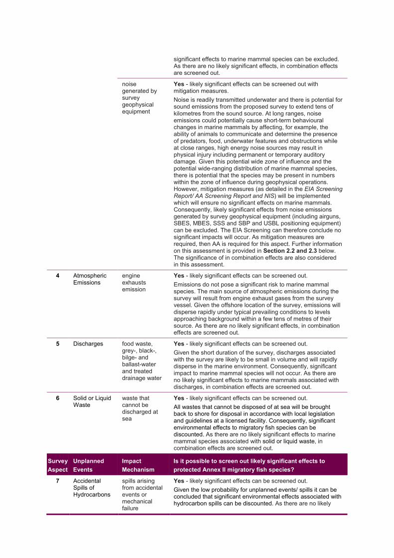
significant effects to marine mammal species can be excluded. As there are no likely significant effects, in combination effects are screened out.
noise generated by survey geophysical equipment
Yes - likely significant effects can be screened out with mitigation measures. Noise is readily transmitted underwater and there is potential for sound emissions from the proposed survey to extend tens of kilometres from the sound source. At long ranges, noise emissions could potentially cause short-term behavioural changes in marine mammals by affecting, for example, the ability of animals to communicate and determine the presence of predators, food, underwater features and obstructions while at close ranges, high energy noise sources may result in physical injury including permanent or temporary auditory damage. Given this potential wide zone of influence and the potential wide-ranging distribution of marine mammal species, there is potential that the species may be present in numbers within the zone of influence during geophysical operations. However, mitigation measures (as detailed in the EIA Screening Report/ AA Screening Report and NIS) will be implemented which will ensure no significant effects on marine mammals. Consequently, likely significant effects from noise emissions generated by survey geophysical equipment (including airguns, SBES, MBES, SSS and SBP and USBL positioning equipment) can be excluded. The EIA Screening can therefore conclude no significant impacts will occur. As mitigation measures are required, then AA is required for this aspect. Further information on this assessment is provided in Section 2.2 and 2.3 below. The significance of in combination effects are also considered in this assessment.
4 Atmospheric Emissions
engine exhausts emission
Yes - likely significant effects can be screened out. Emissions do not pose a significant risk to marine mammal species. The main source of atmospheric emissions during the survey will result from engine exhaust gases from the survey vessel. Given the offshore location of the survey, emissions will disperse rapidly under typical prevailing conditions to levels approaching background within a few tens of metres of their source. As there are no likely significant effects, in combination effects are screened out.
5 Discharges food waste, grey-, black-, bilge- and ballast-water and treated drainage water
Yes - likely significant effects can be screened out. Given the short duration of the survey, discharges associated with the survey are likely to be small in volume and will rapidly disperse in the marine environment. Consequently, significant impact to marine mammal species will not occur. As there are no likely significant effects to marine mammals associated with discharges, in combination effects are screened out.
6 Solid or Liquid Waste
waste that cannot be discharged at sea
Yes - likely significant effects can be screened out. All wastes that cannot be disposed of at sea will be brought back to shore for disposal in accordance with local legislation and guidelines at a licensed facility. Consequently, significant environmental effects to migratory fish species can be discounted. As there are no likely significant effects to marine mammal species associated with solid or liquid waste, in combination effects are screened out.
Survey Aspect
Unplanned Events
Impact Mechanism
Is it possible to screen out likely significant effects to protected Annex II migratory fish species?
7 Accidental Spills of Hydrocarbons
spills arising from accidental events or mechanical failure
Yes - likely significant effects can be screened out. Given the low probability for unplanned events/ spills it can be concluded that significant environmental effects associated with hydrocarbon spills can be discounted. As there are no likely

significant effects to marine mammal species associated with spills, in combination effects are screened out.
2.2 Determination of Significance To assess expected underwater noise levels from the proposed survey and determined whether likely significant effects in marine mammals are possible, an underwater noise modelling exercise was undertaken to predict the likely spatial area (or zone) around the noise source within which noise emissions exceed thresholds of potential injury and behavioural effects. The underwater noise modelling, identification of potential zones of impact and assessment of potential impacts are briefly summarised below and presented in full Section 3.4 to Section 3.6 of the EIA Screening and ERA report and Section 2.4 of the AA Screening and NIS report. Noise modelling indicated that the maximum zone of disturbance impact in marine mammal Qualifying Features extends approximately 111 m from the sound source. Given the wide-ranging foraging behaviour of marine mammals, it is concluded that the QI species of the SACs presented in Table 1.1 could be present within the zone of disturbance impact during survey operations. It has therefore been concluded, on the basis of objective information, that in the absence of mitigation measures likely significant effects from the proposed survey cannot be excluded.
2.3 Mitigation Measures The risk of potential impact of underwater noise to marine mammals from survey operations will be managed through the implementation of current best industry practice during the proposed survey including DAHG Guidance to Manage the Risk to Marine Mammals from Man-made Sound Sources in Irish Waters (DAHG, 2014) and recommendations from PAD/ NPWS, regarding the separation distance between concurrent acoustic surveys. Mitigation measures to manage risk to marine mammals are detailed in Section 3.11 of the EIA Screening and ERA report and Section 3.3 of the Screening for AA and NIS. In line with current recommendations from PAD and NPWS, Europa will maintain a 100 km separation distance between the concurrent acoustic surveys that may be operating. Implementing a 100 km separation zone between concurrent acoustic survey operations will ensure in-combination effects from noise generating equipment are avoided. Europa are in regular communication with operators proposing to undertake operations offshore Ireland in 2019. Survey operations will be coordinated to ensure a 100 km separation is maintained between surveys during concurrent geophysical operations.
3 CONCLUSION 3.1 EIA Screening Conclusion The information presented in this Appendix B in response to EAU Query No. 12, provides further information on marine mammals associated with the additional European sites. The original findings of the EIA Screening Report are confirmed in this assessment, that is:
“This assessment has identified that the only source of potential impact to receptors is the underwater noise generated by survey equipment. The environmental receptors of concern include Annex IV and Annex II marine mammal species. Based on the nature and duration of the proposed site survey operations, and strict adherence to DAHG Guidance to Manage the Risk to Marine Mammals from Man-made Sound Sources in Irish Waters (DAHG, 2014) and recommendations from PAD and NPWS, in relation to the separation distance between the concurrent acoustic surveys, no significant impacts will occur.”

Appendix C
Assessment of Likely Significant Effects to Habitats Directive Annex II Migratory Fish Species

1 INTRODUCTION To address Query 10 and Query 12 this section presents an assessment of potential impacts of the survey to Irish SACs designated for protected migratory fish species listed in Annex II of the Habitat Directive. Habitats Directive Annex II migratory fish species designated for Irish SACs are: • Salmo salar (Atlantic salmon) • Lampetra fluviatilis (River lamprey) • Petromyzon marinus (Sea lamprey) • Alosa fallax fallax (Twaite shad)
Irish SACs for which the above species are designated are listed in Table 1.1. The survey aspects (impact mechanisms) associated with proposed survey activities and unplanned events considered with respect to potential impacts are listed in Table 1.2 below. Table 1.1: SACs designated for Annex II migratory fish species
SAC • Twaite shad
(Alosa fallax fallax)
• River lamprey
(Lampetra fluviatilis)
• Sea lamprey (Petromyzon
marinus)
• Atlantic salmon
(Salmo salar)
Blackwater River (Cork/Waterford) SAC
Blackwater River (Kerry) SAC Castlemaine Harbour SAC Cloghernagore Bog and Glenveagh National Park SAC
Connemara Bog Complex SAC Cummeen Strand/Drumcliff Bay (Sligo Bay) SAC
Glenamoy Bog Complex SAC Killala Bay/Moy Estuary SAC Killarney National Park, Macgillycuddy's Reeks and Caragh River Catchment SAC
Leannan River SAC Lough Corrib SAC Lough Eske and Ardnamona Wood SAC
Lough Gill SAC Lough Melvin SAC Lower River Shannon SAC Lower River Suir SAC Maumturk Mountains SAC Mweelrea/Sheeffry/Erriff Complex SAC
Newport River SAC Owenduff/Nephin Complex SAC
River Barrow and River Nore SAC

SAC • Twaite shad
(Alosa fallax fallax)
• River lamprey
(Lampetra fluviatilis)
• Sea lamprey (Petromyzon
marinus)
• Atlantic salmon
(Salmo salar)
River Boyne and River Blackwater SAC
River Finn SAC River Moy SAC Slaney River Valley SAC The Twelve Bens/Garraun Complex SAC
Unshin River SAC West of Ardara/Maas Road SAC
Table 1.2: Survey aspects associated with proposed activities and unplanned events
Survey Aspect
Planned Activities and Impact Mechanisms
1 Physical Presence of Vessel and Equipment injury to fauna from collision with the vessels and/ or equipment disturbance to fauna
2 Physical Changes localised physical disturbance to the seabed sediment.
3 Underwater noise emissions noise will be generated by vessel engines noise generated by survey geophysical equipment
4 Atmospheric Emissions engine exhausts emission
5 Discharges food waste, grey-, black-, bilge- and ballast-water
6 Solid or Liquid Waste; waste that cannot be discharged at sea
Survey Aspect
Unplanned Events and Impact Mechanisms
7 Accidental Spills of Hydrocarbons spills arising from accidental events or mechanical failure

2 IMPACT ASSESSMENT METHODOLOGY 2.1 Screening Assessment The assessment of the potential impact of survey aspects to receptors (habitats/ species) is based on an assessment of the connectivity and potential interaction between the receptors and the survey aspects 1 through 7 (as listed in Table 1.2). Table 2.1 presents a screening assessment to establish whether survey aspects 1 through 7 are likely to have direct, indirect or cumulative effects on protected Annex II migratory fish species based on consideration of the connectivity between survey aspects and the species designated for the SAC listed in Table 1.1. Table 2.1: Screening assessment of potential effects of the survey aspects to Annex II migratory fish species Survey Aspect
Planned Activities
Impact Mechanism
Is it possible to screen out likely significant effects to protected Annex II migratory fish species?
1 Physical Presence of Vessel and Equipment
injury to fauna from collision with the vessels and/ or equipment
Yes - likely significant effects can be screened out. The vessel and equipment do not pose a significant collision risk to migratory fish species. As there are no likely significant effects to Annex II migratory fish species, in combination effects are screened out.
disturbance to fauna
Yes - likely significant effects can be screened out. The presence of the vessel and equipment could act to disturb marine fauna including marine mammals and birds, displacing the species from the survey area. The survey vessel and equipment do not pose a significant disturbance risk to migratory fish species. As there are no likely significant effects to Annex II migratory fish species, in combination effects are screened out.
2 Physical Changes
localised physical disturbance to the seabed sediment.
Yes - likely significant effects can be screened out. Seabed sampling equipment does not pose a significant risk to migratory fish species. The environmental impact of seabed sampling equipment is limited to seabed habitats; in summary, equipment will result in physical changes to seabed habitats through the physical (mechanical) damage and removal of sediment, and through the resuspension of sediments. As there are no likely significant effects to Annex II migratory fish species, in combination effects are screened out.
3 Underwater noise emissions
noise will be generated by vessel engines
Yes - likely significant effects can be screened out. EMODnet vessel density mapping1 indicates that fishing and shipping activity in the areas immediately adjacent to the survey is low (less than 2 hours per square km per month). Given the short duration of the proposed survey (approximately 14 days) the vessel engines will only marginally increase the level of overall vessel activity and vessel engine noise within and adjacent to the proposed survey area; consequently, likely significant effects to migratory fish species can be excluded. As there are no likely significant effects to Annex II migratory fish species, in combination effects are screened out.
noise generated by survey geophysical equipment
Yes - likely significant effects can be screened out. Underwater noise does not pose a significant risk to migratory fish species. An assessment of this is provided in Section 2.1.1 below. As there are no likely significant effects to Annex II migratory fish species, in combination effects are screened out.
1 EMODnet vessel density mapping http://www.emodnet-humanactivities.eu/view-data.php

4 Atmospheric Emissions
engine exhausts emission
Yes - likely significant effects can be screened out. Emissions do not pose a significant risk to migratory fish species. The main source of atmospheric emissions during the survey will result from engine exhaust gases from the survey vessel. Given the offshore location of the survey, emissions will disperse rapidly under typical prevailing conditions to levels approaching background within a few tens of metres of their source. As there are no likely significant effects to Annex II migratory fish species, in combination effects are screened out
5 Discharges food waste, grey-, black-, bilge- and ballast-water and treated drainage water
Yes - likely significant effects can be screened out. Given the short duration of the survey, discharges associated with the survey are likely to be small in volume and will rapidly disperse in the marine environment. Consequently, significant impact to migratory fish species will not occur. As there are no likely significant effects to Annex II migratory fish species, in combination effects are screened out
6 Solid or Liquid Waste
waste that cannot be discharged at sea
Yes - likely significant effects can be screened out. All wastes that cannot be disposed of at sea will be brought back to shore for disposal in accordance with local legislation and guidelines at a licensed facility. Consequently, significant environmental effects to migratory fish species can be discounted. As there are no likely significant effects to Annex II migratory fish species, in combination effects are screened out.
Survey Aspect
Unplanned Events
Impact Mechanism
Is it possible to screen out likely significant effects to protected Annex II migratory fish species?
7 Accidental Spills of Hydrocarbons
spills arising from accidental events or mechanical failure
Yes - likely significant effects can be screened out. Given the low probability for unplanned events/ spills it can be concluded that significant environmental effects associated with hydrocarbon spills can be discounted. As there are no likely significant effects to Annex II migratory fish species, in combination effects are screened out
2.1.1 Underwater noise impacts on migratory fish species As described in Section 3.7 of the Screening for EIA and ERA report direct effects of underwater noise to fish include physical auditory damage and behavioural change; the significance of these effects are discussed below.
2.1.1.1 Physical Effects on Protected Annex II migratory fish species To assess expected underwater noise levels from the proposed survey and determined whether likely significant physical effects in fish are possible, an underwater noise modelling exercise was undertaken to predict the likely spatial area (or zone) around the noise source within which noise emissions exceed thresholds of potential injury in fish. Full description of the underwater noise modelling is presented in Section 3.4 of the EIA Screening and ERA report and Section 2.4 of the AA Screening and NIS report. Section 3.7.1 of the EIA Screening and ERA report presents an assessment of potential impact of noise to fish species. The assessment of potential impacts to fish is are briefly summarised below. As outlined in Section 3.7.1 of the Screening for EIA and ERA report the modelling of noise emissions from the survey indicates that noise levels will not exceed the threshold for injury in fish2; consequently, significant physical effects to protected Annex II migratory fish species from underwater noise will not occur. As significant effects can be excluded mitigation measures are not required.
2 Popper et al., 2014. Sound Exposure Guidelines for Fishes and Sea Turtles: A Technical Report prepared by ANSI-Accredited Standards Committee S3/SC1 and registered with ANSI,

2.1.1.2 Behavioural Change Effects in Protected Annex II migratory fish species As outlined in Section 3.7.2 of the Screening for EIA and ERA report there is conflicting evidence on the behavioural effects of geophysical surveys on fish. Studies have reported no significant effect on the behaviour of various fish species, even in very close proximity (1.5 m) to the seismic source (Pickett et al., 19943; Wardle et al., 19984) while other have reported that fish leave the immediate area around the survey vessel for the period when the acoustic source is active (Lokkeborg and Soldal 19935; Turnpenny and Nedwell 19946). Avoidance behavioural effects has potential to effect Annex II migratory fish species that may be transiting the survey area in close proximity to the sound source during operations. However, given the short duration of the proposed survey any impacts will be temporary and therefore will not result in significant effects on migratory fish species. As significant effects can be excluded mitigation measures are not required.
3 Pickett et al., 1994. Poole Bay Seismic Survey: Effects on Bass Movements and Catch-rates in the Local Fishery. 4 Wardle et al., 1998. The Sound of a Triple ‘G’ Seismic Airgun and its Effects on the Behaviour of Marine Fish. Fisheries Research Services Services, Marine Laboratory, Aberdeen. 5 Løkkeborg, S., and Soldal, A.V. 1993. The influence of seismic exploration with air guns on cod (Gadus morhua) behaviour and catch rates. ICES Mar. Sci. Symp. 196: 62–67. 6 Turnpenny W.H. and Nedwell J.R. 1994. The Effects on Marine Fish, Diving Mammals and Birds of Underwater Sound Generated by Seismic Surveys. Consultancy Report proposed for UKOOA by Fawley Aquatic Research Laboratories Ltd.

3 CONCLUSION 3.1 EIA Screening Conclusion The information presented in this response, provides further information on migratory fish species associated with the additional European sites. The original findings of the EIA Screening Report are confirmed in this assessment, that is: no likely significant effects.

Appendix D
Assessment of Likely Significant Effects to Habitats Directive Annex I Reef

1 INTRODUCTION To address Query 12 this section presents an assessment of potential impacts of the survey to Irish offshore SACs designated for Habitats Directive Annex I reef habitat. Irish offshore SACs designated for reef are listed in Table 1.1. The survey aspects (impact mechanisms) associated with proposed survey activities and unplanned events considered with respect to potential impacts are listed in Table 1.2 below. Table 1.1: SACs designated for Annex I reef habitat
SAC • QI [code]
Belgica Mound Province SAC (Site code: 002327) Reefs [1170] Hovland Mound Province SAC ) (Site code: 002328) Reefs [1170]
South-West Porcupine Bank SAC (Site code: 002329) Reefs [1170]
North-West Porcupine Bank SAC (Site code: 002330) Reefs [1170]
Porcupine Bank Canyon SAC (Site code: 003001) Reefs [1170] South East Rockall Bank SAC (Site code: 003002) Reefs [1170]
Table 1.2: Survey aspects associated with proposed activities and unplanned events
Survey Aspect
Planned Activities and Impact Mechanisms
1 Physical Presence of Vessel and Equipment injury to fauna from collision with the vessels and/ or equipment disturbance to fauna
2 Physical Changes localised physical disturbance to the seabed sediment.
3 Underwater noise emissions noise will be generated by vessel engines noise generated by survey geophysical equipment
4 Atmospheric Emissions engine exhausts emission
5 Discharges food waste, grey-, black-, bilge- and ballast-water
6 Solid or Liquid Waste; waste that cannot be discharged at sea
Survey Aspect
Unplanned Events and Impact Mechanisms
7 Accidental Spills of Hydrocarbons spills arising from accidental events or mechanical failure

2 IMPACT ASSESSMENT METHODOLOGY 2.1 Screening Assessment The assessment of the potential impact of survey aspects to receptors (habitats/ species) is based on an assessment of the connectivity and potential interaction between the receptors and the survey aspects 1 through 7 (as listed in Table 1.2). Table 2.1 presents a screening assessment to establish whether survey aspects 1 through 7 are likely to have direct, indirect or cumulative effects on protected Annex I offshore reef habitat based on consideration of the connectivity between survey aspects and the species designated for the SAC listed in Table 1.1. Table 2.1: Screening assessment of potential effects of the survey aspects to Annex I Annex II reef habitat Survey Aspect
Planned Activities
Impact Mechanism
Is it possible to screen out likely significant effects to protected Annex II reef habitat?
1 Physical Presence of Vessel and Equipment
injury to fauna from collision with the vessels and/ or equipment
Yes - likely significant effects can be screened out. The vessel and equipment do not pose a collision risk to Annex I offshore reef habitats and likely significant effects can be excluded. As there are no likely significant effects to Annex I offshore reef habitats, in combination effects are screened out.
disturbance to fauna
Yes - likely significant effects can be screened out. The presence of the vessel and equipment could act to disturb marine fauna including marine mammals and birds, displacing the species from the survey area. The survey vessel and equipment do not pose a significant disturbance risk to Annex I offshore reef habitats. As there are no likely significant effects to offshore reef habitat designated for offshore SACs, in combination effects are screened out.
2 Physical Changes
localised physical disturbance to the seabed sediment.
Yes - likely significant effects can be screened out. The environmental impact of seabed sampling equipment is limited to seabed habitats; in summary, equipment has the potential to result in physical changes to seabed habitats through the physical (mechanical) damage and removal of sediment, and through the resuspension of sediments. No seabed sampling is proposed within or adjacent to SAC consequently no likely significant effects to designated habitat will occur. The proposed survey is located over 200 km from the closest SAC designated for offshore reef habitat. As there are no likely significant effects impact, in combination effects are screened out.
3 Underwater noise emissions
noise will be generated by vessel engines
Yes - likely significant effects can be screened out. EMODnet vessel density mapping1 indicates that fishing and shipping activity in the areas immediately adjacent to the survey is low (less than 2 hours per square km per month). Given the short duration of the proposed survey (approximately 14 days) the vessel engines will only marginally increase the level of overall vessel activity and vessel engine noise within and adjacent to the proposed survey area. Given the distance of the proposed survey from offshore SACs (over 200 km) and the water depth of the sites (400 - 2,600 m), likely significant effects of vessel noise to Annex I offshore reef habitats can be excluded. As there are no likely significant effects, in combination effects are screened out.
1 EMODnet vessel density mapping http://www.emodnet-humanactivities.eu/view-data.php

noise generated by survey geophysical equipment
Yes - likely significant effects can be screened out. Noise is readily transmitted underwater and there is potential for sound emissions from the proposed survey to extend tens of kilometres from the sound source. Given the distance of the proposed survey from offshore SACs (over 50 km), the water depth of the sites (400 - 2,600 m) and the rate of sound attenuation in water likely significant effects of underwater noise emission to Annex I offshore reef habitats can be excluded. As there are no likely significant effects, in combination effects are screened out.
4 Atmospheric Emissions
engine exhausts emission
Yes - likely significant effects can be screened out. Emissions do not pose a significant risk to Annex I habitat reef. The main source of atmospheric emissions during the survey will result from engine exhaust gases from the survey vessel. Given the offshore location of the survey, emissions will disperse rapidly under typical prevailing conditions to levels approaching background within a few tens of metres of their source. As there are no likely significant effects to Annex I offshore reef habitats, in combination effects are screened out.
5 Discharges food waste, grey-, black-, bilge- and ballast-water and treated drainage water
Yes - likely significant effects can be screened out. Given the short duration of the survey, discharges associated with the survey are likely to be small in volume and will rapidly disperse in the marine environment. Consequently, significant impact to will not occur. As there are no likely significant effects to Annex I offshore reef habitats, in combination effects are screened out.
6 Solid or Liquid Waste
waste that cannot be discharged at sea
Yes - likely significant effects can be screened out. All wastes that cannot be disposed of at sea will be brought back to shore for disposal in accordance with local legislation and guidelines at a licensed facility. Consequently, significant environmental effects can be discounted. As there are no likely significant effects to Annex I offshore reef habitats, in combination effects are screened out.
Survey Aspect
Unplanned Events
Impact Mechanism
Is it possible to screen out likely significant effects to protected Annex II migratory fish species?
7 Accidental Spills of Hydrocarbons
spills arising from accidental events or mechanical failure
Yes - likely significant effects can be screened out. Given the low probability for unplanned events/ spills it can be concluded that significant environmental effects associated with hydrocarbon spills can be discounted. As there are no likely significant effects to Annex I offshore reef habitats, in combination effects are screened out.
In summary, the screening assessment concluded that the no aspect of the proposed survey will result in potential effects to the Annex I reef designated for offshore SACs; further assessment is not required.

3 CONCLUSION 3.1 EIA Screening Conclusion The information presented in this response, provides further information on Annex I reefs associated with the additional European sites. The original findings of the EIA Screening Report are confirmed in this assessment, that is: no likely significant effects.

Appendix E
Assessment of Likely Significant Effects to Bird Directive Annex I Seabird Species

1 INTRODUCTION To address Query 12 the previously presented assessment of likely significant effect to birds designated for SPAs focused on four SPAs located closest to the proposed survey GWA (see Table 1.1) has been updated to include a detailed consideration of SCI species of SPAs that may be present in the survey GWA. For the updated assessment the analysis of SCI species that may be present in the survey GWA has used the information on the foraging distance of bird species included in Thaxter et al. (2012) and Wakefield et al. (2017). The assessed SPAs are presented in Table 1.2. The survey aspects (impact mechanisms) associated with proposed survey activities and unplanned events considered with respect to potential impacts are listed in Table 1.3 below. Table 1.1: SPAs closest to the proposed Edgeworth Survey area
SPA
The Bull and the Cow Rocks SPA Beara Peninsula SPA
Skelligs SPA The Sheep's Head to Toe Head SPA
Table 1.2: SPAs assessed for potential impacts
SPA
Beara Peninsula SPA Bills Rocks SPA Blasket Islands SPA Clare Island SPA Cliffs of Moher SPA Cruagh Island SPA Deenish Island and Scariff Island SPA Dingle Peninsula SPA Duvillaun Islands SPA High Island, Inishshark and Davillaun SPA Horn Head to Fanad Head SPA Illanmaster SPA Inishglora and Inishkeeragh SPA Inishmore SPA Iveragh Peninsula SPA Kerry Head SPA Lambay Island SPA Loop Head SPA Magharee Islands Old Head of Kinsale Puffin Island Saltee Islands Skelligs Stags of Broad Haven The Bull and The Cow Rocks Tory Island
Cork Harbour SPA Ballycotton Bay SPA Ballymacoda Bay SPA Castlemaine Harbour SPA Tralee Bay Complex Courtmacsherry Bay SPA Illaunnanoon SPA Ireland's Eye SPA Aughris Head SPA Mid-Waterford Coast Wexford Harbour and Slobs Mid-Clare Coast Howth Head Coast SPA Inishbofin, Inishdooey and Inishbeg SPA Inishkea Islands SPA Keeragh Islands SPA Blacksod Bay/Broad Haven SPA The Raven West Donegal Islands Ardboline Island and Horse Island SPA Dalkey Islands SPA Illancrone and Inishkeeragh SPA Inishmurray SPA Lady's Island Lake SPA Lough Corrib SPA River Nanny Estuary and Shore
Dundalk Bay SPA Greers Isle SPA Inner Galway Bay SPA Lough Foyle Lough Mask Lough Swilly Middle Shannon Callows North Bull Island River Little Brosna Callows River Shannon and River Fergus Estuaries The Murrough Connemara Bog Complex SPA Inishtrahull SPA Lough Conn and Lough Cullin SPA Lough Carra SPA Lough Derg (Shannon) Lough Ree Lough Cutra Skerries Islands Sovereign Islands Lough Derg (Donegal) Roaninish Poulaphouca Reservoir Boyne Estuary SPA Derryveagh and Glendowan Mountains SPA Carrowmore Lake SPA

SPA West Donegal Coast Helvick Head to Ballyquin SPA
Rockabill South Dublin Bay and River Tolka Estuary
Cross Lough (Killadoon) SPA Inishduff SPA
Table 1.3: Survey aspects associated with proposed activities and unplanned events
Survey Aspect Planned Activities and Impact Mechanisms
1 Physical Presence of Vessel and Equipment injury to fauna from collision with the vessels and/ or equipment disturbance to fauna
2 Physical Changes localised physical disturbance to the seabed sediment.
3 Underwater noise emissions noise will be generated by vessel engines noise generated by survey geophysical equipment
4 Atmospheric Emissions engine exhausts emission
5 Discharges food waste, grey-, black-, bilge- and ballast-water
6 Solid or Liquid Waste; waste that cannot be discharged at sea
Survey Aspect Unplanned Events and Impact Mechanisms
7 Accidental Spills of Hydrocarbons spills arising from accidental events or mechanical failure

2 IMPACT ASSESSMENT 2.1 Screening Assessment The assessment of the potential impact of survey aspects to receptors (species/ habitats) is based on an assessment of the connectivity and potential interaction between the receptors and the survey aspects 1 through 7 (as listed in Table 1.3). Table 2.1 presents a screening assessment to establish whether survey aspects 1 through 7 are likely to have direct, indirect or cumulative effects on protected Annex I bird species based on consideration of the connectivity between survey aspects and the species designated for the SPAs listed in Table 1.2. Table 2.1: Screening assessment of potential effects of the survey aspects to Birds Directive
Annex I bird species
Survey Aspect
Planned Activities
Impact Mechanism
Is it possible to screen out likely significant effects to protected Annex I bird species?
1 Physical Presence of Vessel and Equipment
injury to fauna from collision with the vessels and/ or equipment
Yes - likely significant effects can be screened out. The likelihood of collision events occurring between the project and seabirds is low. It must also be noted, that should an event occur it is likely to be an isolated event with any potential impact at the population level likely to be minor when compared to natural mortality rates. The survey vessel and equipment do not pose a significant disturbance risk to seabird species. As there are no likely significant effects to seabird species, in combination effects are screened out.
disturbance to fauna
Yes - likely significant effects can be screened out. While seabird may be foraging in the survey area during operations, given the short duration of the survey (approximately 14 days) and the relatively small survey area the potential to result in significant effects is highly unlikely. The survey vessel and equipment do not pose a significant disturbance risk to seabird species. As there are no likely significant effects, in combination effects are screened out.
2 Physical Changes
localised physical disturbance to the seabed sediment.
Yes - likely significant effects can be screened out. Seabed sampling equipment does not pose a significant risk to seabird species. The environmental impact of seabed sampling equipment is limited to seabed habitats; in summary, equipment will result in physical changes to seabed habitats through the physical (mechanical) damage and removal of sediment, and through the resuspension of sediments. As there are no likely significant effects to seabird species, in combination effects are screened out.
3 Underwater noise emissions
noise will be generated by vessel engines
Yes - likely significant effects can be screened out. EMODnet vessel density mapping1 indicates that fishing and shipping activity in the areas immediately adjacent to the survey is low (less than 2 hours per square km per month). Given the short duration of the proposed survey (approximately 14 days) the vessel engines will only marginally increase the level of overall vessel activity and vessel engine noise within and adjacent to the proposed survey area; consequently, likely significant effects to seabird species can be excluded. As there are no likely significant effects, in combination effects are screened out.
noise generated by survey geophysical equipment
Yes - likely significant effects can be screened out. Noise is readily transmitted underwater and there is potential for sound emissions from the proposed Edgeworth Survey to extend tens of kilometres from the sound source. Given the potential wide-ranging distribution of seabird species, in particular diving species, information
1 EMODnet vessel density mapping http://www.emodnet-humanactivities.eu/view-data.php

on these species and potential effects from noise emissions generated by survey geophysical equipment (including airguns, SBES, MBES, SSS and SBP, and USBL positioning equipment) has been provided to support the conclusion of no likely significant effects (see Section 2.1.2). As there are no likely significant effects, in combination effects are screened out.
4 Atmospheric Emissions
engine exhausts emission
Yes - likely significant effects can be screened out. Emissions do not pose a significant risk to seabird species. The main source of atmospheric emissions during the survey will result from engine exhaust gases from the survey vessel. Given the offshore location of the survey, emissions will disperse rapidly under typical prevailing conditions to levels approaching background within a few tens of metres of their source. As there are no likely significant effects, in combination effects are screened out.
5 Discharges food waste, grey-, black-, bilge- and ballast-water and treated drainage water
Yes - likely significant effects can be screened out. Given the short duration of the survey, discharges associated with the survey are likely to be small in volume and will rapidly disperse in the marine environment. Consequently, significant impact to marine mammal species will not occur. As there are no likely significant effects to seabird species associated with discharges, in combination effects are screened out.
6 Solid or Liquid Waste
waste that cannot be discharged at sea
Yes - likely significant effects can be screened out. All wastes that cannot be disposed of at sea will be brought back to shore for disposal in accordance with local legislation and guidelines at a licensed facility. Consequently, significant environmental effects to migratory fish species can be discounted. As there are no likely significant effects to seabirds associated with solid or liquid waste, in combination effects are screened out.
Survey Aspect
Unplanned Events
Impact Mechanism
Is it possible to screen out likely significant effects to protected Annex II migratory fish species?
7 Accidental Spills of Hydrocarbons
spills arising from accidental events or mechanical failure
Yes - likely significant effects can be screened out. Given the low probability for unplanned events/ spills it can be concluded that significant environmental effects associated with hydrocarbon spills can be discounted. As there are no likely significant effects to seabirds associated with spills, in combination effects are screened out.
With regards to diving birds and survey aspect 3, underwater noise, further information has been presented in the following sections to clearly demonstrate that the Edgeworth survey will have no significant effects on bird SCIs.
2.1.1 Identification of Relevant SCIs and SPAs Given the nature of the proposed development, which relates only to surveys of the marine environment within the GWA, it is considered that SPAs which solely support terrestrial bird species or species which do not utilise the marine environment can be excluded from further consideration. Furthermore where a SPA is designated for a range of species including those which utilise marine habitats and other species which do not, only those species which are known to utilise marine habitats are considered in respect of the potential for the proposals to give rise to likely significant effect on these sites. Thaxter et al. (2012) list a range of species which utilise marine habitats for the purposes of foraging during the breeding season, in addition Wakefield et al. (2017) lists recorded foraging distances for four marine bird species. A summary table of these ranges is set out below at Table 2.2.

Table 2.2: Seabird foraging ranges (summarised from Thaxter et al. 2012 and Wakefield et al. 2017)
Species
Thaxter et al. 2012 Wakefield et al. 2017
Maximum foraging range
Mean foraging range
Maximum foraging range
Mean foraging range
Red-throated diver
9 4.5 - -
Little tern 11 2.1 - - European shag 17 5.9 35 3.4 Mediterranean gull
20 11.5 - -
Roseate tern 30 12.2 - - Common tern 30 4.5 - - Arctic tern 30 7.1 - - Great cormorant
35 5.2 - -
Black-headed gull
40 11.4 - -
Common gull 50 25 - - Sandwich tern 54 11.5 - - European storm-petrel
>65 - - -
Arctic Skua 75 6.4 - - Common eider 80 2.4 - - Herring gull 92 10.5 - - Razorbill 95 23.7 305 13.2 Black-legged kittiwake
120 24.8 300 11.9
Leach’s storm petrel
<120 - - -
Common guillemot
135 37.8 340 10.5
Lesser black-backed gull
181 71.9 - -
Atlantic puffin 200 4 - - Great Skua 219 - - - Manx shearwater
330 2.3 - -
Northern fulmar 580 47.5 - - Northern gannet
590 92.5 - -
In light of information set out within Table 2.2, data held by NPWS was considered in respect of SPA sites supporting SCI listed in the above tables where the sites lay within the established maximum foraging ranges of these qualifying SCI species. For example, all sites within 590 km of the GWA supporting northern gannet Morus bassanus, were considered. In order to establish the sites that lay within the foraging ranges specified, straight line distances were utilised where the shortest pathway between the GWA and those sites was not interrupted by land.

Where the shortest pathway between the GWA and those sites was interrupted by land a shortest straight-line distance around such lands was used to calculate the shortest pathway which would be likely to be utilised by a SCI species to reach marine waters within the GWA. Where maximum or mean/ median ranges were utilised, the larger of the two figures presented within the referenced publications was utilised on a precautionary basis. The results of this analysis are presented in Table 2.3 which includes for all SPA sites which support qualifying species with maximum and mean/median foraging ranges which overlap the GWA of the proposed Edgeworth Survey and the respective distances of these sites from the GWA. Table 2.4 lists the SPAs for which the potential foraging range of at least one qualifying species overlaps the GWA of the proposed Edgeworth Surveys and as such are “screened in” for initial assessment. Table 2.5 lists the SCI of SPAs which were screened in for further assessment on the basis of their proximity to the GWA with regard to their respective foraging ranges; these SCIs are brought forward to Section 2.1.2 where the significance of impact is determined. Table 2.3: SPAs with qualifying species with foraging ranges potentially overlapping the GWA Seabird foraging ranges (summarised from Thaxter et al. 2012 and Wakefield et al. 2017)
SPA Approximate distance
from GWA (km)
Qualifying interests with max foraging distances overlapping the GWA
Qualifying interests with mean or median* foraging distances overlapping the
GWA
Beara Peninsula SPA 125 Northern Fulmar - Bills Rocks SPA 355 Storm petrel* -
Blasket Islands SPA 150
Northern Fulmar - Black-legged kittiwake -
Lesser black-backed gull - Manx shearwater -
Atlantic puffin - Razorbill -
Storm petrel* - Clare Island SPA 350 Northern Fulmar -
Cliffs of Moher SPA 285
Northern Fulmar - Common guillemot -
Black-legged kittiwake - Razorbill -
Cruagh Island SPA 315 Manx shearwater -
Deenish Island and Scariff Island SPA 130
Northern Fulmar - Lesser black-backed gull -
Manx shearwater - Storm petrel* -
Dingle Peninsula SPA 160 Northern Fulmar - Duvillaun Islands SPA 375 Northern Fulmar -

SPA Approximate distance
from GWA (km)
Qualifying interests with max foraging distances overlapping the GWA
Qualifying interests with mean or median* foraging distances overlapping the
GWA
Storm petrel - High Island, Inishshark and Davillaun SPA 315 Northern Fulmar -
Horn Head to Fanad Head SPA 580 Northern Fulmar -
Illanmaster SPA 435 Storm petrel - Inishglora and Inishkeeragh SPA 390 Storm petrel -
Inishmore SPA 280 Common guillemot -
Black-legged kittiwake -
Iveragh Peninsula SPA 140 Northern Fulmar -
Common guillemot - Black-legged kittiwake -
Kerry Head SPA 210 Northern Fulmar - Lambay Island SPA 550 Northern Fulmar - Loop Head SPA 230
Common guillemot - Black-legged kittiwake -
Magharee Islands 205 Storm petrel -
Old Head of Kinsale 225 Common guillemot -
Black-legged kittiwake -
Puffin Island 140
Northern Fulmar - Lesser black-backed gull -
Manx shearwater - Atlantic puffin -
Razorbill - Storm petrel -
Saltee Islands 365 Northern Fulmar - Northern Gannet -
Skelligs 130
Northern Fulmar - Northern Gannet -
Common guillemot - Black-legged kittiwake -
Manx shearwater - Atlantic puffin -

SPA Approximate distance
from GWA (km)
Qualifying interests with max foraging distances overlapping the GWA
Qualifying interests with mean or median* foraging distances overlapping the
GWA
Storm petrel - Stags of Broad Haven 420 Storm petrel -
The Bull and The Cow Rocks 120
Northern Gannet - Atlantic puffin - Storm petrel -
Tory Island 565 Northern Fulmar - West Donegal Coast 495 Northern Fulmar - Beara Peninsula SPA 125 Northern Fulmar - Bills Rocks SPA 355 Storm petrel -
* Mean (taken from Thaxter et al. 2012) or median (taken from Wakefield et al. 2017) was chosen according to highest value.
Table 2.4: SPAs with Conservation Interests with foraging ranges overlapping the GWA.
SPA SPA
Beara Peninsula SPA Iveragh Peninsula SPA Bills Rocks SPA Kerry Head SPA Blasket Islands SPA Lambay Island SPA Clare Island SPA Loop Head SPA Cliffs of Moher SPA Magharee Islands SPA Cruagh Island SPA Old Head of Kinsale SPA Deenish Island and Scariff Island SPA Puffin Island SPA Dingle Peninsula SPA Saltee Islands SPA* Duvillaun Islands SPA Skelligs SPA
High Island, Inishshark and Davillaun SPA Stags of Broad Haven SPA Horn Head to Fanad Head SPA The Bull and The Cow Rocks SPA Illanmaster SPA Tory Island SPA Inishglora and Inishkeeragh SPA West Donegal Coast SPA Inishmore SPA * SPA assigned site-specific Conservation Objectives.

Table 2.5: SCI species with foraging ranges overlapping the GWA
SCI Species SCI Species
Fulmar Manx shearwater Gannet Atlantic puffin Common guillemot Razorbill Black-legged kittiwake Storm petrel Lesser black-backed gull
2.1.2 Assessment of Potential Impact to Relevant SCIs Each of the SCI brought forward to assess potential impact is assigned a risk category based on the typical foraging and diving behaviour of the species (see Table 2.6). Risk category2 criteria are described in Table 2.7. The species assigned risk categories 0, 1 and 2 (see Table 2.6) are predominately terrestrial species and/ or coastal/ shore species. In general, these species forage in terrestrial habitats, soft sediment coastal habitats or water surface zones and display either limited or shallow diving range capabilities or no diving behaviour. Given that these species do not spend extended periods of time underwater, likely significant effect of underwater noise can be excluded. Species assigned to risk category 3 have varying deeper diving capabilities. For the relevant SCIs categorised as being at risk category 2 and 3, Section 2.1.2.1 through Section 2.1.2.8 present a description of the species ecology and typical foraging behaviour, alongside assessments of risk posed to these species from underwater noise emissions.
Table 2.6: Risk categories of SCI species with foraging ranges overlapping the GWA
SCI Species Risk Category
Northern Gannet 3 Common Guillemot 3 Atlantic Puffin 3 Razorbill 3 Northern Fulmar 2 Black-legged Kittiwake 2 Manx Shearwater 2 Storm Petrel 2 Lesser Black-backed Gull 1
2 Risk categories are relative measures of risk.

Table 2.7: Risk categories
Risk category Relative Risk Risk Category
3 High
Foraging distributions extending from inshore coastal waters to offshore areas. Diving birds.
2 Medium Predominately foraging in coastal waters. Shallow diving behaviour.
1 Low
Main foraging habitats are terrestrial with limited foraging in coastal waters. Limited diving behaviour.
0 Negligible risk/ no risk
Species associated with terrestrial habitats. Rarely found foraging outside of terrestrial habitats. Non-diving birds.
2.1.2.1 Northern Gannet (Morus bassanus) Gannet have a significant diving capability and are frequently found feeding in inshore and offshore continental shelf waters often associated with deep-water. They eat mid-sized schooling fish and squid, generally 2 cm – 30 cm in length (Lloyd et al, 19863) as well as fish discarded by fishing boats. They forage by plunge diving between 10 m – 40 m depth and with a mean foraging depth of 8.8 m and a mean foraging range of 140 km from their cliff-based colonies4 (higher than that stated within Thaxter et al, 20125). While the species may be found in the Edgeworth Survey area during operations, which lie within the maximum foraging distance (590km) of a number of SPAs for which the species forms a SCI, this is limited to populations associated with three SPAs. The closest of these SPAs, The Bull and The Cow Rock SPA, is located approximately 120 km from the survey area, this is within the maximum foraging range of the species but far beyond the mean/median foraging range; consequently, likely significant effects to the SPAs designated for the species are excluded on the basis that any temporary effects associated with the proposed survey will not impact the core foraging areas utilised by populations of the species associated with any SPA.
2.1.2.2 Common Guillemot (Uria aalge) The Common Guillemot is wide ranging and regularly occurring migratory bird in Europe6. The species dive from the sea surface up to 200 m to catch schooling fish such as sandeels and sprats, although most dives are less than 50 m. Guillemots feed in inshore and offshore waters. Their foraging range varies with mean foraging range of reported 37.8km while most foraging occurs within 50 km of a colony. The species may be found in the Edgeworth Survey area during operations, which lies within the maximum foraging distance (340km) of a number of SPAs for which the species forms a SCI, including populations associated with six SPAs. The closest of these SPAs, Skelligs SPA, is located approximately 130km from the survey area, this is within the maximum foraging range of the species but far beyond the mean/median foraging range (37.8); consequently, likely significant effects to the six SPAs designated for the species are excluded on the basis that any temporary effects associated with the proposed survey will not impact the core foraging areas utilised by populations of the species associated with any SPA.
3 Lloyd et al, 1986. The Status of Seabirds in Britain and Ireland 4 Natural England Technical Information Note TIN122 Northern gannet: species information for marine Special Protection Area consultations.
5 Thaxter et al, 2012 Seabird foraging ranges as a preliminary tool for identifying candidate Marine Protected Areas. Biological Conservation Issue 156, pp. 53-61.
6 Natural England Technical Information Note TIN123 Guillemot: species information for marine Special Protection Area consultations.
2.1.2.3 Atlantic Puffin (Fratercula arctica) Puffin is a wide-ranging species that can dive up to 60 m to catch prey most dives are less than 30 m7. Foraging range in the species varies between colonies and with the season. The mean foraging range is 4km (Thaxter et al. 2012), with a maximum with a maximum recorded foraging distance of 200 km reported. The species may be found in the Edgeworth Survey area during operations, which lies within the maximum foraging distance (200km) of a number of SPAs for which the species forms a SCI, including populations associated with four SPAs. The closest of these SPAs, The Bull and The Cow Rocks SPA, is located approximately 120km from the survey area, this is within the maximum foraging range of the species but beyond the mean/median foraging range (4km); consequently, likely significant effects to the four SPAs designated for the species are excluded on the basis that any temporary effects associated with the proposed survey will not impact the core foraging areas utilised by populations of the species associated with any SPA.
2.1.2.4 Razorbill (Alca torda) Razorbill is a wide-ranging species breeding in low density colonies on rocky islands8. The species is widespread in European seas during the winter months. While typically razorbill dive up to 30 m in pursuit of prey, the species has been reported to dive up to 140 m. While it has been shown that species have a mean foraging range of 23.7 km from their colonies, the species tend to feed within a few km of their coastal colonies. The species may be found in the Edgeworth Survey area during operations, which lies within the maximum foraging distance (305km) of a number of SPAs for which the species forms a SCI, including populations associated with three SPAs. The closest of these SPAs, Puffin Island SPA, is located approximately 140km from the survey area, this is within the maximum foraging range of the species but well beyond the mean/median foraging range (23.7km); consequently, likely significant effects to the three SPAs designated for the species are excluded on the basis that any temporary effects associated with the proposed survey will not impact the core foraging areas utilised by populations of the species associated with any SPA.
2.1.2.5 Northern Fulmar (Fulmarus glacialis) Fulmar principally feed through the seizure of food from the sea surface while swimming or in flight, however they do also forage using shallow dives of up to 3m. Foraging is often undertaken in large flocks which form around feeding opportunities as a result of the bird’s keen sense of smell. Food items typically comprise planktonic crustaceans and small fish. Fulmar have a large foraging range with trips taking up to 5 days, although typically of shorter length, between 0.5 and 1 day9. Individuals can live for up to 50 years with a typical age of around 44 years. While the species may be found in the Edgeworth Survey area during operations, which lie within the maximum foraging distance (580km) of a seventeen SPAs for which they form a SCI. The closest of the SPAs designated for the species to the survey area, the Beara Peninsula SPA, is located approximately 125km from the survey area, this is within the maximum foraging range of the species. However any likely significant effects to the SPAs designated for the species are excluded on the basis that any temporary effects associated with the proposed survey, limited to effects associated with underwater noise, will not impact the foraging behaviour of the species, which is categorised at risk category 2 and does not utilise the underwater environment for a substantial portion of its time while foraging.
7 Natural England Technical Information Note TIN125 Atlantic Puffin: species information for marine Special Protection Area consultations.
8 Natural England Technical Information Note TIN124 Razorbill: species information for marine Special Protection Area consultations.
9 Natural England Technical Information Note TIN126 Northern fulmar: species information for marine Special Protection Area consultations.
2.1.2.6 Black-legged Kittiwake (Rissa tridactyla) Kittiwake are surface feeders, taking prey from the surface of the water through dipping however they also utilise shallow dives of up to a metre; the species also often follows ships to scavenge offal and bycatch. Food items typically comprise small shoaling fish including Herring, Sprats and Sand eels, in addition to intertidal molluscs and crustaceans. The species may be found in the Edgeworth Survey area during operations, which lie within the maximum foraging distance (300km) of eleven SPAs for which they form a SCI. The closest of these SPAs, Skelligs Island SPA, is located approximately 130km from the survey area, this is within the maximum foraging range of the species but far beyond the mean foraging range (24.8km). Any likely significant effects to the eleven SPAs designated for the species are excluded on the basis that any temporary effects associated with the proposed survey, limited to effects associated with underwater noise, will not impact the foraging behaviour of the species, which is categorised at risk category 2 and does not utilise the underwater environment for a substantial portion of its time while foraging. Furthermore any temporary effects associated with the proposed survey will not have any potential to impact the core foraging areas utilised by populations of the species associated with any SPA.
2.1.2.7 Manx Shearwater (Puffinus puffinus) Manx Shearwater largely forage through catching food from the water’s surface however pursuit diving is also utilised. Diving is typically done from a height of 1-2m with a maximum recorded dive depth of 55m and a mean maximum depth of 31m10 (Shoji et al. 2016). Food items typically comprise small fish including Herring, Sprats ad Sand eels in addition to cephalopods and crustaceans. While the species may be found in the Edgeworth Survey area during operations, which lie within the maximum foraging distance (330km) of a number of SPAs for which they form a SCI, this is limited to populations associated with five SPAs. The closest of these SPAs, Deenish Island and Scariff Island SPA, is located approximately 130km from the survey area, this is within the maximum foraging range of the species but far beyond the mean foraging range (2.3km). Any likely significant effects to the five SPAs designated for the species are excluded on the basis that any temporary effects associated with the proposed survey, limited to effects associated with underwater noise, will not impact the foraging behaviour of the species, which is categorised at risk category 2 and does not utilise the underwater environment for a substantial portion of its time while foraging. Furthermore any temporary effects associated with the proposed survey will not have any potential to impact the core foraging areas utilised by populations of the species associated with any SPA.
2.1.2.8 Storm-petrel (Hydrobates pelagicus) Storm-petrel is a pelagic species, spending the majority of its lifetime at sea, the species feeds on the surface of the water without landing with prey items including surface plankton and small fish. The species may be found in the Edgeworth Survey area during operations, which lie within the maximum foraging distance (>65km) of a number of eleven SPAs for which it forms a SCI (see Table 2.3). The closest of these SPAs, The Bull and Cow Rocks SPA, is located approximately 120km from the survey area, this is within the maximum foraging range of the species. Any likely significant effects to the SPAs designated for the species are excluded on the basis that any temporary effects associated with the proposed survey, limited to effects associated with underwater noise, will not impact the foraging behaviour of the species, which is categorised at risk category 2 and does not utilise the underwater environment for a substantial portion of its time while foraging.
2.1.2.9 Lesser Black-backed Gull (Larus fuscus) The diet of lesser black-backed gull, as with most gull species, is relatively broad including a large component scavenged from landfill and other urban areas. Birds foraging at sea typically feed on shoals of fish close to the surface. As a highly adaptable omnivore the species will make use of all marine food 10 Shoji, A., Dean, B., Kirk, H., Freeman, R., Perrins, C.M. & Guilford, T.C. 2016. The diving behaviour of the Manx Shearwater Puffinus puffinus. Ibis doi: 10.1111/ibi.12381.

sources which are available to them. The species may be found in the Edgeworth Survey area during operations, which lie within the maximum foraging distance (181km) of three SPAs for which they form a SCI. The closest of these SPAs, Deenish Island and Scariff Island SPA, is located approximately 130km from the survey area, this is within the maximum foraging range of the species. Any likely significant effects to the SPAs designated for the species are excluded on the basis that any temporary effects associated with the proposed survey, limited to effects associated with underwater noise, will not impact the foraging behaviour of the species, which is categorised at risk category 2 and does not utilise the underwater environment for a substantial portion of its time while foraging.

3 CONCLUSION The conclusion of no likely significant impacts concluded in the above species assessments is supported by an assessment of likely significant impact undertaken for the Irish Offshore Strategic Environmental Assessment (IOSEA) 5 (PAD, 201511), which concluded that acoustic emissions from seismic airguns are unlikely to have a direct impact on seabirds as they spend most of their time above water and studies have identified no effect of seismic survey activity on the movements and diving behaviour of birds or result in variation in the abundance of birds seen at nesting sites (PAD, 2015a). As such, the IOSEA 5 assesses impact of seismic surveys on seabirds as ‘Neutral’. As the noise emissions anticipated from the proposed site survey and 2D survey are significantly less than that produced by large scale seismic surveys it is reasonable to conclude here that acoustic emissions arising from the proposed survey will have no likely significant effects on the Conservation Objectives of any SPA sites.
3.1 EIA Screening Conclusion The information presented in this response, provides further information on bird SCI associated with the additional European sites. The original findings of the EIA Screening Report are confirmed in this assessment, that is: no likely significant effects.
11 https://www.dccae.gov.ie/en-ie/natural-resources/topics/Oil-Gas-Exploration-Production/environment/strategic-environmental-assessment/Pages/Irish-Offshore-Environmental-Assessment-(IOSEA)-5.aspx