euratlas periodis guide book battle of lepanto ... - treaty of karlowitz euratlas periodis guide...
TRANSCRIPT

A SEQUENTIAL HISTORICAL ATLAS OF
THE EUROPEAN CULTURAL AREA
from year 1 to year 2000
A SEQUENTIAL HISTORICAL ATLAS OF
THE EUROPEAN CULTURAL AREA
from year 1 to year 2000
EURATLAS PERIODIS
GUIDE BOOK

CONTENTS
WHAT IS EURATLAS PERIODIS.................... 3
AD 1........................................................... 5AD 100........................................................... 6AD 200........................................................... 7AD 300........................................................... 8AD 400........................................................... 9AD 500........................................................... 10AD 600........................................................... 11AD 700........................................................... 12AD 800........................................................... 13AD 900........................................................... 14AD 1000........................................................... 15AD 1100........................................................... 16AD 1200........................................................... 17AD 1300........................................................... 18AD 1400........................................................... 19AD 1500........................................................... 20AD 1600........................................................... 21AD 1700........................................................... 22AD 1800........................................................... 23AD 1900........................................................... 24AD 2000........................................................... 25
WHICH EURATLAS PERIODIS DO YOU NEED 26
Euratlas-NüssliMilieu 301400 Yverdon-les-Bains - SwitzerlandJanuary 2015

A Historical Atlas
Euratlas Periodis is a history and geography program useful for the visualization of complex past situations. It allows everyone to get a better understanding of passing of time, the great political changes and the origin of modern nations.
The Sequential Historical Atlas Concept
was designed by the German scholar Christian Kruse in the 19th C. Aware that historical accounts are often biased for geographical, philosophical or political reasons, Prof. Kruse created a set of sequential maps on the same base map of Europe and Middle East in order to offer a global vision of history and to allow easier comparison between regions and time frames.
Euratlas Periodis
is a centennial map-by-map historical atlas not intended to show the crucial historical moments but to outline the evolution of the European cultural area with a regular frequency over the centuries.
History is a continuous string of events among which prominent facts sometimes emerge: wars, conquests, revolutions etc. We can evaluate the influence of these important movements in the course of time, by comparing them to the normal periods, to the control years in some way. So, Euratlas Periodis, describes the political status of the European cultural area at fixed intervals. It therefore represents a list of reference points and permits an appreciation of the real range of important items on the continuation of political changes. Stress is put on the precise drawing of territories at one exact instant defined by an arbitrary periodicity, the first day of each centennial year.
The notions taken into account are legal, literary or linguistic. The names of the polities are noted in English as they are known, and the sovereign states are distinguished from the semi-independent entities. The 1st - when existing - and 2nd level administrative divisions are shown too. When information is insufficient, usual names of groups or federations of populations only are indicated. The periodical historical atlas concept.
euratlas periodis guide book 3
WHAT IS EURATLAS PERIODIS
1800
1700
1900
2000

euratlas periodis guide book4
Euratlas Periodis presents the countries under the
form of entities arising, changing size, moving or
vanishing over time. The states are always shown
as they were in the political context of the exact
end of each century. So, you will get successive
and unbiased visions of the interactions between
the different states and you will be able to analyze
the history of the whole area in a global perspec-
tive. You will discover, for instance, continuities
throughout the centuries - the Ottoman Empire
succeeding to the Roman (Byzantine) Empire - or
regions subject to frequent changes.
Euratlas Periodis includes Europe, North Africa
and Middle East. Thus, all the cultural areas
having affected the expansion of our continent
through its history are shown. As a result, the atlas
covers Europe and the Mediterranean basin from
degree 15 west to 50 east and from degree 20 to
60 north. mation was missing. This is also true for some
ancient states with unclear status for which it is dif-Strong Pointsficult to define the level of autonomy from a power-
The Euratlas historical maps are the result of ful neighbour. That is why a lot of entities are
significative researches and compilations of seve-shown as semi-independent.
ral sources: history atlases from almost all Euro-The maps use the official contemporary names for pean countries, old maps, primary sources and countries, when known. As a result some denomi-reference works. Stress has been put on the accu-nations may be surprising. For instance Empire of rate drawing of the borders and on a scrupulous Rhomania, official name attested by the medieval categorization of the polities. So, the maps offer a sources, instead of Byzantine Empire, exonym, or general view of the main territorial changes over Maghreb al-Aqsa instead of Idrissid Kingdom. 20 centuries, regardless of the limited and locali-Such a choice is not neutral since it gives an indi-zed events and of the historical theories. They cation on the perception of the country by the offer also a great accuracy at the local level, also people living at that time. However, usual names for less studied regions like Eastern Mediterra-are also provided to avoid confusion.nean.
Euratlas Periodis is a useful tool for students and Due to the meticulousness of the drawing, it has professionals of several fields. Maps are legible, often been necessary to take into account, the easy to understand and offer a high level of accu-uncertainty and the lack of reliable sources. Thus, racy in regard to the complexity of the political several blurred areas have been used when inforsituations.
Euratlas PeriodisMediterranean basin from degree 15 west to 50 east and from degree 20 to 60 north.
covers Europe and the
In the following pages, you will see an example of the Periodis map series encompassing only Western Europe along with minimaps recalling the political situation of the whole area. Keep in mind that the original software Euratlas Periodis features the whole area shown by the mini-maps.

AD 1
The Roman Empire rules the whole Mediterranean area.
euratlas periodis guide book 5
- Ancient Rome- Roman Republic- Gaul- Roman Empire- Augustus- Germania- Battle of the Teutoburg Forest- Roman conquest of Britain- Julio-Claudian dynasty- Flavian dynasty

euratlas periodis guide book6
AD 100
The Roman Empire reaches its peak about AD 110-150.
- Nerva–Antonine dynasty- Trajan- Hadrian- Marcus Aurelius- Marcomannic Wars- Commodus- Septimius Severus

euratlas periodis guide book 7
Unrest and rebellions within the Empire between AD 220 and AD 280.
AD 200
- Constitutio Antoniniana- Crisis of the Third Century- Gallic Empire- Palmyrene Empire- Vandals- Visigoths- Diocletian

euratlas periodis guide book8
After 285, Emperor Diocletian undertakes an administrative reorganization ofthe Empire.
AD 300
- Tetrarchy- Constantine the Great- Edict of Milan- Constantinople- First Council of Nicaea- Julian (emperor)- Theodosius I- Edict of Thessalonica

euratlas periodis guide book 9
In 380, Christianity becomes the sole allowed religion in the Empire.
AD 400
- Franks- Alemanni- Visigoths- Ostrogoths- Burgundians- Huns- Attila- Odoacer- Fall of the Western Roman Empire
euratlas periodis guide book10
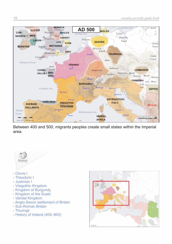
Between 400 and 500, migrants peoples create small states within the Imperialarea.
AD 500
- Clovis I- Theodoric I- Justinian I- Visigothic Kingdom- Kingdom of Burgundy- Kingdom of the Suebi- Vandal Kingdom- Anglo-Saxon settlement of Britain- Sub-Roman Britain- Thuringii- History of Ireland (400–800)

euratlas periodis guide book 11
Between 500 and 600, from Constantinople, the surviving part of the Empiretries to recover the lost territories.
AD 600
- Kingdom of the Lombards- Neustria- Austrasia- Vascones- Exarchate of Ravenna- Kingdom of Kent- Wessex- Kingdom of East Anglia- Avar Khaganate- Agilolfings- Slavic settlement of the Eastern Alps

euratlas periodis guide book12
In West Europe, the new states fight each other but manage to fix theirboundaries.
AD 700
- Umayyad conquest of Hispania- Duchy of Spoleto- Duchy of Aquitaine- Duchy of Rome- Heptarchy- Duchy of Benevento- Charles Martel- Merovingian dynasty- Origin hypotheses of the Croats- Origin hypotheses of the Serbs

euratlas periodis guide book 13
In 800, under Charlemagne, the Frankish kingdom rules almost the whole West.
AD 800
- Charlemagne- Emirate of Córdoba- Kingdom of Asturias- Patrimonium Sancti Petri- Saxon Wars- Palatine Chapel, Aachen- Byzantine Iconoclasm- Donation of Constantine- Great Moravia- Polish tribes- History of Dalmatia- Alfred the Great
euratlas periodis guide book14
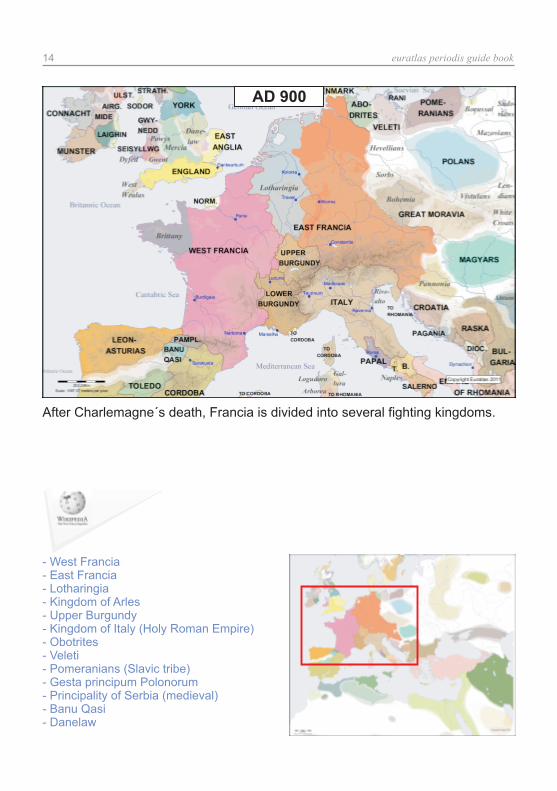
After Charlemagne´s death, Francia is divided into several fighting kingdoms.
AD 900
- West Francia- East Francia- Lotharingia- Kingdom of Arles- Upper Burgundy- Kingdom of Italy (Holy Roman Empire)- Obotrites- Veleti- Pomeranians (Slavic tribe)- Gesta principum Polonorum- Principality of Serbia (medieval)- Banu Qasi- Danelaw

euratlas periodis guide book 15
In 962, Otto I, a German overlord, is crowned Roman Emperor, that is Emperorof the German and Italian lordships.
AD 1000
- Otto I, Holy Roman Emperor- Rudolph III of Burgundy- Norman conquest of England- Caliphate of Córdoba- Stephen I of Hungary- Kingdom of Poland (1025–1385)- Kingdom of France- Kingdom of Navarre- Catalan counties- Kingdom of Croatia (925–1102)- Narentines- First Bulgarian Empire- Přemyslid dynasty

euratlas periodis guide book16
The West Frankish lordships gradually go together and England is ruled by theNormans.
AD 1100
- Crusades- Duklja- Holy Roman Empire- Kingdom of Castile- Kingdom of León- Kingdom of Aragon- El Cid- History of the Republic of Venice- County of Apulia and Calabria- Pomerania during the High Middle Ages

euratlas periodis guide book 17
Endless disputes between the reigning families of England and France.
AD 1200
- House of Plantagenet- Magna Carta- Angevin Empire- County of Toulouse- Crown of Aragon- Trencavel- Lombard League- Frederick II, Holy Roman Emperor- Testament of Bolesław III Krzywousty- Kingdom of Hungary (1000–1301)- Serbian Grand Principality- Almohad Caliphate

euratlas periodis guide book18
After 1254, 100 Years' Warbetween England and France begins in 1337.
the Holy Empire disintegrates slowly and the
AD 1300
- Hundred Years' War- Black Death- Federal Charter of 1291- Kingdom of Majorca- Capetian House of Anjou- Rudolf I of Germany- House of Luxembourg- Kingdom of Naples- Duchies of Silesia- History of Portugal (1279–1415)- County of Savoy

euratlas periodis guide book 19
New powers emerge: Habsburg, Swiss cantons, Burgundy, Castile and Aragon.
AD 1400
- Joan of Arc- Pact of Vilnius and Radom- House of Sforza- Republic of Florence- Duchy of Ferrara- Duchy of Burgundy- Teutonic Knights- Duchy of Savoy- Crown of Castile- Fall of Constantinople

The Habsburgs and France share the Burgundian territories.
AD 1500
- Isabella I of Castile- Ferdinand II of Aragon- Louis XI of France- Burgundian Wars- Italian Wars- Charles V, Holy Roman Emperor- European colonization of the Americas- Margraviate of Brandenburg- Protestant Reformation- Growth of the Ottoman Empire- Battle of Lepanto
euratlas periodis guide book20

The Habsburg Charles V, Holy Roman Emperor, ruled the half world until 1556,his heirs have shared his dominions.
AD 1600
- Thirty Years' War- Dutch Republic- English Civil War- Louis XIV of France- Great Turkish War- Polish–Lithuanian Commonwealth- Bourbon Claim to the Spanish Throne- Treaty of Karlowitz
euratlas periodis guide book 21

England, France, Spain and the Habsburg Monarchy dominate WesternEurope.
AD 1700
- War of the Spanish Succession- Kingdom of Prussia- Frederick the Great- Acts of Union 1707- Seven Years' War- Habsburg Monarchy- Partitions of Poland- Age of Enlightenment- French Revolution- Great Northern War- French Revolutionary Wars
euratlas periodis guide book22

The French Revolution and the Napoleonic Wars dissolve the Holy RomanEmpire.
- Napoleon- Napoleonic Wars- First French Empire- German mediatization- Austrian Empire- German Confederation- Revolutions of 1830- Victorian era- Italian unification- German Empire- Revolutions of 1848- Austro-Hungarian Compromise of 1867- Franco-Prussian War
euratlas periodis guide book 23
AD 1800

After 1914, Western Europe will become the battlefield of the Great Powers.
AD 1900
- World War I- 1918 flu pandemic- Treaty of Versailles- Russian Revolution- League of Nations- Soviet Union- Great Depression- Yugoslavia- Czechoslovakia- Second Polish Republic
euratlas periodis guide book24

Five years after the creation of the Schengen Area and one year after theEurozone.
AD 2000
- World War II- The Holocaust- United Nations- Cold War- European Coal and Steel Community- European Union- Revolutions of 1989- Yugoslav Wars- Schengen Area- Eurozone
euratlas periodis guide book 25

Everyone may visit Euratlas Periodis Web but if you want to go further, to see more details or to create your own maps, there are also other possibilities.
WHICH EURATLAS PERIODIS DO YOU NEED ?
The Georeferenced Historical Vector Data, based upon the maps used for Euratlas Periodis, are shapefiles data which can be analyzed and organized spatially with a GIS software.
Periodis Web, the online version, presents simple and low resolution maps of the European cultural area at the beginning of each century, since AD 1 until AD 2000 and, through a gazetteer, allows the user to highlight every sovereign or semi-independent entity.
Periodis Editor is a set of 21 mute vector historical maps in Corel Draw 13 (CDR) format, which comes along with the software Euratlas Periodis Expert.
Periodis Expert is a software with powerful display, zoom (up to 6000 %), search and editing functions. It allows an easy and intuitive exploration as well as a customization of the displayed informations. You can export and print maps after changing names or adding geographi-cal signs.
Periodis Basic is a high resolution PDF version of the same 21 historical maps available online. The maps are zoomable and printable but without a gazetteer although it is possible to search through the names displayed on the maps.
Periodis Web is made for those who simply want to have a short overview of European history. Visit and note that you can click on the main map of each centennial page to enlarge it and display a detailed view.
www.euratlas.net/history/europe/index.html
For individual studies, map customization and printing for students, choose Periodis Expert Single Computer or Teaching License. For academic or cultural institutions who want to offer to their members an exploration tool of European history, choose Periodis Expert Site License.
To draw your own custom maps for one or several exact years (1215, 1914 or whatever), you can use the Periodis Editor base maps and change borders and colors. Thereafter, you may add roads, landmarks or cities and write down the denominations you want.
The Georeferenced Historical Vector Data are adapted for people who have knowledge in GIS data and software. It is the most complete form of our data which can be used for spatial analysis, map creation, wall maps printing or integration with other data for research or display purpose.
Periodis Basic is adapted for persons who want to explore more detailed maps with a zoom factor up to 1600%.
euratlas periodis guide book26
www.euratlas.net/shop/history_atlas/periodis_b.html
www.euratlas.net/shop/history_atlas/periodise_en.html
www.euratlas.net/shop/maps_gis/editor.html
www.euratlas.net/shop/maps_gis/index.html
Keep in mind that the software Euratlas Periodis Expert contains all the 21 historical maps and offers powerful integrated editing possibilities. Thus, for an academic or teaching usage, you can use
Euratlas Periodis Expert Teaching License or
Euratlas Periodis Expert Site License.
Moreover, this program is also available in French or German.
For more details and to download the demo version, visit please:
http://www.euratlas.net/shop/history_atlas/index.html
The Euratlas Cartographer
Christos Nüssli was born in Athens on February 14th, 1954. He got a Masters Degree in Law at the University of Lausanne, Switzerland in 1976 and studied the history of Europe. Moreover he studied drawing and painting. From 1979 to 2014, he was teacher of law and economics at the commercial school of Yverdon-les-Bains.
From 1996 on, he has begun detailed researches in historical cartography and realized the Euratlas basemaps, trying continually to improve their shape and accuracy.

Where was
your country so many
years ago ?
www.euratlas.org