etr 101, energy & wetlands research group, ces,...
TRANSCRIPT

ETR 101, Energy & Wetlands Research Group, CES, IISc 2016
© Ramachandra T V, Asulabha K S, Sincy V, Sudarshan Bhat and Bharath H.Aithal, 2015. Wetlands: Treasure
of Bangalore, ENVIS Technical Report 101, Energy & Wetlands Research Group, CES, IISc, Bangalore, India 1
WETLANDS: TREASURE OF BANGALORE [ABUSED, POLLUTED, ENCROACHED & VANISHING]
I. Executive Summary:
Status Wetlands: Abused, encroached and polluted
Cause 1. 98% lakes are encroached - Encroachment of lakebed, flood
plains, etc.;
Loss in lake interconnectivity - Encroachment of
rajakaluves / storm water drains and loss of
interconnectivity;
Lake reclamation for infrastructure activities;
Topography alterations in lake catchment;
38% is surrounded by slums and 82% showed loss of
catchment area.
unauthorised dumping of municipal solid waste and
building debris;
2. 90% lakes are sewage fed (sustained inflow of untreated sewage)
and industrial effluents.
Sustained inflow of untreated or partially treated sewage
and industrial effluents;
Removal of shoreline riparian vegetation; and unabated
construction activities in the valley zone has threatened
these urban wetlands.
Pollution due to enhanced vehicular traffic;
3. Very poor governance - too many para-state agencies and lack of
co-ordination among them.
Solution
Good governance (too many para-state agencies and lack of co-
ordination). Single agency with the statutory and financial autonomy
to be the custodian of natural resources (ownership, regular
maintenance and action against polluters (encroachers as well as those
contaminate through untreated sewage and effluents, dumping of solid
wastes). Effective judicial system for speedy disposal of conflicts
related to encroachment;
Digitation of land records (especially common lands – lakes, open
spaces, parks, etc.) and availability of this geo-referenced data with
query based information system to public.
Removal of encroachment of lakes / wetlands, lake beds and storm
water drains (connecting feeders) after the survey based on reliable
cadastral maps;
Decentralised treatment of sewage and solid waste (preferably at ward
levels). Letting only treated sewage into the lake (as in Jakkur lake
model); Ensure that sewage generated in a locality /ward is treated
locally.
Restriction of the entry of untreated sewage into lakes;
To make land grabbing cognizable non-bail offence;

ETR 101, Energy & Wetlands Research Group, CES, IISc 2016
© Ramachandra T V, Asulabha K S, Sincy V, Sudarshan Bhat and Bharath H.Aithal, 2015. Wetlands: Treasure
of Bangalore, ENVIS Technical Report 101, Energy & Wetlands Research Group, CES, IISc, Bangalore, India 2
Regular removal of macrophytes in the lakes;
Implementation of ‘polluter pays’ principle as per water act 1974;
Plant native species of macrophytes in open spaces of lake catchment
area;
Stop solid wastes dumping into lakes / in the lake bed
Ensure proper fencing of lakes
Restrictions on the diversion of lake for any other purposes;
Complete ban on construction activities in the valley zones.
Decentralised management of lakes through local lake committees
involving all stakeholders
The restoration and conservation strategies has to be implemented for maintaining the ecological
health of aquatic ecosystems, aquatic biodiversity in the region, inter-connectivity among lakes,
preserve its physical integrity (shorelines, banks and bottom configurations) and water quality to
support healthy riparian, aquatic and wetland ecosystems. The regular monitoring of water bodies and
public awareness will help in developing appropriate conservation and management strategies.
1.1 WETLANDS: ESSENTIAL FOR BANGALOREANS’ SURVIVAL
Wetlands (and lakes) constitute the most productive ecosystems with a wide array of goods
and services. These ecosystems serve as life support systems; serve as habitat for a variety of
organisms including migratory birds for food and shelter. They aid in bioremediation and
hence aptly known as ‘kidneys of the landscape’. Major services include flood control,
wastewater treatment, arresting sediment load, drinking water, protein production, and more
importantly recharging of aquifers apart from aiding as sinks and climate stabilizers. The
wetlands provide a low cost way to treat the community’s wastewater, while simultaneously
functioning as wild fauna sanctuary, with public access. These ecosystems are valuable for
education and scientific endeavours due to rich biodiversity.
Bangalore city (Karnataka State, India) has been experiencing unprecedented urbanisation
and sprawl due to concentrated developmental activities in recent times with impetus on
industrialisation for the economic development of the region. This concentrated growth has
resulted in the increase in population and consequent pressure on infrastructure, natural
resources and ultimately giving rise to a plethora of serious challenges such as climate
change, enhanced green-house gases emissions, lack of appropriate infrastructure, traffic
congestion, and lack of basic amenities (electricity, water, and sanitation) in many localities,
etc. Temporal data analysis reveals that that there has been a growth of 925% in urban areas
of Bangalore across four decades (1973 to 2013). Sharp decline in natural resources – 78%
decline in trees and 79% decline in water bodies highlight unplanned urbanisation process in
the city. Urban heat island phenomenon is evident from large number of localities with higher
local temperatures. The city once enjoyed salubrious climate (about 14-16 °C during peak
summer – May month in early 18th century), now has been experiencing higher temperatures
(34 to 37° C) with altered micro climate and frequent flooding during rainy days. The study
reveals the pattern of growth in Bangalore and its implication on local climate (an increase of
~2 to 2.5 ºC during the last decade) and also on the natural resources, necessitating

ETR 101, Energy & Wetlands Research Group, CES, IISc 2016
© Ramachandra T V, Asulabha K S, Sincy V, Sudarshan Bhat and Bharath H.Aithal, 2015. Wetlands: Treasure
of Bangalore, ENVIS Technical Report 101, Energy & Wetlands Research Group, CES, IISc, Bangalore, India 3
appropriate strategies for the sustainable management of natural resources (water bodies, tree
cover, etc.). The frequent flooding (since 2000, even during normal rainfall) in Bangalore is a
consequence of the increase in impervious area with the high-density urban development in
the catchment and loss of wetlands and vegetation.
Urban ecosystems are the consequence of the intrinsic nature of humans as social beings to
live together (Ramachandra et al., 2012; Ramachandra and Kumar, 2008). The process of
urbanisation contributed by infrastructure initiatives, consequent population growth and
migration results in the growth of villages into towns, towns into cities and cities into metros.
Urbanisation and urban sprawl have posed serious challenges to the decision makers in the
city planning and management process involving plethora of issues like infrastructure
development, traffic congestion, and basic amenities (electricity, water, and sanitation), etc.
(Kulkarni and Ramachandra, 2006). Apart from this, major implications of urbanisation are:
Loss of wetlands and green spaces: Urbanisation (925% concretisation or paved
surface increase) has telling influences on the natural resources such as decline in
green spaces (78% decline in vegetation) including wetlands (79% decline) and / or
depleting groundwater table. Quantification of number of trees in the region using
remote sensing data with field census reveal 1.5 million trees and human population is
9.5 million, indicating one tree for seven persons in the city. This is insufficient even
to sequester respiratory carbon (due to breathing which ranges from 540 -900 g per
person per day).
Floods: Conversion of wetlands to residential and commercial layouts has
compounded the problem by removing the interconnectivities in an undulating terrain.
Encroachment of natural drains, alteration of topography involving the construction of
high-rise buildings, removal of vegetative cover, reclamation of wetlands are the
prime reasons for frequent flooding even during normal rainfall post 2000.
Decline in groundwater table: Studies reveal the removal of wetlands has led to the
decline in water table. Water table has declined to 300 m from 28 m over a period of
20 years after the reclamation of lake with its catchment for commercial activities. In
addition, groundwater table in intensely urbanized area such as Whitefield, etc. has
now dropped to 400 to 500m.
Heat island: Surface and atmospheric temperatures are increased by anthropogenic
heat discharge due to energy consumption, increased land surface coverage by
artificial materials having high heat capacities and conductivities, and the associated
decreases in vegetation and water pervious surfaces, which reduce surface
temperature through evapotranspiration.
Increased carbon footprint: Due to the adoption of inappropriate building
architecture, the consumption of electricity has increased in certain corporation wards
drastically. The building design conducive to tropical climate would have reduced the
dependence on electricity. Adoption of building architecture unsuitable for Bangalore
climate has contributed to higher electricity consumption and hence higher GHG
(Greenhouse gases). Per capita electricity consumption in the zones dominated by
high rise building with glass facades require 14000-17000 units (kWh) per year

ETR 101, Energy & Wetlands Research Group, CES, IISc 2016
© Ramachandra T V, Asulabha K S, Sincy V, Sudarshan Bhat and Bharath H.Aithal, 2015. Wetlands: Treasure
of Bangalore, ENVIS Technical Report 101, Energy & Wetlands Research Group, CES, IISc, Bangalore, India 4
compared to the zones with eco-friendly buildings (1300-1500
units/person/year)Higher energy consumption, enhanced pollution levels due to the
increase of private vehicles, traffic bottlenecks have contributed to carbon emissions
significantly. Apart from these, mismanagement of solid and liquid wastes has
aggravated the situation.
Unplanned urbanisation has drastically altered the drainage characteristics of natural
catchments, or drainage areas, by increasing the volume and rate of surface runoff. Drainage
systems are unable to cope with the increased volume of water, and are often blocked due to
indiscriminate disposal of solid wastes. Encroachment of wetlands, floodplains, etc. obstructs
flood-ways causing loss of natural flood storage.
1.2 WETLANDS - VITAL FOR BANGALOREANS
Wetlands are the kidneys of landscape and are vital for human survival. Wetlands are most
productive environments; cradles of biological diversity that provide the water and
productivity upon which countless species of plants and animals depend for survival; help in
remediation - bioremediation. The wetlands perform various ecological functions such as:
1) Wetlands act as kidneys of the landscape – aids in water purification (by
uptake of nutrients and heavy metals).
2) Provide wide range of ecosystem services such as food, fiber and waste
assimilation.
3) Support large biological diversity.
4) Maintain stream flow, mitigate floods, and control erosion.
5) Recharge ground water.
6) Regulate microclimate.
7) Mitigate floods and loss to human life s and properties
8) Enhance the aesthetics of the landscape and support many significant
recreational, social, and cultural activities, aside from being a part of our
cultural heritage
Wetlands are indispensable for the countless benefits or “ecosystem services” that they
provide humanity, ranging from freshwater supply, food and building materials, and
biodiversity, to flood control, groundwater recharge, and climate change mitigation
(http://www.ramsar.org/about/the-importance-of-wetlands).
1.3 NORMS VIOLATIONS: PERSISTENT ABUSE AND MISUSE
Bangalore Wetlands have been facing persistent threats due to (i) encroachments and
unauthorised construction in the lake bed, wetlands, (ii) violation of prohibited activities in
the valley zone / sensitive zone and senseless development activities (contrary to the norms of
CDP: Comprehensive Development Plan/ RMP: Revised Master Plan, 2015), (iii) violation
of regulated activities in the buffer zone (30 m as per BDA), (iv) dumping of municipal solid
wastes, demolished building debris, excavated earth, etc., (v) sustained inflow of partially

ETR 101, Energy & Wetlands Research Group, CES, IISc 2016
© Ramachandra T V, Asulabha K S, Sincy V, Sudarshan Bhat and Bharath H.Aithal, 2015. Wetlands: Treasure
of Bangalore, ENVIS Technical Report 101, Energy & Wetlands Research Group, CES, IISc, Bangalore, India 5
treated or untreated sewage (by BWSSB and high-rise buildings in the lake bed), (vi) disposal
of industrial effluents into the drains connecting the lake, (vii) removal of interconnectivity
among lakes – by encroachment of Rajakaluve and drains connecting lakes, (viii) dumping of
untreated sewage through tankers, (ix) dumping of bio-medical waste, etc.
Major violations in Bellandur-Agara wetlands are:
LAND USE CHANGES WITH THE CONSTRUCTION ACTIVITIES IN
THE PRIMARY VALLEY – SENSITIVE REGIONS (as per RMP, 2015 of
BDA: The Proposed SEZ in Agara-Bellandur region is located in the primary
valley of the Koramangala Challaghatta valley. Primary valleys in Bangalore
are sensitive regions as per sensitive zone notification -
Circular/35/BBMP/2008, dated: 26/11/2008) and buffer zone for primary
valley is 100 m.
The region is a wetlands as per KARNATAKA LAKE CONSERVATION
AND DEVELOPMENT AUTHORITY ACT, 2014 - KARNATAKA ACT
NO. 10 OF 2015; KAR. ACT 12, pg 462; National Wetland Atlas, SAC
Ahmedabad, 2009; Wetland rules, MoEF, Govt of India, 2010; RAMSAR
Definition of wetlands.
Removal of wetlands affects Intergeneration Equity.
Depriving local residents of water: Wetlands helps in recharge of groundwater
in the region.
Encroachment of Rajakalve and streams (connecting Agara lake with Bellandur
Lake).
Deprives local residents of clean, air and water (as per Article 21 of the
Constitution of India).
Dumping of building debris and excavated earth in Wetlands and also in water-
spread area of Bellandur Lake.
Affects livelihood - Forceful eviction of local farmers due to acquisition of
wetlands.
Construction of compound wall depriving local fishermen of their fundamental
right.
Further encroachment of Bellandur Lake.
Intimidation, threats and harassment of wetland researchers and
conservationists.

ETR 101, Energy & Wetlands Research Group, CES, IISc 2016
© Ramachandra T V, Asulabha K S, Sincy V, Sudarshan Bhat and Bharath H.Aithal, 2015. Wetlands: Treasure
of Bangalore, ENVIS Technical Report 101, Energy & Wetlands Research Group, CES, IISc, Bangalore, India 6
1.4 WETLANDS – DEFINITIONS (CONVENIENTLY IGNORED BY
BUREAUCRACY)
"Lake" means an inland water-body irrespective of whether it contains water or not,
mentioned in revenue records as sarkari kere, kharab kere, kunte, katte or by any other
name and includes the peripheral catchment areas, Rajakaluve main feeder, inlets,
bunds, weirs, sluices, draft channels, outlets and the main channels of drainages to
and fro; "Landscape" includes all forms of trees, shrubs, grasses whether naturally
growing or planted in water bodies to enhance aesthetic value; [KARNATAKA
LAKE CONSERVATION AND DEVELOPMENT AUTHORITY ACT, 2014,
KARNATAKA ACT NO. 10 OF 2015].
STATEMENT OF OBJECTS AND REASONS Act 10 of 2015 - It is considered
necessary,-
1. to protect, conserve, reclaim, regenerate and restore lakes to facilitate recharge of
depleting ground water by promoting integrated approach with the assistance of
concerned Government departments, local and other authorities;
2. to exercise regulatory control over all the lakes within the jurisdiction of all the
Municipal Corporations and Bengaluru Development Authority including
prevention and removal of encroachment of lake area and its natural drainage
system.
3. to prepare a plan for integrated development of lakes and to improve and also to
create habitat of wetland for aquatic biodiversity, water birds and aquatic plants
controlling pollution of lakes from sewage and other industrial effluents.
4. to encourage participation of communities and voluntary agencies and to launch
public awareness programmes for conservation, preservation and protection of
lakes.
Wetlands defined as areas of land that are either temporarily or permanently
covered by water exhibit enormous diversity according to their genesis,
geographical location, water regime and chemistry – National Wetland Atlas,
SAC Ahmedabad, 2009
Wetlands means an area or of marsh, fen, peatland or water, natural or
artificial, permanent or temporary, with water that is static or flowing, fresh,
brackish or salt, including areas of marine water, the depth of which at low
tide does not exceed six meters and include all waters such as lakes,
reservoirs, tanks, backwaters, lagoons, creeks, estuaries, and manmade
wetland and the zone of direct influence on wetlands that is to say the drainage
area or catchment region of wetlands as determined by the authority but does
not include main river channels, paddy fields and the coastal wetland covered
under the notification of the Government of India in the Ministry of

ETR 101, Energy & Wetlands Research Group, CES, IISc 2016
© Ramachandra T V, Asulabha K S, Sincy V, Sudarshan Bhat and Bharath H.Aithal, 2015. Wetlands: Treasure
of Bangalore, ENVIS Technical Report 101, Energy & Wetlands Research Group, CES, IISc, Bangalore, India 7
Environment and Forest, S.O number 114 (E) dated the 19th February, 1991
published in the Gazette of India, Extraordinary, Part II, Section 3, Subsection
(ii) od dated the 20th February 1991 - Wetland rules, MoEF, Govt of India,
2010
Wetland means land in which wetcrops can be grown by use of rain water or
water obtained from any source which is not the property of state government –
1964: KAR. ACT 12, pg 462.
Ramsar Definition of a Wetland: Under the Convention on Wetlands (Ramsar, Iran, 1971)
‘wetlands’ are defined by Articles 1.1 and 2.1 as shown below:
Article 1.1: ‘For the purpose of this Convention wetlands are areas of marsh,
fen, peatland or water, whether natural or artificial, permanent or temporary,
with water that is static or flowing, fresh, brackish or salt, including areas of
marine water the depth of which at low tide does not exceed six metres.
’
Article 2.1provides that wetlands: ‘may incorporate riparian and coastal zones
adjacent to the wetlands, and islands or bodies of marine water deeper than six
metres at low tide lying within the wetlands’.
Wetlands means an area or of marsh, fen, peatland or water, natural or
artificial, permanent or temporary, with water that is static or flowing, fresh,
brackish or salt, including areas of marine water, the depth of which at low
tide does not exceed six meters and include all waters such as lakes,
reservoirs, tanks, backwaters, lagoons, creeks, estuaries, and manmade
wetland and the zone of direct influence on wetlands that is to say the drainage
area or catchment region of wetlands as determined by the authority but does
not include main river channels, paddy fields and the coastal wetland covered
under the notification of the Government of India in the Ministry of
Environment and Forest, S.O number 114 (E) dated the 19th February, 1991
published in the Gazette of India, Extraordinary, Part II, Section 3, Subsection
(ii) od dated the 20th February 1991 - Wetland rules, MoEF, Govt of India,
2010
Wetland means land in which wetcrops can be grown by use of rain water or
water obtained from any source which is not the property of state government –
1964: KAR. ACT 12, pg 462.
Wetlands defined as areas of land that are either temporarily or permanently
covered by water exhibit enormous diversity according to their genesis,
geographical location, water regime and chemistry – National Wetland Atlas,
SAC Ahmedabad, 2009
"Lake" means an inland water-body irrespective of whether it contains water or
not, mentioned in revenue records as sarkari kere, kharab kere, kunte, katte or
by any other name and includes the peripheral catchment areas, Rajakaluve

ETR 101, Energy & Wetlands Research Group, CES, IISc 2016
© Ramachandra T V, Asulabha K S, Sincy V, Sudarshan Bhat and Bharath H.Aithal, 2015. Wetlands: Treasure
of Bangalore, ENVIS Technical Report 101, Energy & Wetlands Research Group, CES, IISc, Bangalore, India 8
main feeder, inlets, bunds, weirs, sluices, draft channels, outlets and the main
channels of drainages to and fro; "Landscape" includes all forms of trees,
shrubs, grasses whether naturally growing or planted in water bodies to
enhance aesthetic value; [KARNATAKA LAKE CONSERVATION AND
DEVELOPMENT AUTHORITY ACT, 2014, KARNATAKA ACT NO. 10
OF 2015].
Ramsar Wetland Classification: The wetland types listed below are from the ‘Ramsar
Classification System for Wetland Type as approved by Recommendation 4.7 and amended
by Resolution VI.5 of the Conference of the Contracting Parties. The categories listed herein
are intended to provide only a very broad framework to aid rapid identification of the main
wetland habitats represented at each site’
(http://www.fao.org/docrep/003/x6611e/x6611e03d.htm;
http://www.lrm.nt.gov.au/__data/assets/pdf_file/0013/10462/appendix7.pdf ).
Human-made wetlands
1. -- Aquaculture (e.g. fish/shrimp) ponds
2. -- Ponds; includes farm ponds, stock ponds, small tanks; (generally below 8 ha).
3. -- Irrigated land; includes irrigation channels and rice fields.
4. -- Seasonally flooded agricultural land (including intensively managed or grazed
wet meadow or pasture).
5. -- Salt exploitation sites; salt pans, salines, etc.
6. -- Water storage areas; reservoirs/barrages/dams/impoundments (generally over 8
ha).
7. -- Excavations; gravel/brick/clay pits; borrow pits, mining pools.
8. -- Wastewater treatment areas; sewage farms, settling ponds, oxidation basins, etc.
9. -- Canals and drainage channels, ditches.
Inland Wetlands
L -- Permanent inland deltas.
M -- Permanent rivers/streams/creeks; includes waterfalls.
N -- Seasonal/intermittent/irregular rivers/streams/creeks.
O -- Permanent freshwater lakes (over 8 ha); includes large oxbow lakes.
P -- Seasonal/intermittent freshwater lakes (over 8 ha); includes floodplain lakes.
Q -- Permanent saline/brackish/alkaline lakes.
R -- Seasonal/intermittent saline/brackish/alkaline lakes and flats.
Sp -- Permanent saline/brackish/alkaline marshes/pools.
Ss -- Seasonal/intermittent saline/brackish/alkaline marshes/pools.
Tp -- Permanent freshwater marshes/pools; ponds (below 8 ha), marshes and swamps on
inorganic soils; with emergent vegetation water-logged for at least most of the growing
season.
Ts -- Seasonal/intermittent freshwater marshes/pools on inorganic soils; includes
sloughs, potholes, seasonally flooded meadows, sedge marshes.
U -- Non-forested peatlands; includes shrub or open bogs, swamps, fens.

ETR 101, Energy & Wetlands Research Group, CES, IISc 2016
© Ramachandra T V, Asulabha K S, Sincy V, Sudarshan Bhat and Bharath H.Aithal, 2015. Wetlands: Treasure
of Bangalore, ENVIS Technical Report 101, Energy & Wetlands Research Group, CES, IISc, Bangalore, India 9
Va -- Alpine wetlands; includes alpine meadows, temporary waters from snowmelt.
Vt -- Tundra wetlands; includes tundra pools, temporary waters from snowmelt.
W -- Shrub-dominated wetlands; shrub swamps, shrub-dominated freshwater marshes,
shrub carr, alder thicket on inorganic soils.
Xf -- Freshwater, tree-dominated wetlands; includes freshwater swamp forests,
seasonally flooded forests, wooded swamps on inorganic soils.
Xp -- Forested peatlands; peatswamp forests.
Y -- Freshwater springs; oases.
Zg -- Geothermal wetlands
Zk(b) – Karst and other subterranean hydrological systems, inland
Note: ‘floodplain’ is a broad term used to refer to one or more wetland types, which may
include examples from the R, Ss, Ts, W, Xf, Xp, or other wetland types. Some examples of
floodplain wetlands are seasonally inundated grassland (including natural wet meadows),
shrublands, woodlands and forests. Floodplain wetlands are not listed as a specific wetland
type herein.
1.5 THREATS: LOSS OF WETLANDS - ENCROACHMENTS
The rapid development of urban sprawl has many potentially detrimental effects including the
loss of valuable agricultural and eco-sensitive (e.g. wetlands, forests) lands, enhanced energy
consumption and greenhouse gas emissions from increasing private vehicle use
(Ramachandra and Shwetmala, 2009). Vegetation has decreased by 32% (during 1973 to
1992), 38% (1992 to 2002) and 63% (2002 to 2010).
Figure 1: Lakes encroached by land mafia

ETR 101, Energy & Wetlands Research Group, CES, IISc 2016
© Ramachandra T V, Asulabha K S, Sincy V, Sudarshan Bhat and Bharath H.Aithal, 2015. Wetlands: Treasure
of Bangalore, ENVIS Technical Report 101, Energy & Wetlands Research Group, CES, IISc, Bangalore, India 10
Disappearance of water bodies or sharp decline in the number of water bodies in Bangalore is
mainly due to intense urbanisation and urban sprawl. Latest field survey of 105 wetlands
reveal that lakes (98%) have been encroached for illegal buildings (high raise apartment,
commercial building, slums, etc.). Field survey of all lakes (in 2014-15) shows that nearly
90% of lakes are sewage fed, 38% surrounded by slums and 82% showed loss of catchment
area. Also, lake catchments were used as dumping yards for either municipal solid waste or
building debris. The surrounding of these lakes have illegal constructions of buildings and
most of the times, slum dwellers occupy the adjoining areas. At many sites, water is used for
washing and household activities and even fishing was observed at one of these sites. Multi-
storied buildings have come up on some lake beds that have totally intervene the natural
catchment flow leading to sharp decline and deteriorating quality of water bodies. This is
correlated with the increase in built up area from the concentrated growth model focusing on
Bangalore, adopted by the state machinery, affecting severely open spaces and in particular
water bodies. Some of the lakes have been restored by the city corporation and the concerned
authorities in recent times.
Figure 2: Spatial spread of lakes and custodians (too many – BBMP, BDA, LDA…. But too
less effort to protect these lakes)

ETR 101, Energy & Wetlands Research Group, CES, IISc 2016
© Ramachandra T V, Asulabha K S, Sincy V, Sudarshan Bhat and Bharath H.Aithal, 2015. Wetlands: Treasure
of Bangalore, ENVIS Technical Report 101, Energy & Wetlands Research Group, CES, IISc, Bangalore, India 11
Threats faced by lakes and drainages of Bangalore:
1. Encroachment of lakebed, flood plains, and lake itself;
2. Encroachment of rajakaluves / storm water drains and loss of interconnectivity;
3. Lake reclamation for infrastructure activities;
4. Topography alterations in lake catchment;
5. Unauthorised dumping of municipal solid waste and building debris;
6. Sustained inflow of untreated or partially treated sewage and industrial effluents;
7. Removal of shoreline riparian vegetation;
8. Pollution due to enhanced vehicular traffic;
9. Too many para-state agencies and lack of co-ordination among them.
10. Different custodians for upstream and downstream lakes in the valley (Figure 2 and
Table 1).
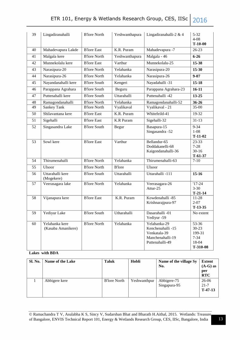
Table 1: Lakes with BBMP (A: Area in acres, G: Gunta, T: Total)
Sl.No Name of the lake Taluk Hobli Name of the village
Survey No.
Extent (A-
G) as per
RTC
1 Agrahara Lake B'lore North Yelahanka Agrahara -33 15-34
2 Allalasandra kere B'lore North Yalahanka Allalsandra -15 41-23
3 Ambalipura Kelagina
kere
B'lore East Varthur Ambalipura-40 & 41 3-0, 4-09
T-7-09
4 Amblipura
Melinakere
B'lore East Varthur Ambalipura-36 12-16
5 Attur kere B'lore North Yalahanka Attur kere-81
Ananthapura-92
Ramagondanahalli- 39
Kempanahalli-12
56-29
6-15
7-22
19-18
T-90-04
6 Avalahalli B'lore North Yalahanka Avalahalli -10 &
Singanayakanahalli 64
11-01
2-10
T-13-11
7 Bhimmana katte B'lore South Kengeri Halagevaderahalli-138 1-23
8 Bayappanapalya
Kunte
(Munniyappana katte)
B'lore South Uttarahalli Vajarahalli -36 2-31
9 Challakere Lake B'lore East K.R. Puram Challakere - 85 38-05
10 Chinnapanhalli kere B'lore East K.R. Puram Chinnapanahalli 15 & 17 11-33
11-10
11 Chokkanahalli lake B'lore North Yelahanka Chokkanahalli Sy-2 8-02
12 Dasarahalli kere
(Chokkasandra)
B'lore North Yeshwanthapura Dasarahalli - 24
Chokkasandra - 5
3-29
24-04
T-27-33
13 Deepanjali kere B'lore South Kengeri Devatige Ramanahalli-32 7-22
14 Devsandra kere B'lore East K.R. Puram Devasandra 31 16-08
15 Doddabommasandra B'lore North Yelahanka Dodda Bommasandra-56
Kodigehalli- 175
Thindlu - 53
39-10
49-21
35-28
T-124-19

ETR 101, Energy & Wetlands Research Group, CES, IISc 2016
© Ramachandra T V, Asulabha K S, Sincy V, Sudarshan Bhat and Bharath H.Aithal, 2015. Wetlands: Treasure
of Bangalore, ENVIS Technical Report 101, Energy & Wetlands Research Group, CES, IISc, Bangalore, India 12
16 Doddakanenahalli
kere
B'lore East Varthur Doddakanenahalli - 109 18-14
17 Dore kere B'lore South Uttarahalli Uttarahalli -22
Vasanthapura -06
19-11
'9-06
T-28-17
18 H Gollahalli Lake
(Varahasandra Lake)
B'lore South Kengeri Kengeri Gollahalli-9
Varahasandra-9
Hemgepura-25
7-08
4-33
7-25
T-19-26
19 Halagevaderahalli
Lake
B'lore South Kengeri Halagevaderahalli-1 17-10
20 Handrahalli B'lore North Yeshwanthapura Handrahalli -8 16-06
21 Haraluru kere B'lore East Varthur Haraluru-95 34-70
22 Herohalli B'lore North Yeshwanthapura Herohalli-99 34-33
23 Harohalli lake B'lore North Yelahanka Harohalli-91 74-32
24 Jogi kere B'lore South Uttarahalli Mallasandra-30 3-20
25
J.P. Park (Mathikere) B'lore North Yeshwanthapura
Jalahalli-32
Mathikere-59
Thaniranahalli-01
Kasaba Yeshwanthpura-
114
47-26
--
20-39
--
T-
26 Kaikondanahalli kere B'lore East Varthuru Kaikondanahalli -8
Kasavanahalli -70
18-18
30-05
T-48-23
27 Kalkere Agra kere B'lore East K.R. Puram &
Bidarahalli
Kalkere-45
Kyalasanahalli-36
Beelisivale-101 & 106
Horamavu Agra-36
73-11
51-19
0-37 & 0-
14
61-11
T-187-12
28 Kammagondanahalli B'lore North Yeshwanthapura Kammagondanahalli-18
Shettyhalli-67
Myadarahalli
(Medarahalli)-26
15-26
5-32
1-32
T-23-10
29 Kasavanhalli B'lore East Varthur Kasavanahalli-50
Haralur-32
21-30
33-18
T-56-08
30 Kattiganahalli Kere-
136
B'lore North Jala Kattiganahalli -136 25-28
31 Kattiganahalli Kere-
31
B'lore North Jala Kattiganahalli -31 20-10
32 Kempambudhi Lake B'lore North B'lore Kempambudhi-2
33 Kodigehalli kere B'lore North Yeshwanthapura Kodigehalli - 30 9-25
34 Kogilu Lake B'lore North Yelahanka
Jala
Kogilu - 84
Kattigenahalli - 117
40-04
38-24
T-78-28
35 Koudenahalli kere B'lore East K.R. Puram Koudenahalli -27 55-05
36 Kudlu Chikere Anekal Taluk Sarjapura Koodlu-70 13-05
37 Kudlu doddakere Anekal Talulk
and B'lore
South
Sarjapur &
Begur
Koodlu-150
Parapanaagrahara-37
26-38
17-01
T-43-39
38 Kundalahalli Lake B'lore East K.R. Puram Kundalahalli -05 30-20
ETR 101, Energy & Wetlands Research Group, CES, IISc 2016
© Ramachandra T V, Asulabha K S, Sincy V, Sudarshan Bhat and Bharath H.Aithal, 2015. Wetlands: Treasure
of Bangalore, ENVIS Technical Report 101, Energy & Wetlands Research Group, CES, IISc, Bangalore, India 13
39 Lingadiranahalli B'lore North Yeshwanthapura Lingadiranahalli-2 & 4 5-32
4-08
T-10-00
40 Mahadevapura Lakde B'lore East K.R. Puram Mahadevapura -7 26-23
41 Malgala kere B'lore North Yeshwanthapura Malgala - 46 6-26
42 Munnekolalu kere B'lore East Varthur Munnekolalu-25 15-38
43 Narasipura-20 B'lore North Yelahanka Narasipura-20 15-30
44 Narasipura-26 B'lore North Yelahanka Narasipura-26 9-07
45 Nayandanahalli kere B'lore South Kengeri Nayadahalli -31 15-18
46 Parappana Agrahara B'lore South Beguru Parappana Agrahara-23 16-11
47 Puttenahalli kere B'lore South Uttarahalli Puttenahalli -42 13-25
48 Ramagondanahalli B'lore North Yelahanka Ramagondanahalli-52 36-26
49 Sankey Tank B'lore North Vyalikaval Vyalikaval - 21 35-00
50 Shilavantana kere B'lore East K.R. Puram Whitefeild-41 19-32
51 Sigehalli B'lore East K.R Puram Sigehalli-32 31-13
52 Singasandra Lake B'lore South Begur Basapura-15
Singasandra -52
9-34
1-08
T-11-02
53 Sowl kere B'lore East Varthur Bellandur-65
Doddakanelli-68
Kaigondanahalli-36
23-33
7-28
30-16
T-61-37
54 Thirumenahalli B'lore North Yelahanka Thirumenahalli-63 7-10
55 Ulsoor B'lore North B'lore Ulsoor
56 Uttarahalli kere
(Mogekere)
B'lore South Uttarahalli Uttarahalli -111 15-16
57 Veerasagara lake B'lore North Yelahanka Veerasagara-26
Attur-25
'17-24
3-30
T-21-14
58 Vijanapura kere B'lore East K.R. Puram Kowdenahalli -85
Krishnarajpura-97
11-28
2-07
T-13-35
59 Yediyur Lake B'lore South Utharahalli Dasarahalli -01
Yediyur -59
No extent
60 Yelahanka kere
(Kasaba Amanikere)
B'lore North Yelahanka Yelahanka-29
Kenchenahalli -15
Venkatala-39
Manchenahalli-19
Puttenahalli-49
53-36
30-23
199-31
7-34
18-04
T-310-08
Lakes with BDA
Sl. No. Name of the Lake Taluk Hobli Name of the village Sy
No.
Extent
(A-G) as
per
RTC
1 Abbigere kere B'lore North Yeshwanthpur Abbigere-75
Singapura-95
26-06
21-7
T-47-13

ETR 101, Energy & Wetlands Research Group, CES, IISc 2016
© Ramachandra T V, Asulabha K S, Sincy V, Sudarshan Bhat and Bharath H.Aithal, 2015. Wetlands: Treasure
of Bangalore, ENVIS Technical Report 101, Energy & Wetlands Research Group, CES, IISc, Bangalore, India 14
2 Alahalli kere / Anjanapura B'lore South Uttarahalli Allahalli -30
Gollahalli-3
15-35
5-30
T-21-25
3 Amruthalli kere B'lore North Yelahanka Amruthalli-115 24-36
4 Annappahalli/ Yelachenahalli
Lake
B'lore South Uttarahalli Yelachenahalli-06,
Govinayakanahalli-14
4-39
1-33
T-6-32
5 Arakere B'lore South Beguru Arakere-34 37-21
6 Avalahalli B'lore North Yelahanaka Avalahalli-10
Shiganayakanahalli-64
11-01
2-10
T-13-11
7 B.Narayanapura B'lore East K.R. Puram B.Narayanapura-109 15-06
8 Baiyappanahalli kere B'lore East K.R. Puram Baiyappanahalli-61 8-09
9 Basapura Lake-2 B'lore South Beguru Basapura-66 10-29
10 Basavanapura Lake B'lore South Beguru Basavanapura-14 7-34
11 Begur Lake Bl'lore South Begur Begur-94 137-24
12 Bellahalli B'lore North Yelahanka Bellahalli-68 18-32
13 Bellandur B'lore East Varthur Yamaluru-62
Amanikere Bellandur
Kahne-1
Ibbalur-12
Kempapura-6
Beluru-2
3-04
284-20
399-14
13-15
2-00
T-700-
13
14 Beratena Agrahara Lake
(Chowdeshwari Layout
B'lore South Begur Beratena Agrahara
(Chowdeshwari)-18 11-18
15 Bhattralli kere B'lore East Bidarahalli Bhattralli-2 18-10
16 Bheemanakuppe B'lore South Kengeri Bheemanakuppe-180 75-15
17 Bhoganalli kere B'lore East Varthur Bhoganalli-21 12-24
18 Byrasandra B'lore South Utharahalli Byrasandra-56 15-11
19 Byrasandra kere (Chikkepet)
(Melinakere)
B'lore East K.R. Puram Byrasandra-109 14-19
20 Chennasandra-2 B'lore East K.R. Puram Banasawadi-211 47-38
21 Chikka Banavara B'lore North Yeshwanthpur Chikka Banavara-3,
Somashettyhalli-73,
Kere gullada halli-22
and Ganigarahalli-
11,15
67-38
3-21
26-32
4-14
2-30
T-105-
15
22 Chikka Bellandur kere B'lore East Varthur Chikka Bellandur-9
Mullur -63
67-14
8-07
T-75-21
23 Chikkabasavanapura kere B'lore East K.R. Puram Basavanapura-14 14-07
24 Chikkabasthi B'lore South Kengeri Ramasandra-6 7-06
25 Chikkabettahalli B'lore North Yelahanka Chikkabettahalli-52 1-32

ETR 101, Energy & Wetlands Research Group, CES, IISc 2016
© Ramachandra T V, Asulabha K S, Sincy V, Sudarshan Bhat and Bharath H.Aithal, 2015. Wetlands: Treasure
of Bangalore, ENVIS Technical Report 101, Energy & Wetlands Research Group, CES, IISc, Bangalore, India 15
26 Chick begur Lake B'lore South Begur Begur-168,
Singanadra-86
32-19
9-37
T-42-16
27 Chikkammanahalli Lake B'lore South Begur Kammanahalli -22
Vamadevanahalli-
5-19
28 Chikkegowdana palya Lake B'lore South Kengeri Hemmagepura-92
29 Chunchanaghatta B'lore South Utharahalli Chunchanaghatta-70,
70/2, 70/3
20-31
1-0
1-0
T-22-31
30 Chowdeshwari Layout Lake B'lore South Begur
31 Devarakere Lake B'lore South Uttarahalli Bikasipura-9 7-15
32 Doddabidarakallu B'lore North Yeshwanthpur Doddabidarakallu-125
Nagasandra -06
23-21
16-36
T-40-17
33 Doddakallasandra B'lore South Uttarahalli Doddakallasandra-27 21-16
34 Doddanakundi B'lore East K.R. Puram
(village map)
Varthur (In
RTC-Bhoomi)
Doddanekundi -200
Kaggadasapura - 25
Vibhutipura -13
56-39
75-16
3-15
T-135-
30
35 Dubasipalya Lake B'lore South Kengeri Valagerehalli-43, 43/P1 23-35
1-0
T-24-35
36 Gangasetty kere
(Diesel shed kere
(Gangadhariahnakere)
(Dyavasandrakunte kere)
B'lore East K.R. Puram KR Pura-58
Devasandra-46
18-32
2-35
T-21-27
37 Gandhinagara Lake B'lore North
38 Garudachar Palya Kere -1
(Achanakere)
B'lore East K.R. Puram Mahadevapura-31 5-36
39 Garudachar Palya Kere -2
(Goshala) Yekkalagatta kere
B'lore East K.R. Puram Mahadevapura-86 5-14
40 Garvebhavi Palya B'lore South Begur Hongasandra -41 18-04
41 Gattigere palya Lake B'lore South Kengeri Somapura-27/53 0-37
42 Gottigere Lake B'lore South Uttarahalli Gottigere-71 37-13
43 Gowdana Palya Lake B'lore South Uttarahalli Kadirenahalli-33 9-30
44 Gubbalala B'lore South Uttarahalli Gubbalala-25
Vajarahalli- 8-10
45 Gunjur Kere (Carmelarm) B'lore East Varthur Gunjur-95 9-17
46 Gunjur Mouji kere B'lore East Varthur Gunjur-301,
Kachamaranhalli-74
59-13
4-26
T- 63-39
47 Gunjur Palya kere B'lore East Varthur Gunjur-83 36-27
48 Haralakunte Lake
(Somasandrakere)
B'lore South Begur Haralakunte-51 16-29

ETR 101, Energy & Wetlands Research Group, CES, IISc 2016
© Ramachandra T V, Asulabha K S, Sincy V, Sudarshan Bhat and Bharath H.Aithal, 2015. Wetlands: Treasure
of Bangalore, ENVIS Technical Report 101, Energy & Wetlands Research Group, CES, IISc, Bangalore, India 16
49 Hoodi kere (GIDDANA KERE ) B'lore East K.R. Puram Hoodi-138 28-31
50 Hoodi kere -1 B'lore East K.R. Puram Hoodi-79 15-10
51 Horamavu Agara B'lore East K.R. Puram Horamavu Agra-77 51-34
52 Horamavu kere B'lore East K.R. Puram Horamavu-83 37-14
53 Hosakerehalli B'lore South Uttarahalli Hosakerehalli-15 59-26
54 Hosakere B'lore South
55 Hulimavu B'lore South Beguru Hulimavu-42
Kammanahalli -110
124-25
5-32
130-17
56 Ibbalur Lake B'lore South Beguru Ibbalur-36 18-06
57 Jakkur & Sampigehalli B'lore North Yelahanka Jakkur-15, 23
Yalahanka Amanikere-
55
Sampigehalli-12
Agrahara-13
39-
21,36-33
58-16
19-25
3-17
T-157-
32
58 Jaraganahalli/Sarakki/Puttenahalli
Lake
B'lore South Uttarahalli Jaraganahalli-7
Sarrakki-26
Puttenahalli - 5
Kothanuru-103
Chunchaghatta-28
38-14
38-0
6-10
11-21
13-07
T-107-
12
59 Jimkenalli kere B'lore East Bidarahalli Varanasi-47 8-24
60 Junnsandra kere B'lore East Varthur Junnasandra-32 24-33
61 Kadirenapalya kere B'lore East KR Puram Binnamangala-99
62 K R Puram (BEML)
Bendiganahalli kere
B'lore East K.R. Puram Benniganahalli-47 &
55
18-24,
27-14
T- 45-39
63 Kaggadasanapura B'lore East K.R. Puram
(village map)
Varthur (In
RTC-Bhoomi)
Byrasandra -5
Kaggadasapura-141
Bendiganahalli - 24/3
14-24
32-16
3-26
T-51-26
64 Kalena Agrahara Lake B'lore South Begur Kalena Agrahara-43 7-30
65 Kalkere Rampura kere Anekal Taluk
(B'lore East)
Jigani
Bidarahalli
Kalkere-162
Rampura-22
Maragondanahalli-71
Huvineane-86
64-25
3-04
11-35
108-07
T-187-
31
66 Kalyani / Kunte ( Next to Sai
Baba Temple)
B'lore South Uttarahalli Vasanthpura-21 1-33
67 Kannenahalli B'lore North
(Bng South)
Kengeri
Yeshwanthpur
68 Kelagina kere / Byrasandra B'lore East K.R. Puram Byrasandra-112 12-21
69 Kembatha halli B'lore South Uttarahalli Kembathahalli-3
Kathnuru-32/3
5-16
1-33
T-7-20
70 Kenchanapura B'lore South Kengeri Kenchanapura-10 17-20

ETR 101, Energy & Wetlands Research Group, CES, IISc 2016
© Ramachandra T V, Asulabha K S, Sincy V, Sudarshan Bhat and Bharath H.Aithal, 2015. Wetlands: Treasure
of Bangalore, ENVIS Technical Report 101, Energy & Wetlands Research Group, CES, IISc, Bangalore, India 17
71 Kengeri Lake B'lore South Kengeri Kengeri-15,
Valagerehalli-85
27-03
5-13
T-32-16
72 Kommaghatta B'lore South Kengeri Komaghatta-03
Ramasandra-46
9-04
28-01
T-37-05
73 Konankunte B'lore South Uttarahalli Konanakunte - 2 09-18
74 Konasandra Anekal Taluk Jigani Dyavasandra-9
Bommandahalli-18
Konasandra-17
21-13
7-39
3-20
T-32-32
75 Konnappana agrahara B'lore South Begur Naganathpura
(South)81 5-17
76 Kothnur B'lore South Utharahalli Kothnur-54 18-09
77 Lakshmipura lake B'lore North Yeshwanthpur Lakshmipura-25 10-06
78 Lingadheeranahalli B'lore South Kengeri Lingadheeranahalli-13 5-22
79 Madavara B'lore North Dasanapura
Yeshwanthpur
Madavara -48
Chikkabidarakallu-21
Tirumalapura-32 (from
Yeshwanthpura hobli)
Doddabidarakallu -98
(From Yeshwanthpura
hobli
35-31
20-20
8-36
2-39
T-68-06
80 Mahadevapura
(Bandemahadevpura kere)
B'lore East K.R. Puram Mahadevapura-187 13-11
81 Mallasandra Gudde lake B'lore North Dasanapura Mallasandra-49,
Mallasandra-50
11-28
5-23
T-17-11
82 Mallathahalli B'lore North Yeshwanthpur Mallathahalli-101
Giddadakonenahalli-6
50-38
20-08
T-71-06
83 Manganahalli B'lore North Yeshwanthpur Manganahalli - 43 6-22
84 Medi Agrahara B'lore North Yelahanka Medi Agrahara-33 13-15
85 Meenakshi Kere B'lore South Begur Kammanahalli
(Meenakshi)-38 18-37
86 Mesthripalya Lake B'lore South Begur Jakkasandra- 30 11-21
87 Nagarabhavi B'lore North
(Bng South)
Yeshwanthpur Nagarabhavi-17 17-39
88 Nagareshwara-Nagenahalli Lake B'lore East K.R. Puram Nagareshwara-
Nagenahalli -10
11-08
89 Nellagaderanahalli B'lore North Yeshwanthpur Nallagaderanahalli - 62 19-22

ETR 101, Energy & Wetlands Research Group, CES, IISc 2016
© Ramachandra T V, Asulabha K S, Sincy V, Sudarshan Bhat and Bharath H.Aithal, 2015. Wetlands: Treasure
of Bangalore, ENVIS Technical Report 101, Energy & Wetlands Research Group, CES, IISc, Bangalore, India 18
90 Nalluralli tank B'lore East K.R. Puram Nalluralli-4
Pantandur Agrahara-85
20-34
27-05
T-47-39
91 Narasappanahalli B'lore North Yeshwanthpur Karivabanahalli-40
Nelagadiranahalli - 90
Nelagadiranahalli -89
Doddabidarakallu - 24
27-13
19-05
5-26
1-20
T-53-24
92 Nyanappanahalli Lake B'lore South Begur Begur-344 6-07
93 Panathur kere -38 B'lore East Varthur Panathur - 38 27-17
94 Panathur kere -48 B'lore East Varthur Panathur - 48 6-30
95 Pattandur Agrahara B'lore East K.R. Puram Pattandur Agrahara-
124 16-35
96 Pattandur Agrahara B'lore East K.R. Puram Pattandur Agrahara-54 12-37
97 Pattanagere Kenchenhalli B'lore South Kenchenahalli-33
Pattanagere-43
3-39
0-31
T-4-30
98 Rachenahalli B'lore North
B'lore East
Yelahanka
K.R Puram
Dasarahalli-61 (Bng
East- KR Puram)
Jakkur - 82 (Bng
North-Yelahanka)
Rachenahalli - 69 (Bng
East-KR Puram)
73-23
39-07
18-16
T-131-
06
99 Ramsandra (Hirekere) B'lore South
B'lore North
Kengeri
Yeshwanthpur
Ramasandra-159
Kenchanpura-36/*
Kenchenapura -
36/¥ÉÊQ
Kannahalli-37 (Bng
north-Yeshwanthpura)
66-20
56-05
5-0
12-29
T-140-
14
100 Sadaramangala kere B'lore East K.R. Puram Sadaramangala-61,
Kodigehalli-8
51-04
1-17
T-52-21
101 Shivanahalli B'lore North Yelahanka shivanahalli-48
Allalasandra-38, 48
14-30
3-22
0-27
T-18-39
102 Siddapura kere B'lore East Varthur Siddapura -18 27-38
103 Singapura Kere B'lore North Yelahanka Singapura-102 66-18
104 Singasandra B'lore South Beguru Singasandra -99, 100 10-14
0-34
T-11-08
105 Sitaram Palya B'lore East K R Puram Sonnenahalli
(Seetharmapalya)-33 23-37

ETR 101, Energy & Wetlands Research Group, CES, IISc 2016
© Ramachandra T V, Asulabha K S, Sincy V, Sudarshan Bhat and Bharath H.Aithal, 2015. Wetlands: Treasure
of Bangalore, ENVIS Technical Report 101, Energy & Wetlands Research Group, CES, IISc, Bangalore, India 19
106 Sompura B'lore South Kengeri Sompura - 11 17-38
107 Srigandadakaval (near
Rajivgandhi nagar)
B'lore North Yeshwanthpur Srigandakavalu-15 6-33
108 Srinivasapura Kere B'lore North Yelahanaka Srinivasapura-2 3-14
109 Subbarayanakere B'lore South Uttarahalli Gottigere-12 5-10
110 Subedeharanakere B'lore South Begur Begur-48 6-05
111 Subramanyapura Lake B'lore South Uttarahalli Uttarahalli-64 18-06
112 Sulekere (Soolikere) B'lore South Kengeri Maragondanahalli
Krishnasagara
113 Swarnakunte gudda kere B'lore South Begur Chandrashekarpura-1 09-05
114 Talaghattapura (Gowdarakere) B'lore South Uttarahalli Talaghattapura -73 19-16
115 Ullal B'lore North Yeshwanthpur Ullal-93 24-12
116 Vaderahalli B'lore North Yelahanka Vaderahalli-32 9-34
117 Varahasandra Lake B'lore South Kengeri Hemigepura-4,
Varahasandra-24
4-11
13-09
T-17-20
118 Varthur B'lore East Varthur Varthur-319 445-14
119 Vasanthapura (Janardhanakere) B'lore South Utharahalli Vasanthpura-28 7-10
120 Venkateshpura B'lore North Yelahanka Ventateshpura-12
Sampigehalli-37
6-35
11-29
T-18-24
121 Vibhuthipura kere B'lore East Varthur Vibhuthipura-175 45-18
122 Vishwa nidam lake B'lore North Yeshwanthpur Herohalli-50 4-30
123 Yellenhalli Lake (Elenahalli) B'lore South Begur Yellenhalli-55 4-39
Lakes under Lake Development Authority (LDA)
Sl.No Name of the Lake Taluk Hobli Name of the village Sy No. Extent (A-
G) as per
RTC
1 Agaram Lake B'lore South Kengeri Agara-11
Venkojiraokhane-11
5-39
136-30
T-142-29
2 Hebbal Lake B'lore North Kasaba Hebbla-38
Kodigehalli-37
92-26
99-33
T-192-19
3 Nagavara Lake B'lore North Kasaba Nagawara-58
Vishwanatanagenahalli -
12,13
56-17
12-35
6-01
T-75-13
4 Vengaiahnakere B'lore East K.R. Puram Krishnarajapura-9
Sannathammanahalli-46
38-12
26-23
T-64-35
Lakes - Karnataka Forest Department
Sl.No Name of the Lake Taluk Hobli Name of the village
Sy No.
Extent (A-
G) as per

ETR 101, Energy & Wetlands Research Group, CES, IISc 2016
© Ramachandra T V, Asulabha K S, Sincy V, Sudarshan Bhat and Bharath H.Aithal, 2015. Wetlands: Treasure
of Bangalore, ENVIS Technical Report 101, Energy & Wetlands Research Group, CES, IISc, Bangalore, India 20
RTC
1 Hennur (K.R.Puram
Range)
B'lore North Kasaba Hennur - 53
Nagawara - 13
58-30
14-11
T-73-01
2 J.B.Kaval Tank
(Bangalore Range)
B'lore North Yelahanka Jyarakabande Kavalu-
P1-36
44-21
2-04
3 Madiwala
(K.R.Puram Range)
B'lore South Begur Madivala- 7
Kodichikkanahalli-23
Belekannahalli-64
Rupena Agrahara-11
166-39
80-09
21-35
6-10
T-275-13
4 Mylsandra
(Kaggalipura
Range)
Gumaiahanakere
(Mylasandra 1)
Mylasandra 2
B'lore South Kengeri Mylasandra-37
Kasaba Kengeri-58
Mylasandra - 27
Kasaba Kengeri-66
6-24
6-02
T-12-26 10-14
5-28
T-16-02
5 Puttenahalli
(Yelahanka Range)
B'lore North Yelahanka Puttenehalli - 36
Attur - 49
29-14
7-26
T-37-00
Lakes - Minor Irrigation Department
Sl.No Name of the Lake Taluk Hobli Name of the village Sy
No.
Extent (A-G)
as per RTC
1 Agara kere Bangalore
South
Kengeri Agara - 103
Agara -102
Agara - 104
13-11
0-08
0-06
T-13-25
2 Alluru kere Bangalore
North
Dasanapura Aluru-132
Vaderahalli - 8
Mathahalli - 25
Narasipura - 41
39-38
27-23
5-32
1-21
T-75-34
3 Bhimanakuppe kere Bangalore
South
Kengeri Bheemanakuppe-180 75-15
4 Bidara Amanikere Anekal
5 Bidarahalli kere Bangalore
East
Bidrahalli Bidarahalli-8
Byappanahalli - 21
15-10
81-16
T-96-26
6 Chikkanahalli Bangalore
East
7 Doddagubbi kere Bangalore
East
Bidarahalli Doddagubbi-38
NadagowdaGollahalli-39
Chikkagubbi-9
105-18
16-37
1-32
T-124-07
8 Ghattahalli
Bommankere
Anekal Sarjapura Gattahalli-62
Rayasandra - 33
51-17
21-22
T-72-39

ETR 101, Energy & Wetlands Research Group, CES, IISc 2016
© Ramachandra T V, Asulabha K S, Sincy V, Sudarshan Bhat and Bharath H.Aithal, 2015. Wetlands: Treasure
of Bangalore, ENVIS Technical Report 101, Energy & Wetlands Research Group, CES, IISc, Bangalore, India 21
9 Hoskuru kere
(Huskur Lake)
Anekal Sarjapura Huskur - 163
Harohalli - 51
Avalahalli - 50
91-10
23-0
---
T-114-10
10 Hulimangala
Doddakere
Anekal Jigani Hulimangala - 22 67-07
11 Kodatikere Bangalore
East
Varthru Kodati-8
Solikunte - 52
40-32
37-09
T-78-01
12 Margondanahalli
kere
Bangalore
South
Kengeri Margondanahalli -45 5-33
13 Rampura kere Bangalore
East
14 Sakalavara
Bujangadasana kere
Anekal Jigani
Sakalavara - 93
23-34
15 Singanayakana halli
kere
Bangalore
North
16 Singena Agrahara
kere
Anekal Sarjapura Singena Agrahara-94
Narayanaghatta - 128
Gottammanahalli - 13
95-39
19-32
8-04
T-123-35
17 Vaderahalli kere Bangalore
South
Kengeri B.M.Kaval P1 -136 21-07
18 Yellemallappa
Shetty kere
Bangalore
East
K.R. Puram Avalahalli -57
Avalahalli -12
Heerandahalli - 95
Heerandahalli -96
Kurudu Sonnenahalli -2
Medahalli -63
Veerenahalli -29
13-26
17-26
170-16
33-24
31-2
91-35
132-06
T-490-15
Source: https://www.karnataka.gov.in/ldakarnataka/documents/Listof-210Lake-BDA,BBMP,LDA, KFD, MILIst.xlsx
The anthropogenic activities particularly, indiscriminate disposal of industrial effluents and
sewage wastes, dumping of building debris have altered the physical, chemical as well as
biological integrity of the ecosystem. This has resulted in the ecological degradation, which is
evident from the current ecosystem valuation of wetlands. Global valuation of coastal
wetland ecosystem shows a total of 14,785/ha US$ annual economic value. Valuation of
relatively pristine wetland in Bangalore shows the value of Rs. 10,435/ha/day while the
polluted wetland shows the value of Rs.20/ha/day (Ramachandra et al., 2005). In contrast to
this, Varthur, a sewage fed wetland has a value of Rs.118.9/ha/day (Ramachandra et al.,
2011). The pollutants and subsequent contamination of the wetland has telling effects such as
disappearance of native species, dominance of invasive exotic species (such as African
catfish, water hyacinth, etc.), in addition to profuse breeding of disease vectors and
pathogens. Water quality analyses revealed of high phosphates (4.22-5.76 ppm) levels in
addition to the enhanced BOD (119-140 ppm) and decreased DO (0-1.06 ppm). The
amplified decline of ecosystem goods and services with degradation of water quality

ETR 101, Energy & Wetlands Research Group, CES, IISc 2016
© Ramachandra T V, Asulabha K S, Sincy V, Sudarshan Bhat and Bharath H.Aithal, 2015. Wetlands: Treasure
of Bangalore, ENVIS Technical Report 101, Energy & Wetlands Research Group, CES, IISc, Bangalore, India 22
necessitates the implementation of sustainable management strategies to recover the lost
wetland benefits.
1.6 CONSERVATION AND MANAGEMENT OF WETLANDS
In recent years, there has been concern over the continuous degradation of wetlands
due to unplanned developmental activities (Ramachandra, 2002). Urban wetlands are
seriously threatened by encroachment of drainage through landfilling, pollution (due to
discharge of domestic and industrial effluents, solid wastes dumping), hydrological
alterations (water withdrawal and inflow changes), and over-exploitation of their natural
resources. This results in loss of biodiversity of the wetland and loss of goods and services
provided by wetlands (Ramachandra, 2009). The mitigation of frequent floods and the
associated loss of human life and properties entail the restoration of interconnectivity among
wetlands, restoration of wetlands (removal of encroachments), conservation and sustainable
management of wetlands (Ramachandra et al., 2012).
Despite good environmental legislations, loss of ecologically sensitive wetlands is due to the
uncoordinated pattern of urban growth happening in Bangalore. Principal reason is lack of
good governance and decentralized administration evident from lack of coordination among
many Para-state agencies, which has led to unsustainable use of the land and other resources.
Failure to deal with water as a finite resource is leading to the unnecessary destruction of
lakes and marshes that provide us with water. This failure in turn is threatening all options for
the survival and security of plants, animals, humans, etc. There is an urgent need for:
Restoring and conserving the actual source of water - the water cycle and the
natural ecosystems that support it - are the basis for sustainable water management
Reducing the environmental degradation that is preventing us from reaching
goals of good public health, food security, and better livelihoods world-wide
Improving the human quality of life that can be achieved in ways while maintaining
and enhancing environmental quality
Reducing greenhouse gases to avoid the deleterious effects of climate change is an
integral part of protecting freshwater resources and ecosystems.
Maintaining intergeneration Equity
A comprehensive approach to water resource management is needed to address the myriad
water quality problems that exist today from non-point and point sources as well as from
catchment degradation. Watershed-based planning and resource management is a strategy for
more effective protection and restoration of aquatic ecosystems and for protection of human
health. The watershed approach emphasizes all aspects of water quality, including chemical
water quality (e.g., toxins and conventional pollutants), physical water quality (e.g.,
temperature, flow, and circulation), habitat quality (e.g., stream channel morphology,
substrate composition, riparian zone characteristics, catchment land cover), and biological
health and biodiversity (e.g., species abundance, diversity, and range). The suggestions to
implement in lakes in order to maintain its healthy ecosystem include:

ETR 101, Energy & Wetlands Research Group, CES, IISc 2016
© Ramachandra T V, Asulabha K S, Sincy V, Sudarshan Bhat and Bharath H.Aithal, 2015. Wetlands: Treasure
of Bangalore, ENVIS Technical Report 101, Energy & Wetlands Research Group, CES, IISc, Bangalore, India 23
Good governance (too many para-state agencies and lack of co-ordination) - Single
agency with the statutory and financial autonomy to be the custodian of natural
resources (ownership, regular maintenance) and action against polluters (encroachers
as well as those let untreated sewage and effluents, dumping of solid wastes).
De-congest Bangalore: Growth in Bangalore has surpassed the threshold evident
from stress on supportive capacity (insufficient water, clean air and water, electricity,
traffic bottlenecks, etc.) and assimilative capacity (polluted water and sediments in
water bodies, enhanced GHG – Greenhouse gases, etc.). No new projects shall be
sanctioned and the emphasis would be on increasing green cover and restoration of
lakes.
Disband BDA – creation of Bangalore Development Agency has given impetus to
inefficient governance evident from Bangalore, the garden city turning into ‘dead
city’ during the functional life of BDA.
Digitation of land records (especially common lands – lakes, open spaces, parks,
etc.) and availability of this geo-referenced data with query option (Spatial Decision
Support System) to public.
Comprehensive development plan (CDP) for the city has to be developed through
consultative process involving all stakeholders and should not be outsourced to
outside agencies / consultants (from other countries).
Removal of encroachment near to lakes after the survey based on reliable cadastral
maps;
Remove all encroachments (without any mercy) of wetlands, lakes, rajjakaluves
(storm water drain) – encroachers have violated all humanitarian norms and deprived
large section of the society of ecological services (provided by wetlands)
Effective judicial system for speedy disposal of conflicts related to encroachment;
Apply principles of ‘polluter pays’ principle to agencies responsible for contamination
of Bangalore surface and ground water (Agency: BWSSB, industries);
Action against regulatory agency (KSPCB) for dereliction of statutory duties and
other responsibilities by allowing sustained contamination of water, land and air;
Restriction of the entry of untreated sewage and industrial effluents into lakes;
To make land grabbing cognizable non-bailable offence;
Letting off only treated sewage into the lake through constructed wetlands and
shallow algae ponds (as in Jakkur lake);
Regular removal of macrophytes in the lakes;
Implementation of ‘polluter pays’ principle as per water act 1974;
Plant native species of macrophytes in open spaces of lake catchment area;
Stop solid wastes (municipal and demolition debris) dumping into lakes; treatment
and management of solid waste shall be as per MSW Rules 2000, GoI.
Ensure proper fencing of lakes
Restrictions on the diversion of lake for any other purposes - Lakes and wetlands
provide ecological services (depending on the catchment integrity, duration may vary)
– there are no dead lakes or wetlands
Complete ban on construction activities in the valley zones;

ETR 101, Energy & Wetlands Research Group, CES, IISc 2016
© Ramachandra T V, Asulabha K S, Sincy V, Sudarshan Bhat and Bharath H.Aithal, 2015. Wetlands: Treasure
of Bangalore, ENVIS Technical Report 101, Energy & Wetlands Research Group, CES, IISc, Bangalore, India 24
Monitoring of lakes through network of schools and colleges;
Mandatory environment education at all levels (schools and colleges including
professional courses).
Wetlands in Bangalore are to be restored considering:
Activities around lakes Norms to protect and conserve Wetlands
Encroachment of lake
bed and loss of
interconnectivity
among
lakes
The Hon’ble Supreme Court in Civil appeal number 1132/2011 at
SLP (C) 3109/2011 on January 28,2011 has expressed concern
regarding encroachment of common property resources, more
particularly lakes (and raja kaluves) and it has directed the state
governments for removal of encroachments on all community
lands.
Eviction of encroachment: Need to be evicted as per Karnataka
Public Premises (eviction of unauthorised occupants) 1974 and
the Karnataka Land Revenue Act, 1964
Buildings in the buffer
zone of lakes
In case of water bodies, a 30.0 m buffer of ‘no development zone’
is to be maintained around the lake (as per revenue records)
• As per BDA, RMP 2015 (Regional Master Plan, 2015)
• Section 17 of KTCP (Karnataka Town and Country Planning)
Act, 1961 and sec 32 of BDA Act, 1976
• Wetlands (Conservation and Management) Rules 2010,
Government of India; Wetlands Regulatory Framework, 2008.
• Valley zones are sensitive and are to be with any construction
activities as per RMP 2015 of BDA
Valley Zones
LAND USE CHANGES WITH THE CONSTRUCTION
ACTIVITIES IN THE PRIMARY VALLIES – SENSITIVE
REGIONS (as per RMP, 2015 of BDA). For example, the
Proposed SEZ in Agara-Bellandur region is located in the primary
valley of the Koramangala Challaghatta valley. Primary valleys in
Bangalore are sensitive regions as per sensitive zone notification
- Circular/35/BBMP/2008, dated: 26/11/2008) and buffer zone for
primary valley is 100 m.
Construction activities
in the valley zone (SEZ
by Karnataka Industrial
Areas Development
Board (KIADB)) in the
valley zone
This is contrary to sustainable development as the natural
resources (lake, wetlands) get affected, eventually leading to the
degradation/extinction of lakes. This reflects the ignorance of the
administrative machinery on the importance of ecosystems and
the need to protect valley zones considering ecological function
and these regions are ‘NO DEVELOPMENT ZONES’ as per CDP
2005, 2015
Alterations in
topography
Flooding of regions would lead to loss of property and human life
and, spread of diseases.

ETR 101, Energy & Wetlands Research Group, CES, IISc 2016
© Ramachandra T V, Asulabha K S, Sincy V, Sudarshan Bhat and Bharath H.Aithal, 2015. Wetlands: Treasure
of Bangalore, ENVIS Technical Report 101, Energy & Wetlands Research Group, CES, IISc, Bangalore, India 25
Increase in
deforestation in
catchment area
Removing vegetation in the catchment area increases soil erosion
and which in turn increases siltation and decreases transpiration
Documentation of
biodiversity
• The biodiversity of every water body should form part of the
School, College, People’s Biodiversity Registers (SBR, CBR,
PBR).
• The local Biodiversity Management Committees (BMC)
should be given necessary financial support and scientific
assistance in documentation of diversity.
• The presence of endemic, rare, endangered or threatened
species and economically important ones should be
highlighted
• A locally implementable conservation plan has to be prepared
for such species
Implementation of
sanitation facilities
• The lakes are polluted with sewage, coliform bacteria and
various other pathogens
• Preserving the purity of waters and safeguarding the
biodiversity and productivity, dumping of waste has to be
prohibited
• All the settlements alongside the water body should be
provided with sanitation facilities so as not to impinge in
anyway the pristine quality of water
Violation of regulatory
and prohibitory
activities as per
Wetlands
(Conservation and
Management) Rules,
2010;
Regulatory wetland
framework, 2008
Environment Impact Assessment (EIA) Notification, 2009.
Wetlands (Conservation and Management) rules 2010,
Government of India; Regulatory wetland framework, 2008
Regulated activity
• Withdrawal of water/impoundment/diversion/interruption of
sources
• Harvesting (including grazing) of living/non-living resources
(may be permitted to the level that the basic nature and
character of the biotic community is not adversely affected)
• Treated effluent discharges – industrial/ domestic/agro-
chemical.
• Plying of motorized boats
• Dredging (need for dredging may be considered, on merit on
case to case basis, only in cases of wetlands impacted by
siltation)
• Constructions of permanent nature within 50 m of periphery
except boat jetties
• Activity that interferes with the normal run-off and related
ecological processes – up to 200 m

ETR 101, Energy & Wetlands Research Group, CES, IISc 2016
© Ramachandra T V, Asulabha K S, Sincy V, Sudarshan Bhat and Bharath H.Aithal, 2015. Wetlands: Treasure
of Bangalore, ENVIS Technical Report 101, Energy & Wetlands Research Group, CES, IISc, Bangalore, India 26
Prohibited activity
i. Conversion of wetland to non-wetland use
ii. Reclamation of wetlands
iii. Solid waste dumping and discharge of untreated effluents
Damage of fencing,
solid waste dumping
and encroachment
problems in Varthur
lake series
High Court of Karnataka (WP No. 817/2008) had passed an order
which include:
• Protecting lakes across Karnataka,
• Prohibits dumping of garbage and sewage in Lakes
• Lake area to be surveyed and fenced and declare a no
development zone around lakes
• Encroachments to be removed
• Forest department to plant trees in consultation with experts in
lake surroundings and in the watershed region
• Member Secretary of state legal services authority to monitor
implementation of the above in coordination with Revenue
and Forest Departments
• Also setting up district lake protection committees
• Implementation of Handling, Treatment and Management of
Municipal Solid Waste as per MSW Rule 2000, GoI
Polluter Pays principle
National Environment Policy, 2006
The principal objectives of NEP includes :
• Protection and conservation of critical ecological systems and
resources, and invaluable natural and man-made heritage
• Ensuring judicious use of environmental resources to meet the
needs and aspirations of the present and future generations
• It emphasizes the “Polluter Pays” principle, which states the
polluter should, in principle, bear the cost of pollution, with
due regard to the public interest
Prevention of pollution
of lake
National Water Policy, 2002
Water is a scarce and precious national resource and requires
conservation and management.
Watershed management through extensive soil conservation,
catchment-area treatment, preservation of forests and increasing
the forest cover and the construction of check-dams should be
promoted.
The water resources should be conserved by retention practices
such as rain water harvesting and prevention of pollution.
Discharge of untreated
sewage into lakes
The Environment (Protection) Act, 1986
• Lays down standards for the quality of environment in its
various aspects
• Laying down standards for discharge of environmental
pollutants from various sources and no persons shall discharge
any pollutant in excess of such standards

ETR 101, Energy & Wetlands Research Group, CES, IISc 2016
© Ramachandra T V, Asulabha K S, Sincy V, Sudarshan Bhat and Bharath H.Aithal, 2015. Wetlands: Treasure
of Bangalore, ENVIS Technical Report 101, Energy & Wetlands Research Group, CES, IISc, Bangalore, India 27
• Restriction of areas in which industries, operations or
processes shall not be carried out or carried out subject to
certain safeguards
The water pollution,
prevention and its
control measures were
not looked upon
Water (Prevention and Control of Pollution) Act, 1974
• It is based on the “Polluter pays” principle.
The Pollution Control Boards performs the following functions :
• Advice the government on any matter concerning the
prevention and control of water pollution.
• Encourage, conduct and participate in investigations and
research relating to problems of water pollution and
prevention, control or abatement of water pollution.
• Inspects sewage and effluents as well as the efficiency of the
sewage treatment plants.
• Lay down or modifiy existing effluent standards for the
sewage.
• Lay down standards of treatment of effluent and sewage to be
discharged into any particular stream.
• Notify certain industries to stop, restrict or modify their
procedures if the present procedure is deteriorating the water
quality of streams.
Pathetic water scenario
and insufficient
drinking water in
Bangalore
The depletion of ground water and drying up off lakes has
affected the water availability to meet the current population. At
the 4% population growth rate of Bangalore over the past 50
years, the current population of Bangalore is 8.5 million (2011).
Water supply from Hesaraghatta has dried, Thippagondanahalli is
drying up, the only reliable water supply to Bangalore is from
Cauvery with a gross of 1,410 million liters a day (MLD). There
is no way of increasing the drawal from Cauvery as the allocation
by the Cauvery Water Disputes Tribunal for the entire urban and
rural population in Cauvery Basin in Karnataka is only 8.75 TMC
ft (one thousand million cubic – TMC ft equals 78 MLD),
Bangalore city is already drawing more water-1,400 MLD equals
18 TMC—than the allocation for the entire rural and urban
population in Cauvery basin
The restoration and conservation strategies has to be implemented for maintaining the
ecological health of aquatic ecosystems, aquatic biodiversity in the region, inter-connectivity
among lakes, preserve its physical integrity (shorelines, banks and bottom configurations)
and water quality to support healthy riparian, aquatic and wetland ecosystems. The regular
monitoring of waterbodies and public awareness will help in developing appropriate
conservation and management strategies (Ramachandra, 2005).
Ecological and Environmental Implications:

ETR 101, Energy & Wetlands Research Group, CES, IISc 2016
© Ramachandra T V, Asulabha K S, Sincy V, Sudarshan Bhat and Bharath H.Aithal, 2015. Wetlands: Treasure
of Bangalore, ENVIS Technical Report 101, Energy & Wetlands Research Group, CES, IISc, Bangalore, India 28
Land use changes: Conversion of watershed area especially valley regions of the lake
to paved surfaces would alter the hydrological regime.
Loss of Drainage Network: Removal of drain (Rajakaluve) and reducing the width of
the drain would flood the surrounding residential as the interconnectivities among
lakes are lost and there are no mechanisms for the excessive storm water to drain and
thus the water stagnates flooding in the surroundings.
Alteration in landscape topography: This activity alters the integrity of the region
affecting the lake catchment. This would also have serious implications on the storm
water flow in the catchment.
The dumping of construction waste along the lakebed and lake has altered the natural
topography thus rendering the storm water runoff to take a new course that might get
into the existing residential areas. Such alteration of topography would not be
geologically stable apart from causing soil erosion and lead to siltation in the lake.
Loss of Shoreline: The loss of shoreline along the lakebed results in the habitat
destruction for most of the shoreline birds that wade in this region. Some of the
shoreline wading birds like the Stilts, Sandpipers; etc will be devoid of their habitat
forcing them to move out such disturbed habitats. It was also apparent from the field
investigations that with the illogical land filling and dumping taking place in the
Bellandur lakebed, the shoreline are gobbled up by these activities.
Loss of livelihood: Local people are dependent on the wetlands for fodder, fish etc.
estimate shows that wetlands provide goods and services worth Rs 10500 per hectare
per day (Ramachandra et al., 2005). Contamination of lake brings down goods and
services value to Rs 20 per hectare per day.
Decision makers need to learn from the similar historical blunder of plundering ecosystems
as in the case of Black Swan event (http://blackswanevents.org/?page_id=26) of evacuating
half of the city in 10 years due to water scarcity, contaminated water, etc. or abandoning of
Fatehpur Sikhri and fading out of AdilShahi’s Bijapur (inputs from V.Balasubramanian), or
ecological disaster at Easter Island or Vijayanagara Empire.
It is the responsibility of Bangalore citizens (to ensure intergeneration equity, sustenance of
natural resources and to prevent human-made disasters such as floods, etc.) to stall the
irrational conversion of land in the name of development and restrict the decision makers
taking the system (ecosystem including humans) for granted as in the case of wetlands by
KIADB, BDA, BBMP and many such para-state agencies.
1.7 Recommendations for Conservation and Sustainable Management of
Wetlands
1. Carrying capacity studies for all macro cities: Unplanned concentrated
urbanisation in many cities has telling impacts on local ecology and biodiversity,
evident from decline of water bodies, vegetation, enhanced pollution levels (land,
water and air), traffic bottlenecks, lack of appropriate infrastructure, etc. There is a
ETR 101, Energy & Wetlands Research Group, CES, IISc 2016
© Ramachandra T V, Asulabha K S, Sincy V, Sudarshan Bhat and Bharath H.Aithal, 2015. Wetlands: Treasure
of Bangalore, ENVIS Technical Report 101, Energy & Wetlands Research Group, CES, IISc, Bangalore, India 29
need to adopt holistic approaches in regional planning considering all components
(ecology, economic, social aspects). In this regard, we recommend carrying capacity
studies before implementing any major projects in rapidly urbanizing macro cities
such as Greater Bangalore, etc. Focus should be on
Good governance (too many para-state agencies and lack of co-ordination) -
Single agency with the statutory and financial autonomy to be the custodian of
natural resources (ownership, regular maintenance) and action against polluters
(encroachers as well as those let untreated sewage and effluents, dumping of solid
wastes).
De-congest Bangalore: Growth in Bangalore has surpassed the threshold
evident from stress on supportive capacity (insufficient water, clean air and
water, electricity, traffic bottlenecks, etc.) and assimilative capacity (polluted
water and sediments in water bodies, enhanced GHG – Greenhouse gases, etc.)
Disband BDA – creation of Bangalore Development Agency has given impetus to
inefficient governance evident from Bangalore, the garden city turning into ‘dead
city’ during the functional life of BDA.
Digitation of land records (especially common lands – lakes, open spaces, parks,
etc.) and availability of this geo-referenced data with query option (Spatial
Decision Support System) to public.
2. Demarcation of the boundary of water bodies:
The existing regulations pertaining to boundary demarcations within different
states need to be reviewed according to updated norms and based on
geomorphology and other scientific aspects pertaining to individual water
bodies.
Maximum Water Level mark should form the boundary line of the water body.
In addition, a specified width, based on historical records/ survey records etc.
may be considered for marking a buffer zone around the water body. In case
such records are not available, the buffer zones may be marked afresh
considering the flood plain level and also maximum water levels.
The width of the buffer zone should be set considering the geomorphology of
the water body, the original legal boundaries, etc.
The buffer zone should be treated as inviolable in the long term interests of the
water body and its biodiversity.
Declare and maintain floodplains and valley zones of lakes as no activity
regions
Remove all encroachments – free flood plains, valley zones, storm water
drains, etc. of encroachments of any kind.
Ban conversion of lake, lake bed for any other purposes.
Urban wetlands, mostly lakes to be regulated from any type of encroachments.
Regulate the activity which interferes with the normal run-off and related
ecological processes – in the buffer zone (200 m from lake boundary / flood
plains is to be considered as buffer zone)

ETR 101, Energy & Wetlands Research Group, CES, IISc 2016
© Ramachandra T V, Asulabha K S, Sincy V, Sudarshan Bhat and Bharath H.Aithal, 2015. Wetlands: Treasure
of Bangalore, ENVIS Technical Report 101, Energy & Wetlands Research Group, CES, IISc, Bangalore, India 30
3. Mapping of water-bodies: The mapping of water bodies should also include smaller
wetlands, particularly streams, springs etc. The neglect of these hydrological systems
could cause considerable impoverishment of water flow in the river systems as well as
turn out to be threats to rare kinds of biodiversity. The waters of many of these
streams are being diverted for private uses. This causes diminished water flow
especially in the during the summer months. A judicious water sharing mechanism
has to be worked out at the local level taking into account also the broader national
interest as well as conservation of dependent biodiversity. The mapping of these
smaller water-bodies, along with their catchments needs to be conducted involving
also the local Biodiversity Management Committees. The jurisdictional agreements
on the water usage and watershed protection need to be arrived at on a case to case
basis involving all the stakeholders.
Spatial Extent of Water bodies,
Spatial extent of its catchment (watershed/basin),
Demarcate Flood plains,
Demarcate buffer zone – with a list of regulated activities,
Land cover in the catchment,
Ensure at least 33% of land cover is covered with natural vegetation (to
ensure the lake perennial),
Identify the natural areas in the catchment,
Biodiversity inventory – capture entire food chain,
The jurisdictional agreements on the water usage and watershed protection
need to be arrived at on a case to case basis involving all the stakeholders,
Develop a comprehensive database (spatial with attribute information) and
available to public,
Development of Spatial Decision Support System to aid decision makers,
Identify and demarcate the region around the lake where all activities are to be
prohibited (Flood plain)
The biodiversity of every water body should form part of the Biodiversity
Registers (BR),
The local Biodiversity Management Committees (BMC) should be given
necessary financial support and scientific assistance in documentation of
diversity,
The presence of endemic, rare, endangered or threatened species and
economically important ones should be highlighted,
A locally implementable conservation plan has to be prepared for such
species.
4. Holistic and Integrated Approaches – Conservation and
Management: Integration of the activities with the common jurisdiction boundaries
of Government para-state Agencies for effective implementation of activities related
to management, restoration, sustainable utilization and conservation. This
necessitates:

ETR 101, Energy & Wetlands Research Group, CES, IISc 2016
© Ramachandra T V, Asulabha K S, Sincy V, Sudarshan Bhat and Bharath H.Aithal, 2015. Wetlands: Treasure
of Bangalore, ENVIS Technical Report 101, Energy & Wetlands Research Group, CES, IISc, Bangalore, India 31
Common Jurisdictional boundary for all para-state agencies
To minimise the confusion of ownership – assign the ownership of all
natural resources (lakes, forests, etc.) to a single agency – Lake
Protection and Management Authority (or Karnataka Forest
Department). This agency shall be responsible for protection,
development and sustainable management of water bodies).
Custodian (single para-state agency) shall manage natural resources -
let that agency have autonomous status with all regulatory powers to
protect, develop and manage water bodies.
All wetlands to be considered as common property resources and
hence custodians should carefully deal with these ensuring security.
Management and maintenance of lakes to be decentralized involving
stakeholders, local bodies, institutions and community participation
without any commercialization or commoditization of lakes.
Integrated aquatic ecosystem management needs to be implemented to
ensure sustainability, which requires proper study, sound
understanding and effective management of water systems and their
internal relations.
The aquatic systems should be managed as part of the broader
environment and in relation to socio-economic demands and potentials,
acknowledging the political and cultural context.
Wetlands lying within the protected area of National Parks and
Wildlife Sanctuaries shall be regulated under the Wildlife Protection
Act, 1972. Wetlands lying within the notified forest areas shall be
regulated by the Indian Forest Act, 1927 and the Forest Conservation
Act, 1980; and the relevant provisions of the Environment (Protection)
Act, 1986. The Wetlands outside protected or notified forest areas shall
be regulated by the relevant provisions of the Environment (Protection)
Act, 1986.
Immediate implementation of the regulatory framework for
conservation of wetlands.
Socio-economic studies with land use planning in and around the lakes
can help in providing ecological basis for improving the quality of
lakes.
Prohibit activities such as conversion of wetlands for non-wetland
purposes, dumping of solid wastes, direct discharge of untreated
sewage, hunting of wild fauna, reclamation of wetlands.
Maintain Catchment Integrity to ensure lakes are perennial and
maintain at least 33% land cover should be under natural Vegetation.
Plant native species of vegetation in each lake catchment.
Create new water bodies considering the topography of each locality.
Establish laboratory facility to monitor physical, chemical and
biological integrity of lakes in each lake.

ETR 101, Energy & Wetlands Research Group, CES, IISc 2016
© Ramachandra T V, Asulabha K S, Sincy V, Sudarshan Bhat and Bharath H.Aithal, 2015. Wetlands: Treasure
of Bangalore, ENVIS Technical Report 101, Energy & Wetlands Research Group, CES, IISc, Bangalore, India 32
Maintain physical integrity - Free storm water drains of any
encroachments. Establish interconnectivity among water bodies to
minimise flooding in certain pockets. The process of urbanization and
neglect caused disruption of linkages between water bodies such as
ancient lake systems of many cities. Wherever such disruptions have
taken place alternative arrangements should be provided to establish
the lost linkages.
Encroachment of lake beds by unauthorized /authorized agencies must
be immediately stopped. Evict all unauthorized occupation in the lake
beds as well as valley zones.
Restrictions on the diversion of lake for any other purposes - Lakes and
wetlands provide ecological services (depending on the catchment
integrity, duration may vary) – there are no dead lakes or wetlands
Remove all encroachments (without any mercy) of wetlands, lakes,
rajjakaluves (storm water drain) – encroachers have violated all
humanitarian norms and deprived large section of the society of
ecological services (provided by wetlands)
Any clearances of riparian vegetation (along side lakes) and buffer
zone vegetation (around lakes) have to be prohibited
Penalise polluters dumping solid waste in the lake bed.
Implement polluter pays principle for polluters letting liquid waste in
to the lake either directly or through storm water drains.
Lake privatized recently to be taken over and handed over to locals
immediately thus restoring the traditional access to these lakes by the
stakeholders.
Restore surviving lakes in urban areas and strengthening their
catchment area and allowing sloping shorelines for fulfilling their
ecological functions.
Alteration of topography in lake / river catchments should be banned.
Appropriate cropping pattern, water harvesting, urban development,
water usage, and waste generation data shall be utilized and projected
for design period for arriving at preventive, curative and maintenance
of aquatic ecosystem restoration action plan (AERAP).
Desilting of lakes for removal of toxic sediment, to control nuisance
macrophytes; further silting in the catchment should be checked by
suitable afforestation of catchment areas and the provision of silt traps
in the storm water drains.
Maintaining the sediment regime under which the aquatic ecosystems
evolve including maintenance, conservation of spatial and temporal
connectivity within and between watersheds.
Conversion of land around the lakes particularly in the valley zones
and storm water drains for any kind of development must be totally
banned.

ETR 101, Energy & Wetlands Research Group, CES, IISc 2016
© Ramachandra T V, Asulabha K S, Sincy V, Sudarshan Bhat and Bharath H.Aithal, 2015. Wetlands: Treasure
of Bangalore, ENVIS Technical Report 101, Energy & Wetlands Research Group, CES, IISc, Bangalore, India 33
Flora in the catchment area should be preserved & additional
afforestation programmes undertaken.
Check the overgrowth of aquatic weeds like Eichhornia, Azolla,
Alternanthera etc. through manual operations.
Aquatic plants greatly aid in retarding the eutrophication of aquatic
bodies; they are the sinks for nutrients & thereby play a significant role
in absorption & release of heavy metals. They also serve as food and
nesting material for many wetland birds. Therefore, knowledge of the
ecological role of aquatic species is necessary for lake preservation.
Adopt biomanipulation (Silver carp and Catla– surface phytoplankton
feeders, Rohu – Column zooplankton feeder Gambusia and Guppies –
larvivorous fishes for mosquito control), aeration, and shoreline
restoration (with the native vegetation) in the management of lakes.
Environmental awareness programmes can greatly help in the
protection of the water bodies.
Government Agencies, Academies, Institutions and NGO’s must co-ordinate
grass-root level implementation of policies and activities related to
conservation of lakes and wetlands (both Inland and Coastal), their sustainable
utilization, restoration and development including human health. There is also
a need for management and conservation of aquatic biota including their
health aspects. Traditional knowledge and practices have to be explored as
remedial measures. Cost-intensive restoration measures should be the last
resort after evaluating all the cost-effective measures of conservation and
management of the wetlands.
A Committee be constituted consisting of Experts, Representatives of
Stakeholders (researchers, industrialists, agriculturists, fishermen, etc.) and
Line Agencies, in addition to the existing Committee(s), if any, in order to
evolve policies and strategies for reclamation, development, sustainable
utilization and restoration of the wetlands and socio-economic development of
the local people.
At regional level, Lake Protection and Management Authority
(LPMA) with autonomy, corpus funds from plan allocations of state and
center and responsibility and accountability for avoiding excessive cost and
time over runs. LPMA shall have stakeholders-representatives from central
and state and local body authorities, NGO’s and eminent people and experts
shall be constituted
Generous funds shall be made available for such developmental works through
the Committee, as mentioned above. Local stakeholders be suggested to
generate modest funds for immediate developmental needs in the aquatic
systems in their localities.
Provisions should be made for adoption of lakes and wetlands by the NGO’s
and Self-help groups for their conservation, management, sustainable
utilization and restoration.

ETR 101, Energy & Wetlands Research Group, CES, IISc 2016
© Ramachandra T V, Asulabha K S, Sincy V, Sudarshan Bhat and Bharath H.Aithal, 2015. Wetlands: Treasure
of Bangalore, ENVIS Technical Report 101, Energy & Wetlands Research Group, CES, IISc, Bangalore, India 34
Aquatic ecosystem restoration works taken up by any agency, Govt. or NGO’s
should have 10% of restoration costs (per annum) spent or set off for creating
awareness , research and monitoring compulsorily in future.
Public education and outreach should be components of aquatic ecosystem
restoration. Lake associations and citizen monitoring groups have proved
helpful in educating the general public. Effort should be made to ensure that
such groups have accurate information about the causes of lake degradation
and various restoration methods.
5. Documentation of biodiversity: The biodiversity of every water body should form
part of the School, College, People’s Biodiversity Registers (SBR, CBR, PBR). The
local Biodiversity Management Committees (BMC) should be given necessary
financial support and scientific assistance in documentation of diversity. The presence
of endemic, rare, endangered or threatened species and economically important ones
should be highlighted. A locally implementable conservation plan has to be prepared
for such species.
All kinds of introduction of Exotic species and Quarantine measures be done
in consultation with the concerned Authorities and the data bank
There is an urgent need for creating a `Data Bank’ through inventorisation and
mapping of the aquatic biota.
Identify water bodies of biodiversity importance and declare them as wetland
conservation reserves (WCR)
6. Pollution Prevention:
Letting only treated sewage into the lake (Integration of sewage treatment
plant with the constructed wetlands and shallow algal pond would help in the
removal of nutrients from the sewage).
Complete restriction on disposal of industrial effluents into the lake directly or
through drains to the lake.
Handling, treatment and management of municipal solid waste as per MSW
RULE 2000, GoI
Ban on dumping building/construction debris, excavated earth in the drains as
well as in the lake bed.
7. Preparation of management plans for individual water bodies: Most large water
bodies have unique individual characteristics. Therefore it is necessary to prepare
separate management plans for individual water bodies.
Greater role and participation of women in management and sustainable
utilization of resources of aquatic ecosystems.
Impact of pesticide or fertilizers on wetlands in the catchment areas to be
checked.
Regulate illegal sand and clay mining around the wetlands.

ETR 101, Energy & Wetlands Research Group, CES, IISc 2016
© Ramachandra T V, Asulabha K S, Sincy V, Sudarshan Bhat and Bharath H.Aithal, 2015. Wetlands: Treasure
of Bangalore, ENVIS Technical Report 101, Energy & Wetlands Research Group, CES, IISc, Bangalore, India 35
7. Implementation of sanitation facilities: It was noted with grave concern that the
water bodies in most of India are badly polluted with sewage, coliform bacteria and
various other pathogens. This involves:
Preserving the purity of waters and safeguarding the biodiversity and
productivity, dumping of waste has to be prohibited;
In addition to this, all the settlements alongside the water body should be
provided with sanitation facilities so as not to impinge in anyway the pristine
quality of water.
8. Management of polluted lakes: This programme needs priority attention. This
involves:
Implementation of bioremediation method for detoxification of polluted water
bodies.
The highly and irremediably polluted water bodies to be restored on priority to
prevent health hazards.
Based on the concept of polluter pays, a mechanism be evolved to set up
efficient effluent treatment plants [ETP], individual or collective, to reduce the
pollution load. Polluting industries be levied Environmental Cess, which can
be utilised for conservation measures by the competent authorities. A `waste
audit’ must be made compulsory for all the industries and other agencies.
9. Restoration of lakes: The goals for restoration of aquatic ecosystems need to be
realistic and should be based on the concept of expected conditions for individual eco-
regions. Further development of project selection and evaluation technology based
on eco-region definitions and description should be encouraged and supported by the
national and state government agencies.
Ecosystem approach in aquatic ecosystem restoration endeavor considering
catchment land use plan as of pre-project status and optimal land use plan
shall first be prepared for short term (10 to 30 years) and long term (>30)
periods keeping in view developmental pressure over time span.
Research and development is needed in several areas of applied limnology,
and this programme should take an experimental approach which emphasizes
manipulation of whole ecosystems.
Appropriate technologies for point and non-point sources of pollution and in
situ measures for lake restoration shall be compatible to local ethos and site
condition as well as objectives of Aquatic Ecosystem Restoration Action Plan
(AERAP).
Traditional knowledge and practices have to be explored as remedial
measures. Cost-intensive restoration measures should be the last resort after
evaluating all the cost-effective measures of conservation and management of
ecosystems.
Public needs to be better informed about the rational, goal and methods of
ecosystem conservation and restoration. In addition, the need was realized for

ETR 101, Energy & Wetlands Research Group, CES, IISc 2016
© Ramachandra T V, Asulabha K S, Sincy V, Sudarshan Bhat and Bharath H.Aithal, 2015. Wetlands: Treasure
of Bangalore, ENVIS Technical Report 101, Energy & Wetlands Research Group, CES, IISc, Bangalore, India 36
scientist and researchers with the broad training needed for aquatic ecosystem
restoration, management and conservation.
Improved techniques for littoral zone and aquatic macrophytes management
need to be developed. Research should go beyond the removal
of nuisance macrophytes to address the restoration of native species that are
essential for waterfowl and fish habitat.
Basic research is necessary to improve the understanding of
fundamental limnological processes in littoral zones and the interactions
between littoral and pelagic zones of lakes.
Bio manipulation (food web management) has great potential for low-cost and
long-term management of lakes, and research in this emerging field must
be stimulated.
Innovative and low-cost approaches to contaminant clean up in lakes need
to be developed.
The relations between loadings of stress-causing substances and responses of
lakes need to be understood more precisely. Research should be undertaken to
improve predictions of trophic state and nutrient loading relationships.
Improved assessment programmes are needed to determine the severity and
extent of damage in lakes and wetlands and a change in status over
time. Innovative basic research is required to improve the science of
assessment and monitoring.
There is a great need for cost effective, reliable indicators of ecosystems
function, including those that would reflect long-term change and response to
stress.
Research on indicators should include traditional community and ecosystem
measurements, paleoecological trend assessments and remote sensing.
Effective assessment and monitoring programme would involve network of
local schools, colleges and universities.
10. Only treated sewage into the Lake: Prohibition on partially treated or untreated
sewage getting into the lake. Integration of constructed wetlands and shallow algal
ponds with the sewage treatment plant (as in JAKKUR LAKE) helps in the removal
of nutrients and other contaminants. Treatment and management of treated sewage at
decentralised levels would help in the prevention of groundwater contamination and
also recharge of groundwater resources.
11. Valuation of goods and services : Goods and services provided by the individual
water bodies and the respective species to be documented, evaluated through
participatory approach and be made part of the Biodiversity Registers (PBR: People’s
Biodiversity Registers, SBR: School Biodiversity Registers). If in any case the
traditional fishing rights of the local fishermen are adversely affected by lake
conservation or by declaring it as a bird sanctuary, etc. they should be adequately
compensated.

ETR 101, Energy & Wetlands Research Group, CES, IISc 2016
© Ramachandra T V, Asulabha K S, Sincy V, Sudarshan Bhat and Bharath H.Aithal, 2015. Wetlands: Treasure
of Bangalore, ENVIS Technical Report 101, Energy & Wetlands Research Group, CES, IISc, Bangalore, India 37
Ecological values of lands and water within the catchment / watershed shall be
internalised into economic analysis and not taken for granted. Pressure groups
shall play as watchdogs in preventing industrial and toxic and persistent
pollutants by agencies and polluters.
11. Regulation of boating: Operation of motorized boats should not be permitted within
lakes of less than 50 ha. In larger lakes the number of such boats should be limited to
restricted area and carrying capacity of the water body. In any case boating during the
periods of breeding and congregations of birds should be banned.
12. Protection of riparian and buffer zone vegetation: Any clearances of riparian
vegetation (along side rivers) and buffer zone vegetation (around lakes) have to be
prohibited.
13. Restoration of linkages between water bodies: The process of urbanization and
neglect caused disruption of linkages between water bodies such as ancient lake
systems of many cities. Wherever such disruptions have taken place alternative
arrangements should be provided to establish the lost linkages.
14. Rainwater harvesting: Intensive and comprehensive implementation of rain water
harvesting techniques can reduce taxation of water bodies and also minimize
electricity requirements. The country needs in principle a holistic rainwater harvesting
policy aimed at directing water literally from “roof-tops to lakes” after catering to the
domestic needs.
15. Environment Education: It was felt among the participants that public needs to be
better informed about the rational, goal and methods of ecosystem conservation and
restoration. In addition, the need was realized for scientist and researchers with the
broad training needed for aquatic ecosystem restoration, management and
conservation. Public education and outreach should include all components of
ecosystem restoration. Lake associations and citizen monitoring groups have proved
helpful in educating the general public. Effort should be made to ensure that such
groups have accurate information about the causes of lake degradation and various
restoration methods. Funding is needed for both undergraduate and graduate
programmes in ecosystem conservation and restorations. Training programmes should
cross traditional disciplinary boundaries such as those between basic and applied
ecology: water quality management and fisheries or wildlife management: among
lakes, streams, rivers, coastal and wetland ecology. In this regard the brainstorming
session proposes:
Environmental education program should be more proactive, field oriented
and experiential (with real time examples) for effective learning.
Environmental education should be made mandatory at all levels – schools,
colleges, universities, professional courses, teachers and teacher educators at
the teachers’ training institutes (C P Ed, B P Ed, B Ed, D Ed)
16. Adopt Inter-disciplinary Approach: Aquatic ecosystem conservation and
management requires collaborated research involving natural, social, and inter-
disciplinary study aimed at understanding various components, such as monitoring of
water quality, socio-economic dependency, biodiversity and other activities, as an

ETR 101, Energy & Wetlands Research Group, CES, IISc 2016
© Ramachandra T V, Asulabha K S, Sincy V, Sudarshan Bhat and Bharath H.Aithal, 2015. Wetlands: Treasure
of Bangalore, ENVIS Technical Report 101, Energy & Wetlands Research Group, CES, IISc, Bangalore, India 38
indispensable tool for formulating long term conservation strategies. This requires
multidisciplinary-trained professionals who can spread the understanding of
ecosystem’s importance at local schools, colleges, and research institutions by
initiating educational programmes aimed at rising the levels of public awareness of
aquatic ecosystems’ restoration, goals and methods. Actively participating schools
and colleges in the vicinity of the water bodies may value the opportunity to provide
hands-on environmental education, which could entail setting up of laboratory
facilities at the site. Regular monitoring of water bodies (with permanent laboratory
facilities) would provide vital inputs for conservation and management.
Wetland Protection Laws and Government Initiatives
The primary responsibility for the management of these ecosystems is in the hands of the
Ministry of Environment and Forests. Although some wetlands are protected after the
formulation of the Wildlife Protection Act, the others are in grave danger of extinction.
Effective coordination between the different ministries, energy, industry, fisheries revenue,
agriculture, transport and water resources, is essential for the protection of these ecosystems.
Thus, wetlands were not delineated under any specific administrative jurisdiction. Recently
the Ministry of Environment and Forests of the Government of India issued Notification
2010 Regulatory Framework for Wetlands Conservation (Wetland Conservation Rules).
Wetlands in India are protected by an array of laws given below:
The Indian Fisheries Act - 1857
The Indian Forest Act - 1927
Wildlife (Protection) Act - 1972
Water (Prevention and Control of Pollution) Act - 1974
Water (Prevention and Control of Pollution) Cess Act - 1977
Forest (Conservation) Act - 1980
The Environment (Protection) Act - 1986
Wildlife (Protection) Amendment Act - 1991
National Conservation Strategy and Policy Statement on Environment and
Development – 1992
Environment Impact Assessment Notification, 2009
Wetlands Regulatory Framework, 2008
Wetlands (Conservation and Management) Rules 2010, Government of India
In addition to the above laws, India is a signatory to the Ramsar Convention on Wetlands and
the Convention of Biological Diversity. According to these formulations India is expected to
conserve the ecological character of these ecosystems along with the biodiversity of the flora
and fauna associated with these ecosystems. Despite these, there is no significant
development towards sustaining these ecosystems due to the lack of awareness of the values
of these ecosystems among the policymakers and implementation agencies. The effective
management of these wetlands requires a thorough appraisal of the existing laws, institutions

ETR 101, Energy & Wetlands Research Group, CES, IISc 2016
© Ramachandra T V, Asulabha K S, Sincy V, Sudarshan Bhat and Bharath H.Aithal, 2015. Wetlands: Treasure
of Bangalore, ENVIS Technical Report 101, Energy & Wetlands Research Group, CES, IISc, Bangalore, India 39
and practices. The involvement of various people from different sectors is essential in the
sustainable management of these wetlands.
Apart from government regulation, development of better monitoring methods is needed to
increase the knowledge of the physical and biological characteristics of each wetland
resources, and to gain, from this knowledge, a better understanding of wetland dynamics and
their controlling processes. Discussions based on accurate knowledge and increased
awareness of wetland issues can then begin to develop management strategies (to protect,
restore and/or mitigate) that account for the function and value of all wetland resources in the
face of natural and socioeconomic factors, while continuing to satisfy critical resource needs
of the human population.
The Legal framework for the conservation and management of Wetland Ecosystems is
provided by the following National and International Legal instruments:
The Wildlife Protection Act, 1972: This act provides for the protection of wild animals, birds
and plants. For the purpose of this act, the state government constitutes the Wildlife Advisory
board, which performs the following functions: It advices the state government:
In the selection of areas to be declared as Sanctuaries, National Parks and Closed
Areas.
In the formulation of policy of protection and conservation of wildlife and specified
plants.
In relation to the measures to be taken for harmonizing the needs of the tribals and
forest dwellers with the protection and conservation of wildlife.
This Act imposes prohibition on hunting of wild animals, their young ones as well as their
eggs except with prior permission of the Chief Wildlife Warden. This acts prohibits the
picking, uprooting, destroying, damaging, possessing of any plant in a protected area, except
with prior permission of the Chief Wildlife Warden. The State government may declare any
area; which it considers to have adequate ecological, faunal, geomorphological, natural or
zoological significance for the purpose of protecting, propagating or developing wildlife or
its environment; to be included in a sanctuary or a National Park. No person shall, destroy,
exploit or remove any wildlife from a National Park and Sanctuary or destroy or damage the
habitat or deprive any wild animal or plant its habitat within such National Park and
Sanctuary. The State government may also declare any area closed to hunting for a
designated period of time if it feels the ecosystem of that area is disturbed by hunting.
Water (Prevention and Control of Pollution) Act, 1974: for the prevention and control of
water pollution and the maintaining or restoring of wholesomeness of water. To carry out the
purposes of this act, the Central and the State government constitutes the Central Pollution
Control Board (CPCB) and State Pollution Control Board (SPCB) respectively. The main
functions of the pollution control boards include:

ETR 101, Energy & Wetlands Research Group, CES, IISc 2016
© Ramachandra T V, Asulabha K S, Sincy V, Sudarshan Bhat and Bharath H.Aithal, 2015. Wetlands: Treasure
of Bangalore, ENVIS Technical Report 101, Energy & Wetlands Research Group, CES, IISc, Bangalore, India 40
Advice the government on any matter concerning the prevention and control of water
pollution.
Encourage, conduct and participate in investigations and research relating to problems
of water pollution and prevention, control or abatement of water pollution.
Lay down or modify standards on various parameters for the release of effluents into
streams.
Collect and examine effluent samples as well as examine the various treatment
procedures undertaken by the industries releasing the effluent.
Examine the quality of streams.
Notify certain industries to stop, restrict or modify their procedures if it feels that the
present procedure is deteriorating the water quality of streams.
Establish or recognize laboratories to perform its functions including the analysis of
stream water quality and trade effluents.
Forest (Conservation) Act, 1980: Without the permission of the Central government, no
State government or any other authority can:
Declare that any reserved forest shall cease to be reserved.
Issue permit for use of forest land for non-forest purpose.
Assign any forest land or portion thereof by way of lease or otherwise to any private
person, authority, corporation, agency or any other organization, not owned, managed
or controlled by government.
Clear off natural trees from a forest land for the purpose of reafforestation.
The Biological Diversity Act, 2002: India is a signatory to the United Nations Convention on
Biological Resources, 1992 and in accordance with that convention, brought into force The
Biological Diversity Act, 2002. This act prohibits biodiversity related activities as well as
transfer of the results of research pertaining to biodiversity to certain persons. It also
necessitates the approval of National Biodiversity Authority before applying for Intellectual
Property Rights on products pertaining to biological diversity. This act emphasizes the
establishment of National Biodiversity Authority to carry out various functions pertaining to
the Act, viz guidelines for approving collection, research and patents pertaining to biological
diversity. It also notifies the central government on threatened species. The central
government to develop plans, programmes and strategies for the conservation, management
and sustainable use of the biodiversity. Where the Central Government has reason to believe
that any area rich in biological diversity, biological resources and their habitats is being
threatened by overuse, abuse or neglect, it shall issue directives to the concerned State
Government to take immediate ameliorative measures.
Convention on Wetlands of International Importance, especially as Waterfowl habitats,
(Ramsar) 1971: To stem the progressive destruction of the wetlands, Ramsar convention was
signed. Waterfowls are birds ecologically dependent on the wetlands. The various points
agreed under Ramsar convention includes:

ETR 101, Energy & Wetlands Research Group, CES, IISc 2016
© Ramachandra T V, Asulabha K S, Sincy V, Sudarshan Bhat and Bharath H.Aithal, 2015. Wetlands: Treasure
of Bangalore, ENVIS Technical Report 101, Energy & Wetlands Research Group, CES, IISc, Bangalore, India 41
Each contracting party should nominate at least one wetland having significant value
in terms of ecology, botany, zoology, limnology or hydrology to be included in the
List of Wetlands of International Importance (Ramsar sites) and precisely describe its
boundaries.
The contracting parties will have right to add further wetland sites to the list, expand
the boundaries of the existing sites and also to delete or minimize the boundaries of
the existing sites.
Each contracting party shall strive for the conservation, management and restoration
of the wetlands in the list.
Establishment of nature reserves in the area of wetlands thereby protecting it as well
as the biological diversity it supports.
Restriction of boundaries or deletion of a wetland listed as Ramsar sites should be
immediately compensated by the creation of additional nature reserves for the
protection of waterfowls and other species habiting that wetland.
International convention for the protection of Birds, 1950: To abate the ever dwindling
number of certain bird species (particularly the migratory ones) as well as the other birds, this
convention was made. This is an amendment to the “International Convention for the
Protection of Birds useful to Agriculture, 1902”. The objectives of this convention include:
Protection to all birds, their young ones and their eggs especially in their breeding
season.
Prohibit hunting, killing, mass capture or captivating birds, except those causing
intense damage to crops or other components of the ecosystem, such so that the above
said components is in the danger of extinction.
Adopt measures to prohibit industries and other processes causing contamination of
air and water that has adverse effects on the survival of birds.
Adopt measures to prohibit the destruction of suitable breeding grounds and the bird
habitat and also encourage the creation of suitable land and water habitat for the birds.
Bonn Convention on Conservation of Migratory Species, 1979: According to the Bonn
Convention on Conservation of Migratory Species, the participating parties:
Should promote, co-operate in and support research relating to migratory species.
Shall endeavour to provide immediate protection for migratory species which are
endangered.
Shall strive to conserve and restore those habitats of the endangered species in an
effort to eliminate the chances of extinction of that species.
Shall prohibit or minimize those activities or obstacles that seriously impede or
prevent the migration of the species.
Convention on Biological Diversity, 1992: The main objectives of this convention are the
conservation of biological diversity, the sustainable use of its components and the fair and

ETR 101, Energy & Wetlands Research Group, CES, IISc 2016
© Ramachandra T V, Asulabha K S, Sincy V, Sudarshan Bhat and Bharath H.Aithal, 2015. Wetlands: Treasure
of Bangalore, ENVIS Technical Report 101, Energy & Wetlands Research Group, CES, IISc, Bangalore, India 42
equitable sharing of benefits arising out of the utilization of genetic resources. In accordance
with this convention, each contracting party shall –
Identify places supporting immense biological diversity.
Monitor through sampling or other means the components of biological diversity
identified and strive for the conservation of those components requiring urgent
attention.
Develop new or adapt existing strategies, plans and programmes for the conservation
and sustainable use of biological diversity.
Identify activities which have or may have significant adverse impact on the
sustainability of the biodiversity in an area.
It prescribes conservation of biological diversity by either In situ conservation
mechanisms or Ex situ conservation mechanisms or both.
In situ conservation: Each contracting parties shall declare a region harbouring immense
biological diversity as a protected area and develop various plans and strategies for the
establishment, conservation and management of these protected areas and also strive to
conserve biodiversity beyond these protected areas.
Promote environmentally sound and sustainable development in the areas adjacent to
the protected areas so as to further enhance the development and protection of these
protected areas.
Promote the protection of ecosystems, prevent the introduction of alien species likely
to have an adverse effect on the existing ecosystem and also rehabilitate & restore
degraded ecosystems.
Enforce legislative measures for the protection of threatened species and population.
Ex situ conservation : Each contracting party shall establish facilities for ex situ conservation
and for research on plants, animals and micro-organisms, especially the threatened species,
augment their number and take steps for their reintroduction in their own natural habitat.
Relative merits and scope of the respective Indian laws with respect to the wetlands
protection and conservation is given in Table 2.
Table 2: Sections applicable to Wetlands in the various environmental laws
No. Act Relevant Sections
1 The Wildlife (Conservation)
Act, 1972
Prohibits hunting of wild animals, their young ones as
well as their eggs
Prohibits the picking, uprooting, destroying, damaging,
possessing of any plant in a protected area
Can declare any area with high ecological significance
as a national park, sanctuary or a closed area.
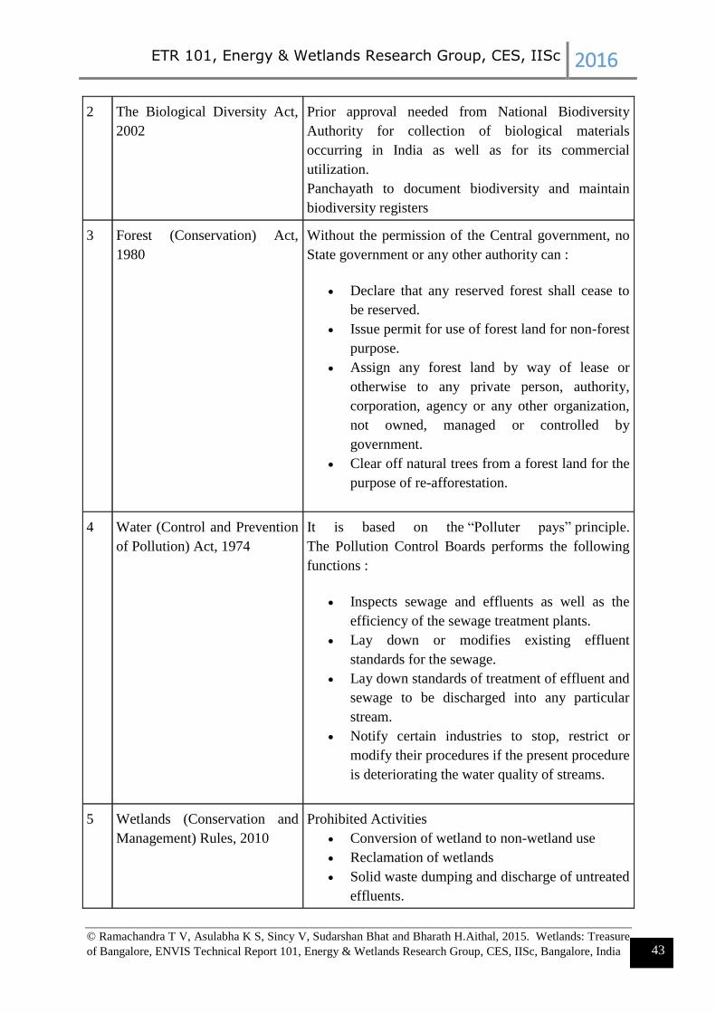
ETR 101, Energy & Wetlands Research Group, CES, IISc 2016
© Ramachandra T V, Asulabha K S, Sincy V, Sudarshan Bhat and Bharath H.Aithal, 2015. Wetlands: Treasure
of Bangalore, ENVIS Technical Report 101, Energy & Wetlands Research Group, CES, IISc, Bangalore, India 43
2 The Biological Diversity Act,
2002
Prior approval needed from National Biodiversity
Authority for collection of biological materials
occurring in India as well as for its commercial
utilization.
Panchayath to document biodiversity and maintain
biodiversity registers
3 Forest (Conservation) Act,
1980
Without the permission of the Central government, no
State government or any other authority can :
Declare that any reserved forest shall cease to
be reserved.
Issue permit for use of forest land for non-forest
purpose.
Assign any forest land by way of lease or
otherwise to any private person, authority,
corporation, agency or any other organization,
not owned, managed or controlled by
government.
Clear off natural trees from a forest land for the
purpose of re-afforestation.
4 Water (Control and Prevention
of Pollution) Act, 1974
It is based on the “Polluter pays” principle.
The Pollution Control Boards performs the following
functions :
Inspects sewage and effluents as well as the
efficiency of the sewage treatment plants.
Lay down or modifies existing effluent
standards for the sewage.
Lay down standards of treatment of effluent and
sewage to be discharged into any particular
stream.
Notify certain industries to stop, restrict or
modify their procedures if the present procedure
is deteriorating the water quality of streams.
5 Wetlands (Conservation and
Management) Rules, 2010
Prohibited Activities
Conversion of wetland to non-wetland use
Reclamation of wetlands
Solid waste dumping and discharge of untreated
effluents.

ETR 101, Energy & Wetlands Research Group, CES, IISc 2016
© Ramachandra T V, Asulabha K S, Sincy V, Sudarshan Bhat and Bharath H.Aithal, 2015. Wetlands: Treasure
of Bangalore, ENVIS Technical Report 101, Energy & Wetlands Research Group, CES, IISc, Bangalore, India 44
Regulated activities
Withdrawal of water, diversion or interruption
of sources
Treated effluent discharges –
industrial/domestic/agro-chemical.
Plying of motorized boats
Dredging
Constructions of permanent nature within 50 m
Activity which interferes with the normal run-
off and related ecological processes – up to 200
m
6 National Environment Policy,
2006
The principal objectives of NEP includes :
Protection and conservation of critical
ecological systems and resources, and
invaluable natural and man made heritage.
Ensuring judicious use of environmental
resources to meet the needs and aspirations of
the present and future generations.
It emphasizes the “Polluter Pays” principle,
which states the polluter should, in principle,
bear the cost of pollution, with due regard to the
public interest.
8 The Environment (Protection)
Act, 1986
Lays down standards for the quality of environment in
its various aspects.
Laying down standards for discharge of environmental
pollutants from various sources and no persons shall
discharge any pollutant in excess of such standards.
Restrictions of areas in which industries, operations or
processes shall not be carried out or carried out subject
to certain safeguards.
9 National Water Policy, 2002 Water is a scarce and precious national resource and
requires to be conserved and management.
Watershed management through extensive soil
conservation, catchment-area treatment, preservation of
forests and increasing the forest cover and the
construction of check-dams should be promoted.
The water resources should be conserved by retention
practices such as rain water harvesting and prevention
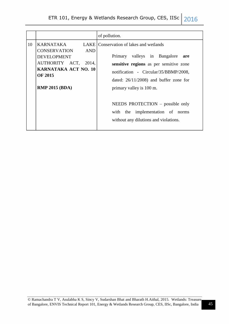
ETR 101, Energy & Wetlands Research Group, CES, IISc 2016
© Ramachandra T V, Asulabha K S, Sincy V, Sudarshan Bhat and Bharath H.Aithal, 2015. Wetlands: Treasure
of Bangalore, ENVIS Technical Report 101, Energy & Wetlands Research Group, CES, IISc, Bangalore, India 45
of pollution.
10 KARNATAKA LAKE
CONSERVATION AND
DEVELOPMENT
AUTHORITY ACT, 2014,
KARNATAKA ACT NO. 10
OF 2015
RMP 2015 (BDA)
Conservation of lakes and wetlands
Primary valleys in Bangalore are
sensitive regions as per sensitive zone
notification - Circular/35/BBMP/2008,
dated: 26/11/2008) and buffer zone for
primary valley is 100 m.
NEEDS PROTECTION – possible only
with the implementation of norms
without any dilutions and violations.