^esjssrch central 1 u> agricultural ) j hp >»— ' hz?
TRANSCRIPT

Society
HOpiiut institute a t' AgricuJtureiesjSSrch Central 1
LJ 8R A s vHp >»—u> Agricultural ) Research Central J
LIBRARY
'■Hz? <rc9*c Otvt*?.*a,'i'
Proceedings of a W orkshop
Organized by
Biological Society of Ethiopia
February 12-13, 2003
Faculty of Science, Addis Ababa University
Edited bySeyoum Mengistou, Abebe Getahun
and Ensermu Kelbessa

W etlands and Aquatic Resources of
Ethiopia: Status, C hallenges and
Prospects
Proceedings of a W orkshop
Organized by
Biological Society of Ethiopia
February 12-13, 2003
Faculty of Science,Addis Ababa University
Edited bySeyoum Mengistou, Abebe Getahun
and Ensermu Kelbessa

\N e tland s and A quatic R esources o f E th iopia: S tum s, C hallenges and P rospects Feb. 2003, A ddis A baba
P U B L IS H E R
B io log ica l S ociety o f E th iop ia PO B ox 31819
A d d is A b ab a, E th iop ia T el. 573422 Fax 552350
E -m ail: bseejbsfg vah oo .com
© B io log ica l S ociety o f E th iop ia , 2004
E dited by:S eyou m M en gistou (P hD ) and A bebe G etah u n (P hD )
and E n sern iu K elb essa (P hD )
A ssista n t E d itors and L ayou t D esigners: A b eb e A m eha and N egusu A klilu
ii
W etland s and A quatic R esources o f E th iopia: S ta tu s, C hallenges and P rospects Feb. 2003, A ddis A baba
TABLE OF CONTENTS
PageTable of contents iii
^ Welcoming address ivKeynote address vi
®“The current status of Lake Ziway fishery, Yared Tigabu 1-10^ A Review on impact of some development activities on the
aquatic environment and potential providential solutions for resource base development and management, Getinet G. Tsadik 11-16
^Priorities for wetland biodiversity conservation and watermanagement in Africa, Anada Tiega 17-25
■^Aquatic habitats and biodiversity changes of twoEthiopian lakes, Brook Lemma 27-31
•^Wetlands: Policy issues in Ethiopia, Mesfin Bayouand Getachew Tesfaye 33-40
^Biodiversity assessment in Foggera wetland, NortheasternEthiopia, Getachew Tesfaye and Kagnew Hailesellasse 41-53
®"A floristic analysis and ethnobotanical investigation of the Awash riverine vegetation, Mitiku Tiksa, Tamrat Bekeleand Ensermu Kelbessa 55-72
^ T h e herbaceous vegetation of Kitto-Koffe Wetland,Yosepli Assefa and Melaku Wondafrash 73-84
®°The Ramsar Convention and Ethiopia: Status and challenges,Ababu Anage 85-98
^ Annex (Conference Timetable) 99-101
Acknowledgement
The Biological Society of Ethiopia would like to extend its sincere appreciation to the DGIS-WWF Forest Conservation in High Priority Areas Project (EWCO), the Research and Publications Office (Addis Ababa University), the Ethiopian Agricultural Research Organization (EARO) and the Ethiopian Science and Technology Commission for their financial assistance towards the Workshop.
iii

W etland s and A qua tic R esources o f E th iop ia: S ta tu s, C hallenges and P rospects Feb. 2003, A ddis A baba
W E L C O M IN G A D D R E S S
Bv Dr Ensermu Kelbessa, President, Biological Society o f Ethiopia
Your Excellencies Dr Tewolde Berhan G/Egziabher. G/Manager o f the
Environmental Protection Authority, and Mr. Anada Tiega, Regional Coordinator
for Africa o f the Bureau o f the Ramsur Convention.
Distinguished guests.
Dear members o f the Biological Society o f Ethiopia,
Ladies and gentlemen.
The Biological Society o f Ethiopia is a professional society o f biologists having about 500 members to date. One o f the objectives o f our Society is to create awareness on development issues in the formal and informal education sectors and amongst the general public. Therefore w'e believe that it is imperative for a professional society o f our kind to contribute its share in the national endeavor towards attaining food security and sustainable use o f natural resources.
Therefore, the main theme o f this year's (XIIIth) Annual Conference is ‘Wetlands and Aquatic Resources o f Ethiopia: Status. Challenges and Prospects'.The major aims o f the Conference are
• To raise the level o f awareness among the public in general and the Workshop participant institutions in particular about the current status o f Ethiopia's wetlands and aquaiic resources:
• To assess the economic importance o f wetlands and recommend ways o f promoting tourist attraction;
• To assess the problems o f wetlands and aquatic resources associated with institutional arrangement and eventually suggest some corrective measures;
• To create a forum about the roles played by communities, questions of ownership and use right in the management o f wetlands and aquatic resources;
• To review the national policies and legislations pertinent to the management o f wetlands and aquatic resources and discuss about the problems associated with their implementation;
• To compile all relevant information on wetlands and aquatic resources o f Ethiopia for future use;
• To exchange available information on wetlands and aquatic resources o f Ethiopia;
• To suggest directions for new research and conservation programmes; and• To produce a document that would contribute a great deal towards future
endeavors o f wetland consen ation, development and management.
iv

Wetland s and Aquatic Resources of Ethiopia: Status, Challenges and Prospects Feb. 2003, Addis Ababa
| During this two-day Conference, more than 40 papers will be presented on wetlandi issues and other biological disciplines. Some o f the topics to be dealt with during! the Workshop include:! • The wetlands o f Ethiopia: an overview' • Policy issues pertaining to wetlands in the country! • The RAMSAR Convention: Ethiopia's status and challenges
• Pollution o f wetlands and other water bodies• Biological diversity in the Ethiopian wetlands: case studies• Unwise practices in the utilization o f wetlands and their consequences• Principal problems o f wetlands
Over 300 participants including BSE members, as well as invited guests from i various governmental and non-governmental organizations are expected to attend
this Conference.
Finally, I would like to extend my sincere appreciation and gratitude to our collaborators in this Workshop: the Department o f Biology (Addis Ababa University), the Ethiopian W ildlife Conservation Organization, the Ethiopian Environmental Protection Authority, the Ethiopian Science and Technology Commission, Ethiopian Agricultural Research Organization, and Institute for Biodiversity Conservation and Research. Our heartfelt thanks also go to Dashen Brewery for its material contribution towards the social evening o f the Workshop. My thanks should also go to Dr Tewolde Berhan G/Egziabher, G/Manager o f the Ethiopian Environmental Protection Authority for his positive attitude and prompt response to our request regardless o f apparent time constraints.
] bid all o f you welcome on behalf o f the Biological Society o f Ethiopia and the Organizing Committee o f this Workshop and now call upon Dr Tewolde Berhan G/Egziabher, a long-standing founding member o f our society and G/Manager o f the Ethiopian Environmental Protection Authority, to give us a keynote address.
Thank you.

T H E C U R R E N T S T A T U S O F L A K E Z IW A Y F IS H E R Y
Yared T igabu1
INTRODUCTION
To trace the history o f the fishery o f Lake Ziway is difficult because only little is documented in the literature. Elder people say that the islanders always fished using cast nets and hook and lines. Like other island populations in Ethiopia they used an indigenous boat type locally called bofofe. The boat can carry two persons or one person plus his light fishing gear and catch. The limited resource o f arable land on the islands made cattle rearing and farming nearly impossible. The use o f fish resources as a source protein was the only possibility for the islanders. According to Huttnagel report o f 1961 (LFDP, 1993), the fishermen o f Lake Ziway used gill nets and he recommended that they should adopt the beach seining technique practiced in Lake Awassa. He reported that licensed merchants came from Addis Ababa to Lake Ziway to buy fish especially during lent (fasting season).
During the EEC~Fisheries Development Project-phase I (1981-83) 1000 gill net o f 100 nun mesh size and 39 beach seines o f 80 mm mesh size were imported and distributed within the following years. Under the previous Socialist Government the fishermen cooperatives were formed and only members o f a cooperative had the legal right to fish with nets. For personal consumption people living around the lake were allowed to fish up to 5 kg per head with hook and line. The minimum allowed mesh size for gill nets was 100 mm (stretched) and 80 mm for beach seines (in the wings and the cod end). During the 80's more and more fishermen did not follow this rule. The mesh sizes and fishes caught became smaller and smaller. The local fishery officers and the government sensed the danger that the use o f small meshes beach seines endangered the fish stock. In 1984 an agreement was reached between the local administration and the fishermen cooperatives to increase the mesh sizes again to the recommended level. But in 1985 the situation went out o f control, The national administration instructed confiscation o f all beach seines used in the lake. The resistance o f fishermen against this radical measure led finally to the decision o f the party to close the lake completely, until 1987.
Following the closure period, the catch increased significantly as reported by the fishermen. Until the change o f government in 1991 only cooperatively organized fishermen were allowed fishing in the lake. These cooperatives still exist nowadays. Since 1992 many people have started fishing with out being members o f
1 National Fisheries and Other Living Aquatic Resources Research Center. EARO. PO Box 64, Sebeta: T e i . 38 00 23; Fax 380657.

Proceedings of a National W o rk sh o p (BSE. F e b r u a n 2003)
cooperatives. Due to lack o f effective control over the access to the lake and fishing methods, the mesh sizes o f the gears have been decreased and the size o f fishes caught have become smaller from year to year over the last eight years.
Any economic activity requires assessment it it has to be properly managed. Fish can not normally be seen until they are actually caught. Indirect methods are used to find out about the stocks. This makes fish stock assessment so different from other activities and it requires specific data collection system and materials. Organized system for the collection and analysis o f catch-effort and length- frequency data was started under the impulse o f the Lake Fisheries Development Project (LFDP) phase II in 1994.
From the data it is possible to make preliminary management recommendations but there is clearl} a need to continue with data collection and exploratory fishery programs in order to further refine the estimates made and ensure that they keep up w ith the changing biological, economical and social conditions. Managing fisheries means to a large extent managing the commercial fisheries. This monitoring allows introducing corrective measures to limit the total effort before the fishery declines too much.
Maximum sustainable yield (MSY) is probably the most widely used concept to define optimal level. This is because social and political considerations are difficult to translate in terms o f biomass o f fishing effort and its objectivity and relative simplicity. It is the highest y ield (in terms o f biomass or weight) that may be taken from a fishers w ith out endangering its continuation. Catch effort data are needed to make predictions about the possible impact o f management decisions.
THE STUDY AREA
Lake Ziway is the most northerly rift valley lake. It is located between 7"5I'N to 8"07rN and 38' 43'E to 38°57'E. Lake Ziway has an open water area o f 434 km2 and is the third biggest o f the rift valley lakes (after Abaya and Chamo). It has a maximum length o f 32 km and a maximum w idth o f 18 km. It is a shallow lake having a mean depth o f 2.5 m and maximum depth o f 7 m (Van den Bosche and Bernacsek. 1991). The lake is fed by two major rivers, i.e. ketar and Meki Rivers, and has one out flow in the south, the Bulbula River which flow in to Lake Abiyata.I -)
Two big and three small islands are located in Lake Ziway. Tulu Gudo (4.8 km'),Tsedecha (2.1 km2), Funduro (0.3 km"). Debresina (0.3 km2) and Gelila (0.2 km2).Debresina and Gelila have onl\ a few inhabitants, the other three are inhabited bvseveral hundreds o f people.
M ATERIALS AND METHODS
The catch effort data were recorded from 23 landing sites o f the lake between February 2000 and January 2001. Data collection was done by the fisheries staff o f
T he C u r r e n t S ta tu s of L ake Z iw ay Fishery Y ared Tigabu
the woreda in which the landing sites are situated, and by staff members o f Ziway Fisheries Research Center. During sampling days the following data were recorded for each landing:
• The total landing by species in kg
® The number and type o f gears used for fishing
® The number o f setting (in case o f beach seines)
These data allow the estimation o f Catch per Unit Effort (CPUE) by species in terms o f kg per unit effort. The units o f effort are one beach seine setting, one gill net set for one day, one hook set for one day (in case o f long line) and one hook used for one trip (Hook and line). The sampling days were distributed in a systematic way over the whole month. The data collection calendar was fixed and was not altered by the data collector. The number o f gears in a community was monitored by the data collector responsible for it. Total effort per gear type was estimated based on the number o f gears (gill net, hooks) and settings (beach seine) times the number o f days the gear was deployed in the month. The number o f gears and settings were obtained through interviews with the fishermen.
RESULTS AND DISCUSSION
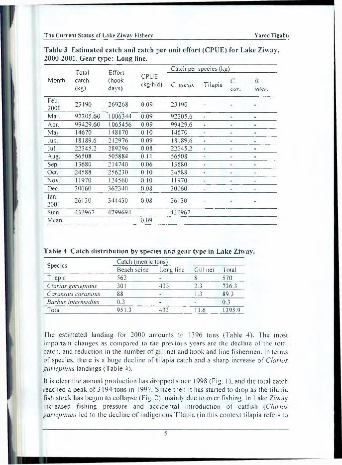
The mean CPUE for beach seine is 16 kg/setting (Table 1) this result is almost by half lower than that o f 30 kg/setting, which was reported by FDP (1993). CPUE for gill net dropped to 1.3 kg/net/day from 3 kg/net/day (Table 2). The changes in CPUE proportionally reflect changes in the abundance o f fish in the stock. The increment in CPUE for beach seine (Table 1) from September 2000 to January 2001 is due to increase in the fishing power o f the net. The standard length o f beach seine is 150 to 200 m long, but some fishermen have increased the size o f the net up to 800 m. As a consequence, the CPUE rose without changing the effort, by making the gear more destructive to the spawning ground o f tilapia species. Long line was introduced very recently and it has a CPUE around 0.09 kg/hook/day (Table 3). Beach seine contributed the bulk o f the catch, about 68% (951.3 tons) o f the total catch (Table 4).
The wings o f beach seines have a stretched mesh size o f 60 mm, and a height o f 3 m. The cod end is 5 m Long and has an average stretched mesh size o f 40 mm. The net is produced locally from white nylon twine (210/15 and 210/12-twine size).
Long lines are the second most important types o f gear and contributed 31% (433 tons) o f the total catch (Table 4). Each long line on the average contains 200 hooks. Before the introduction o f long line, gill net was the second most important fishing gear in Lake Ziway. Nowadays the number o f gill net fishermen has dropped due to the poor catching efficiency o f the net (CPUE around 1.3 kg/net/day). Gill net contributed less than 2% (11.2 tons) o f the total catch (Table 4).

Proceedings o f a N ationa l W orkshop (BSE, F e b ru a ry 2003)
Table 1 Estimated catch and catch per unit effort (CPUE) for Lake Ziway, 2000-2001. Gear type: Beach seine.
Total CPUE(kg/set)
Effort(setting)
Catch per species (kg)Month catch
(kg)Tilapia Clarias
gariepinusCarassiuscarassius
Barbus inter me dius
Feb.2000 55173.6 8.20 6732 40152 11331.6 3690 -
Mar. 107694 8.40 12822 79647.6 16788 11258.4 -
Apr. 136245.6 10.03 13590 92736 28641.6 14868 -
May 50993 16.34 3120 25812 21132 4050 -
Jun. 54643.2 13.14 4158 23265.6 27957.6 3420 -
Jul. 53506.8 15.50 3438 21639.6 25120.8 6746.4 -
Aug. 59161.2 15.50 3816 30060 20760 8079.6 261.6Sep. 82692 25.10 3294 47304 27054 8334 -
Oct. 100119.6 27.54 3636 48414 46935.6 4770 -
Nov. 96705.6 24.53 3942 59022 30816 6867.6 -
Dec. 84096 22.68 3708 48896 25956 8244 -
Jan.2001 70884 19.21 3690 44856 18504 7524 -
Sum 951915 65946 561805 300998 87852 262Mean 16
Table 2 Estimated catch and catch per unit effort (CPUE) for Lake Ziway, 2000-2001. Gear type: Gill net.
Totalcatch(kg)
Effort(netdays)
Catch per species (kg)
Month CPUE(kg/n/d) Tilapia Clarias
garipinusCarassiuuscarassius
Barbusintermedius
Feb.2000
1242 1692 0.73 1026 216 - -
Mar. 4599.6 2682 1.71 2628 1215.6 756Apr. 3582 2844 1.26 2700 486 396May 144 * 72 2.00 72 - 72Jun. - - - - - -
Jpl. - - - - - -
Aug. - - - - - -
Sep. - - - - - -Oct. 414 522 0.79 378 36 -Nov. 414 288 1.44 351.6 54 8.4Dec. 909.6 540 1.68 540 324 45.6Jan.2001
144 144 1.00 144 - -
Sum 11449 8784 7840 2332 1279 -
Mean 1.3
The C u r r e n t S ta tus of L ake Z iw ay Fishery Y ared T igabu
Table 3 Estimated catch and catch per unit effort (CPUE) for Lake Ziway, 2000-2001. G ear type: Long line.
Totalcatch(kg)
Effort(hookdays)
Catch per species (kg)
Month CPUE(kg/h/d) C. garip. Tilapia car.
B.inter.
Feb.2000 23190 269268 0.09 23190 - -
Mar. 92205.60 1006344 0.09 92205.6 - -
Apr. 99429.60 1065456 0.09 99429.6 - -
May 14670 148170 0.10 14670 - -
Jun. 18189.6 212976 0.09 18189.6 - -
Jul. 22345.2 289296 0.08 22345.2 - -
Aug. 56508 505884 0.11 56508 - -
Sep. 13680 214740 0.06 13680 - -
Oct. 24588 256230 0.10 24588 - -
Nov. I 1970 124560 0.10 1 1970 - -
Dec. 30060 362340 0.08 30060 - -
Jan.2001 26130 344430 0.08 26130 - -
Sum 432967 4799694 432967Mean 0.09
Table 4 Catch distribution by species and gear type in Lake Ziway
Species Catch (metric tons)Beach seine Lonsi line Gill net Total
Tilapia 562 - 8 570C/arias gariepinus 301 433 2.3 736.3C arassius car ass ins 88 - 1.3 89.3Barbus intermedins 0.3 - - 0.3Total 951.3 433 11.6 1395.9
The estimated landing for 2000 amounts to 1396 tons (Table 4). The most important changes as compared to the previous years are the decline o f the total catch, and reduction in the number o f gill net and hook and line fishermen. In terms of species, there is a huge decline o f tilapia catch and a sharp increase o f C/arias gariepinus landings (Table 4).
It is clear the annual production has dropped since 1998 (Fig. 1). and the total catch reached a peak o f 3194 tons in 1997. Since then it has started to drop as the tilapia fish stock has begun to collapse (Fig. 2). mainly due to over fishing. In Lake Ziway increased fishing pressure and accidental introduction o f catfish (C/arias gariepinus) led to the decline o f indigenous Tilapia (in this context tilapia refers to

Proceedings of a National W o rk sh o p (BSE, F e b ru a ry 2003)
Oreochromis niloticus and Tilapia zilli) species. It is to be noted that catfish (C. gariepinus) after its introduction in the lake, has successfully colonized all parts o f the lake territory.
3500
1988 1989 1990 1991 1992 1993 1994 1995 1996 1997 1998 1999 2000
Year
Fig. 1 Total estimated production (in metric tons) in Lake Ziway, 1988-2000.
3000
2500
c£ 2000
a 100(1w
5(H)
0
2820
1944 19551721
838
1
571
■1995 1996 1997 1998 1999 2000
Y ear
Fig. 2 Catch data for tilapia (in metric tons) from Lake Ziway, 1995-2000.
The other cause for the decrease could be environmental changes. There is a significant change in the water level. A lowering o f the level was noticed since1995, the fall in the level has been blamed on pumping farm irrigation which might need reviewing the water management aspect. The irrigation development results in the destruction o f macrophyte vegetation, which leads to the shortage o f suitable nursery grounds for tilapia juveniles. The macrophyte vegetation provides suitable nurseries and sufficient cover to tilapia juveniles (Welcomme. 1967: Billatd and Hatton, 1978). Fertilizers, pesticides and herbicides are used intensively on farms. Chemicals applied on farms are easily washed away b\ flood and enter the lake.
6

The C u r r e n t S ta tus o f L ak e Z iw ay F ishery Y ared Tigabu
The lake is close to the farm and the chance o f chemical contamination is high. As more vegetation belt areas are destroyed better condition were created for expansion o f beach seine fishery. The beach seines operate in shallow areas and destroys the spawning grounds o f tilapia. The number o f beach seine has increased from 39 in 1988 to 207 in 1996.
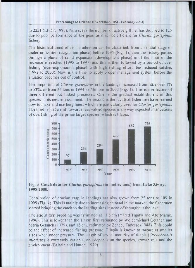
While the total catch started to decline since the peak o f 1997, the catch o f Clarias gariepinus is still increasing and since 2000 has exceeded that o f tilapia (Fig. 1). No one knows exactly when and who introduced Clarias gariepinus in the lake. In1994 woreda fishery staffs reported about the catch o f Clarias gariepinus in the commercial landings (LFDP, 1995). Since then, the production o f the Clarias gariepinus has been increasing from year to year. The total estimated landing in1995 was 2070 tons, o f this 1944 tons were Tilapia (94%). 168 tons catfish {Clarias gariepinus) (4.6%), 25 tons o f Crucian carp Carassius carasus and four tons o f Barbus (Barbus intermedius) (LFDP, 1996 a and b). The total estimated production for the year 2000 is 1396 tons. Out o f this Clarias gariepinus contributed 736 tons (53%) from the total catch. There are signs o f over fishing of tilapia species, the catch dropped from 2820 tons in 1997 to 570 tons in 2000 (Table 5). The management o f fisheries o f the lake is urgent if the tilapine resources are not to be depleted.
Table 5 Total fish production and species composition (in metric tons) in Lake Ziway, 1995-2000.
Year Totalproduction Tilapia Clarias
gariepinusCarassiuscarassius
Barbusintermedius
1995 2070 1944 97 25 41996 2234 1955 234 45 0.41997 3194 2820 294 81 0.41998 2296 1721 479 95 0.61999 1629 838 682 109 0.62000 1397 571 736 89 0.5
A combination o f factors has helped to accelerate the depletion o f tilapia resources. The main factors are the continued investments in fishing gears throughout the lake, which leads to overall increase in fishing effort and the exceptionally poor management o f the aquatic resources.
In practice, access to the fishery is open to any one who wants to fish. Membership to a recognized fishermen’s cooperative is thought to be equivalent to a fishing license but this lacks any legal basis. There was no control either on the quantity or on the type o f fishing gear. As long as the fishery was underdeveloped, management o f the resources did not seem a great priority. This situation has changed already. Fishermen have proved that provided the right incentives are in place, they can increase their effort rapidly. After credit was given to fishermen in1996, the number o f beach seine increased from 108 to 207 and gill net from 1148
Proceed ings o f a National W o rk sh o p (BSE, F e b ru a ry 2003)
to 2251 (LFDP, 1997). Nowadays ihe number o f active gill net has dropped to 125 due to poor performance o f the gear, as it is not efficient for Clarias gariepinus fishery.
The historical trend o f fish production can be classified, from an initial stage of under utilization (stagnation phase) before 1995 (Fig. 1), then the fishery passes through a phase o f rapid expansion (development phase) until the limit o f the resource is reached (1995 to 1997) and this is then followed by a period o f over fishing (over-exploitation phase) with high fishing effort, but reduced catches (1998 to 2000). Now is the time 10 apply proper management system before the situation becomes out o f control.
The proportion o f Clarias gariepitius in the landings increased from little over 1% to 53%, or from 26 tons in 1994 to 736 tons in 2000 (Fig. 3). This is a reflection o f three different but linked processes. One is the gradual establishment o f this species in its new environment. The second is the fact that fishermen have learned how to make and use long lines, which are particularly used for Clarias gariepinus. The third is that a shift towards less valued species is anyway expected in situations o f overfishing o f the prime target species, which is tilapia.
682 736
479
97
A
294
I B1995 1996 1997 1998 1999 2000
Year
Fig. 3 Catch data for Clarias gariepinus (in metric tons) from Lake Ziway, 1995-2000.
Contribution o f crucian carp in landings has also grown from 25 tons to 109 in 1999 (Fig. 4). This is mainly due to increasing demand in the market, the fishermen started bringing the catch to the landing sites instead o f throughout the lake.
The size at first breeding was estimated at 1 3.8 cm (Yared Tigabu and Abe Mamo, 1996). This is lower than the 19 cm first estimated by Woldemichael Getaneh and Maria Getaneh (1979), and 18 cm. estimated by Zenebe Tadesse (1988). This could be the effect o f increased fishing pressure. Tilapia is known to mature at smaller sizes when under pressure. The length o f sexual maturity o f tilapia (Oreochromis niloticus) is extremely variable, and depends on the species, growth rate and the environment (Balarin and Hatton. 1979).

T he C u r r e n t S ta tus of L ak e Z iw ay Fishery Y ared Tigabu
120 t 109
89
1995 1996 1997 1998 1999 2000Year
Fig. 4 Catch data for Carassius carassius (in metric tons) from Lake Ziway, 1995-2000.
If a species lives in an unpredictable or variable environment, where the chances o f survival are uncertain, evolution is likely to favor early maturity. In this case, spawning early in life, in the face of poor survival prospects, ensures the success of the species.
Generally, over fishing, environmental degradation and pollution have negatively affected the fisheries and aquatic resources o f Lake Ziway. Today, the situation has become so pressing that it can no longer be ignored. Administrative bodies and policy makers have to act urgently to stop the wrong course o f the lake fisheries.
ACKNOW LEDGEM ENTS
1 thank Dr. Zenebe Tadesse for his suggestions and comments on the manuscript. I am also grateful to Ato Abera Degebassa, Dawit Emiru, Demisse Mekuria and Tsegaye Daba, fishery experts who helped me on data collection.
REFERENCES
Balarin. J.D. and Hatton, J. (1979). Tilapia: A Guide to their Biology andCulture in Africa. University o f Stirling, Scotland, pp. 1-42.
Billard. R. and Hatton, J. (1978). Rhythms o f reproduction in teleost fish. In: Rhythmic activities o f fishes. Academic press, London, pp 31-53.
LFDP (1993). Fisheries Baseline Survey 1993. Lake Fisheries Development, Project.Working Paper Number 7. Ministry o f Agriculture, Addis Ababa, Ethiopia.
LFDP (1995). Fisheries Statistical Bulletin Num ber 1. Lake Fisheries Development Project. Working Paper Number 16. Ministry o f Agriculture, Addis Ababa, Ethiopia.
9
Proceedings o f a Nation.il W o rk sh o p (BSE, F e b ru a ry 2003)
LFDP (1996a). Fisheries Statistical Bulletin Number 3. Lake Fisheries Development, Project Working Paper Number 20. Ministry o f Agriculture, Addis Abebe. Ethiopia.
LFDP (1996b). Fisheries Statistical Bulletin Number 4. Lake Fisheries Development. Project Working Paper Number 22. Ministry o f Agriculture, Addis Ababa, Ethiopia.
LFDP (1997). Fisheries Statistical Bulletin Number 5. Lake Fisheries Development, Project. Working Paper Number 26. Ministry o f Agriculture, Addis Ababa, Ethiopia.
Van den Bosche. J.P. and Bernacsek (1991). Source Book for the Inland Fishery Resources o f Africa: C1FA Technical Paper No.318.3. FAO. Rome.2198
Welcomme, R.L (1967). Breeding season, fecundity and fertility in the mouth brooding cichlid fish Tilapia leucosticta. J. Zool. Lotid. 151: 453-468.
Woldemichael Getaneh and Maria Getaneh (1979). Breeding period and fecundity o f Tilapia ni/olica in Lake Ziway. Ethiop. J. Agri. Sci., 1: 13-21.
Yared Tigabu and Abe Mamo (1996). The Exploratory Fishery Programme in Lake Ziway. Proceedings o f the National Fisheries Seminar. Ziway, November 1996. Lake Fisheries Development Project. Working Paper Number 21. Ministry o f Agriculture, Addis Ababa. Ethiopia.
Zenebe Tadesse (1988). Studies on Some Aspects o f the Biology o f Oreochrom is N iloticus L. (Pisces: Cichlidae) in Lake Ziway, Ethiopia. Unpublished. M.Sc Thesis. School o f Graduate Studies, Addis Ababa University. 78 pp.
A R E V IE W O N IM P A C T O F S O M E D E V E L O P M E N T A C T IV IT IE S O N T H E A Q U A T IC E N V IR O N M E N T A N D P O T E N T IA L P R O V ID E N T IA L S O L U T IO N S F O R R E S O U R C E B A SE
D E V E L O P M E N T A N D M A N A G A M E N T
Getinet G. T sadik1
INTRODUCTION
Ethiopia’s aquatic resources with regard to water resources include lakes, rivers, reservoirs, small water bodies, proposed impoundment and aquaculture potentials. Aubray (1975) reported that 173000 km2 (14%) o f Ethiopia consists o f swamp (4%), lakes (1%), rivers and flood plains (9%). This is much higher than the wetland (0.7%) and water body (0.5%) areas given in Balarin (1986).
The total lake area in Ethiopia was estimated as 750000 ha by Aubray (1975) but from GiudicelIi (1984) and other statistical data it appears that this area may be as much as 880 000 ha, representing an excess o f 88 billion cubic meters storage capacity. Lake Tana alone comprises 52% o f the total surface area or 33% o f the total volume. The seven natural lakes o f the Rift Valley cover 40% of the lake area. Koka, Fincha and Melka Wakana reservoirs, account for 5%. In addition, there are numerous small, deep crater lakes. The lakes are generally high altitude type with a mean altitude o f 1750 m; the lowest ones, apart from lake Turkana, are the Abaya and Chamo lakes at about 1250 m altitude.
There are nine major rivers, totaling 6400 km and an annual discharge o f 63 billion cubic meters o f which the Blue Nile account for 80% (Aubray, 1975). There are six major drainage basins. The major systems are those o f the Nile in the northwest and the Indian Ocean systems o f Bale and Harar. There are several closed depressions and numerous lakes associated with the Rift Valley. The largest internal drainage system is the Awash River running northward to Lake Abbe. The Omo River drains southwards to Lake Turkana. Several o f the lakes have an interlinking river system.
The eastern streams and those in areas o f high rainfall tend to be short, intermittent and torrential. Others such as Abbai, Baro, Omo, Webi Sliebeli, Awash and rakazzi rivers are long and perennial. There is a great difference between
discharge in the wet season (July-September) and that o f the dry season. The Awash discharge for example ranged from 2 to 600 nr'/s but the construction o f the Koka dam maintains a steady flow- o f 43 nrVs. O f interest is the exceptionally high runoff shown by the Blue Nile, a characteristic o f the wetter region. The rivers are
1 Ethiopian Agricultural Research Organization, National Fisheries and Other LivingAquatic Resources Research Center, PO Box 1055, Addis Ababa. Ethiopia.
Proceedings of a National W o rk sh o p (BSE. F e b ru a ry 2003)
usual 1\ very deeply incised in their upper courses and their irrigation potential consequently impracticable without artificial control. There is however, considerable scope for the construction o f dams for the production o f hydroelectric power and therefore, also for water control, irrigation and fish production. None o f the rivers is navigable except for the lower Baro. In the northeast is the drying Chew Bahir swamp (Lake Stefanie) and the Danakil depression is characterized by swamp and salt lakes. notably the Aussa swamp, the salt lake Abbe and the Assale lagoon. Hot springs and mineral springs occur at several places within the Rift Valley but no documentation is available.
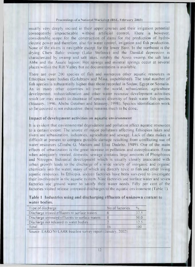
There are over 200 species of fish and numerous other aquatic resources in Ethiopian water bodies (Golubtso\ and Mina, unpublished). The total number of fish species is substantial!) higher than those recorded in Sudan: Egypt or Somalia. As in main other countries all over the world, urbanization, agriculture development, industrialization and other water resource development activities result (or may result) in decrease o f species diversity o f fresh water fish species (Stiassny. 1996: Abebe Getahun arid Stiassny. 1998). Species identification work so far covered is not exhaustive: there remains much to be done.
Impact o f development activities on aquatic environment
It is evident that environmental degradation and pollution affect aquatic resources to a certain extent. The source o f major pollutants affecting Ethiopian lakes and rivers are urbanization, industries, agriculture and sewage. Lack o f data makes it difficult at present to compare possible damage resulting from conflicting use o f water resources (Zinabu G. Mariam and Elias Dadebo. 1989). One o f the main effects o f urbanization is the greai increase in pollution and eutrophication. Even when adequate!) treated, domestic sewage contains large amounts o f Phosphorus and Nitrogen. Industrial development which is usually closely associated with urban growth leads to the discharge o f a wide variety o f inorganic and organic chemicals into the water, mam o f w hich are directly toxic to fish and other living aquatic resources. In Ethiopia, sixteen factories have been surveyed to investigate their involvement in the aquatic system. Nine factories use surface water and seven factories use ground water to satisfy their water needs. Fifty per cent o f the factories \isited release untreated discharges to the aquatic environment (Table 1).
Table 1 Industries using and discharging effluents of unknown content to water bodies.Type of discharge No of factories %Discharae treated effluents to surface waters 6 37.5Discharge untreated effluents to surface waters 8 50.0Discharge not released to water bodies 2 12.5Total 16 100Source: EARONFLARR baseline survey report (January. 2002)

A Review on Im pact o f Some Development Activities . Getine t G .T sad ik
Mineral extraction from Lake Abijata could affect the aquatic stock in some way. It is also claimed that effluents from the tannery at Koka reservoir and the textile industries in Awassa and Arba Minch have affected the concerned ecosystems but once more, in the absence o f a data collection system, with the exception o f the textile industry in Awassa. it is difficult to estimate any consequential economic loss for the aquatic industry.
The main reason for the aquatic degradation in the country is likely to be in close relation w ith the increasing degree o f deforestation which accelerates the drying up o f w ater bodies and increases the turbidity o f w aters. In addition, the fall o f organic matter such as leaves, bark, branches or insects from vegetation over hanging water courses provide an essential source o f allochthonous food (Blackburn and Peter. 1979). Clearing o f forests, high densities o f animals and other reductions in the vegetation o f catchment areas increase silt and nutrient load o f aquatic ecosystems (Platts, 1978: Zinabu G.Mariam, 1989). Processes associated with mining disturb the aquatic ecosystem in a number o f ways. The first and most serious o f these is siItation from material excavated during mining. This is frequently spread in dumps, from which particles are dislodged and washed into rivers, and may also be discharged directly into the aquatic system. Heavy silt loads and disturbed flow patterns also arise where large amounts o f water are abstracted from the rivers for washing ores and extraction o f heavy metals after which they are returned heavily loaded with tailings.
Multipurpose dam projects can also have adverse economic consequences on the aquatic ecosystem due to control and regulation o f tlow. Such activities as power generation, irrigation, domestic water supply, navigation or flood control all use dams, levees or channels w hich alter the morphology o f the river system and hence the abundance and composition o f the aquatic biodiversity.
Indeed it has been suggested in Kenya that dam construction on River Omo has adversely affected the anadromous fish which migrate from Lake Turkana to spawn in the river (FAO. 1993). Furthermore. Valley dwellers displaced to uplands increase population and farming pressure on marginal and steep sloping land, increasing soil erosion together with silt and chemical pollution o f streams. Sediment is eventually deposited in the reservoir, reducing storage capacity and causing turbidity, w hich with the chemicals adversely affects aquatic life.
Within the development plans there are many opportunities for water resource schemes related to potential hydropower and irrigation development and flood control. Irrigation projects have indirect impacts that should be considered when planning irrigation schemes. Agricultural development associated with the irrigation schemes is frequently a major source o f pollution. The runoff of fertilizers and pesticides used in intensive agriculture can severely upset the trophic balance of the waters downstream. If eutrophication occurs, the ecological communities will change downstream and many of the important aquatic species may be lost. Similarly, the run off o f pesticides into the watercourses can affect
Proceed ings o f a National W ork sh o p (BSE, F e b ru a ry 2003)
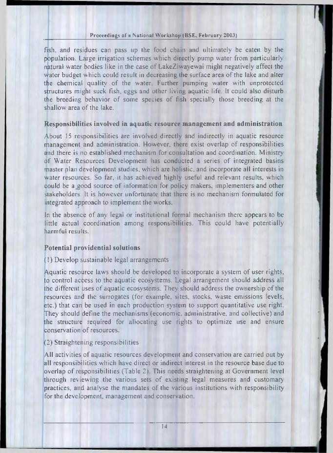
fish, and residues can pass up the food chain and ultimately be eaten by the population. Large irrigation schemes which directly pump water from particularly natural water bodies like in the case o f LakeZiwayewai might negatively affect the water budget which could result in decreasing the surface area o f the lake and alter the chemical quality o f the water Further pumping water with unprotected structures might suck fish, eggs and other living aquatic life. It could also disturb the breeding behavior o f some species o f fish specially those breeding at the shallow area o f the lake.
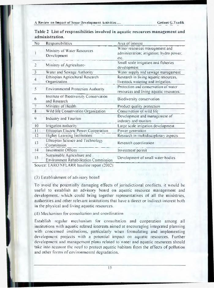
Responsibilities involved in aquatic resource management and administration
About 15 responsibilities are involved directly and indirectly in aquatic resource management and administration. However, there exist overlap o f responsibilities and there is 110 established mechanism for consultation and coordination. Ministry o f Water Resources Development has conducted a series o f integrated basins master plan development studies, which are holistic, and incorporate all interests in water resources. So far. it has achieved highly useful and relevant results, which could be a .good source o f information for policy makers, implementers and other stakeholders. It is however unfortunate that there is no mechanism formulated for integrated approach to implement the works.
In the absence o f any legal or institutional formal mechanism there appears to be little actual coordination among responsibilities. This could have potentially harmful results.
Potential providential solutions
(1) Develop sustainable legal arrangements
Aquatic resource laws should be dev eloped to incorporate a system of user rights, to control access to the aquatic ecosystems. Legal arrangement should address all the different uses o f aquatic ecosystems. They should address the ownership o f the resources and the surrogates (for example, sites, stocks, waste emissions levels, etc.) that can be used in each production system to support quantitative use right. They should define the mechanisms (economic, administrative, and collective) and the structure required for allocating use rights to optimize use and ensure conservation o f resources.
(2) Straightening responsibilities
All activities o f aquatic resources development and conservation are carried out by all responsibilities which have direct or indirect interest in the resource base due to overlap o f responsibilities (Table 2). This needs straightening at Government level through reviewing the various sets o f existing legal measures and customary practices, and analyse the mandates o f the various institutions with responsibility for the development, management and conservation.
14
A Review on Im pact of Some Development Activities . G etine t G .T sad ik
Table 2 List o f responsibilities involved in aquatic resources management and administration.No Responsibilities Area of interest
1 Ministry of Water Resources Development
Water resources management and administration: irrigation: hydro power; etc.
i Ministry of Agriculture- Small scale irrigation and fisheriesdevelopment
3 Water and Sewage Authority Water supply and sewage managementA Ethiopian Agricultural Research Research in living aquatic resources.
Organization livestock watering and irrigation.
5 Environmental Protection Authority Protection and conservation of water resources and living aquatic resources.
6 Institute of Biodiversity Conservation and Research Biodiversity conservation
7 Ministry of Health Product quality protection8 Wild life Conservation Organization Conservation of wild life
9 Industry and Tourism Development and management of industry and tourism
10 Irrigation authority Large scale irrigation development1 1 Ethiopian Electric Power Cooperation Power generation12 Higher Learning Institutions Research in multidisciplinary aspects
13 Ethiopian Science and Technology Commission Research coordination
14 Investment Offices Investment permit
15 Sustainable Agriculture and Environment Rehabilitation Commission Development of small water bodies
Source: EARO/NFLARR baseline report (2002)
(3) Establishment o f advisory board
To avoid the potentially damaging effects o f jurisdictional conflicts, it would be useful to establish an advisory board on aquatic resource management and development, which could bring together representatives o f all the ministries, authorities and other relevant institutions that have a direct or indirect interest both in the physical and living aquatic resources.
(4) Mechanism for consultation and coordination
Establish regular mechanism for consultation and cooperation among all institutions with aquatic related interests aimed at encouraging integrated planning with concerned institutions, particularly when formulating and implementing development projects with a potential impact on aquatic resources. Further development and management plans related to water and aquatic resources should take into account the need to protect aquatic habitats from the effects o f pollution and other forms of environmental degradation.
Proceed ings o f a National W o rk sh o p (BSE, F e b ru a ry 2003)
(5) Defining water quality standards
The proper management o f aquatic system demands that water o f suitable quality be provided for each use that is made or intended to be made o f it and that the attainment and maintenance o f such quality is normally to be sought through the control o f pollution. It is necessary, therefore, to define the standards o f quality required for each particular use, in order to determine the degree o f pollution control necessary and to forecast the probable effect o f augmented or new discharges o f effluents. Water quality standards for drinking water had been well defined by the World Health Organization (WHO) and standards for certain agricultural and industrial uses arc also well defined. However, water quality criteria for fish and other living aquatic resources have not received the attention that they deserve.
REFERENCES
Abebe Getahun and Stiassny. M.L.J. (1998). The fresh water biodiversity crisis: The case o f the Ethiopian fish fauna. SINET: Ethiop. J. Sci. 21:207-230.
Aubrey, R. (1975). The Fisheries of Ethiopia. An Economic Study. F.A.O.
Balarin, J.D. (1986). National Reviews for Aquaculture Developm ent in Africa.9 Ethiopia. FAO Fisheries Circular No.770.9.
Blackburn, W.M. and Peter. T. (1979). Forest litter decomposition and benthos in a mountain stream in Victoria, Australia. Arch. H ydrobiol., 86 (4):453-98.
EARO/NFLARR (2002). Current Status o f Fisheries and other Living Aquatic Resources Research and Development: Baseline Survey Report.
FAO (1993). Proceedings o f the National Sem inar on Fisheries Policy and Strategy. TCP/ETH/ 1357 (T) Rome, FAO.
Giudicelli, M. (1984). The Ethiopian Fisheries: Situation, Developm ent Needs and opportunities. Rome, FAO: 27 p.
Golubtsov. A.S. and Mina. M.V. (unpublished). Distribution o f Fish Species Diversity over the Main Drainage Systems o f Ethiopia: Current State o f K now ledge and Research Perspectives.
Platts, W.S. (1978). Livestock grazing and the aquatic environment. J. Soil Water C onserv ., 33: 274-8.
Stiassny. M.L.J. (1996). An over view of fresh water biodiversity; with some lessons from African fishes. Fisheries. 21 (9): 7-13.
Zinabu G.Mariam and Elias Dadebo (1989) Water Resource and Fisheries Management in the Ethopian Rift Valiev lakes. SIN E T : Ethiop. J. Biol. S c i., 12(2): 95-109.
P R IO R IT IE S FO R W E T L A N D B IO D IV E R S IT Y C O N S E R V A T IO N A N D W A T E R M A N A G E M E N T IN A F R IC A
Anada T iega1
INTRODUCTION
Successful wetland biodiversity conservation in Africa is being challenged by poor policies and a lack o f suitable legislative frameworks as a result o f insufficient political conviction or ‘will* to formalize wetland conservation. Commonly, dilemmas are faced when evaluating options that are either beneficial in the short term - but are derived from unsustainable practices - or accrue benefits only in the mid-long term -but sustain wealthy and productive wetland ecosystems. This paper examines some o f the issues around this dilemma. Particular attention is given to how African countries can mobilize existing knowledge and capacity so as to foster political conviction and activate decisions for wetland conservation and wise use.
There is growing awareness o f the importance o f wetlands and increasing recognition that wetlands are amongst the most economically valuable of ecosystems. Table I summarizes the economic importance o f wetlands and demonstrates that wetlands provide ecosystem services estimated to be worth at least $ 14.785/ha/vr. a substantially higher value than any other ecosystem. This, , however, relates to a narrower definition o f "wetland" than that o f the Ramsar Convention, and for wetlands under the Ramsar Convention the total value of wetlands ecosystem services is in excess o f USD 14.9 trillion per annum, some 45% of the global total (Ramsar Convention Bureau. 2000a).
However, despite this global importance o f wetlands, these ecosystems are still perceived as wastelands by decision-makers in many African countries. Some water users consider wetlands as competitors for water. At its Regional Pan- African Meeting o f 1998. Contracting Parties to the Ramsar Convention recognized that "in many cases, the greatest threat to wetlands is land use which does not take water conservation objectives into account, since the shortage o f lands makes wetlands a target for gaining land through drainage." The approach recommended under the Convention, to encourage the incorporation o f water resource management when dealing with wetland biodiversity conservation, is one potential solution to this problem. In this context, the conservation and wise use o f wetland biodiversity need to be addressed through the wider perspective o f the sustainable use and management o f both land and water resources.
'Ramsar Convention Bureau. Rue Mauverney 28. I 196 Gland. Switzerland. E-mail: [email protected]

Prior i t ie s for W etland Biodiversity C onse rva tion and W a te r M an a g em en t . . . A n ad a Tiega
Table 1 The econom ic value o f ecosystem services (Costanza et al., 1997).
Ecosystem Area(million ha)
Value US$ ha/yr
Global Value USD Trillions/vr
Open Ocean 33,200 252 8.4Coastal 3,102 4,052 12.6Tropical forest 1.900 2,007 3.8Other forests 2,955 302 0.9Grasslands 3,898 232 0.9Wetlands 330 14,785 4.9Lakes and Rivers 200 8,498 1.7Cropland 1.400 92 0.1Total annual worth of the services provided by the Biosphere
M A JO R ISSUES LINKED TO W ETLAND CONSERVATION IN AFRICA
The major challenge facing wetland conservation in Africa is how to identify and apply efficient incentives which serve to maintain and improve the livelihood o f local people dependent on wetland areas while safeguarding wetland functions, values and attributes (including biodiversity). In this regard, land use patterns and water management for economic development are important issues to be addressed.
To address this it is essential for policy-makers to know where their wetlands are, and what their importance is in terms o f values and functions, i.e., to have adequate national wetland inventory and assessment.
However, even w'here such information exists, a further barrier to achieving sustainable wetland use is that in many African countries there are numerous national institutions and interest groups dealing with land use and water issues at local, national and international levels. In addition, wetland issues are quite often considered as a sectoral matter under the responsibilities o f a single national institution. As a result, there is an urgent need to establish mechanisms to coordinate the work being carried out on wetland conservation and wise use at national and regional levels. The Ramsar Convention offers a framework for international co-operation and encourages the establishment o f National Ramsar (or wetland) Committees which should include representatives from other government sectors, NGOs and local communities.
A number o f ecological, socio-cultural, economic and political constraints need to be addressed through those coordinating mechanisms. In response to these constraints, Ramsar Convention and its Partners Organizations (BirdLife International, IUCN, Wetlands International and WWF), are being instrumental in urging African countries to work towards the conservation o f wetland ecosystems in the Africa region. This is directed to a focus on economic valuation o f wetlands; development o f incentives to foster public and decision makers’ awareness; training; environmental education and communication in order to raise the profile o f wetland issues among young people; water or wetland policies; legislation and
18

Proceedings of a Nationa l W o rk sh o p (BSE, F e b ru a ry 2003)
regulation; community empowerment; community capacity building - to promote an enabling environment; pollution control; initiatives related to climate change; invasive alien species control; threatened species conservation; and programmes on adaptive management o f ecosystems in response to a changing environment.
IDENTIFYING PRIORITIES FOR W ETLAND BIODIVERSITY CONSERVATION AND W ATER M ANAGEM ENT IN AFRICA
Identifying priorities for wetland conservation is a complex exercise since it involves a number o f interests ranging from local concerns to global goals. In addition, the decision about priorities can be made on different grounds: scientific, social and economic, or political grounds. African decision-makers are mainly politicians and as such they prefer to make decisions on political grounds. However, economic and social considerations can considerably influence political decisions. Therefore, to promote the conservation o f wetland biodiversity in Africa, we need to encourage actions which lead to a better understanding o f socioeconomic relationships between wetland resources and the various interests of stakeholders which in turn can be used to persuade politicians and incite them to take action for wetland conservation.
Hence it is important to identify and collaborate with interest groups which have direct dependency on wetlands such as fishermen for whom wetland biodiversity is the primary source of their income and food security. Empowering those interest groups can be an efficient move for promoting partnership between these stakeholders and political decision-makers. African political leaders are very receptive to any actions that can contribute to food security. As a result, identifying and implementing pertinent options, which combine food security and biodiversity conservation, are critical steps to be taken for wetland biodiversity conservation in Africa. In this respect, it is useful to recognize the rights o f local communities over the biodiversity that exists on wetlands they manage and use. and the rights over their traditional know ledge and practices. The value to local people o f sustainable use should be promoted through an appropriate combination o f the best traditional knowledge/practices and the latest technical and scientific understanding.
The promotion o f wise use concepts and practices is o f critical importance. A number o f actions have to be taken to create an enabling environment that is likely to support and encourage the efforts of different stakeholders, policy makers and decision-makers.
Consequently, wetland policy/strategy development and legislative review are essential tools to adopt in each country. At present. Uganda is the only African country, which has a National Wetland Policy in place along with a National Wetland program to implement it. However, it is encouraging to note that Ghana has recently developed and adopted a National Wetland Strategy and the following countries are drafting Wetland Policies: Benin. Botswana, Kenya. Namibia. South
19

Priori t ies for W etlan d Biodiversity C o n se rv a tio n and W ate r M an a g em en t . A n a d a Tiega
Africa and Zambia. It is worth noting that the following countries do not have a Wetland Policy: Algeria, Burkina Faso, Chad, Congo, Cote d'Ivoire, Democratic Republic o f Congo, Federal Republic o f Comoros, Guinea, Mali, Morocco, Niger, Senegal, Tunisia and Togo. However, wetland issues are also considered through Biodiversity Strategies and Action Plans in Algeria, Burkina Faso, Chad, the Gambia, Malawi, Mali and Niger. In Tunisia, the conservation and wise use o f wetlands form part o f water management policy. National Environmental Action Plans are integrating wetland issues in the Democratic Republic o f Congo, the Federal Republic o f Comoros, Guinea, Senegal and Togo. Thus there is a clear need to coordinate the work o f environment-related conventions in each country and to create a synergy' for the effective implementation o f these international treaties. This can be developed at a national level through assisting African Contracting Parties in implementing the Memoranda o f Cooperation between the Convention on Wetlands and the other environment-related conventions, and notably the Joint Work Plan between the Convention on Biological Diversity and the Ramsar Convention.
African contracting parties to the Ramsar Convention recognize that the greatest threat to wetlands in Africa arises from inappropriate land use practices. Given the fact that wise use o f natural resources is a complex issue, African countries need some guidelines on various aspects o f this concept. In response to this need, the Ramsar Convention has published its ‘toolkit' o f nine Wise Use Handbooks (Ramsar Convention Bureau 2000), which draws together the numerous guidelines approved by its recent Conferences o f Parties, together with supporting case studies. Amongst this guidance a new priority is stressed, that o f integrating wetlands and biodiversity conservation into river basin management (Wise Use Handbook 4). This approach seeks to integrate conservation and wise use of wetlands into national, provincial and local planning and decision making on land use, groundwater management, catchment/river basin and coastal zone planning, and all other environmental management. Since a critical requirement for this approach is the involvement o f all stakeholders at the river basin scale, there is a need for joint action plans on shared wetlands/catchments and concerted action at national level.
Fortunately, it is worth noting that many African countries are more and more committed to decentralization o f governance and decision making to local levels. When the local administration is involved in taking responsibility for wetland management in a given country, there is an opportunity for local communities to be involved in decision-making processes. Guidance on local community and indigenous people's participatory management is included in Ramsar’s Wise Use Handbook 5 (Ramsar Convention Bureau 2000). At regional level, where a river basin is shared between two or more countries, the establishment o f an international river commission can facilitate the development o f a common vision for the efficient management and use o f shared wetlands.
2 0

Proceed ings o f a National W o rk sh o p (BSF„ F e b r u a ry 2003)
KEY QUESTIONS TO BE ANSW ERED FOR W ETLAND BIODIVERSITY CONSERVATION IN AFRICA
In identifying priorities for wetland biodiversity conservation, it is useful to consider the following questions:
a) W here arc the important wetlands in Africa?
As yet very few African countries have complete national inventories to allow them to assess the full range o f wetland types present and to permit identification o f the most important wetlands for biodiversity conservation. An analysis o f National Reports from Ramsar Contracting Parties for their 71'1 Conference o f the Parties (Costa Rica, 1999) indicated that Botswana, Malawi and Tunisia are the only African Parties who had completed a national inventory for their wetlands. Zambia's was reported as nearing completion, and Kenya has many wetland inventories that are being developed at various sectoral levels. Namibia indicated that a national inventory is in preparation and a first edition would be available before the end o f 1999 Cote d'Ivoire, Ghana. Kenya, Mali, Morocco, Senegal, South Africa, the Gambia and Uganda have comprehensive national wetland inventories planned for the near future. Ten countries have directories o f “ important" wetlands: Botswana, Cote d ’Ivoire, Bgypt, Kenya. Morocco, Namibia, Senegal. Uganda, Tunisia and Zambia.
In addition to lack o f baseline wetland inventory there is a general lack of assessment and monitoring, so it is difficult to assess trends in wetland degradation at national and regional levels.
Ramsar’s 7,h Meeting o f the Conference o f Parties (Costa Rica, 1999) placed a high priority on countries to undertake national wetland inventories, which the Conference considered as the essential information base on which to develop policies and implementation o f wetland wise use. To help develop cost-effective approaches and prioritization o f inventory, assessment and monitoring a recent workshop (Uganda, December 2000) brought together African wetland experts from 7 countries and developed a 'route-map' designed to contribute to this process.
The workshop examined the need for wetland inventories in relation to wise wetland use at national and local levels. Some important issues w'ere discussed during this workshop, including the choice o f wetland inventory types, the various methods and approaches, training needs and suitable institutions for training. The workshop was also an opportunity to learn from the practical experience o f Uganda and other countries. In this regard, a route-map based on the Uganda's cxpcrienec was adopted. One major step in this route-map is related to the actions to be taken as a result o f the rapid assessment in the inventory process ( fable 2).

Priorities for V\etland Biodiversity C onserva tion and W a te r M an ag em en t . A n ad a Tiega
b) Should priorities focus on threatened wetland types, on rare wetland types, on wetlands with rare and endangered species, on wetlands with endemic species, on wetlands w ith a high diversity of species and/or on w etlands w hich are important com m ercially?
A comprehensive wetland inventory in each country would go some way to providing the basis for answering this. Under the criteria for the selection and designation o f Wetlands o f International Importance, included in Ramsar's Strategic Framework and guidelines for the future development o f the List of Wetlands of International Importance, published as Wise Use Handbook 7 (Ramsar Convention Bureau 2000). Parties are expected to designate wetlands o f almost all these categories - and many important wetlands w ill have at least several o f these features. Since Ramsar site designation criteria are based on ecological and biodiversity features, 'commercial importance' is not a selection criterion in its own right, but identification o f the \alues and functions o f designated wetlands forms an important basis for developing appropriate management planning.
Table 2 Inventory Route Map (From the Uganda W orkshop, December 2000) Rapid Assessment.
Wetland Wetland StatusImportance Threatened Not threatened Vanquished
Vital wetland Restore Monitor strictly RestoreValuable wetland Ensure wise use Monitor RestoreDispensablewetland Encourage wise use Monitor? Forget for the
time beinu............................... . .. ^
Suggestions have been made as to acti\ ities that should be undertaken as a priority whilst countries are completing their national wetland inventories. The report- WWF Priorities and Guidelines for the Conservation o f Freshwater Ecosystems in the Africa and M adagascar Region (WWF International 1997) provides some useful suggestions. It recommends that a variety o f representative freshwater ecosystems should be targeted as a priority, including the Niger River, Lake Malawi. Lake Tanganyika (Tanzania), Lake Barombi (Cameroon). Lake Nawampassa (Uganda), Lake Kanyaboli (Kenya) and Lake Nabugado (Uganda). The flooded grassland and savannas o f particularly the inner delta o f the Niger River in Mali and the Okavango in Botswana are also priority target wetlands. Since 1999. W W F's Living Waters Campaign has been working with the Ramsar Convention to assist countries in accelerating the designation o f some of these, and other, major wetlands in Africa as Ramsar sites. As a result o f this support. Algeria has added 10 new sites to the List o f wetlands o f international importance, including typical desert wetland ty pes, which are so far under represented in the Ramsar List. Cameroon. Central African Republic. Chad. Niger. Nigeria and Guinea are also in the process o f designating new Ramsar sites, thanks to the WWF International's financial assistance.
—

Proceedings of a National W o rk sh o p (BSE, F e b ru a ry 2003)
Undertaking programmes for wetland biodiversity conservation should not, however, be delayed because o f insufficient baseline information. Taking action should go in parallel with inventory development, so as to make the best use o f existing information. In this respect, it should be noted that the "directories of important wetlands” which already exist in at least ten African countries have not so far been used adequately to identify priority sites for biodiversity conservation. Ramsar site designation has progressed very slowly in Africa. By January 2001, o f the 1050 Ramsar sites w-orldwide. only 95 (8.96%) w'ere in Africa, although since many o f the sites are large (including the world's largest Ramsar site, the Okavango Delta) to area designated in Africa (19.670,644 hectares) is 24.41% of the total area designated. This lack o f designation is certainly not an indication that there are few important wetlands in Africa, since this is certainly not the case, and many other wetlands are known to qualify for designation. Further priority, and helping increase national capacities, for designation is important, since designation is just the first step in ensuring that the use and management o f these key wetlands are sustainable.
c) W hat are the most important features to be conserved for any particular wetland?
The range o f potential solutions for safeguarding Africa's vital wetlands is diverse and they should be integrated so as to be able to combine the satisfaction o f basic needs o f people while ensuring biodiversity conservation. It is essential to identify the various responses to soil and wetland degradation and apply the best existing practices to maintain soil fertility, wetland functions and values. To that end, the following guiding principles (WWF International, 1997) should be used:
■ promote healthy and productive wetland ecosystems w'ith an emphasis on measures to be taken for pollution control, toxics and excess nutrients;
■ focus on maintaining ecological processes in areas o f high biodiversity, or high conservation value in terms o f biodiversity, and functional links with important forests or coastal systems;
■ address the interdependence o f human and nature w ith respect to w'ater resources, by taking into account the hydrological cycle, ecosystem needs, and human development imperatives.
n order to promote wetland biodiversity conservation in Africa, economic policies and strategies that decrease local community food security should be avoided. Perceived gaps in wetland information and understanding should not be used as a reason for inaction. Our understanding o f possible solutions to soil and wetland degradation should be improved and the relevant application o f local strategies should be encouraged.
CONCLUSION: SOM E TACTICS TO BE APPLIED
Ethiopian Instituteof Agricultural
Centralr> \R Y
. * v t f H r l

Prior i t ies for W e t lan d Biodiversi ty C o n se r \ -ition and W a te r M an a g em en t .. . A n a d a Tiega
To achieve wetland biodiversity conservation, building partnership is essential in order to be able to mobilize existing knowledge on wetlands, existing capacity and funding mechanisms at local, national, regional and global levels. At the local level, partnership is needed between various interest groups in order to have a better understanding o f the major issues surrounding wetlands and to prevent conflicts. At the national level, building partnership means strengthening solidarity among national institutions and reaching consensus on priorities and actions. At an international level, partnership should help mobilize expertise and financial assistance to promote sustainable use practices in wetland management.
Finally, it is necessary to remain realistic about the feasibility' o f policy/strategy implementation and law enforcement. It is essential to take into account the ecological, socio-cultural, economic and political context in each country so as to be able to make the best use o f existing human capacity and financial resources.
REFERENCES
Convention on Wetlands (Ramsar, Iran, 1971). 1998. Report o f the Pan-African Regional Meeting, Kampala, Uganda. h ttp .r ra n isa r .o rg /m ig reg p a n a fr9 S _ rp t_ e .h tm
Costanza, R.. d'Arge. R.. de Groot. R., Farber, S., Grasso, M., Hannon, B., Limburg, K., Naeem. S.. O 'Neill, R.V.. Paruelo, J., Raskin. R.G., Sutton, P., and van den Belt. M. (1997). The Value o f the World 's Ecosystem Services and Natural Capital. Nature 387: 253-260.
IUCN (1997). Conservation o f the Lesser Flamingo in Eastern Africa and Beyond. Proceedings o f a Workshop at Lake Bogoria, IUCN Eastern Africa Programme, Nairobi. Kenya.
Leach, M. and Mears, R. (eds.). (1996). The Lie o f the Land. Challenging Received W isdom on the African Environm ent. The International African Institute. London. U.K., in association with James Currey Ltd. Heinemann, New Hampshire.
Phillips, B. (1998). The M ainstream ing o f W etland Conservation andSustainable (W ise) Use. Presentation to the Wetlands International Board o f Members Meeting, Dakar, Senegal. November 1998. http://ramsar.oru sDeech-bill-wi-boaid-dakar.htm
Ramsar Convention Bureau (2000a). W etland Values and Functions. Ramsar Convention Bureau. Gland. Switzerland.
Ramsar Convention Bureau (2000b). Ramsar Handbooks for the W ise Use o f W etlands. Ramsar Convention Bureau. Gland. Switzerland.
Stevenson, N. and Frazier. S. (2001). Status o f National W etland Inventories in Africa.
24

Proceed ings of a National W o rk sh o p (BSE, F e b ru a ry 2003)
Tiega. A. (1999). Regional Overview o f Implementation o f the Convention on W etlands and its Strategic Plan 1997-2002 in Africa. The Bureau o f the Convention on Wetlands (Ramsar, Iran. 1971). Gland. Switzerland.
UNDP. FAO and IUCN (1996). M echanisms for Conserving W etland Biodiversity. W orkshop on W etland Biodiversity Conservation. Mbale. Uganda. Institutional Support for the Protection o f East African Biodiversity. Food and Agriculture Organisation o f the United Nations. Dar es Salaam. Tanzania.
WWF International (1997). W W F Priorities and Guidelines for the Conservation o f Freshwater Ecosystems in the Africa and M adagascar Region. WWF International. Gland. Switzerland.

A Q U A T IC H A B IT A T S A N D B IO D IV E R S IT Y C H A N G E S O F T W O E T H IO P IA N L A K E S
Brook L em m a1
INTRODUCTION
Although small, Lake Alemaya provides freshwater for drinking, irrigation, fishing (Oreochromis n ih ticus and Clarias gariepinus), animal watering, general municipal uses and recreation to over 120,000 people o f the region. Up until 1989, the original water o f Lake Hora-Kilole was not potable for people or animals due to its high salinity (conductivity 6720 jiS/cm) (Tailing and Tailing, 1965; Wood and Tailing, 1988). In late 1989, a weir was constructed nearby River Mojo and water was diverted into Hora-Kilole in an attempt to convert it into a reservoir. The purpose o f the diversion was to irrigate the south and easter^i low-lying plains o f about 3000 hectares o f farmland by gravitational flow (personal communication: Mr. Abebaw Tezera, Hora-Kilole (Hidi) Irrigation Project Leader). Limnological investigations were made at both lakes after they began to change under the influence o f human interference. The aim o f this paper is to describe the status o f the lakes in 2000.
M ATERIALS AND M ETHODS
Study sites
Lake Alemaya is located in the Southeastern Ethiopian Plateau at 2000 m a.s.l., between 4 1°40r and 42°02'E, and 9°22' and 9H21'N. Lake Hora-Kilole is found in central Ethiopia at 1920 m a.s.l., 39°5'E and 8°48'N. The lakes are thus at similar altitudes o f 2000 m and exposed to similar current climatic changes in the tropics.
Sampling
Water sampling was made at central positions o f the lakes using standard YS1 Instruments and plankton nets. Primary production was measured by Winkler Method.
RESULTS
In Lake Alemaya, among the phytoplankton species, Navicirfa sp. (cell number 2-9%) showed an increase between 1986 and 1999 but Cosmarium sp. (cell number 64-43%) and Merismopedia sp. ( c e l l . number 28-13%) showed their highest abundances at the beginning o f the investigation, continuously decreasing towards
1 Alemaya University, PO Box 138, Dire-Dawa, Ethiopia. Fax: 251-5-114008; E-mail: [email protected]

Aquatic H ab i ta ts and Biodiversity C h an g es o f Two Ethiopian Lakes B rook Lemma
the end o f the study period at stations I and II. Dinophyceae. represented by Peridiiiium sp.. were persistently present in increasing numbers throughout the study period (station I: 14-3 1%: station II: 13-34%).
Table 2 presents an overview o f phytoplankton species identified in Lake Alemaya, and a list o f the zooplankton species o f this lake is given in Table 3. During the study period, Rotifera (station I: 14-19%; station II: 7-10%) and Copepoda (station I: 56-67%; station II: 81-83%) have continuously increased, while Cladocera (station 1; 30-14%; station II: 12-7%) showed considerable decrease.
Table 1 Comparative morphometric and physico-chemical data o f Lake Alemaya prior to and post 1986 up to 2000 (Brook Lemma 2002, 2003).
Parameters Up to 1987 Post 1987 up to 2000Surface area, knr 4.72 2.17Maximum depth, m 7.0 3.5Mean depth, m 3.13 1.33Volume, km' 0.15 0.005Secchi depth, in 0.98-1.81 0.8-0.9Water temperature. "C 19.2-23.8 19.0-24.0pH 7.4 -8.8 8.0-9.2Dissolved oxygen. mgO:,1 3.0-5.0 6.0-10.0Conductivity. (.iS/cm 960-1 180 990-1200
Table 2 Com parative morphometric and other data o f Lake Hora-Kilole prior and post 1989 up to 2000 (Brook Lemma 2002, 2003).
Parameters Before 1989 Post 1989 up to 2000Surface area, km2 0.77 1.18Maximum depth, m 6.4 29.0Mean depth, m 2.6 1.69Volume, km' 0.002 0.023Secchi depth, m 0.15 0.37-1.80Water temperature. °C 19.0-23.0 19.3-24.0pH 9.6 7.4-9.2Dissolved oxygen. mgO^L" 1.0-6.0 3.4-10.6Conductivity'. jiScm'1 5930 339Gross photosynthesis, mgOim' h' 4000-10000 21-225
All phytoplankton species identified in Lake Hora-Kilole were not present before the diversion o f River Mojo in 1989. The dominant phytoplankton species that prevailed in the years 1990, 1999 and 2000 in the lake were Peridiiiium sp. (54. 77
28
Proceedings of a National W o rk sh o p (BSE, F e b ru a ry 2003)
and 96%, respectively), Cosmarium sp. (12, 20 and 2%). Slaurcistrum sp. (33, 2 and 1%) and N itzschia sp. (1% in the whole study period).
Among zooplankton species, rotifers showed an abundance o f 2, 7 and 9%. copepods were represented by 5, 71 and 84% and cladocerans by 93. 22 and 7%, in the years 1990. 1999 and 2000, respectively. In general, it was observed that after the inflow of the River Mojo the dominant rotifer was Filinia sp. Among the Cladocera the dominant species was Daphnia barbata , and among the Copepoda it was Thermocyclops decipiens.
DISCUSSION
The climatic pattern in Lake Alemaya area shows a steady rise in air temperature. Rainfall does not seem to show much change although it appears to be highly erratic in this area, indicating that this is one o f the reasons for the variability o f the volume o f the lake, as observed for the last 40 years at Alemaya University (unreported data). The morphometry o f Lake Alemaya has changed drastically since the 1980s (Table 1). By 2000, the maximum depth has decreased to 3.0 - 3.5 m, less than half o f the wet season depth o f 8.5 m measured 14 years ago. The volume of the lake and the size o f the surface area show a corresponding decrease. Likewise the changes in phytopankton and zooplankton communities are associated with human interferences o f improper sewage disposal, overcrowding in the watershed and excessive removal o f vegetation cover for the cultivation of farmlands. Zooplankton communities changed from macrozooplankton to rotifer domination (See Brook Lemma 2003). As a result Lake Alemaya is facing:
• an excessive water withdrawal for municipal and household uses by the people within and outside o f the watershed area.
• a marked rise o f air temperature in the region is contributing to an increased loss o f water by evapo-transpiration.
• the adverse effects o f deforestation and irrigation practices, namely lowering of the water table due to erosion and transportation o f the topsoil in to the lake lead to accumulation o f silt (Brook Lemma, 1995).
Lake Hora-Kilole was once grouped among the unique saline lakes o f Africa, such as the lakes Arenguade, Chitu, Nakuru, Abijata (Abiata) and Shala (Prosser ei a /.,
968; Tailing el a l 1973; Vareschi, 1982; Wood el al., 1984; Elizabeth Kebede et al., 1986; Green, 1986, 1993; Wood and Tailing, 1988; Tudorancea el al., 1999;). This lake was also well known for its rich Spirulina biomass and bird fauna. As described above, the planned use o f the lake as a reservoir to irrigate the south and eastern fields o f about 3000 hectares was not achieved, because the water level did not reach the desired elevation for gravitational irrigation.
The lake has drastically increased in volume, and the lake water has been diluted due to the inflow from River Mojo. This increase in volume has occurred despite progressive rise in annual air temperature and erratic patterns o f rainfall over the
29
Aquatic H ab i ta ts and Biodiversity C h an g es of T w o E th iop ian Lakes Brook Lem m a
past 35 years, as observed from meteorological data collected at Debre Zeit Agricultural Research Center (data not reported here). The tropical, volcanic Lake Hora-Kilole is no longer a shallow, polymictic lake with high conductivity and high primary production as previously reported (Prosser cl al. 1968: Tailing el al. 1973: Wood and Tailing 1988). but it is now a relatively deep and warm oligotrophic freshwater lake with low conductivity (Brook Lemma 1995).
The previous dominant phytoplankton species Spirulina sp. has been very rapidly replaced by Peridiiiium sp.. Cosnmrium sp., Sfaurastruin sp. and Xirzschia sp. Caused by the excessive deforestation, erosion of the topsoil and siltation of Lake Hora-Kilole. high volumes o f organic matter and silt flow into the lake and have caused proliferation o f Dinoflagellates, for instance Peridinium sp. The previous unique plankton community has been lost without realization o f its potential, particularly the commercial exploitation of Spirulina sp. The main factor for the changes in the algal community in Lake Hora-Kilole may be the reduction o f the conductivity. The changes in the zooplankton community are also associated with the conversion o f the lake into a reservoir, making it possible for more freshwater species to prevail.
The case o f these two lakes v ividly brings out the effect of human intervention on freshwater systems, which are in recent years becoming very limiting in countries like Ethiopia. A concerted action by all concerned to use such water systems sustainably is an option without alternatives.
REFERENCES
Brook Lemma (1995). Seasonal limnological studies on Lake Alemaya: a tropical African lake. Ethiopia. Arch, fu r HydrobioL (Suppl.), 107: 263-285.
Brook Lemma (2002). Contrasting effects o f human activ ities on aquatic habitats and biodiversity. Elh. J. Nat. Res.. 4(1): 123-144.
Brook Lemma (2003). Ecological changes in two Ethiopian lakes caused by contrasting human interventions. Limnologica 33: 44-53.
Elizabeth Kebede. Humber. D. and Amha Belay (1986). The explosion crater lakes o f Debre-Zeit. Walia 9: 11-15.
Green, J. (1986). Zooplankton associations in some Ethiopian crater lakes. Fresfnvat. Biol.. 16: 495-499.
Green, J. (1993). Zooplankton associations in East African lakes spanning a w ide salinity range. Hvdrobiologia 267: 249-256.
Prosser, M.V.. Wood, R.B. and Baxter, R.M. (1968). The Bishoftu crater lakes: a bathymetric and chemical study. Arch, fu r HydrobioL. 63: 309-324.
Tailing, J.F., Wood. R.B., Prosser. M.V. and Baxter. R.M. (1973). The upper limit o f photosynthetic productivity by phy toplankton: evidence from Ethiopian soda lakes. Fresimal. Biol.. 3: 33-76.
30

Proceed ings o f a National W o rk sh o p (B SE , F e b r u a ry 2003)
Tailing, J.F. and Tailing, l.B. (1965). The chemical composition o f African lake waters. Internal. Revue derges. Hydrobiologic 50: 421-463.
Tudorancea, C., Zinabu G. Mariam and Elias Dadebo (1999). Limnology in Ethiopia. In: Limnology in Developing Countries, Vol. 2, pp. 63-118 (R.G. Wetzel and B. Gopal, eds.).
Vareschi, E. (1982). The ecology o f Lake Nakuru (Kenya). Oecologia 55: 81-101.
Wood, R.B. and Tailing, J.F. (1988). Chemical and algal relationship in a series o f Ethiopian inland waters. Hydrobiologia 158: 29-67.
Wood, R.B., Baxter, R.M. and Prosser, M.V. (1984). Seasonal and comparative aspects o f chemical stratification in some crater lakes, Ethiopia. Freshwat. Biol. 14: 551-573.

W E T L A N D S : P O L IC Y IS SU E S IN E T H IO P IA
Mesfin Bayou and Getachew Tesfaye
INTRODUCTION
Wetlands provide many ecological services and commodities that contribute to survival and the well being o f humanity. Several ethnic groups have lived and depend on harvests from wetlands for centuries. Nevertheless, recent trend shows that significant proportions o f wetlands o f the country are facing rampant loss. They are exposed to conversion to different land uses, ecological degradation, human interference and pollution.
In recent times, the loss o f wetlands is getting recognition as a result o f which the interest to conserve wetlands is rising (Wood. 2000). The effective conservation and sustainable utilization o f wetland resources requires the integrated effort o f all the concerned stakeholders, which needs to be defined and directed by an appropriate policy to this end.
In order that wetlands continue to play their ecological functions and that we benefit from the potential o f this function, the existing rampant loss o f wetlands needs to be arrested, or at least lessened significantly.
In this short paper, attempt shall be made to discuss the existing policy framework on wetlands and examine its adequacy to address wetland concerns. The purpose o f this paper is to contribute to making known the wetland policy situation in the country and point out some o f the major actions to be taken in this regard.
BACKGROUND
Wetlands are lands transitional between terrestrial and aquatic systems where the water table is usually at or near the surface, or the land is covered by shallow water; they contain characteristic fauna and flora specially adapted to waterlogged soil condition. Wetlands include swamps, marshes, riparian, bogs, salt lakes and. shorelines o f deep-water bodies. They are distributed across all the topographic unit o f the country (ranging from the lowlands salt lakes in the Afar depression to the fresh water shallow lakes at Bale and Simon Mountains).
Given the wide definition and range o f ecosystems classified as wetlands and the dynamic nature o f the hydrologic condition that exists in the system, it is difficult to accurately gauge the total extent o f wetland ecosystem in the country, or precisely delimit the boundaries.
1 Institute of Biodiversity Conservation and Research. PO Box 30726. Addis Ababa.

Proceedings o f a Nationa l Y\ o rk sh o p (BSE, Februar> 2003)
There is no information on how much humans have changed the extent o f wetlands in the country. In densely populated areas, the impact has ranged from significant to total loss. Currently it is estimated that 1-2% of the landmasses o f the country is categorized as wetlands. Despite their significant reduction in size, wetlands still provide various ecological and economic sen ices. At the population level they provide food (fishing, wildlife, plants), grazing ground, subsistence farming, and construction materials. At the ecosystem level, wetlands moderate the effects o f floods, water supply and aquifer recharge, improve water quality, habitat for wi ldlife. spawning ground for fishes and have aesthetic as well as spiritual values. They also contribute to the stability o f global lex el o f available nitrogen, atmospheric sulphur, carbon dioxide and methane (Mitsch and Gosselink. 1993 )
In earlier times, wetland drainage was considered the best way for managing w-etlands. As a result significant wetland alteration continued particularly by dredging, filling, hydrologic modification, mineral extraction, pollution, settlement and urban expansion. Today wetland management means both wetland development and protection. Wetlands can be managed for their certain role such as fish and aquaculture production, agriculture and wildlife enhancement and in some cases preventing pollution from reaching wetlands and using w'etlands as sites for waste water treatments, and maximized flood water retention.
NATIONAL POLICIES RELEVANT TO W ETLANDS
The degradation o f the biophysical environment o f the country made the Government issue various policies directed at addressing the various facets o f this general problem. The En\ ironment. Biodiversity, and Water Resources policies are the main policies of such kind. There is no single policy specifically dedicated to deal with wetland issues comprehensively. The policies noted above consist some general provisions that may also be applicable to wetlands and some incidental policy statements on wetlands. The aggregate o f such policy provisions constitute the wetland policy o f the country at present. Follow ing is the discussion o f the policies, policy pro\ isions and laws relevant to wetlands as stipulated in various policy and legal documents.
1) Environment Policy
The Environment Policy o f Ethiopia was developed from volume 2 o f the Conservation strategy o f Ethiopia and approved in 1997 to direct the environment and related activities in the country.
The overall objective o f the policy is to promote sustainable social and economic development o f the country through the conservation and sustainable utilization o f the natural, man made and cultural resources, and the environment o f the country. The policy determines the policy objectives, key guiding principles, sectoral and cross-sectoral policy frameworks and implementation strategies to be followed so that the overall objective can be realized.

W etlan d s : Policy Issues in E th iop ia Mesfin Bayou and Getachew Tesfaye
The policy is framed on the basis o f defined key guiding principles. These principles shape not only the environment policy itself but also the various sectoral and cross-sectoral policies to be developed in the future. O f the key guiding principle the policy is based on, the following three are worth mentioning in relation to wetland concerns.
These are:
• natural resources conservation activities shall be integrated with activities in all other sectors at all level;
® in situations where it is necessary to balance between conflicting needs o f short-term economic development and long-term environmental conservation, the degradation and pollution development activities posed on ecosystem must be kept minimal;
• situations shall be created to help resource user communities and individuals to sustainably manage their resources.
The environment policy is an umbrella to the policies in the various facets and elements o f the environment. It thus specifies the umbrella policies in such sectors on the basis o f which sector specific policies shall be framed. O f the specific sectors the policy determines, the framework policy, biodiversity and water resources are relevant to the subject at hand.
Section 3.2 o f the policy, which is entitled as "genetic, species and ecosystem biodiversity" deals specifically with biodiversity issues. As wetlands constitute one ecosystem type, this section o f the policy is relevant to and contains some policy provisions on wetlands. O f the policy provisions in this section, the following are also applicable to wetlands:
• ensure that threat, rarity, demand, and environmental and economic factors are taken into account when setting conservation criterion;
• ensure that local communities participate in the planning and management of protected areas in their surrounding;
<* ensure that protected areas cover the various areas and ecosystems and when necessary' connect them by corridors;
» ensure that price policies and tools support biodiversity conservation:
Section 3.4 o f the environment policy deals with the conservation and sustainable use o f water resources. The section focuses on the water resource, but some o f the policy provisions on the conservation o f water resources have indirect or tangential application to the conservation o f wetlands. The follow ing are policy provisions o f such kind:
35
Proceedings o f a National W o rk sh o p (BSE, F e b r u a ry 2003)
• integrate the conservation and regeneration o f forests around high lands, where natural ecosystems particularK rivers and wetlands originate, with water resources development and management o f water resources. The rationale behind the conservation o f such forests is that they are the determining factors for water size and quality. This policy has indirect relevance to wetlands in that the conservation o f the forest resource means the conservation of wetlands.
• ensure the conservation o f the interface between water bodies and land such as wetlands, lakesides and riversides.
• ensure that the introduction o f alien species in to water resources is made only after detail ecosystem research is conducted and meets the environmental impact assessment. The measure expressed in this policy contributes to the conservation and sustainable use o f wetlands as it enables to prevent the destruction o f wetlands ecosystems due to alien species.
• to prevent ecological imbalance, ensure the participation o f the concerned water user communities, particularly women and nomads, in the development and implementation o f water policies, programs, and projects. The participation o f the local communities is o f vital importance for the policies, programs and projects to attain the desired goal.
• cause that major water conservation, development and management projects undergo environmental impact assessment; and cause that the costs and benefits o f the conservation to be made to forests, wetlands and other key ecosystems in the watershed be included in the feasibility study o f the project.
• encourage alternative feasible water size improving activities that help increase size o f surface and sub-surface water.
2) Biodiversity Policy
The National Biodiversity Conservation and Research Policy was approved in April 1998. As the concept o f biodiversity also includes ecosystems, the policy shall have general application to wetlands.
The overall objective o f the policy is to ensure the effective conservation, rational development and sustainable utilization o f the country's biodiversity. The policy specifies the specific objectives and directions to be followed for the realization o f the sought overall objective. O f the specific policy objectives so specified, the following are o f application also to wetlands:
• ensure that the genetic resources and essential ecosystems o f the country are conserved, developed and sustainable utilized;
• integrate biodiversity conservation with sectoral and cross-sectoral strategies and programs:
36
W etlan d s : Policy Issues in E thiopia Mesfin Bayou and Getachew Tesfaye
• encourage public participation in biodiversity conservation, development and utilization;
• integrate biodiversity education into the education system;
• establish national biodiversity information and documentation system relevant to biodiversity conservation and sustainable utilization.
3) W ater resources managem ent policy
Water Resources Management Policy o f Ethiopia was approved to chart the direction towards the proper conservation and sustainable utilization o f the country's water resources. The effective integration o f environmental conservation and management concerns in the management o f water resources; and the conservation, protection and enhancement o f the water resources and the water environment in general are among the objectives o f the policy.
The policy defines what wetland is but does not provide specifically the policy on the conservation and sustainable utilization o f wetlands. The following policy statements on the conservation o f water resources may be cited as policies having relevance to wetlands.
These are:
® design the appropriate strategies that prevent pollution and depletion o f water resources and enable sustainable development and utilization; and
© conserve water resources through integrating the various relevant ways for all water uses.
These two policies rather sound strategies than policies. They do not carry substantive policy stands but describe the means to be used to implement an already set stand.
LAWS RELEVANT TO W ETLANDS
Various laws have been enacted to regulate the conservation and utilization o f the various forms o f natural resources. O f such laws, the laws on the utilization of water resources, mines investment and land laws have some tangential application to wetland concerns. The following is a bird's eye view o f the relevant provisions o f such laws.
1) W ater Resources Utilization Law
Proclamation No. 92/1994 is the law that regulates the utilization o f water resources in the country. The objective o f this proclamation is to ensure that the water resources in the country are allocated in an equitable manner and utilized properly between the various uses and users. To this end. it determines the water use system and the principles o f water allocation.
37
Proceedings of a Nationa l W o rk sh o p (BSE, F e b ru a ry 2003)
The water use system is based on use permit. Accordingly, except for some traditional uses, utilization o f water is subject to the requirement o f water use permit. Water use permit from the concerned authority is required to use water for purposes o f commercial animal rearing, irrigated agriculture, commercial fishery resources development, industry and agro-industry, mining municipal and urban water supply, hydro-electric power generation, recreation and tourism and water transport. Use o f water by peasants, artisanal miners, traditional fishermen and persons rendering traditional water transport sen ice do not require use permit.
It is provided that water use permit is issued only when the intended use o f water is not detrimental to the interests o f other water users and it does not entail harmful effects or pollution to the water resources and the environment. It is also stipulated that, when giving water use permit, the necessary precautionary measures shall be taken to avoid depletion o f the water resource; ensure that water resource is utilized in a sustainable and most beneficial manner, and the issuance o f permit to investors does not adversely affect the interest o f peasants in any manner whatsoever. However the- law on the protection o f the environment anticipated by the proclamation itself has not appeared yet. Furthermore concerns o f conservation and sustainable use o f important ecosystems like wetlands are not well reflected in the proclamation.
2) M ining Law
Proclamation No. 52/1993 regulates mining activity in the country at present and the regulation issued thereunder, regulation No. 182/1994. These laws determine, inter a lia . the conditions o f mining, the rights o f miners to use the natural resource in the license area and the area o f lease, and their obligations based on some environmental considerations
The law allows the miner to use. among other things, water resources in the area o f lease. Regarding using water resources, the limitation is that the use should not result in substantial reduction o f the amount o f water needed by other users or result in pollution thereof. Also a miner is not allowed to construct dam or divert any watercourse without the prior approval by the concerned authority.
STATUS OF EXISTING POLICY ON W ETLANDS
The brief review o f policies pertaining to wetlands presented above shows that, even though various policies have been issued to address the different aspects o f environmental problems, there is no specific policy that deals with w'etland issues comprehensively. The Environment. Biodiversity and Water Resources policies are the main policies that deal with different aspects o f the environment. These policies consist some general policy provisions that apply also to wetlands and some incidental policy statements that deal with wetland concerns tangentially. The aggregate o f such policy provisions in these various policy documents constitute the wetland policy o f the country at present.
38
W etlan d s : Policy Issues in E thiopia Mesfin Bayou and G etachew Tesfaye
The existing policy on wetland is not comprehensive enough to address all wetland concerns. Many o f the policy provisions in the existing policy documents are very general to address wetland concerns. Even the specific policies are incidental to wetlands, their focus is on other concerns and their application is only tangential. They do not identify and specify the conservation measures to be taken and the sustainable use directions to be followed pertaining to wetlands.
Furthermore, it is difficult to comprehend existing policies on wetlands. This is because they are found scattered in the various policies and that they are stated in policy statements directed at other issues.
The existing policies on wetlands have not even affected the continued loss on wetlands. This is because they have not been implemented. The various conservation measures provided by the existing policies have not been put into practice. Implementation mechanisms have not been developed even though they were necessary for many o f the conservation measures specified in the existing policies. For example, community participation in the conservation and management o f environment is enshrined in the various policies but the mechanism by which such participation shall be realized has not been identified and developed.
The conservation measures specified in the policies are not integrated on ground with sectoral and cross-sectoral activities, such as agriculture, investment and trade that have impact on forest resources. The conservation and sustainable use measures in the policies and laws are not integrated with the licensing and monitoring o f investment activities and in the agricultural activities of communities.
The policies and laws are not properly known among the various stakeholders at all levels. The conservation measures to be taken and the limitations and prohibitions imposed on the utilization o f the various natural resources specified in the laws and policies are not properly known among the local communities and the private sector in particular and other stakeholders in general. Effective implementation o f policies and laws very much depend on their publicity to the public in general and the stakeholders in particular.
CO NCLUSION AND RECOM M ENDATIONS
Even though various policies have been issued to address the different aspects of environmental problems, there is no specific national policy that deals with wetland issues comprehensively.
The existing policies on wetlands are not comprehensive enough to address all wetland conservation concerns and are found scattered. Therefore a comprehensive wetland policy needs to be developed. The policy also needs to be followed with the identification and development o f implementation tools and mechanisms. The wetland policy to be developed and the existing policy for that matter, needs to be effectively integrated with all other relevant sectors and activities.
39

Proceed ings o f a National W orkshop (BSE, F e b ru a ry 2003)
REFERENCES
Wood. A. (2000). Proceedings o f the National Workshop on Sustainable Management o f Wetlands in 111ubabor Zone. Southwest Ethiopia. Addis Ababa.
EPA (Environmental Protection Authority) (1997). Environment Policy o f Ethiopia. Addis Ababa.
IBCR (Institute for Biodiversity Conservation and Research) (1998). Biodiversity Conservation and Research Policy. Addis Ababa.
Mitsch. J. and Gosselink G. (1993). Wetlands. Thompson Publishing Company.NY.
MoM (Ministry o f Mining) (1993 i. Mining Proclamation No. 52/1993. Addis Ababa.
MoWR (Ministry o f W;ater Resources) (1994). Water Resource Utilization Proclamation No. 92/1994. Addis Ababa.
MoWR (1995). Water Resource: Management Policy . Addis Ababa.
40

B IO D IV E R S IT Y A S S E S M E N T IN F O G G E R A W E T L A N D , N O R T H W E S T E R N E T H IO P IA
Getachew Tesfaye and Kagnew H ailesellasse1
INTRODUCTION
Wetlands are among the most productive ecosystems on earth. They are transitional (ecotone) between terrestrial and aquatic ecosystems. Wetlands have a range o f ecological and socio-economic benefits including food (from fish, plants and wildlife), fodder, water supply, flood control, improve water quality and aquifer recharge. They serve as habitat for endemic and endangered waterfowl, maintain gene pool o f wetland plants and natural communities, and are aesthetic and heritage sites. Wetlands also play significant role in subsistence agriculture and food security. They are unique because o f their dynamic hydrologic condition and support vegetation adapted to or tolerant o f saturated wetland soils.
The Foggera wetland is an integral pail o f Lake Tana system forming a mosaic o f complex landscape. The area is known for hosting unique biodiversity resources including those globally threatened bird species such as Lesser Kestrel, Wattled Crane, Lesser Flamingo. Pallid Harrier and Great Snipe (EWNHS. 1996). The area also houses the unique 'Foggera Cattle breed' known for its high milk and meat production. So far, there is no botanical information o f the area. Hence the objectives o f the study are to: (1) assess plant species diversity o f the area, (2) identify plant communities and structure o f the vegetation,'(3) assess the status and threats to biodiversity, and (4) identify determinant environmental factors attributed to the total biodiversity.
Study site
The Foggera Plain is found in Amhara Regional State, South Gonder. Northwestern Ethiopia ( ] ] 055'N and 3 7°40'E). The area is a transition between Montane Grassland and deep water Lake Tana. The site is bordered by two river systems, namely. Rib and Gumara. It is a flat plain topography with slope range 0 to 4% and estimated area o f 262 km". It is inhabited permanently and known for its malaria epidemics. Flooding occurs regularly in the area and there exist extreme fluctuation in hydrologic conditions between the dry and wet seasons o f the year (MoWR, 1999)."
1 Institute of Biodiversity Conservation and Research. PO Box 30726. Addis Ababa. Ethiopia

Biodiversity Assessment in Foggera W etlan d . G e tachew Tesfaye and k a g n e w H/selassie
Climate and hydrology
The climate o f the study area is marked by wet and dry seasons. The wet season is from May to September and dry season from October to April where minimum and maximum temperatures are ll .4°C and 27.3°C, respectively. The total annual rainfall is 1290 mm and the lake level o f Tana varies between 1784 and 1787.5 m a.s.I.. The seasonal hydrologic changes between summer and winter, and temperature and humidity variation, make the area one o f the most interesting places in the region.
Soil
The soil is allu\ ial Vertisol with drainage from perfectly drained to moderately drained deep soil. The material is heavy textured and the ground water is at moderately shallow depth, or if deeper, not more than 2 m.
METHODS
Vegetation sampling
The vegetation was sampled in a pi iori-defmed habitat type, comprising five major habitat types, namely, perennial swamp, seasonal swamp, grazing land, plantation forest and natural forest. Topographic maps 1:50.000 scales were used to classify the study site by habitat types. Transects were laid systematically across the five habitats and selected to represent hydrological variations and habitat heterogeneity in October 2002. Along each transect quadrat size o f 4 m x 4 m (16 n r ) were used to sample grassland, seasonal and perennial sw'amps while 20 m x 20 m (400 m") were established for natural and plantation forest habitats. At every 50 m interval quadrats were laid and every plant species found in the quadrat was recorded and its percent cover/abundance estimated using Braun-Blanquet method as modified by (W esthof and van der Mareel. 1978). The canopy height and water depth was also measured whenever applicable. A total o f 21 quadrats were surveyed.
Plant identification
Plant identification followed Hedberg and Edwards (1989); Edwards et al. (1997); and Hedberg and Edwards (1995). Unidentified wetland plants on the field were collected in triplicates and identified at the National Herbarium of Addis Ababa University. Voucher specimens were deposited in both the National and IBCR Herbaria.
Indigenous knowledge
Knowledgeable traditional elders from different peasant associations were systematically selected and interviewed. Group discussion was made among rural communities representing various age and gender groups. The collected information was checked consistently and notes were taken. Discussion was held
42

Proceedings of a National W o rk sh o p (BSE, F e b ru a ry 2003)
with farmers on the use o f the wetland plants and succession o f wetland plant communities following drainage and grazing.
DATA ANALYSIS
Two-Way Indicator Species Analysis (TW1NSPAN) and Canonical Correspondence Analysis (CCA) were used with presence/absence data to see the relationship between plant communities and environmental variables. Species richness and Shanon-Weiver diversity index was calculated following Magurran (1988).
RESULTS
Floristics
A total o f 146 vascular plant species were recorded from the Foggera wetland. O f these 143 were identified to belong to 45 families (Appendix 1). Woody species (trees and shrubs) constituted 18% and herbs and grasses 82% o f the total species recorded. Plant families with highest number o f species were Poaceae. Cyperaceae and Fabaceae. Poaceae constituted 24% while Cyperaceae and Fabaceae each contributed 10%. Among the grasses (Poaceae), the dominant genera were Brachiaria (7 species). Digit aria (3 species), Echinochloa (3 species) and Set aria (3 species). Monocotyledons accounted 38% of the total species and Dicotyledons 62%. Generally, 31% o f the families were recognized as rare plants (plant families that are represented by a single genus in the family or occur in less than 5% o f the quadrats). Such families were Araceae, Boraginaceae. Brassicaceae, Capparidaceae, Celastraceae, Commelinaceae, Dracenacea, Euphorbiaceae, Moraceae. Plantaginaceae, Sapotaceae, Tiliaceae and Urticaceae.
Description of plant com m unities
Five community types were identified on the basis o f TW1NSPAN analysis. The community types represented logical groupings o f the sampled stands on the basis o f the observed habitat differences and structural variations o f the vegetation. The result also confirmed with subsequent field inspection. The community types are named after their major vegetation type on the basis o f observed habitat types to help resource mangers and conservation workers understand them easily.
1. Perennial swamp
Plant species in this habitat are adapted to either floating, emergent or submerged underwater. The commonest species o f the perennial swamp habitat, among others, are Centrostachyus aquatic a, Cyperus rotundus, Echinochloa co/ona, E. stagnina, Ipomoea aquatica , Lagarosiphon sp., Nymphaea nouchali, Persicaria glabra . P. senegalensis, Ranunculus sp. and Sacciolepis africana. Structure o f this vegetation type was represented by almost entirely floating water lily, Ranunculus sp. commonly occurs in shallower water whereas Nymphaea nouchali is highly
43

Biodiversity Assessment in Foggera W etlan d ... G e taehew Tesfaye and K agnew H/selassie
associated with relatively deep-water conditions. The water depth in such perennial swamps reach up to Im depth and occupies less than 5% of the total study area. It occurs relatively at lower topographic condition than the other community types. The most characteristic species are Centrostachyus aquatica. Lagarosiphon sp.. Nvmphaea nouchali and Ranunculus sp.
2. Seasonal swamp
Plant species in this community are in most cases emergent, and also rarely floating ones are also present. The most common plant species in the seasonal inundated habitat include Aerva sp.. Aeschynomene schimperi. Centrostachyus aquatica, Cyperus distorts, C. flavesens. C. m undtii, C polystachyos. C. rotundus, Digit aria sp.. Echinochloa co/ona. E. haploclada, E. sfagnina. Hygrophi/a schu/li. Ipomea aquatica. Otte/ia ulvifolia, Panicum coloratum , Persicaria senegalensis, Ranunculus sp.. Sacciolepis africcma. Sesbania sp.. Vigna vexillata and Zanniche/lia \palustris. The water level in seasonal swamp is 20-60 cm deep and emergent plants reach up to 1.5 m in height. This community ty pe occupies up to 20% o f the study area.
3. Grassland
The number o f plant species in this community and their dominance is quite remarkable. Plant species that occur in grassland habitat include, among others. Aniaranthus spinosus. Brachiaria brizantha. Commelina benghalensis, Cynodon dactyl on. Q. plectostachus. Cyperus mundtii. (.’. rotundus. Digit aria abyss in ica, D. velutina. Discoriste sp.. Echinochloa colona, E. stagnina. Eleusine floccifolia, Fimbristy/is dichotoina. Guizotia scabra . Hygrophila schulli. lndigofera sp..
IOxvgonuni sinuatum. Pennisetum schimperianum, Plectranthus sp.. Rumex nervosum. Sacciolepis ajricana . Sesbania sesban and Trifolium polystachyum. The ground was almost dry at the time o f survey and. regularly flooded for four to five months during the wet season. This community type occupies about 40% of the study area, which is an extensive portion o f the Foggera wetland. This habitat occurs relatively in middle topographic position between the upland plantation and natural forests, and the lowland seasonal and perennial swamps.
4. Plantation forest
I This community type is Eucalyptus and Oxvtenanthera - dominated forests ; conserved by private owners. The Eucalyptus forest forms an elongated narrow band in relatively dry sites, peripheral regions, roadsides, adjacent to farmlands and surrounding settlement areas. The forest is a multistoried complex structure and
■ was found to be relatively rich in terms o f the number o f species. The most common and dominant tree species is Eucalyptus sp.. but in places pure stands o f
I Oxvtenanthera abyssinica are also found. Other tree species associated to this forest are. Albizia gummifera. Cordia africcma. Croton macros!achyus. M imusops kum mel and Vernonia amygdalina. The herb layer includes Abutilon villosu .
44

Proceed ings of a National W o rk sh o p (BSE, F e b ru a ry 2003)
Acanthus sennii, Amaranthus spinosus, Bidens pi/osa, Crotolaria spinosa, Guizotia scahra. Hibiscus cannabinus, H. macranthus, Justicia sp., Leucas martiniensis, Pavetta sp., Plecthranthus sp.. Rumex abyssinica, Sesbania sesban, Sida Schimperiana. Solanum incanum, S. marginatum, Tephrosia pum i/a and Urtica sp. Grasses are Oxytenanthera abyssinica. Cynodon dacty/on. Digitaria abyssinica, D. velutina. Eleusine floccifolia, Hyparrhenia rufa and Snowden ia polyst achy a. This community type occupies only 10% of the study site and occurs on similar topographic position with that o f natural forests. The soil under plantation forest community remain drained almost through out the year except when unusual over flooding occurs.
5. Natural forest
Up slope from the relatively deep marshy area, the soils are relatively well drained in wet season or saturated with moisture. This community type has a well- developed canopy structure with up to 30 in height. It is a multistoried dense natural forest. The upper canopy species are Albizia gummifera, Cordia africana, Ficus vast a. MiUetia ferruginea, Mimusops kummel and Olea europaea. The middle storey species are Acanthus sp.. Oxytenanthera abyssinica, Cassia didymobotrya, Clausiena anisata, Cojfea arabica, Dracena afromontanum, Ensete ventricosum, Galiniera saxifraga, Justicia ladanoides, Pavetta sp. and Ricinus communis. The ground layer is occupied by herbaceous species such as Abutilon villosa, Achyrantes aspera, Ageratum conyzoides. Hibiscus sp., Justicia flava , Rumex abyssinica, R. nervosus, Sida schimperiana, Tephrosia pum ila and Urtica sp. Grasses include, Cayratia gracilis, Cynodon dact}>lon, Digitaria velutina, and Eleusine sp. Continuous canopy cover and dense undergrowth vegetation was associated with natural forest community. This community type occupies only 5% o f the study site.
Based on the information in Table 1, high species richness was observed in grassland and plantation forest, where hydrologic variation and disturbance are relatively higher. On the other hand, species diversity was found higher in natural forest and seasonal swamp.
Characteristic species o f the different com munity types
The characteristic species o f the five community types are shown in Table 2. The characteristic species associated with particular community type were identified based on two-way indicator analysis (Muller-Dombois and Ellenberg, 1974).
Invasive species at Foggera wetland
Hygrophila schulli and Xanthium strumarium were found as two invasive plants in Foggera wetland. According to information from local people, previously H. schulli occurred mainly as rare individual plants in parts o f the Foggera plain. However, within few years, one fifth o f the grazing fields are currently invaded by
45

H. schulli. The rapid encroachment may have been triggered by the increased hydrologic condition in the area (MoWR. 1999). In several places where encroachment from Hvgrophila was pronounced, there was no pasturing taking place and the area left was abandoned. The inhabitants attempted various traditional control activities (mechanical means) to avoid the invasive species through uprooting and clearing. But such control mechanism was found unsuccessful because the plant is aggressive in displacing other native grasses and sedges and there occurs a vigor resprouting o f H. schulli soon after tlte area is flooded with water after the rainy season.
Table 1 Species richness and diversity in five com m unity types identified at Foggera wetland.
Biodiversity Assessment in Foggera W etlan d . .. G e tach ew T esfaye and k a g n e w H/selassie
Community type Species richness (%) Species diversityPerennial swamp 12(8.2%) 2.2Seasonal swamp 36 (24.6%) 3.5Grassland 51(34.9%) 3.1Plantation forest 52 (34.9%) 2.6Natural forest 46(31.29%) 4.0
Table 2 Characteristic species o f the five com m unity types.Community type Characteristics indicator species
Perennial swamp Centrostachyus aquatica, Ipomoea aquatica. and Nymphaea nouchali
Seasonal swamp Ottelia ulvifolia and Sacciolepis africana
GrasslandBrachiaria sp. and Cyperus rotundus, Digitaria velutina, Echinochloa stagnina. Setaria sp. and Pennisetum sp.
Plantation forest Oxytenanthera abyssinica and Eucalyptus sp.Natural forest Milletia ferruginea and Mimusops kummel
SERVICES OF FOGGERA W ETLAND
Local people at Foggera wetland derive their income from a range o f wetland products. The wetland provides a fertile farmland, which has made possible to practice receding agriculture, and harvest diverse multipurpose crops. The crops grown include among others, cereals, legumes, oil and horticulture. For example. Rice (Oryza saliva), Finger millet (Eleusine coracana), Tef (Eragroslis tef), Sorghum (Sorghum sp.), Wheat ( Triticum sp.), Lentil (Lens culinaris), Chick pea (Cicer arietinum), Grass pea (Lathyrus sativus). Nug (Guizotia abyssinica), and Pepper (Capsicum sp.) are cultivated in Foggera plain. Recently, Rice (Oryza saliva) cultivation dominates other crops grown in the area.
46

Proceed ings of a Nationa l W o rk sh o p (BSE. F e b ru a ry 2003)
Cattle husbandry is another economic activity practiced at Foggera wetland. Most importantly, the wetland supports the unique indigenous cattle Foggera Breed which is known for its high milk and meat production. The wetland provides both dry and wet season grazing. The dry season sources for grazing are the seasonal swamps, which start drying out at the end o f the rainy season. Grazing lands are owned and used communally except some pocket areas, which are owned privately.
Moreover, rural communities benefit from natural wetland plants as sources o f thatching reeds for house construction, and herbal medicine. The wetland has also religious as well as scenery value where a number o f age-old Orthodox churches and monasteries found on the beach o f Lake Tana including the Foggera plain. Various annual social ceremonies are celebrated on the edge of the two rivers crossing the plain, and hence, it has a connection to both spiritual and cultural life o f the local people.
LAND USE CHANGES AND ITS CONSEQUENCES
Traditional elders responded that there was a high rate o f conversion o f grazing lands to farmlands due to population increase. According to the information from the inhabitants, family size is increasing from time to time and hence, each family tended to expand its farmland. Because of this, more wetlands are subjected to cultivation, and as a consequence, grazing lands have shown drastic decline in recent years. Complicated problems occurred in connection with shortage o f feed for the livestock. Above all, the indigenous cattle, 'Foggera breed' has been victimed because o f decline o f grazing lands. Because o f this, the population o f Foggera breed is decreasing at alarming rate, and is restricted to three Peasant Associations (personal communication). The inhabitants are introducing local Zebu cattle from the nearby areas, which crossbreed with the Foggera cattle. This has brought genetic dilution. Even though the people are adopting those Zebu breeds, they have no rewarding yield like the Foggera breed. Besides, survival o f those newly introduced Zebu cattle 50% cross-bred in a wetland environment was difficult as seen that they sink and die while grazing unlike the "Foggera' breed, which selects appropriate sites while grazing.
DISCUSSION
The present study provides a benchmark for ecological study at Foggera wetland showing both species and community diversity o f the area. The vegetation at the Foggera plain forms a mosaic o f several different wetland community types. The communities are spatially distributed in patchy forms in association with topographic relief or micro topographic variation. Both the composition o f species and physiognomic structure o f the different communities in the Foggera plain are distinct. The strong physical gradients result in relatively sharp boundaries between the communities and their associated plant dominance across the landscape. The distribution o f the plant communities is controlled primarily by differential

Biodiversity Assessment in Foggera W etland Getachew Tesfaye and K agnew H/selassie
distribution o f hydrologic regimes (flood), which accumulates in low-lying plains during the wet season. A slight change o f elevation would result change in the species composition, community, and structure o f the vegetation as a result o f greater fluctuation in hvdrologic conditions. The turn over o f species composition and community structure is, therefore, relatively higher across elevation (slope gradient).
The area has also significant social, ecological and economic values to the indigenous inhabitants. The local people have been using rice cultivation recently since the 1980's as a tool for food security in the region. The period 1990's can be described as rice colonization phase because o f increase in cultivation and production per unit area (MoA, unpublished report).
The study revealed four major driving factors in charge o f conservation priority in Foggera wetland:
• the expansion o f invasive species in the area, which are threat to biodiversity and the ecosystem;
• the problems o f increased hydrologic period/condition;
• problems encountered with the conservation o f the gene pool o f Foggera cattle such as population decline, restricted range o f occurrence (in only 3 peasant associations) and out crossing with local Zebu' cattle;
• the sensitive co-existence o f the recently expanding rice cultivation with the indigenous Foggera breed where the former compete for increased cultivation and the later for increased grazing fields, and the increasing interest to cultivate more land for rice and other field crops induced competition for grazing land, in which case, pastureland has no more chance for protection.
CONCLUSION
The study shows that the Foggera wetland is a complex mosaic o f habitats supporting relatively high number o f plant species and communities. Plant communities o f high conservation value emerge on natural and plantation forest and grasslands. But perennial swamp community species need to be prioritized because o f their constituent o f unique and rare species. The wetland is currently under serious ecological problems that need special attention for ecosystem management and biodiversity conservation. The invasion o f Hygrophi/a schulli in Foggera plain could be a threat to the entire ecosystem o f the Foggera plain.
REFERENCES
Edwards. S.. Sebsebe Demissew and Hedberg. I. (eds.) (1997). Flora o f Ethiopia and Eritrea. V ol.6. Addis Ababa. Ethiopia.
Hedberg. 1. and Edw'ards, S. (eds.) (1989). Flora o f Ethiopia. Vol. 3. Addis Ababa. Ethiopia.
48

Proceedings of a National W o rk sh o p (BSE, F e b ru a ry 2003)
Hedberg, I. and Edwards, S. (eds.) (1995). Flora o f Ethiopia, Vol. 3. Addis Ababa, Ethiopia.
Magurran (1988). Ecological Diversity and its M easurement. Princeton University, New Jersey.
MoA (2001). Technical Report o f Amhara Region Agriculture Bureau(unpublished)
MoWR (1999). Blue Nile Basin Developm ent M aster Plan. Vol. IV. Pail 5, 233 pp.
Muller-Dombois. D and Ellenberg. H. (1974). Aims and Methods o f Vegetation Ecology. Wiley, New York.
Westhof. V. and van der Mareel. E. (1978). The Braun-Blanquet Approach. In: Classification o f Plant Comm unities, pp. 287-399 (Whitaker, R.H. ed.). Junke, The Hague.
49

Biodiversity Assessment in Foggera W etland .. . Getachew Tesfaye and Kagnew H/selassie
Appendix 1 List o f plant species, their plant families and growth habit recorded at Foggera wetland.
Scientific name Family GrowthHabit
Abutilon sp. Mill. Malvaceae HerbAcanthus polystachius Acanthaceae HerbA. senni Chiov. Acanthaceae HerbAchyranthes aspera L. Amaranthaceae HerbAeschynomene schimperi Hochst. Ex A. Rich. Fabaceae Herb
Ageratum conyzoides Asteraceae HerbAlbizia gummifera (J.F. Gmel.) C.A.Sm. Fabaceae Tree
Amaranthus sp. L. Amaranthaceae HerbA. caudatus L. Amaranthaceae HerbA. hybridus L Amaranthaceae HerbA. spinosus L. Amaranthaceae HerbAndropogon sp. L. Poaceae GrassBidens pill os a L. Asteraceae HerbBracharia brizantha (A. Rich.)Stapf Poaceae GrassB. eruciformis (J.E. Smith)Griseb. Poaceae GrassB. jubuta (Fig. & De Not.) Stapf Poaceae GrassB. serrifolia (Hochst.) Stapf Poaceae GrassB. serrifolia (Hochst.) Stapf var.pubscence Chiov. Poaceae Grass
B. sp. (Trin.) Griseb Poaceae GrassBrassica nigra (L.)Koch Brassicaceae GrassCapparis sepiaria L. Capparidaceae ShrubCarex peregrine Link Cyperaceae HerbCayratia gracilis (Guill. & Perr) Suesseng Vitaceae Herb
Celosia trigyma L. Amaranthaceae HerbCentrostachys aquatica (R.Br.) Wall. Ex Moq. Amaranthaceae Herb
Chloris sp. Sw. Poaceae GrassClausena anisata (Willd.) Benth. Rutaceae ShrubCoccinia grandis (L.) Voigt Cucurbitaceae HerbCoffea arabica L. Rubiaceae TreeCommelina benghalensis L. Commelinaceae HerbCordia africana Boraginaceae TreeCroalaria spinosa Hochst. Ex Benth. Fabaceae HerbCroton macrostachvus Del. Euphorbiaceae TreeCucurbita pepo L. Cucurbitaceae HerbCynodon dactyl on (L.) Pers. Poaceae GrassCyperus atronen>atus Bock. Cyperaceae HerbC. bulbosus Vahl Cyperaceae Herb
50

Proceed ings of a National W o rk sh o p (BSE, F e b ru a ry 2003)
Appendix 1 contd.C. dereilema Steud. Cyperaceae HerbC. dig flatus Roxb. Cyperaceae HerbC. dis tans L.f. Cyperaceae HerbC. flavesens L. Cyperaceae HerbC. mundilii (Nees) Kunth Cyperaceae HerbC. nitidus Lam. Cyperaceae HerbC. polystachos Rottb. Cyperaceae HerbC. rotundas L. Cyperaceae HerbC. rotundus var. spadicaus Bock. Cyperaceae HerbC. sanguinolentus Vahl Cyperaceae HerbC. schimperianus Steud. Cyperaceae HerbDatura stramonium (Hochst. Ex A. Rich.)Stapf Solanaceae Herb
Digitaria abyssinica (Hochst. Ex A.Rich.) Stapf var. velutina (Chiov) Poaceae GrassHenr.Digitaria abyssinica (A. Rich.) Stapf Poaceae GrassD. velutina (Forssk.) P. Beauv. Poaceae GrassDracaena steudneri Engl. Draceanaceae TreeDvschoriste sp. Acanthaceae HerbEchinochloa col on a (L.) Link Poaceae GrassE. haploclada (Stapf) Stapf Poaceae GrassE. stagnina (Retz.) P. Beauv. Poaceae GrassEleusine floccifolia (Forssk.) Spreng. Poaceae GrassEmilia abyssinica Asteraceae HerbEnsete veniricosum (Welw.) Cheesman Musaceae HerbEnteropogon sp. Nees Poaceae GrassEragrostis japonica (Thunb.) Trin Poaceae GrassE. sp. Wolf Poaceae GrassEucalyptus sp. L' Herit. Rutaceae TreeFicus vasia Forssk. Moraceae TreeFimbristylis dichotoma (L.) Vahl Cyperaceae HerbGaliniera saxifraga (Hochst.) Bridson Rubiaceae ShrubGirardinia bullosa (Steudel) Engl. Urticaceae HerbGrewia villosa Willd. Tiliaceae HerbGuzoita sea bra Asteraceae HerbHibiscus cannabinus L. Malvaceae HerbH. macranihus Hochst. Ex A. Rich. Malvaceae HerbHydrocharis haesas L. Hvdrocharitaceae HerbHygrophila auriculata (Schum.) Heine Acanthaceae HerbHvparrhenia ruffa (Nees) Stapf Poaceae GrassIndigofera sp. L. Fabaceae HerbIpomoea aquatica Convolvulaceae HerbJusticia flava Acanthaceae HerbJ. ladanoides Acanthaceae ShrubLagarosiphon sp. Harvey Hvdrocharitaceae Herb
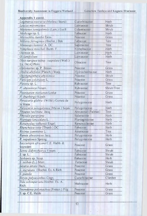
Biodiversity Assessment in Foggera W et lan d . . . Getachew Tesfaye and K agnew H/selassie
Appendix 1 contd.Lagenaria siceraria (Molina) Standi. Cucurbitaceae HerbLeucas martiniensis Lamiaceae ShrubMaytenus senega!ensis (Lam.) Exell Celastraceae ShrubMedicago sp. L. Fabaceae HerbMicrochloa kunthii Desv. Poaceae GrassMilletia ferruginea (Hochst.) Bak Fabaceae TreeMimusops kummel A. DC. Sapotaceae TreeNymphaea nouchali Burm. F. Nymphaceae HerbOcimum sp. Lamiaceae Herb0. lamifolium Lamiaceae HerbOlea europea subsp. cuspidaia (Wall.) Ex. Dc) Cifferri Oleaceae Tree
Oblismenus sp. P. Beauv. Poaceae GrassOltelia ulvifolia (Planch.) Walp. Hvdrocharitaceae HerbOxythenanthera abyssinica Poaceae ShrubPanicum col or a turn L. Poaceae GrassPavetta sp. L. Rubiaceae TreeP. abyssinica Fresen. Rubiaceae Shrub/TreePennisetum mezianun Leeke Poaceae GrassP thunbergii Kunth Poaceae GrassPersicaria glabra (Willd.) Gomez de la Maza Polygonaceae Herb
Persicaria senegalensis (Meisn.) Sojak Polygonaceae HerbPhoenix reclinata Jacq. Arecaceae (Palmae) TreePhysalis peruviana Solanaceae HerbPI ant ago lanceolata L. Plantaginaceae HerbRanunculus volkensii Engel. Ranunculaceae HerbRhynchosia totta (Thunb.) DC. Fabaceae HerbRicinus communis L. Asteraceae TreeRumex abyssinicus Jacq. Polygonaceae HerbR. nepalensis Spreng. Polygonaceae HerbSacciolepis africana C.E. Hubb. & Snowden Poaceae Grass
Senna didvmobotrva Fresen. Fabaceae ShrubS. sp. L. Fabaceae ShrubSesbania sp. Scop. Fabaceae Herb5. sesban (L.) Merr. Fabaceae ShrubSetaria atrata Hack. Poaceae GrassS. incrasata (Hochst. Ex A.Rich. Poaceae GrassS. pumila Poaceae GrassSicyos polyacanthus Cogn. Cucurbitaceae ClimberSida schimperiana Hochst. Ex. A. Rich. Malvaceae Herb
Snowdeniapolystachya (Fresen.) Pilg Poaceae Grass5. sp. C.E. Hubb Poaceae Grass
52

Proceedings of a National Workshop (BSE, February 2003)
Appendix 1 contd.Solarium marginatum Soianaceae HerbS. rtigram L, Solanaceae HerbTagetus m inula L. Asteraceae HerbTephrosia pumila (Lam.) Pers. Fabaceae HerbTrifolium- polystachyum Fresen. Fabaceae HerbT. quartinianum A. Rich. Fabaceae HerbT. rueppellianum Fres. Fabaceae HerbTriumfetta annua L. Tiliaceae HerbVerbena officinalis L. Verbenaceae HerbVernonia amygdalina Del. Asteraceae TreeV. auriculifoda Hiern. Asteraceae HerbV. sp. Asteraceae HerbVigna luteola (Jacq.) Benth. Fabaceae HerbV. vexillata (L.) A. Rich. Fabaceae HerbXanthium strum arium L. Asteraceae HerbZannicheilia palustris L. Zannichelliaceae Herb
53

A F L O R IS T IC A N A L Y S IS A N D E T H N O B O T A N IC A L IN V E S T IG A T IO N O F T H E A W A S H R IV E R IN E V E G E T A T IO N
Mitiku T ik sa1, Tamrat Bekele2 and Ensermu K elbessa2
INTRODUCTION
Awash is one o f the major rivers o f Ethiopia. Headwater o f the Awash River is found at an altitude o f 2230 in a.s.I. in the central highlands o f Ethiopia. The specific site is a place locally called Eela Hunde, where perennial deep headwaters are found in a tuft grass meadow. There is a site called Tabala Haw'aas, a spring water used for a cure o f different diseases under a Phoenix tree where the 1200 km long Awash starts as a river, thereafter flowing to the south east until it finally drains into Lake Abe at the Ethio-Djibouti border. There is a diversified environmental gradient along the Awash River corridor from the central highlands of Ethiopia to the Arid and Semi-Arid Lowlands (ASALs).
Detailed study o f the Awash Valley was carried out by FAO between 1961 and 1965 to assess the potentials for irrigation and hydroelectric power. Sir William Halcrow and Partners in May, 1987 studied the Awash Master Plan in agreement with the Ethiopian Valleys Development Studies Authority (EVDSA) (Tesfaye Chernet, 1993), though no quantitative analysis o f the Awash Basin vegetation was included. The studies mainly focused on the possible w;ater and land use pattern in the Awash Basin. This study was carried out to cover the gap o f quantitative analysis o f the Awash riverine vegetation and the environmental gradients as factors for the formation o f major plant communities and to collect information on the ethnobotanical aspects o f the plants for the pastoral livelihood.
The tributaries o f the Awash originate from the western and eastern Ethiopian escarpments divided by the Rift Valley. The tributaries from the eastern escarpment are all seasonal. The Awash Basin in contrast to the other river valleys o f Ethiopia is relatively open and accessible for development schemes (FAO, 1965). Halcrow (1989) attributed the rich dryland biodiversity o f the Awash Basin to the biogeographic setting o f the river and the vegetation that enabled the survival o f the whole-integrated ecosystem.
Far before the implementation o f the development schemes within the Awash Basin Longhitano and Bavazzano (1973), noted the human influence on the environment. They described the destruction o f the vegetation on a wider area with a consequence o f easy removal o f soil by wind and water in the Middle Awash valley. The Awash riverine vegetation is severely destroyed by overuse and
1 S O S S ah e l In te rn a tio n a l (U K ), PO B o x 3 2 6 2 , A d d is A b a b a . E th io p ia . E -m a il; so s .s a h e l@ te le c o m .n e t .e t2 N a tio n a l H e rb a riu m , P O B o x 3 4 3 4 , A d d is A b a b a , E th io p ia .

Proceed ings o f a Nationa l W o rk sh o p (BSE, F e b ru a ry 2003)
clearing for small scale and large scale irrigation schemes by the government. The conservation o f biodiversity within the Awash valley also seems to fall under complicated land use impact. The stream corridor is exceptionally diverse environmentally and normally supports high species richness, sometimes the highest in the landscape. Riparian corridors in dry areas have been called "linear oasis" and contain many rare species. Many animals in the surrounding matrix also depend on these corridors for water, food or shade (Forman. 1995).
The water resource in the semi-arid and arid environment attracts wildlife, which seek the refuge o f the diversified riverine habitat (Mitch and Gosselink, 1993). It is also clear that luxurious vegetation within the arid and semi-arid lands (ASALs) is found diversified within the different continuum from headwater to the mouth o f the river. Though the 1200 km. long Awash River course with most o f its channel in the Rift Valley faced serious channel diversions, damming, intensive irrigation and overgrazing, remnant patches o f natural riverine vegetation supporting different life forms is found along the river, mainly along the conservation areas. Most o f the riverine vegetation along the state farms are highly disturbed and/or completely removed. There is a continuous challenge on the conservation areas from pastoral communities due to the dynamics in land use pattern.
According to Carr (1998). detailed investigations o f riverine vegetation in semi- arid Africa are poorly represented in the literature. Ensermu Kelbessa el al. (1992) noted that the riparian and swamp vegetation in Ethiopia is not properly collected though there is a higher probability of finding endemic species.
Human activities throughout the world have caused great concern in the scientific community and among the general public. This disappearance o f species has been described as a loss o f plants and animals with potential agricultural and economic value, as a loss o f medical cures not yet discovered and as a loss o f the Earth's genetic diversity (Huston. 1994). According to Finch and Ruggiero (1998), riverine forests represent critical structural habitat in arid and semi-arid landscapes, and are valued for their role in supporting regional biological diversity and a range o f human economic and recreational activities. The semi-arid and arid riverine ecosystems are conspicuous and attractive oasis to wildlife and humans. Some authorities call these ecosystems the "green r ibbons" within the semi-arid and arid drylands (Mitch and Gosselink. 1993). Wetlands can be also described as "biological superm arkets' for the extensive food chain and rich biodiversity they support (Godreau, 1999). Gregory (1991) noted that small watercourses and larger riparian zones within natural forests are far more significant than their restricted area might suggest. A key characteristic o f riparian zones in natural forests is habitat diversity. The high water table o f riverine zones and associated ecosy stems are highly influenced by topography, aridity and presence o f depositional soils. These ecosystems are uniquely characterised by the combination o f high species diversity, high species densities and high productivity'. These water bank ecosystems continuously interact for exchange o f energy, nutrients and species between the aquatic and the terrestrial ecosy stems (Mitch and Gosselink, 1993).
56
i
A Floristic Analysis and E thnobo tan ica l Investigation of the A w ash . . . Mit iku T iksa el al.
Fragile range ecosystems are more easily lost under conditions o f overgrazing, especially when combined with drought (EPA. 1998). Heavy overgrazing due to confining livestock to limited areas and loss o f access to previous rangelands by the pastoralists exacerbated the rate of soil erosion, and exerted a negative impact on the riverine vegetation. Widespread decline in riverine forests o f arid and semi- arid regions have been observed in association with a variety o f human water and land use practices, including alteration and heavy cattle grazing (Rood and Mahoney, 1990). The extensive invasion o f the rangelands and the riverine vegetation with low forage value weeds like Prosopis ju liflora (Sw.) DC. has become a potential threat to the diversity o f vegetation in the Middle and Lower Awash Valley. This condition is threatening the productivity o f the rangelands and complicating the livelihood o f the Afar pastoralists. The extensive establishment o f the invasive P. ju liflo ra seems to be beyond control within a decade. The need to study the remnant patches o f vegetation left along the Awash River within the semi-arid environment for the floristic analysis and ethnobotanical investigation was initiated and carried out to highlight the need for the conservation o f this disappearing ecosystem.
Friis and Mesfin Tadesse (1990) noted that only a brief summary with reference to the literature can be given on the riparian and riverine vegetation o f Ethiopia. They further noted that the riverine forest on the Awash River was studied by Sebald and Pichi-Sermolli. Cufodontis studied the riverine vegetation o f the Dawa River at Melka Guba. Important species in these forests are: Ficus sycamorus, Lepisanthes senegalensis. M imusops kummel, Phoenix reclinata . Tamarindus indica and Trichilia enietica. Friis (1992) noted that the major part o f the Afar Depression is covered by Somali-Masai semi-desert grassland and bushland. Riverine vegetation including riverine forest occurs along watercourses in almost all of the vegetation types.
DESCRIPTION OF THE STUDY AREA
The study area is the riverine vegetation along the Awash River in the semi-arid and arid climate below the Koka Dam to Logia Bridge (39° 1 O'E- 40°46'E, 9°36'N-11 °07"N) from an altitude 1470 m a,s.l. at Koka Dam to 350 m a.s.I. at Logia Bridge.
The headwaters o f the Awash River are found at an elevation o f 2320 m a.s.I. west o f the small town called Ginchi about 96 km west o f the Ethiopian capital Addis Ababa. The river channel extends about 1200 km until it finally ends in Lake Abe at the Ethio-Djibouti border. The river crosses western and eastern Shoa in the central highlands o f Ethiopia and bends northeast to the Afar Triangle until it finally ends in Lake Abe. Mohr (1971) noted that "...more perhaps than in any other country o f Africa, the physiography o f Ethiopia is an intimate expression of the underlying geology.” The two main physiographic components o f the Awash Basin are the Ethiopian Plateau, and the Rift Valley that widens to the north into the Afar Triangle. On the Ethiopian plateau are the tertiary volcanics: basalt tufts
57

Proceedings o f a N ational W o rk sh o p (BSE, F e b ru a ry 2003)
and agglomerates o f the trap series. The volcanic rocks on the floor o f the Rift Valley are mainly the basaltic and ignimbrites o f the Afar group (Pliocene to Holocene) and Holocene lavas are present near the active volcanic centres like Fantale, Dofan and Afrera.
Fig. 1 A Climate Diagram o f Koka Station; 1470 m a.s.l. (Upper Awash);B. Climate Diagram o f Gewane Station; 650 m a.s.l.;C. Climate Diagram o f Assaita Station; 350 m a.s.l.
According to Tesfaye Chernet (1993) the Awash Basin is described as having the following main regions: (1). the Upper Basin is from the headwaters to the Koka Dam: (2), the Upper Valley is from Koka Dam to Metahara; (3), the Middle Valley is from Metehara to Tendaho; and (4), lower Plains is from Tendaho to Lake Abe.
Volcanic activity in the Rift Valley has resulted in rich soils made up o f layers o f volcanic dusts and ashes sandwiched between sands and silts made up from erosion o f the Ethiopian plateau and subsequent flooding (EWNHS, 1996). Along the Awash River series o f recently deposited soil is found on which the riverine vegetation is established.
M ATERIALS AND M ETHODS
Reconnaissance survey o f the Awash riverine vegetation was conducted in December 1999 to identify random sampling sites in Upper Awash Valley, Middle Awash and Lower Awash Plains. The Koka Dam site was selected at the highest
58

A Floristic Analysis arid Ethnobotanical Investigation of the Awash. Mitiku Tiksa etal.
altitude o f 1470 m a.s.l. and Logia Bridge at the lowest altitude at 350 m a.s.I. to study the riverine vegetation along the Awash River within the arid and semi-arid zones.
Sample sites along the Awash River were preferentially laid from the Koka Dam to Logia Bridge. An open transect o f 100 m length and 10 m width was randomly laid to collect floristic data. A cover-abundance value o f all woody plants was estimated according to the Braun-Blanquet scale as modified by van der Maarel (1979).
At each random sampling site along the Awash River, homogenous vegetation was analysed along the 100 m transect laid parallel to the river channel. Five quadrants o f 10 m x 10 m stands were systematically laid for the sampling o f the vegetation thus resulting in an open transect. A total o f 65 sample plots following the Braun Blanquet approach (Braun-Blanquet, 1965) was analysed. Soil composite samples were collected (1-2 kg) and analysed at the National Soil Laboratory in Addis Ababa, Ethiopia. The vegetation samples were described at the National Herbarium (ETH.), Addis Ababa, Ethiopia.
Vegetation data was analysed and classified by using the computer program (TW o- Way INdicator SPecies ANalyses) Version 1.0, written by Hill (1974) resulting in a hierarchical structure o f releves and species groups (see Table 1). Analysis o f Variance (ANOVA) and Spearman's product moment analyses were computed for environment data. Tukey’s Multiple Riange Test was also used for the environmental variables and the plant communities (see Table 2).
RESULTS AND DISCUSSION
1) Vegetation analysis
Based on the cover/abundance values o f a total o f 93 plant species that were identified from the study area were described. The final homogenous groups that resulted from the analyses were identified as plant community types and subsequently designated as 1, 2, 3, 4, 5, 6 and 7 (Table 3). The plant communities were named by the characteristic species, which have the highest cover/abundance values. The seven major plant communities are described as follows:
1(a). Acacianilotica subs p. leiocarpa-Carissa edulis type
Acacia nilotica subsp. leiocdrpa (L.) Willd ex Del. and Carissa spinarum Vahl. were found to be the characteristic species in the Upper Awash Valley between the Koka Dam and Sodore. Scattered shrubs o f Sesbania sesban var. tmbica Chiov., Lantana camara L.. Euclea racemosa subsp. schimperi (A. DC.) Dandy dominate the shrub layers. This community type is found between altitudes 1470-1320 m between Koka and Sodore.
59

UU
l 11
3112
2
32
22
31
33
33
33
34
22
2224
4444
66
666
4445
4555
55
55
55
6
1234
5 6
78
12
34
5906
0790
7
96
89
38
45
61
72
80
12
3451
2354
34
512
8973
6012
45
68
97
0
Proceedings of a National Workshop (BSE, February 2003)
O O O O O O O ^OOOa OOOOOOOOOO — r-*r C>0 0 ' -< ' -« ' -~~-^ ' -0 0 0 -«'-'O O O O O O O O O C O O O O O O O r - —< ' ~ < r - r — —o o o o o o o o o o o o o o o o o o o o o o o o o o o o ~ - - « - * H — o o o o o o o o o o o r-t _« r-t r-4 «H r* • ' - * » — »-4 o O O O O O O O O O OC O O O O O O O O O O O O O O O C O O O O O C O O O O O O O O O O O ^ ' - t - H r - . r - 4 ^ 4 r - i r H » - 4 r - ( r ^o o o o o o o o o o o o o o o o c o o o o o c o o o o o o o o o o o o o o o o o o o o o o
<n r> i m n r>
<u6£<u>
icaouJZw«*<
jaIS«H
— «Tinv0r-»fOcocoo>c**-« f^u^vovoser*^ “ “ [ ^ O O r ^ o r - O M ' o r - o ^ r O c o c N i r - r ' O c v j m r o i n t n c D O —•
60


Proceed ings o f a National W o rk sh o p (BSE, F e b r u a ry 2003)
Table 1 Results o f T ukey’s M ultiple Range Test between environmentalvariables and plant com munities.
E n5 “ ■
o r\
Sand
%
Sill
%
Clay
% 33
Z$
Uah2
UU
C/3 u
. 7.79 0.13 1.29 52 30 18 2.48 3.82 13.1 1.75 31.4 68 2.951
a b bed be b b be b ab a ab a c- 8.24 8.86 1.32 37 41 21 3.12 4.56 15.5 2.05 33.9 75 1 802 b a bed abc cd b c be abc a ab a b, 8.14 0.14 1.19 35 42 22 2.37 5.04 17.7 2.61 37.5 75 3.053 b b a abc cd b be c c b b a c
8.16 5.95 1.23 39 7 4 1.28 2.44 12.2 1.62 25.5 73 0.854 b a ab abc a a a a a a a a ab, 8.20 5.83 1.34 27 51 21 1.73 2.38 19.0 2.75 35.7 73 1.045 b a cd ab de b ab a c be b a ab, 8.14 7.50 1.36 19 60 21 2.72 4.65 17.2 3.08 39.2 71 1.196 b a d a e b c be be be b a ab, 8.24 0.15 1.25 57 34 9 3 68 1.40 11.9 3.25 30.2 68 0.297 b b abc c be a d a a c ab a a
Significant d ifferences ai P<0.05 ( if a m ) are indicated with different letter notations below each colum n. (Com . = Com munitv type: EC = E lectrical conductivity; BD = Bulk density: CEC = Cation exchange capacity: BS = Base saturation)
1(b). Acacia robusta subsp. usambarensis-Acokanthera scliimperi type
Acacia robusta Burch subsp. usam barem is (Taub) Brenan and Acokanthera schim peri (A. DC.) Schweinf. are the characteristic species along the altitudinal gradient between 1300-980 m between Sodore and Nura Era in the Upper Awash Valley. Acacia robusta subsp. usambarensis. M anilkara butugi Chiov., Pappea capensis Eckl. and Zeyh.; Tamarindus indica L. and Conibretum adenogonium Steud ex. A. Rich., form the upper canopy in this community. Salix mucronata Thunb.; Ziziphus spina-christi (L.) Desf.: Balanites aegvptiaca (L.) Del. and Euclea divinorum Hiern. form the shrub layer.
1(c). Celt is africana-M imusops laur [folia type
Celtis africatia Burm. f. and Mimusops laurifolia (Forssk.) Friis make the characteristic species between altitude 920-850 m. along the Awash National Park. Conibretum niolle R. Br., Cordia sinensis Lam.. Tamarindus indica L.. Conibretum adenogonium , Diospvros abyssinica (Hiern) F. White, dominate the higher tree canopy. Grewia bicolor Juss.. G. tenax (Forssk.) Fiori.. Ziziphus mucronata W i I Id.. Euclea divinorum Heirn. and Rhus natalensis, form the middle shrub layer. Between steep rock outcropings Sansevieria ehrenbergii Schweinf. ex Bak. and S.
forskaoliana (Schult. f.) Hepper and Wood grow. Cissus rotundifolia (Forssk.) Vahl grows as a liana.
62

A Floristic Analysis and EthnobotanicalInvestigation of the Awash... Mitiku Tiksa el al.
Table 2 Pearson’s Product Moment Correlation (Coefficient for Correlation) between Environmental Variables at p<0.05.
215T
SAN
D h-V) CL
AY
21 ra OU2
oU
cnCO o
EC -0.6
ris
SAND 0.001 -0.13
ns ris
SILT 0.0369 -0.03 -0,98ns ns Sig.
CLAY >0.15 0.68 -0.7! 0,54
ns ns ns ns
Na -0.34 0.29 -0.65 0.55 0.70
ns ns ns ns ns
K. -0.21 0.75 -0.44 0.24 0.94 0.69
ns ris ns ns Sig. ns !Ca 0.49 0,19 -0.60 0.55 0 .57 -0.03 0,34
ns ns ns ns ns ns ns
Mg 0.19 0.07 -0.79 0.86 0.32 0.06 -0.03 0.74
ns ns ns bs ns ris ns ns
CEC -0 .19 0.65 -0.82 0.70 0.94 0.57 0.77 0.69 0.59
ns ns ns ns Sig. ns ns ns IIS
BS 0.97 -0.41 -0.03 0.02 0.03 -0.28 -0.01 0.59 0.16 -0.04
Sig. ns ns ns ns IIS ris ns ns ns
OC -0.69 0 .9 5 . -0.13 -0.05 0 .69 0.51 0.82 -0.03 ,-0.24 0.58 -0.50
ns Sig. ns ns ns ns ns ns ns ns ns
SL -0.52 0.96 -0.01 -0.18 0,67 0.33 0.82 0.09 -0.28 0.54 -0.31 0.96
ns Sig. ns ns ns ns 11 s IIS ns ns ns Sig.AL -0.51 0.30 0.55 -0.64 -0.07 0.26 0.25 -0 .78 -0.92 -0.34 -0.46 0.52 0.47
ns ns ns ns ns ns ns ns Sig. ns ns ns ns
1(d). A cacia Senegal-A cacia mettifem-Dobera gla b ra type
Acacia Senegal (L.) W illd , Acacia'meUifera (Vahl) Berith. and Dobera glabra (Forssk.) Poir. were sampled as characteristic species at’ a steep back1 slope along the Awash River at an altitude 740-720 m. the seasonal tributary from the Eastern Highlands makes a confluence with the main Awash River. Roofs o f high escarpments, with the deep cutting o f the rivers makes a habitat for the Hamadrias and Atiubis baboons. Trees that are more or less similar to the adjacent dryland vegetation were sampled. Barlerict acanthoides Vahl, Euphorbia glochidiata Pax., E. nigrispinoides M. Gilbert, E. sp., Balanites aegypliaca, Terminalia browftii
] Fresen., Sida collina Schlechtend, Capparis tomentosd Lam. and Cadaba
63

Proceed ings of a National W orkshop (BSE, F e b ru a ry 2003)
rotundifolia Forssk. form inaccessible dense shrub layer. Sansevieria abyssinica, Hereropogon contortus (L.) Roem and Schult. Aristida cum ingiana Trin. and Rupr., grow in between the steep vokanic rock cover.
1(e). Tamarix nilotica-Acacia hockii type
Tamarix nilotica (Ehrenb) Bunge is the characteristic species o f the extensive riparian zone o f the Awash River luxuriantly growing on the riverbank at an altitude o f 350 m. at the more arki Logia Bridge in the Lower Awash Basin. Among the scattered Tamarix nilotica. Prosopis ju liflo ra (Sw .) DC. is densely established as one o f the ver\ recent invasion o f this species in the middle and lower Awash rangelands. Except for the scattered Tamarix nilotica there is distinct shrub and herb coverage on the fine sand. Capparis tomentosa and Acacia hockii scrubs are found on the outer fringe.
1(f). Acacia nilotica subsp. indica-f icus capreaefolia type
Acacia nilotica subsp. indica is wel established as a characteristic species forming the highest canop\ as well. Ficus capreaefolia Del. is well established along the very wet riverbanks adjacent to the river channel. Lower shrubs like Phyllanthus reticulatus Poir., Acalypha crenata A. Rich., Achyranthes aspera, Senna Jloridbunda, Cycantheropsis parviflora. Datura inoxia L.. M egalochlamys violacea fVahl) Vollesen, Solanum incanum L., Withania somnifera (L.) cover the middle canopy and ground cover o f the a l lu v i a l p la in m a k i n g the riverine vegetation at the middle Awash inaccessible.
1(g). Lannea schimperi-Glycine wightii var. longicauda type
At an altitude 650 m a.s.I. along the Awash flood plain at Angalale high canopy Lannea schim peri was sampled. This vegetation type is distinctively established on the two sides o f the flood plain. Glycine w ightii var. longicauda (Weight and Arn) Verde.. Creptostegia grandiflora R. Br.. Phyllanthus reticulatus Poir. form the lower ground cover o f the alluvial plane.
2) Soil properties and plant com m unities
Soil pH: - Soil pH values, averaged for all quadrants in each community shows slightly alkaline value (7.79-8.38). (Table 4). The highest pH value was obtained in community 5 and the lowest in community 1. Soil pH gradient revealed an increasing trend with decreasing altitude. Community 5 with the highest soil pH supports the Tamarix nilotica-Acacia hockii community type. No significant difference between the communities was revealed based on pH measurement. According to Slingsby and Cook (1986), soil pH measurements are often difficult to interpret. If the value is over 7, this suggests that the parent rock is limestone in origin. Pearson's Product Moment Correlation computed (Table 3), showed negative correlation for altitude and soil pH value, but a positive correlation for pH and organic carbon content. Alkaline soils are characteristic o f most arid and semi-
64

A Floristic Analysis and E thnobo tan ica l Investigation o f the Aw ash. M itiku T iksa et al.
arid regions. Alkalinity occurs when there is a comparatively high degree o f base saturation. The presence o f salts especially calcium, magnesium and sodium carbonates makes the soil very strong alkaline. Base saturation is high for the soil along the Awash River, ranging from 68-75 percent. The soil alkalinity is attributed to the high base saturation and the presence o f salts. The slight runoff or the nearly absence o f leaching causes in the soil a neutral or alkaline reaction and the pH is never inferior to 7 (Longhitano and Bavazzano, 1973).
Electrical conductivity: The mean value o f sampling plots in each community type showed the highest electrical conductivity in community 5 and the lowest in community 4. This shows the saline soil environment at the lower Awash with high electrical conductivity on which the Tamarix nilotica-Acacia hockii community type is established and the well-drained back slope o f the Awash River at Agle, Awash Arba from which the mineral nutrients were leached. Communities 3, 1, 2, 7 and 6 showed mean values o f electrical conductivity in a decreasing order. ANOVA test showed significance between communities 1, 3. 5 and 2, 4, 6, 7.
Soil texture: Soil bulk density averaged for all quadrants in each community had the highest value for community 7 and the lowest for community 3. Communities 6, 2, 1, 5 and 4 were arranged in decreasing gradient o f bulk density. Community 7 in the riparian zone o f the Middle Awash revealed a compacted, cracked silty-soil deposited mainly by seasonal alluvial deposition o f fine silt and clay. Community 7 supports the establishment o f high canopy vegetation dominated by Lannea schimperi and the lower ground cover comprised o f Glycine xvightii. Luxuriously growing Lannea schim peri was observed on the east and west bank o f the Awash on the alluvial deposition o f the flooding season. Computed ANOVA test showed significance for communities between communities 3, 4, 5 and 7, 6, 1, 2. The lowest bulk density was recorded for community 3, in the Upper Awash, which supports old stand relic o f Celt is africana-M imusops laurifo/ia community type.
Community 7 in the riparian flood plain o f the Awash showed the highest silt percent and the lowest record was for community 4, in the Upper Awash at Koka Dam. The decreasing gradient o f the silt percent showed communities 5, 3, 2, 5 and1 in decreasing order. The highest silt percent supported Lannea schimperi-GJycine wightii community type and the least silt percent supported Acacia nilotica subsp. leiocarpa-Carissa spinarum community type. Significance test revealed differences between communities 4, 5 and 2, 3, 6 and community 7. Correlation coefficient value computed for the environmental variables shows positive correlation between silt percent, slope and pH. Negative correlation was shown between silt percent and altitude. This show's that the silt deposition along the Awash River increases with decreasing altitude.
The highest clay percent obtained from the average values o f all quadrants in a community was found to be highest for community 3 and lowest for community 4. Along the Awash National Park between altitudes 920-850 m a.s.I. the Celt is africana-M imusops laurifolia community was found to have the highest clay
65

Proceedings o f a National W orkshop (BSE. Feb ru a rv 2003)
content. Acacia me/lifera-Acacia senegal-Dobera glabra community at Awash Arba back slope o f the Awash contrasts with this community in clay content. ANOVA test revealed significance between communities 4. 5 and 1, 2, 3, 6, 7. The physiochemical characteristics o f the soils o f riparian ecosystems are different from those o f either upland ecosystems or permanently, flooded swamps. In erosion and transport systems, sediments are coarse and soils poorly developed (Mitch and Gosselink, 1993). Seasonal inundation takes place along the Celt is africana- Mimusops laurifolia community whereas the Acacia senegal-Acacia mellifera- Dobera glabra community is a high slope which is not over flooded seasonally. Correlation coefficient value computed shows that there is a strong positive correlation between clay content and pH. The water supply o f plants in arid regions depends upon the soil texture (particle size). Quantity o f rain is only o f indirect importance; the amount o f water remaining in the soil, and thus available to plants, is far more important (Walter, 1985). Considering the toposequence o f soils from the Awash River it often really seems to follow a chain strictly related to erosion and deposition o f soil materials and especially to the soil moisture regime (Longhitano and Bavazzano, 1973). So the Awash riverine vegetation is established mainly on eroded and deposited soils.
Table 4 The uses o f the ethnobotanically important plants.Scientific Nam e Use Parts UsedAbutilon anglosomalie Cufod. Animal forage Leaves and TwigsAcacia brevispica Harms construction: root extracts m edicine Stem and rootA. hecatophvla Steud. e \ Rich. Browse for aoats and cam els Leaves and TwigsA. mellifera (V ahl) Benth. Browse for eoats and cam els Leaves and TwigsA. nilotica (L.) WilId. ex Del. Browse for goats and cam els: famine Leaves and Twigs:subsp. indicci (B enth.) Brenan food: eumA. nilotica (L.) W illd. ex Del. L ivestock feed; construction: Pod: stem andsubsp. leiocarpa Brenan fuelw ood: charcoal branchAI robusla Burch, subsp. Usambarensis (Taub.) Brenan
A groforestry tree; wound healing W hole plant; leaf
A. senega! (L.) W illd. Browse: hut construction: famine food Leaves and twigs: stem and branch: gum
A. seyal Del. Browse: hut construction: famine food Leaves and twigs: gum
A. tornlis (Fo rssk .) Hayne Agroforestry tree: ritual tree The whole treeAcalypha crenata A. Rich. C ure for headache; m alaria
com plicationsLeaf
Achvranthes aspera L. Im portant mix for traditional m edicine RootAcokanthera schimperi (A. DC.) Schweinf.
C ure for haem orrhoids: arrow poison Leaves and roots
Amaranthus dubius Mart. Cure for headache: malaria com plications
Leaves
Asparagus africanus Lam. Ritual value W hole plant;Balanites aegyptiaca (L .) Del. var aegvptiaca
Bark and shoots medicinal value: fruits edible
Bark: shoots: fruits
Carissa spinarum L. Fruit edible: spine used for piercing ears: branch used for fencing
Fruits: branches
66
A Ftoristic Analysis and Ethnobotanical investigation of the Awash..._______ Mitiku 1'iksa etal.
Table 4 (continued ...)Cissus quadrangularis L. M edicine for different com plications:
expels placenta if delayedRoot; the w hole plant
Combretum /nolle R. Br. Used for sm oking m ilk utensils for good smell and taste
W ood
Commeiina benghalensis L , L eaf for quick recovery o f wound; for rem oving fungus infection
L eaf
Cvept ostegia grand [flora R. Br. Perm anent mark on am m unition: latex poisonous
Latex
Equisentm ramosissimum Desf. Tooth brush: W hole plantFicus capreaefolia Del. Tem porary ritual huts: river bank
protectionW hole plant: root
F: sycomoriis L. Shade: leaves and fruits livestock feed; ritual tree
Leaves: fruit: whole plant
Glycine wightii (W ight and A m .) Verde, var. longicauda (Schw einf.) Bak.
L ivestock feed: stem and leaves Leaves and stem
Grewia mollis Juss. Ritual stick; farm tools: hut construction; browse for livestock
Stem and leaves
Lannea schimperi (A .R ich.) Engi. Bark: root; m edicinal value; drupe edible when ripe;
Bark: root; drupe
Manilkara butugi Chiov. W ood splitted and used for sm oking milk utensils
Stem and branches
Maytemis senega/ensis (Lam .) Excell
Leaves are used for treating cataract and Haem orrhoids:
Leaves
Minntsops laurifolia (Forssk ,) Friis Fruit is eaten both by man and other prim ates
Fruit
Pappea cape ns is Eckl. and Zeyh. Splitted and used for sm oking milk and other house utensils
W ood
Phoenix reclinata Jacq. For m aking hats: mats and baskets LeavesPlerolobium stellatum (Forssk .) Brenan
For fencing Stem
Rhus natalensis K rauss Leaves and roots are used as a m edicine; fruit edible
Roots; leaves: fruit
Sansevieria ehrenbergii Schweinf. ex Baker
Fibre from the plant used for making; whips: gourds; baskets etc.
Leaves
S. forskaoliaiKi (Schult. f.) H epper and tW ood
Fibre for m aking baskets: m arking m arriage cerem ony am ong the Orom oo
Leaves
i :
Soil nutrients: From the values o f available sodium averaged for quadrants in each community, community 7 located at the Lower Awash flood plain showed the highest salinity, and community 4 showed the least sodium content. Due to the long time water logging, and high evapotranspiration sodium is deposited at the soil surface by capillary movement from the ground water. Tamarix nilotica is established on the saline flood plain. ANOVA test showed significance between community 5 and communities 1 ,2 ,3 , 7 ,4 and 6.
The highest Potassium content was recorded for community 3 and the lowest for community 5. As potassium is an important nutrient for plant growth the high concentration o f potassium was revealed i,n community 3, which is a high canopy

Proceedings o f a Nationa l W o rk sh o p (BSE, F e b ru a ry 2003)
and well established evergreen riverine forest o f Celtis africana-M iniusops laurifolia community. Community 5. in the lower Awash Basin Tamarix nilotica- Acacia hockii community type contrasts well with community 3. Significance test carried out shows difference between communities 1, 2, 3, 6 and 4, 7, 5 (see Table 4). The highest available Calcium was recorded for community 6 and the lowest for community 5. Acacia nilotica subsp. indica-Ficus capreae folia community type was described in community 5 established along the riverine zone at Melka Warar: extending to Sheleko and Ambash. When aluminium and hydronium ion dominate the humid environments, calcium cations dominate the semi-arid soil exchange complex (Etherington, 1974). Thus ihe analysis clearK shows that the soil physical and chemical properties play a significant role in the formation o f the Awash riverine vegetation together with the physiographic features.
The highest magnesium was found for the Tamarix nilotica-Acacia hockii community' in the lower Awash. The least magnesium was recorded for the Acacia senegal-Acacia mellifera- Dobera glabra community type on the well drained back slope o f the Awash River. The magnesium content showed a trend o f decreasing in the quadrants sited in the Upper Awash. This could be attributed to the leaching o f magnesium in the upper catchment.
Cation Exchange Capacity' (CEC): The highest cation exchange capacity was recorded for community 7 in the Middle Awash which supports high canopy vegetation o f Larmea schimperi and Glycine w ighfii on the ground cover. The lowest cation exchange capacity was recorded for the well-drained back slope at Awash Arba. where Acacia senegal-Acacia mellifera- Dobera glabra community was described. Due to the leaching o f the nutrients at this site, the least cation exchange capacity was recorded. \N O V A test revealed significance between the different communities based on cation exchange capacity Significant difference was observed between communities 1, 2, 4 and communities 3, 6.and 7. Cation exchange capacity shows a general trend o f increasing w ith fine particles o f clay: as clay soils have a high adsorptive capacit\ for mineral nutrients.
Organic carbon content: The highest organic carbon content was found in community 3 and the lowest in commimit\ 5. This shows that the organic humus content is the highest in Celtis africana-M iniusops laurifolia community type and the lowest in the Tamarix nilotica-Acacia hockii communitx in the lower Awash flood plain. Organic carbon content in communities 1, 2, 7, 6 and 4 was shown in decreasing order from the average values of all quadrants in each community. Significance was found between plant communities based on organic carbon content. ANOVA test showed significance between communities 4, 5, 7 and 1, 3, 2 and 5.
3) Correlations between environm ental factors
Correlations between environmental factors were computed using Pearson's Product Moment Correlation. Negative correlation was found between sand percent
68
and silt percent value. As the silt percent increases along the alluvial plane along the Awash River the amount o f sand percentage decreases. The available potassium positively correlates to the amount o f clay particles. As the surface area o f the clay particles is high there is a greater chance o f adsorbing mineral particles like potassium. This is mainly true for the Middle Awash Valley. Cation exchange capacity is positively correlated to clay particles. Organic carbon percentage and silt percentage are all positively correlated to electrical conductivity. Clay and silt percentage are both negatively correlated to altitude. As the altitude along the Awash increases the silt and clay percent gradually decrease. Clay and silt contents are positively correlated to the pH values (see Table 3),
4) The Awash Riverine Vegetation
The Awash Riverine Vegetation floristic analyses showed 7 plant communities along the Awash River within the semi-arid zone between altitude 350-1470 m a.s.l.. Forman (1995) discussed the general types o f plants that dominate the riverbanks as disturbance tolerant or resistant and opportunistic. The disturbance resistants have extensive root systems and strong resprouting ability. The opportunistic are the species, which are readily eliminated by disturbance. As the Awash River seasonally overflows during the heavy rainy season from June to September in the central highlands o f Ethiopia, the vegetation that is established on the floodplains and inundated riverbanks resists the seasonal flooding and water logging. The soil texture and the soil chemical properties with other environmental factors like geomorphology, slope and gradient in altitude determine the type o f vegetation communities described along the Awash River. The edaphic factors, which are in a cycle o f erosion, transportation and deposition with the period o f water logging from seasonal flooding, also determine the type o f communities established along the Awash River. The human interference in the river corridor for irrigation, dam construction and over grazing by pastoral livestock has an impact on the riverine vegetation succession.
The Upper Awash Valley is characterised with narrow and relatively straight river channel along which four o f the plant communities were described. The upper Awash is characterised with deep cutting river valley in the highland with relatively narrower flood plains, high flow rates and steep slopes. The soil particles eroded and transported in the upper Awash are relatively coarse when compared to the middle and lower Awash. The period o f inundation is shorter when compared to the middle and lower Awash, which is confined to the narrow river banks with high slopes flushing the flood down stream. Some o f the sample sites are not flooded even during the heavy rain in the central highlands o f Ethiopia.
Acacia nilotica subsp. leiocarpa-Carissa spinarum community type, Acacia robusta subsp. usainbarensis-Acokanthera schimperi type, Celtis africana- Mimusops laurifolia type. Acacia senegal-Acacict me 11 i f era- Dobera glabra type were described in the Upper Awash Valley, where the rate and period o f inundation is lower. In the Upper Awash Community 3 is inundated for a longer period o f
A Floristic Analysis and Ethnobotanieal Investigation of the Awash..._______ Mitiku Tiksa et al.
69

Proceedings of a National W o rk sh o p (BSE. F e b ru a ry 2003)
time, when compared to communities 1, 2 and 4 which are on relatively higher slopes. Vegetation formation o f community 3 is with increased canopy and diameter at breast height (dbh) with old formation o f Celtis africana and M imusops laurifolia. According to Forman (1995) average soil conditions are wettest near the river and driest near the hill slope. Acacia senegal-Acacia mellifera- Dobera glabra community type was described on back slopes and dry areas, which resemble the upland vegetation in the semi-arid zone. Roofs o f deep canyons dissected by the river from time immemorial support different vegetation types in the upper Awash valley. The altitude o f this site is 740 m a.s.l.. The releves are covered with basaltic rocks where hardly accessible Acacia mellifera , Acacia Senegal and Dobera glabra are established as scrubs 3-4 in high. Acacia mellifera savanna begins on sandy soil at a rainfall o f 250-400 mm (Walter, 1985). The vegetation is established on a steep slope along the river, where grazers could hardly reach.
Within the Middle and the lower Awash, both slope and altitude decrease and alluvial planes stretch from the river bank forming u ide areas flooded during June to October. The vegetation at the middle Awash valley covers extensive areas along the alluvial plains. It seems that the vegetation cover has been reduced by the deforestation for state farms to increase agricultural land. Three plant communities; Acacia nilotica subsp. indica-Ficus capreaefolia , Lannea schimperi-Glycine w ightii, Tamarix nilotica-Acacia hockii were described on the flood plains along the Awash River. The alluvial deposits are comprised of fine sediments o f silt and clay; and the pH is slightly alkaline. The flow rate o f the river is highly reduced in the riparian zone and fine silt and clay are deposited. Creptostegia grandiflora, a very common liana in the middle Awash, profusely grows on the trees and shrubs and its seedlings are well established on the wet flat clay soil. It seems that the height o f the Acacia nilotica subsp. indica decreases as one goes further down the Awash River to the arid lands where the potential evapo-transpiration gradually increases and moisture content decreases.
As one proceeds along the Awash River to the arid zone where the precipitation is highly reduced the soil salinity increases. 1-1.5 m tall Acacia scrubs are found on the upland, whereas Tamarix nilotica-Acacia hockii community type is a conspicuous feature all along the Awash in the arid zone. The river deposits gravel and fine sandy particles along its banks as it slowly flows in the arid environment. According to Walter (1985). favourable conditions for the growth o f halophytic plants like Tamarix sp. is provided by the washing o f some o f the salts and the soaking o f the soil to considerable depth.
Tamarix nilotica which can resist the salinity effect grows with other species like Acacia hockii. though the current trend shows the intensive growth o f the invasive shrub. Prosopis juliflora. It is possible to imagine that the intensive invasion o f the invasive weed will be a serious nuisance in the Afar Rangelands, and the Awash River bank in the future. The functioning o f riparian systems is determined by a complex interplay between hydrological, geomorphologic and biological factors

A Floristic Analysis and E thnobo tan iea l Investigation o f the A w ash . . .________ M itiku Tiksa et at.
and that this is often reflected in the structure o f riparian plant communities (Gregory, 1991). It follows that a vegetation description has the potential to identify functional land units, that is, landscape units which are defined by their response to the disturbance regimes and resource gradients which determine a system's functioning (Higgins, 1997). The riverine vegetation o f the Awash along the environmental gradient is mainly the result o f the interactions between the hydrology, slope, altitude, edaphic factors and climate, which could be the attributes o f mainly geomorphology, edaphic factors, hydrology and climate.
Among the 36 plants which were identified as having ethnobotanic use, the use categories were divided into: plants with ethno-medicinal and ethnoveterinary use; plants that are used for fumigation and smoking o f utensils among the Afar and Oromo pastoralists in the Rift Valley; ritual values; constructions (see Table 4).
REFERENCES
Braun-Blanquet, J. (1965). Plant Sociology: The Study o f Plant Communities. Hafner Publishing Company, New York. 439 pp.
Carr, C.J. (1998). Patterns o f vegetation along the Omo River in southwest Ethiopia. Plant Ecol., 135: 135-163.
Ensermu Kelbessa, Sebsebe Demissew, Zerihun Woldu and Sue Edwards (1992). Some threatened endemic plants o f Ethiopia. In: The Status o f Some Plant Resources in Parts o f Tropical Africa (Sue Edwards and Zemede Asfaw, eds.). NAPRECA Monograph Series No. 2: 35-55.
EPA-Environmental Protection Authority. (1998). Background Information on Drought and Desertification in Ethiopia. Berhanena Selam Printing Enterprise, Addis Ababa, Ethiopia.
Etherington J.R. (1974). Environment and Plant Ecology. John Wiley and Sons, Ltd. New Delhi. India. 347 pp.
EWNHS-Ethiopian Wildlife and Natural History Society (1996). Important Bird Areas o f Ethiopia. First Inventory. Samayata Press, Addis Ababa, Ethiopia. 300 pp.
FAO (1965). Report on Survey o f the Awash River Basin. Volume 1. Rome.
Friis, I. (1992). Forests and Forest Trees o f Northeast Tropical Africa. Kew Bull. Additional Series XV: HMSO, UK, 336 pp.
Friis, I. and Mesfin Tadesse (1990). The Evergreen Forests o f Tropical N.E. Africa. Proceedings o f the Twelfth Plenary Meetings o f AETFAT. Hamburg.
Cinch, D.M. and Ruggiero, L.G. (1998). W ildlife habitats and biological diversity in the Rocky M ountains and northern Great Plains. Natural areas 13: 191-203.
71

Proceedings o f a National W ork sh o p (BSE, F e b ru a ry 2003)
Forman. T.T (1995). Land Mosaics: The Ecology o f Landscapes and Regions.Press Syndicate o f the University o f Cambridge, Cambridge University, UK. 632 pp.
Gregory. S.V. (1991). An ecosystem perspective o f riparian zones. Bioscience 41: *540-551.
Godreau. V.. (1999). Biodiversity in the floodplain o f Saone: A global Approach. Biod. Cons.. 8: 839-864.
Halcrow. W. (1989). M aster Plan for the Development o f Surface W ater Resources in the Awash Basin, Final Report. Vol. 2. EVDSA. Addis Ababa.
Higgins. S .L Rogers. K.H and Kempler. K. ( 1997). A description o f the functional vegetation pattern o f a semi-arid floodplain. South Africa. Plum E col. 129: 95-101.
Hill, M.O. (1974). TW INSPAN: A FORTRAN Program for Arranging M ultivariate data in an Ordered Two-way Table Classification of Individuals and Attributes. Cornell University. Ithaca. New York. pp. 31.
Huston, M.A. (1994). Biological Diversity: The Coexistence o f Species on Changing Landscapes. Cambridge University Press: UK, 680 pp.
Longhitano, N. and Bavazzano. R (1973). Researches on the vegetation o f the Middle Valleys o f Awash River (Ethiopia). Webbia 28: 543-565.
Mitch. J. and Gosselink, G. (1993). W etlands, Van Nostrand Reinhold, USA, 559 pp.
Mohr, P.A. (1971). The Geology of Ethiopia. 2" ! ed. University College o f Addis Ababa Press, Addis Ababa.
Rood. S.B. and Mahoney. J.M. (1990). Collapse o f riparian popular downstream from dams in western prairies: probable cases and prospects for mitigation. Environ. Manage.. 14: 451-464.
Tesfaye Ghernet (1993). Hydrology o f Ethiopia and W ater Resources Development. Ethiopian Institute O f Geological Surveys, Ministry o f Mines and Energy. Addis Ababa. 179 pp.
Van der Maarel (1979). Transformation o f cover/abundance values in phvtosociolog} and its effect on community similarity. Vegetatio.. 39: 97- 114.
Walter, H. (1985). Vegetation o f the Earth and Ecological Systems of the Geobiosphere. Springer-Verlag, Berlin Heidelberg. Germany, 318 pp.
T H E H E R B A C E O U S V E G E T A T IO N O F K IT T O -K O F F E W E T L A N D
Yoseph A ssefa1 and Melaku W ondafrash2
INTRODUCTION
Wetland is a collective term for ecosystems whose formation has been dominated by water, and whose processes and characteristics are largely controlled by water. A wetland is a place that has been wet enough for a long enough time to develop specially adapted vegetation and other organisms. There are more than 50 definitions o f wetland (Dugan, 1992). The Ramsar definition is the broadest and the most widely used. It is stated as follows: ‘‘Wetland are areas o f marsh, fen, peatland or water, whether natural or artificial, permanent or temporary', with water that is static or flowing fresh, brackish or salt, including areas o f marine water the depth o f which at low tide does not exceed six metres" (Ramsar. 1971). In wetlands water is the primary factor controlling the environment and the associated plant and animal life. They occur where the water table is at or near the surface o f the land, or where the land is covered by shallow water. Delineation o f wetland is mainly dependent on plants which are typically adapted to saturated soils (Dugan, 1992).
Wetlands are among the most fertile and productive ecosystems in the world. They are essential life-support systems, play a vital role in controlling water cycles, and help to clean up our environment. Some wetlands can produce promising higher crop yields if the fertility o f wetland soils can be harnessed and the ecosystem managed to give sustained production. Wetlands sift dissolved and suspended materials from floodwaters, thereby encouraging plant growth, and prevent the water becoming over-rich in nutrients and poor in oxygen. They also filter sediments and pollutants out o f water, maintaining water quality and protect inland areas from floods, reducing the dangers posed to people and agriculture (Denny, 1994; Afework Hailu, 1999).
Until recently little attention was given to the conservation and sustainable utilization o f these resources, both globally and country-wise. Moreover, adequate attention has not been given for the sector in the Sub-Saharan Africa where a third o f the world's international river basins are found (Donokor and Wolde. 2000). The situation in Ethiopia is even worse and sometimes paradoxical. The country is endowed with different landforms, diverse ecology and large lakes and rivers. Ethiopia is a water divide between Mediterranean and the Indian Ocean. There are also 12-river basin and major lakes and the country is often referred as the" water tower o f Northeast Africa". There are a number o f wetlands in the country that are registered by the Ethiopian Wildlife and Natural History Society (EWHNS) as
1 IBCR, PO Box 10067. Addis Ababa. Ethiopia. E-mail: [email protected] National Herbarium. PO Box 3434. AAU. Ethiopia. E-mail: [email protected]

Proceed ings o f a National W o rk sh o p (BSE, F e b ru a ry 2003)
Important Bird Areas. IBA (EWHNS. 2000). On the other hand the shortage o f potable water and water for subsistence farming is a burning issue. Pressure on the wetland is becoming worse due to development plans that are converting the wetlands to farmland without considering their ecological benefit.
If there is anv research/development activity, it is onlv with the big water bodies (Mesele Fisseha, 2000; Berihun Desta, 2000). But swamps, floodplains and marshes and other forms o f wetland are taken as wastelands, as often referred b\ various authors (Birhanu Tekalegn. 2000: Yilma Delelgn, 2000). On the other hand, the hydro powers in all parts o f the country are suffering from siltation due to degradation o f the uplands.
Among all the components o f these ecosystems, the least attention is given to the biodiversity component particular!) to t ie floral elements o f these ecosystems and their contribution to the sustainability o f the development activities. Except few wetlands the degree o f threat on the flora is not even identified. This implies that the documentation o f these resources should be done in due time (Wood et al.. 2000).
In light o f this purpose, the current study has the following objectives;
• Documenting the floral information o f the wetland o f Kilto-Koffe
• Assess the current distribution o f wetland communities in the area
M ATERIALS AND METHOD
Description o f the area
The study was done as part o f the countryw ide survey o f wetland sites supported by Eastern Africa Regional Wetlands Support Program (IUCN). The survey was coordinated by Environmental Protection Authority (EPA) in June 2002. The group w'hich was composed o f ecologists, taxonomist, cartographer and ornithologist, covered the western part o f the countn . This paper focuses only on a single site, in Jimma zone o f Oromia regional state
Kitto-Koffe wetland is found in the Southwestern highlands o f Ethiopia. It is located 07°39.638N and 036°49.742E. It is 345 km from Addis Ababa, 10 km from Jimma town on Bonga road. The altitude ranges between 1700-1800 m a.s.l. This part o f the country is known for its moist high forest that contains wild coffee (Zerihun Woldu and Kumelachew Yeshitela. 1999). The annual rainfall is above 2000 mm. The plateau is underlain mainly by extensive network o f streams and rivers that include wetlands at various points along their course.
Vegetation sampling
Although there is no information on the current status and extent o f the wetlands o f Jimma zone, study on the wetlands o f 11 lubabor has shown that 4% o f the zone
74

T h e H erb aceo u s Vegeta tion o f Kitto-Koffe W et lan d Yoseph Assefa and IMelaku W o n d a f ra sh
(immediate vicinity o f Jimma) which is about 19,000 km2 is covered with wetlands (Dixon, 1997).
Systematic vegetation sampling was used to analyze the herbaceous wetland vegetation. Two transects were selected: one near Kitto River and the other at Koffe swamp. The transects were taken along moisture gradient. A total o f 36 sample plots 4 m x 4 m were laid at intervals ranging from 0 to 5 m. In each plot all vascular plants were recorded. The cover abundance o f all herbaceous vascular plants was taken.
Moisture level o f sites as a prime environmental factor and disturbance indicators such as trampling, grazing and farming were noted whenever it was applicable.
Plant identification
Plant specimens that were difficult to identify on spot were collected after taking notes on the habits and habitat. The specimens were then numbered and pressed for identification. The identification was made at the National Herbarium, Addis Ababa University.
Data analysis
The cover abundance data was summarized on Excel spreadsheet. Minitab and SPSS-Version 10 statistical softwares were used for analysis. Minitab was used for hierarchical cluster analysis o f the cover abundance data. Average linkage between clusters was used based on their similarity ratio to depict their resemblance. Finally, partition between the groups was made within similarity level o f 55-75%.
RESULT AND DISCUSSION
Floristics
The result has shown that the vegetation o f Kitto Koffe was characterized with herbaceous vegetation dominated by sedges and grasses that reach as high as 1.5 meter. Based on the classification o f the wetlands in East Africa, this type o f wetland is categorized as category no. 1 o f Maviti (Mavitti, 1992). The group encompasses permanent reeds and marshes and swamps with characteristic hydrophytes and hydric soil. The central part o f the wetland, which is a permanent swamp, is dominated by rooted plants like the fern Thelypteris palustris and Lipocarpha chinesis on floating mat. Typha latifolia and Nymphaea lotus are also common where the level o f water is higher. A total o f 62 species that fall in 24 families were identified (Table 1).
The taxonomic diversity was coupled with diversity in life forms. All the four types o f aquatic macrophytes that have been described in East Africa wetland (Mathuri, 1992) viz: the emergent ( Typha latifolia); free floating (Cyperus pectinatus) floating leaved (Nymphaea lotus) and submerged (Potamogeton lucens) were recorded. This indicates the importance o f the area in terms o f biodiversity.
75

Proceedings of a National W orkshop (BSE, February 2003)
Some o f the specimens collected were represented by few or no specimen. For instance Cyperus aethops and C. denudatus vs ill be the first and the second collection for Ethiopia when they are incorporated.
T able 1 N u m b er o f species p e r fam ily in Kitto-Koffe w etland .Family______________ Number of speciesAlismataceae_________ 1___________________Amaranthaceae_______ 1___________________Apocynaceae_________ 1___________________Asteraceae___________ 2___________________Cyperaceae__________ 1_0__________________Euphorbiaceae________2___________________Fabaceae____________ 5___________________Lamiaceae___________ J___________________Lobeliaceae__________ 1___________________Malvaceae___________ 2___________________Myrsinaceae_________ 1___________________Myrtaceae___________ 3___________________Oleacaceae___________1___________________Orchidaceae__________2___________________Poaceae_____________ 5___________________Potamogetonaceae____ 1___________________Primulaceae__________ \____________________Ranunculaceae________I___________________Rubiaceae___________ 1___________________Sapindaceae__________1___________________Scrophulariaceae______3___________________Thelipteridaceae______ 1___________________Typhaceae___________ 1___________________Thymelaceae_________ j___________________Verbenaceae 2Xyridaceae___________1___________________
As indicated in Table 2. some o f the species are either poorly represented in the National Herbarium or have few representative specimens or none at all. This could be due to the difficulty o f collecting wetland specimens in malarious areas and places where vectors such as Biomphalaria sp. (an intermediate host o f Schistosomiasis) are found. Unless these specimens are collected in due time, there is a possibility o f extinction due to pasture and farming, and pressure on the wetland for cultivation even before the existence o f the species is known to the rest o f the world.
This will not be overemphasized when one considers the degree o f threat in the area. The major threat observed from the current survey is the conversion o f the wetlands to farmlands. Formerly local people were using Bune (dry season maize
76

T he H erb aceo u s Vegetation o f Kitto-Koffe W et lan d Yoseph Assefa and M e lak u W o n d a f ra sh
farming) only for dry season; but due to the population pressure and the fluctuation o f the rainfall the wetlands are converted into permanently dry land farm.
The other problem that was observed was related to grazing fields. As a local farmer stated “formerly it was only during the dry season that they used the marginal part o f wetland for grazing”. But now trampling and cattle droppings were observed in all transects. Eucalyptus plantation could also be a potential threat although no investigation was made on the influence o f the plantation in the middle o f the wetland.
Description o f plant com m unities
A total o f six distinct clusters were identified from the hierarchical cluster analysis, as show'n in Fig. 1. Naming o f the community was done based on the characteristic species that has the highest cover abundance value. The distribution o f the community followed the moisture gradient.
Fig. 1 Dendrogram showing the six plant com m unities at Kitto-Koffe wetland.
A) Cyperus aethiops-Cyperus latifolus-Acroceros macrum
This community is a typical wetland community found in a hydric soil. The characteristic species o f this community are Cyperus aethiops, C. latifolus and Acroceros macrum. It is dominated by C. aethopus. w'liich grows in locality which is dominated by floating substrate and extremely hydric soil. The woody vegetation along the margin o f the w'etland includes M aessa /cinceolata, Carisa spin arum, Syzygium guineense and Bredelia micrantha.

Proceedings o f a Nationa l W o rk sh o p (BSE, F e b r u a ry 2003)
B) Cyperus diclirostacliyus-Pliyllantlius boehmii-Cyperus aethiops
The characteristic species are Cyperus dichrostachyus, Phyllanthus boehmi and C. aethiops. It is dominated by monoculture o f the sedge, C. dichrostachyus (Fig. 2) that give a whitish coloration to the area. It is found in a relatively drier area than the previous community but still wetter than community F.
C) Cyperus aethiops-Cyperus denudtes-Neophyptis paniculata
This community is found at the central part o f the wetland and in other parts o f the wetland where the soil is extremely hydric. li shares a similar microenvironment with community A and D. The characteristic species include Cyperus aethiops, C. denudtes and Neophyptispaniculata The community is dominated by C. aethops.
D) Lipocarpha cliinensis-Tlielypteris palustris-Fuirena pubescens
The characteristic species are Lipocarpha chinensis, Thelypterispa]ustris, Fuirena pubescens. This community was found at the central part o f the wetland where the water level was higher than 80 cm from the ground. The vegetation is codominated by L. chinensis and a fern species T. palustris.
E) Schoenoplectus corymbosus-Sphaerunthus suaveo/ens-HygropJiila schulli
This community occurs both at the central and marginal part o f the wetland. The characteristic species are Schoenoplectus corymbosus, Sphaeranthus suaveolens, and Hygrophilaia spinosa. It is dominated b> common wetland species that are used for rituals and other traditional ceremonies.
F) Cynodon dactylon-Cyperus latifolus-Sida ovata
It is found around the margin o f the wetland and the grazing field. The association o f this genus in area bordering the dry land has also been observed in other Eastern African wetlands (Muthuri, 1992). The frequency o f cattle droppings and degree of trampling was higher than any o f the sites observed. The characteristic species of this community are Cynodon dactylon, Cyperus latifolus and Sida ovata. It is dominated by a hygrophilous grass Cynodon dactylon and the occurrence o f nonwetland species such as Sida ovata and Senna didmobotrya.
Zonation o f the plant com m unities
The six communities that were identified showed a clear pattern o f transition o f communities dominated by typical w'etland species near the center to communities dominated by dry land species at the margin. The ecotone is occupied by the mixture o f the two. How'ever, this pattern is disrupted in areas where the degree o f disturbance was severe. The schematic representation o f the distribution o f the communities against the moisture gradient is indicated in Fig. 3.
78

T h e H erb aceo u s Vegetation o f Kitto-Koffe W et land Yoseph Assefa and M elaku W o n d a f ra sh
CONCLUSION AND RECOM M ENDATION
The vegetation o f Kitto-Koffe wetland has high diversity both in terms o f taxonomy (24 families and 62 species) and life form (all the four aquatic macrophytes were recorded), but is poorly documented at a national level. Similar works are required in the area along this line. The current survey concentrated on producing a checklist but future studies should include structure, composition and ecological investigation o f the area.
A B
ACyp-»e: Cyp-<Jen Neo-pan
l± ]
Fig. 2 Average percent cover o f the dom inant species in com m unities A, B, C, D, E and F.
Although the threat observed on the survey was not quantified, information gathered from local communities indicate farming and grazing as a threat and a potential threat that could result in the destruction o f habitat o f the wetland plants.
The wetland vegetation o f Kitto-Koffe is shrinking and being replaced by farmlands, weeds and grazing lands. This shows the need for a sound conservation and management measure o f the wetland before the herbaceous species vanish. This will not be over emphasized when one considers the area in terms o f the criteria for identifying wetlands o f international importance, particularly Group B o f the criteria, criterion 2, which states, "A wetland should be considered internationally important if it supports vulnerable, endangered or critically
79

endangered species or threatened species or ecological communities (Ramsar. 1971). Based on the above criterion, ihe area could be a Ramsar candidate o f wetland o f international importance due to its importance as the habitat for endemic birds like Abyssinian long claw and Rouget’s Rail.
Proceed ings o f a National W o rk sh o p (BSE. F e b ru a ry 2003)
Fig. 3 Schematic diagram showing distribution o f the six com m unities against moisture gradient.
Most authorities are aware o f the problems related to the forest, but the issue o f wetlands is neither well addressed nor recognized as a threat. Rather they consider destructing wetlands just as changing the unproductive wasteland into productive farmland, and people are encouraged to this end. Moreover, draining the wetlands for various agricultural acti\ ities is done in unsustainable way. This requires an intervention on awareness creation among the community, development workers and local officials.
We need to begin to appreciate the vital functions wetlands perform and the goods and services the\ prov ide. The case for protecting and managing wetlands is based not just on sentimentalitv or the preservation o f rare species but a sustainable development can be done b\ making seasonal farming and grazing around the margin. The other approach could be increasing the income of the local people through undestructive harvest o f specie^ like Typhu lullfolia for ornamental, mattress, cushion and medicinal purposes.
REFERENCES
Afework Hailu (1999) Researching W etlands in Southwestern Ethiopia: The Experience o f Ethiopian W etland Research Program. Ethiopian wetland research program. Illubabor. Ethiopia.
80
T he H erbaceous Vegetation o f Kitto-Koffe W et land Yoseph Assefa and M elaku W o n d a f ra sh
Berhanu Tekalgin (2000). Environmental Impact Assessm ent as Related to W ise Use o f W etlands. Paper presented at Workshop on Wetlands Ethiopia, June 13-15, 2000, Addis Ababa, Ethiopia.
Berihun Desta (2000). Challenges and Opportunities o f the W etlands of Ethiopia: The Case o f Lake Awassa and its Feeders. Paper presented at Workshop on Wetlands Ethiopia. June 13-15. 2000. Addis Ababa, Ethiopia.
Denny, P. (1994). Biodiversity and wetlands. Wetlands Ecol. Manag., 3(1): 55-61.
Dixon, A. (1997). The Sustainable Hydrological M anagem ent o f Valley Bottom W etlands in Illubabor, Southwest Ethiopia. Unpublished Report, llluababur, Ethiopia.
Donokor, S.M.K. and Wolde. Y.E. (2000). Integrated water resources management in Africa: Issues and options. In: Integrated W etlands and W ater Resources M anagement: Workshop Proceeding o f Second International Conference on Wetlands and Development (November 1998, Dakar, Senegal), pp. 3-14 (Bergkamp, G., Pirot, J.V. and Hostettler. S. eds.). Wagningen. The Netherlands.
Dugan, P.J. (1992). W etlands in Danger. 1UCN, Gland Switzerland.
EWHNS (2000). Important bird areas o f Ethiopia, Summary of Book Review,EWHNS, Addis Ababa, Ethiopia.
Mavitti, K.M. (1992). An Account o f Some Important Fresh W ater W etlands.In: Proceedings o f a seminar on Wetlands o f Kenya held in National Museum o f Kenya, Nairobi, Kenya 3-5 July 1991, pp. 23-35, (Crafter, S.S., Njuguna, S.G., and Howard, G.W. eds.) IUCN, Gland, Switzerland.
Messele Fisseha (2000). W ater Resource Policy and River Basin Developm ent as Related to W etlands. Ethiopian Wetlands Workshop, June 13-15, 2000, Addis Ababa, Ethiopia.
Muthuri, F. (1992). Classification and Vegetation of Fresh W ater W etlands. InProceedings o f a Seminar on Wetlands o f Kenya held in National Museums s o f Kenya, Nairobi, Kenya 3-5 July 1991, pp. 79-84, (Crafter, S.S., Njuguna, S.G., and Howard, G.W. eds.). IUCN, Gland, Switzerland.
Ramsar Convention Bureau (1971). Convention on W etlands, Ram sar Information Paper No. 5, Gland, Switzerland.
Wood, A.. Afework Hailu, Abbot, P. and Dixon, A. (2002). Sustainable Management wetlands in Ethiopia: Local knowledge versus government policy. In: Strategies for W ise Use o f W etlands: Best Practices in Participatory M anagem ent. Workshop proceeding o f second international conferences on wetlands and Development (November 1998,
81

Proceedings of a Nationa l W o rk sh o p (BSE, F e b ru a ry 2003)
Dakar. Senegal), pp. 81-88 (Gawler. M. ed.). Wagenningen, The Netherlands.
Yilma Dellelegn (2000) W hy W etlands? Do We Need Them in Ethiopia? IUCN Eastern Africa Regional Office.
Zerhun Woldu and Kumelachew Yeshitela (1999). The W etland Vegetation o f Illubabor. Ethiopian Wetland Research Program, Addis Ababa.

The Herbaceous Vegetation of Kitto-Koffe Wetland Yoseph Assefa and Melaku Wondafrash
Annex 1 List of identified Species with their authority and family.Species FamilyFuirena pubescens (Poir.) Kunth. CyperaceaeLindernia why lei Skan. ScrophulariaceaeEleocharis acutangula (Roxb.) Schult. CyperaceaePlatycoryne corcea (Rchb.f.) Rolfe OrchidaceaeAUstma plantqgo-aquatica L. AlismataceaeSchoenoplectus corymbosus (Roem. and Schult.) Rayn. CyperaceaeThypha latifolia L. ThypaceaeAlistma plantago-aquatica L. AlismataceaeCarissa spinarum L. ApocynaceaeCyperus aeihiops Ridl. CyperaceaeC. denudatus L. f. CyperaceaeC. dichroostachyus A. Rich. CyperaceaeC. latifolius Poir. CyperaceaeC. nitidus Lam. CyperaceaeC. pec final us Vahl CyperaceaeEleocharis acutangula (Roxb.) Schult CyperaceaeFuirena pubescens (Poir.) Kunth. CyperaceaeLipocarpha chinensis (Osb.) Karn CyperaceaeSchoenoplectus corymbosus (Roem. & Schult.) Rayn. CyperaceaeBridelia micraniha (Hochst.) Baill. EuphorbiaceaePhyllanthus boehmii Pax EuphorbiaceaeCadia purpurea (Picc.) Ait. FabaceaePterolobium stellatum (Forssk.) Brenan FabaceaeSenna didymohonya (Fresen.) Irwin & Bameby FabaceaeNeohyptis paniculala (Bak.)'J.K. Morton LamiaceaeLobelia wehvitschii Engl, and Diels LobeliaceaeSida schimperiana Hochst. ex A. Rich. MalvaceaeMaesa lanceolafa Forssk. MyrsinaceaePsidium guajava L. MyrtaceaeSyzygium guimense (Willd.) DC. MyrtaceaePlalycoryne corcea (Rchb.f.) Rotfe OrchidaceaeAcroceras macntm Stapf PoaceaeDigifaria ternata (A. Rich.) Stapf PoaceaeEchinochloa colona (L.) Link PoaceaeE. pyramidal is (Lam.) Hitche. and Chase PoaceaeHyparrhenia hirta (L.) Stapf PoaceaePotamogeton tucens L. Potamogeton aceaeAnagalis tenuicaulis Bak. PrimulaceaeDodonea augustifalia L.f. SapindaceaeBuchnera capitata Benth. ScrophulariaceaeLindernia oliveriana Dandy ScrophulariaceaeL why lei Skan. } Scrophulariaceae
83

P roceed ings o f a National W o rk sh o p (BSE, F e b ru a ry 2003)
Thelypteris palitsiris Schott ThelypteridaceaeTypha latifolia L. TyphaceaeGnidia glauca (Fresen.) Gilg ThymelaeaceaeLantana camara L. VerbenaceaeXyris cape ns is Thunb. Xyridaceae
84

THE RAMSAR CONVENTION AND ETHIOPIA: STATUS AND CHALLENGES
| Ababu A nage1
| INTRODUCTION!I Wetlands are areas where water is the primary factor controlling the environment I and the associated plant and animal life. They occur where the water table is at or I near the surface o f the land or where the land is covered by shallow water.
According to the Ramsar convention, wetlands are defined as:t '
"Areas o f marsh, fen, peat land, water whether natural or artificial, permanent ortemporary, static or flowing, fresh, brackish or salt and including areas o f marine Water the depth o f which at low tide doesn't exceed six meters" (Dugan, 1990).
Ethiopia, as per the above definition, is endowed with a great diversity o f wetland ecosystems (lakes, swamps, flood plain, natural or artificial ponds, high mountain lakes and micro dams) as a result o f formation o f diverse landscape subjected to tectonic movements, a continuous process o f erosion and human activities.
The Ethiopian wetlands are among the most productive ecosystems and haVe been utilized by humans for generations. They provide a wide range o f socio-economic and ecological functions and benefits, including the supply o f food, water, furniture and dry season grazing for Cattle. Through these benefits and their natural capacity to regulate hydrological systems, they are o f direct benefit to many local Communities living around wetlands.
Wetland vegetation controls flood and purify the river water by trapping the sediment that has been transported from the surrounding higher points; Due to constant nutrient flow, wetlands are . important ecosystems with very high nature and wild life values, especially for millions o f migratory birds. Wetland ecosystems support a combination o f traditional land use practices that are well adapted to the dynamic and capricious environment, and which yield a wide variety o f products. Research has also shown that wetlands are capable o f removing 80-90 percent o f Nitrogen, Phosphorous, sediment loads and pesticides tliat would otherwise polluting down streams and reservoirs.
As mentioned above, although wetlands have a great role in the ecosystem function and contain rich biodiversity resources, they are neglected and considered as a waste jand.
[The rapid growth o f population around wetland areas is threatening the well jfunctioning o f these important ecosystems. The higher pulling potential o f
1 Environmental Protection Authority, PO Box 12760, Addis Ababa, Ethiopiaj.
Proceedings o f a National W o rk sh o p (BSE, F e b ru a ry 2003)
wetlands (factors that attract people to a place like fishing, farming and grazing) is a cause for population density being higher than other agricultural areas.
The impacts of present da> agricultural development (valley bottom development) on wetlands have given rise to serious concern for the future use o f wetlands that may result in loss o f a variety o f important environmental functions including reduced flood water retention, surface water filtration, ground water recharge and habitat for wildlife, including fish, game and endangered species.
Some o f the wetlands are likely to lose large proportions o f the land formerly used for seasonal agricultural production, pasture, and fishing and in some cases over a total loss is expected. Over-exploitaiion o f the natural resources on the upper part o f the catchment is one o f the causes o f wetland losses. The degradation o f the surrounding catchment basin and its consequences such as increased soil erosion, more frequently drying out o f lakes and increased pollution have had a series negative impact on wetland ecosystems. The flora and fauna, which form the base of the ecosystem food chain, have partl\ or totally disappeared.
Globally aware o f the need for the importance and sustainable utilization and conservation of the wetlands, limited number o f countries sign the convention 011
wetlands in 1971, in the small town o f Ramsar in Iran, and this has become known as Ramsar Convention.
In this paper, general overview o f the Ramsar convention, major achievements and challenges o f the convention, opportunities and obligations o f a country joining the convention and common misunderstandings o f not being a party to the convention will be discussed.
GENERAL OVERVIEW OF THE RAM SAR CONVENTION
The Ramsar convention is the convention 011 wetlands. In 1971, the representative o f 18 countries went to the small town o f Ramsar in Iran to put their signatures to the convention on wetlands. The architects o f the convention had the foresight to recognize the importance o f wetlands as ke\ elements o f inland waterways and coastal systems. The\ also recognized the many serv ices. functions, and benefits that wetland prov ide and formulated the concept o f "wise use" with which the convention is synonymous today.
Ramsar promotes the integrated approach to managing wetland system so that human uses o f these areas are undertaken in such a wav as to retain their natural "capital" for future generations.
The best known aspect o f the Ramsar Convention is the list o f Wetlands o f International Importance, or "Ramsar List". The list includes sites, which the countries concerned have determined to meet the Ramsar criteria as "Internationally important". They are sites, which on the global, regional and national scale contribute to maintaining biodiversity and the natural functioning of our precious water ecosystems.
86
The R a m s a r C onvention a n d E th iop ia : S ta tus and Challenges A b a b u Anage
The Ramsar convention also encourages and supports countries to develop and implement national policy and legislative frameworks, education and awareness raising programs, as well as inventory, research, and training projects. Cooperation between countries for the management o f shared wetland systems or species is also a Ramsar priority.
CRITERIA FO R THE DESIGNATION OF W ETLANDS IN THE RAM SAR LIST
The criteria for the designation o f wetlands as Ramsar List are discussed below:
Criterion 1: A wetland should be considered internationally important if it contains a representative, rare or unique example o f a natural or near-natural wetland type found within the appropriate bio-geographic region.
Criterion 2: A wetland should be considered internationally important if it supports vulnerable, endangered, or critically endangered species or threatened ecological communities.
Criterion 3: A wetland should be considered internationally important if it supports populations o f plant and/or animal species important for maintaining the biological diversity o f a particular bio-geographic area.
Criterion 4: A wetland should be considered internationally important if it supports plant / or animal species at a critical stage in their life cycles, or provides refuge during adverse conditions.
Criterion 5: A wetland should be considered internationally important if it regularly upports 20,000 or over water birds.
Criterion 6: A wetland should be considered internationally important if it regularly upports 1% o f the individuals in a population o f one species or sub species o f vater bird.
Criterion 7: A wetland should be considered internationally important if it supports a significant proportion o f indigenous fish sub species, species or families, life
istory stages, species interactions and/or benefits and/or values and thereby :ontributes to global biological diversity.
riterion 8: A wetland should be considered internationally important if it is an mportant source o f food for fishes, spawning ground, nursery and / or migration
path on which fish stocks either within the wetland or elsewhere depend.
As per the article 2 o f the convention each contracting party shall designate suitable wetlands within its tertiary for inclusion in a list o f wetlands o f international importance. The boundaries o f each wetland shall be precisely described and also delimited on a map and they may incorporate riparian and coastal zone adjacent to the wetlands, and islands on bodies o f marine water deeper than six makers at low tide lying within the wetlands, especially where these have importance as water fowl habitat.
87

Proceedings of a National W o rk sh o p (BSE, F e b ru a ry 2003)
Moreover, the above mentioned article has got the following provisions:
• Wetlands should be selected for the list on account o f their international significance in terms o f ecology, botany, zoology , limnology or hydrology. In the first instance wetlands o f international importance to water fowl at any season should be included.
• The inclusion o f wetland in the list doesn't prejudice the exclusive sovereign rights o f the contracting part} in whose territory the wetland is situated.
• Each contracting party shall designate at least one wetland to be included in thelist when signing the Convention or when depositing its instrument o fratification or accession, as provided in Article 9.
• Any contracting party shall have the right to add to the list further wetlandssituated within its territory, to extend the boundaries o f these wetlands alreadyincluded in the list or, because o f its urgent national interests, to delete or restrict the boundaries o f wetlands already included in the list and shall, at the earliest possible time, inform the organization or government.
• Each contracting part) shall consider its international responsibilities for the conservation, management and wise use o f migratory stocks o f water fowl, both when designating entities for the list and when exercising its right to change entities in the list relating to wetlands within its territory.
CO M M ITM ENTS OF THE CONTRACTING PARTIES TO THE CONVENTION
Contracting parties to the convention commit themselves to:
• Designate at least one site that meets the criteria for inclusion in the Ramsar List and ensure maintenance o f the ecological character o f each Ramsar site;
• Include wetland conservation within the national land use planning in order to promote the wise use o f all wetlands v\ ithin their territory;
• Establish nature reserves on wetlands and promote training in wetlands research and management:
• Consult with other parties about convention implementation, especially with regard to transboundary wetlands, shared water systems, shared species and development projects affecting wetlands.
ACHIEVEM ENTS AND CHALLENGES OF THE CONVENTIONGLOBALLY
Some o f the major implementation o f the convention by contracting parities as perthe submitted national reports o f the parties and analyzed in the Secretary GeneralReport at COP 8 in Valencia /Spain is depicted below:
88
T
1) Inventory and assessment
The analysis o f national reports indicated twenty-eight parties have indicated that they have comprehensive wetland inventory with national coverage (24%), and 51 have partial inventories.
Moreover, the Secretariat o f the Convention has responded to the initiative to launch the Millennium Ecosystem Assessment (MEA), which has been developed as a response, primarily, to the information needs o f the Convention on Biodiversity, Desertification, and Wetlands (Secretary General of the Ramsar Convention Report at COP 8. 2002.)
Challenge
Complete and scientifically based wetland inventories continue to be a sine qua non-requirement for the effective implementation of the convention. Yet, as mentioned above, only 28 parties have indicated that they have inventories with national coverage. Currently the convention has got 133 contracting parties.
2) Policies and legislation including impact assessment and valuation
In relation to the status o f national wetland policy or similar instruments, 41 parties (35%) have indicated that they have such an instrument, 14 that they would integrate w'etland policy into other sectoral policies, and 18 that they are developing one. In total 61% o f all parties have taken or initiated action.
Challenge
® The need to develop national wetland policies or similar instruments as the basis for coherent action on wetland issues.
® It has also become more and more evident that the ability to undertake economic valuations o f wetland values and functions in relation to w ise use is a pressing issue. Yet, the methodologies and expertise to do so effectively and with expediency are lacking in most countries.
3) Integration or wetland wise use into sustainable development
® Review o f resource materials related to wetland management policies and practices: 25 parties indicated that they have done so (21%), and 11 that they have done so partially or are in the process o f doing so.
• Implementation o f integrated management approaches (river basins / coastal zones). Thirty-seven parties (31%) indicated that they are doing so nation wide, and 64 that they have integrated management approaches only for part o f their territory. In total, 85% of all CPs are taking action.
The R a m s a r C onven tion and E thiopia: S ta tus and Challenges_____________________ A b ab u Anage
89

P roceed ings of a National W o rk sh o p (BSE, F e b ru a ry 2003)
Challenge
The need to realize operational objectives related to the significance o f wetlands for reasons o f water supply, flood defense, food security , poverty alleviation, etc.
4) Designation o f Ram sar sites
COP 7 adopted the strategic framework and guidelines for the future development of the list o f Wetlands o f International importance, intended to give more coherence to Ramsar site designations in order to "develop and maintain an international network o f wetlands which are important for the conservation of global biological diversity and for sustaining human life through the ecological and hydrological functions they perform."
As o f 30 September 2002, there are 1198 Ramsar sites, covering 103.332,813 hectares. Living waters o f W'WF International has provided support to a number o f developing countries to designate Ramsar sites that are larger than half million hectares. The target o f the programme is to contribute to ensuring that 250 million hectares o f high priority fresh water ecosystems worldwide are protected and sustainably managed by 2010.
Challenge
The need for a more thorough review of the application o f the strategic framework for the Ramsar List, since, in spite o f the fact that 73 parties have indicated that they have applied a systematic approach to Ramsar site designations, the information available to the Ramsar Bureau doesn't corroborate such a high level progress.
5) M anagement, planning and monitoring of Ramsar sites
O f all Ramsar sites with management plans in place, only 24 parties (20%) have reported having achieved this target. It has been difficult to extract from the information provided by the parties the figures regarding the exact number o f Ramsar sites which have management plans in place and those that are being fully implemented. The Bureau concludes that at least 553 sites should have management plans and that 397 should be fully implemented.
Challenge
• Management planning at Ramsar sites is becoming a major concern, since, if the designation o f sites for the list is not followed with the appropriate measures to safeguard the ecological character o f the sites, including through wise use, then the designation becomes meaningless or even counter productive for the whole purpose o f having established the Ramsar List.
• Implementation o f the New Guidelines for management planning for Ramsar sites and other wetlands.
90

T h e R a m s a r C onven tion an d E th iop ia : S ta tus a n d Challenges A b a b u A nage
6) M anagem ent o f shared w ater resources, wetlands and wetland species
The main indicators derived from the analysis o f the national reports are as follows:
• Implementation o f integrated management approaches (River basins/ coastal zones): 37 parties (31%) have reported having done so, and 64 having done so partially.
• Cooperative management o f shared wetlands: 33 parties (31%) responded doing so and three parties partially doing so.
® Data on water bird populations and other taxa gathered regularly: 88 parties (74%) have reported doing so, and 5 doing it partially.
Challenge
Forging close working relations between the convention and river basin authorities at national and regional levels could be the most effective way to make progress in this activity area. The COP may consider giving instructions to the Bureau in this direction and suggest possible solutions to the question o f the necessary resources for doing so, in relation to the River Basin Initiative.
7) Financing the conservation and w ise use o f wetlands
The main indicators derived from the analysis o f the national reports are as follows:
• Project proposals submitted to funding agencies, which were intended to assist Ramsar implementation: 75 parties (63%) reported having done so.
• CP government represented in governing bodies or scientific advisor bodies o f multilateral donors or the GEF: 41 parties provided an affirmative answer.
Challenges
The absence o f a financial mechanism for the convention continues to be a significant challenge. At the COP 8 Endowment Fund is approved to support only the small grants fund which at present provides a maximum o f 40,000 Swiss francs per project, w hich useful as it is, doesn 't constitu te a solution for financing the management plans that are required for the effective conservation and sustainable use o f many Ramsar sites and other wetlands.
The option o f the GEF becoming a financial mechanism for the Ramsar seems out o f question for the time being. Thus, access to GEF funding will require: a) working through the focal points for CBD, climate change, and Desertification in the recipient countries: and b) the political decision that wetland projects constitute a priority for submission to the GEF.
. r '
91
Proceed ings o f a Nationa l W o rk sh o p (BSE, F e b r u a ry 2003)
8) Institutional capacity o f contracting parties
The main indicators derived from the analysis o f the national reports are as follows:
• Review o f national institutions related to wetlands to ensure that resources aYe available to implement the convention 53 parties have indicated having done so, and six have done so partially or are in the process o f doing so.
• Establishment o f a National Ramsar Committee or similar body; 69 parties reported having a Ramsar committee, 13 reported having a body that performs similar functions, and 13 reported that steps are being taken to establish a committee. In total, 80% o f parties have acted or are acting on this matter.
• Funds allocated to conservation and wise use o f wetlands: 93 parties (78%) have responded positively to this question.
Challenge
It has been stated that National Ramsar committees involving all relevant stockholders and working effectively constitute one o f the most effective mechanisms for the implementation o f the convention. However, there is a need for a critical analysis to be undertaken on the relevancy and efficiency o f the existing committee and this should be disseminated as soon as possible during the next triennium.
COM M ON M ISUNDERSTANDINGS ABOUT JOINING THE RAM SAR CONVENTION
The most usual misunderstandings for not joining the Ramsar convention are:
1) Ramsar is only interested in the conservation o f habitats for migrator)'' water birds.
Ramsar has always taken a keen interest in the protection o f habitats for migratory birds, but from the very beginning the text o f the convention recognized the many values and functions o f wetlands and promoted the "wise use" o f these areas by human populations. The development o f the wise use guidelines, the addition o f fish habitat criteria for identifying wetlands o f International importance, and the efforts to encourage the designation o f all types o f wetlands are clear signals that the convention on wetlands has an interest in all wetland types.
2) Suffice to be a contracting party to other MEAs like CBD, UNFCC, CCD, etc.
It is true that the Convention on Biological Diversity are now cooperating closely on a wide range o f issues under Memorandum o f cooperation which is in place between the secretariats and the joint work plan which has been approved by both conferences o f the parties.
92

T he R a m s a r C onvention and Ethiopia: Sta tus and Challenges A b a b u Anage
The two conventions are implementing a joint work plan under which Ramsar is to take the lead role in encouraging the implementation o f appropriate action on wetland ecosystems.
In a similar way, the Ramsar Bureau is presently pursuing collaboration activities with both the FCC and UNCCD. It also has in place a Memorandum of understanding with the secretariat o f the convention on migratory species. Ramsar is a natural partner with these conventions and is seeking to ensure that there is no duplicated effort, which would impose 011 added administrative burden on the signatory states.
3) Ramsar Convention is only about managing protected areas and these are already taken care or in their country.
The Ramsar convention recognizes the intrinsic functions and services that wetlands provide for human populations and encourages their "wise use" while many Ramsar listed sites are also protected areas, many are not, and the convention gives high priority to the development o f consultative and inclusive management practices for these sites. Ramsar also aims to provide the "tools" for involving local people and stakeholders in the development o f management plans for wetland sites whether they are recognized under the convention or not.
RAM SAR CONVENTION AND KEY CHALLENGES OR ETHIOPIA
© Lack o f complete and scientifically based comprehensive inventory o f the Ethiopian wetlands which is the basic requirement for the implementation o f the Ramsar Convention;
© Lack o f wetland policy and defined institutional arrangement for the sustainable conservation and management o f wetlands.
TRAGEDY OF THE COM M ONS
® uncontrolled expansion o f development projects around the wetland areas and the subsequent over exploitation o f wetland resources, e.g., development projects concentration at Lake Ziway;
• due to lack o f awareness, wetlands are usually considered as waste lands by themajority o f the public and minimal attention is given for their conservation;
© the alarming rate o f deforestation/devegetation at the upper catchments in most parts o f the country is threatening our lake ecosystems by aggravating siItation;
© absence o f strong institutional set up for the conservation and management ofthe natural resources o f the country, e.g., the current institutional arrangement o f the forestry section;

Proceedings of a National W o rk sh o p (BSE, F e b r u a ry 2003)
• absence o f the land use policy that constrained the inclusion o f the wetland conservation in the federal/regional land use policy as per the Ramsar Convention;
• the various types o f problems facing our protected areas including encroachment, outdated conservation approaches which do not involve the community in the conservation and management o f projected areas, ungazettment, etc.;
• lack o f forest management plans, especially for high forest areas o f the country which are important for the watershed management and biodiversity conservation;
• lack o f awareness on the role o f wetlands for water supply. flood defense, food security7. poverty alleviation.
• convince the decision makers at all levels to join the convention
• designation o f Ramsar sites and maintaining the ecological character o f the sites by formulating management plan.
ADVANTAGES OF JOINING THE CONVENTION
There are many reasons why countries should join the convention, the most important o f which are listed hereunder:
1) To safeguard wetland resources
First and foremost countries join the Ramsar convention to ensure that the vital services, functions and benefits provided by their wetlands are maintained. Membership in Ramsar gives countries a focal point and direction for the action necessary to ensure that these critical elements o f the total environment are protected and managed for sustainability.
2) Greater access to expertise and training opportunities
Membership in Ramsar brings with it increased opportunities for seeking expert assistance and support. The convention itself has dev eloped many "tools” to assist countries with meeting the modern challenges to the conserv ation o f wetland areas. Ramsar has four official NGO partner Organizations" (Bird Life International. IUCN - The World Conservation Union, Wetlands International, and the World Wide Fund for Nature, WWF) and through the extended networks provided by those organizations and the convention Bureau itself, signatories have access to a major international community o f experts in wetland conservation and wise use.
Increasingly, the donor community and private sector are supplmentary Ramsar signatories in their actions to improve the management o f wetlands. This trend is expected to continue with the Bureau expanding its contact and partnerships with
94
T he R a m s a r C onvention and E thiopia: S ta tus and Challenges A b ab u Anage
Global Environmental Facility and bilateral assistance agencies. Ramsar also has it own small Grant Fund from which annual allocations are made to developing countries for projects related to implementation o f the convention.
3) A voice on the international fora
As signatories to the Ramsar convention, countries will be better placed to tell the global community o f their special concerns and problems. It is important for the long-term future o f African countries that wetland issues, such as protection of water supply, food security and poverty alleviation schemes provided through wetland uses, are brought to world attention and adequately considered in global environmental planning and support programs.
4) Synergy with other conventions
The convention on wetlands recognizes, and strongly promotes, a partnership approach to doing business with counterpart environment conventions, be they international or regional. Further details are given below:
The Convention on Biological Diversity
In January 1996, the secretariats o f the Ramsar convention and the CBD signed a Memorandum o f Cooperation and in March o f that year Ramsar's 6th conference o f the parties (COP 6) instructed the Bureau to give a high priority to implementing the MOC. The conferences o f the parties to both conventions have also called for increased communication and cooperation between their subsidiary scientific bodies, the SUBSTTA and the scientific and Technical Review Panel (STRP).
The Convention to Combat Desertification (CCD)
Wetlands are crucially important everywhere, and even more so in arid lands. Thus, the Ramsar Bureau w'as present at the first CCD conference o f the parties in October 1997, where it distributed to the delegates an information document on "Wetlands in Arid zones". In December 1998, during the 2nd CCD conference of the parties in Dakar, the secretary General o f the Ramsar convention and the Executive Secretary o f the CCD signed a memorandum of cooperation between them to coordinate efforts and avoid duplication.
The Convention on Conservation o f M igratory Species of Wild Animals
The Ramsar Bureau and the convention on migratory species secretariat signed a Memorandum o f Understanding in February 1997. The memorandum seeks to ensure co-operation between the two secretariats in the fields o f joint promotion o f the two conventions, i.e., joint conservation action, data collection, storage and analysis, and new agreements on migratory species, including endangered migratory species and species with unfavorable conservation status.
95
Proceed ings of a National W orkshop (BSE, F e b ru a ry 2003)
World Heritage Convention
A Memorandum o f Understanding was signed between the Ramsar Bureau and the world Heritage Center in May 19c'9. The Ramsar Bureau and world Heritage officer in charge o f natural sites maintain a close working relationship with a view to:
• promoting nominations o f wetland sites under the two conventions;
• reviewing reporting formats and coordinating the reporting about shared sites:
• contributing to both conventions training efforts:
• coordinating fund raising initiatives concerning shared sites; and
• encouraging the establishment o f joint national committees.
5) External support agencies
The Ramsar Bureau maintained active contacts with a number o f external support agencies, such as the World Bank, the Global Environmental Facility, and the regional development banks. All o f them provide funding for wetlands projects that affect wetlands. Contacts are also maintained with the Development Assistance Committee o f the organization for Economic C ooperation and Development (DAC/ DECD) and with the European Commission. The DAC/ OECD has produced, in conjunction with IUCN. "Guidelines for aid agencies for improved conservation and sustainable use o f tropical and sub-tropical wetlands"
Since August 2000. the Bureaus Senior Policy Advisor on Environment and Development cooperation has been working with the development assistance community to ensure a more significant flow of resources o f wetland conservation and sustainable use in developing countries and countries in transition.
International organization partners and NGOsHThe conference o f the parties may confer the status o f International Organizations,
both intergovernmental and non-governmental, that "contribute on a regular basis and to the best o f their abilities to the further development o f the policies and technical and scientific tools o f the convention and to their application".
So far the status o f IOP has been closely associated with the convention since its inception. They are:
• BirdLife International
• IUCN
• Wetlands International
• World Wide Fund for Nature (WW'F)
_
J
T he R a m s a r Conv ention and E thiopia: Sta tus and Challenges A b a b u Anage
The four o f them provide invaluable technical advice, field level implementation assistance, and financial support.
6) Access to funding
A. The Ram sar Small Grants Fund for W etlands Conservation and W ise Use
The small Grants Fund for Wetland Conservation and Wise Use (ISGF) was established by the 1990 conference o f the contracting parities (at that time under the name" Wetland conservation Fund").The SGF provides financial assistance in the form o f small grants (Maximum Swiss francs 40,000 per project) for projects in developing countries and countries w ith economics in transition.
So far some 129 projects have been funded in about 75 countries, for a total amount o f Swiss francs 4.416, 029. At present, funding is provided for activities related to the implementation o f the convention Work plan 2000-2002, including request for emergency assistance.
B. Swiss Grant Fund to Africa
The Swiss Grant Fund for Africa is a generous contribution offered by the Federal Government o f Switzerland over and above the annual dues provided to the convention's core budget. This contribution dates back to 1989 following the establishment o f the bureau o f the convention in 1988.
The Swiss Grant Fund is extremely useful in financing suitable emergency action or specific activities in needy areas o f wetland conservation and w'ise use. Thus contribution is also particularly helpful in promoting the convention in the region.
C. Developm ent assistance officer
This is a new' position funded from the conventions core budget. The aim of this new post at the Ramsar Bureau is not to raise funds for projects to be managed by the convention secretariat, but rather to generate a more significant flow of resources for wetland issues towards developing countries and countries with economies in transition through existing channels.
In co-operation with senior staff at the convention secretariat and when appropriate in consultation with the secretariats o f other environment-related convention, the development assistance officer will establish and maintain active working relations with multilateral agencies providing assistance to developing countries and countries with economies to transition, in particular the Global Environment Facility (GEF); the World Bank; the UNDP’; the UNEP. etc.
In cooperation with the Administrative Authorities o f the convention on wetlands in OECD countries, to establish active working relation with the bilateral development assistance agencies and the authorities responsible for the multilateral institutions in each o f those countries so as to encourage full coherence between
97

Proceed ings o f a National W o rk sh o p (BSE, F e b r u a ry 2003)
the obligations specified under the Ramsar Convention for Wetlands and the countries bilateral development assistance policies and practices, and voting records in the multilateral institution.
CONCLUSION AND RECOM M ENDATION
The different types o f the Ethiopian wetlands are suffering from mis-management practices, lack o f legal backing, clear ownership right, financial constraints etc.
At macro level, there is a favorable policy environment for the management and conservation o f wetlands. In the approved environmental policy o f Ethiopia under policy element o f "g" o f the water sector, it has been stated that:
"To subject all major water conser\ ation, development and management projects to the environmental impact assessment process and to include the costs and benefits o f protecting watershed forests, wetlands and other relevant key ecosystems in the economic analysis o f water projects. Besides, the recently approved Environmental Impact Assessment legislation also makes it mandatory that development projects consider the sustainable conservation and management o f wetlands."
However, Ethiopia being one o f the least developed countries in addition to the national efforts, it needs the assistance o f the international community to realize the favourable policy environment, to formulate and implement appropriate wetland policy strategy and action plan to relax the wetland related conservation in challenges mentioned above and generally to sustainably manage and conserve its biodiversity-rich wetland ecosystems.
Hence, by considering the above-mentioned multi-faceted advantages o f the contracting parties to the Ramsar convention and the chronic status o f our wetlands, we should initiate series o f consultative meetings so as to make aware the public and decision makers about the wetland issues and to consider Ethiopia's advantages and disadvantages o f being a party or not o f the Ramsar convention.
REFERENCES
Dugan, P. (1990) (ed.). W etland Conserv ation: Review o f Current Issues and Required Actions. IUCN.
Ramsar Convention Bureau (1971). Ram sar Convention. Ramsar. Iran.
Ramsar Handbook No. 7 (2000). Strategic Fram ework and G uidelines for the Future Developm ent o f the Ram sar List. Ramsar Convention Bureau. Switzerland.
Report by secretary-general o f the Convention at COP 8 (2002). Valencia, Spain.
98

A N N E X : C O N F E R E N C E T IM E T A B L E
B S E X l i r " A N N U A L C O N F E R E N C E P R O G R A M M E 12-13 February 2003
Faculty o f Science, Addis Ababa University
W ednesday 12th February 2003
“W etlands and Aquatic Resources o f Ethiopia: Status, Challenges and Prospects”
8:30-9:00 Registration9:00-9:30 Opening Session - Hall B 3/2
® Programme Overview by Dr. Yalemtsehay Mekonnen, Secretary, BSE• Welcoming Speech by Dr Ensermu Kelbessa, President, BSE• Keynote Address by Guest of Honor
9:30-10:00 Coffee/Tea Break
Workshop on Wetlands - Hall B 3/2 Chairperson 10:00- 11:0010:00- 10:20
10:20-10:40 11:40-11:00
11:00-11:4511:00-11:15
11:15-11:30
11:30-11:45
11:45-12:40 Chairperson11:45-12:00
12:00-12:15
12:15-12:30 12:30-12:45 12:45-2:00
2:00-2:30 Chairperson2:00-2:15
2:15-2:30 2:30-3:20
99
Dr Zerihun Woldu Plenary LecturesPriority actions for wetland biodiversity conservation and water management in Africa, Anada TiegaThe RAMSAR Convention and Ethiopia: status and challenges, Ababu Anage Sustainable wetland use in southwest Ethiopia: the role of local knowledge and community management, Afework Hailu Session I: General Wetland Issues - Hall B 3/2Wetland ecosystem of Ethiopia: classification, distribution and biodiversity assessment. Getachew TesfayeEcological and economic importance of wetlands in the southern part of Lake Tana,Ale mu AssefaWetlands of Ethiopia: an overview of policy issues, Mesfin Bayou
Session 11: Fish Resources - Hall B 3/2 Dr Zenebe TadesseDiversity and conservation status of the Ethiopian freshwater fish fauna. Abebe GetahunDistribution of fish species diversity over the main drainage systems of Ethiopia: current state of knowledge and research perspectives, Alexander S. Golubtsov The fate of barbs in Gumara River, Ethiopia, Abebe Aniha Discussion Lunch Break
Session 111: Avifauna and other life forms - Hall B 3/2 Prof. Sebsebe DemissewDiversity comparisons of waterfowl between the highland and Rift Valley wetlands of Ethiopia. Yirmed DemekeCrustacean and algal aquaculture: an unexplored option, Seyoum Mengistou Session IV: Flora of Wetlands - Hall B 3/2
2:30-2:45
2:45-3:003:00-3:203:20-3:40
3:40-5:30Chairperson3:40-3:55
3:55-4:10
4:10-4:254:25-4:40
4:40-5:30
9:00-10:30Chairperson9:00-9:15
9:15-9:30
9:30-9:45
9:45-10:00
10:00-10:3010:30-10:4510:45-12:30
2:00-3:45Chairperson2:00-2:15
2:15-2:30
2:30-2:45
2:45-3:00
3:00-3:15
Vegetation analysis and ethnobotanic investigation of the Awash Riverine vegetation, Mitiku TiksaThe herbaceous vegetation of Kitto-Koffe wetland. Yoseph AssefaDiscussionCoffee/Tea Break
Session V: Changes, threats and conservation issues - Hall B 3/2 Dr Brook LemmaWetland soils, their management practices and pattern of landuse/land cover changes in the Tulube Catchment, lllubabor Highlands, Southwest Ethiopia. Solomon TekalignSocio-economic aspects of land use change and wetland cultivation in Beke Chora.lllubabor Zone. Tegegne SishawThe current status of Lake Zway fishery. Yared TigabuA review of impact assessment of other development activities on the aquatic environment and potential solutions for resource base development and management, Getinet G/Tsadik Discussion
Thursday, February 13, 2003 (Morning)
Session VI: Changes, threats and conservation issues - NB Hall 1 Prof. Shibru TedlaUnwise practices in the utilization of wetlands and their consequences: Cases o: Lakes Alemaya and Hora-Kilole. Brook LemmaEffect of improper water and land resources utilization on the main Ethiopian Rif: Lakes. Dagnachew LegesseHolocene lake levels as evidences of the extent of wetlands in Ethiopia, Mohammed UmerChanges in the trophic structure of fishes in Lake Zwai with notes on some threats to the resource and biodiversity of the lake, Demeke Admassu Discussion Coffee/Tea BreakGeneral Discussion and Recommendations
Thursday, February 13, 2003 (Afternoon)
Parallel Session I: Biomedical Sciences - Hall B 2/1 Dr Beyene PetrosIn vivo antimalarial testing of some Ethiopian traditional medicinal plants against Plasmodium berghei in mouse system. Abebe AnimutScreening of Ethno-medicinal plants of Ethiopia for their anti-microbial properties against pathogenic bacterial and fungal agents, Aberra Geyid Seven-year trend in HIV prevalence among blood donors in a teaching hospital. Northwest Ethiopia, Afeworj: KassuCultivation of free-living amoeba from soil and water: a preliminary observation. Am ha KebedeOverdiagnosis of amoebiasis in the absence of Entamoeba histolytica among diarrhea patients in Wonji and Akaki, Ethiopia, Amha Kebede
100

3:15-3:30 Immunophenotyping of blood lymphocytes from birth to adulthood in HIV-1uninfected Ethiopians, Aster Tsegaye
3:30-3:45 Discussion3::45-4:00 Coffee/Tea Break
2:00-3:45 Parallel Session II: Zoology + Agriculture - Hall B 2/2Chairperson Dr Emiru Seyoum2:00-2:15 The mate check hypothesis or "has evolution come to an end?" A taxonomist’s view,
RudyJocque2U5-2:30 Factors affecting the distribution of stem borers and their natural enemies in
I sorghum and maize based agroecosystems in Ethiopia, Emma Getu30-2:45 Occurrence of coffee berry borer, Hypothemmus hampei (Ferari) (Coleoptera:
Scolytidae) on arabica coffee of Ethiopia, Esayas Mendesil 45-3:00 The biology and ecology of Gitona pauliani and Gitona ethiopica (Diptera:
Drosophilidae) on Phytolacca dodecandra (endod) plant, Mekonnen Muleta 00-3:15 Induction of propolis production by Apis mellifera bandasii in traditional basket and
moveable-frame hives in Ethiopia, Nuru AdgabaEffects of chronic exposure to pesticides on the cardiopulmonary and cholinesterase values of farm workers in Ethiopia, Michael Biru Discussion Coffee/Tea Break
Parallel Session I: Biomedical Sciences - Hall B 2/1 Dr Fassil AssefaParasitologic and haematological features of acute Plasmodium falciparum and P, vivax malaria patients with and without HIV co-infection at Wonji Sugar Estate: a twelve-month survey, Desta Kassa
15-4:30 In vivo fertility and in vitro abortifaecient effects of Asparagus africanus andLeonotis ocymifolia in albino rats, Geremew Tafesse
4:j30-4:45 Comparison of the genetic variability of the Human Immunodeficiency Virus Typej 1 (HIV-1) in blood plasma and cervicovaginal lavage using C2V3 region of the EnvI gene, Melaku Adal
4:45-5:00 Some determinant factors of dietary intake and their effect on nutritional status of| children and mothers in slum areas of Addis Ababa, Ethiopia, Senait Zewdie
5:00-5:15 A study on HIV-infection resistance factors in Ethiopian commercial sex workersJ (CSWs), Tsehaynesh Messele
5:15-5:30 The epidemiology of HIV in Ethiopia: a review, Yared Mekonnen5:30-5:45 Discussion
4:00-5:45 Parallel Session II: Botany - Hall B 2/2Chairperson Dr Sileshi Nemomissa4:60-4:15 Sacred groves as repositories of natural biodiversity, M. Balakrishnan4:)5-4:30 Study of useful plants in and around homegardens in the vicinity of, Arba Minch,
| southwestern Ethiopia: ethnobotanic approach, Belachew Wassihun '4:30-4:45 Composition, structure and regeneration of Din Din natural forest in Southeast
I Ethiopia, Simon Shibru4:45-5:15 Determination of optimum nursery potting mixture and pot size for successful
l . propagation of Grevillea robusta seedlings, Abebe Yadessa5: i 5-5:45 Discussion
3i 15-3:30l
3530-3:453^45-4:00
4*00-5:45Chairperson4:00-4:15
4:
101
BIOLOGICAL SOCIETY OF ETHIOPIA
O b j e c t iv e
Create awareness on environment and development issues in the formal and informal education sectors and amongst the igeneral public;
Promote biological research and encourage biologists to strive for iprofessional excellence; j l Contribute to the growth and 'development of biological education and give technical support and encouragement particularly to biology teachers; p Enable biologists to interact with their local as well as international counterparts through seminars, workshops, symposia, publications, etc.;
Popularize biological science through publications and the mass media;$1 Provide consultancy services and conduct collaborative investigations on issues that require biological expertise; al Publish scientific journals and other documents as media for communication among its members and the general public.
A c t iv i t i e s
ju Organize conferences, workshops, ^eminars, panel discussions and film shows;
Support the existing environmental ducation school clubs and encourage the
Establishment of others;Publish background reading materials on
^iological topics in English and the main local languages to improve the Understanding of biological issues \ for students, teachers, and the general public; m Create networks with sister societies and organizations at national and international levels on matters of common interest;
Seek for fiinds to support the society'sactivities.1bRGANIZATIONirhe Society is governed by an officially registered constitution and is managed by an Executive Committee elected for a period of two years by the General Assembly. The Executive Committee consists of President,
Vice president, Secretary, Treasurer, Editor- in-Chief, Public Relations Officer and three ordinary members. In addition, it has a Programme Coordinator to run the Society's activities.
MEMBERSHIPThere are four types of membership:Regular - those who have a diploma or higher qualifications in biology or those who have studied biology for at least two years at university level;Associate - Biology teachers or persons engaged in biological research who do not fulfill the requirement for regular membership;Institutional - institutions wishing to support and benefit from some of the activities of the Society; and Student - those registered in higher education institutions and who are majoring in biology.
CURRENT OFFICE HOLDERS OF THE BSEPresidentVice presidentSecretaryTreasurerEditorPR OfficerMembers
Auditor
Dr Ensermu Kelbessa Dr Yalemtsehay Mekonnen Dr Seyoum Mengistou Dr Bekele Jembere Dr Abebe Getahun Ato Mulu Bitew Dr Mekbeb Zerihun Ato Girma Wondimu Dr Menassie Gashaw Ato Getachew Tesfaye Wzo Tsehaynesh Lema
Prog. Coordinator Ato Negusu Aklilu Asst Prog. Coor. Ato Abebe Ameha Office Assistant Wzt Tigist Ayele
All inquiries about the BSE can be addressed to:
The Secretariat Biological Society of Ethiopia
0 3 1 8 1 9 S 573422 or 553177 Ex. 234
Fax 552350 Addis Ababa, Ethiopia

B IO L O G IC A L SO C IET Y OF ETH IO PIA
P u V l i s f v Y o u r r r W ' v u s c r i p J ’ s i n H > e
(zt'klopiam (Journo/ o ff3 ioJogic^JS> ciences
(6JBS).
For further enquiries, please contact the EJBS Secretariat at:
PO Box 31819,Addis Ababa, Ethiopia;
Tel. 573422 E-mail: [email protected]
Vol. 2 No. 2 and Vol. 3 No. 1 are coming soon.