escap is the regional development arm of the united ... · rtwp regional tsunami watch provider...
TRANSCRIPT


ESCAP is the regional development arm of the United Nations and serves as the main economic and social development centre for the United Nations in Asia and the Pacific. Its mandate is to foster cooperation between its 53 members and 9 associate members. ESCAP provides the strategic link between global and country-level programmes and issues. It supports Governments of the region in consolidating regional positions and advocates regional approaches to meeting the region’s unique socio-economic challenges in a globalizing world. The ESCAP office is located in Bangkok, Thailand. Please visit our website at www.unescap.org for further information.
The shaded areas of the map indicate ESCAP members and associate members.

Report on Regional Unmet Needs
Tsunami Early Warning Systems in the Indian Ocean and Southeast Asia
New York, 2009United Nations
Economic and Social Commission for Asia and the Pacific

Tsunami Early Warning Systems in the Indian Ocean and Southeast Asia
Report on Regional Unmet Needs
The designations employed and the presentation of the material in this publication do not imply the expression of any opinion whatsoever on the part of the Secretariat of the United Nations concerning the legal status of any country, territory, city or area, or of its authorities, or concerning the delimitation of its frontiers or boundaries.
This publication has been issued without formal editing. The research for this publication was carried out by Sheila B. Reed, Consultant.
The publication may be reproduced in whole or in part for education or non-profit purposes without special permission from the copyright holder, provided that the source is acknowl-edged. The ESCAP Publications Office would appreciate receiving a copy of any publication that uses this publication as a source.
No use may be made of this publication for resale or any other commercial purpose whatsoever without prior permission. Applications for such permission, with a statement of the purpose and extent of reproduction, should be addressed to the Secretary of the Publica-tions Board, United Nations, New York.
United Nations publicationSales No. E.09.11.F.14Copyright © United Nations 2009All rights reservedPrinted in ThailandISBN: 978-92-1-120580-0ST/ESCAP/2536

About this Report
This Report provides an overview of priorities for tsunami early warning systems in the Indian Ocean and Southeast Asia. In particular, it will guide funding decisions by the ESCAP Multi-Donor Voluntary Trust Fund on Tsunami Early Warning Arrangements in the Indian Ocean and Southeast Asia, and was developed at the request of the Fund’s Advisory Council.
ESCAP would like to thank the Governments of Thailand, Sweden, Turkey and Nepal, which have made financial contributions to the Fund, and the many other countries and partners that have made important contributions of their time and expertise.


v
Tsunami Early W
arning Systems in the Indian O
cean and Southeast Asia
Table of Contents
Acronyms and Abbreviations ....................................................................................................... viiExecutive Summary ........................................................................................................................... 1
1. Introduction ........................................................................................................................... 3
1.1 Report on Regional Unmet Needs ...................................................................................... 31.2 ESCAP Tsunami Regional Trust Fund .............................................................................. 41.3 Methodology.......................................................................................................................... 4
2. Background ............................................................................................................................ 5
2.1 TEWS Evolution .................................................................................................................... 52.2 Response to the 12 September 2007 Tsunami Event ........................................................ 62.3 Key Components of the Regional TEWS ........................................................................... 7
3. Governance and Institutional Arrangements ................................................................... 9
3.1 Summary ................................................................................................................................ 93.2 Introduction ........................................................................................................................... 93.3 International Coordination Mechanisms ........................................................................... 93.4 National Coordination Mechanisms ................................................................................ 123.5 Civil Society and Community Coordination .................................................................. 133.6 Priorities/Recommendations ............................................................................................ 14
4. Risk Knowledge .................................................................................................................. 15
4.1 Summary .............................................................................................................................. 154.2 Introduction ......................................................................................................................... 154.3 Organizational Arrangements .......................................................................................... 154.4 IdentificationofHazards ................................................................................................... 164.5 Community Vulnerability Assessment............................................................................ 194.6 Risk Assessment .................................................................................................................. 204.7 Information Storage and Accessibility ............................................................................. 204.8 Priorities/Recommendations ............................................................................................ 21
5. Monitoring and Warning Service ..................................................................................... 22
5.1 Summary .............................................................................................................................. 225.2 Introduction ......................................................................................................................... 225.3 Institutional Mechanisms................................................................................................... 225.4 Monitoring Systems ............................................................................................................ 245.5 Forecasting and Warning Systems ................................................................................... 28

vi
Repo
rt o
n Re
gion
al U
nmet
Nee
ds
5.6 Priorities/Recommendations ............................................................................................ 29
6. Communication and Dissemination of Warnings.......................................................... 30
6.1 Summary .............................................................................................................................. 306.2 Introduction ......................................................................................................................... 306.3 Organizational and Decision Making Processes ............................................................ 316.4 Effective Communication Systems and Equipment ...................................................... 326.5 Warning Messages .............................................................................................................. 336.6 Priorities/Recommendations ............................................................................................ 33
7. Response Capability ........................................................................................................... 34
7.1 Summary .............................................................................................................................. 347.2 Introduction ......................................................................................................................... 347.3 Reaction to Warnings ......................................................................................................... 357.4 Disaster Preparedness and Response Plans .................................................................... 367.5 Community Response Capacity ....................................................................................... 377.6 Public Awareness and Education ..................................................................................... 377.7 Priorities/Recommendations ............................................................................................ 38
8. Priorities/Recommendations ............................................................................................ 39
Annex 1 - Bibliography ................................................................................................................... 41
vii
Tsunami Early W
arning Systems in the Indian O
cean and Southeast Asia
Acronyms and Abbreviations
AADMER ASEAN Agreement on Disaster Management and Emergency Response
ADB Asian Development Bank ACDM ASEAN Committee on Disaster Management ADPC Asian Disaster Preparedness Center ADRC Asian Disaster Reduction CenterADRRN Asian Disaster Response and Recovery NetworkASEAN Association of Southeast Asian NationsATWS Australian Tsunami Warning SystemBIMSTEC Bay of Bengal Initiative for Multi-Sectoral Technical and Economic
CooperationCCR Coastal Community ResilienceDART Deep-ocean Assessment and Reporting of TsunamisDRR Disaster Risk ReductionEOC Emergency Operations CentreESCAP United Nations Economic and Social Commission for Asia and the
PacificEWS Early Warning SystemGLOSS Global Sea Level Observing System GTS Global Telecommunications SystemHFA HyogoFrameworkforActionICG Intergovernmental Coordination GroupICT information and communication technologyIFRC International Federation of Red Cross and Red Crescent SocietiesIO Indian OceanIOC UNESCO Intergovernmental Oceanographic Commission of UNESCO IOTWS Indian Ocean Tsunami Warning and Mitigation System ISDR International Strategy for Disaster ReductionITIC International Tsunami Information CentreJMA Japan Meteorological Agency JTIC Jakarta Tsunami Information CentreJCOMM Joint WMO-IOC Technical Commission for Oceanography and Marine
MeteorologyLoA Letter of AgreementMDGs Millennium Development GoalsMoU Memorandum of UnderstandingNDWC National Disaster Warning CentreNEIC National Earthquake Information Center

viii
Repo
rt o
n Re
gion
al U
nmet
Nee
ds
NGI Norwegian Geotechnical InstituteNGOs non-governmental organizationsNOAA National Oceanic and Atmospheric Administration (United States)NTWC National Tsunami Watch CentreOCHA OfficefortheCoordinationofHumanitarianAffairsPAGER Prompt Assessment of Global EarthquakesPTWC PacificTsunamiWarningCenterPTWS PacificTsunamiWarningandMitigationSystemRISTEK Indonesian State Ministry of Research and TechnologyRTWP Regional Tsunami Watch ProviderSAARC South Asian Association for Regional Cooperation SCMG Sub-Committee on Meteorology and Geo-physicsSDMC SAARC Disaster Management CentreSEI Stockholm Environment InstituteSEisComp Seismological Communication ProcessorSMS Short Message ServiceSOPs Standard Operating Procedures TEWS Tsunami Early Warning SystemTWFP Tsunami Warning Focal PointUNDP United Nations Development ProgrammeUNDP-RCB UNDP Regional Centre in BangkokUNEP United Nations Environmental Programme UNESCO UnitedNationsEducational,ScientificandCulturalOrganizationUSAID United States Agency for International DevelopmentUSGS US Geological SurveyWG Working GroupWMO World Meteorological Organization
1
Tsunami Early W
arning Systems in the Indian O
cean and Southeast Asia
Executive Summary
This Study contains an update of the original “Report on Regional Unmet Needs and Recommendations: Tsunami Early Warning Systems (TEWS) in the Indian Ocean and Southeast Asia”. The Study aims to guide the policy and programming of the Fund as well as other initiatives in this area of work. This updated Study has been prepared in light of ongoing work and new developments in early warning systems in the region.
Since the Indian Ocean tsunami of 2004, intensive work has been carried out by a range of stakeholders to support development of all elements of the regional tsunami warning system in the IndianOcean and SoutheastAsia. There has been significant progress in particularin establishment of tsunami watch provider services in several countries in the region, and installation of networks of seismic and sea level stations on which these warnings depend. Important issues concern the long-term sustainability of the system (e.g., ongoing provisions for early warning in national, provincial and local budgets) and strengthening “end-to-end” warnings that reach people at risk and generate an appropriate response.
NearlyfiveyearsaftertheIndianOceantsunami,mostfundingfortsunamiearlywarningisnowbeingphasedout.However,inalmosteveryaspectoftsunamiwarning--fromoperationof sea level sensors to institutional frameworks to community awareness initiatives -- tsunami warning is most effectively and sustainably addressed through a multi-hazard approach, together with other related hazards. Most initiatives to develop tsunami warning in the region have indeed been adopting such an approach. In this regard, early warning can be considered an important form of climate change adaptation, since climate change is expected to increase the frequency and severity of natural disasters.
The following paragraphs summarize the status of the different aspects of the regional tsunami warning system:
Governance and Institutional Arrangements
The Indian Ocean and Southeast Asian region is rich in institutions contributing to regional coordination on different aspects of disaster risk reduction (DRR). The regional tsunami warning system is coordinated by IOC UNESCO’s Intergovernmental Coordination Group (ICG) for the Indian Ocean, with other countries in Southeast Asia covered by the ICG for the Pacific.Intensiveworkhasbeencarriedoutbymanycountriestodevelopdisastermanagementlaws and institutions following the Indian Ocean tsunami. In many cases, additional work to develop implementing regulations and Standard Operating Procedures (SOPs) at different levels of Government is ongoing.
Monitoring and Warning
SeismicandsealevelstationshavebeeninstalledtofillgapsintheregionalTEWSnetwork.Countries face a challenge in terms of the needed expertise and providing allocated funding
2
Repo
rt o
n Re
gion
al U
nmet
Nee
ds
to manage and sustain the stations. Ongoing support for operation and maintenance will be needed to maintain the performance of the regional monitoring and warning network over the long-term. Six countries and one regional institution have expressed willingness to commence the transition process to become a RTWP, which three countries have already started.
Risk Knowledge
Risk assessment guidelines and an Indian Ocean tsunami hazard map based on current knowledge have been developed within the framework of ICG/IOTWS Working Group 3. The Guidelines, entitled “Tsunami risk assessment and mitigation for the Indian Ocean: knowing your tsunami risk – and what to do about it” were adopted by ICG/IOTWS -VI in April 2009. Even at the broadest level, the high-risk tsunami zones and the overall tsunami frequency in different parts of the region are still poorly known, with most recent research focusing on areas affected by the 2004 Indian Ocean tsunami. While intensive work has been carried out to improve risk knowledge, applying the information for planning and vulnerability assessments is a challenge, especially at the local level. Vulnerability mapping is a complex exercise with expandingbutlimitedcoverage.ItmaybedifficultforGovernmentsanddisastermanagerstoaccess reliable and standardized data that are needed.
Communication and Dissemination of Warnings There is a clear need to strengthen systems of dissemination and communication, in particular at the downstream level. Several countries are developing Standard Operating Procedures for tsunamiwarnings,butthesearefullydevelopedandtestedonlyinafewcountries.Significantgaps include effective and redundant channels of communication to the community level, and design of clear warning messages that are understandable to end users. To a large extent, the channelsofcommunicationavailablefordisasterwarningsmayreflecttheoveralldevelopmentof communications networks in a country.
Preparedness and Response Strategies
Intensive and innovative work on community preparedness and response strategies is carried out in many countries in selected areas. A comprehensive programme is not available in most cases. Many tsunami drills have been carried out in the region since the Indian Ocean tsunami, although there is no comprehensive regional programme for drills and other assessments of the status of the TEWS over the long-term. There are numerous actors involved in this area of work and also many gaps in education, awareness, and operating procedures.
Based on this assessment, 17 priorities for TEWS in the Indian Ocean and South China Sea havebeenidentified(seeSection8).

3
Tsunami Early W
arning Systems in the Indian O
cean and Southeast Asia
Introduction
1.1 Report on Regional Unmet Needs
The original ESCAP study “Report on Regional Unmet Needs and Recommendations: Tsunami Early Warning Systems (TEWS) in the Indian Ocean and Southeast Asia”, was prepared by Mr. Chow Kok Kee, Consultant, and published in August 2007. Its objectives were to identify gaps in the TEWS and to offer recommendations on priority areas for consideration by the ESCAP-administered Multi-donor Voluntary Trust Fund on Tsunami Early Warning Arrangements in the Indian Ocean and Southeast Asia (hereafter referred to as the “Fund”). The original Study aimed to serve as an input for policy and programming purposes to the Advisory Council of theFund.Itwasalsointendedtoprovideadvicetopartnerswishingtosupporteffortstofillidentifiedgaps.
This updated Study has been prepared in light of additional information and a number of developments in early warning systems in the region at the regional, national and community level. The Study has been expanded to provide more analysis to users on national and local level gaps in addition to regional needs.
The structure of the report has been altered to correspond more closely to the considerations for development of an early warning system found in the “Checklist” developed as a product of the Third International Conference on Early Warning held in 2006.1 The Conference concluded that people-centered early warning systems are critical “to empower individuals and communities threatened by hazards to act in sufficient time and in an appropriate manner to reduce the possibility of personal injury, loss of life and damage to property and the environment”.
The Checklist is structured around the four key elements of effective early warning systems. These elements are: Risk Knowledge, Technical Monitoring and Warning Service, Communication and Dissemination of Warnings, and Response Capability. The Checklist also covers Governance and Institutional Arrangements and outlines concerns on cross cutting issues such as a multi-hazard approach, involvement of local communities and consideration of gender perspectives and cultural diversity.
By covering these key elements and cross cutting issues, the study is enriched in several important ways:1. Expansion of the concept of “end-to-end”, which frequently emphasizes communications
systems. The study also emphasizes legal and organizational systems and their connections to overall disaster risk reduction, risk knowledge issues, such as hazard mapping, data collection and analysis, as well as longer term mitigation efforts.
2. Thestudydelvesdeeperintoissuesonanationalandcommunitylevelwhichsignificantlyinfluence the efficacy of the end-to-end systems, for example, capacities to receive andrespond to early warning.
1 ISDR (2006) Third International Conference on Early Warning, Developing Early Warning Systems: A Checklist.

4
Repo
rt o
n Re
gion
al U
nmet
Nee
ds
1.2 ESCAP Tsunami Regional Trust Fund
The destructive 2004 Indian Ocean tsunami demonstrated the need for an Indian Ocean Tsunami Warning and Mitigation System (IOTWS) to identify and mitigate risks posed by tsunamis. In 2005, ESCAP set up the Multi-Donor Voluntary Trust Fund on Tsunami Early Warning Arrangements in the Indian Ocean and Southeast Asia (hereinafter the “Fund”). The Fund has received contributions from the Governments of Thailand (US$ 10 million), Sweden (US$ 2.6 million), Turkey and Nepal.
The Fund aims to build and enhance tsunami early warning capabilities in accordance with the needs of Indian Ocean and Southeast Asian countries. The Fund is a resource mechanism to narrow the capacity gaps in the region, through building institutional, technical, system-wide and other types of capacity for the development of early warning systems for tsunamis in a multi-hazard context. The Fund works within the international framework of the ICG/IOTWS, coordinated by the Intergovernmental Oceanographic Commission of the United Nations Educational, Scientific and Cultural Organization (IOC UNESCO). In addition toIOC UNESCO, four other United Nations entities are partners in the Fund: the secretariat of the InternationalStrategyforDisasterReduction(ISDR), theOffice for theCoordinationofHumanitarianAffairs (OCHA), theUnitedNationsDevelopmentProgramme (UNDP)andthe World Meteorological Organization (WMO).
Asof theendof2008, theFundhadconductedfive roundsof funding; ithad received51proposals from various regional, subregional and national organizations. Eleven projects had been approved, with a total budget of roughly US$ 9.2 million. Through these projects, the Fund balanced programming of different aspects of early warning arrangements, including monitoring and warning services, risk knowledge, dissemination and communications, and response capacity from the national to the subnational and community levels.
More information on the Fund can be found at: www.unescap.org/pmd/tsunami_index.asp.
1.3 Methodology
This study is based on desk research to outline the current status of regional TEWS projects and initiatives including a mapping of regional achievements and gaps (who is doing what, where, when, how, etc.), followed by analysis of unmet needs and gaps and possible ways to address them. The research was carried out by Sheila B. Reed, Consultant.
A review of existing documents was carried out, including: • reportsfromIOCUNESCO(includingICG/IOTWSanditsWorkingGroupmeetings);• regional/nationalIOTWSplansandstrategies;• statusandprogressupdatesfromregionalandnationalTEWSinitiatives(carriedoutby
United Nations entities, bilateral donors, governments, regional organizations, global and regional disaster management and early warning centres, and civil society organizations), and relevant conference proceedings and presentations.
See Annex 1 for a list of the main resource documents used for this Study.

5
Tsunami Early W
arning Systems in the Indian O
cean and Southeast Asia
Background
2.1 TEWS Evolution
Tsunami early warning systems monitoring the Indian Ocean were not well developed prior to the occurrence of destructive Indian Ocean tsunami in December 2004. Furthermore, emergency communication systems failed and coastal populations and tourists were not educated and prepared to respond appropriately to tsunami warnings and calls for evacuations. As a result, all countries failed to respond effectively to the tsunami. Some of the countries affectedbythetsunamihadtsunamiearlywarningsystemsmonitoringtheirPacificshoreswhere the greatest threat was perceived. It was obvious that there was an urgent need to establish Tsunami Early Warning Systems (TEWS) in the Indian Ocean and Southeast Asia to significantlyreducetheriskoffuturelossoflives,assetsandlivelihoods.Thus,IOCUNESCOtogetherwithWMOquicklyidentifiednationalfocalpointsandnationalcentrestooperateon a 24/7 basis for tsunami early warning. The Intergovernmental Coordination Group (ICG) for the Indian Ocean Tsunami Warning and Mitigation System (IOTWS) was formed in 2005, with secretariat support provided by IOC UNESCO.2 Six meetings have been held to date, the mostrecentinApril2009.TheIntergovernmentalCoordinationGroupforthePacificTsunamiWarningandMitigationSystem (ICG/PTWS) includes countriesbordering thePacificandmarginal seas.3 The ICG/PTWS was established in 1968 and coordinates international tsunami mitigation activities, including the dissemination of timely tsunami warnings, watches, and advisorybulletinsthroughoutthePacific.
At the outset of TEWS development, several challenges and limitations emerged. For example, capacitiesofcountriesfortheestablishmentofnationalTEWSdifferedsignificantly.Insomecountries, like India, Indonesia, Malaysia and Thailand, networks of seismological stations andtidegaugeswereestablishedquickly.ThesewereultimatelyconfiguredforTEWSaswell.On the other hand, countries such as Myanmar and Cambodia did not possess systematic seismic and tidal observations.
In2005,membersofIOCUNESCOheldseveralroundsofinternationalnegotiationandfinallyreached consensus4 on building a distributed, interconnected tsunami warning system. An Interim Advisory Service was set up for the Indian Ocean involving the provision of tsunami advisoriesandwatchinformationfromPacificTsunamiWarningCenter(PTWC)inHonoluluand Japan Meteorological Agency (JMA) in Tokyo directly to the National Tsunami Warning Centres (NTWC) of the ICG/IOTWS Member States. Eventually, this responsibility is planned to be taken over by a number of Regional Tsunami Watch Providers (RTWPs) located in the Indian Ocean region. At the national level, each ICG/IOTWS Member State is responsible
2 ICG/IOTWS Member States: Australia, Bangladesh, Comoros, Djibouti, France, India, Indonesia, Iran, Kenya, Madagascar, Malaysia, Maldives, Mauritius, Mozambique, Myanmar, Oman, Pakistan, Seychelles, Singapore, Somalia, South Africa, Sri Lanka, Tanzania, Thailand, Timor-Leste, United Arab Emirates, United Kingdom and Yemen. 3 ICG/PTWS Member States: Australia, Canada, Chile, China, Colombia, Cook Islands, Costa Rica, Democratic People’s Republic of Korea, Ecuador, El Salvador, Fiji, France, Guatemala, Indonesia, Japan, Malaysia, Mexico, New Zealand, Nicaragua, Niue, Panama, Papua New Guinea, Peru, Philippines, Republic of Korea, Russian Federation, Samoa, Singapore, Thailand, Tonga, Tuvalu (provisional), United States of America and Viet Nam.4 IOC UNESCO Resolution XXIII-12.

6
Repo
rt o
n Re
gion
al U
nmet
Nee
ds
for issuing warnings to its own citizens through its NTWC. These warnings are based either on the NTWC’s own analysis, or on the advisory messages received from PTWC and JMA, or a combination of both. This decisionwas a significant stepmade by the region in theestablishment of an IOTWS.
Thespiritanddesire for regionalcooperationwas furtherdemonstratedbysettingupfiveworkinggroupsundertheICG/IOTWS(fouratthefirstmeetingandthefifthatthesecondmeeting) to identify gaps and to recommend approaches to be taken on issues such as seismicity, sea level networks, risk assessment, modeling and forecasting, and interoperability of tsunami advisory and warning centres. A sixth working group was adopted by the third meeting of the ICG/IOWTS (ICG/IOTWS-III) in Bali, Indonesia in August 2006 to deal with cross-cutting issues related to mitigation, preparedness and response.
Although the South China Sea has previously been considered as a low tsunami risk area, severe earthquakes along subduction zones, e.g. around the Philippines, could generate tsunamis that would affect the coastal areas of Philippines, China and Viet Nam, and possibly parts of Cambodia, Thailand and Malaysia. Other areas of concern are the countries near the Makran Subduction zone - Oman, Iran, Pakistan and India, among others - as little research has been conducted regarding the hazard potential of this fault, which last generated a major tsunami in 1945. Some countries do not have national funding for developing national tsunami warning systems and have indicated that they need technical assistance. Donor funds have tended to be concentrated in the countries that suffered greatest impact from the Indian Ocean tsunami of 2004.
At the ICG/IOTWS-III meeting in 2006, countries maintained their decision that the IOTWS should be made up of many, mostly national, early warning systems. The fourth ICG meeting (ICG/IOTWS-IV), held in Mombasa, Kenya in February 2007, agreed that national implementation of effective and sustainable end-to-end early warning and mitigation systems wasofcriticalimportanceandMemberStateswithoutsufficientcapacitytodeveloptsunamiearly warning and mitigation systems should be given special support to accelerate their respective implementation. The ICG/IOTWS-IV meeting noted that several countries were developing Regional Tsunami Watch Provider (RTWP) capabilities. ICG/IOTWS-IV agreed to develop, by the end of 2007, an implementation plan for an interoperable system of RTWPs, including a transition from the Interim Advisory Service providers, for presentation at the next meeting of the ICG/IOTWS. At the ICG/IOTWS-V meeting in April 2008, an RTWP Implementation Plan was adopted and it was agreed that the transition process would commence in the latter half of 2008. In terms of the nomination of Tsunami Warning Focal Points and Tsunami National Contacts, 25 out of 28 countries had made complete (13) or partial (12) formal nominations.
2.2 Response to the 12 September 2007 Tsunami Event5
The tsunami generated on 12 September 2007 by a magnitude 8.4 earthquake southwest of Bengkulu, Sumatra, occurred after many components of the IOTWS had been installed and the Interim Advisory Service had been operational for over two years. An Indian Ocean-wide watch
5 Summary excerpted from Indian Ocean Tsunami Warning and Mitigation System (IOTWS) “12 September 2007 Indian Ocean Tsunami Event – Post Assessment of IOTWS Performance”, Intergovernmental Oceanographic commission Technical Series 77, UNESCO 2008.

7
Tsunami Early W
arning Systems in the Indian O
cean and Southeast Asia
bulletinwasissuedbyPTWCandJMAforthefirsttimesincetheInterimAdvisoryServicebegan in March 2005. The event presented an ideal opportunity to evaluate the performance of the IOTWS, to highlight both the strengths and weaknesses of the system, to identify areas that required further attention, and to provide a benchmark of the status of the system. The IOCSecretariatsentoutapost-eventsurveyquestionnairetothe25MemberStatestofindoutwhether the NTWCs received bulletins from the Interim Advisory Service in a timely manner, to determine what actions were taken by the NTWCs, and to learn whether the Member States had activated their emergency response plans based on the available information.
Overall, the survey produced many positive results indicating that progress had been made in thedevelopmentandimplementationoftheIOTWS.Gapsandweaknesseswerealsoidentified,mainly at the downstream end of the system where national procedures for issuing tsunami warnings and evacuation orders required further attention. The seismic and coastal and deep water sea level networks demonstrated that they were capable of detecting and locating the earthquakesourceandconfirmingthatatsunamihadbeengenerated.Asthesecorenetworksexpand,itisanticipatedthatthetimeforbothearthquakedetectionandtsunamiconfirmationwill reduce and accuracy will increase further to within the targets set by the ICG/IOTWS. The surveyproducednationalreportsandanumberofverydetailedfindingsthatarebeyondthescope of this report to mention. 2.3 Key Components of the Regional TEWS
A complete and effective early warning system comprises four inter-related elements, spanning knowledge of hazards and vulnerabilities through to preparedness and capacity to respond.6
Figure 1: The Four Elements of Effective Early Warning Systems7
Good early warning systems have strong linkages between the four elements. The major players concerned with the different elements should meet regularly to ensure they understand all of the other components and what other parties need from them. Risk scenarios should be constructedandreviewed.Specificresponsibilitiesthroughoutthechainshouldbeagreedand
Monitoring and warning service
Develop hazard monitoring and early warning services
Are the right parameters being monitored? Is there a soundscientificbasisfor making forecasts? Can accurate and timely warnings be generated?
Dissemination and communication
Communicate risk information and early warnings
Do warnings reach all of those at risk? Are the risks and the warnings understood? Is the warning information clear and useable?
6 ISDR (2006) Third International Conference on Early Warning, Developing Early Warning Systems: A Checklist.7 UN/ISDR Platform for the Promotion of Early Warning.
Risk knowledge
Systematically collect data and undertake risk assessments
Are the hazards and the vulnerabilities well known? What are the patterns and trends in these factors? Are risk maps and data widely available?
Response capability
Build national and community response capabilities
Are response plans up to date and tested? Are local capacities and knowledge made use of? Are people prepared and ready to react to warnings?

8
Repo
rt o
n Re
gion
al U
nmet
Nee
ds
implemented. Past events should be studied and improvements should be made to the early warning system. Manuals and procedures should be agreed and published. Communities should be consulted and information should be disseminated. Operational procedures such as evacuations should be practiced and tested.8
Behind all of these activities should lie a solid base of political support, laws and regulations, institutional responsibility, and trained people. Through these, early warning systems are established and supported as a matter of policy and preparedness to respond is engrained in society.8
Figure 2: End-to-end components of TEWS
Rather than being carried out as a separate activity, most TEWS are part of a multi-hazard EWS that addresses hazards threatening the population and includes all actors who are responsible, inordertoimproveeconomiesofscale,sustainabilityandefficiencyandtoconsiderallendusers needs. It is likely that a multi-hazard EWS will be activated more often than a single-hazard warning system and therefore will provide better functionality and reliability which will support warning for dangerous and high intensity events, such as tsunamis, that occur infrequently. The TEWS is easier to support when linked to the same institutions, trained staff and technology that monitor other hazards. Multi-hazard systems also help the public understand the range of risks they face and can reinforce desired preparedness actions and warning response behaviours.9
8 UN/ISDR Platform for the Promotion of Early Warning.9 ISDR (2006) Third International Conference on Early Warning, Developing Early Warning Systems: A Checklist.
9
Tsunami Early W
arning Systems in the Indian O
cean and Southeast Asia
Governance and Institutional Arrangements
3.1 Summary
The Indian Ocean and Southeast Asian region is rich in institutions contributing to regional coordination on different aspects of disaster risk reduction (DRR). The regional tsunami warning system is coordinated by IOC UNESCO’s Intergovernmental Coordination Group fortheIndianOcean,withothercountriesinSoutheastAsiacoveredbytheICGforthePacific.Intensive work has been carried out by many countries to develop disaster management laws and institutions following the Indian Ocean tsunami. In many cases, additional work to develop implementing regulations and Standard Operating Procedures (SOPs) at different levels of Government is ongoing.
3.2 Introduction
Well developed governance and institutional arrangements, both internationally and nationally, form the foundations for successful development and sustainability of sound early warning systems. Clear indicators of political commitment are the level of resources allocatedandtheefficiencyoftheirusebystakeholders.Decentralizationofauthority,aswellas building capacity and devoting resources at provincial and local levels are means to foster participation. Ultimately, the TEWS functions as part of the overall DRR system.
Key foundations of DRR and EWS are the laws and regulations which underpin the functioning of the systems, clarify roles and responsibilities and dedicate resources to warning, response and recovery. Since the Indian Ocean tsunami of 2004, countries like Sri Lanka, Indonesia and Thailand have passed national disaster management legislation.
3.3 International Coordination Mechanisms
3.3.1 Intergovernmental Coordination Group (ICG)
The Intergovernmental Coordination Group for the Indian Ocean Tsunami Warning and Mitigation System (ICG/IOTWS) was formed in response to the 2004 Indian Ocean tsunami. The IOC Assembly, during its twenty-third Session (21-30 June 2005), formally established the ICG/IOTWS through Resolution IOC-XXIII-12. In 2006 and 2007, IOC UNESCO was mandated by the UN General Assembly to coordinate the implementation of the Indian Ocean Tsunami Warning and Mitigation System (UNGA Res/61/132 and UNGA Res/62/91).
ICG/IOTWS includes six Working Groups10 (WGs) and some task teams within these groups. TheyareoverseenbyaSteeringGroupcomposedofICG/IOTWSofficers,WorkingGroupchairs and vice chairs. It is IOC UNESCO’s mandate to coordinate all activities, groups and NGOs involved in the ICG/IOTWS.
10 WG1: Seismic measurement, data collection and exchange, WG2: Sea level measurement, data collection and exchange, WG3: Risk assessment, WG4: Modeling, forecasting and scenario development, WG5: A System of Interoperable Advisory and WarningCentres;RTWPTaskForce,WG6:Mitigation,preparednessandresponse.ICGWorkingGroupmembersinclude:Indian Ocean countries (28), Observer States, UN agencies and NGOs.

10
Repo
rt o
n Re
gion
al U
nmet
Nee
ds
WG meetings have effectively pushed forward the goals of the TEWS, based on consensus of the members. The rate of progress, however, is uneven among the Working Groups and is dependent on support at a national level. Group output is sometimes hampered by lack of consistent attendance by country representatives. Generally, a certain level of expertise in the relevant technologies and disciplines is required to participate in a Working Group. At the Fifth Session of the ICG/IOTWS, the Steering Group requested that the membership criteria for WGs be formalized to facilitate contact with members and help maintain the momentum at WGmeetings.Further,financialissueshaveplaguedsomecountriesintermsofabilitytosendrepresentatives, which limits the range of opinion on important issues in the meetings.
3.3.2 Other International Coordination Groups
ESCAPESCAP, at its 64th Session in April 2008, established a new intergovernmental Committee on Disaster Risk Reduction and programme of work on disaster risk reduction, and mandated ESCAP to further strengthen its capacity in this area. Issues to be addressed include policy options and strategies for multi-hazard disaster risk reduction and mitigation; regionalcooperation mechanisms for disaster risk management, including space and other technical support systems; multi-hazard assessment, preparedness, early warning and response todisaster risks.
To enable transfer of valuable information and knowledge of disaster management across the region, ESCAP’s DRR programme is advocating a synchronized platform for cooperation andknowledgesharingforthe increasingnumberofnetworksandinitiativeswithspecificfocus on certain types of natural disasters, phases of disaster management and geographical locations.
The ESCAP Tsunami Regional Trust Fund promotes coordinated programming to support end-to-end early warning in ESCAP Indian Ocean and Southeast Asian countries, through a multi-hazard approach. Grants are provided to governments and intergovernmental and not-forprofitorganizations.IOCUNESCO,ISDR,OCHA,UNDPandWMOattendAdvisoryCouncil meetings as observers and appraise proposals to the Fund.
UN International Strategy for Disaster Reduction (ISDR) Among other initiatives, ISDR has been coordinating a multi-partnered initiative “Building Resilience to Tsunamis in the Indian Ocean”, which targets national focal points for development of early warning systems and national platforms for DRR in India, Indonesia, Maldives, and Sri Lanka. The initiative aims to advance research and analysis on risk and impact of disasters including socio-economic impact and gender aspects. In order to strengthen coherence between global and government policies, ISDR is building partnerships among ISDR system and regional partners. ISDR has also been coordinating global and regional platforms for disaster risk reduction (DRR), including regular Asian Ministerial Conferences on DRR.
The Indian Ocean (IO) ConsortiumThe Indian Ocean (IO) Consortium “Strengthening National Capacities for Tsunami Early Warning and Response Systems in the Indian Ocean” was established during the Third International Conference on Early Warning in Bonn, March 2006, and is composed of eight partners:ISDR,IOCUNESCO,UNDP,WMO,UNEP,IFRC,OCHAandtheWorldBank.Its

11
Tsunami Early W
arning Systems in the Indian O
cean and Southeast Asia
purpose is to support the development of national components of the IOTWS and further the development of national coordination mechanisms among the governments and ISDR system partners. The IO Consortium is supporting implementation of national action plans for TEWS and linking ongoing regional TEWS activities. A review of national TEWS plans has been undertaken in order to identify critical areas of need that require support.
ASEAN 11
The Association of Southeast Asian Nations (ASEAN) has developed an Agreement on Disaster Management and Emergency Response (AADMER). The aim of the agreement is to provide effective mechanisms for joint response and DRR and it sets out principles for regional cooperation. This Agreement has not entered into force, but efforts are ongoing to operationalize the components of the Agreement. It was employed following the Yogjakarta, Indonesia May 2006 earthquake and more recently in the response to Cyclone Nargis in Myanmar in May 2008.
SAARCThe members of the South Asian Association for Regional Cooperation (SAARC) include Afghanistan, Bangladesh, Bhutan, India, Maldives, Nepal, and Pakistan and Sri Lanka. The SAARC Disaster Management Centre (SDMC) was set up in October 2006 in New Delhi, India.
BIMSTECThe Bay of Bengal Initiative for Multi-Sectoral Technical and Economic Cooperation (BIMSTEC) includes Bangladesh, Bhutan, India, Myanmar and Thailand. In its focal sector of Environment and Disaster Management, a decision was made to establish the BIMSTEC Centre for Weather and Climate. BIMSTEC plans to strengthen emergency preparedness for natural disasters, especially through early warning systems and networking with ADPC and SAARC.
ESCAP /WMO Typhoon Committee 12
The Typhoon Committee was established to promote and coordinate the planning and implementation of measures required for minimizing the loss of life and material damage caused by typhoons in East and Southeast Asia.
ESCAP/WMO Panel on Tropical Cyclones 13
The Panel on Tropical Cyclones is the equivalent organization to the Typhoon Committee serving the Indian Ocean.
South-South CooperationWith support from ESCAP and the UNDP Special Unit on South-South Cooperation, an Asia-PacificRegionalSouth-SouthCooperationMechanismforDisasterRiskReductionwasestablished in late 2007, for which Indonesia serves as the interim secretariat.
11 ASEAN member states are: Brunei Darussalam, Cambodia, Indonesia, Lao PDR, Malaysia, Myanmar, Philippines, Singapore, Thailand, and Viet Nam.12TheTyphoonCommitteeiscurrentlycomposedof14Members:Cambodia;China;DemocraticPeople’sRepublicofKorea;HongKong,China;Japan;LaoPeople’sDemocraticRepublic;Macao,China;Malaysia;thePhilippines;RepublicofKorea;Singapore;Thailand;VietNam;andtheUnitedStatesofAmerica.13ThePanelonTropicalCyclonesiscurrentlycomposedof8Members:Bangladesh;India;Maldives;Myanmar;Oman;Pakistan;SriLanka;andThailand.
12
Repo
rt o
n Re
gion
al U
nmet
Nee
ds
Other regional actorsSeveralactorsintheAsia-Pacificregionofferstakeholdersresources,andexpertiseindisasterrisk reduction. These include:
• Asian Disaster Preparedness Center (ADPC), in Bangkok, Thailand, develops sustainable institutional disaster risk management capacities and is working in the areas of climate risk management, community-based disaster risk management, disaster risk management systems, public health in emergencies, supplying training resources, and urban disaster risk management.
• Asian Disaster Reduction Center (ADRC) was established in Kobe, Japan, in 1998. The Center works to build disaster resilient communities and to establish networks among countries through many programmes including personnel exchanges.
• Asian Disaster Response and Recovery Network (ADRRN) was created in February 2002,whenADRCandOCHA,withtheassistanceoftheASEANFoundation,broughttogether more than 30 NGOs from all over Asia in Kobe, Japan, to discuss the need for a network of NGOs for disaster reduction and response in Asia.
3.4 National Coordination Mechanisms
Coordination of TEWS at the national level takes place generally through the national disaster management bodies in each country, but arrangements differ considerably. Well definedrelationships are important to avoid problems including: clashes between early warning providers as to who is the ultimate authority, confusing or contradictory messages to the public from various sources, and budgetary inefficiencies where monitoring centres andemergency operations centres (EOCs) are duplicated in each institution resulting in the possible marginalization of one or more of these institutions. In Thailand, for example, an attempt was made to address these issues by institutionally incorporating the Thailand National Disaster Warning Center (NDWC) into the Ministry of Information and Communication Technology, alsothehomeoftheThailandMeteorologicalDepartment,topromoteefficiencyandtobetterclarify their respective roles.
3.4.1 Legal and Policy Frameworks
The strength of national legal and policy frameworks for Disaster Risk Reduction (DRR) is likely to affect the functioning of the regional TEWS. Regionally, there is considerable momentum to establish national disaster management laws and regulations. Generally the process to develop, vet and pass the laws requires a number of years and once passed, the laws are not fully operable without considerable work on related policy documents and operations plans as well as capacity building throughout the system. Major governance issues also concern whether management of the DRR system is decentralized, how well it is resourced, and how well it works to the community level. Weaknesses and gaps in any of these aspects precipitate issues that are described above particularly in relation to the national level of commitment to the TEWS and national roles in the TEWS.
Several initiatives have supported national efforts to develop appropriate legislation and tools to implement these laws. UNDP carried out studies on “Institutional and Legislative Systems for Early Warning and Disaster Risk Reduction” in Sri Lanka, Indonesia and Thailand. The preliminaryfindingsof these studieswerepresented toa regionalworkshop inMay2008.

13
Tsunami Early W
arning Systems in the Indian O
cean and Southeast Asia
Somefindingsincluded:• Therecentpassageofdisastermanagementlawsinallthreecountriesisheraldedasa
significantmilestone,however, the lawstendnot tocontainspecific legal languageonearly warning systems and tend to focus on response.
• AllcountriesareincreasingemphasisonDRRinnationaldevelopmentplanning.• Althoughasmalldegreeofimprovementhasbeenseenpartlythrougheffortstoachieve
the Millennium Development Goals (MDGs), women lack adequate political participation and voice in the legislature which seriously dilutes their impact on laws and policies for gender-balancedDRR;theirparticipationisgenerallylowestatthesmallestadministrativelevel.
Other gains are being made in law, policy and planning for early warning as part of DRR. For instance,theMaldivesGovernmenthasbeenfinalizingaDisasterRiskManagementActandis developing a National Platform for Disaster Reduction.
Severalinitiativeshaveaddressedtheneedforgreaterclarificationofroles.AseriesoffourSOP (Standard Operating Procedures) workshops14 took place between October 2006 and May 2007 in Indonesia and focused on warning and information dissemination including the development of a dissemination strategy that includes interconnecting policies between national and local levels. The ESCAP Tsunami Regional Trust Fund is supporting a series of regional workshops implemented by IOC UNESCO to strengthen national capacity to develop SOPs, focusing in particular on Myanmar, Pakistan, Philippines and Viet Nam.
3.4.2 Sustainabilityissuesandfinancialresources
Sustainability is a particular challenge for TEWS as tsunami disasters tend to be rare events. One major indicator for sustainability of TEWS is the level of ongoing financial supportfrom national government budgets essential for its long-term effectiveness. Others include integration of TEWS in broader disaster management legal and institutional development for a multi-hazard approach and incorporation of early warning and prevention in development policies and plans.
Funds are continuously needed to support capacity development, participation in meetings, maintenance of hardware and software and databases, dissemination of information to the public and ongoing educational, media and DRR programmes covering various hazards including tsunamis. One issue is that there is a tendency to lump DRR budgets with emergency/relief budgets, with the end result that funds are used for relief assistance rather than development of a preventive system. Most major donors are tending to phase out TEWS funding after years ofintensiveeffort;politicalwilltoprotecttheregionneedstobemaintained.
3.5 Civil Society and Community Coordination
Stakeholders in TEWS include the general public, media and civil society actors such as NGOs. Community-based organizations and networks are important actors in strengthening the TEWS.
General PublicThe general public is the end user of the TEWS and each person/household essentially requires
14 Sponsored by UNDP, USAID, GTZ and The Indonesian Red Cross/IFRC.

14
Repo
rt o
n Re
gion
al U
nmet
Nee
ds
their own personal and family plans for response to early warning messages. There are significantregionaldisparitiesintermsofdevelopment,includingdisparitiesinincomeandeducation. Even in Indonesia where considerable work is underway to reach communities, it may be years before all are reached. Countrywide resources devoted to supporting community preparednessaregenerallysmallandinsufficientcomparedto thosededicatedto technicalcomponents of TEWS and central planning.
MediaThe media has the potential to provide substantial support for TEWS. The media can have a high impact and inaccuracies in the information provided can lead to an inappropriate response by a large number of people. Therefore, media actors require investment in their capacity to report on disasters and support early warning. Actors experience confusion as to the roles and authorities of government agencies in the EWS and often lack real-time information and analysis.
3.6 Priorities/Recommendations
1. Provide support at the national level to put laws and regulations into operation through development of relevant policies and SOPs.
2. Promote sustainability and adequacy of funds to achieve TEWS objectives by linking project interventions with earmarked funds for TEWS in national budgets.
3. Promoteefficiencythroughregionalresourcesharingarrangementsandthemulti-hazardapproach.
4. Support links between institutional arrangements at different levels of government, from the regional to the national, provincial and community levels, including “end-to-end” SOPs.

15
Tsunami Early W
arning Systems in the Indian O
cean and Southeast Asia
Risk Knowledge
4.1 Summary
Risk assessment guidelines and an Indian Ocean tsunami hazard map based on current knowledge have been developed within the framework of ICG/IOTWS Working Group 3. The Guidelines, entitled “Tsunami risk assessment and mitigation for the Indian Ocean: knowing your tsunami risk – and what to do about it” were adopted by ICG/IOTWS -VI in April 2009.Even at the broadest level, the high-risk tsunami zones and the overall tsunami frequency in different parts of the region are still poorly known, with most recent research focusing on areas affected by the 2004 Indian Ocean tsunami. While intensive work has been carried out to improve risk knowledge, applying the information for planning and vulnerability assessments is a challenge, especially at the local level. Vulnerability mapping is a complex exercise with expandingbutlimitedcoverage.ItmaybedifficultforGovernmentsanddisastermanagerstoaccess reliable and standardized data that are needed.
4.2 Introduction
Risks arise from the combination of hazards and vulnerabilities at a particular location. Assessments of risk require systematic collection and analysis of information and should consider the dynamic nature of hazards and vulnerabilities that arise from processes such as urbanization, rural land-use change, environmental degradation and climate change. Risk assessments and maps help to motivate people, to prioritise early warning system needs and guide preparations for disaster prevention and response.15
4.3 Organizational Arrangements
National and local risk assessments based on hazard data and vulnerability information should be available and include multi-hazard risk assessments for key sectors, such as education and landusemanagement,andcostbenefitanalysistodeterminewhereresourcesshouldbeplaced.Risk assessments allow decision makers and the public to understand the country’s exposure to various hazards and its social, economic, environmental and physical vulnerabilities.
At the national level, tsunami hazard mapping and modeling is proceeding and the trend is increasing toward multi-hazard or integrated mapping. Frequently, a number of institutions are involved in mapping and modeling using a variety of technologies. National capacities to promote risk knowledge vary considerably depending on the availability of expertise, tools for analysisanddataquality.Inmanycountriesthereisinsufficientdataformodelingonnationaland local levels. In Indonesia, which is vulnerable in many respects to numerous hazards, efforts are being made by the government to standardize disaster risk mapping. In Thailand, the Department of Disaster Prevention and Mitigation is developing an integrated system that is intended to serve as a clearinghouse of disaster risk management information. In Maldives, detailed island level risk mapping is being completed by a UNDP-supported study within the Ministry of Planning and National Development.16
15 ISDR (2006) Third International Conference on Early Warning, Developing Early Warning Systems: A Checklist.16 Disaster Risk Assessment Maldives (DRAM).

16
Repo
rt o
n Re
gion
al U
nmet
Nee
ds
In many countries, regulations related to housing, building and land use planning are not unifiedundercomprehensivepoliciesandriskassessmentsmaynotbe included inmasterplans for developing cities and rural areas. Land-use policies and environmental protection measures vary in terms of effectiveness and enforcement, some due to lack of clear mandates for designated institutions and the need for greater administrative capacity. Some laws are outdated relative to modern needs. Sub-standard building materials may be used particularly by the poor.
The ICG/IOTWS WG3 is supporting processes to promote comprehensive risk assessment and mitigation options. A number of countries are planning to prepare risk assessment case studies around topics such as use of environmental barriers (e.g., mangroves and sand dunes), use of artificial countermeasures such as tsunami breakwaters and sea walls, land coverand land use (tsunami-specific zoning), tsunami resistant infrastructure, evacuation plans(vertical evacuation and tsunami safe zones) and harnessing indigenous knowledge to reduce vulnerability.
4.4 IdentificationofHazards
An IOC UNESCO Workshop17on“IndianOceanTsunamiHazardAssessment”tookplaceinJuly2007,whichrepresentedafirststeptowardsdevelopinganIndianOceantsunamihazardmap based on assessment of earthquake sources and on modeling of deep-ocean propagation.18 ATsunamiHazardMapfortheIndianOceanregionisbeingpreparedbyGeoscienceAustralia,with contributions from members of ICG/IOTWS Working Group 3. The map was presented at the ICG/IOTWS–VI meeting (7-9 April 2009), and will be made freely available to all Indian Ocean countries. In fact, two maps (“low risk” and “high risk”) were prepared to highlight the uncertainty regarding the risk of major tsunamis from some subduction zones.
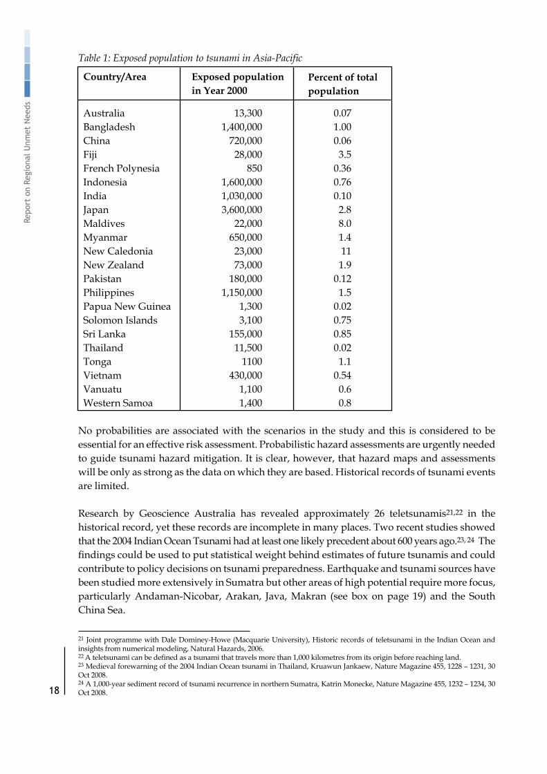
A recent study on “Risk Assessment andMitigationMeasures for Natural- and Conflict-RelatedHazardsinAsia-Pacific”commissionedbyOCHARegionalOfficeforAsiaandthePacificBangkokandcarriedouttheNorwegianGeotechnicalInstitute(NGI),presentedafirst-pass assessment of the tsunami hazard and population exposure based on today’s knowledge using a deterministic scenario approach.19ThetsunamihazardmapforAsiaandthePacificisshown in Figure 3, and the number of people exposed is listed in Table 1.
17 “IOCUNESCOWorkshoponIndianOceanTsunamiHazardAssessment”,Bandung,Indonesia,17-18July2007,FinalReport.18Tsunamiscanbegeneratedwhentheseafloorisupliftedordown-dropped,pushingtheentirewatercolumnupordown.Thepotential energy that results from pushing water above mean sea level is then transferred to horizontal movement of the tsunami wave propagation . (Source: USGS)19“RiskAssessmentandMitigationMeasuresforNatural-andConflict-RelatedHazardsinAsia-Pacific”,OCHARegionalOfficeforAsiaandthePacificBangkok,January2009.

17
Tsunami Early W
arning Systems in the Indian O
cean and Southeast Asia
Figure 3: NGI “first pass”tsunami hazard map for Asia-Pacific. Note: The coastal areas without a level of tsunami hazard indicated on the map mostly represent areas where no data are available.
Maximum wave run-up of more than 10m was estimated along the coast of Pakistan. These waves are associated with short travel times, and there is hence little time for warning. In the neighbouring shorelines in India, the waves are an order of magnitude smaller. For the Bengal Bay and Andaman Sea coastlines, potentially destructive waves of 5-8m are found at Andaman, Nicobar, a small section of the Myanmar coastline and Sri Lanka. In India, Bangladesh and Myanmar almost 3 million people are exposed to tsunami hazard.18
Indonesia is the country exposed to the largest wave run-ups, ranging from 5 to 20m over large parts of the country. Short travel times are often associated with tsunami impact in Indonesia,whichmakestsunamiearlywarningdifficult.TheexposedpopulationinIndonesiaexceeds 1.5 million. Similarly, a large number of people could be exposed to large waves in the Philippines. Large population exposure is also found for Viet Nam and China, but in these countries the tsunami risk is lower, both because of the smaller waves expected and longer travel times and hence increased possibilities of early warning.20
20“RiskAssessmentandMitigationMeasuresforNatural-andConflict-RelatedHazardsinAsia-Pacific”,OCHARegionalOfficeforAsiaandthePacificBangkok,January2009.
18
Repo
rt o
n Re
gion
al U
nmet
Nee
ds
Table 1: Exposed population to tsunami in Asia-Pacific
Australia 13,300 0.07 Bangladesh 1,400,000 1.00 China 720,000 0.06 Fiji 28,000 3.5 French Polynesia 850 0.36 Indonesia 1,600,000 0.76 India 1,030,000 0.10 Japan 3,600,000 2.8 Maldives 22,000 8.0 Myanmar 650,000 1.4 New Caledonia 23,000 11 New Zealand 73,000 1.9 Pakistan 180,000 0.12 Philippines 1,150,000 1.5 Papua New Guinea 1,300 0.02 Solomon Islands 3,100 0.75 Sri Lanka 155,000 0.85 Thailand 11,500 0.02 Tonga 1100 1.1 Vietnam 430,000 0.54 Vanuatu 1,100 0.6 Western Samoa 1,400 0.8
No probabilities are associated with the scenarios in the study and this is considered to be essential for an effective risk assessment. Probabilistic hazard assessments are urgently needed to guide tsunami hazard mitigation. It is clear, however, that hazard maps and assessments willbeonlyasstrongasthedataonwhichtheyarebased.Historicalrecordsoftsunamieventsare limited.
Research by Geoscience Australia has revealed approximately 26 teletsunamis21,22 in the historical record, yet these records are incomplete in many places. Two recent studies showed that the 2004 Indian Ocean Tsunami had at least one likely precedent about 600 years ago.23, 24 The findingscouldbeusedtoputstatisticalweightbehindestimatesoffuturetsunamisandcouldcontribute to policy decisions on tsunami preparedness. Earthquake and tsunami sources have been studied more extensively in Sumatra but other areas of high potential require more focus, particularly Andaman-Nicobar, Arakan, Java, Makran (see box on page 19) and the South China Sea.
Exposed populationin Year 2000
Country/Area Percent of totalpopulation
21 JointprogrammewithDaleDominey-Howe(MacquarieUniversity),HistoricrecordsofteletsunamiintheIndianOceanandinsightsfromnumericalmodeling,NaturalHazards,2006.22 Ateletsunamicanbedefinedasatsunamithattravelsmorethan1,000kilometresfromitsoriginbeforereachingland.23 Medieval forewarning of the 2004 Indian Ocean tsunami in Thailand, Kruawun Jankaew, Nature Magazine 455, 1228 – 1231, 30 Oct 2008.24 A 1,000-year sediment record of tsunami recurrence in northern Sumatra, Katrin Monecke, Nature Magazine 455, 1232 – 1234, 30 Oct 2008.

19
Tsunami Early W
arning Systems in the Indian O
cean and Southeast Asia
Makran - One of the subduction zones which requires more studySources: National Report submitted by the Islamic Republic of Iran to the ICG/IOTWS - V (also map below)and“IOCUNESCOWorkshoponIndianOceanTsunamiHazardAssessment”Bandung,Indonesia, 17-18 July 2007, Final Report.
The northwestern Indian Ocean has experienced some deadly tsunamis but little research work has been devoted to tsunami hazard assessment in this region. In 1945 a fault rupture resulted in a largetsunami.Historicaldatahas indicatedthatother tsunamisoccurredin326BC,1008,and1897. It is thought that GPS observations are urgently needed along the Makran coast and more paleotsunami studies. A preliminary estimation of the hazard is calculated for each area of the coastline and numerical modeling is performed for each source scenario. The maximum tsunami wave heights along the coasts are then calculated to show the locations facing the greatest threats. The University of Tehran is working on developing three models, a generation model, a propagation model and an inundation model, to help predict potential tsunamis in the Gulf of Oman, in the Makran Subduction Zone.
4.5 Community Vulnerability Assessment
Vulnerability assessments are expanding but coverage is still low. In general, information on social, economic and environmental factors that increase vulnerability is inadequate. The vulnerability of groups who lack effective connections to the early warning systems such as rural poor, urban poor, ethnic minorities, handicapped persons, elderly, children, and foreigners such as refugees, migrant workers and tourists requires more analysis and inclusion of those groups in discussions of their vulnerability.
Coastal Community Resilience (CCR) is a general methodology for assessing the relative vulnerabilities of a community using an eight point scale including factors like national resource management, early warning and institutional frameworks for DRR. Building on local knowledge and needs, this initiative supported integrated and more standardized hazard awareness and mitigation efforts particularly by agencies working in local communities and helping them to prioritize DRR activities. With support of the ESCAP Tsunami Regional Trust Fund,ADPChastrainedofficialsfromSriLankaandMaldivesinCCRassessmentandcarriedout CCR assessments of pilot sites in both countries. In February 2008, ICG/IOTWS WG 6

20
Repo
rt o
n Re
gion
al U
nmet
Nee
ds
organized a workshop on Approaches to CCR at its inter-sessional meeting. The workshop brought together various approaches to CCR and their role in developing integrated disaster risk management in the coastal communities around the Indian Ocean.
4.6 Risk Assessment
Prior to the Indian Ocean tsunami of 2004, there were very limited efforts in undertaking risk assessments in the countries affected. Risk information was largely based on limited historical records of events and most were inadequate to impress decision makers and the public to take the appropriate action to minimize these risks.
Since the 2004 tsunami, a number of tsunami risk assessments have been completed or are underway. In Thailand, a tsunami risk assessment was completed in 2007 using a scenario approach based on the 2004 event from a single source, i.e. Sumatra tsunamigenic earthquake. In Indonesia, a risk assessment is being undertaken with high local resolution. In Sri Lanka, at least one district has been a subject of a tsunami modeling study and several districts have had risk assessments using community participatory approaches. In southern coastal states of India, the government is scoping a risk assessment study that will attempt to map hazards ofimportantconcernincoastalcommunities.MeanwhileinMaldives,anationalriskprofilewas completed and at least nine islands are being subjected to a detailed multi-hazard risk assessment study.
IOC UNESCO, in cooperation with the UNDP Regional Centre in Bangkok (UNDP RCB), and within the framework of ICG/IOTWS WG3, has developed standardized Guidelines for Tsunami Risk Assessment and Mitigation. The purpose of the Guidelines is to provide a description of basic and best-practice methodologies and case studies for conducting tsunami risk assessments and for developing effective mitigation solutions. The Guidelines were adopted by ICG/IOTWS - VI in April 2009, will be published as an IOC UNESCO Technical Publication and will be available to all IOC UNESCO Member States.
4.7 Information Storage and Accessibility
An overview of various national, regional and global data collection, storage and analysis methods was presented in the 2006 “Workshop to Improve the Compilation of Reliable Data on Disaster Occurrence and Impact” and served to reveal the wide variety of tools in use in the region. As is the case regionally, national level data collection, storage and access suffer from a lack of standardization, limited access to data and unreliable data.25 A sustainable approach to database development would include development of comprehensive systems, ensuring that data is compatible among systems, and competent and motivated human resources to manage the systems.
Government policies may be lacking in regard to supporting the appropriate use of data and there may be different modes of access and storage. In the tsunami-affected countries, UNDP RCB is supporting governments to build capacity for utilizing the DesInventar methodology, which collects homogeneous data on disasters of all scales. Notable achievements to date
25 Workshop to “Improve the Compilation of Reliable Data on Disaster Occurrence and Impact” April 2-4, 2006, jointly organized by the Centre for Research on the Epidemiology of Disasters (CRED) and UNDP Bangkok.

21
Tsunami Early W
arning Systems in the Indian O
cean and Southeast Asia
include the increasing use of the database and analysis by the Government focal organizations in Sri Lanka, Indonesia and in Tamil Nadu, India. These databases are currently being used to develop a report that analyzes the interface between disaster risks and poverty using a pioneering methodology. Databases in Iran, Nepal and Orissa State, India are also analyzed as the region’s contribution to the upcoming ISDR System Global Assessment Report 2009. When completed, the analysis generated is expected to guide policy makers in using disaster risk reduction in poverty alleviation programmes.
4.8 Priorities/Recommendations
1. Support research on historical records of tsunami events. Special focus is required for areas of high potential risk that have not been studied extensively, particularly Andaman-Nicobar, Arakan, Java, Makran and the South China Sea.
2. Continue support to increase the coverage of vulnerability assessments, in particular at the local level.
3. Support development and application of standardized risk mapping and risk assessment guidelines.
4. Promote capacity development for standardized information storage, system compatibility, data accessibility and their use for disaster risk reduction.

22
Repo
rt o
n Re
gion
al U
nmet
Nee
ds
Monitoring and Warning Service
5.1 Summary
SeismicandsealevelstationshavebeeninstalledtofillgapsintheregionalTEWSnetwork.Countries face a challenge in terms of the needed expertise and providing allocated funding to manage and sustain the stations. Ongoing support for operation and maintenance will be needed to maintain the performance of the regional monitoring and warning network over the long-term. Six countries and one regional institution have expressed willingness to commence the transition process to become a Regional Tsunami Watch Provider (RTWP), which three countries have already started.
5.2 Introduction
Monitoring and warning services form a critical component of the TEWS as there must be a soundscientificbasis forpredictingand forecastinghazardsanda reliable forecastingandwarning system that operates 24 hours a day. Continuous monitoring of hazard parameters and precursors is essential to generate accurate warnings in a timely fashion. Where possible, tsunami warning services should be coordinated with warning services for other hazards to gainthebenefitofsharedinstitutional,proceduralandcommunicationnetworks.26
5.3 Institutional Mechanisms
For regional watch advisories, ICG/IOTWS Member States have decided that having several Regional Tsunami Watch Providers (RTWPs) is the preferred mode of operation rather than a single provider. This may have advantages in terms of redundancy and for technical reasons, given the large number of tsunamigenic subduction zones in the Indian Ocean region. Essentially, the RTWPs will support an interoperable tsunami watch system for the Indian OceanthataimstoemulatetheinterimserviceprovidedbyPacificTsunamiWarningCentre(PTWC) and the Japan Meteorological Agency (JMA), with enhanced capability to help advise those countries most at threat. In the longer-term, it is envisaged that RTWPs will support the development and provision of enhanced tsunami warning services by National Tsunami Warning Centres (NTWCs). As more detailed bathymetry and coastal topography information becomes available to NTWCs, these centres will be able to undertake more detailed inundation studies to determine tsunami threat more accurately at the national level.27
The two-tier interoperable system of Regional Tsunami Watch Providers (RTWP) and National Tsunami Warning Centers (NTWCs) will be in place where:28
• Nationsareresponsibleforissuingwarningswithintheirownterritories;• Relatedrelevantinformationwillbefreelyavailable;
26 ISDR (2006) Third International Conference on Early Warning, Developing Early Warning Systems: A Checklist.27 IOC UNESCO (2008) Indian Ocean Tsunami Warning and Mitigation System (IOTWS), Implementation Plan for Regional Tsu-nami Watch Providers, IOC Information Series No. 81. 28 Indian Ocean Tsunami Warning and Mitigation System IOTWS. Implementation Plan, Third Session of the Intergovernmental Coordination Group for the Indian Ocean Tsunami Warning and Mitigation System (ICG/IOTWS-III), Bali, Indonesia, 31 July – 2 August 2006, IOC Technical Series No. 71, UNESCO 2006.

23
Tsunami Early W
arning Systems in the Indian O
cean and Southeast Asia
• Some nations will derive their own warnings from primary seismic and sea-levelobservationsandseismicandoceanmodels;
• Other nationswill receivewatches based on bilateral arrangementswithRTWPs thatshould assist them in preparing and issuing their own national warnings.
The roles and responsibilities of a RTWP are:29 • Determineandprovidetimelyinitialearthquakeinformation(magnitude,location,depth,
time,confidencelevels);• Determine more specific threat information using output from scenario databases
producedbytsunamimodels,usingearthquakesourceinformationandverifiedbysealevelinformation;
• ProvidetimelytsunamiwatchinformationforuseinpreparationandissuingofnationaltsunamiwarningsbyNTWCs;
• Provide timely standardized SituationReports (SitReps) for use by otherRTWPs andNTWCs;
• ShareinformationwithotherRTWPsandNTWCsvia,forexample,GTS,websites,RSSfeeds,fax,emails,etc,instandardformats;
• Coordinateupdates,cancellationandfinalizationadvicewithRTWPs;• Regulartestingandexercisestodeterminesystemperformance(includingcommunication
channelstoNTWCs,decisiontools,etc.);• Performcalibrationandvalidationofdetectionandforecastingtoolsandmodels;• Define theirownregionforprovisionofservice,whichmay include thewhole Indian
Ocean, or a sub-region.
A two year transition period is envisaged for RTWPs to run in parallel with the PTWC and JMA, until the service can ultimately be taken over completely by the RTWPs.29 The NTWCs, operating within their own legal frameworks, will be free to negotiate bilateral agreements with RTWP(s) from which they wish to access tsunami watch information.
For sustainability purposes, the timely development of RTWPs is critical yet the locations and countries of responsibility have not been completely determined. There are also some questions whether the RTWPs can provide the services needed by the most vulnerable NTWCs and what the conditions will be for providing the services. Several stakeholders have expressed willingness to commence the transition process, these are: Australia, India, Indonesia, Iran, Malaysia, Thailand and ADPC.30 India has commenced the transition process in June 2008, Australia in August 2008 and Indonesia in January 2009.
The Governments of Bangladesh, Cambodia, China, Lao PDR, Maldives, Myanmar, Philippines, Sri Lanka, Thailand, and Viet Nam agreed in 200631 to establish an operational end-to-end multi-hazard early warning centre for the Indian Ocean and South China Sea. ADPC is establishing a regional facility for TEWS, based on that agreement. In light of the regional scope and likely economies of scale, the ESCAP Tsunami Regional Trust Fund is supporting developmentofthefacilityaswellasitsoperationfortwoyears.Toenablenationalfinancial
29 IOC UNESCO (2008) Indian Ocean Tsunami Warning and Mitigation System (IOTWS), Implementation Plan for Regional Tsu-nami Watch Providers, IOC Information Series No. 81. 30 IOC UNESCO (2008) Fifth Session of the Intergovernmental Coordination Group for the Indian Ocean Tsunami Warning and Mitigation System, Kuala Lumpur, Malaysia.31MeetingonRegionalCooperationonEarlyWarningArrangements,PreparednessandMitigationofNaturalHazards,14July2006, Bangkok, Thailand.

24
Repo
rt o
n Re
gion
al U
nmet
Nee
ds
systems to incorporate collaborating country support into their annual budgetary processes, the Maldives Meteorological Service is implementing a system sustainability plan. Collaborating countries’formalcommitmentstofinanciallycontributetosystemsustainabilityarehopedtobe made shortly. The sustainability of the ADPC regional facility will depend on the continued contributions from Member States.
When the RTWPs become operational, they will issue the following messages: 1) an Earthquake Alert message for potentially tsunamigenic under-sea earthquakes as soon as possible after the event’s detection, followed by 2) a Tsunami Detection Alert message within 15 minutes ofdetection, and,3)ANilTsunamiAdvisoryprovidingconfirmation.32 Together with the NTWCs, they should adhere to internationally agreed-upon public messages in interoperable formats. Confusion among users will be minimized if these public messages are similar in name and content from one centre to the next.
At the national level, institutions, generally the NTWC, have been selected to take the lead on tsunami monitoring and warning, in many cases the national meteorological organization conducts monitoring activities and issues warnings in conjunction with the NTWC and/or Emergency Operations Centers. Most central institutions have monitoring staff on duty 24/7 to issue warnings on the appropriate levels but some may lack staff and resources to maintain 24/7 vigilance at more remote locations. This weakness forms one of the vulnerable links in the end-to-end chain.
5.4 Monitoring Systems
The post-event survey undertaken by the IOC Secretariat following the 12 September 2007 tsunami event indicated strengthened national monitoring systems. Of the 21 Member State respondents: • Many (12) NTWCs undertook their own earthquake analysis.• Most Member States (19) took some action after receiving the PTWC/JMA bulletin.• Many (13) Member States monitored sea level. • Some (8) Member States used numerical models in their analysis.33
Plans have been developed by ICG/IOTWS on seismic and sea level detection networks. Several elements of these plans to install and/or upgrade seismic and sea level stations have been addressed by UN (e.g. by IOC UNESCO and ESCAP’s Tsunami Regional Trust Fund), regional, and national entities, including in the South China Sea and Bay of Bengal areas.
5.4.1 Seismic Data
There are two categories of seismic stations, some form part of the core regional network coordinated by IOC UNESCO, whereas others are additional stations for improved coverage primarily at the national level. To form the core network, seismic stations meeting certain qualificationshavebeenselectedtoprovideessentialseismicdatarelevanttomonitoringand
32 Indian Ocean Tsunami Warning and Mitigation System IOTWS. Implementation Plan, Third Session of the Intergovernmental Coordination Group for the Indian Ocean Tsunami Warning and Mitigation System (ICG/IOTWS-III), Bali, Indonesia, 31 July – 2 August 2006, IOC Technical Series No. 71, UNESCO 2006.33 Indian Ocean Tsunami Warning and Mitigation System (IOTWS) “12 September 2007 Indian Ocean Tsunami Event – Post Assess-ment of IOTWS Performance”, Intergovernmental Oceanographic Commission, Technical Series 77, UNESCO 2008.

25
Tsunami Early W
arning Systems in the Indian O
cean and Southeast Asia
detecting earthquakes that can trigger tsunamis, and some new sites have been proposed. In addition to the core network of the Indian Ocean, national seismic networks are necessary to addressspecificnationalrequirementsandconstraints.34
As of April 2009, 73 of 80 core network seismic stations were in operation in the Indian Ocean region. Not all countries have the needed expertise and allocated funding to manage the stations and guidance documents have been made available by ICG/IOTWS to all Member States. Although it is considered to be critical by IOC UNESCO that seismic waveform data is shared in real-time, not all seismic stations are currently available in real-time.
National seismic networks are at various stages of development. These include stations that arepartofthecoreregionalnetworkaswellasadditionalstationstailoredtospecificnationalneeds. Some examples:• Australiahasnearlycompletedinstallingitsseismicstations.• Singapore’s network has been consistently improved since 2004, the goal is to have
7 stations.• Indonesiaplanstohaveatotalof160seismicstations.• IndiaopeneditsnationalEarlyWarningSystemforTsunamisandStormSurgesinOcto-
ber 2007 and has installed a network of seismic stations.
Figure 4: Core Regional Seismic Network for the Indian Ocean34
Most national seismic networks allow free access to their data and those currently not sharing have been asked to reconsider. The IOC UNESCO data sharing policy stipulates a free exchange of data between Member States and this will be extended to include real-time waveform data. The need for free exchange of real-time seismic waveform data is one of the six key recommendations of the Fifth Session of the ICG/IOTWS. To accomplish this goal, training of NTWC staff is critical. The potential RTWPs have been requested by the ICG/IOTWS to assist with the design of the required training material and to conduct the training.
34 Indian Ocean Tsunami Warning and Mitigation System IOTWS, Implementation Plan, Third Session of the Intergovernmental Coordination Group for the Indian Ocean Tsunami Warning and Mitigation System (ICG/IOTWS-III), Bali, Indonesia, 31 July – 2 August 2006, IOC Technical Series No. 71, UNESCO 2006.

26
Repo
rt o
n Re
gion
al U
nmet
Nee
ds
5.4.2 Sea Level Data
Real-time sea level observations are a key element in TEWS as these observations are used to helpconfirmtheexistenceofamajortsunamiortocancelatsunamiwatchorwarningfollowingan earthquake. Real-time sea level data together with numerical modeling output is important to provide improved tsunami forecasts. Two types of measurement systems are used to detect the presence and character of tsunami waves: coastal sea level stations, typically installed in harborsandatpiers,anddeepoceanstationsusingocean-floorpressuresensors.35
The global network of coastal sea level stations established under the IOC UNESCO Global Sea Level Observing System (GLOSS) forms the basis of the initial sea level monitoring for the basin-wideIOTWS.Thesesiteshavebeenidentifiedbecauseoftheprovenquality,relevance,and long-time availability of the data. These stations are part of a multi-user/multi-purpose sea level observing network that serves both research and operational purposes (e.g., monitoring long-term sea level change, storm surge monitoring, and port operations). The multi-purpose nature of these stations maximizes the likelihood of ongoing maintenance and the continued functioning of the sea level network.35
Over 120 coastal stations are in place and 64 are transmitting real-time data using GTS.36 The ESCAP Tsunami Regional Trust Fund has supported the installation of four sea level stations in Myanmar, Philippines and Vietnam. Five more station installations are planned by the end of 2010. All in all, there are a relatively small number of sea level stations to cover the region. This is due to fundingpriorities and/or technical difficulties in upgrading and sustainingsome of the stations. A major challenge is to maintain and broaden the user base for these observing networks. Some countries have mechanisms, structures, and funds in place to carry this forward while others will need to develop them.35
35 Indian Ocean Tsunami Warning and Mitigation System IOTWS, Implementation Plan, Third Session of the Intergovernmental Coordination Group for the Indian Ocean Tsunami Warning and Mitigation System (ICG/IOTWS-III), Bali, Indonesia, 31 July – 2 August 2006, IOC Technical Series No. 71, UNESCO 2006. 36AsdefinedintheWMOTechnicalRegulations(WMOPublicationNo.49),theGlobalTelecommunicationSystem(GTS)isthecoordinated global system of telecommunication facilities and arrangements for the rapid collection, exchange and distribution of observations and processed information within the framework of the World Weather Watch (WWW). It is implemented and oper-ated by National Meteorological Services of WMO Members and also a few International Organizations (ECMWF, EUMETSAT). GTS consists of an integrated network of point-to-point circuits, and multi-point circuits, which interconnect meteorological telecom-munication centres.

27
Tsunami Early W
arning Systems in the Indian O
cean and Southeast AsiaFigure 5: Current and planned sea level stations in the Indian Ocean.37
Sea level measurement at deep ocean stations (“tsunameters”) is critical to improve the rapid detection and forecast of tsunamis, as they can be deployed offshore, near tsunamigenic areas. Apart from their value in early wave detection, they also provide “clean” open ocean wave signatures that can be correlated with forecast models.38 The deep ocean network consists of 19 stations with a further 13 planned for deployment. A major issue plaguing the deep ocean network is vandalism and accidental damage, particularly arising from interaction with fishingactivities.Thisincreasestheriskofnon-transferofdataandweakenssustainabilityofthe deep ocean system.
37 Map of sea level stations is provided by IOC UNESCO.38 Indian Ocean Tsunami Warning and Mitigation System IOTWS, Implementation Plan, Third Session of the Intergovernmental Coordination Group for the Indian Ocean Tsunami Warning and Mitigation System (ICG/IOTWS-III), Bali, Indonesia, 31 July – 2 August 2006, IOC Technical Series No. 71, UNESCO 2006.

28
Repo
rt o
n Re
gion
al U
nmet
Nee
ds
Figure 6: Indian Ocean Deep Ocean Sea Level Measurement Network.39
At the national level, several countries are making efforts to upgrade their sea level network, whichisusefultomonitorstormsurgesandflooding,oftenaspartofamulti-hazardwarningsystem approach. Collaborations have been established between countries like Australia, Germany, Indonesia, Malaysia, Thailand and USA including a range of technical collaborations and cooperation on contribution and deployment of tsunameter instruments.40
The need for free exchange of real-time sea level data among Member States is one of the six key recommendations of the ICG/IOTWS–V Conference. In addition, Member States are urged to promote awareness and explore possible means to reduce the intensive and ongoing vandalism on tsunameter buoys and to report to the ICG/IOTWS. Member States needtoconsiderlong-termfinancialandin-kindsupporttoensuresustainabilityofsealevelinstrumentation networks and their maintenance.
5.5 Forecasting and Warning Systems
Significantadvancesarebeingmadeworldwideinthedetectionofearthquakes.TheUS-basedNational Earthquake Information Center (NEIC) has access to about 1,000 seismic stations which has reduced the time needed to process information by early warning centers and disseminate a warning message to national/regional/local authorities globally to less than 20 minutes (and to only 5 minutes in the US).
39 Map of Deep Ocean Sea Level Stations is provided by IOC UNESCO.40 Tsunameters are deep-ocean stations for sea level measurements.

29
Tsunami Early W
arning Systems in the Indian O
cean and Southeast Asia
Numerous new monitoring and forecasting tools have been developed and some have been shared in the region. These include:
• PAGER (Prompt Assessment of Global Earthquakes) which combines ShakeMaps41 with population exposure to come up with estimates of numbers of people who were exposed to strong ground shaking. This will be made publicly available on the internet.
• SEisComp(SeismologicalCommunicationProcessor)isfreesoftwaredevelopedbytheGermanResearchCenterforGeoSciences–HelmholtzCenterPotsdam(GFZ)andusesSeedLink42 as a core protocol and has been running in Indonesia since May 2007.43 It was tested on September 12, 2007 and the BMG (Indonesian Meteorological and Climatologi-calOrganization)madethetsunamiwarningin5minutesandthelocationwasfixedin4minutes. SEisComp is also installed in several other countries.
• TheNationalUniversityofSingaporehasdevelopedamethodologyforcalculatingmag-nitudes of large earthquakes, using a few reliable seismic stations and comparing results withtheUSGS;thecomputationscanbecompletedin15-20minutes.
• TheNEIChasdevelopedPQLX,asoftwaretooltoevaluateseismicstationperformance,which sits on top of the station database – it can help with determining detection thresh-olds and time and location errors.
5.6 Priorities/Recommendations1. Promotelong-termfinancialandin-kindsupporttoensuresustainabilityofseismicand
sea level instrumentation networks and their maintenance. 2. Promote use of the network of sea level and seismic stations for multi-hazard purposes
to maximize the likelihood of ongoing maintenance and the continued functioning of the network.
3. Conduct a network-wide effectiveness review to analyze geographic coverage.4. Promote national support for real-time, timely, free and open access to data, analysis, and
other information products for (tsunami) warning purposes.
41 ShakeMap is aproduct of theUSGSEarthquakeHazardsProgram in conjunctionwith regional seismicnetworkoperators.ShakeMapsitesprovidenear-real-timemapsofgroundmotionandshakingintensityfollowingsignificantearthquakes.42 The SeedLink protocol is a robust data transmission intended for use on the Internet or private circuits that support TCP/IP. The protocol is robust in that clients may disconnect and reconnect without losing data, the transmission is started where it ended. All data packets are 512-byte Mini-SEED records. 43 In Jakarta, the new version of the seismology software package “SeisComP3” replaces an older one that only worked automati-callyanddidnotincludesufficientvisualcontrolandinteraction.(GFZwebsite).

30
Repo
rt o
n Re
gion
al U
nmet
Nee
ds
Communication and Dissemination of Warnings
6.1 Summary
There is a clear need to strengthen systems of dissemination and communication, in particular at the downstream level. Several countries are developing Standard Operating Procedures (SOPs) for tsunami warnings, but these are fully developed and tested only in a few countries. Significantgapsincludeeffectiveandredundantchannelsofcommunicationtothecommunitylevel, and design of clear warning messages that are understandable to end users. To a large extent,thechannelsofcommunicationavailablefordisasterwarningsmayreflecttheoveralldevelopment of communications networks in a country.
6.2 Introduction
The purpose of dissemination and communications systems is to ensure that people and communities are warned in advance of impending tsunami and earthquake events. Warnings must reach those at risk and contain clear messages with simple useful information that will enable the appropriate responses to save lives and livelihoods. Regional, national and community level communication systemsmust be pre-identifiedwith formal confirmationregarding authorities who will issue the messages. The use of multiple communication channels is important to ensure that as many people as possible are warned, to avoid failure of any one channel and to reinforce the warning message. The systems should facilitate national and regional coordination and information exchange.44
The post-event survey undertaken by the IOC Secretariat following the 12 September 2007 tsunami event indicated some positive changes in regard to dissemination and communications but there is a clear need to focus on strengthening systems at the downstream level. Most of the negative outcomes of the survey can be addressed both by the ICG/IOTWS and at the national level through a comprehensive capacity development process and regional cooperation. Post-event assessments can assist in this process by highlighting the strengths and weaknesses of the IOTWS at regional, national and local levels and by raising the awareness of how Member States responded, both individually and collectively.45
44 ISDR (2006) Third International Conference on Early Warning, Developing Early Warning Systems: A Checklist.45 Indian Ocean Tsunami Warning and Mitigation System (IOTWS), “12 September 2007 Indian Ocean Tsunami Event – Post Assess-ment of IOTWS Performance”, Intergovernmental Oceanographic Commission Technical Series 77, UNESCO 2008.

31
Tsunami Early W
arning Systems in the Indian O
cean and Southeast Asia
Table 2: Outcomes of the IOC UNESCO Survey
This chapter contains some examples of issues and good practices based partially on the post-event survey national reports (undertaken by the IOC Secretariat following the 12 September 2007 tsunami event46) and reports supported by UNDP Regional Office in Bangkok oninstitutional and legislative systems for early warning in Indonesia, Sri Lanka and Thailand.
6.3 Organizational and Decision Making Processes
While progress has been significant in recent years with passage of legal instruments tosupport emergency management in many countries, procedures may require formalization for numerous aspects of dissemination and communication. There are many national actors who must be coordinated in terms of their responsibilities for informing the general public. These include government staff, from the President or Prime Minister and armed forces to regional centres, national centres, and local authorities including governors, mayors, and police. Others include public and private (such as amateur radio operators) media, tourist destinations, civil society and communities.
The people who support the warning system require training and education regarding the roles they should play, including the smaller administrative units and communities. Many ofthestakeholderswhocouldcontributesignificantlytoeffectivewarninghavenotreceived
Positive outcomes Negative outcomes
•SeveralMemberStatesexperienceddelays in receiving watch bulletins from PTWC/JMA.
•SomeMemberStatesexperienceddownstream communications problems.
•SomeMemberStatesissuedwarnings after other Member States had cancelled their warnings.
•InsomeMemberStates,evacuationswere ordered when a closer analysis of the event may have indicated that the tsunami risk was low. The positive side of this is that it is good practice for the communities involved but the negative side is that it can build complacency.
•InsomeMemberStatestherewasconfu-sion over the need to evacuate and dis-connection between national and local decision making.
46 Indian Ocean Tsunami Warning and Mitigation System (IOTWS), “12 September 2007 Indian Ocean Tsunami Event – Post Assessment of IOTWS Performance”, Intergovernmental Oceanographic Commission Technical Series 77, UNESCO 2008.
•All(21outof21respondents)NTWCs received watch bulletins from PTWC/JMA.
•15NTWCsreceivedwatchbulletinviathe GTS.
•Indonesialocatedtheearthquakehypocentre and issued a warning within 5 minutes of the event.

32
Repo
rt o
n Re
gion
al U
nmet
Nee
ds
sufficienttrainingortheyarenotfullyengagedindialogueonhowtosupportthepublic.Insome countries much work is carried out by Red Cross and Red Crescent volunteers while in others volunteers need to be brought more fully on board. Adequate budgets are vital in the provinces and districts to upgrade equipment and devices. There should be more signing of Memorandums of Understanding (MoUs) or Letters of Agreement (LoAs) for interagency collaboration and streamlining of the warning system.
SOPs may not be in place or sufficiently vetted to guide these actors or SOPs may beorganization-centricandnotunified.Someoftheseactorsdonotoperate24/7socoordinationwill be critical to disseminate messages, particularly at night-time. People with authority must wait for the data to be analyzed in order to avoid false alarms. Authorities often express fear of issuing false alarms due to potential negative legal effects or public outcry and worry about the margin of error in analysis. Bureaucratic processes may cause delays in dissemination of information and action. Any confusion over government roles and authorities and inadequate collaboration among information providers reverberates with the media and the public who may be skeptical about the sources of messages and the messages themselves. Severalinitiativeshaveaddressedtheneedforgreaterclarificationofroles.AseriesoffourSOP workshops47 took place between October 2006 and May 2007 in Indonesia and focused on warning and information dissemination including the development of a dissemination strategy that includes interconnecting policies between national and local levels, tools and equipment for warning dissemination, SOPs for warning dissemination at the local level, and message content that can be understood by communities. The ESCAP Tsunami Regional Trust Fund is supporting a series of regional and national workshops implemented by IOC UNESCO to strengthen national capacity to develop SOPs.
6.4 Effective Communication Systems and Equipment
The dissemination of data and early warning messages is undertaken in numerous ways including by telegraph, telephone (mobile, fixed), facsimile, TV, radio, cellular operators,mosques, churches, hitting bamboo or drums, and sirens. Electronic communications systems are subject to power outages and failure or overloading, so alternatives such as manual sirens and loudspeakers are important. Key actors in communication include the local police and disaster managers, among others, who must be capable of effectively communicating warning messages.
Warningtowershavebeeninstalledextensivelyintheregion;SriLanka’sgoalistoinstallover200 while Thailand intends to reach nearly 150. A critical issue regarding the siren towers is that redundancy is important to back up the tower functions in order to effectively reach all at risk. Regulations need strengthening for tower operation and the operators and the public require training and education as to how the system works. Adequate funds are needed to maintain and inspect the towers.
In general, limited progress is being made on community-based early warning systems. Community leadership for early warning needs to be established as well as effective methods of communicating to people with limited access to technology. A programme currently
47 Sponsored by UNDP, USAID, GTZ and The Indonesian Red Cross/IFRC.

33
Tsunami Early W
arning Systems in the Indian O
cean and Southeast Asia
underway by the Stockholm Environment Institute (SEI) Asia focuses on “Early Warning and Community Preparedness: Strengthening the Technology – Community Interface”. A study within the programme “From knowledge to action: learning to go the last mile”, aims to collect good practices to promote enabling circumstances for reaching people and results should be availableattheendof2008.ThevisionistoexpandupontheresultsoftheLastMileHazardWarning System developed by Sri Lankan organization Sarvodaya, which highlights use of addressable satellite radio (AREA) sets plus GSM/CDMA phones. The pilot system was put into action on the day of the September 12, 2007 Bengkulu tsunamigenic earthquake and regular alerts were successfully sent to Sarvodaya villages.
6.5 Warning Messages
Creating effective warning messages and disseminating them is extremely challenging. Even warningmessagesthataregloballyacceptedmaynotprovidesufficientguidanceonresponseactions.Althoughmessagesmaybeclear,theymaynotflowdownstreamefficientlyinorderto reach everyone at risk. Two major access problems are 1) messages transmitted during the nightdonotreachpeoplewhiletheyaresleeping;and2)messagesmaynotbetransmittedin all of the appropriate languages to be understood, for example, by immigrants, migrant workers, or tourists.
Warning statements should not evoke curiosity or panicky behavior and rumor control action should be taken. A clear and phased formulation of warning messages should help to create public trust that warnings are well founded. For verbal language messages, the wording turns out to be very important - warning messages that lack clarity can cause public confusion. There may be limited feedback to the warning centers as to whether warnings have been successfully received and understood by relevant agencies and the public. The actual general warning format may not be well known by most local stakeholders involved in warning dissemination. Some communities have been confused by messages relayed by signal or siren towers. Efforts are currently underway by many organizations to understand how people comprehend the various messages.
A particular problem is the need for interpretation of news bulletins to the public, otherwise, for example, an earthquake of around 5 on the Richter scale may cause panic. The technical information has to be backed up with the human relationship aspects. The assistance of community leaders should be sought to help in explaining the threat and a warning should be followed by subsequent information and an all clear signal given when the threat of disaster has passed.
6.6 Priorities/Recommendations
1. Continue to support development of Standard Operating Procedures (SOPs) from the regional to the national, provincial and local levels.
2. Continue programmes to strengthen channels of communication for warning messages from the national to local levels, including strengthening of communications networks where feasible.
3. Strengthentheefficacyofwarningmessages,e.g.throughregularuserfeedback,involvingother stakeholders such as the media in their development, and training end users.
34
Repo
rt o
n Re
gion
al U
nmet
Nee
ds
Response Capability
7.1 Summary
Intensive and innovative work on community preparedness and response strategies is carried out in many countries in selected areas. A comprehensive programme is not available in most cases. Many tsunami drills have been carried out in the region since the Indian Ocean tsunami, although there is no comprehensive regional programme for drills and other assessments of the status of the TEWS over the long-term. There are numerous actors involved in this area of work and also many gaps in education, awareness, and operating procedures.
7.2 Introduction
This chapter focuses on the activities that should occur when a warning or watch has been disseminated. The success of these activities is dependent on the quality of planning and capacity building that has taken place before the event, including all measures discussed in previous chapters, such as putting enabling policies and plans in place, building credibility of regional and national institutions, development of hazard maps and models, monitoring ofseismicityandsea level,analyzingandbuildingscientificandcommunitycapacity,andcommunication of information on hazards to the public. Response activities should feed back into the longer term strategy through sharing of lessons.
It is to be stressed that response capacity is an extremely broad area and that numerous actors are involved. To give full credit to the complexities of the response systems is beyond the scope of this study. Further, effective response is predicated upon the planning and strategic involvement of many stakeholders and experts, in areas including but not limited to climate change, natural resource management, gender, child protection, poverty reduction, infrastructure planning, military, police, and emergency and health services. Response capacity should include general disaster risk reduction (DRR) activities which would, for example, include zoning regulations to place schools and hospitals outside of tsunami inundation zones.
It is essential that communities understand their risks, respect the warning service and know how to react. Education and preparedness programmes play a key role. It is also essential that disaster management plans are in place, well practiced and tested. The community should be well informed on options for safe behaviour, available escape routes, and how best to avoid damage and loss of property.48 Many people, in particular living close to subduction zones, donothavetimetowaitforanofficialwarningandneedtobetrainedtomovetosafeareasin response to earthquakes and other natural tsunami warning signs, as well as to understand and accept a high level of false alarms.
ThemediaareinvaluablepartnersininfluencingandeducatingthepublicregardingTEWS.Another critical role for media is helping the government and the public deal with false alarms
48 ISDR (2006) Third International Conference on Early Warning, Developing Early Warning Systems: A Checklist.

35
Tsunami Early W
arning Systems in the Indian O
cean and Southeast Asia
and to avoid panic. To do this, a protocol should be in place with media in terms of how to report why a disaster event did not take place as predicted to enhance public understanding. Local media are important actors to move messages among communities. The preparedness and warning messages need to be passed among schools, hotel security, and a range of other facilities, and various types of media can be used to do this.
ISDRindicatorsformeasuringtheimplementationoftheHyogoFrameworkforActionandstrengthening disaster preparedness for response include:
• Strongpolicy,technicalandinstitutionalcapacitiesandmechanismswithadisasterriskreductionperspectiveareinplace;
• Disaster preparedness plans and contingency plans are in place at all administrative levels and regular drills and rehearsals are held to test and develop disaster response programmes;
• Financialreservesandcontingencymechanismsareinplacetoenableeffectiveresponseandrecovery;
• Procedures are in place to exchange relevant information during disasters and to undertake post-event reviews.
7.3 Reaction to Warnings
The tremors of the 12 September Bengkulu earthquake lasted for several minutes. Violent tremors were reported in Jakarta and several high rise buildings were evacuated. The earthquake also led to a power outage in Bengkulu, which crippled communications. Consequently, the extent of damage in areas near the epicenter was not immediately known. Ultimately, there were approximately 25 deaths and 100 injured. The impact in some communities was substantial, over 17,000 homes were destroyed or heavily damaged with the worst hit areas being West Sumatra and Bengkulu province, including Pesisir Selatan and Mentawai Islands districts and North Bengkulu District.49
The ICG/IOTWS Member States reported mixed response to the messages issued in the warnings. For example, in Bangladesh, where communities are well accustomed to evacuating ahead of storms and cyclones, an orderly evacuation was conducted along part of the coastline. In Thailand, the National Disaster Warning Center determined that a public alarm was not needed and sent out a confirmation of “no tsunami threat”. Progress achieved and issuesencountered were reviewed in the USAID IOTWS Transition workshop in December 2007, by Indonesia, Thailand, Maldives and India. The country-based analyses indicated some similar needs among the countries. These include the following: • Enhanceevacuationplanning,especiallyindenselypopulatedareas;• Enhanceprovisionofaccessibletsunamishelters;• Augmentnumbersofwarningandevacuationdrillsnationwideandconductmoresimu-
lations with special focus on schools and local communities.
49 DatapresentedbyMuslimAidIndonesiatoOCHA,December2007.
36
Repo
rt o
n Re
gion
al U
nmet
Nee
ds
Response to the Bengkulu Earthquake in Indonesia: Significant Progress toward the End-to-End System; Much Work Yet to Be Done50
For a country whose northern Sumatra province was devastated in the 2004 tsunami, Indonesia’s progress toward achieving an early warning system has been remarkable. The monitoring and dissemination phases of the 12 September warning beat all previous records. The alarms were triggered less than two minutes after the earthquake and a warning was sent approximately two minutes later. This message reached the general public by radio, television, SMS, and other local communication networks. In some areas, RANET units were also able to provide information. The Indonesia Red Cross (Palang Merah Indonesia - PMI) mobilized local volunteers immediately and began distributing stand-by stocks. Participating National Societies offered help immediately. UN assessment teams prepared to deploy. PMI ultimately assisted over 5,500 families.
The progress that had been achieved and issues needing further attention included the following:
Reaching the last kilometer through RANET.OnehundredfiftyRANETunitshavebeendistributed in Indonesia (136 were installed by the end of 2007). In one case, the RANET unit was turned off, so it did not receive the warning message.
Low rate of evacuation. Many local people did not understand the information disseminated in the warning messages issued by government agencies. In addition, September12wasthefirstdayofRamadanandsomepeopledidnotevacuatebecauseofthe ceremonies.
Development of SOPs. Work on development of SOPs particularly at the sub-national level has been slow due to the complexities in ensuring that they are appropriate to the context. SOPs must also be in line with national disaster management policies currently under developmentinrelationtotheDisasterManagementLawwhichwasfinalizedin2007.TheSOPs should include evacuation as well as how people’s property will be protected. The national TEWS coordinator (RISTEK) is working closely with its sister agencies to facilitate local SOP development.
Safe evacuation. Several “safe areas” in densely populated areas were located quite far away.Itwasdifficulttosafelyandquicklyevacuatehundredsofthousandsofpeople,sooptions for vertical evacuation are being explored by the local governments.
7.4 Disaster Preparedness and Response Plans
Disaster plans must be tailored to the individual needs of vulnerable communities, thus in addition to the national plan, communities must participate in planning based on hazard and vulnerability maps of their locations and then practice implementing the plans. The ESCAP Trust Fund is supporting “Strengthening National and Community Capacities for Effective Early Warning Dissemination and Response” in the Maldives. Community-based preparedness
50 Synthesized from the US IOTWS Program Transition Workshop Proceedings, December 2007, presentation by BMG and GITEWS, pages 11-13.

37
Tsunami Early W
arning Systems in the Indian O
cean and Southeast Asia
activities included development of early warning and response plans on target islands. Early warningvolunteertaskforceshavealreadybeenidentifiedandtrainedonsomeoftheislands.Both women and men are included in the task forces and training and the roles of women in disaster preparedness have been extensively discussed during awareness building activities.
7.5 Community Response Capacity
The local response actors require capacity development region-wide to strengthen their ability to meet large and smaller disaster response needs. From a human resources point of view, the needs for management skills are critical in order to effectively utilize the technology and equipmentrequiredforefficientresponse.Theremayalsobeshortagesinhumanresourcestomanage the response resources. These human resource needs may be highlighted less by both local authorities and assistance actors than needs for material resources.
Empowering the volunteer network is seen as one effective means to create closer collaboration andamoreefficientresponsesystem.TheSriLankanRedCrossSocietyworksthroughitsnetwork of volunteers and is implementing a large scale training programme through creation of a training center supported by the National Red Cross Society of the Republic of Korea. The Sri Lanka-Korea Disaster Management Centre will be used to train staff members, volunteers, and members of the public.
7.6 Public Awareness and Education
7.6.1 Public Awareness Strategies
Theefficacyofearlywarningsystemsisdeeplyrootedincommunities’knowledgeoftheirown vulnerability and their capacity to protect themselves and their livelihoods. Country-wide public awareness strategies are important to stimulate a culture of disaster resilience, with outreach to urban and rural communities.Although scientific analysis regarding thetsunami hazard is still being developed, citizens need to be up to date with current knowledge so they can prepare themselves to react. It is unclear to what degree the coverage, depth and breadth of awareness-raising methods have been effective across the region.
Statistics do not exist on levels of risk awareness regionwide, but this information would be extremely useful. Awareness campaigns have been widely undertaken and some examples include the following:51
• Malaysiainitiatedseveralpublicawarenessprogrammesin2007intheformofexhibitions,tsunami video displays and simulation exercises involving the public and government authorities.
• InPakistan,anawarenesscampaignregardingtsunami,itspossibleoccurrence,theprobableloss of life and property and mitigation measures, has been undertaken through news and print media.
• InAustralia,becausetsunamisareinfrequentevents,long-termawarenessprogrammesaimat reducing complacency, conducted together with strengthened emergency management training and exercise regimes. Since the inception of the Australian Tsunami Warning System (ATWS) project in June 2007, over 50 separate activities have been delivered to representatives from every state and territory.
51 Examples taken from National Reports for the “Fifth Session of the Intergovernmental Coordination Group for the Indian Ocean Tsunami Warning and Mitigation System”, Kuala Lumpur, 8-10 April 2008.
38
Repo
rt o
n Re
gion
al U
nmet
Nee
ds
7.6.2 Evacuation Drills
In most countries affected by the 2004 tsunami evacuation drills have been conducted especially intsunami-affectedareasbutmostrequirefinetuning.Drillstendtoberatheradhocandthehighriskareasinmostcountriesarenotcoveredproportionatelywithhazard-specificdrillsand evacuation information. While warning response drills are increasing, coordination and resources for coverage are not adequate - some provinces and districts are not able to conduct drills due to budget constraints.
Ideally, drills and evacuation information need to be supported by regulations which stipulate frequency for drills, standards for success and procedures covering each area and hazard. Feedback/evaluation or measurement of the effectiveness of drills is still limited. The evacuationroutesandlocationofsafeplacesneedtobeclarifiedinastrategyorplanbyareaand hazard, such as locating key facilities outside of hazard zones and ensuring that police sealoffevacuatedareas.Keyinfluentialactorssuchaseducationinstitutions,teachers,villageand religious leaders, and local government institutions, as well as NGOs, the private sector and community based organizations and networks should be involved.
Two highly publicized drills have served as examples to the entire region and the inclusion of a wide range of national and international stakeholders ensured that lessons and good practiceswouldbe retained.Thefirst tsunamidrillwas conducted inPadangcity inWestSumatraonthefirstanniversaryoftheDecember2004tsunamidisasterandanotherat theend of 2006 in Bali, the most popular tourist destination in Indonesia. The exercise in Bali was carefully constructed as an end-to-end EWS simulation, involving institutions at all levels and communities. The Indonesian government has been conducting tsunami preparedness drills in various parts of the country every year on 26 December - the annual anniversary of the 2004tsunami.In2008thedrillwasheldinGorontaloandthefirstIndianOcean-widedrillisconsidered for 2009.
7.7 Priorities/Recommendations
1. Continue to support the massive task of supporting response capacity at the local level, recognizing that populations in many areas – in particular those close to subduction zones –willneedtoreactbeforereceivinganofficialwarningmessage.
2. Support regulations that stipulate frequency for drills, standards for evaluation and procedurescoveringeachareaandhazard,andinvolvingkeyinfluentialactors.

39
Tsunami Early W
arning Systems in the Indian O
cean and Southeast Asia
Priorities/Recommendations
This section provides a consolidated list of the 17 priorities/recommendations proposed in this report.
Governance and Institutional Arrangements
1. Provide support at the national level to put laws and regulations into operation through development of relevant policies and SOPs.
2. Promote sustainability and adequacy of funds to achieve TEWS objectives by linking project interventions with earmarked funds for TEWS in national budgets.
3. Promoteefficiencythroughregionalresourcesharingarrangementsandthemulti-hazardapproach.
4. Support links between institutional arrangements at different levels of government, from the regional to the national, provincial and community levels, including “end-to-end” SOPs.
Risk Knowledge
5. Support research on historical records of tsunami events. Special focus is required for areas of high potential risk that have not been studied extensively, particularly Andaman-Nicobar, Arakan, Java, Makran and the South China Sea.
6. Continue support to increase the coverage of vulnerability assessments, in particular at the local level.
7. Support development and application of standardized risk mapping and risk assessment guidelines.
8. Promote capacity development for standardized information storage, system compatibility, data accessibility and their use for disaster risk reduction.
Monitoring and Warning Service
9. Promotelong-termfinancialandin-kindsupporttoensuresustainabilityofseismicandsea level instrumentation networks and their maintenance.
10. Promote use of the network of sea level and seismic stations for multi-hazard purposes to maximize the likelihood of ongoing maintenance and the continued functioning of the network.
11. Conduct a network-wide effectiveness review to analyze geographic coverage.12. Promote national support for real-time, timely, free and open access to data, analysis, and
other information products for (tsunami) warning purposes.
Communication and Dissemination of Warnings
13. Continue to support development of Standard Operating Procedures (SOPs) from the regional to the national, provincial and local levels.

40
Repo
rt o
n Re
gion
al U
nmet
Nee
ds
14. Continue programmes to strengthen channels of communication for warning messages from the national to local levels, including strengthening of communications networks where feasible.
15. Strengthentheefficacyofwarningmessages,e.g.throughregularuserfeedback,involvingother stakeholders such as the media in their development, and training end users.
Response Capability
16. Continue to support the massive task of supporting response capacity at the local level, recognizing that populations in many areas – in particular those close to subduction zones –willneedtoreactbeforereceivinganofficialwarningmessage.
17. Support regulations that stipulate frequency for drills, standards for evaluation and procedurescoveringeachareaandhazard,andinvolvingkeyinfluentialactors.

41
Tsunami Early W
arning Systems in the Indian O
cean and Southeast Asia
Annex 1 - Bibliography
1. ADPC (2008) Elements of Disaster Risk Communication, Lolita S. Bildan, presentation. 2. ADPC(2008)ProceedingsofTsunamiAlertRapidNotificationSystem(TARNS),Local
Level Early Warning and Dissemination Procedures, First Workshop. 3. ASEAN (2004) ASEAN Regional Programme on Disaster Management, 2004-2010.4. ASEAN (2006) ASEAN Agreement on Disaster Management and Emergency Response.5. ASEAN(2006)JointUNHCR/ACDMWorkshopontheASEAN-HyogoFrameworkfor
Action - Regional Capacity Building in Disaster Response and Preparedness, Nakhon, Pathom, Thailand.
6. Dominey-Howe, Dale (2006) Historic records of teletsunami in the Indian Ocean andinsightsfromnumericalmodeling,NaturalHazards.
7. ESCAP (2007) Report on Regional Unmet Needs and Recommendations: Tsunami Early Warning Systems (TEWS) in the Indian Ocean and Southeast Asia, August 2007.
8. IFRC (2006) International Disaster Response Law, Legal Issues in the International ResponsetotheTsunamiinSriLanka;AnInternationalDisasterResponseLaws,Rulesand Principles (IDRL) Program Case Study.
9. IO Consortium (2008) Strengthening National Capacities for Tsunami Early Warning and Response Systems in the Indian Ocean, Progress Report as of 25 March 2008. National information for Comoros, Madagascar, Maldives, Mauritius, Mozambique, Pakistan, Seychelles, Sri Lanka, Tanzania, and Thailand.
10. IOC UNESCO (2005) Resolution XXIII-12.11. IOC UNESCO (2005) First Session of the Intergovernmental Coordination Group for the
Indian Ocean Tsunami Warning and Mitigation System, Perth, Australia. 12. IOC UNESCO (2005) Second Session of the Intergovernmental Coordination Group for
theIndianOceanTsunamiWarningandMitigationSystem,Hyderabad,India.13. IOC UNESCO (2005) Assessment of Capacity Building Requirements for an Effective and
Durable Tsunami Warning and Mitigation System in the Indian Ocean. Consolidated Report for Countries Affected by the 26 December 2004 Tsunami. IOC/INF-1219.
14. IOC UNESCO (2006) Third Session of the Intergovernmental Coordination Group for the Indian Ocean Tsunami Warning and Mitigation System, Bali, Indonesia.
15. IOC UNESCO (2006) Indian Ocean Tsunami Warning and Mitigation System (IOTWS) Implementation Plan, IOC Technical Series 71.
16. IOCUNESCO(2006)Twenty-firstSessionoftheIntergovernmentalCoordinationGroupforthePacificTsunamiWarningandMitigationSystem,ExecutiveSummary.
17. IOC UNESCO (2006) Communications Plan for the Interim Tsunami Advisory Information ServicefortheIndianOceanRegionU.S.NOAARichardH.Hagemeyer
18. IOC UNESCO (2007) Fourth Session of the Intergovernmental Coordination Group for the Indian Ocean Tsunami Warning and Mitigation System, Mombassa, Kenia.
19. IOC UNESCO (2007) IOC UNESCO Workshop on Indian Ocean Tsunami HazardAssessment, Bandung, Indonesia, 17-18 July 2007, Final Report.
20. IOC UNESCO (2008) 12 September 2007 Indian Ocean Tsunami Event – Post Assessment of
42
Repo
rt o
n Re
gion
al U
nmet
Nee
ds
IOTWS Performance, Intergovernmental Oceanographic Commission Technical Series 77.21. IOC UNESCO (2008) Fifth Session of the Intergovernmental Coordination Group for the
Indian Ocean Tsunami Warning and Mitigation System, Kuala Lumpur, Malaysia.22. IOCUNESCO(2008)IndianOceanTsunamiWarningandMitigationSystem(IOTWS);
Implementation Plan for Regional Tsunami Watch Providers, IOC Information Series No. 81.
23. ISDR (2006) Third International Conference on Early Warning, Developing Early Warning Systems: A Checklist.
24. ISDR (2006) Third International Conference on Early Warning, Developing Early Warning Systems, proceedings.
25. ISDR (2006) Global Survey of Early Warning Systems.26. ISDR (2008) Guidance on Measuring the Reduction of Disaster Risks and the Implementation
oftheHyogoFrameworkforAction,(Indicators).27. Jankaew, Kruawun (2008) Medieval forewarning of the 2004 Indian Ocean tsunami in
Thailand, Nature Magazine 455, 1228 – 1231.28. Kumar, C. Raj and D. K. Srivastava (2006) Tsunami and Disaster Management: Law and
Governance, Thompson and Sweet and Maxwell Asia publishers. 29. Lassa,Jonatan(2008)GovernancefortheSustainabilityofHazardEarlyWarningSystem.
An Interdisciplinary Approach, GeoForchungZentrum Potsdam. 30. Lassa,Jonatan(2008)WhenHeaven(hardly)MeetstheEarth:TowardsConvergencein
TsunamiEarlyWarningSystems,ProceedingsofIndonesianStudents’ScientificMeeting,Delft, The Netherlands.
31. Left, Elizabeth (2006) Recognizing and Incorporating All Resources – Integrating Private Sector Contributions into Aid Coordination Mechanisms: The Tsunami Case.
32. Nicholson, William (2005) Legal Issues: Warning Systems. 33. Monecke, Katrin (2008) A 1,000-year sediment record of tsunami recurrence in northern
Sumatra, Nature Magazine 455, 1232 – 1234.34. Provention Consortium (2006) Tsunami Recovery Impact Assessment and Monitoring
System (TRIAMS) Risk Reduction Indicators. 35. PTWC(2008)InterimAdvisoryServiceReport:PacificTsunamiWarningCenter,Charles
McCreery, Director, presentation at Fifth Session of the Intergovernmental Coordination Group.
36. Phuket Ministerial Declaration on Regional Cooperation on Tsunami Early Warning Arrangements, Phuket, Thailand, 29 January 2005.
37. SEI Asia (2008) From Knowledge to Action: Learning to go the last mile, participatory assessment of enabling conditions for implementing of the last mile in early warning systems in Asia, progress update for stakeholders no. 1.
38. UNOCHARegionalOfficeforAsiaandthePacificBangkok(2009)RiskAssessmentandMitigationMeasuresforNatural-andConflict-RelatedHazardsinAsia-Pacific.

United Nations publicationSales No. E.09.11.F.14Copyright © United Nations 2009All rights reservedPrinted in ThailandISBN: 978-92-1-120580-0ST/ESCAP/2536
Printed in BangkokApril 2009 - 1,000
