erdc/crrel tr-14-13 'a guide to ordinary high water … · a guide to ordinary high water mark...
TRANSCRIPT

ERD
C/CR
REL
TR-1
4-13
Wetlands Regulatory Assistance Program (WRAP)
A Guide to Ordinary High Water Mark (OHWM) Delineation for Non-Perennial Streams in the Western Mountains, Valleys, and Coast Region of the United States
Cold
Reg
ions
Res
earc
h
and
Engi
neer
ing
Labo
rato
ry
Matthew K. Mersel and Robert W. Lichvar August 2014
Approved for public release; distribution is unlimited.

The U.S. Army Engineer Research and Development Center (ERDC) solves the nation’s toughest engineering and environmental challenges. ERDC develops innovative solutions in civil and military engineering, geospatial sciences, water resources, and environmental sciences for the Army, the Department of Defense, civilian agencies, and our nation’s public good. Find out more at www.erdc.usace.army.mil.
To search for other technical reports published by ERDC, visit the ERDC online library at http://acwc.sdp.sirsi.net/client/default.
Wetlands Regulatory Assistance Program (WRAP)
ERDC/CRREL TR-14-13 August 2014
A Guide to Ordinary High Water Mark (OHWM) Delineation for Non-Perennial Streams in the Western Mountains, Valleys, and Coast Region of the United States Matthew K. Mersel and Robert W. Lichvar Cold Regions Research and Engineering Laboratory (CRREL) U.S. Army Engineer Research and Development Center 72 Lyme Road Hanover, NH 03755
Final Report Approved for public release; distribution is unlimited.
Prepared for Wetlands Regulatory Assistance Program (WRAP) U.S. Army Corps of Engineers Vicksburg, MS 39180-6133

ERDC/CRREL TR-14-13 ii
Abstract
This document provides technical guidance for delineating the ordinary high water mark (OHWM) in non-perennial streams in the Western Mountains, Valleys, and Coast (WMVC) Region of the United States. Un-der Section 404 of the Clean Water Act, the OHWM defines the lateral ex-tent of federal jurisdiction in non-tidal waters of the U.S. in the absence of adjacent wetlands. The OHWM in the WMVC Region is consistent with the physical and biological signature established and maintained at the boundaries of the active channel. Delineation of the active channel signa-ture, and thus the OHWM, is based largely on identification of three pri-mary physical or biological indicators—topographic break in slope, change in sediment characteristics, and change in vegetation characteristics. This guide addresses the underlying hydrologic and geomorphic concepts per-taining to the OHWM and the field indicators, methods, and additional lines of evidence used to assess and delineate the OHWM in WMVC non-perennial streams. The technical guidance presented here increases the accuracy and consistency of OHWM delineation practices in the WMVC Region.
DISCLAIMER: The contents of this report are not to be used for advertising, publication, or promotional purposes. Citation of trade names does not constitute an official endorsement or approval of the use of such commercial products. All product names and trademarks cited are the property of their respective owners. The findings of this report are not to be construed as an official Department of the Army position unless so designated by other authorized documents. DESTROY THIS REPORT WHEN NO LONGER NEEDED. DO NOT RETURN IT TO THE ORIGINATOR.
ERDC/CRREL TR-14-13 iii
Contents Abstract .......................................................................................................................................................... ii
Illustrations .................................................................................................................................................... iv
Preface ............................................................................................................................................................ vi
Acronyms and Abbreviations ................................................................................................................... viii
1 Introduction ............................................................................................................................................ 1 1.1 Geographic scope .......................................................................................................... 4 1.2 Non-perennial streams in the WMVC Region ............................................................... 6 1.3 Understanding the OHWM ............................................................................................ 9 1.4 The active channel ...................................................................................................... 11 1.5 Occurrence and distribution of OHWM indicators in the WMVC Region .................. 13
2 The OHWM in the WMVC Region ..................................................................................................... 15 2.1 The active channel signature ...................................................................................... 15 2.2 Primary indicators........................................................................................................ 17
2.2.1 Break in slope............................................................................................................... 18 2.2.2 Change in sediment characteristics ........................................................................... 21 2.2.3 Change in vegetation characteristics.......................................................................... 23
2.3 Supporting features ..................................................................................................... 26 2.4 Sources of instability for stream systems and OHWM indicators ............................. 29
3 OHWM Delineation Procedures ....................................................................................................... 31 3.1 Field techniques for identifying the OHWM ................................................................ 31 3.2 Problematic sites and circumstances ........................................................................ 33 3.3 Supplemental information and additional lines of evidence .................................... 39
3.3.1 Remotely sensed imagery ........................................................................................... 39 3.3.2 Hydrologic and hydraulic information ......................................................................... 42
3.4 OHWM documentation ................................................................................................ 45
4 Summary ............................................................................................................................................... 46
References ................................................................................................................................................... 48
Report Documentation Page

ERDC/CRREL TR-14-13 iv
Illustrations
Figures
1 Generalized map of the Western Mountains, Valleys, and Coast Region ............................... 3 2 Idealized long profile from hillslopes and unchanneled hollows downslope
through the channel network showing the general distribution of alluvial channel types and controls on channel processes in mountain drainage basins ............................... 9
3 Common hydrogeomorphic units that form in stream systems in response to spatially and temporally varying hydrologic and geomorphic processes .............................. 12
4 The distribution of rankings for each of the three primary indicators observed to correspond with the outer limits of the active channel, and thus with the OHWM, as recorded in 150 non-perennial streams sampled in the WMVC Region ......................... 14
5 Example of an active channel signature as expressed by three primary indicators—break in slope, change in sediment characteristics, and change in vegetation characteristics ........................................................................................................... 16
6 A non-perennial stream in Catron County, NM, as seen in (a) aerial and (b) ground-based images. These two images illustrate the concept of the active channel signature at two scales ................................................................................................. 17
7 Non-perennial stream in Sevier County, UT. In this stream, the boundaries of the active channel, and thus the location of the OHWM, are clearly defined by a sharp break in slope that corresponds with a change in sediment characteristics and a moderate change in vegetation ....................................................................................... 19
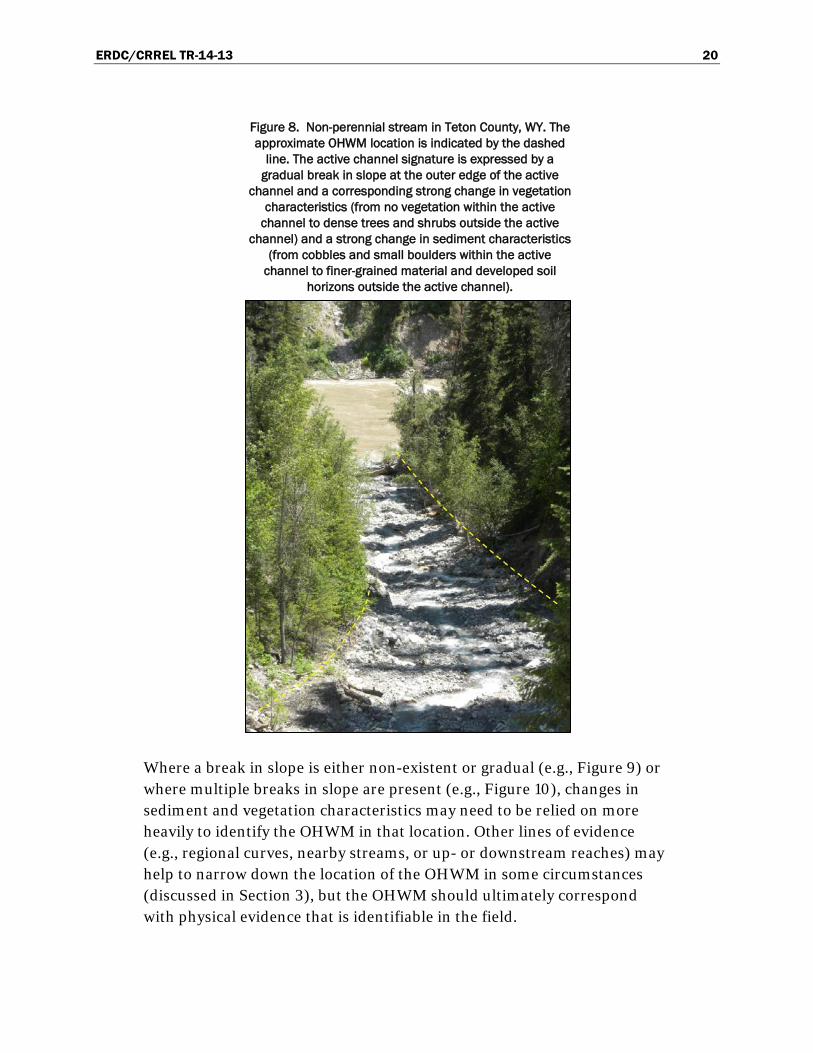
8 Non-perennial stream in Teton County, WY. The active channel signature is expressed by a gradual break in slope at the outer edge of the active channel and a corresponding strong change in vegetation characteristics and a strong change in sediment characteristics ........................................................................................... 20
9 Non-perennial stream in Fremont County, ID. In this stream system, there is no distinct break in slope associated with the boundaries of the active channel .................... 21
10 Non-perennial stream in Crook County, OR. The presence of two gradual (weak) breaks in slope and the lack of any strong vegetation changes in this location are cause to rely more heavily on sediment characteristics for identifying the boundaries of the active channel ............................................................................................... 23
11 Non-perennial stream in Fremont County, WY. In this example, all three primary indicators are strong on the right side of the channel but weak on the left side ................ 25
12 Non-perennial stream in Gunnison County, CO. In this location, a change in vegetation characteristics is the only strong primary OHWM indicator ................................ 35
13 Non-perennial stream in Park County, WY. All three primary OHWM indicators are strong in this stream system, but they are obscured by dense vegetation along some portions of the reach ......................................................................................................... 36
14 Non-perennial stream in Skagit County, WA. As is apparent from the heavy erosion and exposed roots visible on the stream banks, recent flooding has scoured out and potentially enlarged the stream channel ..................................................... 38
15 Remotely sensed images acquired from Google Earth and ground-based images from 2011 of a non-perennial stream in Teton County, WY ................................................... 41

ERDC/CRREL TR-14-13 v
Tables
1 Descriptions of seven mountain stream reach or morphology types ..................................... 8 2 Some potential supporting features and generalized interpretations of their utility
for OHWM delineation purposes ................................................................................................ 28

ERDC/CRREL TR-14-13 vi
Preface
Support and funding for this project were provided by the U.S. Army Corps of Engineers (USACE) Headquarters through the Wetlands Regula-tory Assistance Program (WRAP). The authors acknowledge and appreci-ate the interest and support of Margaret Gaffney-Smith and Karen Mulli-gan of the Headquarters Regulatory Program and Sally Yost of the U.S. Army Engineer Research and Development Center Environmental Labora-tory (ERDC-EL).
This report was prepared by Matthew K. Mersel and Robert W. Lichvar (Remote Sensing/GIS and Water Resources Branch, Timothy Pangburn, Chief), ERDC Cold Regions Research and Engineering Laboratory (CRREL). At the time of publication, Dr. Justin Berman was Chief of the Research and Engineering Division. The Deputy Director of ERDC-CRREL was Dr. Lance Hansen, and the Director was Dr. Robert Davis.
Peer reviews and comments were provided by the following:
• Paul Anderson, Wetlands Specialist, Washington State Department of Ecology (WADOE)
• Brian Cluer, Fluvial Geomorphologist, National Oceanic and Atmos-pheric Administration (NOAA) Fisheries, West Coast Region
• Heather Dean, Environmental Scientist, U.S. Environmental Protec-tion Agency (EPA), Region 10 (Pacific Northwest)
• Ken Fritz, Research Ecologist, EPA, Office of Research and Develop-ment
• Michael Finan, Wetland Specialist, USACE, Sacramento District • John Gartner, Research Physical Scientist, ERDC-CRREL • Jennifer Gillrich, Physical Scientist, ERDC-CRREL • Lindsey Lefebvre, Physical Scientist, ERDC-CRREL • Steve Manlow, Biologist, USACE, Seattle District • Gregory Martinez, Environmental Resources Specialist, USACE, Walla
Walla District • Julia McCarthy, Environmental/Life Scientist, EPA, Region 8 (Moun-
tains and Plains) • Susan Meyers, Wetlands Specialist, WADOE • Stephen Moore, Project Manager, USACE, Sacramento District

ERDC/CRREL TR-14-13 vii
• Tracie Nadeau, Environmental Scientist, EPA, Region 10 (Pacific Northwest)
• Patricia Olson, Senior Hydrogeologist, WADOE • Joseph Sheahan, Regulatory Project Manager, USACE, Portland Dis-
trict • Kristina Tong, Senior Scientist, USACE, Seattle District • Brian Topping, Environmental Protection Specialist, EPA, Wetlands
Division • Patrick Trier, Jurisdictional Subject Matter Expert, USACE, Northwest
Division • Parker J. Wigington, Jr., Research Hydrologist, EPA, Office of Re-
search and Development
COL Jeffrey R. Eckstein was the Commander of ERDC, and Dr. Jeffery P. Holland was the Director.

ERDC/CRREL TR-14-13 viii
Acronyms and Abbreviations
CRREL U.S. Army Cold Regions Research and Engineering Laboratory
CWA Clean Water Act
EL Environmental Laboratory
EPA U.S. Environmental Protection Agency
ERDC Engineer Research and Development Center
LWD Large, Woody Debris
NOAA National Oceanic and Atmospheric Administration
OHWM Ordinary High Water Mark
GIS Geographic Information System
USACE U.S. Army Corps of Engineers
USDA U.S. Department of Agriculture
USGS U.S. Geological Survey
WADOE Washington State Department of Ecology
WoUS Waters of the United States
WMVC Western Mountains, Valleys, and Coast
WRAP Wetlands Regulatory Assistance Program

ERDC/CRREL TR-14-13 1
1 Introduction
Federal regulations define the ordinary high water mark (OHWM) as “that line on the shore established by the fluctuations of water and indicated by physical characteristics such as a clear, natural line impressed on the bank, shelving, changes in the character of soil, destruction of terrestrial vegeta-tion, the presence of litter and debris, or other appropriate means that consider the characteristics of the surrounding areas” (U.S. Congress 1986). Under Section 404 of the Clean Water Act (CWA), the OHWM de-fines the lateral extent of federal jurisdiction in non-tidal waters of the United States (WoUS) in the absence of adjacent wetlands (U.S. Congress 1977). Thus, accurate and consistent OHWM delineation practices are es-sential for proper implementation of the CWA.
The dynamic nature of stream systems and fluvial processes presents chal-lenges for OHWM delineation. Natural sources of variability in river and stream systems (e.g., climate, sediment supply, landscape position, etc.) are compounded by direct and indirect anthropogenic sources of variabil-ity (e.g., watershed alteration, dam emplacement and removal, climate change, etc.). Thus, it is challenging to impose a consistent measure of “ordinary” high flow conditions across systems in which the hydrology and geomorphology can vary greatly in both space and time.
OHWM delineation in non-perennial (i.e., intermittent and ephemeral) streams can be especially challenging. The U.S. Army Corps of Engineers (USACE) defines intermittent streams as having “flowing water during certain times of the year, when groundwater provides water for stream flow. During dry periods, intermittent streams may not have flowing wa-ter. Runoff from rainfall is a supplemental source of water for stream flow” (USACE 2012). Ephemeral streams have “flowing water only during, and for a short duration after, precipitation events in a typical year. Ephemeral stream beds are located above the water table year-round. Groundwater is not a source of water for the stream,” and “[r]unoff from rainfall is the primary source of water for stream flow” (USACE 2012). In contrast to both intermittent and ephemeral streams, perennial streams have “flowing water year-round during a typical year. The water table is located above the stream bed for most of the year,” and “[g]roundwater is the primary source of water for stream flow” (USACE 2012).
ERDC/CRREL TR-14-13 2
Given the less persistent streamflow regimes characteristic of non-perennial streams, particularly ephemeral systems, the characterization of ordinary high water flows is perhaps more challenging than in perennially flowing systems. Moreover, depending on climate, vegetation, and other related factors, the appearance of some OHWM indicators may vary great-ly between wet and dry seasons or between relatively infrequent flow events, more so than in many perennial streams. Mountainous terrain can present additional challenges to OHWM delineation. For instance, the rel-atively steep and confined valleys in which mountain streams commonly flow can restrict the development of some alluvial features (e.g., flood-plains, bankfull benches, etc.) that are typical of low-gradient systems and that may help to identify the OHWM. Thus, in non-perennial mountain streams, it is often difficult to determine what constitutes ordinary high water and to interpret the physical and biological indicators established and maintained by ordinary high water flows.
Challenges and inconsistencies pertaining to OHWM delineation practices are becoming increasingly relevant in mountainous parts of the western U.S. in light of expanding development. This increased pressure on fluvial systems highlights the need for accurate, consistent, and repeatable OHWM delineation practices in this region. These factors, combined with the particular challenges of OHWM delineation in non-perennial moun-tain streams, provided the impetus for developing this delineation guide.
This guide presents the concepts, field indicators, and methods for as-sessing, delineating, and documenting the OHWM in non-perennial streams in the Western Mountains, Valleys, and Coast (WMVC) Region of the United States (Figure 1). The information presented here is based on the findings of Mersel et al. (2014) (discussed in Section 1.5) and on years of field observations and data gathering in the WMVC Region and in other regions of the U.S. by the authors and other contributing experts. The re-mainder of Section 1 provides background information regarding the con-cept of the OHWM and pertaining to stream hydrology and geomorpholo-gy in general. Section 2 discusses and provides examples of the specific field indicators used to identify the OHWM in non-perennial streams in the WMVC Region. Section 3 discusses field methods for delineating the OHWM and addresses additional techniques and lines of evidence that may help in problematic delineation scenarios.

ERDC/CRREL TR-14-13 3
Figure 1. Generalized map of the Western Mountains, Valleys, and Coast Region. The region consists mainly of U.S. Department of Agriculture (USDA) Land Resource Regions A and E but also includes the Sierra
Nevada Mountains (MLRA 22A), the Southern Cascade Mountains (MLRA 22B), the Arizona and New Mexico Mountains (MLRA 39), the Black Hills (MLRA 62), and other mountainous areas not shown. These areas are
dominated by coniferous forests on the slopes and coniferous woodlands, hardwood riparian woodlands, shrublands, or meadows in the valleys down to the lower limit of the ponderosa pine zone (USACE 2010).
ERDC/CRREL TR-14-13 4
The information presented here is technical guidance and does not define, amend, or replace any existing regulations, laws, or legal guidance related to the OHWM or to the regulation of WoUS. Furthermore, determining whether any stream is a jurisdictional WoUS is beyond the scope of this document and involves further assessment in accordance with regulations, case law, and clarifying guidance. This guide pertains to non-perennial streams in the WMVC Region of the U.S., and while the information pre-sented here may have a wider applicability to other regions or to perennial rivers within the WMVC Region, this has not been tested or validated. This manual serves as a companion to A Field Guide to the Identification of the Ordinary High Water Mark (OHWM) in the Arid West Region of the Western United States (Lichvar and McColley 2008) as these two re-gions—the WMVC and the Arid West—are interspersed with one another. Best professional judgment is required to determine which manual is most appropriate for any given location within these two regions.
The technical guidance presented here aims to provide an informed and consistent approach to OHWM delineation within the WMVC Region; however, OHWM delineation is not a precise practice. The OHWM can take on a variety of appearances and characteristics and may change over time due to natural or anthropogenic causes. Best professional judgment and consideration of the unique characteristics of each project site are al-ways required.
1.1 Geographic scope
The boundaries of the WMVC Region are the same as those used in the Regional Supplement to the Corps of Engineers Wetland Delineation Manual: Western Mountains, Valleys, and Coast Region (Version 2.0) (USACE 2010) (Figure 1). This selection of regional boundaries allows for consistency with respect to the geographic regionalization of technical guidance for delineation of both wetlands and streams. Note that in addi-tion to the areas highlighted in Figure 1, this guide may have applicability within many other small mountain ranges scattered throughout the Great Basin, southern California, and other parts of the western U.S. Moreover, the WMVC Region is interspersed with the Arid West Region; and as such, the applicability of OHWM delineation technical guidance for either re-gion does not necessarily follow the rigid geographic boundaries that Fig-ure 1 might suggest. The following paragraphs taken from USACE (2010) give a general description of the climatic and physiographic characteristics

ERDC/CRREL TR-14-13 5
of the WMVC Region and how they compare to those of the Arid West Re-gion:
[T]he Western Mountains, Valleys, and Coast Region . . . consists of portions of 12 states: Arizona, California, Colorado, Idaho, Mon-tana, Nevada, New Mexico, Oregon, South Dakota, Utah, Washing-ton, and Wyoming (Figure 1). The region contains the major west-ern mountain ranges—the Cascade Mountains, Sierra Nevada, and Rocky Mountains—and other scattered mountain ranges where the vegetation is dominated mainly by coniferous forests at lower eleva-tions and alpine tundra at the highest elevations. The region also embraces the Willamette/Puget lowlands, and the numerous val-leys, meadows, high plateaus, and parks scattered within the moun-tainous areas that often support grasses, forbs, or shrubs, and in-cludes the Coast Ranges, rain forests, and coastal zone from northern California to the Canadian border. About half of the region is in Federal ownership, mostly in national forests. . . .
The Western Mountains, Valleys, and Coast Region consists of steep, rugged mountains, high plateaus, gently sloping valleys, and a narrow coastal plain. Due to rugged topography, climatic condi-tions are highly variable across the region. The north–south orien-tation of the major mountain ranges forms barriers to the prevailing westerly winds, producing more abundant rainfall on west-facing slopes and rain-shadow effects on east-facing slopes and in interior valleys. Average annual precipitation ranges from more than 250 in. (6,350 mm) in the Olympic Mountains of Washington to 15 in. (380 mm) or less in the drier valleys and east-facing slopes of the Cas-cade Range and southern Rocky Mountains. Winters throughout the region tend to be long and cold, except near the ocean and in valleys west of the Cascades. The frost-free period is less than 70 days in the high mountains, but approaches 365 days on the coast (Bailey 1995; USDA 2006). This topographic and climatic diversity is reflected in very high vegetation diversity. Mountain slopes throughout the region generally are forested, but the dominant tree species change with location, elevation, and aspect. Other vegeta-tion types include alpine tundra, mountain meadows, valley grass-lands, shrublands, and hardwood riparian systems.

ERDC/CRREL TR-14-13 6
The Western Mountains, Valleys, and Coast Region surrounds and is interspersed with the Arid West Region . . . but generally receives more abundant rainfall and/or snow, has lower average tempera-tures, higher humidity, and lower evapotranspiration rates. . . . Many of the major streams and rivers that flow into and through the Arid West have their headwaters in the Western Mountains, Valleys, and Coast Region.
The decision to use the Western Mountains, Valleys, and Coast [OHWM delineation manual] or the Arid West [OHWM delineation manual] on a particular field site should be based on landscape and site conditions, and not solely on map location. Figure 1 is highly generalized and does not indicate many of the smaller mountain ranges where the Western Mountains, Valleys, and Coast [OHWM delineation manual] would be applicable. Furthermore, there are arid environments within the highlighted areas in Figure 1 where the Arid West [manual] would be appropriate. . . . [A]lthough no one environmental characteristic is diagnostic . . . [i]n many areas of the West, the transition between the two regions is indicated by the upper limit of pinyon/juniper and associated shrub dominated communities, and the lower limit of ponderosa pine or other conif-erous forests.
Region and subregion boundaries are depicted in Figure 1 as sharp lines. However, climatic conditions and the physical and biological characteristics of landscapes do not change abruptly at the bounda-ries. In reality, regions and subregions often grade into one another in broad transition zones that may be tens or hundreds of miles wide. . . . In transitional areas, the investigator must use experience and good judgment to select the supplement and indicators that are appropriate to the site based on its physical and biological charac-teristics.
1.2 Non-perennial streams in the WMVC Region
As compared to perennial and lowland rivers, non-perennial mountain streams in general tend to be steep and coarse-grained, characterized by a relatively immobile substrate, limited sediment supply, and turbulent flow (Wohl and Merritt 2005). Moreover, while the morphologies of their low-gradient and flatland counterparts tend to reflect the predominance of flu-vial processes, those of high-gradient and mountain streams tend to reflect

ERDC/CRREL TR-14-13 7
a greater degree of influence from external processes and landforms (Grant and Swanson 1995). For instance, lateral migration of stream channels in mountainous regions is often constricted by narrow valley bot-toms (Wohl and Merritt 2005). However, some stream reaches do develop alluvial floodplains and migrate laterally, especially where gradient is rela-tively low, sediment loads are high, or valleys are less confined. Debris flows and landslides are common in the region, accounting for much, if not most, of the sediment flux from headwater streams in steep terrain (Mont-gomery and Buffington 1997). In many mountain streams, particularly in more humid regions (e.g., the Pacific Northwest), large, woody debris (LWD) can have a substantial influence on channel form and process, act-ing to retain sediment and to increase variability in bed elevation, water depth, and particle size (Faustini and Jones 2003). LWD and other flow obstructions (e.g., large boulders) can “force a reach morphology that dif-fers from the free-formed morphology for a similar sediment supply and transport capacity” (e.g., forced pool-riffle or step-pool morphologies) (Montgomery and Buffington 1997). These are only general trends as sub-stantial variability in channel size, form, gradient, sediment supply, and other stream characteristics can be found throughout the WMVC Region due in part to variability in vegetation, climate, geology, disturbance histo-ry, and a number of other factors.
Montgomery and Buffington (1997) provide a useful classification and de-scription of stream channels in mountain drainage basins. They categorize mountain streams into seven distinct reach types or channel morphologies (members along a continuum): bedrock, colluvial, cascade, step-pool, plane-bed, pool-riffle, and dune-ripple. Table 1 provides a brief summary of each reach type.

ERDC/CRREL TR-14-13 8
Table 1. Descriptions of seven mountain stream reach or morphology types (Montgomery and Buffington 1997).
Reach/Morphology Type
Description
Bedrock Lacks a continuous alluvial bed; generally confined by valley walls; bedrock provides a dominant external control on channel form.
Colluvial Typically small headwater streams that flow over colluvial valley fill; episodic transport by debris flows accounts for much of the sediment transport in these reaches; fluvial processes are weak to non-existent.
Cascade Generally occurs on steep slopes, within narrowly confined valley walls, and contain disorganized bed material consisting of cobbles and boulders.
Step-pool Characterized by longitudinal steps organized into sections of relatively large clasts separating pools containing finer material.
Plane-bed Gravel and cobble-bed channels characterized by the absence of tumbling flow (as for cascade and step-pool channels) and containing long stretches with few to no bedform features; often transitional between supply-limited and transport-limited reaches/morphologies.
Pool-riffle Characterized by lateral bedform oscillation (as opposed to vertical bedform oscillation found in steeper streams) in rhythmic sequences of bars, pool, and riffles; generally occurs at moderate to low gradients in unconfined valleys; sediment ranges from sand to cobbles; floodplains are often well-established.
Dune-ripple Commonly associated with low-gradient, sand-bed channels and characterized by high sediment loads and mobile bedforms (e.g., ripples, dunes, antidunes).
Figure 2 illustrates a general downstream progression of these mountain stream types. Bedrock channels are not included in Figure 2 as they do not follow the general downstream progression of colluvial and alluvial stream types but instead occur “at locally steep locations throughout the channel networks” (Montgomery and Buffington 1997). This framework also rec-ognizes a general downstream progression from sediment-supply-limited stream reaches with high transport capacity to depositional reaches with limited transport capacity (Figure 2). Note that these are only generalized patterns of mountain streams and that downstream progression of chan-nel form, process, deposition, and other stream characteristics may be heavily influenced by a variety of factors (e.g., channel slope, discharge, sediment supply, lithology, disturbance history, LWD, etc.).

ERDC/CRREL TR-14-13 9
Figure 2. Idealized long profile from hillslopes and unchanneled hollows downslope through the channel network showing the general distribution of alluvial channel types and controls
on channel processes in mountain drainage basins (Montgomery and Buffington 1997).
1.3 Understanding the OHWM
The OHWM definition provided in the federal regulations leaves substan-tial room for interpretation. This is due in part to its necessary application to a wide variety of stream types (as well as lakes) in a wide variety of landscape settings, thus precluding a definition that is both universally applicable and highly specific. Therefore, OHWM delineations may de-pend on the investigator’s interpretation of both the concept of the OHWM and the field indicators used to identify it. The following paragraphs are meant to increase clarity with regard to underlying hydrologic and geo-morphic concepts pertaining to the OHWM.
Federal regulations do not provide a strict hydrologic definition of the OHWM other than that it is “established by the fluctuations of water.” Thus, the OHWM is not explicitly defined by or associated with a specific streamflow recurrence interval (e.g., the 2-year flood) or any other statisti-cal measurement. Given the lack of direct hydrologic observations or

ERDC/CRREL TR-14-13 10
measurements in most stream systems, a statically-based definition would be exceedingly difficult and impractical to implement. Therefore, the pre-cise hydrologic frequency associated with the OHWM may vary between different streams or even between different locations along the same stream.
However, despite a vague hydrologic definition for the OHWM, some rea-sonable assumptions can be made regarding the hydrologic understanding of ordinary high water. Existing Corps regulatory guidance pertaining to the OHWM (USACE 2005) states that “[w]hen making OHWM determina-tions, districts should be careful to look at characteristics associated with ordinary high water events, which occur on a regular or frequent basis. Ev-idence resulting from extraordinary events, including major flooding and storm surges, is not indicative of the OHWM.” Moreover, implicit in the term ordinary high water mark itself, the word ordinary can be taken to exclude extremes on either end of the streamflow spectrum (i.e., very low or very high flows), while the term high stands in contrast to low or mod-erate streamflow levels. Taken together, ordinary high water implies streamflow levels that are greater than average, but less than extreme, and that occur with some regularity. A common and reasonable interpretation of this concept, supported in part by legal precedent, is that ordinary high water refers to the ordinary or normal water levels that occur during the high water season (see Guest [1990] for some background information on the historical and legal basis for the OHWM). However, this reasoning on-ly helps to narrow the concept of the OHWM, not to strictly define it.
In accordance with federal regulations (U.S. Congress 1986), the OHWM is instead defined by physical features (including vegetation and other bio-logical indicators as opposed to a statistically derived point on the land-scape that is not tied to physical evidence) that are proxies for the spatial extent of ordinary high water. Thus, the OHWM in most circumstances should correspond with physical evidence on the landscape (exceptions to this general rule are discussed in Section 3). However, there is no ubiqui-tous mark or feature that represents exactly the same hydrologic frequency in all stream systems. Moreover, in many stream systems, there are multi-ple features or distinct points on the landscape that may meet the regula-tory definition of the OHWM (i.e., more than one “line on the shore estab-lished by the fluctuations of water” [U.S. Congress 1986]). These features may be the remnants of a single flood event or repeated inundation; they may be established by low flows, high flows, or extreme flows. Additional-

ERDC/CRREL TR-14-13 11
ly, while some features are regularly altered with each flow event (in terms of appearance or location), others are more stable over time. It follows that when using physical features to identify the extent of ordinary high water levels, the features themselves should be ordinary in the sense of being relatively stable and consistently present and identifiable over time. Thus, the OHWM pertains to those features evidenced to be established and maintained by high flows (i.e., above average but not extreme) that occur with some regularity and are therefore most associated with the concept of ordinary high water. It is useful, then, to consider that it is the mark on the landscape itself that is ordinary as shaped by high flows that occur with a frequency and power sufficient to establish and maintain a consistent mark on the landscape.
The above reasoning helps to constrain the concept of the OHWM and the identification of field indicators for delineating the OHWM in rivers and streams. For instance, the locations of features known or evidenced to be representative of low, average, or extreme flow conditions or events can typically be rejected as potential OHWM locations. Likewise, features sug-gestive of individual flow events or those known or evidenced to be unsta-ble or highly migratory over time are unlikely to accurately indicate the OHWM location. However, these constraints are secondary to the re-quirement that the OHWM correspond with physical evidence that can be identified in the field, ideally using indicators that are relatively stable, both spatially and temporally.
1.4 The active channel
The term active channel, as it is used here, refers to that hydrogeomorphic unit of a stream system within which the local hydrologic regime and geo-morphic processes are effective in maintaining a linear topographic de-pression or conduit on the land surface, typically characterized by the presence of a bed and banks. Hydrogeomorphic units are distinct macro-scale geomorphic features formed within stream systems in response to spatially and temporally varying hydrologic and geomorphic processes. Figure 3 shows an idealized illustration of common hydrogeomorphic units (note that Figure 3 is more representative of low-gradient arid stream systems but is a good illustration of common alluvial surfaces and features and their typical spatial arrangements). Some hydrogeomorphic units (e.g., the active channel and floodplain) are common to many or most stream systems while others (e.g., low-flow and high-flow channels) are more common in particular regions or stream types. However, the ac-
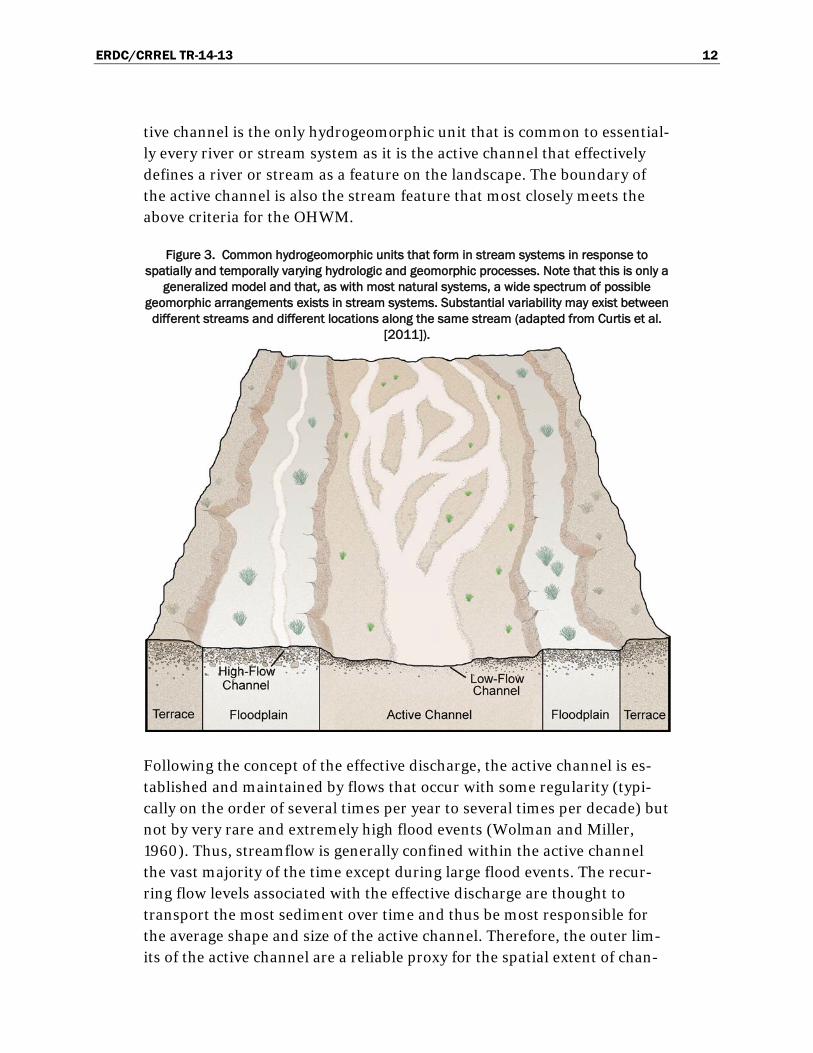
ERDC/CRREL TR-14-13 12
tive channel is the only hydrogeomorphic unit that is common to essential-ly every river or stream system as it is the active channel that effectively defines a river or stream as a feature on the landscape. The boundary of the active channel is also the stream feature that most closely meets the above criteria for the OHWM.
Figure 3. Common hydrogeomorphic units that form in stream systems in response to spatially and temporally varying hydrologic and geomorphic processes. Note that this is only a
generalized model and that, as with most natural systems, a wide spectrum of possible geomorphic arrangements exists in stream systems. Substantial variability may exist between
different streams and different locations along the same stream (adapted from Curtis et al. [2011]).
Following the concept of the effective discharge, the active channel is es-tablished and maintained by flows that occur with some regularity (typi-cally on the order of several times per year to several times per decade) but not by very rare and extremely high flood events (Wolman and Miller, 1960). Thus, streamflow is generally confined within the active channel the vast majority of the time except during large flood events. The recur-ring flow levels associated with the effective discharge are thought to transport the most sediment over time and thus be most responsible for the average shape and size of the active channel. Therefore, the outer lim-its of the active channel are a reliable proxy for the spatial extent of chan-

ERDC/CRREL TR-14-13 13
nel-shaping flows that are above average, but less than extreme, and that occur with some regularity. This is in contrast to floodplains, which are generally inundated only infrequently during relatively large flood events, and less stable features, such as low-flow channels, drift deposits, matted vegetation, leaf clearing, and bank undercuts, which may be established by or shift in response to individual flow events or recent flow conditions. Thus, the active channel is that part of a stream system in which the ma-jority of fluvial sediment transport processes occur and in which streamflow is fully contained except for during large flood events. The ac-tive channel can therefore be seen as ordinary with respect to the recurring high flows it contains and with respect to its ubiquity across the diversity of streams that exist in nature.
The association of the OHWM with the lateral extent of the active channel agrees well with the interpretation of ordinary high water and its intended limits. Moreover, this interpretation agrees well with previous OHWM in-vestigations and delineation guidance in arid systems. Lichvar et al. (2006) found the active floodplain to be the most consistent and reliable feature with which to delineate the OHWM in Arid West non-perennial streams. The term active floodplain, as used in this prior study (as well as in the subsequent field manual [Lichvar and McColley 2008]) refers to the broader active zone within which a series of low-flow channels migrate—a braided channel arrangement that is common in dryland stream systems. The active channel, as described here and as pertains to single-thread (i.e., single channel) streams and streams in less arid regions, is analogous to the active floodplain as the term is used in previous investigations and OHWM delineation guidance for the Arid West. Therefore, in braided stream systems, the active channel, and thus the OHWM, may encompass multiple low-flow channels and the migratory islands that separate them.
1.5 Occurrence and distribution of OHWM indicators in the WMVC Region
Mersel et al. (2014) explored OHWM indicator occurrence and distribu-tion in 150 non-perennial stream systems throughout the U.S. WMVC Re-gion. This study used the boundaries of the active channel to delineate the OHWM and identified a ubiquitous active channel signature (i.e., a com-bination of physical and biological features that act to form a distinct mark on the landscape) across the region. This study found three primary indi-cators—a topographic break in slope, change in vegetation characteristics, and change in sediment characteristics—consistently associated with the
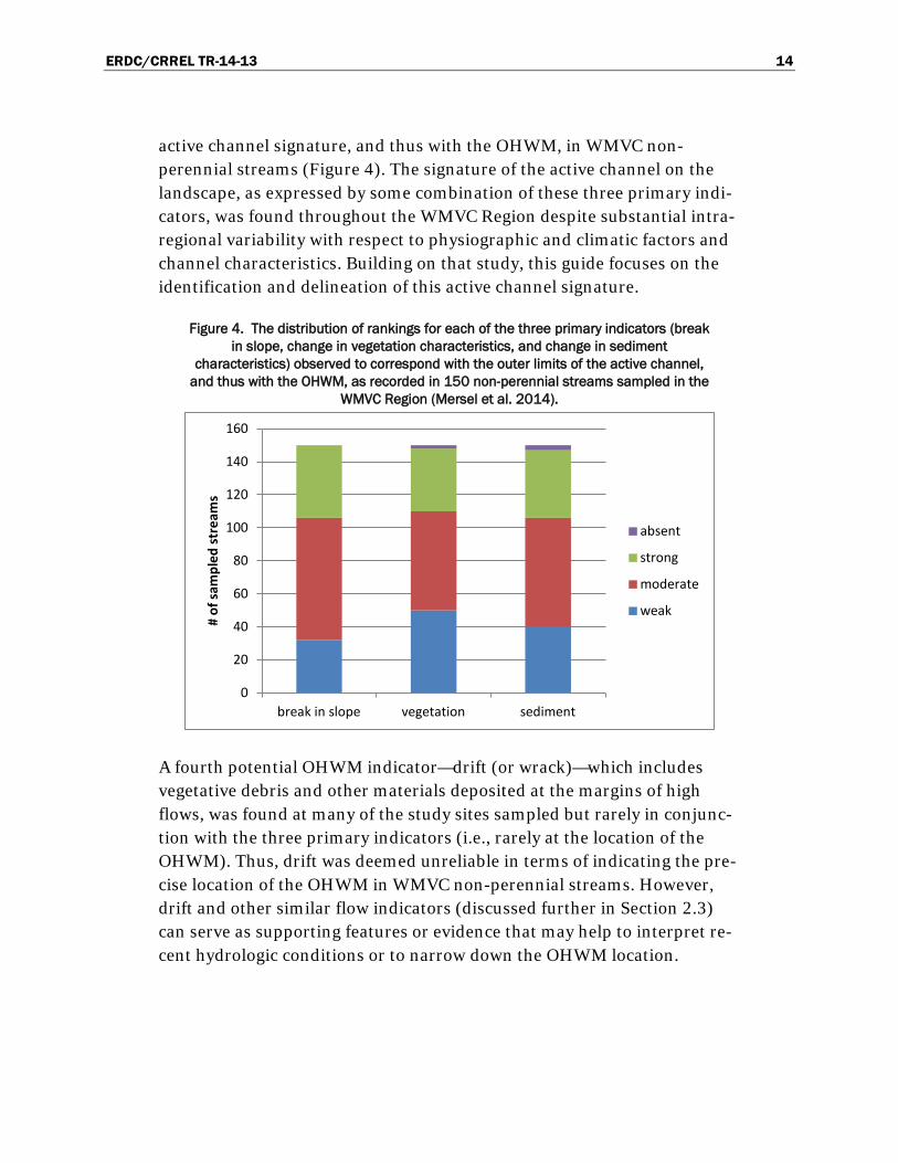
ERDC/CRREL TR-14-13 14
active channel signature, and thus with the OHWM, in WMVC non-perennial streams (Figure 4). The signature of the active channel on the landscape, as expressed by some combination of these three primary indi-cators, was found throughout the WMVC Region despite substantial intra-regional variability with respect to physiographic and climatic factors and channel characteristics. Building on that study, this guide focuses on the identification and delineation of this active channel signature.
Figure 4. The distribution of rankings for each of the three primary indicators (break in slope, change in vegetation characteristics, and change in sediment
characteristics) observed to correspond with the outer limits of the active channel, and thus with the OHWM, as recorded in 150 non-perennial streams sampled in the
WMVC Region (Mersel et al. 2014).
A fourth potential OHWM indicator—drift (or wrack)—which includes vegetative debris and other materials deposited at the margins of high flows, was found at many of the study sites sampled but rarely in conjunc-tion with the three primary indicators (i.e., rarely at the location of the OHWM). Thus, drift was deemed unreliable in terms of indicating the pre-cise location of the OHWM in WMVC non-perennial streams. However, drift and other similar flow indicators (discussed further in Section 2.3) can serve as supporting features or evidence that may help to interpret re-cent hydrologic conditions or to narrow down the OHWM location.
0
20
40
60
80
100
120
140
160
break in slope vegetation sediment
# of
sam
pled
stre
ams
absent
strong
moderate
weak
ERDC/CRREL TR-14-13 15
2 The OHWM in the WMVC Region
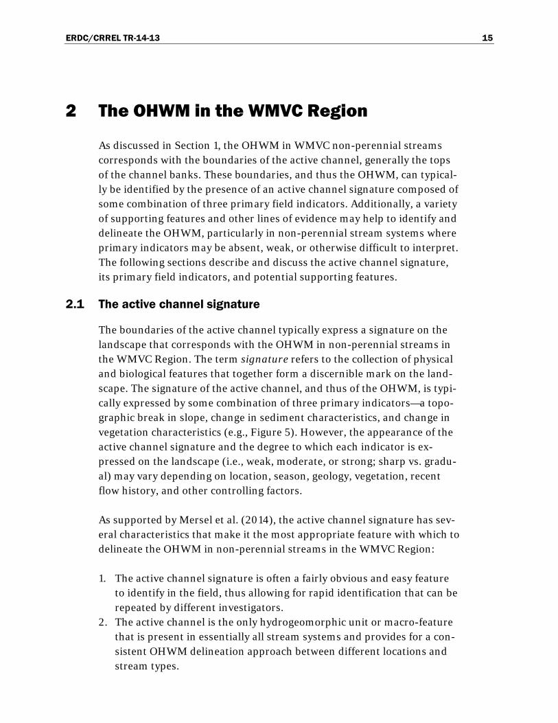
As discussed in Section 1, the OHWM in WMVC non-perennial streams corresponds with the boundaries of the active channel, generally the tops of the channel banks. These boundaries, and thus the OHWM, can typical-ly be identified by the presence of an active channel signature composed of some combination of three primary field indicators. Additionally, a variety of supporting features and other lines of evidence may help to identify and delineate the OHWM, particularly in non-perennial stream systems where primary indicators may be absent, weak, or otherwise difficult to interpret. The following sections describe and discuss the active channel signature, its primary field indicators, and potential supporting features.
2.1 The active channel signature
The boundaries of the active channel typically express a signature on the landscape that corresponds with the OHWM in non-perennial streams in the WMVC Region. The term signature refers to the collection of physical and biological features that together form a discernible mark on the land-scape. The signature of the active channel, and thus of the OHWM, is typi-cally expressed by some combination of three primary indicators—a topo-graphic break in slope, change in sediment characteristics, and change in vegetation characteristics (e.g., Figure 5). However, the appearance of the active channel signature and the degree to which each indicator is ex-pressed on the landscape (i.e., weak, moderate, or strong; sharp vs. gradu-al) may vary depending on location, season, geology, vegetation, recent flow history, and other controlling factors.
As supported by Mersel et al. (2014), the active channel signature has sev-eral characteristics that make it the most appropriate feature with which to delineate the OHWM in non-perennial streams in the WMVC Region:
1. The active channel signature is often a fairly obvious and easy feature to identify in the field, thus allowing for rapid identification that can be repeated by different investigators.
2. The active channel is the only hydrogeomorphic unit or macro-feature that is present in essentially all stream systems and provides for a con-sistent OHWM delineation approach between different locations and stream types.
ERDC/CRREL TR-14-13 16
3. As compared to many other potential OHWM indicators (e.g., drift, leaf clearing, bank undercuts) the active channel is generally more repre-sentative of longer term streamflow conditions rather than recent flows and is likely to be more stable over time, thus allowing for temporal consistency in OHWM delineations.
4. The active channel signature is consistent with existing federal regula-tions (U.S. Congress 1986) and guidance (USACE 2005) in that it is a mark on the landscape indicated by physical characteristics and shaped by flows that are above average but less than extreme and that occur with some regularity (as discussed in the previous section).
Figure 5. Example of an active channel signature as expressed by three primary indicators—break in slope, change in sediment characteristics, and change in vegetation characteristics. The boundaries of the active channel
provide a consistent and repeatable feature with which to delineate the OHWM (indicated by the dashed line) in WMVC non-perennial stream
systems.
To further illustrate the concept of the active channel signature, Figure 6 contains an aerial and a ground-based image of a non-perennial stream located in Catron County, NM. A stream is clearly visible in the aerial pho-tograph, and it is the signature of the active channel that makes it appar-ent to the viewer. This signature is identified by a distinct change in color associated with the boundaries of the active channel and the denuded ap-pearance within these boundaries. Viewed from ground level, this same signature is now expressed in terms of three primary indicators—a topo-

ERDC/CRREL TR-14-13 17
graphic break in slope, change in sediment characteristics, and change in vegetation characteristics—all of which are coincident with the boundaries of the active channel. While Figure 6 is only one example within the WMVC Region, Figures 7–15 illustrate how the concept of the active chan-nel signature translates to non-perennial streams in other stream types elsewhere within the region. Note that Figure 6 is meant only to illustrate some key concepts. OHWM delineation is primarily a field-based exercise, and remotely sensed imagery should not generally be relied on exclusively to identify or delineate the OHWM location. (The use of remotely sensed imagery for OHWM delineation purposes is discussed in Section 3.)
Figure 6. A non-perennial stream in Catron County, NM, as seen in (a) aerial and (b) ground-based images. The approximate OHWM location is indicated by the dashed line. These two
images illustrate the concept of the active channel signature at two scales. In the aerial image, the signature is expressed by a distinct change in color at the edge of the active
channel. At ground level, this is expressed by three primary indicators—a break in slope, a change in sediment characteristics (from coarse sediments within the active channel to fine sediments outside the active channel), and a change in vegetation characteristics (from bare ground within the active channel to herb cover with some trees outside the active channel)—
that indicate the boundaries of the active channel and thus the location of the OHWM.
2.2 Primary indicators
Mersel et al. (2014) found the three primary field indicators described in detail below to consistently define the active channel signature, and thus the OHWM, in non-perennial stream systems throughout the WMVC Re-gion. Therefore, field identification of the OHWM relies primarily on accu-rate identification of these three indicators as they are associated with the boundaries of the active channel of a stream. Note that it is generally a combination of multiple primary indicators that creates the active channel signature and that a single primary indicator by itself can be misleading evidence of the active channel boundaries and the OHWM. It should also be noted, however, that in the absence of multiple primary indicators, the

ERDC/CRREL TR-14-13 18
investigator must sometimes resort to using only one primary indicator (or none, in rare cases) in conjunction with supporting features and other lines of evidence.
2.2.1 Break in slope
A break in slope refers to a localized and distinct change in the lateral topographic gradient (i.e., perpendicular to the principal direction of flow) within a stream system. A convex break in slope is often associated with the outer limits of the active channel at the tops of the channel banks. In many WMVC non-perennial streams, this break in slope is a distinct and easily identifiable feature that corresponds strongly with one, if not both, of the other two primary indicators (e.g., Figure 7). These circumstances provide for relatively simple OHWM identification using features that can be repeatedly identified over time and by different investigators. However, where multiple breaks in slope are found along a given cross section of a stream system, identifying which of these is most reasonably associated with the OHWM may prove challenging.
Where one or more low-flow channels are present, their boundaries may have similar indicators to those of the active channel. In Figure 8, for ex-ample, a smaller channel containing streamflow is present within a broad-er unvegetated zone; and close inspection reveals a mild break in slope and change in sediment texture associated with its boundaries. These features might be used by some to delineate the OHWM. However, unconsolidated sediment and a lack of vegetation within the broader zone surrounding the smaller channel suggest that the boundaries of the smaller channel are rel-atively unstable. From a practical standpoint, this precludes their use for delineating the OHWM. More importantly, however, the boundaries of the broader, unvegetated zone are coincident with not only a distinct change in vegetation but also a corresponding break in slope and change in sedi-ment characteristics (delineated with a dashed line in the image). This lo-cation is the more likely boundary of the active channel within which a smaller low-flow channel migrates. The presence of all three primary indi-cators suggests that this is a more stable feature than that of the low-flow channel and is a more reasonable OHWM location. Note that the OHWM is formed by high flow events, thus the boundaries of the low-flow channel do not provide a reasonable OHWM location. The long-term stability of the supposed active channel boundaries in this location can be assessed and validated using remotely sensed imagery (discussed in Section 3).

ERDC/CRREL TR-14-13 19
Figure 7. Non-perennial stream in Sevier County, UT. The approximate OHWM location is indicated by the dashed
line. In this stream, the boundaries of the active channel, and thus the location of the OHWM, are clearly defined by a sharp break in slope that corresponds with a change in
sediment characteristics (from large cobbles and boulders within the active channel to finer-grained sediments and greater soil development outside the active channel) and
a moderate change in vegetation (from no vegetation within the active channel to a sparse mix of herbs and
trees outside the active channel).
ERDC/CRREL TR-14-13 20
Figure 8. Non-perennial stream in Teton County, WY. The approximate OHWM location is indicated by the dashed
line. The active channel signature is expressed by a gradual break in slope at the outer edge of the active
channel and a corresponding strong change in vegetation characteristics (from no vegetation within the active
channel to dense trees and shrubs outside the active channel) and a strong change in sediment characteristics
(from cobbles and small boulders within the active channel to finer-grained material and developed soil
horizons outside the active channel).
Where a break in slope is either non-existent or gradual (e.g., Figure 9) or where multiple breaks in slope are present (e.g., Figure 10), changes in sediment and vegetation characteristics may need to be relied on more heavily to identify the OHWM in that location. Other lines of evidence (e.g., regional curves, nearby streams, or up- or downstream reaches) may help to narrow down the location of the OHWM in some circumstances (discussed in Section 3), but the OHWM should ultimately correspond with physical evidence that is identifiable in the field.

ERDC/CRREL TR-14-13 21
Figure 9. Non-perennial stream in Fremont County, ID. The approximate OHWM location is indicated by the dashed line. In this stream system, there is
no distinct break in slope associated with the boundaries of the active channel (although there is slight topographic relief). The OHWM is instead identified primarily by a change in sediment characteristics (from coarser
sediments within the active channel to finer sediments and some soil development outside the active channel) that coincides with a change in vegetation characteristics (from sparse cover within the active channel to
dense cover outside the active channel).
2.2.2 Change in sediment characteristics
Changes in sediment characteristics include any transition in the physical, chemical, or biological qualities of the sediments within and adjacent to a stream channel. For the purposes of OHWM identification, the investiga-tor is most concerned with lateral changes (i.e., perpendicular to the prin-cipal direction of flow) in sediment characteristics. These changes are as-sociated with variation in flow frequency, duration, and magnitude and are dependent on the materials available within a given system (mountainous regions, for instance, generally have larger sediments available than do coastal or plains regions).
Lateral changes in sediment characteristics often correlate well with tran-sitions between various hydrogeomorphic units. It is quite common, for instance, to find a change in sediment texture associated with the transi-tion from the active channel to the floodplain or adjacent land surface. This change is typically characterized by a transition from coarser material

ERDC/CRREL TR-14-13 22
(e.g., gravel, cobbles, and boulders) within the active channel to finer ma-terial (e.g., sand, silt, and clay) outside the active channel. This is because streamflow within the active channel is generally deeper and more power-ful than that in the floodplain. Thus, larger sediments can be transported and deposited within the active channel while finer particles are carried away. In contrast, the lower velocities associated with floodplain flow pre-clude the mobilization of larger sediments, while finer particles settle out of the water column. Note that where the available sediment is highly uni-form in size, little to no change in sediment texture is likely to be observed.
Another common lateral change in sediment characteristics is associated with the degree of soil development. The development of soil horizons or a top soil layer suggests infrequent inundation. Thus, a change in soil devel-opment is commonly associated with the transition from the active chan-nel to the adjacent land surface. This change is commonly characterized by a transition from loose sediments with little to no organic content within the active channel to soils with increased development of horizons, topsoil, and organic content outside the active channel.
Where a break in slope and changes in vegetation characteristics are grad-ual or not obvious, changes in sediment characteristics can be especially important. In the stream in Figure 10, for example, there are two gradual breaks in slope that could potentially represent the OHWM, and there are no distinct changes in vegetation characteristics in this location. However, a distinct change in sediment texture from cobbles to fine-grained materi-als identifies the lower of the two gradual breaks in slope as the more rea-sonable location of the OHWM.
Note that the OHWM in Figure 10 does not correspond precisely with the change in sediment texture but rather with the convex break in slope asso-ciated with and lying just outside of this point of change. In many streams, especially where steep channel banks exist, a change in sediment texture is often located at the concave break in slope at the outer edge of the active channel bed (the bottom of the banks) as opposed to the convex break in slope at the top of the active channel banks. This is due in part to the abil-ity of deeper flows to transport larger materials and also due to the angle of repose of larger sediment particles (i.e., the steepest angle that piled loose granular material can maintain before sliding downhill). Under these circumstances, the OHWM may not be located precisely at the location where a change in sediment texture occurs, but instead at the break in

ERDC/CRREL TR-14-13 23
slope located outside of this transition point (at the top of banks or outer limits of the active channel). Thus, in these cases, a change in sediment characteristics does not indicate the exact location of the OHWM but still gives an indication of the active channel boundaries (e.g., Figure 10).
Figure 10. Non-perennial stream in Crook County, OR. The approximate OHWM location is indicated by the
dashed line. The presence of two gradual (weak) breaks in slope and the lack of any strong vegetation changes in this location are cause to rely more heavily on sediment
characteristics for identifying the boundaries of the active channel. Indeed, a distinct change from relatively coarse to fine sediment identifies the lower of the two breaks in
slope (delineated with a dashed line) as the more appropriate OHWM location.
2.2.3 Change in vegetation characteristics
For the purposes of OHWM identification, changes in vegetation charac-teristics include any lateral transition (i.e., perpendicular to the principal direction of flow) in the abundance, growth form stage, or species compo-sition of the vegetation within and adjacent to a stream channel. A change

ERDC/CRREL TR-14-13 24
in vegetation is commonly expressed by some combination of these transi-tions. Vegetation transitions can be gradual or abrupt and may have dif-ferent appearances depending on season, climate, local vegetation, and other factors.
In non-perennial stream systems in the WMVC Region, there is often some change in vegetation associated with the active channel boundaries, and thus with the OHWM, most commonly characterized by transitions in vegetation abundance and growth form stage. Typically, the active channel will contain sparse or immature vegetation relative to the adjacent land surface (e.g., Figures 5–11 and 13–15). However, it is not uncommon for terrestrial vegetation to encroach into the active channel (e.g., Figure 11); and when the time since the last high flow is sufficiently long, vegetation may completely fill the active channel. Likewise, hydrologically tolerant plant species may be present both within and adjacent to the active chan-nel in equal abundance in some cases. In these circumstances, vegetation within the active channel may be indistinguishable from that of the adja-cent land surface; and vegetation may not be a useful OHWM indicator.
Opposite of the general trends described above, vegetation is sometimes more abundant or mature within the active channel as compared to the adjacent land surface (e.g., Figure 12). This is more common of arid sys-tems, where landform position is strongly related to moisture availability and rapidly colonizing plant species may exploit recently flooded surfaces within the active channel (Bendix and Hupp 2000). In these cases, a greater density or maturity of vegetation within the active channel or a dif-ferent species composition may contrast with that of the adjacent land sur-face and serve to indicate the OHWM location (Lichvar and McColley 2008).
In addition to transitions in vegetation abundance and maturity, there may be changes in species composition associated with the boundary of the active channel. However, this is perhaps more common in larger stream systems and in those with gradually sloping banks where macro-scale geomorphic features are not apparent (Hupp and Osterkamp 1996). Regardless, knowledge of common local plant species and their tolerances to variable hydrologic conditions is essential to informed delineation of the OHWM.

ERDC/CRREL TR-14-13 25
Vegetation and sediment characteristics are interrelated in multiple ways, including through mechanical processes of vegetation removal resulting from sediment transport. Additionally, coarse sediment has relatively high permeability and lower soil water-holding capacity and may inhibit seed-ling establishment or plant growth (McBride and Strahan 1984). Vegeta-tion in turn reduces streamflow velocities, thereby encouraging the deposi-tion of relatively fine sediments. Thus, dynamic feedbacks exist between sediment transport processes and composition and vegetative patterns. In addition to mechanically removing vegetation or inhibiting its growth, rel-atively coarse sediment may obscure any vegetation that is present or emerging, creating an apparent change in both indicators. In Figure 11, for example, the difference in vegetation abundance between the active chan-nel of this non-perennial meadow stream and the adjacent land surface is enhanced by the corresponding change in sediment characteristics (i.e., the abundance of large clasts present) and vice versa.
Figure 11. Non-perennial stream in Fremont County, WY. The approximate OHWM location is indicated by the dashed line. In this example, all three
primary indicators are strong on the right side of the channel but weak on the left side. The clear indicators visible on the right can be extrapolated to the left side of the channel where the OHWM is less obvious. Note that it is generally the case that erosion is greater on the outside of meander bends,
thus resulting in more pronounced channel boundaries. However, bank failures are also common on the outside of meander bends and can produce
misleading indicators that lie above the OHWM.

ERDC/CRREL TR-14-13 26
Where vegetation within or surrounding a stream channel has been dis-torted due to grazing, fire, logging, mowing, recreation, or other disturb-ance, vegetation indicators may be non-existent or misleading. In these circumstances, macro-scale geomorphic features, sediment characteristics, and other supporting features or lines of evidence should be relied on to identify and delineate the OHWM.
2.3 Supporting features
In addition to the three primary OHWM indicators described above, there are many other physical and biological features, here termed supporting features, that may help to interpret the hydrology and geomorphology at a given stream site and to narrow down the OHWM location. Supporting features may serve to reinforce OHWM delineations based on primary in-dicators alone, and they can be particularly useful in complex stream sys-tems or where primary indicators are not strong. Unlike primary indica-tors, supporting features in general do not directly indicate the precise location of the OHWM; but they may add supplementary hydrologic, geo-morphic, and in some cases biological information at a given stream site that may help to delineate the OHWM. Note that many supporting fea-tures can also be potentially misleading in terms of identifying the location of the OHWM, and no individual supporting feature should be relied on too heavily.
An example of a potential supporting feature is drift (or wrack), which re-fers to organic and other material that is deposited as water recedes, often during or following a flood event. Drift commonly forms isolated or con-tinuous linear deposits and is often found on the upstream side of inun-dated vegetation and other barriers that trap debris. Because drift is a hy-drologic indicator and often forms linear features on the land surface, drift deposits are used by some to delineate the OHWM. However, drift can be unreliable and often misleading in terms of identifying the precise location of the OHWM (Mersel et al. 2014). This is because drift and other similar flow indicators, such as litter removal, matted vegetation, and scour lines and silt deposits (in some circumstances), are often remnants of individual flow events rather than ordinary or recurring flow conditions.
However, while generally poor indicators of ordinary flow conditions, many of these features may still provide useful supporting information. For instance, the presence of multiple drift lines in close proximity might suggest frequent inundation. Additionally, many of the flow features listed

ERDC/CRREL TR-14-13 27
above are good indicators that a given location does indeed inundate at least periodically; or they may be useful for indicating the elevation and spatial extent of a relatively recent flood event. Flow indicators may also help interpolate the OHWM between locations where it is well defined. For instance, where a continuous drift line or other flow indicator demarcates the lateral extent of a recent high flow event, the relative location of the OHWM to that flow indicator may potentially be extrapolated along a stream section where the OHWM is poorly defined on the landscape (note that the relative location of the OHWM to a given flow indicator may not be spatially consistent, but this technique can provide a useful approxima-tion).
As with the flow indicators mentioned above, certain geomorphic features, such as bank undercutting, point bars, and root exposure, can provide ad-ditional information that may help support an OHWM delineation. Bank undercutting and point bars generally develop within the active channel and thus below the OHWM. The presence of root exposure and other ero-sional features, when considered relative to the location of hydrogeomorphic units and in the context of local vegetation and sedi-ment characteristics, may indicate frequent active erosional processes but may also be the remnants of an individual flood event (and thus should be considered with caution).
In short, many supporting features, when interpreted properly, may help in understanding local and recent hydrologic conditions or in narrowing down or interpolating the OHWM along a stream reach; but they should not be relied on exclusively for identifying the OHWM location. Table 2 gives a list of other potential supporting features. This is not an exhaustive list, and additional supporting features might occur. Moreover, the inter-pretations provided in the table are generalized; and the utility of a partic-ular feature may vary depending on local conditions.

ERDC/CRREL TR-14-13 28
Table 2. Some potential supporting features and generalized interpretations of their utility for OHWM delineation purposes. These features do not generally indicate the precise location of the OHWM but may be useful as supplementary information (i.e., in addition to interpretation of primary indicators) for interpreting
recent or long-term hydrologic and geomorphic conditions within a given stream system. This list is not exhaustive and other supporting features may occur.
Feature Description Interpretations Drift/wrack Debris deposited as streamflow
recedes (typically during/following flood events); commonly forms linear features or piles and often collects on the upstream side of inundated vegetation or other flow barriers
May indicate the spatial extent of a recent flow event; a concentration of drift features may suggest relatively frequent inundation.
Erosion/scour The removal of sediment or rock due to mechanical forces (e.g., water or wind)
Typically occurs within the active channel (i.e., below the OHWM) but can also result from extreme flood events or non-fluvial processes.
Bank undercutting
Erosion of channel banks beneath the ground surface such that a “roof” of sediment, roots, etc., remains
Typically occurs within the active channel (i.e., below the OHWM); more commonly in entrenched streams.
Root exposure Exposure of previously buried roots due to erosion; common along active channel banks, particularly on the outside of bends (meanders)
Suggests the presence of active erosional processes; can also result from infrequent flood events.
Point bars Depositional features found on the inside of stream bends (meanders).
Suggests relatively frequent inundation; the tops of point bars typically occur below the OHWM.
Water staining Staining or discoloring of natural (e.g., bedrock) or man-made (e.g., bridges) objects due to the frequent presence of water.
In bedrock or colluvial channels or confined reaches where primary indicators cannot develop, water stains are sometimes the best or only indicator of ordinary flow conditions. However, they may indicate the most frequently experienced flow level (e.g., mean flow) rather than the ordinary extent of high flows, or they may indicate the spatial extent of a recent flood.
Litter removal The removal of leaves, needles, and other organic ground cover due to flowing water
May indicate the extent of recent flows (depending on the time of year) or may be useful for verifying streamflow in small or hard-to-detect streams.
Silt deposits Deposition of fine sediments Generally depositional features rather than erosional ones. Silt deposits found on a floodplain often stand in contrast to the relatively course substrate of the active channel.
Shelving The presence multiple “benches” and breaks in slope along the margins of the active channel.
Suggests downcutting of the active channel. The lowest bench may represent an emerging floodplain.
Headcut/ knickpoint
An abrupt vertical drop in the stream bed that typically migrates upstream
Sometimes indicates the upper, longitudinal extent of a headwater stream and the OHWM (i.e., the point of stream initiation).
Macro-invertebrates
Invertebrates (animals lacking vertebral columns) that are visible to the naked eye (e.g., aquatic insect larvae, clams, crayfish, aquatic worms, etc.)
Certain aquatic species and aquatic life stages of macroinvertebrates have been found to be strongly tied to streamflow permanence (i.e., ephemeral vs. intermittent vs. perennial) in the Pacific Northwest (Mazzacano and Black 2008, Nadeau 2011, Blackburn and Mazzacano 2012).

ERDC/CRREL TR-14-13 29
2.4 Sources of instability for stream systems and OHWM indicators
Streams are dynamic systems that are constantly adjusting in response to complex and interrelated external and internal forces at many spatial and temporal scales. Sources of instability to stream systems may be natural (e.g., wildfire) or anthropogenic (e.g., livestock grazing or watershed alter-ation) or some combination of both. However, even stable streams (those in which channel dimensions and shape remain relatively constant over moderate time scales) migrate over time, experience periods of erosion or aggradation due to natural forces, and have varied characteristics and ap-pearances depending on the time of year and recent hydrologic conditions. Thus, as stream systems change over time, so, too, may the location and appearance of the OHWM.
Somewhat predictable and recurring sources of variability for OHWM de-lineation purposes are seasonal changes in the appearance of the OHWM and its indicators. In winter, for instance, ice and snow cover may com-pletely obscure a stream channel and OHWM indicators, in some cases making OHWM delineation infeasible until the snowmelt season. Spring-time floods may scour out a stream channel, potentially altering existing OHWM indicators or depositing new and, in some cases, misleading indi-cators. Rampant growth of vegetation during summer and throughout the growing season may partially or completely fill an ephemeral or intermit-tent stream channel, potentially complicating the vegetation indicators as-sociated with the OHWM. Likewise, in autumn, heavy leaf litter may cover or fill a channel and obscure potential OHWM indicators or the channel itself. These seasonal changes vary with location, depending on climate, elevation, local vegetation, and other related factors. Therefore, regionally-specific knowledge of how streamflow conditions and OHWM indicators vary with the seasons is essential for accurate and consistent OHWM de-lineation.
Less predictable than the seasonal variability described above are the im-pacts to OHWM indicators caused by a variety of direct and indirect dis-turbances to streams. These sources of instability to stream systems act on a wide range of temporal scales. Some anthropogenic sources of watershed alteration (e.g., urbanization, logging, and dam emplacement), for exam-ple, may result in very long-term modification to the local hydrology and sediment loads, the effects of which may take years to fully manifest them-

ERDC/CRREL TR-14-13 30
selves throughout a stream network. By contrast, large flood events (which can be exacerbated by watershed alterations) can cause very rapid stream channel adjustment. Livestock grazing is a major source of disturbance to stream systems in the WMVC Region. At the watershed scale, grazing can result in increased runoff and erosion, thus amplifying flood magnitudes and sediment loads in stream systems (Belsky et al. 1999). Also important for OHWM delineation purposes are the direct impacts (e.g., vegetation removal and destruction, stream bank compaction, etc.) that grazing has on stream channels.
In some circumstances of disturbance, alteration, or instability, it may take years or decades for stream channels to return to pre-disturbance condi-tions, while in others, the impacts may be irreversible. Streams may even-tually attain a new equilibrium state or may maintain an essentially con-stant state of instability (e.g., in an increasingly urbanized watershed). In short, the potential sources and response times and patterns of stream in-stability and recovery are many and varied. As such, for OHWM delinea-tion purposes, the investigator should minimize speculation as to past or future stream conditions without ample supporting evidence. Instead, the OHWM should be identified based on the preponderance of physical and biological evidence available to the investigator at the time of the delinea-tion. Thus, when substantial alteration to a stream system occurs, due to either natural or anthropogenic causes, OHWM delineation may need to be repeated to reflect the new conditions. However, by relying on robust indicators of the active channel boundary, the OHWM effectively shifts in concert with the active channel. The OHWM indicators themselves will of-ten remain fairly constant in appearance even as the active channel mi-grates across the landscape or channel dimensions change, thus allowing for consistent indicators to be used over time.
The OHWM is defined by physical indicators, and its delineated position on the landscape should coincide with physical evidence in most circum-stances. However, in some cases the impacts of livestock grazing, water-shed alteration, extreme flooding, or other sources of instability or dis-turbance may act to remove or obscure some or all of the primary OHWM indicators along a stream system. In these and other problematic situa-tions, there are additional tools, techniques, and lines of evidence that may assist the investigator in delineating the OHWM (discussed in Section 3.2).

ERDC/CRREL TR-14-13 31
3 OHWM Delineation Procedures
The sections below outline and discuss a general approach to identifying and delineating the OHWM in WMVC non-perennial stream systems. OHWM delineation relies principally on field identification of primary physical and biological OHWM indicators and supporting features. How-ever, in some circumstances, remotely sensed imagery, hydrologic data, and other supplementary information may provide additional lines of evi-dence and help the investigator to more accurately interpret field indica-tors and to narrow down the OHWM location.
3.1 Field techniques for identifying the OHWM
The OHWM is defined principally by physical features, thus on-site field assessment of a project site is essential for accurate and defensible deline-ation of the OHWM. In WMVC non-perennial streams, the investigator is attempting to identify the boundaries of the active channel, typically ex-pressed on the landscape as a signature composed of multiple primary physical and biological indicators. The OHWM should generally be identi-fied by the presence of at least two coinciding primary indicators because individual primary indicators are also commonly found above or below the OHWM. For instance, multiple breaks in slope may be found along a given stream cross section. An examination of vegetation and sediment charac-teristics, however, can help to narrow down which break in slope is most likely associated with the active channel boundaries and thus with the OHWM. Likewise, multiple changes in sediment or vegetation characteris-tics are common along a given cross-section of a stream system. Hence, when used individually and without consideration of other indicators, primary indicators can also be highly misleading with respect to identify-ing the OHWM.
To get a broad sense of the project site, a field delineation should begin by walking the length of the stream reach to be delineated. Assess which hydrogeomorphic units and potential OHWM indicators are present, and take note of any variability in these features within the project site. Docu-ment any abutting or adjacent wetlands and any tributary junctions pre-sent within the project site or area of interest. Where substantial variabil-ity in landscape features does exist or the OHWM signature is unclear in some way, it is often helpful to walk up- or downstream of the stream

ERDC/CRREL TR-14-13 32
reach in question. This can be particularly useful if the stream reach is un-stable or has undergone recent alteration as adjacent undisturbed or less-disturbed stream reaches may serve as useful comparisons.
A good strategy for delineating the OHWM is to first identify one or more representative points along the stream where hydrogeomorphic units, primary indicators, etc., are well defined and representative of the stream reach in question and to establish a reference transect. A cross section of the stream system surveyed along the transect will provide a useful quanti-tative benchmark. (Harrelson et al. [1994] provides detailed information on surveying cross sections and measuring other stream parameters for the establishment of reference sites.) However, qualitative information (e.g., features of interest and their relative locations to one another) doc-umented along a representative transect may be sufficient in some circum-stances. The precise length of a transect will vary with stream size, valley confinement, and the particulars of each site; but in general, a transect should extend well beyond the active channel boundaries and ideally cap-ture all hydrogeomorphic surfaces (e.g., floodplains, terraces, etc.) present. Straight sections are generally better reference locations than are meander bends.
Along a representative transect, note any lateral topographic breaks in slope and attempt to identify the hydrogeomorphic units (e.g., the active channel, floodplain, low-flow channels, etc.) present. Next, identify any lateral changes in sediment or vegetation characteristics and note loca-tions where multiple primary indicators line up. Once all three primary indicators have been assessed, examine any potential supporting features, such as root exposure, point bars, silt deposits, etc. (see Table 2 for more examples), that might provide additional information. Supporting features may be useful for interpreting recent flow levels (e.g., drift/wrack deposits or litter removal) or for eliminating or reinforcing potential OHWM loca-tions; but generally, do not rely on them to determine the precise location of the OHWM. Supporting features may be relied on more heavily for identifying the OHWM when primary indicators do not provide strong ev-idence.
After assessing the hydrogeomorphic units, primary indicators, and sup-porting features along a reference transect, delineate the OHWM at the location with the greatest preponderance of physical evidence. This is typi-cally the location with the greatest number of coincident primary indica-
ERDC/CRREL TR-14-13 33
tors or with the strongest primary indicators and supporting features. Where there is only one prominent break in slope, this is typically the OHWM. Even in this circumstance, though, a minimum of two coincident primary indicators should ideally be identified. However, some circum-stances necessitate the use of only one primary indicator in conjunction with supporting features and other lines of evidence (discussed in the fol-lowing section).
On relatively homogenous stream reaches, the OHWM indicators identi-fied at one or more reference points can be easily followed up and down-stream of the reference location. However, in many cases, the active chan-nel signature may correspond with a broader zone of transition, be discontinuous throughout the stream reach in question, or be otherwise difficult to identify and delineate. The following section gives suggestions for delineating the OHWM in problematic situations.
3.2 Problematic sites and circumstances
In many WMVC non-perennial stream systems, the OHWM can be easily identified by a distinct break in slope corresponding with changes in sedi-ment or vegetation characteristics associated with the boundaries of the active channel (the active channel signature). However, problematic OHWM delineations arise for a number of reasons, including when prima-ry indicators are not strong, where the active channel signature is a broad zone of transition, where multiple candidate locations are identified, where OHWM indicators are variable either along a transect or between transects, or where recent flooding or land-use practices have introduced instability into or greatly altered the system. Regardless of these or other circumstances, OHWM delineation ultimately relies on the preponderance of evidence as determined by the investigator at the time of assessment. Whenever possible, the OHWM should correspond with physical features or evidence that can be repeatedly identified over time and by different in-vestigators. The OHWM may not directly correspond with physical evi-dence at every point along a stream reach but should be tied to nearby (i.e., up- or downstream) physical evidence whenever possible.
Where the OHWM is difficult to identify, first try to identify locations that are clearly above the OHWM (outside of the active channel) and clearly below the OHWM (within the active channel); and begin to narrow it down from there. Within this narrowed zone, resort to landscape features evidenced to be shaped and maintained by water and that are likely to be

ERDC/CRREL TR-14-13 34
fairly stable over time. Place an emphasis on macro-scale geomorphic fea-tures and on identifying multiple corresponding indicators, when possible. However, macro-scale geomorphic features are not always present, and some circumstances necessitate the use of only a single primary OHWM indicator.
In Figure 12, for example, there are no distinct macro-scale geomorphic features associated with this stream in this location. Some combination of factors (e.g., stream gradient, drainage area, grazing practices, etc.) pre-cludes the development of a defined bed and banks in this particular loca-tion; however, assessment of the landscape characteristics up- and down-stream of this location suggests that this is a regularly inundated fluvial feature (note that determination of whether an aquatic feature is a stream, wetland, etc., and whether it is a jurisdictional WoUS is beyond the scope of this manual and involves further assessment in accordance with regula-tions, case law, and clarifying guidance). The only prominent “line on the shore established by the fluctuations of water” (U.S. Congress 1986) in this particular location is an abrupt change in vegetation density, the only site-specific feature that is identifiable, continuous, and repeatable. Thus, in this circumstance, delineation of the OHWM relies on a single primary in-dicator. A comparison of channel conditions up- and downstream of the location in Figure 12 helps to confirm and justify the chosen delineation line in this location.
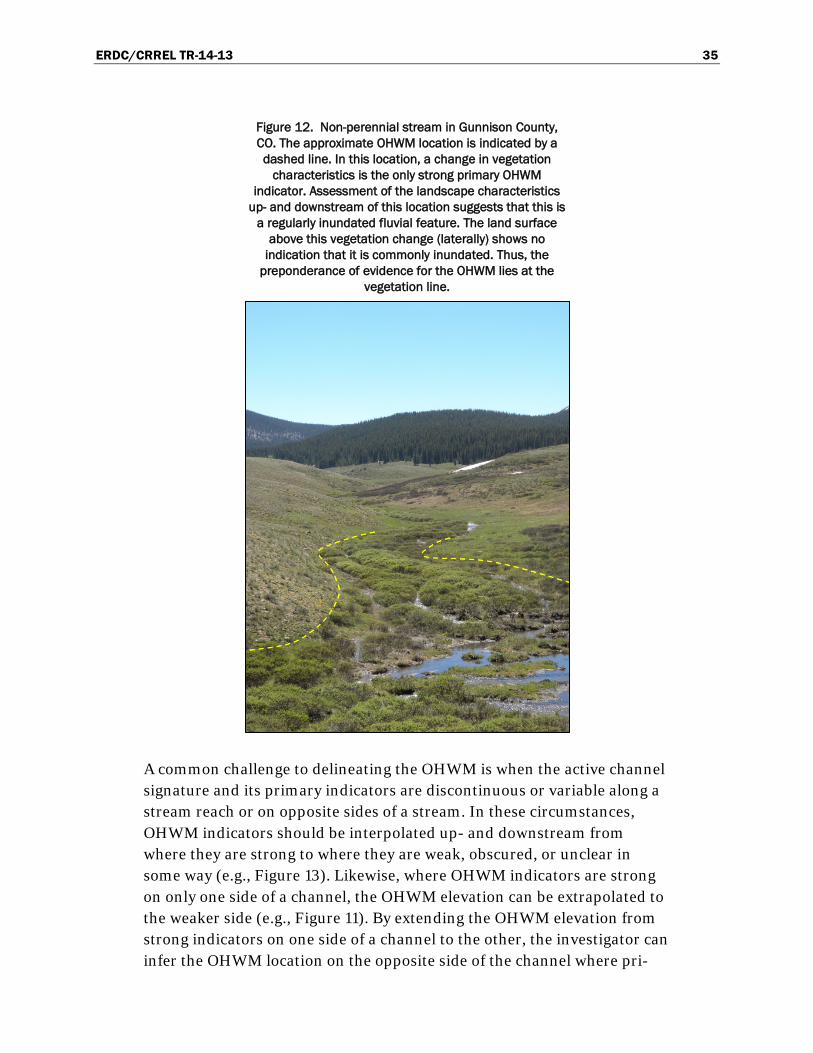
ERDC/CRREL TR-14-13 35
Figure 12. Non-perennial stream in Gunnison County, CO. The approximate OHWM location is indicated by a dashed line. In this location, a change in vegetation
characteristics is the only strong primary OHWM indicator. Assessment of the landscape characteristics
up- and downstream of this location suggests that this is a regularly inundated fluvial feature. The land surface
above this vegetation change (laterally) shows no indication that it is commonly inundated. Thus, the
preponderance of evidence for the OHWM lies at the vegetation line.
A common challenge to delineating the OHWM is when the active channel signature and its primary indicators are discontinuous or variable along a stream reach or on opposite sides of a stream. In these circumstances, OHWM indicators should be interpolated up- and downstream from where they are strong to where they are weak, obscured, or unclear in some way (e.g., Figure 13). Likewise, where OHWM indicators are strong on only one side of a channel, the OHWM elevation can be extrapolated to the weaker side (e.g., Figure 11). By extending the OHWM elevation from strong indicators on one side of a channel to the other, the investigator can infer the OHWM location on the opposite side of the channel where pri-
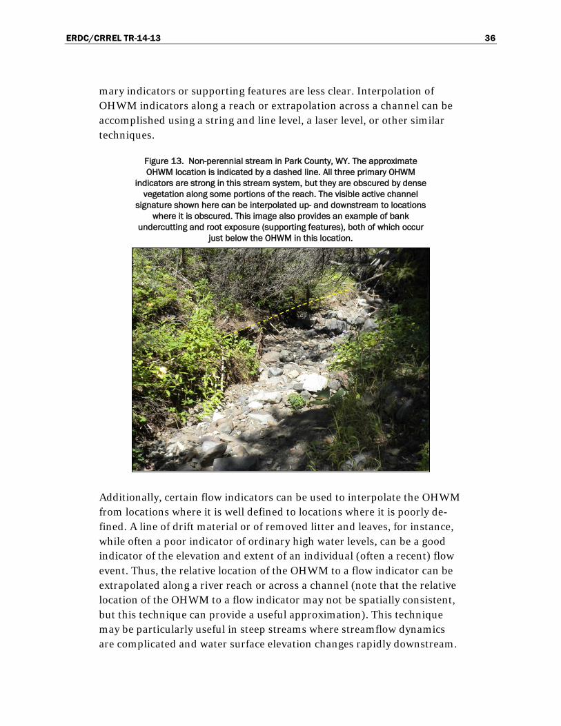
ERDC/CRREL TR-14-13 36
mary indicators or supporting features are less clear. Interpolation of OHWM indicators along a reach or extrapolation across a channel can be accomplished using a string and line level, a laser level, or other similar techniques.
Figure 13. Non-perennial stream in Park County, WY. The approximate OHWM location is indicated by a dashed line. All three primary OHWM
indicators are strong in this stream system, but they are obscured by dense vegetation along some portions of the reach. The visible active channel
signature shown here can be interpolated up- and downstream to locations where it is obscured. This image also provides an example of bank
undercutting and root exposure (supporting features), both of which occur just below the OHWM in this location.
Additionally, certain flow indicators can be used to interpolate the OHWM from locations where it is well defined to locations where it is poorly de-fined. A line of drift material or of removed litter and leaves, for instance, while often a poor indicator of ordinary high water levels, can be a good indicator of the elevation and extent of an individual (often a recent) flow event. Thus, the relative location of the OHWM to a flow indicator can be extrapolated along a river reach or across a channel (note that the relative location of the OHWM to a flow indicator may not be spatially consistent, but this technique can provide a useful approximation). This technique may be particularly useful in steep streams where streamflow dynamics are complicated and water surface elevation changes rapidly downstream.

ERDC/CRREL TR-14-13 37
Where physical evidence at the site of interest is insufficient to confidently identify the OHWM, information can be compared against adjacent stream reaches or nearby streams. Long-term, it may be advantageous to establish one or more reference sites, representative of particular stream types for a given area, at which OHWM indicators are well defined (again, see Harrelson et al. [1994] for detailed information on establishing refer-ence sites). These sites can serve as useful comparisons for similar loca-tions and be used to ensure consistent OHWM delineation practices within a given area. A useful technique is to compare the channel dimensions (i.e., cross-sectional area) within a problematic stream reach with those of adjacent (i.e., up- and downstream) stream reaches, nearby streams that are similarly situated on the landscape and have similar contributing drainage areas, reference streams, or regional curves (discussed in the fol-lowing section). This can help to narrow down the OHWM location as cross-sectional area should stay fairly consistent along a relatively short stream reach where channel slope does not vary greatly.
Recently disturbed or rapidly adjusting systems present unique challenges for OHWM delineation. In some cases, streams may readjust to pre-disturbance channel dimensions (e.g., following a large flood event) while in others they may be adjusting to altered watershed conditions (e.g., in response to logging, grazing, wildfire, etc.). In the stream depicted in Fig-ure 14, for example, the active channel appears to have been scoured out by a large flood event. The apparent erosion and root exposure on the stream banks suggest that channel enlargement may have occurred. Therefore, evidence suggests that the stream channel is somewhat unsta-ble in its current condition. Stream channels may take years or decades to restabilize following disturbance or altered hydrologic conditions within a watershed, and the stream in Figure 14 will potentially readjust to pre-flood dimensions if given enough time. However, it is important to consid-er that all streams are in a constant state of adjustment in response to complex and interrelated external and internal forces at many spatial and temporal scales. For regulatory purposes, speculation as to past and future channel conditions should be minimized unless ample evidence is present. Instead, OHWM delineation should generally be made with the field indi-cators and evidence present at the time of assessment.

ERDC/CRREL TR-14-13 38
Figure 14. Non-perennial stream in Skagit County, WA. The approximate OHWM location is indicated by the dashed line. As is apparent from the
heavy erosion and exposed roots visible on the stream banks, recent flooding has scoured out and potentially enlarged the stream channel.
However, despite recognition of potentially unstable channel conditions, the signature associated with the recently adjusted active channel boundaries
remains the most stable feature that can be delineated in this location. Therefore, the OHWM here is still identified by the break in slope at the top of the active channel banks, which coincides with a distinct change in both
vegetation and sediment characteristics. A sharp change in sediment texture, indicated by a red arrow in the image, marks the edge of the
channel bed, not the precise location of the OHWM.
In Figure 14, the only viable indicators present in this location at the time the photograph was taken are the primary indicators associated with the boundaries of the recently adjusted active channel. The break in slope at the top of the reworked active channel coincides with a distinct change in both sediment and vegetation characteristics and thus represents the OHWM as determined on the day this photo was taken. Note that a dis-tinct change in sediment texture in Figure 14 (indicated by a red arrow) is located at the edge of the channel bed, not at the top of the channel banks. As discussed in Section 2.3, this may be due to the ability of deeper flows to transport larger sediments or simply the angle of repose of large sedi-ment particles on steep banks.
Thus, the OHWM location indicated in Figure 14 corresponds with the ac-tive channel boundaries at the time this photo was taken. Assessment of adjacent stream reaches confirms similar channel conditions up- and
ERDC/CRREL TR-14-13 39
downstream of the location depicted. Consistent and repeatable delinea-tion practices are achieved in this circumstance by relying on primary OHWM indicators that are likely to shift with the active channel bounda-ries. Thus, it is the mark (the active channel signature) itself that is ordi-nary, consistently indicating the boundaries of the active channel even when those boundaries shift over time. Additional delineations may be re-quired in the event of ongoing channel adjustment. The following section discusses additional information and lines of evidence that can help with OHWM delineations.
3.3 Supplemental information and additional lines of evidence
Assessment of remotely sensed imagery and hydrologic data can be per-formed before or after a field delineation to gather preliminary data about a project site, to help narrow down the OHWM location, or to verify the accuracy of or provide supporting evidence for a field delineation. These resources may provide additional lines of evidence to help the investigator to better interpret field indicators or to validate or support field delinea-tions. However, OHWM delineations should not rely solely on evaluation of remotely sensed imagery or hydrologic information. Field assessment or verification of physical evidence should always be performed, and the OHWM should be tied to physical features whenever possible.
3.3.1 Remotely sensed imagery
Remotely sensed imagery (i.e., satellite and aerial photographs) can pro-vide useful information that cannot be ascertained at ground level about a stream and the surrounding landscape. This information is becoming in-creasingly available and easy to analyze via free, open-access resources such as Google Earth (www.earth.google.com). Where stream size, vegetation cover, and data availability permit, remotely sensed images can help to identify and delineate the geomorphic features of a stream system. This may be useful for performing a preliminary delineation (which should then be spot-checked and validated on the ground), potentially reducing the time and effort required in the field. Alternatively, assessment of re-motely sensed imagery can aid in validating a field delineation.
A time series of images dating from the near present through the recent past may be used to assess the stability of geomorphic features over time and the recent history of a project site. This includes assessment of past and present land-use patterns and landscape alteration (e.g., wildfire,
ERDC/CRREL TR-14-13 40
flooding, urbanization, dam emplacement or removal, etc.), which may help to better understand potential sources of impact to the project site and the recent stability of the stream in question. Where remotely sensed imagery cannot adequately show stream features (e.g., due to small stream size or thick vegetation cover), images of the surrounding landscape may still help the investigator to understand the recent history of the watershed and any changes that might affect local hydrologic and geomorphic condi-tions.
In Figure 15, the OHWM location along this stream reach in Teton County, WY, is approximated in the acquired images (from Google Earth) based on a distinct change in color at the edge of what appears to be the active channel. A time series of images dating from 2006, 2009, and 2011 in this location also allows for a quick and easy visual assessment of recent land-use changes and stream stability. It is apparent from these images that the stream and the surrounding landscape have undergone little change from 2006 to 2011, suggesting that the stream has been relatively stable in its current location in recent years. In this case, a preliminary delineation of the OHWM can be traced on the most recent acquired image. Field valida-tion confirms that the preliminary OHWM delineation corresponds with the active channel signature as observed on the ground. Again, note that, in most circumstances, OHWM delineation should not be based solely on assessment of remotely sensed imagery. Any remotely sensed images used to support an OHWM delineation and the information discerned from them should be documented in the project report.

ERDC/CRREL TR-14-13 41
Figure 15. Remotely sensed images from 2006, 2009, and 2011 acquired from Google Earth (left) and ground-based images from 2011 (right) of a non-perennial stream in Teton County, WY. The acquired remotely
sensed images allow for a preliminary off-site delineation of the OHWM (indicated by a dashed line). Visual analysis of this time series of remotely sensed images suggests relatively stable active channel boundaries
from 2006 to 2011. Field validation of the off-site delineation verifies that the active channel signature identified in the remotely sensed images corresponds with the field signature as expressed by three primary
indicators—break in slope, change in sediment characteristics, and change in vegetation characteristics.

ERDC/CRREL TR-14-13 42
3.3.2 Hydrologic and hydraulic information
Hydrologic and hydraulic information about a stream or its watershed may help the investigator to better interpret physical evidence in the field. This information, generated either from direct measurements and obser-vations or from modeled estimates, is of particular use in complex stream systems, in circumstances where there are multiple potential OHWM loca-tions, or where the location of the OHWM is otherwise unclear. These re-sources may provide hydrologic context to geomorphic features and poten-tial OHWM indicators, but none of these tools or resources are meant to replace field delineation of the OHWM. Moreover, these resources should be used only by those with the necessary training and expertise required to implement and interpret them accurately.
Hydrologic information does not pinpoint the exact location of the OHWM but may narrow the range of potential locations. As discussed in the intro-duction to this guide, while not correlated to a specific discharge return interval, the OHWM is associated with ordinary water levels that occur during the high water season—streamflow levels are above average but less than extreme and occur with some regularity. Therefore, having an idea of the water surface elevations associated with various streamflow return in-tervals that are well outside of the reasonable range of ordinary high water flows (e.g., mean annual discharge, the 100-year flood, etc.) may help to narrow down the OHWM location. Likewise, correlating field indicators with the stage heights of specific flood events or comparing channel di-mensions with those of similarly situated streams based on statistical rela-tionships may help to rule out potential OHWM locations. However, the precise location of the OHWM should not be based on modeled or statisti-cally derived information.
3.3.2.1 Streamflow data
Stream gages provide in situ measurements of water surface elevation and discharge at specific points along a stream system. The U.S. Geological Survey (USGS) maintains a network of around 7000 stream gages throughout the country (http://waterdata.usgs.gov); however, they are most heav-ily concentrated in eastern parts of the U.S. and on relatively large, peren-nial streams. Additionally, a number of state and local agencies, research organizations, and private companies maintain their own stream gages and often freely distribute these data.

ERDC/CRREL TR-14-13 43
Although it is rare to have a stream gage in the exact location of a project site, gages located up- or downstream of a project site, within the same watershed, or within adjacent or nearby watersheds may help to better understand the hydrologic regime (the timing, magnitude, frequency, and duration of streamflow events) for a given area or to interpret the recent flow history of a site. From a stream gage near a given project site, one might learn that the area recently experienced a sizable flood, for example, which in turn may help to interpret the physical and biological features at the ungaged project site. As a general rule, the closer two locations are to each other, the more strongly correlated the streamflow histories in the two locations will be. But this is only true for the timing and relative mag-nitude of flow events and not for flow depths. In locations where precipita-tion patterns are highly spatially variable (“flashy” systems), streamflow records between two relatively near locations may not be well correlated. Curtis et al. (2011) provides a more comprehensive overview of stream gages, stage-discharge relationships, and the utility and limitations of stream gage data in interpreting and delineating the OHWM (this source focuses on arid systems, but much of the information has broader applica-bility).
Where streamflow data are not directly measured, statistically derived hy-drologic information can provide useful estimates of streamflow parame-ters at ungaged sites. StreamStats (http://water.usgs.gov/osw/ streamstats/), for in-stance, is a web-based GIS (geographic information system) program developed by the USGS and provides streamflow statistics throughout most of the U.S. StreamStats can also help to determine the contributing drainage area for a given point and other useful drainage basin character-istics; streamflow information at ungaged locations is extrapolated from gaged sites using regression and other statistical methods. StreamStats provides estimates of various streamflow statistics that may help to narrow down the location of the OHWM. Streamflow information will typically be most useful for OHWM delineation purposes when converted to stage es-timates. There are a number of methods by which to accomplish this, but this should be performed and assessed only by personnel with the appro-priate expertise to do so. Gartner et al. (in prep. b) provides a more thor-ough overview of StreamStats, hydrologic modeling, and other sources of hydrologic information.

ERDC/CRREL TR-14-13 44
3.3.2.2 Hydraulic models
Various hydraulic equations (e.g., the Manning formula) and models (e.g., the Hydraulic Engineering Center River Analysis System) may be used to estimate the elevation and spatial extent of particular flows. These tools can aid in estimating the stage heights associated with various discharge return intervals at a particular location or, conversely, in estimating the return interval associated with observed field indicators (however, note again that the OHWM should not be tied to a specific return interval). Again, the purpose of such an exercise would not be to determine the pre-cise location of the OHWM but rather to narrow it down or to add addi-tional supporting evidence to a field delineation. Note that the accuracy of hydraulic models can be heavily user-dependent. Additionally, the use of hydraulic models in small, high-gradient streams can be challenging due to the complex hydraulics in these systems. Thus, while these resources can be useful in certain circumstances, they have limited applicability for delineating the OHWM in WMVC non-perennial streams. Hydraulic mod-els should be used and reviewed with caution and only by those with ap-propriate expertise. All assumptions and input data must be documented and submitted for review if used as supporting evidence in an OHWM de-lineation. Gartner et al. (in prep. a) provides a detailed discussion on the utility of hydraulic models for OHWM delineation.
3.3.2.3 Regional curves
Regional curves or hydraulic geometry curves are another source of poten-tially useful data for OHWM delineation purposes. These empirically de-rived curves relate drainage area to useful hydraulic parameters, such as bankfull discharge, cross-sectional area, width, and mean depth. This in-formation can be useful for interpreting physical features in complicated or disturbed systems or for adding supplementary data to support or vali-date a field delineation. Note that regional curves are regionally specific and are derived from relatively undisturbed and hydrologically unregulat-ed stream systems and should be interpreted accordingly. Regional curves are available from a variety of sources, such as the Natural Resource Con-servation Service (http://www.nrcs.usda.gov/wps/portal/nrcs/detail/national/water/ ?cid=nrcs143_015052).

ERDC/CRREL TR-14-13 45
3.4 OHWM documentation
It is essential to properly document not only the location of the OHWM along a given stream but also the field evidence and procedures used to delineate it. Be sure to provide adequate detail on channel dimensions and conditions and the location of the OHWM relative to hydrogeomorphic units and other features of interest. Describe the physical features used to identify the OHWM, the field methods used, and any supplemental sources of information or additional lines of evidence used. An OHWM de-lineation datasheet and suggested documentation procedures are available online at http://www.erdc.usace.army.mil/. The procedures and level of detail re-quired to adequately document an OHWM delineation will depend on the nature of the project and the scale and complexity of the project site. Con-sult with your local Corps Regulatory District regarding specific documen-tation requirements.

ERDC/CRREL TR-14-13 46
4 Summary
Accurate and consistent OHWM delineation practices require an under-standing of both the conceptual basis for the OHWM and the field indica-tors and methods used to identify it. The concept of ordinary high water in rivers and streams is understood to be consistent with the ordinary extent of inundation during the high water or wet season—with high water levels that are well above average and occur with some regularity but that do not include extreme and infrequent flood events. This hydrologic explanation of ordinary high water helps to constrain the understanding of the OHWM and the flows that shape it, but the location of the OHWM in any given stream system is ultimately based on physical and biological evidence that is observable on the landscape. The OHWM should ideally be tied to land-scape features that are relatively stable over time, and these features should be representative of long-term, recurring flow conditions rather than recent flow conditions or individual flow events. However, the OHWM is not a static line on the landscape and may vary in appearance and location over time given the dynamic nature of fluvial systems. Thus, while information on prior landscape or streamflow conditions (e.g., from aerial imagery, stream gage records, anecdotal evidence, etc.) may provide useful supporting evidence, the OHWM at any given location should ulti-mately be delineated based on current site conditions as observed in the field.
The OHWM in WMVC non-perennial streams is generally consistent with the boundaries of the active channel, typically expressed on the landscape by a physical or biological signature composed of multiple primary indica-tors—a topographic break in slope (typically the tops of the channel banks), change in sediment characteristics (texture and soil development), and change in vegetation characteristics (density, maturity, and species composition). The OHWM should be correlated with two or more of these primary indicators whenever possible, as primary indicators can also be highly misleading when used individually and without consideration of other indicators. However, some locations or circumstances may necessi-tate reliance on only a single primary indicator in conjunction with other supporting evidence. There are numerous supporting features and sup-plemental sources of information (e.g., stream gages, remotely sensed im-agery, etc.) that may lend additional evidence to an OHWM delineation.

ERDC/CRREL TR-14-13 47
Supporting features, especially those reflective of recent flow conditions or individual flow events (e.g., drift, leaf clearing, matted vegetation, etc.), should generally not be used to pinpoint the precise location of the OHWM. These features and supplemental sources of information should primarily be used to narrow down the OHWM location and to better inter-pret the primary indicators at a given site.
The general approach to OHWM delineation suggested here emphasizes first getting a broad sense of the project site by walking its entire length and potentially up- and downstream of the stream reach in question. Iden-tify the hydrogeomorphic units (e.g., low-flow channels, the active chan-nel, floodplain, etc.) present and areas that are clearly outside or above the OHWM and those that are clearly within or below the OHWM (i.e., within the active channel). In some locations, remotely sensed imagery may help to identify hydrogeomorphic units and other landscape features. A good strategy is to identify one or more locations where features of interest are well defined and representative of the stream reach in question and to es-tablish reference transects (also good locations at which to document the OHWM). Narrow down the OHWM at these reference points using prima-ry indicators, supporting features, and additional lines of evidence. Ex-trapolate the OHWM from locations where it is well defined to those where it is unclear. Lastly, be sure to adequately document an OHWM de-lineation by detailing the field evidence, methods, and any supplemental sources of information used.
This guide aims to provide an accurate and consistent approach to OHWM delineation in non-perennial streams within the WMVC Region. Many of the concepts, indicators, and methods discussed are potentially applicable to other stream types and regions, but this has not been adequately vali-dated. OHWM delineation is not a precise practice, and best professional judgment and consideration of the unique characteristics of each project site are always required.

ERDC/CRREL TR-14-13 48
References Bailey, R. G. 1995. Description of the ecoregions of the United States. 2nd ed.
Miscellaneous Publication 1391 (revised). Washington, DC: U.S. Department of Agriculture, Forest Service. http://www.fs.fed.us/land/ecosysmgmt/ecoreg1_home.html.
Belsky, A. J., A. Matzke, and S. Uselman. 1999. Survey of Livestock Influences on Stream and Riparian Ecosystems in the Western United States. Journal of Soil and Water Conservation 54:419–31.
Bendix, J., and C. R. Hupp. 2000. Hydrological and Geomorphological Impacts on Riparian Plant Communities. Hydrological Processes 14 (16–17): 2977–2990. doi:10.1002/1099-1085(200011/12)14:16/17<2977::AID-HYP130>3.0.CO;2-4.
Blackburn, M., and C. Mazzacano. 2012. Using Aquatic Macroinvertebrates As Indicators of Streamflow Duration: Washington and Idaho Indicators. Portland, OR: The Xerces Society for Invertebrate Conservation. http://www.xerces.org/wp-content/uploads/2009/03/Streamflow_duration_indicators_ IDWA_2012_Final_06072012.pdf.
Curtis, K .E., R. W. Lichvar, and L. Dixon. 2011. Ordinary High Flows and the Stage-Discharge Relationship in the Arid West Region. ERDC/CRREL TR-11-12. Hanover, NH: U.S. Army Engineer Research and Development Center.
Faustini, J. M., and J. A. Jones. 2003. Influence of Large Woody Debris on Channel Morphology and Dynamics in Steep, Boulder-rich Mountain Streams, Western Cascades, Oregon. Geomorphology 51 (1–3): 187–205. doi:10.1016/S0169-555X(02)00336-7.
Gartner, J. D., M. K. Mersel, L. E. Lefebvre, and R. W. Lichvar. In prep. a. The Benefits and Limitations of Modeling in Ordinary High Water Mark Delineation Part 1: Hydraulic Modeling. Hanover, NH: U.S. Army Engineer Research and Development Center.
Gartner, J. D., M. K. Mersel, and R. W. Lichvar. In prep. b. The Benefits and Limitations of Modeling in Ordinary High Water Mark Delineation Part 2: Hydrologic Modeling. Hanover, NH: U.S. Army Engineer Research and Development Center.
Grant, G. E., and F. J. Swanson. 1995. Morphology and Processes of Valley Floors in Mountain Streams, Western Cascades, Oregon. Geophysical Monograph Series. 89:83–101.
Guest, D. 1990. The Ordinary High Water Boundary on Freshwater Lakes and Streams: Origin, Theory, and Constitutional Restrictions. Journal of Land Use and Environmental Law 6 (2): 205–240.
Harrelson, C. C., C. L. Rawlins, and J. P. Potyondy. 1994. Stream Channel Reference Sites: An Illustrated Guide to Field Technique. General Technical Report RM-245. Fort Collins, CO: U.S. Department of Agriculture, Forest Service, Rocky Mountain Forest and Range Experimentation Station.

ERDC/CRREL TR-14-13 49
Hupp, C. R., and W. R. Osterkamp. 1996. Riparian Vegetation and Fluvial Geomorphic Processes. Geomorphology 14 (4): 277–95. doi:10.1016/0169-555X(95)00042-4.
Lichvar, R. W., D. C. Finnegan, M. P. Ericsson, and W. Ochs. 2006. Distribution of Ordinary High Water Mark (OHWM) Indicators and Their Reliability in Identifying the Limits of “Waters of the United States” in Arid Southwestern Channels. ERDC/CRREL TR-06-5. Hanover, NH: U.S. Army Engineer Research and Development Center.
Lichvar, R. W., and S. M. McColley. 2008. A Field Guide to the Identification of the Ordinary High Water Mark (OHWM) in the Arid West Region of the Western United States. ERDC/CRREL TR-08-12. Hanover, NH: U.S. Army Engineer Research and Development Center.
Mazzacano, C. M., and S. H. Black. 2008. Using Aquatic Macroinvertebrates as Indicators of Streamflow Duration. Portland, OR: The Xerces Society for Invertebrate Conservation. http://www.xerces.org/wp-content/uploads/2009/03/xerces_ macroinvertebrates_indicators_stream_duration.pdf.
McBride, J. R., and J. Strahan. 1984. Establishment and Survival of Woody Riparian Species on Gravel Bars of an Intermittent Stream. American Midland Naturalist 112 (2): 235–245. doi:10.2307/2425430.
Mersel, M. K., R. W. Lichvar, J. J. Gillrich, L. E. Lefebvre. 2014. Occurrence and Distribution of Ordinary High Water Mark (OHWM) Indicators in Non-Perennial Streams in the Western Mountains, Valleys, and Coast Region of the United States. ERDC/CRREL TR-14-11. Hanover, NH: U.S. Army Engineer Research and Development Center.
Montgomery, D. R., and J. M. Buffington. 1997. Channel-reach Morphology in Mountain Drainage Basins. Geological Society of America Bulletin 109 (5): 596–611. doi:10.1130/0016-7606(1997)109<0596:CRMIMD>2.3.CO;2.
Nadeau, T-L. 2011. Streamflow Duration Assessment Method for Oregon (Revised). EPA 910-R-11-002. Portland, OR: U.S. Environmental Protection Agency, Region 10.
U.S. Army Corps of Engineers. 2005. Ordinary High Water Mark Identification. Regulatory Guidance Letter 05-05. Washington, DC: U.S. Army Corps of Engineers.
U.S. Army Corps of Engineers. 2010. Regional Supplement to the Corps of Engineers Wetland Delineation Manual: Western Mountains Valleys, and Coast Region (Version 2.0), ed. J. S. Wakeley, R. W. Lichvar, and C. V. Noble. ERDC/EL TR-10-3. Vicksburg, MS: U.S. Army Engineer Research and Development Center.
U.S. Army Corps of Engineers. 2012. 2012 Nationwide Permits, Conditions, District Engineer’s Decision, Further Information, and Definitions (with corrections). http://www.usace.army.mil/Portals/2/docs/civilworks/nwp/2012/NWP2012_corrections_21-sep-2012.pdf.
U.S. Congress. 1977. Clean Water Act. Codified at 33 U.S.C. 1251 (et seq.). Washington, DC: U.S. Government Printing Office.

ERDC/CRREL TR-14-13 50
U.S. Congress. 1986. Definition of “Waters of the United States.” Codified at 33 CFR 328.3 (et seq.). Washington, DC: U.S. Government Printing Office.
U.S. Department of Agriculture (USDA). 2006. Land Resource Regions and Major Land Resource Areas of the United States, the Caribbean, and the Pacific Basin. Agriculture Handbook 296. Washington, DC: U.S. Department of Agriculture, Natural Resources Conservation Service. http://www.nrcs.usda.gov/wps/portal/ nrcs/detail/soils/survey/geo/?cid=nrcs142p2_053624.
Wohl, E., and D. Merritt. 2005. Prediction of Mountain Stream Morphology. Water Resources Research 41 (August 1): 08419. doi:10.1029/2004WR003779.
Wolman, M. G., and J. P. Miller. 1960. Magnitude and Frequency of Forces in Geomorphic Processes. Journal of Geology 68 (1): 54–74. doi:10.2307/30058255.

REPORT DOCUMENTATION PAGE Form Approved
OMB No. 0704-0188 Public reporting burden for this collection of information is estimated to average 1 hour per response, including the time for reviewing instructions, searching existing data sources, gathering and maintaining the data needed, and completing and reviewing this collection of information. Send comments regarding this burden estimate or any other aspect of this collection of information, including suggestions for reducing this burden to Department of Defense, Washington Headquarters Services, Directorate for Information Operations and Reports (0704-0188), 1215 Jefferson Davis Highway, Suite 1204, Arlington, VA 22202-4302. Respondents should be aware that notwithstanding any other provision of law, no person shall be subject to any penalty for failing to comply with a collection of information if it does not display a currently valid OMB control number. PLEASE DO NOT RETURN YOUR FORM TO THE ABOVE ADDRESS. 1. REPORT DATE (DD-MM-YYYY) August 2014
2. REPORT TYPE Technical Report/Final
3. DATES COVERED (From - To)
4. TITLE AND SUBTITLE
A Guide to Ordinary High Water Mark (OHWM) Delineation for Non-Perennial Streams in the Western Mountains, Valleys, and Coast Region of the United States
5a. CONTRACT NUMBER
5b. GRANT NUMBER
5c. PROGRAM ELEMENT NUMBER
6. AUTHOR(S)
Matthew K. Mersel and Robert W. Lichvar
5d. PROJECT NUMBER
5e. TASK NUMBER
5f. WORK UNIT NUMBER
7. PERFORMING ORGANIZATION NAME(S) AND ADDRESS(ES) 8. PERFORMING ORGANIZATION REPORT NUMBER
U.S. Army Engineer Research and Development Center Cold Regions Research and Engineering Laboratory 72 Lyme Road Hanover, NH 03755-1290
ERDC/CRREL TR-14-13
9. SPONSORING / MONITORING AGENCY NAME(S) AND ADDRESS(ES) 10. SPONSOR/MONITOR’S ACRONYM(S) Wetlands Regulatory Assistance Program (WRAP) U.S. Army Corps of Engineers Vicksburg, MS 39180-6133
11. SPONSOR/MONITOR’S REPORT NUMBER(S)
12. DISTRIBUTION / AVAILABILITY STATEMENT Approved for public release; distribution is unlimited.
13. SUPPLEMENTARY NOTES
14. ABSTRACT
This document provides technical guidance for delineating the ordinary high water mark (OHWM) in non-perennial streams in the Western Mountains, Valleys, and Coast (WMVC) Region of the United States. Under Section 404 of the Clean Water Act, the OHWM defines the lateral extent of federal jurisdiction in non-tidal waters of the U.S. in the absence of adja-cent wetlands. The OHWM in the WMVC Region is consistent with the physical and biological signature established and maintained at the boundaries of the active channel. Delineation of the active channel signature, and thus the OHWM, is based largely on identification of three primary physical or biological indicators—topographic break in slope, change in sed-iment characteristics, and change in vegetation characteristics. This guide addresses the underlying hydrologic and geo-morphic concepts pertaining to the OHWM and the field indicators, methods, and additional lines of evidence used to as-sess and delineate the OHWM in WMVC non-perennial streams. The technical guidance presented here increases the accuracy and consistency of OHWM delineation practices in the WMVC Region.
15. SUBJECT TERMS
Delineation Ephemeral
Intermittent Non-perennial OHWM delineation
Ordinary High Water Mark Streams Western Mountains, Valleys, and Coast
16. SECURITY CLASSIFICATION OF: 17. LIMITATION OF ABSTRACT
18. NUMBER OF PAGES
19a. NAME OF RESPONSIBLE PERSON
a. REPORT
U
b. ABSTRACT
U
c. THIS PAGE
U None 61
19b. TELEPHONE NUMBER (include area code)
Standard Form 298 (Rev. 8-98) Prescribed by ANSI Std. 239.18