episode ii (6.2mb pdf)
TRANSCRIPT

EPISODE I I TEACHERS’ GUIDE
Nancy O’Brien Wagner, Lansing Shepard,
Carol Schreider, Barbara Coffin
A joint project of the College of Natural Resources, University of Minnesota
and the Education Department of the Minnesota Historical Society

II
USE AND PHILOSOPHY ......................................................................................................................................... III
SERIES OVERVIEW ................................................................................................................................................... V
EPISODE II: CHANGES IN THE LAND
ORIENTATION .......................................................................................................................................................... 2
VIEWING GUIDE ...................................................................................................................................................... 4
LESSONS
Lesson 3: The Big Woods: A Settler’s Dilemma ........................................................................................................ 7
Lesson Worksheet ........................................................................................................................................................ 8
Lesson 4: Bison: A Keystone Species .......................................................................................................................... 11
Lesson Worksheet ........................................................................................................................................................ 12
ANSWER KEYS
Viewing Guide Answer Key .......................................................................................................................................... 14
Lesson 3 Worksheet Answer Key ................................................................................................................................... 16
Lesson 4 Worksheet Answer Key ................................................................................................................................... 18
SUGGESTED RESOURCES ...................................................................................................................................... 18
WEB SITE ............................................................................................................................................................ 19
MAPS ............................................................................................................................................................. 20
CONTENTS

III
Minnesota: A History of the Land is a four-part documentary series that weaves
together human and natural history and illustrates the historical and ongoing
importance of Minnesota’s landscapes to the social, cultural, and economic systems
of the region.
Throughout time, humans have altered their landscapes. In the 500 years since Europeans
arrived on this continent, the physical landscape has changed profoundly. Minnesota: A
History of the Land tells part of that story chronicling the vast changes that Minnesota’s
ecosystems have undergone, from presettlement to the present. By showing how humans
have shaped and interacted with the land, this series provides a powerful context for under-
standing the region’s current environmental challenges.
A set of powerful insights about the relationship between the physical environment and
humans binds the four episodes of the series together:
• How humans view the land determines how humans use the land. In Minnesota, for
example, different people have viewed (and thus used) these lands very differently.
Because of human perception and action, the landscape has been altered dramatically
and, in many cases, irrevocably.
• Apart from human perceptions, these lands have always had their own existence.
Landscapes are first and forever ecological entities that react to disturbances in ecologi-
cal ways—through an immense web of complex interdependencies, cycles, and energy
flows that is connected to landforms, soils, seasons, and rainfall patterns.
• The gap between human perception and ecological reality has led repeatedly to unin-
tended and often negative consequences. Because of this, people have been forced to
adjust their view of the land and thus their use of the land. This halting, adaptive
process means that the landscape shapes people even as people shape the landscape.
• In changing these landscapes, people not only replace old, complex landscapes with
new, simplified ones, they set the terms of engagement—the limits of what is possible
for future generations.
The series can be viewed in a number of ways: as social and political history, as a history of
environmental thought, as a history of technology, or even as lessons in ecology.
For more information about the series, visit: www.historyoftheland.org
USE AND PHILOSOPHY
The series can be viewed
in a number of ways —
as social and political
history, as a history of
environmental thought,
as a history of technology, or
even as lessons in
ecology.
T H E F O U R - P A R T D O C U M E N T A R Y S E R I E S D V DOriginal soundtrack by Peter Ostroushko

IV
Goals for Student LearningThis teachers’ guide is intended to help middle-school students view the Minnesota: A History
of the Land video series and develop an understanding of the following key concepts:
• The land (physical environment) has played a powerful role in shaping Minnesota’s
economies and communities.
• Minnesotans have had an enormous impact on the state’s waters, plants, and wildlife and
have an important role to play as stewards of the environment.
• The historical causes of the landscape’s current condition—its health, use, and long-term
sustainability—are essential to understanding crucial issues of conservation and natural
resource management.
How to Use the Teachers’ GuideWhile the video alone is an effective educational tool, this curriculum is designed to help
middle-school teachers guide students to uncover the main points in each episode and to
expand the ideas described above. As you watch the video in your classroom, we suggest you
break your viewing into smaller sections. Each hour-long episode is composed of three to
four segments that range from twelve to twenty minutes in length.
I. The Episode Orientation presents a synopsis of each one-hour video as well as an easy-
to-follow guide to viewing and using each video. The orientation includes:
• a summary of each episode’s content and a time-coded abstract for each segment
• Northern Lights links, which cue users to related chapters of Northern Lights: The Story of
Minnesota’s Past, a middle-school curriculum of state history developed by the
Minnesota Historical Society
• key terms needed to understand the concepts in the video, along with brief definitions. You
may find it useful to preview these terms with your students before watching the video.
• discussion questions that explore concepts presented in each episode and require students
to synthesize information, think through implications, and draw conclusions
II. In addition, a viewing guide for each episode provides a list of questions that help students
identify the main concepts of each segment. You may find it helpful to pause the video after
each segment to allow students to discuss and revise their answers.
III. Each episode has two lessons designed to amplify the central ideas presented in that
episode. Each lesson contains a lesson plan to guide teachers in setting up and conducting
that exercise, and a reproducible worksheet on which the students’ work is done. Additional
ideas for related extension activities are included for each episode.
IV. Additional resources such as reference maps, suggested resources, and answer keys are
included to help the teacher and students.
USE AND PHILOSOPHY continued
Northern Lights LinksN
T E A C H E R S ’ G U I D E
Nancy O’Brien Wagner, Lansing Shepard,
Carol Schreider, Barbara Coffin
A joint project of the College of Natural Resources, University of Minnesota
and the Education Department of the Minnesota Historical Society

V
EPISODE I: Ordering the Land / 16,000 BP–1870s
Witness 16,000 years of Minnesota’s fascinating early history.
Its unique place in North America is revealed through state-
of-the-art animations and graphics. Prominent members of
Minnesota’s Native American community describe their long
relationship with the land. With the arrival of Europeans
comes a new way of looking at the land, one that will change
the region forever. See how this is expressed in the land sur-
vey, which carves the natural world into squares that can be
bought and sold. The fur trade era and early lumbering are
brought to life with historic re-creations and photographs.
Discover what happens when early entrepreneurs fail to
understand the geology of St. Anthony Falls.
EPISODE II: Changes in the Land / 1870s–1900
Voices from the past and stunning nature videography re-
create the natural world Euro-Americans first encountered.
Find out what happens to North America’s most abundant
species as commercial hunters and the railroad arrive in
Minnesota. The majestic Big Woods are cut down to make
room for farms and villages. Visit one of the little-known
crown jewels of Minnesota, the Bluestem Prairie. Find out
why Minnesota has some of the richest soils in the world
and how Minneapolis becomes the flour-milling capital of
the world. Historic re-creations bring to life the bonanza era
of wheat farming. And experience the catastrophic fire that
ushers in a new way of looking at the land.
EPISODE III: Out of the Ashes / 1900–1940s
Never-before-seen historic footage brings to life the begin-
nings of conservation in Minnesota. Discover why
Minnesota is at the forefront of conservation in the United
States and the key role that women play. See what happens
to the Mississippi River as the population of the Twin Cities
explodes. Graphic animations help viewers imagine the
results of one man’s plan to flood the boundary waters
region. Then, get to know the fascinating character who
helps to save the region from destruction. In the series’ most
ambitious historic re-creation, find out which prominent
Minnesota conservationist begins his career promoting the
destruction of wolves.
EPISODE IV: Second Nature / 1940s and Beyond
Unique historic footage and photographs depict the
momentous changes brought to Minnesota during and after
World War II. A vivid re-creation brings to life the revolu-
tionary work of a University of Minnesota graduate student.
Simple inventions like nylon nets and the introduction of an
exotic species bring the fishery of Lake Superior to the brink
of collapse. Through rarely seen footage, experience the
extensive pollution of Lake Superior caused by the disposal
of over 60,000 tons of waste a day. Then, hear firsthand how
a group of citizens plays a central role in stopping this pollu-
tion. Discover the ways in which our own homes and busi-
nesses result in changes in the land as far away as the rain
forests of South America. Consider how the stories of
Minnesota’s past can inform our choices for the future.
SERIES OVERVIEW
Minnesota: A History of the Land brings to life the epic story of the people and landscapes of Minnesota from
the retreat of the last ice sheets to the growth of today's suburbs. This four-part documentary series features nature
videography from across the state, never-before-seen historic images, state-of-the-art animations, and historic
recreations. The original soundtrack for the series is by award-winning composer Peter Ostroushko.
For more background information on the series, visit www.historyoftheland.org

1
Changes in the Land1870s – 1900
E P I S O D E I I :

2
Episode SummaryBy the middle of the nineteenth century, a surge of European settlement makes new landscapes of the old. Loggers harvest the pine
forest of the north at an ever-accelerating rate. The Big Woods in the south-central region of Minnesota are cut and turned into
farms. The prairie fills with new settlers and booming bonanza farms. The flour mills at St. Anthony Falls bring wealth and renown
to the bustling city of Minneapolis. The landscapes of Minnesota are blanketed by farms and industry, and the area’s wildlife is deci-
mated with unprecedented fury by market hunters. After less than fifty years of settlement, the prairie is nearly gone, numerous
species have disappeared from the region, and the “inexhaustible” northern forest is strained by logging and fire. Changes in the
Land is the story of the monumental change that sweeps the landscape of Minnesota in the last half of the nineteenth century.
2.5 minutes Episode Introduction. An introduction summarizes thehistory told in Episode I and foreshadows the story thatis Episode II.
11.5 minutes The Big Woods tells the story of Minnesota’s decidu-ous forest biome. It explores the ecosystem and howthe Dakota lived in and used its many elements. Thesegment explains how European settlers moved intothe very places the Dakota had occupied, but, unlikethe Dakota, they viewed the woods as an impedimentto a better use of the land—farming. The settlers cutthe woods down, converting a forest ecosystem into afarming landscape that echoed the landscapes of theirformer homelands.
5.5 minutes Market Hunting describes how the hunt for furbearersthat had fueled the old Indian-based fur trade wasextended after 1850 to the rest of the region’s wildlifeon a scale that dwarfed that former trade. The segmentlooks at how the arrival of the railroad connected thestate with eastern markets and triggered an explosionin commercial hunting that decimated wildlife acrossthe state. The story of the passenger pigeon and itsextinction at the hands of market hunters is used as anexample of the wastefulness of this period.
13.5 minutes Plowing the Prairie explains how the prairie ecosys-tems of Minnesota functioned as highly complex com-munities of plants and animals that were adapted todrought, fire, and bison. Incoming settlers, however, val-ued the prairie only as land with deep, rich soils.
Farmers plowed the prairie, cutting off the nutrient-pro-duction process that had made the soil so rich. It was onthe prairie’s composting remains that settlers then plant-ed a single species of an imported grass called wheat.
10.5 minutes Wheat, Wheat, Wheat is the story of the rise and fall ofwheat farming in Minnesota. Railroads, again, werecentral to the expansion of wheat farming and thedestruction of the prairie. Giant corporate bonanzafarms were established in the Red River valley andbecame symbols of this era. In the end, the glut ofwheat on the market and declining soil fertility, disease,and insects brought the wheat era to a close. Unlike adiverse prairie, monoculture farmlands lost fertility andbecame less stable and less sustainable over time. Bythe end of the nineteenth century, the prairie inMinnesota was essentially gone.
9.5 minutes Slash and Burn describes the revolution that the lum-ber industry went through in Minnesota after the CivilWar, and the effect it had on the state’s northern forest.Railroads and advancing technology led to rapid defor-estation. Cutover land left stumps and brush that driedand became fuel for enormous wildfires. Little wasdone to halt the destruction, however, because it wasassumed—incorrectly—that farming would follow. Itwasn’t until a tragic fire wiped out the town of Hinckleythat voices of reform began to be heard.
1.5 minutes The Close provides a brief summary of Episode II andforeshadows the content of Episode III.
ORIENTATIONEpisode II: Changes in the Land (1870s – 1900)
Note: The bold face type listed here in the "segment descriptions" indicates that an intertitle marks the beginning of a new segment in the episode.
The italic type indicates the beginning of a new segment in the episode, but the transition is made through visuals and narration.
SEGMENT LENGTH DESCRIPTION

3
Episode Key Terms
Big Woods: a huge forest of oak, maple, and basswood that lay across much
of central and south-central Minnesota; part of the state’s deciduous forest
biome
biodiversity: the diversity of organisms living within an ecological system
bonanza farms: giant 1,000-acre corporate wheat farms that flourished in
the Red River valley in the late 1800s
monoculture: an ecological system composed of only one species
of plant or animal
cutover lands: once-forested lands of northern Minnesota that had been
cleared of trees
Northern Lights Links
The following chapters have contentthat connects to this episode:
Chapter 7: Minnesota’s Newcomers
Chapter 10: Sod Busters
Chapter 11: Flour, Lumber, and Iron
Discussion Questions
1. What did the settlers value about the Big Woods? The prairie? The northern forests? Why
did they value certain things and not others?
2. What effect did these views have on those landscapes?
3. What is the difference between a prairie and a farm field?
4. Why were fires in the cutover area so much worse than the natural fires that occurred
before the lumber era?
5. Why was the Hinckley fire so important in Minnesota’s environmental history?
6. What are some ways we can use the land without making things worse for the future?
7. New technology dramatically changed the pace of lumbering and farming in the 1800s.
Are there any similar changes happening today?
8. Is there an economic value to untouched prairies or forests? How might you decide that?
9. What do you think Minnesota’s farms and forests will look like in fifty years? Should we
change the direction we are going in?
?
Episode II: Changes in the Land ORIENTATION continued
N
4
The Big Woods
1. What types of trees were most common in the Big Woods? (Name two or more.)
2. What did the Big Woods need to continue itself?
3. Why did settlers cut down the Big Woods?
Market Hunting
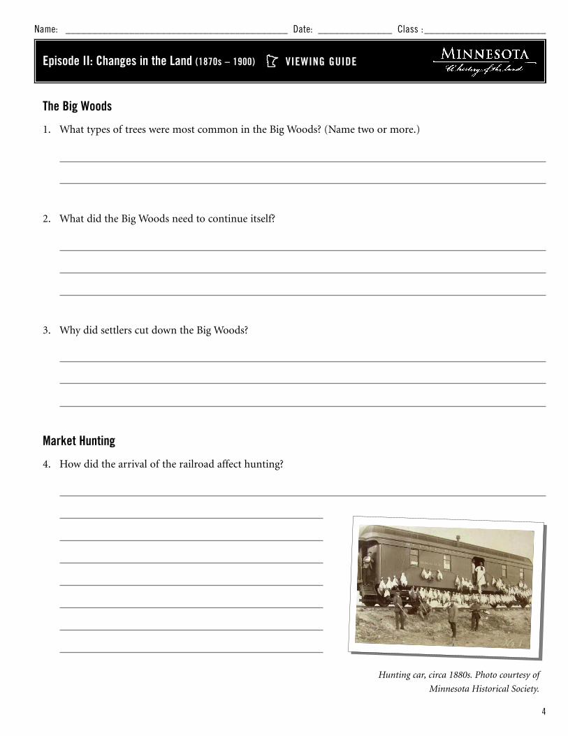
4. How did the arrival of the railroad affect hunting?
Name: __________________________________________ Date: ______________ Class :_______________________
VIEWING GUIDEEpisode II: Changes in the Land (1870s – 1900)
Hunting car, circa 1880s. Photo courtesy of
Minnesota Historical Society.

5
Plowing the Prairie
5. What were some of the plants and animals found in a prairie? (Name two or more plants and
two or more animals.)
6. Why was Minnesota’s prairie soil so good for farming?
Wheat, Wheat, Wheat
7. How did railroads encourage the plowing of the prairie?
8. What caused bonanza farms to fail?
Episode II: Changes in the Land VIEWING GUIDE continued
Settler with oxen. Photograph by Richard Hamilton Smith.
6
Slash and Burn
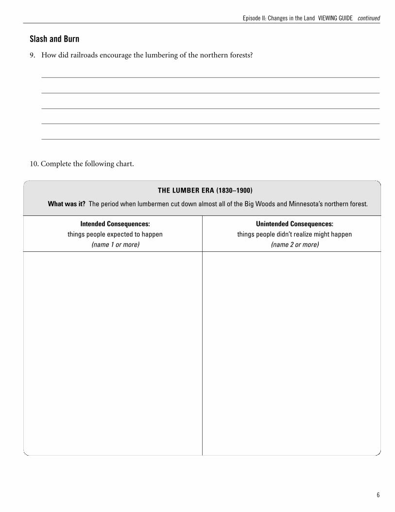
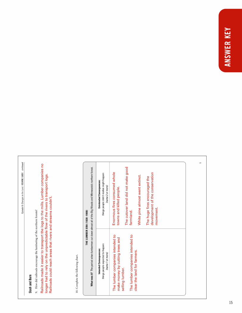
9. How did railroads encourage the lumbering of the northern forests?
10. Complete the following chart.
Episode II: Changes in the Land VIEWING GUIDE continued
Intended Consequences:things people expected to happen
(name 1 or more)
Unintended Consequences:things people didn’t realize might happen
(name 2 or more)
THE LUMBER ERA (1830–1900)
What was it? The period when lumbermen cut down almost all of the Big Woods and Minnesota’s northern forest.

7
Lesson Objective Upon completion of this lesson, students will understand:
• how settlers faced complex decisions about how to
manage their land
• how the use of the land and commercial success
are connected
• that different trees have different values
MaterialsLesson 3 Worksheet
Background When the settlers arrived on the Minnesota frontier, they faced
many difficult choices and many difficult years. Though most
settlers arrived with enough materials, food, or money to sup-
ply them in their first year, this exercise asks students to pre-
tend that they had no such preparations. Historically, the
process of clearing the land, building a home, and developing
income would have taken months and often years. As milled
lumber became available, the cost and/or effort of building a
home decreased significantly.
Consider dividing the class into small groups. This exercise
requires strong math skills as students test out different scenarios
to raise money to build a farm. Consider analyzing one section
of the map as a whole class, and model how to figure out how
much money could be raised from the lumber on that section.
Procedure1. With the class, review the section The Big Woods in Episode
II. Review the concept of what the Big Woods biome was.
2. Ask students what settlers did to make their homes. What
were the settlers’ main motivations?
Extension Ideas:
• Complete a tree survey near your school. Measure thecircumference of trees around your school, and notetheir species. What types of trees are most common?How big are the trees nearby? Can you tell whether thesetrees were planted intentionally or just grew there?Which student has the largest tree in their backyard orneighborhood?
• Visit a state forest or nearby park to see what trees arenative to your area.
• The Minnesota Department of Natural Resources hasmanaged Minnesota’s forests since the early 1900s. Goonline for more information about “Big Trees” in yourarea and the health of your local forest:http://www.dnr.state.mn.us/forestry/index.html
LESSON 3 PLANEpisode II: Changes in the Land (1870s – 1900)
LESSON 3 PLAN: The Big Woods: A Settler’s Dilemma
3. Hand out the worksheet, and discuss the chart. Note that
the figures for tree prices are not actual historic prices.
However, the general relationships between the prices for trees
(e.g., oak wood was more valuable than aspen) are accurate.
Follow-Up Discuss the different scenarios that students developed.
• Who was able to build a home with destroying the fewest trees?
How did you do that?
• Who decided to cut down the most trees? Why did you make
that choice?
• Do you think the settlers made similar choices? Why do you
think settlers made the choices that they did?
• Is there some way to live off the land without destroying the Big
Woods? Could settlers have done something differently?

8
Name: __________________________________________ Date: ______________ Class :_______________________
LESSON 3 WORKSHEETThe Big Woods: A Settler’s Dilemma
Animals:Broad-winged hawksBarred owlsPileated woodpeckersYellow-bellied sapsuckersBobcats
Trees:10 acres elm15 acres sugar maple15 acres basswood
Animals:Wood ducksRed-shouldered hawksTurtlesFish
Trees:10 acres cottonwood15 acres silver maple10 acres green ash(5 acres in river)
Animals:Broad-winged hawksBarred owlsPileated woodpeckersYellow-bellied sapsuckersBobcats
Trees:10 acres elm10 acres sugar maple15 acres basswood(5 acres in prairie)
UPLAND FOREST (wetter) LOWLAND FOREST (wettest)
UPLAND FOREST (wetter)
160 ACRES
In the 1850s and 1860s, Minnesota settlers reached the Big Woods, a forest of native plants and animals thathad adapted to the shady deciduous forest. In the lowlands, the plants and animals adapted to the wetter envi-ronment. In the highlands, the plants and animals adapted to drier conditions. The diversity of plants, insects,birds, fish, and larger animals kept the local environment healthy. When the new settlers arrived, however,their first concern was to take care of their own families—by building homes and making money.
Imagine that you are a settler in the late 1800s. With your last savings, you are able to buy the 160 acres of land
pictured. With careful decisions and hard work, you just might be able to survive your first winter. Follow these steps
to see how your choices affect you and the land.
Animals:Red-tailed hawksGreat-horned owlsCat birdsTurkeysRuffed grouse
Trees:10 acres burr oak10 acres aspen10 acres white and red oak(10 acres in prairie)
UPLAND FOREST (drier)

9
Step 1: Locate your homestead or farm.Look at your land, and consider what natural resources exist on the land. Now consider what you can do with
your land to help support yourself and your family. To build a home, you will need to clear some land. If you
want to become a farmer, you will need to clear more land. Take a look at the requirements to build a home or a
farm, then answer the following question.
1. Where are you going to locate your home or
farm? Show where on the map, and explain
why you chose that location. (Hint: You may
want to think about water needs!)
Step 2: Raise your money.Now, you must decide how to raise the money to afford your new homestead. Look at some of the uses and prices for
trees, then decide how you are going to use or manage your land.
2. How are you going to make money to afford to build your place?
The Big Woods: A Settler’s Dilemma : LESSON 3 WORKSHEET continued
Land Required
MoneyRequired
Home
1-3 acres for a home and garden
$100 to build a house and buy household equipment
Farm
80 or more acres clearedfor crops and home
$200 to build a house and buy household andfarm equipment
Tree Type Use Price
bur oak construction $3.75 an acre
silver maple furniture, firewood $3.75 an acre
sugar maple sugar and syrup making or construction $3.50 an acre
red, white oak, elm construction $3.50 an acre
green ash construction $3.40 an acre
aspen, cottonwood furniture, paper, firewood $3.00 an acre
basswood construction, matchsticks, barrels $3.00 an acre

10
Step 3: Consider the consequences and plan for the future.
3. What are you going to do to support yourself after you have settled your land?
4. How will your choices affect the animals that live on your land?
The Big Woods: A Settler’s Dilemma : LESSON 3 WORKSHEET continued

11
Lesson Objective Upon completion of this lesson, students will understand
• how bison affect the prairie ecosystem and increase stability
MaterialsLesson 4 Worksheet
Posters, flip book materials, markers
Background None
Procedure1. With the class, review the section Plowing the Prairie in
Episode II.
2. Discuss with the class the meaning of a keystone species (a
species whose impact on an ecosystem is disproportionately
large), and brainstorm about other species that might be key-
stone species.
3. Hand out the worksheet, and discuss the chart.
4. Have students create a flip book, comic strip, or poster that
illustrates how the bison affected the prairie.
Follow-Up Allow students to present their projects. Possible discussion
questions include:
• In what other ways might bison have affected the prairies?
• Why did people hunt bison?
• If we could reintroduce bison to Minnesota, should we? Why
or why not?
• What other parts of this prairie ecosystem would
you want to study?
Extension Ideas:
• Consider planting some of the prairie plants that aredescribed in the film (also listed on the worksheet) in agarden, or visit a prairie or greenhouse to see what theseplants look like. Prairie Restoration, a business dedicatedto restoring natural plantings in Minnesota, has a goodWeb site at http://www.prairieresto.com/
• Agricultural animals like hogs and cattle have a significant impact on their environment. Ask students tovisit the Minnesota Pollution Control Agency Web site tofind out more information on this topic:http://www.pca.state.mn.us/hot/feedlots.html
• Bison can be found in a few locations in Minnesota,including at Blue Mounds State Park, near Luverne insouthwestern Minnesota. For more information, go tohttp://www.dnr.state.mn.us/state_parks/blue_mounds/index.html
LESSON 4 PLAN: Bison: A Keystone Species
LESSON 4 PLANEpisode II: Changes in the Land (1870s – 1900)

12
Name: __________________________________________ Date: ______________ Class :_______________________
Bison were an important part of the prairie ecosystem and a central foodsource for many Plains Indians. To attract bison to different areas, Indiansoften set fires to the prairie to encourage growth of new, tender plants. Bisonpreferred eating these plants and would move to areas with new plantgrowth. Because bison grazed in a patchy pattern, the ground cover for fireswas patchy. This meant that when fires started, they tended to travel in aragged, patchy way and to burn only parts of the area. The plants and ani-mals in the areas where fires burned could quickly recover, expanding frompopulations in adjacent patches that had not been burned in the fire.
From the 1830s to the 1880s, however, as settlers arrived and Indians moved out, the balance of people, bison,
and plants on the prairie changed. The settlers destroyed the prairie and hunted the bison. By the end of the
1800s, the number of bison had decreased from over 30 million to around 4,000. No longer were the bison creat-
ing patchy grazed areas. When fires occurred, they were larger and more destructive. The plants and animals in
the burned areas could not recover as well.
In the 1900s, people began to study the remaining prairies and consider how the bison and the fires interacted
with the prairie. Study the chart on the following page to see how bison affected the prairie, then answer the
questions below.
Step 1: Answer these questions.
1. What types of plants do bison like to eat?
2. How are bison and insect populations connected?
3. Which bison behavior actually decreases plant growth?
Step 2: Make a flipbook, comic strip, or poster
Create a flipbook, comic strip, or poster that shows:
• how the presence of bison affected the prairie
• how the absence of bison
affected the prairie
LESSON 4 WORKSHEETBison: A Keystone Species

13
Bison: A Keystone Species : LESSON 4 WORKSHEET continued
What Bison Do Which Causes Which Causes Which Causes
Eat more grasses likebig bluestem grass, little bluestem grass,Indian grass, andswitchgrass
Decrease in proportionof these grasses in aprairie
Increased temporarygrowth of these plants
Decreased height ofthese plants
Fire to travel in patchypattern
Increased grazing ofbison in patches
Increased stability ofprairie ecosystem
Eat fewer forbs (broad-leaved plants) like wildindigo, evening prim-rose, ironweed, heathaster, and wood sorrel
Increase in proportionof these forbs and flowers in a prairie
Fire to travel in patchypattern
Increased populationsof butterflies, moths,weevils, beetles, flies,and bees that eat theseplants
Increased stability ofprairie ecosystem
Increases populationsof other insects andbirds that eat theseinsects
Graze sporadically inpatches
Increased height diver-sity in prairie patches
Fire to travel in patchypattern
Increased stability ofprairie ecosystem
Wallow (roll and rub onthe ground until dirtpatches form)
Decreased plant growthin patches of prairie
Compaction of soil,increased dampness ofsoil in spring, increaseddrought in summer
Fire to travel in patchypattern
Increased diversity ofplants that can toleratesuch soil changes
Increased stability ofprairie ecosystem
Urinate, defecate, and die
Increased plant growthin patches of prairie
Increased grazing ofbison in patches
Increased stability ofprairie ecosystem
The Effect of Bison on the Prairie

14
ANSW
ER K
EY
Wh
eat
dis
ease
s, w
eed
s, in
sect
s, a
nd
a d
eclin
ein
th
e n
utr
ien
ts o
f th
e so
il b
egan
to
cau
seyi
eld
s to
dec
line.
A g
lut
of
wh
eat
on
th
e m
ar-
ket
mad
e w
hea
t fa
rmin
g le
ss p
rofit
able
.
Rai
lro
ads
bro
ug
ht
farm
ers
ou
t o
nto
th
e p
rair
ie, a
nd
rai
lro
ads
mad
e tr
ansp
ort
ing
pro
du
ce b
ack
to m
arke
ts f
aste
r an
d c
hea
per
.
Th
e ro
ot
syst
em o
f p
rair
ie p
lan
ts is
mas
sive
an
d c
om
ple
x. In
a p
rair
ie, m
ost
of
the
bio
mas
s (p
lan
ts a
nd
an
imal
s) li
es b
enea
th t
he
surf
ace
of
the
gro
un
d r
ath
er t
han
abo
ve. T
ho
usa
nd
s o
f m
icro
sco
pic
org
anis
ms
livin
g in
th
e so
il co
nve
rt p
lan
t ro
ots
into
nu
trie
nt-
rich
so
il.
Pra
irie
s in
clu
ded
pla
nts
like
big
blu
este
m, c
ord
gra
ss, r
eed
can
ary
gra
ss, c
atta
ils,
Liat
ris
spec
ies,
gre
en n
eed
leg
rass
, lea
dp
lan
t, n
eed
le a
nd
th
read
, str
aig
ht-
hea
ded
con
eflo
wer
, pra
irie
co
nef
low
er, e
ven
ing
pri
mro
se, a
nd
sag
e; a
nd
an
imal
s lik
e g
riz-
zly
bea
r, tim
ber
wo
lf, b
iso
n, e
lk, a
nd
wat
erfo
wl.
Wh
en t
he
railr
oad
s ar
rive
d, l
oca
l hu
nte
rsco
uld
co
nn
ect
to a
nat
ion
al m
arke
t.S
hip
pin
g m
eat
east
to
ok
on
ly a
few
day
s,an
d t
hat
was
wh
ere
the
bes
t p
rice
s w
ere.
Pro
fess
ion
al h
un
ters
hu
nte
d n
earl
y ev
ery
gam
e an
imal
in M
inn
eso
ta.
Ther
e w
ere
suga
r m
aple
s, A
mer
ican
bas
swoo
ds, o
aks,
and
Am
eric
an e
lms.
Sha
de. T
he p
lant
s in
the
Big
Woo
ds fo
rest
dep
ende
d on
sha
de to
rep
rodu
ce
and
flour
ish.
The
sett
lers
cut
dow
n th
e tr
ees
to m
ake
way
for
farm
s, a
nd u
sed
the
woo
d fr
om th
etr
ees
as b
uild
ing
mat
eria
l.
15
ANSW
ER K
EY
Th
e lu
mb
er c
om
pan
ies
inte
nd
ed t
om
ake
mo
ney
by
cutt
ing
tre
es a
nd
selli
ng
lum
ber
.
Th
e lu
mb
er c
om
pan
ies
inte
nd
ed t
ocl
ear
the
lan
d f
or
farm
ers.
En
orm
ou
s fir
es c
on
sum
ed w
ho
leto
wn
s an
d k
illed
peo
ple
.
Th
e cu
tove
r la
nd
did
no
t m
ake
go
od
farm
lan
d.
Wh
ite p
ine
alm
ost
wen
t ex
tinct
.
Th
e h
ug
e fir
es e
nco
ura
ged
th
ed
evel
op
men
t o
f th
e co
nse
rvat
ion
mo
vem
ent.
Rai
lro
ads
mad
e it
easi
er t
o t
ran
spo
rt t
he
log
s to
th
e m
ills.
Lu
mb
er c
om
pan
ies
no
lon
ger
had
to
rel
y o
n t
he
un
pre
dic
tab
le f
low
of
the
rive
rs t
o t
ran
spo
rt lo
gs.
Rai
lro
ads
cou
ld r
each
are
as t
hat
riv
ers
and
str
eam
s co
uld
n’t.

16
ANSW
ER K
EY
An
swer
s w
ill v
ary,
bu
t sh
ou
ld s
ho
w t
he
loca
tion
of
the
ho
me
and
far
m, a
nd
sho
uld
exp
lain
wh
y th
ey c
ho
se t
ho
se a
reas
. Sav
vy s
tud
ents
will
pla
ce t
he
ho
me
by
the
rive
r fo
r ac
cess
to
wat
er, a
nd
pla
ce t
he
farm
on
th
e p
rair
ie la
nd
s.
An
swer
s w
ill v
ary.

17
ANSW
ER K
EY
An
swer
s w
ill v
ary
bu
t co
uld
incl
ud
e fa
rmin
g, s
ellin
g t
imb
er, o
r h
un
ting
.
An
swer
s w
ill v
ary,
bu
t af
fect
ed a
nim
als
sho
uld
mat
ch t
he
area
s w
her
e th
e st
u-
den
t h
as d
ecid
ed t
o lo
cate
ho
me
(an
d f
arm
). It
is im
po
rtan
t to
rem
emb
er t
hat
mo
st o
f th
ese
anim
als
hav
e h
abita
t re
qu
irem
ents
th
at r
equ
ire
inta
ct c
hu
nks
of
fore
st.
Bis
on
eat
mo
re g
rass
es s
uch
as
big
blu
este
m g
rass
, litt
le b
lues
tem
gra
ss,
Ind
ian
gra
ss, a
nd
sw
itch
gra
ss t
han
forb
s (b
road
-leav
ed p
lan
ts)
such
as
wild
ind
igo
, eve
nin
g p
rim
rose
, iro
n-
wee
d, h
eath
ast
er, a
nd
wo
od
so
rrel
.
Bis
on
eat
less
fo
rbs
(bro
ad-le
aved
pla
nts
) th
an g
rass
like
pla
nts
. Th
isin
crea
ses
the
pro
po
rtio
n o
f fo
rbs
and
flow
ers
in a
pra
irie
, wh
ich
cau
ses
anin
crea
se in
th
e p
op
ula
tion
s o
f b
utt
er-
flies
, mo
ths,
wee
vils
, bee
tles,
flie
s, a
nd
bee
s th
at e
at t
ho
se p
lan
ts.
Wh
en b
iso
n w
allo
w, t
hat
act
ual
lyd
ecre
ases
pla
nt
gro
wth
in s
pec
ific
pat
ches
of
the
pra
irie
.

18
SUGGESTED RESOURCES
Web Sites
Animal Feedlot Pollution: www.pca.state.mn.us/hot/feedlots.html
Bison at Blue Mounds State Park: http://www.dnr.state.mn.us/state_parks/blue_mounds/index.html
Minnesota Department of Natural Resources: www.dnr.state.mn.us/
Minnesota Department of Natural Resources – Interactive Maps: http://www.dnr.state.mn.us/maps/index.html
Minnesota’s Forest Health: www.dnr.state.mn.us/forestry/index.html
Minnesota: A History of the Land – Interactive Maps: http://www.historyoftheland.org
Minnesota Historical Society: Forests, Fields and Falls: http://discovery.mnhs.org/ConnectingMN/
Minnesota Historical Society, Northern Lights: http://www.mnhs.org/school/classroom/nlights.html
Minnesota Office of Environmental Education: www.moea.state.mn.us/ee/index.cfm
Prairie Restoration: http://www.prairieresto.com/
Books for Teachers
Sansome, Constance. Minnesota Underfoot. Voyageur Press, 1983.
Tester, John. Minnesota’s Natural Heritage. University of Minnesota, 1995.
Wagner, Nancy O’Brien and Hilary Wackman. Northern Lights: The Stories of Minnesota’s Past (annotated Teacher’s
Edition). Minnesota Historical Society Press, 2004.
Books for Students
Arthus-Bertrand, Yahn. The Future of the Earth: An Introduction to Sustainable Development for Young Readers.
Harry N. Abrams, 2004.
Dolan, Edward. Our Poisoned Waters. Dutton Books, 1997.
Hoose, Phillip. The Race to Save the Lord God Bird. Farrar, Straus, and Giroux, 2004.

19
WEB SITE
Minnesota: A History of the Land is a four-part documentary series that weaves together human and natural
history and illustrates the historical and ongoing importance of Minnesota’s landscapes to the social, cultural,
and economic systems of the region. To learn more about the series, and dig deeper into the history of
Minnesota, visit the web site. On the site, you can:
• View Interactive Maps
• View 4-minute Video Clip
• Order the CD Soundtrack
• Order the Series on DVD
www.historyoftheland.org
The Minnesota: A History of the Land web
site provides brief overview of each episode,
behind-the-scenes information, video trailer,
interactive maps, and much more.
On the web site, you will have
access to interactive maps featured in
the 4-part video that illustrates
Minnesota’s major biomes, water-
sheds, and glacial history.

20
Scale:
0 50 mi
Major Lakes & Rivers LAC QUI PARLE
BIG STONE
STEVENS
SWIFT
TRAVERSE
CHIPPEWA
LINCOLN LYON
MURRAYPIPE-STONE
YELLOW MEDICINE
REDWOOD
RENVILLE
ROCK NOBLES JACKSON MARTIN FARIBAULT
NICOLLET LE SUEUR
COTTON-WOOD WATON-
WANBLUEEARTH
BROWN
FREEBORN
DODGE
RICE GOODHUE
MOWER
STEELEWASECA WINONAOLMSTED
WABASHA
FILLMORE HOUSTON
SCOTT DAKOTA
CARVER
SIBLEY
MCLEOD
MEEKERHENNEPIN RAM-
SEY
WASHIN
GTON
ANOKA
CHISAGO
ISANTIBENTON
WRIGHT
COOK
ITASCA
KOOCHICHING
LAKE
ST. LOUIS
Aitkin CARLTON
CASS
BELTRAMICLEARWATER
CLAYBECKER
DOUGLASGRANT
KITTSON
MAHN-OMEN
LAKE OF THE WOODS
MILLE LACS
KANABEC
HUBBARD
CROW WING
NORMAN
PENNINGTON
POLK
RED LAKE
ROSEAU
OTTER TAIL
MARSHALL
WADEN
A
TODD
STEARNS
MORRISON
KANDIYOHI
POPE
PINE
SHERBURNE
WILKIN
Upper Red Lake
Lower Red Lake
Lake of the Woods
Rainy Lake
Lake Winnibigoshish
Lac qui Parle
Lake Pepin
Mille Lacs
Leech Lake
Lake Superior
Big Stone Lake
Red River
Red River
Mississippi River
Mississippi River
Root River
Minnesota River
Cannon River
St. Croix River
Saint Paul
Duluth
Mankato
Minneapolis
Grand Marais
InternationalFalls
Worthington
Morris
Bemidji
Hinckley
Moorhead
Roseau
GrandRapids
Brainerd
Rochester
MAP 1: MINNESOTA COUNTY REFERENCE MAP

21
Lake Superior
Mississippi
Red River
Watersheds
MAP 2: MAJOR WATERSHEDS OF MINNESOTA
Lake Superior
Mississippi
Red River
Watersheds

22
Lake Superior
Basin
Mississippi HeadwatersBasin
Minnesota River Basin
Lower Mississippi-
Cannon-Root
Rivers Basin
Lower Mississippi-
Reno Rivers BasinLower Mississippi-Cedar-
Wapsipinicon Rivers Basin
Des Moines
River Basin
Red River Basin
Rainy River Basin
Missouri-Big Sioux Rivers Basin
Missouri-Little Sioux Rivers Basin
Major Watersheds
St. Croix River
Basin
MAP 3: SUBWATERSHEDS OF MINNESOTA

23
Prairie
Deciduous Forest
Coniferous Forest
Biomes (around 1850)
MAP 4: MAJOR BIOMES OF MINNESOTA (around 1850)
Prairie
Deciduous Forest
Coniferous Forest
Biomes (around 1850)

24
Over 16001400-16001200-14001000-1200600-1000Lakes
Elevation (feet)
MAP 5: ELEVATIONS OF MINNESOTA
Over 16001400-16001200-14001000-1200600-1000Lakes
Elevation (feet)
25
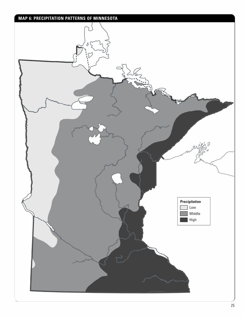
Low
Middle
High
Precipitation
MAP 6: PRECIPITATION PATTERNS OF MINNESOTA
Low
Middle
High
Precipitation

26
Population DensityPer Sq. Mile 2000
10 or fewer
11 to 50
51 to 100
101 to 200
More than 200
MAP 7: MINNESOTA POPULATION DENSITY/SQUARE MILE (circa 2000)

27
Major RiMajor Ri
Develocombined and minin
AgricuForest/combined and brush
Wetlanprairie wepeatlands
Lakes Rivers
Land Use inMinnesota
MAP 8: LAND USE IN MINNESOTA 2000
Major RiversMajor Rivers
Developed combined urban, rural, and mining development
AgricultureForest/Brush combined forested landand brushland
Wetland prairie wetlands,peatlands, forest swamp
Lakes Rivers
Land Use in Minnesota 2000