environmental resource inventory township of teaneck new
TRANSCRIPT

Environmental Resource Inventory
Township of Teaneck New Jersey
This document was prepared with the aid of a grant from the New Jersey Department of Environmental Protection, environmental services program.
Prepared by: Kasler Associates, PA
29 Pangborn Place Hackensack, NJ 07601

The original document was signed and sealed on February 26, 2002 in accordance with Chapter 41 of Title 13 of the State Board of Professional Planners.
Jason L. Kasler, AICP, PP
Kasler Associates, PA Professional Planner #5240

Kasler Associates • 29 Pangborn Place • Hackensack, New Jersey • 07601 • (201) 487-1424 • Page i 69 Highlands Ave. • Springfield, New Jersey • 07081 • (908) 598-1666
ENVIRONMENTAL FEATURES .............................................................................................. 1
GEOLOGY.................................................................................................................................... 1
MAP 1 - GEOLOGY MAP ............................................................................................................... 2
SOIL CONDITIONS .................................................................................................................... 3
BOONTON SERIES ......................................................................................................................... 5 BUB-BOONTON-URBAN LAND COMPLEX, UNDULATING.............................................................. 5 BUC-BOONTON-URBAN LAND COMPLEX, GENTLY ROLLING ....................................................... 6 BUD- BOONTON-URBAN LAND, HILLY ........................................................................................ 7 DUNELLEN-URBAN LAND COMPLEX, SERIES ............................................................................... 8 DVA-DUNELLEN-URBAN LAND COMPLEX, NEARLY LEVEL ......................................................... 8 DVB-DUNELLEN-URBAN LAND COMPLEX, UNDULATING ............................................................ 9 DVC- DUNELLEN-URBAN LAND COMPLEX, ROLLING ................................................................ 10 DVD- DUNELLEN –URBAN LAND COMPLEX, HILLY ................................................................... 11 DUB DUNELLEN LOAM, 3 TO 8 PERCENT SLOPES ....................................................................... 12 HUB HALEDON-URBAN LAND COMPLEX, UNDULATING............................................................ 13 UA-UDONTHENTS, LOAMY......................................................................................................... 14 UB UDONTHENTS, ORGANIC SUBSTRATUM................................................................................. 15 UC UDONTHENTS, ORGANIC SUBSTRATUM-URBAN LAND COMPLEX .......................................... 16 UD UDONTHENTS, REFUSE SUBSTRATUM ................................................................................... 17 UE UDORTHENTS, WET SUBSTRATUM......................................................................................... 18 UF UDOTHENTS, WET-SUBSTRATUM-URBAN LAND COMPLEX ................................................. 19 UR URBAN LAND ....................................................................................................................... 19 OT D OTISVILLE GRAVELLY LOAMY SAND, 15 TO 25 PERCENT SLOPES ...................................... 20 POA PASCACK SILT LOAM, 0 TO 3 PERCENT SLOPES ................................................................... 21 PR PREAKNESS SILT LOAM ......................................................................................................... 22 TABLE 1- AREA OF SOILS, BY SOILS TYPE, TOWNSHIP OF TEANECK ......................................... 23 TABLE 2- BUILDING SITE DEVELOPMENT LIMITATIONS, TOWNSHIP OF TEANECK ..................... 24 TABLE 3- RECREATIONAL DEVELOPMENT LIMITATIONS, TOWNSHIP OF TEANECK .................... 25 MAP 2 - SOIL MAP ..................................................................................................................... 26
TOPOGRAPHY.......................................................................................................................... 27
MAP 3 – TOPOGRAPHY............................................................................................................... 28 MAP 4 - SLOPE ANALYSIS MAP TEANECK, NEW JERSEY............................................................ 29
STREAMS ................................................................................................................................... 30
TABLE 4 STREAM NAMES, LENGTHS, AND ORDERS ................................................................... 31 MAP 5 - STREAMS MAP.............................................................................................................. 33 FRESHWATER WETLANDS .......................................................................................................... 34
Regulated Activities in Wetland Areas.................................................................................. 35 Regulated Activities in Transition Areas .............................................................................. 35 Wetland Classifications ........................................................................................................ 37
DECIDUOUS, 10-50% CROWN CLOSURE .................................................................................... 38 DECIDUOUS > 50% CROWN CLOSURE........................................................................................ 39 BRUSHLAND/SCHRUBLAND (HEIGHT<20 FEET) ......................................................................... 39

Kasler Associates • 29 Pangborn Place • Hackensack, New Jersey • 07601 • (201) 487-1424 • Page ii 69 Highlands Ave. • Springfield, New Jersey • 07081 • (908) 598-1666
DECIDUOUS BRUSH/SHRUBLAND (>25% BRUSH COVERED WITH DECIDUOUS SPECIES PREDOMINANT > 75%)............................................................................................................... 39 MANAGED WETLANDS ....................................................................................................... 40 MAP 6 -FRESHWATER WETLANDS MAP ..................................................................................... 41
FLOOD PRONE AREAS ........................................................................................................... 42
MAP 7 - FLOOD PRONE AREAS MAP .......................................................................................... 43
EXISTING MASTER PLAN RECREATION RECOMMENDATIONS............................. 44
EXISTING PERIODIC RE-EXAMINATION REPORT RECOMMENDATIONS........... 47
EXISTING PARK FACILITIES............................................................................................... 49
VACANT AND PUBLIC LAND ............................................................................................... 49
MAP 8 - RECREATIONAL, PUBLIC, AND VACANT LAND.............................................................. 50 MAP 9 - RECREATIONAL, PUBLIC, AND VACANT LAND : AERIAL PERSPECTIVE......................... 51 TABLE 5- EXISTING PARK FACILITIES ........................................................................................ 52 TABLE 6-VACANT AND PUBLIC LANDS ...................................................................................... 53
RECOMMENDATIONS............................................................................................................ 60
WATERFRONT PARK SYSTEM ..................................................................................................... 61 EXPAND EXISTING PARK AND OPEN SPACE. .............................................................................. 61 EXPAND PARK AND OPEN SPACE WHERE THERE IS A VOID. ...................................................... 61 MAJOR AREAS OF MUNICIPALLY OWNED LAND ........................................................................ 61 INDIVIDUAL LOTS WHICH ARE MUNICIPALLY OWNED ............................................................... 62 OVERPECK PARK........................................................................................................................ 62 TABLE 7-RECOMMENDATIONS ................................................................................................... 63
APPENDIX
GEOLOGIC DEFINITIONS.............................................................................................................A1 JTRP, JTRPG PASSAIC FORMATION (LOWER JURASSIC AND UPPER TRIASSIC) ...........................A1 JD DIABASE (JURASSIC) .............................................................................................................A2 QUEALE AND LYNCH REPORT FINDINGS ....................................................................................A3 HACKENSACK RIVER GREENWAY THROUGH TEANECK BROCHURE .........................................A12
Kasler Associates • 29 Pangborn Place • Hackensack, New Jersey • 07601 • (201) 487-1424 • Page iii 69 Highlands Ave. • Springfield, New Jersey • 07081 • (908) 598-1666
Disclaimer:
Maps in this report were developed using New Jersey Department of Environmental Protection Geographic Information System digital data,
but this secondary product has not been verified by NJDEP and is not state-authorized.

Kasler Associates • 29 Pangborn Place • Hackensack, New Jersey • 07601 • (201) 487-1424 • Page 1 69 Highlands Ave. • Springfield, New Jersey • 07081 • (908) 598-1666
Environmental Features We are the stewards of our natural environment. Protection and preservation of our natural resources is essential and requires more than just regulatory controls. It is necessary to establish proactive planning techniques to be implemented at all levels of government not only to identify and address existing harmful threats but also to guide future development activities to be compatible with the protection of these resources.
Geology The geology of an area is an important factor in land use decision-making, for it influences the nature and extent of how land is developed. In areas that are not served by a centralized water supply system, underlying geological formations can serve as a good source of water supply if a sufficient frequency of cracks in the underlying bedrock can be found to allow for adequate access into the water table. Conversely, certain geological formations such as sand and gravel can provide for a porous subgrade which permits a rapid recharge of groundwater supplies. When these materials are situated over aquifers, they are considered to be of value for the continuation and protection of the aquifer. Sewage disposal facilities and their respective capabilities are influenced by the geology as well since a dense substratum can inhibit or prohibit infiltration. Conversely, a geological formation that is fissured or cracked might allow infiltration at a very rapid rate, precluding adequate infiltration, and potentially contaminating groundwater supplies. Both the nature and depth of bedrock influences the stability and cost of construction. Certain low bearing strength geological formations, especially those situated at or near the surface, are not capable of supporting heavy loads. The Township of Teaneck occupies 3,986 acres of land. A majority of the Township, a total of 3,805 acres of land, is underlain by Passaic Formation Sandstone and Siltation compositions. Other smaller isolated areas of the Township are underlain by Passaic Formation Mudstone, (128 acres) adjacent to the Overpeck Creek and Jurrasic Diabase formations (52 acres) which exist on the west side of Queen Anne Road in two areas; one at the intersection of Cedar Lane and the other near Degraw Avenue. These areas are depicted on Map 1 - Geology map on the following page. The NJDEP definitions of these geological formations are located in the appendix of this report.

Kasler Associates • 29 Pangborn Place • Hackensack, New Jersey • 07601 • (201) 487-1424 • Page 2 69 Highlands Ave. • Springfield, New Jersey • 07081 • (908) 598-1666
Map 1 - Geology Map Teaneck, New Jersey
Jurassic Diabase
Passaic Formation Mudstone facies
Passaic Formation Sandstone and Siltstone facies

Kasler Associates • 29 Pangborn Place • Hackensack, New Jersey • 07601 • (201) 487-1424 • Page 3 69 Highlands Ave. • Springfield, New Jersey • 07081 • (908) 598-1666
Soil Conditions The United States Department of Agriculture, Soil Conservation Service, has prepared a study of soil conditions for Bergen County. The forward to the report states the following:
This soil survey contains information that can be used in land-planning programs in Bergen County. It contains predictions of soil behavior for selected land uses. The survey also highlights limitations and hazards inherent in the soil, improvements needed to overcome the limitations, and the impact of the selected land uses on the environment. This soil survey is designed for many different users. Farmers, foresters and agronomists can use it to evaluate the potential of the soil and the management needed for maximum food and fiber production. Planners, community officials, engineers, developers, builders, and homebuyers can use the survey to plan land use, select sites for construction, and identify special practices needed to ensure proper performance. Conservationists, teachers, students, and specialists in recreation, wildlife management, waste disposal, and pollution control can use the survey to help them understand, protect and enhance the environment. Great differences in soil properties can occur within short distances. Some soils are seasonally wet or subject to flooding. Some are shallow to bedrock. Some are too unstable to be used as a foundation for buildings or roads. Clayey or wet soils are poorly suited for basements or underground installations. These and many other soil properties that affect land use are described in this soil survey. Broad areas are shown on the general soil map. The location of each soil is shown on the detailed soil maps. Each soil in the survey area is described. Information on specific uses is given for each soil. Helping in using this publication and additional information are available at the local office of the Soil Conservation Service or the Cooperative Extension Service.
The Soil Conservation Report identifies eight different soil families with several subfamilies in the Township of Teaneck. Some of the soils are further divided into subcategories. The classifications are noted on Map 2 - Soils map. Table 1 indicates the relative ease or difficulty of building based upon specific soil characteristics. Slight constraints generally indicate that the soils are compatible for the intended use. Moderate constraints indicate there are limitations to the use of the soils for building site construction and special considerations will be necessary to adequately accommodate this land use. Severe constraints notes that the properties of the soil are so unfavorable that extraordinary means will significantly increase costs and are likely to be required to serve this land use adequately. Table 2 indicates the respective areas of various soil types in acres.

Kasler Associates • 29 Pangborn Place • Hackensack, New Jersey • 07601 • (201) 487-1424 • Page 4 69 Highlands Ave. • Springfield, New Jersey • 07081 • (908) 598-1666
Soils can either be mineralogic or organic in their composition. Mineralogic soils generally are structurally sound. Other soils can have a high organic component, which, while serving as a favorable medium for growing vegetative matter, may be too compressible to support development. The composition and size of soils effects erosion. Uniform size soils (sands, silts or clays) generally promote erodibility. Conversely, loamy soils, where a mixture of particle sizes within a soil composition, promotes a “locking together” of soil particles which minimizes the potential for erosion. Soils containing larger particle sizes (sands) or those intermixed with gravels and stones, are generally well drained and can absorb frost expansion. Soils containing smaller particle sizes (silts and clays) are moderately to poorly drained and are subject to damaging frost resulting from the expansion of water as it freezes. Some soils have a high propensity for absorption, while others do not. Soils that absorb water well generally promote a favorable characteristic for development. Other soils expand significantly, which is unfavorable for development. Soils can either be deep or shallow. Deep soils provide a favorable environment for construction and septic disposal, while shallow soils promote a more readily available supply of groundwater. Shallow soils generally have a shallow depth to bedrock. Groundwater supplies are generally located within the fissures of the bedrock. Shallow bedrock also means that blasting or the ripping of rock may be necessary to prepare land for development. The depth to water table affects the nature of the soils. Deep depths to the water table promotes non-hydric soils which are aerobic in nature and supports upland vegetation while shallow depth to water table promotes hydric soils, which are generally found to be anaerobic (absence of air). Hydric soils commonly support hydrophytic vegetation. Certain soil types are described as having a high or low potential for flooding. Soils that are prone to flooding are generally low-lying soils with a high water absorption capacity, a low porosity and slow permeability. In highly developed areas, these soils have often been filled or disturbed for the purpose of site development; but these actions may not remove their potential for flooding. Soil profiles are comprised of several layers or “soil horizons” the characteristics of which define the soil type. The top layer is usually referred to as the topsoil which overlays the subsoil. Topsoil is generally comprised of organic matter. Subsoils can be either organic or mineralogic. The substratum is the soil occurring below the subsoil. Steeply sloping areas generally have soils that are shallow, erodible, well drained, non-hydric and have a deep depth to the water table. Conversely, extremely flat areas often have soils that are deep, also erodible, poorly drained and hydric, with a shallow depth to the water table. These characteristics are generalities and exceptions are frequent in both extremes. The following represents a description of each of the soil types occurring in the Township of Teaneck:

Kasler Associates • 29 Pangborn Place • Hackensack, New Jersey • 07601 • (201) 487-1424 • Page 5 69 Highlands Ave. • Springfield, New Jersey • 07081 • (908) 598-1666
Boonton Series The Booton Series consists of undulating moderately well drained Boonton soils and Urban land. Slopes range from 3 to 8 percent. Permeability of the Boonton soils is moderate above the fragipan and slow or very slow in the fragipan. Surface runoff is medium in the Boonton part of the complex and very rapid in the Urban land part. The hazard of erosion is slight. The available water capacity is moderate. The seasonal high water table is perched above the fragipan during the months of November through May in most years. Areas of the complex are used for single-family residential use.
BUB-Boonton-Urban land complex, undulating
This unit consists of undulating moderately well drained Boonton soils and Urban land. It occurs throughout the county, primarily east of the Ramapo River, on long glacial till ridges and on slightly convex broad till plains. Individual areas are irregular in shape. Most areas are between 5 and 140 acres in size. Slopes range from 3 to 8 percent. The Boonton soils and Urban land occur in such intricate patterns or in such small areas in this unit that they can not be shown separately on the soil map. This complex consists of about 55 percent Boonton soils, 30 percent Urban land and 15 percent other soils. Urban land consists of areas with an impervious surface such as buildings, paved driveways, parking lots, patios, and paved walkways. Permeability of the Boonton soils is moderate above the fragipan and slow or very slow in the fragipan. Surface runoff is medium in the Boonton part of the complex and very rapid in the Urban land part. The hazard of erosion is slight. The available water capacity is moderate. The seasonal high water table is perched above the fragipan during November through May in most years. Frost action potential is moderate. The slow permeability in the fragipan, the perched seasonal high water table, and the fragipan are the major limiting factors for community development and installation of on-site sanitary disposal facilities. Downslope movement of water along the top of the fragipan is a limitation for dwellings with basements and on-site waste disposal systems. There are slight to moderate limitations for lawns, ornamental shrubs and trees. Approximately 343.9 acres of land or 8.9% of the acreage in the Township contain soils of this type.

Kasler Associates • 29 Pangborn Place • Hackensack, New Jersey • 07601 • (201) 487-1424 • Page 6 69 Highlands Ave. • Springfield, New Jersey • 07081 • (908) 598-1666
BUC-Boonton-Urban land complex, gently rolling This unit consists of sloping moderately well drained Boonton soils and Urban land. It is located east of and through the Ramapo River, on long glacial till ridges and on slightly convex broad till plains. Individual areas are irregular in shape. Most areas are between 5 and 150 acres in size. Slopes range from 8 to 15 percent. The Boonton soils and Urban land occur in such intricate patterns or in such small areas in this unit that they can not be shown separately on the soil map. This complex consists of about 55 percent Boonton soils, 30 percent Urban land and 15 percent other soils. Urban land consists of areas with an impervious surface such as buildings, paved driveways, parking lots, patios, and paved walkways. Permeability of the Boonton soils is moderate above the fragipan and slow or very slow in the fragipan. Surface runoff is medium in the Boonton part of the complex and very rapid in the Urban land part. The hazard of erosion is moderate. The available water capacity is moderate. The seasonal high water table is perched above the fragipan during November through May in most years. Frost action potential is moderate. Areas of this complex are used for single-family residential use. Individual lots vary in size from primarily ¼ acre or less in the central and southeastern parts of the county to up to one acre in the northeast and western parts of the county. The slow permeability in the fragipan, the depth to the perched seasonal high water table the fragipan and the slope are the major limiting factors for community development and installation of on-site sanitary disposal facilities. Downslope movement of water along the top of the fragipan is a limitation for dwellings with basements and on-site waste disposal systems. There are moderate limitations for lawns, ornamental shrubs and trees. The Township of Teaneck contains 451.5 acres of this soil type, representing 11.3 percent of the Township.

Kasler Associates • 29 Pangborn Place • Hackensack, New Jersey • 07601 • (201) 487-1424 • Page 7 69 Highlands Ave. • Springfield, New Jersey • 07081 • (908) 598-1666
BUD- Boonton-Urban land, hilly
This unit consists of hilly well-drained Boonton soils and Urban land. Approximately 90 percent of this unit is located east of the Saddle River and the remaining 10 percent are located between the Saddle and Ramapo Rivers. Individual areas are irregular in shape and on the sides of long narrow glacial till ridges. Most areas are between 5 and 170 acres in size. Slopes range from 15 to 25 percent. The Boonton soils and Urban land occur in such intricate patterns or in such small areas in this unit that they can not be shown separately on the soil map. This complex consists of about 65 percent Boonton soils, 25 percent Urban land and 10 percent other soils. Urban land consists of areas with an impervious surface such as buildings, paved driveways, parking lots, patios, and paved walkways. Permeability of the Boonton soils is moderate above the fragipan and slow or very slow in the fragipan. Surface runoff is rapid in the Boonton part of the complex and very rapid in the Urban land part. The hazard of erosion is severe. The available water capacity is moderate. Frost action potential is moderate. Areas of this complex are used for single-family residential use. Individual lots vary in size from primarily 1/3 acre or less in the central and southeastern parts of the county to up to one acre in the northeast and western parts of the county. The slow permeability in the fragipan, the depth to the high water table and the slope are the major limiting factors for community development and installation of on-site sanitary disposal facilities. Downslope movement of water along the top of the fragipan is a limitation for dwellings with basements and on-site waste disposal systems. There are severe limitations for lawns, ornamental shrubs and trees. Approximately 202.9 acres or 5.2% of the total land area of Teaneck contains soils of this type.

Kasler Associates • 29 Pangborn Place • Hackensack, New Jersey • 07601 • (201) 487-1424 • Page 8 69 Highlands Ave. • Springfield, New Jersey • 07081 • (908) 598-1666
Dunellen-Urban Land Complex, Series Permeability of the Dunellen soils is moderate or moderately rapid in the subsoil and rapid in the substratum. Surface runoff is low in the Dunellen part of the complex and very rapid in the urban land part. The hazard of erosion is slight. The available water capacity is moderate. Frost action is moderate. Permeability of the Dunellen soils is moderate or moderately rapid in the subsoil and rapid in the substratum. Surface runoff is low in the Dunellen part of the complex and very rapid in the urban land part. Areas of this complex are used for single-family residential uses.
DVA-Dunellen-Urban land complex, nearly level The Dunellen-Urban land soil series consists of nearly level well-drained Dunellen soils and Urban land. It occurs throughout the county, between the Ramapo River and the Palisades range, on broad outwash plains or stream terraces. Individual areas are dominantly irregular or oval in shape. Most areas are between 5 and 185 acres in size. Slopes range from 0 to 3 percent. This complex consists of about 55 percent Dunellen soils, 30 percent Urban land and 15 percent other soils. Urban land consists of areas with an impervious surface such as buildings, paved driveways or parking lots and paved walkways. Permeability of the Dunellen soils is moderate or moderately rapid in the subsoil and rapid in the substratum. Surface runoff is slow in the Dunellen part of the complex and very rapid in the Urban land part. The hazard of erosion is slight. The available water capacity is moderate. Frost action is moderate. Areas of this complex are used for single-family residential uses. Individual lots vary in size from primarily ¼ acre or less in the central and southeastern parts of the county up to 1 acre in the northeast and western parts of the county. The rapid permeability in the substratum and the moderate potential frost action are the major limiting factors for community and recreational facilities development. There are limitations for the installation of on-site sanitary disposal facilities due to the soils rapid permeability and the potential for waste disposal effluent to contaminate the ground water. Downslope movement of water along the top of the subsoil or stratified substratum is also a limitation for dwellings with basements. There are slight limitations for lawns and landscaping. Approximately 84.6 acres or 2.2% of the total land area of Teaneck contains soils of this type.

Kasler Associates • 29 Pangborn Place • Hackensack, New Jersey • 07601 • (201) 487-1424 • Page 9 69 Highlands Ave. • Springfield, New Jersey • 07081 • (908) 598-1666
DVB-Dunellen-Urban land complex, undulating This unit consists of undulating well-drained Dunellen soils and Urban land. It is located between the Ramapo River and the Palisades range on broad outwash plains or stream terraces. Individual areas are irregular or oval in shape. Most areas are between 5 and 310 acres in size. Areas larger than 125 acres are located primarily in the Northern Valley and in northwest Bergen County. Slopes range from 3 to 8 percent. The Dunellen soils and Urban land occur in such intricate patterns or small areas in this unit that they can not be shown separately on the soil map. This complex consists of about 55 percent Dunellen soils, 30 percent Urban land and 15 percent other soils. Urban land consists of areas with an impervious surface such as buildings, paved driveways, parking lots, patios, and paved walkways. Permeability of the Dunellen soils is moderate or moderately rapid in the subsoil and rapid in the substratum. Surface runoff is medium in the Dunellen part of the complex and very rapid in the Urban land part. The hazard of erosion is moderate. The available water capacity is moderate. Frost action potential is moderate. Areas of this complex are used for single-family residential use. Individual lots vary in size from primarily 1/4 acre or less in the central and southeastern parts of the county to up to one acre in the northeast and western parts of the county. The rapid permeability in the substratum and the moderate potential frost action are the major limiting factors for community recreational facilities development. There are severe limitations for the installation of on-site sanitary disposal facilities due to the potential for waste disposal effluent to contaminate the ground water. Downslope movement of water along the top of the subsoil or stratified substratum also is a limitation for dwellings with basements and on-site waste disposal systems. There are slight limitations for lawns and landscaping Approximately 489.9 acres or 12.7% of the total land area of Teaneck contains soils of this type.

Kasler Associates • 29 Pangborn Place • Hackensack, New Jersey • 07601 • (201) 487-1424 • Page 10 69 Highlands Ave. • Springfield, New Jersey • 07081 • (908) 598-1666
DVC- Dunellen-Urban land complex, rolling This unit consists of rolling well drained Dunellen soils and Urban land. It is located between the Ramapo River and the Palisades range on broad outwash plains or stream terraces. Individual areas are irregular or oval in shape. Most areas are between 5 and 300 acres in size. Areas larger than 100 acres are located primarily in the Northern Valley and in northwest Bergen County. Slopes range from 8 to 15 percent. The Dunellen soils and Urban land occur in such intricate patterns or small areas in this unit that they can not be shown separately on the soil map. This complex consists of about 55 percent Dunellen soils, 30 percent Urban land and 15 percent other soils. Urban land consists of areas with an impervious surface such as buildings, paved driveways, parking lots, patios, and paved walkways. Permeability of the Dunellen soils is moderate or moderately rapid in the subsoil and rapid in the substratum. Surface runoff is medium in the Dunellen part of the complex and very rapid in the Urban land part. The hazard of erosion is moderate. The available water capacity is moderate. Frost action potential is moderate. Areas of this complex are used for single family residential use. Individual lots vary in size from primarily 1/4 acre or less in the central and southeastern parts of the county to up to one acre in the northeast and western parts of the county. The rapid permeability in the substratum and the moderate potential frost action and slope are the major limiting factors for community recreational facilities development. There are severe limitations for the installation of on-site sanitary disposal facilities due to the potential for waste disposal effluent to contaminate the ground water. Downslope movement of water along the top of the subsoil or stratified substratum also is a limitation for dwellings with basements and on-site waste disposal systems. Approximately 627.9 acres or 16.2% of the total land area of Teaneck contains soils of this type.

Kasler Associates • 29 Pangborn Place • Hackensack, New Jersey • 07601 • (201) 487-1424 • Page 11 69 Highlands Ave. • Springfield, New Jersey • 07081 • (908) 598-1666
DVD- Dunellen –Urban land complex, hilly This unit consists of rolling well-drained Dunellen soils and Urban land. Most of the areas contain this soil type are located between the Saddle River and the Palisades range. A few areas are in the northwest Bergen County, primarily in the municipalities of Allendale, Ramsey and Saddle River. Most of the areas are long and narrow, irregular or oval in shape on the sides of broad outwash plains or stream terraces. . Most areas are between 5 and 50 acres in size. Areas larger than 100 acres are located primarily in the Northern Valley and in northwest Bergen County. Slopes range from 15 to 25 percent. The Dunellen soils and Urban land occur in such intricate patterns or small areas in this unit that they can not be shown separately on the soil map. This complex consists of about 60 percent Dunellen soils, 25 percent Urban land and 15 percent other soils. Urban land consists of areas with an impervious surface such as buildings, paved driveways, parking lots, patios, and paved walkways. Permeability of the Dunellen soils is moderate or moderately rapid in the subsoil and rapid in the substratum. Surface runoff is rapid. The hazard of erosion is severe. The available water capacity is moderate. Frost action potential is moderate. Areas of this complex are used for single-family residential use. Ind ividual lots vary in size from primarily 1/4 acre or less in the central and southeastern parts of the county to up to one acre in the northeast and western parts of the county. Slope and rapidly permeable substratum are the major limiting factors for community recreational facilities development. There are severe limitations for the installation of on-site sanitary disposal facilities due to the potential for waste disposal effluent to contaminate the ground water. Downslope movement of water along the top of the subsoil or stratified substratum also is a limitation for dwellings with basements and on-site waste disposal systems. Approximately 151.4 acres or 3.9% of the total land area of Teaneck contains soils of this type.

Kasler Associates • 29 Pangborn Place • Hackensack, New Jersey • 07601 • (201) 487-1424 • Page 12 69 Highlands Ave. • Springfield, New Jersey • 07081 • (908) 598-1666
DUB Dunellen loam, 3 to 8 percent slopes
Dunellen loam is an undulating and well-drained soil. It is located on broad outwash plains or stream terraces. Individual areas are irregular or oval in shape. Most areas are between 5 and 65 acres in size. Permeability is moderate or moderately rapid in the subsoil and rapid in the substratum. Surface runoff is medium to slow. The hazard of erosion is moderate. The available water capacity is moderate. Frost action potential is moderate. Most areas of this soil are used for woodlands or recreational facilities. A small proportion is used for the production of vegetable or fruit crops and horticultural plants. The rapid permeability and moderate potential frost action are the major limiting factors for community development. There are limitations for the installation of on-site waste disposal systems due to the soils rapid permeability and the potential for waste disposal effluent to contaminate the ground water. Downslope movement of water along the top of the subsoil or stratified substratum also is a limitation for dwellings with basements and on-site waste disposal. This soil is well suited as an upland wildlife habitat and generally provides slight limitations for woodland management. Approximately 61.9 acres or 1.6 % of the total land area of Teaneck contains soils of this type.

Kasler Associates • 29 Pangborn Place • Hackensack, New Jersey • 07601 • (201) 487-1424 • Page 13 69 Highlands Ave. • Springfield, New Jersey • 07081 • (908) 598-1666
HuB Haledon-Urban Land Complex, undulating
This soil unit consists of undulating, somewhat poorly drained Haledon soils and Urban land. It is located east of the Ramapo River in slightly depressed areas on broad glacial till ridges and till plains. Individual areas are either long and narrow or broad and irregular in shape. Most areas are between 5 and 80 acres in size. Slopes range from 3 to 8 percent. This complex consists of about 45 percent Haledon soils, 30 percent Urban land, and 25 percent other soils. Urban land consists of areas with an impervious surface such as buildings, paved driveways, patios and paved walkways. Permeability of the Haledon soils is moderate above the fragipan and slow in the fragipan. Surface runoff is medium in the Haledon part of the complex and very rapid in the Urban land part. The hazard of erosion is slight. The available water capacity is moderate. The seasonal high water table is between 6 and 18 inches below the surface during the winter and spring months in most years. Frost action potential is high. Areas of this complex are utilized for single-family residential uses. Individual lots range in size from primarily ¼ acre or less in the central and southeastern parts of the county to up to one acre in the northeast and western parts of the county. The slow permeability in the fragipan, the depth to the perched seasonal high water table and the high potential for frost action are the major limiting factors for community development and the installation of onsite sanitary disposal facilities. Downslope movement of water along the top of the fragipan is a limitation for dwellings with basements and on-site waste disposal. There are moderate limitations for lawns, ornamental shrubs and trees caused by the seasonal high water table. Approximately 37.4 acres or 1.0 % of the total land area of Teaneck contains soils of this type.

Kasler Associates • 29 Pangborn Place • Hackensack, New Jersey • 07601 • (201) 487-1424 • Page 14 69 Highlands Ave. • Springfield, New Jersey • 07081 • (908) 598-1666
Ua-Udonthents, loamy
Udonthents soils exist on uplands with glacial till or outwash on stream terraces. Individual areas are irregular in shape. Most areas are between 5 and 85 acres in size. Slopes range from 0 to 5 percent. This unit has been cut and smoothed, or otherwise extensively disturbed, to a depth of 3 feet or more. The original soil can no longer be identified. Included in mapping are small areas of well drained Boonton and somewhat poorly drained Haledon soils on glacial till ridges along the perimeter of the disturbed areas. Also included are areas on short steep slopes of more than 5 percent. Small areas of Pits, sand and gravel, Udorthents, wet substratum, and Urban land are also included with this unit. Included soils comprise about 5 percent of the mapped acreage. Areas of this mapping unit are predominantly used for playgrounds, ball fields, and other intensive recreational facilities. Other areas remain idle, or reserved for future development. Individual areas require on-site investigation for all areas because of the variability of the soil unit. Approximately 18.8 acres or 0.5% of the total land area of Teaneck contains soils of this type.

Kasler Associates • 29 Pangborn Place • Hackensack, New Jersey • 07601 • (201) 487-1424 • Page 15 69 Highlands Ave. • Springfield, New Jersey • 07081 • (908) 598-1666
Ub Udonthents, organic substratum
This unit is located on low lying marine and estuarine deposits. Individual areas are irregular in shape and range from less than 5 to about 195 acres in size. Slopes range from 0 to 5 percent. This unit has been filled and smoothed, or otherwise extensively disturbed, to a depth of 3 feet or more. The original soil can no longer be identified. Fill material generally consists of a mixture of stones, boulders, rubble and soil material. Most areas are presumed to have been deep, very poorly drained organic or mineral soils, subject to daily tidal flooding. Included in mapping are areas of very poorly drained Sulfaquents and Sulfihemists; Udorthents, refuse substratum, wet substratum along narrow perimeter areas, and areas of short steep slopes of more than 5 percent. Included soils comprise approximately 10 percent of the mapped acreage. Areas of this mapping unit are reserved for development and support railroads and unpaved service roads. Some areas are vegetated and utilized for recreational purposes. These areas require on-site investigation for all uses because of the variability of the soil material in the filling process. Approximately 226.3 acres or 5.7 % of the total land area of Teaneck contains soils of this type.

Kasler Associates • 29 Pangborn Place • Hackensack, New Jersey • 07601 • (201) 487-1424 • Page 16 69 Highlands Ave. • Springfield, New Jersey • 07081 • (908) 598-1666
Uc Udonthents, organic substratum-Urban land complex
This unit is located on low lying marine and estuarine deposits and in the upland areas. Individual areas are irregular in shape and range from less than 5 to about 310 acres in size. The most extensive area is located south of the Meadowlands Sports complex in East Rutherford. Slopes range from 0 to 5 percent. This unit contains about 50 percent Udonthents, organic substratum, 35 percent Urban land, and 15 percent other soils. Areas of Udothents, organic substratum have been filled to variable depths and smoothed, and partially paved. Most areas are presumed to have been deep to shallow very poorly drained organic soils and subject to daily tidal flooding, or prolonged ponding. Fill material is presumed to consist of stones, boulders, rubble, and variable amounts of soil and non-soil material. Areas of Urban land consist of single-family residential units, commercial buildings, local roads and streets, small parking lots and other structures. This mapping unit is predominantly used to support major thoroughfares, large parking lots, and commercial or industrial complexes. These areas require on-site investigation for all uses because of the variability of the soil material in the filling process. Approximately 103.2 acres or 2.7 % of the total land area of Teaneck contains soils of this type.

Kasler Associates • 29 Pangborn Place • Hackensack, New Jersey • 07601 • (201) 487-1424 • Page 17 69 Highlands Ave. • Springfield, New Jersey • 07081 • (908) 598-1666
Ud Udonthents, refuse substratum
This unit is located on low-lying marine and estuarine deposits, upland stream terraces, and till plains. Individual areas are irregular in shape and range from 5 to about 410 acres in size. The most extensive area is located south of the Meadowlands Sports complex in East Rutherford. Slopes range from 0 to 5 percent. This unit has been or is being filled and otherwise extensively disturbed to a depth of 3 feet or more. The original soil can no longer be identified. Fill material generally consists of various kinds of refuse, solid wastes, and other non-soil material. In some areas limited amounts of soil material have been added or incorporated with the dominant fill material. Most areas are presumed to have been deep, somewhat poorly drained to very poorly drained soils in low lying areas and a few upland areas. Included in mapping are areas of very poorly drained Sulfaquents and Sulfihemists; Udorthents, wet substratum; and Udorthents, organic substratum, and areas of short steep slopes more than 5 percent. Included soils comprise approximately 5 percent of the mapped acreage. This soil type is used for refuse disposal sites that currently serve individual or several participating communities. Other extensive areas, such as the Overpeck County Park, have been closed to additional filling, vegetated and currently provide excellent recreational facilities. These areas require on-site investigation for all uses because of the variability of the soil material in the filling process. Approximately 149.6 acres or 3.9 % of the total land area of Teaneck contains soils of this type.

Kasler Associates • 29 Pangborn Place • Hackensack, New Jersey • 07601 • (201) 487-1424 • Page 18 69 Highlands Ave. • Springfield, New Jersey • 07081 • (908) 598-1666
Ue Udorthents, wet substratum
This soil type is located on upland stream terraces, drainageways, marine and estuarine deposits, and flood plains. Individual areas are irregular in shape. Most areas are 5 to 180 acres in size. Slopes range from 0 to 5 percent. This unit has been filled and smoothed or otherwise extensively disturbed to a depth of 3 feet or more. Most areas are presumed to have been deep, somewhat poorly drained to very poorly drained soils and subject to flooding or prolonged ponding. Fill material generally consists of a mixture of soil material with variable amounts of stones, boulders, and rubble. Silty and sandy soil dredgings are commonly found near water bodies. This mapping unit is used primarily for playgrounds, ball fields and other intensive recreational purposes commonly associated with parks and schools. Other areas are reserved for open space or future community development. These areas require on-site investigation for all uses because of the variability of the soil material. Approximately 168.1 acres or 4.3 % of the total land area of Teaneck contains soils of this type.

Kasler Associates • 29 Pangborn Place • Hackensack, New Jersey • 07601 • (201) 487-1424 • Page 19 69 Highlands Ave. • Springfield, New Jersey • 07081 • (908) 598-1666
Uf Udothents, Wet-Substratum-Urban Land Complex
This type of soil exists on low lying marine and estuarine deposits, upland streams and terraces and flood plains. Slopes range from 0 to 5 percent. This unit consists of about 50 percent Udorthents, wet substratum, 35 percent urban land and 15 percent other soils. Most areas are presumed to have been deep poorly drained to very poorly drained areas that are subject to flooding or prolonged ponding. Areas of Urban land consist of single-family residential units, commercial buildings, local roads and streets, small parking lots and other structures. Approximately 270.0 acres or 7 % of the total land area of Teaneck contains soils of this type.
UR Urban land
This unit is nearly level or gently sloping. It occurs throughout the survey area except in the Borough of Alpine and west of the Mahwah River in the Borough of Oakland and Mahwah Township. Individual areas are irregular in shape and range from 6 to more than 750 acres in size. Slopes range from 1 to 5 percent. This unit has been cut or filled and covered with impervious surface such as paving materials or buildings over 85 percent of the areas. Included in the mapping are high density residential areas that are less than 85 percent covered and contain reworked soil material or Udorthents. This unit is used for commercial and industrial development such as shopping malls and office building complexes. Some areas are utilized for central school sites. Approximately 450.6 acres of land or 11.6 % of the Township contains this soil type.

Kasler Associates • 29 Pangborn Place • Hackensack, New Jersey • 07601 • (201) 487-1424 • Page 20 69 Highlands Ave. • Springfield, New Jersey • 07081 • (908) 598-1666
Ot D Otisville gravelly loamy sand, 15 to 25 percent slopes
This soil is moderately steep and excessively drained. It is on the sides of kames and glacial outwash terraces. Individual areas are irregular or oval in shape. Most areas are between 5 and 40 acres in size. Permeability is rapid. Runoff is medium. The hazard of erosion is slight. The available water capacity is very low. Frost action potential is low. Most areas of this soil are used for woodlands or non-wooded tracts with native herbaceous weeds. The rapid permeability and moderately steep slopes are the major limiting factors for community and recreational facilities development. This soil has poorly suited as a wildlife habitat. There are very severe limitations for woodland management because of the very low available water. Approximately 6.9 acres or 0.2% of the total land area of Teaneck contains soils of this type.

Kasler Associates • 29 Pangborn Place • Hackensack, New Jersey • 07601 • (201) 487-1424 • Page 21 69 Highlands Ave. • Springfield, New Jersey • 07081 • (908) 598-1666
PoA Pascack silt loam, 0 to 3 percent slopes This soil is moderately steep and excessively drained. It is on the sides of kames and glacial outwash terraces. Individual areas are irregular or oval in shape. Most areas are between 5 and 40 acres in size. Permeability is rapid. Runoff is medium. The hazard of erosion is slight. The available water capacity is very low. Frost action potential is low. Most areas of this soil are used for woodlands or non-wooded tracts with native herbaceous weeds. The rapid permeability and moderately steep slopes are the major limiting factors for community and recreational facilities development. This soil has poorly suited as a wildlife habitat. There are very severe limitations for woodland management because of the very low available water. Approximately 8.9 acres or 0.2% of the total land area of Teaneck contains soils of this type.

Kasler Associates • 29 Pangborn Place • Hackensack, New Jersey • 07601 • (201) 487-1424 • Page 22 69 Highlands Ave. • Springfield, New Jersey • 07081 • (908) 598-1666
Pr Preakness silt loam
Preakness soils are level or nearly level and poorly or very poorly drained. These soils are located in shallow depressions and drainageways on glacial outwash terraces and in areas at the base of the terraces adjacent to perennial streams. Individual areas are long and narrow or broad and oval in shape. Most areas are between 5 and 100 acres in size. Areas larger than 30 acres are located in the northern part of Northern Valley, associated with outwash terraces adjacent to the Hackensack River and Sparkill Creek. Included with this soil in mapping are level areas of very poorly drained Adrian and poorly and very poorly drained Preakness soils in depressions. Also included are narrow perimeter areas with soils similar to Pascack with gray mottles between 24 and 40 inches. Included soils comprise approximately 15 percent of the mapped acreage. Permeability is moderate or moderately rapid in the subsoil and rapid to very rapid in the substratum. Surface runoff is medium to slow. The hazard of erosion is slight. The available water capacity is moderate. The seasonal high water table is between 6 and 18 inches below the surface from the fall through the spring months in most years. Frost action potential is high. The depth to the seasonal high water table, rapid permeability in the substratum and high potential frost action are the major limiting factors for community development and the installation of sanitary facilities. There are limitations for lawns and landscaping and for recreational development caused by the seasonal high water table. This soil is well suited as an upland wildlife habitat and poorly suited as a wetland wildlife habitat. There are limitations for woodland management because of the depth to the seasonal high water table. Approximately 10.3 acres or 0.3% of the total land area of Teaneck contains soils of this type.

Kasler Associates • 29 Pangborn Place • Hackensack, New Jersey • 07601 • (201) 487-1424 • Page 23 69 Highlands Ave. • Springfield, New Jersey • 07081 • (908) 598-1666
Table 1- Area of Soils, By Soils Type, Township of Teaneck
Soil
Classification Area of Soils
(Acres) Percent of Total
Township Land Area
BUB 343.8 8.9 BUC 451.5 11.7 BUD
202.9 5.2
DvA 84.6 2.2 DvB 489.9 12.7 DvC 627.9 16.2 DvD 151.4 3.9 DuB
61.9 1.6
HuB
37.4 1.0
Ur 450.6 11.6 Ua 18.8 0.5 Ub 226.3 5.7 Uc 103.2 2.7 Ud 149.6 3.9 Ue 168.1 4.3 Uf
270.0 7.0
OtD
6.9 0.2
Pr
10.3 0.3
PoA 8.9 0.2
Total 3,871.9 100.0 Source: Bergen County Soil Conservation District DEP Digital Soils Data Calculations: Kasler Associates, P.A

Kasler Associates • 29 Pangborn Place • Hackensack, New Jersey • 07601 • (201) 487-1424 • Page 24 69 Highlands Ave. • Springfield, New Jersey • 07081 • (908) 598-1666
Table 2- Building Site Development Limitations,
Township of Teaneck
Soil Symbol
Shallow Excavations
Dwellings without Basements
Dwellings with Basements
Small Commercial Buildings
Local Roads & Streets
Lawns & Landscaping
BUB Severe: wetness Moderate: wetness Severe: wetness Moderate: wetness, slope
Moderate: wetness, frost action
Moderate: small stones, wetness
BUC Severe: wetness Moderate: wetness, slope.
Severe: wetness Severe: slope Moderate: wetness, slope frost action
Moderate: small stones, wetness, slope
BUD Severe: wetness, slope
Severe: slope. Severe: wetness, slope
Severe: slope Severe: slope Severe: slope
DVB Severe: cutbanks cave
Slight Slight Moderate: slope Moderate: frost action
Slight
DVC Severe: cutbanks cave
Moderate: slope Moderate: slope Severe: slope Moderate: slope, frost action
Moderate: slope
DVD Severe: cutbanks cave, slope
Severe: slope Severe: slope Severe: slope Severe: slope Severe: slope
DUB Severe: cutbanks cave
Slight Slight Moderate: slope Moderate: frost action
Slight
UR* Ua* Ub* Uc* Ud* Ue* Uf* OtD Severe: cutbanks
cave
Severe: slope Severe: slope Severe: slope Severe: slope Severe: slope
Pr Severe: cutbanks cave, wetness
Severe: flooding, wetness
Severe; flooding, wetness
Severe: flooding, wetness
Severe: flooding, frost action
Severe: wetness, flooding
PoA Severe: cutbanks cave, wetness
Severe: wetness Severe: wetness Severe; wetness Severe: frost action Moderate: wetness
*Lack of entry indicates that the soil was not rated. The information indicated in this table indicates the dominant soil condition but does not eliminate the need for onsite investigation.
Slopes: Steep slopes add to difficulty of development for most development. Slight: Limitations to development are considered slight if soil properties and site features are generally favorable for the indicated use. Limitations are minor and easily overcome. Moderate: Limitations to development are considered moderate if soil properties and site features are not favorable for the indicated use. Special planning, design or maintenance may be needed to overcome or minimize limitations. Severe: Limitations to development are considered severe if conditions are so unfavorable or difficult to overcome that a special design or feasibility study may be required, resulting in significant increases in construction and maintenance costs.

Kasler Associates • 29 Pangborn Place • Hackensack, New Jersey • 07601 • (201) 487-1424 • Page 25 69 Highlands Ave. • Springfield, New Jersey • 07081 • (908) 598-1666
Table 3- Recreational Development Limitations, Township of Teaneck
Soil Symbol
Camp Areas
Picnic Area
Playgrounds
Paths and Trails
Golf fairways
BUB Severe: percs slowly
Severe: percs slowly
Severe: small stones, percs slowly
Severe: erodes easily Moderate: small stones, wetness.
BUC Severe: percs slowly
Severe: percs slowly
Severe: slope, small stones, percs slowly.
Severe: erodes easily Moderate: small stones, wetness, slope.
BUD Severe: slope, percs slowly
Severe: slope, percs slowly
Severe: slope, small stones, percs slowly.
Severe: erodes easily. Severe: slope.
DVA Slight Slight Moderate: small stones
Slight Slight
DVB Slight Slight Moderate; slope, small stones
Slight Slight
DVC Moderate: slope Moderate slope
Severe: slope Slight Moderate: slope
DVD Severe: slope Severe: slope Severe: slope Moderate: slope Severe: slope DUB Slight Slight Moderate: slope,
small stones Slight Slight
HUB Severe: wetness Severe: wetness
Severe: small stones, wetness.
Severe: wetness Severe: wetness
UR* Ua* Ub* Uc* Ud* Ue* Uf* OtD Pr Severe:flooding,
wetness Severe: wetness
Severe: wetness, flooding
Severe: wetness Severe: wetness, flooding
PoA Severe: wetness Moderate: wetness
Severe: wetness Moderate: wetness Moderate: wetness.
*Lack of entry indicates that the soil was not rated. The information indicated in this table indicates the dominant soil condition but does not eliminate the need for onsite investigation. Slopes: Steep slopes add to difficulty of development for most development. Slight: Limitations to development are considered slight if soil properties and site features are generally favorable for the indicated use. Limitations are minor and easily overcome. Moderate: Limitations to development are considered moderate if soil properties and site features are not favorable for the indicated use. Special planning, design or maintenance may be needed to overcome or minimize limitations. Severe: Limitations to development are considered severe if conditions are so unfavorable or difficult to overcome that a special design or feasibility study may be required, resulting in significant increases in construction and maintenance costs.

Kasler Associates • 29 Pangborn Place • Hackensack, New Jersey • 07601 • (201) 487-1424 • Page 26 69 Highlands Ave. • Springfield, New Jersey • 07081 • (908) 598-1666
Map 2 - Soil Map Teaneck, New Jersey

Kasler Associates • 29 Pangborn Place • Hackensack, New Jersey • 07601 • (201) 487-1424 • Page 27 69 Highlands Ave. • Springfield, New Jersey • 07081 • (908) 598-1666
Topography The United States Geological Survey (USGS) map for Teaneck indicates topographic elevations in 10-foot contour intervals. Elevations gradually rise from the west to the east from the banks of the Hackensack River and from the east to the west as elevations increase from the banks of the Hackensack River and Overpeck Creek. The topography of the Township can best be described as gently rolling with a majority of the land, 84.7% of the total Township landmass, containing slopes of less than 4 percent. The Township contains moderate slopes of 5 to 9 percent in various locations of the Township and steep slopes, defined as containing slopes in excess of 15 percent in two or three distinct locations in the northeast quadrant of the Township. This slope analysis is indicated on the following page. The steep slopes map delineates the exact locations of steeply sloping land. There are a total of 14 acres of land containing lands in excess of 15 percent slope, 60 acres containing 10-15 % slopes, 80 acres containing 7 to 9% slopes, 457 acres containing 5-7% slopes, 1,046 acres of land containing slopes of 3 to 4% and 2,354 acres of land containing slopes of 0-2%. Extremely steep slopes may posit various problems for development including erosion, and sever drainage problems.

Kasler Associates • 29 Pangborn Place • Hackensack, New Jersey • 07601 • (201) 487-1424 • Page 28 69 Highlands Ave. • Springfield, New Jersey • 07081 • (908) 598-1666
Map 3 – Topography Teaneck, New Jersey

Kasler Associates • 29 Pangborn Place • Hackensack, New Jersey • 07601 • (201) 487-1424 • Page 29 69 Highlands Ave. • Springfield, New Jersey • 07081 • (908) 598-1666
Map 4 - Slope Analysis Map Teaneck, New Jersey

Kasler Associates • 29 Pangborn Place • Hackensack, New Jersey • 07601 • (201) 487-1424 • Page 30 69 Highlands Ave. • Springfield, New Jersey • 07081 • (908) 598-1666
Streams The United States Geological Survey Professional Paper 964, 1976, edited by NJDEP, OIRM, GGIA, 1998, 2000, and 2001 defines streams as follows:
Streams This category includes streams that are no less than 80 feet wide. These features are easily recognized on aerial photography because of their meandering pattern and variable width due to natural fluvial processes. Short distances of WC constriction which fall under the minimum width standard may be included for the sake of continuity. The photographic characteristics of streams are much too numerous and obvious to list…
The maps that follow indicate the presence of the Hackensack River which coincides with the western Township boundary, the Hirshfield Brook in the northeastern portion of the Township and the Teaneck and Overpeck Creeks in the southeastern portion of the Township as well as two un-coded tributaries. Table 4, appearing on the following page, indicates the respective lengths, numbers, levels, and orders of each stream. Map 4 depicts the location of each stream. NJDEP defines a stream number, level and order as follows:
Order: Stream order. Tributaries converge to produce higher order.
Level: USNS stream level: See explanation of Universal Stream Numbering System (USNS) under NUMBER.
Number: USNS stream number: 5-digit stream index number.
Numbering system begins at the mouth of a major stream (example: Delaware River is 57000 and level 1). The first tributary entering the Delaware (moving up-stream) is given the next highest stream number (usually incremented by 8, example: Pond Creek is 570088, level 2, direction 20). If there are level 3 tributaries that enter the level 2, the first is given the next stream number. If there are any level 4 tributaries that enter the level 3, the first is given the next stream number.)

Kasler Associates • 29 Pangborn Place • Hackensack, New Jersey • 07601 • (201) 487-1424 • Page 31 69 Highlands Ave. • Springfield, New Jersey • 07081 • (908) 598-1666
Table 4 Stream Names, Lengths, and Orders
Name
Length (within Teaneck)
Order
Level
Number
Hackensack River 14,798 Ft 5 5 35736 Hirshfield Brook 9,600 Ft 1 1 37192 Teaneck Creek 10,807 Ft 1,2 1,2 36840/36848 Overpeck Creek 7,943 Ft 3,2 2,3 36704/36904
Source: NJDEP digital database Although this analysis utilized NJDEP data pertaining to streams, the study utilizes the USGS definitions, which is described as follows:
Stream order: Geologists classify the segments (“links”) of a drainage pattern using a convention in which its number (“stream order”) increases as the size and numbers of tributaries increase. Wherever two segments of the same order join downstream, the order of the downstream segment is increased by 1; two first-order drainages join to form a second order drainage and so on. Note that “stream order” in a drainage network is not determined by the presence or absence of flowing water, but by the shape of the land surface, which determines where flow will be concentrated when water is present. Debris flows tend to form on steep slopes and accelerated downslope unit flow slows and stops. The base of a steep slope is most likely to be exposed to debris flows from small, steep drainage channels, first and second order drainages. Locations in and near the mouths of relatively steep, larger ravines, which are generally second and third order drainage channels, can be vulnerable to unexpectedly large flows surges if surface runoff is bulked by debris flows in the drainage basin upstream Still larger drainages, such as canyons (fourth and fifth order drainages), generally have gentler gradients, and larger volumes of slurry are needed to maintain flow. During intense rainstorms these larger streams can receive both increased surface runoff and increased input of debris flows, which may cause large surges of debris-laden floodwater. You can determine stream order from a map of a stream network. First-order streams are perennial streams, which carry water all year. When two first-order streams come together, they become a second order stream. However, if a first order joins a second-order stream, it remains a second- order stream. It is not until a second-order stream combines with another second-order stream that it becomes a third-order stream.

Kasler Associates • 29 Pangborn Place • Hackensack, New Jersey • 07601 • (201) 487-1424 • Page 32 69 Highlands Ave. • Springfield, New Jersey • 07081 • (908) 598-1666
The Hackensack River and its estuary is one of the most important waterways in the State of New Jersey and form the western border of the Township. The River has been categorized as a fifth-order river. The river flows through the heart of the New York City metropolitan area into New Jersey where it empties into Newark Bay. Its headwaters are located in the Town of Haverstraw in Rockland County, New York. The Hackensack-Meadowlands estuary supports 55 rare bird and 29 rare fish species.1 The river’s estuary—the Meadowlands—is the last large block of open space in this densely population region. The Meadowlands supports a great diversity and concentration of wildlife including fish, birds and other animal life. The area has been designated an Essential Fish Habitat by the National Marine Fisheries. The Hackensack River and the Meadowlands currently face escalating pressure due to development which threatens to destroy a significant portion of the largest block of wetlands left in the region and increase the amount of pollution entering reservoirs that supply drinking water for over one million people. The New Jersey Department of Environmental Protection (NJDEP) recognizes the great importance of the protection of all types of surface waters and now regulates them via the Stream Encroachment Permit Process. Consequently, local communities situated along the upper Hackensack River’s remaining forest buffers should take additional actions, where feasible, to protect the habitat that protects their drinking water. Riparian forests and other existing open space tracts within the watershed should be protected through conservation easements, development setback, land purchase, or stream corridor preservation ordinances. Hirshfield Brook has been designated a first-order stream and runs in a north-south direction. Parts of the Teaneck Creek have been designated a first-order stream. At the point where they converge, the Teaneck Creek is designated a second- order stream. The Overpeck Creek has been designated a third- order stream.
1 http://www.americanrivers.org/mostendangered/hackensack2001.htm

Kasler Associates • 29 Pangborn Place • Hackensack, New Jersey • 07601 • (201) 487-1424 • Page 33 69 Highlands Ave. • Springfield, New Jersey • 07081 • (908) 598-1666
Map 5 - Streams Map Teaneck, New Jersey

Kasler Associates • 29 Pangborn Place • Hackensack, New Jersey • 07601 • (201) 487-1424 • Page 34 69 Highlands Ave. • Springfield, New Jersey • 07081 • (908) 598-1666
Freshwater Wetlands Wetlands, until recently, were considered wastelands suitable primarily for drainage, fill and subsequent development. The significance of fresh water wetlands in the maintenance of environmental quality through flood control, ground water protection, pollution filtration and ecological productivity has been recognized by both the Federal and State governments. A number of years ago, the Federal government undertook a nationwide survey of wetlands. The National Wetlands Inventory, prepared by the United States Department of the Interior, Fish and Wildlife Service, provided a comprehensive inventory of wetland areas for all municipalities in the State of New Jersey as well as the Country. The Wetlands Inventory noted that the data was prepared
... primarily by stereoscopic analysis of high altitude aerial photographs... and were identified on the photographs based upon vegetation, visible hydrology and geography in accordance with classification of wetlands and Deep-Water Habitats of the United States...
The U.S. Department of the Interior, Fish and Wildlife Service, had defined wetlands as follows:
In general terms, wetlands are lands where saturation with water is the dominant factor determining the nature of soil development and the types of plant and animal communities living in the soil and on its surface. The single feature that most wetlands share is soil or substrate that is at least periodically saturated with or covered by water. The water creates severe physiological problems for all plants and animals except those that are adapted for life in water or in saturated soils. Wetlands are lands transitional between terrestrial and aquatic systems where the table is usually at or near the surface or the land is covered by shallow water. For purposes of this classification, wetlands must have one or more of the following three attributes: (1) at least periodically, the land supports predominantly hydrophytes; (2) the substrate is predominantly undrained hydric soil; and (3) the substrate is nonsoil and is saturated with water at some time during the growing season of each year.
Hydrophytes, or hydrophytic vegetation, are defined as “any plant growing in water or on a substrate that is at least periodically deficient in oxygen as a result of excessive water content.” New Jersey’s Freshwater Wetlands Protection Act was established in 1987 and is codified at NJSA 13:9B-1 et. seq. As of this date, NJDEP attained co-permitting jurisdiction over freshwater, or inland, wetlands and their corresponding transition or buffer areas. NJDEP adopted the federal definition of regulated wetlands with certain modifications and states that, in

Kasler Associates • 29 Pangborn Place • Hackensack, New Jersey • 07601 • (201) 487-1424 • Page 35 69 Highlands Ave. • Springfield, New Jersey • 07081 • (908) 598-1666
most cases, all three of the federally defined parameters- presence of hydric soils, hydrophytes and periodic saturation of the soil, must be met to be considered a regulated wetland. NJDEP’s regulation of activities in wetlands became effective July 1, 1988 and regulations pertaining to activities regulated in buffer areas became operative a year later. The following is a listing of regulated activities for freshwater wetlands and wetland buffers. Regulated Activities in Wetland Areas Activities that are regulated in wetlands include:
• Excavation (without minimum) of any material • Drainage or disturbance of the water table • Discharge of any fill, including discharge into open waters and incidental discharge from
dredging projects • Driving of pilings • Placement of permanent obstructions such as billboards, bridge piers, abutments etc.
including structures that span but shade wetlands and • Destruction of plant life that will alter the character of the wetland, including the cutting
of trees except State Forestry approved harvesting of forest products (i.e. under an approved Woodlot Management plan).
Regulated Activities in Transition Areas
• Excavation or disturbance (without minimum) of any soil; • Discharge of fill • Erection of structures • Placement of pavements; and • Destruction of plant life that will alter the existing pattern of vegetation.
Map 5 depicts four distinct areas of freshwater wetlands occupying a total of 132.1 acres of land in Teaneck. This information was obtained from the NJDEP digital wetlands files and is considered the most accurate source of data other than a site-specific evaluation by a qualified wetlands expert.

Kasler Associates • 29 Pangborn Place • Hackensack, New Jersey • 07601 • (201) 487-1424 • Page 36 69 Highlands Ave. • Springfield, New Jersey • 07081 • (908) 598-1666
Of this total 52 acres are occupied by deciduous wooded wetlands, 7.8 acres are occupied by deciduous shrub wetlands, 0.95 acres are occupied by managed/modified wetlands and 71.35 acres are occupied by herbaceous wetlands. These wetland areas are concentrated in the south-central and southeastern portion; the northeast; north central and northwestern portions of the Township. Beyond this however, the NJDEP has adopted more stringent regulations activities in or adjacent to wetlands. For example:
1. There is no minimum size threshold, smaller than which a general permit would be automatically granted;
2. Excavation (removal) and deposition (filling) of wetlands is regulated;
3. Buffer or Transitional areas are required to be preserved around most wetlands, varying in
width depending upon the relative level of sensitivity or resource value. Wetlands have been classified as either Exceptional Resource Value (requiring a 150 foot buffer), Intermediate Resource Value (50 foot buffer); or Ordinary Resource Value (no buffer required). State Open Waters which include manmade retention and detention facilities do not require a buffer. See page 37 for definitions of these wetland classification
4. There is a presumption that a practicable alternative to the proposed action exists that
would have less of an adverse impact on the wetlands; and the burden of proof rests with the applicant to refute this assumption in order to qualify for a permit;
5. In the case of an Exceptional Resource Value wetland, the applicant must demonstrate that
there is a compelling public need for the project which is more essential than the desire to preserve the wetland; or that denial or the permit application would present an extraordinary hardship peculiar to the project; and
6. Wetland mitigation (creation of new wetland areas) is an acceptable practice in some cases,
with specific regulations established in order to attain compliance. A mitigation bank has also been established to receive contributions in lieu-of on-site mitigation, for sites where mitigation is either impossible or undesirable.

Kasler Associates • 29 Pangborn Place • Hackensack, New Jersey • 07601 • (201) 487-1424 • Page 37 69 Highlands Ave. • Springfield, New Jersey • 07081 • (908) 598-1666
Wetland Classifications The New Jersey Department of Environmental Protection classifies freshwater wetlands by their resource value. These resource values are exceptional, intermediate, and ordinary wetlands. Wetland Buffers or Transition areas requirements are 150 feet for exceptional value wetlands, 50 feet for intermediate value wetlands and no buffer is required for ordinary value wetlands. These are defined as follows:
Exceptional Value A freshwater wetland of exceptional resource value, or exceptional resource value wetland, is a freshwater wetland which: 1. Discharges into FW1 or FW2 trout production waters or their
tributaries;
2. Is a present habitat for threatened or endangered species; or
3. Is a documented habitat for threatened or endangered species, and which remains suitable for breeding, resting, or feeding by these species during the normal period these species would use the habitat.
Ordinary Value A freshwater wetland of ordinary resource value, or an ordinary resource value wetland, is a freshwater wetland which does not exhibit any of the characteristics in above, and which is: 1. An isolated wetland, as defined at N.J.A.C. 7:7A-1.4, which:
i. Is smaller than 5,000 square feet; and ii. Has the uses listed below covering more than 50 percent of
the area within 50 feet of the wetland boundary. In calculating the area covered by a use, the Department will only consider a use that was legally existing in that location prior to July 1, 1988, or was permitted under this chapter since that date: (1) Lawns; (2) Maintained landscaping; (3) Impervious surfaces; (4) Active railroad rights-of-way; and (5) Gravelled or stoned parking/storage areas and roads;
Intermediate Value A freshwater wetland of intermediate resource value, or intermediate resource value wetland, is any freshwater wetland not defined as exceptional or ordinary.

Kasler Associates • 29 Pangborn Place • Hackensack, New Jersey • 07601 • (201) 487-1424 • Page 38 69 Highlands Ave. • Springfield, New Jersey • 07081 • (908) 598-1666
The observed wetlands are characterized by wooded, deciduous hardwood, closed canopy vegetation. Deciduous wooded wetlands represent the middle to drier end of the wetland continuum; which is not atypical for a developed suburb of this area. NJDEP defines deciduous wetlands as follows:
The average height of the stand is at least 20 feet. Areas with woody vegetation less than 20 feet high should be placed in the Brushland category. A forest stand must have at least 75% canopy coverage from deciduous tree species to be placed in this category. Deciduous trees are those species that lose their leaves at the end of the growing season. These trees remain leafless throughout the winter and sprout new leaves the following spring. Deciduous Wooded Wetlands These wetlands are closed canopy swamps dominated by deciduous trees normally associated with watercourses, edges of marshes, and isolated wetlands. The important canopy species includes Acer rubrum, Nyssa sylvatica, Fraxinus pennsylvanica, Salix nigra, Quercus bicolor, Q. phellos, Q. falcata, Liquidambar styraciflua, and Platanus occidentalis. These species combine to form a series of mixed hardwood lowland habitats throughout the entire state. These species have photographic signatures that exhibit height, rough texture, and are dark blue-gray to dark gray or black on winter infrared, and gray to dark gray on panchromatic film.
Deciduous, 10-50% Crown Closure
This category contains deciduous forest stands that have crown closure greater than 10%, but less than 50%. Crown closure is the percentage of a forest area occupied by the vertical projections of tree crowns. Crown closure percentages provide a reasonable estimate of stand density. An ocular estimate of percent crown closure is made while viewing the area stereoscopically. The ocular judgement is a reliable estimate since the category levels for closure are relatively broad: 10-50% and > 50%. This procedure will also be followed to determine percent crown closure in the other categories.

Kasler Associates • 29 Pangborn Place • Hackensack, New Jersey • 07601 • (201) 487-1424 • Page 39 69 Highlands Ave. • Springfield, New Jersey • 07081 • (908) 598-1666
Deciduous > 50% Crown Closure
This category contains deciduous stands with crown closures greater than 50%. The majority of the deciduous forests in New Jersey will be in this category. Deciduous shrub wetlands are assigned to the brushland/shrubland category which is defined by NJDEP as follows:
Brushland/Schrubland (Height<20 feet)
This Level II category contains forest lands which are predominately between 0 and 20 feet in height. Vegetative communities in these areas may range from early successional species which are only a few years old, to climax or sub-climax communities which are many years old. Also included in this category are old fields that are covered primarily by grasses and some shrubs.
Deciduous Brush/Shrubland (>25% Brush Covered with Deciduous Species Predominant > 75%)
This category contains natural forested areas with deciduous species less than 20 feet in height. An area must have greater than 25% brush cover to be placed in this category. This category also contains inactive agricultural areas that have been grown over with brush. There are photographic signature differences between brushland and the pole or saw-timber stage trees. Besides the obvious height difference visible on stereo viewing, larger trees display much larger crown diameters than brushland areas.
Open canopy, or emergent herbaceous wetlands, have been found in limited quality in the outwash plains of the southern extremity of the Hackensack River. Due to the highly developed nature of the County, all of these wetlands exhibit a high ecological value.

Kasler Associates • 29 Pangborn Place • Hackensack, New Jersey • 07601 • (201) 487-1424 • Page 40 69 Highlands Ave. • Springfield, New Jersey • 07081 • (908) 598-1666
Managed wetlands are defined by NJDEP as follows:
MANAGED WETLANDS
This category was added to provide an Anderson classification code for several types of disturbed wetland areas that did not easily fit into the existing classification categories. Included would be various landscaped or maintained areas that exhibit signs of soil saturation on the imagery, and which are in zones of hydric soils, but which do not support typical wetlands vegetation because of various alterations. Examples of managed wetlands would be storm water swales, saturated portions of golf fairways and other recreational fields, and open lawn areas in business parks, etc. These areas have often been graded, are vegetated typically by various cultivated grasses and often undergo periodic mowing and other maintenance typical of managed lawn areas.
Smaller isolated wetlands, swales, detention facilities, drainage ditches and open state waters would fall under the Ordinary Resource Value wetlands that are neither mapped nor regulated. The quality or classification of the type of wetland, ordinary, intermediate or exceptional is important for many reasons one of which is in the determination of the size of the requisite wetland buffer or transition area. Wetlands of an ordinary resource value require no buffer, intermediate value wetlands require a 50 foot buffer and an exceptional value wetland requires a 150 foot buffer. NJDEP does not publish information pertaining to the quality of individual wetland areas. Only a Letter of Interpretation (LOI) obtained from NJDEP will qualify the type and exact location of a wetland. This procedure requires a site-specific investigation by NJDEP.

Kasler Associates • 29 Pangborn Place • Hackensack, New Jersey • 07601 • (201) 487-1424 • Page 41 69 Highlands Ave. • Springfield, New Jersey • 07081 • (908) 598-1666
Map 6 -Freshwater Wetlands Map Teaneck, New Jersey

Kasler Associates • 29 Pangborn Place • Hackensack, New Jersey • 07601 • (201) 487-1424 • Page 42 69 Highlands Ave. • Springfield, New Jersey • 07081 • (908) 598-1666
Flood Prone Areas Floods pose serious threats to life and property effecting not only abutting property owners, but down-stream neighbors as well. As development occurs in up-stream areas, lands in flood plains may be filled, thereby diminishing the capacity to store floodwaters. This diminished capacity means that downstream areas may be subject to increased volumes of water causing additional flooding. These environmentally critical areas are delineated on the map presented on the following page. The flood prone areas were ascertained from USGS Flood prone Maps. USGS defines a flood prone area where there is on the average a 1 percent chance in 100 that the designated areas will be inundated by floodwaters in any year. The flood prone areas have been delineated through the use of readily available information based upon past floods rather than from detailed surveys and inspection. In general, the delineated areas are for natural conditions and do not take into account the possible effects of existing or proposed flood control structures except where those effects should be evaluated. This data is also pertinent for planning purposes since it signals areas where development may be restricted because of direct threats to property and life, and because of the potential degradation of the abutting watercourses by the introduction of the pollutants. The major flood prone areas of Teaneck include several distinct areas directly abutting the Hackensack River and in the area straddling the I-80 interchange and adjacent to the Overpeck Creek. Documented flood prone areas total 403.75 acres. Smaller undocumented flood prone areas exist in four locations in the Township as depicted on the following map. They occupy a total of 66.75 acres of land.

Kasler Associates • 29 Pangborn Place • Hackensack, New Jersey • 07601 • (201) 487-1424 • Page 43 69 Highlands Ave. • Springfield, New Jersey • 07081 • (908) 598-1666
Map 7 - Flood Prone Areas Map Teaneck, New Jersey
USGS flood prone area Undocumented flood prone area

Kasler Associates • 29 Pangborn Place • Hackensack, New Jersey • 07601 • (201) 487-1424 • Page 44 69 Highlands Ave. • Springfield, New Jersey • 07081 • (908) 598-1666
Existing Master Plan Recreation Recommendations The Township of Teaneck last adopted its master plan in 1994. The Planning Board is currently in the process of updating the master plan. The 1994 master plan was prepared by the planning firm of Queale and Lynch and adopts the principles from the 1978 Recreation Plan Update with 26 additional comments. Those comments are as follows:
1. Argonne Park should be expanded to Loraine Avenue through the acquisition of individual lots to bring the park to a natural boundary. This would involve Block 5714, Lots 7-13.
2. Herrick Park should be expanded to the south in an attempt to
increase recreational opportunities in the southeast quadrant of the Township. Expansion would involve Block 2402, Lot 1.
3. Coolidge Park should be expanded to the south through various paper
streets and Township-owned land including approximately the following:
a. The portion of Tietjen Avenue between Loraine Avenue and Webster
Avenue. This is currently a paper street.
b. The southern end of Loraine Avenue, beginning approximately at the boundary between Block 5925, Lots 6 and 7. This is currently a paper street.
c. The portion of Alfred Avenue west of Webster Avenue. This is currently a paper street.
d. Block 5925, Lots 7 and 8.
e. Block 5927, Lots 1,2,4 and 5.
4. The proposal in the Recreation Plan for the acquisition of residential properties located between River Road and the Hackensack River is endorsed, but should be deferred for further consideration at a future date. The Township should support the Hackensack River Pathway concept plan. Initial implementation includes the following specific items:
a. Establish a park along the river, south of Cedar Lane on
Township-owned land in Block 201, (Pomander Walk Park). The development of this park should be in accordance with the plans prepared by Tom Condit and submitted to the Planning Board.
b. To allow for pedestrian access to the southern end of Andreas
Park, add the Township-owned land (Block 1401, Lot 2) on River Road near the foot of Camperdown Avenue to Andreas Park and acquire an easement from Fairleigh Dickinson University for access between this lot and Andreas Park.

Kasler Associates • 29 Pangborn Place • Hackensack, New Jersey • 07601 • (201) 487-1424 • Page 45 69 Highlands Ave. • Springfield, New Jersey • 07081 • (908) 598-1666
c. Add strips along the west and south sides of the DPW yard which
is along the Hackensack River. The strips will connect with Brett Park and River Road and should be at least wide enough to allow for pedestrian and bicycle trails.
d. The existing building in Andreas Park should be used as a nature
museum/visitor center.
5. Care should be exercised in implementing the recommendation for lighting tennis courts to assure minimal impact on nearby residential properties.
6. The lighting of parking lots for recreation facilities is supported
as a security and safety measure. Adequate shielding of the lighting should be provided to minimize impact on nearby residential properties.
7. At least two swimming facilities should be provided through the
municipality on a membership or daily fee basis. The Township has an option to buy the swimming facilities at Pomander Walk and should consider exercising that option. An in-ground swimming pool has been built at Votee Park. An indoor swimming facility is desirable. This could be provided through modification of an outdoor facility, perhaps enclosing it with an air structure, or located as a part of the high school complex as a joint project of the Board of Education and the Township.
8. Consideration should be given to locating additional facilities in
the undeveloped County Park lands in the southeastern section of the Township, as shown in the Overpeck Park development plans, dated March, 1982, prepared by the County.
9. As a part of the conservation and open space aspects of this Plan,
the Township reaffirms the preservation of open space along Route 4, recognizing the important role this open space plays in protecting the residential character of Teaneck, and continuing to recognize the far-sighted actions of early Teaneck planners in establishing this open space.
10. The Rodda Center Expansion plans, as set forth on pages 11 and 12 of
the Bilow + Goldberg and Associates report of February 1991, entitled "Teaneck Space Study Update", are hereby endorsed and incorporated by reference in this Plan.
11. Existing major trees in the Township should be preserved where
possible within street rights-of-way, publicly owned lands, and lands in private ownership. A plan should be developed for replacing aging and downed trees on these lands to maintain coverage.
12. A new, lighted full-sized basketball facility with 40 parking spaces
is proposed for the northwest corner of Votee Park. The paddleball-handball courts in Votee Park should be restored to their original condition, including the reseeding of the grassy area around these

Kasler Associates • 29 Pangborn Place • Hackensack, New Jersey • 07601 • (201) 487-1424 • Page 46 69 Highlands Ave. • Springfield, New Jersey • 07081 • (908) 598-1666
courts. Lights for the interior Votee walking oval and soccer fields should be installed.
13. Downsized basketball courts should be established in Tryon Park for
children under the age of 14.
14. Continental Park should be expanded to the west through the inclusion of the neighboring lot (Block 1102, Lot 10) which is owned by the Township and which serves as a de facto extension of the existing facility.
15. A new mini-park should be established on the Township-owned land on
the southeast corner of Sackville and Stephens Streets (Block 5103, Lot 7). Stephens Street is a paper street and should be included as part of the park to provide access from Bilton. The park should be equipped with playground equipment, benches and picnic facilities.
16. A new mini-park should be established on the vacant land at the
northeast corner of Cedar Lane and Palisade Avenue (block 2609, Lot 25). The park should be equipped with benches.
17. A new mini-park should be established in Census Tract 544, the
southwesterly part of the Township. Very little vacant land is available in this area of the Township. A small Township-owned parcel at Kipp and Front Streets (Block 107, Lot 5) consisting of 0.16 acres should be improved as a mini-park equipped with playground equipment and benches.
18. New shuffleboard courts and other recreational and social activities
meeting the needs of senior citizens should be established at appropriate locations where parking is convenient and where topography permits reasonable access for this age group.
19. Appropriate zoning standards should be adopted to provide for a
natural buffer of about l00 feet along the Hackensack River. In addition, the Township should require that future development on land fronting on the river should allow for a pathway along the river in conformance with the Hackensack River Pathway concept plan.
20. Any development of Brett Park should be made with regard to plans
for the entire New Bridge Landing area being developed by the Bergen County Historical Society, the County and the State.
21. Encouragement is given to implementing the joint use of athletic
fields and facilities (including parks) under the jurisdiction of the Township and the Board of Education.
22. Additional informal picnic areas should be provided in existing
parks.
23. Adequate toilet facilities should be provided in the larger parks.
24. Playground equipment should be installed in Hawthorne Park.

Kasler Associates • 29 Pangborn Place • Hackensack, New Jersey • 07601 • (201) 487-1424 • Page 47 69 Highlands Ave. • Springfield, New Jersey • 07081 • (908) 598-1666
25. Consideration should be given to providing one or two outdoor ice skating facilities.
26. Prior to the next update of this Master Plan, the Township should
obtain an update of the 1978 Recreational Update with regard to the facilities to be provided within each of the parks and open space areas in the Township.
Existing Periodic Re-examination Report Recommendations The most recent periodic re-examination report was completed in February 2001. The extent to which problems and objectives have been changed in the conservation, recreation and energy plan has been noted as follows:
A. Goals
The general goals of this element of the Master Plan has not changed since 1994. It should be noted that the Hackensack River Pathway concept plan is now referred to as the Hackensack River Greenway.
B. Problems and Policies
Only minor changes have occurred with respect to this element since 1994. The recommended expansions of Argonne Park, Herrick Park and Coolidge Park have not occurred. The Hackensack River Pathway Committee has made a presentation of its plan for the Hackensack River Greenway to the Planning Board. It is anticipated that the prospective changes to the campus of Fairleigh Dickinson University will include a discussion relating to the implementation of that portion of the Greenway which crosses the University campus. In addition, the plans for the new Department of Public Works facility on River Road makes provision for the Greenway plans on that property. The area of the Greenway which is located south of the Cedar Lane-Hackensack River Bridge is still being investigated, along with the purchase of property located on the southern boundary of Teaneck, north of Terhune Park, from the owner (i.e., the Jehovah's Witnesses property). Current plans contemplate a soft surface trail, comprised of natural materials (such as wood chips) as opposed to a hard paved surface.
With respect to the recommendation for two swimming pools to be provided by the municipality on a membership or day-fee basis, it should be noted that an in-ground pool has been provided at Votee Park, and two above-ground pools exist at Phelps Park and at Hawthorne Park. The PPRAB recommend these two above-ground pools be replaced with in-ground pools, to be used on a membership basis.

Kasler Associates • 29 Pangborn Place • Hackensack, New Jersey • 07601 • (201) 487-1424 • Page 48 69 Highlands Ave. • Springfield, New Jersey • 07081 • (908) 598-1666
The policy of locating additional facilities in the undeveloped portions of Overpeck County Park is being pursued by the formation of a committee with representatives from the Township of Teaneck, the Borough [SIC] of Ridgefield Park and the County of Bergen. As previously mentioned, the Township reaffirms the preservation of open space in the Route 4 Greenbelt.
The Rodda Center expansion is complete. At Votee Park the paddleball courts have been rehabilitated, lights for the interior oval and soccer field have been added, and a new lighted basketball facility has been completed. The downsizing of basketball courts for children in Tryon Park is no longer necessary with the completion of the basketball facility at Votee Park. A sum of $20,000 has been budgeted to change the configuration of Tryon Park, and to enhance its use as passive open space. The Township owns lot 10 of Block 1102 to the west of Continental Park, but this lot has not been incorporated into the park.
Tree preservation is an ongoing project in Teaneck. A tree survey in the Township has been completed by the Teaneck Environmental Commission and the Shade Tree Advisory Board, and the database is now maintained by the DPW.
None of the four mini-parks which were recommended to be established in the 1994 Master Plan have been undertaken. This goal requires further reexamination.
With respect to the proposal to provide a 100-foot natural buffer and pathway along the Hackensack River, the Township is looking towards the completion of plans for the DPW facility before going ahead with this item. The PPRAB supports the implementation of Planning Board resolution PB67-95. It certainly will be part of the discussion with respect to Faireigh Dickinson University's proposal to move the ballfields and replace them with multifamily and senior housing along the Hackensack River waterfront.
The management of Brett Park will be undertaken in cognizance of the historic New Bridge Landing development. Playground equipment has been installed at Hawthorne Park. A rollerhockey facility has been provided in Votee Park.
Finally, the 1978 Recreational Update has not been updated; however, the Township is contemplating the preparation of a Comprehensive Recreation Master Plan in 2001.

Kasler Associates • 29 Pangborn Place • Hackensack, New Jersey • 07601 • (201) 487-1424 • Page 49 69 Highlands Ave. • Springfield, New Jersey • 07081 • (908) 598-1666
Existing Park Facilities The Township currently maintains 22 parks that vary in size from 40+ acres to ½ acre. Table 5, on the following page, indicates the name and the size of the park, and the existing recreational facilities at each of these parks.
Vacant and Public Land In an effort to inventory all vacant and public land, table 6 has been prepared to illustrate all lands which were vacant or owned by a public entity in 2001. These lands have been categorized as vacant land privately held, vacant land publicly held, land whose sole purpose is to act as a buffer for Route 4, parks, public land, and schools. Parks and open space add value to the community, neighborhoods, and surrounding properties. In a report from the Trust for Public Land entitled “The economic benefits of Parks and Open Space” the following was sited regarding studies from around the county:
• SALEM, OR: Land adjacent to a greenbelt was found to be worth about $1,200 an acre more than land only 1,000 feet away.22
• OAKLAND, CA: A three-mile greenbelt around Lake Merritt, near the city center, was found to add $41 million to surrounding property values.23
• FRONT ROYAL, VA: A developer who donated a 50-foot-wide, seven-
mile-long easement along a popular trail sold all 50 parcels bordering the trail in only four months.24
• SEATTLE, WA: Homes bordering the 12-mile Burke Gilman trail sold
for 6 percent more than other houses of comparable size.25
• DENVER, CO: Between 1980 and 1990, the percentage of Denver residents who said they would pay more to live near a greenbelt or park rose from 16 percent to 48 percent.26
• DAYTON, OH: Five percent of the selling price of homes near the
Cox Arboretum and park was attributable to the proximity of that open space.27
• SAN FRANCISCO, CA: Golden Gate Park increases the value of nearby
property by an amount of from $500 million to $1 billion, in the process generating $5-$10 million in annual property taxes.28

Kasler Associates • 29 Pangborn Place • Hackensack, New Jersey • 07601 • (201) 487-1424 • Page 50 69 Highlands Ave. • Springfield, New Jersey • 07081 • (908) 598-1666
Map 8 - Recreational, Public, and Vacant Land Teaneck, New Jersey
See page 52 for parks identified by numbers. See page 61 for areas identified by letters.

Kasler Associates • 29 Pangborn Place • Hackensack, New Jersey • 07601 • (201) 487-1424 • Page 51 69 Highlands Ave. • Springfield, New Jersey • 07081 • (908) 598-1666
Map 9 - Recreational, Public, and Vacant Land : Aerial Perspective Teaneck, New Jersey
See page 52 for parks identified by numbers.

Kasler Associates • 29 Pangborn Place • Hackensack, New Jersey • 07601 • (201) 487-1424 • Page 52 69 Highlands Ave. • Springfield, New Jersey • 07081 • (908) 598-1666
Table 5- Existing Park Facilities
Playground Active Passive
Name Map ID acres Sp
ray
pool
Wad
ing
pool
Slid
e
Hor
se s
win
gs
Lar
ge S
win
gs
Smal
l Sw
ings
See-
Saw
Sand
box
Clim
bing
Stru
ctur
e
Teth
erba
ll
Play
Ani
mal
s
Mon
key
Bar
s
Mer
ry-g
o-ro
und
Swin
ging
gat
e
Han
dbal
l
Pool
Soft
ball
/ Bas
ebal
l
Bas
ketb
all C
ourt
Socc
er
Vol
leyb
all
Gol
f Cou
rse
Tenn
is C
ourts
Picn
ic T
able
s
BB
Q
Am
phith
eate
r Fi
shin
g
Gre
enho
use
Nat
ure
/Wal
king
Tra
ils
Pond
Ref
resh
men
t Sta
nd
Sani
tary
Fac
ilitie
s
Amman Park 14 5.29 ¨ þ ¨ þ ¨ ¨ þ þ þ ¨ ¨ þ ¨ ¨ ¨ ¨ 1 1 ¨ ¨ ¨ 2 þ ¨ ¨ ¨ ¨ ¨ ¨ ¨ ¨ Marie Andreas Memorial Park
10 23.24 ¨ þ þ ¨ þ þ þ þ þ ¨ ¨ ¨ þ þ ¨ ¨ ¨ ¨ ¨ ¨ ¨ 1 ¨ ¨ ¨ ¨ ¨ ¨ þ ¨ ¨
Argonne Park 21 54.00 þ ¨ þ ¨ þ þ þ þ þ ¨ ¨ ¨ þ ¨ ¨ ¨ 1 1 ¨ ¨ ¨ 4 ¨ ¨ ¨ ¨ ¨ ¨ ¨ ¨ ¨ Bookstaver Park 4 1.48 ¨ ¨ ¨ ¨ ¨ ¨ ¨ ¨ ¨ ¨ ¨ ¨ ¨ ¨ ¨ ¨ ¨ ¨ ¨ ¨ ¨ ¨ þ ¨ ¨ ¨ ¨ ¨ ¨ ¨ ¨ Brett Park 6 10.54 ¨ ¨ ¨ ¨ ¨ ¨ ¨ ¨ ¨ ¨ ¨ ¨ ¨ ¨ ¨ ¨ ¨ ¨ ¨ ¨ ¨ ¨ þ ¨ ¨ þ ¨ ¨ ¨ ¨ ¨ Contential Park 8 1.20 ¨ ¨ ¨ ¨ ¨ ¨ ¨ ¨ ¨ ¨ ¨ ¨ ¨ ¨ ¨ ¨ ¨ ¨ ¨ ¨ ¨ ¨ ¨ ¨ ¨ ¨ ¨ ¨ ¨ ¨ ¨ Coolidge Park 0.57 ¨ ¨ ¨ ¨ ¨ ¨ þ þ þ ¨ ¨ ¨ ¨ ¨ ¨ ¨ ¨ 1 ¨ ¨ ¨ ¨ ¨ ¨ ¨ ¨ ¨ ¨ ¨ ¨ ¨ Mathew Feldman Nature Preserve
7 14.90 ¨ ¨ ¨ ¨ ¨ ¨ ¨ ¨ ¨ ¨ ¨ ¨ ¨ ¨ ¨ ¨ ¨ ¨ ¨ ¨ ¨ ¨ ¨ ¨ ¨ ¨ ¨ þ ¨ ¨ ¨
Harte Park 18 0.49 ¨ ¨ ¨ þ ¨ ¨ þ þ þ þ þ ¨ þ ¨ ¨ ¨ ¨ ¨ ¨ ¨ ¨ ¨ ¨ ¨ ¨ ¨ ¨ ¨ ¨ ¨ ¨ Hawthorne Park 16 14.60 ¨ ¨ ¨ ¨ ¨ ¨ ¨ ¨ ¨ ¨ ¨ ¨ ¨ ¨ ¨ ¨ ¨ 4 ¨ ¨ ¨ 2 ¨ ¨ ¨ ¨ þ ¨ ¨ þ þ Herrick Park 12 2.74 ¨ þ ¨ þ ¨ þ ¨ þ þ ¨ ¨ þ ¨ ¨ ¨ ¨ 1 1 ¨ ¨ ¨ ¨ ¨ ¨ ¨ ¨ ¨ ¨ ¨ ¨ ¨ Mackel Field 1.24 ¨ þ ¨ þ þ þ þ ¨ þ ¨ ¨ ¨ ¨ ¨ ¨ ¨ ¨ 1 ¨ ¨ ¨ ¨ ¨ ¨ ¨ ¨ ¨ ¨ ¨ ¨ ¨ N. Gaylord Park 11 2.25 ¨ ¨ ¨ ¨ ¨ ¨ ¨ ¨ ¨ ¨ ¨ ¨ ¨ ¨ ¨ ¨ ¨ ¨ ¨ ¨ ¨ ¨ ¨ ¨ ¨ ¨ ¨ ¨ ¨ ¨ ¨ Phelps Park 2 15.78 ¨ þ ¨ þ þ þ þ þ ¨ ¨ ¨ ¨ ¨ ¨ ¨ 1 4 1 ¨ 1 ¨ 4 15 þ ¨ ¨ ¨ ¨ ¨ ¨ ¨ Sagamore Park 3 4.48 þ ¨ ¨ ¨ þ þ ¨ ¨ þ ¨ ¨ ¨ ¨ ¨ ¨ ¨ 1 1 ¨ ¨ ¨ ¨ þ ¨ ¨ ¨ ¨ ¨ ¨ ¨ ¨ S. Gaylord Park 5 2.27 ¨ ¨ ¨ ¨ ¨ ¨ ¨ ¨ ¨ ¨ ¨ ¨ ¨ ¨ ¨ ¨ ¨ ¨ ¨ ¨ ¨ ¨ ¨ ¨ ¨ ¨ ¨ ¨ ¨ ¨ ¨ Terhune Park 1 10.30 ¨ þ 2 ¨ ¨ ¨ ¨ þ þ ¨ ¨ þ 2 ¨ ¨ ¨ 1 ¨ ¨ ¨ ¨ 2 ¨ ¨ ¨ ¨ ¨ ¨ ¨ ¨ ¨ Tokaloka Park 9 10.58 ¨ ¨ ¨ ¨ ¨ ¨ ¨ ¨ ¨ ¨ ¨ ¨ ¨ ¨ ¨ ¨ ¨ ¨ ¨ ¨ ¨ ¨ ¨ ¨ ¨ ¨ ¨ ¨ ¨ ¨ ¨ Town Hall Park 13 1.23 ¨ þ ¨ ¨ þ þ 2 þ þ ¨ ¨ ¨ ¨ ¨ ¨ ¨ ¨ ¨ ¨ ¨ ¨ ¨ ¨ ¨ ¨ ¨ ¨ ¨ ¨ ¨ ¨ Tryon Park 20 4.73 ¨ þ ¨ þ þ ¨ 2 ¨ þ ¨ ¨ þ þ ¨ ¨ ¨ 1 3 ¨ ¨ ¨ ¨ þ ¨ ¨ ¨ ¨ ¨ ¨ ¨ ¨ Milton Votee Park 19 40.51 ¨ þ ¨ þ ¨ þ 2 þ þ ¨ ¨ ¨ þ ¨ 2 1 5 2 3 ¨ ¨ 4 þ þ þ ¨ ¨ þ ¨ ¨ þ Windsor Park 17 41.16 ¨ ¨ ¨ ¨ ¨ ¨ ¨ ¨ ¨ ¨ ¨ ¨ ¨ ¨ ¨ ¨ ¨ ¨ ¨ ¨ ¨ ¨ ¨ ¨ ¨ ¨ ¨ ¨ ¨ ¨ ¨ Overpeck Park 15 ¨ ¨ ¨ ¨ ¨ ¨ ¨ ¨ ¨ ¨ ¨ ¨ ¨ ¨ ¨ ¨ ¨ ¨ ¨ ¨ þ ¨ ¨ ¨ ¨ ¨ ¨ ¨ ¨ ¨ ¨

Kasler Associates • 29 Pangborn Place • Hackensack, New Jersey • 07601 • (201) 487-1424 • Page 53 69 Highlands Ave. • Springfield, New Jersey • 07081 • (908) 598-1666
Table 6-Vacant and Public Lands Vacant Land Privately Held Block
Lot
Property Location
Building Description1
Land Description1
Calculated Acres1
Owners Name
Owners Address
Owners City
Zip Code
Land value
Net value
00101 00001 640 RIVER RD 1.01 AC 1.01 SPANISH ENGLEWOOD CONG OF JEHOVAH'S 315 W PALISADE AVE ENGLEWOOD, NJ 07631 300,000 300,000
00201 00002 836 CEDAR LANE VACANT LAND 100X118 0.27 RANCHESTER CORP. C/O ERNST & YOUNG ONE OXFORD CENTRE PITTSBURGH PA 15219 170,000 170,000 00212 00002 662 POMANDER WALK 76X200 0.35 LINN,WILLIAM & JOSEPHINE 654 POMANDER WALK TEANECK NJ 07666 114,900 114,900
00706 00007 390 CEDAR LANE VACANT LAND 45X102 0.11 PRESCHEL,HOWARD & LAURENCE 907 PRINCE ST. TEANECK, N.J. 07666 135,000 135,000 00807 00008.02 520 MARTENSE AVE VACANT 50X100 0.11 BARRESE,FRANK & ADELAIDE 526 MARTENSE AVE TEANECK, N.J. 07666 100,000 100,000
00808 00003.01 502 CLAREMONT AVE 50X112 0.13 CAMBRIDGE HOMES, INC. 502 CLAREMONT AVE TEANECK, NJ 07666 112,200 112,200 00819 00013 820 WINDSOR RD VACANT 40X105 0.10 TEANECK CENTER HOLDG 8-17 PLYMOUTH DR. FAIR LAWN NJ 07410 66,400 66,400
01001 00010 1750 RIVER RD VACANT LAND 270X114 0.71 ALFIS,MICHAEL JR 800 ELM AVE RIVER EDGE, N.J. 07661 243,400 243,400 01109 00003 630 NORFOLK ST VACANT 40X60 0.06 GROSSBARD,MARVIN & BEA 46 DOVER COURT BERGENFIELD NJ 07032 18,900 18,900
01201 00020 1635 RIVER RD 60X180 0.25 LEVIE,WARREN & ESTHER 814 DOWNING ST TEANECK, N.J. 07666 120,000 120,000 01614 00005 1163 TRAFALGAR ST VACANT LAND 50X124 0.14 FISCH,JEROME 1167 TRAFALGAR ST TEANECK NJ 07666 135,200 135,200
01806 00011 450 WINTHROP RD VACANT LAND 112X250 0.64 LINDENBAUM,NATHAN J.& SHARI A. 464 WINTHROP RD TEANECK NJ 07666 313,600 313,600 01808 00013 596 WARWICK AVE 2S-B-L-1AG 60X118 0.16 ZAYAT,JOANNE 1348 MERCEDES ST TEANECK NJ 07666 140,600 140,600
01808 00014 598 WARWICK AVE 2.5S-B-L-2UG 60X118 0.16 ZAYAT LLC 1348 MERCEDES ST. TEANECK NJ 07666 140,600 140,600 01808 00015 608 WARWICK AVE 2S-B-L-1AG 60X118 0.16 ZAYAT,AHMED 1348 MERCEDES ST TEANECK NJ 07666 140,600 140,600 01907 00011 416 BRIARCLIFFE RD VACANT LAND 10X60 0.01 HOCHSZTEIN,JAY G.& JUDY C. 6 BRIARCLIFFE RD BERGENFIELD, NJ 07621 11,300 11,300
02105 00017 1363 TAFT RD VACANT LAND 20X210 0.10 SIEGFRIED,JOHN, ET AL 278 W ENGLEWOOD AVE TEANECK NJ 07666 19,200 19,200 02301 00002 332 GROVE ST VACANT LAND 36X100 0.08 BOGGIO,HENRY & BOGGIO,RICHARD 138 E GROVE ST BOGOTA NJ 07603 42,500 42,500
02415 00012 GROVE ST VACANT LAND 4X100 0.01 REILLY,EDWARD & C.CECILA 137 E GROVE ST BOGOTA NJ 07603 2,800 2,800 02504 00003 707 PALMER AVE VACANT LAND 112X99 0.25 SELIGMAN,DIANE L. 700 CARROLL PLACE TEANECK, NJ 07666 141,800 141,800
02507 00001 730 PALISADE AVE 207X168 0.80 W.H.P. 13 L.L.C. 2 EXECUTIVE DR STE 745 FORT LEE NJ 07024 400,000 400,000 02603 00023 FRANCES ST VACANT LAND 18X100 0.04 SAGAMA CORPORATION 375 CEDAR LANE TEANECK, NJ 07666 34,500 34,500
02912 00015 147 STERING PL VACANT LAND 25X100 0.06 BLIEDEN,LOIS 850 PRINCE STREET TEANECK NJ 07666 0 0 02912 00016 152 STERLING PL VACANT LAND 25X100 0.06 GRUBER,DAVID & ELLEN 4 MYRON COURT TEANECK NJ 07666 13,100 13,100
02916 00009 816 RED ROAD VACANT LAND 35X100 0.08 SIEGLER,MARK ET AL 11 CAMBRIDGE RD. WOODCLIFF LK 07675 30,200 30,200 02917 00016 MERRISON ST VACANT LAND 35X75 0.06 TEPPER,HOWARD & BEVERLY 844 GRANGE RD TEANECK NJ 07666 12,000 12,000
03002 00003 60 CEDAR LANE VACANT LAND 75X130 0.22 HOLY NAME REAL ESTATE CORP. 718 TEANECK ROAD TEANECK, N.J. 07666 131,000 131,000 03003 00005 109 VANDELINDA AVE VACANT LAND 75X131 0.23 SPIEWAK,ROBERT L.,ET ALS. 681 GRANGE RD TEANECK, N.J. 07666 110,800 110,800
03103 00017.01 16 JOHNSON AVE 50 X 125 0.14 KLEIN,ROBIN & DEBRA N 639 TEANECK ROAD TEANECK, NJ 08666 110,300 110,300 03210 00018 283 QUEEN ANNE RD VACANT 51X91 0.11 GILCHRIST,IRMGARD K. & MALCOLM J. 184 VAN BUREN AVE. TEANECK, N.J. 07666 73,400 73,400 03301 00001 129 FORT LEE RD VACANT LAND 19X50 0.02 MCR,INC 252 E. FORT LEE RD BOGOTA NJ 07603 4,200 4,200
03301 00026 211 HENRY ST VACANT LAND 18X132 0.05 IWANO,MARIA & HEINSEN,HANS 255 HENRY STREET BOGOTA NJ 07603 32,100 32,100 03306 00001 207 MUNN AVE VACANT LAND 23X105 0.06 BRADY,JOHN F,JR. 407 LARCH AVENUE BOGOTA, NJ 07603 36,700 36,700
03306 00015 206 HENRY ST VACANT LAND 22X188 0.10 GUNDRY,DOROTHY A. 254 HENRY STREET BOGOTA NJ 07603 39,900 39,900 03408 00007 60 BERGEN AVE VACANT LAND 1.44 1.44 TRUE LIGHT PRESBYTERIAN CHURCH 304 GLENWOOD AVE LEONIA, NJ 07605 262,500 262,500
03602 00002 391 TEANECK RD VACANT LAND 100X214 0.49 TEANECK ROAD ASSOC C/O R.REDUCE P.O. BOX 208 NORWOOD, NJ 07648 127,100 127,100 03602 00004.01 371 TEANECK RD 53530 SQ 1.23 REDMOR ASSOCIATES L.L.C. 302 ORANGEBURGH RD OLD TAPPAN, NJ 07675 525,600 525,600
03609 00003 291 WILLOW ST VACANT LA ND 80X300 0.55 BATT,RICHARD G.& BATT RICHARD R. 4451 PACIFIC COAST HWY TORRANCE, CA 90505 66,700 66,700 03609 00006 311 WILLOW ST VACANT LAND 75X100 0.17 BATT,IRENE M. 6028 SCOTMIST DRIVE RANCHO PALOS 90274 56,300 56,300
03609 00008 325 WILLOW ST VACANT LAND 2.74 2.74 BATT,IRENE 6028 SCOTMIST DRIVE RANCHO PALOS 90274 119,900 119,900 04102 00028 FARRAGUT DR VACANT LAND 90X11 0.02 SIEGEL,HOWARD & BERTRAM 300 ROUTE 4-E TEANECK, N.J. 07666 6,100 6,100
04401 00011 314 HARDING AVE VACANT LAND 74X178 0.30 PURVIS,JOHN D.& GENETTE H 310 HARDING AVE TEANECK NJ 07666 42,300 42,300 04403 00001 284 OAKDENE AVE 1.22 AC 1.22 GLENPOINTE ASSOICATES III 25 MAIN ST.,P O BOX 487 HACKENSACK, NJ 07606 366,900 366,900
05002 00021 41 STATE ST VACANT LAND 100X100 0.23 ALEXANDER,ROBERT F 1430 OLERI TERRACE FORT LEE, N.J. 07024 200,000 200,000 05004 00003 118 STATE ST VACANT LAND 25X115 0.07 NEWDOW,ROSALYN 100 STATE ST TEANECK, N.J. 07666 27,800 27,800
1 See appendix page A11

Kasler Associates • 29 Pangborn Place • Hackensack, New Jersey • 07601 • (201) 487-1424 • Page 54 69 Highlands Ave. • Springfield, New Jersey • 07081 • (908) 598-1666
Block
Lot
Property Location
Building Description1
Land Description1
Calculated Acres1
Owners Name
Owners Address
Owners City
Zip Code
Land value
Net value
05004 00005 90 STATE ST VACANT LAND 125X115 0.33 NEWDOW,ROSALYN 100 STATE ST TEANECK, N.J. 07666 139,200 139,200
05106 00011 77 TRYON AVE WEST VACANT LAND 75X150 0.26 BULDO,MICHELE & ANTONIETTA 87 TRYON AVE WEST TEANECK NJ 07666 87,500 87,500 05106 00016 44 GALWAY PL VACANT LAND 100X120 0.28 BULDO,AMBROSE & LORETTA 65 TRYON AVE. WEST TEANECK, N J 07666 102,000 102,000
05109 00003 PALISADE AVE VACANT LAND 25X30 0.02 BONANNO REAL ESTATE GROUP 111 107 W. TRYON AVE. TEANECK, N.J. 07666 1,600 1,600 05201 00001 1775 WINDSOR RD 60X213 0.29 GIVAUDAN-ROURE FRAGRANCE CORP 1775 WINDSOR RD TEANECK, N.J. 07666 106,800 106,800
05202 00008 MEYER CT VACANT LAND .68 0.68 PUBLIC SERVICE ELECTRIC & GAS CO 80 PARK PLACE NEWARK N.J. 07100 127,500 127,500 05202 00009 1860 TEANECK RD VACANT LAND .01 0.01 DI BELLA,MICHAEL V 26 NEW ST ENGLEWOOD CLFS 07632 2,500 2,500
05202 00010 1860 TEANECK RD VACANT LAND 60X85 0.12 DI BELLA,MICHAEL V. 26 NEW STREET ENGLEWOOD CLFS 07632 92,100 92,100 05413 00020 97 VAN BUSKIRK RD VACANT LAND 40X100 0.09 BELNAVIS,RICARDO & CLAUDETTE A. 1510 JEFFERSON STREET TEANECK, N.J. 07666 16,800 16,800 05505 00001 115 FAIRFIELD ST VACANT LA ND 34X58 0.05 NORTHERN,C & S SR. C/O NORTHERN JR 321 WEST 55TH ST #33 NEW YORK NY 10019 12,900 12,900
05602 00010 190 TRYON AVE VACANT LAND 38X129 0.11 KACZKOWSKI,MATTHEW S P.O.BOX 33 BIG PINE KEY 33043 51,500 51,500 05604 00019 250 HARGREAVES AVE VACANT LAND .753 0.08 ISLAM,NIDA UL,C/O ZAKIR 76 SO. COLONIAL DRIVE HARRINGTON PK 07640 129,200 129,200
05605 00020 150 MANHATTAN AVE VACANT LAND 75X100 0.17 BOYD,RAYMOND 80 HAYWARD AVE BROCKTON, MA 02401 75,900 75,900 05606 00030 184 WASHINGTON PL VACANT LAND 50X105 0.12 GHANT,WILLIAM & BETTY 176 WASHINGTON PLACE TEANECK NJ 07666 78,000 78,000
05615 00008 527 ENGLEWOOD AVE VACANT LAND 67X84 0.13 DOWDY,FRED,JR & MOORE,CHARLES &D 366 W. ENGLEWOOD A VE ENGLEWOOD, N.J. 07631 39,100 39,100 05615 00010 527A ENGLEWOOD AVE VACANT LAND 58X31 0.04 SMITH,ANDREW C 96 OAK STREET ENGLEWOOD NJ 07631 17,100 17,100
05615 00011 527B ENGLEWOOD AVE VACANT LAND 58X31 0.04 FOSQUE,BRUCE E. 92 OAK STREET ENGLEWOOD,N.J. 07631 11,400 11,400 05712 00047 17 FRANKLIN RD 59X96 0.13 MENORAH CHAPELS,INC 1321 TEANECK ROAD TEANECK, N.J. 07666 98,700 98,700
05713 00018.02 FRANKLIN RD VACANT LAND 31X22 0.02 HALL,WILBERT & LEZLI 85 GENNESSEE AVE. TEANECK, N.J. 07666 1,800 1,800 05714 00006 1290 LORAINE AVE VACANT LAND 25X110 0.06 MCCAIN,ROSEMARY 100 WEST FOREST AVE TEANECK, N.J. 07666 6,600 6,600
05714 00007 1288 LORAINE AVE 56X111 0.14 MCCAIN,ROSEMARY 100 W FOREST AVE TEANECK, NJ 07666 78,000 78,000 05714 00012 1236 LORAINE AVE VACANT LAND 50X115 0.13 GREENE, JOHN J & ELIZABETH 1232 LORAINE AVE TEANECK, N.J. 07666 76,500 76,500
05902 00008 64 E FOREST AVE VACANT LAND 25X104 0.06 GLORIA,DIANE,C/O ELITE ASSOCIATES 180 RT 17N PARAMUS, NJ 07652 13,900 13,900 05907 00004 1171 MADISON AVE VACANT LAND 100X200 0.45 KOWALSKI,ALEXANDER 235 MADISON AVE RIVER EDGE NJ 07661 127,100 127,100 05919 00004 JEROME PL VACANT LAND 75X100 0.17 VALLEY NATIONAL BANK 1445 VALLEY ROAD WAYNE, NJ 07470 50,000 50,000
05919 00005 JEROME PL VACANT LAND 75X100 0.17 VALLEY NATIONAL BANK 1445 VALLEY ROAD WAYNE, NJ 07470 50,000 50,000 05919 00016 1076 ARLINGTON AVE 1S-F-O 2.01AC 2.01 VALLEY NATIONAL BANK 1445 VALLEY ROAD WAYNE, NJ 07470 400,000 400,000
Vacant Land Publicly Held Block
Lot
Property Location
Building Description1
Land Description1
Calculated Acres1
Owners Name
Owners Address
Owners City
Zip Code
Land value
Net Value
105 21 440 KIPP ST 25X102 0.06 TOWNSHIP OF TEANECK MUNICIPAL BUILDING TEANECK NJ 07666 $26,200.00 $26,200.00 107 5 370 KIPP ST 60X114 0.16 TOWNSHIP OF TEANECK MUNICIPAL BUILDING TEANECK NJ 07666 $101,700.00 $101,700.00 201 1 700 POMANDER WALK 9.4 ACRES 9.40 TOWNSHIP OF TEANECK MUNICIPAL BUILDING TEANECK NJ 07666 1,057,500.00 1,057,500.00 201 11 672 POMANDER WALK 6.94 ACRES 6.94 TOWNSHIP OF TEANECK MUNICIPAL BUILDING TEANECK NJ 07666 $607,300.00 $607,300.00 302 4 827 CEDAR LANE .2862 ACRES 0.29 BOARD OF FREEHOLDERS ADMINISTRATION BLDG. HACKENSACK NJ 07601 $166,400.00 $166,400.00 510 2 681 MARTENSE AVE VACANT LAND 42X108 0.10 TOWNSHIP OF TEANECK MUNICIPAL BUILDING TEANECK NJ 07666 $18,800.00 $18,800.00 604 5 668 TILDEN AVE VACANT LAND 40X100 0.09 TOWNSHIP OF TEANECK MUNICIPAL BUILDING TEANECK NJ 07666 $75,600.00 $75,600.00 605 6 668 MAPLE AVE VACANT LAND 56X10 0.01 TOWNSHIP OF TEANECK MUNICIPAL BUILDING TEANECK NJ 07666 $7,400.00 $7,400.00 706 5 404 CEDAR LANE VACANT LAND 12X100 0.03 TOWNSHIP OF TEANECK MUNICIPAL BUILDING TEANECK NJ 07666 $18,000.00 $18,000.00 706 9 380 CEDAR LANE VACANT LAND 70X103 0.17 TOWNSHIP OF TEANECK MUNICIPAL BUILDING TEANECK NJ 07666 $157,500.00 $157,500.00
1001 6 764 NEW BRIDGE RD VACANT LAND .91 ACRES 0.91 TOWNSHIP OF TEANECK MUNICIPAL BUILDING TEANECK NJ 07666 $136,500.00 $136,500.00 1101 1 739 ROEMER AVE VACANT 1.04 ACRES 1.04 TOWNSHIP OF TEANECK MUNICIPAL BUILDING TEANECK, N.J. 07666 $175,500.00 $175,500.00 1102 10 661 ROEMER AVE VACANT 1.39 ACRES 1.39 TOWNSHIP OF TEANECK MUNICIPAL BUILDING TEANECK NJ 07666 $234,600.00 $234,600.00 1107 1 440 NEW BRIDGE RD VACANT 225X220 1.14 TOWNSHIP OF TEANECK MUNICIPAL BUILDING TEANECK NJ 07666 $109,300.00 $109,300.00 1107 5 416 NEW BRIDGE RD VACANT 15X125 0.04 TOWNSHIP OF TEANECK MUNICIPAL BUILDING TEANECK NJ 07666 $8,200.00 $8,200.00
1 See appendix page A11

Kasler Associates • 29 Pangborn Place • Hackensack, New Jersey • 07601 • (201) 487-1424 • Page 55 69 Highlands Ave. • Springfield, New Jersey • 07081 • (908) 598-1666
Block
Lot
Property Location
Building Description1
Land Description1
Calculated Acres1
Owners Name
Owners Address
Owners City
Zip Code
Land value
Net Value
1112 1 751 ROEMER AVE VACANT .43 ACRES 0.43 TOWNSHIP OF TEANECK MUNICIPAL BUILDING TEANECK, N.J. 07666 $24,200.00 $24,200.00 1504 11 PEMBROKE ST VACANT .461 ACRES 0.46 TOWNSHIP OF TEANECK MUNICIPAL BUILDING TEANECK NJ 07666 $34,600.00 $34,600.00 1506 14 1064 CAMBRIDGE RD VACANT 1.43 ACRES 1.43 TOWNSHIP OF TEANECK MUNICIPAL BUILDING TEANECK NJ 07666 $107,200.00 $107,200.00 1618 1 668 NORTHUMBERLAND VACANT LAND 70X120 0.19 TOWNSHIP OF TEANECK MUNICIPAL BUILDING TEANECK NJ 07666 $73,800.00 $73,800.00 1805 8 547 WARWICK AVE VACANT LAND 10X190 0.04 TOWNSHIP OF TEANECK MUNICIPAL BUILDING TEANECK NJ 07666 $3,100.00 $3,100.00 1905 7 279 BRIARCLIFFE RD VACANT LAND 25X139 0.08 TOWNSHIP OF TEANECK MUNICIPAL BUILDING TEANECK NJ 07666 $6,700.00 $6,700.00 1909 15 CHURCHILL RD VACANT LAND 20X110 0.05 TOWNSHIP OF TEANECK MUNICIPAL BUILDING TEANECK NJ 07666 $5,100.00 $5,100.00 2107 5 1220 EMERSON AVE VACANT LAND 1X132 0.00 TOWNSHIP OF TEANECK MUNICIPAL BUILDING TEANECK NJ 07666 $7,000.00 $7,000.00 2205 9 1192 WINDSOR RD VACANT LAND 55X169 0.21 TOWNSHIP OF TEANECK MUNICIPAL BUILDING TEANECK NJ 07666 $140,900.00 $140,900.00 2801 2 101 CRANFORD PL VACANT .70 ACRES 0.70 TOWNSHIP OF TEANECK MUNICIPAL BUILDING TEANECK NJ 07666 $60,700.00 $60,700.00 2917 17 136 MERRISON ST VACANT LAND 30X130 0.09 TOWNSHIP OF TEANECK MUNICIPAL BUILDING TEANECK NJ 07666 $17,600.00 $17,600.00 3114 82 87 OAKDENE AVE VACANT 100X20 0.05 TOWNSHIP OF TEANECK MUNICIPAL BUILDING TEANECK NJ 07666 $3,100.00 $3,100.00 3114 83 97 OAKDENE AVE VACANT 100X15 0.03 TOWNSHIP OF TEANECK MUNICIPAL BUILDING TEANECK NJ 07666 $2,600.00 $2,600.00 3114 84 115 OAKDENE AVE VACANT 100X10 0.02 TOWNSHIP OF TEANECK MUNICIPAL BUILDING TEANECK NJ 07666 $2,100.00 $2,100.00 3114 85 127 OAKDENE AVE VACANT 150X5 0.02 TOWNSHIP OF TEANECK MUNICIPAL BUILDING TEANECK NJ 07666 $1,600.00 $1,600.00 3306 2 207 MUNN AVE VACANT LAND 32X6 0.00 TOWNSHIP OF TEANECK MUNICIPAL BUILDING TEANECK, N.J. 07666 $1,000.00 $1,000.00 3502 3 18 E SHERWOOD AVE VACANT LAND 1.93 ACRES 1.93 TOWNSHIP OF TEANECK MUNICIPAL BUILDING TEANECK NJ 07666 $579,000.00 $579,000.00 3602 3 381 TEANECK RD VACANT LAND 92X100 0.21 TOWNSHIP OF TEANECK MUNICIPAL BUILDING TEANECK NJ 07666 $101,600.00 $101,600.00 3607 25 GLENWOOD AVE .0521 ACRES 0.00 TOWNSHIP OF TEANECK MUNICIPAL BUILDING TEANECK N.J. 07666 $30,000.00 $30,000.00 3609 1 FORT LEE RD VACANT LAND 49X163 0.18 COUNTY OF BERGEN ADMIN BUILDING HACKENSACK, N.J. 07601 $51,400.00 $51,400.00 3701 14 56 FYCKE LANE VACANT LAND 31X218 0.16 TOWNSHIP OF TEANECK MUNICIPAL BUILDING TEANECK NJ 07666 $20,700.00 $20,700.00 3706 1 566 JOHN ST VACANT LAND 22X119 0.06 TOWNSHIP OF TEANECK MUNICIPAL BUILDING TEANECK NJ 07666 $12,200.00 $12,200.00 3712 16 492 GLENWOOD AVE VACANT LAND 50X180 0.21 TOWNSHIP OF TEANECK MUNICIPAL BLDG. TEANECK, N.J. 07666 $80,600.00 $80,600.00 3712 17 DEGRAW AVE VACANT LAND .4037 0.40 COUNTY OF BERGEN ADMIN BUILDING HACKENSACK, N.J. 07601 $45,000.00 $45,000.00 3814 12 64 LINDBERGH BLVD VACANT LAND 8X12 0.00 TOWNSHIP OF TEANECK MUNICIPAL BUILDING TEANECK NJ 07666 $1,000.00 $1,000.00 3814 13 64 LINDBERGH BLVD VACANT LAND 8X40 0.01 TOWNSHIP OF TEANECK MUNICIPAL BUILDING TEANECK NJ 07666 $1,000.00 $1,000.00 3820 9 666 HOWARD ST VACANT LAND 13X92 0.03 TOWNSHIP OF TEANECK MUNICIPAL BUILDING TEANECK, N.J. 07666 $2,000.00 $2,000.00 3820 10 665 HOWARD ST VACANT LAND 12X80 0.02 TOWNSHIP OF TEANECK MUNICIPAL BUILDING TEANECK, N.J. 07666 $1,700.00 $1,700.00 3820 11 660 STELTON ST VACANT LAND 12X104 0.03 TOWNSHIP OF TEANECK MUNICIPAL BUILDING TEANECK, N.J. 07666 $1,900.00 $1,900.00 3820 12 659 STELTON ST VACANT LAND 11X105 0.03 TOWNSHIP OF TEANECK MUNICIPAL BUILDING TEANECK, N.J. 07666 $1,800.00 $1,800.00 3913 24 119 EAST CEDAR LANE VACANT LAND 30X74 0.05 TOWNSHIP OF TEANECK MUNICIPAL BUILDING TEANECK NJ 07666 $13,700.00 $13,700.00 4303 1 314 HOME ST VACANT LAND 150X128 0.44 TOWNSHIP OF TEANECK MUNICIPAL BUILDING TEANECK NJ 07666 $80,700.00 $80,700.00 4303 19 HOME STREET VACANT LAND .03AC 0.03 TOWNSHIP OF TEANECK MUNICIPAL BUILDING TEANECK NJ 07666 $3,000.00 $3,000.00 4305 1 278 HEMLOCK TERR SO VACANT LAND 75X100 0.17 TOWNSHIP OF TEANECK MUNICIPAL BUILDING TEANECK NJ 07666 $84,400.00 $84,400.00 4305 17 326 HEMLOCK TERR SO VACANT LAND 75X100 0.17 TOWNSHIP OF TEANECK MUNICIPAL BUILDING TEANECK NJ 07666 $60,000.00 $60,000.00 4402 14 289 E OAKDENE AVE VACANT LAND 40X153 0.14 TOWNSHIP OF TEANECK MUNICIPAL BUILDING TEANECK NJ 07666 $73,400.00 $73,400.00 4812 15 1056 MARGARET ST VACANT LAND .255 ACRES 0.26 TOWNSHIP OF TEANECK MUNICIPAL BUILDING TEANECK NJ 07666 $17,300.00 $17,300.00 5002 1 108 AMSTERDAM AVE VACANT LAND .2439 ACRES 0.24 TOWNSHIP OF TEANECK MUNICIPAL BUILDING TEANECK NJ 07666 $89,500.00 $89,500.00 5002 20 29 STATE ST VACANT LAND 195X100 0.45 TOWNSHIP OF TEANECK MUNICIPAL BUILDING TEANECK NJ 07666 $120,500.00 $120,500.00 5002 23 89 STATE ST VACANT LAND 175X100 0.40 TOWNSHIP OF TEANECK MUNICIPAL BUILDING TEANECK NJ 07666 $120,000.00 $120,000.00 5002 25 105 STATE ST VACANT LAND 325X100 0.75 TOWNSHIP OF TEANECK MUNICIPAL BUILDING TEANECK NJ 07666 $222,000.00 $222,000.00 5005 12 195 THE PLAZA VACANT LAND 15X129 0.04 TOWNSHIP OF TEANECK MUNICIPAL BUILDING TEANECK NJ 07666 $10,300.00 $10,300.00 5103 7 1665 STEPHENS PL VACANT LAND 200X100 0.46 TOWNSHIP OF TEANECK MUNICIPAL BUILDING TEANECK NJ 07666 $157,500.00 $157,500.00 5105 10 GALWAY PL VACANT LAND 50X29 0.03 TOWNSHIP OF TEANECK MUNICIPAL BUILDING TEANECK NJ 07666 $9,000.00 $9,000.00 5107 18 56 TRYON AVE WEST VACANT LAND .96 ACRES 0.96 TOWNSHIP OF TEANECK MUNICIPAL BUILDING TEANECK NJ 07666 $191,400.00 $191,400.00 5207 14 43 SACKVILLE ST VACANT LAND 75X100 0.17 TOWNSHIP OF TEANECK MUNICIPAL BUILDING TEANECK NJ 07666 $75,900.00 $75,900.00 5302 29 207 LIBERTY RD VACANT LAND .4132AC. 0.41 TOWNSHIP OF TEANECK MUNICIPAL BUILDING TEANECK NJ 07666 $110,200.00 $110,200.00 5402 15 100 IRVINGTON RD VACANT LAND 5X100 0.01 TOWNSHIP OF TEANECK MUNICIPAL BUILDING TEANECK NJ 07666 $1,300.00 $1,300.00 5402 23 152 IRVINGTON RD VACANT LAND 40X100 0.09 TOWNSHIP OF TEANECK MUNICIPAL BUILDING TEANECK NJ 07666 $54,000.00 $54,000.00
1 See appendix page A11

Kasler Associates • 29 Pangborn Place • Hackensack, New Jersey • 07601 • (201) 487-1424 • Page 56 69 Highlands Ave. • Springfield, New Jersey • 07081 • (908) 598-1666
Block
Lot
Property Location
Building Description1
Land Description1
Calculated Acres1
Owners Name
Owners Address
Owners City
Zip Code
Land value
Net Value
5404 12 246 STUYVESANT RD VACANT LAND 8X100 0.02 TOWNSHIP OF TEANECK MUNICIPAL BUILDING TEANECK NJ 07666 $1,400.00 $1,400.00 5406 26 24 STUYVESANT RD VACANT LAND 20X100 0.05 TOWNSHIP OF TEANECK MUNICIPAL BUILDING TEANECK NJ 07666 $7,200.00 $7,200.00 5411 3 204 HAMILTON RD VACANT LAND 6X100 0.01 TOWNSHIP OF TEANECK MUNICIPAL BUILDING TEANECK NJ 07666 $1,400.00 $1,400.00 5413 18 93 VAN BUSKIRK RD VACANT LAND 40X100 0.09 TOWNSHIP OF TEANECK MUNICIPAL BUILDING TEANECK, N.J. 07666 $54,000.00 $54,000.00 5502 4 151 INTERVALE RD VACANT LAND 40X100 0.09 TOWNSHIP OF TEANECK MUNICIPAL BUILDING TEANECK NJ 07666 $54,000.00 $54,000.00 5507 6 1603 ARDSLEY CT VACANT LAND .7802 0.78 TOWNSHIP OF TEANECK MUNICIPAL BUILDING TEANECK NJ 07666 $146,200.00 $146,200.00 5508 2 175 HARGREAVES AVE VACANT LAND 50X145 0.17 TOWNSHIP OF TEANECK MUNICIPAL BUILDING TEANECK NJ 07666 $80,500.00 $80,500.00 5508 7 201 HARGREAVES AVE VACANT LAND 48X115 0.13 TOWNSHIP OF TEANECK MUNICIPAL BUILDING TEANECK NJ 07666 $76,500.00 $76,500.00 5508 9 189 HARGREAVES AVE VACANT LAND 50X101 0.12 TOWNSHIP OF TEANECK MUNICIPAL BUILDING TEANECK NJ 07666 $76,500.00 $76,500.00 5602 1 116 TRYON AVE VACANT LAND .1232 0.12 TOWNSHIP OF TEANECK MUNICIPAL BUILDING TEANECK NJ 07666 $86,700.00 $86,700.00 5604 7 1576 SUMNER AVE VACANT LAND 75X100 0.17 TOWNSHIP OF TEANECK MUNICIPAL BUILDING TEANECK NJ 07666 $71,700.00 $71,700.00 5604 17 220 MANHATTAN AVE VACANT LAND 150 X 150 0.52 TOWNSHIP OF TEANECK MUNICIPAL BUILDING TEANECK NJ 07666 $173,400.00 $173,400.00 5604 24 191 WASHINGTON PL VACANT LAND 50 X 108 0.12 TOWNSHIP OF TEANECK MUNICIPAL BUILDING TEANECK,N.J. 07666 $76,500.00 $76,500.00 5604 27 231 WASHINGTON PL VACANT LAND 75 X104 0.18 TOWNSHIP OF TEANECK MUNICIPAL BUILDING TEANECK, N.J. 07666 $8,400.00 $8,400.00 5605 15 1569 CRESCENT AVE VACANT LAND 75X95 0.16 TOWNSHIP OF TEANECK MUNICIPAL BUILDING TEANECK NJ 07666 $84,300.00 $84,300.00 5606 32 194 WASHINGTON PL VACANT LAND 50X105 0.12 TOWNSHIP OF TEANECK MUNICIPAL BUILDING TEANECK NJ 07666 $78,000.00 $78,000.00 5608 10 210 SHEPARD AVE VACANT LAND 6.297 ACRES 6.30 TOWNSHIP OF TEANECK MUNICIPAL BUILDING TEANECK NJ 07666 1,260,000.00 1,260,000.00 5612 11 1466 ENDICOTT TERR VACANT LAND 100X95 0.22 TOWNSHIP OF TEANECK MUNICIPAL BUILDING TEANECK NJ 07666 $93,700.00 $93,700.00 5614 8 1478 SYLVAN TERR VACANT LAND 40X95 0.09 TOWNSHIP OF TEANECK MUNICIPAL BUILDING TEANECK NJ 07666 $66,600.00 $66,600.00 5706 6 ENGLEWOOD AVE VACANT LAND .68 ACRES 0.68 TOWNSHIP OF TEANECK MUNICIPAL BUILDING TEANECK NJ 07666 $153,000.00 $153,000.00 5706 9 1423 ASPEN TERR VACANT LAND 240X100 0.55 TOWNSHIP OF TEANECK MUNICIPAL BUILDING TEANECK NJ 07666 $123,700.00 $123,700.00 5707 2 ENGLEWOOD AVE VACANT LAND 265X125 0.76 TOWNSHIP OF TEANECK MUNICIPAL BUILDING TEANECK NJ 07666 $171,000.00 $171,000.00 5707 10 1423 SPRUCE ST VACANT LAND 165X100 0.38 TOWNSHIP OF TEANECK MUNICIPAL BUILDING TEANECK NJ 07666 $120,500.00 $120,500.00 5713 39 ARLINGTON AV VACANT LAND .0742 ACRES 0.07 TOWNSHIP OF TEANECK MUNICIPAL BUILDING TEANECK N.J. 07666 $4,000.00 $4,000.00 5801 4 75 BEDFORD AVE VACANT LAND 1.32 ACRES 1.32 TOWNSHIP OF TEANECK MUNICIPAL BUILDING TEANECK NJ 07666 $198,000.00 $198,000.00 5801 15 GENESEE AVE VACANT LAND 50X118 0.14 TOWNSHIP OF TEANECK MUNICIPAL BUILDING TEANECK NJ 07666 $81,100.00 $81,100.00 5802 3 1279 LORAINE AVE VACANT LAND 50X125 0.14 TOWNSHIP OF TEANECK MUNICIPAL BUILDING TEANECK, N.J. 07666 $46,700.00 $46,700.00 5809 2 1233 OVERLOOK AVE VACANT LAND 25X125 0.07 TOWNSHIP OF TEANECK MUNICIPAL BUILDING TEANECK NJ 07666 $7,000.00 $7,000.00 5816 2 GENESEE AVE VACANT LAND 20X140 0.06 TOWNSHIP OF TEANECK MUNICIPAL BUILDING TEANECK NJ 07666 $5,900.00 $5,900.00 5902 9 66 E FOREST AVE VACANT LAND 50X104 0.12 TOWNSHIP OF TEANECK MUNICIPAL BUILDING TEANECK NJ 07666 $76,500.00 $76,500.00 5905 2 150 E FOREST AVE VACANT LAND 50X89 0.10 TOWNSHIP OF TEANECK MUNICIPAL BUILDING TEANECK NJ 07666 $71,900.00 $71,900.00 5906 3 1172 MADISON AVE VACANT LAND 100X100 0.23 TOWNSHIP OF TEANECK MUNICIPAL BUILDING TEANECK NJ 07666 $79,700.00 $79,700.00 5909 9 254 FOREST AVE VACANT LAND 20X120 0.06 TOWNSHIP OF TEANECK MUNICIPAL BUILDING TEANECK NJ 07666 $5,500.00 $5,500.00 5910 5 249 COOLIDGE AVE VACANT LAND 40X112 0.10 TOWNSHIP OF TEANECK MUNICIPAL BUILDING TEANECK NJ 07666 $17,600.00 $17,600.00 5911 1 1140 LORAINE AVE VACANT LAND .80 ACRES 0.80 TOWNSHIP OF TEANECK MUNICIPAL BUILDING TEANECK NJ 07666 $72,000.00 $72,000.00 5918 3 36 PROSPECT TERR SO VACANT LAND 50X100 0.11 TOWNSHIP OF TEANECK MUNICIPAL BUILDING TEANECK NJ 07666 $76,500.00 $76,500.00 5925 2 1124 LORAINE AVE VACANT LAND 60X100 0.14 TOWNSHIP OF TEANECK MUNICIPAL BUILDING TEANECK NJ 07666 $77,300.00 $77,300.00 5925 7 1096 LORAINE AVE VACANT LAND 235X100 0.54 TOWNSHIP OF TEANECK MUNICIPAL BUILDING TEANECK NJ 07666 $132,500.00 $132,500.00 5927 1 1101 LORAINE AVE VACANT LAND .32 ACRES 0.32 TOWNSHIP OF TEANECK MUNICIPAL BUILDING TEANECK NJ 07666 $48,000.00 $48,000.00 5927 4 1111 WEBSTER AVE VACANT LAND 40X100 0.09 TOWNSHIP OF TEANECK MUNICIPAL BUILDING TEANECK NJ 07666 $51,000.00 $51,000.00 6001 1 266 TIETJEN AVE VACANT LAND 92X140 0.30 TOWNSHIP OF TEANECK MUNICIPAL BUILDING TEANECK NJ 07666 $84,900.00 $84,900.00 6001 3 286 TIETJEN AVE VACANT LAND 60X132 0.18 TOWNSHIP OF TEANECK MUNICIPAL BUILDING TEANECK NJ 07666 $85,000.00 $85,000.00 6001 8 1091 WEBSTER AVE VACANT LAND 100X100 0.23 TOWNSHIP OF TEANECK MUNICIPAL BUILDING TEANECK NJ 07666 $83,100.00 $83,100.00 4811 11 1061 MARGARET ST VACANT LAND 100X200 0.46 BOARD OF EDUCATION 1 MERRISON ST TEANECK NJ 07666 $69,000 $69,000 4812 14 1060 MARGARET ST VACANT LAND 100X299 0.69 BOARD OF EDUCATION 1 MERRISON ST TEANECK NJ 07666 $100,500 $100,500
1 See appendix page A11

Kasler Associates • 29 Pangborn Place • Hackensack, New Jersey • 07601 • (201) 487-1424 • Page 57 69 Highlands Ave. • Springfield, New Jersey • 07081 • (908) 598-1666
Route 4 Buffer Block
Lot
Property Location
Building Description1
Land Description1
Calculated Acres1
Owners Name
Owners Address
Owners City
Zip Code
Facility Name
Land value
Net value
01501 00001 ROUTE 4 BUFFER VACANT 14X120 0.04 TOWNSHIP OF TEANECK MUNICIPAL BUILDING TEANECK NJ 07666 VACANT LAND 3,800 3,800 01501 00007 ROUTE 4 BUFFER VACANT 48X125 0.14 TOWNSHIP OF TEANECK MUNICIPAL BUILDING TEANECK NJ 07666 VACANT LAND 17,600 17,600 01502 00001 ROUTE 4 BUFFER VACANT 47X120 0.13 TOWNSHIP OF TEANECK MUNICIPAL BUILDING TEANECK NJ 07666 VACANT LAND 60,700 60,700 01503 00001 ROUTE 4 BUFFER VACANT 25X120 0.07 TOWNSHIP OF TEANECK MUNICIPAL BUILDING TEANECK NJ 07666 VACANT LAND 24,100 24,100 01507 00001 ROUTE 4 BUFFER VACANT 60X120 0.17 TOWNSHIP OF TEANECK MUNICIPAL BUILDING TEANECK NJ 07666 VACANT LAND 72,600 72,600 02702 00011 ROUTE 4 BUFFER VACANT 107X142 0.35 TOWNSHIP OF TEANECK MUNICIPAL BUILDING TEANECK NJ 07666 VACANT LAND 75,300 75,300 02703 00010 ROUTE 4 BUFFER VACANT 1.49 ACRES 1.49 TOWNSHIP OF TEANECK MUNICIPAL BUILDING TEANECK NJ 07666 VACANT LAND 111,700 111,700 00502 00018 ROUTE 4 BUFFER VACANT .58 ACRES 0.58 TOWNSHIP OF TEANECK MUNICIPAL BUILDING TEANECK NJ 07666 VACANT LAND 29,000 29,000 00502 00019 ROUTE 4 BUFFER VACANT .062 ACRES 0.06 TOWNSHIP OF TEANECK MUNICIPAL BUILDING TEANECK NJ 07666 VACANT LAND 8,200 8,200 00503 00010 ROUTE 4 BUFFER VACANT 15X174 0.06 TOWNSHIP OF TEANECK MUNICIPAL BUILDING TEANECK NJ 07666 VACANT LAND 7,700 7,700 00504 00009 ROUTE 4 BUFFER VACANT 15X239 0.08 TOWNSHIP OF TEANECK MUNICIPAL BUILDING TEANECK NJ 07666 VACANT LAND 6,100 6,100 04001 00008 ROUTE 4 BUFFER VACANT .18 ACRES 0.18 TOWNSHIP OF TEANECK MUNICIPAL BUILDING TEANECK NJ 07666 VACANT LAND 9,000 9,000 04002 00011 ROUTE 4 BUFFER VACANT .19 ACRES 0.19 TOWNSHIP OF TEANECK MUNICIPAL BUILDING TEANECK NJ 07666 VACANT LAND 9,500 9,500 04003 00023 ROUTE 4 BUFFER VACANT 1.250AC 1.25 TOWNSHIP OF TEANECK MUNICIPAL BUILDING TEANECK NJ 07666 VACANT LAND 114,000 114,000 04102 00027 ROUTE 4 BUFFER VACANT .94 ACRES 0.94 TOWNSHIP OF TEANECK MUNICIPAL BUILDING TEANECK NJ 07666 VACANT LAND 47,000 47,000 04808 00015 ROUTE 4 BUFFER VACANT 1.800AC 1.80 TOWNSHIP OF TEANECK MUNICIPAL BUILDING TEANECK NJ 07666 VACANT LAND 135,000 135,000 04811 00012 ROUTE 4 BUFFER VACANT 25X200 0.11 TOWNSHIP OF TEANECK MUNICIPAL BUILDING TEANECK NJ 07666 VACANT LAND 13,100 13,100 05921 00011 ROUTE 4 BUFFER VACANT .0521 0.05 TOWNSHIP OF TEANECK MUNICIPAL BUILDING TEANECK NJ 07666 VACANT LAND 7,400 7,400 05921 00012 ROUTE 4 BUFFER VACANT .0342 0.03 STATE OF NEW JERSEY 1035 PARKWAY AVE. TRENTON, N.J. 08625 VACANT LAND 1,500 1,500 05922 00009 ROUTE 4 BUFFER VACANT 10X55 0.01 STATE OF NEW JERSEY 1035 PARKWAY AVE. TRENTON, NJ 08625 VACANT LAND 2,000 2,000 05923 00009 ROUTE 4 BUFFER VACANT 35X100 0.08 TOWNSHIP OF TEANECK MUNICIPAL BUILDING TEANECK NJ 07666 VACANT LAND 24,300 24,300 05924 00011 ROUTE 4 BUFFER VACANT 50X100 0.11 TOWNSHIP OF TEANECK MUNICIPAL BUILDING TEANECK NJ 07666 VACANT LAND 22,200 22,200 05925 00008 ROUTE 4 BUFFER VACANT 41X100 0.09 TOWNSHIP OF TEANECK MUNICIPAL BUILDING TEANECK NJ 07666 VACANT LAND 34,800 34,800 05927 00005 ROUTE 4 BUFFER VACANT .23 ACRES 0.23 TOWNSHIP OF TEANECK MUNICIPAL BUILDING TEANECK NJ 07666 VACANT LAND 34,500 34,500 06001 00007 ROUTE 4 BUFFER VACANT 140X135 0.43 TOWNSHIP OF TEANECK MUNICIPAL BUILDING TEANECK NJ 07666 VACANT LAND 81,200 81,200 06002 00010 ROUTE 4 BUFFER VACANT 4.92 AC. 4.92 TOWNSHIP OF TEANECK MUNICIPAL BUILDING TEANECK NJ 07666 VACANT LAND 246,000 246,000 06002 00011 ROUTE 4 BUFFER VACANT 20X20 0.01 STATE OF NEW JERSEY 1035 PARKWAY AVE. TRENTON, N.J. 08625 2,000 2,000
1 See appendix page A11

Kasler Associates • 29 Pangborn Place • Hackensack, New Jersey • 07601 • (201) 487-1424 • Page 58 69 Highlands Ave. • Springfield, New Jersey • 07081 • (908) 598-1666
Parks Block
Lot
Property Location
Building Description1
Land Description1
Calculated Acres1
Owners Name
Owners Address
Owners City
Zip Code
Facility Name
Land value
Improved value
Net value
05926 00001 1125 LORAINE AVE VACANT .57 ACRES 0.57 TOWNSHIP OF TEANECK MUNICIPAL BUILDING TEANECK NJ 07666 COOLIDGE PARK 85,500 0 85,500 05802 00001 1295 LORAINE AVE VACANT 55X139 0.18 TOWNSHIP OF TEANECK MUNICIPAL BUILDING TEANECK NJ 07666 ARGONNE PARK 53,800 0 53,800 05714 00001 200 ENGLEWOOD AVE VACANT 54 ACRES 54.00 TOWNSHIP OF TEANECK MUNICIPAL BUILDING TEANECK, N.J. 07666 ARGONNE PARK 6,750,000 0 6,750,000 05708 00001 1415 BALSAM ST VACANT 25X100 0.06 TOWNSHIP OF TEANECK MUNICIPAL BUILDING TEANECK NJ 07666 ARGONNE PARK 21,300 0 21,300 05511 00028 150 INTERVALE RD VACANT 4.730AC 4.73 TOWNSHIP OF TEANECK MUNICIPAL BUILDING TEANECK NJ 07666 TRYON PARK 709,500 42,900 752,400 05101 00001 1601 WINDSOR RD VACANT 30 ACRES 30.00 TOWNSHIP OF TEANECK MUNICIPAL BUILDING TEANECK NJ 07666 WINDSOR PARK 3,375,000 0 3,375,000 05006 00001 1471 WINDSOR RD VACANT 1.02 ACRES 1.02 TOWNSHIP OF TEANECK MUNICIPAL BUILDING TEANECK NJ 07666 WINDSOR PARK 102,000 0 102,000 05007 00001 1421 WINDSOR RD VACANT 3.00 ACRES 3.00 TOWNSHIP OF TEANECK MUNICIPAL BUILDING TEANECK, N.J. 07666 WINDSOR PARK 450,000 0 450,000 04901 00002 1355 WINDSOR RD VACANT 2.33 ACRES 2.33 TOWNSHIP OF TEANECK MUNICIPAL BUILDING TEANECK NJ 07666 WINDSOR PARK 116,500 0 116,500 04501 00001 ROUTE NO.95 VACANT 56.6 ACRES 56.67 COUNTY OF BERGEN ADMINISTRATION BLD HACKENSACK NJ 07601 OVERPECK MARINE PARK 5,667,000 0 5,667,000 04701 00001 1101 WINDSOR RD VACANT 2.750AC 2.75 TOWNSHIP OF TEANECK MUNICIPAL BUILDING TEANECK NJ 07666 WINDSOR PARK 550,000 0 550,000 04703 00002 1086 QUEEN ANNE RD VACANT .079 ACRES 0.08 TOWNSHIP OF TEANECK MUNICIPAL BUILDING TEANECK, N.J. 07666 MILTON VOTEE PARK 34,000 0 34,000 04704 00001 1086 PALISADE AVE VACANT 1.35 AC 1.35 TOWNSHIP OF TEANECK MUNICIPAL BUILDING TEANECK NJ 07666 MILTON VOTEE PARK 135,000 0 135,000 04306 00001 ROUTE NO.95 VACANT 50.5 ACRES 50.55 COUNTY OF BERGEN ADMINISTRATION BLD HACKENSACK NJ 07601 OVERPECK MARINE PARK 5,055,000 0 5,055,000 04208 00011 LUCY AVE VACANT 7.52 ACRES 7.55 TOWNSHIP OF TEANECK MUNICIPAL BUILDING TEANECK, N.J. 07666 HAWTHORNE PARK 1,540,000 0 1,540,000 04302 00003 565 GLENWOOD AVE VACANT 95X175 0.38 TOWNSHIP OF TEANECK MUNICIPAL BUILDING TEANECK NJ 07666 HARTE MEMORIAL PARK 192,900 0 192,900 03719 00001 80 FYCKE LANE VACANT 45.618 AC 45.61 COUNTY OF BERGEN ADMINISTRATION BLD HACKENSACK NJ 07601 OVERPECK COUNTY PAR 5,130,000 0 5,130,000 03602 00010 379 TEANECK RD VACANT .770AC 0.77 COUNTY OF BERGEN ADMINISTRATION BLD HACKENSACK NJ 07601 PARK 78,000 0 78,000 03608 00001 FORT LEE RD VACANT 39.6 ACRES 39.68 COUNTY OF BERGEN ADMINISTRATION BLD HACKENSACK, N.J. 07601 OVERPECK COUNTY PARK 5,952,000 0 5,952,000 03303 00005 200 TEANECK RD VACANT 5.29 ACRES 5.29 TOWNSHIP OF TEANECK MUNICIPAL BUILDING TEANECK NJ 07666 AMMANN PARK 1,322,500 57,200 1,379,700 02402 00002 PALISADE AVE VACANT 2.74 ACRES 2.74 TOWNSHIP OF TEANECK MUNICIPAL BUILDING TEANECK NJ 07666 HERRICK PARK 411,000 0 411,000 02601 00001 949 WINDSOR RD VACANT .770AC 0.77 TOWNSHIP OF TEANECK MUNICIPAL BUILDING TEANECK NJ 07666 PARK 115,000 0 115,000 02211 00001 374 BILLINGTON RD VACANT 1 ACRE 1.00 TOWNSHIP OF TEANECK MUNICIPAL BUILDING TEANECK NJ 07666 NORTH GAYLORD PARK 180,000 0 180,000 02701 00001 1001 WINDSOR RD VACANT 1.310AC 1.31 TOWNSHIP OF TEANECK MUNICIPAL BUILDING TEANECK NJ 07666 PARK 196,500 0 196,500 01102 00011 ROEMER AVE VACANT 1.200AC 1.20 TOWNSHIP OF TEANECK MUNICIPAL BUILDING TEANECK NJ 07666 CONTINENTAL PARK 162,000 0 162,000 01103 00001.01 1725 RIVER RD VACANT 15.10 AC 15.10 TOWNSHIP OF TEANECK MUNICIPAL BUILDING TEANECK NJ 07666 FELDMAN NATURE PRES 284,400 0 284,400 01002 00001 1660 RIVER RD VACANT 10.5 ACRES 10.54 TOWNSHIP OF TEANECK MUNICIPAL BUILDING TEANECK NJ 07666 BRETT PARK 1,185,700 0 1,185,700 00810 00009 860 WINDSOR RD VACANT 1.48 ACRES 1.48 TOWNSHIP OF TEANECK MUNICIPAL BUILDING TEANECK NJ 07666 PARK 222,000 0 222,000 04201 00021 665 GLENWOOD AVE 1S-B-O 6.89 ACRES 6.89 TOWNSHIP OF TEANECK MUNICIPAL BUILDING TEANECK NJ 07666 HAWTHORNE PARK 1,378,000 166,600 1,544,600 04702 00001 1104 QUEEN ANNE RD 1S-B-O-2AG 39.0 AC 39.00 TOWNSHIP OF TEANECK MUNICIPAL BUILDING TEANECK NJ 07666 MILTON VOTEE PARK 5,874,000 352,700 6,226,700 04101 00001 COLUMBUS DR 2S-B-O 140 ACRES 140.00 COUNTY OF BERGEN ADMINISTRATION BLD HACKENSACK NJ 07601 OVERPECK COUNTY PAR 11,625,000 508,000 12,133,000 02210 00005 434 BILLINGTON RD 1S-F-A 1.25 ACRES 1.25 TOWNSHIP OF TEANECK MUNICIPAL BUILDING TEANECK NJ 07666 NORTH GAYLORD PARK 250,000 74,000 324,000 01301 00001 1400 RIVER RD 1S-F-O 23.3 ACRES 23.38 TOWNSHIP OF TEANECK MUNICIPAL BUILDING TEANECK NJ 07666 ANDREAS MEM. PARK 2,630,300 23,800 2,654,100 00902 00001 399 WOODS RD PARK 1.160AC 1.16 TOWNSHIP OF TEANECK MUNICIPAL BUILDING TEANECK NJ 07666 SOUTH GAYLORD PARK 174,000 0 174,000 00903 00001 401 WOODS RD PARK 1.310AC 1.31 TOWNSHIP OF TEANECK MUNICIPAL BUILDING TEANECK NJ 07666 SOUTH GAYLORD PARK 196,500 0 196,500 01204 00001 589 MAITLAND AVE PARK 10.5 ACRES 10.58 TOWNSHIP OF TEANECK MUNICIPAL BUILDING TEANECK NJ 07666 TOKOLOKA PARK 1,587,000 0 1,587,000 00511 00022 1000 RIVER RD PARK 16.3 ACRES 16.31 TOWNSHIP OF TEANECK MUNICIPAL BUILDING TEANECK NJ 07666 PHELPS PARK 1,728,000 89,400 1,817,400
1 See appendix page A11

Kasler Associates • 29 Pangborn Place • Hackensack, New Jersey • 07601 • (201) 487-1424 • Page 59 69 Highlands Ave. • Springfield, New Jersey • 07081 • (908) 598-1666
Public Land Block
Lot
Property Location
Building Description1
Land Description1
Calculated Acres1
Owners Name
Owners Address
Owners City
Zip Code
Facility Name
Land value
Improved value
Net value
00819 00001 408 BEVERLY RD 1.5S-F-F-1UG 83X125 0.24 TOWNSHIP OF TEANECK MUN.BLDG. TEANECK, N.J. 07666 PARKING LOT 134,600 0 134,600 04901 00001 1375 WINDSOR RD 1S-B-0 200X139 0.64 TOWNSHIP OF TEANECK MUNICIPAL BUILDING TEANECK NJ 07666 FIRE HOUSE 4 160,000 407,400 567,400 02505 00001 751 PALISADE AVE 1S-B-A 275X155 0.98 U.S.OF AMERICA 751 PALISADE AVE TEANECK NJ 07666 POST OFFICE 294,000 795,800 1,089,800 01002 00002 1600 RIVER RD 1S-CB-O 7.58 ACRES 7.58 TOWNSHIP OF TEANECK MUNICIPAL BUILDING TEANECK, N.J. 07666 D.P.W. COMPLEX 1,137,000 152,000 1,289,000 05703 00011 1421-1425 TEANECK 1S-CB-O 120X123 0.34 TOWNSHIP OF TEANECK MUNICIPAL BUILDING TEANECK, N.J. 07666 RECREATION CENTER 189,500 121,700 311,200 04402 00012 309 E OAKDENE AVE 1S-S-O 143X160 0.53 TOWNSHIP OF TEANECK MUNICIPAL BUILDING TEANECK NJ 07666 PUMPING STATION 104,000 825,000 929,000 00610 00029 619 CEDAR LANE 2S-B 54X124 0.15 TOWNSHIP OF TEANECK MUNICIPAL BUILDING TEANECK NJ 07666 FIRE HOUSE 162,000 520,600 682,600 05808 00001 1231 TEANECK RD 2S-B-A 200X95 0.44 TOWNSHIP OF TEANECK MUNICIPAL BUILDING TEANECK NJ 07666 FIRE HEADQUARTERS 294,000 1,486,000 1,780,000 02904 00012 818 TEANECK RD 2S-B-O 6.66 ACRES 6.60 TOWNSHIP OF TEANECK MUNICIPAL BUILDING TEANECK NJ 07666 MUNICIPAL BUILDING 1,498,500 7,029,000 8,527,500 04703 00004 1079 PALISADE AVE 2S-B-O 2.170AC 2.17 TOWNSHIP OF TEANECK MUNICIPAL BUILDING TEANECK NJ 07666 STORAGE & GYM 406,900 2,940,000 3,346,900 04913 00016 1208 TEANECK RD 2S-B-O .60 ACRES 0.60 TOWNSHIP OF TEANECK MUNICIPAL BUILDING TEANECK NJ 07666 ADMINISTRATIVE BLDG. 180,000 597,100 777,100 05301 00001 1799 TEANECK RD 2S-B-O 13.660AC 13.66 STATE OF N.J. CN 229, CN 039 TRENTON NJ 08625 ARMORY 2,561,200 4,186,500 6,747,700 00608 00001 682 BEVERLY RD PARKING LOT 125X115 0.33 TOWNSHIP OF TEANECK MUNICIPAL BUILDING TEANECK NJ 07666 PARKING AREAS 198,800 16,200 215,000 00705 00004 AMERICAN LEGION PARKING LOT 1.89 ACRES 1.89 TOWNSHIP OF TEANECK MUNICIPAL BUILDING TEANECK NJ 07666 PARKING AREAS 756,000 78,700 834,700 00817 00008 539 CEDAR LANE PARKING LOT 100X144 0.33 TOWNSHIP OF TEANECK MUNICIPAL BUILDING TEANECK NJ 07666 PARKING AREAS 197,200 10,500 207,700 00818 00006 BEVERLY RD PARKING LOT 100X128 0.29 TOWNSHIP OF TEANECK MUNICIPAL BUILDING TEANECK NJ 07666 PARKING AREAS 145,600 16,000 161,600 00819 00014 824 WINDSOR RD PARKING LOT .36 ACRES 0.36 TOWNSHIP OF TEANECK MUNICIPAL BUILDING TEANECK NJ 07666 PARKING AREAS 108,700 18,700 127,400 00819 00017 821 GARRISON AVE PARKING LOT 2.03 ACRES 2.03 TOWNSHIP OF TEANECK MUNICIPAL BUILDING TEANECK NJ 07666 PARKING AREAS 609,000 100,000 709,000 03210 00002 325 QUEEN ANNE RD PARKING LOT .3865AC 0.39 TOWNSHIP OF TEANECK MUNICIPAL BUILDING TEANECK NJ 07666 PARKING AREAS 20,600 114,000 134,600
Schools Block
Lot
Property Location
Building Description
Land Description
Calculated Acres
Owners Name
Owners Address
Owners City
zip
Facility Name
Land value
Improved value
Net value
00901 00001 1035 LINCOLN PL 2S-B-O 3.75 ACRES 3.75 BOARD OF EDUCATION 1 MERRISON ST TEANECK NJ 07666 SCHOOL #7,LOWELL 940,000 1,373,800 2,313,800 01813 00011 500 RUTLAND AVE 2S-B-A 3.26 ACRES 3.26 BOARD OF EDUCATION 1 MERRISON ST TEANECK NJ 07666 SCHOOL #4 896,500 1,698,900 2,595,400 02105 00007 1300 WINDSOR RD 2S-B-L 12.7 ACRES 12.77 BOARD OF EDUCATION 1 MERRISON ST TEANECK NJ 07666 B.FRANKLIN JUNIOR HS 3,511,700 7,022,600 10,534,300 02801 00001 1009 QUEEN ANNE RD 3S-B-O 13.1 ACRES 13.15 BOARD OF EDUCATION 1 MERRISON ST TEANECK NJ 07666 HIGH SCHOOL 2,958,700 12,262,300 15,221,000 02904 00010 1 MERRISON ST 2S-B-O 280.39X371. 2.39 BOARD OF EDUCATION 1 MERRISON ST TEANECK NJ 07666 SCHOOLS 537,700 1,547,500 2,085,200 03820 00001 659 TEANECK RD 2S-B-O 13.4 ACRES 13.46 BOARD OF EDUCATION 1 MERRISON ST TEANECK NJ 07666 JEFFERSON JUNIOR HS 3,365,000 8,239,000 11,604,000 04208 00012 225 FYCKE LANE 2S-B-O 3.96 ACRES 3.96 BOARD OF EDUCATION 1 MERRISON ST TEANECK NJ 07666 HAWTHORNE SCHOOL 792,000 1,820,000 2,612,000 05512 00015 1 TRYON AVE 1S-B-O- 5.600AC 5.60 BOARD OF EDUCATION 1 MERRISON ST TEANECK NJ 07666 BRYANT SCHOOL 1,400,000 2,340,100 3,740,100 00301 00001 980 RIVER RD CAMPUS 11.8 ACRES 11.80 FAIRLEIGH DICKINSON 10 WOODRIDGE AVENUE HACKENSACK NJ 07601 COLLEGE 2,972,500 13,368,500 16,341,000 00301 00002 2 LONE PINE LANE CAMPUS 108X105 0.26 FAIRLEIGH DICKINSON 10 WOODRIDGE AVE HACKENSACK, NJ 07601 138,200 0 138,200 00301 00003 868 RIVER RD CAMPUS .11 ACRES 0.11 FAIRLEIGH DICKINSON 10 WOODRIDGE AVE HACKENSACK, NJ 07601 VACANT LAND 19,300 0 19,300 00302 00003 860 RIVER RD CAMPUS 9.05 ACRES 9.05 FAIRLEIGH DICKINSON 10 WOODRIDGE AVE HACKENSACK, NJ 07601 COLLEGE 2,225,000 6,334,600 8,559,600 00401 00001 1020 RIVER RD CAMPUS 28 ACRES 28.00 FAIRLEIGH DICKINSON 10 WOODRIDGE AVE HACKENSACK, NJ 07601 COLLEGE 5,600,000 11,306,300 16,906,300 01401 00001 1200 RIVER RD (REAR) 1S-CB-O 12.2 ACRES 12.22 FAIRLEIGH DICKINSON 10 WOODRIDGE AVE HACKENSACK, NJ 07601 STADIUM 1,649,700 22,900 1,672,600 01403 00001 1140 RIVER RD 2S-B-O 2.98 ACRES 2.98 FAIRLEIGH DICKINSON 10 WOODRIDGE AVE HACKENSACK, NJ 07601 COLLEGE 596,000 825,600 1,421,600
1 See appendix page A11
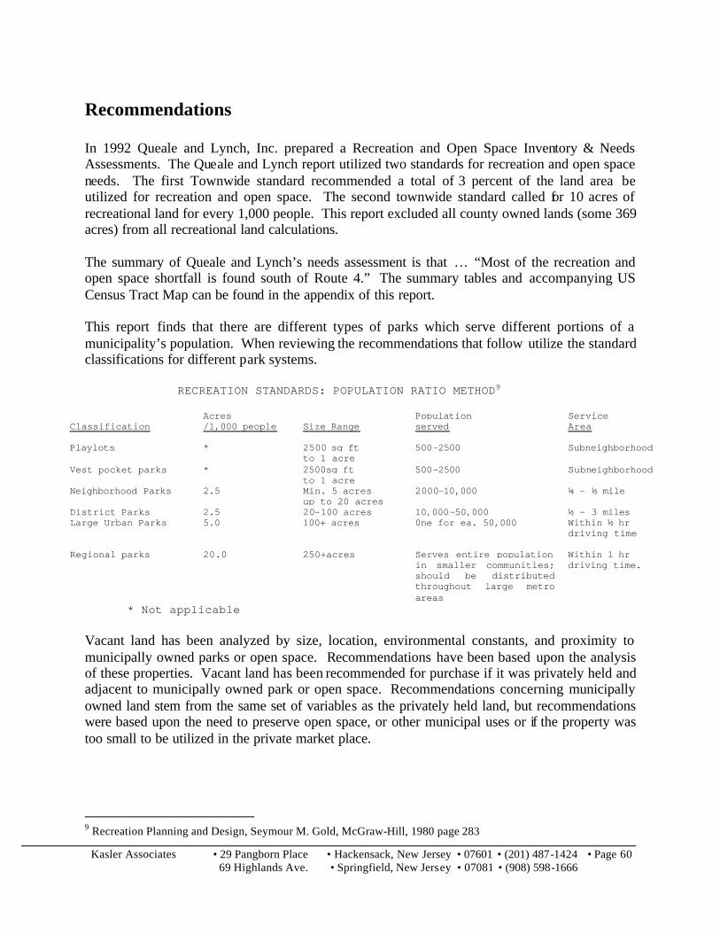
Kasler Associates • 29 Pangborn Place • Hackensack, New Jersey • 07601 • (201) 487-1424 • Page 60 69 Highlands Ave. • Springfield, New Jersey • 07081 • (908) 598-1666
Recommendations In 1992 Queale and Lynch, Inc. prepared a Recreation and Open Space Inventory & Needs Assessments. The Queale and Lynch report utilized two standards for recreation and open space needs. The first Townwide standard recommended a total of 3 percent of the land area be utilized for recreation and open space. The second townwide standard called for 10 acres of recreational land for every 1,000 people. This report excluded all county owned lands (some 369 acres) from all recreational land calculations. The summary of Queale and Lynch’s needs assessment is that … “Most of the recreation and open space shortfall is found south of Route 4.” The summary tables and accompanying US Census Tract Map can be found in the appendix of this report. This report finds that there are different types of parks which serve different portions of a municipality’s population. When reviewing the recommendations that follow utilize the standard classifications for different park systems.
RECREATION STANDARDS: POPULATION RATIO METHOD9
Classification
Acres /1,000 people
Size Range
Population served
Service Area
Playlots * 2500 sq ft to 1 acre
500-2500 Subneighborhood
Vest pocket parks * 2500sq ft to 1 acre
500-2500 Subneighborhood
Neighborhood Parks 2.5 Min. 5 acres up to 20 acres
2000-10,000 ¼ - ½ mile
District Parks 2.5 20-100 acres 10,000-50,000 ½ - 3 miles Large Urban Parks 5.0 100+ acres 0ne for ea. 50,000 Within ½ hr
driving time
Regional parks 20.0 250+acres Serves entire population in smaller communities; should be distributed throughout large metro areas
Within 1 hr driving time.
* Not applicable Vacant land has been analyzed by size, location, environmental constants, and proximity to municipally owned parks or open space. Recommendations have been based upon the analysis of these properties. Vacant land has been recommended for purchase if it was privately held and adjacent to municipally owned park or open space. Recommendations concerning municipally owned land stem from the same set of variables as the privately held land, but recommendations were based upon the need to preserve open space, or other municipal uses or if the property was too small to be utilized in the private market place.
9 Recreation Planning and Design, Seymour M. Gold, McGraw-Hill, 1980 page 283

Kasler Associates • 29 Pangborn Place • Hackensack, New Jersey • 07601 • (201) 487-1424 • Page 61 69 Highlands Ave. • Springfield, New Jersey • 07081 • (908) 598-1666
Waterfront Park System In November of 1995, Hakim Associates prepared a planning study for a propose greenway along the Hackensack River. This report details the feasibility of creating a linear greenway park system along the banks of the Hackensack River. Recommendations of this report echo those represented in this report.
Expand Existing Park and Open Space. Where vacant land abuts a municipal park, or recreational facilities, recommendations for the purchase of these lands have been made if not municipally owned in order to expand the existing recreational facility or to protect its environmental characteristics.
Expand Park and Open Space Where There is a Void. This report recommends, where park and open space is limited, consideration be given to the municipal land for open space or recreational purposes. The municipality may wish to investigate pocket parks where vacant land is scarce.
Major Areas of Municipally Owned land The analysis of municipally owned land has illustrated that there are some of areas where the Township owns large amounts of contiguous land. These areas are indicated on Map 8 and are as follows:
A. Area around Spruce Street B. Hargreaves Avenue C. Land along the following roads:
i. Roemer Avenue ii. New Bridge Road iii. Bedford Avenue iv. Prospect Avenue v. Tietjen Avenue vi. Webster Avenue
D. A large tract of land to the south of Cedar Lane and the Hackensack River E. The intersection of Degraw Avenue and Teaneck Road F. The terminus of the following roads
i. Howland Avenue ii. Manhattan Avenue iii. Sherwood Avenue
Careful planning studies should be performed on these areas in the Municipal Master Plan as to their proposed uses.

Kasler Associates • 29 Pangborn Place • Hackensack, New Jersey • 07601 • (201) 487-1424 • Page 62 69 Highlands Ave. • Springfield, New Jersey • 07081 • (908) 598-1666
Individual Lots which are Municipally Owned
The municipality owns over 140 individual lots throughout the community. Some of these lots are consider sliver lots; small parcels which were either created to provide municipal access to a location, to act as an easement behind properties, or as to act as buffers along roadways. These lots are non developable and are not under consideration for sale or development. There are other individual lots owned by the municipality which are not considered sliver lots in this report. Nevertheless, these parcels do not meet the Townships zoning regulations for minimum lot size, lot width, etc. If these lots were to be sold for development, one or more variances would likely be required. The municipality may wish to consider keeping these lots for either open space or pocket parks, or inquire with adjoining land owners if there is any interest in obtaining additional land for their property.
Overpeck Park
The Overpeck Park is a Bergen County Park system that spans 4 towns. The portion of Overpeck Park located within Teaneck Township contains over 300 acres of land.
The website of the Friends of Overpeck Park, an organization of Bergen County Residents, indicates the following about the Overpeck Park:
Overpeck Park, located in Bergen County, New Jersey, consists of 120 acres of wetlands and landfill surrounding the Overpeck Creek, an estuary of considerable ecological significance which flows into the Hackensack River. The park is bordered by the communities of Leonia, Palisades Park, Ridgefield Park, and Teaneck. The northern half of the park has been developed with various recreational facilities, including a hiking loop, tennis courts, a baseball field, and a football field. The southern half of the park is largely undeveloped, apart from a privately operated horse stable. None of the existing development relates to the park's primary geographic feature, the Creek itself. … The land that currently comprises Overpeck Park was deeded to Bergen County by the surrounding communities in 1951, with the written understanding that the land would be developed as a marine park. Failure of the County to live up to its legal obligations resulted in lawsuits in subsequent years by both Ridgefield Park and Leonia. In its settlement with Leonia in the 1970s, the County agreed to use its best efforts to develop the southern end of the park in accordance with a Master Plan produced by the Bergen County Parks Department in 1963. Such development has not yet taken place, and as a result, this area of the park has been the target for undesirable projects.
This park system, although located within Teaneck and providing additional open space and recreational facilities, is not under municipal land use controls.
Table 7 illustrates the existing private and public vacant lands and recommendations for each lot. Sliver lots have been shaded gray. If there is no specific recommendation for the property, a description of the property location was provided.

Kasler Associates • 29 Pangborn Place • Hackensack, New Jersey • 07601 • (201) 487-1424 • Page 63 69 Highlands Ave. • Springfield, New Jersey • 07081 • (908) 598-1666
Table 7-Recommendations/Comments1
Vacant Land Privately Held
Block
Lot
Property Location
Land Description
Calculated Acres
Net value
Value Per Square Foot
Comment
00101 00001 640 RIVER RD 1.01 AC 1.01 300,000 $ 6.82 Purchase – Adjacent to Terhune Park 00201 00002 836 CEDAR LANE 100X118 0.2709 170,000 $ 14.41 Purchase – Adjacent to Hackensack River
00212 00002 662 POMANDER WALK 76X200 0.3489 114,900 $ 7.56 Across from Lutheran Church 00706 00007 390 CEDAR LANE 45X102 0.1054 135,000 $ 29.40 Double frontage – between Cedar and Water Street
00807 00008 02 520 MARTENSE AVE 50X100 0.1148 100,000 $ 20.00 Cant find 00808 00003 01 502 CLAREMONT AVE 50X112 0.1286 112,200 $ 20.03 Adjacent to church
00819 00013 820 WINDSOR RD 40X105 0.0964 66,400 $ 15.81 Surrounding property is municipally owned 01001 00010 1750 RIVER RD 270X114 0.7066 243,400 $ 7.91 Corner of New bridge road and River road
01109 00003 630 NORFOLK ST 40X60 0.0551 18,900 $ 7.87 Corner of Norfolk St and Dover Ct. Partially in Bergenfield 01201 00020 1635 RIVER RD 60X180 0.2479 120,000 $ 11.11 River Street between Downing and Washburn Street
01614 00005 1163 TRAFALGAR ST 50X124 0.1423 135,200 $ 21.81 Trafalgar Street between Emerson and Forest Ave 01806 00011 450 WINTHROP RD 112X250 0.6428 313,600 $ 11.20 Winthrop Rd 01907 00011 416 BRIARCLIFFE RD 10X60 0.0138 11,300 $ 18.80 Small size – municipal boundary
02105 00017 1363 TAFT RD 20X210 0.0964 19,200 $ 4.57 additional access to school. 02301 00002 332 GROVE ST 36X100 0.0826 42,500 $ 11.81 Grove street – Municipal boundary
02415 00012 GROVE ST 4X100 0.0092 2,800 $ 6.99 Sliver lot – Municipal boundary 02504 00003 707 PALMER AVE 112X99 0.2545 141,800 $ 12.79 Intersection of Palmer and Brinkerhoff Ave
02507 00001 730 PALISADE AVE 207X168 0.7983 400,000 $ 11.50 Corner of Palisade and Demontt Ave. Backs to Rail Road 02603 00023 FRANCES ST 18X100 0.0413 34,500 $ 19.18 Terminus of Frances Street
02912 00015 147 STERING PL 25X100 0.0574 0 $ - Small lot – between Prince Street and Red Road 02912 00016 152 STERLING PL 25X100 0.0574 13,100 $ 5.24 Small lot –between Prince Street and Red Road
02916 00009 816 RED ROAD 35X100 0.0803 30,200 $ 8.63 Red Road between Cedar Lane and Serling Place 02917 00016 MERRISON ST 35X75 0.0603 12,000 $ 4.57 Provides access to lot 16
03002 00003 60 CEDAR LANE 75X130 0.2238 131,000 $ 13.44 Next to church 03003 00005 109 VANDELINDA AVE 75X131 0.2256 110,800 $ 11.27 Adjacent to Holy Name Hospital
03103 00017 01 16 JOHNSON AVE 50 X 125 0.1435 110,300 $ 17.65 Corner of Johnson Avenue and Teaneck Road - cant find 03210 00018 283 QUEEN ANNE RD 51X91 0.1065 73,400 $ 15.82 Between DeGraw Ave and Fort Lee Road 03301 00001 129 FORT LEE RD 19X50 0.0218 4,200 $ 4.42 Sliver lot – boundary of municipality
03301 00026 211 HENRY ST 18X132 0.0545 32,100 $ 13.52 Sliver lot – boundary of municipality 03306 00001 207 MUNN AVE 23X105 0.0554 36,700 $ 15.21 Sliver lot – boundary of municipality
03306 00015 206 HENRY ST 22X188 0.0949 39,900 $ 9.65 Sliver lot – boundary of municipality
1 Shaded lots are lots which are sliver lots and can be ignored.

Kasler Associates • 29 Pangborn Place • Hackensack, New Jersey • 07601 • (201) 487-1424 • Page 64 69 Highlands Ave. • Springfield, New Jersey • 07081 • (908) 598-1666
Block
Lot
Property Location
Land Description
Calculated Acres
Net value
Value Per Square Foot
Comment
03408 00007 60 BERGEN AVE 1.44 1.44 262,500 $ 4.18 Intersection at Jasper Avenue – Location is close to Route 80 03602 00002 391 TEANECK RD 100X214 0.4913 127,100 $ 5.94 Adjacent to county and municipal land
03602 00004 01 371 TEANECK RD 53530 SQ 1.2289 525,600 $ 9.82 Adjacent to county and municipal land 03609 00006 311 WILLOW ST 75X100 0.1722 56,300 $ 7.51 Adjacent to municipal land - wetlands
03609 00008 325 WILLOW ST 2.74 2.74 119,900 $ 1.00 Adjacent to municipal land – wetlands 04102 00028 FARRAGUT DR 90X11 0.0227 6,100 $ 6.17 Sliver lot – intersection at Hancock Avenue
04401 00011 314 HARDING AVE 74X178 0.3024 42,300 $ 3.21 Adjacent to County Land – Built 04403 00001 284 OAKDENE AVE 1.22 AC 1.22 366,900 $ 6.90 Corner of Oakedean and Glenwood Avenues. – Built
05002 00021 41 STATE ST 100X100 0.2296 200,000 $ 20.00 Adjacent to Apartment complex 05004 00003 118 STATE ST 25X115 0.066 27,800 $ 9.67 Small lot 05004 00005 90 STATE ST 125X115 0.33 139,200 $ 9.68 Intersection of Terrace Circle and State Street – Built
05106 00011 77 TRYON AVE WEST 75X150 0.2583 87,500 $ 7.78 Two lots abut each other 05106 00016 44 GALWAY PL 100X120 0.2755 102,000 $ 8.50 Two lots abut each other
05109 00003 PALISADE AVE 25X30 0.0172 1,600 $ 2.14 Small lot, intersection at Tyron Avenue. Abuts railroad 05201 00001 1775 WINDSOR RD 60X213 0.2934 106,800 $ 8.36 Partial Site – Intersection of Windsor Road and Vesey Street
05202 00008 MEYER CT .68 0.68 127,500 $ 4.30 Partial Site – Municipal Boundary with Bergenfield 05202 00009 1860 TEANECK RD .01 0.01 2,500 $ 5.74 Partial Site – Municipal Boundary with Bergenfield
05202 00010 1860 TEANECK RD 60X85 0.1171 92,100 $ 18.06 Teaneck Road and Municipal Boundary with Bergenfield 05413 00020 97 VAN BUSKIRK RD 40X100 0.0918 16,800 $ 4.20 Intersection at Van Courtland Terrace and
05505 00001 115 FAIRFIELD ST 34X58 0.0453 12,900 $ 6.54 Partial Site – Municipal Boundary with Englewood 05602 00010 190 TRYON AVE 38X129 0.1125 51,500 $ 10.51 Intersection of Tryon and Manhattan Ave
05604 00019 250 HARGREAVES AVE .753 0.753 129,200 $ 3.94 Terminus of Manhattan Avenue 05605 00020 150 MANHATTAN AVE 75X100 0.1722 75,900 $ 10.12 Corner of Manhattan Ave and Walden Street
05606 00030 184 WASHINGTON PL 50X105 0.1205 78,000 $ 14.86 Shown on Tax Map as Municipal Owned 05615 00008 527 ENGLEWOOD AVE 67X84 0.1292 39,100 $ 6.95 Adjacent to municipal land 05615 00010 527A ENGLEWOOD AVE 58X31 0.0413 17,100 $ 9.51 Adjacent to municipal land
05615 00011 527B ENGLEWOOD AVE 58X31 0.0413 11,400 $ 6.34 Adjacent to municipal land 05712 00047 17 FRANKLIN RD 59X96 0.13 98,700 $ 17.43 Between Teaneck and Byng Street
05713 00018 02 FRANKLIN RD 31X22 0.0157 1,800 $ 2.63 Shown on Tax Map as Municipal Owned 05714 00006 1290 LORAINE AVE 25X110 0.0631 6,600 $ 2.40 ??
05714 00007 1288 LORAINE AVE 56X111 0.1427 78,000 $ 12.55 ?? 05714 00012 1236 LORAINE AVE 50X115 0.132 76,500 $ 13.30 ??
05902 00008 64 E FOREST AVE 25X104 0.0597 13,900 $ 5.35 Adjacent to municipal land 05907 00004 1171 MADISON AVE 100X200 0.4591 127,100 $ 6.36 Corner of Prospect and Madison
05919 00004 JEROME PL 75X100 0.1722 50,000 $ 6.67 Adjacent to church 05919 00005 JEROME PL 75X100 0.1722 50,000 $ 6.67 Adjacent to church
05919 00016 1076 ARLINGTON AVE 2.01AC 2.01 400,000 $ 4.57 Adjacent to church

Kasler Associates • 29 Pangborn Place • Hackensack, New Jersey • 07601 • (201) 487-1424 • Page 65 69 Highlands Ave. • Springfield, New Jersey • 07081 • (908) 598-1666
Vacant Land Publicly Held
Block
Lot
Property Location
Land Description
Calculated Acres
Net Value
Value Per Square foot
Comment
105 21 440 KIPP ST 25X102 0.06 $26,200.00 $ 10.28 Between Elm and Linden Ave
107 5 370 KIPP ST 60X114 0.16 $101,700.00 $ 14.87 East of Chestnut Ave
201 1 700 POMANDER WALK 9.4 ACRES 9.40 $1,057,500.00 $ 2.58 Riverfront property. Preserve as open space
201 11 672 POMANDER WALK 6.94 ACRES 6.94 $607,300.00 $ 2.01 Riverfront property. Preserve as open space
302 4 827 CEDAR LANE .2862 ACRES 0.29 $166,400.00 $ 13.35 Preserve
510 2 681 MARTENSE AVE 42X108 0.10 $18,800.00 $ 4.15 Preserve – adjacent to Phelps park
604 5 668 TILDEN AVE 40X100 0.09 $75,600.00 $ 18.91 Between River and Catalpa Avenue
605 6 668 MAPLE AVE 56X10 0.01 $7,400.00 $ 13.17 Sliver lot
706 5 404 CEDAR LANE 12X100 0.03 $18,000.00 $ 15.03 Sliver lot
706 9 380 CEDAR LANE 70X103 0.17 $157,500.00 $ 21.85 Intersection at Windsor Road. Adjacent to Railroad.
1001 6 764 NEW BRIDGE RD .91 ACRES 0.91 $136,500.00 $ 3.44 New Bridge Road
1101 1 739 ROEMER AVE 1.04 ACRES 1.04 $175,500.00 $ 3.87 –Acts as buffer for homes along Cottage
1102 10 661 ROEMER AVE 1.39 ACRES 1.39 $234,600.00 $ 3.87 Adjacent to Continental Park. Preserve
1107 1 440 NEW BRIDGE RD 225X220 1.14 $109,300.00 $ 2.21 Intersection of Buckham Road and Roemer Ave
1107 5 416 NEW BRIDGE RD 15X125 0.04 $8,200.00 $ 4.38 Sliver Lot – Municipal Boundary with Bergenfield
1112 1 751 ROEMER AVE .43 ACRES 0.43 $24,200.00 $ 1.29 Center Island of Roemer Avenue
1504 11 PEMBROKE ST .461 ACRES 0.46 $34,600.00 $ 1.72 Buffer of Route 4
1506 14 1064 CAMBRIDGE RD 1.43 ACRES 1.43 $107,200.00 $ 1.72 Buffer of Route 4
1618 1 668 NORTHUMBERLAND 70X120 0.19 $73,800.00 $ 8.79 Intersection of Cornwall Avenue and Northumberland Road
1805 8 547 WARWICK AVE 10X190 0.04 $3,100.00 $ 1.63 Sliver lot
1905 7 279 BRIARCLIFFE RD 25X139 0.08 $6,700.00 $ 1.93 Municipal Boundary with Bergenfield
1909 15 CHURCHILL RD 20X110 0.05 $5,100.00 $ 2.32 Intersection of Windsor and Churchill Road
2107 5 1220 EMERSON AVE 1X132 0.00 $7,000.00 $ 53.57 Sliver lot
2205 9 1192 WINDSOR RD 55X169 0.21 $140,900.00 $ 15.16 Intersection of Forest Avenue and Windsor Road
2801 2 101 CRANFORD PL .70 ACRES 0.70 $60,700.00 $ 1.99 Adjacent to School property along Queen Anne
2917 17 136 MERRISON ST 30X130 0.09 $17,600.00 $ 4.51 Acts as a right of way for lots
3114 82 87 OAKDENE AVE 100X20 0.05 $3,100.00 $ 1.55 Rear portion of lots along Oakdene Avenue.
3114 83 97 OAKDENE AVE 100X15 0.03 $2,600.00 $ 1.74 Rear portion of lots along Oakdene Avenue.
3114 84 115 OAKDENE AVE 100X10 0.02 $2,100.00 $ 2.10 Rear portion of lots along Oakdene Avenue.
3114 85 127 OAKDENE AVE 150X5 0.02 $1,600.00 $ 2.14 Rear portion of lots along Oakdene Avenue.
3306 2 207 MUNN AVE 32X6 0.00 $1,000.00 $ 5.22 Sliver lot. Municipal Boundary – Bogota
3502 3 18 E SHERWOOD AVE 1.93 ACRES 1.93 $579,000.00 $ 6.89 Preserve as open space
3602 3 381 TEANECK RD 92X100 0.21 $101,600.00 $ 11.04 Preserve as open space
3609 1 FORT LEE RD 49X163 0.18 $51,400.00 $ 6.43 Intersection of Parkview Drive and Fort Lee Road

Kasler Associates • 29 Pangborn Place • Hackensack, New Jersey • 07601 • (201) 487-1424 • Page 66 69 Highlands Ave. • Springfield, New Jersey • 07081 • (908) 598-1666
Block
Lot
Property Location
Land Description
Calculated Acres
Net Value
Value Per Square foot
Comment
3701 14 56 FYCKE LANE 31X218 0.16 $20,700.00 $ 3.06 Utilized as a public Right of way
3706 1 566 JOHN ST 22X119 0.06 $12,200.00 $ 4.66 Intersection of Springside Ave and John St?
3712 16 492 GLENWOOD AVE 50X180 0.21 $80,600.00 $ 8.96 ?
3712 17 DEGRAW AVE .4037 0.40 $45,000.00 $ 2.56 ?
3814 12 64 LINDBERGH BLVD 8X12 0.00 $1,000.00 $ 10.43 Sliver back lot
3814 13 64 LINDBERGH BLVD 8X40 0.01 $1,000.00 $ 3.14 Sliver back lot
3820 9 666 HOWARD ST 13X92 0.03 $2,000.00 $ 1.67 Sliver back lot
3820 10 665 HOWARD ST 12X80 0.02 $1,700.00 $ 1.77 Sliver back lot
3820 11 660 STELTON ST 12X104 0.03 $1,900.00 $ 1.52 Sliver back lot
3820 12 659 STELTON ST 11X105 0.03 $1,800.00 $ 1.56 Sliver back lot
3913 24 119 EAST CEDAR LANE 30X74 0.05 $13,700.00 $ 6.17 ?
4303 1 314 HOME ST 150X128 0.44 $80,700.00 $ 4.20 Adjacent to County Land – Terminus of Washington Street Sell for Development?
4303 19 HOME STREET .03AC 0.03 $3,000.00 $ 2.30 Sliver Lot
4305 1 278 HEMLOCK TERR SO 75X100 0.17 $84,400.00 $ 11.25 Terminus of Hemlock Terrace South– Sell for Development
4305 17 326 HEMLOCK TERR SO 75X100 0.17 $60,000.00 $ 8.00 Terminus of Hemlock Terrace South– Sell for Development
4402 14 289 E OAKDENE AVE 40X153 0.14 $73,400.00 $ 11.99 Terminus of East Oakdene Avenue – Sell for Development
4812 15 1056 MARGARET ST .255 ACRES 0.26 $17,300.00 $ 1.56 Route 4 Buffer
5002 1 108 AMSTERDAM AVE .2439 ACRES 0.24 $89,500.00 $ 8.42 Municipal Parking lot
5002 20 29 STATE ST 195X100 0.45 $120,500.00 $ 6.18 Municipal Parking lot
5002 23 89 STATE ST 175X100 0.40 $120,000.00 $ 6.86 Municipal Parking lot
5002 25 105 STATE ST 325X100 0.75 $222,000.00 $ 6.83 Municipal Parking lot
5005 12 195 THE PLAZA 15X129 0.04 $10,300.00 $ 5.33 Sliver lot
5103 7 1665 STEPHENS PL 200X100 0.46 $157,500.00 $ 7.88 Intersection of Stephens Place and Sackville Street Sell for Development
5105 10 GALWAY PL 50X29 0.03 $9,000.00 $ 6.20 Terminus of Galway Place
5107 18 56 TRYON AVE WEST .96 ACRES 0.96 $191,400.00 $ 4.58 Intersection of Tyron Avenue and Queen Anne Road
5207 14 43 SACKVILLE ST 75X100 0.17 $75,900.00 $ 10.12 Intersection of Sackville Street and Stephens Street
5302 29 207 LIBERTY RD .4132AC. 0.41 $110,200.00 $ 6.12 Between Liberty Road and Ivy Lane
5402 15 100 IRVINGTON RD 5X100 0.01 $1,300.00 $ 2.60 Sliver lot
5402 23 152 IRVINGTON RD 40X100 0.09 $54,000.00 $ 13.50 Between Renselaer Road and Van Cortland Terrace– undersized
5404 12 246 STUYVESANT RD 8X100 0.02 $1,400.00 $ 1.75 Sliver lot
5406 26 24 STUYVESANT RD 20X100 0.05 $7,200.00 $ 3.60 Between Teaneck Road and Van Cortland Terrace– undersized
5411 3 204 HAMILTON RD 6X100 0.01 $1,400.00 $ 2.33 Sliver Lot
5413 18 93 VAN BUSKIRK RD 40X100 0.09 $54,000.00 $ 13.50 Between Teaneck Road and Van Cortland Terrace– undersized
5502 4 151 INTERVALE RD 40X100 0.09 $54,000.00 $ 13.50 Between Renselaer Road and Van Cortland Terrace – undersized
5507 6 1603 ARDSLEY CT .7802 0.78 $146,200.00 $ 4.30 Intersection of Hargreaves Avenue and Ardsley Court
5508 2 175 HARGREAVES AVE 50X145 0.17 $80,500.00 $ 11.11 Between Walden Street and St. Marks Place-Open Space

Kasler Associates • 29 Pangborn Place • Hackensack, New Jersey • 07601 • (201) 487-1424 • Page 67 69 Highlands Ave. • Springfield, New Jersey • 07081 • (908) 598-1666
Block
Lot
Property Location
Land Description
Calculated Acres
Net Value
Value Per Square foot
Comment
5508 7 201 HARGREAVES AVE 48X115 0.13 $76,500.00 $ 13.86 Between Walden Street and St . Marks Place- Open Space
5508 9 189 HARGREAVES AVE 50X101 0.12 $76,500.00 $ 15.15 Between Walden Street and St. Marks Place-Open Space
5602 1 116 TRYON AVE .1232 0.12 $86,700.00 $ 16.16 Intersection of Tryon and Manhattan
5604 7 1576 SUMNER AVE 75X100 0.17 $71,700.00 $ 9.56 Terminus of Sumner Ave
5604 17 220 MANHATTAN AVE 150 X 150 0.52 $173,400.00 $ 7.71 At intersection with St. Marks Place
5604 24 191 WASHINGTON PL 50 X 108 0.12 $76,500.00 $ 14.16 ?
5604 27 231 WASHINGTON PL 75 X104 0.18 $8,400.00 $ 1.08 ?
5605 15 1569 CRESCENT AVE 75X95 0.16 $84,300.00 $ 11.83 Between Washington and Manhattan
5606 32 194 WASHINGTON PL 50X105 0.12 $78,000.00 $ 14.86 Between Teaneck and Sunrise
5608 10 210 SHEPARD AVE 6.297 ACRES 6.30 $1,260,000.00 $ 4.59 At municipal boundary with Englewood
5612 11 1466 ENDICOTT TERR 100X95 0.22 $93,700.00 $ 9.86 At intersection with Englewood Avenue
5614 8 1478 SYLVAN TERR 40X95 0.09 $66,600.00 $ 17.53 Between Howland and Englewood avenue
5706 6 ENGLEWOOD AVE .68 ACRES 0.68 $153,000.00 $ 5.17 Between Englewood Ave and Schoonmaker Road preserve open space
5706 9 1423 ASPEN TERR 240X100 0.55 $123,700.00 $ 5.15 At intersection of Aspen Terrace– preserve open space
5707 2 ENGLEWOOD AVE 265X125 0.76 $171,000.00 $ 5.16 At intersection of Spruce Road– preserve open space
5707 10 1423 SPRUCE ST 165X100 0.38 $120,500.00 $ 7.30 At intersection of Schoonmaker Road – preserve open space
5713 39 ARLINGTON AV .0742 ACRES 0.07 $4,000.00 $ 1.24
5801 4 75 BEDFORD AVE 1.32 ACRES 1.32 $198,000.00 $ 3.44 Between Teaneck and Arlington - – No environmental constrains
5801 15 GENESEE AVE 50X118 0.14 $81,100.00 $ 13.75
5802 3 1279 LORAINE AVE 50X125 0.14 $46,700.00 $ 7.47 Portion in Englewood
5809 2 1233 OVERLOOK AVE 25X125 0.07 $7,000.00 $ 2.24 Between Fairview and Circle– No environmental constrains
5816 2 GENESEE AVE 20X140 0.06 $5,900.00 $ 2.11 ?
5902 9 66 E FOREST AVE 50X104 0.12 $76,500.00 $ 14.71 Between Overlook and Arlington
5905 2 150 E FOREST AVE 50X89 0.10 $71,900.00 $ 16.15 Between Congress and Tuxedo– No environmental constrains
5906 3 1172 MADISON AVE 100X100 0.23 $79,700.00 $ 7.97 At intersection of Prospect– No environmental constrains
5909 9 254 FOREST AVE 20X120 0.06 $5,500.00 $ 2.29 At intersection of Lorianne– No environmental constrains
5910 5 249 COOLIDGE AVE 40X112 0.10 $17,600.00 $ 3.93 Between Loraine and Municipal Boundary with Englewood– Sell for development
5911 1 1140 LORAINE AVE .80 ACRES 0.80 $72,000.00 $ 2.07 Between Lorain and Cooper– No environmental constrains
5918 3 36 PROSPECT TERR SO 50X100 0.11 $76,500.00 $ 15.30 Between Overlook and Arlington
5925 2 1124 LORAINE AVE 60X100 0.14 $77,300.00 $ 12.89 At intersection of Robinson– No environmental constrains
5925 7 1096 LORAINE AVE 235X100 0.54 $132,500.00 $ 5.64 Between Robinson and Alfred Ave– No environmental constrains
5927 1 1101 LORAINE AVE .32 ACRES 0.32 $48,000.00 $ 3.44 At intersection of Alfred– No environmental constrains
5927 4 1111 WEBSTER AVE 40X100 0.09 $51,000.00 $ 12.75 At intersection of Alfred– No environmental constrains
6001 1 266 TIETJEN AVE 92X140 0.30 $84,900.00 $ 6.59 Between Webster and Decatur– No environmental constrains
6001 3 286 TIETJEN AVE 60X132 0.18 $85,000.00 $ 10.73 Between Webster and Decatur– No environmental constrains
6001 8 1091 WEBSTER AVE 100X100 0.23 $83,100.00 $ 8.31 Between Webster and Decatur – No environmental constrains

Kasler Associates • 29 Pangborn Place • Hackensack, New Jersey • 07601 • (201) 487-1424 • 69 Highlands Ave. • Springfield, New Jersey • 07081 • (908) 598-1666
Appendix

Kasler Associates • 29 Pangborn Place • Hackensack, New Jersey • 07601 • (201) 487-1424 • Page A 1 69 Highlands Ave. • Springfield, New Jersey • 07081 • (908) 598-1666
Geologic Definitions
JTrp, JTrpg Passaic Formation (Lower Jurassic and Upper Triassic) Predominantly red beds consisting of argillaceous siltstone; silty mudstone; argillaceous, very fine grained sandstone; and shale; mostly reddish-brown to brownish-purple, and grayish-red. Upper Triassic gray lake deposits (Trpg) consist of gray to black silty mudstone, gray and greenish- to purplish-gray argillaceous siltstone, black shale, and medium- to dark-gray, argillaceous, fine-grained sandstone and are abundant in the lower half of the Passaic Formation. Red beds occur typically in 3 to 7 m (10 to 23 ft) thick, cyclic playa lake mud flat sequences and fining upward fluvial sequences. Lamination is commonly indistinct due to burrowing, desiccation, and paleosol formation. Where layering is preserved, most bedforms are wavy parallel lamination and trough and climbing-ripple cross lamination. Calcite- or dolomite filled vugs and flattened cavities, mostly 0.5 to 0.2 mm (0.02 -0.08 in) across, occur mostly in the lower half. Sand-filled burrows, 2to 5 mm (0.08-0.2 in) in diameter, are prevalent in the upper two-thirds of the unit. Desiccation cracks, intraformational breccias, and curled silt laminae are abundant in the lower half. Lake cycles, mostly 2 to 5 m (7-16 ft) thick, have a basal, greenish-gray, argillaceous siltstone; a medial, dark-gray to black, pyritic, carbonaceous, fossiliferous, and, in places, calcareous lake-bottom fissile mudstone or siltstone; and an upper thick-bedded, gray to reddish and purplish-gray argillaceous siltstone with desiccation cracks, intraformational breccias, burrows, and mineralized vugs. Gray lakebeds occur in groups of two to five cycles although they also occur as single cycles in some parts of the formation. Several lake bed sequences consisting of one or two thick groups of drab-colored beds as much as 30 m (98 ft) thick or more can be traced over tens of kilometers. Many gray-bed sequences are locally correlated within faultblocks; some can be correlated across major faults or intrusive rock units. Thickness of the formation between Sourland Mountain and Sand Brook syncline is about 3,500 m (11,483 ft).

Kasler Associates • 29 Pangborn Place • Hackensack, New Jersey • 07601 • (201) 487-1424 • Page A 2 69 Highlands Ave. • Springfield, New Jersey • 07081 • (908) 598-1666
Jd Diabase (Jurassic) Concordant to discordant, predominantly sheet-like intrusions of medium to fine grained diabase and dikes of fine-grained diabase; dark-greenish-gray to black; subophitic texture. Dense, hard, sparsely fractured rock composed mostly of plagioclase (An 50-70), clinopyroxene (mostly augite), and magnetite ilmenite. Orthopyroxene (En 75-80) is locally abundant in the lower part of the sheets. Accessory minerals include apatite, quartz, alkali feldspar, hornblende, sphene, zircon, and rare olivine. Diabase in the map area was derived primarily from high-titanium, quartz-tholeiite magma. Sedimentary rocks within about 300 m (984 ft) above and 200 m (656 ft) below major diabase sheets are thermally metamorphosed. Red mudstone is typically altered to indurated, bluish-gray hornfels with clots or crystals of tourmaline or cordierite. Gray argillitic siltstone is typically altered to brittle, black, very fine grained hornfels. Sills are 365 to 400 m (1,197-1,312 ft) thick. Dikes range in thickness from 3 to 10 m (10-33 ft) and are many kilometers long.

Kasler Associates • 29 Pangborn Place • Hackensack, New Jersey • 07601 • (201) 487-1424 • Page A 3 69 Highlands Ave. • Springfield, New Jersey • 07081 • (908) 598-1666
Queale and Lynch Report Findings

Kasler Associates • 29 Pangborn Place • Hackensack, New Jersey • 07601 • (201) 487-1424 • Page A 4 69 Highlands Ave. • Springfield, New Jersey • 07081 • (908) 598-1666

Kasler Associates • 29 Pangborn Place • Hackensack, New Jersey • 07601 • (201) 487-1424 • Page A 5 69 Highlands Ave. • Springfield, New Jersey • 07081 • (908) 598-1666

Kasler Associates • 29 Pangborn Place • Hackensack, New Jersey • 07601 • (201) 487-1424 • Page A 6 69 Highlands Ave. • Springfield, New Jersey • 07081 • (908) 598-1666

Kasler Associates • 29 Pangborn Place • Hackensack, New Jersey • 07601 • (201) 487-1424 • Page A 7 69 Highlands Ave. • Springfield, New Jersey • 07081 • (908) 598-1666

Kasler Associates • 29 Pangborn Place • Hackensack, New Jersey • 07601 • (201) 487-1424 • Page A 8 69 Highlands Ave. • Springfield, New Jersey • 07081 • (908) 598-1666

Kasler Associates • 29 Pangborn Place • Hackensack, New Jersey • 07601 • (201) 487-1424 • Page A 9 69 Highlands Ave. • Springfield, New Jersey • 07081 • (908) 598-1666

Kasler Associates • 29 Pangborn Place • Hackensack, New Jersey • 07601 • (201) 487-1424 • Page A 10 69 Highlands Ave. • Springfield, New Jersey • 07081 • (908) 598-1666

Kasler Associates • 29 Pangborn Place • Hackensack, New Jersey • 07601 • (201) 487-1424 • Page A 11 69 Highlands Ave. • Springfield, New Jersey • 07081 • (908) 598-1666
Mod IV Data Data within this report utilizes MOD IV data (NJ State approved taxation data). This data is described as follows: Property Description Data Land Dimension This field will accept the size of the parcel in one of the following formats: 150x351 52658SF (square feet) 1.211 AC 7.5 Acres If the size is entered as 150x351 or in square feet, MOD-IV will calculate the acreage and print it in the "Calculated Acreage" field on the Tax List. This is a twenty space, alpha-numeric field. Building Description: The building description codes will appear on the Tax List. The information in a description should be listed in the following order: stories, exterior structural material, style, number of stalls, and type of garage. The listed codes may be supplemented according to need. The building description codes are listed below: STORIES: S Prefix S with number of stories STRUCTURE: AL Aluminum siding RC Reinforced concrete B Brick S Stucco CB Concrete Block SS Structured Steel F Frame ST Stone M Metal W Wood STYLE: A Commercial S Split Level B Industrial T Twin C Apartments W Row home D Dutch Colonial X Duplex E English Tudor Z Raised Rancher L Colonial O Other M Mobile Home 2 Bi-Level R Rancher 3 Tri-level GARAGE: AG Attached Garage UG Unattached Garage Note: Number of cars is prefixed to code. Example: 1.5SSTL2AG means: 1 1/2 story stone colonial with a 2 car attached garage.11
11 MOD IV User Manual

Kasler Associates • 29 Pangborn Place • Hackensack, New Jersey • 07601 • (201) 487-1424 • Page A 12 69 Highlands Ave. • Springfield, New Jersey • 07081 • (908) 598-1666
Hackensack River Greenway through Teaneck Brochure

Kasler Associates • 29 Pangborn Place • Hackensack, New Jersey • 07601 • (201) 487-1424 • Page A 13 69 Highlands Ave. • Springfield, New Jersey • 07081 • (908) 598-1666