environmental profile for the west bank volume 1 ......environmental profile for the west bank...
TRANSCRIPT

Environmental Profile for The West Bank
Volume 1: Bethlehem District Applied Research Institute - Jerusalem
June 1995
Table of Contents
• = Acknowledgment • = Project Team • = List of Acronyms, Abbreviation, and Measuring units • = Introduction • = PART ONE: General Features of Bethlehem District
o Chapter One: Location and Landuse o Chapter Two: Topgraphy and Climate o Chapter Three: Socio-Economics Characteristics o Chapter Four: Soils and Agriculture o Chapter Five: Water Resources
• = PART TWO: Environmental Concerns in Bethlehem District o Chapter Six: Wastewater o Chapter Seven: Solid Waste o Chapter Eight: Air Quality and Noise Pollution o Chapter Nine: Historical & Archeological Sites
• = Conclusion • = References • = Appendix A: Institutions Working in Bethlehem District

Acknowledgment The Applied Research Institute - Jerusalem (ARIJ) would like to thank the Federal Government of Austria, Department of Development Cooperation for their funding of this project through the society for Austro-Arab Relations (SAAR). ARIJ also thanks the Palestinian officials at the municipalities, town and village councils; directors and staff members of the Water Supply and Sewage Authority (WSSA); the United Nations for their assistance and coorperation with the project team members during the data collection phase of the project.

Project Team Jad Isaac
Project Leader
Ibrahim K. Dajani & Violet Qumsieh Project Coordinator
Contributors to this volume
Ahmad Abu Hammad M.Sc in Soil & Irrigation Engineering
Nader Hrimat M.Sc. in Plant Production
Maher Owewi M.Sc. in Remote Sensing
Violet Qumsieh M.Sc. in Water Enginnering
Walid Sabbah M.Sc. in Hydrogeology
Yousef Abu Asaad B.Sc. in Meteorological Engineering
Nadia Al-Dajani B.Sc. in Biology
Taghreed Al-Laham B.Sc in Chemical Engineering
Abdul-Hakim Amer B.Sc.in Environmental Engineering.

Technical Support Team
Faten Al-Juneidi B.Sc. in Soil and Irrigation
Mohammad Abu Amrieh B.Sc. in Plant Production and Protection
Osama Ayyash B.Sc in Plant Protection
Sawsan Istanbuli Diploma in Laboratory Science
Leonardo Hosh M.Sc. in International Agricultural Development
Azzam Saleh M.Sc in Plant Protection (in progress
Rita Sammour B.Sc. in Chemistry
Bassema Takruri Advance Diploma in Water Resource Management
Rafat Ishaq Computer Specialist
Stephen Gasteyer Editor
Jamil Shalaldeh GIS Technician
Issa Zboun GIS Technician
Linda Qassis GIS Technician

List of Acronyms and Abbreviations
ARIJ Applied Research Institute - Jerusalem
BOD Biological Oxygen Demand
CBD Central Business District
COD Chemical Oxygen Demand
Mekorot The National Water Company of Israel
NGO Non-Governmental Organization
PARC Palestinian Aricultural Relief Committees
PCBS Palestinian Central Bureau of Statistics
PECDAR Palestinian Economic Council for Development and Reconstruction
PEPA Palestinian Environmental Protection Authority
PNA Palestine National Authority
PRC Planning and Research Center
R.C. Refugee Camp
SAAR Society for Austro-Arab Relations
TSS Total Suspended Solids
UNRWA United Nations Relief and Works Agency
WBWD West Bank Water Department

Measuring Units
C Degrees Centigrade
CM Cubic Meter
Km2 Square kilometer
MCM Million Cubic Meters
ppm Parts Per Million
Dunum 1000 Square Meters
Hectare 10 Dunums or 10.000 Square Meters

Introduction
Environmental Protection Authority (PEPA)in June 1994.
Environmental profiles are necessary for assessing the environmental soundness and sustainability of the existing and planned local and regional development projects. These are of special importance especially in the context of the new and rapid development brought by the current peace negotiations.
The Bethlehem District Environmental Profile addresses the issues to the major components of the environment in the district and provides data which are helpful for the initiation of projects to rehabilitate environmentally stressed areas and prevent future deterioration.
The Profile emphasizes on the primary environment safety components such as air quality, climate, water resources, soil, landuse, agriculture, noise, solid wastes and wastewater. In addition, pollution sources, the socio-economic aspect of the problems are reviewed. The Profile also includes a section on the historical and archeological sites in the district. As the extension of the flora and fauna in the Bethlehem District are unrestricted to the political boundaries of the district, they will be addressed collectively with those of the other districts in the Comprehensive Environmental Profile for the whole This report is prepared and published by the Applied Research Institute-Jerusalem (ARIJ) as the first of a series of reports on the status of the environment in the West Bank. It is a major component of a two-year project financed by the Federal Government of Austria, department for development cooperation, through the Society for Austro-Arab Relations in Jerusalem (SAAR) to establish an Environmental Data Bank for the West Bank and Gaza Strip. It compliments the Gaza Strip Environmental Profile which was published by the Palestinian West Bank.
Most of the information and data used in this report are based on primary field research, questionnaire,investigations, and personal interviews conducted by the project team. Maps and information related to land areas are all prepared by the Geographic Information System unit team at ARIJ. Officials from the three Palestinian municipalities in the district, the town and village councils, the Water supply and Sewerage Authority (WSSA), the United Nations for Relief and Work Agency (UNRWA), as well as the owners and managers of industrial facilities, were all interviewed for the purpose of this Profile. The remaining data were taken from published reviews and articles, and are indicated in the text.

Chapter One Location And Landuse
Geographic Location
The Bethlehem District is located eight kilometers south of Jerusalem city, in the southern part of the West Bank. It is bounded by the Hebron District to the south and south west, the Dead Sea to the east and Israel to the west. The definition of the boundaries of the Bethlehem District used by ARIJ in this Profile, as seen in (Figure 2), is a combination of the pre-1967 Jordanian and Israeli designation of the boundaries. Towns, such as El-'Eizariya, Abu Deis and Es-Sawahra, which are commonly considered as part of the Bethlehem District, were excluded and re-assigned under the Jerusalem District. This arrangement was constructed for purely technical reasons which facilitated the project team's data collection and analysis.
Figure 2

Landuse
The Bethlehem District, with a total area of 575 km2, includes within its boundaries the three major municipalities of Bethlehem, Beit Jala, and Beit Sahour, 71 Palestinian towns and villages, and 20 Israeli settlements. It also includes Israeli-designated closed military areas, military bases, and nature reserves. The district's total population is estimated at 132,466 Palestinians (PCBS, 1995) and 8,100 Israeli settlers (Tufekgy, 1994). Currently, approximately 5% of the Bethlehem District is classified as a built-up area. The sections below describe the various landuse activities in the district. Palestinian Built-up Areas There are 71 Palestinian communities in the Bethlehem District. These include the three cities of Bethlehem, Beit Jala, and Beit Sahour; villages such as El-Khader, El-'Ubadiyah, Artas, Beit Fajjar, Dar Salah, Marah Rabah, Nahaleen, Teqo'a, Wadi Fukin, Umm Salamuna and Za'tara; and the three refugee camps of 'Aida, El-Daheisha, and Beit Jebren (Figure 3). The total built-up area that Palestinians occupy is approximately 2,000 hectares. As Palestinians maintain a close relationship with their land, most their built-up areas are concentrated in fertile lands used for either rainfed or irrigated agriculture. For example, Bethlehem and Beit Sahour, the largest Palestinian communities in the district, are located on flat and deep brown rendzinas soil that is valuable in terms of agriculture. In contrast, shallow depth and steep areas with brown rendzinas soil, which is mostly suitable for the building foundations, are currently left for olive and grape plantations or as grazing areas. For the last few years, there has been an intensive wave of building constructions. Most of the expansion, unfortunately has been at the expense of the agricultural areas. Many trees have been cut and several roads were constructed on agricultural lands --a trend clearly noticeable around Bethlehem city. As a response to population pressure, the Bethlehem municipality recently began granting building permits for buildings exceeding the previous limit of 3 stories. Israeli Settlements These occupy approximately 790 hectares of land and consist of 20 Israeli settlements (Figure 3). Nine of these settlements are located on either Terra rossa or brown rendzina soil, which are prime agricultural soils. There is a continuous concern about the continued expansion of the Israeli settlements in the Bethlehem District. One of the threatened areas is the forested mountain of Abu Ghunaim, east of Bethlehem City (Photo1).

Figure 3
Photo 1: MountAbu Ghunaim

Closed Military Areas and Bases
These areas are seized and closed by Israel on the basis of classified security reasons or to provide military training areas for the Israeli Army. In addition to four military occupying an area of about 40 hectares, closed military areas constitute approximately 31,000 hectares. These closed areas extend from the north-eastern to the south-eastern boundaries and into the western tip of the of the Bethlehem District (Figure 4). While most of these areas have low agricultural value, they constitute the major grazing areas in the district. Because Palestinian pasturalists are denied access to these areas, unclosed grazing areas currently suffer from sever overgrazing and are under threat of permanent desertification (Photo 2). Furthermore, the wildlife and rich biodiversity which characterize the closed areas are threatened by the action of heavy military tanks and vehicles. Through the peace negotiations, Palestinians are requesting the re-opening of the closed areas. If this occurs, a grazing management environmental protection program should function to prevent overgrazing and the loss of viable genetic resources.
Figure 4

Photo 2 - The Eastern Slopes; an Example of Desertification
Nature Reserves
As of the time of publication, there are three declared nature reserves in the Bethlehem District, occupying an area of approximately 4,800 hectares. A substantial part of this area overlaps with the closed military areas in the district (Figure 4). It has been known that land planned for confiscation is often first, for legal justification, declared as a nature reserve. Later, such land is converted into either Israeli settlement or military training base. Thus, the true environmental importance of areas declared as nature reserves are suspected. Forests The twelve forested areas in the district of Bethlehem comprise approximately 380 hectares. Most of these forests are located in the northwestern part of the district (Figure 4), on fertile soil such as Terra rossa and Brown lithosols. Deforestation is a serious phenomena in the Bethlehem District. The public, in general, lacks the awareness of the importance of trees for the conservation of soil and wildlife. Trees are often cut for their wood or uprooted to make space for a residential building, industrial or commercial facility. The forest areas surrounding Solomon's Pools is one example of the destruction of forest areas in the district. Many trees has been cut down or burnt. Photo 3 shows the remains of a forest area on the mountain behind El-Daheisha refugee camp near Bethlehem City.

Photo 3 - Deforestation Near El-Daheisha Refugee Camp
Cultivated Areas
The cultivated areas in the district cover approximately 4,300 hectares. They are situated primarily on Terra rossa and Brown lithosols soils and are divided into the following : Rainfed field crops, concentrated on hilltops and valley shoulders, are planted primarily with wheat and barley. This form of cultivation occupies an area of around 1,050 hectares. Rainfed fruit orchards, concentrated in the western parts of the district especially on terraces and hilltops, occupy an area of approximately 250 hectares.
1. Rainfed olive groves, mainly in the central and western parts of the district, occupy an area of around 600 hectares.
2. Rainfed vineyards, the largest cultivated area in the district, are concentrated on mountainous terraces, ridges and hilltops especially in the western part of the district, and occupy an area of around 2,300 hectares.
3. Irrigated vegetables, located on horizontal planes, include cucumber, squash, eggplant, radish, bean and parsley, and occupy an irrigated area of about 100 hectares.

The following table shows a summary of the landuse patterns in the Bethlehem District.
Table 1: Landuse Classification in the Bethlehem District
Landuse Area (hectares)
Percentage of Total Land Area (%)
Palestinian Built-up Areas
2,000 3.5
Israeli Settlements 790 1.5
Closed Military Areas 31,000 54
Military Bases 40 <1
Nature Reserves 4,800 8.5
Forests 380 <1
Cultivated Areas 4,300 7.5
Other* 14,190 25
Total 57,500 100
* = represents either unused land or land used for grazing, unofficial waste dumping, and quarrying

Chapter Two Topography And Climate
Topography Although narrow and relatively small in size, the Bethlehem District is characterized by great variation in its topography and altitude. The central mountain range of the West Bank crosses the area from south to north in the western portion of the district. Thus, the highest elevation of approximately 900 m above sea level is found in the Beit Jala area in the west (Figure 5). The eastern parts of the district are characterized by sharp slopes, called the Eastern Slopes, were elevation drops from 900 m above to 400 m below seal level in the Dead Sea area within a short horizontal distance of 25 km.
Figure 5

Climate Bethlehem District features a climate that ranges from arid to semi-arid, with an increase in aridity towards the southern and southeastern direction across the Eastern Slopes in the Jerusalem desert. This climatic variation is primarily due to the drastic drop in the elevation from the western to the eastern part of the district. While the western parts receive an average of 700 mm of rainfall annually, the eastern proximity receives less than 100 mm. In Bethlehem City, the mean annual rainfall for the years 1961-1990 was 609 mm.
Even though the average annual rainfall may reach 700 mm, the Bethlehem District can be classified as semi-arid to arid. This is justified as the mean annual evaporation rate, reaching 1400 - 2600 mm (Table 2) is higher than the mean annual rainfall. The steepness of most of the areas in the district and the lack of water harvesting facilities, prevents efficient utilization of rainfall and runoff water.
Table 2: Climatic Parameters for Bethlehem District
Climatic Parameters Value
mean annual rainfall 100-700 mm
mean annual evaporation 1400-2600 mm
mean annual temperature 17-23
mean annual relative humidity 60 %
mean annual cloudiness 20-35 %
sunshine on average 7-13 hrs
Source: Orni & Efrat,1980
In addition, soil erosion by runoffwater is a major factor contributing to the degradation of the agriculturalareas and the loss of the rich top soil cover. The inconsistency of rainfall across the months and years also requires that most vegetable cultivation be supplemented with irrigation to ensure normal growth. Table 3 shows the climatic parameters for Bethlehem City.

Table 3: Climatic Parameters for Bethlehem City for 1993/1994
BP mb
DT °C.
WT °C.
CF °C.
WS m/s
WG m/s
WD degree
R.H %
Rain mm
Autumn 1993 (September 21 to December 20)
Maximum 935.5 23.8 17.4 22.6 4.4 8.5 334.4 89.9
Minimum 932.8 14.5 12.3 12.5 0.1 0.9 61.0 53.5
Average 934.1 19.1 14.8 17.6 2.3 4.7 197.7 71.8
Total 134.4
Winter 1994 (December 21 to March 20)
Maximum 935.0 14.0 9.7 12.6 5.8 10.9 320 80.4
Minimum 931.5 7.5 4.9 3.4 0.3 1.0 63.6 52.2
Average 933.0 10.7 7.3 8.0 3.0 6.0 191.8 66.3
Total 545.7
Spring 1994 (March 21 to June 20)
Maximum 933 26.6 19.2 25.3 6.0 11.4 319.4 78.2
Minimum 930 15.5 11.7 12.0 1.0 2.1 84.0 45.8
Average 931 21.0 15.5 18.6 3.2 6.8 202 62.0
Total 43
Summer 1994 (June 21 to September 20)
Maximum 929 31.0 16.2 30.4 5.7 11.7 289.2 41.0
Minimum 927 20.6 9.8 18.5 0.7 2.7 116.0 17.1
Average 928 25.8 13.0 24.5 3.2 7.2 203 29.0
Total 0 Source: Daily records of the Weather Station at ARIJ, 1993-1994 Table Key: BP= Barometric Pressure; DT= Dry Temperature; CF= Chill Factor; RH= Relative humidity; WD= Wind Direction; WG= Wind Gust; WS= Wind Speed; WT= Wet Temperature
Rainfall
The rainy season in Bethlehem District starts in the second half of autumn (mid October) and continues until the end of April. Heavy rain is, however, limited to a less than 50 days, where around 70% of the rain falls during November to February (ARIJ Weather
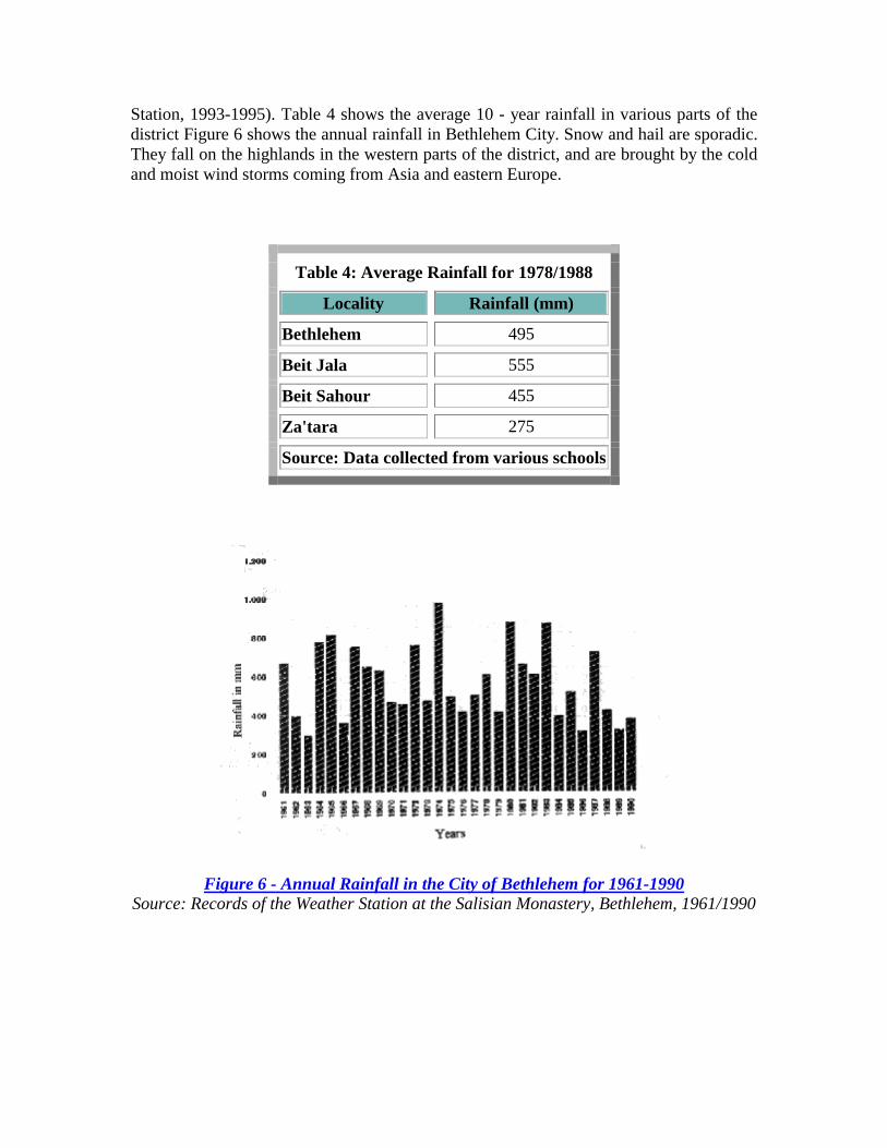
Station, 1993-1995). Table 4 shows the average 10 - year rainfall in various parts of the district Figure 6 shows the annual rainfall in Bethlehem City. Snow and hail are sporadic. They fall on the highlands in the western parts of the district, and are brought by the cold and moist wind storms coming from Asia and eastern Europe.
Table 4: Average Rainfall for 1978/1988
Locality Rainfall (mm)
Bethlehem 495
Beit Jala 555
Beit Sahour 455
Za'tara 275
Source: Data collected from various schools
Figure 6 - Annual Rainfall in the City of Bethlehem for 1961-1990 Source: Records of the Weather Station at the Salisian Monastery, Bethlehem, 1961/1990

Temperature
The average annual temperature in the high grounds of Bethlehem District is 17-19 °C, with an upper limit of 22 °C in the Summer and lower limit of 7 °C in the Winter. At lower elevations, close to the Dead Sea, the average annual temperatures reaches 21-23 °C.
Wind
The district's highland is influenced by the Mediterranean Sea breeze around midday. During the Autumn and Spring, westerly winds from the Mediterranean blow on the area. The humidityof these winds is the significant factor which will determine whether it will rain or not. Data obtained from ARIJ's weather station shows that the mean annual wind speed in the city of Bethlehem is 3 meters per second.
The entire Bethlehem District has been affected by annual waves of hot, dry, sandy, and dust Khamaseen winds which originate from the Arabian desert during the months of April, May and mid-June.
Solar Radiation
Bethlehem District receives an average of seven hours of sunshine a day during the Winter and thirteen hours during the Summer. The average solar radiation ranges from 188 K.Calories/cm2/year (Atlas of Israel, 1985). As a consequence, Palestinians use roof-top solar heaters extensively, to capture the solar energy and replace limited and expensive available energy resources.
Humidity
The average annual relative humidity in the Bethlehem District is 60% and reaches its highest rate during the months of January and February. In May, however, humidity levels are at their lowest. Night dew may occur in up to 180 days per year (Benvenisti, 1986).

Chapter Three Socio-Economic Characteristics
Demography and Population The total population of the Bethlehem District is estimated at 132,466 (PCBS, 1994), representing 5.7% of the total population of the Occupied Palestinian Territories. This number includes 13,451 people living in the three refugee camps of 'Aida, El-Daheisha, and Beit Jebren (UNRWA, 1994). Out of the total population, 64,291 people (47%) are living in rural areas (PCBS, 1994).
Moslems constitute 67% of the district total population, and the remaining 33% are Christians (Soudah, 1990). Christians constitute the majority only in the two cities of Beit Jala and Beit Sahour, with a population percentage of 53% and 73% respectively (Soudah, 1990). Among Christians, the Orthodox are dominant, forming 21%. Although Christians have traditionally been the majority of the population of Bethlehem City, recent information showed that their number have been reduced in the last 28 years. Presently, Moslems represent the majority of the population (excluding refugee camps), with 62% (Soudah, 1990). Such demographic change is a result of Christian immigration to other countries and Moslems emigration from rural areas, and nearby cities and refugee camps.
Until 1990, approximately 92% of the working force in the Bethlehem District are permanent residents, while 2% live elsewhere in the West Bank, 2% in Jordan, 2% in other Arab countries and 2% outside the Middle East region (Soudah, 1990).
Economy Unfortunately, there are no figures or studies concerning the per capita Gross National Product (GNP) or Gross Domestic Profit (GDP) for the Bethlehem District. However, based on the World Bank official statistics, the overall economy in Palestine is characterized by a per capita GNP of US$ 1,715 and a GDP of US$ 1,275 for 1991 (World Bank., 1993).
According to a 1994 study of the Bethlehem District working force, approximately 91% have permanent employment, 1% have seasonal jobs and 8% have part-time jobs (PARC & Arab Though Forum, 1994). The unemployment rate is estimated at 40.5%. In the agricultural sector, 45% of the male workers are between the age of 21-40 (PARC & Arab Thought Forum, 1994). In various communities of the district, there is a great variation in the number of inhabitants working in the agricultural sector. In the village of Beit Fajjar, south of Bethlehem City, most of the work force is concentrated in the stone industry and quarries. On the contrary, Wadi Fukin, a Palestinian village located in the

western parts of Bethlehem District, residents depend primarily on agriculture for their income. Almost 100% of the working force in Wadi Fukin work in agriculture (PARC & Arab Thought Forum, 1994).
Provision of services for the Bethlehem District inhabitants is not limited to the governmental and civil administration institutions. The district contains a large number of charitable societies and non-governmental organizations that fill the gaps in services that the formal institutions are not able to provide. A list of these organizations is found in Appendix A.
Sewage Disposal Facilities
According to a survey conducted by ARIJ in the late December 1994, 20% of the population in Bethlehem City and 60% of the population in El-Daheisha refugee camp have their homes connected to the sewerage system. The nearby villages, however, are still not connected to sewerage networks and depend mainly on cesspits for the disposal of their wastewater. A new wastewater collection network is currently under construction in the three cities of Bethlehem, Beit Jala and Beit Sahour which are anticipated to serve approximately 90% of the population, including the three refugee camps of Daheisha, 'Aida, and Beit Jebren ( Refer to Chapter Six).
Piped Water Supplies
Approximately 99% of the population in the Bethlehem District has access to piped water supply. However, water supply has been irregular and the network suffers from frequent dry periods which sometimes, especially during the Summer, last for over a month. For example, El-Daheisha refugee camp has been out of water supply for more than three months at a time (Barghouthi, 1993).
Garbage Collection Services
Only 65% of the total garbage in the Bethlehem District is collected. Approximately 35% of the garbage is dumped on the road sides, in backyards, on vacant lands, or at the entrance of villages (Refer to Chapter Seven).
Electricity services The Jerusalem District Electricity Company is the main supplier of energy to the Bethlehem District. Electric supply is erratic, particularly in rural areas, with less than 50% of rural households receiving electricity 24 hours/day. On average, in the West Bank, some 63% of households have electricity on 24 hour basis. The remaining rural communities lacking electric supply through the network, are dependent on either local community generators or home generators. Single generators are sometimes used households in the communities (Heiberg & Ovensen, 1993).

Health Care Sector Over the past twenty eight years, the Palestinian health-care sector has been developing side-by-side with the Palestinian society. The rise in Palestinian casualties, brought by the Intifada in early 1988, put the health care sector in a state of emergency. As a result, several new clinics were established in rural areas to meet the increasing demand for adequate medical services. Almost all new clinics were either funded by either NGO's or charitable societies (Barghouthi, 1993). Currently, there are five main branches that support this sector: private for profit, charitable organizations, NGO's, UNRWA which primarily serve the refugee camps, and the Palestinian National Authority (PNA).
In late 1994 responsibility for the Palestinian Health Department was transferred from the Israeli Civil Administration to the PNA. Since then, the Palestinian Ministry of Health took over the responsibility of providing health services in the Bethlehem District. As a first measure, the new ministry assessed the current health services and initiated several emergency projects.
The health sector, comprises more than 9% of total GDP in the West Bank. In the Bethlehem District, the following health services exist (Abu Libdeh, 1993):
• = Primary health care clinics: There are thirty-two primary health care clinics in the Bethlehem District, of which 16 are sponsored by NGO's, 14 by private-for-profit, and two are associated with UNRWA (PRC, 1994).
• = Hospitals: There are six hospitals in the Bethlehem District, three are maternity, one psychiatric, one pediatric, and a general hospital. An Orthopedic hospital, which had operated for more than 25 years, was recently closed in the district (PRC, 1994). The total number of hospital beds in the six hospitals of the district is estimated at 506 (PRC, 1994). Although this number seems sufficient for the district's population, several of these hospitals are the only providers of specialized health services in the whole West Bank and Gaza Strip. Thus, these hospitals are crowded, often giving appointments several weeks ahead to seekers of specialized services. The health institutions in the Bethlehem District, as well as the West Bank and Gaza Strip, lack the funds needed for their development and to maintain their services. The government hospital in Beit Jala, for example, suffers from shortage in staff, equipment, and supplies. Moreover, the district lacks some essential specialized clinics, thus forcing people to travel to other districts to get the needed services (Heiberg & Ovensen, 1993; PRC, 1994). There are five ambulance vehicles in the Bethlehem District, three of which are owned by the Bethlehem municipality, one by the government hospital and one by UNRWA.
• = Medical and HealthCare Personnel: According to official Palestinian health statistics, there are 133 physicians in the district, representing 9% of the total physicians in Palestine. In addition, there are 341 nurses and 27 Dentists, representing 7% and 14% of the total number of nurses and dentists in Palestine respectively (Abu Libdeh, 1993).

The educational institutions in the Bethlehem District are operated by either the government, private (mainly church) organizations, and the UNRWA (Heiberg & Ovensen, 1993).
For many years the Palestinian educational system lacked independence. Both curriculum and official exams were set by either the Jordanians, Egyptians or Israelis. Since 1948, the structure and content of the curriculum, teaching materials and examinations in the West Bank schools followed the Jordanian system, while in the Gaza Strip, schools followed the Egyptian system. After the Israeli occupation in 1967, the actual control over governmental schools was placed under the Israeli jurisdiction. Private schools enjoyed relatively more freedom in appointing their staff and some of the books on the curriculum (Heiberg & Ovensen, 1993). It is worth mentioning that the text books used in Palestinian secondary schools are only now being updated for the first time since the early 1960's.
After the partial implementation of the Oslo Agreement, the Ministry of Education was put under the authority of the PNA. An agreement was then reached with the Jordanian government which gave the PNA more power over the educational system.
According to the Palestinian Central Bureau of Statistics, the total number of schools in the year 1993/1994 in the Bethlehem and Jericho districts is 193. Out of these, 99 are primary (elementary and intermediate) and 32 are secondary schools. The remaining 62 schools are either kindergarten or community colleges.
The Bethlehem University, a leading educational institution in Palestine, is also located in the district. Although governmental schools compromise the largest educational institu-tions in Palestine, in Bethlehem/Jericho district private schools are dominant. There are 99 private schools and 75 government schools, established after 1967. In both districts, schools are identified as 99 private, 75 governmental and 19 UNRWA (PCBS, 1995).
All schools in the Bethlehem and Jericho Districts host approximately 39,346 pupils. Figure 7 shows the distribution of these students by school type and number of pupils per teacher. Table 5 also shows the total number of pupils in the district and their distribution by educational level and sex (PCBS, 1995).

Figure 7 - Average Number of Pupils in the Various school Types Source: The Palestinian Ministry of Education, 1993/1994.
Table 5: Distribution of Pupils by Educational Level and Sex (93/94)
Number of Pupils in :
Kindergarten Primary Secondary Colleges
Male 2520 21,166 1,625 42
Female 2326 19,627 1,470 75
Total 4846 40,793 3,095 117
Source: Palestinian Ministry of Education, 1993/1994
Table 5 shows that equal opportunity for education is given to both female and male pupils in the Bethlehem District.
Although over 50% of the schools in Palestine are governmental, their services and capabilities require great attention and review. Overcrowding is one of these issues that should be addressed. Differences among the various types of schools affect both the levels of education and literacy among pupils (Figure 7).

Chapter Four Soil And Agriculture
Soil The distribution of the major soil associations found in the Bethlehem District is shown in Figure 8. These associations are (Table 6):
Table 6: Major soil types and their Characteristics in the Bethlehem District
no
Soil Assoc-iation
Area km2
American Class-
ification Location
General Charac- teristics
Natural Vegetation
Rainfall (mm)
Mean tempe
-rature (°C)
1
Bare rocks and desert lithosols
152.7 Torrior-thents
Eastern section
Bare rocks, rarely small depth of soil
Retama raetam, Anbasis articulata , and Zygophyllum dumosum
80-100 14-23
Torrior-thents
Sloppy areas
Marl, chalk, limestone and conglomerates parent materials
Ballotetelia undulatae, Artemisietea herbae.
200-350 19-21
2
Brown lithosols & loessial arid brown soils
155.9
Xero- chrepts
Areas with slops
< 5%
Xeric moisture regime, the soil has ochric surface epipedon with low organic matter < 0.6% and massive structure, parent material is loessial sediments.
Leopoldia eburnea, Achillleetum santolinae and Lolium multiflorum Wheat, barely and sorghum are covering most of the area.
250-350 19-21

Xero- chrepts
Hilly slopes near Al-Ubeidia mountains
& hilly areas
Xeric moisture regime, it has a reddish brown color. The structure of the soil is crumby. Texture is loamy or clay. About 30% is stony, parent material is soft chalk and marl.
Pinus halepensis and Pistacia palaestina. Non irrigated field crops like wheat and barley.
600-700 15-19
3 Brown & pale 96.3
Haplo-xerolls
Valleys and
depressions like Wadi An-Nar
depression, Bethlehem, Beit-Jala and Beit Sahour
Xeric moisture regime, it has mollic surface epipedon with high base saturation (75%). It is dark reddish brown color with clay and with gentle slope, parent material is marl, soft and hard chalk
Quercus ithaburensis,Pistacia lentiscus, Pistacia palaestina,Ceratonia siliqua andBallotetalia undulatae.
300-700 18-20

Xero-chrepts
Western section.
Battir and adjacen
areas
Terra rossa type, the parent materials are dolomite and hard limestone, the soil depth varies from shallow to depth (0.5-2 m) Xeric moisture regime, deep in hilltops and shallow in sloppy mountainous areas. Soil has a reddish brown color with subangular blocky structure.
Quercus calliprinos, Pistacia palaestina and Pistacia lentiscus.
400-700 15-20
4
Terra rossas, brown ad pale redizinas
73.7
Halo-xerolls
Small plateau of
the mountains
Same as Xerochrepts with exception that it has a base saturation of 75%, parent material is soft chalk and marl.
Pistacia atlantica, Amygdalus korschinskii and Pistacia palaestina. Fruit trees
400-700 15-20
5
Brown lithosols & loessial serozems
78.4 Hap-largids --
Shallow depth where concentrated on steep hill slops, the parent materials are limestone, dolomite, chalk and flint.
Anabasis articulata, Zygophllum dumosum and Suaeda asphaltica
80-200 17-23

Figure 8
Bare rocks and desert lithosols These types of soil are concentrated in the eastern parts of the district and cover an area of approximately 15,000 hectares. They are generally characterized by bare rocks and slight soil depths especially at plateau and moderately sloping areas. These soils are originally formed from hard limestone, dolomite and chalks mother rocks. Major vegetation growing in these soils are shrubs, mainly Retama roetam, Anabasis articulata, and Zygophyllum dumosum. The use of these area is currently limited to grazing, in particular, where natural valleys and depressions occur.
Brown Lithosols and Loessial Arid Brown Soils These types of soil are found to the east of Beit Sahour and covers an area of 15,500 hectares. They have an infiltration rate of 100-120mm/hr. Rock outcrops in such soils range between 50-60%. The common landuse on these soils is primarily the cultivation of annual field crops, mainly wheat and barley. Field crops are planted in areas where the top soil is deep enough and the sloping is moderate. However, in shallow and steep areas, grazing is the common activity. According to the American great group classifications, these soils represent the association of Torriorthents, Xerochrepts, and Haploxeralfs.
Brown and Pale Rendzinas
These soils dominate in the hilly and mountainous areas of the central part of the West Bank. In the district, they are widespread in the Bethlehem, Beit Jala, Beit Sahour area and their surrounding villages, covering an area of approximately area of 10,000 hectares. Around 30-50% of these soils is outcropped with rocks. On such areas, the cultivation of grapes and olives, field crops (wheat and barley), and grazing is the main landuse, especially in shallow and steep sloping areas. According to the American great group classification, these soils represent the association of Xerorthents, and Haploxerolls.
These soils occupy a total area of approximately 7,500 hectares and are found mainly in the western part of Bethlehem District. Similar to the previous soil types, rock outcrops in these soils are almost 30-50%. The dominant landuse pattern on these soils is the cultivation of field crops, mainly wheat and barley and vineyards, olive and fruit trees, particularly on valley shoulders. This soil association is referred to as Xerorthents, and Haploxerolls.
Brown Lithosols and Loessial Serozems
These soils occupy a total area of approximately 8,000 hectares. Such soils suffer from extensive erosion due to runoff, especially in steep slopes, and limited salt leaching capabilities. Such properties causes salt accumulation. The dominant landuse for these areas are grazing and the cultivation of several field crops, particularly on valley shoulders. The American great group classification for these soil associations is Haplargids, and aridisol respectively.
Agriculture
Plant Production
Bethlehem district is classified as an arid to semiarid region with a Mediterranean climatic type. The Eastern Slopes receive as little as 100 mm of annual precipitation, and the amount of rain per year increases gradually up to 700 mm in the western and northern parts of the district.
The diversity of cultivation and biomass of different species of indigenous wild plants are controlled by the variations in climatic conditions of different plains, valleys, slopes, and mountains of the district. Eastern Slopes have the largest area of natural pastures in the West Bank and contains most of the livestock in the Bethlehem district, owned mainly by Bedouins. Due to the limitations in rainfall, barley is only crop cultivated extensively in these slopes.
In the northern and western parts of district, the biomass and green cover becomes more intensive and the economical returns in cultivated agriculture are greater, especially for

irrigated crops. Open field irrigated vegetables make up about 1.3% of the cultivated area in Bethlehem.
Throughout the district, however, rainfed agriculture is the dominant, comprising about 98.7% of total cultivated area (Figure 9). The size and potential production of this type of agriculture, however, are affected significantly by the quantity and distribution of rainfall, incidence of frost, and warm summer temperatures, especially AlKhmasin hot winds.
Fruit trees make up 62.2% of the total rainfed area. Productive olive trees and grape vines are the most prominent fruit trees, forming about 93% of fruit production in the district. The soil and climatic conditions are suitable for grape cultivation, which is dominant in villages such as al-Khader in the district's central highlands. Olives are moderately productive. Some of other cultivated fruit trees are almonds, unproductive olive trees, apples, apricots and plums.
Field crops make up 32.2% of the total rainfed area. Wheat and barley are the most cultivated crops, covering 67% of the total area planted with field crops, and bitter vetch, lentil, chickpeas and other legumes (in order) make up the remaining 33%.
The landraces of snake cucumber and squash have the largest cultivated areas amongst the rainfed vegetable crops, taking up 76% of the cultivated area. These local varieties are well adapted with special aromas, testability, shape and color. They also have relatively high demand by the consumers. The remaining 26% percent is devoted mostly to tomatoes, dry onions, and okra.
Irrigated vegetables take up the smallest area of all cropping types due to limitations of water resources. These vegetables are totally dependent on the water of springs located in the valleys of some villages like Artas, Husan, Nahalien, Battir, and Wadi Fukin. The main irrigation methods are furrowing, flooding in basins and drip irrigation. Almost all irrigated vegetables are cultivated under open field conditions, with plastic houses used on only one tenth of a hectare in the entire district. The landrace of eggplant called Battiri is the most cultivated vegetable crop in the district, covering 12.9 hectares. Improved varieties of cabbage and other vegetable crops are cultivated over an area of 10.2 hectares.

Figure 9 - Total Cultivated Area in Bethlehem District for 1994/93 Growing Season in Hectares
Total production of rainfed crops and fruit trees was 15,953 tons in the 1993/94 growing season, with average yield of 2660 Kg/hectare. Production for open irrigated vegetables was 13,680 Kg/hectare and for tomatoes under the plastic houses it was 90,000 kg/hectare. This variation resulted from the increased water availability and the application of improved agricultural practices in irrigated vegetable crops (Figure 10).

Figure 10 - Total Plant Production in Bethlehem District for 1993/94 Growing Season in Tons
Cereals gave the highest yield compared with other cultivated field crops. Barley yielded about 1,300 kg/hectare and wheat 1,240 kg/hectare. These results show quite limited production/hectare, probably because the crops suffered from heat stress during summer. For field crops, especially legume crops, productivity could be increased significantly by shifting the planting dates to earlier in the season, increasing the use of new higher yielding and disease resistant varieties which are adapted to the area, and applying fertilizers to improve the soil fertility. The results of experiments and demonstrations on wheat, chickpeas and sorghum carried out by the ARIJ rainfed farming research staff in Za'tara have shown that there is good potential for improving the yield of these crops significantly by applying these improved agricultural practices.
Amongst cultivated fruit trees, plums gave the highest yield, with 8,000 kg/hectare. followed by grapes, 6,580 kg/hectare.
Dry onions produced the highest yield among vegetables cultivated under rainfed conditions, with 5,500 kg/hectare, followed with tomatoes, 4,500 kg/hectare, and squash with 4,000 kg/hectare. For irrigated vegetables, cauliflower, cabbage and pumpkin gave the highest yields, with nearly 20,000 kg/hectare, followed with eggplant and squash with 16,000 kg/hectare. Tomatoes grown under plastic houses yielded 90,000 kg/hectare.
For rainfed plantations in the district, farmers tend to use local landraces, "Baladi varieties," adding animal manure to fertilize their lands. Soil is mainly ploughed using animal traction, and cultivating is done manually. Hand weeding is done by the family,
and only occasionally do farmers use pesticides, generally spraying only when the destructive effect of the pests has reached the economic threshold level, especially for fruit trees.
The products of this kind of cultivation usually sell at higher prices than those produced from intensive irrigated farming, as Palestinian consumers prefer the better aroma and taste, especially in rainfed vegetable crops. These products are also more healthy, because the plants are cultivated with only limited use of chemicals, which could have a negative effects on both humans and the environment.
Livestock and poultry
Sheep and Goats
Most sheep and goats are found in the South-eastern part of the Bethlehem district, due to the existence of natural pastures. However, throughout the district, shepherds and livestock owners face serious problems for the following reasons: the Israeli Authority has confiscated large tracts of range land as military bases, settlements and natural reserves; due to the limited grazing areas for the number of animals, there are increasing signs of overgrazing; in large part as a result of the overgrazing, the biomass of different indigenous species has been reduced significantly and the extinction of some valuable species has been recorded.
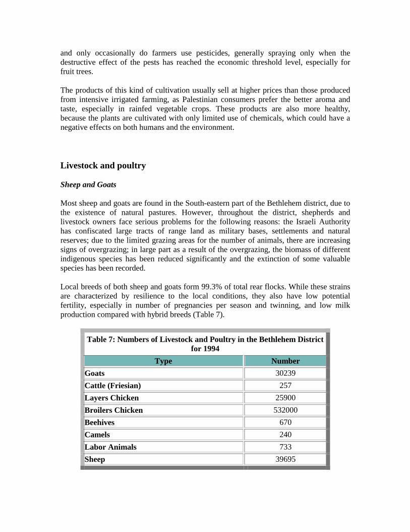
Local breeds of both sheep and goats form 99.3% of total rear flocks. While these strains are characterized by resilience to the local conditions, they also have low potential fertility, especially in number of pregnancies per season and twinning, and low milk production compared with hybrid breeds (Table 7).
Table 7: Numbers of Livestock and Poultry in the Bethlehem District for 1994
Type Number Goats 30239 Cattle (Friesian) 257 Layers Chicken 25900 Broilers Chicken 532000 Beehives 670 Camels 240 Labor Animals 733 Sheep 39695
Cows
Only limited numbers of dairy cattle of the Friesian breed are raised in. The average daily milk production per cow is as high as 22.3 kg.
Poultry
For poultry production in the district, there are about 133 farms of broilers and 28 farms of layers. The number of layer farms in 1994 was down by half from the 1993 season, due to an eggs marketing crises that occurred last year.
Apiculture
The number of commercial Beehives in Bethlehem has increased in the last few years. In 1994, there were 515 hives, with an average production of 9 Kg of honey per hive.
As many Palestinians have returned to agriculture as part of the Intifada (uprising) of the late 1980s and 1990s, labor animals such as donkeys, mules and horses have become more prominent, helping in ploughing and cultivation.
Produce Markets
Farmers in Bethlehem sell most of their products in markets within the district, though a small part of vegetable production is sold in Jerusalem by the rural women.
General Recommendations Regarding the Needs and Prospects for Improving Agricultural Sector in Bethlehem:
• = Protect the natural pasture through developing managed grazing programs in cooperation with shepherds and by increasing the biomass of wild forage plants.
• = Study the possibilities for introducing breeds of goat with higher reproductivity and milk production, such as the Shami goats.

• = Encourage farmers to use well adapted, higher yielding varieties of field crops and fruit trees, and also to incorporate improved cropping practices such as crop rotation.
• = Investigate the best methods to improve irrigated agriculture in terms of water use efficiency, environmental sustainability, productivity and marketing.
• = Develop integrated pest management programs with farmers to help them manage agricultural pests without harming the environment, human health, or the market potentials of crops.
• = Improve the currently almost non-existent agricultural research and extension programs in the district.
Chapter Five Water Resources
Most Middle East countries, including Palestine, generally suffer from the scarcity of water resources. This is not only true due to the arid and semi-arid climatic conditions and rainfall variability in the area, but, in the case of Palestine, to the Israeli strict control over the Palestinian water resources, reduces to the water resources under hand. As an indication of its importance, water rights and distribution are one of the major issues on the agenda of the current peace negotiations between the Palestinians and the Israelis.
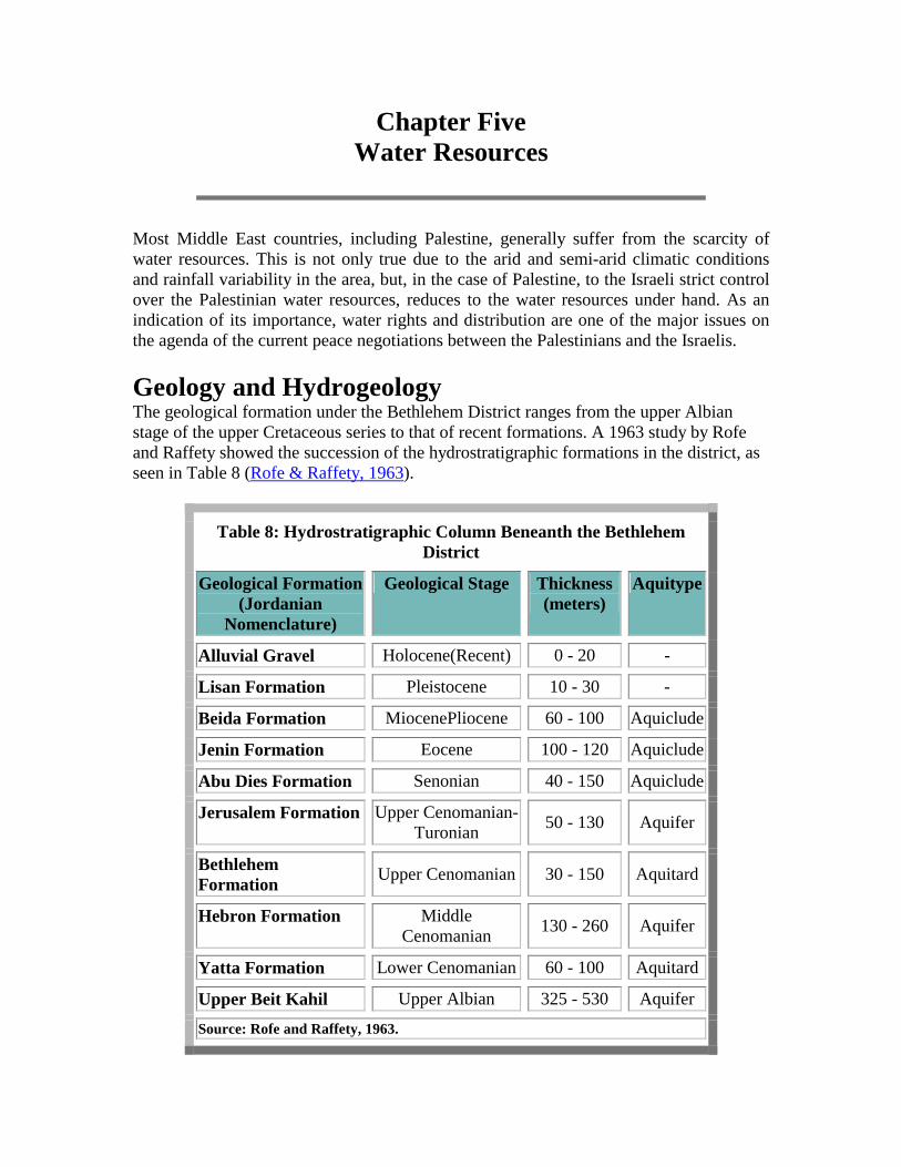
Geology and Hydrogeology The geological formation under the Bethlehem District ranges from the upper Albian stage of the upper Cretaceous series to that of recent formations. A 1963 study by Rofe and Raffety showed the succession of the hydrostratigraphic formations in the district, as seen in Table 8 (Rofe & Raffety, 1963).
Table 8: Hydrostratigraphic Column Beneanth the Bethlehem District
Geological Formation (Jordanian
Nomenclature)
Geological Stage Thickness (meters)
Aquitype
Alluvial Gravel Holocene(Recent) 0 - 20 -
Lisan Formation Pleistocene 10 - 30 -
Beida Formation MiocenePliocene 60 - 100 Aquiclude
Jenin Formation Eocene 100 - 120 Aquiclude
Abu Dies Formation Senonian 40 - 150 Aquiclude
Jerusalem Formation Upper Cenomanian-Turonian 50 - 130 Aquifer
Bethlehem Formation Upper Cenomanian 30 - 150 Aquitard
Hebron Formation Middle Cenomanian 130 - 260 Aquifer
Yatta Formation Lower Cenomanian 60 - 100 Aquitard
Upper Beit Kahil Upper Albian 325 - 530 Aquifer
Source: Rofe and Raffety, 1963.

The lithologic composition of the geological formations in the district (Figure 11) consists of mainly limestone, dolomite, dolomitic limestone, marl, chalky marl, chert, and chalky limestone. The effect and existence of fissures, fractures, joints, and karstification, in addition to the rock permeability and porosity determines the hydrogeology of the area. These features give the aquiferous properties for different geological formations. Therefore, the hydrostratigraphic column shows aquifers, aquitards and aquicludes in the area (Table 8).
Figure 11
The detailed geology of the area, as represented in figure 11, show the following formations arranged from older to younger:
1. Limestone and Marl formations of the Cenomanian to Turonian ages. 2. Chalk and Chert formations of the Senonian age. 3. Metamorphic rocks and calcium silicate rocks of the Miocene age. 4. Lisan and Samara chalk, marl and conglomerates of the Pleistocene to recent
ages.
The area is also covered by a system of faults which is responsible for emergence of springs in the area.

The location map in figure 12 shows the boundaries of the groundwater basin in the Bethlehem District in relation to the West Bank basins. It can be seen that most of the Bethlehem District lies above the Jerusalem Desert basin. This basin lies to the east of the main underground watershed and therefore drains eastwards to the Dead Sea. A small area in the northwestern extremity of the district partly overlies the Auja-Tamaseeh groundwater basin. In this basin, the groundwater flow is westwards as the strata in this area slopes to the west.
The Jerusalem Desert basin, which is a part of the mountain aquifer, may be sub-divided vertically into two systems, the upper and lower Cenomanian. Both systems are separated by aquicludes which are relatively impervious, however leakage does occur. For example, the uppermost beds of the Yatta Formation include clays which, when saturated, are impervious and therefore act as an aquiclude dividing the two systems.
• = The Lower Cenomanian Middle Cenomanian Aquifer System: This aquifer consists of the two overlying Beit Kahil and Yatta geologic formations. This aquifer is 385-630 meters in thickness and is composed mainly of limestone, dolomite, chalky limestone, marl, and massive dolomite. Yatta formation constitutes the upper boundary of the aquifer. It is the clay bed of the Yatta formation which acts as the aquiclude.
• = The Upper CenomanianTuronian Aquifer System: This part of the Cenomanian-Turonian aquifer system underlies the Bethlehem District and constitutes the recharge area for the Jerusalem Hills basin. It is located at a depth of approximately 300-500 meters below surface and its water emerges from springs close to the fault line west of the Dead Sea. The lithology of the Cenomanian part of the system is mainly micritic dolomite which permits only slow rate of flow. Further east, the groundwater flows into the Turonian, a highly fossiliferous lithology of transmissibility. Solution resulting from the weathering process has developed some karstic underground features which greatly increase the rate of water flow, particularly in eastern parts of the system.

Figure 12 - Groundwater Basins and the Exposed Aquifers in the West Bank
Groundwater Resources
Groundwater Wells
The groundwater wells in the Bethlehem District are primarily used to supply domestic water for the inhabitants of the area. These wells pump from underground aquifers that originate from CenomanianTuronian Aquifer System.
Presently, six domestic groundwater wells are functioning in the Bethlehem District. These can be subdivided according to control and management into two main categories:
• = Controlled and managed by the Bethlehem - Beit Jala - Beit Sahour Water Supply and Sewerage Authority. This category includes only the Beit Fajjar Well Number 1.
• = Controlled and managed by Mekorot and the Israeli Civil Administration West Bank Water Department (WBWD). This category includes five wells of the Batn

Al-Ghul, located in the Herodion area. Table 9 provides detailed information about these wells.
Table 9: Groundwater Wells for Domestic Use in the Bethlehem District
Well Name CWD DW DC PR AP
Beit Fajjar 1 307 160 1988 250 1284
Batn el Ghul 1 350 250 1971 120 379
Batn el Ghul 2 600 350 1971 400 2797
Batn el Ghul 3 800 350 1983 450 3230
Batn el Ghul 4 650 350 1986 250 847
Batn el Ghul 5 350 250 1993 250 n/a
Source: Interviews with Mekorot well operators, 1995 Table Key Notes: CWD= Construction well depth (m); DW= Depth to water (m); DC= Date of construction; AP= 1992 Pumpage in (1000 CM); PR= Pumping rate (CM/hr); n/a= Not Available data
The above wells were constructed post 1967 in order to fulfill the Bethlehem District domestic water needs. From 1967 until 1982, the WBWD was responsible for both the technical and administrative tasks of Batn el Ghul wells. In 1982, Mekorot became responsible for the technical aspects and the WBWD role was limited to the administrative tasks. As there are many Palestinians who work with the WBWD, this change in roles was in part to prevent the sharing of technical information with Palestinians, especially related to the well structure. Information such as penetration depth and pumpage from the two aquifers has been classified as security related information that must not be shared with Palestinians.
Although Batn el Ghul wells 4 and 5 are included in this Profile within the Bethlehem District boundaries, in reality, they are located within the Hebron District (Figure 13). As all five wells belong to the same aquifer system, these two wells were included with the remaining wells.

Figure 13: Bethlehem District Water Resorce
Springs
There are 15 major springs in the Bethlehem District (Figure 13) which have a discharge rate exceeding 0.1 l/sec (Records of the WBWD). The estimated total annual discharge of these springs collectively ranges from 1.6 MCM in 1988 to 2.4 MCM in 1992 (Records of the WBWD). The discharge of these springs is directly related to the annual rainfall in the area (Figure 14). With the lack of adequate spring management, the Palestinian utilization from these springs is only 0.5 MCM /Yr, and is primarily used for small scale irrigation and domestic purposes. The unused quantities are considered as recharge sources for the groundwater aquifers.

Figure 14: The Relationship Between Annual Rainfall and the Total Springs' Discharge in the Bethlehem District
The major springs in the Bethlehem District can be divided into three systems:
1. Battir Spring system: This system consists of four springs with a total annual discharge of close to 164,000 CM. The Al-Balad spring discharges 108,000 CM; Al Jame' spring discharges 47,000 CM; Abu Yassen spring discharges 8,000 CM; and Darweesh spring discharges just over 630 CM annually. Spring water is used for both domestic and irrigation purposes. This system also plays an important role in recharging the Auja-Temsah groundwater basin whose groundwater flows in a westerly direction, whereas the majority of the remaining spring systems recharge the Eastern Upper Cenomanian Aquifer System.
2. Artas spring system: This system consists of one spring with an annual discharge of approximately 319,000 CM (Hosh, 1994). This spring represents the backbone of Artas village as it constitutes the only source of domestic and irrigation purposes (Photo 4).

Photo 4: Spring Water Use for Domestic Purposes, Artas Spring
3. Ein Fashkha spring system: This system is located in the eastern proximity of the Bethlehem District, adjacent to the Dead Sea shore. Its water originates from the same groundwater basin underlying the Bethlehem District.
The Fashkha system includes the four springs of Zukim, Kaneh, Samar, and Fashkha. They are located on the northwestern shores of the Dead Sea and within an area designated as an Israeli Nature Reserve. The areas surrounding these springs are declared natural reserves.
The recharge of these springs occurs through the exposed Cenomanian-Turonian geological strata in the Bethlehem District, down the very deep Lower Cenomanian Aquifer System. The water of these springs are saline, with a chloride concentration exceeding 2000 parts per million (Records of WBDB). The cause of high salinity is not clear. It may be due to the mixing of water with another source of saline groundwater or the inflow of groundwater from the deep Kurnub sandstone Aquifer, which has fossil water. It may also be the result of mixing with the Dead Sea water due to the Jordan Valley rift structure in the Dead Sea area.
The potential yield of these springs ranges from 45 to 80 MCM/Year (Assaf et al., 1993). Given this large discharge of water, it is unlikely that all water originates from upstream water recharge. This may justify the theory that part of the spring water originates from a saline groundwater source. Efforts to divert the upstream groundwater flow at a location prior to mixing with the saline water were made by the Hashemite Kingdom of Jordan

during its administration of the West Bank, prior to 1967. Deep wells were drilled in the Falsursa area for this purpose but without fruitful results. The Israeli Authorities, later, succeeded in extracting fresh water from the upstream areas of this Lower Cenomanian Aquifer System. The Israeli Military Authority drilled very deep wells at Herodion and at other sites, tapping the Lower Cenomanian Aquifer to extract water upstream and to ensure water supply for the Israeli settlements of Efrat, Kfar Etzion, and Teqo'a in addition to Jerusalem. This may also be true in the case of Batn el Ghul wells No. 3 and 4, constructed in 1983 and 1986 which also penetrate the Lower Cenomanian Aquifer System. These wells provide water supply for both the Bethlehem District and the Israeli settlements. In addition to such measures to benefit from the Fashkha water, small scale desalinating systems may be utilized to recover some of the salty water.
Groundwater Quality
Water samples from five groundwater wells in the district were analyzed for routine chemical constituents to evaluate water quality (Table 10,11). The water hardness of the groundwater was computed according to the following equation (Todd, 1980):
Hardness = 2.5 Ca++(ppm) + Mg++(ppm)
Table 10: Physical Properties of Groundwater in the Bethlehem District
Well ID Location Temperature
°C Conductivity µ
s/cm pH
W7001 Beit Fajjar 14.5 560 7.3
W7002 Batn Al-Ghoul 1 13.5 338 7.3
W7003 Batn Al-Ghoul 2 13.2 363 6.9
W7004 Batn Al-Ghoul 3 13.5 373 7.2
W7005 Batn Al-Ghoul 4&5
12.6 369 7.0

Table 11: Chemical Properties of the Groundwater in the Bethlehem District
Well ID
Ca ppm
Mg ppm
Na ppm
K ppm
HCO3 ppm
NO3 ppm
F- ppm
TDS ppm
Hardness ppm
W7001 34.0 40.0 45.0 1.0 228.0 2.78 0.013 248 334
W7002 25.0 32.0 1.0 1.0 390.0 3.18 0.013 244 256
W7003 47.0 44.0 1.0 1.0 330.0 1.43 0.021 320 248
W7004 55.0 48.0 1.0 1.0 280.0 1.08 0.018 304 334
W7005 50.0 42.0 45.0 -- 248.0 3.13 0.010 304 297
Water from the Batn Al-Ghoul 1,2, 3, and 4 is hard, while water of Beit Fajjar well and Batn Al-Ghoul 3 is very hard. In comparison to international standards, the groundwater in the Bethlehem District can be described as:
• = Electric conductivity (EC) ranges from 260-373 s/cm which is below the maximum admissible concentration of 500 s/cm (EEC, 1975).
• = Total dissolved solids (TDS) ranges from 224-320 ppm which is below the maximum admissible standard range of 1500 ppm (EEC, 1975).
• = All other concentrations are below the maximum admissible standards and the water is suitable for drinking and irrigation purposes.
Water Reservoir: Solomon's Pools
Solomon's Pools are three large water cisterns located near the village of Artas, four kilometers south of the Bethlehem City (Photo 5). Since their construction, more than 2000 years ago, and until 1967, they served as a main source of drinking water for Jerusalem. Solomon's Pools also were a primary water reservoir that supplied Bethlehem City and the surrounding villages with water for both domestic and irrigation needs.

Photo 5 - Solomon's Pools
The three pools have a total capacity of approximately 0.34 million cubic meters, which may easily provide additional supplies of water for the Bethlehem District. The neglect of the three Pools, especially after the Israeli occupation, has lead to serious structural damages both of the Pools themselves and their water piping system (Refer to Chapter Nine).
Water Consumption and Demand
The current peace negotiations between the Palestinians and the Israelis may lead to rapid economic development in the area and change in its demography. Such outcome will certainly affect the rate of water consumption and increase water demand in Palestine. Table 12 shows the anticipated water consumption and demand in the Bethlehem District in the context of a peace settlement.
Table 12: Middle Scenario for Water Consumption and Demand in the Bethlehem District
Category Water Consumption 1990
Water Demand 2000
Water Demand 2010
Household 8.6 CM/year1 116.3 CM/Year 30.4 CM/Year

Agriculture 0.6 MCM2 2 MCM 9 MCM
Industry 0.7 MCM2 1.7 MCM 3.6 MCM
Total 9.9 20 43
Population 127,1003 219,3005 300,5005
Irrigated area
97 hectares4 310 hectares4 1,380 hectares4
1= Nuseibeh, 1994; 2= ARIJ, 1993; 3= Abdeen & Abu Libdeh, 1993; 4= Rural ResearchCenter, 1990; 5= PCBS, 1994

Chapter Six Wastewater
Wastewater is the effluent water that has been used in various daily activities. It can be divided into domestic and industrial wastewater. The quality and quantity of the wastewater produced by a community depends upon the source of the wastewater supply, the population density, the industrial practices, and the habits of the local population. Wastewater is hazardous if disposed without treatment as it carries disease-causing pathogens, and potential toxic elements. Unmanaged disposal of wastewater may lead to the contamination of the groundwater aquifers. Controlled disposal of domestic and industrial wastewater is thus important to ensure a safe environment. Furthermore, given the water shortage in Palestine, much attention have been given to the potential value of re-using treated wastewater for irrigation purposes.
Domestic Wastewater Domestic wastewater contains mainly human body wastes and sullage. It contains several forms of complex minerals, organic matter, and macro- and micro-organisms. Regulating the quantity and quality of the raw wastewater disposed into the environment is thus very important, especially with the anticipated development of the district in the near future.
The quantity of domestic wastewater produced in the Bethlehem District was calculated based on the average water consumption per capita multiplied by the population. The total annual domestic water consumption of the 132,466 inhabitants in the area is close to 3.4 MCM, of which most ends up as wastewater. As for quality, due to the lack of funds, little work has been done to analyze the raw wastewater in the West Bank. In a recent study done for the Palestinian Economic Council for Development and Reconstruction (PECDAR) in August 1994, wastewater samples were taken from different locations in the West Bank and Gaza Strip, including the Bethlehem District These samples were analyzed at the Islamic University in the Gaza City. The results of this study revealed the characteristics of raw domestic wastewater in Bethlehem District (Table 13).
Table 13: Characteristics of Raw Wastewater in the Bethlehem District
Parameter pH TSS(mg/l) BOD(mg/l) COD(mg/l) P(mg/l) PO4(mg/l) NO3(mg/l) Na(mg/l)
Value 6.5 688 660 2724 141.4 45.6 249.9 411
Industrial Wastewater:
Several sorts of industrial wastewater is generated in the Bethlehem District. The district houses a mixture of small, medium and large scale industries which are located often in residential areas. These industries include stone cutting facilities, and textile, detergent, paint, tobacco, food, and beverage factories. The wastewater generated from these industries often contains heavy metals and organic compounds that pose a threat to the surrounding environment.
The estimated 250 stone cutting facilities in the Bethlehem District utilize large quantities of water for cooling off the cutting saws. Water consumption by these facilities varies widely with the size of the facility and its production potential. Some quarries use as much as 4,000 CM of water annually. While several quarries re-use up to 70 percent of their generated wastewater, most of them dispose of it in wadis and open areas. The generated wastewater is mainly composed of mud and water and can severely contaminate groundwater with the dissolution of the calcium and magnesium carbonate it contains. In addition, this wastewater adversely affects the growth of natural habitats, the quality of soil, and the extension of land cover.
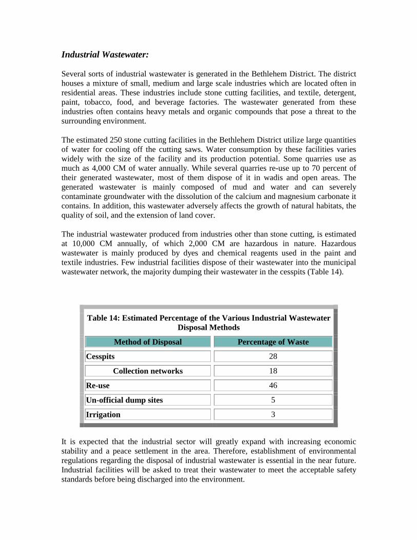
The industrial wastewater produced from industries other than stone cutting, is estimated at 10,000 CM annually, of which 2,000 CM are hazardous in nature. Hazardous wastewater is mainly produced by dyes and chemical reagents used in the paint and textile industries. Few industrial facilities dispose of their wastewater into the municipal wastewater network, the majority dumping their wastewater in the cesspits (Table 14).
Table 14: Estimated Percentage of the Various Industrial Wastewater Disposal Methods
Method of Disposal Percentage of Waste
Cesspits 28
Collection networks 18
Re-use 46
Un-official dump sites 5
Irrigation 3
It is expected that the industrial sector will greatly expand with increasing economic stability and a peace settlement in the area. Therefore, establishment of environmental regulations regarding the disposal of industrial wastewater is essential in the near future. Industrial facilities will be asked to treat their wastewater to meet the acceptable safety standards before being discharged into the environment.

Wastewater Disposal Wastewater in the Bethlehem District is mostly disposed in cesspits, septic tanks, or open channels. This is particularly the case as major portion of the district lacks sewerage systems. Recently, a new sewerage system has been constructed in the municipal areas of Bethlehem, Beit Jala and Beit Sahour.
Wastewater removed from filled cesspits and septic tanks is currently disposed of into either the newly developed sewerage system or into open channels or valleys such as Wadi Al-Nar and Wadi Al-Makhroor in Beit Sahour and Beit Jala areas respectively. In selecting disposal areas, no consideration is currently paid to the nature of the soil, the presence of groundwater, or to human concentration.
The following few pages describes the most common wastewater disposal systems in the district.
• = Cesspits & Septic Tanks Cesspits and septic tanks are common alternatives for wastewater disposal in the absence of a wastewater collection network. These are often designed to serve a single or multiple apartments building. The size of the cesspits or tanks is usually dependent on the availability of land and on the construction costs. These containers, on average, have a holding capacity ranging from 5 to 50 CM.
During their construction, most cesspits are purposely left without a cement basement of liner so as sewage will infiltrate into the earth layers. By doing so, owners will reduce the costs of emptying the cesspits once filled. Although, dirt and soil layers are known for their good filtration action, sewage may rapidly reach the underground water aquifer through the many cracks existing in the ground layers. This untreated sewage contaminates the same water which is the primary source of drinking water for the district. It is essential to impose building regulations for these cesspits to prevent future contamination of the aquifers.
Calculating the holding capacity and the expected amount of sewage produced by each household is important when designing these cesspits. This will avoid having to make frequent use of the expensive services of the vacuum tankers to empty the cesspits.
• = Open Sewerage Channels Open sewerage channels are more common in areas not served by a sewerage network, such as the refugee camps. The dwellings in El-Daheisha refugee camp, until recently, have been connected to open channels for wastewater disposal. In the major parts of the three refugee camps in the Bethlehem district, however, a new internal sewerage network was installed with a project funded by the German Government. In the open channels, domestic wastewater and storm water flow outside the camp boundaries without any treatment into unattended lands. Overflow of wastewater outside the channels is common especially during the winter season.

• = Collection Network Until recently, the only sewerage collection network that existed in the region covered less than 20% of Bethlehem City and 60% of the residents in El-Daheisha refugee camp.
Currently, a project to construct a new wastewater collection network has been implemented for the Bethlehem, Beit Jala, and Beit Sahour municipal areas, including the three refugee camps of El-Daheisha, Beit Jebren, and 'Aida. This US$ 5.66 million project was primarily financed by the Italian and German Governments as part of their aid program to the Palestinian people. The sewerage project is composed of two phases: Phase I, nearly accomplished, will connect residents of approximately 70% of the inhabitants of the area. Phase II, will expand the sewerage network to collect the sewage of up to 90% of the population, which is approximately 50% of the total population in the Bethlehem District.
The new sewerage project is designed to collect domestic wastewater through two pipeline systems :
• = The first pipeline will carry 67% of the total wastewater flow to an area west of Bethlehem city near Wadi Ahmed and Ein Karem, to join the West Jerusalem collection network. The generated wastewater will then be treated by the Jerusalem Municipality and reused by the Israelis. Bethlehem Municipality will pay for the wastewater treatment but will not benefit from it.
• = The second pipeline will carry the remaining sewage to an area east of Bethlehem. A pumping station will be installed there to lift the wastewater toward Wadi An-Nar (Qidron Valley) where the sewage will join the future East Jerusalem collection system.
The Water Supply and Wastewater Authority (WSSA) of Bethlehem, Beit Jala and Beit Sahour is the responsible body for the management and maintenance of the wastewater collection system. Officials in WSSA estimate that every beneficiary from this project will have to pay 1.0 NIS per CM of water consumed. This fund will support the future running costs and maintenance of the network.

Wastewater Treatment The principal objective of wastewater treatment is to dispose of municipal and industrial effluents without endangering the public health or the environment. In addition, wastewater has a high potential for use for irrigation purposes, especially in a semi-arid area such as the Bethlehem District, which suffers from severe water shortages. Even though, a large amount of sewage will be collected by the new sewerage project, there are no wastewater treatment facilities in the district. The collected wastewater will be carried to Israel for treatment and re-use.
The new sewerage project will collect a total annual volume of approximately 1.73 MCM of wastewater. This figure is based on an estimated annual consumption of 24 CM per capita and a population of 72,000 which will be connected to the wastewater collection system (Issac et al., 1994; Meierjohann, 1995). According to experimental projects in other countries, it is estimated that between 65-80% of the wastewater supply can be recycled and reused (Shuval, 1994). Accordingly, it may be concluded that a total amount of 1.124 to 1.384 MCM of water can be extracted if treatment plants were constructed in the area.
The reuse of treated wastewater would be of particular benefit to the agricultural sector. Since the annual water requirement per hectare of orchard trees or fodder crops is estimated at 12,000 CM and 3,500 CM respectively, reuse of treated wastewater could irrigate nearly 93 hectares of orchard trees and 320 hectares of fodder crops annually.
In several stone quarry factories in the district, wastewater is treated and reused on site. Treatment of wastewater at these facilities is performed by a simple collection of the generated wastewater in a conical tank and the separation of settling particles by adding coagulants. The generated treated water is then collected from the top of the tank and kept in an adjacent tank for reuse. It is estimated that close to 70% of the wastewater in these facilities could be recovered and reused on site.
Environmental-Related Problems Four major environmental-related problems were revealed during the field survey of the district.
• = Frequent flooding of wastewater cesspits and open channels especially during the winter season is a major environmental and health problem, potentially leading to infectious disease outbreak and transmission, in addition to fowl odor and mosquitoes.
• = Contamination of groundwater aquifers and springs as a result of wastewater percolation from cesspits. This is already a serious problem for the villages of Wadi Fukin and Battir, where villagers use spring water for irrigation purposes,

and for the village of Artas, where villagers are dependent on spring water for both domestic and irrigation purposes.
• = Irrigation with raw wastewater is another problem found primarily in Wadi An-Nar area (Photo 6). This problem, is compounded when the irrigated crops include tomato, cauliflower, squash, eggplants, and other field crops, as there is direct contact of their fruits with the wastewater, and because some of these fruits are often eaten fresh.
Photo 6 - Cultivated Areas Irrigated with Raw Wastewater, Wadi An-Nar Area
• = Almost all of the car oil-changing facilities in the Bethlehem District, as well as the rest in the of the West Bank, dispose of their oil in the open fields. The disposed oil imposes a serious threat to the quality of the underground water and the fertility of the land. Car oils can be and are recycled in many countries around the world.
The provision of an adequate wastewater collection and disposal system requires immediate attention from the authorities and official institutions. Public awareness, especially among farmers and consumers, must be heightened. The potential danger of improper sewage disposal to human health and welfare should be stressed. Authorities must enforce regulations that require proper wastewater disposal by individuals, and industrial facilities to prevent pollution.

Chapter Seven Solid Waste
The system of solid waste disposal in the Bethlehem District is similar to that of other districts in Palestine. A comprehensive master plan for the whole region is essential to allow appropriate and effective management of solid waste. Solid waste collection in the Palestinian communities, where present, is the responsibility of either the municipalities, town or village councils, or UNRWA in the refugee camps. Today, there are three sites for solid waste disposal: waste collected by municipal and village councils is disposed of at the El-Eizariya (Bethany) waste dump; waste collected by municipal and village councils is disposed of at open dump sites where waste is often burnt at random; and individuals dispose waste in nearby open spaces and road sides. This latter method is very common.
Domestic Waste The quantity of the domestic solid waste generated in the Bethlehem District is estimated at 140 tons/day, excluding the refugee camps. Collection of domestic waste in the district has been the responsibility of the municipalities, towns and village councils and UNRWA in the refugee camps. The information gathered from municipality and UNRWA officials shows the following results: 43% of the generated waste is collected by the three municipalities in the district; 11% by UNRWA, 11% by local village committees and agricultural associations; and 35% of the generated waste is left uncollected (Tables 15,16), and is often dumped in vacant land and on road sides (Photo 7).
Table 15: Domestic Waste Disposal Sites
Type of Dump Percent
Public dumps 54
Local dumps 11
Vacant land and Road sides 35

Table 16: Solid Waste Management in the Bethlehem District Locality Population
(estimated) Quantity Ton/day
No. of vehicles
Labor Recom-mended no. of labors
Annual fee NIS Disposal
site
'Aida R.C 3,500 3.6 1 4 9 no fee Beit Ommar
Artas 2,400 2.3 0 0 6 0 random Battir 3,000 2.7 1 1 8 R:120 Local Beit Sahour
11,500 16.5 4 16 29 R:48 C:96-288
Al-Eizarieh
Beit Fajjar 6,000 6.2 1r 2 15 R:12 Wadi Al-Hatab
Beit Jala 12,500 18 5 14 31 R:48 C:48-144
1:288
Al-Eizerieh
Beit Jebren R.C
2,000 1.8 1 2 5 no fee Beit Ommar
Bethlehem 33,000 50 4 64 83 R:48 C:64-72 I:128-136
Al-Eizerieh
Dar Salah 2,500 2.2 0 0 6 0 random El-Ubeidiyya
4,000 5.3 5 5 10 R:120 local
El-Daheisha R.C
8,500 8.0 1 13 21 no fee Beit Ommar
El-Khader 4,500 4.9 0 0 11 0 random Husan 2,700 2.9 0 0 7 0 random Marah Rabah
500 0.5 0 0 1 0 random
Nahaleen 3,000 3.0 0 0 8 0 random Taqoua' 4,000 4.45 0 0 10 0 random Umm Salamoneh
400 0.25 0 0 1 0 random
Wadi Fukin
1,000 0.9 0 0 2 0 local
Za'tara 3,400 3.1 0 0 9 0 random Notes: R: Residential;C: Commercial;I: Industrial;R.C.: Refugee Camp

Photo 7 - Solid Waste Dumped on the Road Side at the Entrance of Al-Makhrour
According to UNRWA officials, El-Daheisha refuge camp generates approximately 2,800 tons/year, 'Aida 1,000 tons/year and Beit-Jebren 650 tons/year of domestic waste, making a total of 4,450 tons/year. Most of the collected waste is being transferred and dumped at the El-Eizariya dump site, about 38km from Bethlehem city center.
The collection containers and vehicles that are currently used throughout the municipalities, towns and camps vary in number and size. There are approximately 520 containers of which about 65% are 5.0-6.0 CM in volume and 30% are 0.5-1.0 CM in volume. There are also 17 carts, 6 tractors and 10 trucks throughout the district which are also used for collection. A large number of this equipment was damaged during the seven years of the Intifada" (Palestinian uprising). Currently, the municipalities are trying to raise funds for new containers.
Industrial Waste Approximately 70% of all industrial facilities in the district are found near mostly residential areas, while the remaining are found in mostly industrial areas (20%) and mostly commercial areas (10%). These industries are mostly dependent on raw materials imported primarily from Israel, except for stones quarries where stone is available locally. There are a large number of stone cutting facilities in Bethlehem, about 250 of them concentrated in areas such as Beit Fajjar, El-Daheisha R.C (Photo 8) and El-Khader. Thirty of these facilities are described as 'large', 120 as 'medium' and 100 as 'small'. The 30 large facilities generate about 3,600 tons/year of solid waste, whereas the medium ones generate 2,500 and the small ones generate 1,600 tons/year respectively for a total of 600,000 tons/year. This waste or sludge is disposed of at road sides or on vacant parcels adjacent to the facilities. Some waste is being dumped on private land near El-Daheisha refugee camp in return for agreed upon fees per ton of waste (Table 17).

Photo 8 - Stone Cutting Facilities near El-Daheisha Refugee Camp
Table 17: Distribution of Different Methods of Industrial Waste Disposal
Method of Disposal % Municipal waste containers 38 Road-sides dumping 16 On-site burning 11 Reuse 11 All of the above methods 19
Handicraft industries are also common in this district with a particular concentration in Bethlehem, Beit Jala and Beit Sahour. There are close to 30 Mother of Pearl workshops which, though of small scale, generate considerable quantities of dust and particulate that can pose threat to human health and land cover. This is particularly true as most, if not all, of these workshops are found in homes.
The survey of approximately 40% of all industries in the Bethlehem District, other that quarries and stone cutting facilities, revealed that most waste is generated at the production or packaging stages. It is estimated that the food, beverage and cigarette industries contribute to approximately 70% of the total of these kinds of industrial wastes in the district, generating 3,200 tons/year. Construction industry generates 1,150 tons/year while textile industry generates 200 tons/year. The metal industry constitutes

only 1% of the waste, generating 60 tons/year (Table 18). It is found that packaging material, whether of raw or produced materials, constitutes a considerable amount of the total generated waste. The packaging material includes paper, carton, metal, plastic, wood, and Jute.
Table 18 - Industrial Waste Production in the Bethlehem District Industrial Branch No. of
Facilities Surveyed
Solid WasteProduced
(tons/year)
Liquid Waste Produced (CM/year)
Food,Beverage, Cigareetes
5 246 2,900.0
Textile 5 187 600.0 Plastic and Rubber
2 23 --
Chemicals 4 NA 6.00 Metal 2 62 -- Construction Materials
2 1151 180.0
Elecric Industries 2 1.8 96.0 Paint 3 4 201.0 Furniture 2 19 --
Table Key Notes N: Negligible; N/A: Not Available data.
substantial portion of the industrial solid wastes are dumped on road sides or in open fields (Photo 9). several industries, however, utilize the municipa waste collecting services in disposing their generated wastes. recycling facilities are non-existent in the district.
Photo 9 - Industrial waste, Beit- Jala Industrial Park
Hazardous Medical Waste The generated waste from medical institutions in the Bethlehem District is a considerable threat to the population in the area. In the district, there are seven hospitals, one of which has been recently closed, and 32 community health centers and clinics (PCBS), 1994) providing medical attention and services to not only to residents of the Bethlehem District but also to residents of neighboring districts such as Hebron and Jericho. Located throughout the district, medical institutions generate the following kinds of waste: syringes, needles, tips, lancets, towels, media used for bacteria culture, plates, tubes,

urine and stool cups, swabs, cuvets, slides, and sticks. In addition, waste is also generated from medical operations. This medical waste in major towns and municipalities is either disposed of in municipal waste collection containers, on-site burning facilities, or in the wastewater collection networks. Only two of the surveyed medical institutions use on-site burning facilities to dispose of their wastes. However, even such method lacks adequate pollution emission controls which will reduce the emitted fumes and smoke. Autoclaves, a device used for sterilizing media petri dishes under high temperatures, are found in almost all medical institutions in the district, but they need to be expanded for the pre-disposal treatment of wastes.

Chapter Eight Air Quality And Noise Pollution
Air Quality Most areas in the Bethlehem District enjoy good air quality throughout the year. However, the few areas where high population, central businesses, and industrial concentrations exist suffer from air pollution. This is obvious in urban areas such as the Bethlehem central business district (CBD) and the industrial park near El-Daheisha refugee camp.
The main sources of air pollution are industries, particularly quarrying and stone cutting facilities. Most industries in the district lack the necessary air filtration systems to collect dust and particulate matter, and filter poisonous gases before they are release into the atmosphere. Adjacent to El-Daheisha refugee camp, for example, there are several stone cutting facilities which release large quantities of particulate matter into the atmosphere. Another important air polluting factor is the road blocks set up by the Israeli army on the road to Jerusalem as well as in other sites. Palestinian cars at the road blocks are often required to wait idle in long queues and in some cases for long periods of time. Domestic and commercial boilers and furnaces, dry cleaning operations, and auto painting establishments are also a major source of air pollutants.
The Bethlehem District also houses over 9% of the Palestinian population and 11% of the total number of vehicles in the West Bank. It has a total of 455km of paved roads, of which 175km are main roads and 280km are secondary. Also, the district has a low ratio of persons per vehicle (8 persons/vehicle) compared to the average of 10.4 in the West Bank. The number of gas-emitting vehicles in the Bethlehem District is 15,207, including cars, buses, trucks and motorcycles (Table 19). Emissions include various types of pollutants such as carbon monoxide (CO), sulfur oxides (SOX), nitrogen oxides (NOx) and particulate matter. Rough calculations show that the annual emission of air pollutants due to gasoline combustion is close to 0.50 tons per vehicle. Furthermore, an estimated 7,500 tons of CO, 80 tons of SOx, 480 tons of NOx, 990 tons of Hydrocarbons and 4.2 tons of lead are emitted each year in the district due to local traffic only.
Table 19: Types and numbers of transportation vehicles in the Bethlehem District
Type Private Commercial Bus Taxi Truck Motorcycle Other Total Number 11,886 1,660 128 159 171 131 1,072 15,207 Source: Transportation Officer, West Bank Department for Vehicle Licensing, Beit Eil

Several factors hinder the effort to reduce car emissions of air pollutants. These include an inadequate roadway system which lacks proper traffic control measures (traffic signals and guiding signs), and the absence of regulatory standards to limit vehicle emissions. The lack of raw data on air pollution prevents any productive environmental impact assessment of the current practices and policies regarding air quality. There is an urgent need to measure the major and minor pollutants in the atmosphere. This will assist in the establishment of regulations and standards for air quality.
It is anticipated that the new era of peace in the region will lead to an increase in the number of tourists visiting Palestine in general and Bethlehem in particular. This will result in the operation of a higher number of buses, taxis and rental vehicles in the Bethlehem District, and could consequently contribute to higher emissions of gases into the atmosphere. Thus, new traffic management and control policies are needed to reduce congestion and the emission of poisonous gases. Also, with the recent wave of economic development, many buildings are under construction in the district. Most building materials, namely sand, and both coarse and fine gravel, are left uncovered, and dumped on the roadside. These materials are often left at the construction site for extended periods of time and contribute to the particulate matter carried in the atmosphere. Strict construction codes and regulations should be established which limit the amount of particulate matter. Obtaining a building permit should be made conditional upon the adherence to these regulations. The planting of trees in front of buildings should be encouraged as it will moderate the atmosphere and filter pollutants.
A high level of air pollution has a negative impact on humans and wildlife. Harmful concentration of pollutants, along with high temperature and low wind speed, can impose a serious health hazard. Studies have shown that lead emitted from poor gasoline combustion is a pollutant that has a serious negative impact on human health. The fact that the majority of the vehicles in the Bethlehem District still use leaded gasoline heightens the threat of this pollutant to human health. Only recently has unleaded gasoline been introduced to the local markets, and it is used primarily by the few new vehicles in the district.
People, vegetation and wildlife are all adversely affected by the poor air quality. People with allergies, pulmonary diseases and weak immune systems, as well as children, can be in serious danger should they breathe in polluted air. High lead concentration in the air can also negatively affect the function of body systems such as the blood, nervous, and renal systems (Peavy, 1985). Vegetation growth can be inhibited by the accumulation of dust on their surface. Car emissions may also lead to increased concentrations of poisonous residues in the leaves of vegetable and pasture plants, especially for those planted close to main roads.
Noise Pollution Noise is measured according to different levels of loudness and sound frequencies. The international standard measuring unit of noise is in A-weighted decibel (dBA). Loudness

not only relies on how high the noise is, but also on the length of time and the continuous or intermittent nature of the noise.
In some countries, noise sensitivity is classified according to the types of landuse patterns. A very sensitive area for noise pollution includes sites where schools and colleges, hospitals, convalescent homes, wildlife habitats and nature reserves, churches and mosques are located; sensitive areas include residential neighborhoods, hotels and outpatient clinics; moderately sensitive areas include cemeteries, research institutions, government services, restaurants, general merchandising and recreational parks; and insensitive areas include agricultural lands, industrial zones, water areas, natural open spaces, undeveloped land and auto parking.
No scientific research or data regarding noise pollution are available in the area. Field observations, however, can give an idea about the various sources and levels of noise found in the Bethlehem District.
The Israeli military airplanes are a common source of noise in the district as they fly over the area, breaking the sound barrier and producing sonic booms. Another major source of noise is the roadway traffic. This source has a great impact on human health especially since all roads lack sound-reflecting walls on any of their sides. The Madbaseh area and the Manger Square in Bethlehem city are two examples where frequent traffic jams and continuous noise occur. Industries are another source of noise pollution, especially stone cutting facilities and metal shops, as they produce a continuos noise. Many of these facilities are located near residential areas such as near Daheisha refugee camp and in Beit Fajjar.
The effect of noise pollution on human health is emmense and justifies enforceable regulations. Noise pollution, in the long run, causes health problems and interferes with the work environment, normal speech communication, and sleep.

Chapter Nine Historical And Archeological Sites
Bethlehem has been an important city for the three monotheistic faiths throughout history. Bethlehem, the birthplace of Christ Jesus, is an ancient city that has been populated since 2000 B.C. It has been mentioned in Tal Al-Amarneh registers in the fourteenth century B.C. as Beit Ello which is the Canaanite God of Wheat (Encyclopedia Palestina, 1994). The present name of Bethlehem is believed to be derived from this root.
In the Old Testament, Bethlehem was known as Ephrata. In this city, David, the youngest son of Jesse, was born and later anointed by the Prophet Samuel as the King of Israel. The Moslem Caliph Omar also visited the city in 636 A.D. Bethlehem was also the place where the Crusaders stayed and were Baldwin I, was crowned King of the Latin Kingdom.
The following few pages summarizes the main historical and archeological sites in the Bethlehem District.
The Church of the Nativity The Church of Nativity is located in the center of Bethlehem City (Photo 10). The present church structure is basically the original building from the time of Emperor Constantine in 326 A.D. The church was later restored by Emperor Justinian in 529 A.D., and again enhanced by the Crusaders. The Church of Nativity has the shape of a cross, 170 feet long and 80 feet wide. It contains the three convents of the Armenians (S.E.), the Franciscans (N.E.), and the Greeks (S.E.). A narrow passage remains that leads into the original narthex. There are two side entrances under the main altar that lead to Grotto of the nativity where Jesus was born. The Grotto is rectangular in shaped, 35 feet by 10 feet in size, with two entrances, leading to the Holy Manger. The spot where Christ was born is marked with a silver star with the Latin inscription (Here Jesus Christ Was Born of the Virgin Mary). One of the two entrances to the Grotto has Forty-four columns, eighteen feet high, dividing the Basilica of the Nativity into five aisles. The painting on the columns are from the Justinian period and the mosaic on the upper side walls are from the Crusader period. Under the various wooden trap doors are parts of the original mosaic floor of the first church built by Constantine (Omar & Vasko, Year unknown).

Photo 10: Church of the Nativity
The Milk Grotto Located near the Nativity Church. It is an irregular grotto hollowed out of soft white rock. Tradition says that the Holy Family of Virgin Mary, St. Joseoph and the Baby Jesus rested in this grotto while they were fleeing to Egypt. Tradition says that while the Virgin Mary was nursing her baby in the grotto, few drops of her milk fell on the floor, turning the rocks of the grotto into white (Omar & Vasko, Year unknown).
Tomb of Rachel Rachel died and was buried on the way to Ephrata (Bethlehem). Jacob built a memorial over her grave and this memorial marks Rachel's grave to this day (Omar & Vasko, Year unknown).
Shepherd's Field This site is located in Beit Sahour to the east of Bethlehem, and although not localized by the Gospel, tradition has fixed it in a field about 3 Km from Bethlehem, known today by the name "The Shepherd's Field". The Shepherd's Field Church was rebuilt in 1954 on the ruins of an old monastery of the fourth to sixth century (Omar & Vasko, Year unknown).

Herodium The Herodium is a fortress located in the wilderness of the Jerusalem desert 6 Km south-east of Bethlehem, off the Bethlehem - Za'tara - Hebron road. It has an elevation of 758 meters above sea level. The fortress was named after King Herod who built the fortress on the summit and a settlement at its foot in memory of his victory over Antigonous in 42 B.C. Herodium was occupied during the Byzantine Period. Recent excavations uncovered remains of a fortress: a double circular curtain wall with four towers jutting out of wall and a gateway from the north east. Inside the walls were store rooms and water reservoirs. Remains of the hall with pillars and a bath house were found within the fortress. A mosaic floor from the Byzantine church built here, still exists today. Lower Herodium, at the foot of the mountain to the north, includes the remains of palaces, storerooms, a hippodrome and a pool. Herod died in Jericho but his body was buried here. (Encyclopedia Palestina, 1994).
Monastery of St. Theodosios The renowned monastery of St. Theodosios is located east of the Bethlehem City. It is also known in Arabic as "Der Ibn Obed, which was the name of the great Reverend of this cenobitic monastery. The Monastery belongs to the Greek Orthodox Patriarchate of the of Jerusalem. The monastery is located at a site visible from both Bethlehem and Jerusalem. It was here that St. Theodosios first formed a small brotherhood which spread quickly because of the fame of this great and holy man (Personal Interview with the director of the monastery).
Monastery of St. Saba Located 10 Km to the east of Bethlehem. The present monastery consists of the original carved part in addition to the part constructed later in 482 A.D. where St. Saba has lived till the age of 94. The monastery was destroyed twice in the seventh century and then rebuilt in the eighth century. It has the tomb of St. John and a cave full of the skulls of monks who were killed by the Persian invaders (Al-Dabbagh, 1991).
King David's Wells Located on King David Street in the center of Bethlehem City. The Wells marks the site where David's followers broke through Philistine lines in order to fetch him drinking water from the well of Bethlehem (Omar & Vasko, Year unknown).
St. Elijah Monastery (St. Elias Monastery) Located half the way on the main Jerusalem-Bethlehem road. It was established by Patriarch Anistanius in the year 460 A.D. The monastery by destroyed by an earthquake

in the year 1160 A.D., and then was rebuilt in the same year. Part of the Medieval monastery remains until this day (Al-Dabbagh, 1991).
Church and Convent Of St. George Located in the village of El-Khader, 3 kilometers to the south of Bethlehem. The church was established in 1600 A.D., on the site of the home of the mother of St. George. The present church was built in 1912 along with the convent and a mental hospital. Together with the garden, the whole property takes up an area of 1.5 hectares. The site of the present church occupies the place where St. George's family home was located in 275 A.D. Celebrations for the feast of St. George take place in the church on May fifth of each year (Personal interviews with the director of the Monastery).
Church and Convent of Artas (Irtas) Located in the village of Artas three kilometers to the south west of Bethlehem. It was established in 1901 with the help of an Uruguayan bishop. After having obtained the permission from the Turkish ruler at that time, this Convent was built by two Architects from Bethlehem. Donations are the main source of income for this convent which provides important social services to the surrounding community. Other historical sites found within close proximity of the church are (Al-Dabbagh, 1991):
• = Deir Al-Banat: It means he convent and is located south east of Artas village. It was built during the early Christian period. The present site contains the remains of big buildings, mosaic floor and many carved rocks.
• = Khirbit Al-Khoukh: It is located south east of Deir Al-Banat in an adjacent site. It has the ruins of a Roman town called E'tam in addition to a spring and a water channel.
• = Khirbit Olaya: Located south east of Artas and contains the remains of a Roman town, mosaic floor, water channels, in addition to rock-carved tombs.
• = Wadi Artas: It contains many important historical sites, including the remains of a Crusader church, a Roman Palace and several Roman Mills. Also there are Roman Channels known as Belatius, Sifurius and Herodius channels (Sanad, 1992).
• = Wadi Al-Biyar: Located near El-Khader village and is known to be one of the sources of water for Solomon's Pools.
Solomon's Pools Located four kilometers south-west of Bethlehem near the village of Artas and consists of three large cisterns, commonly called "Solomon's Pools." The Pools are carved in rock, approximately 50 meters apart with at a total length of 0.5 kilometers, extending in an east-west direction. They have a holding capacity of approximately 0.34 million cubic meters. The capacity of the first pool is 57,652 cubic meters, the second 113,000 cubic meters and the third 172,575 cubic meters. It is not clear why they were called

"Solomon's Pools" and who gave them this name. An Arab traveler mentioned them as the Pools of al-Marji' (or Return), which, according to a legend, is the place where brothers of Joseph are thought to have returned after they dropped him in the well. The third pool, however, was built by the Mamluk Sultan al-Zahir Khohaqadam in 1460 (Encyclopedia Palestina, 1994; Sanad, 1992). The Pools collected the runoff water from the adjacent mountains, the al-Arrub wadi and from two adjacent springs. The collected water was a major source for the residents in Bethlehem and Jerusalem during the Ottoman period where water was carried through a system of aqueducts and pipelines of closely-fitted stone. The Pools were renovated in the 1920s by the British Mandate authorities who also installed a pumping station to increase the efficiency of water transportation to the nearby communities. Supplying water to East Jerusalem from the pools ceased after the Israeli occupation of the West Bank in 1967. Today, the Pools are in a dilapidated state and the water is used by the neighboring village of Artas, in spite of being heavily polluted. The surrounding area of the Pools is forested with numerous trees and bushes that are currently in need of care, protection and proper management.
Within close proximity from Solomon's Pools the following sites are found (Al-Dabbagh, 1991).
• = The Fourth Murad Castle: Located at the entrance of Solomon's Pools. It was built in the Turkish period by Sultan Murad to protect the pools against pollution. This Castle contains a mosque as well as soldiers' rooms.
• = Khirbit Al-Bassa: Located south of the Solomons' Pools adjacent o Murad's Castle. It contains the ruins of a Roman town called Bethbeza.
• = Khirbit Al-Beereh: Located south of Solomon's Pools. It contains the remains of historic buildings, mosaic-floor, olive-oil and wine presses, as well as several carved basins and caves.
Wadi Khureitun Located near the village of Teqo'a in the Jerusalem desert. It was named after St. Chariton (St. Khureitun) who lived in the fourth century. Wadi Khureitun is located approximately two Kilometers south-east of Herodium Fortress (Hirschfeld, 1987). Its fame goes back to prehistoric times when early humans occupied the caves. These caves are divided into:
• = E'rq Al-Ahmar Cave: It has been occupied by groups of people around 8000 years B.C.
• = Um Qala' Cave: It is also a representative case of the type of caves that were occupied 8000 years B.C.
• = Um Qatfa Cave: This is an important cave as it bears evidence of early Stone Age occupation (500,000-120,000 B.C.). Evidence that fire was used here during the Ice Age (an anomalous term for this part of the world!) indicates how early in the history of Palestine that humans used fire.

• = St. Chariton Monastery: It was built in the fourth century and remained unoccupied until the twelfth century except for short periods of time .
• = The Hanging Cave of St. Chariton: After the construction of the Monastery, St. Chariton used a hanging cave as his own cell. It was near the large Chariton monastery, at the top of a cliff, accessible only by a ladder, and near a spring (Al-Dabbagh, 1993; Hirschfeld,1987).
Teqoa' A Palestinian village 7 kilometers south of Bethlehem off the Beit Sahour - Halhul road. It was mentioned in Onomasticon Eusebius, Madaba map and Crusader Sources. It was also the place were Prohpet Amos grow up. The village has the remains of several buildings, a church, water channels and column fragments (Israel Ministry of Defense, 1993).
Rujm en Naqa (Near Teqoa') Marks the remains of two Roman camps on the border of the eastern hills, three kilometers south of Teqoa'. The camps' walls have been preserved in some places to a height of a meter (Israel Ministry of Defense, 1993).
Battir A Palestinian village located in the Jerusalem hills, seven kilometers south-west of Jerusalem. Battir was built on the ruins of an ancient town called Bethther. Still exists in the village a spring and a pool from which a complex system of channels conducts water to the neighboring fields. Most of the remains are buried but remnants of a wall, towers and rock-hewn agricultural structures are visible. Shreds also exist which indicate a human settlement at the Iron, Roman, and Byzantine periods (Israel Ministry of Defense, 1993).
'Ein el Haniyya A group of springs in the eastern hills, located two kilometers north east of Battir village. Alongside are remains of a sixth century Byzantine church. Christian tradition identifies this spring with the St. Philips' fountain mentioned in the New Testament (Israel Ministry of Defense, 1993).

Nahhalin A Palestinian village in the eastern hills, located 18 kilometers south west of Bethlehem City. The village is built on the ruins of a Medieval settlement. To its west is Khirbet el Kabra with remains of several rectangular structures made of hewn stones. Findings in this site indicate human settlement from the Iron until the Middle Ages (Israel Ministry of Defense, 1993).
Husan A Palestinian village in the eastern hills, located seven kilometers west of Bethlehem City. Within the village are remains from the Iron, post-Babylonian Exile, and until the Middle Ages (Israel Ministry of Defense, 1993).
Khirbet Abu Ghannaim (St. Paul's Hill) A property of the Franciscans, who excavated it under V.Corbo in 1952. It is located near the village of Umm Tuba (or the Byzantine Metopa). The site is identified with the Monastery of Marinus, which was named after Photinus in the fifth century. A small church is visible at a location adjacent to a fair-sized monastery. The are has several water cisterns. Later the Arabs built houses over the church, and the Turks and Germans reinforced it with trenches which are still visible. Some important remains are the apse of the church and some colored mosaics.
Khirbet Luqa (Biyar Luqa; Umm Tuba) Excavated by V. Corbo for the Franciscans in 1954. Its remains include a chapel with a partially preserved mosaic floor and a monastery, probably the one which is built by Lucas in Metopa.
Bir Al-Qutt Excavated by V. Corbo for the Franciscans in 1952. It contains a Georgian monastery of the sixth century which was dedicated to St. Theodore the Martyr. Its many remains include a church with an interior apse and mosaic pavement, and a monastery with a large central courtyard surrounded by colonnades and decorated with geometric patterns. On one side of the church are two doorways, one of which leads to a chapel, which may also have been a burial place for the monks. The other door leads to a passage paved with white mosaics, linked on the east to the central courtyard and on its south to a rectangular hall, perhaps the refectory. This second door is well-preserved, with six pillars supporting the ceiling. Its floor was paved with a colored mosaic. Several unusual inscriptions in Georgian were found, dated to the second half of the sixth century, including one in the

floor which reads: "By the help of Christ and the intercession of St. Theodore, have mercy on Abbot Anthony and Josiah who laid out this mosaic and on Josiah's father and mother - Amen." It is thought that Bir el Qutt was founded by Peter the Iberian, the superior of the Georgian community who arrived from Jerusalem in the fifth century.
Khirbet Jurish It is a ruin of a settlement in the eastern hills, located nine kilometers west of Bethlehem City. It has remains of a group of structures arranged in a circle and enclosed by a wall. Its shards indicate human settlement during the Persian Period (Israel Ministry of Defense, 1993).
Khirbet Kabar It is remains of a Roman army camp located in the eastern hills, three kilometers south west of Bethlehem City. It has the remains of a square well encompassing an area of 0.5 hectares, and the remnants of various buildings. Its shards indicate human settlement in the Persian, Roman and Byzantine Periods (Israel Ministry of Defense, 1993).
Khirbet Um Al-Qal'a A ruin of a settlement ruin in the eastern hills, seven kilometers west of Bethlehem City. It has remnants of a rectangular hewn stone fortress and columned buildings. Its shards indicate human settlement from the Iron until Middle Ages (Israel Ministry of Defense, 1993).
Khirbet Umm et Tala' Remains of a settlement, ten kilometers south west of Bethlehem City. Its remains contains a wall and several towers from the Iron Age and remains of a fortress from the Roman Period (Israel Ministry of Defense, 1993).
Khirbet Al-Mird It is the remains of an ancient fortress and a monastery in the Jerusalem desert between Bethlehem and Dead Sea. It is assumingly built by the order of John Hyracanus. Its Arabic name of Al-Mird comes from the Aramic word 'marada', the fortress. A monastery was built in this location at the end of the fifth century by the monk, Saba, and called castellion (fortress). Excavations have uncovered remains of buildings, Herodiom water system and several Aramaic and Greek papyrus documents (Israel Ministry of Defense, 1993).

Conclusion
The environmental profile for the West Bank outlines the environmental problems facing the Palestinian people. The Middle East peace process created a challenge to Palestinian leadership to build the Palestinian State with its infrastructure while being responsible for the protection of the environment. The building of a good infrastructure, accompanied by sustainable economic development, are among the highest priorities, and aims to provide a way out of the economical hardship that the Palestinian people have been experiencing for the past 28 years of occupation. The environmental concerns cannot be dispensed with and must be addressed appropriately. Environmental catastrophes in the developed countries ought to be a lesson and must serve as a guidance for the Palestinian officials as they strive to implement proper management and planning at this early stage of development.
This environmental profile has been prepared to provide the Palestinian decision and policy makers with facts and conclusions on the current environmental problems. It also stresses the potentials and constraints for the rehabilitation of already damaged areas and possible protection of sensitive areas.
In the Bethlehem District, several sources for environmental pollution have been identified and discussed. The disposal of the hazardous medical waste generated from the district's six hospitals and several health institutions requires special attention by the health officials with a particular emphasis on proper waste management. This can be through a central incineration facility for medical waste that serves the district's institutions. Al-'Azerieh waste dump, where most domestic and commercial waste are currently disposed, must be regarded as only a temporary site, which in the long run, must be replaced by a sanitary landfill in the district.
Industrial waste, especially that generated by the many existing quarries in the district, is also in need of proper management and disposal. Generated wastewater is currently being collected through networks and transferred either to the east into the Qidron Valley or to the west into the West Jerusalem wastewater networks. Future plans to treat and benefit from wastewater must be defined. The treated effluent can well be used for irrigation purposes and can play a major role in the rehabilitation of the eastern slopes. These slopes, which could well bold the genetic base of some of the world's most important agricultural crops, are currently threatened by desertification and loss of its biodiversity.
Solomon's Pools have also been addressed as a potential area for a nature reserve that requires the protection of its biodiversity. In addition, the pools, when rehabilitated, can be used as a water reservoirs. Finally, there is a great need for district-wide landuse planning. This is especially true if there will be an expansion of the current municipal boundaries to cover additional unused areas. A district-wide landuse plan will need to seriously consider the costs and benefits of de-concentration of the population, in contrast to the current high density scenario. This could clearly have impacts on the agriculture

and the district's rural society. The development of infrastructure in the district, especially roadways, and water networks will be a prerequisite to absorb the expected increase in the number of tourists. Improved roadway systems can play a role in the protection of historical sites of possible threat from air pollution.

References
1. Abdeen, Z., & Abu Libdeh, Palestinian Population Handbook Part One, Planning Research Center, Jerusalem, 1993.
2. Abu-Libdeh, H. The Human Resources Survey in Health - A Summary of Main Findings, Planning and Research Center (PRC). East Jerusalem. 1993.
3. Agricultural Relief Committees and Arab Thought Forum. Final Report on Population and Labor Income and Expenditure in the West Bank and Gaza Strip, Agricultural Database Series, Vol. 2, No. 5. 1994.
4. Al-Dabbagh, M., Encyclopedia Beladuna Phalastin, Dar Al-Huda. Series Vol 8. Kfur Qare' 1991. (Arabic)
5. Assaf, K., N. Al Khatib, E. Kally, H. Shuval, A Proposal for the Development of a Regional Water Master Plan, Israel/Palestine Center for Research and Information, IPCRI. Jerusalem. 1993.
6. Atlas of Israel. Cartas, Jerusalem, 1985. 7. Barghouthi, M. and I. Daibes, Infrastructure and Health Services in The West
Bank: Guidelines for Health Care Planning, The Health Development Information Project in Cooperation with the World Health Organization (WHO). Ramallah, West Bank. 1993.
8. Benvenisti, M. The West Bank Data Base Project - Report on demographic, economic, legal, social and political developments in the West Bank, Report. WBDBP. Jerusalem, 1986
9. EEC Standards for Drinking Water, 1975 10. Encyclopedia Palestine, Vol 1. Damascus. 1994. (Arabic) 11. Gearheart, R. et al. Wastewater treatment and reuse strategy for Gaza and West
Bank Water and Wastewater sector, Palestinian Economic Council for Development and Reconstruction (PECDAR), Jerusalem, 1994.
12. Heiberg, M. and Ovensen, G. Palestinian Society - A Survey of Living Conditions, FAFO - Report 151, Oslo,.1993.
13. Hirschfeld, Yizhar, The Hanging Cave of St. Chariton, Israel Land and Nature, Society for the Protection of Nature in Israel, Vol 12, no. 4. Jerusalem, Summer 1987.
14. Hosh, L. Development of Local Water Resources in Palestine - Definition of Potential Involvement A Report for the Near East Foundation. New York, September 1994.
15. Isaac, J., O. Youssef, M. Ja'fari, I. Shawwa, J.R. De Shazo, R. Newell, Water Supply and Demand in Palestine: 1990 Baseline Estimates and Projections for 2000, 2010, and 2020, Applied Research Institute - Jerusalem and Harvard Institute for International Development (for the Harvard Middle East Water Project), Jerusalem January 1994.
16. Israel Ministry of Defence Publishing House & Carta, Jerusalem, Carata's official Guide to Israel, Jerusalem, 1993.
17. Meierjohann, R. Project leader of the Bethlehem, Beit Jala, and Beit Sahour Sewerage project, GTZ. Personal interview. 1994.
18. Nuseiba, records of the West Bank Water Department files, 1994 19. Omar, M. and Fr. Vasko, P., See the Holy Land, Mt. of Olives. Jerusalem., year
not indicated. 20. Orani, Efrat & Elisha Efrat, Geography of Israel, Israeli Universities Press,
Jerusalem, 4th edition, 1980. 21. Palestinian Central Bureau of Statistics (PCBS), Small Area Population in the
West Bank and Gaza Strip, Ramallah, West Bank. 1994. 22. Palestinian Central Bureau of Statistics (PCBS), Palestinian Educational Statistics
in the West Bank and Gaza Strip, Current Status Report Series, No. 5, Ramallah, 1995.
23. Palestinian National Authority. Records of the Ministry of Education & Higher Education. Director of Education - Bethlehem. 1993/1994.
24. Peavy, H., Environmental Engineering, McGraw-Hill, New York, 1985. 25. Planning and Resource Center., The Palestinian Health Services in the West
Bank and Gaza Strip - Facts and Figures, Ramalla, August 1994. 26. Rofe and Raffety Consulting Engineers. Jerusalem and District Water Supply,
Geological and Hydrogeological Report, (for the Central Water Authority of Jordan). Westminster, London. 1963.
27. Rural Research Center., Agricultural Statistical Bulletin for the West Bank and Gaza Strip, An-Najah National University. Nablus, West Bank.1990.
28. Sanad, M., Solomon's Pools - A National, Historic, Economic and Touristic Resource, Al Quds Newspaper, Jerusalem. 1992. (Arabic)
29. Scarpa, D. Eastward Groundwater Flow from the Mountain Aquifer, Elsevier Science Publishers B.V., Amsterdam. 1994.
30. Shuval, H., Wastewater Recycling and Reuse in Water Resources Management under Conditions of Scarcity in the Middle East and Asia, Workshop on "Future Directions for Implementation of Water Policy - Asia and Near East Bureau," AID and ISPAN at the University of MaryLand, College Park, USA. April 28-29, 1994.
31. Soudah, R. Socio-Economic Survey - Bethlehem District, Faculty of Business, Bethlehem University, Bethlehem, March 1990.
32. Tufekgy, K., Israeli Settlements in the West Bank, Arab Studies Society, Jerusalem. July 1994 (Arabic).
33. Todd, D.K., Groundwater Hydrology, John Wiley and Sons, 1980. 34. World Bank., Developing the Occupied Territories, An Investment in Peace.
Volume 1: Overview., The World Bank, Washington D.C. September 1993.